Danube nautical tourism excellence DANTE - rra-bp.rs Study DANTE.pdfDanube nautical tourism...
62
Page 1 Danube nautical tourism excellence DANTE Pre-feasibility Study
Transcript of Danube nautical tourism excellence DANTE - rra-bp.rs Study DANTE.pdfDanube nautical tourism...

Page 1
Danube nautical tourism excellence DANTE
Pre-feasibility Study

Page 2

Page 3
Pre-feasibility Study
Danube nautical tourism excellence DANTE
Autor:
Christine Hamza Nicole Hauder


Pre-Feasibility Study DANTE_final
Page 3
Tables, Figures and Maps ............................................................................................ 4
Acronyms ....................................................................................................................... 5
1 Introduction ........................................................................................................... 6
2 Regional Analysis ................................................................................................. 7
2.1 History ..................................................................................................................... 7
2.2 Geographical situation ............................................................................................ 7
2.3 Connectivity ........................................................................................................... 10
2.4 Existing communal infrastructure .......................................................................... 13
2.5 Environmental situation ......................................................................................... 15
2.6 Socio-economic environment ................................................................................ 16
2.7 Education and research facilities .......................................................................... 21
2.8 Government or regulatory system ......................................................................... 22
3 Tourism sector .................................................................................................... 27
3.1 Economic share of tourism sector......................................................................... 28
3.2 Important tourism attractions in the region ........................................................... 30
3.3 Tourism facilities ................................................................................................... 34
3.4 Main competition ................................................................................................... 39
3.5 Institutional framework .......................................................................................... 42
4 SWOT analysis .................................................................................................... 43
5 Visitor groups and their potential economic impact ....................................... 44
5.1 Cruise ship passengers ........................................................................................ 44
5.2 Weekend travellers ............................................................................................... 44
5.3 Summer holiday makers ....................................................................................... 45
5.4 Sportsmen ............................................................................................................. 46
5.5 Business travellers ................................................................................................ 46
6 Conclusions and recommendations ................................................................. 48
7 Project list ............................................................................................................ 51
8 International examples ....................................................................................... 53
9 Funding opportunity ........................................................................................... 59
10 Annex I ................................................................................................................. 60
Content
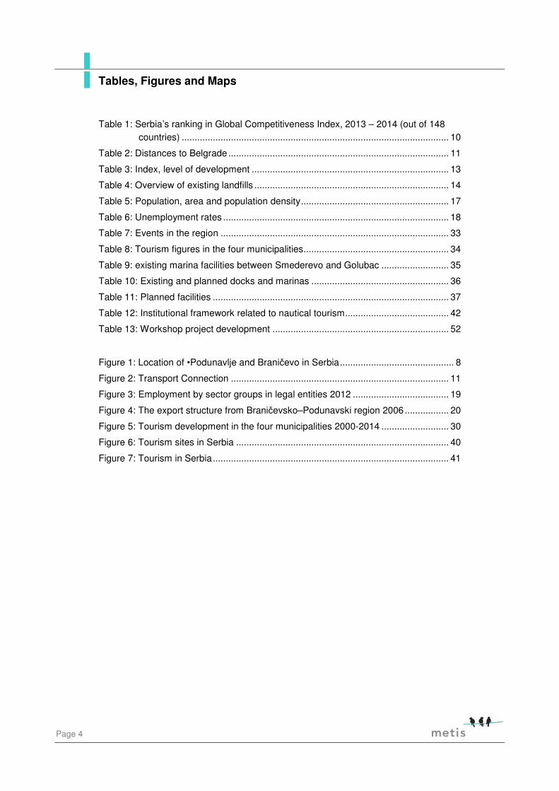
Page 4
Table 1: Serbia’s ranking in Global Competitiveness Index, 2013 – 2014 (out of 148 countries) ....................................................................................................... 10
Table 2: Distances to Belgrade ..................................................................................... 11
Table 3: Index, level of development ............................................................................ 13
Table 4: Overview of existing landfills ........................................................................... 14
Table 5: Population, area and population density ......................................................... 17
Table 6: Unemployment rates ....................................................................................... 18
Table 7: Events in the region ........................................................................................ 33
Table 8: Tourism figures in the four municipalities ........................................................ 34
Table 9: existing marina facilities between Smederevo and Golubac .......................... 35
Table 10: Existing and planned docks and marinas ..................................................... 36
Table 11: Planned facilities ........................................................................................... 37
Table 12: Institutional framework related to nautical tourism ........................................ 42
Table 13: Workshop project development .................................................................... 52
Figure 1: Location of •Podunavlje and Braničevo in Serbia ............................................ 8
Figure 2: Transport Connection .................................................................................... 11
Figure 3: Employment by sector groups in legal entities 2012 ..................................... 19
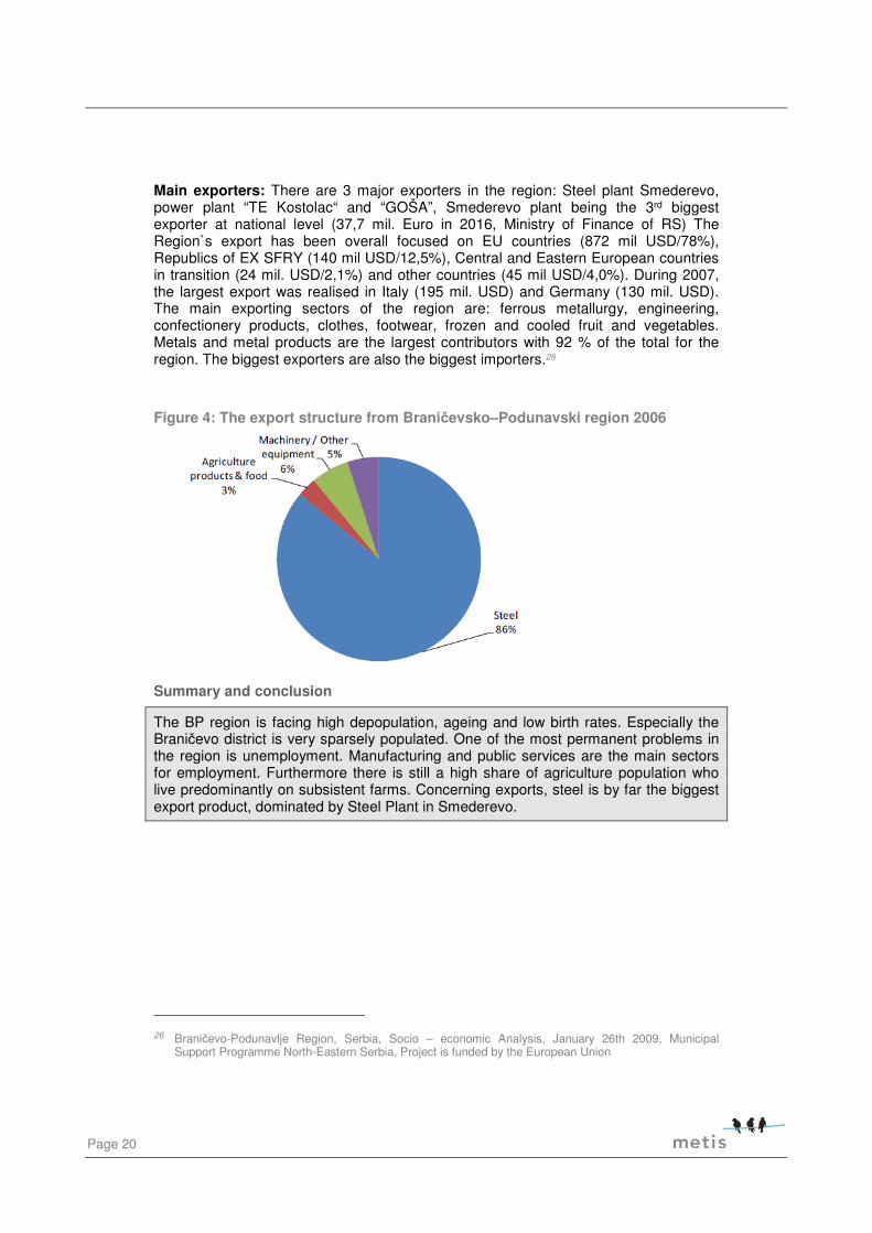
Figure 4: The export structure from Braničevsko–Podunavski region 2006 ................. 20
Figure 5: Tourism development in the four municipalities 2000-2014 .......................... 30
Figure 6: Tourism sites in Serbia .................................................................................. 40
Figure 7: Tourism in Serbia ........................................................................................... 41
Tables, Figures and Maps

Pre-Feasibility Study DANTE_final
Page 5
Art. Article
BC Before Christ
CBC Cross border cooperation
EEA European Environment Agency
EIONET European Network for Information and Observation
EU European Union
ICAO: LYKT Kostolac Airport
ICAO: LYSD Smederevo Airport
LFS Labour Force Survey
NES National Employment Service
RDA BP Regional Development Agency Branicevo-Podunavlje
RO Romania
RSD Serbian Dinar
SWOT Strength, Weaknesses, Opportunities and Threats
TAF-DRP Technical Assistance Facility for Danube Region Projects (TAF-DRP)
USD United States Dollar
Acronyms
Page 6
The project covered by the pre-feasibility study in hand is addressing a region in Serbia covering a territory of 1.569 km2 - 4 local self-governments: City of Pozarevac, City of Smederevo, Municipality Golubac and Municipality Veliko Gradiste. The beneficiary seeks to prepare a pre-feasibility study analysing the nautical tourism potential in the region. The pre-feasibility study should help to define future international and cross-border projects related to the topic. The pre-feasibility study has been elaborated as the main outcome of the Technical Assistance Facility for Danube Region Projects (TAF-DRP). The Facility supports project ideas to set up a clear pathway towards project implementation, through the provision of consultant services. Consultant services are provided free of charge to selected project applicants. In the specific case the assistance comprises the support of elaborating a pre-feasibility study related to nautical tourism and the support of the establishing a project pipeline for future Interreg projects. The consultantcy has been provided by METIS GmbH.
The background of the pre-feasibility was the fact that the beneficiary detected a need of a more systematic approach in developing Danube nautical tourism in the region. There are four municipalities with different activities and ideas and before entering into a transnational project there is a strong need to clarify how the four municipalities are able to jointly develop a tourism project. The current consensus between the four municipalities resulted in the nautical tourism project idea.
The study in hand has summarized the current situation of the region in terms of tourism and socio economy. The region is currently already active in attracting summer tourism and event tourism. However the activities are disperse and lack a joint concept and efficient cooperation between single municipalities. Quality and quantity of facilities are strongly varying between municipalities as well as the perceived attractiveness of different regional sights.
Based on this desk research combined with interviews a SWOT analysis has been designed. Furthermore the study outlines the most important type of tourists and their main economic value for the region. This section should underline which kind of activities have the highest priority in order to improve the current situation.
The main conclusion out of the study highlights the importance of summer and weekend tourism. This type of tourism is asking mainly for leisure and sport activities rather than cultural monuments. The latter presents merely an additional benefit. The regional economy however should focus and develop along this main tourism branch rather than trying to compete in nautical tourism alone.
During the study two workshop have been conducted with the main tourism actors in the region. The workshops highlighted the need for a more holistic tourism concept which goes beyond nautical tourism. Also important is the shift of focus towards the most economically valuable type of tourist in contrary to the focus on nautical tourism alone.
Finally the study outlines a set of recommendations and prospective projects which should be further developed in the region. Examples at international level are provided for potential partnerships.
1 Introduction

Pre-Feasibility Study DANTE_final
Page 7
In order to provide a suitable tourism solution the study gives a basic overview of the Braničevo-Podunavlje region and the four municipalities addressed in this study. The content below is in no way exhaustive but should show the main elements which are important in this state of the planning phase in order to find the most suitable path towards the next steps.
2.1 History
The Braničevo–Podunavlje region, like the whole Danube-Serbia, faces a rich ancient and recent history. Numerous historical events – from the prehistory, to the Roman Empire and medieval Braničevo – left a great cultural impact, intangible heritage and cultural monuments.
The archaeological finds date back to the period of prehistory, which reached to archaeological sites of great importance. Later the Danube represented the natural border for the Roman Empire over centuries. The region features numerous remains of Roman forts and towns, like “Viminacium” in Kostolac (Municipality of Požarevac). The fortresses, monasteries, historical sites and landmarks have a special significance to the whole region. Other examples of remaining historical traces are the Golubac fortress (Municipality of Golubac), Ram fortress (Municipality of Veliko Gradiste) or the Smederevo fortress (Municipality of Smederevo).
Furthermore, Danube-Serbia is the location of several historic landmarks from past battles like the Battle of Slankamen (1691 in Inđija) or the Battle of Petrovaradin (1716 in Petrovaradin), and treaty signatures like the signing of Treaty of Karlowitz (1699 in Sremski Karlovci). 1
To sum up, the region faces a rich history leading to various interesting landmarks like fortresses or archaeological finds with a special significance to the whole region.
2.2 Geographical situation
The 4 local governments Pozarevac, Smederevo, Golubac and Veliko Gradiste cover a total territory of 1,569 km². They are situated in the northern part of the Braničevo-Podunavlje (BP) region, which is located in South – eastern Serbia, directly on the southern riverbank of the Danube (see Fehler! Verweisquelle konnte nicht gefunden werden.). The whole region comprises 5.8% of the Serbian territory and consists of two districts:
• Podunavlje: including 1 city (Smederevo) and 2 municipalities (Smederevo Smederevska Palanka and Velika Plana).
• Braničevo: including 1 city (Pozarevac) and 7 municipalities (Veliko Gradiste, Golubac, Malo Crnice, Zabari, Petrovac na Mlavi, Kucevo and Zagubica).
1 MSPNE (2009): Regional Development Strategy. Braničevsko-Podunavski Region, Serbia. 2009 – 2013.;
MAXIMA Consulting (2014): Danube-Serbia: Building a European Gateway. Challenges and Opportunities.
2 Regional Analysis

Page 8
Figure 1: Location of •Podunavlje and Braničevo in Serbia
Source: Institute of Social Sciences, 2013

Pre-Feasibility Study DANTE_final
Page 9
Topography
Not only administrative, also geographically and climatically the region is divided into two parts. Firstly, the plain central-western part, which is surrounded by the Danube in the north and its confluents (Velika Morava, Pek and Mlava) in the south. This is a plain area with mainly agricultural land. And secondly the mountainous east with its highlands, the Homoljsko-Kučajske mountains. 2
Around a quarter of the total area of the region is wooded. Agricultural land spreads on 63% of the area. The most fertile soil in the region is the wide open area of Stig, which is located between Požarevac, Veliko Gradište, Petrovac and Malo Crnice. 90 % of soil of Stig is "degraded mould", the other 10% are mostly alluvial deposits. 34
Climate
Depending on the geographical position, there are two climate types in the Braničevo-Podunavlje region. A continental climate is prevailing in the west-central part and a mountain climate in the eastern part of the region. Precipitation is normally highest in May (72 mm) and June (86 mm), and lowest in February (38 mm). Average precipitation per year in the western-central part of the region amounts around 650 mm. With more than 170 windy days per year, the entire region can be regarded as windy. Most frequently, the wind blows from the south-east or the north-west. The region matches the Serbian average of 62 to 91 sunny days per year.5
Summary and conclusion
The project territory is located in the Braničevo-Podunavlje (BP) region in the eastern (Lower) Danube-Serbia. The region is divided into two parts, the flat plains surrounded with rivers in the west and the mountainous part in the east.
2 MSPNE (2009): Regional Development Strategy. Braničevsko-Podunavski Region, Serbia. 2009 – 2013. 3 MSPNE (2009): Braničevo-Podunavlje Region, Serbia. Socio – economic Analysis. 4 Braničevo-Podunavlje Region, Serbia (2009): Socio – economic Analysis. 5 Ibid.

Page 10
2.3 Connectivity
For central and eastern Europe ten Pan-European transport corridors were defined, which require major investment over the next ten to fifteen years. The corridors variously encompass road, rail and waterway routes. The Braničevo-Podunavlje region gives opportunities for all transport modes and has got national and international access through the corridors VII (Danube) and X (Highway). The Region hosts a crucial section of Serbian transportation infrastructure in national and international terms. Three major transport axis run through the Region:
• Highway: Zagreb or Budapest – Belgrade – Niš – Thessaloniki – Athens (corridor X),
• Railway line which follows the same alignment as corridor X,
• The Danube, which is completely navigable through Serbia and represents significant but under-utilized transport potential (corridor VII)6
Nevertheless it can be stated that the road network in the region is presently in poor condition and the public transport (by both road and rail) is underdeveloped with limited investment in infrastructure and route development. Also internationally seen, the quality of the entire Serbian transport infrastructure is in poor quality, as shown for instance by the “Global Competitiveness Index”, quoted in Fehler! Verweisquelle konnte nicht gefunden werden..
Table 1: Serbia’s ranking in Global Competitiveness Index, 2013 – 2014 (out of 148 countries)7
Indicator Position (1st being best)
Quality of roads 119th
Quality of railroad infrastructure 95th
Quality of port infrastructure 139th
Quality of air transport infrastructure 121th
Taking a look at the modal split, within Serbia the dominant mode of passenger travel (excluding urban public transport like local buses, trams or trolleybuses) is the road, which counts around 80% share, measured by passengers in number. This is followed by railways (8%) and air transport (2%), there is no significant passenger travel by river. Measured by passenger kilometres, the modal split for road transport falls to 70% and air transport increases to 22%. Freight in contrast is mainly transported by railways (54% measured by tonnage), followed by the road and inland waterways. Figure 2 gives an overview of existing major airports, roads, rails and river connections in the region and the following section shows a more detailed picture for each of the transport infrastructures.
6 Braničevo-Podunavlje Region, Serbia (2009): Socio – economic Analysis.;
MAXIMA Consulting (2014): Danube-Serbia: Building a European Gateway. Challenges and Opportunities.
7 World Economic Forum

Pre-Feasibility Study DANTE_final
Page 11
Figure 2: Transport Connection
Source: Horwath Consulting Zagreb Tourism strategy Serbia 2006
Road
As mentioned above, the Braničevo-Podunavlje region is internationally connected through the multimodal Corridor X, which links Austria, Slovenia, Croatia, Serbia, Macedonia and Greece. The around 2,300 km long road (mainly motorways or highways) is linking Salzburg (via Ljubljana-Zagreb-Beograd-Nis-Skopje) and Thessaloniki and has four branches (A: Graz-Maribor-Zagreb, B: Budapest-Novi Sad-Beograd, C: Nis-Sofia and D: Veles-Bitola-Florina).
Furthermore, the arterial road M-24 ("Danube Arterial Road") passes through the National Park Đjerdap and connects several international border crossings with Romania and Bulgaria. Additionally, important economic transportation routes include: Kučevo-Majdanpek-Đerdap and Petrovac-Žagubica-Bor-Zaječar.
Despite the international and national corridors, the density of road infrastructure in the area has to be characterized as relatively low and existing roads, mainly in the eastern parts of the region, are presently in poor condition. Nevertheless, private cars are the predominant means of transportation within the region. Therefore, Table 2 shows the distances and car driving time from each of the four municipalities to Belgrade.
Table 2: Distances to Belgrade
Municipality Distance to Belgrade Car driving time to Belgrade
Smederevo 46 km 45min
Pozarevac 81 km 1h 15min
Veliko Gradiste 110 km 1h 55min

Page 12
Municipality Distance to Belgrade Car driving time to Belgrade
Golubac 137 km 2h 15min
To sum up, the central and western parts of the region are well connected in terms of proximity to Belgrade and international routes, unlike the eastern part of the region, where the most of the road infrastructure is in poor condition. 8
Railway
Beside the road, the international Corridor X is also consisting of an around 2,500 km long railway track, following the same alignment as described above. From the direction of Belgrade, there is a railway line linking the region with the capital city (Belgrade-Požarevac-Kučevo-Majdanpek-Bor).
River
One can say that the role of the Danube is underestimated in the economic life of Serbia. The river hasn’t been yet recognized as a key factor for economic development9. As stated above, the share of transported freight by waterways is relatively low and there is also no significant passenger travel by the Danube. Main international ports on the Danube are located in Novi Sad, Pančevo, Belgrade and Smederevo. But each of the other municipalities addressed in this study opened their own regional port (see section 3.2)
Air
The Nikola Tesla Airport, which is the biggest one in Serbia, is located near Surčin, 18 kilometres westward from Belgrade. The airport is registered for ground handling of aircraft, passengers, goods and mail in domestic and international traffic. Airlines operating direct scheduled flights are the following: Aegean Airlines, Aeroflot, Air Cairo, Air Serbia, Alitalia, Austrian Airlines, Belavia, eas< Jet, Etihad Airways, fly dubai, LOT Polish Airlines, Lufthansa, Montenegro Airlines, Norwegian Air Shuttle, Pegasus Airlines, Qatar Airways, Swiss, TAROM, Tunisair, Turkish Airlines, Ural Airlines and Wizz Air.10
Kostolac Airport (ICAO: LYKT) is situated on the bank of the Danube river, built in 1998 on the power plant's reclaimed former ash yard. It is two kilometres from the Kostolac town centre and also near the town of Požarevac.
Landing at Kostolac Airport is unique, because the way of landing is over the Danube water plane, which is similar to landing on an aircraft carrier. There is an international air show every August.
Smederevo Airport (ICAO: LYSD) is sport airport located to about 4 km southeast of the city center, near the road 14 that connects Smederevo–Kovin. It is used for the sport-educational flying of planes, helicopters, agriculture planes, motor kites and parachuting.
8 MSPNE (2009): Braničevo-Podunavlje Region, Serbia. Socio – economic Analysis. 9 Ćurčić N., Medić S. and Bjeljac Z. (2011): Danube as a New Strategic Product and the Serbian Tourism. 10 BEG 2016. http://www.beg.aero/en/strana/9851/scheduled-airlines (08/03/2016)
Pre-Feasibility Study DANTE_final
Page 13
Summary and conclusion
The Braničevo-Podunavlje region is well connected through its proximity to Belgrade and international corridors. However, this is more the case for the western part of the region, unlike the eastern part, where most of the transport infrastructure is in very poor condition. The Danube does not play an important role in terms of transport.
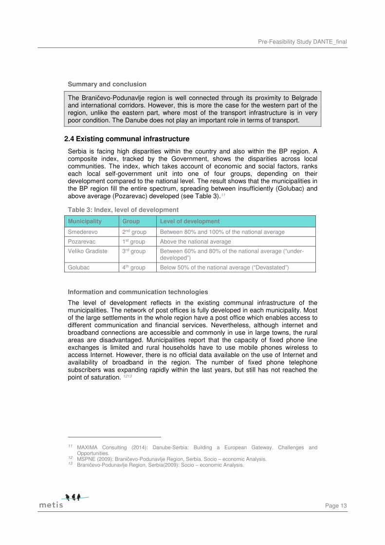
2.4 Existing communal infrastructure
Serbia is facing high disparities within the country and also within the BP region. A composite index, tracked by the Government, shows the disparities across local communities. The index, which takes account of economic and social factors, ranks each local self-government unit into one of four groups, depending on their development compared to the national level. The result shows that the municipalities in the BP region fill the entire spectrum, spreading between insufficiently (Golubac) and above average (Pozarevac) developed (see Table 3).11
Table 3: Index, level of development
Municipality Group Level of development
Smederevo 2nd group Between 80% and 100% of the national average
Pozarevac 1st group Above the national average
Veliko Gradiste 3rd group Between 60% and 80% of the national average (“under-developed”)
Golubac 4th group Below 50% of the national average (“Devastated”)
Information and communication technologies
The level of development reflects in the existing communal infrastructure of the municipalities. The network of post offices is fully developed in each municipality. Most of the large settlements in the whole region have a post office which enables access to different communication and financial services. Nevertheless, although internet and broadband connections are accessible and commonly in use in large towns, the rural areas are disadvantaged. Municipalities report that the capacity of fixed phone line exchanges is limited and rural households have to use mobile phones wireless to access Internet. However, there is no official data available on the use of Internet and availability of broadband in the region. The number of fixed phone telephone subscribers was expanding rapidly within the last years, but still has not reached the point of saturation. 1213
11 MAXIMA Consulting (2014): Danube-Serbia: Building a European Gateway. Challenges and
Opportunities. 12 MSPNE (2009): Braničevo-Podunavlje Region, Serbia. Socio – economic Analysis. 13 Braničevo-Podunavlje Region, Serbia(2009): Socio – economic Analysis.

Page 14
Energy
Concerning energy infrastructure one can state that low energy efficiency and obsolete technology used are the main problems identified at national level. However, the BP region is a net exporter of energy, with the Kostolac power station generating around 13% of domestic Serbian energy production. This national managed thermal plant is an important local employer, but also a major regional air polluter. The majority of the region’s energy comes from non-renewable energy sources. The use of the renewable energy potential would require further investigation and assessment of feasibility. 1415
Water and waste water
The sources of water supply in the region are of a high volume. Almost all cities and municipalities are located along the Danube or others of the various rivers. Therefore the available underground water per capita is above national average. Anyway water resources are not used efficiently for the agricultural irrigation and a high percentage of properties (mainly in the Braničevo district) are still not connected to a public water supply. Another problem is the pollution of surface and underground water, caused by the lack of a comprehensive waste water treatment infrastructure and the poor number of connected holdings to the public sewage system. 16
Solid waste management
Not only water contamination, also solid waste, utility waste and industrial waste cause big environmental problems in the region. Existing landfills (including a significant number of illegal ones) are not managed properly and do not have sufficient capacity for the more than 100,000 tons of annual waste produced in the region. Furthermore, the landfills are not designed to current international sanitary standards. Also the recycling capacities in the region are limited and there exist no facilities for the disposal of hazardous or animal waste. Table 4 demonstrates the poor quality of existing landfills in the investigation area. 17
Table 4: Overview of existing landfills18
Municipality Landfill
Smederevo Smederevo landfill and disposal of solid waste not in compliance with environment standards; problems of communal and industrial waste management in particular due to increased industrial production of the area.
Pozarevac City disposal site. Decontamination and renovation needed. Not protected and overused. Industrial waste is being disposed here, as well. Industrial ash disposal site in Kostolac needs urgent renovation based on technical documentation.
Veliko Gradiste City disposal site. Sanitation needed. New location must be found.
Golubac City disposal site. No valid construction permit.
14 MSPNE (2009): Braničevo-Podunavlje Region, Serbia. Socio – economic Analysis. 15 Braničevo-Podunavlje Region, Serbia (2009): Socio – economic Analysis. 16 MSPNE (2009): Braničevo-Podunavlje Region, Serbia. Socio – economic Analysis. 17 MSPNE (2009): Braničevo-Podunavlje Region, Serbia. Socio – economic Analysis. 18 Ibid.

Pre-Feasibility Study DANTE_final
Page 15
Summary and conclusion
Serbia is facing high disparities, which are also reflected in the communal infrastructure within the Braničevo-Podunavlje region. In terms of technical infrastructure, insufficient development can be identified throughout the region, with main disadvantages in the rural areas in the eastern part. The region is dominated by the Kostolac fossil energy power station with an attached surface production of brown coal. This site has a serious impact on the surrounding area and environment. On top of that it directly conflicts with the archaeological sites of the district. Finally the area in general lacks sufficient waste and sanitary standards which results in visible environmental pollution especially through uncontrolled waste disposal.
2.5 Environmental situation
Environmental issues in Serbia are under the accountability of the Ministry of Agriculture and Environment Protection. Especially the Agency for Environmental Protection performs professional tasks related to development, the coordination and the management of national information systems for environmental protection (e.g. the monitoring of the state of environmental media through environmental indicators, the registry of pollutants, etc.). They also cooperate with the European Environment Agency (EEA) and the European Network for Information and Observation (EIONET).
But unfortunately there is no unique and relevant monitoring of pollution in the region and in Serbia. Information is generally insufficient and resources for an effective management of the environment are scarce. The most visible and urging environmental problems in the area however are soil, water and air pollution.
Air pollution
Air pollution in the region is clearly resulting from Kostolac. However there is no systematic monitoring. Only in two towns in the region a air pollution monitoring system is installed. The measuring stations are placed in the two biggest industry centres in the region, close to the steel plant in Smederevo and the power plant in Kostolac. The result, occasionally recorded instances of emissions exceeding the set limits, shows that air quality issues are an existing problem in this area.
According to the Annual state report19, the agglomerations Bor, Uzice and Smederevo showed over-polluted air during 2014 (category III from three categories: 1 – clean air, 2 – moderately and 3 – exceedingly). Smederevo had 33 days with more than the allowed concentration of polluters in the air.
Furthermore, according to the results from a station located in Pozarevac, which measures the concentration of pollen in the air, there were more than 30 days with an overdraft limit of concentration of Ambrosia in 2014.
19 Annual state report of air quality in Serbia in 2014, the Agency for Environmental Protection,
http://www.sepa.gov.rs/index.php?menu=5000&id=13&akcija=showExternal
Page 16
Waste pollution
The environmental pollution through uncontrolled waste disposal was already described in chapter 2.4 Existing communal infrastructure, utility waste, industrial waste or not properly managed and insufficient landfills all together cause major waste disposal problems in the region.
Illegal dump fields contribute a lot to the potential pollution in the region. In Serbia there are in total 3,085 illegal and old dump fields spread across the country, the region is not an exception and lies in Serbian average. Although a regional plan for waste management (covering 9 municipalities of the Branicevo district with the possibility of adding Smederevo) was adopted, the project is still on hold. Beside lack of finance, a trend of local policy and lack of politically good will are the main obstacles for developing a regional landfill.
Beside waste disposal in the country side the Danube bays are polluted throughout the whole coast line. This not only causes damages of wetland and destroys bird breeding ground and fish stock.
Water pollution
Regarding the water quality, there is only one monitoring base (placed on the river Velika Morava near the delta of Velika Morava and the Danube in Pozarevac) for recording the daily water quality. In general, there are instances of pollution of the rivers and underground water courses, mainly caused by an excessive use of mineral fertilizers on agricultural land. Also old sewage pollution has contributed to the increase of nitrates in underground water. But according to the annual checking control and reports of the Agency for environmental protection the quality of water in the BP region can be still assessed as good.
Summary and conclusion
Environmental pollution in Serbia is a problem in all spheres. In the region the main problems are air pollution as well as uncontrolled waste disposal. There is a lack of awareness among the population and at political level as well as a lack of systematic monitoring of water, air and soil pollution. A trend of local policy and financial problems are obstacles for improving the environmental situation. However several studies reveal that at least at academic/expert level the problem has been already recognised and analysed. With regards to tourism aspects pollution is one of the most repulsive arguments against a potential tourism destination. Therefore it is of economic importance to improve the environmental situation in the region.
2.6 Socio-economic environment
This chapter provides a brief overview of social, demographic and economic conditions. Unfortunately, the availability and access to required and reliable data was not always possible, therefore the comparisons vary sometimes by year or area.

Pre-Feasibility Study DANTE_final
Page 17
Population change
The entire region is facing high depopulation, and especially in Braničevo district it has been a permanent trend since 1991. In the period between 1991 and 2006 population of the BP region decreased for more than 77,000 inhabitants, which is 18% out of total population decrease in Serbia. The rate of decline in the region over this period was higher than 16%, what is more than three times the rate of decline in Serbia. A detailed overview of the population change will be given in Table 5.20
Population density
The average population density in the region is 75 inhabitants per km², but this is not spread equally within the region. The flat Podunavje district is populated with 199,395 inhabitants at 1,248 km², which equates to around 160 inhabitants per km². Within the Braničevo district only 183,625 inhabitants live at 3,865 km² (in average 48 inhabitants/km²). The two cities Pozarevac and Smederevo, which attained their city status in 2008, are located in the central plains of the region, where the majority of the population is concentrated. In contrast, in the highland areas of the Braničevo district in the eastern part, the population density in Golubac for instance only reaches 24 inhabitants or the population density in Zagubica municipality is only 17 inhabitants per km² (see more in Table 5). 21
Consequently also the ration between urban and rural population differs between the two districts. In the Podunavlje region more than half of population (53% in 2007) lives in urban municipalities while in Braničevo rural population prevails (urban population 37% in 2007). 22
Table 5: Population, area and population density
Population 1991
Population 2002
Population 2011
% change 2002 - 2011
Surface in km²
Density per km² 2011
Smederevo 115,617 109,809 108,209 -1% 481 223
Pozarevac 84,678 74,902 61,697 -18% 481 155
Veliko Gradiste 27,174 20,659 17,610 -15% 344 55
Golubac 12,513 9,913 8,331 -16% 368 24
Podunavlje district 226,589 210,290 199,395 -5% 1,248 160
Braničevo district 253,492 200,503 183,625 -8% 3,865 48
BP region 480,081 410,793 383,020 -7% 5,133 75
Serbia 7,822,795 7,498,001 7,186,682 -4% 88,361 81
Source: SEA BP + ADA Danube-Serbia; nochmal nachrechnen!
20 MSPNE (2009): Braničevo-Podunavlje Region, Serbia. Socio – economic Analysis. 21 Numbers on population are based on the population census 2011 22 MSPNE (2009): Braničevo-Podunavlje Region, Serbia. Socio – economic Analysis.
Page 18
Age structure
The average age of the Serbian population in 2011 was 42.2 years, which is two years more than the 2002 results. The aging of the Serbia population and low birth rate strongly reflects the social structure. The number of pensioners is increasing while the share of the economically active population is decreasing. Over the past five decades, the number of pensioners has multiplied eight times, and the share of dependent population reached one third of the total. The age structure within the Podunavlje district is with 41.8 slightly younger than the national average, in contrast the Braničevo district where the average age is even two years more (44.3 years).
Labour market
The main official source of activity, employment and unemployment rates in the Serbian labour market is the Labour Force Survey (LFS), conducted semi-annually by the Republic Statistical Office, compatible with Eurostat standards. Unfortunately, this data is not identified for districts and municipalities and therefore, it is difficult to build up an accurate and up-to-date picture of the local labour market in the BP region. The National Employment Service (NES) also collects and publishes unemployment data (unemployment, age structure, education, length of unemployment, etc), but this is based on registrations and therefore also not capable of providing a valid picture. Nevertheless some economic indicators for the region could be identified and are shown in the following chapters.
Unemployment
Unemployment is one of the most permanent problems in the region and entire Serbia. The unemployment rate is not measured regularly and varies significantly between districts and municipalities. The Podunavlje district has a much higher unemployment rate than the municipalities of Braničevo. This is partially the result of effects of large privatization and restructuring in the Podunavlje district. However this does not suggest that Braničevo economy provides better employment opportunities but it is related to higher share of agriculture population who live predominantly on subsistent farms and thus not register either as employed or unemployed population.
Besides, Braničevo is also the district with the highest economic migration in Serbia as reported by the municipalities. Fehler! Verweisquelle konnte nicht gefunden werden. shows the amount of employed persons per 1000 inhabitants in 2005 in the BP region. 23
Table 6: Unemployment rates24
Unemployment rate Total unemployed, 31.12.2013
Working age population (15-64) population, 2013
Smederevo 11.99% 8,900 74,213
Pozarevac 8.91% 4,515 50,659
Veliko Gradiste 14.01% 1,525 10,884
Golubac 13.67% 700 5,121
23 MSPNE (2009): Braničevo-Podunavlje Region, Serbia. Socio – economic Analysis. 24 Statistical Office of the Republic of Serbia, Yearbook Municipalities and Regions in RS 2014

Pre-Feasibility Study DANTE_final
Page 19
Podunavlje 12.59% 16,845 133,826
Branicevo 8.64% 10,040 116,228
Serbia 15.83% 769,546 4,860,489
Employment and Industrial concentrations
In total, there were over 66,000 people in employment in the BP region in 2012, equally split over the two districts. Out of them 41% were women and 30% were employed as or by ‘entrepreneurs’ (sole traders). The following Figure 3 shows the employment by sector groups in legal entities (employment by sole traders is not broken down by industry). The largest sectorial employer in Danube-Serbia is services, which account for 68% of all jobs, with particular concentrations in Belgrade and South Bačka (including Novi Sad). Also in Braničevo services account for 58% of all jobs, with a disproportionate share of public services. By contrast, different services accounted for only half of employment in Podunavlje, where one can see that instead there is an extreme high share of manufacturing. However, the shares are most likely distorted by the low levels of ‘official’ employment in agriculture, forestry and fishing. After national output and experts, it is clear that the actual share of agri-food employment in the region and Serbia as a whole is far higher, which can be explained by official statistics only showing employment in companies and cooperatives, rather than the far larger employment within family holdings.25
Figure 3: Employment by sector groups in legal entities 2012
Source: own figure based on MAXIMA Consulting 2014: 151
25 MAXIMA Consulting (2014): Danube-Serbia: Building a European Gateway. Challenges and
Opportunities.
Page 20
Main exporters: There are 3 major exporters in the region: Steel plant Smederevo, power plant “TE Kostolac“ and “GOŠA”, Smederevo plant being the 3rd biggest exporter at national level (37,7 mil. Euro in 2016, Ministry of Finance of RS) The Region`s export has been overall focused on EU countries (872 mil USD/78%), Republics of EX SFRY (140 mil USD/12,5%), Central and Eastern European countries in transition (24 mil. USD/2,1%) and other countries (45 mil USD/4,0%). During 2007, the largest export was realised in Italy (195 mil. USD) and Germany (130 mil. USD). The main exporting sectors of the region are: ferrous metallurgy, engineering, confectionery products, clothes, footwear, frozen and cooled fruit and vegetables. Metals and metal products are the largest contributors with 92 % of the total for the region. The biggest exporters are also the biggest importers.26
Figure 4: The export structure from Braničevsko–Podunavski region 2006
Summary and conclusion
The BP region is facing high depopulation, ageing and low birth rates. Especially the Braničevo district is very sparsely populated. One of the most permanent problems in the region is unemployment. Manufacturing and public services are the main sectors for employment. Furthermore there is still a high share of agriculture population who live predominantly on subsistent farms. Concerning exports, steel is by far the biggest export product, dominated by Steel Plant in Smederevo.
26 Braničevo-Podunavlje Region, Serbia, Socio – economic Analysis, January 26th 2009, Municipal
Support Programme North-Eastern Serbia, Project is funded by the European Union

Pre-Feasibility Study DANTE_final
Page 21
2.7 Education and research facilities
Quality, level and accessibility of education in Serbia are still lagging behind EU standards. Just 13% of the Serbian population has completed college or university. If the analysis is conducted only with the economically active population, the percentages are higher, but still far behind the EU average (19% or more with a degree from higher education, while in the EU the percentage reaches 30%).27
Further to the Serbian legislative there is eight years of compulsory education starting with the age of seven until 14 (so called primary schools). Primary schools fall under the responsibility of municipalities. Secondary education is provided by the state and is partially further higher and university degrees. There exists a rather good network of secondary schools which enables easy access for young people to secondary education. In the Braničevo-Podunavlje region 23 schools are offering different programmes (gymnasiums or technical, economy, agricultural, medical or touristic schools) and counted a total of 13,198 students in school year 2012/13. Out of this number, 3,352 completed school in that year. This represents 4% of all students in Serbia which is an indication that the attending of secondary school in the region is in line with national average. 28
Almost half (48.9%) of the total Serbian population aged over 15 have completed secondary education. The proportion of people with tertiary education in Serbia is 16.2%, of which just 10.6% of the population has completed university level education.
Four high schools with three to four years tourism programs could be identified in the project territory or close by: 29
• Smederevo (pastry chef, waiter, cook, tourism technician-i.e. receptionist)
• Pozarevac (pastry chef, waiter, cook, tourism technician)
• Veliko Gradiste (waiter, cook, tourism technician)
• Velika Plana (pastry chef, waiter, cook, tourism technician)
Summary and conclusion
The regions education status is in line with the Serbian average, but compared to EU standards the quality, level and accessibility of education in Serbia is still lagging behind. In the Braničevo-Podunavlje region 23 schools are offering different programmes. In relation to the tourism sector, four high schools with respectively programs could be identified.
27 MAXIMA Consulting (2014): Danube-Serbia: Building a European Gateway. Challenges and
Opportunities. 28 Statistical Office of the Republic of Serbia, Yearbook Municipalities and Regions in RS 2014 29 http://srednjeskole.edukacija.rs/drzavne-srednje-skole/svi-gradovi (15/02/2016)

Page 22
2.8 Government or regulatory system
Over the past ten years of extensive political and economic reforms, Serbia has developed into a stable democratic country with a relatively fast growing market economy. Western–oriented, democratic political parties have a strong majority among citizens and the Government is shaping an attractive environment for business activities, while legislative activities are intensely bringing the legal framework in line with the EU regulations30.
The governance of Danube-Serbia has three main legislative-executive levels (national, provincial and local), one purely administrative level (districts) and one statistical planning level (regions), as laid down in the Constitution of the Republic of Serbia, key Acts of Parliament, such as the 2007 Law on Local Self-Government, and Government Decrees.31 Anyway, inefficient government bureaucracy and corruption are still the most problematic factors for doing business in Serbia.32
The Constitution of Serbia contains a general provision on the competences of both autonomous provinces and units of local self-government: ‘local self-government units shall be competent in those matters which may be realized, in an effective way, within a local self government unit, and autonomous provinces in those matters which may be realized, in an effective way within an autonomous province’.
Among the matters ‘which may be realized in an effective way’, autonomous provinces shall regulate urban planning and development, agriculture, water economy, forestry, hunting, fishery, tourism, catering, spas and health resorts, environmental protection, industry and craftsmanship, road, river and railway transport and road repairs, organizing fairs and other economic events, education, sport, culture, health care and social welfare and public informing at the provincial level. 33
In accordance with Article. 188 of the Constitution, ‘Local self-government units shall be municipalities, towns and the City of Belgrade.’ Among specifically listed competences of the local self-government units there are regulations of the use of urban construction sites and business premises, construction, reconstruction, maintenance and use of local network of roads and streets and other public facilities of municipal interest, local transport, development and improvement of tourism, environmental protection, protection against natural and other disasters; protection of cultural heritage of the municipal interest, protection, improvement and use of agricultural land, etc. More detailed delineation of the competences in above-mentioned fields is regulated by sectorial laws.
Tourism policy is generally defined by the National Strategy for the Development of Tourism (outdated 2006-2015), the Strategic Master plans for particular tourism destinations and other documents of lower hierarchy. The Government proclaims touristic areas in the Republic and their management is entrusted to the public service or public enterprise established by the Republic, autonomous province or the City of Belgrade.
30 DATOURWAY Investment Guidebook: 30ff 31 MAXIMA Consulting (2014): Danube-Serbia: Building a European Gateway. Challenges and
Opportunities. 32 World Economic Forum (2011): The Global Competitiveness Report 2011-2012. Serbia.
http://www3.weforum.org/docs/GCR2011-12/CountryProfiles/Serbia.pdf 33 Bioregio project - analysis of national institutional frameworks and legislations affecting biodiversity and
ecological connectivity in the Carpathian countries. national report, Serbia. 2013
Pre-Feasibility Study DANTE_final
Page 23
The Ministry of Trade, Tourism and Telecommunications which is responsible for tourism is competent for categorization of touristic resorts and objects, while touristic organizations - which are established at the level of the Republic, autonomous province and at local level - are in charge of promotion of tourism and activities related to it.
In the water sector territorial/administrative division of competences is a bit different due to specific characteristics of water protection based on river basin management plans. Waters are divided in two orders. Waters of the first order are international waters, waters of significant water bodies and waters with special regime of use or protection in accordance with defined criteria. In general the Republic is in charge of managing waters of the first order, while waters of the second order are managed on the basis of defined water areas. Both autonomous provinces and local self-government units as well as the public company for water management have their respective competences in the water sector.
Spatial planning is generally governed by the Spatial Plan of the Republic of Serbia
which is adopted by the National Assembly at the proposal of the sectoral Ministry. All the other spatial plans have to be compliant with this framework plan. The other plans could be regional spatial plan, local self-government unit spatial plan and the spatial plan for the area of special purpose. In accordance with Article 35 of the Law on Planning and Construction, regional spatial plans are adopted by the Government at the proposal of the sectoral Ministry, though for regions which are entirely located in the territory of an autonomous province they are adopted by the assembly of the autonomous province.
Local spatial plans are adopted by assemblies of the local self-government units. All these plans have to be approved by the sectoral Minister in order to secure their compliance with the plans of higher hierarchy. Spatial plan for the area of special purpose is one of the available tools to protect landscapes. Special purpose area could also be an area with special natural resources, cultural heritage, touristic or hydro potentials, etc.34
Natural protection
Environmental protection is similarly organized. The main strategic document is the National Strategy on Sustainable Utilization of Natural Resources and Goods, which shall be implemented through various plans and programmes on individual resources. The Government of the Republic of Serbia adopts the National Programme, while autonomous provinces and local self-governance units, shall issue their respective plans and programs for management of natural resources within their competencies and in accordance with the National strategy. Two or more self-government units may promulgate joint programmes. The competent authority (depending on the type of natural resource) may not issue approval for the use of the national resource without the consent of the ministry in charge of environmental protection. The Constitution of the Republic of Serbia requires establishing the environmental protection sector at the level of municipalities.35
34 ibid 35 ibid
Page 24
Although the different regulations on tourism, transport, agriculture, forests, water and hunting do not mention this concept, there are certain provisions related to the protection of environment and biodiversity. The new Law on Spatial Plan12 pays a substantial attention to ecological connectivity, the same goes for the Strategy for Spatial Development 2009-2013-2020 which pursue, as one of its goals, the enlargement of the total territory of protected areas in Serbia to 12% of the national territory by 2020. So far, protected areas cover some 6.2% of the national territory.
In order to improve protection and to more effectively manage the protected natural areas and conservation of protected species, there is an ongoing process of developing the ecological network in Serbia, which presently includes 101 areas. Ecological network in Serbia consists of ecologically important areas, ecological corridors and buffer zones. Now it covers an area of 1,849,201.77 hectares, which amounts to almost 21 % of the territory of Serbia.36
Serbia is a country of rich biodiversity, which is primarily evident in the diversity of its vegetation and fauna. Covering only 1.9% of the whole European territory. The system of protected areas in Serbia has a relatively long tradition and it has been gradually developed for almost 70 years. However, coverage of the PAs is still very low and only a few areas are adequately managed (Sekulić, 2011). Currently there are 463 areas of which 5 are national parks, which have a status of “protected area of extraordinary importance”. The national park Djerdap is the largest national park in Serbia with a total area of 63,608 ha37.
The current system of categories of protected areas is set by legislative act on nature protection adopted in 2009. In principle four different legislative acts are most important for environmental protection: nature protection act, environmental protection act, forestry act and the national park act.38
Cultural heritage
The preservation and protection of cultural heritage sites in Serbia is entrusted to the National Institute for Protection of Cultural Monuments. The Institute maintains the Central Register of Cultural Heritage. The Register currently lists 2,513 heritage sites classified in four categories: cultural monuments, archaeological sites, historic landmarks and spatial cultural-historical units. 200 of those are classified as being "of exceptional importance", and thus entitled to the highest level of protection. Further 582 are classified as being "of great importance", while the rest are "unclassified". Viminacium, the Smederevo Fortress as well as the Golubac Fortress are listed as of exceptional importance.39
36 http://virtuelnimuzejdunava.rs/serbia/informations/institute-for-nature-conservation-of-serbia.-.470.html 37 Management of natural protected areas in Serbia – national park Djerdap, Belgrade Humboldt-Club
Serbien, 2013 38 ibid 39 Republic institute for protection of cultural monuments
http://www.heritage.gov.rs/latinica/nepokretna_kulturna_dobra.php

Pre-Feasibility Study DANTE_final
Page 25
Ownership
The land ownership law on Planning and Construction enacted in September 2009 introduced several positive amendments aimed at improving disadvantages of the old law that have been noted in practice and harmonization with EU legislation and the Constitution of Republic of Serbia relating to the:
• Privatization of the state-owned construction land
• Issuance of construction permit
• Zoning and spatial planning
• Legalization
• The Law introduces different categories of construction land, namely: Consequently, for instance, if a user of state-owned construction land fails to construct a building within a prescribed period of time, his right of use may cease.
• City Construction Land and
• Construction Land outside the Construction Area.
In line with the Constitution of Republic of Serbia, the Construction Law allows for private ownership over any type of construction land and for further transfer of ownership rights. The provisions are aimed at replacing the right of use, which was commonly used during previous periods when city construction land was state owned, and when owners of buildings were entitled to the right of use over the land beneath them. The Law provides for automatic conversion of the right of use on state-owned developed construction land into ownership at no fee, subject to numerous exceptions.
The main exception is related to the right of use on state-owned developed construction land currently or formerly held by companies that were subject to privatization, bankruptcy or enforcement laws which can be converted into ownership subject to the payment of a fee equal to the difference between the market value of the land at the conversion date and the amount paid for the acquisition of the right of use on such land. The criteria for determining the conversion fee are expected to be defined in the implementing by laws.

Page 26
Construction permit
A building is lawfully constructed if a construction permit has been issued. The permit is issued on the basis of a location permit and technical documentation - main design. One of the main features of the new Law is the possibility of a construction permit transfer together with a transfer of property rights over building/land. Municipalities are authorized to issue construction permits. The competent Ministry is in charge of issuing construction permits for the construction of nuclear plants, oil and gas production/processing industry objects, hydro-power stations, airports, traffic infrastructure and similar. Upon construction, the investor will apply for a utilization permit.
Summary and conclusion
The Serbian governance consists of three main legislative-executives, located at national, provincial and local level. The districts are purely administrative, whereas the regions are important for statistical planning. Serbia has developed into a stable democratic country over the last years, but nevertheless inefficient government bureaucracy and corruption are still problematic. Policies on tourism, transport, agriculture, forests, water, hunting, natural protection, cultural heritage etc. are regulated differently. For example, the National Strategy defines the tourism policy for the Development of Tourism, the Strategic Master plan for Touristic Sector and other documents of lower hierarchy. The Ministry of Finance and Economy is competent for categorization of touristic resorts and objects, while touristic organizations at different levels are in charge of promotion of tourism and activities related to it. In the water sector territorial/administrative division of competences is divided in two orders. Autonomous provinces and local self-government units as well as the public company for water management have their respective competences in the water sector. Spatial planning and environmental protection are similarly organised, with main strategic documents at national level.

Pre-Feasibility Study DANTE_final
Page 27
The following section focuses mainly on the four municipalities Pozarevac, Smederovo, Veliko Gradiste and Golubac. The four municipalities are of great diversity in size as well as in economic character. Three out of the four cities do have direct access to the Danube. Only Pozarevac is further inside the land with City municipality Kostolac directly located at the river site.
The existing statistics regarding tourism economic indicators are in most of the cases almost 10 years old. In order to establish a more recent picture of the tourism sector in this municipalities a survey has been conducted by the Regional Development Agency “Branicevo-Podunavlje” Ltd (RDA BP) in Pozarevac. However there are still gaps in the data collection which have been filled with desk research if available.
Pozarevac
Pozarevac is a regional centre of the Braničevo District of Serbia. According to data of the latest Census 2011, the city`s population amounts 61,697 and 75,334 in the municipality40. Pozarevac is dominated by agricultural production and certainly the neighbouring coal mines and energy plant in Kostolac. Pozarevac is the consumer centre of the area. A larger number of services and consumer goods are available. The municipality covers the access to the Danube river only via Kostolac. In Kostolac an artificial channel serves as a recreational settlement area. Most important for tourism is the site, Viminacium, located right in the middle of the coal mine plant.
Smederevo
Smederevo is the regional centre of the Podunavlje region. According to official results of the 2011 Census, the city has a population of 64,105, and 108,209 people in the agglomeration. Smederevo is characterised by heavy industry and manufacturing form the commercial centre of the region. The most important industry is the local steel mill Železara Smederevo. Smederovo’s most important attraction is the Danube Fortress from the14th century) and the Vila Obrenovic in the middle of wine yards.
Golubac
Golubac is a smaller village located directly at the Danube river. It is bordered by Romania to the east, Veliko Gradište to the west and Kučevo to the south. The population of the municipality according to the Census 2011 is 8,331. The village lies at the entrance of national park Djerdap flanked by a medieval fortress and at the widest expansion of the Danube river with 5 km width. Several sports events are taking place at this lake like area of the Danube. The national park offers several hiking trails as well as the Eurovelo 6. 80-90 % is bicycle tourism (15,000 people).
40 Statistical Office of the Republic of Serbia, Yearbook Municipalities and Regions in RS 2014
3 Tourism sector

Page 28
Veliko Gradiste
Veliko Gradiste is located on the right bank of the Danube river and left bank of the Pek river. In 2011, the town had total population of 17.610 in the municipality. According to recent survey the municipality has a population of 23,29341. The local economy in the municipality is dominated by tourism with 30% with a 37% employment share. The area around Veliko Gradiste offers natural tourism attraction with the internationally famous Silver lake. The municipality compared to the others three municipalities has the highest capacity accommodating 20,000 tourists per year42. The most dominant facility remains the silver lake resort offering a conference hall, boats, a small marina, a swimming pools and a small marina with a capacity of 20-30 yachts.
The location of the lake along the Romanian – Serbian border results in existing border facilities and staff at the regional department of Port authority.
Veliko Gradiste town owns a peer with fuel tank facilities for Danube cruise ships which results in a higher daily tourism by cruise ship passengers than the other three regions. The municipality
3.1 Economic share of tourism sector
Tourism sector in Serbia as a whole is slowly rising with an average growth between 1-2%. According to the world travel tourism council economic impact report 2015 the direct growth of Serbian Travel & Tourism to GDP is expected to grow by 5.2% pa to RSD131.2bn (2.5% of GDP) by 2025. The tourism development had suffered with a decline in jobs after the 2008 still not fully recovering from the aftermath of the financial crisis.43
Leisure travel spending is expected to grow by 1.8% in 2015 to RSD156.3bn, and rise by 5.1% pa to RSD256.5bn in 2025. Business travel spending is expected to grow by 4.8% in 2015 to RSD38.2bn, and rise by 4.8% pa to RSD60.8bn in 2025.
Domestic travel spending generated 38.2% of direct Travel & Tourism GDP in 2014 compared with 61.8% for visitor exports (ie foreign visitor spending or international tourism receipts).
The main tourism centres in Serbia are Belgrade, Novi Sad, Zlatibor mountain, and the Spas in Vrnjačka Banja and Sokobanja as well as the Kopaonik mountain.
Tourism in the Braničevo–Podunavlje region is comparably low to the above mentioned destinations. The latest regional statistical data available dates to 2006. Regarding the four cities which are subject of the study the following data is available:
41 Survey of 42 Survey results 43 Travel & Tourism Economic Impact 2015 Serbia, World travel Tourism Council, The Authority on World
Travel & Tourism

Pre-Feasibility Study DANTE_final
Page 29
In 2006, 50,015 tourists and 120,595 overnights were recorded in the Braničevo-Podunavlje region. This contributes only account 2% to the whole Serbian tourism market. But nevertheless, the number of tourists as well as the number of overnights increased (80%, comparing to Serbia with 0% increase) over the last 2 years due to increased transit on the Danube, new investments in refurbishing of accommodation and local improvements of attractions (e.g. caves, cycling tracks, ..).
According to a survey conducted by the Tourist Information Centre in Golubac 2009 domestic tourists come from Belgrade, Vojvodina and Novi Sad most commonly on weekend stays or only a few hours during a guided tour through the wider region. Tourists consumption includes food and beverages and to a smaller part accommodations.
The main focus during daily tours are archaeological sites and cultural monuments such as monasteries. Recreation facilities are frequented by weekend travellers and during the summer season holidaymakers staying longer than a weekend.
Type of guests are families, sports men, schools, excursions and to a smaller part business trips. Elderly people are to a high share coming with cruise ships.
The main share of visitors comes from Belgrade and Novi Sad. Passengers from cruise ships are from Germany (30.15%), followed by France (17.82%) and America (11.64%), Austria (17.11%), Great Britain (11.13%) and Switzerland (5.75%).
The main destination for cruise ship passengers is Viminacium. Statistical data reported the visit of nineteen companies and 2.850 passengers in 2009.
2009 has been the year with the lowest visitor numbers so far and it is assumed that the number of visitors has been increased again and reached the figures of 2008, so far the best year for tourism reported. According to the Statistical Office of Statistics in 2009 the average length of stay in the past 3 years ranges from 1.7 to 1.8, the lowest in the region, while the occupancy rate capacity from 43% in 2008 fell to 26.5% in 2009.
The region has suffered substantially in the aftermath of the economic crises. However recent survey reveals that for Veliko Gradiste the overnight stays 2014/2015 reach the figure before 2008. Neither Smederevo nor Pozarevac or Golubac did succeed in increasing its visitor numbers again. The following figure shows the overnight stay development in Veliko Gradiste and Golubac till 20094445 and 2014/2015.
44 Economic aspects of cultural tourism in eastern border municipalities Serbian, University of Nis, Faculty
of natural sciences, department of geography, Niš, October, 2013 45 Regional Development Strategy Braničevsko-Podunavski Region, Serbia 2009 – 2013, February, 2009,
p. 20

Page 30
Figure 5: Tourism development in the four municipalities 2000-2014
Source: University of Nis 2011, Regional Development Strategy Braničevsko-Podunavski, RRA survey 2015
Official statistics do not include sport angle tourism although according to official fishing association 1,000 licenses are sold annually. These overnight stays are mainly private and statistically unregistered.
Conclusion
Tourism in the region is dominated by domestic tourism. Domestic overnight stays are divided between family stays during summer, weekend stays (for example during events) and sports competitions. The highest share of visitors represents young people and families followed by sport active people (biking, hiking, fishing and kayaking). Retired visitors are the highest in Pozarevac visiting the roman sites. Tourism from abroad is mainly transported by cruise ships without overnight stays. Cruise ships are the least dominant group of visitors. Cruise ships are mainly from Germany, Austria and Switzerland and this is mirrored in the distribution of passengers. The tourism development in the region has been steadily growing 2001 and 2006 with strong increase 2008 and a strong decrease after 2008. Last year 2015 overnight stays have reached almost pre-crises figures.
3.2 Important tourism attractions in the region
The whole region is dominated by its roman history. Names and structure of settlements as well as the importance of the Danube have shaped the area till today. Huge areas of roman remnants are still undiscovered lying underneath the coal sources. This cultural heritage represents the most valuable attraction of the area and should be kept in focus in any further tourism development. The recent excavations have revealed not only roman settlements but also remnants of dinosaurian and prehistoric settlements.
-
5.000,00
10.000,00
15.000,00
20.000,00
25.000,00
30.000,00
35.000,00
40.000,00
45.000,00
50.000,00
year 2000 year 2005 year 2006 year 2014
Nu
mb
er
of
tou
rists
per
year
Veliko Gradiste
Golubac
Pozarevac
Smederevo
Pre-Feasibility Study DANTE_final
Page 31
Danube river
The Danube river due to its natural beauty and specific qualities provides ample opportunities. It is popular for sports men as well as for families and nature enthusiasts. Especially the lake-like wideness around Golubac serves as a perfect sailing place. Boat trips of different size and destinations as well as fishing, kayaking and swimming in side arms like silver lake serve as a magnet for national recreation seekers.
Roman heritage
The most important site already open for tourism shows the roman settlement Viminacium. Viminacium is one of the most important Roman cities and military camps in the period from I to VI century. It is located near the city of Kostolac, at the confluence of Mlava and Danube rivers. The site is one location of the Roman Emperors Route which includes several different ancient Roman sites in Serbia.
During the reign of the king Hаdriаn (117–138), Viminacium became the centre of the Roman province Upper Mezia, whose territory was spreading all over Serbia today. The city was a place where the military gathered many times, and went to wars from there, and in some point it had the right to coin its own money, which had images of wives of the Roman emperors on them. The Danube location has enabled Viminacium to have a developed ceramics industry, to process metal and have numerous artistic shops. Over 50,000 artefacts, among which are the unique findings of world-wide importance: surgical instruments for eye surgery, pen made of bird bone – Calamus, water clock – Klepsidra and frescoes from the IV century have been discovered in a wall tomb in Pećina, not far from Mlava. Inside and around the town, they discovered an amphitheatre, monumental buildings, rich thermal bathrooms and traces of developed infrastructure, mostly streets and sewage system.
It was devastated many times by the Goths and the Avars, and destroyed by the Huns in 441. Today, it is an important archaeological site, and the story of its history, the rise and fall of the Roman town as reached international audience.
Viminacium which is the major attraction of the region was visited by 45,000 tourists, out of which 10,000 were foreign tourists.
Natural heritage
Although not directly located in one of the four municipalities the access to one of the most beautiful sections of the Danube river - National park Djerdap - through the fortress of Golubac is an important asset of the region especially combined with the lake like wideness of the Danube right before the entrance to the park.
Prehistoric sites
Lepenski Vir is one of the biggest and the most important archaeological sites from the Mesolithic and Neolithic period, with traces even from the middle stone age. It is considered that the first settlement were around 8000 BC, after the melting of the huge glaciers in the northern hemisphere.

Page 32
It is located at the Danube’s right bank in the Đerdap Gorge. This site, which got its name by the grand vortex in the Danube, was the main area of one of the most important and the most complex cultures from prehistoric times. It is most known for its stone figures with huge eyes and fish-like mouth, probably made in order to honour the idols of hunters and fishermen, who depended on the powerful Danube.
The site is not directly situated in the region but downstream from the Golubac in neighbouring municipality Majdanpek. However a cooperation with such important sites is absolutely necessary and recommended.
There are other tourism attractions and events in the region which have been improved and better promoted recently (e.g. Smederevo, Ram and Golubac fortresses, caves in Kučevo, Ljubičevske igre,...) but there is still number of attractions (in particular cultural heritage) which require reconstruction and modernization.
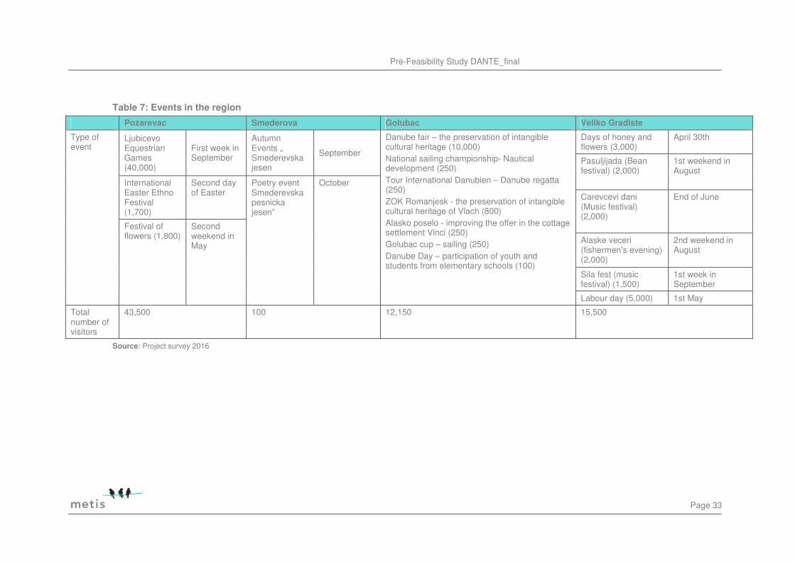
Events
The main attractions for national tourism are humorous events located in all of the four municipalities. These events provide a high share of the overnight stays statistically registered. Events are starting during eastern and reach out till October. However those events are promoted beyond the national borders and attract international visitors. While Pozarevac have more cultural events Golubac focuses on sports and Veliko Gradiste on music and food. The two most outstanding events are the Ljubicevo Equestrian Games with a long tradition of 50 years. The second most important event is the Danube fair. However both events are not adequately published in the internet in order to reach potential visitors abroad.
Pre-Feasibility Study DANTE_final
Page 33
Table 7: Events in the region
Pozarevac Smederova Golubac Veliko Gradiste
Type of event
Ljubicevo Equestrian Games (40,000)
First week in September
Autumn Events „ Smederevska jesen
September
Danube fair – the preservation of intangible cultural heritage (10,000) National sailing championship- Nautical development (250) Tour International Danubien – Danube regatta (250) ZOK Romanjesk - the preservation of intangible cultural heritage of Vlach (800) Alasko poselo - improving the offer in the cottage settlement Vinci (250) Golubac cup – sailing (250) Danube Day – participation of youth and students from elementary schools (100)
Days of honey and flowers (3,000)
April 30th
Pasuljijada (Bean festival) (2,000)
1st weekend in August
International Easter Ethno Festival (1,700)
Second day of Easter
Poetry event Smederevska pesnicka jesen”
October
Carevcevi dani (Music festival) (2,000)
End of June
Festival of flowers (1,800)
Second weekend in May
Alaske veceri (fishermen’s evening) (2,000)
2nd weekend in August
Sila fest (music festival) (1,500)
1st week in September
Labour day (5,000) 1st May
Total number of visitors
43,500
100 12,150 15,500
Source: Project survey 2016
Page 34
Summary and conclusion
The diversity of attractions in the region does have potential for national and regional tourism. The utilisation of the river as well as the archaeological sites still has room for improvement. However although the archaeological sites are of high value the main attraction addressing most of the potential visitors is the nature and the Danube itself. The access to waterfronts and sport activities leads to economically valuable tourism. Events as they have been already established are very effective in promoting the region and increasing visitor numbers. The variety of different events has a high value and should be continued. However the publicity of the events is limited to Serbia but does not reach potential tourists abroad.
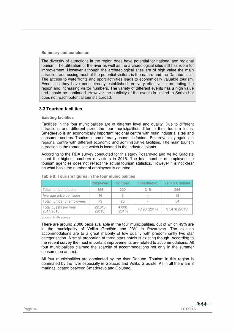
3.3 Tourism facilities
Existing facilities
Facilities in the four municipalities are of different level and quality. Due to different attractions and different sizes the four municipalities differ in their tourism focus. Smederevo is an economically important regional centre with main industrial sites and consumer centres. Tourism is one of many economic factors. Pozarevac city again is a regional centre with different economic and administrative facilities. The main tourism attraction is the roman site which is located in the industrial plants.
According to the RDA survey conducted for this study Pozarevac and Veliko Gradiste count the highest numbers of visitors in 2015. The total number of employees in tourism agencies does not reflect the actual tourism statistics. However it is not clear on what basis the number of employees is counted.
Table 8: Tourism figures in the four municipalities
Pozarevac Golubac Smederevo Veliko Gradiste
Total number of beds 456 220 315 966
Average price per room 16 6 4 18
Total number of employees 73 25 - 54
Total guests per year 2014/2015
22,315 (2015)
4,000 (2014) 4,190 (2014) 37,476 (2015)
Source: RRA survey
There are around 2,000 beds available in the four municipalities, out of which 49% are in the municipality of Veliko Gradište and 23% in Pozarevac. The existing accommodations are to a great majority of low quality with predominantly two star categorisation. A small proportion of three stars hotels is existing though. According to the recent survey the most important improvements are related to accommodations. All four municipalities claimed the scarcity of accommodations not only in the summer season (see annex).
All four municipalities are dominated by the river Danube. Tourism in this region is dominated by the river especially in Golubac and Veliko Gradiste. All in all there are 8 marinas located between Smederevo and Golubac.

Pre-Feasibility Study DANTE_final
Page 35
Table 9: existing marina facilities between Smederevo and Golubac
Km Danube
Name facilities Infrastructure
Service Address
1115.2 R Smederevska Tvrdjava
Dock to dock mooring depth 2-5 m, guard service 00-24h, waste service
Electricity (220V), water
Ship engine, outboard engine, fibreglass hull metal hull
na ušću Jezave 11,300 Smederevo
1108.5 L Kovin Mooring area, restaurant
1094.8 R Kostolac Mooring area, Dunavac yacht club, restaurant
1070.0 R Lederata Mooring area, restaurant Cara Lazara 1 12209 Ram
1062.0 R Srebrno Jezero
Dock to dock mooring depth 1 m, guard service 00-24h, waste service
Electricity (220V), water
Ship engine, outboard engine, fibreglass hull metal hull
Beli bagrem b.b 12,220 Veliko Gradište
1061.0 R Silver Lake
Mooring area, restaurant, Hotel (**) Mooring details: an pontoon bridges, depth 3-5m, beside the shipping route, sheltered from wind Security service 00-24h, waste service
Electricity (220V), water Fuel
Ship engine, outboard engine, fibreglass hull metal hull
Marina Silver Lake Beli Bagrem b.b. 12,220 Veliko Gradište
1054,5 R Alaske Zore Restaurant, guest docks, Service
Požeženo Dunavska b.b. 12,220 Veliko Gradište
1042,0 R Golubac
Mooring area, fuel station, restaurant, Hotel (**) Mooring details: an pontoon bridges, depth 1,5-4,5m, beside the shipping route, sheltered from wind Security service 00-24h, waste service
Electricity (220V), water Fuel
Adam Komerc C. Dušana b.b. 12,223 Golubac
Source: Entdecke die Donau in Serbien, Praktische Informationen, 2010

Page 36
According to the 2007 master plan of touristic destinations in Serbia the total tourist traffic based on numbers of overnight stays related to nautical amounted 1,000 in 2006. This represents less than 1% of total recorded tourist traffic. According to the master plan the reason for this low number is the lack of basic infrastructure. 2006 none of the marinas have been equipped with electricity, water and fuel connections without any possibility to rent a boat and no accommodation within the marina. All existing facilities lack additional services (services for maintenance of boats, possibility of buying equipment for vessels, etc..). This has been changed to a certain extend but there are still quality gaps especially regarding accommodation and boat rental services.
The construction of port and marina facilities seems to be one of the most important objectives of all four municipalities. A recent state subsidy allows the construction/restaurateur of four marinas in the four municipalities. Without the planned marinas the capacity of the existing marinas is estimated for around 70 boats plus mooring places for another approximately 200 boats. Smederevo is the only city with a commercially valuable port. Passenger docks for cruise ships are available in Kostolac which is directly aside the local airport Kostolac and Veliko Gradiste with a fuel station aside.
None of the cities and municipalities has a service dock. However at the entrance of the National park Đerdap there is a private service dock.
Table 10: Existing and planned docks and marinas
Existing nautical infrastructure In development
Municipality Port Passengers dock
Mooring places
Marina Services (e.g. boat repair)
Marina Passengers dock
Smederevo Cargo port Old port – 750,000 t/year New port – 1.5 mil t/year
NA Approx. 150 small boats
NA NA For tourist and international ships
Approx. 150 medium and small boats
Pozarevac NA Approx. 70 NA Max 30 NA
Golubac NA NA YES YES NA Up to 100 boats
river cruise ship
Veliko Gradiste
NA YES 25 20 NA 100 m2
Source: Project survey 2016
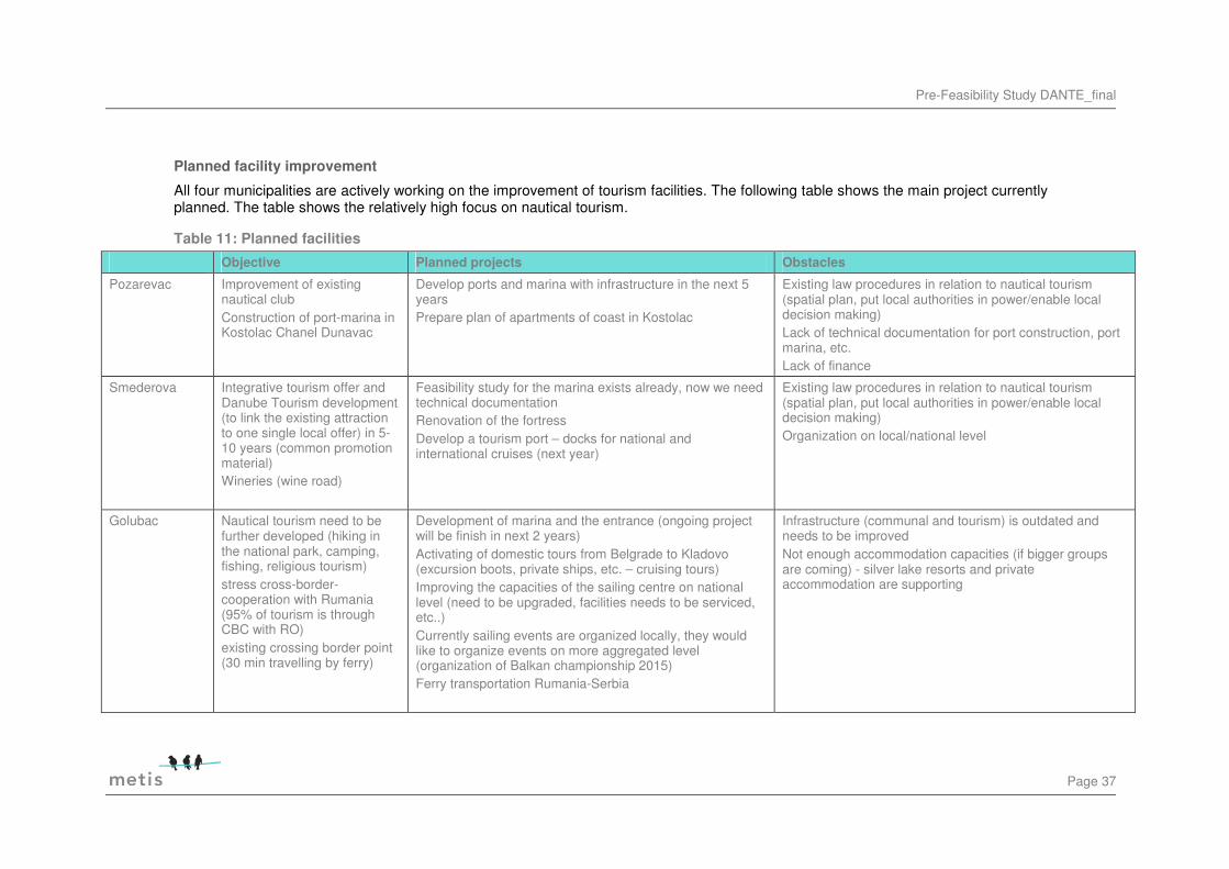
Pre-Feasibility Study DANTE_final
Page 37
Planned facility improvement
All four municipalities are actively working on the improvement of tourism facilities. The following table shows the main project currently planned. The table shows the relatively high focus on nautical tourism.
Table 11: Planned facilities
Objective Planned projects Obstacles
Pozarevac Improvement of existing nautical club Construction of port-marina in Kostolac Chanel Dunavac
Develop ports and marina with infrastructure in the next 5 years Prepare plan of apartments of coast in Kostolac
Existing law procedures in relation to nautical tourism (spatial plan, put local authorities in power/enable local decision making) Lack of technical documentation for port construction, port marina, etc. Lack of finance
Smederova Integrative tourism offer and Danube Tourism development (to link the existing attraction to one single local offer) in 5-10 years (common promotion material) Wineries (wine road)
Feasibility study for the marina exists already, now we need technical documentation Renovation of the fortress Develop a tourism port – docks for national and international cruises (next year)
Existing law procedures in relation to nautical tourism (spatial plan, put local authorities in power/enable local decision making) Organization on local/national level
Golubac Nautical tourism need to be further developed (hiking in the national park, camping, fishing, religious tourism) stress cross-border-cooperation with Rumania (95% of tourism is through CBC with RO) existing crossing border point (30 min travelling by ferry)
Development of marina and the entrance (ongoing project will be finish in next 2 years) Activating of domestic tours from Belgrade to Kladovo (excursion boots, private ships, etc. – cruising tours) Improving the capacities of the sailing centre on national level (need to be upgraded, facilities needs to be serviced, etc..) Currently sailing events are organized locally, they would like to organize events on more aggregated level (organization of Balkan championship 2015) Ferry transportation Rumania-Serbia
Infrastructure (communal and tourism) is outdated and needs to be improved Not enough accommodation capacities (if bigger groups are coming) - silver lake resorts and private accommodation are supporting

Page 38
Objective Planned projects Obstacles
Veliko Gradiste Instalment of a marina, activation of local rafting Increase the capacity of the sailing centre, see port
They start to explore the thermal water (inspection needs to be done from March 2016 onwards) Construct a marina over the next 5 years in the city (for small boats) Will apply for the current CBC call for development of these ports 200 hectares of land at silver lake to be used for tourism purposes (not yet defined)-developed technical documentation for infrastructure reconstruction of fortress Ram(ongoing) swimming pools with thermal waters (midterm, 5 years) Small boats from Veliko Gradiste to Moldova Nova in Romania-on going project
financial constraints, in particular pre-financing bureaucracy processes involving national bodies (very long processes) 15% municipality and other funders
Source: Project survey 2016

Pre-Feasibility Study DANTE_final
Page 39
Summary and conclusion
There is a high density of marinas and mooring stations along the Danube between Smederevo and Golubac of which at least three allow for bigger ships to dock. However the quality of the marinas is of different state and at least some seem to be of low quality. A recent state subsidy allows for construction and renovation of marinas. Notwithstanding the necessity a need assessment and a joint strategy are missing is based on the 2007 master plan which needs to be updated. The current parallel existence of different facilities does not seem to follow a stringent master plan and could lead to substantial competition in the region. All four municipalities are lacking all season tourism. The main reason named is lack of adequate facilities. The main obstacles are adequate accommodations in all four municipalities. However there are different levels of needs. While Veliko Gradiste does have a relatively good facilitation Golubac has only view hotels with low quality. Given the fact that Golubac has access to the national park and lies directly at the lake like expansion of the Danube with its sailing possibilities the lack of accommodations is particularly harmful.
3.4 Main competition
Main competitive sites are rural areas, lake sites, natural reserves and archaeological sites. Additional facilities such as Spas or other recreation facilities extra services which add value to a certain destination. Figure 7 below shows the most important cultural and natural areas in Serbia. From this map it is evident that the region cannot compete with the rest of Serbian in importance of cultural sites. Rather more the region should emphasize the connection to natural resources available, most of all the Danube and the national park. On the other side the region is well accessible from the main cities of Serbia.
Serbia locates 68 marinas only along the Danube, manages five natural parks and 17 archaeological sites of highest importance and 23 spas. The main competition regarding nautical tourism in Serbia is Belgrade and Novi Sad with numerous cruise ship agencies and private yacht clubs (see Figure 6).

Page 40
Figure 6: Tourism sites in Serbia
Source: own adaptation

Pre-Feasibility Study DANTE_final
Page 41
Figure 7: Tourism in Serbia
Source: http://www.rapp.gov.rs/en-GB/content/cid310/spatial-plan-for-the-republic-of-serbia

Page 42
3.5 Institutional framework
The tourism development in the region is supported by the elaboration of 3 Master Plans regarding the Braničevski district and the tourist destinations „Lower Podunavlje“, „Stig-Kučajske Mountains-Beljanica“ and cultural-historical routes “Road of Roman Emperors Felix Romuliana” which were adopted by the Government of Serbia.
There exists an extensive network of tourist organisations set by all 11 municipalities but their operation and coordination is poorly structured or non-existent. In 2006 tourism and restaurants provided only 1.020 jobs in the region which is a decline of one third comparing to the year 2000. Furthermore, according to official statistics in 2013, the sector of accommodation and catering services in BP region employed only 519 persons presenting a share of 2,6% of employees at national level46.
The main institutional framework is shown in Table 12. The actual communication and coordination between the organisations is not clear.
Table 12: Institutional framework related to nautical tourism
Institutions
NATIONAL Serbia Water Hydro Electrical plant Directory for Waters Directory for Water ways Agency for Port management Ministry of Transport Ministry of Trade, Tourism and Telecommunications Ministry of Construction, Infrastructure (spatial planning and legal approval) TOS (Tourism Organisation of Serbia – responsible for development and implementation of tourism strategy including promotion and marketing) Serbian Chamber of Commerce Ministry of Sports Ministry of Culture Sport unions (National sailing, rowing, etc. unions: main organizers of sport events (was founded by Ministry of Sports) NATUS (National Association for development of nautical tourism)
REGIONAL RDA BP (Regional Development Agencies Branicevo-Podunavlje) founded by municipalities Regional chamber of commerce founded by businesses Monument protection bureau (responsible for production of cultural attractions)
LOCAL Municipalities with all their departments Touristic organisations Construction
46 Statistical Office of the Republic of Serbia, Yearbook Municipalities and Regions in RS 2014

Pre-Feasibility Study DANTE_final
Page 43
Strengths Weaknesses
• Heritage of monuments of different cultures, high value archaeological sites
• Natural resources • National park attraction • Proximity to Belgrade and Novi Sad
• Active tourism agency with a strong will to cooperate and a positive attitude of the population of Serbia towards tourism
• Natural products • Wine production
• Geographical position of the region at the borders of several historical cultural sides
• Great unused potential of underground and surface waters,
• Untouched vastness of mountains, forests, agrarian regions,
• Exceptional biosphere
• High level of air and waste pollution • Heavy industry and touristic sites are conflicting
• Limited access to the tourism locations, road and rail infrastructure of low quality
• Accommodation quality and capacity are low with the exception of Velko Gradiste
• Lack of generally accepted regional vision of tourism • Lack of clear structure of responsibilities
• inadequately articulated and established spatial - urban regulations in the majority of the present and potential tourist destinations and/or centres,
• Inadequate protection and maintenance of the main national natural and cultural resources/attractions, uncontrolled "wild" construction activities, and the lack of law enforcement, of control and sanction policies regarding the incidents in the field of environment (wild dumps);
• Inadequate awareness and/or understanding of the importance of the system of tourist experiences and of the establishment of a complete value chain in the majority of the present products of Serbian tourism;
• Lack of internationally qualified hotel and tourist managers and of personnel in new tourist professions 47
Opportunities Threats
• Trend to tourism in South- East Europe • Trend of biking and hiking tourism along the Danube • Trend to eco tourism and natural products • Improvement of Serbian economic situation
• Back to European tourism due to the critical situation in many international tourist destinations.
• Search for hidden places and locations
• Environmental pollution • Economic down sizing
• Lack of cooperation between municipalities and organisations.
• Uneconomic investments in strategically unessential facilities • Decrease of overnights stays in the area • Terrorism • Environmental pollution by industry
• Lack of adequate implementation of environmental protection acts
• European Union financial crises • Political instability
47 Sustainable Tourism Working Group, Assessment Criteria for National Tourism Development, Strategies,
2013
4 SWOT analysis
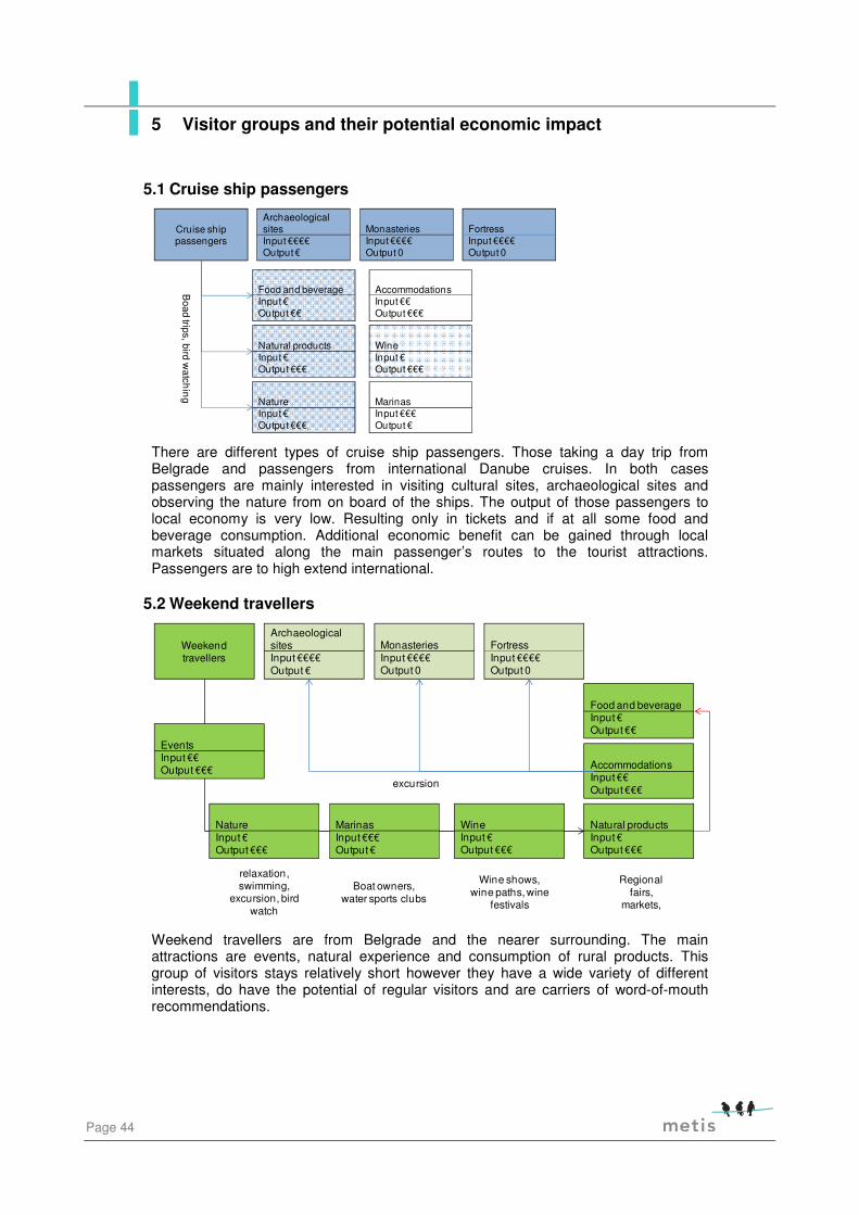
Page 44
5.1 Cruise ship passengers
There are different types of cruise ship passengers. Those taking a day trip from Belgrade and passengers from international Danube cruises. In both cases passengers are mainly interested in visiting cultural sites, archaeological sites and observing the nature from on board of the ships. The output of those passengers to local economy is very low. Resulting only in tickets and if at all some food and beverage consumption. Additional economic benefit can be gained through local markets situated along the main passenger’s routes to the tourist attractions. Passengers are to high extend international.
5.2 Weekend travellers
Weekend travellers are from Belgrade and the nearer surrounding. The main attractions are events, natural experience and consumption of rural products. This group of visitors stays relatively short however they have a wide variety of different interests, do have the potential of regular visitors and are carriers of word-of-mouth recommendations.
Cruise ship passengers
MarinasInput €€€Output €
Food and beverageInput €Output €€
AccommodationsInput €€Output €€€
Natural productsInput €Output €€€
WineInput €Output €€€
NatureInput €Output €€€
Archaeological sitesInput €€€€Output €
MonasteriesInput €€€€Output 0
FortressInput €€€€Output 0
Boad
trips, birdw
atchin
g
Weekend travellers
Archaeological sitesInput €€€€Output €
MonasteriesInput €€€€Output 0
FortressInput €€€€Output 0
MarinasInput €€€Output €
Food and beverageInput €Output €€
AccommodationsInput €€Output €€€
Natural productsInput €Output €€€
WineInput €Output €€€
NatureInput €Output €€€
relaxation, swimming,
excursion, bird watch
Boat owners, water sports clubs
Wine shows, wine paths, wine
festivals
Regional fairs,
markets,
excursion
EventsInput €€Output €€€
5 Visitor groups and their potential economic impact
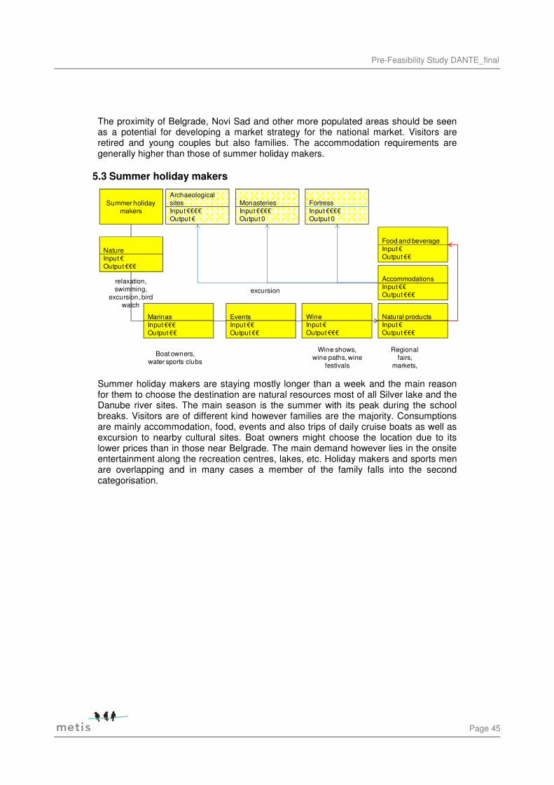
Pre-Feasibility Study DANTE_final
Page 45
The proximity of Belgrade, Novi Sad and other more populated areas should be seen as a potential for developing a market strategy for the national market. Visitors are retired and young couples but also families. The accommodation requirements are generally higher than those of summer holiday makers.
5.3 Summer holiday makers
Summer holiday makers are staying mostly longer than a week and the main reason for them to choose the destination are natural resources most of all Silver lake and the Danube river sites. The main season is the summer with its peak during the school breaks. Visitors are of different kind however families are the majority. Consumptions are mainly accommodation, food, events and also trips of daily cruise boats as well as excursion to nearby cultural sites. Boat owners might choose the location due to its lower prices than in those near Belgrade. The main demand however lies in the onsite entertainment along the recreation centres, lakes, etc. Holiday makers and sports men are overlapping and in many cases a member of the family falls into the second categorisation.
Summer holiday makers
MarinasInput €€€Output €€
Archaeological sitesInput €€€€Output €
Food and beverageInput €Output €€
MonasteriesInput €€€€Output 0
FortressInput €€€€Output 0
AccommodationsInput €€Output €€€
Natural productsInput €Output €€€
WineInput €Output €€€
NatureInput €Output €€€
excursionrelaxation, swimming,
excursion, bird watch
Boat owners, water sports clubs
Wine shows, wine paths, wine
festivals
Regional fairs,
markets,
EventsInput €€Output €€

Page 46
5.4 Sportsmen
Sportsmen are all those visitors whose main aim is a specific type of sport in the region. These can be fishing, hiking, biking, sailing, surfing etc. For this group of visitors the marina has a high value. However sports men characteristically have a high demand on additional services starting from sport event management, purchase specific sport articles, repair shops, recreation possibilities and boat rental. Services can combine boat rental as well as servicing boats in ownership. Again the main competitive value here is the optimal price-service ratio compared to other marinas. The season for water and natural park sports is generally longer than the summer and can last from eastern to September/October. Many sport interested visitors are travelling with their family which causes an overlap with the previous visitor group.
5.5 Business travellers
Sports men
MarinasInput €€€Output €€€
Food and beverageInput €Output €€
AccommodationsInput €€Output €€€
NatureInput €Output €€€
Boat owners, sailing,
kayaking, fishing
Biking, hiking
Summer holiday makers
Archaeological sitesInput €€€€Output €
Food and beverageInput €Output €€
WineInput €Output €€€
EventsInput €€Output €€
AccommodationsInput €€Output €€€
Natural productsInput €Output €€€
Local businessInput €Output €€€
excursion
Regional fairs, markets,

Pre-Feasibility Study DANTE_final
Page 47
Business travellers are the most underestimated group of travellers. Their demand on accommodations and food is generally high. However the potential lies in them recognising the value of the region for private travelling. Therefore this group should not be forgotten when it comes to promote the attractions of the region.
Summary and conclusions
There are five main types of visitors of different interest and economic impact. When comparing the interests and the economic input and outcome the least valuable visitors are those of international cruise ships. Their output is generally low because of limited consumptions and no overnight stays. The highest value do have weekend travellers, and sportsmen mainly because of the long season those groups are potential visitors and because of the variety of interests. Summer holiday makers are of similar importance with a shorter seasonal period of stay. In all those cases nautical tourism is only one part of the spectrum those visitor groups are addressing. Therefore the focus needs to be much broader adding different services to the nautical facilities and improving accommodation and restaurants. The different events which are already in place are important for all three visitor groups. Business travellers can be seen as a value added for the region. The indirect benefit of those travellers is promoting the region directly. However business travellers have in general a high demand in the quality of accommodations and restaurants. The emotional feeling could lead to private recommendations or private travels to the region.

Page 48
In 2014, the region attracted around 20.000 tourists and provided 67.000 overnight stays. This represents approximately 2% of Serbian totals tourism statistic. The region has high potential due to its approximate to Belgrade and to some extend Novi Sad, its good access by high-level road connections and the location along the Danube river. The region however is not homogeneous rather than departed in two main economic characteristics. One is characterised by heavy industry mainly located in Pozarevac and Smederevo. The other part is much more focusing on tourism along the Danube. The outstanding statistic in respect to tourism is shown in the case of Veliko Gradiste which has the benefit to be located along the Silver Lake and provides a frequently located cruise ship dock with fuel station. However the region comprising the four municipalities Pozarevac, Smederevo, Veliko Gradiste and Golubac do have less capitalised areas which still have a high potential to rise.
From the point of visitors the whole region is one destination and only with joint effort all the municipalities will gain benefit from visitor consumption.
In this respect a holistic and participative tourism concept is of need which does not focus only on one particular area of tourism. The general focus on nautical tourism in this respect cannot be seen as feasibility in order to capitalise the economic value of the region as such. The study has shown in some detail what kind of attractions are already existing and what the main obstacle to better generate profit are.
The highest benefits of the region are the natural resources regarding mountains, the Danube and Silver Lake. The service already in place comprises accommodation of an adequate standard only along Silver Lake. The most effective activities in order to attract visitors are the already existing events.
On the opposite site are a vast lack of standard accommodations in three of four municipalities, a highly problematic environmental pollution status which is visible at all sites in the region and a lack of attractive services such as tours, rental facilities, marina services or tour services.
The region cannot exist without strong cooperation with other national sites in order to promote its location nationally. The main visitors from the nearer surrounding including Belgrade should stay in the main focus.
Target group statistics should be conducted in order to understand which groups have an economic impact in order to better specialise and invest more effectively. The study already has made some assumption based on little data evidences.
A marketing concept addressing for example the rural-eco tourism has been already proposed and should be considered again. The concept allows for a holistic picture of the region with a form of unique selling proposition. The current focus on marinas does not reflect the existing competitive situation along the Danube with a high number of marinas much nearer to Belgrade. The only added value of marinas in the region could be held with low prices which do not enable economic benefit in the long run.
Beside the high value tourism attraction rural tourism as such has to be better positioned. Market strategies combining high valued cultural heritage with eco tourism and natural products can be elaborated. Some products are already visible. In order to support this development tourism development needs establish links to business development in the region. Rural tourism development is not an easy task. It is not something which is only based on the development on tourism attractions. Good planned and build up tourist infrastructure is needed, too.
6 Conclusions and recommendations

Pre-Feasibility Study DANTE_final
Page 49
The natural and cultural heritage should be embedded in adequate infrastructure and integrated tourism packages. This requires a strong and educated tourism agency network. With other words there is a need to increase the number of stuff and to improve the specialisation of stuff members related to tourism.
High gloss brochures available for tourism promote a network of events across the region and beyond. The brochures present a united picture of the region however there is no actual joint undertaking in the region. The lack of a joint marketing and tourism strategy leads to parallel activities and competitive projects. The latest example is the marina investment in each of the four municipalities. The investment lacks a need analysis but leads to a competitive situation between the four future marinas. There are no serious statistics justifying the investment.
Quotations of other studies
Rural tourism can bring expected effect on local economy. At the same time, local community supposed to be ready to accept tourism and tourists and be ready to learn how to develop their environment in order to constantly improving given tourist products. Local community should be cooperative and in one moment to take over the leader role in rural tourism development.48 Nautical tourism as such is not the solution. A combination of rural tourism, natural attraction combined with natural products. Labelling the area as agro eco tourism area with access to river and lakes could be a marketing strategy. 49
Main attractions in the region
The region’s main attraction lies in the location along the river and the entrance to the national park Djerdap and the archaeological site of Viminacium. However this alone does not serve the increase of visitor numbers. Active service supply and attractions such as events are suitable. Some examples of thematic services which can be developed by tourist agencies in cooperation with Belgrade and international agents:
• Excursions by boat – photo tourism
• Agencies directly addressing visitors
• Boat rental services and other services related to nautical tourism.
• Natural production such as food and wine should be subsidies and promoted – food tourism
• Hunting, fishing, sailing, kayaking and other sport facility services,
• Biking or hiking combined with water taxi services
48 Evaluation of sustainable rural tourism development in Serbia, JOVANOVIC Verka, MANIC Emilija, 2012 49 Chapter ii rural tourism in the Danube region of the republic of Serbia – comparative experiences and
development perspectives 32 Drago Cvijanovi ć , Predrag Vukovi ć

Page 50
International tourism
Serbia has a high number of different very attractive natural and archaeological sites. This makes the whole country a very interesting destination for international visitors. International visitors come either via cruise ships along the Danube or visit different sites along the road. Cruise ship tourism does not have high economic impact in the region due to the short visits and the lack of consumption off board.
Individual or group tourism through Serbia are of higher value and should be targeted. To reach these tourists it is necessary to be embedded in a Serbian wide network for tourism. The region needs to get promoted in international travel guides and agencies. The USP (unique selling proposition) has to be better defined and developed.
Cooperation with Beograd and other national cities
The proximity to Beograd is never a threat. Belgrade does not compete with the region rather than offers a different and already internally valued tourist destination. The fact that international tourism is attracted is a chance for the nearby regions and it depends on the presence of marketing strategies to reach them as well as domestic citizens most effectively.
Main actions to be undertaken
The following requirements are recommended in order to better position the region in terms of tourism:
Strategy development
• Marketing strategy for the whole region as already indicated in the development strategy 2009-2013.
• Focus on USB development based on a joint development process within the region and together with Belgrade.
Infrastructure improvement
• Waste management in the region needs to be improved. The region is still in a very poor condition.
• The industrial site is very dominant and needs to be better integrated in tourism strategies in order to be less distracting.
• The village around the industrial site in Pozarevac needs to be improved in terms of infrastructure and housing. The poverty of the village has a disturbing effect on tourists.
• Better access to main attraction with public as well as private transport facilities.
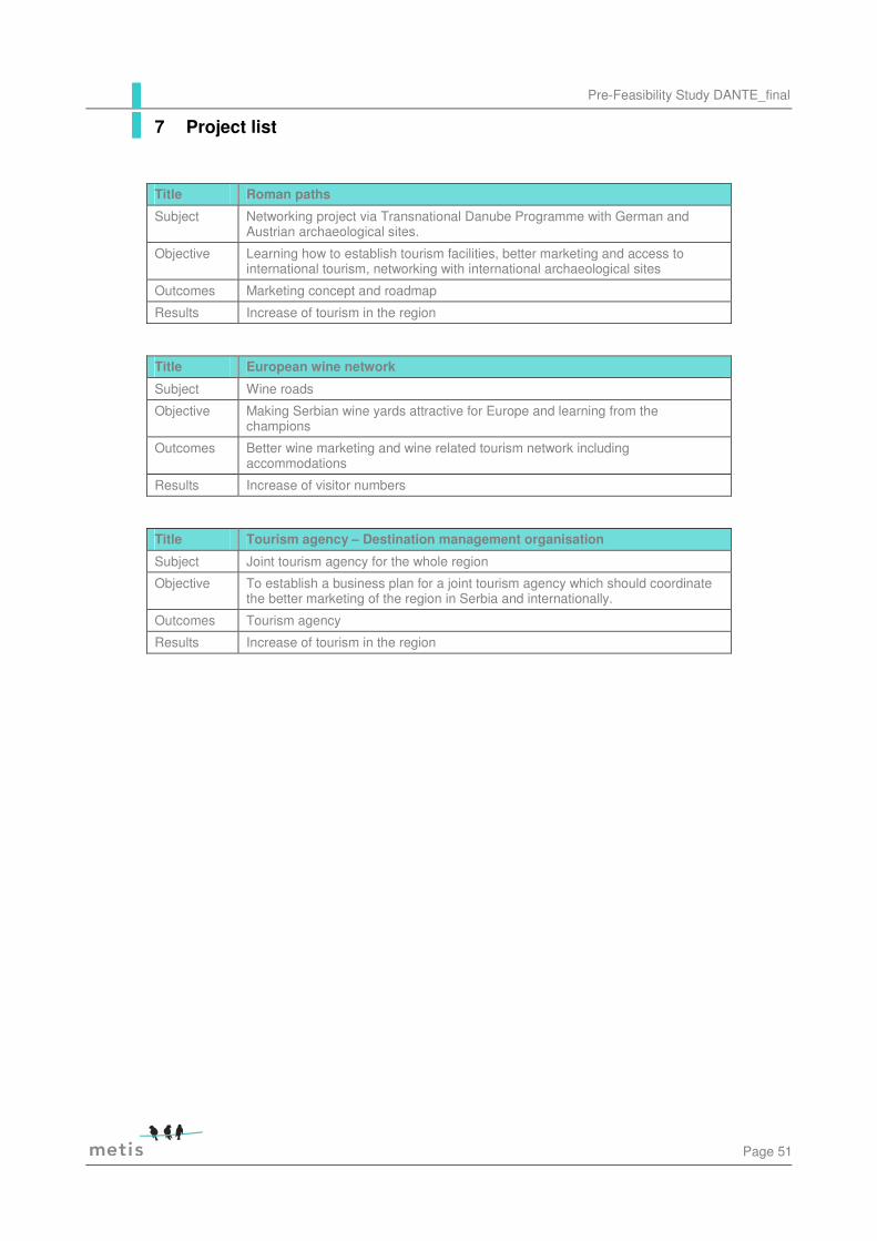
Pre-Feasibility Study DANTE_final
Page 51
Title Roman paths
Subject Networking project via Transnational Danube Programme with German and Austrian archaeological sites.
Objective Learning how to establish tourism facilities, better marketing and access to international tourism, networking with international archaeological sites
Outcomes Marketing concept and roadmap
Results Increase of tourism in the region
Title European wine network
Subject Wine roads
Objective Making Serbian wine yards attractive for Europe and learning from the champions
Outcomes Better wine marketing and wine related tourism network including accommodations
Results Increase of visitor numbers
Title Tourism agency – Destination management organisation
Subject Joint tourism agency for the whole region
Objective To establish a business plan for a joint tourism agency which should coordinate the better marketing of the region in Serbia and internationally.
Outcomes Tourism agency
Results Increase of tourism in the region
7 Project list

Page 52
Table 13: Workshop project development
Pre-Feasibility Study DANTE_final
Page 53
Danube navigation
Description The Danube always has been a major attraction for tourists. Important tourist and natural spots along the Danube include the Naturpark Obere Donau in Germany, the Wachau Valley and the Donau-Auen National Park in Austria, the Danube Bend and Gemenc in Hungary, Kopački rit in Croatia, Iron Gates in Serbia and Romania, the Srebarna Nature Reserve in Bulgaria and the Danube Delta in Romania.
The Danube and its various regions are particularly charming when viewed from a ship. Leisure and travel cruises on the river are of significance. Besides the often frequented route between Vienna and Budapest, some ships even go from Passau in Germany to the Danube Delta and back. During the peak season, more than 70 cruise liners are in use on the river.
Also, one of the major attractions, the scenic Danube Cycle Path, is a bicycle trail along the Danube. It begins in the foothills of the Black Forest in Donaueschingen and continues over 2875 km all the way to the Black Sea in Romania. When cyclists need a break from pedalling, they can load their bicycles onto a ship (bikes are carried free of charge on most Danube liners). Cruise guests can also make land excursions by bike, as rentals are available at many locations.
In Austria for instance, every Sunday in high season, the old-fashioned paddle steamer MS Stadt Wien takes off from Tulln to the Wachau. There are several connections from Vienna in the direction of Bratislava. For a special adventure, tourists might try a tour going downstream on the Wachovia, a ten-meter long vessel modelled on an historical ship. A sporty alternative is a ride in a Zille, a flat-bottomed boat common to this region. The many ferries are a fun way to cross the river and explore perhaps the less well-known side of the Danube.
For hikers, the Sultans Trail runs along the Danube between Vienna and Smederevo, wherefrom the trail leaves the river. The 450 kilometres long Donausteig is a hiking trail from Passau in Germany to Grein in Upper Austria. The route passes five Bavarian and 40 Austrian communities. Along the way a great variety of information services (like the free Donausteig app, brochures or interactive hiking maps), accommodations and gastronomy facilities or other adventures (for instance helicopter rides, rafting, parasailing, ballooning, Motocross or cave trekking) are offered.
Visitors Millions of tourists along the Danube River throughout the seasons. E.g. the Twin City Liner between Vienna and Bratislava counted more than 128.000 passengers in 2015.
Events Events include:
• Seasonal theme cruises • Shore side events like themed festivals
Possible links to the
Key success factors which could be beneficial for the nautical tourism in
8 International examples

Page 54
region the whole region:
• Danube navigation in combination with biking and hiking • A great variety of additional offers and adventures • The integration of public transport facilities, like the possibilities
of using train, bus and ship along the hiking trail • Information via different sources: Apps, brochures, online
maps... • Sustainable eco-tourism can be of benefit to all: the region, its
inhabitants, its visitors and its biodiversity. It can bring small groups close to nature and create local income, but it also needs monitoring and guidance. Cooperation with companies helps work towards the goal of a greener tourism model. The Danube-Drava National Park, for instance, has received the largest charitable donation for environmental protection in Hungary to date. Coca-Cola Hungary donated nearly €95,000 to boost eco-tourism and improve the water quality in the area.
• Excursion program for children and school groups
Sources and further information
http://www.donau.com/en/the-danube-in-lower-austria/outings-activities/excursion-destinations/ships-ferries/
http://www.danubeparks.org/?story=12
http://www.donauregion.at/en/hiking-at-the-donausteig.html
https://www.icpdr.org/main/publications/danube-rivers-lure
https://www.ooe-adventures.at/
http://www.twincityliner.com/en
http://www.donauauen.at/besucherinfo/exkursionsprogramm-kindergruppen-schulklassen/
Xanten
Description Xanten is located in Germany on the left bank of the Rhine River, 65km north of Düsseldorf, 50km north of Duisburg, and 50 south-east of Nijmegen, in the Netherlands. The two main reasons to visit Xanten are the ruins of the Roman city and St. Victor's Cathedral.
1. Xanten Archaeological Park (Archaologischer Park Xanten) houses the remains of the former Roman settlement of Colonia Ulpia Traiana. The area of the park was first garrisoned by Roman legions in around 13 BC and soon flourished.
Most of the buildings in Xanten Archaeological Park date back to the second century AD, when great building projects were undertaken. By this time, the colonia had a population of around 10,000 people and was a great agricultural hub. However, it was utterly destroyed by the Germanic Franks in the third century and, despite final attempts to breathe life back into the settlement, including further fortification, it was abandoned by the fourth century.
At 73 hectares, Xanten Archaeological Park is now Germany’s largest

Pre-Feasibility Study DANTE_final
Page 55
outdoor museum and one of the largest archaeological open air museums in the world. With its mixture of ruins and reconstructed sites it offers much to see, for instance temples, homes, an amphitheatre, a city wall, a baths complex and an inn. There is also a museum housing finds from excavations.
Overall, Xanten Archaeological Park offers an insight into life in this Roman settlement; you can even dress up like a Roman. The Archaeological Park is at the same time a centre of high-calibre research and a fun place to relax and play games.
2. St. Victor's Cathedral (St. Viktor Dom in German) is the biggest cathedral between Cologne and the North Sea. It was built between 1263 and 1544 in the flamboyant Gothic style. The richly decorated interior is a witness of Xanten's medieval wealth. There are as many as 15 altars. In 1937, Pope Pius XI elevated it to the rank of "minor basilica". The Regional Museum, which is in fact an archaeological and historical museum, is just outside the cathedral.
Visitors Xanten is visited by approximately one million tourists a year.
Events Big events include:
• The Xantener Sommerfestspiele (a prestigious classical music festival lasting 2 weeks every summer)
• The annual Xantener Montmartre where artists from all over the world show their latest works
• The annual German sandcastle-building championship.
Possible links to the region
Key success factors which could be beneficial for Viminacium:
• A place for fun, e.g. “dress up like a Roman” • Big (different themed) festivals • Holiday packages • Combination with biking and hiking
Sources and further information
http://www.xanten.de/en/
http://www.eupedia.com/germany/xanten.shtml
http://www.apx.lvr.de/en/lvr_archaeologischer_park/archaeologischer_park.html
http://www.historvius.com/xanten-archaeological-park-1360/
http://www.travel1000places.com/visit/germany/52,Xanten-Archaeological-Park
Page 56
Carnuntum
Description The small town Carnuntum was once the most important Roman settlement in the province of Pannonia. Today, it is one of the tourism hubs of Lower Austria, despite of being located in a rather quiet corner of the country. Antique Carnuntum was founded as an army base for the 15th legion around 40 AD. Over the course of the decades that followed, Carnuntum developed rapidly, since the soldiers (a big economic factor) attracted other settlers and traders discovered the strategic location of Carnuntum.
It controlled both the Eastern border of the Imperium Romanum and had access to the "Amber Road". This important trade route connected the Baltic region with the Mediterranean. Only a few decades after the foundation of Carnuntum, the town became the capital of Upper Pannonia and reached a population of 50,000, which by far exceeds the town′s current number of residents.
Today, the village of Petronell-Carnuntum has grown around the Antique ruins. They are a subject of archaeological excavations for many decades (or centuries) and the Archaeological Park Carnuntum connects several of the most interesting sites. They are divided into three zones, Kernzone I, II and III. Kernzone I consists mostly of a museum for the key findings, Kernzone II of the former military camp and Kernzone III of the civil town.
The museum ("Archäologisches Museum Carnuntum") is actually outside the modern village and in the neighbouring Bad Deutsch-Altenburg. It is housed in a super-size Roman villa built in 1904. The civil town has little to show beyond foundations, but there are audio guides available for background information. The vivid presentation of the ancient Romans at the Archaeological Park Carnuntum and the new accessibility attract a great many of visitors in the three exhibition venues with the Open Air Museum Petronell, the Carnuntinum and the Amphitheater in Bad Deutsch-Altenburg.
Visitors 136,000 visitors within the first ten months in 2015, the target for 2015 was to reach 160.000 visitors.
Around a quarter of the visitors come from schools, three quarter are individual tourists, of which around 70% come from Austria, ten from Slovakia and the remaining 20% from 70 other nations. The modification to accessibility have created additional groups of visitors.
Events Big events include:
• Various Roman festivals where visitors can try themselves as a gladiator or test the life of a Roman legionary are particularly well received.
• Special events, such as the Roman delicacies and special theme tours as well as weddings in Roman style also showed an increasing attraction.
Pre-Feasibility Study DANTE_final
Page 57
• On the occasion of the 20th anniversary of the Operating Company in 2016 a three week Romans festival with activities in all three locations is planned. Priority will be to convey the life in ancient Carnuntum faithfully and easy understandable. Highlights include gladiator fights, Roman delicacies, crafts and an extensive children's program.
Possible links to the region
Key success factors which could be beneficial for Viminacium:
• “Real Roma-feeling” through the vivid presentation of the ancient Romans at the Archaeological Park Carnuntum
• Various events • Shuttle busses that run between the different sites or nearby
attractions • Accessibility
Sources and further information
http://www.carnuntum.at/de
http://www.tourmycountry.com/austria/carnuntum.htm
http://www.wirtschaftspressedienst.at/index.php?site=artikel_show&artikelid=11346&ausgabenr=1352#sthash.xn5wxoBW.dpuf
Styrian Wine routes
Description Styria is a state located in the southeast of Austria and is also called the ‘Green Heart’ of Austria because of its large forests throughout the province and inviting vineyards. Styria offers many activities and excursions such as hiking, skiing, castles, thermal spas and last but not lease an unrivalled wine growing area.
The term Styrian Wine roads was established by the market community “Styrian Wine” and these eight routes are among the most popular culinary destinations in Styria. Along this wine routes over 2000 winegrowers are settled. There are many taverns serving local products and wine. Wine connoisseurs and tourists can get to know the most important wine-growing villages with their diversity of landscape. Diversified marked hiking trails offer lots of rest and viewpoints and lead through the hilly landscape with its vineyards and forests.
The WINEmobil, the local taxi system connects the hotels, restaurants, Buschenschanken, private accommodation or wine growers.
Located in the Southern part of Styria, the Südsteirische Weinstrasse (South Styrian Wine Road) is often compared to Italy’s Tuscany. Of the 8 wine routes in Styria the South Styrian one is the oldest and most well-known. It is the most significant in Styria because of the length and because of the number of wine makers who live here. Whether you start in Ehrenhausen, Spielfeld or from the side of ‘vine land’ Leutschach you will travel through idyllic wine making towns and parishes.
Visitors The eight wine routes are among the most popular culinary destinations in Styria, for wine connoisseurs, walkers who love nature, food, and

Page 58
wine, and other tourists.
Events Events include:
• WINEspring • Storytelling Festival • Cultural and culinary exhibitions
Possible links to the region
Key success factors which could be beneficial for the BP region
• Creating a local brand with an image (Styrian Wine, South Styrian Wine route...)
• Local taxi system • Marked hiking trails with viewpoints, taverns... • Combination with thermal spas
Sources and further information
http://www.suedsteirischeweinstrasse.at/en/experience-weinstrasse/angebote/winespring/
http://www.sws.st/en/sws/regions-places/south-styria/the-south-styrian-wine-route/the-south-styrian-wine-route.html
http://www.steiermark.com/en
http://www.steiermark.com/en/styria/regions/styrian-spa-country
http://www.steirischerwein.at/styria-land-of-vineyards/
http://www.austria.info/us/where-to-go/provinces/styria

Pre-Feasibility Study DANTE_final
Page 59
See attached Annex II
9 Funding opportunity

Page 60
City Are there cases where accommodations are scarce?
If so, at what time and how many days a year?
Why are accommodations scarce because of availability of quality?
What else is missing to answer the current/future demands?
Pozarevac Yes – in Kostolac, there is lack of capacity due to one of two hotels is closed and one is in process of bankruptcy
First week in September, during manifestation Ljubičevo Equestrian Games
quantity Transportation of tourists to certain locations that are not well connected with city traffic in Pozarevac, primarily to Viminacium. Faster and easier way of finding the necessary tourist information. The introduction of new communication technologies, interactive whiteboard and marking locations and easy retrieval via smartphones Arrangement the town center (pedestrian zone).
Golubac Lack of accommodation facilities, needed better quality of accommodation
During the whole year
Investors, Quantity and Quality
Accommodation
Smederevo Yes During big events
Quantity. Lack of hotels for accommodation of larger number of visitors
Veliko Gradiste
Yes During summer, July/August
Increased number of tourists in summer and during the weekend
Lack of contents during the winter period - indoor swimming pool, spa facilities ATM missing on Silver Lake and more pedestrian trail
10 Annex I