Damage to foundations from swelling soil in Smara (Morocco ...
17
Journal of Earth Sciences and Geotechnical Engineering, vol. 2, no.2, 2012, 51-67 ISSN: 1792-9040(print), 1792-9660 (online) Scienpress Ltd, 2012 Damage to foundations from swelling soil in Smara (Morocco): geotechnical data and mitigation measures M. El Bakay 1 , A. Kchikach 1 , A. Abdelgheffar 2 , R. Guerin 3 , R. Hakkou 4 , H. Bouzahzah 5 Abstract The shrinkage-swelling behavior of the foundation layer in the urban perimeter of the city of Smara (Morocco), results in defects observed in the walls and partitions of public buildings, individual homes and city infrastructures. Since the shrinkage-swelling phenomenon is long-lasting and evolves slowly over time, these defects reappear, even after the damage has been repaired. The present study deals with the lithological, mineralogical and geotechnical characterization of the soil, with the aim of improving our understanding of the origins of its swelling characteristics and thereby adopting the necessary measures to limit the future appearance of defects in constructions. Granulometric analysis and determination of the Atterberg limits in the laboratory revealed that the clay fraction of the mudstone has only a weak potential to swell, which is insufficient to explain the soil's tendency to expand. X-ray diffractometry, together with the examination of several samples under a scanning electron microscope, revealed the presence of sulfate minerals (gypsum and anhydrite), which are known to experience significant changes in volume when hydrated or dehydrated. This soil's tendency to expand thus has its origins mainly in the transformation process of anhydrite into gypsum and vice versa, as a function of variations in its water content. Determination of the pressure modulus, the pressure yield point and the swelling pressure, based on in situ pressuremeter and rigid plate tests, allowed the deformability and state of rupture of the studied soil to be characterized. The measured values of swelling pressure are considerably greater than those transmitted to the ground by the foundations of existing 1 Equipe de recherche Génie Civil et Géo-Ingénierie (E2G), Université Cadi Ayyad, Marrakech, Maroc, [email protected] 2 Laboratoires Public d’Essais et d’Etudes, Agadir, Maroc 3 Université Pierre et Marie Curie, Paris 6, UMR 7619 Sisyphe, France 4 Research Chair in Management and Stabilization of Mining and Industrial Wastes, UCAM, Marrakech, Maroc 5 Université du Québec, Rouyn-Noranda, Québec, Canada
Transcript of Damage to foundations from swelling soil in Smara (Morocco ...

Journal of Earth Sciences and Geotechnical Engineering, vol. 2, no.2, 2012, 51-67 ISSN: 1792-9040(print), 1792-9660 (online) Scienpress Ltd, 2012
Damage to foundations from swelling soil in Smara (Morocco): geotechnical data and mitigation measures
M. El Bakay1, A. Kchikach1, A. Abdelgheffar2, R. Guerin3, R. Hakkou4, H. Bouzahzah5
Abstract
The shrinkage-swelling behavior of the foundation layer in the urban perimeter of the city of Smara (Morocco), results in defects observed in the walls and partitions of public buildings, individual homes and city infrastructures. Since the shrinkage-swelling phenomenon is long-lasting and evolves slowly over time, these defects reappear, even after the damage has been repaired. The present study deals with the lithological, mineralogical and geotechnical characterization of the soil, with the aim of improving our understanding of the origins of its swelling characteristics and thereby adopting the necessary measures to limit the future appearance of defects in constructions. Granulometric analysis and determination of the Atterberg limits in the laboratory revealed that the clay fraction of the mudstone has only a weak potential to swell, which is insufficient to explain the soil's tendency to expand. X-ray diffractometry, together with the examination of several samples under a scanning electron microscope, revealed the presence of sulfate minerals (gypsum and anhydrite), which are known to experience significant changes in volume when hydrated or dehydrated. This soil's tendency to expand thus has its origins mainly in the transformation process of anhydrite into gypsum and vice versa, as a function of variations in its water content.
Determination of the pressure modulus, the pressure yield point and the swelling pressure, based on in situ pressuremeter and rigid plate tests, allowed the deformability and state of rupture of the studied soil to be characterized. The measured values of swelling pressure are considerably greater than those transmitted to the ground by the foundations of existing
1 Equipe de recherche Génie Civil et Géo-Ingénierie (E2G), Université Cadi Ayyad, Marrakech, Maroc, [email protected] 2 Laboratoires Public d’Essais et d’Etudes, Agadir, Maroc 3 Université Pierre et Marie Curie, Paris 6, UMR 7619 Sisyphe, France 4 Research Chair in Management and Stabilization of Mining and Industrial Wastes, UCAM, Marrakech, Maroc 5 Université du Québec, Rouyn-Noranda, Québec, Canada
Damage to foundations from swelling soil in… 52
constructions in the city. In the present paper we discuss all of the results obtained and their practical implications.
Key words: Shrinkage-Swelling, Swelling pressure, Foundation, Damage, Smara city, Morocco
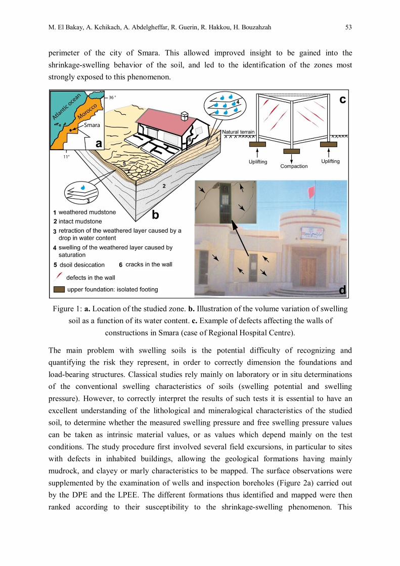
1 Introduction The shrinkage-swelling phenomenon of clays and some other geological formations leads to differential compaction, which can be noticed by the appearance of defects in buildings and structures. Within the urban perimeter of the city of Smara in south of Morocco (Figure 1a), this phenomenon is caused by the presence of swelling weathered mudrock, which in most cases represents the consolidated layer on which the city's foundations are laid. This has reached considerable proportions in recent years, as a consequence of a succession of periods of drought and rainfall, and has become a major concern for the local authorities and inhabitants. During the course of the present study, at least 150 cases of defects were recorded: cracks sometimes exceeding 10 mm in width and generally inclined at 45°, in public buildings, individual homes and city infrastructures. Fortunately, the defects are currently limited to cracks in the walls and partitions, with no major damage having occurred. Since the shrinkage-swelling phenomenon is long-lasting and occurs over long periods of time, the cracks reappear even after the damage has been repaired.
The shrinkage-swelling phenomenon is due mainly to changes in the volume of clay formations, as result of variations in their water content (Figure 1b). In an arid climate such as that of the region of Smara, when the clay situated at shallow depths is humidified by showers, rainy periods or the accidental flow of water in the foundations, it then rapidly loses its water content through intense evaporation, reaching a level below that at which shrinkage occurs. This leads to desiccation cracking of the clay matrix and even the appearance of negative interstitial pressure in the ground at the level of the foundations. These variations in volume result in unacceptable differential terrain movements, which may lead to defects in constructions. A building with incorrectly made foundations on this type of soil then develops highly characteristic cracking (Figure 1c and 1d). These defects require the use of very considerable means and facilities in order to stabilize the building, and in some cases to avoid its total destruction. The cost of such recoveries is generally incompatible with the total value of the construction.
In order to establish an objective scientific observation, and to provide reference documents allowing preventive information to be prepared, the Provincial Public Works Authority (DPE), the Public Testing and Analysis Laboratory (LPEE) and the Civil Engineering and Geo-engineering Research Team (E2G) from the Cadi Ayyad University (Marrakech, Morocco) carried out a characterization study of the foundation layer within the urban
M. El Bakay, A. Kchikach, A. Abdelgheffar, R. Guerin, R. Hakkou, H. Bouzahzah 53
perimeter of the city of Smara. This allowed improved insight to be gained into the shrinkage-swelling behavior of the soil, and led to the identification of the zones most strongly exposed to this phenomenon.
Figure 1: a. Location of the studied zone. b. Illustration of the volume variation of swelling soil as a function of its water content. c. Example of defects affecting the walls of
constructions in Smara (case of Regional Hospital Centre).
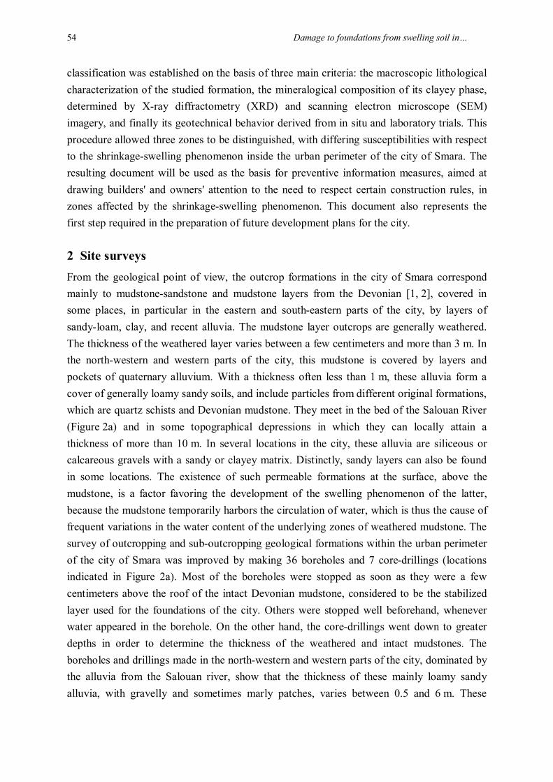
The main problem with swelling soils is the potential difficulty of recognizing and quantifying the risk they represent, in order to correctly dimension the foundations and load-bearing structures. Classical studies rely mainly on laboratory or in situ determinations of the conventional swelling characteristics of soils (swelling potential and swelling pressure). However, to correctly interpret the results of such tests it is essential to have an excellent understanding of the lithological and mineralogical characteristics of the studied soil, to determine whether the measured swelling pressure and free swelling pressure values can be taken as intrinsic material values, or as values which depend mainly on the test conditions. The study procedure first involved several field excursions, in particular to sites with defects in inhabited buildings, allowing the geological formations having mainly mudrock, and clayey or marly characteristics to be mapped. The surface observations were supplemented by the examination of wells and inspection boreholes (Figure 2a) carried out by the DPE and the LPEE. The different formations thus identified and mapped were then ranked according to their susceptibility to the shrinkage-swelling phenomenon. This
Damage to foundations from swelling soil in… 54
classification was established on the basis of three main criteria: the macroscopic lithological characterization of the studied formation, the mineralogical composition of its clayey phase, determined by X-ray diffractometry (XRD) and scanning electron microscope (SEM) imagery, and finally its geotechnical behavior derived from in situ and laboratory trials. This procedure allowed three zones to be distinguished, with differing susceptibilities with respect to the shrinkage-swelling phenomenon inside the urban perimeter of the city of Smara. The resulting document will be used as the basis for preventive information measures, aimed at drawing builders' and owners' attention to the need to respect certain construction rules, in zones affected by the shrinkage-swelling phenomenon. This document also represents the first step required in the preparation of future development plans for the city.
2 Site surveys From the geological point of view, the outcrop formations in the city of Smara correspond mainly to mudstone-sandstone and mudstone layers from the Devonian [1, 2], covered in some places, in particular in the eastern and south-eastern parts of the city, by layers of sandy-loam, clay, and recent alluvia. The mudstone layer outcrops are generally weathered. The thickness of the weathered layer varies between a few centimeters and more than 3 m. In the north-western and western parts of the city, this mudstone is covered by layers and pockets of quaternary alluvium. With a thickness often less than 1 m, these alluvia form a cover of generally loamy sandy soils, and include particles from different original formations, which are quartz schists and Devonian mudstone. They meet in the bed of the Salouan River (Figure 2a) and in some topographical depressions in which they can locally attain a thickness of more than 10 m. In several locations in the city, these alluvia are siliceous or calcareous gravels with a sandy or clayey matrix. Distinctly, sandy layers can also be found in some locations. The existence of such permeable formations at the surface, above the mudstone, is a factor favoring the development of the swelling phenomenon of the latter, because the mudstone temporarily harbors the circulation of water, which is thus the cause of frequent variations in the water content of the underlying zones of weathered mudstone. The survey of outcropping and sub-outcropping geological formations within the urban perimeter of the city of Smara was improved by making 36 boreholes and 7 core-drillings (locations indicated in Figure 2a). Most of the boreholes were stopped as soon as they were a few centimeters above the roof of the intact Devonian mudstone, considered to be the stabilized layer used for the foundations of the city. Others were stopped well beforehand, whenever water appeared in the borehole. On the other hand, the core-drillings went down to greater depths in order to determine the thickness of the weathered and intact mudstones. The boreholes and drillings made in the north-western and western parts of the city, dominated by the alluvia from the Salouan river, show that the thickness of these mainly loamy sandy alluvia, with gravelly and sometimes marly patches, varies between 0.5 and 6 m. These

M. El Bakay, A. Kchikach, A. Abdelgheffar, R. Guerin, R. Hakkou, H. Bouzahzah 55
alluvia rest on partly weathered mudstone from the Devonian. The weathered layer has a thickness of 1 to 2.5 m.
Figure 2: a. Location of the reconnaissance surveys. b. Sectional view showing the successive layers making up the foundation soil at Smara. The photograph shows the
transition from a weathered, to an intact part of the studied mudstone.
In all the boreholes made in this zone, the water level is stabilized at a depth of approximately 2 m with respect to the natural terrain. The local hydrological conditions are in fact a

Damage to foundations from swelling soil in… 56
dominant factor in the development of the shrinkage-swelling phenomenon of the mudstone. Although the presence of a shallow water table generally prevents the desiccation of the superficial layer of soil, its lowering, as a result of pumping or natural recession of the superficial water flow during periods of drought, worsens the desiccation of the layer of soil exposed to evaporation.
The wells and drillings present in the centre, east and south of the city show that the top of the weathered Devonian mudstone lies at a depth ranging from 0 to 1.3 m, with the exception of certain topographic depressions in which a layer comprising fill and gravelly loam is present. The top of the intact mudstone in this zone lies at a depth between 0.5 and 2.7 m. The core-drillings show that the thickness of the latter can occasionally exceed 10 m. In Figure 2b we present a typical section and a picture indicating the size of the weathered mudstone layer and the depth of the piezometric level. The analysis of the lithological and hydrological data recorded during field excursions, from wells and inspection boreholes, allowed an improved understanding to be gained of the shrinkage-swelling phenomenon within the urban perimeter of the city of Smara. Areas in which this phenomenon could potentially develop were identified and classified, on the basis of the dominant factors giving rise to this phenomenon, in particular the areas affected by strong changes in the soil and a significant thickness of weathered mudstone, since they could clearly be expected to have a more significant shrinkage-swelling potential.
3 Mineralogical characterization of the Smara mudstone A dominant factor affecting the degree of susceptibility to the shrinkage-swelling phenomenon of a clay layer is its mineralogical composition. The shrinkage-swelling occurs preferentially in the presence of so-called swelling clayey minerals from the smectite group (Montmorillonite, Beidellite, Sauconite, etc.), and to a lesser extent from interstratified minerals (smectites /illite) [3, 4]. According to these authors, vermiculite and some chlorites are also classed in the category of swelling minerals. Consequently, in the context of the present study, 22 samples taken from different sites in the city of Smara, boreholes and core-drillings were studied under a polarizing microscope and were analyzed using X-ray diffractometry. Another seven samples were examined using scanning electron microscopy.
The examination of thin slices under a polarizing microscope showed that the Smara mudstone is formed mainly from quartz, feldspar, clayey minerals, mica (Clinochlorite and Muscovite) and sulfate minerals in the form of anhydrite and gypsum. The presence of anhydrite and gypsum, which is also visible macroscopically, was confirmed by SEM imagery (Figure 3a). XRD analysis showed that the clayey phase is represented mainly by Illite, Montmorillonite and Chlorite (Figure 3b). The latter two minerals have very weak inter-layer bonds [5], and thus have the property of fixing water molecules between two adjacent layers, whenever the soil is even slightly damp. This leads to inter-layer swelling

M. El Bakay, A. Kchikach, A. Abdelgheffar, R. Guerin, R. Hakkou, H. Bouzahzah 57
which can attain very significant amplitudes. In parallel, we carried out granulometric tests with Smara mudstone samples. The results show that the fine constituents (< 80μm) make up approximately 26% of the weight of the samples. The Wetting Limit (WL) determined from the same samples lies in the range between 32% and 38%, and the Plasticity Index (PI) lies in the range between 15% and 19%. Paradoxically, the Smara mudstone therefore has a small swelling potential: its clay content and the plasticity index of the fine constituents do not provide an adequate explanation for the mudstone's swelling characteristics.
In addition to the clay fraction, the Smara mudstone contains a high proportion of sulfate minerals in the form of anhydrite (CaSO4) and gypsum (CaSO4, 2H20). These minerals are visible to the naked eye and were found in all of the samples examined under XRD and SEM. Their presence is suggestive of the role played by this phase in accentuating the shrinkage-swelling phenomenon of the foundation layer in Smara, since it is well known that the transformation of anhydrite into gypsum, and vice versa, is accompanied by a change in the soil's volume [6, 7].
Figure 3: a. Images recorded by SEM, showing the abundance of laminated gypsum, which is characteristic of the Smara mudstone. The symbol (+) indicates the point analyzed by SEM,

Damage to foundations from swelling soil in… 58
to obtain the spectrum confirming the presence of gypsum. b. Example of an XRD spectrum showing the variety of clay fractions found in the Smara mudstone.
4 In situ geotechnical tests The qualitative lithological and mineralogical characterization of the foundation layer within the urban perimeter of the city of Smara made it possible to categorize those which are the most sensitive to the shrinkage-swelling phenomenon, to locate the most likely sites where this could occur, and to gain improved insight into its origins. The remaining factor to be determined was the growth rate of the swelling process, as a function of quantifiable geotechnical parameters. To this end, we carried out seven Menard pressuremeter tests in the core-drilling holes.
The Menard pressuremeter test is used to measure the in situ loading of the soil. It involves radially dilating a cylindrical probe in the soil, and determining the relationship between the applied pressure and the displacement of the probe's walls. It allows the deformability (EM = Menard Modulus) and limit pressure (PL) characteristics to be determined. These parameters make it possible to detect the successive layers of soil, determine their ability to bear the load of certain types of construction, dimension the foundations, and evaluate a structure's displacement as a function of the loads to which it is exposed [8, 9 and 10]. In Figure 4a, we show the results corresponding to borehole number 5, together with the mean values of these parameters, computed from the tests carried out in the other boreholes, as required by the French standard NF P 94-110.
The values of PL and EM determined by the pressuremeter tests allowed us to estimate the quality of the foundation soil in Smara. In accordance with the classification based on these parameters [11], the alluvia traversed by certain boreholes (PL: 0.9 – 1.0 MPa; EM: 9.7 – 24.4 MPa) ranges from 'loose' to 'moderately compact'. The weathered mudstone (PL: 1.3 – 2.5 MPa; EM: 10.7 – 74.9 MPa) has a normal consolidation.

M. El Bakay, A. Kchikach, A. Abdelgheffar, R. Guerin, R. Hakkou, H. Bouzahzah 59
Figure 4: a. Values for the pressuremeter modulus (EM) and limiting pressure (PL) determined from the pressuremeter tests. b. Photograph illustrating the rigid plate loading
tests carried out at Smara. The curves show the vertical deformation for the different loading pressures used (3, 5 and 7 bars) and the measured value of swelling pressure (4.8 bars) for the site corresponding to the playground of a national school (11th January High School, Smara).

Damage to foundations from swelling soil in… 60
On order to improve the characterization of the swelling behavior of the Smara mudstone, and determine its swelling pressure, we made four rigid-plate loading tests (Figure 4b). The plate used has a square shape, 30 cm on edge, and a thickness of 2.5 cm. The actuator is located at the centre of the plate and three displacement sensors are positioned at the edge. The counter-mass was produced by a truck, allowing a load of up to 9000 daN to be applied.
The swelling pressure is defined as the pressure which needs to be applied to the plate in order to maintain zero vertical deformation, starting from the moment when it is initially placed in water, and until the rock has become totally saturated [12, 13 and 14]. For the four studied sites, (see Figure 2a for their locations), three different loading pressures were applied to the rigid plate (3, 5 and 7 bars), following which the vertical deformation in the presence of water was measured as a function of time. By convention, the deformation is considered to be stabilized when the variations in this deformation are smaller than 1/100 mm, for two readings separated by a period of at least 8 hours. A torque can thus be determined (pressure, deformation when stabilized), from which the swelling pressure, corresponding to the intersection between this linear expression and the axis of the abscissa, can be derived [13, 15]. This is a highly important parameter for the design of foundations and structures, which are intended to be built on swelling soils such as the mudstone at Smara. In effect, the uplifting of the footings laid on swelling soil depends on both the soil's tendency to expand and the load applied by the building.
The foundation soil swelling pressures at Smara obtained from the four tests vary between 2.5 and 6 bars, under the same loading conditions. This implies that the Smara mudstones are heterogeneous. In addition, we computed the loads transferred to the ground by the foundations of several typical buildings and individual homes in Smara. These loads vary between 1 and 2.5 bars. The swelling pressures measured by the rigid plat tests are thus considerably greater than those transmitted to the ground by the foundations of most constructions. Swelling of the soil cannot be prevented by the load resulting from these structures, in situations involving the infiltration of water into the foundations resulting from rainfall or the accidental flow of water.
5 Discussion Within the urban perimeter of the city of Smara, the foundations are set in uniform soil, formed either from alluvia or weathered mudstone, or in rare cases compact unaltered mudstone. Determination of the Atterberg limits of the fine fraction of this soil shows that it has a moderate swelling potential (15% < PI < 19%). XRD analyses of this fraction confirm this result. Indeed, the clay fraction is mainly represented by Illites and Chlorites. Montmorillonite, which is reputed to swell strongly, is present in only small proportions. The swelling potential of the clay fraction of the Smara mudstone does not provide a credible explanation for its highly expansive characteristics. Under favorably arid climatic conditions,

M. El Bakay, A. Kchikach, A. Abdelgheffar, R. Guerin, R. Hakkou, H. Bouzahzah 61
this property finds its origins mainly in the chemical transformation of anhydrite into gypsum and vice versa. The presence of these two minerals, which are visible to the naked eye, has been confirmed by microscope inspection, XRD analysis, and SEM imaging (Figure 3). This transformation leads to a considerable change in soil volume [6, 7 and 15]:
333 cm 74 cm 36 + cm 46 :Volume
2H2O) (CaSO4, Gypse 2H2O + (CaSO4) Anhydrite
Two cases can thus occur in nature:
- The soil water content is low, but just sufficient for the anhydrite to be transformed into gypsum, with the resulting change of volume given by:
% 9.8 - =36)+(46/ 36)+(46-74= V
which leads to compaction of the ground.
The soil water content of the matrix is high, and in this case the hydration of the anhydrite leads to strong swelling:
% 61 + = 46)/46-(74 = V
The work of Wittke M. and Wittke W. [16] show that the shrinkage-swelling of sulphate-rich soil is a much faster process (several months) than that of clays, such that it must be taken far more seriously than previously thought.
During the loading tests we carried out, the uplifting (s) measured for a square plate (s (0.3 m, 0.3 m)) and a load ( = 1 bar) varies between 6 and 12 mm. For a square footing of width B = 1.5 m (a commonly used dimension in Smara) and a load of 1 bar (mean transferred to the ground by the foundations, for the most common type of individual two-storey home in Smara), the uplifting computed using Naiser's method [17] is:
s(0.3,0.3)x0.3B x
g1= B)(B, s
i.e. between 33 and 67 mm. These values are unacceptable for the buildings and homes present in Smara.
The modulus of deformation (E) determined from the rigid plate loading tests, which were previously carried out by the LPEE on approximately ten dry mudstone sites, and then after 10 hours of saturation, are on average 2500 and 280 bars, respectively. According to Naiser’s method [17], the compaction (h) computed as a function of E, for a 1.5 m square footing, leads to an average value of:
Damage to foundations from swelling soil in… 62
cm 2.26= het cm 0.10= h humide pélitesèche pélite
The unit differential compaction () can then be derived for a 4 m separation (which is the most commonly used dimension in Smara) between two supports:
2001= )/ABh - h( imbibésecAB
According to the same author, this is an unacceptable value, because it exceeds that ( < 1/500) normally imposed in order to avoid the appearance of cracks in walls and partitions. It is thus clear that, from one footing to another, it is necessary to prevent variations in the saturation of the mudstone, whilst at the same time ensuring correct drainage of surface water and taking care to correctly seal piping and sewerage network manholes.
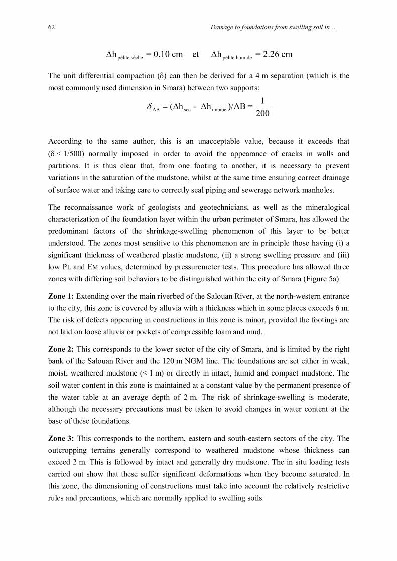
The reconnaissance work of geologists and geotechnicians, as well as the mineralogical characterization of the foundation layer within the urban perimeter of Smara, has allowed the predominant factors of the shrinkage-swelling phenomenon of this layer to be better understood. The zones most sensitive to this phenomenon are in principle those having (i) a significant thickness of weathered plastic mudstone, (ii) a strong swelling pressure and (iii) low PL and EM values, determined by pressuremeter tests. This procedure has allowed three zones with differing soil behaviors to be distinguished within the city of Smara (Figure 5a).
Zone 1: Extending over the main riverbed of the Salouan River, at the north-western entrance to the city, this zone is covered by alluvia with a thickness which in some places exceeds 6 m. The risk of defects appearing in constructions in this zone is minor, provided the footings are not laid on loose alluvia or pockets of compressible loam and mud.
Zone 2: This corresponds to the lower sector of the city of Smara, and is limited by the right bank of the Salouan River and the 120 m NGM line. The foundations are set either in weak, moist, weathered mudstone (< 1 m) or directly in intact, humid and compact mudstone. The soil water content in this zone is maintained at a constant value by the permanent presence of the water table at an average depth of 2 m. The risk of shrinkage-swelling is moderate, although the necessary precautions must be taken to avoid changes in water content at the base of these foundations.
Zone 3: This corresponds to the northern, eastern and south-eastern sectors of the city. The outcropping terrains generally correspond to weathered mudstone whose thickness can exceed 2 m. This is followed by intact and generally dry mudstone. The in situ loading tests carried out show that these suffer significant deformations when they become saturated. In this zone, the dimensioning of constructions must take into account the relatively restrictive rules and precautions, which are normally applied to swelling soils.
M. El Bakay, A. Kchikach, A. Abdelgheffar, R. Guerin, R. Hakkou, H. Bouzahzah 63
Figure 5: a: Map showing the shrinkage-swelling zones within the urban perimeter of Smara. b and c: Types of foundation (foundations on girders, and foundations on a compacted back-fill) recommended to limit the influence of the shrinkage-swelling phenomenon.

Damage to foundations from swelling soil in… 64
6 Conclusions Following this study, improved insight has been achieved into the expansive nature of the foundation layer within the urban perimeter of the city of Smara. The fine clay fraction of this layer has only a weak swelling potential (PI < 20%). It is in all likelihood the hydration of anhydrite and the dehydration of gypsum, resulting from variations in the soil's water content, which accentuates the shrinkage-swelling phenomenon in the soil of this city. The abundance of these sulphate-containing minerals in the Smara mudstone has been demonstrated by XRD analysis and SEM imaging.
The swelling pressures determined from rigid plate loading tests (2.5 to 6 bars) are much greater than those transmitted to the ground (1 to 2.5 bars) by the foundations of the buildings and houses in Smara. The calculations used to dimension the foundations must take this data into account, to allow the swelling pressure to be overcome by an equal pressure from the foundations, whilst at the same time ensuring that the loads transmitted to the ground are not to high, in order to avoid excessive compaction.
Finally, the shrinkage-swelling susceptibility map was produced after having ranked the predominant lithographical, mineralogical and geotechnical factors. This preventive document relevant to urban development should be used by the competent authorities, private individuals, developers and prime contractors, so that the necessary building provisions are taken into account, and the later occurrence of defects in the constructions is avoided. It would thus be advisable to implement building by-laws for each zone, in order to limit the risk of further damage.
For constructions in zone 1, where the foundation layer is represented mainly by alluvia from the Salouan River, a standard geotechnical study is sufficient. Such a study should determine the depth of the foundations, the allowable load to be placed on the alluvia, which are sometimes loose, as well as various recommendations for the construction of foundations in alluvia when water is present. It will also be important to ensure that the area is free of pockets of compressible mud and loam.
Despite the risk of moderate swelling in zone 2, a specific geotechnical study will need to be carried out in this zone. This should confirm the level of the water table, the degree of saturation of the weathered mudstone, and their lift. Precautions should be taken to avoid any reduction in the soil water content, which would lead to an increase in effective loads and shrinkage of the mudstone. A peripheral footpath surrounding the building should be foreseen, to avoid the installation of any plants in its immediate vicinity.
Zone 3 is characterized by the presence of weathered and dry intact mudstone, characterized by deformations which, should they ever become saturated, are unacceptable for constructions. Before allowing any construction in this zone, which has a strong potential to

M. El Bakay, A. Kchikach, A. Abdelgheffar, R. Guerin, R. Hakkou, H. Bouzahzah 65
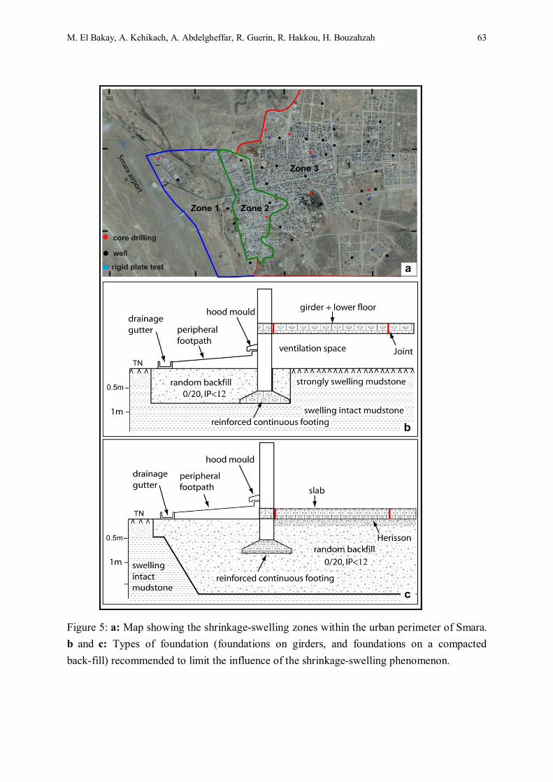
be affected by shrinkage-swelling phenomena, specific geotechnical studies will be needed to determine, among other parameters, the swelling pressure of the mudstone. The foundations must be inspected very carefully, in accordance with relatively restrictive dispositions and precautions. We propose the following two solutions (Figure 5b) to satisfy these requirements. They are based on the principle requiring the foundations to reach down below the depth at which the ground is sensitive to variations in water content, and requiring the building or house to effectively seal the ground off from the possible penetration of surface water.
Foundation on girders: This involves placing the building on intact or weathered mudstone, by means of a continuous footing, which must be interlocked and made from reinforced concrete in order to form a cross-tied structure. A second cross-tied structure with the same quantity of steel will need to be built at the level of the lower floor. The latter can be held up by the framework, using a correctly designed reinforced concrete slab (ventilation space). Full joints, placed at not more than 10 m intervals, will be needed to avoid excessive bending moments. The lower floor can be placed directly on the ground, using back-fill with a minimum thickness of 70 cm. This fill should be composed of a material which is inert (PI < 12%) and compacted to 98% of the Optimum Proctor Modified (OPM) test, in 20 cm layers. To avoid any infiltration of surface water down into the foundations, a 2.50 m wide peripheral footpath must be built, and must have an externally inclined batter and a drainage gutter (Figure 5b). The piping must be watertight and not be touching the framework of the building.
Foundation on compacted fill: This involves replacing the swelling soil by backfill, over the full surface area of the building, with a 2.50 m overlap with respect to the outside wall. The thickness of the backfill can be as much as 2 m and will need to be composed of a material which is inert (PI < 12%) and compacted to 98% of the Optimum Proctor Modified (OPM) test, in 20 cm layers. An impermeable membrane must first be placed on the excavated construction pit. The continuous or isolated footing can be weakly anchored in the fill. We also recommend building a 2.5 m peripheral footpath, taking care to ensure the piping is water-tight, and avoiding the planting of large trees close to the buildings or houses.
7 Acknowledgements The authors wish to thank the anonymous reviewers of this paper. We also thank the management of the DPE (Smara) and the LPEE (Agadir) for providing their assistance and collaboration, and for authorizing the publication of this study. Our study also benefited from the support of the Volubilis program, AI n° MA/209/09.

Damage to foundations from swelling soil in… 66
References [1] E. Rjimati, A. Benlakhdim and A. Zemmouri, "Levé géologique pour la réalisation de la
carte géologique d’Es Smara, échelle 1/200 000, Feuille n°7, " Iinstitut Géologique et
Minier Espagnol, 1971.
[2] A. Azza, "Le secteur minier marocain : une revue," Geology, Vol. 94, no.1047, 2001, pp.
47-52.
[3] N. Zornette, E. Anquetin and L. Krzywda, "Cartographie de l’aléa retrait-gonflement des
sols argileux, département de la Haute-Marne, " Rapport BRGM/RP-55957-FR, 2008,
pp. 9-112.
[4] G. W. Brindley and G. Brown, "Crystal Structures of Clay Minerals and Their X-Ray
Identification, " Miner. Soc., Londres, 1980.
[5] G. Mesri, C. R. Ullrich and Y. K. Choi, "The rate of swelling of overconsolidated clays
subjected to unloading," Géotechnique, Vol. 28, 1999, pp. 281-307.
[6] D. Fabre and M. Dayre, "Geotechnical properties of gypsum and anhydrite, Trias of the
northern alpes in France, " Bulletin of Engineering Geology and the Environmen, Vol.
25, 1982, pp. 91-98.
[7] W. Wittke, M. Wittke and R. Wahlen, " Zum Quellgesetz für den anhydritführenden,
unausgelaugten Gipskeuper," Geotechnik, Vol. 27, no. 2, 2004, pp.112-117.
[8] J. P. Baud, "Analyse des résultats pressiométriques Ménard dans un diagramme spectral
Log (Plm, Log (Em/Plm) et utilisation des regroupements statisatiques dans la
modélisation d’un site," 50 ans de pressiomètres, Vol. 1, Gambin, Magnan et Mestat
(ed.), Presses de l’ENPC/LCPC, Paris, 2005.
[9] Eurocode 2, "Calcul des structures en béton, Partie 1-1, règles générales et règles pour
les bâtiments, " Annexe Nationale à la NF EN 1992-1-1, 2005.
[10] Ministère de l’Equipement, du Logement et des Transports, "Règles techniques de
conception et de calcul des fondations des ouvrages de génie civil, cahier des clauses
techniques générales applicables aux marchés publics de travaux," Fascicule no. 62,
Titre 5, Textes officiels, imprimerie nationale, Paris, 1993.
[11] J. P. Baud and M. Gambin, "Soil and Rock Classification Based on High Pressure
Borehole Expansion Tests, "Proceedings of the 15th European Conference on Soil
Mechanics and Geotechnical Engineering, Athens, September 2011, pp. 325-330.
[12] A. Komornik and D. David, "Prediction of swelling pressure of clays," Journal of Soil
Mechanics, Vol. 95, 1969, pp. 209-225.

M. El Bakay, A. Kchikach, A. Abdelgheffar, R. Guerin, R. Hakkou, H. Bouzahzah 67
[13] L. Lancelot, I. Shahrour and S. Khaddaj,"Etude au laboratoire du gonflement de l’argile
des Flandres, In : Paramètre de calcul géotechnique," Magnan (Eds.), Presses de
l’ENPC/LCPC, Paris, 2002, pp. 145-151.
[14] A.W. Skempton and F.A. Delory, "Stability of natural slopes in London clay,"
Proceedings Seventh International Conference on Soil Mechanics and Foundation
Engineering, Vol. 2, Mexico, November 1969, pp. 173-181.
[15] J. F. Serratrice and B. Soyez, "Les essais de gonflement," Bull. Labo. Ponts et Chaussées,
no. 204, 1996, pp. 65-85.
[16] M. Wittke and W. Wittke, "Design, construction and supervision of tunnels in swelling
rock. In : Taylor and Francis (Eds.)," Proceedings of the International World Tunnel
Congress and the 31st ITA General Assembly, Underground Space Use : Analysis of the
Past and Lessons for the Future, Istanbul, May 2005, pp.1173-1178.
[17] D. D. Naiser, "Procedures to predict vertical differential soil movement for expansive
soils, "M.S. Thesis. Texas A&M Univ., College Station, Texas, 1997.