DĂBÂCA (DOBESCHDORF, DOBOKA): THE …banatica.ro/media/b23/dtna.pdf · 8 According to Alexandru...
86
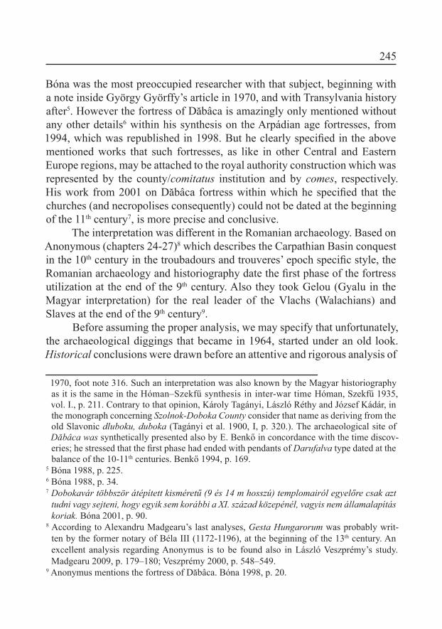
DĂBÂCA (DOBESCHDORF, DOBOKA): THE NECROPOLIS AROUND THE CHURCH IN A. TĂMAŞ’ GARDEN. SOME IDEAS ON THE DEVELOPMENT OF DĂBÂCA HABITAT Erwin Gáll * Keywords: Dăbâca, early Middle Ages, churchyards, fortress, settlements Cuvinte cheie: Dăbâca, evul mediu timpuriu, cimitire, fortăreaţă, aşezări The village of Dăbâca, the former center of the same-named county, is situated at 30 km N-W from Cluj-Napoca, on the steam of Loana which lows into the River of Someşul-Mic at a distance of 10 km eastern 1 . Part of Muntele Mare (529m altitude) (Fig. 1), on the southwestern side of the village towards the steam valley made the area narrowed and settled the key-point of the valley within these gorges (Pl. 1; Fig. 1.a-b). By its part through the length of the valley between the two hills, the road made unexpectedly a narrow curve by the middle of the village. The early medieval fortresses of Dăbâca complex lays along this territory which is closed by the valley curve. The two hills diminish their altitude towards N-W 2 . The fortress shape may be compared with a rounded peak with a sharpen angle toward N-NE. Its two lanks made a slope of 20-25 0 that is very easy to be defended. The early Medieval Ages the fortress was built there, and on a small scale, a system of settlements and, respectively, more churches together with the churchyards around them have been examined. (Fig. 1. a-c) * Institutul de Arheologie Vasile Pârvan al Academiei Române, Bucureşti, e-mail [email protected]. 1 Hodor 1837. 2 The irst to mention the destroyed fortress was János Könyöki. Könyöki 1906, p. 292.
Transcript of DĂBÂCA (DOBESCHDORF, DOBOKA): THE …banatica.ro/media/b23/dtna.pdf · 8 According to Alexandru...

DĂBÂCA (DOBESCHDORF, DOBOKA):THE NECROPOLIS AROUND THE CHURCH IN
A. TĂMAŞ’ GARDEN.SOME IDEAS ON THE DEVELOPMENT OF DĂBÂCA HABITAT
Erwin Gáll*
Keywords: Dăbâca, early Middle Ages, churchyards, fortress, settlementsCuvinte cheie: Dăbâca, evul mediu timpuriu, cimitire, fortăreaţă, aşezări
The village of Dăbâca, the former center of the same-named county, is situated at 30 km N-W from Cluj-Napoca, on the steam of Loana which lows into the River of Someşul-Mic at a distance of 10 km eastern1. Part of Muntele Mare (529m altitude) (Fig. 1), on the southwestern side of the village towards the steam valley made the area narrowed and settled the key-point of the valley within these gorges (Pl. 1; Fig. 1.a-b). By its part through the length of the valley between the two hills, the road made unexpectedly a narrow curve by the middle of the village. The early medieval fortresses of Dăbâca complex lays along this territory which is closed by the valley curve. The two hills diminish their altitude towards N-W2.
The fortress shape may be compared with a rounded peak with a sharpen angle toward N-NE. Its two lanks made a slope of 20-250 that is very easy to be defended. The early Medieval Ages the fortress was built there, and on a small scale, a system of settlements and, respectively, more churches together with the churchyards around them have been examined. (Fig. 1. a-c)
* Institutul de Arheologie Vasile Pârvan al Academiei Române, Bucureşti, e-mail [email protected].
1 Hodor 1837.2 The irst to mention the destroyed fortress was János Könyöki. Könyöki 1906, p. 292.

244
Fig. 1 a-d. Dăbâca and his position in Transylvanian Basin. Dăbâca on the 1st and the 2nd topographical surveys3, the I-III areas, respectively, as seen
from north-west direction (1964)
I. An introduction in the history of Dăbâca site researchingThe Magyar early Medieval Ages historiography and archaeology
from the 20th century generally thought that the ground-wood fortress of Dăbâca had been built either in the 10th century or during the age of Stephen I (consecrated in 1083), around 1000 and its building was attached to the leader Dobuca (he seemed to have been the irst county head), who defeated Gyla and was mentioned in a unique narrative source4. The lamented István 3 Josephinische Landesaufnahme (I) and Zweite oder Franziszeische Landesaufnahme (II).4 Anonymus: Sunad f. Dobuca nepos regis. SRH. I. 50. Gy. Györffy considers that Dăbâca
existed yet in the 10th century and its name comes from Doboka, the irst county head of Stephen I, the son of whom, Sunad in Latin (Csanád)would have defeated Ahtum later (the name of the locality of Csanád comes from him; Cenad). Györffy 1987, p. 66–67; Bóna
245
Bóna was the most preoccupied researcher with that subject, beginning with a note inside György Györffy’s article in 1970, and with Transylvania history after5. However the fortress of Dăbâca is amazingly only mentioned without any other details6 within his synthesis on the Arpádian age fortresses, from 1994, which was republished in 1998. But he clearly speciied in the above mentioned works that such fortresses, as like in other Central and Eastern Europe regions, may be attached to the royal authority construction which was represented by the county/comitatus institution and by comes, respectively. His work from 2001 on Dăbâca fortress within which he speciied that the churches (and necropolises consequently) could not be dated at the beginning of the 11th century7, is more precise and conclusive.
The interpretation was different in the Romanian archaeology. Based on Anonymous (chapters 24-27)8 which describes the Carpathian Basin conquest in the 10th century in the troubadours and trouveres’ epoch speciic style, the Romanian archaeology and historiography date the irst phase of the fortress utilization at the end of the 9th century. Also they took Gelou (Gyalu in the Magyar interpretation) for the real leader of the Vlachs (Walachians) and Slaves at the end of the 9th century9.
Before assuming the proper analysis, we may specify that unfortunately, the archaeological diggings that became in 1964, started under an old look. Historical conclusions were drawn before an attentive and rigorous analysis of
1970, foot note 316. Such an interpretation was also known by the Magyar historiography as it is the same in the Hóman–Szekfű synthesis in inter-war time Hóman, Szekfű 1935, vol. I., p. 211. Contrary to that opinion, Károly Tagányi, László Réthy and József Kádár, in the monograph concerning Szolnok-Doboka County consider that name as deriving from the old Slavonic dluboku, duboka (Tagányi et al. 1900, I, p. 320.). The archaeological site of Dăbâca was synthetically presented also by E. Benkő in concordance with the time discov-eries; he stressed that the irst phase had ended with pendants of Darufalva type dated at the balance of the 10-11th centuries. Benkő 1994, p. 169.
5 Bóna 1988, p. 225.6 Bóna 1988, p. 34.7 Dobokavár többször átépített kisméretű (9 és 14 m hosszú) templomairól egyelőre csak azt
tudni vagy sejteni, hogy egyik sem korábbi a XI. század közepénél, vagyis nem államalapítás koriak. Bóna 2001, p. 90.
8 According to Alexandru Madgearu’s last analyses, Gesta Hungarorum was probably writ-ten by the former notary of Béla III (1172-1196), at the beginning of the 13th century. An excellent analysis regarding Anonymus is to be found also in László Veszprémy’s study. Madgearu 2009, p. 179–180; Veszprémy 2000, p. 548–549.
9 Anonymus mentions the fortress of Dăbâca. Bóna 1998, p. 20.

246
the archaeological material so that to ind out, irst of all, strict archaeological reasons. Such a trend is based on a much older reason that comes from the real past and development of archaeology, especially of the medieval one: ever since its beginning the archaeology as an auxiliary science of history was destined to motivate the information from the narrative sources, and to correlate the written events with the archaeological discoveries. As a conclusion, the archaeological discoveries played for stressing the reasons that assert the data from the written sources, and had to be in the written source service10, an erroneous method that has been perpetuated till nowadays. That error was assumed and even developed by the archaeologists from Dăbâca, who hastened after less than four years of the site researching11 (that included the ground fortress, the civil settlement with hovels, workshops, graves, respectively, necropolises vestiges) to state Dăbâca for Gelou’s political-military center, falling in an almost unprecedented historicizing of an archaeological situation, without any scientiic reasons for such an interpretation. But we would not aim to impartiality without considering the black years almost like in Orwell’s works, of the Romanian national-communism that may explain in a certain measure the historicizing conclusions of the archeologists there12. Iurie Stamati notices a similar development in his article on the 5th–7th centuries
researching in the Soviet Socialist Republic of Moldavia and the Republic of Moldavia after, but in the opposite direction: due to the politics meddling in the history writing, there are striking resemblances among the reasons of some interpretations turning up (in the former Republic of Moldavia, a Soviet power till 1989)13.
The case of Dăbâca aroused immediate and later reactions. As we have already noted, István Bóna criticized the article from 196814, and included it much later, without a large debate, within the early Arpádian age system of fortresses (the 11th century)15.
But the more dour attack came from Romania soon after the national-communist regime from Bucharest changing. In 1991, an article of Radu Popa 10 See Young 1992, p. 135-147.11 The irst archaeological researches at Dăbâca were initiated by Márton Roska, but the re-
searches and their publishing belong to Károly Chrettier who made the irst topographic survey and diggings in 1942. Chrettier 1943, p. 115-117.
12 See also Madgearu 2008, p. 63-71.13 Stamati 2002, p. 185.14 Bóna 1970, p 191-242, footnote 315.15 Bóna 1998, p. 34.
247
harshly attacked Stefan Pascu, the archaeologist in charge at Dăbâca, and called him an “amateur” and his work a “romantic” and “negligent” one, with a mention on ”the carelessness in making assertions without the security given by proves”16.
Nevertheless, with some exceptions17, the stereotypy that the village of Dăbâca dates since/in the 9th century mainly and, much more serious, that it could be attached to the “great” confrontations between the so-called Tuhutum’s army and Gelou took deep root, and so a classic example of gemischte Argumentation18 is maintained within the scientiic consciousness.
At the end of this short analysis of the researching phase we may note: 1. the case of Dăbâca perfectly illustrates the historical perception, conception and vision as being under the inluence of varied scientiic and non-scientiic factors on the researching in different periods of the 20th century; 2. until now the historical-narrative and linguistic data played the main role in the site of Dăbâca interpretation, while, for different reasons, the archaeology had only an auxiliary role and was blamed to offer a set of complementary reasons to different historical theories19; 3. Scientiic-political, political and supposedly personal interests and careerist considerations all played a part or worked as the driving forces behind the start of the excavations in Dăbâca in the 60’s. It may also explain that later, as the results were not satisfactory from the given point of view, the starting pace of research slackened and gradually phased out. The last excavation in 1986 was led just by a one archaeologist, Petru Iambor and the results was only the excavation of eight graves, representing the disinterest shown towards the site in the 80’s.
16 Popa 1991, p. 159, 165, footnote 51.17 Horedt 1986, p. 127; Rusu 1998, p. 5-19; Madgearu 2001, p. 162; Curta 2002, p. 273-274.18 The expression gemischte Argumentatio from the German archaeological speech, means
a method in archaeology (quasi-general in the early Medieval Ages archaeological re-searching in Romania and almost in all eastern European countries), according to which the archaeological discoveries or phenomena are relied on other archaeological data or assumptions, and historic data (in very numerous cases), or on different historical theories. But within the European philosophy based on the doubtless speciic features of cognition, since Aristotle comparing, joining and confronting different categories or types of things are possible only in limited conditions. It means for archaeology that the historic data and the archaeological facts joining may be made only when the archaeological discoveries are surely dated; if not, an uncertain thing is to be demonstrated through other uncertain data. Niculescu 1997, p. 63-69; Bálint 1995, p. 246-248; Brather 2004, p. 517-567.
19 See for such an attitude: Niculescu 1997, p. 64
248
Unfortunately the past political manipulations have had a great ‛career’ in national-communist Romania,20 and Dăbâca is a sad symbol of this.
II. Necropolis from Dăbâca-A. Tămaş’ Garden researching phase (Pl. 3-6)The investigation of the south-eastern corner of the local terrace at
Dăbâca began in the summer of 1966, the place being called “Incinta IV” (the Area IV) by the researchers there. Nearby the Orthodox Church functionally also today as always, on the same point within Alexandru Tămaş’ garden; this plot of land presented o slight elevation with visible signs on its surface of stones and a building vestiges.
Firstly, a column of 4x3 m was dug nearby the north-eastern corner of A. Tămaş’ house to verify if a churchyard could be there. Some burial graves were discovered (1-10) then. In 1966 summer a section of 14x2 m carrying number I (S. I) was also dug towards N-S, nearby the above mentioned elevation, at about 50 m distance from the house of the mentioned owner, two deepened in ground dwellings having been identiied21.
In September 1966 the Section II (S.II) was also examined; it is of 11.5x1.5m on north-south direction, perpendicularly on the 1st column and
the northern wall of A. Tămaş’ house. O surface of 3 m was not dug for a still unknown reason, between the 1St Column and Section II. The same distance of 3m was also not dug between the 16th and the 19th graves, the reasons being unknown too. Fallowing the investigations the graves 11-28, 61 (between m 4.5 and 15.8), and 29-37, respectively, were brought into relief. Three walls were also identiied. The irst two ones represented probably the walls of another church while the third one was surely the altar of another church. There were open some columns in the west-eastern walls to watch the graves 30-32, 35-37.
Section II was partly uncovered during the next year archaeological campaign, 1967, in the northern part between m 19 and 29, beginning with a watching column for the church altar22, in the eastern wall of Section II, and
20 In this aspect one cannot cite enough Radu Popa’s criticism from 1991.21 I would not deal with these discoveries here, but I would conine myself to remember that
according to the digging authors, within the reference material from MNIT, ceramics dat-ing from the 9-11th centuries (!) were discovered there.
22 It is very important to note that the term of altars does not appear in the written primary ref-erence or the illustrated part, as we shall ind it later at Petru Iambor. Iambor 2005, Pl. LXII.

249
a column of larger dimensions (10x14 m) where the nave of the church23 was identiied, as well as 23 graves in situ (graves 28-60).
Within the year 1980 another digging was undertook but we have no data on it except for a coin which was mentioned as coming from the hovel No 1/1980. Unfortunately, even Petru Iambor’s work of synthesis does mention but the church plan which is erroneously presented, and more than this, the author puts the reader on the wrong track by erroneously presenting the examined sections and columns numbering. I could infer from the respective plan the mark of some (four maybe?) graves which had been examined in 198024.
III. Description of gravesGrave 1
Aspect: W-E. Depth: 20-25 cm. The adult skeleton was laid on back, the skull fell to right, and the inferior part of the corpse didn’t remain. The grave was deranged that part. The arms were put against the corpse (position I.). The skeleton remained length: 90cm.
No inventory.
Grave 2Aspect: W-E. Depth: 40-50 cm. The adult skeleton was laid on back, and
only it was deranged. The arms were put against the corpse (position I). The skeleton measured length: 175cm.
Funeral rite: up the skull they put a stone (34x20 cm), and another one, respectively, by the left shoulder.
Inventory: An anonymous, indeinable coin from the 12th century. Diameter: 1.0 cm. MNIT. N. 97934. (Pl. 9.1)
Grave 3Aspect: W-E. Depth: 65 cm (skull)–75 cm (the rest of the skeleton). The
adult skeleton was partly deranged by Gr. 9, on left toward north; the remained corpse: up the pelvis. The right forearm does not remain. It deranged grave No 5.
Funeral rite: there were observed two stones which had been laid on the left part of the skull and at the right shoulder.
Inventory: three bronze ear-rings S shaped; their position in the grave is not speciied. The Museum collection registered only two of them.23 And not of the churches as it appears at Iambor 2005, p. 187-19.24 Iambor 2005, Pl. LXII.

250
A hair ring with an S shaped extremity. A large part of its end is broken. 1. Diameter: 1.75 × 1.9 cm; 2. the breadth of the extremity in the shape of S: 0.3 cm. M.N.I.T. F. 13617 (Pl. 8.1)
A hair ring with an S shaped extremity. Even if the end of it is broken, two grooved by incision lines could still be noticed. 1 Diameter: 1.9 × 1.6 cm; 2. the breadth of the extremity in the shape of S: 0.3 cm. Weight: 0.65 g. Amount of Ag: 750 ‰. MNIT. F. 13618. (Pl. 8.2)
Grave 4Aspect: W-E. Skeleton of a child. Depth: 50 cm. It partly deranged grave No 5.No inventory.
Grave 5A rummaged child skeleton, part of the bones being nearby the skull of grave No 3. The skull and the other bones are at 40 cm in depth.
No inventory.
Grave 6 A-BAspect: W-E. Depth: 22 cm. The skeleton was partly deranged when the
foundation of a modern building was dug there, the inferior limbs bones being cut and drawn out. At the moment of digging the grave Gr. 6A another grave was deranged the skull of which was put in the western end of the grave pit. The arms were laid along the corpse (position I.).
No inventory.
Grave 7Aspect: W-E. Depth: 40 (skull)-45 (rest of the skeleton) cm. The infant’s
skeleton was laid on back, the skull fell to left, the upper part of the corpse being deranged. The skeleton measured length: 120 cm.
Inventory: two hair bronze rings, with an S shaped the extremity. The Museum collections registered only one of them, but even that one was not to be identiied the present time. The hair bronze rings drawing remained as a plan that we have processed.
A hair ring with an S shaped extremity, large diameter. 1 Diameter: 2.8 × 2.4 cm. MNIT. F. 13626. (Pl. 8.8)
A hair ring with an S shaped extremity, average diameter. 1 Diameter: 2.2 × 2.2 cm. Not registered. (Pl. 8.9)

251
Grave 8Aspect: NW-SE. Depth: 60cm. The infant skeleton remained up to the
knees, the skull fell to right. The arms were laid along the corpse (position I.). Tombstones lanked the corpse. It remains to answer the question whether such a think belongs to the rite or the stones were an integral part of the church fence.
No inventory.
Grave 9Aspect: W-E. Depth: 75 cm. The skeleton deranged partly the grave No 3.
There were identiied stone blocks up the skeleton that dated from the modern era (?) in the digging authors’ view.
No inventory.
Grave 10Aspect: W-E. Depth: 30 cm. It was cut on a side by a modern grave. The
adult skeleton was laid on back and the skull fell to left.No inventory.
Grave 11Aspect: W-E. Depth: 90 cm. An adult skeleton, the skull fell on the right
side. Length up to pelvis: 85 cm. Over the pelvis there were lots of rummaged stones that obviously proceeded from another grave.
No inventory.
Grave 12, Grave 12AAspect: NE-SW. Depth: 80 cm. The infant skeleton was laid on back. It
is a subsequent grave to grave No. 11, over the bones of which the right hand bones of Gr. 12 were discovered. The skeleton remained in a very good repair.
Funeral rite: the skeleton was surrounded by two tombstones. The pelvis from Grave 12 is on the breast of an older corpse in grave 12A
that 12 superposed and made its skull slide deeper. In the pelvis zone of Gr. 12 a coin which probably provided from Gr. 12A was discovered.
Inventory: 1. An anonymous coin H100 from the 12th century. 1. Diameter: 1.2 cm.
2. Weight: 0.298 gr. MNIT. N. 97932 (Pl. 9.2.)

252
Grave 13Aspect: W-E. Depth: 115 cm. More stones and a feudal brick were
amassed around the bones cluster (at a depth of 67-90 cm).
Grave 14Aspect: NE-SW. Depth: 87 cm. It is an adult skeleton which was deranged
in the upper right side. The skull was in situ but only partly preserved.No inventory.
Grave 15A bad preserved skull in situ, together with some deranged bones. Depth: 100 cm.Inventory:An anonymous silver coin H102. 1. Diameter: 1.2 cm. 2. Weight: 0.269
gr. MNIT. N. 97933 (Pl. 9.3).Two hair rings, one of them with the S shaped broken extremity, and a
simple one; both of them were discovered near the skull. They were registered in the Museum collections, but neither of them could be identiied till now. The rings drawings were kept in a plan which I have processed.
A simple hair ring, with a large diameter. 1. Diameter: 3.1 × 3.1 cm. MNIT. F. 13619. (Pl. 8.10).
A hair ring with the S shaped extremity; the end is largely broken. 1 Diameter: 1.4 × 1.3. F. 13621 (Pl. 8.11).
Grave 16 A-BTwo skulls at a depth of 100 cm.Inventory: a simple hair ring which was identiied on the left temple.
The simple hair ring drawing was kept in a plan that I have processed. 1. Diameter: 2.2 × 1.8 cm. I haven’t found its registering. (Pl. 8.12).
Grave 17 A-BAspect: W-E. Depth: 82 cm. An infant skeleton which was laid on back,
on an accumulation of bones that had come from a previous grave. The skull fell on left, the inferior part of the skeleton having been deranged (inferior limbs). The skeleton measured length: 75 cm.
Gr. 17 B: an accumulation of bones.No inventory.

253
Grave 18Depth: 88 cm. Only the upper part of the corpse was examined, the rest
of the skeleton being inside the section wall.Inventory: a bronze simple hair ring which was identiied in the right
temple region.
Grave 19 A-DAspect: W-E. Depth: 70 cm. An adult skeleton, which was laid on back
and deranged by the subsequent burials. The skeleton measured length: 155 cm.Inventory: There were discovered two hair rings with S shaped
extremities, on the right and the left sides of the skull.Another skull (B) was registered in the northern part of the irst one, and
another one (C) in the breast region. Fragments of an infant skeleton directed toward N-W, were discovered in the skeleton A pelvis region.
Grave 20Aspect: W-E. Depth: 90 cm. The skeleton measured length: 165 cm. It is
an adult skeleton which was laid on beck. The arms were laid side by side on the corpse belly (position XIII).
No inventory.
Grave 21Aspect: W-E. Depth: 55 cm. The skeleton measured length: 45 cm. An
infant skeleton I., that remained in a relative good repair excepting the skull that is partly destroyed.
No inventory.
Grave 22 A-BAspect: W-E. Depth: 75-80 cm. The skeleton measured length: 65 cm. An infant skeleton I., that remained in a relative good repair with a
battered skull.Funeral rite: a tombstone on the skeleton right side.A bad preserved skull was identiied on the inferior lambs’ right side.No inventory.
Grave 23 A-DAspect: W-E. Depth: 50 cm. An adult skeleton; only the inferior lambs
were discovered. The inferior lambs’ length: 75 cm.
254
An accumulation of bones belonging to other deranged graves and a skull were discovered on the skeleton right side.
No inventory.
Grave 24Aspect: W-E. Depth: 100 cm. An adult skeleton; the skull fell on right.
The left arm was laid against the corpse and the right one on breast, bended at 900 (position III.). The skeleton measured length: 155 cm.
No inventory.There is an accumulation of bones in vicinity of this grave, so that we
could speak about ossuary.
Grave 25 A-DAspect: W-E. Depth: 95 cm. An adult skeleton with the right arm against
the corpse and the bended at 900 left one on breast (position II.). The skeleton measured length: 155 cm.
Deranged bones and three skulls (B-D) providing from other graves were found on the right part and at the skeleton’s legs.
No inventory.
Grave 26 A-BAspect: W-E. Depth: 95 cm. An adult skeleton; the skull fell on right.
The arms were laid on the holy bone, in the shape of a cross (position XIV). The skeleton measured length: 170 cm.
The A skeleton deranged the B one, from which a coin that was identiied at a depth of 60 cm provides. Coin: anonymous, H96a, silver. 1. Diameter: 1.0 cm. 2. Weight: 0.155 gr. MNIT. N. 97929 (Pl. 9.4).
Grave 27Aspect: W-E. Depth: 100-105 cm. An adult skeleton; its superior part
remained in very bad repair. The skeleton measured length: 160 cm.No inventory.
Grave 28Aspect: W-E. Depth: 93-110 cm. An adult skeleton which was laid on
back and the skull fell on right. The arms were laid against the corpse (position I.). The skeleton measured length: 158 cm.
No inventory.

255
Grave 29Aspect: W-E. Depth: 85 cm. An infant II skeleton. The skeleton skull
was laid on a stone of the oven, near the eastern wall of the church altar. The left arm was laid against the corpse, the right one on the breast, bended at 900
(position III.).No inventory.
Graves 30-32On the scale papers, the three graves were mentioned with the same
numbers as on the reference plan, but on a place where no archaeological investigations had been made. In the same time, after each of the numbers 30-37 on the scale papers a question mark was written. We do not know why the graves were not recorded on the plan, and we have not found any reference to even within the written documents.
Nevertheless, the graves reference material clearly points out that those ones were examined, and this is the reason to further present their description:
Grave 30Aspect: W-E. Depth: 100 cm. An adult skeleton with the skull on right.
The arms were laid against the corpse (position III.). The skeleton measured length: 160 cm.
No inventory.
Grave 31Aspect: W-E. Depth: 100 cm. An adult skeleton with the upper part
including the skull were cut by a modern grave. The remained part is well preserved.
No inventory.
Grave 32Aspect: W-E. Depth: 95-100 cm. It was rummaged by a modern grave
that also deranged the grave No 31. Only the inferior lambs were preserved. The grave was dug over an oval ireplace.
No inventory.
Graves 33–34The graves No 33 and 34 were not recorded on the plan. According to

256
the written reference material they must have been in the left side, over the demolished altar of the examined church.
Grave 33Aspect: W-E. Depth: 118 cm. A well preserved adult skeleton. The skull
is gently dislocated and fell on left. The skeleton measured length: 170 cm.No inventory.
Grave 34Aspect: W-E. Depth: 130 cm. According to the reference material it was
cut by the eastern wall of the altar, but the plan clearly shows that it was in a large measure destroyed because one of the stones was identiied at a depth of 120 cm, while the grave No 33 was identiied at a depth of 118 cm. In other words those graves are later than the church is.
Inventory: Six hair rings: three hair rings on the right side, three ones on the right
side. Those pieces are probably F. 13627, F. 13628, and the three temple rings which are recorded under F. 13629. Only F. 13628 could be identiied from all of them.
I. A bronze hair ring, the extremity in the shape of S. 1. Diameter: 1.8 × 2.2 cm. 2. The S extremity breadth: 0.4 cm. MNIT. F. 13622 (Pl. 8.3).
Graves 35–36Not even the graves No 35 and 36 were recorded on the plan, but there
are some data on them within the reference material. They were recorded on the altar right side when later they come back to the scale papers.
Grave 35 A-B (a double grave) (Pl. 7.B)Aspect: W-E. Depth: 150 cm. The skeletons measured length: 175 cm
(A) and 65 cm (B).Skeleton A: the arms were laid against the corpse (position I). The infant
skeleton (B) was laid on the adult skeleton left side.No inventory.
Grave 36Aspect: W-E. Depth: 150 cm. An adult skeleton with well preserved bones.No inventory.

257
Grave 37Nor the grave No 37 was recorded on the plan but it is mentioned in the
reference material. It was recorded later on the scale papers on the altar northern side.Aspect: W-E. Depth: 110 cm. A well preserved skeleton. The skeleton
measured length: 170 cm.Funeral rite: two large stones, one of them being burnt were put over
the head.Inventory:A string of beads between the inferior lambs? (Pl. 8.15).
Grave 38Aspect: W-E. Depth: 80 cm (the skull), 92–95cm (pelvis and the inferior
lambs). The infant skeleton was laid on back, the skull fell to right, and the arms were laid against the corpse (position I.). The skeleton preserved length: 110 cm.
No inventory.
As the authors of the diggings noticed, a coin was discovered close by the grave “at the treading level from which the pit of the grave had been dug”25.
The coin: anonymous, H89, silver. 1. Diameter: 1.0 cm. Weight: 0.133 gr. MNIT. N. 97930 (Pl. 9.6).
Grave 39Aspect: W-E. Depth: 70cm (skull), 80 cm (the rest of the skeleton). The
adult skeleton was laid on back, the skull fell toward right, while the arms were laid against the corpse (position I.). The bones are well preserved. The skeleton preserved length: 155 cm.
No inventory. Grave 40Aspect: W-E. Depth: 60 cm. The infant skeleton was laid on back.No inventory.
Grave 41Aspect: W-E. Depth: 20-25 cm. The well preserved adult skeleton was
laid on back and the skull fell to left. The arms were laid against the corpse (position I). The skeleton measured length: 160 cm.
No inventory.25 Unfortunately that level from which the pit had been dug was not recorded.

258
Grave 42Aspect: W-E. Depth: 78 cm (skull), 8797 cm (the rest of the skeleton).
The skeleton measured length: 165 cm. The well preserved adult skeleton was laid on back, the skull fell to right. The right arm was laid against the corpse, the left one on breast, bended at 900 (position II).
No inventory.
Grave 43Aspect: W-E. Depth: 136 cm (skull), 148 cm (by the pelvis). The arms
were laid over the holy bone in the shape of a cross (position XIV). The skeleton measured length until knees: 110 cm. the grave was identiied in the melted ground of the pit, with debris and lime traces.
No inventory.
Grave 44Aspect: S-N. Depth: 34 cm (skull), 36-44 cm (the rest of the skeleton).
The superior part until the skeleton waist is well preserved. The bended right arm was laid on the pelvis, the inferior lambs are deranged. The skeleton measured length till waist: 87 cm.
No inventory.
Grave 45Aspect: W-E. Depth: 78 cm (skull), 81-88 cm (the rest of the skeleton).
The skeleton measured length: 150 cm. The adult well preserved skeleton was laid on back; the skull fell on the right side. The right arm was bended at 450
and laid on the breast bone, the left one at 450, on pelvis (position XVII).Funeral rite (?): much coal was identiied around the right hand bones.No inventory.Grave 46 (Pl. 7. A)Aspect: W-E. Depth: 44 cm (skull), 49 cm (pelvis). Te skeleton
measured length till pelvis: 80 cm. Only the superior part of the probably adult skeleton remained, without the left hand bones; the right hand was laid against the corpse. The inferior lambs were laid as a cluster. The grave No
47 was deranged.No inventory.

259
Grave 47 (Pl. 7.A)Aspect: W-E. Depth: 48 cm (skull), 58 cm (pelvis). The skeleton
measured length: 165 cm. The well preserved adult skeleton was laid on back, the skull felon the left side. The arms were laid over the holy bone in the shape of a cross (position XIV).
Inventory:A simple hair ring: in the breast zone (the 6th rib) a ring made from a
bronze wire. It could not have been identiied as it had not been registered.
Grave 48Aspect: W-E. Depth: 67 cm (skull), 76-80 cm (pelvis). The skeleton
measured length: 165 cm. The well preserved adult skeleton was laid on back and the skull fell on the left side.
Funeral rite: the skeleton inferior part was covered with stones.No inventory.
Grave 49 (Pl. 7.A)Aspect: W-E. Depth: 60-70 cm. As placed at Gr. 46 and Gr. 47 legs, its
skull was drawn out from the pit of Gr. 47 and laid over after between ribs and pelvis.
No inventory.
Grave 50Aspect: W-E. Depth: 115 cm (skull), 128-135 cm (pelvis and inferior
lambs). The skeleton measured length: 170 cm. The well preserved adult skeleton was laid on back and the skull fell on the left side. The arms were laid against the corpse (position I).
No inventory.
Grave 51Aspect: W-E. Depth: 128 cm (skull), 141cm (pelvis). The skeleton
measured length till pelvis: 100 cm. The well preserved adult skeleton was laid on back and the skull fell on the left side. The arms were laid over the holy bone in the shape of a cross (position XIV). The bones down the knees were destroyed by further interventions. The skeleton pit was partly dug within the initial altar foundation on its southern side, the moment the foundation stones were drawn out from their position.
No inventory.

260
Grave 52 A-BAspect: W-E. Depth: 82 cm (skull), 90 cm (pelvis). The skeleton
measured length: 80 cm. The infant skeleton was laid on back and the skull fell on right. The arms were laid against the corpse (position I). The left leg was bended over the right one.
Inventory:A bronze hair ring with a large diameter, over the skull. MNIT. F. 13882.
I could not identify it within the museum collections.A bronze hair ring with a small diameter, on the pelvis right side. I could
not identify it because it hadn’t been recorded within the inventory register, but it is mentioned in the necropolis reference material.
Grave 52B: on the inferior lambs left side a skull was discovered at a depth of 87 cm.
Grave 53 A-BAspect: W-E. Depth: 57 cm (skull), 64-66 cm (the rest of the skeleton).
The skeleton measured length: 133 cm. It is a well conserved youthful (?) infant II skeleton, the skull fell on right. The left arm was laid against the corpse, the bended at 900 right one, on breast (position III).
No inventory.The A skeleton deranged another older grave (B) the bones of which are
laid at its pit extremity.No inventory.
Grave 54Aspect: W-E. Depth: 70 cm (skull), 65 cm (the rest of the skeleton). The
skeleton measured length: 133 cm. A well preserved adult (?) skeleton. The right arm was laid against the corpse, and the 900 bended left one, on breast (position II).
No inventory.
Grave 55Aspect: W-E. Depth: 62 cm (skull), 68 cm (skeleton). The skeleton
measured length: 82 cm. The infant’s bones were much bad preserved. The arms were laid against the corpse (position I).
No inventory.

261
Grave 56 A–BAspect: W-E. Depth: 70 cm. The skeleton was partly deranged by the
pit of Gr. 55. In turn, the inferior lambs were deranged by another church building; that one is not examined yet.
A bones accumulation was identiied on the right side of the skeleton (skeleton B).
No inventory.
Grave 57 A–D (Pl. 7.C)Aspect: W-E. Depth: 50 cm (skull), 65-78 cm (pelvis and inferior
lambs). The skeleton measured length: 16 cm. There are traces of a wood coffin. It seems that the arms bones were laid against the corpse (position I).
A bones accumulation, two skulls (at a depth of 50 cm) and a mandible ere found on the left side of the skeleton.
No inventory.
Grave 58Aspect: W-E. Depth: 65 cm (skull), 75-77 cm (the rest of the skeleton).
The skeleton measured length: 90 cm. An infant skeleton with bad preserved remains.
No inventory.
Grave 59 A-BAspect: W-E. Depth: 70 cm (skull), 80 cm (the rest of the skeleton).
The skeleton measured length: 110 cm. An infant skeleton with bad preserved bones. The arms bones were laid against the corpse (position I).
A skull (B) and some bone belonging to another grave that it deranged were identiied at its legs.
No inventory.
Grave 60Right nearby the grave No 60 an accumulation of deranged bones was
traced out at the superior part of Gr. 59, the skull of which is at a depth of 60 cm.No inventory.
262
Grave 61 A-BAround the grave No 28 two destroyed skeletons were traced out.
Graves 62-67 (Cr. 25, 26, 27, 28, 29 on the scale papers)Another ive skulls were traced out in section II, between m 12 and
14.50; they point out destroyed graves by some late burials.
Graves 68-71They were investigated in 1980. WE have not those graves reference
material.
The hovel that was investigated in 1980Inventory from the hovel loor:Anonymous silver coin H82. Diameter: 1.0 cm. Weight: 0.212 gr. MNIT.
N. Not registered (Pl. 11.3).
Other archaeological materials were identiied within the museum inventory register, but they have not connection with any of the examined complexes:
1. A hair ring with an S shaped extremity. A large part of this extremity is broken. 1. Diameter: 1.7 × 2.2 cm; 2. Breadth of S extremity: 0.25 cm. MNIT. F. 13622 (Pl. 8.4).
2. A hair ring with an S shaped extremity and large diameter. O large part of this extremity is broken. 1 Diameter: 3.1 × 3.3 cm; 2. Breadth of S extremity: 0.4 cm. MNIT. F. 13623 (Pl. 8.5).
3. A hair ring with an S shaped extremity; it is dropped in three pieces. 1. Diameter: 1.5 × 2.0 cm; Breadth of S extremity: 0.23 cm. MNIT. F. 13906. I have found grave No 5 in the register description, but that one had no inventory. The hair ring therefore belongs to another grave (Pl. 8.6).
4. A digital ring from bronze knitting wire. According to the inventory register, it comes from “Section II”, from a rummaged grave. Diameter: 2.7 × 2.6 cm. MNIT. F. 13881 (Pl. 8.7).
5. A coin was discovered in Section II, at 9.20 m. It is mentioned as “Béla III” in the inventory register. It is fragmentary preserved. MNIT. N. 97931 (Pl. 9.5)
263
IV. The church/churches problems The examined church from Tămaş’ Garden is a modest dimensioned
building, with a nave and a square altar. The inner nave dimensions are: 4.30 m in length, 4.00 m in breadth, and the altar has a side of 2.60 m in length. The nave foundation was drawn out to a great extension maybe in order to use the rocks, but enough elements are preserved in situ so that to illustrate the nave shape. The nave and altar foundation penetrates the living soil horizon at a depth of 125 cm reported to the trampled level in 1966-1967. Foundation is built on crude rock with clay for binding material. There are some points where the wall still preserves a line of rocks from the proper face that was made from limestone summarily shaped at the exterior level, and crude rock which are drowned in mortar with a mixture of much sand and a few lime. The foundation breadth is not larger than 100 m both at the nave and the altar, but the wall’s one diminishes at 80 cm. The altar entrance is lanked by the pilasters foundations, which were intended to hold the triumphal arch. We cannot specify which side the entrance was, or the cover system but we can suppose that both over the chorus and the nave there was a wood ceiling.
Having presented the church that was named the irst one in the specialized literature we may tackle now the problem of the second church. That one was mentioned in Stefan Matei’s unpublished text, respectively, in Petru Iambor’s work26, and also in the later made plan of the churches, after the end of the diggings. That church (II) plan was illustrated by horizontal hachure near by the irst church foundations and besides the fact that it was very narrow, the problem is that no material appeared from the supposed foundation! In contrast with it, the primary written reference material presented only one church, and on the scale papers of digging from 1966 only a smaller church foundations are drawn down, previously presented. At the same time, Stefan Matei’s manuscript
– which uses alternatively the terms of “a church” and “churches” – contains also a fragment, namely “the church II foundation was integrally drawn out by the natives” that is impossibly to be explained as the so-called I church foundation, at a depth of 60 cm, was not affected in a large part. We may mention that a rock building vestiges were found on the left side of the church and we believe them to be the cause of misleading the authors of manuscript and, respectively, the work over three decades27. Any case we may assume that: at Dăbâca - Tămaş’ Garden o single church was examined, contrary to the erroneously presented 26 Iambor 2005, p. 188.27 Stefan Matei’s manuscript was typed in 1997 and Petru Iambor’s work in 1999.
264
data, and that one was never superposed by another one28. As we can see on the 1966 digging plan, foundation of a stone wall was examined on 1.5 m in length, south of the church nave. The digging insuficiency does not let us have a clear opinion on that wall function, as it was investigated on a very reduced part; but having in mind the fact that burials were registered there after the formerly presented little church had disappeared (and even over that one), those walls probably belonged also to a religious building.
The structure of the identiied church, usually known as No I, represents the classic shape of the Arpádian epoch churches, with the mention that the altar of that church is not a semicircular but a rectangular one, being a more rarely type by this. So, Imre Szathmári presents 21 churches with a semicircular altar (54%), and only eight (21%) with a rectangular one29, in the medieval county of Békés catalogue. They are also rare in the Transdanubian area were according Ilona Valter’s catalogue, such churches with a rectangular altar are known only at Egregy, Somogyvámos and Zalaegerszeg-Zalabesenyő30.
The church from Dăbâca could not be dated on the basis of its structure as it was known yet in the 11th century till the 14th one. The diggings authors mentioned in the manuscript, respectively, in Petru Iambor’s work, but even later, that the eight coins (but 9 coins are mentioned in the reference papers concerning their evaluation!) were discovered on the treading level, out of the church (II – m.n.), on its northern side31.
The written reference material that we have found at The National History Museum of Transylvania speciies the following data on the coins which were issued by Ladislaus I (1077-1095)32:
1. Denarius, type H28 from the excavated section, at 43 cm in depth (discovered on the 2nd of September 1967). Diameter: 1.4 × 1.32 cm. Weight: 0.509 gr. MNIT. N. 97940 (Pl. 10.3).
2. Denarius, type H28 from the excavated section, at 60 in depth (discovered on the 2nd of September 1967). Diameter: 1.3 cm. Weight: 0.603 gr. MNIT. N. 97936 (Pl. 9.8)
28 With this in view, the data regarding the supposed church II I offered within the last year published work may be also erased: Gáll 2011, p. 15; Fig. 5.
29 Szathmári 2005, p. 41: Fig.30 Valter 2005, p. 146, 164-165: Fig. 50, ig 77, ig 87.31 Matei, no year; Iambor 2005, p. 189.32 The coins were identiied by the help of László Kovács (The Archaeology Institute of the
Magyar Academy) and Csaba Tóth (The National Magyar Museum), to whom we tender thanks.

265
3. Denarius, type H28 from the northern wall of the excavated section, between 60 and 80 cm (discovered on the 4th of September 1967). Diameter: 1.5 cm. Weight: 0.588 gr. MNIT. N. 97937 (Pl. 10.1)
4. Denarius, type H28 in the throwing ground, between 60 and 80 cm (discovered on the 4th of September 1967). Diameter: 1.55 × 1.5 cm. Weight: 0.562 gr. MNIT. N. 97939 (Pl. 10.2)
5. Denarius, type H28 from the northern slope of the excavated section, between 60 and 80 cm (discovered on the 5th of September 1967). Probably not registered.
6. Denarius, type H26 from the excavated section, at 80cm in depth (discovered on the 4th of September 1967). Diameter: 2.1 × 2.0 cm. Weight: 0.880 gr. MNIT. N. 97938 (Pl. 10. 4)
7. Denarius, type H30 from the excavated section, at 85 cm in depth, broken in two parts (discovered on the 4th of September 1967). Diameter: 1.6 × 1.5 cm. Weight: 0.549 gr. MNIT. N. 9791 (Pl. 11.1)
8. Indeinite denarius from the excavated section, at 85 cm I depth (discovered on the 5th of September 1967). Diameter: 1.0 cm. MNIT. N. 97942 (Pl. 11.2)
9. Denarius type H28 from the excavated section, at 90 cm in depth (discovered on the 5th of September 1967). Diameter: 1.5 cm. Weight: 0.593 gr. MNIT. N. 97935 (Pl. 9.7)
On these data basis, we may make three observations:1. The respective coins were discovered on different spots and at different
depths, but relatively close each other. They were discovered in the area of the northern wall and gradient of the column of 1967, and one of them (No. 4) was registered in the throwing ground. But considering that the reference material is not a certain one, we cannot deem them to belong to a closed complex (grave, hoard).
2. Also we cannot assume that these coins date the church as we have no precise information on them. The note that they were “discovered on the treading level”, as we have seen above, is referentially uncovered.
3. Six from the nine coins belong to type H28 and László Kovács proposed 1095 as their issue year, according to the last numismatic analyses, and the same year for the two ones of type H3033. Only the coin of type H26
is early issued (1089, up to László Kovács)34.33 Kovács 1997, p. 162: Table 50.34 Kovács 1997, p. 162: Table 50.

266
Summing up: the earliest coins that were discovered in Tămaş’ Garden site had been issued by Ladislaus I (1077–1095), but they did not belong to a closed complex. Although we cannot exclude such a possibility, only with some limitations we may connect them with the church treading level. These coins were not discovered close by the church, but in the northern gradient of the column, respectively, in the northern wall of it.
V. Analysis of the churchyardThe funeral rites relect the human emotions and feelings at the passing
away of a relative, a close individual, a human being from a micro-community, but also different attitudes, feelings and emotions of a community when a member dies. The funeral ceremonies for each one may be an occasion to legitimate at a micro- or macro-social scale the position the heir would accede35; indirectly, the social status may be relected, which means in fact the individual’s position in the life to come36. Death of a community’s member gives birth to an institutionalized reaction of the survived ones; that one received during the age we are dwelling with features which are decided and dominated by church, respectively, by the Christian state (the Magyar one in our case) that interfered in funeral rites settling37.
We may distinguish more types of churchyards in the case of early Medieval Ages necropolises, following the three periods: the pre-Christian age (pagan age), the Christianity propagation age and that one of Christianity generalization (a term rather connected to the Christian institution and the Christian state development which radically inluence the rites evolution); they are named “necropolises around the church” (churchyard) in the specialized literature, and took for typical in the medieval Christian age (Pl. 18)
If during the former ages the social position was illustrated by the weapons presence, sometimes adorned with gold and silver, or by horses/ horse burying together with the defunct, beginning with Christianize process the individual or the family social distinctive position would be represented by a grave placed as near as possible by the church or even inside of it. That
“challenge” in representing richness, power and family position was for the 35 Parker Pearson 2001, p. 196.36 For the process of passing from the pagan necropolis to the Christian ones around the
church in Transylvania in early Medieval Ages, see: Gáll 2010a, p. 265-288.37 Szuromi 2002.

267
secular individuals of the medieval epoch just like their ancestors’ weapons, horses or very different adornments burial: a battle for prestige illustrating. We may no perceive the simplicity of funeral inventory as “poverty”, but the modesty in funeral expressing and behavior of the medieval Christianity till the 15th–16th centuries at least, the period that the spreading of different inventories deposition began again; in certain cases, some of those pieces were just rank insignia38. The modest behavior (including the funeral one), is the key-word but the attempt to illustrate power and prestige remained, with only new expressing shapes. The most important way to demonstrate the prestige is the burial inside the church, respectively, as close as possible by it. Eloquently is also in this instance the fact that the lays’ burial inside monasteries became a fashion among the riches that supported or founded monasteries39.
The churchyard from Tămaş’ Garden according to the literary sources had probably a fence or a hedge, but that one was not put in evidence. Any case the hovel that was discovered in the 1980 diggings campaign that was dated by the help of the anonymous coin H28 in the 12th century, is very eloquent in this respect. It is certain that nearby the churchyard, not far, respectively, from the IVth area churchyard the contemporary settlement laid too (Pl. II.3). The Churches Garden is mentioned also in the 73rd article of Coloman the Scholar’s decree of low40 and this shows the existence of a fence around the churchyards41.
As it seems from the presented plan, the churchyard was examined only through a section and a column, and a igure in the shape of L resulted, but 38 Deposition of swords, generally with armament in the graves of important personages from
Transylvania (re)became a fashion from the 16th-17th centuries, especially for those ones who were buried inside a church. The better example is in this case the digging of Béla Pósta, Márton Roska and István Kovács in Alba Iulia: Pósta 1917, p. 1-155. A similar phe-nomenon is known also in Scandinavia during the late Medieval Ages: Kiefer-Ollsen 1997, p. 188, footnote 17. The case of the grave No 4 from Năleţi must also mentioned where the defunct was buried with a coat of mail: Rusu 1991, p. 136.
39 Szuromi 2005, 10; Kubinyi 2005, 15.40 Ritoók 2004, p. 116.41 An improvised rock yard seems to have been existed at Zăbala, and a rock yard cut more
burials at Veszprémfajsz. At Ilidia, a ditch was built and a yard with pillars was set in its middle part. At Visegrád the residence of the archpriest’ churchyard was enclosed by a hedge. Vestiges of a ditch could be noticed at Csátalja. Benkő 2010, p. 229, ig. 2; Uzum, Lazarovici 1971, p. 160; Szőke 1979, 105; Ritoók 1997, 169, footnote 18; Cs. Sós, Parádi 1971, 136. The irst written testimony on the church hedge within the Magyar Kingdom dates from 1313. Ritoók 2004, 117, footnote 21.
268
by such a non-functional method the authors of the diggings did not succeed to clarify even the churchyard extension or the function of the rock fence on the left side of the church. We cannot assume therefore the churchyard extension in any direction, and on the basis of the descriptions from the reference material, only on the southern direction we may presume that it didn’t lay till Section I (1966). As a conclusion, we could consider a more reduced size of this churchyard comparatively with the one from the 4th area. According to Iambor’s rough plan no grave was discovered in the northern part in the 1980 examined section. So we can do an approximate delimitation of the churchyard northern part. New diggings have to establish further the eastern and western sides of the necropolis.
V.1 Stones inside gravesOne of the necropolis speciic features is the presence of one ore more
pieces of stone inside the graves. There are not many samples in this respect, only in ive cases of the 91 skeletons, the deposition of one ore more stones could be identiied (5.49%). Their position is very different inside the graves:
- on the skull left side and nearby the left shoulder (Gr. 3)- a piece over the skull and another one by the left shoulder (Gr. 2)- a stone slab on the skeleton right side (Gr. 22 A)- two larger stones over the skull, one of them being burnt42 (?) (Gr. 37)w- the skeleton inferior part was covered with fragments of rocks (Gr. 48) The pieces of stones provide from adult graves in four of the cases and
from an infant grave in a single case. The ive cases may be classiied as follow:Pieces of stones inside the pit without a clear functionThe skeleton or part of it covered with a layer of rocksIt is important to mention that the cases where deposition of stone was
identiied without a concrete function, the rocks were laid in the superior part of the corpse, especially by the head, covering it in some cases.
We cannot pronounce on that practice sense but it may be connected, probably, to some pagan43 rites the meaning of which is no longer known. In fact, the very little number of such cases attracts our attention that we cannot speak about a widespread custom. The grave No 48 where the skeleton was covered with stone on the inferior part belongs to the church demolishing subsequent utilization phase. The ritual difference, given the four graves, is thus explained from the archaeological point of view.42 Written reference material MNIT.43 Tettamanti 1975, p. 95; Gáll 2004–2005, p. 352–361.

269
V.2. The orientation of the gravesThe graves aspect followed the general tendency of the 11th–14th centuries,
namely W-E or a very close one to it. The greatest part of the burials complied with the W-E tendency and the WSW-ENE one.
The grave No 44 was oriented S-N. There are few inverse, opposite or perpendicular aspects considering the W-E one in the churchyards44, which may be explained by the humble social situation of the defunct. We can cite for such a subject the known example from St. Margaret in Combustubo where the hanged persons’ churchyard shows that the corpses were directed to E-W or N-S45. We cannot exclude that the above situation may be explain in such a way too.
V.3. The skeleton positionOnly in 27 cases from the 95 registered situations, the arms bones were
untouchedly preserved and could be examined, what means 71.58% losing of data. In analyzing the arms position we may irstly consider objective reasons which had no connection with the corpse deposition, but rather with the change of place of the corpse different parts with its rotting. We have tried to frame the arms position under a system also used in other studies46; to that one we have added six positions from another monograph study47 that we classiied after in seven main groups (the description of each situation is also included there).
From these 24 positions I could register ive positions at Dăbâca-Tămaş’ Garden:
Positions CasesPosition I: arms laid alongside the corpse Graves 1, 2, 6A, 8, 28, 30, 35A, 38, 39,
41, 50, 52A, 55, 57A, 59A – 15 casesPosition II: the right arm laid alongside the corpse, the bended at 900 left one, on pelvis/stomach
Graves 25A, 42, 54 – 3 cases
Position III: the left arm laid alongside the corpse, the bended at 900 right one, on breast
Graves 24, 29, 44, 53A – 4 cases
44 See in this regard: Szathmári 2005, p. 74; Ritoók 2004, p. 119.45 After Ritoók 2004, p. 119, footnote 37.46 Ritoók 2004, p. 119, footnote 37.47 Gáll 2004–2005, p. 369, Fig. 8.

270
Position XIV: arms in the shape of a cross or joined as for praying, on the holy bone, ei-ther each near by other, or one over the other
Graves 26A, 43, 47, 51 – 4 cases
Position XVII: the bended at 45º right arm on the breast bone, respectively, the same bended left one, on the pelvis
Grave 45 – 1 case
No data Graves 3–5, 6B, 7, 9, 10, 11, 12, 12A, 13, 14, 15, 16A–B, 17A–B, 18, 19A–B, 21, 22A–B, 23A–D, 25B–D, 26B–D, 27, 31, 32, 33, 34, 35B, 36, 37, 40, 46, 38, 39, 52B, 53B, 56A–B, 57B–D, 58, 59B, 60, 61A-B , 62, 63, 64, 65, 66, 67–63 cases + 4 graves that were dug in 1980
Fig. 2 The frequency of the positions of the forearms
We have tried to combine these variants of the arms position in seven main groups:
Group I: Positions I, IV, V, VI: 15 cases
Group II Positions II-III, IX, XV, XIX-XX: 7 cases
Group III Positions VII-VIII, X-XII, XVI-XVII: 1 case
Group IV Position XIV: 4 cases
Group V Position XIII: no case is known
Group VI Position XVIII: no case is known
Group VII Positions: XXI-XXIV: no case is known
Fig. 3 The frequency of the groups of different positions of the forearms
As the next graphic representation shows, we have no data in the greatest part of the cases (71.58%). It would be risky therefore to reach a conclusion:
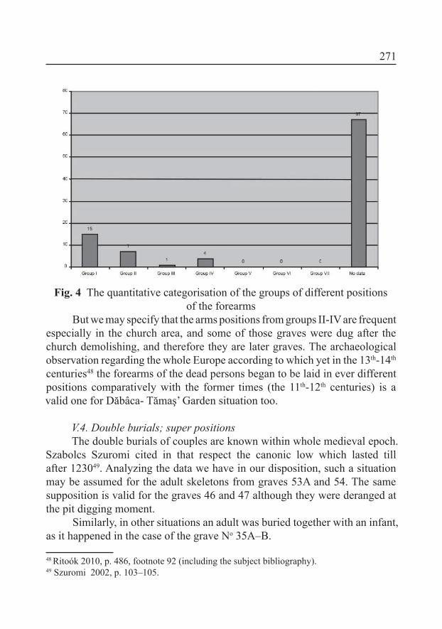
271
Fig. 4 The quantitative categorisation of the groups of different positionsof the forearms
But we may specify that the arms positions from groups II-IV are frequent especially in the church area, and some of those graves were dug after the church demolishing, and therefore they are later graves. The archaeological observation regarding the whole Europe according to which yet in the 13th-14th
centuries48 the forearms of the dead persons began to be laid in ever different positions comparatively with the former times (the 11th-12th centuries) is a valid one for Dăbâca- Tămaş’ Garden situation too.
V.4. Double burials; super positionsThe double burials of couples are known within whole medieval epoch.
Szabolcs Szuromi cited in that respect the canonic low which lasted till after 123049. Analyzing the data we have in our disposition, such a situation may be assumed for the adult skeletons from graves 53A and 54. The same supposition is valid for the graves 46 and 47 although they were deranged at the pit digging moment.
Similarly, in other situations an adult was buried together with an infant, as it happened in the case of the grave No 35A–B.
48 Ritoók 2010, p. 486, footnote 92 (including the subject bibliography).49 Szuromi 2002, p. 103–105.

272
V.5. Coins inside graves. MitesOne of the most dificult questions consists in interpreting the different
positions of the discovered in graves coins (on skeletons): is their presence a result of the funeral rite or of the fashion/deportment? Certainly, the coins that were found within mouth, on breast bone and in hands can be interpreted as a mite.
When did that custom spread or (re)come out in the Carpathian Basin? According to Pavel Radomĕrský and Béla Szőke it spread in the 11th century50, according to others, as following the Byzantine inluence51, or under Frank inluence by Moravian agency52. Béla Miklós Szőke, in accordance with Béla Szőke, asserted that it was a former resurrected custom which had also been known the anterior epochs53.
Certainly the large spreading of that custom is dated in the 11th century, but its practicing in the 10th century is emphasized by an important number of known cases. László Kovács succeeded to put together 56 discoveries in the Carpathian Basin, dating in the 10th century. The grave No 52 from Karos54
necropolis II must be mentioned among the earliest discoveries, but quite earliest is also the directed N-S infant grave from Uivar (that the Magyar archaeologist couldn’t have known)55. Up to Kovács’ theory the Magyars conquerers brought that custom from east, but under the Byzantine inluence56
already, even if a spreading from south is also not excluded57.That custom was identiied inside four graves of Dăbâca necropolis
representing 4.39% from the burials total (grave No 38 is not a part of this category).
The four graves with coins as currency deposition and mites are:
50 Radomĕrský 1955, p. 3-7; Szőke 1962, p. 92.51 csekély előzményei a 11. századi Magyarország déli felében mutathatóak ki (”previous
unimportant signs may be noticed in the southern part of Hungary in the 11th century”), see: Bálint 1976, p. 240. I may also mention that that custom is also known on Walachia territory in the 10th century, see: Fiedler 1992.
52 Kolníková 1967, p. 214-216.53 Szőke, Vándor 1987, p. 78.54 Révész 1996, p. 26, Pl. 78, pl. 84. 13-14.55 Gáll 2004–2005, p. 373.56 Kovács 2004, p. 46-47.57 Gáll 2004–2005, p. 373.

273
Number of the grave
The coins
issuing king’s reigning
period
Type in Huszár system
Position Weight
Situation/data from
the inventory register
Gr. 2 Anonymous denar? ? on the
right chest unspeciied Bad/“Géza II” is mentioned:
Gr. 12A Anonymous denar
H100 In front of the skull 0.298 gr Good
Gr. 15 Anonymous denar
H 102 In front of the skull 0.269 gr Good
Gr. 26B Anonymous denar
H96a
Not speci-ied in the reference material
0.155 gr Good
Fig. 5. Oboluses in the graves and their positions
Besides these four pieces another two coins were recorded, one nearby the grave No. 38, the other one in an unknown context, probably providing from a grave too:
Context The coins issuing king’s reigning
period
Type in Huszár system
Weight Situation/data from the inven-
tory registerNearby grave
No 38
Anonymous denar H89 0.133 gr good
9.20 m are mentioned in
the inventory register
Anonymous denar unspeciied ? Bad/“Béla II” is men-
tioned
Fig. 6The coins H89, H96a, H100 and H102 being anonymous cannot be
clearly connected with a certain king from the 12th century58. László Réthy divided the anonymous coins into two large chronological groups following their features. Those from Dăbâca-Tămaş’ Garden may be integrated to the
58 Huszár 1979, p. 38-45, 347.

274
age of kings Coloman–Géza II (1095-1162)59. Although that division was criticized by Bálint Hóman60 or by László Kovács61 we may assert for certain that those coins arrived inside the graves within the 12th century.
VI. The archaeological material analysesThe institutional Christianity spreading in the 11th century determined
the funeral rites simplifying, better say the rites that provide archaeological vestiges, therefore we may ascertain in such a case an “impoverishment” of the funeral inventory.
This impoverishment of the inventory can be seen also in the case of Dăbâca-Tămaş’ Garden as from the 95 (91+4) skeletons from 71 graves, only in 12 cases we could establish the presence of an inventory inside the grave (12.63%), mainly consisting in coins.
Considering their function-destination, the registered pieces in the graves of Sighisoara necropolis may be ordered into two groups;
Deportment elements: hair rings, inger ring, beadsMites62: coins with a special function in the funeral rites context
VI.1 Hair rings with an S shaped extremity (Pl.8.1-7, 9-14)The so-called hair rings played an important role in the 11th–13th centuries
deportment both for females and males. The hair rings functions still stay many times under a question mark, especially for their position inside the grave: they could have been used as hair rings but some times we couldn’t exclude their utilization as ear rings63. Those pieces were made mainly from silver64 and bronze, and rarely from gold65.
These jewelry represent an insigniicant percent in Dăbâca-Tămaş’ Garden necropolis as they were identiied only in eight graves from the 91 59 Réthy 1899, p. 16-17. 60 Hóman 1916, p. 236-238.61 Kovács 1997, p. 291-292.62 See above their analysis63 Connected to such a subject more examples are given in another work. See in this respect:
Gáll 2008, vol. 1, p. 143-144.64 Their statistics for the Transylvania Basin necropolises from the 10th – 11th centuries see:
Gáll 2008, vol. 1, p. 148-154. Statistics for the raw material the rings are made from, relat-ed to Cluj area necropolises in the 10th-13th, see: Gáll et al. 2010, p. 65-69, ig. 24 26. Their analysis from this point of view, for Dăbâca necropolis-Area IV: Gáll 2011, p. 35, ig. 20.
65 Károly Mesterházy identiied in 1983 only 13 samples of hair rings with the S shaped end made from gold. Mesterházy 1983, p. 143-151.

275
(+4) ones. Six hair rings were identiied inside Gr. 34, the position of which clearly relects their function. The described situation suggests that they were set on a textile strip that used to be worn on head. Although not speciied, three samples were identiied in grave No. 3, which probably had had also another function, like the two samples from Gr. 7, 15 and 52A. Position of the two samples from Gr. 52A gives us no clew on their function, and also we have no information on the two hair rings from Gr. 7. Two hair rings, one of them with an S shaped broken end and a simple one the other were registered by the skull, but this situation doesn’t allow us to reach a conclusion on their function. As about the samples from the graves 16 and 18, their function as ear rings mayn’t be excluded, and the sample from Gr. 47 could have been used to catch the shroud, or it could have arrived there with the corpse rotting.
Thus, on the archaeological material we have had in our disposition, we could draw the conclusion that also in that necropolis the deportment or one or two hair rings is dominant.
The types of the simple hair rings from Dăbâca prove once again that their deporting may be registered even in the 12th–13th centuries as the samples from graves 15, 16, 18, and 47 suggest us. During the 11th–13th centuries the hair rings with the S66 shaped end may be considered as the classic ones. The samples with a huge diameter, as that one of Gr. 52A, are enough rarely known. They characterize exclusively the 12th–13th centuries, similar pieces being discovered at Alba-Iulia-Cathedral67, Dăbâca - Area IV Gr. 114, Gr. 176, Gr. 122 and Gr. 26768, Dăbâca-Boldâgã (Pl. 8.13–14)69; Ulieş Gr. 4370, Peteni Gr. 79 and Gr. 19371, respectively, Zăbala Gr. 54, Gr. 74, Gr. 117, Gr. 168, and Gr. 18472. Their position inside the mentioned graves relects the fact that these pieces with a large diameter have no special function. Their diameter draws near that of large links73, which in their turn belonged to the head ornament category74. Probably such jewelry was speciic to females’ ornaments, but 66 The debate on these jewelry in Area IV of Dăbâca necropolis but also with general observa-
tions on the whole site, see: Gáll 2011, p. 50-55, 152-157. 67 Crângaci-Ţiplic, Oţa 2002-2003, p. 91-106.68 Gáll 2011, p. 40, 74, 85, 92, 101, Pl. 38/12, 39/8, 40/15.69 Unpublished.70 Derzsi, Sófalvi 2008, p. 269, 275, ig. 11/5.71 Székely 1990, ig. 12/4, 13/13. 72 Székely 1993–94, p. 284, ig. 4/2, 4-8.73 Former those ones were taken for bracelets. Parádi 1975, p. 157.74 Kulcsár 1992–95, p. 249-275.
276
a clear conclusion could be drawn out only upon further anthropological analyses.
The hair rings with the S shaped end decorated with grooved lines was dated between the middle of the 11th century and the middle of the 13th
one75. The samples that were discovered in the Area IV, considering also the anonymous coins dating in the 12th century consolidate these observations.
The shapes of hair rings that were discovered at Dăbâca-Tămaş’ Garden dating ever since the 12th–13th centuries are attested in important percentages in the necropolises of the 10th–13th centuries in Eastern and Central Europe, but also within treasures belonging to different aristocratic families76. These ornaments utilization in deportment was very diverse relecting the level of Eastern European civilization in those times, and, in our case, the distinct hair deporting77.
VI.2. Finger ring from plaited wire (Pl. 8.7)An almost unknown feature of Dăbâca material culture is represented
by the inger ring with plaited wire. Unfortunately, it cannot be connected to a closed complex; we have found in the inventory register only the note that it provides from a rummaged grave. Another sample of the same type is not known at Dăbâca, but we have in turn a silver series of a good quality providing from Cluj-Mănăştur Gr. 2, 60, 86, 157 and 15978, which dated, on the basis of horizontal-stratigraphic analysis, from the end of the 11th century till the 13th century79. Considering that it was recorded in a rummaged grave at Dăbâca, that ring probably belongs to an early phase of the necropolis.
VI.3 Beads (Pl. 8.15)A string of beads was recorded in the inventory register of The National
History Museum of Transylvania80. The grave number is not mentioned.
75 Szőke 1962, p. 89; Szőke, Vándor 1987, p. 51-52.76 Fiedler 1992, 171-172, ig. 14/10, 79/10, 87/13-15, 95/12; Jażdżewski 1949, p. 91-191;
Marciniak 1960, p.141–186; Kaszewscy, Kaszewscy 1971, p. 365-434; Rashev 2008, Pl. LXXVIII/1-86, 88-89; Jakab 2007, 247-296.
77 Bálint 2006, p. 322.78 Gáll et al. 2010, p. 77-79, Pl. 47: m. 2. 3, pl. 51: m. 60. 2, pl. 55: m. 159. 1, pl. 56; 14, pl. 64. 7.79 This observation doesn’t run counter at all to the former ones: Szőke 1962, p. 97; Giesler
1981, p. 113, types 29-30.80 MNIT.F 13634.

277
VII. An attempt to establish the relative chronology of the necropolis utilization
The necropolis around the church of Dăbâca, on the basis of the registered coins, began to function from and in the 12th century. In this case we speak about graves 1–11, 12–28, and 62–67 that were investigated southwards of the partly examined church.
Another part of the graves were investigated right on the demolished church place. When digging the pit of grave No. 51, part of the altar foundation was drawn out (by that one was buried also the corpse 50). Within the (already destroyed) altar perimeter the graves 33-35 were dug. On the basis of their depth, graves 38–48, 55–60 may belong to the post-church phase too.
In conclusion, we may specify that the graves of that churchyard that had functioned simultaneously with the investigated church were deranged by later burials. It may be mentioned also that the graves from where coins were retrieved (Gr. 12, 15, 26), except for Gr. 2, had been destroyed by the later burials; by the skull of grave 25, a part of the rummaged and put in an ossuary skeletons was identiied. We cannot specify at the present moment of the research weather the burials that had destroyed the graves which were dated by the help of coins, respectively, the accumulation of bones (the ossuary) in the western part of the section belong to the directly after epoch, or to an epoch within which the researched church had already been demolished. Unfortunately, even the stratigraphic observation which is unclear couldn’t help us at all in this regard; the absence of other analyses, such as the anthropological analysis, discourages us to set up observations on this subject81. Only on a side of the wall that was identiied southwards of the demolished church the diggers noted the depth (27, 30 and 35 cm), and the bones depth from ossuary in the middle of which the skeleton was identiied doesn’t outran 0.46 cm. But the undestroyed graves, 24 – 28 respectively, are dug at a depth of 100 cm.
81 There are other places with interesting set up observations: Lajos Bartucs noticed in 1929 at Nyársapát that the skulls were long within the ossuary, and short within the researched graves. Such a result shows us that the necropolis was used by anthropologically different populations; the analyzed skulls from the ossuary gave practically the earlier phases of the necropolis. Similar difference could also be observed by Pál Liptâk, respectively, Antónia Marcsik at Téglás, Kinga Éry at Csenge-Bogárhát and Veszprém-Kálvária domb, and by Balázs Mende at Alsórajk. Bartucz 1929, p. 148-174; Lipták, Marcsik 1965, p. 69-96; Éry 1982, p. 89; Szőke 1996, p. 267; Éry et al. 2005, p. 125; Ritoók 2010, p. 481-482.
278
Finally we can set up the following observations concerning a relative chronology:
Within the irst phase, after the church building, the burials began in the southern part of it. The presence of ossuary in Section II, by the grave No. 26 indicates the earliest phase of the necropolis.
Within the second phase, after the church demolishing, its area became be used for burials. The skeletons No. 30-32, 35-37, 38-48 and 55-60 were probably deposed within that period. Considering the very varied arms’ positions, we may date those burials in the 13th-14th centuries.
At this moment, we couldn’t give our opinion on some possible relationship or any other sociological intercourses between the skeletons of the necropolis two chronological phases. Also we couldn’t illustrate if a hiatus took place in the necropolis using. But having in view that the site was dug only in a small proportion, an analysis in this regard may be done only after an exhaustive and well documented digging. By this token, we may specify that the situation in the case of this site is not at all compromised.
In close conjunction with this problem, we could couch absolutely nothing on the population which was buried here. Chronologically, in the irst phase the necropolis was used simultaneously with that one of Area IV. In the present stage of the research we couldn’t give any scientiic answer to the pertinent question why two necropolises were used all at once. The great numbers of graves from the Area No IV (677)82, respectively, the more reduced surface of the necropolis from Tămaş’ Garden suggest the possibility of a social differentiation of the population of the two churchyards.
VIII. Churchyard in Tămas’ Garden and the other Dăbâca sites. Some observations
As we have shown in the introductory part, the historic-narrative data, respectively, the linguistic ones played the main role in interpreting Dăbâca site while archaeology had to offer doubtless information for historical theories.
Two great problems appear in Dăbâca site analysis on account of which the researching process couldn’t advance:
The archaeological diggings affected only a reduced part of the site territory so that we have a relative image on the fortress/fortresses or the inhabited settlements and, respectively, the used necropolises. During the 20
82 Gáll 2011.

279
years of work only a small area of the fortress was excavated, not more than an estimated 20% (Pl. 2). On top of this, the documentation of the excavations is also poor, in several cases they do not exceed the level of the 19th century, and in other cases (such as the excavation in 1980) no documentation has remained, just some notes. Therefore the great conclusions that can be read in the article written in 1968 and in Petru Iambor’s paper of 2005 (and based upon them, in several other papers) must be considered in a more relative way. To draw such overall conclusions, the excavation of the whole site would be required with a much more accurate documentation!
Dăbâca was taken for a unitary pile where fortress functioned parallel, up to the general vision, with the settlement, or better say, the settlements.
Another problematic component was added to these above. In all course of the 20th century, the early medieval age archaeology set hypotheses in concordance with the contemporary epoch hopes and they were often inluenced by the ideology of the national state83. Dăbâca was in its turn included to such a paradigm: even since 1943, Crettier connected the fortress with the beginning of the 11th century, during Stephan I rule84, as the possible center of the border county; at the same time he recognized that those were only means to interpret the case85.
The inter-war Romanian archaeology possibly under Vasile Pârvan’s inluence, didn’t take a distinct interest in the early medieval ages archaeology, that one being an almost inexistent researching ield in the Great Romania. The great turning point came after 1946, but especially after the Magyar revolution from 1956 the moment that the former cosmopolitan-communist or Moscow depending Romanian communist regime turned radically to national-communism86. Besides that general situation but obviously determined by that one, on the stock of the national Romanticism of the 19th century a speciic aspect of the Romanian historiography is connected. As Lucian Boia noticed more than a decade and a half ago, after the information belonging to narrative-historical sources on the Daco-Roman continuity and proto-Romanian demonstrating, the Romanian historiography put all down to archaeology87. Another aspect may be added to these all which can explain from the
83 Brather 2006, p. 24.84 Crettier 1943, p. 201.85 Crettier 1943, p. 202.86 In this regard see the analysis of Boia 1999, p. 76-79.87 Boia 1999, p. 152.

280
chronologic point of view, some deiciencies and the handicap of the early Medieval Ages Romanian archaeology comparing to the Eastern and Central Europe archaeology88. If in Transylvania and mainly the Western Plain area yet in the second half of the 19th century, within the museum associations the early Medieval Ages researching beneited by renown (J. Milleker, Gy. Kisléghi89, J. Karácsonyi, J. Bodrogi, G. Nagy), and, respectively, the archaeological school from Cluj directed by Béla Pósta laid the foundation of modern archaeology90, we cannot say the same thing about the extra-Carpathian territories (the former Kingdom areas)91. Only the former Béla Pósta’ disciple, Márton Roska92 continued the research on the early Medieval Ages in Transylvania within the inter-war period. Consequently, not accidentally Radu Harhoiu entitled his article from 2004: Das Miereschprogramm. Ein vergessenes Forschungsprojekt?93 Bogdan Ciupercă also noticed this hiatus some years ago and wrote for good reason: …As early as the inter-war times they began, timidly to tell the truth, to appeal to the archaeological data which should have supplemented the literary source insuficiency94.
In the new politic and historiographic context which was dominated by the speech concerning the past times recuperation95, the character of which is very similar to the historiographic speeches in other countries, Dăbâca
88 For instance, Croatia: at the end of the 19th century, Frane Bulić, Lujo Marun, and specially Josip Brunšmid, and within the inter-war years, Ljubo Karaman and Zdeno Vinski; Bulgar-ia: the end of the 19th century Karel Škorpil, respectively, in inter-war period Bogdan Filov, Géza Fehér and Nikola Mavrodinov; Serbian from Austria-Hungary: Ilarion Ruvarac; The Serbian-Croatian-Slovenian Kingdom (Serbians): Ðorde Mano-Zisi, Mihajlo Purković, Jo-van Cvijić (more preoccupied with the anthropogeography of the medieval epoch). The medieval epoch archaeology was practically born after 1945 in Macedonia, Boško Babić bring the most known Macedonian archaeologist after World War II, as in Kosovo (a fe-male grave “Germanic” was discovered at Novo Brdo, and necropolises from the migration era and the 9th12th centuries were investigated at Klina). This footnote has been realized on the basis of Miklós Takács’ articles: Takács 2006b, p. 147179; Takács 2007, p. 3-6.
89 Kisléghi 2010.90 On the Cluj school and its impact ina rchaeology: Harhoiu 2004, p. 159-162; Gáll 2010b, p.
284-287 (with the all literature on the subject); Gáll 2012, u. pr.91 A study on why that epoch of almost 1.000 years wasn’t encouraged would be worthy. Only
by Vasile Pârvan’s activity and impact could be explained such a state of things?92 On Roska’s activity concerning the subject, see: Gáll 2010b, p. 281-306.93 Harhoiu 2004, p. 159-162.94 Ciupercă 2009, p. 134. 95 Boia 1999, p. 76; Ciupercă 2009, p. 148-150.

281
researches began in 1964. Thus, in the context of the 60s of the past century, an epoch of national past times re-discovering, it goes almost without saying that the authors of diggings whished to discover the politic-military center which had been at the bottom of the Romanian (pre)state organizing in Transylvania (and not only)96, but also the Transylvanian primacy comparatively with the other provinces (and schools). Nor the inluence of Constantin Daicoviciu’s97
personality might be forgotten in this respect, as he always was in collision with Bucharest school (and especially with Ion Nestor)98; Daicoviciu visited many times Dăbâca99. Obviously, but without having how to demonstrate it, within that “challenge” between Cluj and Bucharest, Dăbâca played besides the scientiic part, another role, namely a cultural-political one becoming in fact, after the archaeological digging, the irst imaginary and imagined center of the Romanian state or pre-state organizing100. Practically (and) in the sense of personal psychology it may explain the fact that none of those who had taken part in the diggings could renounce to the idea of 1968 (after 1990 they would have had time on their hands and freedom of speech, but they couldn’t have applied a written self-criticism)101.
In conclusion: Dăbâca researches started with a preconception in order that Dăbâca become the politic-military center of Gelou, the Vlachs and
96 On the Romanian ethno-genesis and continuity debates in that period, see: Măgureanu 2007, p. 289-321.
97 One of Daicoviciu’s irst works on that subject was written in 1935; the work emphasized the Transylvanian primacy beginning with the Roman times (especially in the ield of state organizing), repealing the Romanian character of Dridu culture (he didn’t specify what is Romanian and what is not). Daicoviciu 1935, p. 176-180; Daicoviciu 1968a, p. 261-271; Daicoviciu 1968, p. 90-91.
98 Opriş 2004, p. 76-87; Madgearu 2008, p. 65-66.99 The excavations must have been very important to the contemporary Romanian scientiic
elite in Transylvania: they were visited several times by Constantin C. Daicoviciu, the chairman of the committee set up in 1955. I could identify photos with the scholar visiting the site, within the reference material “Dăbâca” from MNIT. According to the various documentations in the museum in Cluj-Napoca, there were at least ten archaeolo-gists in the team led by Pascu (Şt. Pascu, M. Rusu, P. Iambor, N. Edroiu, Gyulai P., V. Wollmann, Şt. Matei, Gh. Lazarovici, I. Hica).
100 O very good introduction on the concept of state, respectively, of the state speciic features within early medieval Ages could be found at Szabados 2011, p. 10 -57.
101 One of the participants in Dăbâca digging confessed us in 1998 that actually he hadn’t believed for quite a long time in the ideas of 1968. Verba volant, scripta manent!

282
Slaves leader102. We have to mention at the same time that such an attempt was not a speciic Romanian one as in the same period Nitra became another Troy. In substance, that fact characterized the beginnings of fortresses researching and the most representative words perhaps in this respect are those ones of István Bóna: so, the modern ight for fortresses began103. The Magyar archaeology also played in the course of time a negative role in such a situation constructing. In the 19th century that one presented the populations belonging to the politic-military entity which had conquered the Carpathian Basin, using the formula noble horsemen104 who never dismounted, and that of Slaves who served the irst ones105. From the second part of the 20th century especially the historians (Gy. Györfy, for instance) asserted that the fortresses which began to be examined only in the 50s of the past century had functioned since / in the 10th century. We also have to mention that that conception fell out of the scientiic use in the train of István Bóna’s works, beginning with History of Transylvania and after, by the works that analyzed fortresses, in 1994 and 1998106. Bóna’s observations have been accepted, within the Romanian archaeology as far as we know, only by Adrian Andrei Rusu107, otherwise the Magyar archaeologist’s work has remained unknown and unread.
Coming back to Dăbâca, it is no longer important in this context if besides Vlachs, the Slave entity also appears within Anonymous’ narrative source. The fundamental error of Ştefan Pascu and his team lies in the fact that they counted too much on a single narrative source (which is much more than a contestable one), but also in the fact that their diggings till 1967 (their article was published in 1968) touched only an ininitesimal part of the whole site108. In addition to those errors that could have been avoided other problems come too, the supericial enough analysis of the archaeological material being the gravest one, as well as the too emphasized historicity comparatively with the archaeological material permissible possibilities. It is not signiicantly in the 102 See footnote 4.103 Bóna 1998, p. 6.104 This is the source of “nobiliary archaeology” – a denomination used in a critical sense by
Bóna in different articles. As an example in this respect, Bóna 1988, p. 572105 Langó 2006, p. 93-94, with a very vast bibliography concerning the subject. We have to
remember that the process can be noticed also in the case of other peoples. Brather 2000, p. 139-177.
106 Bóna 1994; Bóna 1998.107 Rusu 1998, p. 5-19.108 Pascu at al. 1968, p. 153-202.
283
context how the obsolescent problem of the ethnic assignment was touched on or what historical-politic conclusions were drawn out on the archaeological material basis. But considering the digging surface and level it is very clear that it was not the best choice.
Unfortunately, these preconceived ideas haven’t been corrected up to the present. The main reason consists in the fact that after 1968 the archaeological examined material was not published short of the necropolis of the 12th-13th
centuries from Area IV109. On the other hand, even if it had been published, the theoretical development of the archaeology presupposes nowadays a digging tending to be exhaustive110, with a much better documentation and a better founded and detailed analysis of the archaeological material aiming not only to the irst level as it was indicated by Sebastian Brather111 but more detailed, which is possible on the archaeological sources basis as this one of the old structures and economic relationship (level two as Brather indicated). Or, neither in the present researching phase more than a typology of the archaeological material and its chronologic integration can be done because: 1. as I have already reminded the site is examined in a very small extend (see Pl. 1-2); 2. materials to be “annexed” to the archaeological one, which could have offered information on the local population, composition of food etc. were not preserved. We cannot say that the site is compromised, but any case the loss of anthropological and zoological material from the fortress afferent necropolises and settlements112 distort such attempts. Only new and more precise diggings could bring to other results.
The archaeological material allows us in a certain measure some conclusions on the social composition of the inhabitants from Dăbâca fortress settlement, but we cannot reach a conclusion concerning their ethnic identity. As whishing to touch this subject that has become delicate during the 20th
century, we may clarify some problems.From the beginning of the 20th century the connection between the
material culture and the ethnic identity has been estimated on the basis of Gustav Kossina’s theory of a great impact, in the meaning of which the geographic areas are represented by unitary material cultures, an ethnic entity
109 Gáll 2011.110 The Romanian archaeology was and still remains at a pitiable level in this regard, com-
paratively with this science in Europe. 111 Brather 2006, p. 27: Fig. 1.112 In this regard see: Gáll 2011, p. 12.
284
corresponding to each of them113. Nation was considered as a biologic and linguistic unitary formation and not what it really is: a sociologic construction114. We insist at the same time to specify that the culture homogeneousness is not Kossina’s invention but the mental construction of the 19th century (nation building phenomenon), the (archaeological) culture homogeneousness being only a “development” of the German linguist behind of which there is a modern myth that was created in the Romantic epoch: the national unity myth.
Under the inluence of sociology, the question of nationality was redeined within the majority of European archaeological schools to this day extant. Thus we can specify without question that the connections between nationality and material culture (the archaeological culture in our case) are mobile, instable and luid. It is of the same importance that not different (ethnic) identities steal in the archaeological inventory but different archaeological distinct signs of a cultural nature, traditions, relations and interactions which normally may be only indirectly connected to different identities. We must specify that during the early Medieval Ages no population (the name of which is present within the narrative sources) from the Carpathian Basin can be associated to or identiied with a certain anthropologic type or anthropologic types, respectively, no anthropologic type can be associated to an ethnos!! In relation to the evolution and, respectively, the cosmopolitan origin of the Hungarian Kingdom elites in the 11th century115, the case of Vecelin is one of the most eloquent; he was the leader of Stephen I army in the battle against Koppány in 997, but also the cases of the other leaders of that army as Poznano, Cuntio and Orzio116.
Consequently, we have to emphasize: the role of archaeology (also) in the case of Dăbâca site consists irst of all in the importance of clarifying the development of the inside fortress habitat (from now on the fortress environs might be included in the researching plan), the different phases of the fortress building, the notices on the social stratiication on the basis of the archaeological material from the fortress territory, and the funeral rites analysis and also of the archaeological material from the three only fragmentary examined necropolises. No case we could give a scientiic answer to the questions concerning the inhabitants’ ethnos that entire generations of scholars and others worried about. 113 Kossina 1936, p. 315114 Pohl 1998, p. 15-18; Bálint 2006, p. 277-347.115 Bálint 2005, p. 37-56.116 Györffy 1992, I. p. 39-40.
285
VIII.1 About the fortress/fortressesFirst of all we may clarify the fortress dating as the diggings authors gave
the end of the 11th century for the fortress irst phase of utilization, also connecting its destroying to Gelou’s battles with Tuhutum. But from the 1st burn level of Area I, artifacts were identiied the dating of which is impossible not only for the 9th century but for the 10th one too. Thus, inside the column “A” near section 1; that one was opened in 1964, and silver pendants with granulation ornament117
on the surfaces that seems to be worn out were documented, and also from the ditch I, a bracelet and a necklace with a rhomboidal section, respectively, the polyhedral inger ring118, the dating of which would be impossible to motivate before the irst decades of the 11th century. At the same time, the necklace with a rhomboidal section was associated with a “beard” type arrow point which is in the most cases dated in the second half of the 11th-12th centuries119. One can thus specify that none of these artifacts can be dated before the 11th century, and the arrow point with “beard” is even later. A lunula type pendant from a hovel illing belongs to this phase of the fortress utilization too; we know its identical analogy from Zimandinu Nou120. Up to the diggings authors, simultaneously with Area I the ditch of Area III was in use; in its north-western corner a coin H9 which had been issued by Andrew I (1046-1060) was discovered, and not far in the ditch illing two coins, H1 and H2, from Stephen I epoch (1001-1038) were also recorded. Consequently, although the question is relative, this phase may be dated within the irst two thirds of the 11th century. After the fortress arson, on its place – as the article of the 1968 shows – another one was built with a structure in the shape of a column inside the Areas I and II121, that is that the
117 Their analysis: Bóna 1964, p. 151 – 169; Bóna 1970, footnote 315. O similar piece is known also from a fortress dating from the 10th-11th centuries in the Republic of Molda-via. Our gratitude to Mrs. Svetlana Rjabceva for giving us the data.
118 Gáll 2008, I., p. 199–208, 216–260.119 Among the discoveries belonging to the 10th-11th centuries in Transylvania Basin, Partium
and the Banat, only a single sample of that type was found at Pecica-Şanţul Mare, but also this one is without a context. The number of them would explosibily increase during the 12th century. In the Eastern part of Transylania Zsigmond Lóránd Bordi gathered these ar-row points, but we do not agree his observations according to which those components of weapons spread only in the 12th century, on the basis of that piece from Dăbâca. Gáll 2008, I, p. 329; Pascu et al. 1968, ig. 4 ; Bordi 2006, p. 91-97.
120 Réthy 1898, p. 128, III. 6.121 According to Gergely Buzás, the building of such a type of a fortress was realized be-
tween 1942 and 1952. Buzás 2006, p. 51.

286
small fortress was extended. A coin H6 Peter Orseolo (1038-1041, 1044-1046) comes from the treading level of the fortress section “B” and, respectively, a spur. Probably that fortress was built by the middle – the second half of the 11th
century and destroyed by the end of the 11th century – the irst part of the 12th
one (Pl. 14).It is possible that a third fortress had been built by the end o the 11th
century – beginning of the 12th one, as a coin of Coloman the Scholar (1095-1114), providing from the ditch122, would show us. Unfortunately, we couldn’t identify that coin at MNIT; such being the case, we couldn’t get at the truth if the coin really belongs to Coloman. We have to specify that beginning with the epoch of Coloman’s rule, some of that king-scholar’s issues were anonymous, so that the question on weather that coin is connected or not to that king may be posed as the irst chronologic group of anonymous issues are dated in 1095-1162. According to the authors’ opinion, after the third destroying of the fortress, a stone wall had been built that was destroyed later too. This assertion is also doubtful because the stone building of a large part of the kingdom fortresses began in the second half of the 13th century, not at all costs owning to the Tatars invasion, but for reasons connected to the kingdom social-economic changes123.
We call the readers’ attention on the relativity of this observation. We also must underline that in the early Medieval Ages the fortresses were not used for centuries, their frequent rebuilding being motivated by very many factories among which maybe the most important was the wood perishableness. Any case in our opinion and following the present researching phase, the material culture aspects relying on the coins from the fortress too, indicate the utilization of fortress beginning with the 11th century. The time being, one could reach to a progress of Dăbâca archaeological site researching, by: 1. new investigations on site; 2. if possible, the interdisciplinary analyses, as dendrochronology and radiocarbon dating may be integrated to the research.
VIII.2. On the habitat: the early Medieval Ages levels of settlements (the 11th-12th c.)124
Since the beginning the main problem perhaps in Dăbâca researching was the fact that the archaeologists who realized the digging were making 122 MNIT. F. 2914.123 Wolf 2011, p. 324.124 A single settlement from Transylvania Basin has been published till now. Ioniţă 2009.

287
efforts so that almost all habitat aspects be harmonized with the period of fortress functioning.
On the basis of published data and, respectively, of documentation we found at The National History Museum of Transylvania, we have tried to systemize the material, but the situation would become much clearer at the moment of archeological mater integral publication:
Topo-graphical position withinthe site
Locali-zation
Hovels Dwell-ings on the sur-
face
Otherhabitat
elements
Aspects of the material culture
Dating
Branişte S3, S6, S7/1972
4 pit hou-ses
Pits Fragments of ceramics, the end of an “Avar” girdle (Pl. 12. 11), ar-rowhead with three
edges (Pl. 12. 10) frag-ments of burnt bones
The 8th c.
Fortress
Area I
section
“A”/ 1964
A ire place under the burning
level of the stockade, at
125 cm
Golden silver pendants with granulated orna-
ments (Pl. 11. 4-5, 7-8), an iron plough, a chisel, arrowhead rhomboidal
shaped
1st part of the 11th c.
Fortress
Area I
section
“A”/ 1964
Fragments o ceramics, a spur, a Friesach coin
The 13th c.
Fortress
Area I
section
“B”/ 19641 pit house
A lunula shaped pen-dant from illing (Pl.
11.6)
The 1st
part of the 11th c.
Fortress
Area I
I ditch burn level
A necklace, a bracelet and a inger ring with
rhomboidal section (Pl. 12.1-3, 5), a inger ring with polygonal section
(Pl. 12.4), an arrow-head with “beard”
The irst 2 thirds of the 11th c.
Fortress
Area I
dungeon Fragments of ceram-ics, spurs, arrowhead,
coins, horseshoes, spurs, coins
The 13th-14th c.
Fortress
Area II
S2/II/1966-1976
cultural
layerfragments of clay
pottery11–12th c.
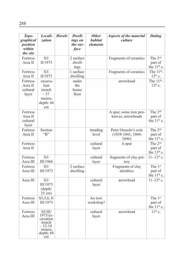
288
Topo-graphical position withinthe site
Locali-zation
Hovels Dwell-ings on the sur-
face
Otherhabitat
elements
Aspects of the material culture
Dating
Fortress
Area II
S3/II/1973
2 surface dwell-ings
Fragments of ceramics The 2nd
part of the 11th c.
Fortress
Area II
S3/II/1973
1 surface dwelling
Fragments of ceramics The 11th-12th c.
Fortress
Area II
cultural
layer
excava-tion
trench ‒ 37
meters, depth: 66
cm
under
the house loor
arrowhead The 11th‒12th c.
Fortress
Area II
cultural
layer
A spur, some iron pen-knives, arrowheads
The 2nd
part of the 11th c.
Fortress
Area II
Section
“B”treading
level
Peter Orseolo’s coin (1038-1041; 1044-
1046)
The 2nd
part of the 11th c.
Fortress
Area II
cultural
layerA spur The 2nd
part of the 13th c.
Fortress
Area III
S3/III/1966
cultural
layerfragments of clay pot-
tery11- 12th c.
Fortress
Area III
S3/III/1973
2 surface dwelling
Fragments of clay alembics
The 1st
part of the 11th c.
Area III S3/III/1973 (depth: 25 cm)
cultural
layerarrowhead 11–12th c.
Fortress
Area III
S3,5,6, 8/III/1973
An iron
workshop?The 1st
part of the 11th c.
Fortress
Area III
S5/III/1973/ex-cavation
trench ‒ 12-14 meters,
depth: 66 cm
cultural
layerarrowhead 11th c.
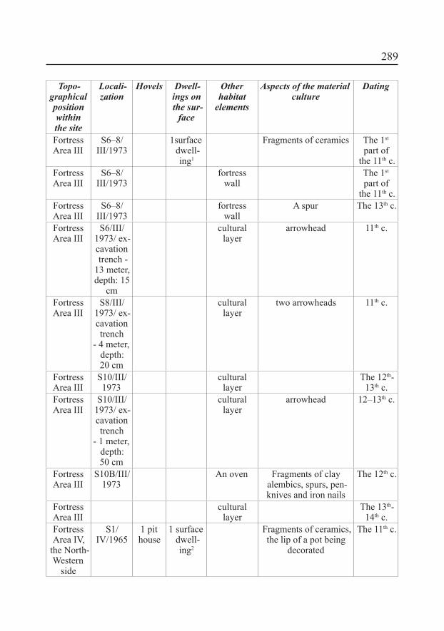
289
Topo-graphical position withinthe site
Locali-zation
Hovels Dwell-ings on the sur-
face
Otherhabitat
elements
Aspects of the material culture
Dating
Fortress
Area III
S6–8/III/1973
1surface dwell-ing1
Fragments of ceramics The 1st
part of the 11th c.
Fortress
Area III
S6–8/III/1973
fortress wall
The 1st
part of the 11th c.
Fortress
Area III
S6–8/III/1973
fortress wall
A spur The 13th c.
Fortress
Area III
S6/III/1973/ ex-cavation
trench - 13 meter, depth: 15
cm
cultural
layerarrowhead 11th c.
Fortress
Area III
S8/III/1973/ ex-cavation
trench - 4 meter,
depth: 20 cm
cultural
layertwo arrowheads 11th c.
Fortress
Area III
S10/III/1973
cultural
layerThe 12th-
13th c.Fortress
Area III
S10/III/1973/ ex-cavation
trench - 1 meter,
depth: 50 cm
cultural
layerarrowhead 12–13th c.
Fortress
Area III
S10B/III/1973
An oven Fragments of clay alembics, spurs, pen-knives and iron nails
The 12th c.
Fortress
Area III
cultural
layerThe 13th-
14th c.Fortress
Area IV, the North-Western
side
S1/IV/1965
1 pit house
1 surface dwell-ing2
Fragments of ceramics, the lip of a pot being
decorated
The 11th c.

290
Topo-graphical position withinthe site
Locali-zation
Hovels Dwell-ings on the sur-
face
Otherhabitat
elements
Aspects of the material culture
Dating
Fortress
Area IV, the North-Western
side
S1/IV/1965
1 surface dwelling
A X Petersen sword crossguard, two frag-
ments of gold thin col-lared spurs, fragments of green glazed ceram-ics, fragments of (a)
cross, penknives
The 11th c.
Fortress
Area IV, the North-Western
side
S2/IV/1965
1 surface dwelling
An oven A rhomboidal arrow head, beasts bones (?), fragments of ceram-
ics, rhomboidal arrow points, beasts bones,
iron slag, fragments of ceramics, cooper wires
The 1st
part of the 11th c.
Fortress
Area IV, the North-Western
side
S3/IV/1965
2 pit houses
Fragments of ceramics The 8th-9th c.
Fortress
Area IV, the North-Western
side
S3/IV/1965
1 surface dwelling
The 9th c.
Fortress
Area IV, the North-Western
side
S4/IV/1965
1 surface dwelling
Fragments of ceramics The 8th-9th c.
Fortress
Area IV, the North-Western
side
S5/IV/1965
1 pit house
A gold hair ring with triangular section (?)3, a fragment of a silver twisted inger ring or a hair ring with the S shaped end (Pl. 12.8), two penknives, a frag-ment of a bone with
processing marks
The 11th c.
Fortress
Area IV, the North-Western
side
S6/IV/1965
1 pit house
Fragments of ceram-ics, beasts bones, iron
knives, the iron belts of wood buckets
The 11th c.
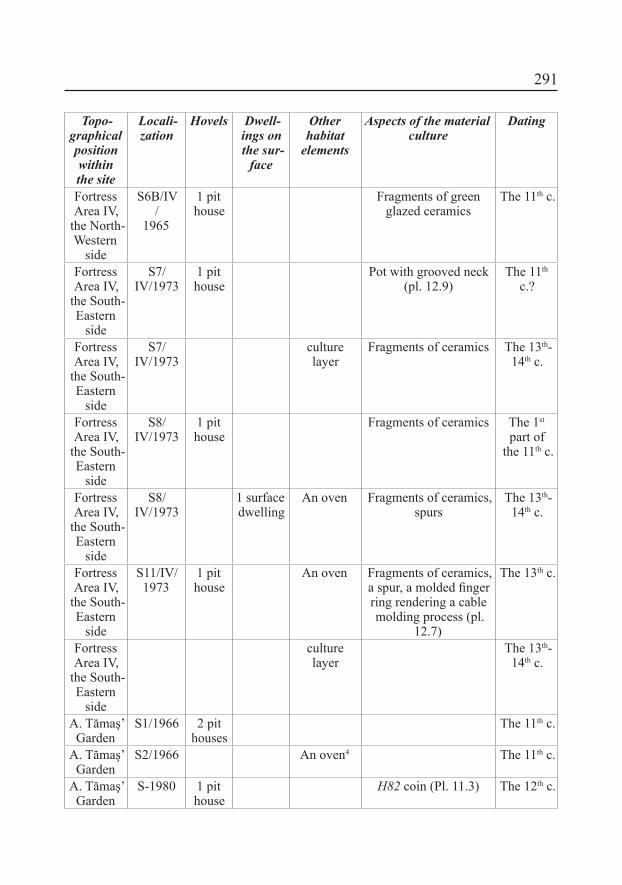
291
Topo-graphical position withinthe site
Locali-zation
Hovels Dwell-ings on the sur-
face
Otherhabitat
elements
Aspects of the material culture
Dating
Fortress
Area IV, the North-Western
side
S6B/IV/
1965
1 pit house
Fragments of green glazed ceramics
The 11th c.
Fortress
Area IV, the South-Eastern
side
S7/IV/1973
1 pit house
Pot with grooved neck (pl. 12.9)
The 11th
c.?
Fortress
Area IV, the South-Eastern
side
S7/IV/1973
culture
layerFragments of ceramics The 13th-
14th c.
Fortress
Area IV, the South-Eastern
side
S8/IV/1973
1 pit house
Fragments of ceramics The 1st
part of the 11th c.
Fortress
Area IV, the South-Eastern
side
S8/IV/1973
1 surface dwelling
An oven Fragments of ceramics, spurs
The 13th-14th c.
Fortress
Area IV, the South-Eastern
side
S11/IV/1973
1 pit house
An oven Fragments of ceramics, a spur, a molded inger ring rendering a cable molding process (pl.
12.7)
The 13th c.
Fortress
Area IV, the South-Eastern
side
culture
layerThe 13th-
14th c.
A. Tămaş’ Garden
S1/1966 2 pit houses
The 11th c.
A. Tămaş’ Garden
S2/1966 An oven4 The 11th c.
A. Tămaş’ Garden
S-1980 1 pit house
H82 coin (Pl. 11.3) The 12th c.
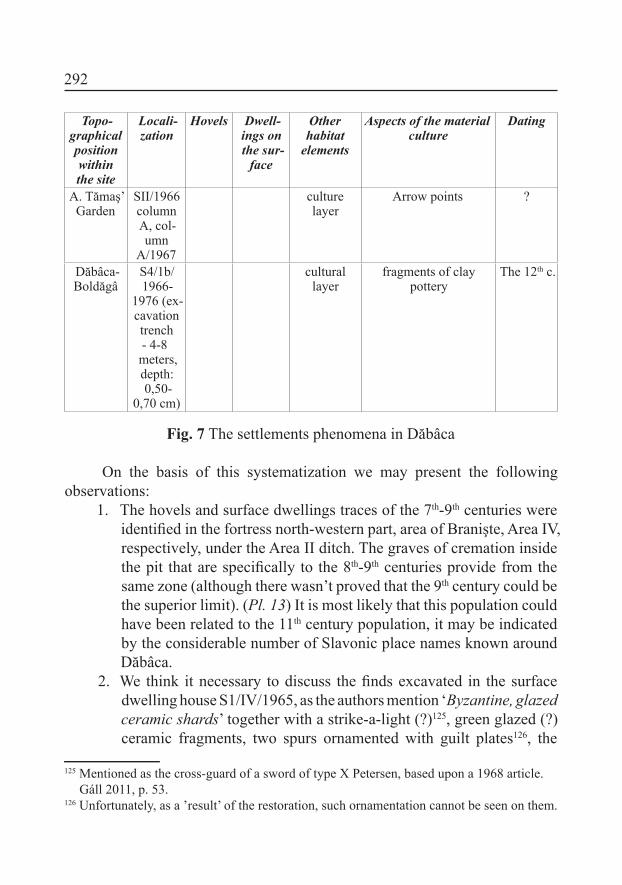
292
Topo-graphical position withinthe site
Locali-zation
Hovels Dwell-ings on the sur-
face
Otherhabitat
elements
Aspects of the material culture
Dating
A. Tămaş’ Garden
SII/1966 column
A, col-umn
A/1967
culture
layerArrow points ?
Dăbâca-Boldăgâ
S4/1b/ 1966-
1976 (ex-cavation
trench - 4-8 meters, depth: 0,50-
0,70 cm)
cultural
layerfragments of clay
potteryThe 12th c.
Fig. 7 The settlements phenomena in Dăbâca
On the basis of this systematization we may present the following observations:
1. The hovels and surface dwellings traces of the 7th-9th centuries were identiied in the fortress north-western part, area of Branişte, Area IV, respectively, under the Area II ditch. The graves of cremation inside the pit that are speciically to the 8th-9th centuries provide from the same zone (although there wasn’t proved that the 9th century could be the superior limit). (Pl. 13) It is most likely that this population could have been related to the 11th century population, it may be indicated by the considerable number of Slavonic place names known around Dăbâca.
2. We think it necessary to discuss the inds excavated in the surface dwelling house S1/IV/1965, as the authors mention ‘Byzantine, glazed ceramic shards’ together with a strike-a-light (?)125, green glazed (?) ceramic fragments, two spurs ornamented with guilt plates126, the
125 Mentioned as the cross-guard of a sword of type X Petersen, based upon a 1968 article. Gáll 2011, p. 53.
126 Unfortunately, as a ’result’ of the restoration, such ornamentation cannot be seen on them.

293
fragment of a cross and iron knives. In our opinion it remains doubtful as the only documentation we have is a supericial list of the inds. Concerning the inds excavated in the house, it remains undecided what belonged originally to the house and what was found in the ill. However, even if the above mentioned objects were found at walking level, thus dating the house, the typochronology would not allow it to be dated to the 9th–10th centuries, but to a much later date, partly based on the two spurs (10th-11th centuries)127, but mainly upon the two strike-a-lights (which can rather be dated to the 12th century). It should be emphasized once again: all this may be true only if the inds belong to the same place and time, but in the documentation there is no evidence of it! From a methodological point of view, it would be far fetched to consider three or four ceramic shards as the evidence of Byzantine connections (certainly they cannot be excluded either), whose dating is at least doubtful, as their chronological classiication is not clear. Therefore it is more than dangerous to list the inds from this house as one unit, and methodologically, it is a major mistake to envision the presence of Byzantine Christianity in the 9th-10th
centuries. (Pl. 16)3. Besides the previously presented discoveries belonging to the 11th
century (Pl. 15), in the same century we may date some habitat aspects from the south-eastern part of Area III, respectively, of the Area IV north-western part (and not at all costs at the beginning of the 11th
c., as they were dated without absolutely any motivation). We may remember irst of all the hovel from the Area IV south-eastern part, under the Area IV churchyard, which was published by the author of present study, where the much disputed pot with grooved neck comes from128 (Pl. 12.9). Its dating in the 11th century is not at all a sure one as that type of ceramics was also used during the following centuries. Three hovels from the 11th-12th centuries are known from Tămaș’ Garden too, and maybe they belong to the same settlement.
127 Cosma 2004, p. 192-193.128 Such a type of pot was for longer considered of an oriental origin, but these last years
Csanád Bálint has asserted its Mediterranean origin. Mária Wolf in return speciied that the pot neck had had a special, functional role so that its cultural origin which is dificult to be established is less important than its functionality is. Bálint 2004, p. 43-50; lecture, Cluj-Napoca, on the 17th of April 2012.
294
4. The inhabitancy discontinuity and population changing are demonstrated by the dwellings levels, a hovel and a surface dwelling dating from the 13th-14th centuries on territory of the necropolis from the 12th-13th centuries (Pl. 17).
VIII.3 Churches and churchyardsIn the south-eastern part of Dăbâca fortresses complex, respectively, in
the sub-fortress zone, the necropolis and the Area IV church were examined, that one from Tămaş’ Garden, respectively, in the sub-fortress zone which is called Boldâgă129 by the local inhabitants. As in the case of settlements, the diggings authors made the same error in that case too, obstinately trying to date the churches Boldâgă I-III and Tămaş’ Garden apart from the necropolises, which means in/since the 11th century, so that the politic-military center of P. Magister, the personage from the end of the 12th century be justiied.
As we have formerly motivated, the church from Tămaş’ Garden was probably built by the end of the 11th century or the beginning of the 12th one, and the burial from the irst phase could be dated in the same century on the basis of the anonymous coins. But the ossuary from the grave 24 south-western part shows an earlier phase of the necropolis utilization, which cannot be dated without fail at the present moment. The coins from the church northern side, column A, which were interpreted as a “hoard”, represent late issues mainly of Ladislaus I (1077-1095).
On the basis of the coins inventory the church that was found in the great necropolis of 677 graves is dated since the beginning of the 12th century till the beginning of the 13th one130.
Undoubtedly, the church from Boldâgã may be taken for the more complex archaeological situation among the all religious ediices, as three buildings were superposed there. According to the numismatic documentation which we have identiied at MNIT, the church I from Boldâgã is the earliest building among the three early churches from Dăbâca. A dating in this matter is offered also by the grave 57 that was investigated on the northern side of the church, from which an anonymous denar comes or, according to Eugen Chirilă131, a coin issued by Stephen II (1116-1131). But, if the documentation 129 The name comes from the Magyar “Boldogasszony” known since 1768. Tagányi et al.
1900, 1, p. 340.130 Gáll 2011, p. 15-17, 45-47.131 We may specify that “Solomon’s coin” as Iambor called it, from grave 57 is in fact an
295
was correctly drawn up church I had deranged the grave No 67 which could indicate formerly burials132. Obviously a wood church133 could have existed before that church, which the archaeologist couldn’t identify. As a matter of fact, it is possible that another church should have existed nearby, but also we cannot exclude the fact that the respective grave should have belonged to another epoch. Any case, as the monetary discoveries from the ediice pavement show us134, the church II was built and utilized during the 13th-14th
centuries. The latest ediice in turn functioned during the 15th-17th centuries as
the coins of those centuries demonstrate135; that church vestiges were visible even in 1730136. Belonging to Judith Matulai, as the inscription on the silver hair pin137 shows us, the grave with a rich inventory, namely, grave 42 belongs to that phase.
At the end of this analysis, we may note:1. The archaeological material as resulted from the archaeological
diggings on a triling part of the large site of Dăbâca indicates dwelling
anonymous coin belonging to the 12th century. Iambor 2005, p. 190. Probably, Iambor as-sumed Matei’s text from 1997, as nowhere in documentation, respectively, in numismatic discoveries “Solomon’s coin” can be found.
132 It is possible that the tower that Petru Iambor speaks about should have been built later than the church was, a fact that doesn’t result from the documentation we have had at our disposal.
133 On the wood churches existence and the analysis of narrative source on them, see: Németh 2002, p. 84-91.
134 The coins that surely belong to the church II were issued by Béla IV (1235-1270) (Unger
228) and Charles I of Hungary (1330) (Unger 382).135 Sigismund of Luxemburg’s issue was discovered within the church altar ground that had
been rummaged by pits for graves (Unger 464); at a distance of 150 cm from the southern altar foundation (Unger 460); in the illing ground of the pit that penetrated the foundation wall of the church II chorus, in the south-eastern corner; at 100 cm distance from the north-ern foundation wall of the altar, under the pavement (Unger 464). The silver denar issued by Ladislaus V (1453-1457) was discovered at 120 cm distance from the church altar pilas-ter. A silver denar issued by Matthias Corvinus (1458-1490) (Unger 572) was discovered in the level of debris and fragments of picture from the church III altar. A coin issued by Ladislaus II (1516-1526) (Unger 675) comes from grave 56, a child grave, near church III. The coin issued by Rudolph II (1576-1608), which is a counterfeit one after a denar issued by that one at Kremnits (Kamenita, today), probably in 1579 (Unger 810) was discovered under the church pavement at 25cm in depth (III), column C, square 8-9.
136 Hodor 1837, p. 17. Cited by Crettier 1943, p. 198137 MNIT reference material.
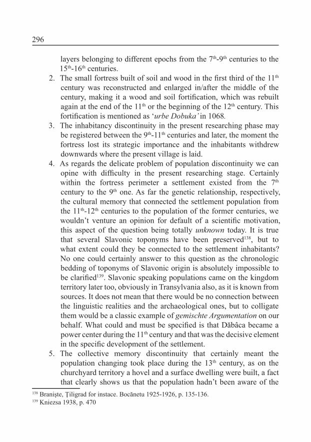
296
layers belonging to different epochs from the 7th-9th centuries to the 15th-16th centuries.
2. The small fortress built of soil and wood in the irst third of the 11th
century was reconstructed and enlarged in/after the middle of the century, making it a wood and soil fortiication, which was rebuilt again at the end of the 11th or the beginning of the 12th century. This fortiication is mentioned as ‘urbe Dobuka’ in 1068.
3. The inhabitancy discontinuity in the present researching phase may be registered between the 9th-11th centuries and later, the moment the fortress lost its strategic importance and the inhabitants withdrew downwards where the present village is laid.
4. As regards the delicate problem of population discontinuity we can opine with dificulty in the present researching stage. Certainly within the fortress perimeter a settlement existed from the 7th
century to the 9th one. As far the genetic relationship, respectively, the cultural memory that connected the settlement population from the 11th-12th centuries to the population of the former centuries, we wouldn’t venture an opinion for default of a scientiic motivation, this aspect of the question being totally unknown today. It is true that several Slavonic toponyms have been preserved138, but to what extent could they be connected to the settlement inhabitants? No one could certainly answer to this question as the chronologic bedding of toponyms of Slavonic origin is absolutely impossible to be clariied139. Slavonic speaking populations came on the kingdom territory later too, obviously in Transylvania also, as it is known from sources. It does not mean that there would be no connection between the linguistic realities and the archaeological ones, but to colligate them would be a classic example of gemischte Argumentation on our
behalf. What could and must be speciied is that Dăbâca became a power center during the 11th century and that was the decisive element in the speciic development of the settlement.
5. The collective memory discontinuity that certainly meant the population changing took place during the 13th century, as on the churchyard territory a hovel and a surface dwelling were built, a fact that clearly shows us that the population hadn’t been aware of the
138 Branişte, Ţiligrad for instace. Bocănetu 1925-1926, p. 135-136.139 Kniezsa 1938, p. 470

297
existence of the 12th century population funerary place; it is an aspect that illustrates the breaking off in the 13th century.
6. The diggings authors’ conclusions analysis in a retrospective style couldn’t be scientiically upheld140; the hiatuses and endeavor to lay fortress, habitat aspects, and the necropolises around the church on the same chronologic layer rather represents a scientiic Utopia. On account of this we have tried to illustrate the chronologic evolution of the different archaeological monuments having consideration for all the question relativity:
Fig. 8. Chronological evolution of the Dăbâca fortress complex
140 The analysis in a retrospective style proceeds from the 19th c. evolution philosophy. As a re-searching method it proceeds from the idea that a connection could be identiied by following back in time a community or another one cultural speciic elements. In our case for example, such a connection would be between the communities of the 11th c. and those of the 9th c. It is known that such a look on the human community, the basis of which is the 19th c Romanti-cism, is directly connected to the biologic and not sociologic feature of the human entities (tribe, ethnos, nation), but also proceeds from a modern myth of the 18th-19th c., namely that of national unity. For the analysis in a retrospective style, see: Langó 2007, p. 241-242.
298
IX. Some idea on the social bedding at Dăbâca, the 11th-12th centuriesAs a primary group141 the community of Dăbâca in the 11th-12th centuries
may be characterized by relations and direct collaborations among its members. It still rests unclear up if there were tribal relations among the members that stood that community or if, following the politic-military constructions which were occasioned by the important changing in the 11th century that one was organized on the basis of some artiicial constructions. The social progress and competition among the community’s members which could have decided a new social status too142, are attested now at Dăbâca though conclusive elements from that settlement. Unfortunately, the necropolises couldn’t offer any signs in this respect given the osteological material absence.
On the basis of the archaeological data we have had at our disposal, which were registered only on the examined settlement/ settlements perimeter, even relative the community/ communities’ multi-functionality however appears, respectively, the existent social stratiication. The ceramics production, iron processing, armament, harness, and certain elements of the material culture that indicate the practice of at a long distance trade, but also the site environment show the multi-functionality we have spoken above.
Certainly, in the present researching phase more of the questions couldn’t receive undoubted answers. Where the fortress leading elites used to live, or the ecclesial personal, and where were they buried143?
The armament discovering (arrowheads, spearheads) as well as the harness discovering (spurs) probably indicate the presence of miles layer, with military function (Pl. 16)144. The 15 mansio that are mentioned in the narrative sources of the 12th century concerning the fortress from Arad145 show that there was also a subservient to fortress population with the role of miles layer provisioning. Unfortunately, in the present researching phase we couldn’t clarify where the members of those different social layers were buried. We might consider at a suppositional level that the subservient to miles layer inhabitants were buried
141 Cooley 1909, p. 23.142 Elton Mayo laid the foundations of this researching. Mayo 1933.143 In the case of some ecclesiastic dignities at Esztergom, Székesfehérvár, Kalocsa and Viseg-
rád, their clerical insignia were put inside the graves. The French bishop Durandus’ expla-nation may be cited: the clergyman is buried with his insignia to indicate his virtues. Ritoók 2004, p. 120-121, footnote 43.
144 Zsoldos 1999, p. 12-38.145 Györffy 1977, p. 229.

299
inside the Area IV, and in the case of Tămaş’ Garden necropolis, the members of miles layer were buried in146. For more certain results than these hypotheses new diggings might be realized within both the necropolises147 (Area IV and Tămaş’ Garden), and the anthropological analyses of the two sites be compared. Thus we could receive more deinite answers.
This question may be put also in the dwellings’ case. A larger surface dwelling was discovered until now, but scarcely can it be taken for a dwelling of an elite person. Samples of stone buildings that were identiied as comes’ dwelling were examined on the territory of Abaújvár, Borsod, Visegrád, respectively, Somogyvár fortresses148. Maybe the diggings at Dăbâca should be resumed and continued also in this respect or in this direction.
X. A (historical) hypothesis: the ’failure’ of DăbâcaFollowing the archaeological and numismatic material analysis it results
the fact that the fortress which had been built in the irst half of the 11th century reached its climax within the 12th century. The number of coins which were discovered inside the graves from the investigated necropolises in Area IV, Tămaş’ Garden, respectively, Boldâgă also demonstrates this fact.
On our account, the 13th century was the fortress decline epoch from its role of a politic-military and administrative center of Arpádian kingdom. That decline might be connected to Mongol-Tatars’ invasion, but we believe that some other more credible causes of a social-economic range, as the administrative reorganization of the kingdom (the royal counties disappearing, the nobiliary counties appearing149) were at the bottom of that phenomenon. As a working hypothesis we might put the question if the power center decline wasn’t connected to the habitat structure of the county extend toward east,
146 At Abáujvár inside the necropolis around the church two men’s corpses could be examined, their death being caused by arrow points. According to the archaeologists’ opinion those persons belonged to the fortress miles layer. Also, the discovered weapons were connected to miles layer, especially the arrow points, some lances and spurs. Gádor 1988, p. 123-128. Cited by: Wolf 2011, p. 324. At Borsod the stirrups that had been discovered inside the necropolis, and two spurs on the fortress territory were also connected to miles layer. Wolf 2004, p. 139-159.
147 Probably, after the anthropological analyses there were identiied the miles layer families’ members nearby the southern side of the church within Zalavár-Vársziget-Kápolna necro-polis. Ritoók 2004, 139 – 159.
148 Wolf 2011, p. 324; Szőke 2000, p. 363; Bakay 1975, p. 191.149 Zsoldos 1991, p. 60, nota 60; Wolf 2011, p. 327.

300
north and north-east because its territory got permanency at the balance of the 12th-13th centuries. This cautious observation relies also on the fact that till now a single coin of the 13th century is known at Dăbâca site, from Boldâgă, which was issued by Béla IV (1235-1270). At the same time the main part of the habitat elements are dated in the 11th-12th centuries. Although these data have no absolute value, the numismatic material absence (not at all just in cemeteries) claims explanations. Our hypothesis may be demonstrated or combated through new interdisciplinary researches at Dăbâca.
BIBLIOGRAPHY
Bakay 1975, K. Bakay, Második jelentés a somogyvári bencés apátság feltárásáról (1974-75), in SMK,
2, 1975, p. 191-207.
Bálint 1976, Cs. Bálint, A magyarság és az ú.n. Bjelo Brdói kultúra, in Cumania, 4, 1976, p. 225–254.
Bálint 1995, Cs. Bálint, Kelet, a korai avarok es Bizanc kapcsolatai: Régészeti tanulmanyok, Magyar
Őstörténeti Könyvtár, Szeged, 1995.
Bálint 2004, Cs. Bálint, Mediterráneum és a Kárpát-medence kapcsolatai a kora középkori régészet
szemszögéből, in Gy. Erdei, B. Nagy (ed.), Változatok a történelemre. Tanulmányok Székely György tiszteletére, in MHB, 14, 2004, p. 43–50.
Bálint 2005, Cs. Bálint, Ki volt „magyar” a honfoglaláskorban és Szent István korában?, in I. Romsics, M.
Szegedy-Maszák, Mi a magyar?, Budapest, 2005, p. 37-56.
Bálint 2006, Cs. Bálint, Az ethnosz a kora középkorban (A kutatás lehetőségei és korlátai), in Sz., 140,
2006, 2, p. 277–347.
Bartucz 1929,L. Bartucz, A nyársapáti XV-XVII. századbeli koponyákról, in DolgSzeg, 5, 1929, p. 148-174.
Benkő 1994, E. Benkő, Doboka, in Gy. Kristó (ed.) Korai magyar történeti lexikon (9–14. század),
Budapest, 1994, p. 169.

301
Benkő 2010, E. Benkő, A középkori székelyek, in E. Benkő, Gy. Kovács (ed.), A középkor és a kora újkor
régészete Magyarországon/Archaeology of the Middle Age and the Early Modern Period in Hungary, Budapest, 2010, p. 221-254.
Bocănetu 1925-1926, Al. Bocănetu, Terminologia agrară in limba română, în Codrul Cosminului (Cernăuţi),
2-3, 1925-1926, p. 125-139.
Boia 1999, L. Boia, Történelem és mítosz a román köztudatban, Kolozsvár/Cluj-Napoca, 1999.
Bóna 1964, I. Bóna, Der Silberschatz von Darufalva, in ActaArchHung, 16, 1964, p. 151-169.
Bóna 1970, I. Bóna, Nota 316, in Gy. Györffy, A honfoglaló magyarok települési rendjéről, in AÉ, 97,
1970, 1, p. 191–242.
Bóna 1988, I. Bóna, Monostorok, templomok, templom körüli temetők, in B. Köpeczi (ed.), Erdély
története, I, Budapest, 1988, p. 235–237.
Bóna 1998, I. Bóna, Az Árpádok korai várairól, Debrecen, 1998.
Bóna 2001, I. Bóna, Erdély a magyar honfoglalás és államalapítás korában, in Erdély a keresztény
Magyar Királyságban, in ETF, 231, 2001, p. 68-96.
Bordi 2006, Zs. L. Bordi, Az íj és a számszeríj Erdélyben a magyar honfoglalástól Mohácsig, in AS,
2006/2, p. 91–97.
Brather 2000, S. Brather, Ethnische Identitäten als Konstrukte der frühgeschichtlichen Archäologie, in
Germania, 78, 2000, p. 139-177.
Brather 2004, S. Brather, Ethnische Interpretationen in der frühgeschichtlichen Archäologie, Geschichte,
Grundlage und Alternativen, Berlin–New York, 2004.
Brather 2006, S. Brather, „Etnikai értelmezés” és struktúra történeti magyarázat a régészetben, in
Korall, 24-25, 2006, Június/June, p. 23-72.

302
Buzás 2006, G. Buzás, 11. századi ispáni várainkról, in Gy. Kovács, Zs. Miklós (ed.) „Gondolják,
látják az várnak nagy voltát”. Tanulmányok a 80 éves Nováki Gyula tiszteletére, Budapest, 2006, p. 43-53.
Ciupercă 2009, B. Ciupercă, Conceptul de cultură Dridu in arheologia românească. Apariţie, evoluţie,
controverse, in Istros, 15, 2009, p. 133-162.
Cooley 1909, C. H. Cooley, Social Organization, New York, 1909.
Cosma 2004-2005, C. Cosma, Pinteni medievali timpurii descoperiţi pe teritoriul Transilvaniei (secolele
VII-X), in EphNap, 14-15, 2004-2005, p. 177-210.
Crângaci Ţiplic, Oţa 2005, M. E. Crângaci Ţiplic, S. Oţa, Piese inedite din colecţia Muzeului Naţional de Istorie
a României descoperite în necropola de secol XII de la catedrala romano-catolică de la Alba Iulia (Bislang Unveröffentliche Fundstücke aus der Sammlung des Nationalmuseums für Geschichte Rumäniens, aus dem Gräberfeld der Römisch-Katolischen Kathedrale in Karlsburg/Alba Iulia (12. Jh.) Stammen), in ActaMN, II, 39–40, 2002–2003 (2005), p. 91–106.
Curta 2002, Fl. Curta, Transilvania în jurul anului 1000, in EphNap, 12, 2002, p. 273–274.
Crettier 1943, K. Chrettier, A dobokai vár, in KözlCluj, 3, 1943, p. 197–208.
Cs. Sós, Parádi 1971, Á. Cs. Sós, N. Parádi, A csátaljai Árpád kori temető és település, in FolArch, 22, 1971,
105-141.
Daicoviciu 1935, C. Daicoviciu, Există monumente în Dacia Traiană din secolele II-III, in AISC, 2, 1933-
1935, p. 176-180.
Daicoviciu 1968a, C. Daicoviciu, Romanizarea Daciei, in Apulum, 7, 1968, p. 261-271.
Daicoviciu 1968b, C. Daicoviciu, Originea poporului român după cele mai noi cercetări, in D. Berciu (ed.),
Unitate şi continuitate în istoria poporului român, Bucureşti, 1968, p. 83-98.

303
Derzsi, Sófalvi, Cs. Derzsi, A. Sófalvi, Régészeti kutatások a kányádi középkori templomnál [2005–2006],
in AS, 2008, p. 267–285.
Éry 1982, K. Éry, Embertani adatok Veszprém középkori népességéhez. Veszprém-Kálvária domb
11-16. századi temetkezései, in VMMK, 14, 1979, p. 215-244.
Éry et al 2005, K. Éry, A. Marcsik, F. Szalai, Adalék a templom körüli temetők embertanához: Székesfehérvár
(Data on the Anthropology of Churchyards: Székesfehérvár), in Á. Ritoók, E. Simonyi (ed.), A középkori templom körüli temetők kutatása, in OH, Budapest, 2005, p. 77–83.
Fiedler 1992,U. Fiedler, Studien zu Gräberfeldern des 6. bis 9. Jhs. an der unteren Donau
(Universitätsforschungen zur prähistorischen Archäologie. Aus dem Seminar f. Ur- und Frühgeschichte der Freien Universität Berlin, Bd 11), Bonn, Teil 1-2, 1992.
Gádor 1988, J. Gádor, Az abaújvári vár kutatása, Bölcsészdoktori disszertáció. Manuscript, Eötvös
Lóránd University, Faculty of Humanities, Institute of Archaeology, Library, Budapest, 1988.
Gáll 2004–2005, E. Gáll, Analysis and comparison of burial customs in the 10–11th century in the
Transylvanian basin, Crişana and Banat, in Dacia (N.S.), 38–39, 2004–2005, p. 334–454.
Gáll 2008, E. Gáll, A honfoglalás - és kora Árpád kori temetők és szórványleletek elemzése az
Erdélyi-medencében, a Partiumban és a Bánságban/The analysis of the tenth and eleventh centuries’ burial sites and stray inds in Banat, Partium and the Transylvanian Basin, Doktori disszertáció, Budapest, I (http://doktori.btk.elte.hu/hist/gall/diss.pdf ).
Gáll 2010a, E. Gáll, The analysis of churchyard cemeteries in Transylvania from the 11th–13th
centuries. From the pagan cemetery to the Christian churchyard. Preliminary results, in TR, 19, Supplement 5, 2010, p. 265–289.
Gáll 2010b, E. Gáll, Márton Roska şi cercetarea secolelor X-XI, in SCIVA, 61, 2010, 3-4, p. 281–306.
Gáll 2011, E. Gáll, Doboka - IV. vártérség templom körüli temetője. Régészeti adatok egy észak-
erdélyi ispáni központ 11–13. századi fejlődéséhez, Kolozsvár/Cluj-Napoca, 2011.
304
Gáll et al. 2010, E. Gáll, B. Gergely, Sz. Gál, La răscruce de drumuri. Date arheologice privind teritoriul
oraşului Cluj-Napoca în secolele X–XIII, Cluj-Napoca, 2010.
Giesler 1981, J. Giesler, Untersuchungen zur Chronologie der Bjelo-Brdo (Ein Beitrag zur Archäologie
des 10. und 11. Jahrhunderts im Karpatenbecken), in PZ, 56, 1981, p. 3-181.
Györffy 1977, Gy. Györffy, István király és műve, Budapest, 1977.
Györffy 1987, Gy. Györffy, Az Árpád kori Magyarország történeti földrajza, III, Budapest, 1987.
Györffy 1992, G. Györffy, Diplomata Hungariae Antiquissima Volumen I. 1001-1131, Budapest, 1992.
Harhoiu 2004, R. Harhoiu, Das Miereschprogramm. Ein vergessenes Forschungsprojekt?, in Monumenta
Studia Gothica, 4, Europa Barbarica, 2004, p. 159–162.
Hodor 1837, K. Hodor, Doboka természeti és polgári esmértetése, Kolozsvár/Cluj-Napoca, 1837.
Hóman 1916, B. Hóman, Magyar pénztörténet 1000-1325, Budapest, 1916.
Hóman, Szekfű 1935, B. Hóman, Gy. Szekfű, Magyar történet, 2, Budapest, 1936.
Horedt 1986, K. Horedt, Siebenbürgen im Frühmittelalter, Bonn, 1986.
Huszár 1979, L. Huszár, Münzkatalog Ungarn von 1000 bis heute, Battenberg, 1979.
Iambor 2005, P. Iambor, Aşezări fortiicate din Transilvania (sec. IX-XIII), Cluj-Napoca, 2005.
Ioniţă 2009, A. Ioniţă, Aşezarea din secolele XII-XIII de la Bratei (Bibliotheca Brukenthal BB XXXII),
Alba Iulia, 2009.
Jakab 2007, A. Jakab, Tatárjárás kori kincslelet Tyukod-Bagolyvárról, in ÉvkNyíregyháza, 49, 2007,
p. 247-249.

305
Jażdżewski 1949, K. Jażdżewski, Cmentarzysko wczesnośredniowieczne w Lutomiersko pod Łodzia w
Świetle Badań z.r. 1949, in MW, 1, 1949, p. 91–191.
Kaszewscy, Kaszewscy 1971, E. Kaszewscy, Z. Kaszewscy, Wczesnośredniowieczne cmentarzysko w Brześciu
Kujawskim, pow. Włocławek, in MSW, 1, 1971, p. 365–434.
Kieffer-Olsen 1997, J. Kieffer-Olsen, Christianity and Christian Burial. The religious background, and the
transition from paganism to Christianity, from the perspective of a churchyard archaeologist, in C. K. Jensen, K. H. Nielsen, Burial and Society, Aarhus University Press, 1997, p. 185–189.
Kniezsa 1938, I. Kniezsa, Magyarország népei a XI-ik században, in Serédi Jusztinián, Emlékkönyv Szent
István király halálának kilencszázadik évfordulóján, II, Budapest, p. 365-472.
Kolníková 1967, E. Kolníková, Oblolus mŕtvych vo včasnostredevekých hroboch na Slovensku, in SlovArch,
15, 1967, p. 189–245.
Kossina 1936, G. Kossina, Die deutsche Vorgeschichte, eine hervorragend nationale Wissenschaft7,
Würzburg, 1936.
Kovács 1997, L. Kovács, A kora Árpád-kori pénzverésről. Érmetani és régészeti tanulmányok a Kárpát-
medence I. (Szent) István és II. (Vak) Béla uralkodása közötti időszakának (1000-1141) érméiről, in VAH, 7, Budapest, 1997.
Kovács 2004, L. Kovács, Érmék nem dísz vagy ékszer szerepben a honfoglaló magyar sírokban, in Gy.
Erdei, B. Nagy (ed.), Változatok a történelemre. Tanulmányok Székely György tiszteletére, in MHB, 14, 2004, p. 43–50.
Könyöki 1906, J. Könyöki, Középkori várak, különös tekintettel Magyarországra, Budapest, 1906.
Kubinyi 2005,Kubinyi András, Késő középkori temetkezések a történeti forrásokban, in Á. Ritoók, E.
Simonyi (ed.), A középkori templom körüli temetők kutatása., in OH, 2005, 13–18.
Kulcsár 1992–1995, M. Kulcsár, Néhány megjegyzés az Árpád-kori karikaékszerek viseletének kérdéséhez. Az
ún. köpűs záródású karikák, in Savaria, 22, 1992–1995, p. 249-275.
306
Langó 2006, P. Langó, A Kárpát-medence 10. századi emlékanyagának kutatása mint nemzeti régészet.
Kutatástörténeti áttekintés, in Korall, 24-25, 2006, Június/June, p. 89-117.
Langó 2007. P. Langó, Amit elrejt a föld…A 10. századi magyarság anyagi kultúrájának régészeti
kutatása a Kárpát-medencében, Budapest, 2007.
Lipták, Marcsik 1965, P. Lipták, A. Marcsik, A téglás-angolkerti középkori (XI-XIV. századi) temető embertani
anyagának ismertetése, in ÉvkDebrecen, 1965, p. 69-96.
Lupescu 2005, R. Lupescu, Kolozsvár korai történetének buktatói, in ErdCluj, 67, 2005, 3–4, p. 25–77.
Madgearu 2001, A. Madgearu, Românii în opera Notarului Anonim, Cluj-Napoca, 2001.
Madgearu 2008, A. Madgearu, Cultura Dridu şi evoluţıa pozıţiei României în lagărul socialist, in Analele
ANTIM, 8, 2008, p. 63-71.
Madgearu 2009, A. Madgearu, Denumirea Mării Negre în Gesta Hungarorum a notarului Anonim, in
EphNap, 19, 2009, p. 177–182.
Marciniak 1960, J. Marciniak, Cmentarzysko szkieletowe z okresu wczesnośredniowiecznego w Strzemie-
szycach wielkich pow. Będzin, in MW, 5, 1960, p. 141–186.
Măgureanu 2007, A. Măgureanu, Dezbateri privind etnogeneza românilor în anii ’50. De la manualul lui
Roller la Tratatul de Istorie, in SCIVA, 58, 2007, 3-4, p. 289–321.
Mayo 1933, E. Mayo, The Human Problems of Industrial Civilization, New York, 1933.
Mesterházy 1983, K. Mesterházy, Köznépi ékszerek nemesfém változatai: arany S-végű hajkarikák, in
AlbaRegia, 20, 1983, p. 143-151.
Niculescu 1997, Gh. Al. Niculescu, Interpretarea fenomenelor etnice de către istorici şi arheologi.
Pericolele argumentaţiei mixte, in M. Ciho, M. V. Nistor, D. Zaharia (ed.), In honorem emeritae Ligiae Bârzu. Timpul Istoriei I, Bucureşti, 1997, p. 63–69.

307
Opriş 2004, I. Opriş, Istoricii şi Securitatea, Bucureşti, 2004.
Parádi 1975, N. Parádi, Pénzekkel keltezett XIII. századi ékszerek. A Nyáregyháza-Pusztatótharaszti
kincslelet, in FolArch, 36, 1975, p. 119–161.
Parker Pearson 2001, M. Parker Pearson, The archaeology of death and burial, Texas A&M University
Anthropology Series 3, Texas A&M University Press, 2001.
Pascu et al. 1968, Şt. Pascu, M. Rusu, P. Iambor, N. Edroiu, P. Gyulai, V. Wollmann, Şt. Matei, Cetatea
Dăbâca, in ActaMN, 5, 1968, p. 153–202.
Pohl 1998, W. Pohl, Conceptions of Ethnicity in Early Medieval Studies, in L. K. Little, B. H.
Rosenwein, Debating the Middle Ages – Issues and Readings, Malden-Oxford, 1998, p. 15-24.
Popa 1991, R. Popa, Observaţii şi îndreptări la istoria României din jurul Anului O Mie, in SCIVA, 41,
1991, 3-4, p. 153-188.
Pósta 1917, B. Pósta, A gyulafehévári székesegyház sírleletei, in DolgCluj, 8, 1917, p. 1-155.
Radomĕrský 1955, P. Radomĕrský, Obol mrtvých u Slovanů v Čechách a na Moravĕ, Prague, 1955.
Rashev 2008, R. Rashev, Bălgarskata ezicseska kultura VII-IX vek, Soia, 2008.
Réthy 1898, L. Réthy, Két Árpádkori temető Arad megyében, in AÉ, 18, 1898, p. 124–131.
Réthy 1899, L. Réthy, Corpus Nummorum Hungariae - Egyetemes Magyar Éremtár, I, Budapest,1899.
Révész 1996, L. Révész, A karosi honfoglaláskori temetők. Régészeti adatok a Felső-Tisza vidék X.
századi történetéhez, Miskolc, 1996.
Ritoók 1997, Á. Ritoók, A magyarországi falusi templom körüli temetők feltárásának újabb eredményei,
in FolArch, 46, 1997, p. 165-175.

308
Ritoók 2004, Á. Ritoók, Szempontok a magyarországi templom körüli temetők elemzéséhez, in B.
F. Romhányi, A. Grynaeus, K. Magyar, A. Végh, „Es tu scholaris” Ünnepi tanulmányok Kubinyi András 75. születésnapjára, Budapest, 2004, p. 115-124.
Ritoók 2010, Á. Ritoók, A templom körüli temetők régészeti kutatása, in E. Benkő, Gy. Kovács (ed.), A középkor
és a kora újkor régészete Magyarországon/Archaelogy of the Middle Ages and the early Modern Period in Hungary, Budapest, 2010, p. 473-494.
Rusu 1991, A. A. Rusu, Vechea biserică din Nălaţi (jud. Hunedoara), in EphNap, 1, 1991, p. 127-143.
Rusu 1998, A. A. Rusu, Arheologia cetăţilor medievale ale Transilvaniei, in ArhMed, 2, 1998, p. 5–19.
Szabados 2011, Gy. Szabados, Magyar államalapítások a IX-XI. században, Szegedi Középkortörténeti
Könyvtár, 26, Szeged, 2011.
Stamati 2002, I. Stamati, Cercetarea istorico-arheologică cu privire la secolele V/VI-VII. p. Chr. in Republica
Moldova, între anii 1950-1990, in EphNap, 12, 2002, p. 183-202.
Szatmári 2005, I. Szatmári, Békés megye középkori templomai, Békéscsaba, 2005.
Székely 1990, Z. Székely, Necropola medievală de la Peteni, com. Zăbala, jud. Covasna, in SCIVA, 41,
1990, p. 87–110.
Székely 1993–1994, Z. Székely, A zabolai (Zăbala – Románia) kora-középkori temető, in VMMK, 19–20,
1993–1994, p. 277–305.
Szőke 1962, B. Szőke, A honfoglaló és kora Árpád-kori magyarság régészeti emlékei (Régészeti
Tanulmányok 1), Budapest, 1962.

309
Szőke 1979, M. Szőke, Ásatási jelentés, Régészeti Füzetek Ser. I., 32, 1979, 105.
Szőke 1996, B. M. Szőke, Die Prämonstratenserpropstei von Alsórajk-Kastélydomb, in Antaeus, 23,
1996, p. 251-305.v
Szőke 2000,M. Szőke, Die mittelalterliche Burg von Visegrád, in A. Wieczorek, H. M. Hinz, Europas
mitte um 1000. Beiträge zur Geschichte, Kunst und Archäologie Band 2, Stuttgart, 2000, p. 584–587.
Szőke–Vándor 1987, B. M. Szőke, L. Vándor, Pusztaszentlászló Árpád-kori temetője (Fontes archaeologici
Hungariae), Budapest, 1987.
Szuromi 2002, Sz. Szuromi, A temetésre vonatkozó egyházfegyelem a XII–XIII. században (Bibliotheca
Instituti Postgradualis Iuris Canonici Universitatis), Budapest, 2002.
Szuromi 2005, Sz. Szuromi, A templom körüli temetkezés a középkori egyházfegyelem tükrében (12–13.
század), in Á. Ritoók, E. Simonyi (ed.), A középkori templom körüli temetők kutatása, in OH, 2005, 9-12.
Tagányi et al. 1900, K. Tagányi, L. Réthy, Gy. Kádár, Szolnok-Doboka vármegye monographiája, Deés, 1900.
Takács 2006a, M. Takács, A nemzetépítés jegyében megfogalmazott elvárások. Kutatási célok az észak-
balkáni államok középkori régészetében, in Korall, 24-25, 2006, Június/June, p. 163 – 202.
Takács 2006b, M. Takács, A középkori régészet a Vajdaságban 1918 és 1987 között, in: Testis temporum,
vita memoriae. Ünnepi tanulmányok Pálóczi Horváth András 65. születésnapjára, in Studia Caroliensia, 7, 2006, 3–4, p. 147–179.
Takács 2007, M. Takács, Koszovó/Kosova földje a középkorban, in História-történelmi folyóirat, 29,
2007, 2. p. 3–6.
Tettamanti 1975, S. Tettamanti, Temetkezési szokások a X-XI. században a Kárpát-medencében, in Studia
Comitatensia, 3, 1975, 79-112.

310
Uzum, Lazarovici 1971, I. Uzum, Gh. Lazarovici, Aşezarea feudală Ilidia în lumina izvoarelor scrise şi a
cercetărilor arheologice, in Banatica, 1, 1971, p. 157-162.
Valter 2005, I. Valter, Árpád-kori téglatemplomok Nyugat-Dunántúlon, Budapest, 2005.
Veszprémy 2000, L. Veszprémy, Gesta Hungarorum. A középkori krónikaírás kezdetei, in E. Marosi (ed.),
Európa közepe 1000 körül. Történelmi, művészeti és régészeti tanulmányok, Budapest, 2000, p. 548–549.
Wolf 2004, M. Wolf, Nielló díszes bronz csat Edelény-Borsodról, in HOMÉ, 43, 2004, p. 139-159.
Wolf 2011, M. Wolf, Adatok az ispáni várak szerepéhez az Árpád-kori Magyarországon, in Gy. Terei,
Gy. Kovács, Gy. Domokos, Zs. Miklós, M. Mordovin, Várak nyomában. Tanulmányok a 60 éves Feld István tiszteletére, Budapest, 2011, p. 323-328.
Young 1992, B. K. Young, Text aided or text misled? Relections on the uses of archaelogy in medieval
history, in B. J. Little– B. Raton (ed.), Text-Aided Archaelogy, London, 1992, p. 135–147.
Zsoldos 1991, A. Zsoldos, A királyi várszervezet és a tatárjárás, in HK, 104, 1991, p. 45-76.
Zsoldos 1999, A. Zsoldos, A szent király szabadjai: fejezetek a várjobbágyság történetéből, Budapest, 1999.
DĂBÂCA (DOBESCHDORF, DOBOKA): NECROPOLA DIN JURUL BISERICII DIN GRĂDINA LUI A. TĂMAŞ.
CÂTEVA IDEI PRIVIND EVOLUŢIA HABITATULUIDE LA DABÂCA
Rezumat
Lucrarea de faţă îşi propune să analizeze necropola din jurul bisericii cercetată într-o parte, din Grădina lui Tămaş, descoperit pe lângă partea de sud-est a cetăţii de la Dăbâca, respectiv să ofere o sinteză, cât poate i reconstituit, privind situl arheologic din epoca medieval timpurie. Satul Dăbâca, centrul de odinioară a comitatului cu acelaşi nume, se ală la 30 de km nord-vest, pe malul pârâului Lona, care se varsă de aici 10 km la est în Someşul-

311
Mic. Necropola din jurul bisericii a fost cercetată în cursul anilor 1966-1967, în urma căreia a fost dezvelită urmele unei biserici, zidurile unei alte biserici, mult mai mare, mai târziu construit, respectiv 95 de schelete din 71 de morminte.
O parte din morminte se datează în secolul XII, iar biserica probabil, pe baza monedelor lui Ladislau I, alate în partea nordică, probabil datează construcţia bisericii la sfârşitul secolului al XI-lea. Cealaltă parte a mormintelor se datează mai târziu, în cursul secolelor XIII-XIV, şi probabil aparţine bisericii ale căror ziduri au fost dezvelite în cursul cercetărilor.
Inventarul arheologic care provine din mormintele secolului al XII-lea reprezintă cultura materială cunoscută din necropolele secolului al XII-lea: inele de buclă, monede (denarii anonimi emisă de către regii maghiari în primele două treimi a secolului al XII-lea). Populaţia înmormântată aici probabil aparţinea atât stratului de miles, cât şi slujitorilor acestora (servi).
Necropola se integrează în rândul siturilor funerare de la Dăbâca, toate iind necropole din jurul bisericii: necropola din incinta IV, Boldâgă. Totodată aceste necropole trebuie şi pot i analizate paralel, dar separat, cu aşezările din secolele XI-XIII, respectiv fortiicaţia ridicată, după părerea noastră în secolul XI.
Apogeul cetăţii construită în prima jumătate a secolului al XI-lea, a fost secolul XII. Acesta este demonstrată şi de numărul monedelor descoperite în mormintele necropolelor cercetate din incinta IV, Grădina lui Tămaş, respectiv Boldâgă.
Epoca decăderii cetăţii, reprezentând centrul politico-militar şi administrative, după părerea noastră a fost secolul al XIII-lea. Evident această decădere am putea lega de invazia mongolo-tătară, dar personal, credem în alte cauze, mult mai adânci, din punct de vedere social-economic, de exemplu precum şi reorganizarea administrativă a regatului (dispariţia comitatelor regale, respective apariţia comitatelor nobiliare).

312
Plate 1. Dăbâca and his position in Transylvanian basin. The fortress complex of Dăbâca. The structure of the settlement in the 12th century, based upon archaeological data (drawn by E. Gáll and N. Laczkó); C. A 3D reconstruction of the settlement structure of the 12th century Dăbâca (drawn by N. Laczkó).

313
Plate 2. Excavations from Dăbâca and the site of Tămaş’s garden.
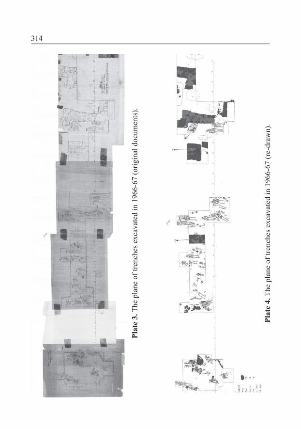
314
Plat
e 3.
The
pla
ne o
f tre
nche
s exc
avat
ed in
196
6-67
(orig
inal
doc
umen
ts).
Plat
e 4.
The
pla
ne o
f tre
nche
s exc
avat
ed in
196
6-67
(re-
draw
n).

315
Plate 5. Dăbâca-Tămaş’s garden: the church (documents from MNIT).

316
Plate 6. Dăbâca- Tămaş’s garden: a reconstruction of the church proposed on the base of dates on original documents from MNIT.
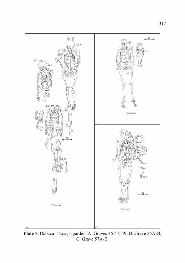
317
Plate 7. Dăbâca-Tămaş’s garden: A. Graves 46-47, 49; B. Grave 35A-B;C. Grave 57A-B.

318
Plate 8. Dăbâca-Tămaş’s garden, Grave 3: 1-2; Grave 34: 3; various inds which are not to be connected to Graves: 4-7; Grave 7: 8-9;
Grave 15: 10-11; Grave 16: 12; Dăbâca-Boldâgă: 13-14;Dăbâca-Tămaş’s garden: maybe the Grave 37: 15.
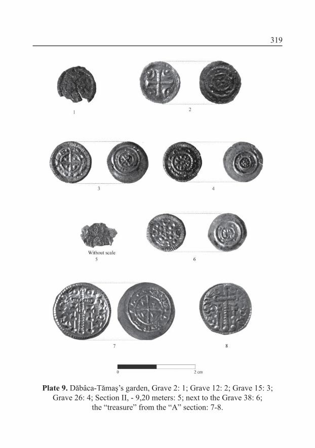
319
Plate 9. Dăbâca-Tămaş’s garden, Grave 2: 1; Grave 12: 2; Grave 15: 3; Grave 26: 4; Section II, - 9,20 meters: 5; next to the Grave 38: 6;
the “treasure” from the “A” section: 7-8.

320
Plate 10. Dăbâca-Tămaş’s garden, the “treasure” from the “A” section: 1-4.

321
Plate 11. Dăbâca-Tămaş’s garden, the “treasure” from the “A” section: 1-2, on the loor of pit house (1980): 3; Dăbâca-fortress, Area I: 4-8.

322
Plate 12. Dăbâca-fortress, Area I-II.
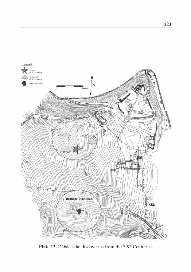
323
Plate 13. Dăbâca-the discoveries from the 7-9th Centuries.

324
Plate 14. The elements of the material culture from the fortress,Area I-III (11th Century).

325
Plate 15. The elements of the settlement structure of the 11th-12th
century Dăbâca.
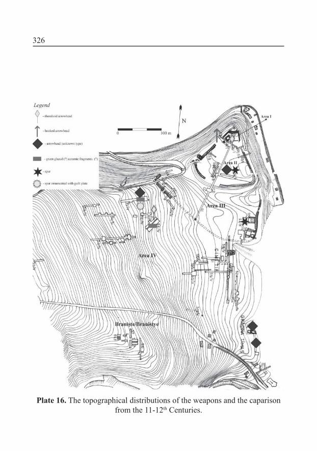
326
Plate 16. The topographical distributions of the weapons and the caparison from the 11-12th Centuries.

327
Plate 17. The elements of the settlement structure of the 13th-14th
century Dăbâca.
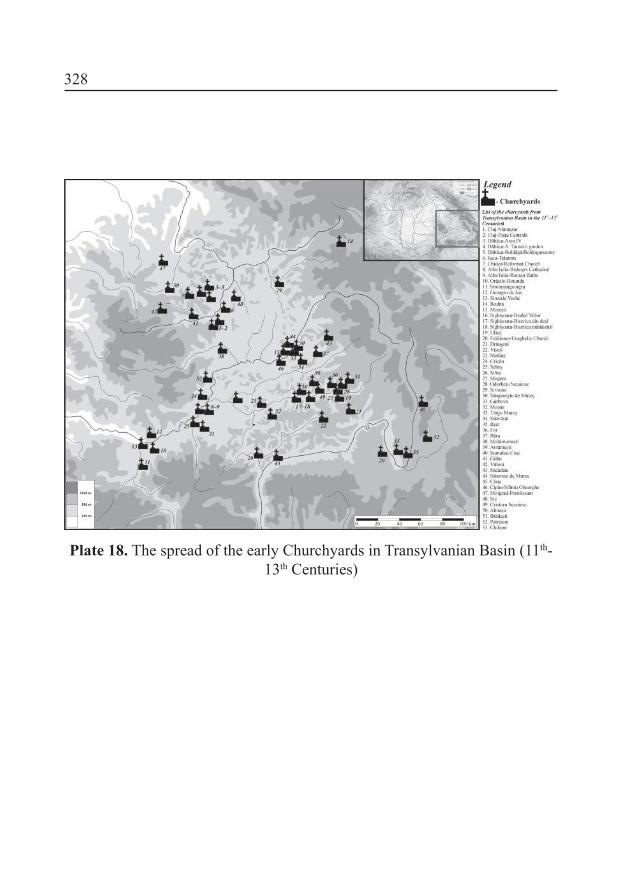
328
Plate 18. The spread of the early Churchyards in Transylvanian Basin (11th-13th Centuries)


![Gesta Francorum - Documenta Catholica Omnia · Gesta Francorum sive Itinerarium Hierosolimitanorum. Liber I [i] Cum iam appropinquasset ille terminus quem dominus Iesus cotidie suis](https://static.fdocuments.in/doc/165x107/60d02fa3cd010d27836a1fd1/gesta-francorum-documenta-catholica-omnia-gesta-francorum-sive-itinerarium-hierosolimitanorum.jpg)