D2.3.3 Eurosion Dataset Structure Description
195
Dataset_structure Reference EUR-0002-TN-003 1/1 D2.3.3 Eurosion Dataset Structure Description European Commission Contract nr. B4-3301/2001/329175/MAR/B3 EADS S&DE Toulouse, 29 th September 2003
Transcript of D2.3.3 Eurosion Dataset Structure Description
Dataset_structure
Reference EUR-0002-TN-003
1/1
D2.3.3 Eurosion Dataset Structure Description
European Commission Contract nr. B4-3301/2001/329175/MAR/B3
EADS S&DE Toulouse, 29th September 2003
Dataset_structure
Reference EUR-0002-TN-003
2/2
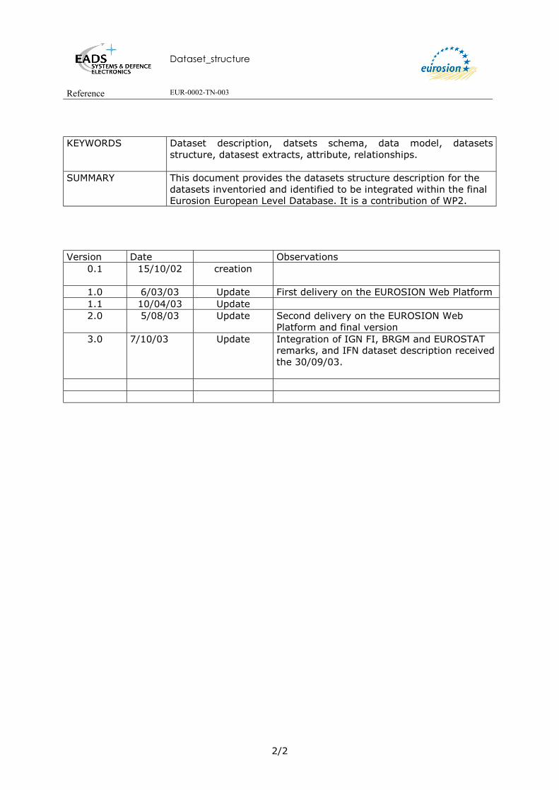
KEYWORDS Dataset description, datsets schema, data model, datasets
structure, datasest extracts, attribute, relationships.
SUMMARY This document provides the datasets structure description for the datasets inventoried and identified to be integrated within the final Eurosion European Level Database. It is a contribution of WP2.
Version Date Observations
0.1 15/10/02
creation
1.0 6/03/03 Update First delivery on the EUROSION Web Platform 1.1 10/04/03 Update 2.0 5/08/03 Update Second delivery on the EUROSION Web
Platform and final version 3.0 7/10/03 Update Integration of IGN FI, BRGM and EUROSTAT
remarks, and IFN dataset description received the 30/09/03.

Dataset_structure
Reference EUR-0002-TN-003
3/3
TABLE OF CONTENTS
1. INTRODUCTION ------------------------------------------------------------------------------------------------------ 9
2. ACRONYMS ---------------------------------------------------------------------------------------------------------- 10
3. DOCUMENTS OF REFERENCE--------------------------------------------------------------------------------- 11
4. ADMINISTRATIVE BOUNDARIES ---------------------------------------------------------------------------- 13 4.1. TERRESTRIAL BOUNDARIES ------------------------------------------------------------------------------------------ 13
4.1.1 SABE----------------------------------------------------------------------------------------------------------- 13 4.1.1.1 Overview of the dataset structure --------------------------------------------------------------------------- 13 4.1.1.2 Description of the Arc Attribute Table of the XX30 coverage ------------------------------------------ 13 4.1.1.3 Description of the Polygon Attribute Table of the XX30 coverage------------------------------------- 14 4.1.1.4 Description of the INFO table XX30.NAM ---------------------------------------------------------------- 15 4.1.1.5 Description of the INFO table XX30.REL ----------------------------------------------------------------- 16 4.1.1.6 Description of the INFO table SABE.ISN------------------------------------------------------------------ 16
4.1.2 GISCO--------------------------------------------------------------------------------------------------------- 18 4.1.2.1 Overview of the dataset structure --------------------------------------------------------------------------- 18 4.1.2.2 Description of the Arc Attribute Table of the NUEC1MV7 coverage---------------------------------- 19 4.1.2.3 Description of the Polygon Attribute Table of the NUEC1MV7 coverage ---------------------------- 19 4.1.2.4 Description of the INFO table NUECATV5.INF---------------------------------------------------------- 20 4.1.2.5 Description of the INFO table NUECATV6.INF---------------------------------------------------------- 21 4.1.2.6 Description of the INFO table NUECATV7.INF---------------------------------------------------------- 21 4.1.2.7 Description of the INFO table NUV5V6.INF-------------------------------------------------------------- 22 4.1.2.8 Description of the INFO table NUV6V7.INF-------------------------------------------------------------- 22
4.2. MARITIME BOUNDARIES ---------------------------------------------------------------------------------------------- 24 4.2.1 Overview of the dataset structure -------------------------------------------------------------------------- 24 4.2.2 Description of the Point Attribute Table of MBEULSI100KV1 coverage---------------------------- 25 4.2.3 Description of the Arc Attribute Table of the MBEULSI100KV1 coverage -------------------------- 26 4.2.4 Description of the INFO tables MBLSDS.INF ----------------------------------------------------------- 26 4.2.5 Description of the INFO table MBLSTP.INF ------------------------------------------------------------ 27 4.2.6 Description of the INFO table MBLSDT.INF ------------------------------------------------------------ 28 4.2.7 Description of the INFO table MBLSST.INF------------------------------------------------------------- 28 4.2.8 Description of the INFO table MBLSSD.INF ------------------------------------------------------------ 29 4.2.9 Description of the INFO table MBLSZT.INF------------------------------------------------------------- 29 4.2.10 Description of the INFO table MBLSND.INF------------------------------------------------------------ 30 4.2.11 Description of the INFO table MBLSGD.INF------------------------------------------------------------ 30
4.3. SHORELINE -------------------------------------------------------------------------------------------------------------- 32 4.3.1 SABE shoreline----------------------------------------------------------------------------------------------- 32
4.3.1.1 Overview of the dataset structure --------------------------------------------------------------------------- 32 4.3.1.2 Description of the Arc Attribute Table of the SCxx30 coverage ---------------------------------------- 32
4.3.2 GISCO shoreline --------------------------------------------------------------------------------------------- 33 4.3.2.1 Overview of the database structure------------------------------------------------------------------------- 33 4.3.2.2 Description of the Arc Attribute Table of the EUCL coverage ----------------------------------------- 33 4.3.2.3 Description of the Polygon Attribute Table of the EUCL coverage------------------------------------ 33 4.3.2.4 Description of the INFO table EUSR.INF ----------------------------------------------------------------- 33
4.3.3 World Vector Shoreline ------------------------------------------------------------------------------------- 34 4.3.4 Eurosion Shoreline ------------------------------------------------------------------------------------------ 34
4.3.4.1 Overview of the database structure------------------------------------------------------------------------- 35 4.3.4.2 Description of the Arc Attribute Table of the CLEUER100kV1 coverage----------------------------- 35
5. BATHYMETRY ------------------------------------------------------------------------------------------------------ 36

Dataset_structure
Reference EUR-0002-TN-003
4/4
5.1. GEBCO BATHYMETRY ----------------------------------------------------------------------------------------------- 36 5.1.1 Overview of the database structure------------------------------------------------------------------------ 36 5.1.2 Description of the Arc Attribute Table of the BTEUGO100KV1 coverage--------------------------- 36
5.2. ETOPO5----------------------------------------------------------------------------------------------------------------- 37 5.3. DIGITAL BATHYMETRY DATA BASE VARIABLE------------------------------------------------------------------- 37 5.4. DIGBATH250------------------------------------------------------------------------------------------------------------ 37 5.5. IOWTOPO -------------------------------------------------------------------------------------------------------------- 37
6. ELEVATION ---------------------------------------------------------------------------------------------------------- 38 6.1. MONA PRO EUROPE ------------------------------------------------------------------------------------------------- 38
6.1.1 Overview of the dataset structure -------------------------------------------------------------------------- 38 6.1.2 Description of the Polygon Attribute Table of the DEEUINMPV1 Coverage------------------------ 38 6.1.3 Description of the Value Attribute Table (.VAT) of the ASCII GRID DATA BLOC
DEEUMP100Knm:----------------------------------------------------------------------------------------------------- 39 7. GEOLOGY GEOMORPHOLOGY AND EROSION TREND---------------------------------------------- 40
7.1. OVERVIEW OF THE DATASET STRUCTURE--------------------------------------------------------------------------- 40 7.2. DESCRIPTION OF THE ARC ATTRIBUTE TABLE OF THE COVERAGE CEEUBG100KV2:--------------------- 41 7.3. DESCRIPTION OF THE INFO TABLE CEDW.INF------------------------------------------------------------------- 43 7.4. DESCRIPTION OF THE INFO TABLE CEDA.INF ------------------------------------------------------------------- 43 7.5. DESCRIPTION OF THE INFO TABLE CEDC.INF ------------------------------------------------------------------- 44 7.6. DESCRIPTION OF THE INFO TABLE CEGO.INF ------------------------------------------------------------------- 44 7.7. DESCRIPTION OF THE INFO TABLE CEMO.INF------------------------------------------------------------------- 46 7.8. DESCRIPTION OF THE INFO TABLE CEEV.INF-------------------------------------------------------------------- 48
8. SEA LEVEL RISE AND HYDRODYNAMICS ---------------------------------------------------------------- 49 8.1. OVERVIEW OF THE DATASET STRUCTURE--------------------------------------------------------------------------- 49 8.2. SEA LEVEL RISE --------------------------------------------------------------------------------------------------------- 50
8.2.1 Description of the Point Attribute Table of the HDEURK100KV1 coverage ------------------------ 50 8.2.2 Description of the INFO TABLE HDSLRI.INF ---------------------------------------------------------- 50 8.2.3 Description of INFO table HDTIMNAM.INF ------------------------------------------------------------ 50
8.3. HYDRODYNAMICS ------------------------------------------------------------------------------------------------------ 51 8.3.1 Description of the Point Attribute Table of the HDEURK100KV1 coverage.------------------------ 51 8.3.2 Description of INFO table HDAWWIDI.INF------------------------------------------------------------- 51 8.3.3 Description of the INFO table HDAWWIOM.INF------------------------------------------------------- 53 8.3.4 Description of INFO table HDAWWIRO.INF------------------------------------------------------------ 54 8.3.5 Description of INFO table HDSWWIDI.INF ------------------------------------------------------------- 56 8.3.6 Description of INFO table HDSWWIOM.INF ----------------------------------------------------------- 58 8.3.7 Description of INFO table HDSWWIRO.INF ------------------------------------------------------------ 60 8.3.8 scription of INFO Table HDSLWAWIDI.INF ------------------------------------------------------------ 62 8.3.9 Description of INFO table HDSLWAWIOM.INF -------------------------------------------------------- 64 8.3.10 Description of INFO table HDSLWAWIRO.INF-------------------------------------------------------- 66
9. HYDROGRAPHY ---------------------------------------------------------------------------------------------------- 69 9.1. GISCO LAKES------------------------------------------------------------------------------------------------------------ 69
9.1.1 Overview of the dataset structure -------------------------------------------------------------------------- 69 9.1.2 Description of the Arc Attribute Table of the EULK coverage----------------------------------------- 69 9.1.3 Description of the Polygon Attribute Table of the EULK coverage ----------------------------------- 69 9.1.4 Description of INFO table EUSR.INF-------------------------------------------------------------------- 70
9.2. GISCO WATER PATTERN--------------------------------------------------------------------------------------------- 71

Dataset_structure
Reference EUR-0002-TN-003
5/5
9.2.1 Overview of the dataset structure -------------------------------------------------------------------------- 71 9.2.2 Description of the Arc Attribute Table of the WPEU1M coverage ------------------------------------ 71 9.2.3 Description of the Arc Attribute Table of the WPEUTNV2 coverage --------------------------------- 72 9.2.4 Description of the Arc Attribute Table of the WPEUNV1M coverage -------------------------------- 72 9.2.5 Description of the INFO Table WPEU1MAT.INF------------------------------------------------------- 73 9.2.6 Description of INFO Table WPEUNVRVTP.INF-------------------------------------------------------- 73 9.2.7 Description of INFO Table WPEUNVSGLV.INF-------------------------------------------------------- 74
9.3. GISCO WATERSHEEDS------------------------------------------------------------------------------------------------ 75 9.3.1 Overview of the dataset structure -------------------------------------------------------------------------- 75 9.3.2 Description of Polygon Attribute Table of WSEU1M coverage---------------------------------------- 75 9.3.3 Description of the REGION table REGION.WSID_* --------------------------------------------------- 76
10. INFRASTRUCTURE ------------------------------------------------------------------------------------------------ 77 10.1. GISCO AIRPORTS ------------------------------------------------------------------------------------------------------ 77
10.1.1 Overview of the database structure------------------------------------------------------------------------ 77 10.1.2 Description of APEU coverage ---------------------------------------------------------------------------- 77 10.1.3 Items of INFO table APEUAT.INF ------------------------------------------------------------------------ 78 10.1.4 Description of APEUTNSYV2 coverage ------------------------------------------------------------------ 79 10.1.5 Description of Info table APEUTNV2AT.INF ------------------------------------------------------------ 79 10.1.6 Description of APEUTNSYV3 coverage ------------------------------------------------------------------ 80 10.1.7 Description of Info table APEUTNV3AT.INF ------------------------------------------------------------ 80 10.1.8 Description of APEUTNSYV4 coverage ------------------------------------------------------------------ 81 10.1.9 Description of Info table APEUTNV4AT.INF ------------------------------------------------------------ 81 10.1.10 Description of Info table APEUTNTR.INF : Statistical Data--------------------------------------- 82
10.2. GISCO PORTS ---------------------------------------------------------------------------------------------------------- 84 10.2.1 Overview of the dataset structure -------------------------------------------------------------------------- 84 10.2.2 Description of POEU coverage ---------------------------------------------------------------------------- 84 10.2.3 Description of Info table POEUAT.INF ------------------------------------------------------------------ 85 10.2.4 Description of Info table POCOSR.INF------------------------------------------------------------------- 86 10.2.5 Description of Info table POECAT.INF------------------------------------------------------------------- 87 10.2.6 Description of Info table POEUTNV1.INF --------------------------------------------------------------- 88 10.2.7 Description of Info table POEUTNV2.INF --------------------------------------------------------------- 88 10.2.8 Description of Info table POEUTNSYTR.INF------------------------------------------------------------ 89 10.2.9 Description of Info table POSYRG.INF------------------------------------------------------------------- 92 10.2.10 Description of Info table POSYAC.INF---------------------------------------------------------------- 92 10.2.11 Description of Info table POSYTP --------------------------------------------------------------------- 92
10.3. GISCO RAILWAYS ----------------------------------------------------------------------------------------------------- 93 10.3.1 Overview of the dataset structure -------------------------------------------------------------------------- 93 10.3.2 Description of the Arc Attribute Table of coverage RWEU1MV4 ------------------------------------- 94 10.3.3 Description of the Node Attribute Table of coverage RWEU1MV4 ----------------------------------- 94 10.3.4 Info table RWEUSGATV4.INF ----------------------------------------------------------------------------- 94 10.3.5 Description of Info table RWEUNDATV4.INF----------------------------------------------------------- 95 10.3.6 Description of Info table RWEUTNATV4.INF ----------------------------------------------------------- 96 10.3.7 Description of ROUTE table RWEU1MV4.RATRWPLTNSC ------------------------------------------ 97 10.3.8 Description of Info table RWEUPLTN.INF--------------------------------------------------------------- 99 10.3.9 Description of ROUTE table RWEU1MV4.RATRWLNTE--------------------------------------------- 100 10.3.10 Description of the ROUTE table RWEU1MV4.RATRWLPTE ------------------------------------- 105 10.3.11 Description of the ROUTE table RWEU1MV4.RATRWLNTR ------------------------------------- 108 10.3.12 Description of the ROUTE table RWEU1MV4.RWLKTR ------------------------------------------ 108 10.3.13 Description of Info table RWEUNDTP.INF---------------------------------------------------------- 110 10.3.14 Description of Info table RWEUSGTP.INF ---------------------------------------------------------- 110 10.3.15 Description of Info table RWEUTNPP.INF ---------------------------------------------------------- 111 10.3.16 Description of Info table RWEUTNTP.INF ---------------------------------------------------------- 111 10.3.17 Description of Info table RWPLTNPRST.INF ------------------------------------------------------- 112 10.3.18 Description of Info table RWPLTNPRTP.INF ------------------------------------------------------- 112

Dataset_structure
Reference EUR-0002-TN-003
6/6
10.3.19 Description of Info table RWPLTNLISD.INF-------------------------------------------------------- 113 10.3.20 Description of Info table RWPLTNSUWK.INF ------------------------------------------------------ 113 10.3.21 Description of Info table RWLNTP.INF -------------------------------------------------------------- 113 10.3.22 Description of Info table RWLNEQ.INF-------------------------------------------------------------- 114 10.3.23 Description of Info table RWLNTACT.INF ---------------------------------------------------------- 114 10.3.24 Description of Info table RWLNSGSY.INF----------------------------------------------------------- 115 10.3.25 Description of Info table RWLNEL.INF -------------------------------------------------------------- 115 10.3.26 Description of Info table RWLNCUTP.INF ---------------------------------------------------------- 115 10.3.27 Description of Info table RWLNCLGA.INF ---------------------------------------------------------- 116 10.3.28 Description of Info table RWLNUS.INF -------------------------------------------------------------- 117 10.3.29 Supporting files ------------------------------------------------------------------------------------------ 118
10.4. GISCO ROUTES -------------------------------------------------------------------------------------------------------119 10.4.1 Overview of the dataset structure ------------------------------------------------------------------------- 119 10.4.2 Description of Arc Attribute Table of RDEU1MV4 coverage----------------------------------------- 119 10.4.3 Description of the Node Attribute Table of RDEU1MV4 coverage----------------------------------- 120 10.4.4 Description of Info Table RDEUSGATV4.INF---------------------------------------------------------- 120 10.4.5 Description of Info Table RDEUNDATV4.INF --------------------------------------------------------- 121 10.4.6 Description of Info Table RDEUTNATV4.INF---------------------------------------------------------- 121 10.4.7 Description of the ROUTE Table RDEU1MV4.RATRDLKTR --------------------------------------- 122 10.4.8 Description of the ROUTE Table RDEU1MV4.RATRDPLTNSC------------------------------------- 124 10.4.9 Description of Info Table RDEUPLTN.INF ------------------------------------------------------------- 127 10.4.10 Description of Info Table RDEUSGTP.INF---------------------------------------------------------- 127 10.4.11 Description of Info Table RDEUNDTP.INF --------------------------------------------------------- 128 10.4.12 Description of Info Table RDEUTNPP.INF --------------------------------------------------------- 128 10.4.13 Description of Info Table RDLKTP.INF (RoaD LinK TyPe) -------------------------------------- 129 10.4.14 Description of Info Table RDPLTNPRST.INF------------------------------------------------------- 129 10.4.15 Description of Info Table RDPLTNPRTP.INF------------------------------------------------------- 129 10.4.16 Description of Info Table RDPLTNCUTP.INF ------------------------------------------------------ 130 10.4.17 Supporting files ------------------------------------------------------------------------------------------ 130
10.5. GISCO SETTLEMENTS ------------------------------------------------------------------------------------------------132 10.5.1 Overview of the dataset structure ------------------------------------------------------------------------- 132 10.5.2 Description of the Point Attribute Table of STEU coverage------------------------------------------ 132 10.5.3 Description of Info Table STEUAT.INF ----------------------------------------------------------------- 132 10.5.4 Description of Info Table STCOSR.INF------------------------------------------------------------------ 133 10.5.5 Description of Info Table STARSR.INF ------------------------------------------------------------------ 134 10.5.6 Description of Info Table STPUSR.INF ----------------------------------------------------------------- 134 10.5.7 Description of Info Table STUKAN.INF ---------------------------------------------------------------- 134 10.5.8 Description of Info Table STNUCPV5.INF ------------------------------------------------------------- 135 10.5.9 Description of Info Table STNUCPV6.INF ------------------------------------------------------------- 135 10.5.10 Description of Info Table STNUCPV7.INF--------------------------------------------------------- 135 10.5.11 Description of Info Table STARCPV7.INF --------------------------------------------------------- 135 10.5.12 Supporting files ------------------------------------------------------------------------------------------ 136
11. LAND COVER ------------------------------------------------------------------------------------------------------- 137 11.1. CORINE LAND COVER ------------------------------------------------------------------------------------------------137
11.1.1 Overview of the dataset structure ------------------------------------------------------------------------- 137 11.1.2 Description of the Polygon Attribute Table of Coverage LCXXCO100KV1 ------------------------ 138 11.1.3 Description of the INFO table LCEULCCDAT.INF---------------------------------------------------- 138 11.1.4 Description of the INFO table LCEULCCDL2AT.INF ------------------------------------------------ 140 11.1.5 Description of the INFO table LCEULCCDL1.INF---------------------------------------------------- 141
12. LAND COVER CHANGES --------------------------------------------------------------------------------------- 142 12.1. LACOAST -------------------------------------------------------------------------------------------------------------142
12.1.1 Overview of the dataset structure ------------------------------------------------------------------------- 142 12.1.2 Description of the Polygon Attribute Table of the LCXXCHI100kv1 coverage -------------------- 143

Dataset_structure
Reference EUR-0002-TN-003
7/7
12.1.3 Description of the INFO table LCCH.INF--------------------------------------------------------------- 143 13. LAWS AND DECREES -------------------------------------------------------------------------------------------- 145
13.1. LAWS AND DECREES --------------------------------------------------------------------------------------------------145 13.1.1 Dataset structure overview -------------------------------------------------------------------------------- 145 13.1.2 Description of the Polygon Attribute Table of the XX30 coverage ----------------------------------- 146 13.1.3 Description of the INFO table LDXXJTDS.INF -------------------------------------------------------- 146 13.1.4 Description of the INFO table LDJTTP.INF ------------------------------------------------------------ 148 13.1.5 Description of the INFO table LDJTLN.INF ------------------------------------------------------------ 150 13.1.6 Description of the INFO table LDJTSTAB.INF -------------------------------------------------------- 151 13.1.7 Description of the INFO table LDJTRSTP.INF--------------------------------------------------------- 151 13.1.8 Description of the INFO table LDJTRS.INF ------------------------------------------------------------ 152 13.1.9 Description of the INFO table LDJTDTTP.INF -------------------------------------------------------- 153
14. NATIONALLY DESIGNATED AREAS ----------------------------------------------------------------------- 155 14.1. INTRODUCTION --------------------------------------------------------------------------------------------------------155 14.2. NATURA2000 --------------------------------------------------------------------------------------------------------156
14.2.1 Overview of the dataset structure ------------------------------------------------------------------------- 156 14.2.2 Description of the Poygon Attribute Table of NDXXN2100KV1 coverage -------------------------- 156
15. SEDIMENTS DISCHARGES FROM RIVER BASINS ----------------------------------------------------- 158 15.1. OVERVIEW OF THE DATASET STRUCTURE--------------------------------------------------------------------------158
15.1.1 Description of the Point Attribute Table of the coverage SFEUQSIFV1 --------------------------- 159 15.1.2 Description of the INFO table SFEUQSDSIF----------------------------------------------------------- 160 15.1.3 Description of the INFO table SFQSOCD.INF --------------------------------------------------------- 162 15.1.4 Description of the Polygon Attribute Table of the coverage WSEUDS1M ------------------------- 163 15.1.5 Description of the INFO table SFEUWSDSIF (ZHYD) ----------------------------------------------- 163 15.1.6 Description of the Polygon Attribute Table of the coverage WSEUTSSDIF1M ( BVFLUX) ----- 166 15.1.7 Description of the INFO table SFEUTSSDIF --------------------------------------------------------- 166
16. SOCIO-ECONOMIC PROFILES, VULNERABLES AREAS --------------------------------------------- 169 16.1. OVERVIEW OF THE DATASET STRUCTURE--------------------------------------------------------------------------169
17. ANNEXE: ARC INFO COVERAGE ---------------------------------------------------------------------------- 170 17.1. GENERIC ATTRIBUTES OF THE ARC ATTRIBUTE TABLE (AAT)------------------------------------------------170 17.2. GENERIC ATTRIBUTES OF THE POINT ATTRIBUTE TABLE OR THE POLYGON ATTRIBUTE TABLE (PAT) OF
AN ARCINFO COVERAGE -----------------------------------------------------------------------------------------------------171 17.3. GENERIC ATTRIBUTES OF THE NODE ATTRIBUTE TABLE (NAT) OF AN ARC/INFO COVERAGE -----------171 17.4. GENERIC ATTRIBUTES OF A ROUTE ATTRIBUTE TABLE (RAT)-------------------------------------------------172 17.5. GENERIC ATTRIBUTES OF A SECTION TABLE (SEC) --------------------------------------------------------------172
18. ANNEXE: GISCO NAMING CONVENTION ---------------------------------------------------------------- 175 18.1. GENERIC RULES--------------------------------------------------------------------------------------------------------175 18.2. CODE LIST FOR SPECIFIERS CONTAINS------------------------------------------------------------------------------175
19. CORINE COASTAL EROSION LAYER FIRST VERSION: CCER 1990------------------------------ 177 19.1.1 Overview of the dataset structure ------------------------------------------------------------------------- 177 19.1.2 DescrIption of the Arc Attribute Table of the Coverage CEEC: -------------------------------------- 177 19.1.3 Description of the Arc Attribute Table of the Coverage CEEC1M ----------------------------------- 178 19.1.4 Description of the INFO table CEECAT.INF ----------------------------------------------------------- 178 19.1.5 Description of the INFO table CEMO.INF -------------------------------------------------------------- 179 19.1.6 Description of the INFO table CEEV.INF --------------------------------------------------------------- 179

Dataset_structure
Reference EUR-0002-TN-003
8/8
19.1.7 Description of the INFO table CECL.INF --------------------------------------------------------------- 180 19.1.8 Description the Coastal Erosion CoastLine omenclature --------------------------------------------- 180 19.1.9 Description of the INFO table CEMS.INF--------------------------------------------------------------- 180 19.1.10 Description of the INFO table CETR.INF------------------------------------------------------------ 181 19.1.11 Description of INFO Table CEEVL0 ----------------------------------------------------------------- 181 19.1.12 Description the Coastal Erosion EVolution Level 0 nomenclature ------------------------------ 181 19.1.13 Description of INFO Table CEML0------------------------------------------------------------------- 181 19.1.14 Description the Coastal Erosion MOrphology Level 0 nomenclature --------------------------- 182
20. NATIONALLY DESIGNATED AREAS DESCRIPTION FOR OTHERS EXISTING SOURCES 183 20.1. RAMSAR --------------------------------------------------------------------------------------------------------------183
20.1.1 Overview of the dataset structure ------------------------------------------------------------------------- 183 20.1.2 Description of the Poygon Attribute Table of coverage NDXXN2100KV1 -------------------------- 183
20.2. SPA----------------------------------------------------------------------------------------------------------------------185 20.3. SAC ---------------------------------------------------------------------------------------------------------------------186 20.4. COMMON DATABASE ON DESIGNATED AREAS - CDDA --------------------------------------------------------188
21. INFORMATION PROVIDED AT THE 1(TH OF JULY 2003--------------------------------------------- 190 21.1. QUESTIONNAIRES AND DATASET DESCRIPTION RECEIVED------------------------------------------------------190 21.2. EXPECTED DATASETS EXTRACTS OR DESCRIPTION---------------------------------------------------------------193
Dataset_structure
Reference EUR-0002-TN-003
9/9
1. INTRODUCTION This document has been undertaken as part of Work Package 2.3 "Design of the European Database Architecture" of EUROSION, a project contracted by the European Commission to a consortium led by the National Institute for Coastal and Marine Management of the Netherlands (RIKZ), for the period 2002-2004. Within the EUROSION framework, EADS S&DE is in charge of designing and supporting implementation of the European Level Database for coastal erosion. The Eurosion European Level data base designed and implemented within the framework of WP 2 encompasses existing information, which will complement and be compatible with related information systems developed or under construction. It will feature:
• Administrative information: terrestrial and marine administrative units. • Physical information: infrastructure, hydrographic features, elevation and
bathymetry, land cover, coastal erosion, hydrodynamics and sea level, sediment flows from river basins.
• Socio-economic information: population, economics, driving forces, legal status and coastal reporting.
This document aims at providing a visibility of the structure (geometry, attributes, relationships…) of the datasets gathered by IGN FI to implement the EUROSION European Level database. The datasets structure is the needed baseline to design the EUROSION data model. In addition it is the necessary support to identify significant attributes, define new relationships related to coastal erosion theme and thus provide an EUROSION data model with thematic added value. Signicant work has been undertaken to fit with the GISCO naming convention. Within Annex 2 is provided a brief explantion of these conventions and acronyms used to title every EUROSION dataset and their fields. This document provides an exhaustive description of the EUROSION datasets. Concerning layers linked to “Development of vulnerability indicators” the description is not included within this document as this information is not a contractual deliverable of EUROSION project.
This output is the third version of the third deliverable of Work Package 2.3: D2.3.3. A first version of this document has been provided the 6th of March 2003 and second version at the end of July 2003, which has been reviewed by EUROSTAT/GISCO technical team. The following people have contributed to this analysis:
• M. COUILLAUD Patrice (Eurosion project manager at EADS S&DE)
• Ms. LACIRE Kathy (Eurosion Technical project manager at EADS S&DE)

Dataset_structure
Reference EUR-0002-TN-003
10/10
2. ACRONYMS
EEZ
Exclusive Economic Zones
GEBCO General Bathymetrical Chart of Oceans
GISCO
Geographic Information System of the European Commission
LaCoast Land Cover Changes on Coastal Zones
NUTS Nomenclature of Territorial Units for Statistics
SABE Seamless Administrative Boundaries of Europe
SHOM
Service Hydrographique et Océanographique de la Marine
TCIFMS Trait de Côte et Isobathes de France Métropolitaine du SHOM

Dataset_structure
Reference EUR-0002-TN-003
11/11
3. DOCUMENTS OF REFERENCE
DR1 Eurosion Consortium, Inventory Report, Eurosion Deliverable D2.1.1, IGN France International Paris, July 2002
DR2 The GISCO Database Manual – EUROSTAT, November 2001
DR3 Eurosion Consortium, Eurosion Questionnaire, Eurosion Deliverable D2.3.1, EADS S&DE, March 2002.
DR4 Eurosion Consortium, Metadata Standards Analysis and Catalogue Interoperability Study, Eurosion Deliverable D2.3.2, EADS S&DE, October 2002.
DR5 Eurosion Consortium, Methodology to design the Coastal Erosion Layer for EUROSION database– BRGM/RC-51916-FR, BRGM, October 2002
DR6 Eurosion Consortium, Scoping Study, Eurosion Deliverable D5.2, EUCC The Coastal Union, July 2002
DR7 Eurosion Consortium, Eurosion Coast Line, Eurosion Deliverable D2.XX.XX, Draft Report , IGN France International, December 2002
DR8 Sabe - Seamless Administrative Boundaries of Europe – User Guide – Refers to SABE 97 version 2.2, EuroGeographics, 1997.
DR9 Eurosion Consortium, Corine Costal Erosion – CD-ROM Manual, G.I.M.
DR10 Eurosion Consortium, Projet EUROSION: Notes sur la base CORINE coastal erosion, BRGM, July 2002.
DR11 Eurosion Consortium, Report of the Inventory on Maritimes Boundaries and Methodology of their representation, N° NO020718-01, IGN France International Paris, June 2002.
DR12 Eurosion Consortium, Spécifications pour le formulaire de remplissage de données et métadonnées pour la couche LEGAL_STATUS, IGN France International Paris, September 2002.
DR13 Specification de produit du TCIFMS-S57, SHOM
DR14 Corine Land Cover (Installation Manual), EEA – M. Chris STEENMANS, 14th December 2000.
DR15 GEBCO, Guidelines for the General Bathymetric Chart of the Oceans, International Hydrographic Bureau, Monaco, September 2001.
DR16 Eurosion technical meeting held between EADS S&DE and IGN-FI, the 10th of April 2003, REF: EUR-00002-CRp-002.
DR17 COMMISSION DECISION of 28 December 2001 adopding the list of sites of

Dataset_structure
Reference EUR-0002-TN-003
12/12
Community importance for the Macaronesian biogeographical region, pursunat to Council Directive 92/43/EEC, 2002/11/EC.
DR18 Digital Boundary Data for Designated Sites. English Nature, Information Team, Geographic Information Unit, 10 July 2001.
DR19 NATURA 2000, Special Protection Areas, EUR 15, JUNE 1999, EUROPEAN COMMISSION, DG ENV.

Dataset_structure
Reference EUR-0002-TN-003
13/13
4. ADMINISTRATIVE BOUNDARIES
4.1. TERRESTRIAL BOUNDARIES 4.1.1 SABE 4.1.1.1 Overview of the dataset structure
This dataset is splited into 3 main directories:
CEEC ETTA EU
The EFTA countries don’t belong to the Eurosion area of interest. For every country (titled xx) there are the following data:
one coverage of the administrative areas : xx30. This coverage contains arc, label, node, polygon and tic feature classes.
one table of administrative units names : xx30.nam one table of relation: xx30.rel
Every country has 1 coverage and 2 tables. There is one table related to every country, titled, SABE.ISN table, which contains the names of levels of national administrative hierarchies and the key to derive unique codes for the higher level administrative units from the lowest level administrative unit code (SHN). SABE 1995 is 200 meters precision and SABE 1997 is 30 meters precision. Within the framework of EUROSION project, only SABE 1997 with 30 meters precision will be used. All the administrative units from SABE will be conserved to link for exemple the juridical texts, which are for example applicable at National Level and not only for the Administrative units close to the shoreline. 4.1.1.2 Description of the Arc Attribute Table of the XX30 coverage Attribute Name Type Description
FID OID Unique Object Identifier
XX30.NAMXX30.NAM SABE.ISNSABE.ISNSHN ISN
XX30XX30
Dataset_structure
Reference EUR-0002-TN-003
14/14
USE Integer Level of administration in the country’s hierarchy: USE = 1; 1st order (“national level”) USE = 2; 2nd order USE = 3; 3rd order USE = 4; 4th order USE = 5; 5th order USE = 6; 6th order
EUR Integer Level of the boundary as defined by EUROSTAT: EUR = 0; NUTS0 level (national level) EUR = 1; NUTS1 level EUR = 2; NUTS2 level EUR = 3; NUTS3 level EUR = 4; NUTS4 level EUR = 5; NUTS5 level EUR = 997; Boundary does not belong to an EU country, or adjacent units are not defined/available in the EUROSTAT hierarchy EUR = 8; at least one adjacent polygon contains no EUR code.
ICC String Contains the 2-character country code according to ISO 3166 (e.g DE for Germany). For the datasets that do not cover the whole country the code does not comply with ISO standard. These exceptions are France, where the dataset does not contain information from DOM (overseas departments) and United Kingdom for which the data are provided as one dataset for Great Britain and the other for Northern Ireland.
MOL Integer Origin or source of the line : MOL = 1: provided by NMA MOL = 2: added by EuroGeographics
4.1.1.3 Description of the Polygon Attribute Table of the XX30 coverage Attribute Name Type Description
FID OID Unique Object Identifier Shape Geometry Polygons

Dataset_structure
Reference EUR-0002-TN-003
15/15
SHN String This code is derived from the unit’s national code if provided by the national mapping agency, overwise it is created by EuroGeographics. The SHN attribute indicates the adminiistrative unit to which the area belongs. It is possible to have many occurrence of the same value as one or many polygons (administrative area) can belong to one administrative unit. To extract the codes of higher level units you need to know the SHI value. Together, the ICC+SHN codes provide a unique identifier for each administrative unit.
MOC String Meaning of the centroid of the Administrative Unit. Each unit may consist of several separate areas. Each unit has at least one mainland, and occasionally several islands (exclaves). MOC = 1; Area is mainland and the label points to the residence of the authority MOC = 2; Area is mainland and label does not have a geo-graphical meaning MOC= 3; Area is exclave or island apart from the mainland MOC= 4; Area is condominium MOC= 7; Area is water only MOC = 9; Unkown area.
ICC String Contains the 2-character country code according to ISO 31666 (see above description).
4.1.1.4 Description of the INFO table XX30.NAM Attribute Name Type Description
rowid OID Unique Object Identifier.
ICC String Contains the 2-character country code according to ISO
31666 (see above description).
SHN String This code is derived from the unit’s national code if provided by the national mapping agency, overwise it is created by EuroGeographics. Together, the ICC+SHN codes provide a unique identifier for each administrative unit.
RAU String Residence of the Authority of a Unit (i.e. the SHN of the lowest level unit which hosts this unit’s "council"
USE Integer Level of administration in the country’s hierarchy (see the description of AAT).

Dataset_structure
Reference EUR-0002-TN-003
16/16
EUR Integer Level of the uit as defined by EUROSTAT: EUR = 0; NUTS0 level (national level) EUR = 1; NUTS1 level EUR = 2; NUTS2 level EUR = 3; NUTS3 level EUR = 4; NUTS4 level EUR = 5; NUTS5 level EUR = 997; Boundary does not belong to an EU country, or adjacent units are not defined/available in the EUROSTAT hierarchy EUR = 8; at least one adjacent polygon contains no EUR code.
ISN Integer Structure ID of the unit from the Catalogue of Internal Structures and Designations (see SABE.ISN table)
GEN String Geographical Name (official name) of the administrative unit.
4.1.1.5 Description of the INFO table XX30.REL Attribute Name Type Description
Rowid OID Unique Object Identifier. Relation String Relation = ATTR ; xx30.nam
Relation = ISN ; sabe.isn
Table-ID Striing Table-id = xx30.nam if Relation = ATTR Table-id = sabe.isn if Relation = ISN
DATABASE String DATABASE = info
ITEM String COLUMN = SHN if RELATION = ATTR COLUMN = ISN if RELATION = ISN
COLUMN String COLUMN = shn if RELATION = ATTR COLUMN = isn if RELATION = ISN
TYPE String TYPE = Linear
ACCESS String ACCESS = RW
4.1.1.6 Description of the INFO table SABE.ISN Attribute Name Type Description
Rowid OID Unique Object Identifier.
Dataset_structure
Reference EUR-0002-TN-003
17/17
ISN Integer Structure Identifier (structure ID): identifies a level in the hierarchy and links to the Administrative Unit attributes in the NAM table.
ISS Integer Substructure Identifier (substructureID): a pointer to the ISN attribute of another line in this table identifying the hierarchy level immediately below the current. If no further substructure exists, this pointer is set to 9997
SHI Integer Number of figures which must be removed from the right of the lowest unit SHN code and replaced with zeros (see Administrative area attributes – Polygon Attribute Table) to identify all the units belonging to the structure. (e.g: “SHI = 4” attached to the hierarchy level called “Province” means that replacing the right four digits of the PAT table’s SHN column with zeros will derive the SHN codes for provinces).
DES String Name of the hierarchy level in the national language (e.g ; ‘Province’).
Dataset_structure
Reference EUR-0002-TN-003
18/18
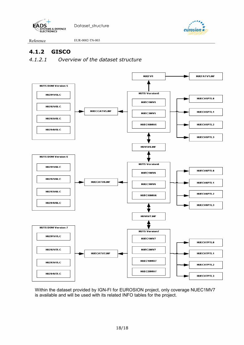
4.1.2 GISCO 4.1.2.1 Overview of the dataset structure
Within the dataset provided by IGN-FI for EUROSION project, only coverage NUEC1MV7 is available and will be used with its related INFO tables for the project.

Dataset_structure
Reference EUR-0002-TN-003
19/19
4.1.2.2 Description of the Arc Attribute Table of the NUEC1MV7 coverage
Attribute Name Type Description
FID OID Unique Object Identifier. Shape Geometry Polyline
NURGBNLV Integer NUts ReGion BouNdary LeVel
Indication of type of boundary -9: hidden -2: lake / sea boundary -1: coastline 0: national boundary 1: regional boundary 2: regional boundary 3: regional boundary
ARRGBNLV Integer Administrative ReGion BouNdary LeVel. Indication of type of boundary: -9: hidden -2: lake / sea boundaries -1: coastline 0: national boundary 1: regional boundary 2: regional boundary 3: regional bounbary
4.1.2.3 Description of the Polygon Attribute Table of the NUEC1MV7 coverage
Attribute Name Type Description
FID OID Unique Object Identifier. Shape Geometry Polygon
NURGCD String NUTS ReGion CoDe
This attribute contains the regional NUTS codes made up of 5 characters. As the NUTS code is hierarchical, the subsequent attributes, indicating level 0 to 2, are derived from the complete NUTS code by taking res. the first 2, 3 or 4 characters.
NURGCDL0 String NUTS ReGion CoDe Level 0 This attribute contains regional codes of 2 characters indicating the country; these are the first 2 characters of the NUTS code.

Dataset_structure
Reference EUR-0002-TN-003
20/20
NURGCDL1 String NUTS ReGion CoDe Level 1 This attribute contains regional codes of 3 characters; these are the first 3 characters of the NUTS code.
NURGCDL2 String NUTS ReGion CoDe Level 2 This attribute contains regional codes of 4 characters; these are the first 4 characters of the NUTS code
ARRGCDL0 String Adm. ReGion CoDe Level 0 Identification of an adm. Region on level 0 (country level) (ISO country code)
ARCDCT String Adm. Region CoDe ConTinent Identification of continent to which the region belongs: EE: Europe (EC countries) EF: Europe (EFTA countries) EN: Europe (others) A: Asia F: Africa N: North America S: Seas / Lakes
ARRGLBLV Integer Adm. Regions LaBel LeVel Identification of largest polygon of adm. region: 1: largest polygon 0: all others
4.1.2.4 Description of the INFO table NUECATV5.INF
This table description is just provided for information.
Attribute Name Type Description
Rowid OID Unique Object Identifier NURGNM String NUTS ReGion NaMe
The region's name is spelled in the original language. Special characters, such as umlaut, however, are replaced by a 2-character equivalent; the Greek names are transposed to the Latin alphabet.
NURGAR Float NUTS ReGion Area Area of NUTS region in km²
NURGCD String NUTS ReGion CoDe This attribute contains the regional NUTS codes made up of 5 characters. As the NUTS code is hierarchical, the subsequent attributes, indicating level 0 to 2, are derived from the complete NUTS code by taking res. the first 2, 3 or 4 characters.
Dataset_structure
Reference EUR-0002-TN-003
21/21
NURGCDL0 String NUTS ReGion CoDe Level 0 Identification of NUTS administrative region on level 0 (country level)
NURGCDL1 String NUTS ReGion CoDe Level 1 Identification of NUTS administrative region on level 1
NURGCDL2 String NUTS ReGion CoDe Level 2 Identification of NUTS administrative region on level 2
4.1.2.5 Description of the INFO table NUECATV6.INF
This table description is just provided for information. Attribute Name Type Description
Rowid OID Unique Object Identifier NURGCD String NUTS ReGion CoDe
This attribute contains the regional NUTS codes made up of 5 characters. As the NUTS code is hierarchical, the subsequent attributes, indicating level 0 to 2, are derived from the complete NUTS code by taking res. the first 2, 3 or 4 characters.
NURGNM String NUTS ReGion NaMe The region's name is spelled in the original language. Special characters, such as umlaut, however, are replaced by a 2-character equivalent; the Greek names are transposed to the Latin alphabet.
NURGCDL1 String NUTS ReGion CoDe Level 1 Identification of NUTS administrative region on level 1
NURGCDL2 String NUTS ReGion CoDe Level 2 Identification of NUTS administrative region on level 2
NURGCDL0 String NUTS ReGion CoDe Level 0
4.1.2.6 Description of the INFO table NUECATV7.INF
Attribute Name Type Description
Rowid OID Unique Object Identifier

Dataset_structure
Reference EUR-0002-TN-003
22/22
NURGCD String NUTS ReGion CoDe This attribute contains the regional NUTS codes made up of 5 characters. As the NUTS code is hierarchical, the subsequent attributes, indicating level 0 to 2, are derived from the complete NUTS code by taking res. the first 2, 3 or 4 characters.
NURGNM String NUTS ReGion NaMe The region's name is spelled in the original language. Special characters, such as umlaut, however, are replaced by a 2-character equivalent; the Greek names are transposed to the Latin alphabet.
NURGCDL0 String NUTS ReGion CoDe Level 0 Identification of NUTS administrative region on level 0 (country level)
NURGCDL1 String NUTS ReGion CoDe Level 1 Identification of NUTS administrative region on level 1
NURGCDL2 String NUTS ReGion CoDe Level 2 Identification of NUTS administrative region on level 2
4.1.2.7 Description of the INFO table NUV5V6.INF
This table description is just provided for information.
Attribute Name Type Description
Rowid OID Unique Object Identifier NURGCDV5 String NUTS ReGion CoDe Version 5
NURGCDV6 String NUTS ReGion CoDe Version 6
MO String MOdification
Modification between version 5 and version 6: S: Split M: Merge
4.1.2.8 Description of the INFO table NUV6V7.INF
This table description is just provided for information.
Attribute Name Type Description
Rowid OID Unique Object Identifier
Dataset_structure
Reference EUR-0002-TN-003
23/23
NURGCDV6 String NUTS ReGion CoDe Version 6
NURGCDV7 String NUTS ReGion CoDe Version 7
MO String MOdification Modification between version 6 and version 7: S: Split M: Merge S/M: Partially split, partially merged

Dataset_structure
Reference EUR-0002-TN-003
24/24
4.2. MARITIME BOUNDARIES
4.2.1 Overview of the dataset structure
This dataset is going to be implemented by using juridical texts coming from the Law of the Sea (LS) available in PDF file. Those LS documents contain the coordinates of the points defining the area limits this text refers to. In that case limits are integrated (maritime boundaries coverage).
Within the framework of EUROSION project, to follow the GISCO naming conventions, the name proposed for the coverage of Maritime Boundaries is: MBECLSI100kV1, which means:
• MB for Maritime Boundaries,
• EU for EUurope, witin the framework of EUROSION project, EC covers the applicant countries and not only the 15 countries of the curent EC, the Georeference
• LS for Law of the Sea, the entity
• I for IGN France International, the source
• 100K for the scale
• V1 version 1

Dataset_structure
Reference EUR-0002-TN-003
25/25
4.2.2 Description of the Point Attribute Table of MBEULSI100KV1 coverage
The point attribute table is going to be built with the points coordinates provided for every treaty into the corresponding PDF file. For every point digitised it is recommended to input the point number reference corresponding to the one mentioned within the PDF file or the juridical text.
Attribute Name Type Description
Rowid
OID Point unique identifier.
Shape Geometry Point.
MBLSPTID
Integer Law of the Sea PoinT IDentifier. Point number mentioned within the corresponding Law of the Sea juridical text (provided into a PDF file for every juridical text) .
MBLGDD Integer LonGitude in Decimal Degrees. Point longitude defined within the Law of the Sea juridical text.
MBLSDS.INFMBLSDS.INFMBEULSI100KV1MBEULSI100KV1
MBLSTP.INFMBLSTP.INF
MBLSDT.INFMBLSDT.INF
MBLSZT.INFMBLSZT.INF
MBLSGD.INFMBLSGD.INF
MBLSST.INFMBLSST.INF
MBLSSD.INFMBLSSD.INF
MBLSND.INFMBLSND.INF

Dataset_structure
Reference EUR-0002-TN-003
26/26
MBLTDD Integer LaTitude in Decimal Degrees. Point latitude defined within the Law of the Sea juridical text.
MBLSID
Integer Law of the Sea IDentifier. Unique identifier for the concerned juridical text (act, convention, treaty…).
4.2.3 Description of the Arc Attribute Table of the MBEULSI100KV1 coverage
This polyline table is going to be built with the points coordinates provided for every treaty into the corresponding PDF file.
Attribute Name Type Description
Rowid
OID Polyline unique identifier.
Shape Geometry Polyline
MBLSID
Integer Law of the Sea IDentifier. Unique identifier for the concerned juridical text (act, convention, treaty…).
4.2.4 Description of the INFO tables MBLSDS.INF This table provides metadata for every maritime juridical text. The proposed name of this table is defined as follows:
• MB for Maritime Boundaries • LS for Law of the Sea • DS for DeScription
Attribute Name Type Description
MBLSID
Integer Law of the Sea IDentifier. Unique identifier for the concerned juridical text.
MBLSNM String Law of the Sea NaMe, length at least 250 characters.
MBLSTPID Integer Law of the Sea TyPe IDentifier. For example Act, Convention, Treaty etc. These types are defined in the INFO table MBLSTP.INF.
Dataset_structure
Reference EUR-0002-TN-003
27/27
MBLSNTDMID Integer Law of the Sea NaTure of the DeliMitation IDentifier. It provides the number of states involved within the juridical text signed. There are 3 possibilities: 1: Unilateral 2: Bilateral 3: Multilateral The description of the nature delimitation is provided in table MBLSND.INF.
MBLSDT Date Law of the Sea DaTe. Date of the Law of the Sea.
MBLSDTTPID Integer Law of Sea DaTe TyPe IDentifier. Type of the date, number corresponding to the types defined within the table MBLSDT.INF
MBLSLK http link Law of the Sea LinK. Link to the corresponding PDF file containing the juridical text.
MBLSMP http link Law of the Sea MaPe. Link to the corresponding PDF file containing the cartographic map for the corresponding juridical text.
MBLSGDID Integer Law of the Sea Geodetic Datum IDentifier. Unique identifier of the Geodetic Datum. The description of the Geodetic Datum is provided in table MBLSGD.INF.
MBLSZOTPID
Integer Law of the Sea ZOne TyPe IDentifier. Unique identifier of the Zone Type. Type of the zone defines the zone to which the juridical text corresponds (e.g. Exclusive Economic Zone, territory sea (12 nm), …). The description of the zone types is provided in table MBLSZT.INF.
MBLSPTNR
Integer Law of the Sea PoinT NumbeR. Number of points. It is the number of points mentioned in the juridical text.
MBLSCM
String Law of the Sea CoMments. Free text with not less than 250 characters length.
4.2.5 Description of the INFO table MBLSTP.INF This table provides information on the type of every maritime juridical text. The proposed name of this table is defined as follows:
• MB for Maritime Boundaries • LS for Law of the Sea • TP for TyPe
Attribute Name Type Description

Dataset_structure
Reference EUR-0002-TN-003
28/28
MBLSTPID
Integer Law of the Sea TyPe IDentifier.
MBLSTPNM String Law of the Sea TyPe NaMe. Type of the juridical text: 0: Other 1: Act 2: Agreement 3: Amendment Act 4: Convention 5: Decision 6: Declaration 7: Decree 8: Law 9: Legislation 10: Note Verbale 11: Notice 12: Order 13: Ordinance 14: Proclamation 15: Resolution 16: Treaty
4.2.6 Description of the INFO table MBLSDT.INF This table provides information on the type of the date for every maritime juridical text. The proposed name of this table is defined as follows:
• MB for Maritime Boundaries • LS for Law of the Sea • DATE for DaTe
Attribute Name Type Description
MBLSDTTPID Integer Law of Sea DaTe TyPe IDentifier. Unique IDenfifier of the
date type
MBLSDTTPNM String Law of the Sea DaTe TyPe NaMe. Type of the date relative to the juridical text: 0: Date of creation 1: Date of update 2: Date of publishing 3: Date of signature 4: Date of ratification 5: Date of enter in force 6: Date of adoption
4.2.7 Description of the INFO table MBLSST.INF This table ensures the link between every juridical text and every country. For example, if the juridical text is of bilateral nature, this table will contain two occurrences of the juridical text identifier (LSID), one for each 2 country. The proposed name for this table is defined as follows:
• MB for Maritime Boundaries

Dataset_structure
Reference EUR-0002-TN-003
29/29
• LS for Law of the Sea • ST for StaTe
Attribute Name Type Description
MBLSID Integer Law of the Sea IDentifier
MBCNCD String CouNtry CoDe. Contains the 2-character country code according to the Contains the 2-character country code according to the ISO 3166 nomenclature (e.g. DE for Germany). It is the ICC code from the SABE model.
4.2.8 Description of the INFO table MBLSSD.INF This table provides information on the name of evey state linked with maritime juridical text. The proposed name of this table is defined as follows:
• MB for Maritime Boundaries • LS for Law of the Sea • SD for Sate Description
Attribute Name Type Description
MBCNCD String CouNtry CoDe. Contains the 2-character country code according to the ISO 3166 nomenclature (e.g. DE for Germany). It is the ICC code from the SABE model.
MBLSSTNM String Law of the Sea StaTe NaMe.
4.2.9 Description of the INFO table MBLSZT.INF This table provides information on type of zone delimited by the boundaries defined within the maritime juridical text. The proposed name of this table is defined as follows:
• MB for Maritime Boundaries • LS Law of the Sea • ZT Zone Type
Attribute Name Type Description
MBLSZOTPID
Integer Law of the Sea ZOne TyPe IDentifier. Unique identifier of the zone type.

Dataset_structure
Reference EUR-0002-TN-003
30/30
MBLSZOTPNM
String Law of the Sea ZOne TyPe NaMe. Name of the zone type. TYPE = 0: Baseline TYPE = 1: Territory sea (12 nm) TYPE = 2: Exclusive Economic Zone (200 nm), EEZ TYPE = 3: Delimitation line between states TYPE = 4: Continental shelf TYPE = 5: Contiguous zone (24 nm) TYPE = 6: Fishery zone TYPE = 7: Other
4.2.10 Description of the INFO table MBLSND.INF This table provides information on type of the Delimitation Nature of the Law of the Sea text. The proposed name of this table is defined as follows:
• MB for Maritime Boundaries • LS for Law of the Sea • ND for Nature of the Delimitation
Attribute Name Type Description
MBLSNTDMID Integer Law of the Sea NaTure of the DeliMitation IDentifier.
MBLSNTDMNM String Law of the Sea NaTure of the DeliMitation NaMe. It provides the number of states involved within the juridical text signed. There are 3 possibilities: 1: Unilateral 2: Bilateral 3: Multilateral
4.2.11 Description of the INFO table MBLSGD.INF This table provides information on type of the Geodetic datum related to the points coordinates of the maritime juridical text. The proposed name of this table is defined as follows:
• MB for Maritime Boundaries • LS for Law of the Sea • GD for Geodetic Datum
Attribute Name Type Description
MBLSGDID Integer Law of the Sea Geodetic Datum IDentifier. Unique Identifier
of the Geodetic Datum used for creating the points of the juridical text.
MBLSGDNM String Law of the Sea Geodetic Datum NaMe. Name of the Geodetic Datum used to reference the points coordinates mentioned within the Law of Sea text.

Dataset_structure
Reference EUR-0002-TN-003
31/31
Dataset_structure
Reference EUR-0002-TN-003
32/32
4.3. SHORELINE
4.3.1 SABE shoreline
4.3.1.1 Overview of the dataset structure The SABE shoreline is defined by the terrestrial administrative limits for the countries
where there is no difference.
For the countries where there is a physical difference, coverages are existing. Their names are defined as follow, Scxx30, where:
- Sc : means Shoreline
- XX: is the ISO country code (XX= DE (Germany); FI (FINLAND); GB (Great Britain) ; IE (Ireland) ; NI (Northern Ireland) ; NL (Netherlands) ; SE (Sweden), FX (France).
- For CEEC: PL (Poland) and Baltics Countries, (Ro) Romania
- and for ETFA, XX = NO (Norway) (rem: Hrvatska ne fait pas partie des CEEC ou PECO – en francais)
The coastline coverage contains only those (coastline) arcs, which do not coincide with administrative boundaries.
4.3.1.2 Description of the Arc Attribute Table of the SCxx30 coverage
Attribute Name Type Description
FID OID Unique Object Identifier
Shape Geometry Polyline
ICC String The ICC attribute contains the 2 character country code according to ISO 3166
TOC Integer Type of coastline describes the particular characteristics of a coastline segment in relation to a boundary segment. 2: Physically exists but not identical to international boundary. TOC = 2.
For all other states, the coastline still corresponds to the boundary of the littoral administrative units.
SCXX30SCXX30
Dataset_structure
Reference EUR-0002-TN-003
33/33
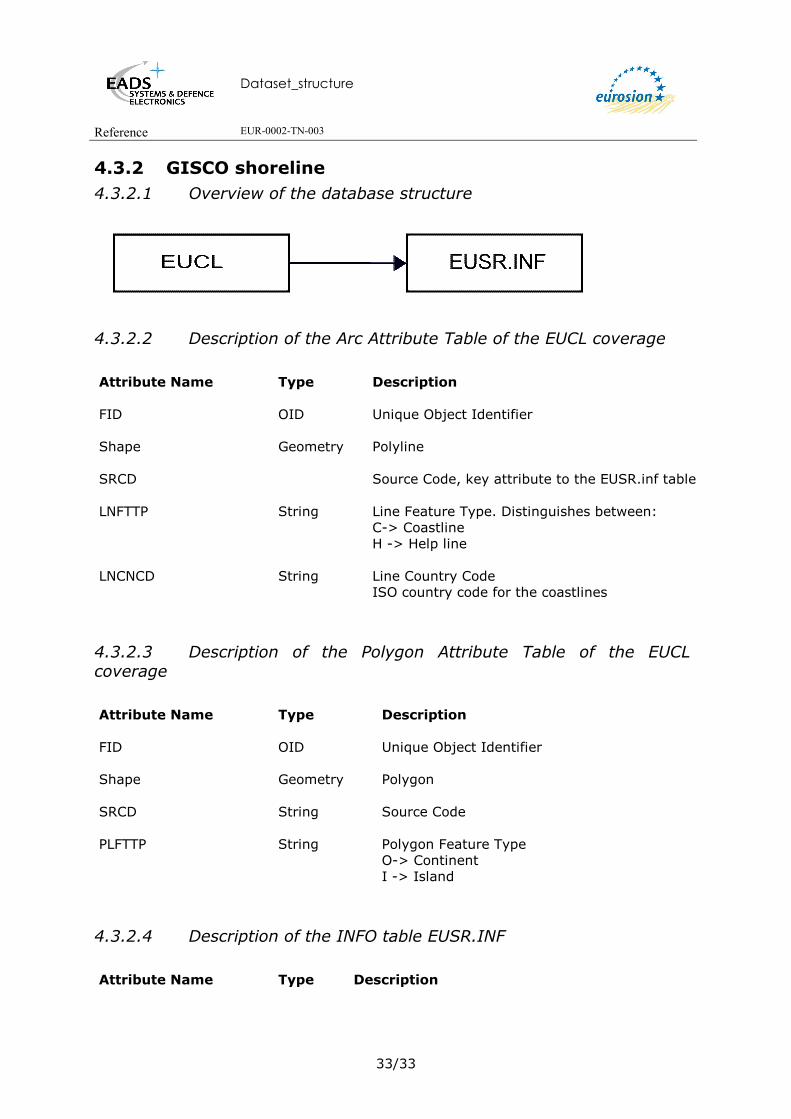
4.3.2 GISCO shoreline 4.3.2.1 Overview of the database structure
4.3.2.2 Description of the Arc Attribute Table of the EUCL coverage
Attribute Name Type Description
FID OID Unique Object Identifier
Shape Geometry Polyline
SRCD Source Code, key attribute to the EUSR.inf table
LNFTTP String Line Feature Type. Distinguishes between:
C-> Coastline H -> Help line
LNCNCD String Line Country Code ISO country code for the coastlines
4.3.2.3 Description of the Polygon Attribute Table of the EUCL coverage
Attribute Name Type Description
FID OID Unique Object Identifier
Shape Geometry Polygon
SRCD String Source Code
PLFTTP String Polygon Feature Type
O-> Continent I -> Island
4.3.2.4 Description of the INFO table EUSR.INF
Attribute Name Type Description

Dataset_structure
Reference EUR-0002-TN-003
34/34
SRCD Integer SouRce CoDe. Key attribute to the arcs.
SRNM String SouRce NaMe Name of the data source from which the arc was retrieved.
SRDA Date Source Date Date of the data source
SRRS Integer Source Resolution Resolution (meters) of the data source no data -> -999
SRPU String Source public Y: the data can be served over the web N: If special conditions apply
SRPJ String Source projection file Name of the projection system definition file of the source data
4.3.3 World Vector Shoreline Attribute Name Type Description
FID OID Unique Object Identifier
Shape Geometry Polyline
4.3.4 Eurosion Shoreline The EUROSION shorline is initially coming out from the EUROSION shoreline coming from the Corine Coastal Erosion Version 1 (from 1985). This shoreline has been geometrically improved and extended to applicant countries to cover the whole area of interest of EUROSION project. For that purpose , IGN FI has used others sources:
• SCOL (SABE shoreline), • World Vector Shoreline (WVS) • GISCO Shoreline,
This extended new shoreline has been provided by IGN FI to BRGM and GIM who are in charge of the update and extension of Corine Coastal Erosion data base. Furthermore the CCER updating process allows BRGM and GIM to modify the shoreline geometry (new vertices, add or split coastal segments) while they are usually working with more accurate maps than scale 1/100 000, offering more accurate information than for instance, the scale of the WVS shoreline. Improvements are taking part of a pro active process to provide in fine the EUROSION Shoreline.
Dataset_structure
Reference EUR-0002-TN-003
35/35
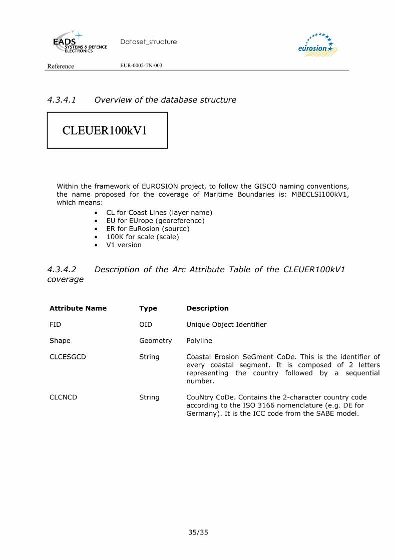
4.3.4.1 Overview of the database structure
Within the framework of EUROSION project, to follow the GISCO naming conventions, the name proposed for the coverage of Maritime Boundaries is: MBECLSI100kV1, which means:
• CL for Coast Lines (layer name) • EU for EUrope (georeference) • ER for EuRosion (source) • 100K for scale (scale) • V1 version
4.3.4.2 Description of the Arc Attribute Table of the CLEUER100kV1 coverage
Attribute Name Type Description
FID OID Unique Object Identifier
Shape Geometry Polyline
CLCESGCD String
Coastal Erosion SeGment CoDe. This is the identifier of every coastal segment. It is composed of 2 letters representing the country followed by a sequential number.
CLCNCD String CouNtry CoDe. Contains the 2-character country code according to the ISO 3166 nomenclature (e.g. DE for Germany). It is the ICC code from the SABE model.
CLEUER100kV1CLEUER100kV1

Dataset_structure
Reference EUR-0002-TN-003
36/36
5. BATHYMETRY 5.1. GEBCO BATHYMETRY 5.1.1 Overview of the database structure
The name of this layer is proposed following the GISCO naming conventions. Thus BTECGO100KV1 means:
• BT for BaThymetry (the layer name) • EU for EUrope (the georeference) • GO for GebcO (the source) • 250K for scale 1:250 000 (for some countries, in particular some british irelan,
scale is 1 :100000) • V1 for Version 97
Remark:
The first data provided were in DXF format. These data were converted into shape format. For every value of depth, corresponds a DXF file. Every DXF files were merged into only one shape file. Attributes linked to the symbol representation were dropped as they are not useful for the ArcEditor plateform or for not containing any type of information.
These attributes are:
• Handle
• Layer
• Color
• Linetype
• Thickness
• Text_
• Shap_Leng
5.1.2 Description of the Arc Attribute Table of the BTEUGO100KV1 coverage
BTEUGO250KV1BTEUGO250KV1

Dataset_structure
Reference EUR-0002-TN-003
37/37
Attribute Name Type Description
FID OID Unique polyline idenfier.
Shape Geometry Polyline
BTEV Double BaThymetry EleVation. Indicates the seafloor depth in meters. The more this depth is high the more the isobath line is far from the coast.
5.2. ETOPO5 Within the framework of EUROSION project it is not planned to acquire this dataset, and thus only metadata are documented according to the Eurosion ISO 19115 metadata model.
5.3. DIGITAL BATHYMETRY DATA BASE VARIABLE Within the framework of EUROSION project it is not planned to acquire this dataset, and thus only metadata are documented according to the Eurosion ISO 19115 metadata model.
5.4. DIGBATH250 Within the framework of EUROSION project it is not planned to acquire this dataset, and thus only metadata are documented according to the Eurosion ISO 19115 metadata model.
5.5. IOWTOPO Within the framework of EUROSION project it is not planned to acquire this dataset, and thus only metadata are documented according to the Eurosion ISO 19115 metadata model.

Dataset_structure
Reference EUR-0002-TN-003
38/38
6. ELEVATION
6.1. MONA PRO EUROPE 6.1.1 Overview of the dataset structure Every file corresponds to a bloc or a tile. Shape coverage with an INDEX referering every bloc number of the tiles is also provided.
The name of this layer is proposed taking into account the GISCO naming conventions. Thus DEECBCMP100KV1n means:
• DE for Digital Elevation (the layer name) • EU for EUrope (the georeference) • MP for MonaPro (the source) • 100K for scale 1:100 000 • nn identifies the bloc number.
Every bloc in ASCII Grid format is referenced within an INDEX coverage, which is a polygon coverage giving the location (bounding box) of every bloc and its number. According to the GISCO naming conventions this coverage is titled DEECINMP100KV1, which means:
• DE for Digital Elevation (the layer name) • EU for EUrope (the georeference) • IN for Index (the entity) • MP for MonaPro (the source) • V1 for version 1
6.1.2 Description of the Polygon Attribute Table of the DEEUINMPV1 Coverage
DEEUMP100Knn.VATDEEUMP100Knn.VAT
DEEUINMPV1DEEUINMPV1
DEEUMP100KnnDEEUMP100Knn

Dataset_structure
Reference EUR-0002-TN-003
39/39
Attribute Name Type Description
FID OID Unique polygone identification
Shape Geometry Polygon
DENRBC Long Integer
NumbeRr of BloC. Bloc number. Every bloc has an area of 0,25
6.1.3 Description of the Value Attribute Table (.VAT) of the ASCII GRID DATA BLOC DEEUMP100Knm:
Attribute Name Type Description
FID OID Unique pixel identification
Value Integer Altitude of the pixel in meters.
Count Integer Number of pixels with an altitude equal to value.
Dataset_structure
Reference EUR-0002-TN-003
40/40
7. GEOLOGY GEOMORPHOLOGY AND EROSION TREND
7.1. OVERVIEW OF THE DATASET STRUCTURE The Coastal Erosion Layer (CEL – New CCEr) database is using the updated Eurosion Coastline provided to BRGM by IGN FI. Thus the geometry of the Coastal Erosion Layer (CEL) is different from the geometry of the 1990 CCEr1.
The CEL contains the same attributes as described in the original CCEr with two new more attributes:
- CEGO: Geology
- CEDA: data availability
Within the framework of EUROSION project according to the Terms Of Reference the database will be produced at 1 / 100 000 scale (the 1990 CCEr is available at 1/100 000 and 1 /1 000 000 scales).
The name propoposed for this new coverage according to the GISCO rules is CEEU100KV2. Where:
• CE for Coastal Erosion
• EU EUrope, this includes applicant countries covered within the framework of Eurosion project
• BG for BrGm, the source
• 100K for scale 1:100000
• V2 for version 2
1 Just for information, the structure description of the original CCEr 1990 database is provided in Annex 19.

Dataset_structure
Reference EUR-0002-TN-003
41/41
7.2. DESCRIPTION OF THE ARC ATTRIBUTE TABLE OF THE COVERAGE CEEUBG100KV2: Attribute Name Type Description
FID OID Unique object identifier.
Shape Geometry Polyline.
CEEUBG100KV2CEEUBG100KV2
CEGO.INFCEGO.INF
CEMO.INFCEMO.INF
CEEV.INFCEEV.INF
CEDA.INFCEDA.INF
CEDW.INFCEDW.INF
CEDC.INFCEDC.INF
Dataset_structure
Reference EUR-0002-TN-003
42/42
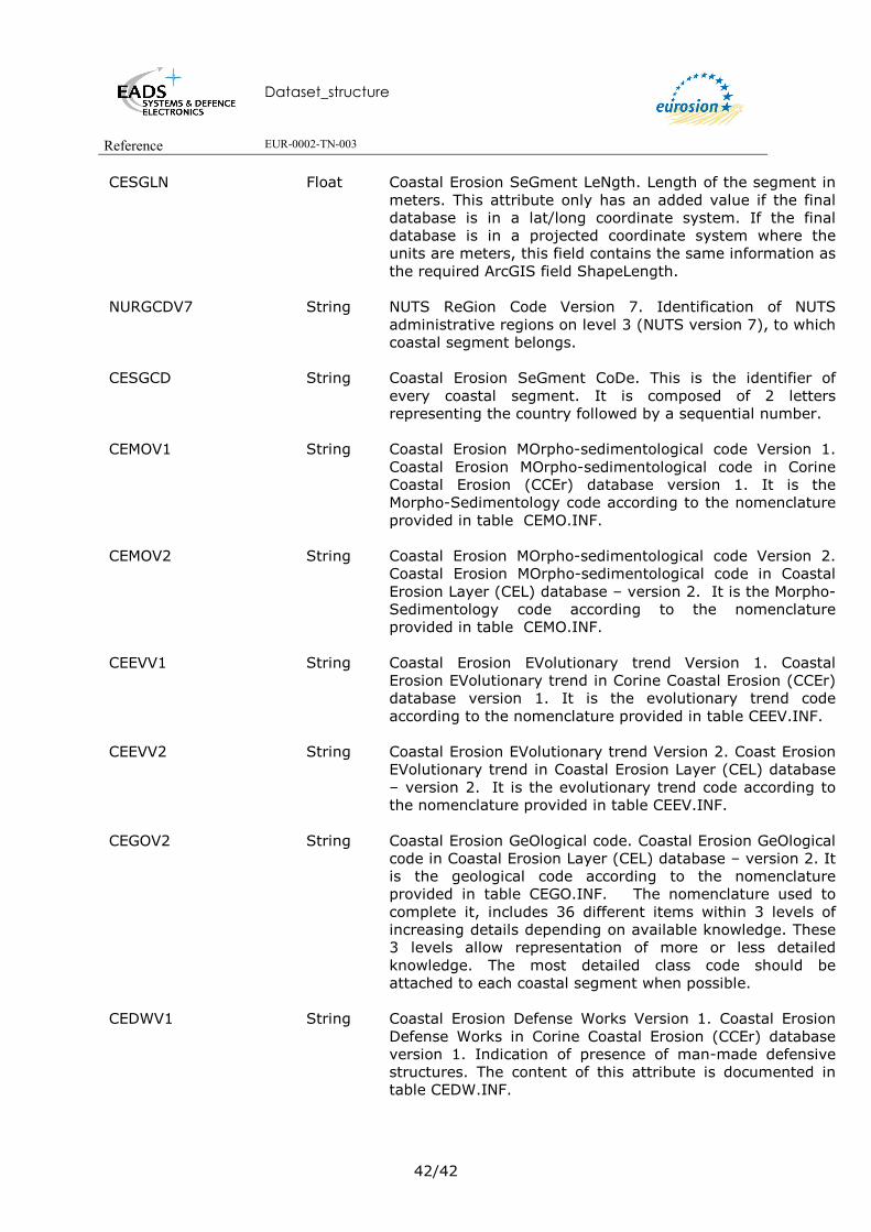
CESGLN Float
Coastal Erosion SeGment LeNgth. Length of the segment in meters. This attribute only has an added value if the final database is in a lat/long coordinate system. If the final database is in a projected coordinate system where the units are meters, this field contains the same information as the required ArcGIS field ShapeLength.
NURGCDV7
String NUTS ReGion Code Version 7. Identification of NUTS administrative regions on level 3 (NUTS version 7), to which coastal segment belongs.
CESGCD String
Coastal Erosion SeGment CoDe. This is the identifier of every coastal segment. It is composed of 2 letters representing the country followed by a sequential number.
CEMOV1
String Coastal Erosion MOrpho-sedimentological code Version 1. Coastal Erosion MOrpho-sedimentological code in Corine Coastal Erosion (CCEr) database version 1. It is the Morpho-Sedimentology code according to the nomenclature provided in table CEMO.INF.
CEMOV2
String Coastal Erosion MOrpho-sedimentological code Version 2. Coastal Erosion MOrpho-sedimentological code in Coastal Erosion Layer (CEL) database – version 2. It is the Morpho-Sedimentology code according to the nomenclature provided in table CEMO.INF.
CEEVV1
String Coastal Erosion EVolutionary trend Version 1. Coastal Erosion EVolutionary trend in Corine Coastal Erosion (CCEr) database version 1. It is the evolutionary trend code according to the nomenclature provided in table CEEV.INF.
CEEVV2 String Coastal Erosion EVolutionary trend Version 2. Coast Erosion EVolutionary trend in Coastal Erosion Layer (CEL) database – version 2. It is the evolutionary trend code according to the nomenclature provided in table CEEV.INF.
CEGOV2
String Coastal Erosion GeOlogical code. Coastal Erosion GeOlogical code in Coastal Erosion Layer (CEL) database – version 2. It is the geological code according to the nomenclature provided in table CEGO.INF. The nomenclature used to complete it, includes 36 different items within 3 levels of increasing details depending on available knowledge. These 3 levels allow representation of more or less detailed knowledge. The most detailed class code should be attached to each coastal segment when possible.
CEDWV1
String Coastal Erosion Defense Works Version 1. Coastal Erosion Defense Works in Corine Coastal Erosion (CCEr) database version 1. Indication of presence of man-made defensive structures. The content of this attribute is documented in table CEDW.INF.

Dataset_structure
Reference EUR-0002-TN-003
43/43
CEDWV2
String Coastal Erosion Defense Works Version 2. Coastal Erosion Defense Works in Coastal Erosion Layer (CEL) database – version 2. Indication of presence of man-made defensive structures. The content of this attribute is documented in table CEDW.INF.
CEDAV2
String Coastal Erosion Data Avaibility. Coastal Erosion Data Avaibility in Coastal Erosion Layer (CEL) database – version 2. The Coastal Erosion Data Availability (CEDA attribute) attribute informs on the avaibility of updated data (same or not) in regard of the CCEr data. The content of this attribute is documented in table CEDW.INF.
CEDC String Coastal Erosion Data Change. Coastal Erosion Data Change. Indication of change in values between CCEr database (version 1).
7.3. DESCRIPTION OF THE INFO TABLE CEDW.INF This table provides information the presence of defense work. Attribute Name Type Description
CEDW String Coastal Erosion Defense Works.
Indication of presence of man-made defensive structures.
CEDWDS String Coastal Erosion Defense Works DeScription. Indication of presence of man-made defensive structures: Y: presence of defense work N: no coastal defence work (default)
7.4. DESCRIPTION OF THE INFO TABLE CEDA.INF This table provides information the data status. Attribute Name Type Description
CEDA Integer Coastal Erosion Data Avaibility. The Coastal Erosion Data
Availability (CEDA) attribute informs on the avaibility of updated data (same or not) in regard of the CCEr data
CEDADS String
Coastal Erosion Data Avaibility DeScription. This description is provided in the table below.

Dataset_structure
Reference EUR-0002-TN-003
44/44
CEDA CEDADS
0 No data available
1 No new data available. Data are from CCEr 1990,(version 1) if exist
2 CEL data (same as CCEr or updated information)
7.5. DESCRIPTION OF THE INFO TABLE CEDC.INF This table provides information the data status. Attribute Name Type Description
CEDC Integer Coastal Erosion Data Change. Indication of change in values
between CCEr database (version 1) and CEL database (version 2).
CEDCDS String
Coastal Erosion Data Change DeScription. This description is provided in the table below.
CEDC CEDCDS
1 No change in attributes values. Data are from CCEr 1990,(version 1)
2 New CEL data (new or updated information)
3 Correction of erroneous information (only for CCEr – version 1)
7.6. DESCRIPTION OF THE INFO TABLE CEGO.INF This table provides the nomenclature of the geological codes. This nomenclature includes 36codes.
Attribute Name Type Description
CEGO String Coastal Erosion GeOlogical code.
Identification of the geology of the coast. There are 3 levels of increasing details depending on available knowledge.

Dataset_structure
Reference EUR-0002-TN-003
45/45
CEGODS String Coastal Erosion GeOlogical code DeScription. Coastal Erosion GeOlogical code DeScription. The description of the 36 codes is provided in the table below.
CEGO CEGODS
A00 Substratum
A10 Plutonic rock
A11 Ultramafite and mafic rocks
A12 Intermediate rocks (diorite, gabbro-diorite,..)
A13 Granitic rocks
A20 Volcanic rocks
A21 Lava (basalts, etc.)
A22 Ashes and stone fragments
A23 Volcano-sedimentary formations
A30 Metamorphic rocks
A31 Gneiss
A32 Schist
A33 Marble
A34 Quartzite
A40 Sedimentary rocks
A41 Sandstone
B42 Marl and consolidated clay
B43 Limestone
B44 Chalk
B45 Evaporities
B46 “Flysch” and interbedded series
B00 Non cohesive formations
B10 Marine deposits

Dataset_structure
Reference EUR-0002-TN-003
46/46
B11 Undifferentiated recent marine deposits
B20 Lacustrine deposits
B21 Undifferentiated recent lacustrine deposits
B30 Continental deposits
B31 Eolian sands and dunes
B32 Fluvial (sand and gravel)
B33 Peat bog
B34 Loess and silts
B35 Moraines and glacial or periglacial deposits
B36 Non cohesive undifferentiated sediments
B37 Man made grounds
C00 No information
D00 Out of nomenclature
7.7. DESCRIPTION OF THE INFO TABLE CEMO.INF This table provides the nomenclature of the morpho-sedimentological codes.
Attribute Name Type Description
CEMO String
Coastal Erosion MOrpho-sedimentological code. Morpho-Sedimentology code.
CEMODS
String Coastal Erosion MOrpho-sedimentological code DeScription. Description of the morpho-sedimentological entity corresponding to the associated CEMS code. This description is provided in the table below.
CEMO CEMODS
A Rocks and/or cliffs made of hard rocks (little subject to erosion) with eventual presence of a rock platform.

Dataset_structure
Reference EUR-0002-TN-003
47/47
B Conglomerates and/or cliffs (example: chalk) i.e. subject to erosion: presence of rock waste and sediments (sand or pebbles) on the strand.
AC Mainly rocky, little erodible, with pocket beaches (< 200 m long) not localised.
C Small beaches (200 to 1000 m long) separated by rocky capes (< 200 m long).
D Developed beaches (length of the beach > 1 km) with strands made of coarse sediments: gravels or pebbles
E Developed beaches ( > 1 Km long) with strands fine to coarse sand.
F Coastlines made of soft non-cohesive sediments (barriers, spits, tombolos).
G Strands made of muddy sediments: "waddens" and intertidal marshes with "slikkes and schorres"
H Estuary (virtual line).
J Harbour areas
K Artificial beaches
L Coastal embankments for construction purposes (e.g. by emplacement of rocks earth etc.)
M Polders (reclamed coastal areas). Only used in CCEr database
N Very narrow and vegetated strands (pond or lake shore type)
P Soft strands with rocky "platforms" (rocky flat) on intertidal strands
R Soft strands with "beach rock" on intertidal strands
S Soft strands made of mine-waste sediments
X Soft strands of heterogeneous category grain size
Y Artificial shoreline or shoreline with longitudinal protection works (walks, dikes, quays, rocky strands ) without sandy strands
Z Soft strands of unknown category grain size

Dataset_structure
Reference EUR-0002-TN-003
48/48
7.8. DESCRIPTION OF THE INFO TABLE CEEV.INF This table provides the nomenclature of the evolutionary trend code. This nomenclature is composed of 10 codes.
Attribute Name Type Description
CEEV String
Coastal Erosion EVolutionary trend.
CEEVDS
String Coast Erosion EVolutionary trend DeScription. Description of the evolutionary trend codes. This description is provided in the table below.
CEEV CEEVDS
0 Out of nomenclature.
1 No information on evolution
2 Stable: Evolution almost not perceptible at human scale
3 Generally stable: small "occasional" variations around a stable position; evolutionary trend is uncertain
4 Erosion probable but not documented
6 Aggradation probable but not documented
50 Erosion confirmed (available data), localised on parts of the segment.
51 Erosion confirmed (available data), generalised to almost the whole segment.
70 Aggradation confirmed (available data), localised on parts of the segment.
71 Aggradation confirmed (available data), generalised to almost the whole segment.
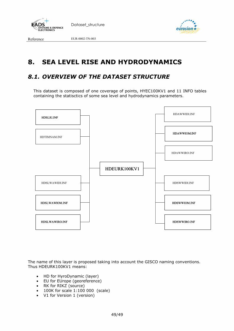
Dataset_structure
Reference EUR-0002-TN-003
49/49
8. SEA LEVEL RISE AND HYDRODYNAMICS
8.1. OVERVIEW OF THE DATASET STRUCTURE This dataset is composed of one coverage of points, HYEC100KV1 and 11 INFO tables containing the statisctics of some sea level and hydrodynamics parameters.
The name of this layer is proposed taking into account the GISCO naming conventions. Thus HDEURK100KV1 means:
• HD for HyroDynamic (layer) • EU for EUrope (georeference) • RK for RIKZ (source) • 100K for scale 1:100 000 (scale) • V1 for Version 1 (version)
HDEURK100KV1HDEURK100KV1
HDAWWIDI.INF
HDAWWIOM.INFHDAWWIOM.INFHDTIMNAM.INF
HDSWWIDI.INF
HDSWWIOM.INFHDSWWIOM.INF
HDAWWIRO.INF
HDSWWIRO.INFHDSWWIRO.INF
HDSLRI.INFHDSLRI.INF
HDSLWAWIDI.INF
HDSLWAWIOM.INFHDSLWAWIOM.INF
HDSLWAWIRO.INFHDSLWAWIRO.INF

Dataset_structure
Reference EUR-0002-TN-003
50/50
8.2. SEA LEVEL RISE 8.2.1 Description of the Point Attribute Table of the HDEURK100KV1 coverage
Attribute Name Type Description
OID OID Unique object identifier. Shape Geometry Point
HDAR Double ARea of interest. Index of location centre. Point index.
There 237 points were measures or statistics have been processed.
HDLGDD Double LonGitude in Decimal Degrees. Longitude of location centre in decimal degrees.
HDLTDD Double LatiTude in Decimal Degrees. Latitude of location centre in decimal degrees.
8.2.2 Description of the INFO TABLE HDSLRI.INF The proposed name of this table is defined as follows:
• HD: for HydroDynamic • SL for Sea Level • RI for Rise
The original name of this table was SEA_LEVEL_RISE.INF. Attribute Name Type Description
FID OID Unique object identifier. HDAR Double ARrea of interest. Index of location centre. Point index or
Point number. There are 237 points were measures or statistics have been processed.
HDLGDD Double LonGitude in Decimal Degrees. Longitude of location centre in decimal degrees.
HDLTDD Double LatiTude in Decimal Degrees. Latiude of location centre in decimal degrees.
HDSELV Double SEa LeVel. Predicted relative sea level rise at the location centers in mm/Year
8.2.3 Description of INFO table HDTIMNAM.INF This table provide information on Mean Tidal Amplitide for every Area Of Interest (AOI). The proposed name of this table is defined as follows:

Dataset_structure
Reference EUR-0002-TN-003
51/51
• HD: for HydroDynamic • TI for Tidal • MN for MeaN • AM for AMplitude
The original name of this table was MEAN_TIDAL_AMPLITUDE.INF. Attribute Name Type Description
FID OID Unique object identifier. HDAR Double ARea of interest. Index of location centre. It is the point
index or number. There 237 points were measures or statistics have been processed.
HDLGDD Double LonGitude of location centre in Decimal Degrees.
HDLTDD Double LatiTude of location centre in Decimal Degrees.
HDTIMNAM Double TIdal MeaN AMplitude at the location centers. It is defined as the square root of the sum of squared amplitudes of the harmonics. The tidal range is as expected largest in the North Sea and the Atlantic Ocean and almost vanishing in the Baltic Sea and Mediterranean. The unit is in meters.
8.3. HYDRODYNAMICS 8.3.1 Description of the Point Attribute Table of the HDEURK100KV1 coverage.
Attribute Name Type Description
FID OID Unique object identifier.
Shape Geometry Point
HDAR Double ARea of interest. Index of location centre. Point index.
There 237 points were measures or statistics have been processed.
HDLGDD Double LonGitude of location centre in Decimal Degrees.
HDLTDD Double LatiTude of location centre in Decimal Degrees.
8.3.2 Description of INFO table HDAWWIDI.INF The proposed name of this table is defined as follows:
• HD for HydroDynamic

Dataset_structure
Reference EUR-0002-TN-003
52/52
• AW for All Waves • WI for WInd • DI for DIrectional
The original name of this table was ALL_WAVES_WIND_DIRECTIONAL.INF.
Attribute Name Type Description
FID OID Unique object identifier.
HDAR Double ARea of interest. Index of location centre. Point number.
HDLGDD Double LonGitude of location centre in Decimal Degrees.
HDLTDD Double LatiTude of location centre in Decimal Degrees.
HDDI Double DIrection. Centre of DIrectional sector, or ‘OMNI’ for
omnidirectional statistics in decimal degrees, it is the original attribute name DIR.
HDWAHSAV Double WAve Height Significant AVerage. Mean significant wave height while wave direction is in the given sector (see dir) in meters, it is the original attribute name :HS_avg.
HDWAHSTN Double WAve Height Significant TeN. Significant wave height exceeded during 10% of the time that wave direction is in the given sector (see dir) in meters,it is the original attribute name HS_10.
HDWAHSOE Double WAve Height Significant OnE. Significant wave height exceeded during 1% of the time that wave direction is in the given sector (see dir) in meters, it is the original attribute name HS_1.
HDWAHSPE Double WAve Height Significant PErcentage. Percentage of samples of significant wave height coinciding with wave direction in the given sector (see dir), it is the original attribute name HS_#.
HDWAPIAV Double WAve PerIod AVerage. Wave period while wave direction is in the given sector (see dir) in secondes, it is the original attribute name Tm_avg .
HDWAPITN Double WAve PerIod TeN. Wave period exceeded during 10% of the time that wave direction is in the given sector (see dir) in secondes, it is the original attribute name Tm_10.
HDWAPIOE Double Wave PerIod OnE. Wave period exceeded during 1% of the time that wave direction is in the given sector (see dir) in secondes, it is the original attribute name Tm_1.
Dataset_structure
Reference EUR-0002-TN-003
53/53
HDWAPIPE Double WAve PerIod PErcentage. Percentage of samples of wave period coinciding with wave direction in the given sector (see dir), it is the original attribute name Tm_#.
HDWISPAV Double WInd SPeed AVerage. Mean wind speed in m/s, it is the original attribute name, U10_avg.
HDWISPTN Double WInd SPeed TeN. Wind speed, which is exceeded by 10% of the time (in the direction sector), it is the original attribute name U10_10.
HDWISPOE Double WInd SPeed OnE. Wind speed, which is exceeded by 1% of the time (in the direction sector), it is the original attribute name U10_1.
HDWISPPE Double WInd SPeed PErcentage. Percentage of samples of wind speed coinciding with wave direction in the given sector (see dir), it is the original attribute name U10_#.
8.3.3 Description of the INFO table HDAWWIOM.INF The proposed name of this table is defined as follows:
• HD: for HydroDynamic • AW: for All Waves • WI for WInd • OM for OMnidirectional
The original name of this table was ALL_WAVES_WIND_OMNI.INF.
Attribute Name Type Description
FID OID Unique object identifier. HDAR Double ARrea of interest. Index of location centre. Point number.
HDLGDD Double LonGitude of location centre in Decimal Degrees.
HDLTDD Double LatiTude of location centre in Decimal Degrees.
HDDI String DIrection. Completed with ‘OMNI’ as the statistics are for
omnidirectional statistics in decimal degrees, it is the original attribute name DIR.
HDWAHSAV Double WAve Height Significant AVerage. Mean significant wave height while wave direction is in the given sector (see dir) in meters, it is the original attribute name HS_avg.
Dataset_structure
Reference EUR-0002-TN-003
54/54
HDWAHSTN Double WAve Height Significant TeN. Significant wave height exceeded during 10% of Significant wave height exceeded during 10% of the time that wave direction is in the given sector (see dir) in meters, it is the original attribute name HS_10.
HDWAHSOE Double WAve Height Significant OnE. Significant wave height exceeded during 10% of Significant wave height exceeded during 1% of the time that wave direction is in the given sector (see dir) in meters, it is the original attribute name HS_1.
HDWAPIAV Double WAve PerIod AVerage. Wave period while wave direction is in the given sector (see dir) in secondes, it is the original attribute name Tm_avg .
HDWAPITN Double WAve PerIod TeN. Wave period exceeded during 10% of the time that wave direction is in the given sector (see dir) in secondes, it is the original attribute name Tm_10.
HDWAPIOE Double WAve PerIod OnE. Wave period exceeded during 1% of the time that wave direction is in the given sector (see dir) in secondes, it is the original attribute name Tm_1.
HDWISPAV Double WInd SPeed AVerage. Mean wind speed in m/s, it is the original attribute name U10_avg .
HDWISPTN Double WInd SPeed TeN. Wind speed, which is exceeded by 10% of the time (in the direction sector), it is the original attribute name U10_10.
HDWISPOE Double WInd SPeed OnE. Wind speed, which is exceeded by 1% of the time (in the direction sector), it is the original attribute name U10_1.
8.3.4 Description of INFO table HDAWWIRO.INF The proposed name of this table is defined as follows:
• HD: for HydroDynamic • AW for All Waves • WI for Wind • RO for ROse
The original name of this table was ALL_WAVES_WIND_ROSE.INF. Attribute Name Type Description
FID OID Unique object identifier.
HDAR Double ARea of interest. Index of location centre. Point number.

Dataset_structure
Reference EUR-0002-TN-003
55/55
HDLGDD Double Longitude of location centre in Decimal Degrees.
HDLTDD Double Latiude of location centre in Decimal Degrees.
HDDI Double Centre of directional sector, or ‘OMNI’ for omnidirectional statistics in decimal degrees, it is the original attribute name DIR.
HDWAHSAV
Double WAve Height Significant AVerage. Omnidirectional mean significant wave height, it is the original attribute name HS_avg.
HDWAHSAVPE
Double WAve Height Significant AVerage PErcentage. Percentage of time that wave direction is in the given sector (see dir) while the significant wave height exceeds the omni-directional Hs_avg, it is the original attribute name P_Hs_avg.
HDWAHSTN
Double WAve Height Significant TeN. Significant wave height exceeded during 10% of the time (omnidirectional), it is the original attribute name HS_10.
HDWAHSTNPE
Double WAve Height Significant TeN PErcentage. Percentage of time that wave direction is in the given sector (see dir) while the significant wave height exceeds the omni-directional Hs_10%, it is the original attribute name P_Hs_10.
HDWAHSOE
Double WAve Height Significant OnE. Significant wave height exceeded during 1% of the time (omnidirectional), it is the original attribute name HS_1.
HDWAHSOEPE
Double WAve Height Significant OnE PErcentage. Percentage of time that wave direction is in the given sector (see dir) while the significant wave height exceeds the omni-directional Hs_1%, it is the original attribute name P_Hs_1.
HDWAPIAV
Double WAve PerIod AVerage . Omnidirectional wave period while wave direction is in the given sector (see dir), it is the original attribute name Tm_avg.
HDWAPIAVPE Double WAve PerIod AVerage PErcentage. Percentage of time that wave direction is in the given sector (see dir) while the wave period exceeds the omni-directional Tm_avg, it is the original attribute name P_Tm_avg.
HDWAPITN
Double WAve PerIod TeN. Wave period exceeded during 10% of the time (omnidirectional), it is the original attribute name Tm_10.
Dataset_structure
Reference EUR-0002-TN-003
56/56
HDWAPITNPE
Double WAve PerIod TeN PErcentage. Percentage of time that wave direction is in the given sector (see dir) while the wave period exceeds the omni-directional Tm_10%, it is the original attribute name P_Tm_10.
HDWAPIOE
Double WAve PerIod OnE. Wave period exceeded during 1% of the time (omnidirectional), it is the original attribute name Tm_1.
HDWAPIOEPE Double WAve PerIod OnE PErcentage. Percentage of time that wave direction is in the given sector (see dir) while the wave period exceeds the omni-directional Tm_1%, it is the original attribute name P_Tm_1.
HDWISPAV
Double WInd SPeed AVerage. Omnidirectional mean wind speed, it is the original attribute name U10_avg.
HDWISPAVPE
Double WInd SPeed AVerage PErcentage. Percentage of time that wave direction is in the given sector (see dir) while the wind speed exceeds the omni-directional U10_avg, it is the original attribute name P_U10_avg.
HDWISPTN
Double WInd SPeed TeN. Wind speed exceeded during 10% of the time (omnidirectional), it is the original attribute name U10_10.
HDWISPTNPE
Double WInd SPeed TeN PErcentage. Percentage of time that wave direction is in the given sector (see dir) while the wind speed exceeds the omni-directional U10_10%, it is the original attribute name P_U10_10.
HDWISPOE
Double WInd SPeed OnE. Wind speed exceeded during 1% of the time (omnidirectional), it is the original attribute name U10_1.
HDWISPOEPE Double WInd SPeed OnE PErcentage. Percentage of time that wave direction is in the given sector (see dir) while the wind speed exceeds the omni-directional U10_1%, it is the original attribute name P_U10_1.
8.3.5 Description of INFO table HDSWWIDI.INF The proposed name of this table is defined as follows:
• HD: for HydroDynamic • SW for Sea Waves • WI for Wind • DI for DIrectional
The original name of this table was SEA_WAVES_WIND_DIRECTIONAL.INF.

Dataset_structure
Reference EUR-0002-TN-003
57/57
Attribute Name Type Description
FID OID Unique object identifier.
HDAR Double ARea of interest. Index of location centre. Point number.
HDLGDD Double LonGitude of location centre in Decimal Degrees.
HDLTDD Double LatiTude of location centre in Decimal Degrees.
HDDI Double DIrection. Centre of directional sector, or ‘OMNI’ for omnidirectional statistics in decimal degrees, it is the original attribute name DIR.
HDWAHSAV
Double WAve Height Significant AVerage. Mean significant wave height while wave direction is in the given sector (see dir) in meters, it is the original attribute name HS_avg.
HDWAHSTN Double WAve Height Significant TeN. Significant wave height exceeded during 10% of the time that wave direction is in the given sector (see dir) in meters, it is the original attribute name HS_10 .
HDWAHSOE Double WAve Height Significant OnE. Significant wave height exceeded during 1% of the time that wave direction is in the given sector (see dir) in meters, it is the original attribute name HS_1.
HDWAHSSA Double WAve Height Significant SAmples. Number of samples of significant wave height coinciding with wave direction in the given sector (see dir), it is the original attribute name HS_n_samples.
HDWAHSPE Double WAve Height Significant PErcentage. Percentage of samples of significant wave height coinciding with wave direction in the given sector (see dir), it is the original attribute name HS_#.
HDWAPIAV Double WAve PerIod AVerage. Wave period while wave direction is in the given sector (see dir) in secondes, it is the original attribute name Tm_avg.
HDWAPITN Double WAve PerIod TeN. Wave period exceeded during 10% of the time that wave direction is in the given sector (see dir) in secondes, it is the original attribute name Tm_10.
HDWAPIOE Double WAve PerIod OnE. Wave period exceeded during 1% of the time that wave direction is in the given sector (see dir) in secondes, it is the original attribute name Tm_1.

Dataset_structure
Reference EUR-0002-TN-003
58/58
HDWAPISA
Double WAve PerIod SAmples. Number of samples of wave period coinciding with wave direction in the given sector (see dir), it is the original attribute name Tm_n_samples.
HDWAPIPE Double WAve PerIod PErcentage. Percentage of samples of wave period coinciding with wave direction in the given sector (see dir), it is the original attribute name Tm_#.
HDWISPAV Double WInd SPeed AVerage. Mean wind speed in m/s, it is the original attribute name U10_avg.
HDWISPTN Double WInd SPeed TeN. Wind speed, which is exceeded by 10% of the time (in the direction sector), it is the original attribute name U10_10.
HDWISPOE Double WInd SPeed OnE. Wind speed, which is exceeded by 1% of the time (in the direction sector), it is the original attribute name U10_1.
HDWISPSA Double WInd SPeed SAmples. Number of samples of wind speed coinciding with wave direction in the given sector, it is the original attribute name U10_n_samples.
HDWISPPE Double WInd SPeed PErcentage. Percentage of samples of wind speed coinciding with wave direction in the given sector (see dir), it is the original attribute name U10_#.
8.3.6 Description of INFO table HDSWWIOM.INF The proposed name of this table is defined as follows:
• HD: for HydroDynamic • SW for Sea Waves • WI for Wind • OM for OMnidirectional
The original name of this table was SEA_WAVES_WIND_OMNI.INF.
Attribute Name Type Description
FID OID Unique object identifier.
HDAR Double ARea of interest. Index of location centre. Point number.
HDLGDD Double LonGitude of location centre in Decimal Degrees.
HDLTDD Double LatiTude of location centre in Decimal Degrees.
HDDI Double Completed with ‘OMNI’ as the statistics are for
omnidirectional statistics in decimal degrees, it is the original attribute name DIR.

Dataset_structure
Reference EUR-0002-TN-003
59/59
HDWAHSAV Double WAve Height Significant AVerage. Mean significant wave height while wave direction is in the given sector (see dir) in meters, it is the original attribute name HS_avg.
HDWAHSTN Double WAve Height Significant TeN. Significant wave height exceeded during 10% of the time that wave direction is in the given sector (see dir) in meters, it is the original attribute name HS_10.
HDWAHSOE Double WAve Height Significant OnE. Significant wave height exceeded during 1% of the time that wave direction is in the given sector (see dir) in meters, it is the original attribute name HS_1.
HDWAHSSA Double WAve Height Significant SAmples. Number of samples of significant wave height coinciding with wave direction in the given sector (see dir), it is the original attribute name HS_n_samples.
HDWAHSWB Double WAve Height Significant WeiBull. Weibull shape parameter for significant wave height (omni), it is the original attribute name HS_Alpha.
HDWAPIAV Double WAve PerIod AVerage. Wave period while wave direction is in the given sector (see dir) in secondes, it is the original attribute name Tm_avg.
HDWAPITN Double WAve PerIod TeN. Wave period exceeded during 10% of the time that wave direction is in the given sector (see dir) in secondes, it is the original attribute name Tm_10.
HDWAPIOE Double WAve PerIod OnE. Wave period exceeded during 1% of the time that wave direction is in the given sector (see dir) in secondes, it is the original attribute name Tm_1.
HDWAPISA
Double WAve PerIod SAmples. Number of samples of wave period coinciding with wave direction in the given sector (see dir), it is the original attribute name Tm_n_samples.
HDWAPIWB
Double WAve PerIod WeiBull. Weibull shape parameter for wave period (omni), it is the original attribute name Tm_Alpha
HDWISPAV Double WInd SPeed AVerage. Mean wind speed in m/s, it is the original attribute name U10_avg.
HDWISPTN Double WInd SPeed TeN. Wind speed, which is exceeded by 10% of the time (in the direction sector), it is the original attribute name U10_10.

Dataset_structure
Reference EUR-0002-TN-003
60/60
HDWISPOE Double WInd SPeed OnE. Wind speed, which is exceeded by 1% of the time (in the direction sector), it is the original attribute name U10_1.
HDWISPSA Double WInd SPeed SAmples. Number of samples of wind speed coinciding with wave direction in the given sector, it is the original attribute name U10_n_samples.
HDWISPWB Double WInd SPeed WeiBull. Weibull shape parameter for wind speed (omni), it is the original attribute name U10_alpha.
8.3.7 Description of INFO table HDSWWIRO.INF The proposed name of this table is defined as follows:
• HD: for HydroDynamic • SW for Sea Waves • WI for WInd • RO for ROse
The original name of this table was SEA_WAVES_WIND_ROSE.INF. Attribute Name Type Description
FID OID Unique object identifier.
HDAR Double ARea of interest. Index of location centre. Point number.
HDLGDD Double LonGitude of location centre in Decimal Degrees.
HDLTDD Double LatiTude of location centre in Decimal Degrees.
HDDI Double DIrection. Centre of directional sector, or ‘OMNI’ for
omnidirectional statistics in decimal degrees, it is the original attribute name DIR.
HDWAHSPE Double WAve Height Significant PErcentage. Percentage of samples of significant wave height coinciding with wave direction in the given sector (see dir), it is the original attribute name Hs_#.
HDWAHSAV Double WAve Height Significant AVerage. Omnidirectional mean significant wave height, it is the original attribute name Hs_avg.
Dataset_structure
Reference EUR-0002-TN-003
61/61
HDWAHSAVPE Double WAve Height Significant AVerage PErcentage. Percentage of time that wave direction is in the given sector (see dir) while the significant wave height exceeds the omni-directional Hs_avg, it is the original attribute name P_Hs_avg.
HDWAHSTN
Double WAve Height Significant TeN. Significant wave height exceeded during 10% of the time (omnidirectional), it is the original attribute name Hs_10.
HDWAHSTNPE
Double WAve Height Significant TeN PErcentage. Percentage of time that wave direction is in the given sector (see dir) while the significant wave height exceeds the omni-directional Hs_10%, it is the original attribute name P_Hs_10.
HDWAHSOE WAve Height Significant OnE. Significant wave height exceeded during 1% of the time (omnidirectional), it is the original attribute name Hs_1.
HDWAHSOEPE
Double WAve Height Significant OnE PErcentage. percentage of time that wave direction is in the given sector (see dir) while the significant wave height exceeds the omni-directional Hs_1%, it is the original attribute name P_Hs_1.
HDWAPIPE Double WAve PerIod PErcentage. Percentage of samples of wave period coinciding with wave direction in the given sector (see dir), it is the original attribute name Tm_#.
HDWAPIAV
Double WAve PerIod AVerage. omnidirectional wave period while wave direction is in the given sector (see dir), it is the original attribute name Tm_avg.
HDWAPIAVPE
Double WAve PerIod AVerage PErcentage. percentage of time that wave direction is in the given sector (see dir) while the wave period exceeds the omni-directional Tm_avg, it is the original attribute name P_Tm_avg.
HDWAPITN Double WAve PerIod TeN. Wave period exceeded during 10% of the time (omnidirectional), it is the original attribute name Tm_10.
HDWAPITNPE
Double WAve PerIod TeN PErcentage. percentage of time that wave direction is in the given sector (see dir) while the wave period exceeds the omni-directional Tm_10%, it is the original attribute name P_Tm_10.
HDWAPIOE Double WAve PerIod OnE. Wave period exceeded during 1% of the time (omnidirectional), it is the original attribute name Tm_1.
Dataset_structure
Reference EUR-0002-TN-003
62/62
HDWAPIOEPE Double WAve PerIod OnE PErcentage. percentage of time that wave direction is in the given sector (see dir) while the wave period exceeds the omni-directional Tm_1%, it is the original attribute name P_Tm_1.
HDWISPPE
Double WInd SPeed PErcentage. Percentage of samples of wind speed coinciding with wave direction in the given sector (see dir), it is the original attribute name U10_#.
HDWISPAV Double WInd SPeed AVerage. Omnidirectional mean wind speed, it is the original attribute name U10_avg.
HDWISPAVP
Double WInd SPeed AVerage PErcentage. percentage of time that wave direction is in the given sector (see dir) while the wind speed exceeds the omni-directional U10_avg, it is the original attribute name P_U10_avg.
HDWISPTN
Double WInd SPeed TeN. wind speed exceeded during 10% of the time (omnidirectional), it is the original attribute name U10_10.
HDWISPTNPE
Double WInd SPeed TeN PErcentage. Percentage of time that wave direction is in the given sector (see dir) while the wind speed exceeds the omni-directional U10_10%, it is the original attribute name P_U10_10.
HDWISPOE
Double WInd SPeed OnE. Wind speed exceeded during 1% of the time (omnidirectional), it is the original attribute name U10_1.
HDWISPOEPE
Double WInd SPeed OnE PErcentage. Percentage of time that wave direction is in the given sector (see dir) while the wind speed exceeds the omni-directional U10_1%, it is the original attribute name P_U10_1.
8.3.8 scription of INFO Table HDSLWAWIDI.INF The proposed name of this table is defined as follows:
• HD: for HydroDynamic • SL for SwelL • WA for WAves • WI for Wind • DI for DirectioNal
The original name of this table was SWELL_WAVES_WIND_DIRECTIONAL.INF. Attribute Name Type Description
FID OID Unique object identifier.

Dataset_structure
Reference EUR-0002-TN-003
63/63
HDAR Double ARea of interest. Index of location centre. Point number.
HDLGDD Double LonGitude of location centre in Decimal Degrees.
HDLTDD Double LatiTude of location centre in Decimal Degrees.
HDDI Double DIrection. Centre of directional sector, or ‘OMNI’ for omnidirectional statistics in decimal degrees, it is the original attribute name DIR.
HDWAHSAV Double WAve Height Significant AVerage. Mean significant wave height while wave direction is in the given sector (see dir) in meters, it is the original attribute name Hs_avg.
HDWAHSTN Double WAve Height Significant TeN. Significant wave height exceeded during 10% of the time that wave direction is in the given sector (see dir) in meters, it is the original attribute name Hs_10.
HDWAHSOE Double WAve Height Significant OnE. Significant wave height exceeded during 1% of the time that wave direction is in the given sector (see dir) in meters, it is the original attribute name Hs_1.
HDWAHSSA
Double WAve Height Significant SAmples. Number of samples of significant wave height coinciding with wave direction in the given sector (see dir), it is the original attribute name Hs_n_samples.
HDWAHSPE
Double WAve Height Significant PErcentage. Percentage of samples of significant wave height coinciding with wave direction in the given sector (see dir), it is the original attribute name Hs_#.
HDWAPIAV Double WAve PerIod AVerage. Wave period while wave direction is in the given sector (see dir) in secondes, it is the original attribute name Tm_avg.
HDWAPITN Double WAve PerIod TeN. Wave period exceeded during 10% of the time that wave direction is in the given sector (see dir) in secondes, it is the original attribute name Tm_10.
HDWAPIOE Double WAve PerIod OnE. Wave period exceeded during 1% of the time that wave direction is in the given sector (see dir) in secondes, it is the original attribute name Tm_1.
HDWAPISA Double WAve PerIod SAmples. Number of samples of wave period coinciding with wave direction in the given sector (see dir), it is the original attribute name Tm_n_samples.

Dataset_structure
Reference EUR-0002-TN-003
64/64
HDWAPIPE Double WAve PerIod PErcentage. Percentage of samples of wave period coinciding with wave direction in the given sector (see dir), it is the original attribute name Tm_#.
HDWISPAV Double WInd SPeed AVerage. Mean wind speed in m/s, it is the original attribute name U10_avg.
HDWISPTN Double WInd SPeed TeN. Wind speed, which is exceeded by 10% of the time (in the direction sector), it is the original attribute name U10_10.
HDWISPOE Double WInd SPeed OnE. Wind speed, which is exceeded by 1% of the time (in the direction sector), it is the original attribute name U10_1.
HDWISPSA Double WInd SPeed SAmples. Number of samples of wind speed coinciding with wave direction in the given sector, it is the original attribute name U10_n_samples.
HDWISPPE Double WInd SPeed PErcentage. Percentage of samples of wind speed coinciding with wave direction in the given sector (see dir), it is the original attribute name U10_#.
8.3.9 Description of INFO table HDSLWAWIOM.INF The proposed name of this table is defined as follows:
• HD: for HydroDynamic • SL for SwelL • WA for Waves • WI for WInd • OM for OMnidirectional
The original name of this table was SWELL_WAVES_WIND_OMNI.INF. Attribute Name Type Description
FID OID Unique object identifier.
HDAR Double ARea of interest. Index of location centre. Point number.
HDLGDD Double LonGitude of location centre in Decimal Degrees.
HDLTDD Double LatiTude of location centre in Decimal Degrees.
HDDI Double DIrection. Centre of directional sector, or ‘OMNI’ for
omnidirectional statistics in decimal degrees, it is the original attribute name DIR.

Dataset_structure
Reference EUR-0002-TN-003
65/65
HDWAHSAV Double WAve Height Significant AVerage. Mean significant wave height while wave direction is in the given sector (see dir) in meters, it is the original attribute name Hs_avg.
HDWAHSTN Double WAve Height Significant TeN. Significant wave height exceeded during 10% of the time that wave direction is in the given sector (see dir) in meters, it is the original attribute name Hs_10.
HDWAHSOE Double WAve Height Significant OnE. Significant wave height exceeded during 1% of the time that wave direction is in the given sector (see dir) in meters, it is the original attribute name Hs_1.
HDWAHSWB
Double WAve Height Significant WeiBull.Weibull shape parameter for significant wave height (omni), it is the original attribute name Hs_alfa.
HDWAHSSA
Double WAve Height Significant SAmples. Number of samples of significant wave height coinciding with wave direction in the given sector (see dir), it is the original attribute name Hs_n_samples.
HDWAPIAV Double WAve PerIod AVerage. Wave period while wave direction is in the given sector (see dir) in secondes, it is the original attribute name Tm_avg.
HDWAPITN Double WAve PerIod TeN.Wave period exceeded during 10% of the time that wave direction is in the given sector (see dir) in secondes, it is the original attribute name Tm_10.
HDWAPIOE Double WAve PerIod OnE.Wave period exceeded during 1% of the time that wave direction is in the given sector (see dir) in secondes, it is the original attribute name Tm_1.
HDWAPIWB
Double WAve PerIod WeiBull. Weibull shape parameter for wave period (omni), it is the original attribute name Tm_alfa.
HDWAPISA
Double WAve PerIod SAmples. Number of samples of wave period coinciding with wave direction in the given sector (see dir), it is the original attribute name Tm_n_samples.
HDWISPAV Double WInd SPeed AVerage. Mean wind speed in m/s, it is the original attribute name U10_avg.
HDWISPTN Double WInd SPeed TeN. Wind speed, which is exceeded by 10% of the time (in the direction sector), it is the original attribute name U10_10.
HDWISPOE Double WInd SPeed OnE. Wind speed, which is exceeded by 1% of the time (in the direction sector), it is the original attribute name U10_1.

Dataset_structure
Reference EUR-0002-TN-003
66/66
HDWISPWB Double WInd SPeed WeiBull. Weibull shape parameter for wind speed (omni), it is the original attribute name U10_alfa.
HDWISPSA
Double WInd SPeed SAmples. Number of samples of wind speed coinciding with wave direction in the given sector, it is the original attribute name U10_n_samples.
8.3.10 Description of INFO table HDSLWAWIRO.INF The proposed name of this table is defined as follows:
• HD: for HydroDynamic • SL for SwelL • WA for WAves • WI for WInd • RO for ROse
The original name of this table was SWELL_WAVES_WIND_ROSE.INF. Attribute Name Type Description
FID OID Unique object identifier. HDAR Double ARea of interest. Index of location centre. Point number.
HDLGDD Double LonGitude of location centre in Decimal Degrees.
HDLTDD Double LatiTude of location centre in Decimal Degrees.
HDDI Double DIrection. Centre of directional sector, or ‘OMNI’ for
omnidirectional statistics in decimal degrees, it is the original attribute name DIR.
HDWAHSPE Double WAve Height Significant PErcentage. with wave direction in the given sector (see dir), it is the original attribute name Hs_#.
HDWAHSAV Double WAve Height Significant AVerage. omnidirectional mean significant wave height, it is the original attribute name Hs_avg.
HDWAHSAVPE Double WAve Height Significant AVerage PErcentage. percentage of time that wave direction is in the given sector (see dir) while the significant wave height exceeds the omni-directional Hs_avg, it is the original attribute name P_Hs_avg.
HDWAHSTN
Double WAve Height Significant TeN. significant wave height exceeded during 10% of the time (omnidirectional), it is the original attribute name Hs_10.

Dataset_structure
Reference EUR-0002-TN-003
67/67
HDWAHSTNPE
Double WAve Height Significant TeN PErcentage. percentage of time that wave direction is in the given sector (see dir) while the significant wave height exceeds the omni-directional Hs_10%, it is the original attribute name P_Hs_10.
HDWAHSOE Double WAve Height Significant OnE. significant wave height exceeded during 1% of the time (omnidirectional), it is the original attribute name Hs_1.
HDWAHSOEPE
Double WAve Height Significant OnE PErcentage. Percentage of time that wave direction is in the given sector (see dir) while the significant wave height exceeds the omni-directional Hs_1%, it is the original attribute name P_Hs_1.
HDWAPIPE Double WAve PerIod PErcentage. percentage of samples of wave period coinciding with wave direction in the given sector (see dir), it is the original attribute name Tm_#.
HDWAPIAV
Double WAve PerIod AVerage. Omnidirectional wave period while wave direction is in the given sector (see dir), it is the original attribute name Tm_avg
HDWAPIAVPE
Double WAve PerIod AVerage PErcentage. percentage of time that wave direction is in the given sector (see dir) while the wave period exceeds the omni-directional Tm_avg, it is the original attribute name P_Tm_avg.
HDWAPITN Double WAve PerIod TeN. Wave period exceeded during 10% of the time (omnidirectional), it is the original attribute name Tm_10.
HDWAPITNPE
Double WAve PerIod TeN PErcentage. percentage of time that wave direction is in the given sector (see dir) while the wave period exceeds the omni-directional Tm_10%, it is the original attribute name P_Tm_10.
HDWAPIOE Double WAve PerIod OnE. wave period exceeded during 1% of the time (omnidirectional), it is the original attribute name Tm_1.
HDWAPIOEPE Double WAve PerIod OnE PErcentage. percentage of time that wave direction is in the given sector (see dir) while the wave period exceeds the omni-directional Tm_1%, it is the original attribute name P_Tm_1.
HDWISPPE
Double WInd SPeed PErcentage. Percentage of samples of wind speed coinciding with wave direction in the given sector (see dir), it is the original attribute name U10_#.

Dataset_structure
Reference EUR-0002-TN-003
68/68
HDWISPAV Double WInd SPeed AVerage. Omnidirectional mean wind speed, it is the original attribute name U10_avg.
HDWISPAVP
Double WInd SPeed AVerage PErcentage. Percentage of time that wave direction is in the given sector (see dir) while the wind speed exceeds the omni-directional U10_avg, it is the original attribute name P_U10_avg.
HDWISPTN
Double WInd SPeed TeN. Wind speed exceeded during 10% of the time (omnidirectional), it is the original attribute name U10_10.
HDWISPTNPE
Double WInd SPeed TeN PErcentage. Percentage of time that wave direction is in the given sector (see dir) while the wind speed exceeds the omni-directional U10_10%, it is the original attribute name P_U10_10.
HDWISPOE
Double WInd SPeed OnE. Wind speed exceeded during 1% of the time (omnidirectional), it is the original attribute name U10_1.
HDWISPOEPE
Double WInd SPeed OnE PErcentage. percentage of time that wave direction is in the given sector (see dir) while the wind speed exceeds the omni-directional U10_1%, it is the original attribute name P_U10_1.

Dataset_structure
Reference EUR-0002-TN-003
69/69
9. HYDROGRAPHY
9.1. GISCO LAKES 9.1.1 Overview of the dataset structure
9.1.2 Description of the Arc Attribute Table of the EULK coverage
Attribute Name Type Description
FID OID Unique object identifier. Shape Geometry Polyline
SRCD Integer SouRce CoDe
Key attribute to the EUSR.inf table
LNFTTP Char LiNe FeaTure TyPe Distinguishes between: L -> Line enclosing a lake I -> Line enclosing an Island in a lake Remark: Water is always on the left side of the line
LNCNCD Char LiNe CouNtry CoDe ISO country code for the coastlines
9.1.3 Description of the Polygon Attribute Table of the EULK coverage
Attribute Name Type Description
FID OID Unique object identifier Shape Geometry Polygon SRCD Integer SouRce CoDe
Key attribute to the EUSR.inf table

Dataset_structure
Reference EUR-0002-TN-003
70/70
PLFTTP Char PoLygon FeaTure TyPe L -> lake or inland water body I -> island in a lake
PLTTNM Char PoLygon FeaTure NaMe Name of the inland water body
9.1.4 Description of INFO table EUSR.INF
Attribute Name Type Description
ROWID OID Unique Object Identifier SRCD Integer SouRce CoDe. Key attibute to the arcs
SRNM Char SouRce NaMe. Name of the datasource from which the arc
was retrieved
SRRS Integer SouRce ReSolution Resolution (meters) of the datasource. no data -> -999
SRPU Char SouRce PUblic Y: the data can be served over the web N: If special conditions apply
SRPJ Char SouRce ProJection file Name of the projection system definition file of the source data
SRDA Date SouRce DaTe Date of the datasource

Dataset_structure
Reference EUR-0002-TN-003
71/71
9.2. GISCO WATER PATTERN
9.2.1 Overview of the dataset structure
Within the framework of EUROSION only data at scale 1:1M will be used. So only coverages WPEU1M, WPEUTNV2 and WPEUTNV1M are used.
9.2.2 Description of the Arc Attribute Table of the WPEU1M coverage
Attribute Name Type Description
FID OID Unique object identifier Shape Geometry Polyline
Dataset_structure
Reference EUR-0002-TN-003
72/72
WPFTCD Binary Water Pattern FeaTure CoDe Code for linking to Barthelomew's Oracle database (item originally called OBS_ACC_NO)
WPCDCN String 2-character ISO country code.
9.2.3 Description of the Arc Attribute Table of the WPEUTNV2 coverage
Attribute Name Type Description
FID OID Unique object identifier Shape Geometry Polyline
WPSGTP String Water Pattern SeGment TyPe
Type of river segment: C: Canal P: Perennial river S: Shoreline
WPSGCNCD1 String Water Pattern SeGment CouNtry CoDe 1 ISO code of first country to which segment belongs.
WPSGCNCD2 String Water Pattern SeGment CouNtry CoDe 2 ISO code of second country to which segment belongs.
WPSGTN String Water Pattern SeGment TeN TEN classification of water pattern segment: E: Existing P: Planned C: Third country connections ' ': No TEN but combined transport
WPSGTNCT String Water Pattern SeGment TeN Combined Transport TEN combined transport classification of water pattern segment: P: Planned extension 43: Inland waterways for 4x3 stacks or more 32: Inland waterways for 3x2 stacks or more ' ': No combined transport
9.2.4 Description of the Arc Attribute Table of the WPEUNV1M coverage Attribute Name Type Description
FID OID Unique object identifier

Dataset_structure
Reference EUR-0002-TN-003
73/73
Shape Geometry Polyline
WPRVTP String Water Pattern RiVer TyPe Type of river segment : CN: Canal RV: Stream or (channelized) river
WPSGLV Integer
Water Pattern SeGment LeVel Category of navigability of river: 0: Limited navigability 1: Category 6 2: Category 5 3: Category 4 4: Category 3 5: Category 2 6: Category 1 9: No data
9.2.5 Description of the INFO Table WPEU1MAT.INF
Attribute Name Type Description
ROWID OID Unique Object identifier.
WPFTCD Binary Water Pattern FeaTure CoDe
Code for linking to Barthelomew's Oracle database (item originally called OBS_ACC_NO)
WPFTCDDS String Water Pattern FeaTure CoDe DeScription Text description of the feature code, e.g. 'RIVER PRIMARY A', 'AQUEDUCT A' and 'MARSH'
9.2.6 Description of INFO Table WPEUNVRVTP.INF
Attribute Name Type Description
ROWID OID Unique object identifier WPRVTP String Water Pattern RiVer TyPe
River type code. WPRVTPNM String Water Pattern RiVer TyPe NaMe
Full name of river type. CN: Canal RV: Stream or (channelized) river

Dataset_structure
Reference EUR-0002-TN-003
74/74
9.2.7 Description of INFO Table WPEUNVSGLV.INF
Attribute Name Type Description
ROWID OID Unique object identifier WPSGLV Integer Water Pattern SeGment LeVel
Segment level code.
WPSGLVNM String Water Pattern SeGment LeVel NaMe Full name of segment level. Category of navigability of river: 0: Limited navigability 1: Category 6 2: Category 5 3: Category 4 4: Category 3 5: Category 2 6: Category 1 9: No data

Dataset_structure
Reference EUR-0002-TN-003
75/75
9.3. GISCO WATERSHEEDS 9.3.1 Overview of the dataset structure
Within the framework of EUROSION project coverages WSEU3M, WSEU1MGR and WSEU10M are not used. 9.3.2 Description of Polygon Attribute Table of WSEU1M coverage
Attribute Name Type Description
FID OID Unique Object Identifier.
Shape Geometry Polygon
WSID_0 Binary
Link CoDe to sub-catchments regionclasses = 0
WSID_1 Binary
Link CoDe to sub-catchments regionclasses = 1
WSID_2
Binary Link CoDe to sub-catchments regionclasses = 2
WSID_4
Binary Link CoDe to sub-catchments regionclasses = 3
WSID_8
Binary Link CoDe to sub-catchments regionclasses = 4
WSID_16
Binary Link CoDe to sub-catchments regionclasses = 8
WSID_32
Binary Link CoDe to sub-catchments regionclasses = 32
WSID_64
Binary Link CoDe to sub-catchments regionclasses = 64

Dataset_structure
Reference EUR-0002-TN-003
76/76
WSID_128
Binary Link CoDe to sub-catchments regionclasses = 128
WSID_P
Integer Link CoDe to sub-catchments regionclasses = P
9.3.3 Description of the REGION table REGION.WSID_*
Attribute Name Type Description
Shape Geometry Polygon
WSID_* Binary Link CoDe to sub-catchments regionclasses
* = 0, 1, 2, 4, 8, 16, 32, 64, 128, 256, P

Dataset_structure
Reference EUR-0002-TN-003
77/77
10. INFRASTRUCTURE 10.1. GISCO AIRPORTS
10.1.1 Overview of the database structure
Within the provided datasets, only coverages APEU and APEUTNSYV4 are used within the framework of EUROSION project. 10.1.2 Description of APEU coverage
Attribute Name Type Description
FID OID Unique object identifier Shape Geometry Point APSICD String AirPorts SIte CoDe. Unique identification of an airport
consists of ISO code of country followed by a serial number per country.
NURGCD String NUTS ReGion CoDe This attribute contains the regional NUTS codes made up of 5 characters. As the NUTS code is hierarchical, the subsequent attributes, indicating level 0 to 2, are derived from the complete NUTS code by taking res. the first 2, 3 or 4 characters.
NURGCDV6 String NUTS ReGion CoDe Version 6
NURGCDV5 String NUTS ReGion CoDe Version 5

Dataset_structure
Reference EUR-0002-TN-003
78/78
10.1.3 Items of INFO table APEUAT.INF
Attribute Name Type Description
ROWID OID Unique Object Identifier APSICD String AirPort SIte CoDe
APCDIC String AirPort CoDe IcaoIcao
APCDIA String AirPort CoDe Iata International Air Transport Association
APCDDF String AirPort CoDe DaFif. Digital Aeronautical Flight Information
File reference number of airport (when available): a sevencharacter alphanumeric code
APCDLC AirPort CoDe LoCode. U.N. Locode of airport (when available), list of 14/2/94
APSIAL Float AirPort SIte Altitude. Altitude of airport in meter (99999.9 means: no data available)
APSITP String AirPort SIte TyPe. Type of airport:
1: active civil 2: active civil and military 3: active military 4: other 5: added from ONC (Operational Navigational Chart) source when not available from DAFIF N: No data available
APSINM String AirPort SIte NaMe . Name of airport
APSINMIC String AirPort SIte NaMe Icao
APSINMIA String AirPort SIte NaMe Iata
APSINMLC1 String AirPort SIte NaMe LoCode 1
The first Locode name
APSINMLC2 String AirPort SIte NaMe LoCode 2
The second (if existing) Locode name
APCDSR String AirPort CoDe SouRce
Several sources were combined to obtain one airport coverage.

Dataset_structure
Reference EUR-0002-TN-003
79/79
NURGCD String NUts ReGion CoDe
Identification of NUTS administrative region (version 7) on level 3 (most detailed)
ARRGCD String AdministRative ReGion CoDe
The code for the administrative region in which the settlement is located. It is a twoletter ISO country code followed by a two, three of fourletter code identifying the region within the country.
NURGCDV5 String NUts ReGion CoDe Version 5
Identification of NUTS administrative region (version 5) on level 3 (most detailed)
NURGCDV6 String NUts ReGion CoDe Version 6
Identification of NUTS administrative region (version 6) on level 3 (most detailed)
ARRGCDL0 String AdministRative ReGion CoDe Level 0
Identification of the administrative region level 0 (country level): ISO country code
NURGCDV7 String NUts ReGion CoDe Version 7
Identification of NUTS administrative region (version 7) on level 3 (most detailed)
10.1.4 Description of APEUTNSYV2 coverage
This coverage is not considered within the framework of EUROSION project. No sample of this coverage has been acquired by IGN-FI.
10.1.5 Description of Info table APEUTNV2AT.INF
This INFO table is not considered within the framework of EUROSION project.
Attribute Name Type Description
ROWID OID Unique object identifier
APSICD String AirPorts SIte CoDe
APCDIC String AirPorts CoDe Icao
Dataset_structure
Reference EUR-0002-TN-003
80/80
APCDTNTP String AirPorts CoDe TeN TyPe
TEN classification of airport A: community connecting points B: regional connecting points C: accessibility points
APCDTNSY String AirPort CoDe TeN System
APSINMTN String AirPort SIte NaMe TeN . TEN Airport name
NURGCD String NUTS ReGion CoDE
NURGCDV5 String NUTS ReGion CoDe Version 5
NURGCDV6 String NUTS ReGion CoDe Version 6
ARRGCDL0 String Adm. ReGion CoDe Level 0
NURGCDV7 String NUTS ReGion CoDe Version 7
10.1.6 Description of APEUTNSYV3 coverage
This coverage is not considered within the framework of EUROSION project. No sample of this coverage has been acquired by IGN-FI.
10.1.7 Description of Info table APEUTNV3AT.INF
This INFO table is not considered within the framework of EUROSION project. Attribute Name Type Description
ROWID OID Unique object identifier
APSICD String AirPorts SIte CoDe
APCDIC String AirPorts CoDe Icao
APCDTNTP String AirPorts CoDe TeN TyPe
TEN classification of airport A: community connecting points B: regional connecting points C: accessibility points
APCDTNSY String AirPort CoDe TeN System
APSINMTN String AirPort SIte NaMe TeN TEN Airport name

Dataset_structure
Reference EUR-0002-TN-003
81/81
NURGCD String NUTS ReGion CoDE
NURGCDV5 String NUTS ReGion CoDe Version 5
NURGCDV6 String NUTS ReGion CoDe Version 6
ARRGCDL0 String Adm. ReGion CoDe Level 0
NURGCDV7 String NUTS ReGion CoDe Version 7
10.1.8 Description of APEUTNSYV4 coverage
Attribute Name TYPE Description FID OID Unique object identifier Shape Geometry Point
APCDTNSY String AirPorts CoDe TeN System
Unique identification of TEN airport system, consists of ISOcode of country followed by a serial number
APCDTNTP String AirPorts CoDe TeN TyPe TEN classification of airport based on decision 1692/96/EC of the European Parlement and Council IS: International system IN: International CS: Community system CM: Community RG: Regional
APSINMTNSY String AirPort SIte NaMe TeN System Name of TEN airport system
10.1.9 Description of Info table APEUTNV4AT.INF
Attribute Name Type Description
ROWID OID Unique object Identifier.
APSICD String AirPorts SIte CoDe
NURGCD String NUTS ReGion CoDE
APCDIC String AirPorts CoDe Icao

Dataset_structure
Reference EUR-0002-TN-003
82/82
APSINMTN String AirPort SIte NaMe TeN
TEN Airport name
APTNTP String AirPorts TeN TyPe
TEN classification of airport based on decision 1692/96/EC of the European Parlement and Council IS: International system IN: International CS: Community system CM: Community RG: Regional
APCDTNSY String AirPort CoDe TeN System
APTNTP2000 String AirPort TeN TyPe for 2000
TEN classification of airport, updated for the 2000 revision of the TEN guidelines (status as of December 31st 2000) IS: International system IN: International CS: Community system CM: Community RG: Regional
APTNTPDF String Airport TeN TyPe DiFference (DIFF)
Difference in codification between 1996 and 2000 versions C: Completed project A: Abandonned project N: New to TEN R: Removed from TEN I: Improvement D: Downgrade
10.1.10 Description of Info table APEUTNTR.INF : Statistical Data
Attribute Name Type Description
ROWID OID Unique Object Identifier
APSICD String AirPort SIte COde
Unique identification of an airport, consists of ISOcode of country followed by a serial number per country
APRFYR Number AirPort ReFerence YeaR
Year of reference for statistics

Dataset_structure
Reference EUR-0002-TN-003
83/83
APPAYRNR Number AirPort PAssengers YeaR NumbeR
Number of passengers per year
APFTYRNR Number AirPort FreighT YeaR NumbeR Number of freight
transported per year (tons)
APSINMTN String AirPort SIte NaMe TeN.
TEN Airport name

Dataset_structure
Reference EUR-0002-TN-003
84/84
10.2. GISCO PORTS
10.2.1 Overview of the dataset structure
10.2.2 Description of POEU coverage
Attribute Name Type Description
FID OID Unique object identifier.
Shape Geometry Point
POSICD String POrts SIte CoDe
Unique identification of the port, consisting of the 2-character ISO country code followed by a sequential number per port, within each country.

Dataset_structure
Reference EUR-0002-TN-003
85/85
10.2.3 Description of Info table POEUAT.INF
Attribute Name Type Description
ROWID OID Unique object identifier
POSICD String POrts SIte CoDe
Unique identification of the port, consisting of the 2-character ISO country code followed by a sequential number per port, within each country.
POCDLC String POrts CoDe LoCode The code consists of the ISO country code followed by a 3-letter code identifying the location within the country.
POCDD4 String POrts CoDe D4 Code from U.N. Locode or code attributed temporarily by Eurostat to ports without Locode (Eurostat list of European ports March '95).
PONMLC1 String POrts NaMe LoCode 1 First name from U.N. Locode list.
PONMLC2 String POrts NaMe LoCode 2 Second name from U.N. Locode list (if existing).
PONMLC3 String POrts NaMe LoCode 3 Third name from U.N. Locode list (if existing).
PONMLL1 String POrts NaMe LLoyd's 1 First name from Lloyd's port list.
PONMLL2 String POrts NaMe LLoyd's 2 Second name from Lloyd's port list.
PONMGC String POrts NaMe GisCo Name of port, originated from GISCO POEU coverage (Eurostat).
POXCDD Float POrts XCoordinate Decimal Degrees 'Official' xcoordinate of port ('Official' does not mean correct, but gives the coordinate from the source).
POYCDD Float POrts YCoordinate Decimal Degrees 'Official' ycoordinate of port ('Official' does not mean correct, but gives the coordinate from the source).

Dataset_structure
Reference EUR-0002-TN-003
86/86
NURGCDV5 String NUts ReGion CoDe Version 5 Identification of NUTS administrative regions (version 5) on level 3 (most detailed).
NURGCDV6 String NUts ReGion CoDe Version 6 Identification of NUTS administrative regions (version 6) on level 3 (most detailed).
NURGCD String NUts ReGion CoDe Identification of NUTS administrative regions(version 7) on level 3 (most detailed).
ARRGCD String AdministRative ReGion CoDe Identification code of administrative region (for all countries).
POCDES String POrts CoDe EuroStat Ports code from C2/Eurostat
PONMES String POrts NaMe EuroStat Ports name from C2/Eurostat
POCOSR Binary POrts COordinates SouRce
Link item with POCOSR.INF.
POCDCN String POrts CoDe CouNtry
ISO country code.
NURGCDV7 String NUts ReGion CoDe Version 7 Identification of NUTS administrative regions (version 7) on level 3 (most detailed).
10.2.4 Description of Info table POCOSR.INF
Attribute Name Type Description ROWID OID Unique Object Identifier POCOSR Float POrt COordinate SouRce

Dataset_structure
Reference EUR-0002-TN-003
87/87
POCOSRDS String POrt COordinate SouRce DeScription Description of the Port system type code 1: Lloyd's Maritime Information Services Ltd. 'Ports dictionary' 3: UN/LOCODE list of 1994?02?14: United Nations codes for ports and other locations 4: Eurostat list of European ports, March '95 5: The Times' Atlas of the World, 1990 (ISBN 0 7230 03467) 6: Port statistics received from DG Transport and Energy 7: Antwerpen data base 8: Fairplay data base 9: NIMA Gazetteer as in GISCO
10.2.5 Description of Info table POECAT.INF
Attribute Name Type Description ROWID OID Unique object identifier POSICD String POrts SIte CoDe
Unique identification of the port, consisting of the 2-character ISO country code followed by a sequential number per port, within each country.
POFC1 String POrt FaCility 1 bulk and general cargo: petroleum
POFC2 String POrt FaCility 2 bulk and general cargo: other liquid bulk.
POFC3 String POrt FaCility 3 bulk and general cargo: dry bulk.
POFC4 String POrt FaCility 4 bulk and general cargo: general cargo.
POFC5 String POrt FaCility 5 bulk and general cargo: containers.
POFC6 String POrt FaCility 6 bulk and general cargo: roro.
POFC7 String POrt FaCility 7 ancillary services: bunkers.
POFC8 String POrt FaCility 8 ancillary services: dry dock.
POFC9 String POrt FaCility 9 ancillary services: towage.

Dataset_structure
Reference EUR-0002-TN-003
88/88
POFC10 String POrt FaCility 10 ancillary services: airport within 100 km.
POCDCN String 2-character ISO country code.
10.2.6 Description of Info table POEUTNV1.INF
Attribute Name Type Description ROWID OID Unique object identifier
POSICD String POrts SIte CoDe
Unique identification of the port, consisting of the 2-character ISO country code followed by a sequential number per port, within each country.
POSINM String POrts SIte NaMe Name of the port.
POTNEN String POrts TeN ENd TEN classification of port: end of a link (1: end of a link, 0: not end of a link).
POTNIP String POrts TeN Inland Port TEN classification of port: main inland port.
POTN String POrts TeN TEN classification of port (combination of POTNEN and POTNIP).
10.2.7 Description of Info table POEUTNV2.INF
Attribute Name Type Description ROWID OID Unique object identifier.
POSICD String POrts SIte CoDe
Unique identification of the port, consisting of the 2-character ISO country code followed by a sequential number per port, within each country.
POCDLC String POrts CoDe LoCode The code consists of the ISO country code followed by a 3-letter code identifying the location within the country.
POSINM String POrts SIte NaMe Name of the port.

Dataset_structure
Reference EUR-0002-TN-003
89/89
POTNTP String POrts TeN TyPe
TEN classification of port: C: Maritime port connected to inland waterway M: Maritime port not connected to inland waterway I: Inland port
POTNTS String POrts TeN TransShipment facilities
Indicates whether inland or maritime/inland port is equipped with trans-shipment facilities Y: Yes N: No
POSYCD Integer POrts SYstem CoDe Port system code for statistical database
POSYTPTS String POrts TeN TyPe and Trans-Shipment facilities
Combination of POTNTP and POTNTS
10.2.8 Description of Info table POEUTNSYTR.INF
Attribute Name Type Description
ROWID OID Unique object identifier POSYCD Integer POrt SYstem COde
Unique identification of the port system POSYNM String POrt SYstem NaMe
Name of the port system POSYRG String POrt SYstem ReGion
Region code for the port system: 1: Baltic 2: North Sea 3: Atlantic 4: West Mediterranean 5: East Mediterranean
POSYAC String POrt SYstem ACtivity Main port system activity P: Passenger F: Freight
POSYTP String POrt SYstem TyPe M: Mainland I: Island
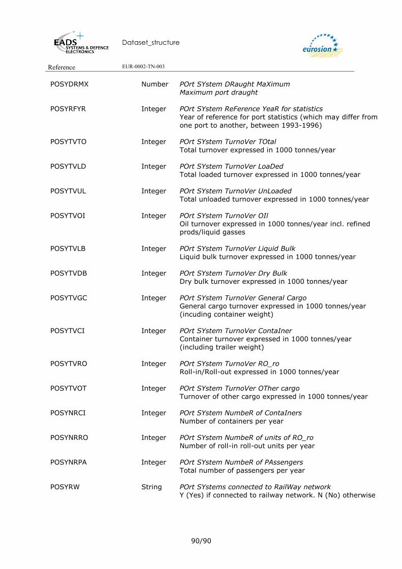
Dataset_structure
Reference EUR-0002-TN-003
90/90
POSYDRMX Number POrt SYstem DRaught MaXimum Maximum port draught
POSYRFYR Integer POrt SYstem ReFerence YeaR for statistics Year of reference for port statistics (which may differ from one port to another, between 1993-1996)
POSYTVTO Integer POrt SYstem TurnoVer TOtal Total turnover expressed in 1000 tonnes/year
POSYTVLD Integer POrt SYstem TurnoVer LoaDed Total loaded turnover expressed in 1000 tonnes/year
POSYTVUL Integer POrt SYstem TurnoVer UnLoaded Total unloaded turnover expressed in 1000 tonnes/year
POSYTVOI Integer POrt SYstem TurnoVer OIl Oil turnover expressed in 1000 tonnes/year incl. refined prods/liquid gasses
POSYTVLB Integer POrt SYstem TurnoVer Liquid Bulk Liquid bulk turnover expressed in 1000 tonnes/year
POSYTVDB Integer POrt SYstem TurnoVer Dry Bulk Dry bulk turnover expressed in 1000 tonnes/year
POSYTVGC Integer POrt SYstem TurnoVer General Cargo General cargo turnover expressed in 1000 tonnes/year (incuding container weight)
POSYTVCI Integer POrt SYstem TurnoVer ContaIner Container turnover expressed in 1000 tonnes/year (including trailer weight)
POSYTVRO Integer POrt SYstem TurnoVer RO_ro Roll-in/Roll-out expressed in 1000 tonnes/year
POSYTVOT Integer POrt SYstem TurnoVer OTher cargo Turnover of other cargo expressed in 1000 tonnes/year
POSYNRCI Integer POrt SYstem NumbeR of ContaIners Number of containers per year
POSYNRRO Integer POrt SYstem NumbeR of units of RO_ro Number of roll-in roll-out units per year
POSYNRPA Integer POrt SYstem NumbeR of PAssengers Total number of passengers per year
POSYRW String POrt SYstems connected to RailWay network Y (Yes) if connected to railway network. N (No) otherwise
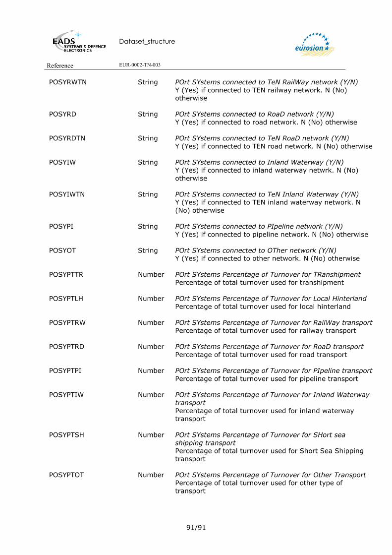
Dataset_structure
Reference EUR-0002-TN-003
91/91
POSYRWTN String POrt SYstems connected to TeN RailWay network (Y/N) Y (Yes) if connected to TEN railway network. N (No) otherwise
POSYRD String POrt SYstems connected to RoaD network (Y/N) Y (Yes) if connected to road network. N (No) otherwise
POSYRDTN String POrt SYstems connected to TeN RoaD network (Y/N) Y (Yes) if connected to TEN road network. N (No) otherwise
POSYIW String POrt SYstems connected to Inland Waterway (Y/N) Y (Yes) if connected to inland waterway netwrk. N (No) otherwise
POSYIWTN String POrt SYstems connected to TeN Inland Waterway (Y/N) Y (Yes) if connected to TEN inland waterway network. N (No) otherwise
POSYPI String POrt SYstems connected to PIpeline network (Y/N) Y (Yes) if connected to pipeline network. N (No) otherwise
POSYOT String POrt SYstems connected to OTher network (Y/N) Y (Yes) if connected to other network. N (No) otherwise
POSYPTTR Number POrt SYstems Percentage of Turnover for TRanshipment Percentage of total turnover used for transhipment
POSYPTLH Number POrt SYstems Percentage of Turnover for Local Hinterland Percentage of total turnover used for local hinterland
POSYPTRW Number POrt SYstems Percentage of Turnover for RailWay transport Percentage of total turnover used for railway transport
POSYPTRD Number POrt SYstems Percentage of Turnover for RoaD transport Percentage of total turnover used for road transport
POSYPTPI Number POrt SYstems Percentage of Turnover for PIpeline transport Percentage of total turnover used for pipeline transport
POSYPTIW Number POrt SYstems Percentage of Turnover for Inland Waterway transport Percentage of total turnover used for inland waterway transport
POSYPTSH Number POrt SYstems Percentage of Turnover for SHort sea shipping transport Percentage of total turnover used for Short Sea Shipping transport
POSYPTOT Number POrt SYstems Percentage of Turnover for Other Transport Percentage of total turnover used for other type of transport

Dataset_structure
Reference EUR-0002-TN-003
92/92
10.2.9 Description of Info table POSYRG.INF
Attribute Name Type Description ROWID OID Unique object identifier
POSYRG String POrt SYstem region COde POSYRGDS String POrt SYstem region COde DeScription
Description of the Port system region code 1: Baltic 2: North Sea 3: Atlantic 4: West Mediterranean 5: East Mediterranean
10.2.10 Description of Info table POSYAC.INF
Attribute Name Type Description ROWID OID Unique object identifier
POYSAC String POrt SYstem Activity Code
POYACDS String POrt SYstem Activity Code DeScription
Description of the Port system activity code P: Passenger F: Freight
10.2.11 Description of Info table POSYTP
Attribute Name Type Description ROWID OID POSYTP String POrt SYstem TyPe code
POSYTPDS String POrt SYstem TyPe code DeScription
Description of the Port system type code M: Mainland I: Island

Dataset_structure
Reference EUR-0002-TN-003
93/93
10.3. GISCO RAILWAYS 10.3.1 Overview of the dataset structure

Dataset_structure
Reference EUR-0002-TN-003
94/94
10.3.2 Description of the Arc Attribute Table of coverage RWEU1MV4
Attribute Name Type Description FID OID Unique object identifier Shape Geometry Polyline
RWSGCD String RailWay SeGment CoDe
Identification of V3 segment (ISO country code followed by a sequential number per country).
RWSGSQ Integer RailWay SeGment SeQuence Sequence number when splitting V3 segment
RWSGCDSQ String RailWay SeGment CoDe/SeQuence Unique identification of segment Combination of RWSGCD/RWSGSQ
10.3.3 Description of the Node Attribute Table of coverage RWEU1MV4
Attribute Name Type Description FID OID Unique Object Identifier Shape Geometry Polyline
RWNDCD String RailWay NoDe CoDe
Unique identification of node (ISO country code followed by a sequential number per country).
10.3.4 Info table RWEUSGATV4.INF
Attribute Name Type Description RWSGCD String RailWay SeGment CoDe
Identification of V3 segment (ISO country code followed by a sequential number per country).
RWSGSQ Integer RailWay SeGment SeQuence Sequence number when splitting V3 segment

Dataset_structure
Reference EUR-0002-TN-003
95/95
RWSGCNCD String RailWay SeGment CouNtry CoDe ISO code of country to which railway segment belongs
RWSGTP String RailWay SeGment TyPe Type of railway segment
RWSGERNM String RailWay SeGment EuRopean number NaMe E number name to which railway segment belongs, as defined by UN-ECE AGC Agreement
RWSGUS String RailWay SeGment Use Use of railway segment: PG: Persons and goods P: Persons only G: Goods only
RWSGLV Integer RailWay SeGment LeVel Hierarchical level of railway segment. Each level (in combination with higher level(s)) forms a seamless network. 0: Highest level 1: level 1 2: level 2 -9: Not Existing/Planned TEN line
RWSGCDSQ String RailWay SeGment CoDe/SeQuence Unique identification of segment Combination of RWSGCD/RWSGSQ
10.3.5 Description of Info table RWEUNDATV4.INF
Attribute Name Type Description
RWNDCD String RailWay NoDe CoDe Unique identification of node (ISO country code followed by a sequential number per country).
RWNDTP String RailWay NoDe TyPe Code of type of node. BN: Border node BS: Border railway station RS: Railway station RI: Rail bifurcation/intersection RP: Rail ferry port
RWNDCNCD1 String RailWay NoDe CouNtry CoDe 1 ISO code of country to which node belongs.

Dataset_structure
Reference EUR-0002-TN-003
96/96
RWNDCNCD2 String RailWay NoDe CouNtry CoDe 2 ISO code of second country to which node belongs (in case of border node).
RWNDTNBT String Railway NoDe TeN BoTtleneck Indicates if a bottleneck is defined at TEN node, as supplied by each Member State 'N': No bottleneck 'U': Bottleneck of unspecified traffic type 'P': Bottleneck for passenger traffic 'F': Bottleneck for freight traffic 'M': Bottleneck for mixed passenger/freight traffic ' ' Not a TEN node
10.3.6 Description of Info table RWEUTNATV4.INF
Attribute Name Type Description RWSGCD String RailWay SeGment CoDe
Unique identification of segment (ISO country code followed by a sequential number per country).
RWSGSQ Integer RailWay SeGment SeQuence Sequence number when splitting V3 segment
RWSGTN String RailWay SeGment TeN TEN classification of rail segment, based on decision 1692/96/EC of the European Parlement and Council E: Existing P: Planned
RWSGTNTP String RailWay SeGment TeN TyPe Code of TEN type, based on decision 1692/96/EC of the European Parlement and Council CL: Conventional Line HS: High Speed line RCE: Rail Corridor towards the East UHS: Upgraded High Speed line
RWSGTNAL String RailWay SeGment TeN Alignment Alignment of TEN rail segment: E: Existing U: Unknown
RWSGTNPP Binary RailWay SeGment TeN Priority Project number TEN Priority Project number.
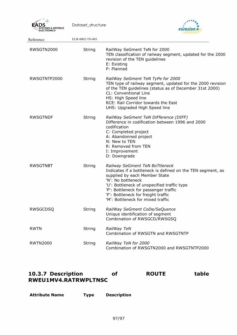
Dataset_structure
Reference EUR-0002-TN-003
97/97
RWSGTN2000 String RailWay SeGment TeN for 2000 TEN classification of railway segment, updated for the 2000 revision of the TEN guidelines E: Existing P: Planned
RWSGTNTP2000 String RailWay SeGment TeN TyPe for 2000 TEN type of railway segment, updated for the 2000 revision of the TEN guidelines (status as of December 31st 2000) CL: Conventional Line HS: High Speed line RCE: Rail Corridor towards the East UHS: Upgraded High Speed line
RWSGTNDF String RailWay SeGment TeN DiFference (DIFF) Difference in codification between 1996 and 2000 codification C: Completed project A: Abandonned project N: New to TEN R: Removed from TEN I: Improvement D: Downgrade
RWSGTNBT String Railway SeGment TeN BoTtleneck Indicates if a bottleneck is defined on the TEN segment, as supplied by each Member State 'N': No bottleneck 'U': Bottleneck of unspecified traffic type 'P': Bottleneck for passenger traffic 'F': Bottleneck for freight traffic 'M': Bottleneck for mixed traffic
RWSGCDSQ String RailWay SeGment CoDe/SeQuence Unique identification of segment Combination of RWSGCD/RWSGSQ
RWTN String RailWay TeN Combination of RWSGTN and RWSGTNTP
RWTN2000 String RailWay TeN for 2000 Combination of RWSGTN2000 and RWSGTNTP2000
10.3.7 Description of ROUTE table RWEU1MV4.RATRWPLTNSC
Attribute Name Type Description
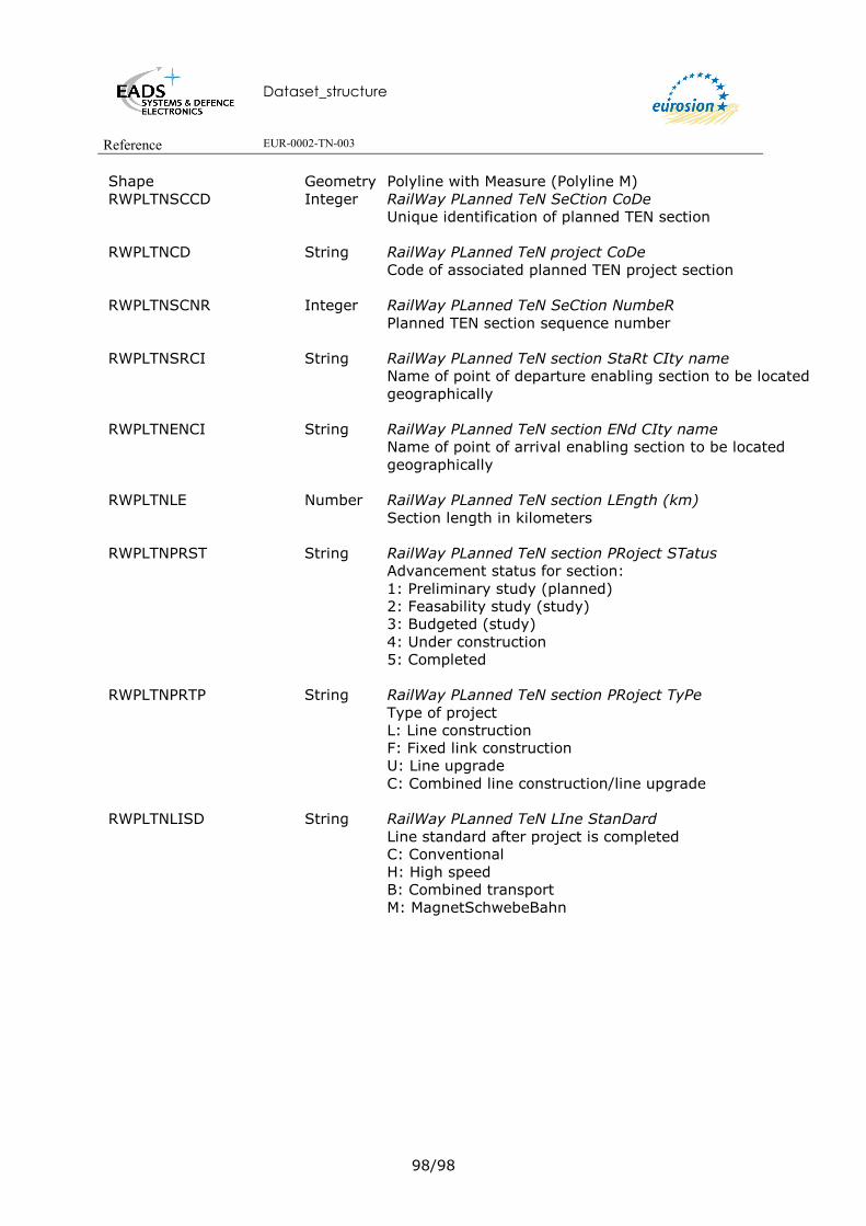
Dataset_structure
Reference EUR-0002-TN-003
98/98
Shape Geometry Polyline with Measure (Polyline M) RWPLTNSCCD Integer RailWay PLanned TeN SeCtion CoDe
Unique identification of planned TEN section
RWPLTNCD String RailWay PLanned TeN project CoDe Code of associated planned TEN project section
RWPLTNSCNR Integer RailWay PLanned TeN SeCtion NumbeR Planned TEN section sequence number
RWPLTNSRCI String RailWay PLanned TeN section StaRt CIty name Name of point of departure enabling section to be located geographically
RWPLTNENCI String RailWay PLanned TeN section ENd CIty name Name of point of arrival enabling section to be located geographically
RWPLTNLE Number RailWay PLanned TeN section LEngth (km) Section length in kilometers
RWPLTNPRST String RailWay PLanned TeN section PRoject STatus Advancement status for section: 1: Preliminary study (planned) 2: Feasability study (study) 3: Budgeted (study) 4: Under construction 5: Completed
RWPLTNPRTP String RailWay PLanned TeN section PRoject TyPe Type of project L: Line construction F: Fixed link construction U: Line upgrade C: Combined line construction/line upgrade
RWPLTNLISD String RailWay PLanned TeN LIne StanDard Line standard after project is completed C: Conventional H: High speed B: Combined transport M: MagnetSchwebeBahn

Dataset_structure
Reference EUR-0002-TN-003
99/99
RWPLTNSUWK String RailWay PLanned TeN Specific Upgrade WorK Type of work in the case where project type is an upgrade T2: Track addition (1 track to 2 tracks) T4: Track addition (2 tracks to 4 tracks) EL: Electrification RI: Route improvement TC: Traffic control system improvement RL: Removal of level-crossing TI: Tilting GI: Gauge Improvement ST: Study
RWPLTNIN97 Number RailWay PLanned TeN INvestment for 1996/1997, in million EURO Investment for 1996/1997 in Million EURO for the section
RWPLTNCS Number RailWay PLanned TeN CoSt, in million EURO Cost of the section in Million EURO
RWPLTNCM97 Number RailWay PLanned TeN CoMmitments for 1996/1997, in million EURO TEN-T commitments for 1996/1997 in Million EURO for the section
RWPLTNEIRM Number RailWay PLanned TeN Estimated Investment ReMaining, in million EURO Estimated Investment Remaining in Million EURO for the section
RWPLTNEOYR Integer RailWay PLanned TeN Estimated cOmpletion YeaR Estimated year of completion for the section
RWPLTNLTPR String RailWay PLanned TeN Long Term PRoject (>2010) Indicates whether the section will be completed before 2010 (N) or after 2010 (Y) U: Unknown
RWPLTNLV Integer RailWay PLanned TeN LeVel Section level indicates the level in the case where more than one project is associated on a segment (level 1, 2 and 3 are available)
RWPLTNCNCD String RailWay PLanned TeN CouNtry CoDe Planned TEN section ISO country code
10.3.8 Description of Info table RWEUPLTN.INF
Attribute Name Type Description

Dataset_structure
Reference EUR-0002-TN-003
100/100
RWPLTNCD String RailWay PLanned TeN CoDe Unique identification of planned TEN project
RWPLTNNM String RailWay PLanned TeN NaMe Name of project, if defined
RWPLTNTTLE Number RailWay PLanned TeN ToTal LEngth (km) Total length of all sections comprising the project
RWPLTNTI97 Number RailWay PLanned TeN Total Investment for 1996/1997, in million EURO Total investment for 1996/1997 in Million EURO for the project
RWPLTNTC Number RailWay PLanned TeN Total Cost, in million EURO Total cost in Million EURO of the project
RWPLTNTM97 Number RailWay PLanned TeN Total coMmitments for 1996/1997, in million EURO Total TEN-T commitments for 1996/1997 in Million EURO of the project
RWPLTNTIRM Number RailWay PLanned TeN Total estimated Investment ReMaining, in million EURO Total estimated Investment Remaining in Million EURO of the project
RWPLTNCNCD String RailWay PLanned TeN CouNtry CoDe Planned TEN project ISO country code
10.3.9 Description of ROUTE table RWEU1MV4.RATRWLNTE
Attribute Name Type Description
Shape Geometry Polyline with Measure (Polyline M).
RWLNCD String RailWay LiNe CoDe Unique identification of the line (original UIC line code)
RWLNCNCD String RailWay LiNe CouNtry CoDe ISO code of country to which railway segment belongs
RWLNERNM String RailWay LiNe EuRopean number NaMer E number name to which railway line belongs, as defined by UN-ECE AGC Agreement
Dataset_structure
Reference EUR-0002-TN-003
101/101
RWLNAD String RailWay LiNe ADministration Identity of the administration responsible for managing the infrastructure
RWLNTP String RailWay LiNe TyPe Type of line NL: Suitable for 250 km/h and higher UL: Suitable for 200 km/h and higher (160 km/h for CEEC) CL: Conventional line YY: ferry line
RWLNSRCI String RailWay LiNe StaRt CIty/location name Name of point of departure enabling line to be located geographically
RWLNENCI String RailWay LiNe ENd CIty/location name Name of point of arrival enabling line to be located geographically
RWLNLE Number RailWay LiNe LEngth (km) length of line section (not length of track) between the departure and arrival points
RWLNTACTCD String RailWay LiNe TrAck CounT CoDe 0: Entirely single lane 1: Single lane and double lane 2: Entirely double lane 3: Double lane and greater 4: Entirely greater than double lane
RWLNKMSINR Number RailWay LiNe KiloMeters of SIngle track, NumbeR aggregate length of single-track line
RWLNKMDTNR Number RailWay LiNe KiloMeters of Double Track, NumbeR aggregate length of double-track line
RWLNKMMTNR Number RailWay LiNe KiloMeters of More Than 2 tracks, NumbeR aggregate length of line with more than 2 tracks
RWLNDICE Number RailWay LiNe DIstance between track CEntres (mm) nominal value measured between the centres of two adjacent tracks on straight section of line
RWLNGA Number RailWay LiNe track GAuge (mm) Nominal value measured between the inner edges of the rail heads on straight track. Standard gauge is 1.435 m, which corresponds to a track gauge of at least 1.435 m on straight track and at most 1.470 m in curves, including gauge widening.
RWLNMXGR Number RailWay LiNe MaXimum GRadient Inclination in ‰ of the maximum slope or grade.
Dataset_structure
Reference EUR-0002-TN-003
102/102
RWLNCLGACD String RailWay LiNe CLearance GAuge CoDe Classification as per UIC Leaflet 506, which lays down the rules for application of the enlarged GA,GB and GC gauges. Some railways, mostly broad gauge, use a specific clearance gauge which is also specified (and country). 1: < GA 2: GA 3: >GA 4: GB 5: >GB 6: GB 7: >GC 11: GSWR (Ireland) 12: DSE (Ireland) 13: CIE (Ireland) 14: MGWR (Ireland) 21: CP (Portugal) 22: CPB+ (Portugal) 23: GB+ (Portugal) 24: CPC (Portugal) 31: W6A (United Kingdom) 32: W6A/80 (United Kingdom) 33: W6A/86 (United Kingdom) 34: SB1C (United Kingdom) 41: TUR_1 (Turkey) 42: TUR_2 (Turkey) 43: TUR_3 (Turkey) 44: TUR_5 (Turkey) 51: D2 (Germany) 52: MSB (Germany) 61: ICE (Belgium) 71: VIF (Romania)
RWLNKMELNR Number RailWay LiNe KiloMeters ELectrified, NumbeR Electrified length (in kilometers) of the line section a value of 0 km indicates that the line section is not electrified a value that is different from that given under line length indicates that the line section is partially electrified a line section can not have two types of electrification; in this case, the line section must be divided further into two smaller sections
RWLNELCD String RailWay LiNe ELectrification CoDe 0: Not electrified 1: Partially electrified 2: Entirely electrified

Dataset_structure
Reference EUR-0002-TN-003
103/103
RWLNCUTPCD String RailWay LiNe CUrrent TyPe CoDe NOT: Not electrified DC1: Direct current - .75 kV DC2: Dircect current - 1.5 kV DC3: Direct current - 3 kV DC4: Direct current - 3.3 kV DC0: Direct current - other AC1: Alternative current - 15 kV 16 Hz 2/3 AC2: Alternative current - 25 kV 50 Hz AC3: Alternative current - 27.5 kV AC0: Alternative current - other MC1: Mixed current - 1.5 and 25 kV MC2: Mixed current - 3 and 25 kV MC3: Mixed current - 3.3 and 27.5 kV
RWLNSGSYCD String RailWay LiNe SiGnalling SYstem CoDe 0: Entirely manual block 1: Manual block and Automatic block 2: Entirely automatic block 3: Automatic block and cab signalling 4: Entirely non-ERTMS cab signalling 5: Entirely ERTMS cab-signalling
RWLNKMMBNR Number RailWay LiNe KiloMeters of Manual Block, NumbeR length of line on which the headway of trains running in the same direction is determined by a block system requiring some amount of manual operation
RWLNKMABNR Number RailWay LiNe KiloMeters of Automatic Block, NumbeR length of line on which the headway of trains running in the same direction is determined by a block system without manual operation
RWLNKMCSNR Number RailWay LiNe KiloMeters of Cab Signalling, NumbeR length of line equipped with automatic block and where signalling instructions are transmitted to the driver in his cab
RWLNER String RailWay LiNe ERtms In the case where line is equipped with cab-signalling, indicates if the on-board signalling is of ERTMS type (Y) or not (N)

Dataset_structure
Reference EUR-0002-TN-003
104/104
RWLNEQCD String RailWay LiNe track EQuipment CoDe Track equipment code 0: None 1: Concrete sleepers 2: CWR 3: CWR/Concrete sleepers 4: Rail 60 kg/m+ 5: Rail 60 kg/m+/Concrete sleepers 6: Rail 60 kg/m+/CWR 7: Rail 60 kg/m+/CWR/Concrete sleepers � Rail 60 kg/m+ condition : if 80 % of the line is fitted with rails of weight greater than or equal to 60 kg/m � CWR condition: if 80% of the line is fitted with welded sections measuring at least 300 metres Rail 60 kg � Concrete sleepers condition: if 80% of the line is fitted with monoblock or twin-block concrete sleepers
RWLNKMTUNR Number RailWay LiNe KiloMeters of TUnnels, NumbeR Total length of line in tunnel; tunnels shall include all underground sections (including cut-and-cover) cut into a natural mass (mountain, hill, etc.)
RWLNKMBVNR Number RailWay LiNe KiloMeters of Bridges and Viaducts, NumbeR Total length of line on railway bridges; only those with a span of at least 2 metres are considered
RWLNMXSP Number RailWay LiNe MaXimum SPeed (km/h) Maximum speed permitted by the track layout, irrespective of signalling conditions.
RWLNAXLD Number RailWay LiNe AXle-LoaD (tons/axle) Load permitted by the infrastructure. Indications given in UIC Leaflet 700 applied by all member railways of the RIV; lines are classified in categories (A,B,C and D) according to mass (wagon + load) in relation to axle (16t, 18t, 20t and 22.5t)
RWLNJTPA Number RailWay LiNe fastest Journey Time for passengers (min.) Fastest journey time with best-performing passenger, used or planned for introduction under operating conditions and without intermediate halts
RWLNJTFR Number RailWay LiNe fastest Journey Time for freight (min.) Fastest journey time with best-performing freight stock, used or planned for introduction under operating conditions and without intermediate halts
Dataset_structure
Reference EUR-0002-TN-003
105/105
RWLNUSCD String RailWay LiNe fastest journey trainset USe CoDe Trainset type used by the fastest journey time for passenger services 0: Classical trainset 1: Dedicated high speed trainset 2: Tilting trainset 3: Tilting trainset suitable for high speed U: Unknown
RWLNMXSPPA Number RailWay LiNe MaXimum SPeed for PAssenger trains (km/h) Maximum speed permitted for the best-performing passenger
RWLNMXSPFR Number RailWay LiNe MaXimum SPeed for FReight (km/h) Maximum speed permitted for the best-performing freight stock
RWLNCP Number RailWay LiNe CaPacity (trains/day) Line capacity is expressed as the number of trains per day in both directions together. The capacity of a railway line reflects the number of trains that can run in a given time on each track, taking account of compliance with certain operating and technical conditions, and certain quality criteria
10.3.10 Description of the ROUTE table RWEU1MV4.RATRWLPTE
Attribute Name Type Description
Shape Geometry Polyline with Measure (Polyline M) RWLPCD String RailWay Line Project CoDe
Unique identification of the line (original UIC line code) RWLPCNCD String RailWay Line Project CouNtry CoDe
ISO code of country to which railway segment belongs
RWLPERNM String RailWay LiNe EuRopean number NaMe E number name to which railway segment belongs, as defined by UN-ECE AGC Agreement
RWLPAD String RailWay Line Project ADministration Identity of the administration responsible for managing the infrastructure

Dataset_structure
Reference EUR-0002-TN-003
106/106
RWLPRFYR Number RailWay Line Project ReFerence YeaR Reference year used for describibing infrastructure characteristics For a detailed description of the items below, refer to the explanation of the associated attribute in table RWEU1MV4.RATRWLNTE
RWLPSRCI String RailWay Line Project StaRt CIty/location name
RWLPENCI String RailWay Line Project ENd CIty/location name
RWLPTP String RailWay Line Project TyPe
RWLPLE Number RailWay Line Project LEngth (km)
RWLPTACTCD String RailWay Line Project TrAck CounT code
RWLPKMSINR Number RailWay Line Project KiloMeters of SIngle track, NumbeR
RWLPKMDTNR Number RailWay Line Project KiloMeters of Double track, NumbeR
RWLPKMMTNR Number RailWay Line Project KiloMeters of More Than 2 tracks, NumbeR
RWLPDICE Number RailWay Line Project DIstance between track CEntres (mm)
RWLPGA Number RailWay Line Project track GAuge (mm)
RWLPMXGR Number RailWay Line Project MaXimum Gradient
RWLPCLGACD String RailWay Line Project CLearance Gauge
RWLPKMELNR Number RailWay Line Project KiloMeters of ELectrified tracks, NumbeR
RWLPELCD String RailWay Line Project ELectrification CoDe
RWLPCUTPCD String RailWay Line Project CUrrent TyPe
RWLPSGSYCD String RailWay Line Project SiGnalling System
RWLPKMMBNR Number RailWay Line Project KiloMeters of Manual Block, NumbeR
RWLPKMABNR Number RailWay Line Project KiloMeters of Automatic Block, NumbeR
RWLPKMCSNR Number RailWay Line Project KiloMeters of Cab Signalling, NumbeR

Dataset_structure
Reference EUR-0002-TN-003
107/107
RWLPER String RailWay Line Project ERtms if cab signalling In the case where line is equipped with cab-signalling, indicates if the on-board signalling is of ERTMS type (Y) or not (N) U: Unknown
RWLPEQCD String RailWay Line Project track EQuipment CoDe
RWLPKMTUNR Number RailWay Line Project KiloMeters of TUnnels, NumbeR
RWLPKMBVNR Number RailWay Line Project KiloMeters of Bridges and Viaducts
RWLPMXSP Number RailWay Line Project MaXimum SPeed (km/h)
RWLPAXLD Number RailWay Line Project AXle-LoaD (tons/axle)
RWLPJTPA Number RailWay Line Project fastest Journey Time for PAssengers (min.)
RWLPJTFR Number RailWay Line Project fastest Journey Time for FReight (min.)
RWLPUSCD String RailWay Line Project trainset USe for fastest journey CoDe
RWLPMXSPPA Number RailWay Line Project MaXimum SPeed for PAssenger trains (km/h)
RWLPMXSPFR Number RailWay Line Project MaXimum SPeed for passenger FReight (km/h)
RWLPCP Number RailWay Line Project CaPacity (trains/day)
RWLPCOYR Number RailWay Line Project COmpletion YeaR Year in which the project is intended to enter service
RWLPECYR Number RailWay Line Project EConomic conditions for a reference YeaR Reference year used to calculate infrastructure and/or rolling stock invertment.
RWLPIC Number RailWay Line Project Infrastructure Cost Total amount, in million ECU, of investment for upgrading or building the infrastructure, as defined in Directive 91/44
RWLPRC Number RailWay Line Project Rolling stock Cost Total amount, in million ECU, of investment in new rolling stock
RWLPLV Number RailWay Line Project LeVel Indicates the level in the case where more than one project is associated on a segment (1 and 2 are available)

Dataset_structure
Reference EUR-0002-TN-003
108/108
10.3.11 Description of the ROUTE table RWEU1MV4.RATRWLNTR
Attribute Name Type Description
Shape Geometry Polyline with Measure (Polyline M).
RWLNCD RailWay LiNe CoDe Unique identification of the line (original UIC line code)
RWLNCNCD String RailWay LiNe CouNtry CoDe ISO code of country to which railway segment belongs
RWLNSRCI String RailWay LiNe StaRt CIty/location name Name of point of departure enabling line to be located geographically
RWLNENCI String RailWay LiNe ENd CIty/location name Name of point of arrival enabling line to be located geographically
RWLNMIUS String RailWay LiNe MIxed traffic USe Indicated if the line is used for mixed traffic (Y) or not (N). The line is open to mixed traffic operations (passenger and freight), if both passenger and freight trains run on it within a 24-hour period. U: Unknown
RWLNPA97NR Number RailWay LiNe PAssenger trains/workday in 1997, NumbeR Number of passenger trains running per 24-hour period
RWLNFR97NR Number RailWay LiNe FReight trains/workday in 1997, NumbeR Number of freight trains running per 24-hour period
RWLNTT97NR Number RailWay LiNe ToTal trains/workday in 1997, NumbeR Total number of train workings
10.3.12 Description of the ROUTE table RWEU1MV4.RWLKTR
Attribute Name Type Description
Shape Geometry Polyline with Measure (Polyline M).

Dataset_structure
Reference EUR-0002-TN-003
109/109
RWLKCD Integer RailWay LinK CoDe Unique identification of the link
RWLKSRCI String RailWay LinK StaRt CIty/location name Name of point of departure enabling link to be located geographically
RWLKENCI String RailWay LinK ENd CIty/location name Name of point of arrival enabling link to be located geographically
RWLKLE Integer RailWay LinK LEngth (km) Length of the section between the start and end points. For pointscomprising several stations, distance has been taken to the most important passenger transport station, usually to the central station
RWLKPAPT String RailWay LinK PAssenger transport PoinT to point Precise definition of the link to be taken into account for passenger transport data
RWLKLSWKNR Integer RailWay LinK Long diStance passenger trains per WorKday, NumbeR of trains Number of long distance passenger trains running on the link on an October workday
RWLKLCWKNR Integer RailWay LinK LoCal passenger trains per WorKday, NumbeR of trains Number of local passenger trains running on the link on an October workday
RWLKPAWKNR Integer RailWay LinK PAssenger trains per WorKday, total NumbeR of trains Total number of passenger trains running on the link on an October workday
RWLKSEWKNR Integer RailWay LinK SEats per WorKday, total NumbeR of seats Total number of seats per workday offered in the above-mentioned trains
RWLKSEYRNR Integer RailWay LinK SEats per YeaR, total NumbeR of seats Total number of seats offered in the above-mentioned trains scaled to an annual figure
RWLKPAYRNR Integer RailWay LinK PAssengers per YeaR, total NumbeR Total number of passengers in 1995 on the whole link
RWLKFRPT String RailWay LinK FReight traffic PoinT to point Precise definition of the link to be taken into account for freight transport data

Dataset_structure
Reference EUR-0002-TN-003
110/110
RWLKFOWKNR Integer RailWay LinK Freight-Only trains per WorKday, NumbeR of trains Number of freight-only trains per October workday 1995
RWLKIMWKNR Integer RailWay LinK InterModal trains per WorKday, NumbeR of trains Number of intermodat trains per October workday 1995
RWLKFRWKNR Integer RailWay LinK FReight trains per WorKday, NumbeR of trains Number of freight trains per October workday 1995
RWLKTOYRNR Integer RailWay LinK TOnnes transported per YeaR, NumbeR of tonnes Number of tonnes transported in 1995 including the tonnes transported by intermodal transport
RWLKTEYRNR Number RailWay LinK TEUs YeaR, NumbeR of TEUs Number of TEUs transported in 1995 over the whole link. This is used as an indicator of the importance of intermodal transport
RWLKCNCD String RailWay LinK CouNtry CoDe ISO code of country to which railway segment belongs 'YY' is used as country code for ferry links
10.3.13 Description of Info table RWEUNDTP.INF
Attribute Name Type Description
RWNDTP String RailWay NoDe TyPe Code of node type.
RWNDTPNM String RailWay NoDe TyPe NaMe Full name of railway node type: BN: Border node BS: Border railway station RS: Railway station RI: Rail bufurication/intersection RP: Rail ferry port
10.3.14 Description of Info table RWEUSGTP.INF
Attribute Name Type Description RWSGTP String RailWay SeGment TyPe
Code of railway segment type.
Dataset_structure
Reference EUR-0002-TN-003
111/111
RWSGTPNM String RailWay SeGment TyPe NaMe Full name of railway segment type: BD: Branch line, double track BDE: Branch line, double track, electrified BS: Branch line, single track BSE: Branch line, single track, electrified MD: Main line, double track MDE: Main line, double track, electrified MS: Main line, single track MSE: Main line, single track, electrified NG: Narrow Gauge TF: Train Ferry
10.3.15 Description of Info table RWEUTNPP.INF
Attribute Name Type Description RWSGTNPP Integer RailWay SeGment TeN Priority Project number
TEN Priority Project number.
RWSGTNPPNM String RailWay SeGment TeN Priority Project NaMe Full name of TEN priority project 0: No TEN priority project 1: High speed rail Nürnberg-Erfurt-Halle, Leipzig-Berlin, Verona- München 2: High speed rail Paris-Bruxelles-Köln-Amsterdam-London 3: High speed rail Madrid-Barcelona-Montpellier, Madrid-Vitoria-Dax 4: High speed rail Paris-Strasbourg-Karlsruhe/Luxembourg/Saarbrücken 5: Betuweline Rotterdam-Rhein/Ruhr 6: High speed rail Lyon-Torino-Milano-Venezia-Trieste 9: Rail Cork-Dublin-Belfast-Larne-Stranraer 11: Öresund road/rail link Denmark-Sweden 12: Nordic Triangle multimodal corridor Stockholm-Oslo, Stockholm-Malmö, Malmö-Göteborg, Stockholm-Helsinki-St. Peter burg 14: West coast main line (United Kingdom) London-Birmingham-Liverpool/Manchester-Glasgow/Edinburgh
10.3.16 Description of Info table RWEUTNTP.INF
Attribute Name Type Description

Dataset_structure
Reference EUR-0002-TN-003
112/112
RWSGTNTP String RailWay SeGment TeN TyPe TEN segment type
RWSGTNTPNM String RailWay SeGment TeN TyPe NaMe Full name of TEN segment type CL: Conventional line HS: High speed line RCE: Rail Corridor towards the east UHS: Upgraded high speed line
10.3.17 Description of Info table RWPLTNPRST.INF
Attribute Name Type Description RWPLTNPRST String RailWay PLanned TeN PRoject STatus
Planned TEN project status code
RWPLTNPRSTNM String RailWay PLanned TeN PRoject STatus NaMe Planned TEN project status description 1: Preliminary study (planned) 2: Feasability study (study) 3: Budgeted (study) 4: Under construction 5: Completed U: Unknown
10.3.18 Description of Info table RWPLTNPRTP.INF
Attribute Name Type Description RWPLTNPRTP String RailWay PLanned TeN PRoject TyPe
Railway planned TEN project type code
RWPLTNPRTPNM String RailWay PLanned TeN PRoject TyPe NaMe Planned TEN railway project type description L: Line construction F: Fixed link construction U: Line upgrade C: Combined line construction/line upgrade X: Unknown
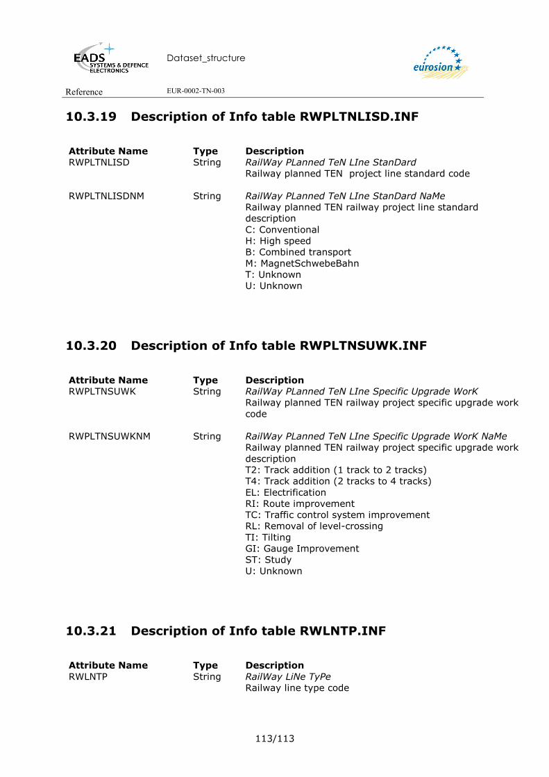
Dataset_structure
Reference EUR-0002-TN-003
113/113
10.3.19 Description of Info table RWPLTNLISD.INF
Attribute Name Type Description RWPLTNLISD String RailWay PLanned TeN LIne StanDard
Railway planned TEN project line standard code
RWPLTNLISDNM String RailWay PLanned TeN LIne StanDard NaMe Railway planned TEN railway project line standard description C: Conventional H: High speed B: Combined transport M: MagnetSchwebeBahn T: Unknown U: Unknown
10.3.20 Description of Info table RWPLTNSUWK.INF
Attribute Name Type Description RWPLTNSUWK String RailWay PLanned TeN LIne Specific Upgrade WorK
Railway planned TEN railway project specific upgrade work code
RWPLTNSUWKNM String RailWay PLanned TeN LIne Specific Upgrade WorK NaMe Railway planned TEN railway project specific upgrade work description T2: Track addition (1 track to 2 tracks) T4: Track addition (2 tracks to 4 tracks) EL: Electrification RI: Route improvement TC: Traffic control system improvement RL: Removal of level-crossing TI: Tilting GI: Gauge Improvement ST: Study U: Unknown
10.3.21 Description of Info table RWLNTP.INF
Attribute Name Type Description RWLNTP String RailWay LiNe TyPe
Railway line type code

Dataset_structure
Reference EUR-0002-TN-003
114/114
RWLNTPNM String RailWay LiNe TyPe NaMe Railway line type description NL: Suitable for 250 km/h and higher UL: Suitable for 200 km/h and higher (160 km/h for CEEC) CL: Conventional line FE: Unknown
10.3.22 Description of Info table RWLNEQ.INF
Attribute Name Type Description RWLNEQCD String RailWay Line track EQuipment CoDe
Railway line track equipment code
RWLNEQCDNM String RailWay Line track EQuipment CoDe NaMe Railway line track equipment description 0: None 1: Concrete sleepers 2: CWR 3: CWR/Concrete sleepers 4: Rail 60 kg/m+ 5: Rail 60 kg/m+/Concrete sleepers 6: Rail 60 kg/m+/CWR 7: Rail 60 kg/m+/CWR/Concrete sleepers U: Unknown
10.3.23 Description of Info table RWLNTACT.INF
Attribute Name Type Description RWLNTACTCD String RailWay LiNe TrAck CounT CoDe
Railway line track count code
RWLNTACTCDNM String RailWay LiNe TrAck CounT CoDe NaMe Railway line track count description 0: Entirely single lane 1: Single lane and double lane 2: Entirely double lane 3: Double lane and greater 4: Entirely greater than double lane 9: Unknown
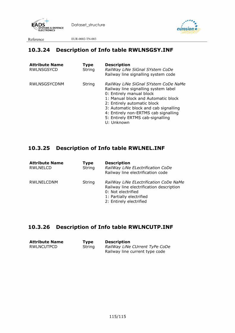
Dataset_structure
Reference EUR-0002-TN-003
115/115
10.3.24 Description of Info table RWLNSGSY.INF
Attribute Name Type Description RWLNSGSYCD String RailWay LiNe SiGnal SYstem CoDe
Railway line signalling system code
RWLNSGSYCDNM String RailWay LiNe SiGnal SYstem CoDe NaMe Railway line signalling system label 0: Entirely manual block 1: Manual block and Automatic block 2: Entirely automatic block 3: Automatic block and cab signalling 4: Entirely non-ERTMS cab signalling 5: Entirely ERTMS cab-signalling U: Unknown
10.3.25 Description of Info table RWLNEL.INF
Attribute Name Type Description RWLNELCD String RailWay LiNe ELectrification CoDe
Railway line electrification code
RWLNELCDNM String RailWay LiNe ELectrification CoDe NaMe Railway line electrification description 0: Not electrified 1: Partially electrified 2: Entirely electrified
10.3.26 Description of Info table RWLNCUTP.INF
Attribute Name Type Description RWLNCUTPCD String RailWay LiNe CUrrent TyPe CoDe
Railway line current type code

Dataset_structure
Reference EUR-0002-TN-003
116/116
RWLNCUTPCDNM String RailWay LiNe CUrrent TyPe CoDe NaMe Railway line current type description NOT: Not electrified DC1: Direct current - .75 kV DC2: Dircect current - 1.5 kV DC3: Direct current - 3 kV DC4: Direct current - 3.3 kV DC0: Direct current - other AC1: Alternative current - 15 kV 16 Hz 2/3 AC2: Alternative current - 25 kV 50 Hz AC3: Alternative current - 27.5 kV AC0: Alternative current - other MC1: Mixed current - 1.5 and 25 kV MC2: Mixed current - 3 and 25 kV MC3: Mixed current - 3.3 and 27.5 kV MIX: Unknown U: Unknown
10.3.27 Description of Info table RWLNCLGA.INF
Attribute Name Type Description RWLNCLGACD String RailWay LiNe CLearance GAuge CoDe
Railway line clearance gauge code

Dataset_structure
Reference EUR-0002-TN-003
117/117
RWLNCLGACDNM String RailWay LiNe CLearance GAuge CoDe NaMe Railway line clearance gauge description 0: Unknown 1: < GA 2: GA 3: >GA 4: GB 5: >GB 6: GB 7: >GC 9: Unknown 11: GSWR (Ireland) 12: DSE (Ireland) 13: CIE (Ireland) 14: MGWR (Ireland) 21: CP (Portugal) 22: CPB+ (Portugal) 23: GB+ (Portugal) 24: CPC (Portugal) 31: W6A (United Kingdom) 32: W6A/80 (United Kingdom) 33: W6A/86 (United Kingdom) 34: SB1C (United Kingdom) 41: TUR_1 (Turkey) 42: TUR_2 (Turkey) 43: TUR_3 (Turkey) 44: TUR_5 (Turkey) 51: D2 (Germany) 52: MSB (Germany) 61: ICE (Belgium) 71: VIF (Romania)
10.3.28 Description of Info table RWLNUS.INF
Attribute Name Type Description RWLNUSCD String RailWay LiNe trainset USe CoDe
Railway line trainset use code
RWLNUSCDNM String RailWay LiNe trainset USe CoDe NaMe Railway line trainset use description 0: Classical trainset 1: Dedicated high speed trainset 2: Tilting trainset 3: Tilting trainset suitable for high speed U: Unknown

Dataset_structure
Reference EUR-0002-TN-003
118/118
10.3.29 Supporting files
text files:
rw.key,;rw1.lin; rw2.lin; rw3.lin; rw4.lin ;rwtn.lin
key file and linesets used in GISCO mapfeature tools rw.aml (aml to select the railway network according to railway level and to draw the European railways with predefined line symbols according to the railway type) and rwtn.aml (aml to draw the TEN railway network according to TEN railway type).
rwtp.lut & rwtntp.lut
look up table for assigning the correct line type to the railway segments, used in the GISCO mapfeature tool rw.aml (aml to select the railway network according to railway level and to draw the European railways with predefined line symbols according to the railway type) and rwtn.aml (aml to draw the TEN railway network according to TEN railway type).

Dataset_structure
Reference EUR-0002-TN-003
119/119
10.4. GISCO ROUTES
10.4.1 Overview of the dataset structure
10.4.2 Description of Arc Attribute Table of RDEU1MV4 coverage
Attribute Name Type Description
FID OID Unique object identifier
Shape Geometry Polyline
RDSGCD String RoaD SeGment CoDe
Identification of V3 segment (ISO country code followed by a sequential number per country).

Dataset_structure
Reference EUR-0002-TN-003
120/120
RDSGSQ Integer RoaD SeGment SeQuence Sequence number when splitting V3 segment
RDSGCDSQ String RoaD SeGment CoDe/SeQuence Unique identification of V4 segment Combination of RDSGCD/RDSGSQ
10.4.3 Description of the Node Attribute Table of RDEU1MV4 coverage
Attribute Name Type Description FID OID Unique object identifier Shape Geometry Node RDNDCD String RoaD NoDe CoDe
Unique identification of segment (ISO country code followed by a sequential number per country).
10.4.4 Description of Info Table RDEUSGATV4.INF
Attribute Name Type Description
RDSGCD String RoaD SeGment CoDe
Identification of V3 segment (ISO country code followed by a sequential number per country).
RDSGSQ Integer RoaD SeGment SeQuence Sequence number when splitting V3 segment
RDSGTP String RoaD SeGment TyPe Type of road segment.
RDSGCNCD String RoaD SeGment CouNtry CoDe ISO code of country to which the segment belongs.
RDSGERNM String RoaD SeGment EuRopean number NaMe European road number of road segment
RDSGNNNM String RoaD SeGment NatioNal number NaMe National number of road segment.
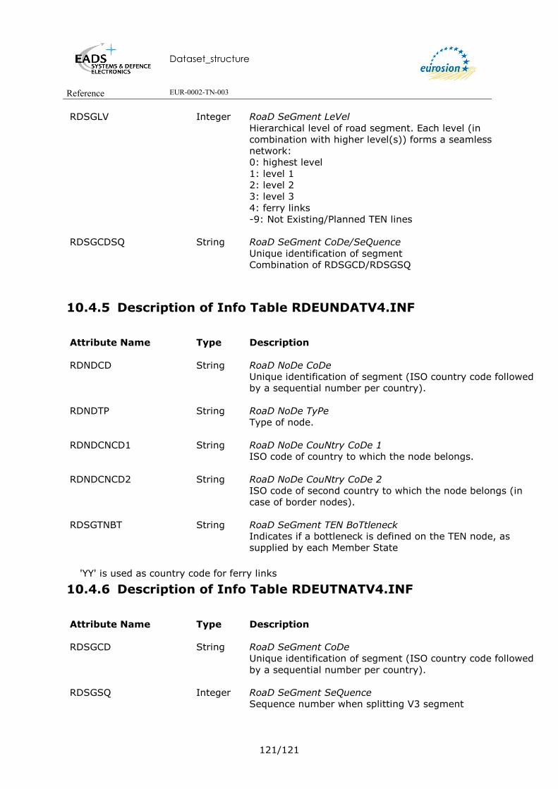
Dataset_structure
Reference EUR-0002-TN-003
121/121
RDSGLV Integer RoaD SeGment LeVel Hierarchical level of road segment. Each level (in combination with higher level(s)) forms a seamless network: 0: highest level 1: level 1 2: level 2 3: level 3 4: ferry links -9: Not Existing/Planned TEN lines
RDSGCDSQ String RoaD SeGment CoDe/SeQuence Unique identification of segment Combination of RDSGCD/RDSGSQ
10.4.5 Description of Info Table RDEUNDATV4.INF
Attribute Name Type Description
RDNDCD String RoaD NoDe CoDe
Unique identification of segment (ISO country code followed by a sequential number per country).
RDNDTP String RoaD NoDe TyPe Type of node.
RDNDCNCD1 String RoaD NoDe CouNtry CoDe 1 ISO code of country to which the node belongs.
RDNDCNCD2 String RoaD NoDe CouNtry CoDe 2 ISO code of second country to which the node belongs (in case of border nodes).
RDSGTNBT String RoaD SeGment TEN BoTtleneck Indicates if a bottleneck is defined on the TEN node, as supplied by each Member State
'YY' is used as country code for ferry links
10.4.6 Description of Info Table RDEUTNATV4.INF
Attribute Name Type Description
RDSGCD String RoaD SeGment CoDe
Unique identification of segment (ISO country code followed by a sequential number per country).
RDSGSQ Integer RoaD SeGment SeQuence Sequence number when splitting V3 segment

Dataset_structure
Reference EUR-0002-TN-003
122/122
RDSGTN String RoaD SeGment TeN TEN classification of road segment based on decision 1692/96/EC of the European Parlement and Council: E: Existing P: Planned
RDSGTN2000 String RoaD SeGment TeN for 2000 TEN classification of road segment, updated for the 2000 revision of the TEN guidelines (status as of December 31st 2000) E: Existing P: Planned
RDSGTNDF String RoaD SeGment TeN DiFference (DIFF) Difference in codification between 1996 and 2000 versions C: Completed project A: Abandonned project N: New to TEN R: Removed from TEN I: Improvement D: Downgrade
RDSGTNAL String RoaD SeGment TeN Alignment Alignment of TEN road segment: E: Existing U: Unknown
RDSGTNPP Integer RoaD SeGment TeN Priority Project number TEN Priority Project number.
RDSGTNBT String RoaD SeGment TeN BoTtleneck Indicates if a bottleneck is defined on the TEN Segment, as supplied by each Member State
RDSGCDSQ String RoaD SeGment CoDe/SeQuence Unique identification of segment Combination of RDSGCD/RDSGSQ
10.4.7 Description of the ROUTE Table RDEU1MV4.RATRDLKTR
(Statistical Data)
Attribute Name Type Description
Shape Geometry Polyline with Measure (Polyline M)

Dataset_structure
Reference EUR-0002-TN-003
123/123
RDLKCD Integer RoaD LinK CoDe Unique identification of road link
RDLKCNCD String RoaD LinK CouNtry CoDe ISO country code for link
RDLKORCD String RoaD LinK ORiginal CoDe Original link code given by WERD national administration. Can be used for update purposes
RDLKSRCI String RoaD LinK StaRt CIty NaMe City/Location/Intersection for link origin
RDLKENCI String RoaD LinK ENd City NaMe Town/Location/Intersection for link destination
RDLKLE Number RoaD LinK LEngth (km) Total link length
RDLKTP String RoaD LinK TyPe Type of road link M: Motorway, road with a permanent physical division (median) between the two directions E: Express / High-speed road, roas limited to cars, busses and trucks connected to other roads through interchanges or at level intersections O: Ordinary / All-purpose road. Road open to all kinds of trafic.
RDLKLD Number RoaD LinK number of Lanes per Direction For each direction, indicates the normal trafic lanes, therefore excluding emergency lanes, climbing lanes and ramps. 1.5 indicates middle lane is used as a passing lane
RDLKMD String RoaD LinK MeDian (Y/N) Indicates whether a permanent physical division between the two directions is present (Y) or not (N)
RDLKNNNM String RoaD LinK NatioNal number NaMe National number name corresponding to road link.
RDLKERNM String RoaD LinK EuRopean number NaMe European number name corresponding to road link (if applicable). Several link names may be present
RDLKLT95 Number RoaD LinK Lightweight (<3.5 tons) average daily Traffic 1995 1995 average daily trafic (ADT) on the link for cars and light vans, i.e vehicles with a total weight < 3.5 tons. Amount is shown in units of 1000 for a 24 hour period

Dataset_structure
Reference EUR-0002-TN-003
124/124
RDLKLTHM95 Number RoaD LinK Lightweight average daily Traffic for Holiday reference Months 1995 1995 average daily trafic (ADT) on the link for cars and light vans for the holiday reference months given below. Amount is shown in units of 1000 for a 24 hour period
RDLKHMLT95 Number RoaD LinK Holiday reference Months for Lightweight Traffic (M/M/M) Reference months for lightweight traffic (M/M/M). One, two or three reference months can be specified
RDLKHT95 Number RoaD LinK Heavyweight (>3.5 tons) average daily Traffic 1995 1995 average daily trafic (ADT) on the link for buses and trucks, i.e vehicles with a total weight >3.5 tons. Amount is shown in units of 1000 for a 24 hour period.
RDLKHTHM95 Number RoaD LinK Heavyweight average daily Traffic for Holiday reference Months 1995 1995 average daily trafic (ADT) on the link for buses and trucks for the holiday reference months given below. Amount is shown in units of 1000 for a 24 hour period
RDLKHMHT95 String RoaD LinK Holiday reference Months for Heavyweight Traffic 1995 (M/M/M) Reference months for heavyweight traffic (M/M/M). One, two or three reference months can be specified
RDLKACRT Number RoaD LinK ACcident RaTe (accidents/million vehicle*km) Average number of accidents per million vehicle per kilometer recorded over the number of reference years given below
RDLKYRNR Number RoaD LinK YeaRs of reference for accident rate, NumbeR Number of years of reference used to calculate the accident rate
10.4.8 Description of the ROUTE Table RDEU1MV4.RATRDPLTNSC
(Statistical Data)
Attribute Name Type Description
Shape Geometry Polyline with Measure (Polyline M)
RDPLTNSCCD Integer RoaD PLanned TeN SeCtion CoDe
Unique identification of planned TEN section

Dataset_structure
Reference EUR-0002-TN-003
125/125
RDPLTNCD String RoaD PLanned TeN project CoDe Code of associated planned TEN section
RDPLTNCNCD String RoaD PLanned TeN CouNtry CoDe Planned TEN section ISO country code
RDPLTNSCNR Integer RoaD PLanned TeN SeCtion NumbeR Planned TEN section sequence number
RDPLTNSRCI String RoaD PLanned TeN section StaRt CIty/location Name of point of departure enabling section to be located geographically
RDPLTNENCI String RoaD PLanned TeN section ENd CIity/location Name of point of arrival enabling section to be located geographically
RDPLTNNNNM String RoaD PLanned TeN section NatioNal number NaMe National number name corresponding to road link.
RDPLTNERNM String RoaD PLanned TeN section EuRopean number NaMe European number name corresponding to road link (if applicable). Several link names may be present
RDPLTNLE Number RoaD PLanned TeN section LEngth (km) Section length in kilometres
RDPLTNPRST String RoaD PLanned TeN section PRoject STatus Advancement status for section 1: Preliminary study (planned) 2: Feasability study (study) 3: Budgeted (study) 4: Under construction 5: Completed
RDPLTNPRTP String RoaD PLanned TeN section PRoject TyPe Type of project: N: New construction U: Upgrade to new standard A: Improvement S: Study
RDPLTNCUTP String RoaD PLanned TeN section CUrrent TyPe Current road type: MW: Motorway HQ: High quality road OR: Ordinary road FL: Fixed link BR: Bridge TU: Tunnel BP: Bypass

Dataset_structure
Reference EUR-0002-TN-003
126/126
RDPLTNCULD Integer RoaD PLanned TeN section CUrrent number of Lanes per Direction Current number of lanes per direction
RDPLTNFUTP String RoaD PLanned TeN section FUture TyPe Road type upon section completion MW: Motorway HQ: High quality road OR: Ordinary road FL: Fixed link BR: Bridge TU: Tunnel BP: Bypass
RDPLTNFULD Integer RoaD PLanned TeN section FUture number of Lanes per Direction Number of lanes per direction upon section completion
RDPLTNIN97 Number RoaD PLanned TeN section INvestment for 1996/1997 in Million EURO Investment for 1996/1997 in Million EURO for the section
RDPLTNCS Number RoaD PLanned TeN section CoSt, in million EURO Cost of the section in Million EURO
RDPLTNEIRM Number RoaD PLanned TeN section Estimated Investment ReMaining, in million EURO Estimated Investment Remaining in Million EURO for the section
RDPLTNCM97 Number RoaD PLanned TeN section CoMmitments for 1996/1997, in million EURO TEN-T commitments for 1996/1997 in Million EURO for the section
RDPLTNEOYR Integer RoaD PLanned TeN section Estimated cOmpletion YeaR Estimated year of completion for the section
RDPLTNLTPR String RoaD PLanned TeN section Long Term PRoject (>2010) Indicates whether the section will be completed before 2010 (N) or after 2010(Y)
RDPLTNLV Integer RoaD PLanned TeN section LeVel Section level indicates the level in the case where more than one project is associated on a section
RDPLTNSCCDNR String RoaD PLanned TeN SeCtion CoDe NumbeR Unique Identificationt of planned TEN section

Dataset_structure
Reference EUR-0002-TN-003
127/127
10.4.9 Description of Info Table RDEUPLTN.INF
(Statistical Data)
Attribute Name Type Description
RDPLTNCD String RoaD PLanned TeN CoDe
Unique identification of planned TEN project
RDPLTNNM String RoaD PLanned TeN NaMe Name of planned TEN project, if defined
RDPLTNCNCD String RoaD PLanned TeN CouNtry CoDe Country code for planned TEN project
RDPLTNTTLE Number RoaD PLanned TeN ToTal LEngth (km) Total length for all project sections (in Kilometers)
RDPLTNTI97 Number RoaD PLanned TeN Total Investment for 1996/1997, in million EURO Total investment for 1996/1997 in Million EURO for the project
RDPLTNTC Number RoaD PLanned TeN Total Cost, in million EURO Estimated Total Cost of project in Million EURO for the project
RDPLTNTIRM Number RoaD PLanned TeN Total estimated Investment ReMaining, in million EURO Total estimated investment remaining for the project
RDPLTNTM97 Number RoaD PLanned TeN Total coMmitments for 1996/1997, in million EURO Total TEN-T commitments for 1996/1997 in Million EURO for the project
10.4.10 Description of Info Table RDEUSGTP.INF
(Domains)
Attribute Name Type Description
RDSGTP String RoaD SeGment TyPe
Codes of road segment types
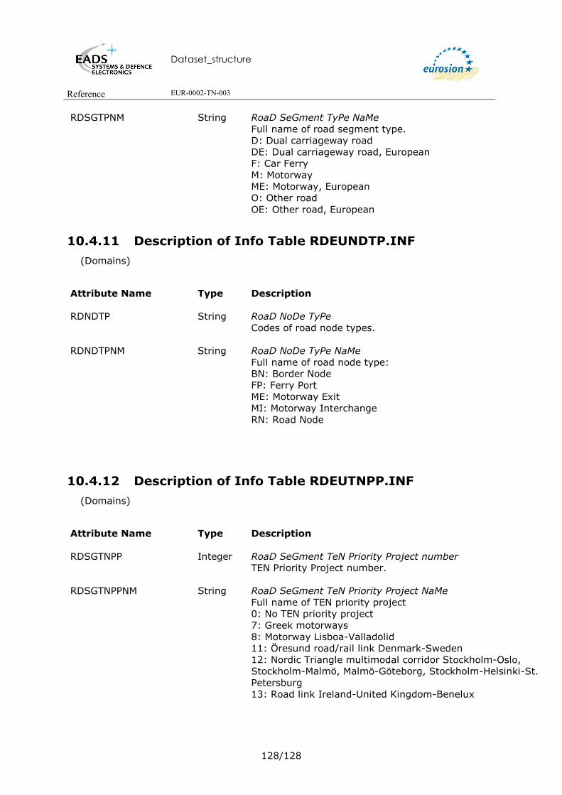
Dataset_structure
Reference EUR-0002-TN-003
128/128
RDSGTPNM String RoaD SeGment TyPe NaMe Full name of road segment type. D: Dual carriageway road DE: Dual carriageway road, European F: Car Ferry M: Motorway ME: Motorway, European O: Other road OE: Other road, European
10.4.11 Description of Info Table RDEUNDTP.INF
(Domains)
Attribute Name Type Description
RDNDTP String RoaD NoDe TyPe
Codes of road node types.
RDNDTPNM String RoaD NoDe TyPe NaMe Full name of road node type: BN: Border Node FP: Ferry Port ME: Motorway Exit MI: Motorway Interchange RN: Road Node
10.4.12 Description of Info Table RDEUTNPP.INF
(Domains)
Attribute Name Type Description
RDSGTNPP Integer RoaD SeGment TeN Priority Project number
TEN Priority Project number.
RDSGTNPPNM String RoaD SeGment TeN Priority Project NaMe Full name of TEN priority project 0: No TEN priority project 7: Greek motorways 8: Motorway Lisboa-Valladolid 11: Öresund road/rail link Denmark-Sweden 12: Nordic Triangle multimodal corridor Stockholm-Oslo, Stockholm-Malmö, Malmö-Göteborg, Stockholm-Helsinki-St. Petersburg 13: Road link Ireland-United Kingdom-Benelux

Dataset_structure
Reference EUR-0002-TN-003
129/129
10.4.13 Description of Info Table RDLKTP.INF (RoaD LinK TyPe)
- (Domains)
Attribute Name Type Description
RDLKTP String RoaD LinK TyPe
Road link type code
RDLKTPNM String RoaD LinK TyPe NaMe Road link type label M: Motorway E: Express / High-speed road O: Ordinary / All-purpose road
10.4.14 Description of Info Table RDPLTNPRST.INF
RDPLTNPRST: RoaD PLanned TeN PRoject STatus) - (Domains)
Attribute Name Type Description
RDPLTNPRST String RoaD PLanned TeN PRoject STatus
Project status code
RDPLTNPRSTNM String RoaD PLanned TeN PRoject STatus NaMe Project status label Advancement status for section: 1: Preliminary study (planned) 2: Feasability study (study) 3: Budgeted (study) 4: Under construction 5: Completed
10.4.15 Description of Info Table RDPLTNPRTP.INF
(RoaD PLanned TeN PRoject TyPe) - (Domains)
Attribute Name Type Description
RDPLTNPRTP String RoaD PLanned TeN PRoject TyPe
Project type code
Dataset_structure
Reference EUR-0002-TN-003
130/130
RDPLTNPRTPNM String RoaD PLanned TeN PRoject TyPe NaMe Project type label Type of project: N: New construction U: Upgrade to new standard A: Improvement S: Study
10.4.16 Description of Info Table RDPLTNCUTP.INF
(RoaD PLanned TeN CUrrent road TyPe) - (Domains)
Attribute Name Type Description
RDPLTNCUTP String RoaD PLanned TeN CUrrent road TyPe
Current Road type code
RDPLTNCUTPNM String RoaD PLanned TeN CUrrent road TyPe NaMe Road type label MW: Motorway HQ: High quality road OR: Ordinary road FL: Fixed link BR: Bridge TU: Tunnel BP: Bypass
10.4.17 Supporting files
rd.key rdto.key rd1.lin rd2.lin rd3.lin rd4.lin rd5.lin rd6.lin rdtn.lin
Key files and line sets used in GISCO mapfeature tool rd.aml (AML to draw the European roads with predefined line symbols according to the line type of the road segments) and rdtn.aml (AML to draw the European TEN roads according to the TEN road type).
Dataset_structure
Reference EUR-0002-TN-003
131/131
rdtp.lut rdtntp.lut
Look up tables for assigning the correct line type to the road segments used in the GISCO mapfeature tool rd.aml (AML to draw the European roads with predefined line symbols according to the line type of the road segments) and rdtn.aml (AML to draw the European TEN roads according to the TEN road type).

Dataset_structure
Reference EUR-0002-TN-003
132/132
10.5. GISCO SETTLEMENTS
10.5.1 Overview of the dataset structure
10.5.2 Description of the Point Attribute Table of STEU coverage
Attribute Name Type Description
FID OID Unique Object Identifier Shape Geometry Point
STSICD String SeTtlement SIte CoDe
This attribute is a unique identification of the settlement and consists of the two character ISO country code followed by a serial number per country which is ordered alphabetically by name.
10.5.3 Description of Info Table STEUAT.INF
Attribute Name Type Description
Dataset_structure
Reference EUR-0002-TN-003
133/133
STSICD String SeTtlement SIte CoDe This attribute is a unique identification of the settlement and consists of the twocharacter ISO country code followed by a serial number per country which is ordered alphabetically by name.
STSINM String SeTtlement SIte NaMe The settlement name spelled in the appropriate national spelling.
STPUNR Binary SeTtlement PopUlation NumbeR The population number for the settlement (if available). (Missing values: 9999999).
STSIAR Float SeTtlement SIte ARea The area of the settlement in km2 (if available).
STPUSRCD Binary SeTtlement PopUlation SouRce CoDe Code with a source (it available)
STARSRCD Binary SeTtlement ARea SouRce CoDe Code with a source (it available)
STCOSRCD Binary SeTtlement COordinate SouRce CoDe Code with a source (it available)
ARRGCD String AdministRative ReGion CoDe The code for the administrative region in which the settlement is located. It is a twoletter ISO country code followed by a by a number identifying the region within the country.
NURGCDV5 String NUTS ReGion CoDe Version 5 The NUTS level 3 region code (for the settlements of the 12 Member States).
NURGCDV6 String NUTS ReGion CoDe Version 6 The NUTS level 3 region code (for the settlements of the 15 Member States).
NURGCD String NUTS ReGion CoDe The NUTS level 3 (version 7) region code (for the settlements of the 15 Member States+the 5 EFTA countries).
NURGCDV7 String NUTS ReGion CoDe Version 7
10.5.4 Description of Info Table STCOSR.INF

Dataset_structure
Reference EUR-0002-TN-003
134/134
Attribute Name Type Description
STCOSRCD Integer SeTtlement COordinate SouRce CoDe Code for the source of the updated coordinates
STCOSRDS String SeTtlement COordinate SouRce DeScription Description of the source of the updated coordinates
10.5.5 Description of Info Table STARSR.INF
Attribute Name Type Description
STARSRCD Integer SeTtlement ARea SouRce CoDe
Code for the source of the updated area figure STARSRDS String SeTtlement ARea SouRce DeScription
Description of the source of the updated area figure
10.5.6 Description of Info Table STPUSR.INF
Attribute Name Type Description
STPUSRCD Integer SeTtlement PopUlation SouRce CoDe
Code for the source of the updated population number
STPUSRDS String SeTtlement PopUlation SouRce DeScription Description of the source of the updated population number
10.5.7 Description of Info Table STUKAN.INF
Attribute Name Type Description
STSICD String SeTtlement SIte CoDe
unique identification of a settlement, consists of ISO code of the country followed by a serial number per country (alphabetically ordered by name).
STSINM String SeTtlement SIte NaMe Official name of the settlement (agglomeration) in national language.
STSINMAN String SeTtlement SIte NaMe ANnotation Settlements name for use as annotation.
Dataset_structure
Reference EUR-0002-TN-003
135/135
10.5.8 Description of Info Table STNUCPV5.INF
Attribute Name Type Description
NURGCD String NUts ReGion CoDe
Identification of NUTS administrative region (Version 5).
STSICD String SeTtlements SIte CoDe Unique identification of a settlement (in this case a capital), consists of ISO code of country followed by a serial number per country (alphabetically ordered by name).
10.5.9 Description of Info Table STNUCPV6.INF
Attribute Name Type Description
NURGCD String NUts ReGion CoDe
Identification of NUTS administrative region (Version 6).
STSICD String SeTtlements SIte CoDe Unique identification of a settlement (in this case a capital), consists of ISO code of country followed by a serial number per country (alphabetically ordered by name).
10.5.10 Description of Info Table STNUCPV7.INF
Attribute Name Type Description
NURGCD String NUts ReGion CoDe Identification of NUTS administrative region (Version 7).
STSICD String SeTtlements SIte CoDe Unique identification of a settlement (in this case a capital), consists of ISO code of country followed by a serial number per country (alphabetically ordered by name).
10.5.11 Description of Info Table STARCPV7.INF
Attribute Name Type Description
Dataset_structure
Reference EUR-0002-TN-003
136/136
ARRGCD String AdministRative ReGion CoDe Identification of administrative regions (Version 7).
STSICD String SeTtlements SIte CoDe Unique identification of a settlement (in this case a capital), consists of ISO code of country followed by a serial number per country (alphabetically ordered by name).
10.5.12 Supporting files
stpt.key stptbc.mrk stptbl.mrk stptbs.mrk stptrd.mrk
key file and marker sets used in GISCO map feature tools stpt.aml, stptne.aml (aml's to draw the European settlements with predefined symbols according to the population number), stcpv5.aml,stcpv6.aml and stcpv7.aml (aml's to draw the European capitals).
stptlu.lut Look up table used in GISCO map feature tools stpt.aml, stptne.aml (aml's to draw the European settlements with predefined symbols according to the population number), stcpv5.aml, stcpv6.aml and stcpv7.aml (aml's to draw the European capitals).

Dataset_structure
Reference EUR-0002-TN-003
137/137
11. LAND COVER
11.1. CORINE LAND COVER 11.1.1 Overview of the dataset structure
The original Corine Land Cover database is tiled up by 545 tiles. Each tile covers an area of 100 Km*100 Km. The original datasets is in ASCII grid format. For EUROSION project the format used in coverage or SHAPE format. The structure defined here is the one corresponding to the dataset hosted at EEA.1 The name of this layer is proposed taking into account the GISCO naming conventions. Thus LCXXCO100KV1 means:
• LC for Land Cover (the layer name)
1 The structure of this dataset is different from the dataset hosted at EUROSTAT/GISCO. The dataset hosted at GISCO contains an attribute titled “LCGRCD” corresponding to the Land cover code. This code is derived from the original Land Cover Grid CoDe. This code ensures the link to the Corine Land Cover nomenclature descripation (INFO table LCECAT.INF). Within the EEA dataset there is no LCGRCD within the polygon coverage and the link to the Corine Land Cover nomenclature is ensured by the attribute titled LCCD within the polygon coverage.
LCXXCO100KV1LCXXCO100KV1
LCEULCCDL1AT.INFLCEULCCDL1AT.INF
LCEULCCDL2AT.INFLCEULCCDL2AT.INF
LCEULCCDAT.INFLCEULCCDAT.INF

Dataset_structure
Reference EUR-0002-TN-003
138/138
• XX for two-character code for the EC country or group of countries (the georeference). These countries include the applicants countries covered by Eurosion Project.
• CO: Coastal, as the Land Cover is derived only for the coastal areas. • 100K for scale 1:100 000 • V1 for Version 1
For every country or group of country there is a coverage. The littoral band covered by these coverages is 10 Km from the coastline. 11.1.2 Description of the Polygon Attribute Table of Coverage LCXXCO100KV1
This table provides the legend defined for Corine Land Cover 1990.
The land cover codes are structured according to a nomenclature organized on 3 levels
Level 1 corresponds to 5 classes (attribute LCCDL1).
Level 2 corresponds to 15 classes (attribute LCCDL2).
Level 3 corresponds to 44 classes (attribute LCCD).
Attribute Name Type Description
FID OID Unique object identifier Shape Geometry Polygon
LCCD String Land Cover CoDe. Land cover level 3 class codes. Defines
the 44 Land cover codes linked to the level 3.
LCCDL1 String Land Cover CoDe Level 1. Land cover level 1 class codes. It is defined the 5 Land cover codes linked to the level 1.
LCCDL2 String Land Cover CoDe Level 2. Land cover level 2 class codes. Defines the 15 Land cover codes linked to the level 2.
11.1.3 Description of the INFO table LCEULCCDAT.INF
This table provides the name of the classes for the Level 3 the Corine Land Cover Nomenclature.
Attribute Name Type Description
FID OID Unique object identifier.

Dataset_structure
Reference EUR-0002-TN-003
139/139
LCCD String Land Cover CoDe. Land cover level 3 class codes. Defines the 44 Land cover codes linked to the level 3. The content of this table is provided below with the English names.
LCNMEN String
Land CoverNaMe English. Name of land cover class in English.
LCNMFR String
Land CoverNaMe French. Name of land cover class in French.
LCNMDE String
Land CoverNaMe DEutsch. Name of land cover class in German.
LCCD LCNMEN
111 Continuous urban fabric 112 Discontinuous urban fabric 121 Industrial or commercial units 122 Road and rail networks and associated land 123 Port Areas 124 Airports 131 Mineral extraction sites 132 Dump sites 133 Construction sites 141 Green urban areas 142 Sport and leisure facilities 211 Non-irrigated arable land 212 Permanently irrigated land 213 Rice fields 221 Vineyards 222 Fruit trees and berry plantations 223 Olive groves 231 Pastures 241 Annual crops associated with permanent crops 242 Complex cultivation patterns 243 Land principally occupied by agriculture, with significant areas of natural vegetation 244 Agro-forestry areas 311 Broad-leaved forest 312 Coniferous forest 313 Mixed forest 321 Natural grassland 322 Moors and heathland 323 Sclerophyllous vegetation 324 Transitional woodland-scrub 331 Beaches, dunes, sands 332 Bare rocks 333 Sparsely vegetated areas 334 Burnt areas 335 Glaciers and perpetual snow 411 Inland marshes

Dataset_structure
Reference EUR-0002-TN-003
140/140
412 Peat bogs 421 Salt marshes 422 Salines 423 Intertidal flats 511 Water courses 512 Water bodies 521 Coastal lagoons 522 Estuaries 523 Sea and ocean 950 Ocean 951 European Union 952 Non European union 999 Not Classified
11.1.4 Description of the INFO table LCEULCCDL2AT.INF
This table provides the name of the classes for the Level 2 the Corine Land Cover Nomenclature.
Attribute Name Type Description
FID OID Unique object identifier.
LCCDL2 String Land Cover CoDe Level 2. Land cover level 2 class codes.
Defines the 15 Land cover codes linked to the level 2. The content of this table is provided below with the English names.
LCNMENL2 String
Land CoverNaMe English Level 2. Name of land cover class in English.
LCNMFRL2 String
Land CoverNaMe French Level 2. Name of land cover class in French.
LCNMDEL2 String
Land CoverNaMe Deutsch Level 2. Name of land cover class in German.
LCCDL2 LCNMENL2
11 Urban fabric. 12 Industrial, commercial and transport units. 13 Mine, dump and construction sites. 14 Artificial non-agricultural vegetated areas. 21 Arable land
22 Permannet crops
23 Pastures
24 Heterogeneous agricultural areas
31 Forests.
Dataset_structure
Reference EUR-0002-TN-003
141/141
32 Shrub and/or herbaceaous vegetation associations 33 Open spaces with little or no vegetation 41 Inland wetlands 42 Coastal wetlands 51 Inland waters
52 Marine waters
11.1.5 Description of the INFO table LCEULCCDL1.INF
This table provides the name of the classes for the Level 1 the Corine Land Cover Nomenclature.
Attribute Name Type Description
FID OID Unique object identifier.
LCCDL1 String Land Cover CoDe Level 1. Land cover level 1 class codes. It is defined the 5 Land cover codes linked to the level 1. The content of this table is provided below with the English names.
LCNMENL1 String
Land CoverNaMe English Level 1. Name of land cover class in English.
LCNMFRL1 String
Land CoverNaMe French Level 1. Name of land cover class in French.
LCNMDEL1 String
Land CoverNaMe Deutsch Level 1. Name of land cover class in German.
LCCDL1 LCNMENL1
1 Artificial surfaces.
2 Agricultural areas.
3 Forest and semi-natural areas.
4 Wetlands.
5 Water bodies.

Dataset_structure
Reference EUR-0002-TN-003
142/142
12. LAND COVER CHANGES
12.1. LACOAST 12.1.1 Overview of the dataset structure This structure is derived from the datastets provided from LACOAST dataset in coverage format. This coverage is linked to the INFO tables defined above for the Corine Land Cover 1990 dataset.
Within the framework of EUROSION project, 3 coverages are going to be delivered for the CEEC countries:
• For Poland and the Baltic countries, • For for Romania and Bulgaria • For Slovenia.
EUROSION is producing the land cover changes dataset according to the LACAOST methodology within these countries1. The name of this layer is proposed taking into account the GISCO naming conventions. Thus LCXXCO100KV1 means:
• LC for Land Cover, the layer name • XX for two-character code for the EC country or group of countries (the
georeference). These countries include the applicants countries covered by Eurosion Project, the Georeference (XX = BG, Bulgaria, PL = Poland, RO = Romania, SI = Slovenia, EE: Estonia, LT = Lithuania, LV = Latvia)
• CH: Change, the entity • I: IGN FI , the source
1 If the existing LACOAST coverage is going to be merged with the coverages produced by EUROSION it will be needed to add a new attribute referencing the source (IGN FI) within the Poygon Attribute Table (PAT) of the final coverage. If this coverage is not mergerd, the name of the coverage should include the source IGN FI (I).
LCXXCHI100kv1LCXXCHI100kv1 LCCH.INFLCCH.INF
LCEULCCDL1AT.INFLCEULCCDL1AT.INF
LCEULCCDL2AT.INFLCEULCCDL2AT.INF
LCEULCCDAT.INFLCEULCCDAT.INF
Dataset_structure
Reference EUR-0002-TN-003
143/143
• 100K for scale 1:100 000 • V1 for Version 1
12.1.2 Description of the Polygon Attribute Table of the LCXXCHI100kv1 coverage
Attribute Name Type Description
FID OID Unique object identifier.
Shape Geometry Polygon
LCCHYR75 String Land Cover Change YearR 1975.
LCCHCD75 String Land Cover CoDE in 1975. It is the Land Cover CoDe of
the Corine Land Cover Nomenclature. Land cover level 3 class codes. Defines the 44 Land cover codes linked to the level 3.This attribute related to the attribute LCCD from Corine Land Cover. Remark: For Baltics countries, Poland, Slovenia, Romania and Bulgaria this attribute is not completed.
LCCHCDL2YR75 String Land Cover Change CoDe Level 2 YeaR 75. Defines the 15 Land cover codes linked to the level 2.
LCCHYR90 String Land Cover Change YearR 1990.
LCCHCD90 String Land Cover CoDE in 1990. It is the Land Cover CoDe of the Corine Land Cover Nomenclature. Land cover level 3 class codes. Defines the 44 Land cover codes linked to the level 3.This attribute related to the attribute LCCD from Corine Land Cover.
LCCHCDL2YR90 String Land Cover Change CoDe Level 2 YeaR 90. Defines the 15 Land cover codes linked to the level 2.
LCCHAR Double Land Cover Change ARrea. It the change area in HA.
12.1.3 Description of the INFO table LCCH.INF Attribute Name Type Description
LCCD String Land Cover CoDe. Land cover level 3 class codes. Defines
the 44 Land cover codes linked to the level 3.

Dataset_structure
Reference EUR-0002-TN-003
144/144
LCCDL1 String Land Cover CoDe Level 1. Land cover level 1 class codes. It is defined the 5 Land cover codes linked to the level 1.
LCCDL2 String Land Cover CoDe Level 2. Land cover level 2 class codes. Defines the 15 Land cover codes linked to the level 2.

Dataset_structure
Reference EUR-0002-TN-003
145/145
13. LAWS AND DECREES
13.1. LAWS AND DECREES
13.1.1 Dataset structure overview
The Juridical text are collected into a separarate table created for every country (XXLDJTDS) and linked to the corresponding national SABE coverage (e.g. XX30) where XX is a 2-character abbreviation for every state.
The link between the polygons of the national SABE coverage (XX30) and the table containing information on the corresponding juridical texts (XXLDJTDS) is ensured by the attribute ICC + SHN, generated for every table and for every national SABE coverage.
XX30XX30 LDXXJTDSLDXXJTDS
LDJTTP.INF
LDJTSTAB.INF
LDJTRSTP.INF
LDJTRS.INF
LDJTLN.INF
LDJTDTTP.INF

Dataset_structure
Reference EUR-0002-TN-003
146/146
13.1.2 Description of the Polygon Attribute Table of the XX30 coverage
We provide here the description of the SABE coverage with its unique identifier ICC + SHN added to the existing SABE coverage to allow the link to each juridical text.
Attribute Name Type Description
FID OID Unique object identifier.
Shape Geometry Polygons
SHN String This code is derived from the unit’s national code if
provided by the national mapping agency, overwise it is created by EuroGeographics. The SHN attribute indicates the adminiistrative unit to whoch the area belongs. It is possible to have many occurrence of the same value as one or many polygons (administrative area) can belong to one administrative unit. To extract the codes of higher level units you need to know the SHI value. Together, the ICC+SHN codes provide a unique identifier for each administrative unit.
MOC Integer Meaning of the centroid of the Administrative Unit. Each unit may consist of several separate areas. Each unit has at least one mainland, and occasionally several islands (exclaves). MOC = 1; Area is mainland and the label points to the residence of the authority MOC = 2; Area is mainland and label does not have a geo-graphical meaning MOC= 3; Area is exclave or island apart from the mainland MOC= 4; Area is condominium MOC= 7; Area is water only MOC = 9; Unkown area.
ICC String Contains the 2-character country code according to ISO 31666 (see above description).
ICCSHN String Concatenation of attributes ICC and SHN.
13.1.3 Description of the INFO table LDXXJTDS.INF
This table corresponds to the metadata linked to every juridical text. The name proposed for this table is XXLDJTDS, where:
• LD for Law and Decress
• XX is the 2-character ISO country code
• JT for Juridical Texts
Dataset_structure
Reference EUR-0002-TN-003
147/147
• DS for DeScription
Attribute Name Type Description
LDJTID Integer Juridical Text IDentifier. Identification number of each
Juridical text, it is the Identifier. This identifier is unique for every occurrence of a juridical text.
LDJTTT String Juridical Text TiTle. Title of the document (the resource).
LDJTCA
String Juridical Text CreAtor. Entity primarily responsible for making the content of the document. Examples of creator include a person, an organization or a service.
LDJTSB String Juridical Text SuBject. The topic of the content of the document (the resource). Typically, it is expressed by keywords. Recommended best pratice is to select a value from a controlled vocabulary or formal classification scheme.
LDJTDS String Juridical Text DeScription. An account of the content of the document (the resource). Description may include typically an abstract
LDJTTPID Integer Juridical Text TyPe IDentifier. Document type. TYPE can take the following values: TYPE = Act TYPE = Convention TYPE = Laws TYPE = International Text TYPE = Other These types are defined within the INFO table LDJTTP.INF.
LDJTSR String
Juridical Text SouRce. A reference to a resource from which the present document (the resource) is derived, i.e legal text on which actual text is based, or analytic resource relative to the juridical text.
LDJTLNID
Integer Juridical Text LaNguage IDentifier. Identifier corresponding to the language of the intellectual content of the document (the resource). Recommended best practice is to define it with the language values provided by ISO 639 standard. These languages are defined in the INFO table LDJTLN.INF.
LDJTCNCD String Juridical Text CouNtry CoDe. The geographical extent to which the juridical text applies. According to IGN FI , this field is the concatenation of the original SABE fields: SHN (lowest adminiistrative unit to which the area belongs ) and ICC (2 character country code according to ISO 3166). It the ICC code from the SABE model.
Dataset_structure
Reference EUR-0002-TN-003
148/148
LDJTCDSH
String Juridical Text CoDe SHn. It is the SHN code within the SABE model. This code is derived from the unit’s national code, if provided by the national mapping agencies; otherwise it is created by Eurogeographics. The SHN attribute indicates the administrative unit to which the area belongs. This number is unique within a given country. Together the LDJTCNCD + SHN codes provide a unique identifier for each administrative unit in the SABE nomenclature. This attribute is obtained from the corresponding XX30 polygon attribute table (PAT) of each XX30 coverage.
LDJTCNCDSH
String Juridical Text CouNtry CoDe SHn. This is the unique identifier for each administrative. It is the concatenation of LDJTCNCD and LDJTCDSH (SHN). It is the concatenation of ICC + SHN within the SABE model.
LDJTRSTPID
Integer Juridical Text ReSource TyPe IDentifier. Identifier corresponding to the type of source of the juridical text. Different types of source types are regrouped in the INFO table LDJTRSTP.INF table and linked by the JTRSTPID attribute.
LDJTRSID
Integer Juridical Text ReSource IDentifier. Identifier corresponding to the resource where the content of the juridical text is available. Different resources are regrouped in the INFO table LDJTRS.INF, and linked by using the JTRSID attribute.
LDJTDTTPID
Integer Juridical Text DaTe TyPe IDentifier. Type of date. It is an identifier corresponding to the type of date. These types are for example: date of signature, date of creation. These types are defined in the INFO table LDJTDTTP.INF and linked to this table by using the JTDTTPID attribute.
LDJTDT
Date Juridical Text DaTe. A date corresponding to the juridical text. The nature of the date is defined into the INFO table LDJTDTTP.INF. A date associated with an event in the life cycle of the resource.
LDJTLK
http link Juridical TextLinK. Direct HTTP link to the juridical text, if exists. In most cases this link provides the access to the PDF file with the content of the juridical text.
13.1.4 Description of the INFO table LDJTTP.INF
The name proposed for this table is LDJTTP, where:

Dataset_structure
Reference EUR-0002-TN-003
149/149
• LD for Law and Decress
• JT for Juridical Texts
• TP for TyPe
Attribute Name Type Description
LDJTTPID Integer Juridical Text TyPe Identifier. Unique identifier for the
juridical text type.
LDJTTPNM String Juridical Text TyPe NaMe. Juridical text type name is completed with different value according to the value of JTTPID attribute. These values are provided within the table below.
LDJTTPID LDJTTPNM
1 Convention
2 Treaty
3 Law
4 Decree
5 Act
6 Regulation
7 Directive
8 Decision
9 Recommendation
10 Opinion
11 Case Law
12 Constitution
13 Communication
14 Proposal
15 Programme
16 Plan
17 Report
18 Agreement
19 Course
20 Written question
21 Code
22 Bulletin
23 Decree-law

Dataset_structure
Reference EUR-0002-TN-003
150/150
24 Project
25 Guide
26 Article
27 Charter
28 Resolution
13.1.5 Description of the INFO table LDJTLN.INF
The name proposed for this table is LDJTTP, where:
• LD for Law and Decress
• JT for Juridical Texts
• LN for LaNguage Attribute Name Type Description
LDJTLNID
Integer Juridical Text LaNguage IDentifier. Unique identifier of the language
LDJTLNNM String
Juridical Text LaNguage NaMe. Name of the language. This attribute is completed with different value according to the value of JTLNID. These values are provided within the table below.
LDJTLNID LDJTLNNM 1 Danish
2 Dutch
3 English
4 Finnish
5 French
6 German
7 Greek
8 Irish
9 Italian
10 Portuguese
11 Spanish
12 Swedish
13 Bulgarian (Applicant Country)
14 Cyprus (Applicant Country)
15 Estonian (Applicant Country)

Dataset_structure
Reference EUR-0002-TN-003
151/151
16 Latvian (Applicant Country)
17 Lithuanian (Applicant Country)
18 Maltese (Applicant Country)
19 Polish (Applicant Country)
20 Rumanian (Applicant Country)
21 Slovene (Applicant Country)
22 Turkish (Applicant Country)
23 Other
24 Multi-language
13.1.6 Description of the INFO table LDJTSTAB.INF This table contains information about the countries covered by EUROSION project (15 EU member states + 10 accessing states). The name proposed for this table is LDJTTP, where:
• LD for Law and Decress
• JT for Juridical Texts
• ST for State
• AB for ABbrevaition
Attribute Name Type Description
LDJTCNCD String Juridical Text CouNtry CoDe. 2-character country code
according to ISO 31666. It is the ICC code from the SABE model.
LDJTST String Juridical Text StaTe. Name of the country
LDJTFL String Juridical Text FiLe Name of the corresponding to the country file XX30.nam from SABE, if doesn’t exist NA is filled in.
13.1.7 Description of the INFO table LDJTRSTP.INF The name proposed for this table is LDJTRSTP, where:
• LD for Law and Decress
• JT for Juridical Texts
• RS for ReSource
• TP for TyPe

Dataset_structure
Reference EUR-0002-TN-003
152/152
Attribute Name Type Description
LDJTRSTPID Integer Juridical Text ReSource TyPe IDentifier.
Unique identifier for the resource type.; different types of resources could be indexed i.e Web sit
LDJTRSTPDS String
Juridical Text ReSource TyPe DeScription Name of the resource type. These types are provided in the following table.
LDJTRSTPID LDJTRSTPDS
1 International text
2 Internet reference
3 File
4 Book
13.1.8 Description of the INFO table LDJTRS.INF The name proposed for this table is LDJTRS, where:
• LD for Law and Decress
• JT for Juridical Texts
• RS for ReSource Attribute Name Type Description
LDJTRSID
Integer Juridical Text ReSource IDentifier. Unique identifier for the resource; different types of resources could be indexed i.e Web site, Book, File
LDJTRSPV String
Juridical Text ReSource ProVider. Resource provider, person, organisation or service making available the content of the resource.
LDJTRSLNID Integer Juridical Text ReSource LaNguage IDentifier. Identifier corresponding to the language of the resource. These languages are defined in the INFO table LDJTLN.INF. The attribute JTLNID of that table ensures the link to attribute JTRSLNID.
LDJTRSKW String Juridical Text ReSource KeWord. Keywords corresponding to the resource content.
LDJTRSDS String Juridical Text ReSource DeScription. Short abstract describing the content and structure of the resource.
LDJTRSTT String Juridical Text ReSource TiTle. Title of the resource

Dataset_structure
Reference EUR-0002-TN-003
153/153
LDJTRSAB String Juridical Text ReSource Abbreviation. Abbreviation of the title of the resource
LDJTRSPC String Juridical Text ReSource Point of Contact. Generally e-mail address of the person responsible for the content of the resource.
LDJTRSON
String Juridical Text ReSource OrgaNisation Name. Name of the organisation providing/hosting the resource.
LDJTRSCN String Juridical Text ReSource CouNtry. Country of the physical address
LDJTRSPH String Juridical Text ReSource PHone. Telephone number
LDJTRSFA String Juridical Text ReSource FAx. Fax number
LDJTRSUR http link Juridical Text ReSource URl. URL address for the web site.
LDJTRSIS String Juridical Text ReSource ISbn. ISBN code for corresponding book.
LDJTRSPA String Juridical Text ReSource PAge. Page number in the book resource.
LDJTDTTPID
Integer Juridical Text DaTE TyPe IDentifier. Event used for the reference date. The type of date is documented within the INFO table LDJTDTTP.INF.
LDJTRSRFDT Date Juridical Text ReSource ReFerence DaTe. Reference date for the cited resource.
13.1.9 Description of the INFO table LDJTDTTP.INF The name proposed for this table is LDJTDTTP, where:
• LD for Law and Decress
• JT for Juridical Texts
• DT for DaTe
• TP for TyPe Attribute Name Type Description
LDJTDTTPID Integer Juridical Text DaTe TyPe IDentifier.
Unique Identifier for the type of the date. This type of date is corresponding to the date associated to the jurirical text description provided in table XXLDJTDS.INF.

Dataset_structure
Reference EUR-0002-TN-003
154/154
LDJTDTTPNM String Juridical Text DaTe TyPe NaMe. Type of date, i.e date of creation, date of signature.
LDJTDTTPID LDJTDTTPNM
0 Date of creation
1 Date of update
2 Date of publishing
3 Date of signature
4 Date of ratification
5 Date of enter in force
6 Date of adoption

Dataset_structure
Reference EUR-0002-TN-003
155/155
14. NATIONALLY DESIGNATED AREAS
14.1. INTRODUCTION The nationally designated areas are composed of differente sources:
• RAMSAR
• NATURA2000
• SPA: Special Proctected Areas
• pSCI: Proposed Sites of Community Interest
• CDDA: Common Database on Designated areas
Within the framework of EUROSION project it is planned to integrate only the NATURA2000 database.
Just for the information, the desciption of RAMSAR, SPA, pSCI and CDDA according to the dataset deliverd by IGN FI is provoded in Annex 20.
Dataset_structure
Reference EUR-0002-TN-003
156/156
14.2. NATURA2000 14.2.1 Overview of the dataset structure Right now only an extract of this dataset has been provided in shape format for a specific area titled “Macaronesia”. According to the GISCO naming conventions it is proposed to title the coverage as follow DAXXN2100KV1 Thus DAXXN2100KV1 means:
• DA for Desiganted Areas (the layer name) • XX the coutry or group of country (the georeference) • N2 for Natura2000 (the source) • 100K for scale 1:100 000 • V1 for Version 1
Each Site of Community Importance (SCI) code, is identified by the information supplied in the Natura 2000 format, including the corresponding map, and transmitted by the competent national authoritities.
14.2.2 Description of the Poygon Attribute Table of NDXXN2100KV1 coverage
Attribute Name Type Description
FID OID Unique object identifier.
Shape Geometry Polygon
DASICD String Designated Areas SIte CoDe. Site of Community
Importance (SCI) code. The SCI code comprises 9 characters, the first 2 being the ISO country code for the Member State (for example, PF for Portugal).
DASINM String Designated Area SIte NaMe .Name of the Site of Community Importance (SCI).
PRIORITY String * = presence on the SCI of at least one priority natural habitat type and/or species within the meaning of Article 1 of Directive 92/43/EEC1.
1 Attribute not included within the data provided by IGN FI in shape for the area of Macaronesian region
DAXXN2100KV1DAXXN2100KV1

Dataset_structure
Reference EUR-0002-TN-003
157/157
CA String Not specificied ( May the the Administrative authority name).
DABGNM String Designated Area BioGeographical NaMe. Name of the biogeographical region. For example the Macaronesian is a biogeographical region regrouping a list of sites (SCI).
DAAR Double Designated Area ARea. Surface area of SCI in hectares
DALE Double Designated Aera LEngth. Length of SCI in Km.
DAXCDD String X Co-ordinate Decimal Degrees Longitude coordinate of SCI.1
DAYCDD String Y Co-ordinate Decimal Degrees. Latitude coordinate of SCI.
1 Attribute not included within the data provided by IGN FI in shape for the area of Macaronesian region

Dataset_structure
Reference EUR-0002-TN-003
158/158
15. SEDIMENTS DISCHARGES FROM RIVER BASINS
15.1. OVERVIEW OF THE DATASET STRUCTURE
This dataset is composed of 3 coverages:
• WSEUDS1M: this is the GISCO watersheds coverage titled WSEU1M. Info table linked to this coverage provides information on the description of the watersheeds. Within this coverage only one attribute is added to ensure the link to INFO table SFEUWSDSIF.INF. According to the GISCO naming conventions the name is defined as follows:
o WS: Water Sheeds o EU: Europe o DS: DeScription o 1M : scale
• WSEUTSSDIF1M: coverage derived from WSEU1M coverage by dissolving the polygons with attribute WSID_P. The info table linked to this coverage provides information of Total Suspended Solid (TSS) delivery downstream within the sea. According to the GISCO naming conventions the name is defined as follows:
o WS: Water Sheeds o EU: Europe o TS: Total Suspended o SD: SoliD
SFEUQSDSIFSFEUQSDSIFSFEUQSIFV1SFEUQSIFV1
WSEUDSSDIF1MWSEUDSSDIF1M
WSEUDS1MWSEUDS1M
SFEUTSSDIFSFEUTSSDIF
SFEUWSDSIFSFEUWSDSIF

Dataset_structure
Reference EUR-0002-TN-003
159/159
o IF: IFen o 1M: scale.
• SFEUQSIFV1: point coverage providing the location of quality station used to derived information on sediments flow. The info table linked to this coverage provides information on the description of the station. According to the GISCO naming conventions the name is defined as follows:
o SF: Sediment Flows o EU: Europe o QS : Quality Station o IF : IFen o V1: version 1
According to the GISCO naming conventions, the names for the tables linked to these coverages are defined as follows: The table name linked to coverage WSEU1M is: SFEUWSDSIF, where :
• SF: Sediment Fow, the layer name • EU: Europe, the georefrence • WS: Water Sheeds • DS: DeScription, the entity, • IF: IFen, the source
The table name linked to coverage WSEUTSSDIF1M is: SFEUTSSDIF, where : • SF: Sediment Fow, the layer name • EU, EUrope, the georefrence • TS: Total Suspended • SD: SoliD • IF: IFen, the source
The table name linked to coverage SFEUQSIFV1 is: SFEUQSDSIF, where :
• SF: Sediment Fow, the layer name • EU: Europe, the georefrence • QS: Quality station, the entity • DS: DeScription • IF: IFen, the source
15.1.1 Description of the Point Attribute Table of the coverage SFEUQSIFV1 Attribute Name Type Description
FID OID Unique object identifier.
Shape Geometry Point

Dataset_structure
Reference EUR-0002-TN-003
160/160
SFQSCDST String Quality Station CoDe Station. Code of station.
15.1.2 Description of the INFO table SFEUQSDSIF Attribute Name Type Description
SFQSCD String Quality Station CoDe. Code of station.
SFQSNM String Quality Station NaMe. Name of station
SFQSTP String
Quality Station TyPe. Type of station (type of network). This type is compliant with the EUROWATERNET.
SFQSSN String
Quality Station SiNgularity. Singularity of location on river stretch.
SFQSPL String
Quality Station PLace. Description of detailed location of station.
SFQSORCD String
Quality Station ORganism CoDe. Code of organism managing the station.
SFQSRVCD String
Quality Station RiVer Stretch CoDe. Code of river stretch on which the station is located.
SFQSPK Double
Quality Station Point Kilometric. Kilometric point (km)
SFQSRVNM String Quality Station RiVer NaMe. River name
SFQSAGCD String Quality Station AGency CoDe. Code of agency
SFQSWSCDGS String Quality Station WaterSheeds CoDe GiSco. Code of watershed (ZHYD).It is the GISCO attribute WSEU1M_ID from coverage WSEU1M. This attribute is converted in string. It is coded with 5 characters (with additional 0 when needed).
SFQSGBCD String Quality Station Geographic Bassin CoDe. Code of geofraphic basin. This code is coming from the French hydrographic database titled BDCARTHADE (it is the ZG code).
SFQSOCCD String Quality Station Oceanic CoDe. Code of oceanic or sea recepient. These codes are described within the table SFQSQOCDS.INF (MN,MA,AT,ME,MB,BL,NO).
NURGCDV5 String Code of NUTS5 level entity
SFQSDRAR Double Quality Station Drained ARea. Drained area (upstream of station) km2

Dataset_structure
Reference EUR-0002-TN-003
161/161
SFQSWSFXCD String Quality Station Water Sheed FluX CoDe. Code of basin for riverine loads calculation. It is the code of watersheed coming from the coverage WSEUTSSDIF1M (attribute SFQSWSFXCD), the original code provided by IFEN is BVFLUX). This code identifies bassins generated from WSEU1M covergare by dissolving polygons with GISCO attribute WSID_P.
SFQSMSNR Integer Quality Station MeaSurement NumbeR. Number of mesureament in time series file. The file concerns the quality measures of Tolal Suspended Solid (TSS).
SFQSLGDD Double Quality Station LonGitude Decimal Degrees. Longitude of the quality station in decimal degrees.
SFQSLTDD Double Quality Station LaTitude Decimal Degrees. Longitude of the quality station in decimal degrees.
SFQSPJLN Double Quality Station ProJection LonGitude. Projected longitude in current projection (m)
SFQSPJLT Double Quality Station ProJection LaTitude. Projected latitude in current projection (m)
SFQSAL Double Quality Station ALtitude. Altitude of the quality station in meters.
SFQSRF Boolean Quality Station ReFerence. Indicate if it is a reference station (indicating unpolluted water) . Values are 1 (Yes) or 0 (No).
SFQSRVLD Boolean Quality Station RiVer LoaD. Indicate if it is a riverine loads calculation station. Values are 1 (Yes) or 0 (No).
SFQSINCM Boolean Quality Station INTernational CoMmission. Indicate if it is an international commission station. Values are 1 (Yes) or 0 (No).
SFQSSL Boolean Quality Station SeLect. Indicate if it is a selectable station (with enough time series data). Values are 1 (Yes) or 0 (No).
SFQSSLAR Boolean Quality Station SeLect ARea criteria. Indicate if it is a selected station based on area criteria of EUROWATERNET. Values are 1 (Yes) or 0 (No).

Dataset_structure
Reference EUR-0002-TN-003
162/162
SFQSSLARAC Boolean Quality Station SeLect ARea Antropogenic Criteria. Indicate if it is a selected station based on antropogenic pressure criteria of EUROWATERNET. Values are 1 (Yes) or 0 (No).
SFQSSLARWN Boolean Quality Station SeLect ARea WaterNet. Indicate if it is a selected station based on area criteria of EUROWATERNET. Values are 1 (Yes) or 0 (No).
SFQSSLWN Booelan Quality Station SeLect WaterNet. Indicate if it is a finally selected station of EUROWATERNET network. Values are 1 (Yes) or 0 (No).
SFQSWSCDCR String Quality Station Water Sheed CoDE CaRthage database. Detail code of the watershed from the French hydrographic database titled CARTHAGE (CODE_HYDRO).
SFQSIXQU Double Quality Station IndeX QUality. General quality value index o to 100, (0: low quality, 100: highest quality).
SFQSLCWS Boolean Quality Station LoCation Water Sheed. Indicates if station is located on main water body of watersheds.
15.1.3 Description of the INFO table SFQSOCD.INF
Attribute Name Type Description
SFQSOCCD String Quality Station Oceanic CoDe. Code of oceanic or sea
recepient.
SFQSOCDDS String Quality Station Oceanic CoDe DeScription. The description is provided within the below table.
SFQSOCCD SFQSOCDDS
MN Northern Sea
MA Manche
AT Atlantic
ME Mediterranean
MB Baltic Sea
BL White Sea

Dataset_structure
Reference EUR-0002-TN-003
163/163
NO Blak Sea
15.1.4 Description of the Polygon Attribute Table of the coverage WSEUDS1M
This coverage has the same attributes as the GISCO coverage WSEU1M. Only the attribute “SFWSCDGS” has been added.
Attribute Name Type Description
FID OID Unique object identifier.
Shape Geometry Polygon
SFWSCDGS
String WaterSheeds CoDe GiSco. The GISCO attribute WSEU1M_ID from coverage WSEU1M. This attribute is converted in string. It is coded with 5 characters (with additional 0 when needed).
15.1.5 Description of the INFO table SFEUWSDSIF (ZHYD)
Attribute Name Type Description
SFWSCDGS String WaterSheeds CoDe GiSco. Code of watershed (ZHYD). It is the GISCO attribute WSEU1M_ID from coverage WSEU1M. This attribute is converted in string. It is coded with 5 characters (with additional 0 when needed).
SFWSFXCD String WaterSheed FluX CoDe. Code of riverine load basin (text of WSID_P GISCO code). It is the code of watersheed coming from the coverage WSEUTSSDIF1M (attribute SFQSWSFXCD), the original code provided by IFEN is BVFLUX). This code identifies bassins generated from WSEU1M coverage by dissolving polygons with GISCO attribute WSID_P.

Dataset_structure
Reference EUR-0002-TN-003
164/164
SFWSYRMN Date WaterSheed YeaR MaNual. Year manually set indicating that the flow in the main river of the zone is obstrued by dam located in this zone and operating since this year (-1 indicate natural lake instead of dam).
SFWSYRAU Date WaterSheed YeaR AUtomatic. Year automatically set indicating that the flow in the main river of the zone is obstrued by dam located in this zone and operating operating since this year (-1 indicate natural lake instead of dam).
SFWSYRAUDW Date WaterSheed YeaR AUtomatic DoWnstream. Year automatically set indicating that the flow in the main river of the zone is obstrued by dam located in this zone or downstream and operating operating since this year
SFWSZNPE Double WaterSheed ZoNe PErcentage. Percentage of zone influenced by dams.
SFWSRVCD String WaterSheed RiVer CoDe. Code of main river course.
SFWSPKGM Double WaterSheed Point Kilometric Gis Measurement. Kilometric point of outlet on main river course (GIS measurement) in meters.
SFWSPKHM Double WaterSheed Point Kilometric Hydrologic Measurment. Kilometric point of outlet on main river course (hydrologic measurement) meters.
SFWSSLER String WaterSheed SeLect EuRosion. Indicate if basin is selected in Eurosion study (Y/N).
SFWSCDSS String WaterSheed CoDe Sub Sector. Code of sub sector. This code comes from the French hydrographic database titled Carthage.
SFWSCDSC String WaterSheed CoDe SeCtor. Code of sector. This code comes from the French hydrographic database titled Carthage.
SFWSLBCD String WaterSheed Large Basin CoDe. Code of large basin. This code comes from the French hydrographic database titled Carthage.

Dataset_structure
Reference EUR-0002-TN-003
165/165
SFWSGBCD String WaterSheed Geographic Basin CoDe. Code of geographic basin. This code comes from the French hydrographic database titled Carthage.
SFWSAREL Double WaterSheed Area ELementary. WaterSheed area in km2. This is the area of the elementary watershed devired from the GISCO coverage WSEU1M.
SFWSARUP Double WaterSheed Area Upstream. Cumulated area upstream of the considered watershed.
SFWSALHI Double WaterSheed ALtitude HIghest. Highest altitude m.
SFWSALLO Double WaterSheed ALtitude LOwest. Lowest altitude m.
SFWSRVDWCD String WaterSheed RiVer DoWnstream CoDe. Code of downstream river stretch.
SFWSBSSE String WaterSheed BaSin SEa. Indicate if basin is connected to the sea (Y or N).
SFWSGHCD String WaterSheed General Hierachical CoDe. General arborescence code
SFWSERCD String WaterSheed EuRosion Hierarchical CoDe. Eurosion arborescence code
SFWSHPLT Double WaterSheed Hydraulic Productivity Long Term. WaterSheed hydraulic productivity (long term average) m3/km2/year
SFWSHPLP Double WaterSheed Hydraulic Productivity Low Percentile. Hydraulic productivity (10% low percentile) m3/km2/year
SFWSHPANAV Double WaterSheed Hydraulic Productivity ANnual AVerage. Hydraulic productivity (QMNAaverage) m3/km2/year
SFWSHPTYAV Double WaterSheed Hydraulic Productivity Two Year AVerage. Hydraulic productivity (QMNA2years) m3/km2/year
SFWSHPFYAV Double WaterSheed Hydraulic Productivity Five Year AVerage. Hydraulic productivity (QMNA5years) m3/km2/year
SFWSLKDW String WaterSheed LinK DoWnstream. Link to downstream

Dataset_structure
Reference EUR-0002-TN-003
166/166
15.1.6 Description of the Polygon Attribute Table of the coverage WSEUTSSDIF1M ( BVFLUX) Attribute Name Type Description
FID OID Unique object identifier.
Shape Geometry Polygon
WSTSSDFXCD String WaterSheed Total Suspended SoliD FluX CoDe. Code
of riverine load basin (text of WSID_P GISCO code). It is the code of watersheed coming from the coverage WSEUTSSDIF1M (attribute SFQSWSFXCD), the original code provided by IFEN is BVFLUX). This code identifies bassins generated from WSEU1M coverage by dissolving polygons with GISCO attribute WSID_P.
15.1.7 Description of the INFO table SFEUTSSDIF Attribute Name Type Description
WSTSSDFXCD String WaterSheed Total Suspended SoliD FluX CoDe. Code
of riverine load basin (text of WSID_P GISCO code). It is the code of watersheed coming from the coverage WSEUTSSDIF1M (attribute SFQSWSFXCD), the original code provided by IFEN is BVFLUX). This code identifies bassins generated from WSEU1M coverage by dissolving polygons with GISCO attribute WSID_P. the original code from IFEN is BVFLUX)
WSTSSDNM String WaterSheed Total Suspended SoliD NaMe. Name of water sheed basin cooresponding to the code WSTSSDFXCD (the original code from IFEN is BVFLUX)
WSTSSDGBCD String WaterSheed Total Suspended SoliD Geographic Basin CoDe. Code of geographic basin. Quality Station Geographic Bassin CoDe. Code of geofraphic basin. This code is coming from the French hydrographic database titled BDCARTHADE (it is the ZG code).

Dataset_structure
Reference EUR-0002-TN-003
167/167
WSTSSDCDGS String WaterSheeds Total Suspended SoliD CoDe GiSco. Code of watershed (ZHYD). It is the GISCO attribute WSEU1M_ID from coverage WSEU1M. This attribute is converted in string. It is coded with 5 characters (with additional 0 when needed). Downstream watershed.
WSTSSDOCCD String WaterSheeds Total Suspended SoliD OCeanic CoDe. Code of oceanic or sea recepient. These codes are described within the table SFQSQOCDS.INF (MN, MA, AT, ME, MB, BL, NO).
WSTSSDAR Double WaterSheeds Total Suspended SoliD ARea. WaterSheed Area elementary. WaterSheed area in km2. This is the area of the elementary watershed devired from the GISCO coverage WSEU1M. Area km2
WSTSSDRVMX Double WaterSheeds Total Suspended SoliD RiVer MAXimum. Maximum of linear river course in basin. This code comes from the French hydrographic database titled Carthage (DRAINPPAL).
WSTSSDRVCD String WaterSheed Total Suspended SoliD RiVer CoDe. Code of main river course.
WSTSSDPKGM Double WaterSheed Total Suspended SoliD Point Kilometric Gis Measurment. GIS kilometric point of the dowstream point
WSTSSDPKHM Double WaterSheed Total Suspended SoliD Point Kilometric Hydrologic Measurment. hydrologic kilometric point of the dowstream point
WSTSSDSLER String WaterSheed Total Suspended SoliD SeLect EuRosion Indicate if basin is selected in Eurosion stud (Y/N).
WSTSSDLDYR Double WaterSheed Total Suspended SoliD LoaD YeaR. Load of TSS delivery downstream Megakg/year (natural)
WSTSSDRTYR Double WaterSheed Total Suspended SoliD RaTe YeaR. Rate of TSS delivery downstream kg/km2/year (natural)
WSTSSDRT50 Double WaterSheed Total Suspended SoliD RaTe 1950. rate of TSS delivery downstream kg/km2/year (year 1950)

Dataset_structure
Reference EUR-0002-TN-003
168/168
WSTSSDPEAR50 Double WaterSheed Total Suspended SoliD PErcentage ARea 1950. Percentage of basin area influenced by dams. (year 1950)
WSTSSDLDYR20 Double WaterSheed Total Suspended SoliD LoaD YeaR 2000. Load of TSS delivery downstream Megakg/year (year 2000)
WSTSSDRTYR20 Double WaterSheed Total Suspended SoliD RaTe YeaR 2000. Rate of TSS delivery downstream kg/km2/year (year 2000)
WSTSSDPEAR20 Double WaterSheed Total Suspended SoliD Percentage ARea 2000. Percentage of basin area influenced by dams. (year 2000)
WSTSSDDILD20 Double WaterSheed Total Suspended SoliD DIfference LoaD 2000. Difference of sediment load forTSS delivery downstream Megakg/year (natural-year 2000)
WSTSSDERTP String WaterSheed Total Suspended SoliD Erosion TyPe. Type erosion on the watershed.
WSTSSDRKBS Double WaterSheed Total Suspended SoliD RanK BaSin. Rank size of selected basin.
WSTSSDFWMN Double WaterSheed Total Suspended SoliD FloW MaNual. Year manually set indicating that the flow in the main river of the zone is obstrued by dam located in this zone and operating since this year (-1 indicate natural lake instead of dam).
WSTSSDFWAU Double WaterSheed Total Suspended SoliD FloW AUtomatic. Year automatically set indicating that the flow in the main river of the zone is obstrued by dam located in this zone and operating operating since this year (-1 indicate natural lake instead of dam).
WSTSSDFWAUYR Double WaterSheed Total Suspended SoliD FloW AUtomatic YeaR. Year automatically set indicating that the flow in the main river of the zone is obstrued by dam located in this zone or downstream and operating operating since this year.

Dataset_structure
Reference EUR-0002-TN-003
169/169
16. SOCIO-ECONOMIC PROFILES, VULNERABLES AREAS
16.1. OVERVIEW OF THE DATASET STRUCTURE Right now, there is no description or extract of this datasete. According to the meeting of 10th of april 2003 the description of this dataset won’t be provided within this document. In addition as it is not a contractual deliverable this dataset won’t be delivered to EUROSTAT. This part will mainly consist in reports and images/maps with potential indicators on various thematics. As visualization, those images have to represent the added-value extracted from the database, and thus be seen through Coastbase, more than in the database itself (but in reports obviously with all the description of the indicators, statistics and the way it has been produced by EUROSION teams).

Dataset_structure
Reference EUR-0002-TN-003
170/170
17. ANNEXE: ARC INFO COVERAGE 17.1. GENERIC ATTRIBUTES OF THE ARC ATTRIBUTE TABLE (AAT)
"Cover" is the name of the coverage.
Attribute Name Type Description
$ID Binary FNODE# Binary From-node sequence number
TNODE# Binary To-node sequence number
LPOLY# Binary Left-polygon sequence number
RPOLY# Binary Right-polygon sequence number
LENGTH Float Length in coverage units
Cover# Binary Arc internal sequence number (record number) assigned by
Arc/Info.
Cover-ID Binary User-ID (values assigned by the user) - Arc feature ID
The points (x,y pairs) along the arc, called vertices define the shape of the arc. The endpoints of the arc are called nodes. Each arc has two nodes: a from-node and a to-node. Arcs join only at nodes. This is one of the major topological concepts of ArcInfo: the connectivity. It is also called the Arc-node topology.
Because every arc has a direction ( a from-node and a to-node), Arc/Info maintains a list of the polygons on the left and right sides of each arc. Polygons sharing the same arc are adjacent. In the above example, Arc number 2, is defined by the from-node n°1 and the to-node n°2. The polygon on the left of arc 2 is polygon A and the polygon on the right of arc 2 is polygon B.
2
1
B
A
1
2
3
4
5
6
Vertice
Node
2
1
B
A
1
2
3
4
5
6
Vertice
Node
1
2
3
4
5
6
1
2
3
4
5
1
2
3
4
5
6
Vertice
Node

Dataset_structure
Reference EUR-0002-TN-003
171/171
Remark: The values for the left and right polygons in an AAT for a coverage containing only lines always equal zero.
17.2. GENERIC ATTRIBUTES OF THE POINT ATTRIBUTE TABLE OR THE POLYGON ATTRIBUTE TABLE (PAT) OF AN ARCINFO COVERAGE
Point and polygon coverages use the same template the PAT which contains the standards items AREA, PERIMETER, Cover and Cover-ID. Where "cover" is the name of the coverage. An Arc/Info coverage can have either a Point Attribute Table or a Polygon Attribute Table, but not both. At a minimum, PATs contain the following items:
Attribute Name Type Description
FID OID Area Float Area of each polygon, measured in coverage units.
Perimeter Float Length of each polygon boundary, measured in coverage
units.
Cover# Binary Internal polygon number (assigned by Arc/Info).
Cover-ID Binary User-ID (assigned by the user).
Polygons are represented as a series of X,Y coordinates that connect to enclose area. Arc/Info stores the arcs defining the polygon. A list of the arcs that make up each polygon is also stored and used to construct the polygon when necessary (for example to draw the polygons). Thus a coverage of polygons has an AAT table to store the arcs defining the polygon’s limits.
Remark: The PAT for a coverage of points always contains zero values for both AREA and PERIMETER.
17.3. GENERIC ATTRIBUTES OF THE NODE ATTRIBUTE TABLE (NAT) OF AN ARC/INFO COVERAGE
The Node attribute table (NAT) stores attribute information about a node. At a minimum, NATs contain the following items.
Attribute Name Type Description

Dataset_structure
Reference EUR-0002-TN-003
172/172
Arc# Internal number of an arc to which a node is attached.
Cover# Node internal number.
Cover-ID Node feature ID.
17.4. GENERIC ATTRIBUTES OF A ROUTE ATTRIBUTE TABLE (RAT)
A route is a linear feature composed of one or more arcs or parts of arcs. There is one Route Attribute Table (RAT) for each route-system in a coverage named <cover>. Every route systems is named as follows: <cover>.RAT<subclass>, where “subclass” is the name of the route-system. An RAT stores attributes. An RAT contains a minium of items as follows:
Attribute Name Type Description
FID OID Shape Geometry Polyline with Measure (PolyLine M). Subclass# Binary Internal sequence number (record number) of the route
(assigned by Arc/Info).
Subclass-ID Binary User-assigned ID number of the route.
17.5. GENERIC ATTRIBUTES OF A SECTION TABLE (SEC) A section (SEC) is an arc or portion of an arc used to define a route. It is the building blok of routes. The section table is part of a route-system that defines which arcs constitute a route and calibrates measures along the route. The SEC table holds attributes about sections. For a coverage named <cover>, the section table is named <cover>.SEC<subclass>, where subclass is the name of the route-system. At a minimum, the SEC table for a route-system in a coverage contains the following items.
Attribute Name Type Description
FID OID Shape Geometry Polyline with Measure (Polyline M). ROUTELINK# Binary Internal sequence number (record number) of the route to
which the section belongs. Relates to Subclass# in the RAT table.
ARCLINK# Binary Internal sequence number (record number) of the arc to which the section belongs. Relates to Cover# in the ATT.

Dataset_structure
Reference EUR-0002-TN-003
173/173
F-POS From-position. Location along the arc, recorded as a percentage of its total length, at which the section begins (ex: F-POS = 50% for a section beginning at the midpoint of an arc).
T-POS To-position. Location along the arc,recorded as a percentage of its total length, at which the section ends (ex: the T-POS = 100% for a section that ends at an arc’s to node).
F-MEAS From-measure. The route-system measure at which the section begins. Uses the same measurement units in which event data is recorded.
T-MEAS To-measure. The measure of the route-system at which the section ends.
Subclass# Binary The internal sequence number of each section.
Subclass-ID Binary The User-assigned feature ID for each section.
The following figure shows the link between the arcs, the sections and the route system with an example.
Arc ID n° 12 Arc ID n° 13
Sec ID n° 1 Sec ID n° 2 Sec ID n°3 Sec ID n°4
Arcs
Sections
Routes
Asphalt AsphaltConcrete
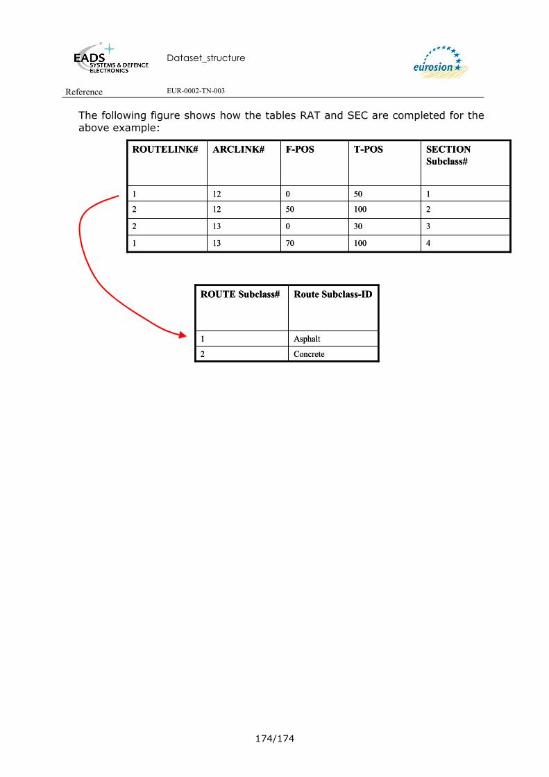
Dataset_structure
Reference EUR-0002-TN-003
174/174
The following figure shows how the tables RAT and SEC are completed for the above example:
210050122
3300132
410070131
1500121
SECTIONSubclass#
T-POSF-POSARCLINK#ROUTELINK#
210050122
3300132
410070131
1500121
SECTIONSubclass#
T-POSF-POSARCLINK#ROUTELINK#
Concrete2
Asphalt1
Route Subclass-IDROUTE Subclass#
Concrete2
Asphalt1
Route Subclass-IDROUTE Subclass#
Dataset_structure
Reference EUR-0002-TN-003
175/175
18. ANNEXE: GISCO NAMING CONVENTION
18.1. GENERIC RULES For more detail information on GISCO naming convention, refer to the GISCO database Manual [DR2]. General GISCO Syntax rules <layer><georeference><entity><specifier><source><time><scale><version><projection><operation><specifier>.<extension>
Syntax rules for Coverages <layer><georeference>{entity}{specifier}{source}{time}{scale}{version}{projection}{operation}{specifier}.<extension> Angle brackets <> mean the obligatory use of the topic Barces {} indicate an optional topic. Syntax rules for attribute tables (INFO tables) <layer>{georeference}{entity}{specifier}{source}{time}{version}.<extension> Syntax rules for items (attribute) <layer><entity>}{specifier}{source}{time}.<extension> Remark: To provide more understanble names, it is possible to add more than one specifier. 18.2. CODE LIST FOR SPECIFIERS CONTAINS AG Agency AL ALtitude AM Amplitude AR ARea
AV Average CD CoDe CN CouNter CP CaPacity DD Decimal Degrees DI DIrectional DN DeNsity DS DeScription DT DaTe
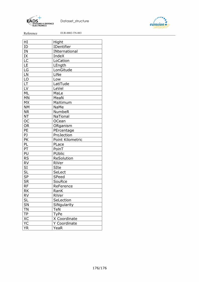
Dataset_structure
Reference EUR-0002-TN-003
176/176
HI Hight ID IDentifier IN INternational IX IndeX LC LoCation LE LEngth LG LonGitude LN LiNe LO Low LT LatiTude LV LeVel ML MaLe MN MeaN MX MaXimum NM NaMe NR NumbeR NT NaTional OC OCean OR ORganism PE PErcentage PJ ProJection PK Point Kilometric PL PLace PT PoinT PU PUblic RS ReSolution RV RiVer SI SIte SL SeLect SP SPeed SR SouRce RF ReFerence RK RanK RV RiVer SL SeLection SN SiNgularity TN TeN TP TyPe XC X Coordinate YC Y Coordinate YR YeaR

Dataset_structure
Reference EUR-0002-TN-003
177/177
19. CORINE COASTAL EROSION LAYER FIRST VERSION: CCER 1990 The structure of CCEr 1990 is provide here just for information. 19.1.1 Overview of the dataset structure
This CORINE COASTAL EROSION (CCEr) database VERSION 1 is hosted on the European Environment Agency (EEA) Web site.
It is composed of 3 compressed ArcInfo exchange:
- CEEC.e00.z Coast line at Scale 1 / 100 000
- CEEC1M.e00.z Coast line at Scale 1 / 1 000 000
- Infofiles.tar.z containing the following attributes tables:
o Ceecat.e00
o cecl.e00,
o ceev.e00,
o ceevl0.e00,
o cemo.e00,
o cemol0.e00,
o cems.e00,
o cetr.e00
19.1.2 DescrIption of the Arc Attribute Table of the Coverage CEEC:
This coverage corresponds to the geometry of the Coastline at scale 1 / 100 000.
Attribute Name
Type Description
FID OID Unique object identifier
CEEC
CEECAT
CEMO
CEEV
CEEC1M CECL CEMS CETR
CEMOL0
CEEVL0

Dataset_structure
Reference EUR-0002-TN-003
178/178
Shape Geometry Polyline
CESGCD String Coastal Erosion SeGment CoDe. This a unique code for every coastal segment. It consists of the ISO country code followed by a sequential number per country.
19.1.3 Description of the Arc Attribute Table of the Coverage CEEC1M This coverage corresponds to the geometry of the Coastline at scale 1 /1 000 000. It won’t be used to implement the EUROSION European Level database. Attribute Name Type Description
FID OID Unique object identifier
Shape Geometry Polyline
CESGCD1M String Coastal Erosion SeGment CoDe 1 Million. This a unique code
for every coastal segment. It consists of the ISO country code followed by a sequential number per country.
19.1.4 Description of the INFO table CEECAT.INF Attribute Name Type Description
rowid OID Unique object identifier.
CESGCD String Coastal Erosion SeGment CoDe. This a unique code for
every coastal segment. It consists of the ISO country code followed by a sequential number per country.
CESGCD1M String Coastal Erosion SeGment CoDe 1 Million. This a unique code for every coastal segment. It consists of the ISO country code followed by a sequential number per country.
NURGCDV5 String NUTS ReGion Code Version 5. Identification of NUTS administrative regions on level 3 (NUTS version 5), to which coastal segment belongs.
CEMO String Coastal Erosion Morphology. Morphology codes, explained in INFO table CEMO.INF. Item applies to coverage CEEC.

Dataset_structure
Reference EUR-0002-TN-003
179/179
CEEV Integer Coastal Erosion Evolution. Evolution codes, explained in INFO table CEEV.INF. Item applies to coverage CEEC.
CEDW String Coastal Erosion Defense Works. Indication of presence of man-made defensive structures: Y: defensive structures present N: defensive structures absent Item applies to coverage CEEC.
CECL String Coastal Erosion CoastLine. Coastline codes, explained in INFO table CECL.INF. Items applies to coverage CEEC1M.
CEMS String Coastal Erosion Morpho-Sedimentology. Morpho-Sedimentological codes, explained in CEMS.INF. Item applies to coverage CEEC1M.
CETR String Coastal Erosion evolutionary trends. Evolutionary trends codes are explained in INFO table CETR.INF. Item applies to coverage CEEC1M.
19.1.5 Description of the INFO table CEMO.INF This the description of the Coastal Erosion Morphology codes. This classification is composed of 19 different codes. Attribute Name Type Description
ROWID OID Unique object identifier.
CEMO Sring Coastal Erosion MOrphology. Morphology codes.
CEMODSEN String Coastal Erosion MOrphology DeScription ENglish
CEMODSFR String Coastal Erosion MOrphology DeScription FRench
CEMOL0 String Coastal Erosion MOrphology Level 0.
19.1.6 Description of the INFO table CEEV.INF This the description of the Evolution Trend Codes codes. This classification is composed of 10 different codes. Attribute Name Type Description
rowid OID Unique object identifier
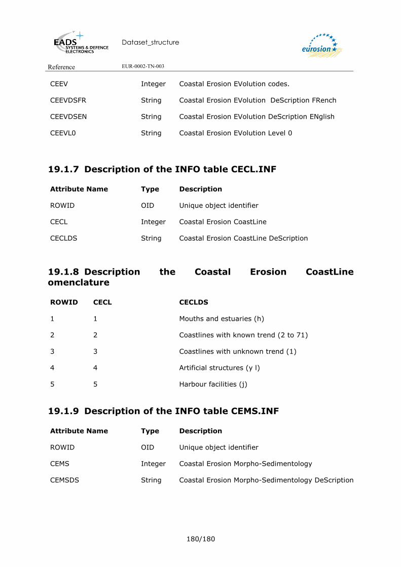
Dataset_structure
Reference EUR-0002-TN-003
180/180
CEEV Integer Coastal Erosion EVolution codes.
CEEVDSFR String Coastal Erosion EVolution DeScription FRench
CEEVDSEN String Coastal Erosion EVolution DeScription ENglish
CEEVL0 String Coastal Erosion EVolution Level 0
19.1.7 Description of the INFO table CECL.INF Attribute Name Type Description
ROWID OID Unique object identifier
CECL Integer Coastal Erosion CoastLine
CECLDS String Coastal Erosion CoastLine DeScription
19.1.8 Description the Coastal Erosion CoastLine omenclature ROWID CECL CECLDS
1 1 Mouths and estuaries (h)
2 2 Coastlines with known trend (2 to 71)
3 3 Coastlines with unknown trend (1)
4 4 Artificial structures (y l)
5 5 Harbour facilities (j)
19.1.9 Description of the INFO table CEMS.INF Attribute Name Type Description
ROWID OID Unique object identifier
CEMS Integer Coastal Erosion Morpho-Sedimentology
CEMSDS String Coastal Erosion Morpho-Sedimentology DeScription

Dataset_structure
Reference EUR-0002-TN-003
181/181
19.1.10 Description of the INFO table CETR.INF Attribute Name Type Description
ROWID OID Unique object identifier
CETR Integer Coastal Erosion TRend
CETRDS String Coastal Erosion evolutionary TRend DeScription
19.1.11 Description of INFO Table CEEVL0
Attribute Name Type Description
ROWID OID Unique object identifier.
CEEVL0 String Coastal Erosion EVolution Level 0
CEEVL0FR String Coastal Erosion EVolution Level 0 DeScription FRench
CEEVL0EN String Coastal Erosion EVolution Level 0 DeScription ENglish
19.1.12 Description the Coastal Erosion EVolution Level 0 nomenclature ROWID CEEVL0 CEEVL0FR CEEVL0EN
1 1 Non applicable Not applicable
2 2 Donnees non disponibles Not Information available
3 3 Stabilite Stable shoreline
4 4 Erosion Erosion
5 5 Engraissement Sedimentation
19.1.13 Description of INFO Table CEML0 Attribute Name Type Description
ROWID OID Unique object identifier

Dataset_structure
Reference EUR-0002-TN-003
182/182
CEMOL0 String Coastal Erosion MOrphology Level 0
CEMOL0FR String Coastal Erosion MOrphology Level 0 DeScription FRench
CEMOL0EN String Coastal Erosion MOrphology Level 0 DeScription ENglish
19.1.14 Description the Coastal Erosion MOrphology Level 0 nomenclature ROWID CEMOL0 CEMOL0FR CEMOL0EN
1 1 Cotes Rocheux
Rocky coasts
2 2 Plages
Beaches
3 3 Cote Limono-vaseux
Muddy coast
4 4 Cote fictive
Fictitious coast
5 5 Cote artificiel
Articicial coast

Dataset_structure
Reference EUR-0002-TN-003
183/183
20. NATIONALLY DESIGNATED AREAS DESCRIPTION FOR OTHERS EXISTING SOURCES This section provides description of existing dataset on nationally designated areas. This description is made according to the shape files provided by IGN FI. This description is just provided for information.
20.1. RAMSAR This dataset description is just provided for information as it won’t be integrated within the framework of EUROSION project. 20.1.1 Overview of the dataset structure A “Ramasar site” is the land listed as a Wetland of International Importance under the Convention on Wetlands of International Importance Especially as Waterfowl Habitat (the Ramsar Convention) 1973. Concerning this dataset, only Metadata on the following web site (+ the official ramsar.org URL): http://www.wetlands.org/RDB/Directory.html will be documented within the framework of Eurosion project. Right now only an extract of this dataset has been provided in shape format for RAMSAR sites in UK. According to the GISCO naming conventions it is proposed to title the coverage as follow NDXXRA100KV1 Thus NDXXN2100KV1 means:
• ND for Nationally Designated areas (the layer name) • XX the coutry or group of country (the georeference) • RA for RamsAr (the source) • 100K for scale 1:100 000 • V1 for Version 1
20.1.2 Description of the Poygon Attribute Table of coverage NDXXN2100KV1
Attribute Name Type Description
FID OID Unique object identifier.
Shape Geometry Polygon
GB_RAMSAR Float To be defined
RAMSAR_NAME String RAMSAR site name
NDXXRA100KV1NDXXRA100KV1

Dataset_structure
Reference EUR-0002-TN-003
184/184
RAMSAR_CODE String RAMSAR site international code
RAMSAR_AREA Float Total area of the RAMSAR site
RAMSAR_GRID_REF String The Easting, Northing, Latitude, Longitude and Map Reference for the RAMSAR site are derived from the geographic position of the centroid of the largest polygon for that RAMSAR site
RAMSAR_EASTING Float The Easting, Northing, Latitude, Longitude and Map Reference for the RAMSAR site are derived from the geographic position of the centroid of the largest polygon for that RAMSAR site
RAMSAR_NORTHING Float The Easting, Northing, Latitude, Longitude and Map Reference for the RAMSAR site are derived from the geographic position of the centroid of the largest polygon for that RAMSAR site
RAMSAR_LATITUDE String The Easting, Northing, Latitude, Longitude and Map Reference for the RAMSAR site are derived from the geographic position of the centroid of the largest polygon for that RAMSAR site
RAMSAR_LONGITUDE String The Easting, Northing, Latitude, Longitude and Map Reference for the RAMSAR site are derived from the geographic position of the centroid of the largest polygon for that RAMSAR site
COMPONENT_FILE String GIS filename
DESIGNATION String To be defined
ITEM001 Float Unique site intifier code. Each site has a unique seven digit integer code, used as a reference number. This code is referred to as the GID. For example the GIS for “The Quantocks” SSSI is 1001391.
ITEM002 String To be defined
POLYGON_AREA Float Hectares for this polygon
POLYGON_EASTING Float Easting for this polygon
POLYGON_NORTHING Float Northing for this polygon
GIS_DATE String GIS file last modified
VERSION Long Integer
Version

Dataset_structure
Reference EUR-0002-TN-003
185/185
20.2. SPA A Special Protection Area (SPA) is the land classified under Directive 79/409 on the Conservation of Wild Birds. Data supplied has the status “Classified”. This dataset description is just provided for information as it won’t be integrated within the framework of EUROSION project. Attribute Name Type Description
FID OID Unique object identifier.
Shape Geometry Polygon
OBJECTID Long
Integer
MIAID Long Integer
REFERENCE String SPA code. The SPA code comprises 9 characters, the first 2 being the ISO country code for the Member State (for example, PF for Portugal).
NAME String SPA site name.
DEC_AREA Double
To be defined.
CALC_AREA Double
To be defined.
PERIMETER Double
To be defined.
GRIDREF String Grid Reference. Map Reference is derived from the geographic position of the centroid of the largest polygon for that SPA.
COUNTY String Administrative authority name.
DCOUNCIL String To be defined.
CONSULTED Date To be defined.
CLASSIFIED Date To be defined.
ACCURACY String To be defined.
CHECKED String To be defined.
URLINK HttpLink To be defined.
LENGTH Double To be defined.
AREA Double To be defined.

Dataset_structure
Reference EUR-0002-TN-003
186/186
20.3. SAC A Special Area of Conservation (SAC) is the land desiganted under Directive 92/43/EEC on the Conservation of Natuarl Habitats and of Wild Fauna and Flora. Data supplied has the status of “Candidate”. This dataset description is just provided for information as it won’t be integrated within the framework of EUROSION project. Attribute Name Type Description
FID OID Unique object identifier.
OBJECTID Long
Integer To be defined.
MIAID Long Integer
To be defined.
MIAPERIMTR Double To be defined.
MIAAREA Double To be defined.
NAME String SAC site name.
REFERENCE String SAC code. The SAC code comprises 9 characters, the first 2 being the ISO country code for the Member State (for example, PF for Portugal).
SITE_TYPE String To be defined.
HABITAT String To be defined.
DESCRIPTIP String To be defined.
DEC_AREA Double To be defined.
CALC_AREA Double To be defined.
PERIMETER Double To be defined.
GRID_REF String Grid Reference. Map Reference is derived from the geographic position of the centroid of the largest polygon for that SAC.
COUNTY String Administrative authority name.
DISTR_COU String To be defined.
CONSULTED Date To be defined.
SUBMITTED Date To be defined.
DESIGNATED String To be defined.
ACCURACY String To be defined.

Dataset_structure
Reference EUR-0002-TN-003
187/187
CHECKED String To be defined.
FEATURES String To be defined.
INTERNET String To be defined.
LENGTH Double To be defined.
AREA Double To be defined.

Dataset_structure
Reference EUR-0002-TN-003
188/188
20.4. COMMON DATABASE ON DESIGNATED AREAS - CDDA This dataset description is just provided for information as it won’t be integrated within the framework of EUROSION project.
Attribute Name Type Description
FID OID Unique object identifier.
Shape Geometry Point
SITECODE Float To be defined.
SITECODE1 String To be defined.
PARENTIS String To be defined.
ISO3 String To be defined.
DESIGABB String To be defined.
AREANAME String To be defined.
SIZE Float To be defined.
DESIGNAT String To be defined.
NUTS1 String To be defined.
IUCNCAT String To be defined.
YEAR String To be defined.
LATNS String To be defined.
LATDEG Float To be defined.
LATMIN Float To be defined.
LATSEC Float To be defined.
LONNEW String To be defined.
LONDEG Float To be defined.
LONMIN Float To be defined.
LONSEC Float To be defined.
LAT Float To be defined.

Dataset_structure
Reference EUR-0002-TN-003
189/189
LON Float To be defined.
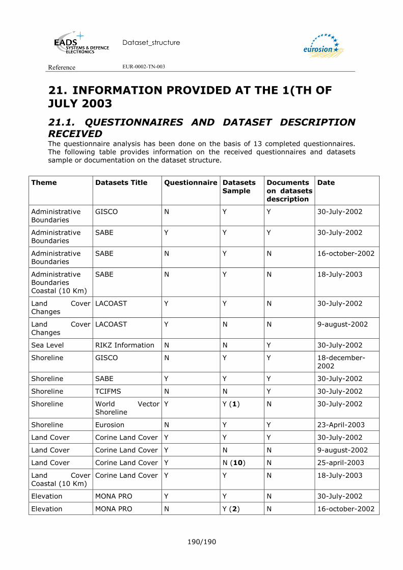
Dataset_structure
Reference EUR-0002-TN-003
190/190
21. INFORMATION PROVIDED AT THE 1(TH OF JULY 2003
21.1. QUESTIONNAIRES AND DATASET DESCRIPTION RECEIVED The questionnaire analysis has been done on the basis of 13 completed questionnaires. The following table provides information on the received questionnaires and datasets sample or documentation on the dataset structure.
Theme Datasets Title Questionnaire Datasets Sample
Documents on datasets description
Date
Administrative Boundaries
GISCO N Y Y 30-July-2002
Administrative Boundaries
SABE Y Y Y 30-July-2002
Administrative Boundaries
SABE N Y N 16-october-2002
Administrative Boundaries Coastal (10 Km)
SABE N Y N 18-July-2003
Land Cover Changes
LACOAST Y Y N 30-July-2002
Land Cover Changes
LACOAST Y N N 9-august-2002
Sea Level RIKZ Information N N Y 30-July-2002
Shoreline GISCO N Y Y 18-december-2002
Shoreline SABE Y Y Y 30-July-2002
Shoreline TCIFMS N N Y 30-July-2002
Shoreline World Vector Shoreline
Y Y (1) N 30-July-2002
Shoreline Eurosion N Y Y 23-April-2003
Land Cover Corine Land Cover Y Y Y 30-July-2002
Land Cover Corine Land Cover Y N N 9-august-2002
Land Cover Corine Land Cover Y N (10) N 25-april-2003
Land Cover Coastal (10 Km)
Corine Land Cover Y Y N 18-July-2003
Elevation MONA PRO Y Y N 30-July-2002
Elevation MONA PRO N Y (2) N 16-october-2002

Dataset_structure
Reference EUR-0002-TN-003
191/191
Theme Datasets Title Questionnaire Datasets Sample
Documents on datasets description
Date
Elevation MONA PRO N Y (6) N 6-may-2003
Geomorphology Corine Coastal Erosion (1990)
Y Y (3) Y 30-July-2002
Geomorphology Corine Coastal Erosion (Version of 1990)
N Y Y 18-december-2002
Hydrography GISCO Lakes N Y Y 30-July-2002
Hydrography GISCO Watersheeds
N Y Y 30-July-2002
Hydrography GISCO Watersheeds
N Y (9) Y 18-december-2002
Hydrography GISCO Water Pattern
N Y Y 30-July-2002
Hydrography GISCO Water Pattern
N Y (9) Y 18-december-2002
Hydrography GISCO Water Pattern
N Y N 18-July-2003
Infrastructure GISCO Airport N Y Y 30-July-2002
Infrastructure GISCO Airport N Y Y 18-July-2003
Infrastructure GISCO Ports N Y Y 30-July-2002
Infrastructure GISCO Railways N Y Y 30-July-2002
Infrastructure GISCO Roads N Y Y 30-July-2002
Infrastructure GISCO Settlements
N Y Y 30-July-2002
Bathymetry DBDB-V Y Y (4) N 9-august-2002
Bathymetry Digibath250 Y N N 9-august-2002
Bathymetry GEBCO Y N N 9-august-2002
Bathymetry GEBCO N Y (5) N 16-october-2002
Bathymetry Iowtopo Y N N 9-august-2002
Bathymetry GEBCO Y Y (7) N 23-april-2003
Bathymetry ETOPO5 N Y N 18-July-2003
Hydrodynamics and sea level rise
RIKZ information Y N N 14-august-2002
Hydrodynamics and sea level rise
RIKZ information Y Y (8) Y 11-July-2003

Dataset_structure
Reference EUR-0002-TN-003
192/192
Theme Datasets Title Questionnaire Datasets Sample
Documents on datasets description
Date
Hydrodynamics and sea level rise
RIKZ information Y Y (8) Y 18-July-2003
Law and Decress IGN FI Information
Y Access Database V1
Y 5-september-2002
Law and Decress IGN FI Information
N Access Database V2
Y 26-september-2002
Law and Decress IGN FI Information
N Access Database V3
Y 5-may-2003
Maritime Boundaries
IGN FI Information
N N Y 5-september-2002
Maritime Boundaries
IGN FI Information
N N Y 17-april-2003
Nationally Designated Areas
NATURA2000 N Y N (attribute description is missing)
29-july-2003 (documentation)
18-july-2003
(dataset extract)
23-april-2003
Nationally Designated Areas
RAMSAR N Y N (attribute description is missing)
6-may-2003
18-july-2003
Nationally Designated Areas
CDDA N Y N (attribute description is missing)
29-july-2003
Nationally Designated Areas
SPA N Y N (attribute description is missing)
29-july-2003 (documentation)
18-july-2003 (dataset extract)
1 Provided in .dat format.
2 Provided in TILE format.
3 Provided information doesn’t correspond to BRGM description of 1990 CCEr
4 Data provided with unknown format (chr and chr.yxz).
5 Provided in DXF format
6 Provided in GRID ASCII format

Dataset_structure
Reference EUR-0002-TN-003
193/193
7 Provided in SHAPE format
8 Provided in SHAPE format
9 Whole datasets for GISCO Water Pattern and Watersheeds
10 Provided in SHAPE and GEODATABASE formats
21.2. EXPECTED DATASETS EXTRACTS OR DESCRIPTION The following table provides information on the needed datasets sample or documentation on the dataset structure to achieve this document.
Theme Datasets Title Datasets Sample Documents on datasets description
Hydrodymacis & Sea Level Rise
PSMSL** Y Y
Law and Decress IGN FI Information Database coverage sample *
Y
Shoreline World Vector Shoreline
Ony geometry available in .dat format
Attributes description needed.
Bathymetry TCIFMS** Y Y
Nationally Designated Areas
SPA Y Attribute description is missing
Nationally Designated Areas
CDDA Y Attribute description is missing
Nationally Designated Areas
Natura 2000 Y Attribute description is missing
Nationally Designated Areas
pSCI*** N N
Sediments and discharges from river bassins
IFEN information N Y
Development of vulnerability indicators
IGN FI information Y Y
Maritime boundaries
IGN FI Information Database coverage sample expected
Y
* Three versions of an Access database description have been yet provided to EADS S&DE. An extract of the coverage in shape format is expected.
** Metadata only. Thus no more datasets extracts are expected.

Dataset_structure
Reference EUR-0002-TN-003
194/194
*** it is considered by IGN FI that this information is mainly a set of documentation and thus it is not a geographical information. For that reason it won’t be considered within the framework of EUROSION project.