Custom Tools for Urban Forestry Nonprofits and Outreach July 12, 2016
62
Chris Peiffer Presented by: www.planitgeo.com | [email protected] 1 Plan-It Geo welcomes you to … Custom Tools for Urban Forestry Non-Profits and Outreach July 12 th , 2016
-
Upload
chris-peiffer -
Category
Environment
-
view
17 -
download
0
Transcript of Custom Tools for Urban Forestry Nonprofits and Outreach July 12, 2016

Chris Peiffer
Presented by:
www.planitgeo.com | [email protected] 1
Plan-It Geo welcomes you to … Custom Tools for Urban Forestry Non-Profits and Outreach July 12th, 2016

GIS/Remote Sensing for Forestry/NR
Software: Urban Forest Cloud
• Web | Mobile | Desktop
• Subscription and custom apps
• 100+ clients/users
Tree Inventory | Risk Assessment
Urban Tree Canopy (UTC) Assessment
i-Tree Ecosystem Services Analysis
Management Plans
Color-Infrared
Natural Color
LiDAR-based Canopy Analysis
Our Services and Markets
www.planitgeo.com | [email protected] 3

Tree Plotter®
Canopy Planner®
Park Plotter®
Work Order Management®
Native Apps
Custom Apps
4 www.planitgeo.com | [email protected]
Software Products Overview

1. Software Overview Chris Peiffer (Plan-It Geo, Pennsylvania)
2. Branch Out Campaign Erin Miller (City of Columbus, OH)
3. PlantMOreTrees Tom Ebeling (Forest ReLeaf of Missouri)
4. Urban Forest Cloud Dana Dentice (PA Horticultural Society)
5. Recap and Q&A
Webinar Agenda
5 www.planitgeo.com | [email protected]

Software Overview
www.planitgeo.com | [email protected] 6
Tech Requirements
• Subscription-based
• Web-browser and Cloud-based • Web connection / URL
• No install or other software
• Mobile • Tablets and smartphones
• Map-based • Place tree points on imagery
• Variety of base maps to choose from
• Administration • Manage users and permissions

Web/Mobile Tree Inventory Components
Tools Edit Data Reports
Add / Move Trees
Login
Legend
www.planitgeo.com | [email protected] 7
Data Table Manager
Edit Tree Attributes Basic tree info

Tools in Tree Plotter
www.planitgeo.com | [email protected] 8
Bing
ESRI
Streets
Multiple imagery base maps for different situations (dense canopy, new development, or navigating streets …)

Make Awesome Maps of Your Trees
• Print & save maps
• Customize labels
• Choose position of legend, scale bar, title
9
www.planitgeo.com | [email protected] 9

www.planitgeo.com | [email protected]
• Use GPS for orientation or to zoom in, not collection
• Click/Tap the map to add new tree point
• x/y coordinate is populated from aerial imagery
Adding Trees
10
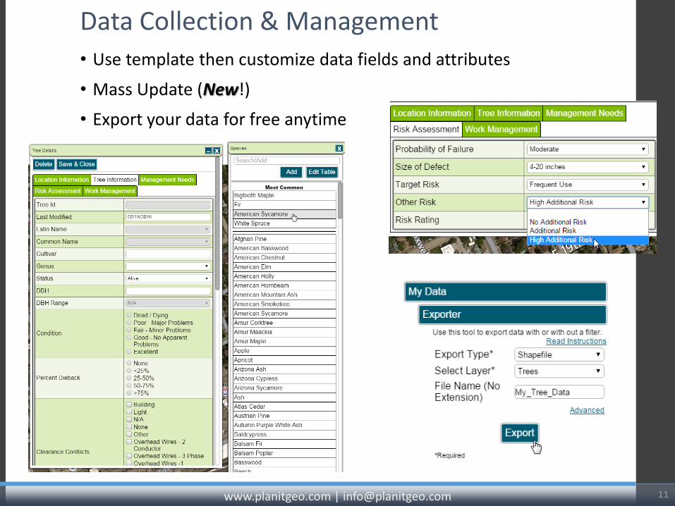
• Use template then customize data fields and attributes
• Mass Update (New!)
• Export your data for free anytime
Data Collection & Management
11 www.planitgeo.com | [email protected]

Filter: find specific trees
• by Attribute Fields or Map Polygon (or both) • Filters Apply to: the map, data table, exports,
and reports.
www.planitgeo.com | [email protected] 12

Print Reports
www.planitgeo.com | [email protected] 14
• Custom order and table of contents
• Add qualitative comments

Work Order Management
www.planitgeo.com | [email protected] 15
• Add-on module to TP
• Track service requests / print work orders

Non-Profit Organizations
www.planitgeo.com | [email protected] 16
What’s Unique? • Custom applications • Submitting managing
tree applications • Tracking
events/projects • Use of volunteers
and crowdsourcing • Data collection fields
(schema) • End-users

17
UP NEXT: Erin Miller, Environmental Steward, City of Columbus, OH
Branch Out Columbus
& Tree Canopy Planning Tool

• 22% tree canopy (31,171 acres) with 63% possible.
• Providing $12.1 million value annually
• Under threat, EAB etc. anticipate 200,000 trees will be lost
• Low income areas have less trees • 60,000 acres of land available
(PPA)- mostly private property • Set a goal to 27% canopy by
2020= 300,000 medium sized trees need planted.


Use Canopy Planner Tool to: • Track tree plantings- connect to web form • View tree canopy data spatially and download data • View tree planting events and where trees have been planted and species
breakdown. • Prioritize planting areas and identify neighborhoods for tree give-a-ways
• For example, we looked at neighborhood scale and selected those with UTC of 15% or less; with a PPA veg. acreage over 100 and weight settings of urban heat island as high priority; stormwater reduction, energy savings, water quality as medium priority and connectivity as low priority.
• Reduced choices from 200+ neighborhoods to 7.


Next Up: Tom Ebeling, Community Forester, Forest ReLeaf of Missouri
Plant MOre Trees

Mapping Missouri’s Trees
Tom Ebeling Community Forester

http://pg-cloud.com/PlantMOreTrees/
www.moreleaf.org [email protected]
Partners Initial funding for this project was provided by a MDC TRIM
grant, with additional financial and in-kind support from PlanIT-GEO
The City of Richmond Heights. MCFC Communications Committee

A 20/20 Vision : Plant One Million Trees by 2020
History Gene Brunk’s vision to plant
enough trees on 79% of the vacant public space (2010 MDC 44 community survey).
Create a means to get communities involved and excited about urban tree planting!
Similar initiatives in other states and cities.
Rallying cry for community forestry!

Tree Plotting Tool
Problem: How do we keep track of a million trees?
Solution: Plant More Trees! Created by Plan-It Geo based on Tree Plotter software
User friendly GIS interface

Tree Plotting Tool
Custom Functions:
Create projects and plot individual trees
Create an organization that projects can be attributed to
Add photos of tree and planting site
Visit sites on Google Street View
Record useful data (e.g. species, size at planting, stock type)
Produce statistics (diversity, health, ecosystem benefits)


Tree Plotting Tool
Fun map features! Layers
Statistics
Map Sources

Ecosystem Services & Benefits
* Based on i-Tree Tools
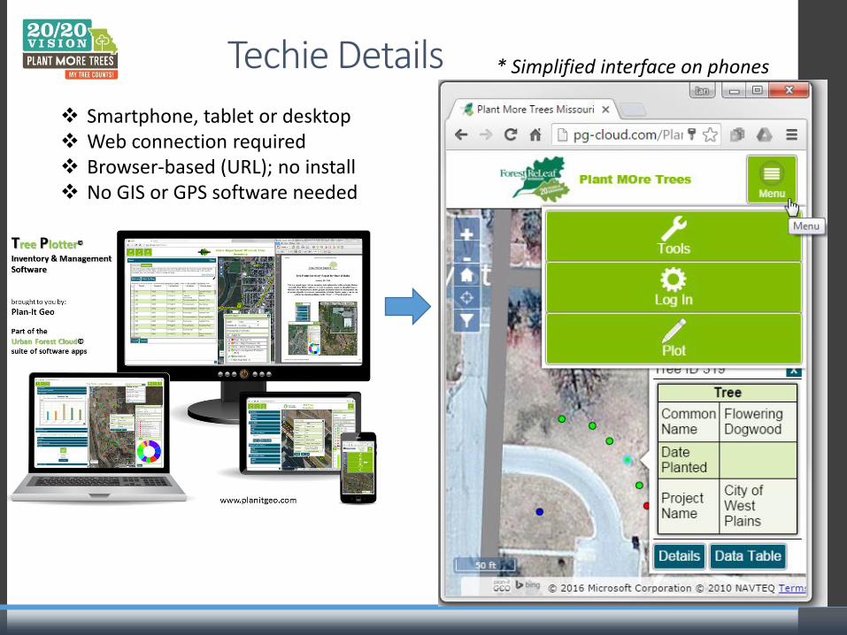
Techie Details
Smartphone, tablet or desktop Web connection required Browser-based (URL); no install No GIS or GPS software needed
* Simplified interface on phones

Why YOUR Tree Counts!
Plant MOre Trees has Multiple Uses Currently being used as inventory tool by Drury University in Springfield,
MO.

Why YOUR Tree Counts!
Plant MOre Trees has Multiple Uses Creates a statewide “call to action” and provides incentives for the public
to plant thousands of trees.
The tool gathers valuable urban forest data for use now and in the future.
The program is another way to build a network of tree advocates and educate the public about community forestry.
FRM uses app to track new planting projects
Private businesses can use the tool for marketing purposes.

Next Up: Dana Dentice, PHS Plant One Million Manager
Urban Forest Cloud

https://pg-cloud.com/phs/
PHS Urban Forest Cloud Dana Dentice Plant One Million Manager, ISA Certified Arborist [email protected]

The Pennsylvania Horticultural Society connects
people with horticulture, and together we create
beautiful, healthy and sustainable communities.

PHS Urban Forestry
Programs
Since 1993, PHS Tree Tenders has trained 4,500 volunteers to plant, monitor (Tree Checkers) and care for +20,000 trees
Multi-state initiative to educate and mobilize volunteers throughout the region to plant, count and tend trees with goal to restore canopy to 30%
Partnership to reverse the loss of tree cover in southeast PA through Tree Tenders and TreeVitalize Watersheds riparian plantings

PHS Tree Checkers
• Tracking tree health and stewardship data
• Tree care action and reminders
• Engaging homeowners
• Tree Tenders address issues (pruning, weeds)
• Goal: collect quality data to evaluate tree performance and success of Tree Tenders program

Before the Urban Forest Cloud…
• Word/pdf application forms
• Application and tree data manually entered and maintained in many spreadsheets by PHS, city street tree inspectors and Tree Tenders groups
• Data not housed in a central location nor in consistent format- lots of time prepping data for archival and analysis!
• No easy way to join tree health data back to planting records
• No system in place for systematically tracking a tree’s maintenance or growth history
• Not much of our tree data has been mapped accurately or in one dataset

49
PHS Urban Forest Cloud
Tabular/map interfaces Import/export/update Stats and reports Printing maps Advanced filter Interactive legend
4 planting programs Historical and future data
on trees, projects and orgs Online application forms
A web-based and mobile device friendly application for collecting and managing tree planting data using Tree Plotter software

User Groups
Public can request trees or view map without account
3 login levels for users – different editing privileges 1. PHS admin, external admin (County
Conservation Districts) 2. Tree Tenders group leaders, Watershed grant
applicants 3. Other Tree Tenders, Phila Street Tree
Inspectors

51
Apply for trees online Map tree location Electronic signature Automatic email notification Approve applications online
Online Forms

Add species and event time/date via Look Up Table Editor Create tree species availability table (dynamic) Confirmation email
Tree Giveaways & Table Editor

PHS Tree Checkers
• Collecting tree health and maintenance data via mobile device
• Save photos
• Long-term monitoring (growth rate)

Live Demo of Urban Forest Cloud
https://pg-cloud.com/phs/

Table, forms, tree points, and charts all integrated View, sort, filter, edit, data Manage and sort by field Filter by map Mass update
Data Table Management

4) Make updates
5) Import to app
3) Export spreadsheet
Import / Export Data
2) Protect/omit/order fields
1) Select trees

Select multiple fields Or filter within the map View and edit trees that meet criteria
Advanced Filter

58
View trees by: Tree Tenders Group Species Status Season
Interactive Legend

Program Stats

Lessons Learned
Document your data and workflow in detail Establish a consistent system for tracking bugs and updates The more simple your tool, the better for all
Enhancements
Integrate City of Phila tree planting and parcel data Incorporate tree benefit summaries and forecasts User wizard tool (describes process) Tree species selection resources Enhanced for long-term tree monitoring Editable online forms and confirmation emails Attach documents to trees/projects Additional custom reports and charts

Dana Dentice Plant One Million Manager, PHS [email protected] 215-988-1618
Questions?
https://pg-cloud.com/phs/

62
Recap & Resources
1. Tree Plotter main page, resources: i. http://www.planitgeo.com/#!new-tree-plotter/c12n
ii. Recorded webinars iii. Short how-to videos iv. FAQs and user guide v. Phone/email support
2. Quarterly Training Webinar 3. All webinars: http://www.planitgeo.com/#!webinars/cfzv
App URLs for Non-profits: i. Demo App: https://pg-cloud.com/tpDemo ii. Columbus, OH: https://pg-cloud.com/columbus/ iii. Forest ReLeaf: https://pg-cloud.com/PlantMOreTrees/ iv. Urban Forest Cloud: https://pg-cloud.com/phs/ i. Others:
Presenters app featured in SMA: https://issuu.com/planitgeoissuu/docs/online_tree_planting-plan-it-geo_ia Keep Indianapolis Beautiful: https://pg-cloud.com/KIB/
www.planitgeo.com | [email protected]

Chris Peiffer, Urban Forester and Business Developer
(717) 579-9890 | [email protected]
Erin Miller, Environmental Steward, Columbus, OH
Tom Ebeling, Community Forester, Forest ReLeaf of MO
Dana Dentice, PHS Plant One Million Manager
Plan-It Geo: A geospatial technology, software, consulting, and planning firm specializing in urban natural
resource management.
[email protected] www.planitgeo.com
THANK YOU! PRESENTATION CONTACTS:
63
Information for ISA Credits will be sent to all
attendees