Current USACE Land Barrier Concept - TAMUG
16
Chapter 3. Land Barrier Must Be Stronger Current USACE Land Barrier Concept The current land barrier concept features a double-dune design and added beach along the open coast of Bolivar Peninsula and West Galveston Island as a combined Coastal Storm Risk Management (CSRM) and Ecosystem Restoration (ER) feature (G5 in USACE report). The proposed Bolivar Peninsula and Galveston Island Gulf beach and dune creation and restoration stretches 25.1 and 18.4 miles, respectively, along the existing beach (total length: 43.5 miles). The beach and dune system would extend from High Island to the Bolivar Roads East Jetty on the Bolivar Peninsula and west of the seawall on Galveston Island all the way to San Luis Pass. The design features a natural double-dune system with a 14-ft landward and a 12-ft seaward dune crest elevation. All elevations are based on NAVD88. Both dunes have a crest width of 15 ft. The base width of the landward dune is 94 ft (somewhat variable based on location) and the base width of the seaward dune is 82 ft. There is an 8-ft gap between the landward toe of the seaward dune and the seaward toe of the landward dune. The landward dune toe is located at 6 ft elevation and the seaward dune toe is located at 4 ft elevation. A nourished beach template is added in front of the seaward dune with a slope of 100H:1V and a beach width of 200 to 250 feet. Figure 3-1 provides a side-view of the proposed dune system template. Figure 3-1. Schematic cross-section of the USACE proposed double-dune system profile template (USACE, 2020) Dunes would be planted with Texas dune grass species (commercially bought or transplanted from natural stands along the coast). Plant grass species include bitter panicum (Panicum amarum), sea oats (Uniola paniculate), and marshhay cordgrass (Spartina patens). Dune fences would be installed at appropriate locations (4 ft above local sand surface as the standard, 2 ft where conditions are poor for dune building). The USACE report proposes the creation of “43 miles of beach and dune segments on Bolivar Peninsula and West Galveston Island that work with the Bolivar Roads Gate System to form a continuous line of defense against Gulf of Mexico surge, preventing or reducing storm surge volumes that would enter the Bay system” (USACE, 2020, p. 54). Sand volumes needed to create and re-nourish the beach and dune
Transcript of Current USACE Land Barrier Concept - TAMUG

Chapter 3. Land Barrier Must Be Stronger
Current USACE Land Barrier Concept
The current land barrier concept features a double-dune design and added beach along the open coast of Bolivar Peninsula and West Galveston Island as a combined Coastal Storm Risk Management (CSRM) and Ecosystem Restoration (ER) feature (G5 in USACE report). The proposed Bolivar Peninsula and Galveston Island Gulf beach and dune creation and restoration stretches 25.1 and 18.4 miles, respectively, along the existing beach (total length: 43.5 miles). The beach and dune system would extend from High Island to the Bolivar Roads East Jetty on the Bolivar Peninsula and west of the seawall on Galveston Island all the way to San Luis Pass. The design features a natural double-dune system with a 14-ft landward and a 12-ft seaward dune crest elevation. All elevations are based on NAVD88. Both dunes have a crest width of 15 ft. The base width of the landward dune is 94 ft (somewhat variable based on location) and the base width of the seaward dune is 82 ft. There is an 8-ft gap between the landward toe of the seaward dune and the seaward toe of the landward dune. The landward dune toe is located at 6 ft elevation and the seaward dune toe is located at 4 ft elevation. A nourished beach template is added in front of the seaward dune with a slope of 100H:1V and a beach width of 200 to 250 feet. Figure 3-1 provides a side-view of the proposed dune system template.
Figure 3-1. Schematic cross-section of the USACE proposed double-dune system profile template (USACE, 2020)
Dunes would be planted with Texas dune grass species (commercially bought or transplanted from natural stands along the coast). Plant grass species include bitter panicum (Panicum amarum), sea oats (Uniola paniculate), and marshhay cordgrass (Spartina patens). Dune fences would be installed at appropriate locations (4 ft above local sand surface as the standard, 2 ft where conditions are poor for dune building).
The USACE report proposes the creation of “43 miles of beach and dune segments on Bolivar Peninsula and West Galveston Island that work with the Bolivar Roads Gate System to form a continuous line of defense against Gulf of Mexico surge, preventing or reducing storm surge volumes that would enter the Bay system” (USACE, 2020, p. 54). Sand volumes needed to create and re-nourish the beach and dune

system are provided in Table 3-1. The USACE assumes (based on numerical modeling) that the seaward dune provides a source of material to re-nourish the beach over time.
“The beach feature does not provide a comparable scale of risk reduction as the levee [previous suggestion using set-back elevated roadway], but is placed gulfward of all structures, creates fewer community impacts, and benefits from the natural resiliency of sand systems. The larger beach feature also sustains the barrier features and supports the function of the Bolivar Roads Gate System.” (USACE, 2020, p. 51)
Table 3-1. Sand volumes needed for beach and dune construction and maintenance
Sand Use Sand Volume Sand Volume per Unit Length
Bolivar initial beach & dune construction 22.14 million cu.yd 167.12 cu.yd/ft
Galveston initial beach & dune construction 17.19 million cu.yd 177.43 cu.yd/ft
Renourishment (every 6 years on Bolivar and every 7 years on Galveston Island)
21.56 million cu.yd 2.156 cu.yd/ft per year for Bolivar example
Drainage of rainwater based on 100-year design storm were incorporated into the analysis as some developments on West Galveston Island and Bolivar Peninsula drain toward the Gulf of Mexico. A total of 39 drainage culverts (24-in diameter) are proposed for West Galveston Island with flap gates to prevent flow from the Gulf through the dunes. Ditches along the backside of the landward dune are proposed to collect and transport rain storm runoff water and transport it laterally before conveying it to the open ocean. For Bolivar Peninsula a total of 48 drainage culverts (varying sizes) with flap gates are proposed.
It is noted that an additional ER measure consisting of a smaller dune and beach nourishment is added on Follets Island (ER measure B2). The Follets Island Gulf beach and dune restoration stretches over 10.1 miles. A dune crest elevation of 9 ft (NAVD88) and crest width of 12 ft are intended (although USACE, 2020, Appendix D, Section 7.3 states 10 ft of crest width) with 5H:1V slopes. An additional subaerial beach width of 200 ft after profile equilibration is planned via nourishment. Beach and dune construction at Follets Island would require 802,000 cubic yards (cu.yd) of sand. This volume is estimated to compensate for erosion that usually occurs over a 10-year period. Re-nourishment plans are not included due to potential cost-sharing issues.
USACE Methods to Evaluate Dune Design
The dune system design and optimization approach are presented in USACE (2020, Appendix D). The USACE states that crest elevations are based on a damage overtopping limit state with annual exceedance probability of 1%. The assumption is made that maximum water level elevation and wave height occur simultaneously. ADCIRC runs with a fixed dune crest at 12 feet (NAVD88) were conducted to calculate flooding extent for different alternative solutions and different storms. The 12-ft dune
height was chosen to acknowledge the effect of dune wave overtopping and overwash before surge levels exceed the dune crest.
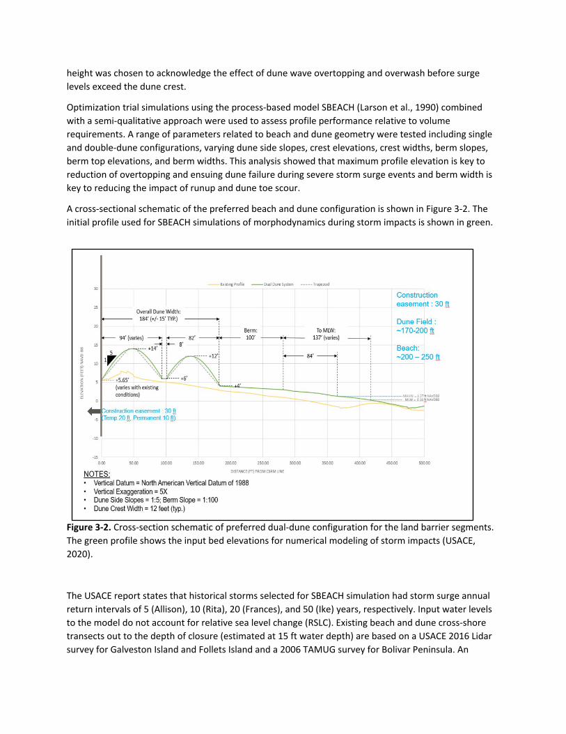
Optimization trial simulations using the process-based model SBEACH (Larson et al., 1990) combined with a semi-qualitative approach were used to assess profile performance relative to volume requirements. A range of parameters related to beach and dune geometry were tested including single and double-dune configurations, varying dune side slopes, crest elevations, crest widths, berm slopes, berm top elevations, and berm widths. This analysis showed that maximum profile elevation is key to reduction of overtopping and ensuing dune failure during severe storm surge events and berm width is key to reducing the impact of runup and dune toe scour.
A cross-sectional schematic of the preferred beach and dune configuration is shown in Figure 3-2. The initial profile used for SBEACH simulations of morphodynamics during storm impacts is shown in green.
Figure 3-2. Cross-section schematic of preferred dual-dune configuration for the land barrier segments. The green profile shows the input bed elevations for numerical modeling of storm impacts (USACE, 2020).
The USACE report states that historical storms selected for SBEACH simulation had storm surge annual return intervals of 5 (Allison), 10 (Rita), 20 (Frances), and 50 (Ike) years, respectively. Input water levels to the model do not account for relative sea level change (RSLC). Existing beach and dune cross-shore transects out to the depth of closure (estimated at 15 ft water depth) are based on a USACE 2016 Lidar survey for Galveston Island and Follets Island and a 2006 TAMUG survey for Bolivar Peninsula. An

example for Galveston transect XS1 is shown in Figure 3-3 where the existing profile and two design profiles for different median sediment sizes of the nourished material are displayed. Here, the existing profile native median sediment size is assumed to be 0.08 mm based on equilibrium beach concepts.
Figure 3-3. Beach profiles out to depth of closure for Galveston representative transect XS1. The measured existing profile (2016) is shown together with two design profiles featuring different median sediment sizes of the fill material (USACE, 2020).
The dual-dune concept requires 16% more sediment volume than a single dune with the same primary dune configuration, although this number seems to assume that the seaward dune is simply added on top of the berm of the single dune design without extending the berm width by the 82-ft base length of the seaward dune. Even with the reduced berm width of the dual-dune design the perceived benefits to erosion resistance during frequently occurring storms seem to outweigh the extra cost based on SBEACH simulation results. The USACE report states that on average the dual-dune system reduces wave height, water depth, and duration of inundation at the CSRM line just landward of the dune system by 87% (from 4.73 to 0.63 ft), 88% (from 9.66 to 1.13 feet), and 95% (from 51.75 to 2.44 hours), respectively, compared to the existing profile based on Hurricane Ike forcing. Furthermore, it is acknowledged that additional analysis is needed to quantify the relative risk reduction.
Sediment for all initial construction of dunes and beaches and maintenance nourishment is tentatively sourced from Sabine and Heald Bank offshore locations (40 mile distance, 40-50 ft water depth) and will be dredged and transported by a large-sized hopper dredge working in concert with track dozers and excavators on the beach to distribute pumped sediment. Sediment input parameters to the SBEACH

model are 0.16 mm, 0.14 mm, and 0.13 mm for Bolivar Peninsula, Follets Island, and Galveston Island, respectively.
The USACE report states that during Hurricane Ike simulations “the dune fails quickly once overtopping begins, leaving the upland area exposed to storm surge and direct wave impact”. The SBEACH modeling results showing initial and final profiles as well as erosion and accretion areas are shown in Figure 3-4. It is worth mentioning that the USACE SBEACH simulations for Hurricane Ike produce a peak water level (surge + setup) at the coast of 12.84 ft (more than 1 ft below the initial elevation of the landward dune crest). Under these conditions both dunes are completely wiped out.
Figure 3-4. Example of storm-induced double-dune profile response to Hurricane Ike forcing for Galveston Island profile XS1 (USACE, 2020)
Core-enhanced dunes were also tested with SBEACH by simulating an impermeable non-erodible core. Simulation results were deemed unreliable and were not considered further in the USACE design efforts. A comment was made, however, that further exploration of this alternative may be worthwhile during the Project Engineering and Design (PED) phase, albeit unspecified concerns regarding potential aesthetic and environmental impacts. Potential wave scour at the toe of such a hybrid structure once exposed was mentioned as an issue along with potential core failure that could spread in the alongshore direction. Another issue raised was the potential for the use of sand over top a hardened core to cause reduced internal stability and promote seepage due to different material properties. These concerns are not substantiated with further calculations.
Positive Aspects of USACE Land Barrier Design
The USACE is to be commended for selecting a land barrier along the open beach instead of levee solutions further back. The idea of a beach nourishment effort to support the dune component of the land barrier and bolster regional sediment supply is also a great feature of the current plan where the added beach width helps reduce wave energy that reaches the dune line during surge events. The choice of a dual-dune system instead of a single dune certainly adds a needed level of resiliency against

storm impact and erosion and is viewed as a positive aspect of the plan, providing additional buffer capacity.
The USACE report does state that dune and beach systems are soft coastal features and that prevention or mitigation of inundation with the proposed design profiles is not solely predicated on dune failure itself, but on when and how the dune fails. Additionally, USACE states that the “buffer” provided by the seaward dune affords some extra time before failure during storm impact which is crucial for risk mitigation.
The choice of 1V:5H slopes for the dunes is a good choice to mimic the slopes of existing “healthy” dunes on Galveston Island and to aid vegetation advancement. Selecting native Texas dune vegetation species for planting efforts is also a great feature of the proposed plan.
The USACE is to be commended for their special consideration of drainage from rainwater runoff toward the Gulf through the dunes via culverts and flap gates. If runoff drainage is not treated properly, dune and beach scouring, culvert damage, clogging, and hazardous beach conditions can ensue. The USACE states that conveyance of runoff to bayside outfalls instead of Gulf-side outfalls would alleviate many of the concerns related to runoff flows being conveyed alongside and through the dune system. This is an important aspect of the overall functionality of the storm risk reduction system and should not be neglected during the PED phase.
The inclusion of proper walkovers and vehicle ramps that do not compromise the integrity of the dune system is viewed favorably, as well as the inclusion of sand fencing and drainage structures.
The proposed plan to start construction of the whole system with the dune and beach is a good idea, as long as the construction of the Bolivar Roads Gate System commences in parallel. The gates reduce inflow of water into the bay even without the land barrier in place as soon as they are functional and can be closed at the appropriate time. The proposed idea to start land barrier construction with the Bolivar Peninsula dunes and beaches adjacent to the Bolivar Roads north jetty working outward is good and should be mirrored on Galveston Island starting at the west end of the seawall working outward toward San Luis Pass.
Shortcomings of USACE Land Barrier Design
The desire to balance residual flood risk due to overtopping and breaching of natural dunes during storm impact with some stakeholder recommendations to mimic existing/natural conditions as much as possible creates a dangerous situation during those situations for which the entire system has been conceived in the first place: overall risk reduction during storm impact. The creation of such a weak link compromises the entire system during time of need. It also has to be recognized that Galveston dune systems have been degraded over a long time and basing a storm surge barrier design on a degraded system is not sufficient.
The notion that a fixed 12-foot dune elevation during ADCIRC storm impact simulations is a proper representation of the degraded dune and/or wave overtopping before surge levels reach the actual 14-foot crest is a dangerous assumption that ignores the actual dune morphodynamics during storm impact. A 12-foot high solid wall is much more efficient at reducing flooding from storm surge and wave

overtopping than a dune breached completely at multiple locations. The USACE life-cycle modeling using CSHORE coupled with Monte-Carlo simulations of storm forcing showed that the dual-dune system experiences maximum crest elevations below 12 ft (2-ft crest elevation reduction) over significant portions of its 50-year life-cycle between renourishments. For the Galveston dual-dune profile XS1 this is the case for over 70% of the time for both the high and low RSLC estimates, respectively. Furthermore, process-based cross-shore only (1-D) models such as SBEACH (used by the Galveston District for dune design) and CSHORE (used by ERDC for life-cycle modeling) tend to understate dune breach channel formation and ultimately the risk of flooding. A more realistic assumption for a fixed elevation of this dune system to be used for ADCIRC computations should be closer to 9 ft considering the life-cycle analysis and breaching underrepresentation. It is also not clear how the USACE design dune crest elevations are based on a damage overtopping limit state with annual exceedance probability of 1% as stated in their report.
SBEACH runs utilize offshore NOAA buoy data on waves to drive model simulations. It is not described in detail how the transformation of these waves as they approach the shoreline (refraction, shoaling, diffraction) is handled (i.e. what bathymetric assumptions were made) and whether nonlinear effects and effects related to infragravity waves were considered. These processes can increase runup and erosion levels at the shore- and dune-line significantly, especially in such a shallow-slope environment as the Texas coast.
The current dune morphodynamic simulations under storm impact using SBEACH do not include RSLC scenarios. PED phase recommendations include life-cycle analysis probabilistic modeling accounting for background erosion and RSLC. A comment is made in the USACE report that this may require updates to the dune design to accommodate new findings. It seems strange that a wide range of dune geometric parameters were tested with the SBEACH model, but potential water level increases were not accounted for. This would be an easy addition to the modeling, especially since the relative elevation of the dune crest to peak surge levels is one of the most critical components in the evolution (or destruction) of a dune during storm impact. Another aspect that is not yet considered is the effect of gradients in alongshore sediment transport and how they may affect renourishment volumes and frequencies.
The proposed natural dual-dune system with 14 ft and 12 ft crest heights, respectively, is only shown to be able to withstand (with significant erosion of the seaward dune) storm impact produced by TS Francis at present sea level conditions based on SBEACH results (Figure 3-5). The USACE report lists TS Francis as having a 20-year annual return interval (ARI) but in fact surge levels for TS Francis are closer to the 5-year ARI based on NOAA water level data from the Pleasure Pier gauge on the Gulf side of Galveston Island. Based on the same gauge data, the maximum recorded water levels for storms Allison, Rita, Frances and Ike were 3.9, 4.0, 5.5, and 11 ft (NAVD88), respectively. Based on Figure 2-22 (USACE, 2020, Appendix D, p. 2-31) which shows hazard curves at 90% confidence interval without relative sea level change, these four storms are 2-, 3-, 5-, and 30-year water level events, respectively. In addition, the ERDC CSHORE modeling suggests complete dune destruction during Hurricane Ike with its 11-ft maximum water level corresponding only to a 30-year return value. This simply seems too weak of a protection level, especially in light of the fact that such a weakness in the overall system will compromise the intent to keep surge waters out of Galveston Bay and thus render all other features less effective (Bolivar Roads Gates) or under-designed (in-bay measures).

Figure 3-5. Example of storm-induced double-dune profile response to TS Francis forcing for Galveston Island profile XS1 (USACE, 2020)
Potential Alternative using Core-Enhanced Dunes / Hybrid Coastal Structures
A natural dune capable of safely defending against the 100-year design storm conditions was determined to be 22 feet high, 300 feet wide, and have a 150-foot wide crest through work conducted by a TU Delft M.Sc. student (Rodriguez Galvez, 2019) using the numerical model XBeach (Roelvink et al., 2009) to verify the performance of the dune under design conditions The crest width proposed by Rodriguez Galvez (2019) is 10 times the width of one of the USACE proposed dunes in the current plan. The required footprint is thus significantly larger than the one currently envisioned by the USACE and existing viewshed concerns would be exacerbated by this crest elevation (8 feet higher than USACE proposed maximum dune crest elevation). Alternatives that limit footprint and elevation while at the same time preserve the natural fabric and aesthetics of the coastal system are needed.
One viable alternative for the land barrier that can alleviate the issue of a compromised dune system during severe storm impact while preserving the aesthetics and ecosystem functions of a natural dune is a core-enhanced dune, sometimes referred to as a hybrid coastal structure (Almarshed et al., 2020). This option is mentioned in the USACE document but not further pursued due to numerical model limitations and other arguments that are not further elaborated or substantiated in the USACE report. Some of the arguments mentioned against core-enhanced dunes are related to aesthetic and environmental concerns, toe scour, and internal stability due to seepage flows between different materials. None of these arguments seem warranted. Core-enhanced dunes look exactly like natural dunes from the outside and provide the same ecosystem functions. Toe scour can happen but is deemed a small issue compared to the devastating destruction of a natural dune during storm impact. Furthermore, the sand cover helps alleviate toe scour issues: during intense storms with overtopping and overwash, the average sediment transport direction is landward and no substantial toe scour forms. During less intense storms, the sediment cover helps reduce the potential for toe scour formation. Internal stability issues due to seepage flows at the interface between different materials making up the hybrid structure

are also not as critical as a destroyed natural dune and can be avoided through proper design (i.e. filter layers, etc.).
Core-enhanced dunes consist of a hard core covered by a layer of sand. They combine effective surge suppression characteristics of the core structure with the aesthetic appeal and ecological benefits of dunes. These hybrid systems look and feel like natural dunes but their performance during storm impact is much improved. Figure 3-6 shows a schematic of hybrid coastal structure dynamics during storm impact to provide an idea how the concept works. A key point is that the fortified dune provides resilience when it is overwashed. The structural core will remain standing and limit inflow and flooding. A regular dune would be eroded and breached and this would also lead to more flooding.
Figure 3-6. Schematic of hybrid coastal structure dynamics under severe storm impact including wave overtopping and sediment overwash. The shown example utilizes a rubble mound as the solid core.
Core alternatives include structures made from clay, reinforced concrete T-wall elements, rubble mound material, or combinations thereof. The sand cover thickness can be varied as needed. In the following, beneficial characteristics of core-enhanced dunes are listed:
• Core-enhanced dunes look and feel like natural dunes. • They can be vegetated just like natural dunes. • Dual-dune design proposed by USACE can be adapted using a core-enhanced version for the
landward dune. This can help alleviate the restraints on dune elevation due to viewshed concerns that would arise with a natural dune system sized to withstand design storm conditions.

• Core structure can guarantee fixed level of protection without the risk of complete breaching and unobstructed landward-directed flood flow as is possible with all natural dunes.
• At the same time, the sand cover still affords some of the beneficial flood risk reduction aspects of natural dunes during storm impact (i.e., erosion buffer, self-healing effect through re-deposition of eroded dune material)
• Variable core designs are conceivable (clay, T-wall, rubble-mound, or combination thereof) and can be chosen based on desired characteristics, costs, and availability of material.
• Sand cover thickness is variable and can be adjusted to accommodate RSLC or updated design conditions in the future.
• Environmental functionality of hybrid dunes remains intact (sea turtle nesting, vegetation growth, bird nesting).
• Walkover and vehicle access structures can be used as currently anticipated by the USACE. • Proposed rainwater runoff drainage structures (culverts with flap gates) can be integrated into
hard core structure in such a way that the creation of weak points in the surge defense system can be avoided. Running culverts through natural dunes can create preferential scour paths and can easily induce culvert breakage.
• The sand volume required to build and maintain the core-enhanced dunes is less than that for natural dunes.
• The self-healing function of the beach-dune system during storms where sand material from the frontal face of the dune is eroded under wave impact, transported offshore, and deposited as a submerged bar to reduce wave energy at the dune is still functioning with a hybrid system.
• During severe storm impact the volume of sand overwashed over the crest of the hybrid structure and transported into the landward residential areas is much reduced from a natural dune. This reduces the hazard of sand deposits that can cover roadways, drainage infrastructure, evacuation routes, emergency access roads, etc. Thus, the hybrid design allows for quicker recovery after storm impact and improved community resilience against flood damage.
• While toe scour at the seaward edge of the core structure during storm impact is a possibility, the sand cover does provide material to limit the potential of scour formation. During significant overwash, the transport of sediment is primarily landward-directed and toe scour is not an issue. For less severe storms, the sand cover eroded from the hybrid dune face alleviates the scour issue. Additional toe scour protection can be added if necessary. If a dual-dune hybrid system is adapted, the seaward dune affords additional scour protection and we do not foresee significant scour issues.
• The core-enhanced dune system provides consistent surge protection while being far less dependent on renourishment cycles compared to an all-natural dune system. This increased resiliency is particularly important in situations where back-to-back hurricanes occur in the same season or multiple hurricanes occur over several seasons without renourishment of the dune and beach taking place. Thus the core-enhanced dune system will be much more amenable to a periodic renourishment plan than an all-natural dune system, which could remain in a degraded state awaiting renourishment for a long time.
It has to be noted that the lee side of the core structure will have to be designed in such a way as to withstand scouring from overtopping flow and seepage flow induced by external water level gradients

between the ocean and bay side during storm impact with the added benefit that the sand cover will help reduce design requirements to some extent.
Core-enhanced dunes have successfully reduced coastal flood risk and erosion in many locations around the world. Some examples are shown in Figure 3-7.
Figure 3-7. Examples of existing core-enhanced dunes from (a) Noordwijk, the Netherlands, (b) Katwijk, the Netherlands, (c) New Jersey, U.S., (d) Hawaii, U.S., (e) Virginia, U.S., (f) Scheveningen, the Netherlands.
(a) (b)
(c)
(d)
(e) (f)

Performance of Normal and Core-Enhanced Dunes under Design Storm Conditions
In the following, select results from numerical model runs using the process-based cross-shore morphodynamic model CSHORE (Johnson et al., 2012; Kobayashi 2013) are presented. CSHORE is the same model used by the USACE Engineering Research and Development Center (ERDC) for the morphodynamic component of their life cycle beach and dune evolution analysis of the various land barrier dune configurations (USACE, 2020, Annex 1). CSHORE is a robust process-based cross-shore hydrodynamic and morphodynamic numerical model capable of computing beach and dune profile evolution under varying hydrodynamic forcing conditions.
A variety of storm conditions and dune designs (natural and hybrid) have been evaluated using CSHORE. A brief introduction to CSHORE, the complete set of hydrodynamic forcing conditions, and an extended set of profile evolution results are provided in Appendix A. The few example outputs shown here are intended to provide a feel for the dune system (natural and hybrid) response to storm forcing. Emphasis is on the temporal evolution of the dune system profiles during storm impact since it is critical to quantify the duration over which a dune system can provide adequate protection against flooding.
Figure 3-8 shows time series of hydrodynamic forcing conditions used as input to CSHORE model runs. Water level change (WL), root-mean-square wave height (𝐻𝐻𝑟𝑟𝑟𝑟𝑟𝑟), peak wave period (𝑇𝑇𝑝𝑝), and mean wave direction (𝜃𝜃𝑟𝑟) for proxy storms with defined ARI (10-year, 100-year, 500-year) as well as Hurricane Ike are shown at the location of the ADCIRC output point S11, just offshore of west Galveston Island in 14 m water depth.
Figures 3-9 and 3-10 show some example CSHORE model results of profile evolution under Hurricane Ike storm forcing for natural dunes as well as core-enhanced dunes. Figure 3-9 uses the USACE dual-dune geometry while Figure 3-10 uses a similar geometry but with increased crest elevations. Note that profile evolution is only shown until the onset of significant overwash and dune crest reduction since the CSHORE model is not intended to deal with inundation flows and dune breaching.

Figure 3-8. Hydrodynamic input parameter time series for various storm forcing conditions (adapted from Ebersole et al., 2018).
Figure 3-9. CSHORE modeled output of beach and dune profile evolution under Hurricane Ike hydrodynamic forcing (30-year water level event). The initial profile is the USACE dual-dune design (12 and 14 feet crest elevation). The left panel shows the results for an all-natural dune system up to the point of landward dune failure initiated by significant overwash and dune crest reduction which commences well before peak water level is reached. The vertical dashed line in the inset figure shows the time of the last plotted profile. The right panel shows the results for a dual-dune system of the same geometry but with added solid cores. While the core-enhanced dunes still experience overtopping, flood-risk reduction is much enhanced since the core structure cannot be breached.
0
2
4 Water Level (m, NAVD88)
0
2
4 Water Level (m, NAVD88)

Figure 3-10. CSHORE modeled output of beach and dune profile evolution under Hurricane Ike hydrodynamic forcing. The initial profile is the USACE dual-dune design but with increased dune crest elevations (15 and 17 feet crest elevation). The left panel shows the results for an all-natural dune system. The right panel shows the results for a dual-dune system of the same geometry but with added solid cores. The combination of increased dune crest elevations and solid core strongly enhance flood-risk reduction.
The modeling confirms that the dual-dune system with 12 and 14 foot height does get eroded during a Hurricane Ike type event with landward dune failure commencing several hours before peak water levels are reached (Figure 3-9). Increasing the crest elevations of both the seaward and landward dunes alleviates the situation for an Ike-type storm. The profile evolution results in Figure 3-10 indicate that for a combination of a 15-ft seaward dune and a 17-ft landward dune, only the seaward dune gets completely eroded during an Ike-type storm. If core structures are added (right panel of Figure 3-10) the amount of eroded sediment can be further reduced, limiting the amount needed for renourishment.
The 100-year return storm of course also erodes the USACE dual-dune design with crest elevations of 12 and 14 ft, respectively. In Figure 3-11 a system with an elevated crest height (15 and 17 ft), a 1.5 times wider crest for each dune, and a core structure in the seaward dune is shown as an example of the performance of a modified system under 100-year return storm impact plus elevated sea level of an additional 2.1 ft. The figure shows the profile evolution over the entirety of the design storm. Even though severe erosion takes place on both dunes, overall crest elevation of the system remains above 12 ft. Figure 3-11 is merely an example to highlight that core-enhanced dunes can be designed to provide sufficient flood-risk reduction to maintain the integrity of the entire system during design storm conditions and expected RSLC.

Figure 3-11. Example of CSHORE modeled profile evolution under 100-year storm water level conditions with added sea level rise of 2.1 ft for a dual-dune system with hardened core structure in the seaward dune.
Recommendations
The dual dune system design proposed for the land barrier segment on Galveston Island and Bolivar Peninsula does not provide adequate protection against storm surge and wave impact. The dune system consisting of a 12-foot seaward dune and a 14-foot landward dune does not withstand a 100-year return value event or even Hurricane Ike, a 30-year water level event. SBEACH and CSHORE numerical modeling confirm the complete destruction of both dunes during an event similar to Hurricane Ike.
It is clear that the land barrier needs to be more robust against storm impact to guarantee the integrity of the entire system. We recommend the use of core-enhanced dunes (i.e., hybrid structures) as part of a hybrid dual-dune system, potentially with a seaward natural dune and a landward core-enhanced dune. With this recommendation the following scenario can be avoided:
A hurricane of magnitude similar to Ike or even less, breaches and obliterates the dune system at multiple locations along the Bolivar Peninsula, leading to relatively uninhibited overland flood flow into Galveston Bay right next to the very expensive 21.5-ft high Bolivar Roads Storm Surge Gates. In such a situation, high strong gates are not needed and even though the gates will prevent a significant portion of flood waters from entering Galveston Bay through the Bolivar Roads inlet, the breached dune system

will provide the path of least resistance for flood waters to enter the Bay and lead to flood damages that can be avoided with a stronger land barrier.
References
Almarshed, B., Figlus, J., Miller, J., & Verhagen, H. J. (2020). Innovative coastal risk reduction through hybrid design: Combining sand cover and structural defenses. Journal of Coastal Research, 36(1), 174–188. https://doi.org/10.2112/JCOASTRES-D-18-00078.1
Ebersole, B. A., Massey, T. C., Melby, J. A., Nadal-Caraballo, N. C., Hendon, D. L., Richardson, T. W., & Whalin, R. W. (2018). Ike Dike concept for reducing hurricane storm surge in the Houston-Galveston region (p. 549) [Final Report]. Jackson State University.
Johnson, B. D., Kobayashi, N., & Gravens, M. B. (2012). Cross-Shore numerical model CSHORE for waves, currents, sediment transport and beach profile evolution (Technical Report ERDC/CHL-TR-12-22). Engineer Research and Development Center.
Kobayashi, N. (2013). Cross-shore numerical model CSHORE 2013 for sand beaches and coastal structures (Research Report CACR-13-01). University of Delaware.
Larson, M., Kraus, N. C., and Byrnes, M. N. (1990). SBEACH: Numerical model for simulating storm-induced beach change; Report 2: Numerical formulation and model test. Technical Report CERC-89-9. Vicksburg, MS: U.S. Army Engineer Waterways Experiment Station, Coastal Engineering Research Center.
Rodriguez Galvez, L. (2019). Dune based alternative to coastal spine land barrier in Galveston Bay: Conceptual design [M.Sc. Thesis]. TU Delft. pp. 101
Roelvink, D., Reniers, A., van Dongeren, A., van Thiel de Vries, J., McCall, R., & Lescinski, J. (2009). Modelling storm impacts on beaches, dunes and barrier islands. Coastal Engineering, 56(11–12), 1133–1152.
USACE (2020). Coastal Texas protection and restoration feasibility study. Draft Report, October 2020. U.S. Army Corps of Engineers, Galveston District and Texas General Land Office.