CURRENT PROGRESS ON UNDERGROUND UTILITY ......01-06-2015 FIG Working Week 2015 1 CURRENT PROGRESS ON...
23
01-06-2015 FIG Working Week 2015 1 CURRENT PROGRESS ON UNDERGROUND UTILITY MAPPING IN MALAYSIA Hasan Jamil Department of Survey and Mapping Malaysia [email protected] FIG Working Week 2015, Sofia, Bulgaria, 17 -21 May 2015 MAP OF MALAYSIA Kuala Lumpur
Transcript of CURRENT PROGRESS ON UNDERGROUND UTILITY ......01-06-2015 FIG Working Week 2015 1 CURRENT PROGRESS ON...

01-06-2015
FIG Working Week 2015 1
CURRENT PROGRESS ON
UNDERGROUND UTILITY MAPPING
IN MALAYSIA
Hasan Jamil Department of Survey and Mapping Malaysia
FIG Working Week 2015,
Sofia, Bulgaria, 17 -21 May 2015
MAP OF MALAYSIA
Kuala Lumpur

01-06-2015
FIG Working Week 2015 2
PRESENTATION OUTLINE
� Introduction
� JUPEM’s Role in Underground
Utility Mapping
� Progress in Underground Utility
Mapping
� Concluding Remarks
� Introduction
� JUPEM’s Role in Underground
Utility Mapping
� Progress in Underground Utility
Mapping
� Concluding Remarks
FIG Working Week 2015,
Sofia, Bulgaria, 17-21 May 2015
INTRODUCTION
FIG Working Week 2015,
Sofia, Bulgaria, 17-21 May 2015

01-06-2015
FIG Working Week 2015 3
JUPEM AND LAND SURVEYORS AS PLAYERS IN
UTILITY MAPPING
• JUPEM – a government agency responsible for cadastral and
mapping activities including underground utility mapping in
Malaysia.
• In the private sector, Licensed Land Surveyors are now beginning
to establish themselves as the prime service provider for utility
detection and mapping.
FIG Working Week 2015,
Sofia, Bulgaria, 17-21 May 2015
DATA PROVIDERS
• Data providers are major players in providing underground utility
information
• Tenaga Nasional – Electricity
• Telekom – Telecommunication
• Water Authorities - Water
• IWK – Sewerage
• Gas Malaysia - Gas
– Private entities or government link companies
– Controlled and governed by legislation but not legislatively
mandated to deposit their data to any repository body
FIG Working Week 2015,
Sofia, Bulgaria, 17-21 May 2015

01-06-2015
FIG Working Week 2015 4
JUPEM’s ROLE IN
UNDERGROUND
UTILITY MAPPING
FIG Working Week 2015,
Sofia, Bulgaria, 17-21 May 2015
As an Authority on
Underground Utility Mapping
• Entrusted by the government to compile
and manage underground utility information due
to frequent disruption of services caused by
damage to underground utilities
• Damage due to unknown or inaccurately
determined location and depth of underground
utilities
• Mandate given through the Cabinet Decisions in
1994 and 1998.
FIG Working Week 2015,
Sofia, Bulgaria, 17-21 May 2015
01-06-2015
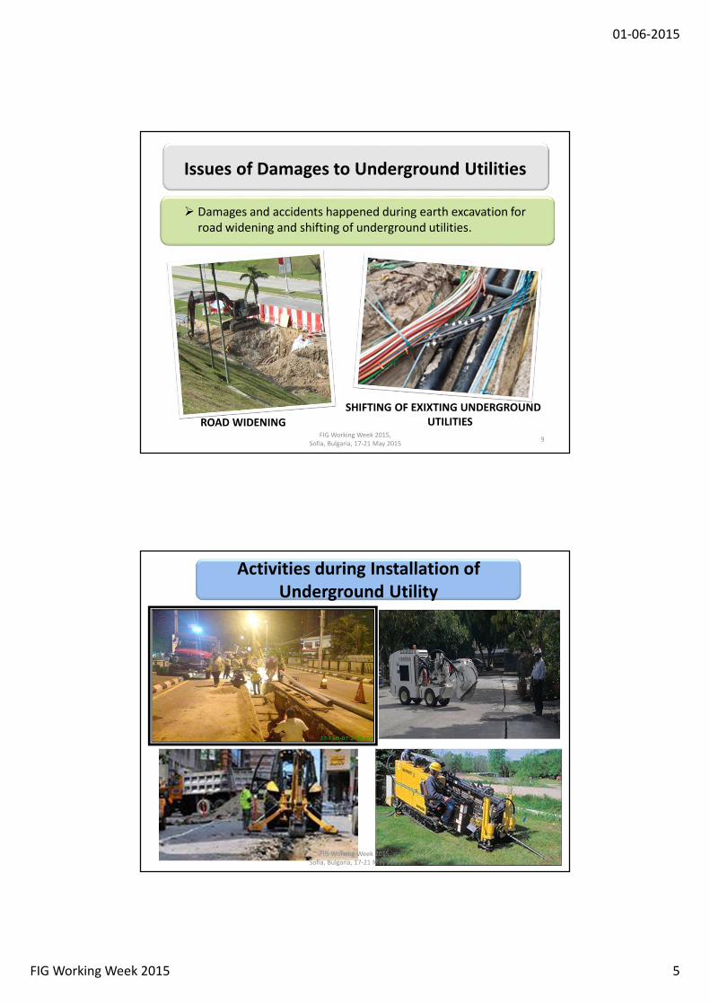
FIG Working Week 2015 5
� Damages and accidents happened during earth excavation for
road widening and shifting of underground utilities.
ROAD WIDENING
SHIFTING OF EXIXTING UNDERGROUND
UTILITIES
9
Issues of Damages to Underground Utilities
FIG Working Week 2015,
Sofia, Bulgaria, 17-21 May 2015
Activities during Installation of
Underground Utility
FIG Working Week 2015,
Sofia, Bulgaria, 17-21 May 2015

01-06-2015
FIG Working Week 2015 6
There is little coordination
between utility providers
resulting in damages to
underground utilities
Reported Damages to Underground
Utilities
FIG Working Week 2015,
Sofia, Bulgaria, 17-21 May 2015
• Increase in cost for project
• Delays to project implementation
• Disruption to consumers and
industries
• Increase in Insurance premium
Consequences due to damage
underground utility Installations
FIG Working Week 2015,
Sofia, Bulgaria, 17-21 May 2015
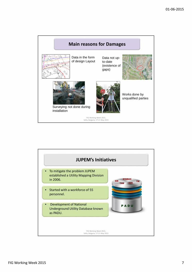
01-06-2015
FIG Working Week 2015 7
Data in the form of design Layout
Surveying not done during installation
Data not up-to-date (existence of gaps)
Works done by unqualified parties
Main reasons for Damages
FIG Working Week 2015,
Sofia, Bulgaria, 17-21 May 2015
JUPEM’s Initiatives
• To mitigate the problem JUPEM
established a Utility Mapping Division
in 2006.
• Started with a workforce of 55
personnel.
• Development of National
Underground Utility Database known
as PADU.
P A D U
TNB
TMIWK
GM
SYABAS
FIG Working Week 2015,
Sofia, Bulgaria, 17-21 May 2015

01-06-2015
FIG Working Week 2015 8
NATIONAL UNDERGROUND UTILITY DATABASE (PADU)
DATA PEPASANGAN UTIITI
DATA UKURAN KADASTER
PETA ORTOFOTO/ IMEJ SATELIT
DATA TOPOGRAFI
• Seamless database consisting of 4 major components; 1:500 base map, cadastral data, utility data and imageries
FIG Working Week 2015,
Sofia, Bulgaria, 17-21 May 2015
An 1:500 scale utility map showing position of utilities and important
topographic features with centimetre accuray
Utility Map by JUPEM
FIG Working Week 2015,
Sofia, Bulgaria, 17-21 May 2015

01-06-2015
FIG Working Week 2015 9
Managing Underground Utility Mapping Activities
• JUPEM collaborates with utility providers and
related agencies to ensure an orderly
management of utility data.
• Specification, standards and guidelines in Utility
Mapping to allow standardization vital for data
sharing.
• Several Circulars produced by JUPEM:
– 2006 Guidelines for Underground Utility Mapping
– 2007 Guidelines for utility surveying and detection
– 2013 Guidelines for surveying of New Utility Installation
FIG Working Week 2015,
Sofia, Bulgaria, 17-21 May 2015
UTILITY MAPPING GUIDELINES
• Circular KPUP 1/2006 – describes the roles of stakeholders, quality
levels in utility mapping, way of obtaining utility information,
deliverables and the national underground utility database (PADU)
maintained by JUPEM.
FIG Working Week 2015,
Sofia, Bulgaria, 17-21 May 2015
• Circular KPUP 1/2007 – provides surveyors with the
recommended technique and practice for the execution of
utility detection for quality level A and B.
• Circular KPUP 1/2013 – provides
surveying procedures for installation of
new underground utility.

01-06-2015
FIG Working Week 2015 10
PROGRESS IN
UNDERGROUND
UTILITY MAPPING
FIG Working Week 2015,
Sofia, Bulgaria, 17-21 May 2015
Quality of Utility Data
• Getting accurate data from utility providers remains the biggest
challenge.
• Data quality varies based on providers specification.
• Comparison made with field verification shows large positional
differences.
• Mainly due to data kept comprise of proposed/design/schematics
plans rather than as-built plans where survey are not required
during installation
FIG Working Week 2015,
Sofia, Bulgaria, 17-21 May 2015

01-06-2015
FIG Working Week 2015 11
EQUIPMENT AND TECHNOLOGY
• Available technology has accuracy limitation and requires skilled
operators and knowledgeable personnel to analyse the results.
• The different type of detection equipment (EML & GPR) have its
advantages and disadvantages in the form of:
• Equipment Cost
• Capabilities and Limitations
• Size
• Etc.
• Proper equipment calibration required.
FIG Working Week 2015,
Sofia, Bulgaria, 17-21 May 2015
• To detect all type of utilities.
• Requires expert knowledge in interpreting the GPR profiles or
tomographic images
GROUND PENETRATING RADAR (GPR)
FIG Working Week 2015,
Sofia, Bulgaria, 17-21 May 2015

01-06-2015
FIG Working Week 2015 12
Transmitter Receiver
Magnetic fields
ELECTROMAGNETIC LOCATOR (EML)
• Limited to detecting utilities made of metal
FIG Working Week 2015,
Sofia, Bulgaria, 17-21 May 2015
Gyro-Based Inertial System
• For detection of utilities installed using Horizontal Directional
Drilling (HDD) a gyro-based inertial measurement system is
recommended before the utility is installed
• Could be done during the drilling or before installation of utility
FIG Working Week 2015,
Sofia, Bulgaria, 17-21 May 2015
Data Collection Data ProcessingData Transfer to
GIS

01-06-2015
FIG Working Week 2015 13
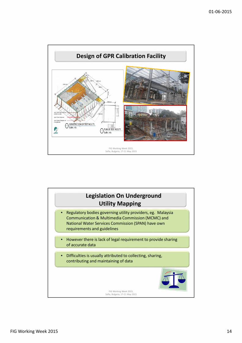
GPR Calibration Facility
• Appropriate testing and calibration of GPR equipment is necessary
to maintain data integrity
• In the latest development - JUPEM is building an indoor build-for-
purpose GPR Testbase where equipment are tested in a controlled
environment.
FIG Working Week 2015,
Sofia, Bulgaria, 17-21 May 2015
Location of GPR Calibration Facility
• Located within JUPEM Complex in Kuala Lumpur
FIG Working Week 2015,
Sofia, Bulgaria, 17-21 May 2015
01-06-2015
FIG Working Week 2015 14
Design of GPR Calibration Facility
FIG Working Week 2015,
Sofia, Bulgaria, 17-21 May 2015
30
00
mm
Legislation On Underground
Utility Mapping
• Regulatory bodies governing utility providers, eg. Malaysia
Communication & Multimedia Commission (MCMC) and
National Water Services Commission (SPAN) have own
requirements and guidelines
• However there is lack of legal requirement to provide sharing
of accurate data
• Difficulties is usually attributed to collecting, sharing,
contributing and maintaining of data
FIG Working Week 2015,
Sofia, Bulgaria, 17-21 May 2015

01-06-2015
FIG Working Week 2015 15
National Repository for Underground
Utility Data
• There is no national repository body sanction by law for safe
keeping of utility data
• Utility mapping is the responsibility of every utility provider.
• JUPEM (through the cabinet decisions) is given the responsibility of
compiling and managing underground utility data from providers
for the purpose of data sharing thereby acting as national
repository centre.
FIG Working Week 2015,
Sofia, Bulgaria, 17-21 May 2015
• No specific Act governing utility mapping
• However power is given to the local government to impose
condition necessary under Street, Drainage and Building Act 1974
but silent on mandatory requirement for utility mapping
• Condition set by local government such as submission of “as-built
survey plan” upon completion of any project can become a good
source for updating but there is no requirement to provide the
information to a any repository centre.
Available Acts
FIG Working Week 2015,
Sofia, Bulgaria, 17-21 May 2015

01-06-2015
FIG Working Week 2015 16
• A decision by the National Council for Local Governments on 18th
September 2014:
• All new underground utility installed using open trenching must
be surveyed during instalation.
• An Accurate positioning method must be used when installing
using HDD method.
• Needs for engagement of qualified surveyors for surveying
work and for producing digital utility data and as-built plan.
• A copy of the digital data must be submitted to JUPEM for
updating on PADU.
• The requirement to become part of the approval criteria in the
Development Order.
Latest Government Decision On Underground
Utility Mapping
FIG Working Week 2015,
Sofia, Bulgaria, 17-21 May 2015
Accreditation and Role of Qualified Land
Surveyors
• LLS will be involved directly in:
– Survey of newly laid utilities
before they are covered.
– Preparation of as-built plan
(this will also include
detected utilities if any).
– Submission of plan to
JUPEM.
FIG Working Week 2015,
Sofia, Bulgaria, 17-21 May 2015

01-06-2015
FIG Working Week 2015 17
• A new standard rates have been introduced for utility detection
work and as-built survey during utility installation.
Standard Rates For Utility Mapping
FIG Working Week 2015,
Sofia, Bulgaria, 17-21 May 2015
• The latest revision on Malaysian Standard 1759 – Geographic
Information/Geomatics Feature and Attribute Codes allows
inclusion of more features for better data sharing amongst users.
• A new guidelines on standard markings and colour codes to depict
the location of all underground utilities at site has been
introduced.
STANDARD CODES & MARKING
FIG Working Week 2015,
Sofia, Bulgaria, 17-21 May 2015

01-06-2015
FIG Working Week 2015 18
COMPETENCY IN UTILITY MAPPING
• LLS or utility players must keep abreast with latest knowledge
on:
• Equipment for detection and surveying
• Techniques used and equipment limitation
• Coordinate systems
• Understand of existing laws and regulations.
• Understand health and safety aspect as require under the
Occupational Safety and Health Acts (OSHA, 1994) :
FIG Working Week 2015,
Sofia, Bulgaria, 17-21 May 2015
• To mitigate the shortage of experts in Utility Mapping:
� On-going short professional courses leading to
certificate of competency in utility mapping is being
conducted by Land Surveyors Board (LJT) for the
licensed land surveyors yearly.
� Current number of Qualified Surveyors with
competency certificate is approximately 79.
SHORT COMPETENCY COURSES AND ACCREDITATION
FIG Working Week 2015,
Sofia, Bulgaria, 17-21 May 2015

01-06-2015
FIG Working Week 2015 19
• Effort made to create interest by introducing subject at
tertiary level educations:
• Introduced as part of syllabus for geomatic undergraduate
studies at UiTM and USM and master program at UTM.
• On-going activities by Professional body in collaboration with
universities in conducting training and research on:
� Technical aspect
� Policy and law
Education, Capacity Building and Researches
FIG Working Week 2015,
Sofia, Bulgaria, 17-21 May 2015
• JUPEM is investing in 3D mapping of underground utility
• This allows depiction from 3D perspective
• Allows informed and intelligent decision making and planning
3D Utility Mapping
FIG Working Week 2015,
Sofia, Bulgaria, 17-21 May 2015

01-06-2015
FIG Working Week 2015 20
FIG Working Week 2015,
Sofia, Bulgaria, 17-21 May 2015
PUTRAJAYACYBERJAYA
KUALA LANGAT
SEPANG
KAJANG
KUALA
LUMPUR
AMPANG
JAYA
SELAYANG
PETALING
JAYA
SUBANG
JAYA
SHAH ALAMKELANG
KUALA SELANGOR
SABAK BERNAM
NILAI
SEREMBAN
PORT DICKSON
REMBAU
KUALA PILAH
HULU SELANGOR
• Data collected from utility
providers for whole of Klang
Valley completed for the
following utilities:
• Water
• Sewerage
• Electricity
• Gas
• Telecommunication
Progress in Utility Data Collection
FIG Working Week 2015,
Sofia, Bulgaria, 17-21 May 2015
• Utility detected by JUPEM
covering the following
districts in the Klang Valley:
• Putrajaya, Cyberjaya,
Petaling Jaya, Shah Alam,
Subang Jaya and Kajang
• A total of 815.8 Km
completed
• Utility Map produced by
JUPEM – 296 Sheet
Progress in Utility Data Detection

01-06-2015
FIG Working Week 2015 21
• The initial role of the
JUPEM at each state is to
accept all as-built plan
submitted by LLS,
populate and manage the
database at state level.
Going Beyond Klang Valley
FIG Working Week 2015,
Sofia, Bulgaria, 17-21 May 2015
• JUPEM has expanded its underground utility activities nationwide.
CONCLUDING
REMARKS
FIG Working Week 2015,
Sofia, Bulgaria, 17-21 May 2015

01-06-2015
FIG Working Week 2015 22
• National Underground Utility Mapping Database will be the
basis for National Data repository for underground utility.
• The decision by the National Council for Local Governments
enabled JUPEM to obtained accurate and quality data from
development projects under the jurisdiction of Local Councils
where:
• All new utilities must be surveyed during installation.
• A copy of the as-built plan forwarded to JUPEM for safe
keeping and future references.
Concluding Remarks
FIG Working Week 2015,
Sofia, Bulgaria, 17-21 May 2015
• Accuracy and quality of data obtained with the involvement of
professional land surveyors as stipulated in the latest guidelines.
• The survey work is classified under the Professional Services with
standard rate available for both detection and survey works.
• JUPEM is spearheading utility mapping for the country with plans
for nationwide expansion.
Concluding Remarks
FIG Working Week 2015,
Sofia, Bulgaria, 17-21 May 2015

01-06-2015
FIG Working Week 2015 23
T hank you for your attention ....T hank you for your attention ....T hank you for your attention ....T hank you for your attention ....