Cumbria Surface Water Management Plan
101
Cumbria Surface Water Management Plan Phase 3 Report July 2012 Doug Coyle Traffic Manager Highways Network Management Environment | Cumbria County Council Barras Lane| Dalston | Carlisle | CA5 7NY
Transcript of Cumbria Surface Water Management Plan
Cumbria Surface Water Management Plan
Phase 3 Report
July 2012
Doug Coyle
Traffic Manager
Highways Network Management
Environment | Cumbria County Council
Barras Lane| Dalston | Carlisle | CA5 7NY
coyled
Draft

2010s4216 - Cumbria SWMP Phase 3 Report.docx i
JBA Project Manager
Sam Wingfield JBA Consulting Bank Quay House Sankey Street Warrington Cheshire WA1 1NN
Revision History
Revision Ref / Date Issued Amendments Issued to
1.0 / 05.07.12 Iwan Lawton and Doug Coyle via www.jbarn.co.uk
Contract
This report describes work commissioned by Richard Evans and Doug Coyle, on behalf of Cumbria County Council, by an email dated 28/05/10. Cumbria County Council’s representative for the contract was Doug Coyle and Iwan Lawton. Sam Wingfield of JBA Consulting carried out this work.
Prepared by ................................................ Sam Wingfield BSc MRes CEnv MCIWEM C.WEM
Analyst
Reviewed by ............................................... Chris Smith BSc PhD CEnv MCIWEM C.WEM MCMI
Principle Analyst
Purpose
This document has been prepared as a draft report for Cumbria County Council. JBA Consulting accepts no responsibility or liability for any use that is made of this document other than by the Client for the purposes for which it was originally commissioned and prepared.
JBA Consulting has no liability regarding the use of this report except to Cumbria County Council.
coyled
Draft
2010s4216 - Cumbria SWMP Phase 3 Report.docx ii
Acknowledgements
JBA would like to thank Iwan Lawton for his continual assistance during the production of the SWMP.
Copyright
© Jeremy Benn Associates Limited 2012
Carbon Footprint
525g
A printed copy of the main text in this document will result in a carbon footprint of 412g if 100% post-consumer recycled paper is used and 525g if primary-source paper is used. These figures assume the report is printed in black and white on A4 paper and in duplex.
JBA is aiming to achieve carbon neutrality.
coyled
Draft
Contents
2010s4216 - Cumbria SWMP Phase 3 Report.docx
1 Introduction............................................................................................................. 1
1.1 Commission .............................................................................................................. 1 1.2 Using the SWMP ...................................................................................................... 1 1.3 Preparation ............................................................................................................... 2 1.4 Surface water flooding .............................................................................................. 3
2 Risk Assessment .................................................................................................... 5
2.1 Plan Structure ........................................................................................................... 5 2.2 Strategic Assessment ............................................................................................... 5 2.3 Intermediate and Detailed Assessment ..................................................................... 6
3 Partnership ............................................................................................................. 9
3.1 Introduction ............................................................................................................... 9 3.2 Community Groups ................................................................................................... 9 3.3 Flood Risk Management Groups ............................................................................... 10 3.4 Links to planning ....................................................................................................... 11
4 Options and Actions ............................................................................................... 12
4.1 Introduction ............................................................................................................... 12 4.2 The appraisal of options ............................................................................................ 12 4.3 Outputs ..................................................................................................................... 13 4.4 Ulverston .................................................................................................................. 14 4.5 Whitehaven .............................................................................................................. 25 4.6 Dearham................................................................................................................... 37 4.7 Keswick .................................................................................................................... 39 4.8 Windermere .............................................................................................................. 51 4.9 Quick Win and Smaller Works Summary ................................................................... 55 4.10 Critical Drainage Areas and Planning Recommendations .......................................... 55 4.11 Action Plan ............................................................................................................... 64
5 Conclusions and Next Steps .................................................................................. 65
5.1 Conclusions .............................................................................................................. 65 5.2 Next Steps ................................................................................................................ 66
Appendices .......................................................................................................................... 69
A Phase 2a Summaries .............................................................................................. 69
B Cumbria SWMP Action Plan ................................................................................... 76
coyled
Draft

2010s4216 - Cumbria SWMP Phase 3 Report.docx
List of Figures
Figure 4-1: Flooding on North Lonsdale Road, November 2009 ............................................ 14
Figure 4-2: Flood defence bund ............................................................................................ 15
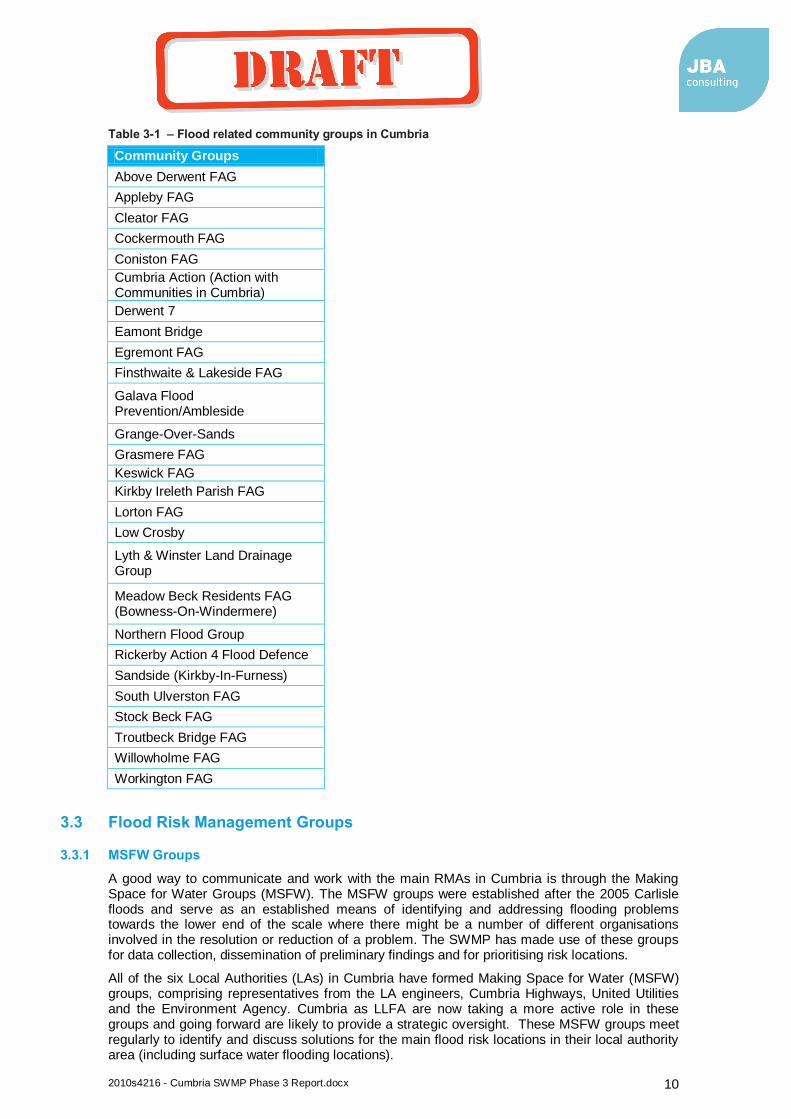
Figure 4-3: North Lonsdale Road Study Area ........................................................................ 16
Figure 4-4: Flat topography at the Steel Street flood risk location .......................................... 17
Figure 4-5: Raised floor levels on North Lonsdale Road ........................................................ 18
Figure 4-6: Ulverston Canal .................................................................................................. 21
Figure 4-7: North Lonsdale Terrace Study Area .................................................................... 22
Figure 4-8: Beckside Road outfall into Town Beck ................................................................ 23
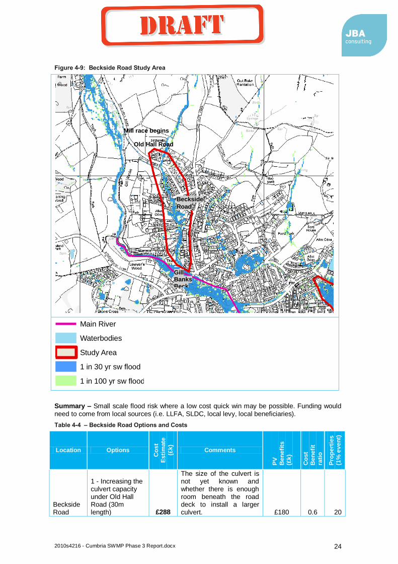
Figure 4-9: Beckside Road Study Area ................................................................................. 24
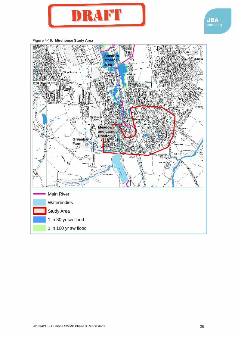
Figure 4-10: Mirehouse Study Area ...................................................................................... 26
Figure 4-11: The water table and marshy land at Mirehouse ................................................. 27
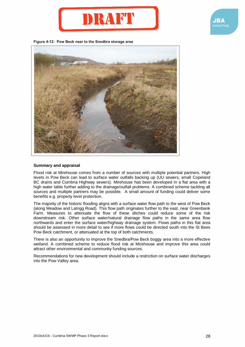
Figure 4-12: Pow Beck near to the Snedbra storage area ..................................................... 28
Figure 4-13: Coach Road Study Area ................................................................................... 31
Figure 4-14: Properties at risk from the Coach Road Culvert ................................................. 32
Figure 4-15: Parton Study Area ............................................................................................ 33
Figure 4-16: The entrance to Lambhill Gill culvert ................................................................. 34
Figure 4-17: The quarry near where Lambhill Gill has been surcharging ............................... 35
Figure 4-18: Dearham Study Area ........................................................................................ 37
Figure 4-19: Ambleside Road Study Area ............................................................................. 40
Figure 4-20: Castlehead Wood, the catchment for the Ambleside Road flood risk area ......... 41
Figure 4-21: Penrith Road Study Area .................................................................................. 44
Figure 4-22: Properties flooded on Penrith Road .................................................................. 45
Figure 4-22: Blocked grids in Keswick .................................................................................. 45
Figure 4-24: Additional highway drains on Penrith Road, alternative option below ................. 47
Figure 4-25: Elliot Park Study Area ....................................................................................... 50
Figure 4-26: Windermere Study Area .................................................................................... 52
Figure 4-27: Surface water flow in the sewer system ............................................................ 53
Figure 4-28: New trash screen on a watercourse in Windermere........................................... 54
Figure 4-29: Surface water outfall into Lake Windermere ...................................................... 54
Figure 4-30: Keswick Critical Drainage Area ......................................................................... 58
Figure 4-31: Kendal Critical Drainage Area ........................................................................... 59
Figure 4-32: Ulverston Critical Drainage Area ....................................................................... 60
Figure 4-33: Windermere Critical Drainage Area ................................................................... 61
Figure 4-34: Whitehaven Critical Drainage Area ................................................................... 62
Figure 4-35: Dearham Critical Drainage Area ....................................................................... 63
coyled
Draft
2010s4216 - Cumbria SWMP Phase 3 Report.docx 2
List of Tables
Table 2-1 – The 16 locations for further assessment in Phase 2b.......................................... 7
Table 3-1 – Flood related community groups in Cumbria ...................................................... 10
Table 4-1 – Options appraisal scoring key ............................................................................ 13
Table 4-2 – North Lonsdale Road Options and Costs ........................................................... 19
Table 4-3 – North Lonsdale Initial Options Appraisal ............................................................. 20
Table 4-4 – Beckside Road Options and Costs ..................................................................... 24
Table 4-5 – Mirehouse Options and Costs ............................................................................ 29
Table 4-6 – Mirehouse Initial Options Appraisal .................................................................... 30
Table 4-7 – Coach Road Options and Costs ......................................................................... 32
Table 4-8 – Parton Options and Costs .................................................................................. 36
Table 4-9 – Parton Initial Options Appraisal .......................................................................... 36
Table 4-10 – Dearham Crossroads Options and Costs ......................................................... 38
Table 4-11 – Dearham Post Office Options and Costs .......................................................... 39
Table 4-12 – Ambleside Options and Costs .......................................................................... 42
Table 4-13 – Ambleside Road Initial Options Appraisal ......................................................... 43
Table 4-14 – Penrith Road Options and Costs ...................................................................... 48
Table 4-15 – Penrith Road Initial Options Appraisal .............................................................. 49
coyled
Draft
2010s4216 - Cumbria SWMP Phase 3 Report.docx 1
1 Introduction
1.1 Commission
JBA Consulting (JBA) has been commissioned by Cumbria County Council (CC) to complete a Surface Water Management Plan (SWMP) for the county of Cumbria. The procedures followed are guided by the Surface Water Management Plan Technical Guidance (Defra, March 2010).
Cumbria CC is now a Lead Local Flood Authority (LLFA). This is a new body established following the Flood and Water Management Act (2010) and Flood Risk Regulations (2009). This LLFA has a new leadership responsibility role in local flood risk management, which has additional challenges due to its two tier structure. The SWMP outlines the preferred surface water management strategy across Cumbria and can therefore significantly contribute to these new responsibilities.
Under a Local Strategy, SWMPs are now likely to be recommended for specific areas of risk, with the Local Strategy undertaking a strategic overview. As the Cumbria SWMP was commissioned before the Local Strategy guidance was in place, its scope included a strategic assessment before focussing in on the areas of greatest risk. The following project phases were in the proposal:
Phase 1 – Strategic Risk Assessment
Phase 2 – Intermediate Risk Assessment
Phase 3 – Options and Action Plans
The strategic assessment involves assessing the risk of surface water flooding to people, the economy and the environment across the whole of Cumbria. Phase 2 assessed the areas of greatest risk in more detail and Phase 3 looked at options to manage the risk.
1.2 Using the SWMP
The Cumbria SWMP has been developed in three phases, all associated reports and figures have been submitted to Cumbria CC (LLFA officers).
Phase 1 can be used to understand surface water flood risk across Cumbria at a strategic level. The report explains the methodology, but also includes a large number of strategic maps. The Phase 1 report provides a schedule of these maps, broken down to the six different local authorities. These give an overview of flood risk, including historic incidents, strategic surface water flood maps and the number of receptors at risk per 1km square.
Phase 2 of the report has been broken down into two phases, 2a and 2b. Phase 2a undertook individual reviews for all of the settlements where the strategic assessment identified potential risk. These individual assessments provide a lot of information, including the justification for taking a location to the next stage of the SWMP or not. This information can be reviewed over time if more information about a certain location is required (e.g. for planning purposes or after a flood event). This information should be stored as it can be referred to over time as part of the evidence base for scheme prioritisation.
Phase 2b provides detail on the 16 locations taken forward following the Phase 2a reviews. Each location includes details on the mechanisms of flooding, flooding hotpots/historic incidents and a description of the surface water modelling findings. Initial FRM options and draft critical drainage areas are also identified. This information provides background to surface water flooding for the 16 locations shown to be at greatest risk. This includes all the major towns and should be referred to by the LLFA and others when developing flood related plans or plans where flooding could be a constraint or opportunity.
Phase 2b also included a review of all the critical services potentially at risk of surface water flooding (electricity installations, sewage works, schools, care homes, police stations, fire stations, ambulance stations and hospitals). These maps were provided to the relevant stakeholders to review and validate the risk. All stakeholders should review these maps to confirm the risk and prepare emergency plans where appropriate. This would best be led through the Cumbria Resilience Flooding Subgroup.
coyled
Draft

2010s4216 - Cumbria SWMP Phase 3 Report.docx 2
Phase 3 includes an initial appraisal of options for six locations across Cumbria. This includes an outline review of schemes costs and benefits. Phase 3 also provides more planning related information and recommendations for the critical drainage areas (CDAs).
All of the actions and recommendations are provided in the Cumbria SWMP Action Plan (see Appendix B). The Action Plan is the principle SWMP output and should be used to engage partners and to programme the future local flood risk management work for Cumbria. This will invariably link to Cumbria’s Local Flood Risk Management Strategy.
1.3 Preparation
A SWMP study is undertaken in consultation with key local partners who are responsible for surface water management and drainage in their area. Partners work together to understand the causes and effects of surface water flooding and agree the most cost effective way of managing surface water flood risk for the long term. The Cumbria SWMP Project Partners include representatives from Cumbria LLFA team, the Environment Agency and the JBA project manager. Regular Project Partner meetings took place to feed back the latest findings and to discuss the direction of the study.
A steering group was assembled to assist in governing the project, incorporating the six local authorities in Cumbria, two National Park Authorities, United Utilities and the Environment Agency. When the SWMP is complete, wider, public consultation will be required incorporating many of the community groups in Cumbria (see Chapter 3).
The steering group has been consulted during all major stages of the plan preparation including the Phase 1 report, Phase 2a location reviews, Phase 2 report and the Phase 3 report. Steering Group meetings have also taken place at key stages of the plan development. This allowed members to influence the direction of the study and to highlight flood risk locations in their local authority areas.
The steering group will be responsible for delivering the actions set out in the Cumbria SWMP Action Plan (Appendix B). Each action has been allocated a lead organisation along with partner organisations.
More details on the SWMP partnerships can be found in Chapter 3.
coyled
Draft
2010s4216 - Cumbria SWMP Phase 3 Report.docx 3
1.4 Surface water flooding
1.4.1 Definition
In simple terms, surface water flood risk is any flood source outside of Main Rivers and the sea. This includes flooding from sewers and the drainage system as a result of heavy rainfall, Ordinary Watercourses (culverted or open), groundwater and pluvial (runoff) flooding.
In more detailed, surface water flooding in the context of a SWMP includes the following sources:
surface water runoff; runoff as a result of high intensity rainfall when water is ponding or flowing over the ground surface before it enters the underground drainage network or watercourse, or cannot enter it because the network is full to capacity, thus causing flooding (known as pluvial flooding);
flooding from groundwater where groundwater is defined as all water which is below the surface of the ground and in direct contact with the ground or subsoil.
sewer flooding*; flooding which occurs when the capacity of underground systems is exceeded due to heavy rainfall, resulting in flooding inside and outside of buildings. Note that the normal discharge of sewers and drains through outfalls may be impeded by high water levels in receiving waters** as a result of wet weather or tidal conditions;
flooding from open-channel and culverted watercourses which receive most of their flow from inside the urban area and perform an urban drainage function;
overland flows from the urban/rural fringe entering the built-up area, and;
overland flows resulting from groundwater sources.
Notes:
* Consideration of sewer flooding in ‘dry weather’ resulting from blockage, collapse or pumping station mechanical failure is excluded from SWMPs as this is for the sole concern of the sewerage undertaker.
**Interactions with larger rivers and tidal waters can be important mechanisms controlling surface water flooding
Although surface water flooding can be defined and separated from Main Rivers and the sea in theory, the reality can be different. Surface water flooding is often linked to Main Rivers and the sea. High river levels can back up sewer outfalls or smaller watercourses leading to upstream flooding. High tides can also prevent a free outfall and be a key element of surface water flood risk. It is necessary to identify surface water flood risk so that the LLFA is aware of locations where it has a responsibility. However, when it comes to identifying options and undertaking a scheme, it will be important to work with others as partners so that a sustainable solution can be found. Chapter 3 identifies some of these important partnerships.
1.4.2 History of surface water flooding
There have been many high profile flood events in Cumbria e.g. Carlisle 2005 and Workington/Cockermouth 2009. The main flood mechanism for these incidents has been Main River. However, during these events and at many other times, there have been damaging localised floods that should not be overlooked.
A large amount of historic flooding data was collected during the SWMP process. Efforts were made to collect just surface water flooding incidents, but there is some overlap in events. Data was collected from the Making Space for Water Groups (see section 3.3), Environment Agency, United Utilities (UU), Cumbria Fire Service and Cumbria Highways. The historic incidents were used to validate the predicted surface water flooding maps. The Phase 1 report shows the distribution of historic flooding events.
In all major settlements, there have been many different surface water flooding incidents. However, some settlements have experienced many more than others. For example, Workington is a large town in Cumbria but has relatively few historic incidents. Ulverston is much smaller but has had many more incidents. For this example, the reasons are topography and asset capacity/functionality. Ulverston is low lying and the drainage system is undercapacity and prone to backing up form a Main River and the sea. Workington has an adequate drainage system and is elevated well above the River Derwent.
coyled
Draft

2010s4216 - Cumbria SWMP Phase 3 Report.docx 4
1.4.3 Nature of surface water flooding in Cumbria
The nature of surface water flooding in Cumbria is varied and dependant on natural features and manmade assets.
Cumbria is a rural county so typical urban flooding is not as common as in other location in the UK (i.e. flooding related to urban watercourses, large, long culverts and large complex drainage systems). Carlisle is the largest urban area where large surface water drainage systems and urban watercourses are likely to be found. A lot of investment has taken place in Carlisle following the 2005 floods. This includes significant improvements to the drainage system, as a result, Carlisle is currently not a significant surface water flooding location. Barrow is the other, larger settlement in Cumbria. Similarly, Barrow has had a lot of investment especially from UU, meaning it is not a significant surface water flooding location.
The remainder of the surface water flooding issues can be roughly split into two types. Firstly there are low lying drainage systems that back up and secondly, steep, flashy catchments with many surcharging watercourses in a dense built environment.
The low lying systems are typical of Ulverston and Whitehaven and other coastal locations. These are generally very flat areas with little gradient in the drainage system. This means that it can be difficult to get a gravity outfall to a larger watercourse or the sea. The gentle gradient can lead to the receiving watercourse silting up, further reducing the gradient and potentially silting up outfalls. In addition, low lying tidal areas will find it difficult to get a free discharge into the sea or estuaries during high tides or storm surges.
The flashy systems are typical of inland hilly places like Keswick, Windermere, Ambleside, Grasmere. During storm events, these locations are prone flashy floods due to rapid runoff from the surrounding hills. This is partly due to the topography (small, steep catchments) and the geology (impermeable bedrock and thin soils). Once the runoff reaches the settlements, the problems are exacerbated. As these locations are in the Lake District National Park, planning restrictions can lead to development pressures. There is therefore a lot of dense development next to small watercourses with very little green space to allow watercourses to surcharge. This constrains already swollen watercourses leading to surcharging and flooding of the many, close by properties.
.
coyled
Draft
2010s4216 - Cumbria SWMP Phase 3 Report.docx 5
2 Risk Assessment
2.1 Plan Structure
The Cumbria SWMP has been undertaken in three stages so that the whole of Cumbria can be assessed for surface water flood risk before going into more detail for the locations at greatest risk. The following stages have been completed and reports produced.
Phase 1 – Strategic Risk Assessment
Cumbria County Surface Water Management Plan – Phase 1 report, November 2010, JBA Consulting.
Phase 2 – Intermediate Risk Assessment
Phase 2a
Individual Location Reviews, June 2011, JBA Consulting
Phase 2b
Cumbria County Surface Water Management Plan – Phase 2 report, January 2012, JBA Consulting.
Phase 3 – Options and Action Plans
Cumbria County Surface Water Management Plan – Phase 3 report, July 2012, JBA Consulting.
This chapter briefly summarises the different phases and how they are linked.
2.2 Strategic Assessment
2.2.1 Phase 1 Study
The aim of the Phase 1 study was to assess surface water flood risk across the whole of Cumbria in order to identify all potential flood risk locations across this wide area. This was necessary due to the size of the area being studied. It would be unpractical and costly to assess the whole of Cumbria in detail. There is a lot of historic information and local knowledge across Cumbria but it is important to gather information on areas of potential risk i.e. locations where an extreme event may not have occurred in recent times.
Phase 1 of the Cumbria SWMP reviewed historic data on flooding from a variety of sources and undertook a strategic risk assessment using the national surface water flood maps and the National Receptor Dataset (NRD). This data was used to create a number of maps showing historic and future surface water flood risks across the county.
This data was also used to identify flood risk locations using a method similar to the PFRA Flood Risk Areas. The NRD (which contains many different flood receptors) was used as the basis for this assessment. Using a GIS tool, the number of properties and other receptors at risk from the intermediate Ares Susceptible to Surface Water Flooding (ASTSWF) map was assessed. This information was summarised in 1km square grids across Cumbria.
The outcome from the Phase 1 analysis placed every 1km cell across Cumbria into one of 4 categories:
1 very high risk 2 high risk 3 intermediate risk 4 little/no risk.
It was then possible to highlight locations within larger towns and smaller communities that were at risk of surface water flooding. The historic records were used at this strategic level to verify the areas highlighted as being at highest risk and also to highlight other areas of risk.
46 locations were identified as being at risk of surface water flooding using the historic data and the strategic GIS assessment. Each of these locations were reviewed in Phase 2.
coyled
Draft
2010s4216 - Cumbria SWMP Phase 3 Report.docx 6
2.3 Intermediate and Detailed Assessment
2.3.1 Phase 2a
Phase 2a involved reviewing all the locations that were classed as ‘significant’ according to the criteria set out in the Phase 1 report. The NRD data behind the ‘significant’ classification was looked at in more detail, e.g. is this area classed as significant due to the number of people or critical services at risk? Individual reports were produced for all 46 locations, summarising the additional information gathered, including:
Historic flooding incidents
The location of properties at risk (clusters or dispersed)
Any related UU sewer model information
Information contained within the SFRAs
Future development plans in the vicinity of the areas at risk
The outputs from the Phase 2 Reviews (the individual reports) were submitted to the project partners for consultation. Feedback was positive, generally confirming that the review had picked up the main surface water flood risk locations, but also providing more detail for some areas of risk.
At the end of the location reviews, one of three recommendations was made, including:
1. No further assessment required in the SWMP, continue to monitor on the MSFW list if relevant.
2. Meet with LA and/or UU engineers to confirm the risk.
3. Undertake a site visit and additional surface water modelling.
Additional sites were brought forward where the strategic assessment was clearly underestimating the risk. An example is Keswick, which has a history of significant surface water flooding in many different locations. This risk was not being picked up by the strategic assessment as flooding was due to localised issues related to the densely developed nature of the town.
Appendix A lists all of these locations, summarises the main issues and the recommendations for Phase 2b. Appendix A explains why certain locations have not been taken forward to the more detailed Phase 2b assessment for transparency.
As a result of this assessment and discussions with stakeholders, 16 locations were identified where detailed modelling and/or site visits for should be undertaken within Phase 2b (see Table 3.1). These are the only locations where the Project Partners agreed that further work was to be undertaken in the final two phases of the SWMP.
coyled
Draft

2010s4216 - Cumbria SWMP Phase 3 Report.docx 7
Table 2-1 – The 16 locations for further assessment in Phase 2b
Location Detailed modelling?
Site visit? Site visit comment
Ulverston Yes Yes -North Lonsdale Road/Terrace area and Dragley Beck -Well Lane/Watery Lane area
Dalton Yes Yes -Hagg Beck/Goose Green area
Barrow Yes Possibly -Not essential, Frederick Street pumping station area maybe
Whitehaven Yes Yes -A5094 - Bransty Row, Tangier Street, Strand Street. -Coach Road area -Mirehouse area
Workington Yes No
Cockermouth Yes Possibly -Gote Road area -Main Street and Waterloo Street -Highfield Road
Carlisle Yes Possibly -Unless any critical locations are brought up in the upcoming meetings, no visits are planned.
Penrith Yes Possibly -Not essential, Thacka Beck
Kendal Yes Yes -Park Side Rd area -Hawesmead Ave. Flow path starts from gill at the top
Keswick Yes Yes -Elliot Park -Springs Road – Helvellyn Street - Blencathra Street leading to Penrith Road
Dearham Yes Yes -Lonsdale Terrace area -Main St area down to Row Beck outfall
Grasmere Yes Yes -Sewer flooding locations
Windermere Yes Yes -Sewer flooding locations
Ambleside Yes Possibly -Not essential. Possibly the Fisher Beck area
Parton No Yes -The 2 watercourses here, can anything be done in the u/s part?
Grange over Sands No Possibly -Not essential. Possibly visit main sw risk location
2.3.2 Phase 2b
The first part of Phase 2b involved meeting each of the LA engineers and UU operations staff to confirm the level of risk and gain a more detailed understanding of the mechanisms of risk at the 16 chosen locations. The meetings were also undertaken to help decide whether more detailed surface water modelling and site visits were required. The following areas were covered when meeting with the LA engineers:
Have the main local flood risk locations been identified
The mechanism of flooding.
Are the issues linked to other partners (e.g. UU sewers, EA Main Rivers)
Should UU engineers be involved
Have works been completed in the past (or are any planned)
Are there any potential options that have been considered/could be considered to reduce the risk?
Major future development areas.
Would a site visit and additional modelling be beneficial?
Areas covered with UU engineers included:
Identification of locations where surface water flows into the sewer system and can cause flooding.
The mechanisms of sewer flooding at each location (capacity, blockage, outfalls backing up from tide, watercourses)
coyled
Draft
2010s4216 - Cumbria SWMP Phase 3 Report.docx 8
New schemes that have recently been completed that may have reduced the risk for the locations highlighted.
Locations where major works are proposed. Any future investment plans. Locations where works could be combined with other authorities to reduce the risk of flooding (i.e. local authorities, Environment Agency, United Utilities). Opportunities to combine investment with other authorities for multiple benefits.
What are the potential options for reducing the risk (in general terms).
Following these meetings, detailed modelling was recommended for most of the 16 locations. Modelling was not thought to be appropriate for the smaller locations in this group (e.g. Parton) or where more detailed modelling already exists (e.g. Grange over Sands). Table 3.1 shows the locations where detailed modelling has been undertaken. The methodology for the surface water modelling can be found in Appendix C of the Phase 2 report.
The outputs for the modelling include flood extent, depth and hazard maps for different return period rainfall events; 1 in 30, 1 in 50, 1 in 75, 1 in 100, 1 in 200 and 1 in 200+cc. Figures for the modelled areas were provided with the Phase 2 report.
The Cumbria surface water mapping is more representative of surface water flooding in Cumbria is therefore the ‘locally agreed surface water flooding information’ as described in the PFRA guidance.
The Phase 2 report describes the results of the new surface water modelling and discusses the mechanisms of flooding in more detail. Conclusions were made on the next steps for each of these settlements. For some, no further action is required, but they should continue to be monitored into the future as part of the Local Flood Risk Management Strategy. For other locations, small scale actions are still applicable, that should come under the remit of the Making Space for Water (MSFW) group or the LLFA. For some locations, a settlement specific Drainage Impact Assessment (DIA) was proposed. These studies are relevant where there are existing problems with the surface water drainage system and significant future development plans that could increase the problems. DIAs should develop a strategic drainage plan for future development which should lead to an overall improvement.
All actions from the Phase 2 and Phase 3 report can be found in the Cumbria SWMP Action Plan (Appendix B).
The locations taken forward to Phase 3 (options appraisal, see Chapter 5) are listed below.
Ulverston
Whitehaven
Keswick
Dearham
Windermere
Parton
Critical Drainage Areas (CDAs)1 have been proposed across Cumbria, using the information
gathered in Phases 1 and 2. The CDAs include all the locations to be taken forward in the SWMP and specify the areas that the study should focus on. In addition to this, the Local Planning Authorities (LPAs) should be made aware of the CDAs and ensure that they are considered in future development proposals. This is very applicable for locations like Dearham, where there are critical drainage issues and significant future development planned. The proposed CDAs are listed below, more details can be found in section 5.10 and the Action Plan in Appendix B.
Ulverston
Whitehaven
Keswick
Dearham
Windermere
Moresby Parks
coyled
Draft
2010s4216 - Cumbria SWMP Phase 3 Report.docx 9
3 Partnership
3.1 Introduction
For the successful implementation of the Cumbria SWMP, it will be important to work with other organisations as partners. This includes Risk Management Authorities (RMAs) but also others e.g. LPAs and community groups.
It is rare for local flood risk problem areas to have flood mechanisms that are entirely the responsibility of the LLFA. A critical drainage system often has multiple owners (i.e. highways, residents, UU, local authority). In addition, there are often strategic issues relating to local problems e.g. a Main River or the sea backing up smaller watercourse and/or the drainage system.
To identify and implement a sustainable flood risk management solution different partner organisations will need to work together by sharing knowledge and data, undertaking joint studies and funding the agreed scheme costs and maintenance.
One of the recommended follow up tasks (see Chapter 5) will be to develop an investment plan for the schemes/measures identified in the SWMP. This will include indentifying the investment plans of different organisations and whether these can be aligned and directed to the works identified in the SWMP (e.g. UU Asset Management Plans and developer contributions through LPAs).
3.2 Community Groups
New government guidance and policy emphasises the need for community engagement in flood risk management. Community engagement should be at the heart of flood management plans and schemes in order to get community support for how local flood risk is managed now and in the future. The future of local flood risk management is that community led and funded schemes will be supported by and gain government funding. Future work on the Cumbria Local FRM Strategy should emphasise the importance of community groups. Public consultation will be required once the Phase 3 draft report has been reviewed by the project partners and steering group.
Cumbria has suffered from many high profile and damaging flood events in recent history. As a result of this and the high levels of community engagement in Cumbria, there are many Flood Action Groups throughout the County. It is vital that these groups are brought into the plan to show that the needs of people who have been affected are taken on board and valued. The community groups will be consulted as part of the public consultation period (see section 5.2.1)
Table 4-1 lists the flood related community groups in Cumbria, these groups should be consulted on the Cumbria SWMP and any related future schemes. The Cumbria SWMP Action Plan (Appendix B) identifies the relevant community group for the SWMP actions.
It will be important to effectively communicate the scope of the study to the Flood Action Groups e.g. explaining that this plan covers surface water not Main Rivers. But in addition to communicating there will also be the need to work with them, so that related problems can be identified and incorporated into the larger Main River schemes that are being considered.
The Northern Flood Action Group has also been recently set up. Keswick and Cockermouth are members and this group which has been designed to tackle common issues relating to communities at risk of flooding, e.g. home insurance. This group should be consulted on the SWMP and any future investment plan as reducing flood risk may reduce insurance premiums.
In addition to the Flood Action Groups, there are other community led groups that have been set up across Cumbria and should be integrated into the consultation process e.g. Cumbria Action. Cumbria Action (Action with Communities in Cumbria) aim to work alongside local people to develop solutions for their needs. They are an independent charity and aim to act as a bridge between communities and public bodies. Derwent Seven is a Community Led Planning Group as a voluntary association of seven Parish & Town Councils in the Keswick area. Some example projects are community emergency planning and a gravel management plan for Borrowdale.
coyled
Draft
2010s4216 - Cumbria SWMP Phase 3 Report.docx 10
Table 3-1 – Flood related community groups in Cumbria
Community Groups
Above Derwent FAG
Appleby FAG
Cleator FAG
Cockermouth FAG
Coniston FAG
Cumbria Action (Action with Communities in Cumbria)
Derwent 7
Eamont Bridge
Egremont FAG
Finsthwaite & Lakeside FAG
Galava Flood Prevention/Ambleside
Grange-Over-Sands
Grasmere FAG
Keswick FAG
Kirkby Ireleth Parish FAG
Lorton FAG
Low Crosby
Lyth & Winster Land Drainage Group
Meadow Beck Residents FAG (Bowness-On-Windermere)
Northern Flood Group
Rickerby Action 4 Flood Defence
Sandside (Kirkby-In-Furness)
South Ulverston FAG
Stock Beck FAG
Troutbeck Bridge FAG
Willowholme FAG
Workington FAG
3.3 Flood Risk Management Groups
3.3.1 MSFW Groups
A good way to communicate and work with the main RMAs in Cumbria is through the Making Space for Water Groups (MSFW). The MSFW groups were established after the 2005 Carlisle floods and serve as an established means of identifying and addressing flooding problems towards the lower end of the scale where there might be a number of different organisations involved in the resolution or reduction of a problem. The SWMP has made use of these groups for data collection, dissemination of preliminary findings and for prioritising risk locations.
All of the six Local Authorities (LAs) in Cumbria have formed Making Space for Water (MSFW) groups, comprising representatives from the LA engineers, Cumbria Highways, United Utilities and the Environment Agency. Cumbria as LLFA are now taking a more active role in these groups and going forward are likely to provide a strategic oversight. These MSFW groups meet regularly to identify and discuss solutions for the main flood risk locations in their local authority area (including surface water flooding locations).
coyled
Draft
2010s4216 - Cumbria SWMP Phase 3 Report.docx 11
An important output of the MSFW groups is the hotspots list. This is a list of flooding problems that have come to the attention of the groups and has generally resulted in the allocation of problems to a lead organisation which reports on progress on resolving the problem at MSFW group meetings.
These lists vary for each LA, but in general show the location of flooding, the number of properties flooded, the frequency of flooding and some notes on the flooding mechanism. The flood risk locations are also prioritised.
These lists have been used to help form the surface water flood risk areas in the county. However, these hotspots tend to be small scale issues rather than large scale strategic surface water flood risk areas. As a result, the hotspots may be used more for identifying ‘quick wins’ or smaller, local levy schemes rather than areas where larger, more costly schemes are required.
3.3.2 Cumbria Resilience Flooding Sub-Group
The Cumbria Resilience Forum was set up following The Civil Contingencies Act 2004 which established a clear set of roles and responsibilities for those involved in emergency preparation and response at the local level. The resilience forum has a Flooding Sub-Group that meets regularly to discuss significant flooding issues, strategies and how to respond to them. The membership of the Flooding Sub-Group includes the following organisations:
Environment Agency
Local Authority engineers
Cumbria CC
Cumbria Highways
UU
Cumbria Constabulary
Cumbria Fire and Rescue
North West Ambulance Service
RAF
Network Rail
Met Office
The meetings involve feeding back significant issues on the MSFW hotspot list and discussing new advances in flood response, forecasting and risk assessment. This sub group should be consulted on the SWMP as solutions are proposed to reduce risk, including emergency response.
3.4 Links to planning
It has been particularly important to incorporate the eight Local Planning Authorities (LPAs – including two National Parks). The LPAs are currently developing preferred options for their Core Strategy. Flood risk is taken into account when developing options, but their assessment of risk has predominantly been reliant on Environment Agency Flood Zones. The surface water modelling and historic flooding information provides a new layer of data available to LPAs. Each of the six LPAs have been consulted and given recommendations regarding their future development plans. The information developed in the SWMP can be used for future development planning and flood risk assessments. The SWMP Action Plan involves recommendations for LPAs specific to Critical Drainage Areas (CDAs).
It was important to give a clear message to the LPAs, that areas at risk of surface water flooding can often be managed within the regeneration, allowing development to go ahead. However, some locations have drainage systems that are at capacity with low infiltration ground conditions and few options for managing the risk. In these locations, large green space needs to be allocated within the plans (for strategic SUDS) or a reconsideration of the proposed development area.
coyled
Draft

2010s4216 - Cumbria SWMP Phase 3 Report.docx 12
4 Options and Actions
4.1 Introduction
The Phase 2 report included a description of the flood mechanisms for the locations across Cumbria perceived as having the greatest risk of surface water flooding. The Phase 2 report also described the new surface water flood modelling produced for the same locations. The conclusions of the Phase 2 study was that some of these locations warranted further investigation through site visits and the consideration of potential options for reducing flooding. These locations and the main recommendations are summarised below:
Ulverston – The next stage of the SWMP should consider options for reducing the risk of surface water flooding. A Drainage Impact Assessment (DIA) should also be considered, focussed on the future development plans.
Whitehaven - The next stage of the SWMP should consider options for reducing the risk of surface water flooding.
Keswick - The next stage of the SWMP should consider options for reducing the risk of surface water flooding. A Drainage Impact Assessment (DIA) should also be considered, focussed on the future development plans.
Dearham - A Drainage Impact Assessment (DIA) should also be considered, focussed on the future development plans.
Windermere - The next stage of the SWMP should consider options for reducing the risk of surface water flooding (runoff attenuation). A Drainage Impact Assessment (DIA) should also be considered, focussed on the future development plans.
Parton – undertake a site visit and look at the potential for upstream storage/attenuation as part of the SWMP.
This part of the report summarises the main findings from the site visits and the options that should be considered to reduce flood risk. For each location there are several areas of interest, where a scheme or a collection of measures could be applied.
4.2 The appraisal of options
Where there is the potential for a large surface water management scheme, an initial options appraisal has been undertaken. Larger schemes (schemes likely to cost over £200k) are likely to required Flood Defence Grant in Aid (FDGiA) funding and will therefore need a full scale options appraisal in a Project Appraisal Report (PAR). Smaller, quick wins have not been appraised but summarised for each location.
Surface water schemes can now be put forward for government FDGiA in addition to local levy funding. Funding for future schemes will be allocated through the Regional Flood and Coastal Committee (RFCC). In order to be considered for future funding, schemes should be put on the Medium Term Plan (MTP) by the LLFA. The Cumbria SWMP has identified a number of local flooding schemes that could be added to the MTP. The remainder of Chapter 4 will include a preliminary assessment of the potential benefits and costs of a scheme. If a scheme looks viable, it can be brought forward and put on the MTP.
4.2.1 Economic assessment
The new surface water modelling has been used to estimate Annual Average Damages (AADs) and Present Value (PV) damages for each location taken forward to Phase 3. The PV benefits of a scheme have also been estimated by assuming that the measures would protect the area up to the 1 in 100 year flood event. Beyond this, the assumption is that flooding would occur but to the equivalent of the 1 in 70 year event. Although the flood event would be greater than the 1 in 70, it has been assumed that the scheme would still provide some benefit, reducing the impact of say a 1 in 150 year event to the equivalent of a 1 in 70 year event.
Outline cost estimates for several potential options have also been calculated. These cost estimates have been calculated using unit cost values based on previous schemes. This will allow the identification of cost beneficial schemes during the appraisal process e.g. where a low
coyled
Draft

2010s4216 - Cumbria SWMP Phase 3 Report.docx 13
number of properties are at risk of superficial flood damage, large scale intervention such as a raised defence, would not be appropriate. This initial consideration of the economics will also allow the Lead Local Flood Authority (LLFA) to plan future schemes without going too far down the funding process for schemes that are not cost effective. However, this outline cost benefit analysis should not be relied upon for funding applications, full cost benefit analysis should be undertaken during more detailed feasibility studies.
4.2.2 Options appraisal
An initial appraisal of the different options has been undertaken for the larger schemes, incorporating the economic appraisal. The types of options being considered include: river walls/embankments, demountable defences, works within a watercourse, culvert and sewer upsizing/new sewers, separating sewers, property resistance, flood warning/forecasting, retrofitting SUDS, flood storage, pumping stations, new outfalls.
Three or more options (including do nothing and do minimum) have been appraised against a number of different objectives. The objectives chosen include the three pillars of sustainable development (the environment, economy and people). This should help to ensure that the options chosen are sustainable over the long term. The objectives are:
1. Reduce Risk – does the solution effectively reduce flood risk to people and property e.g. flood resilience may stop flood water entering properties but roads would still be affected.
2. Economic – is the solution cost effective. Surface water schemes generally have a low cost benefit ratio so low cost options and the availability of alternative funding needs to be considered for this objective.
3. Social – does the solution provide social benefits e.g. regular flood storage in a park area would have a negative impact but removing flood water will have significant benefits to the population’s health and well being.
4. Environmental – this objective will include water quality and other WFD objectives in addition to the impact on any environmental receptors and the ability for the solution to enhance the natural environment.
5. Practicality – Are there technical and construction constraints to the option. Are their land ownership issues that would need to be resolved?
Each objective has been scored from -2 to +2 depending on how well the options meets the objective (see Table 4-1 below).
Table 4-1 – Options appraisal scoring key
2 1 0 -1 -2
Meets objective well
Meets objective No impact Does not meet objective
Adverse effect on objective
4.2.3 Smaller schemes and quick wins
Smaller schemes and quick wins will also be recommended for funding (costing say thousands per property). The nature of local flooding in Cumbria means that relatively low cost options can deliver significant benefits. However, these are more likely to attract local level funding as FDGiA requires a robust cost benefit analysis that may not be possible with smaller schemes. Opportunities to build a funding pot for these quick win schemes should be investigated, for example the early surface water action fund that came from Defra.
The smaller schemes and quick wins are within the Cumbria SWMP Action Plan (Appendix B).
Cumbria’s Local Strategy should build on these recommended schemes and develop an investment plan showing how and when the schemes will be delivered into the future. This will include an assessment of alternative funding sources.
4.3 Outputs
Following the assessment of the Phase 3 sites are a number of outputs that can be brought forward into the SWMP Action Plan. For the locations where larger schemes are required, the
coyled
Draft

2010s4216 - Cumbria SWMP Phase 3 Report.docx 14
most viable options to reduce risk will have been identified. These can then be taken forward to a more detailed feasibility study (Project Appraisal Report) and put forward for entry into the Medium Term Plan (MTP). Smaller schemes and quick wins will also be collated and put onto the action plan (see section 5.2.3).
There will also be some planning related actions e.g. areas to be avoided for future development and where development can help reduce risk. Critical Drainage Areas (CDAs) and other planning recommendations have been outlined in section 4.9.
4.4 Ulverston
4.4.1 North Lonsdale Road
Flood risk in this location is heavily linked to Dragley Beck (Main River). Direct flooding from Dragley Beck to the North Lonsdale Road area is mitigated by a flood defence bund (see Figure 4.2). However, during the November 2009 flood event, the bund was bypassed, allowing the North Lonsdale Road area to flood, 109 properties were flooded. The wall that follows Steel Street offers some addition protection, but floodwaters also passed through this barrier in 2009.
Figure 4-1: Flooding on North Lonsdale Road, November 2009
coyled
Draft

2010s4216 - Cumbria SWMP Phase 3 Report.docx 15
Figure 4-2: Flood defence bund
Flooding in this area is not a pure Main River flooding problem. The low lying, flat topography means that the existing drainage system struggles to get a gravity outfall into Morecambe Bay or Dragley Beck. The drainage system here includes United Utility (UU) sewers, highway drainage and minor watercourses that have been culverted and built over. During heavy rainfall events, surface water enters the drainage system, causing it to surcharge.
Dragley Beck has silted up to such an extent that the river level (and in some places the bed level) is above the level of the drainage system outfalls. This leads to smaller watercourses, highway drains and UU sewers backing up and flooding the North Lonsdale Road area via surcharging manholes. In 2009 all of the sewers and drainage system were at capacity and surcharging. Figure 4.4 shows Steel Street and the flat topography that leads to Dragley Beck.
coyled
Draft
2010s4216 - Cumbria SWMP Phase 3 Report.docx 16
Figure 4-3: North Lonsdale Road Study Area
Legend
Main River
Waterbodies
Study Area
1 in 30 yr sw flood
1 in 100 yr sw flood
Dragley Beck
Ulverston Canal
North Lonsdale
Road
coyled
Draft

2010s4216 - Cumbria SWMP Phase 3 Report.docx 17
Figure 4-4: Flat topography at the Steel Street flood risk location
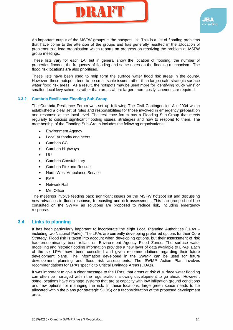
In this area residents have installed some property level protection, mainly flood gates. It may be cost beneficial to invest in more comprehensive property level protection in this area as a response to surface water and Main River flooding. Figure 4.5 below shows steps leading to raised floor levels along North Lonsdale Road, indicating that flooding has been a problem in the past.
Removal of flood water is likely to require large scale investment. Due to the large number of properties at risk, significant investment may be justified. However, the low lying, flat topography of this location and the siltation of Dragley Beck, means that there are no quick and obvious solutions. Any future scheme should be a combined solution for all sources of flooding and include UU and the Environment Agency as partners. The Environment Agency has entered the Ulverston Flood Risk Management Scheme onto the MTP. This feasibility study should include the surface water flood risks in North Lonsdale Road. If this was undertaken, relatively small amounts of local funding could leverage large contributions from the government.
South Lakeland DC is currently undertaking a feasibility study to ascertain the problems and propose solutions for North Lonsdale Road. This will go into more detail than this strategic assessment and should form the next steps in resolving the surface water flooding issues. Draft options include intercepting Kennedy Street Drain and constructing a new pipeline to Dragley Beck, costing in the region of £110k. This will only solve part of the problem and costs for a complete scheme are likely to be much higher. The findings of this study should be used by the Environment Agency for the Ulverston Feasibility Study.
coyled
Draft
2010s4216 - Cumbria SWMP Phase 3 Report.docx 18
Figure 4-5: Raised floor levels on North Lonsdale Road
Summary and Options Appraisal
The high number of properties at risk means that significant investment in a FRM scheme may be justified as part of a larger FRM schemes covering Main River flooding in Ulverston. A complete solution will be complex and involve a several partners (UU, Cumbria CC, SLDC and EA). The partners should present multiple funding sources increasing the likelihood of gaining FDGiA for the scheme.
A more detailed study should use the Dragley Beck hydraulic model and extreme tidal predictions to develop a joint probability assessment of flood levels on Dragley Beck. The current sewer outfall levels and flap valves into Dragley Beck should be compared to a range of modelled flood levels. Increasing some of the pipe sizes may reduce the hydraulic grade line by a margin large enough to reduce backing up from Dragley Beck into North Lonsdale Road.
Another option is to stop surface water draining into Dragley Beck. Due to the low gradient of the area, some of the critical surface water systems could be redirected. Ulverston Canal is to the north of this risk location. The potential for this canal to receive surface water from North Lonsdale Road should be considered. This assessment should include a hydraulic assessment of the canal, modelling the ability of the outlet/overflow structure to be increased to allow additional capacity in the canal. This part of the study should include assessing the hydraulic gradient from the outlet, down the canal. The canal itself should also be risk assessed for leaks, potential breaches and tidal overtopping.
This option could also be used to alleviate flooding in North Lonsdale Terrace and provide surface water runoff storage for proposed new development around the canal. In order to investigate and deliver this options, a stakeholder group should be set up, involving the canal owners, local land owners (including Glaxo), the Environment Agency, United Utilities and the Ulverston Flood Action Group.
Property level protection would be a low cost way of reducing risks to a large number of properties. A resilience survey should be undertaken before progressing with this option for the short or long term.
coyled
Draft
2010s4216 - Cumbria SWMP Phase 3 Report.docx 19
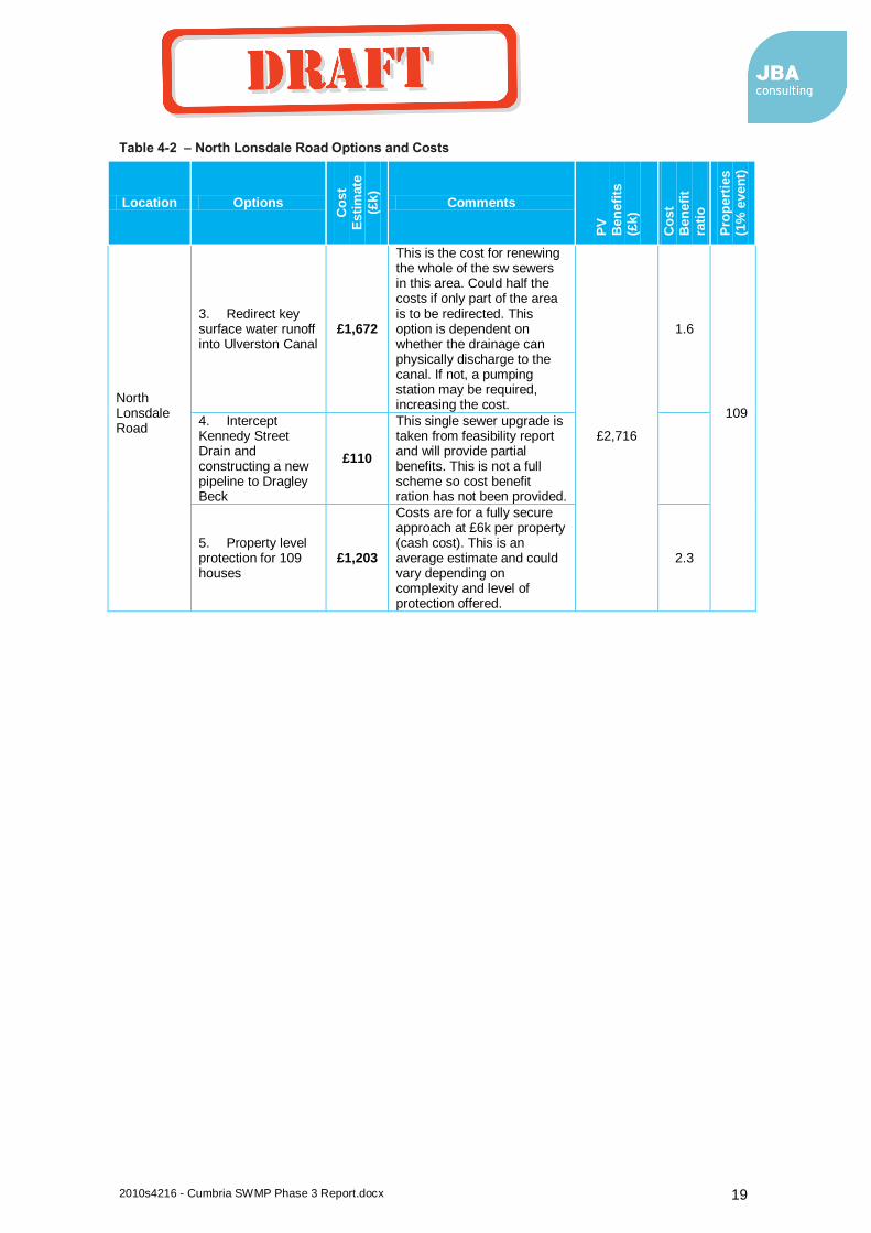
Table 4-2 – North Lonsdale Road Options and Costs
Location Options
Co
st
Esti
mate
(£k)
Comments
PV
B
en
efi
ts
(£k)
Co
st
Ben
efi
t
rati
o
Pro
pert
ies
(1%
even
t)
North Lonsdale Road
3. Redirect key surface water runoff into Ulverston Canal
£1,672
This is the cost for renewing the whole of the sw sewers in this area. Could half the costs if only part of the area is to be redirected. This option is dependent on whether the drainage can physically discharge to the canal. If not, a pumping station may be required, increasing the cost.
£2,716
1.6
109
4. Intercept Kennedy Street Drain and constructing a new pipeline to Dragley Beck
£110
This single sewer upgrade is taken from feasibility report and will provide partial benefits. This is not a full scheme so cost benefit ration has not been provided.
5. Property level protection for 109 houses
£1,203
Costs are for a fully secure approach at £6k per property (cash cost). This is an average estimate and could vary depending on complexity and level of protection offered.
2.3
coyled
Draft
2010s4216 - Cumbria SWMP Phase 3 Report.docx 20
Table 4-3 – North Lonsdale Initial Options Appraisal
Option N
o.
Option
Reduce R
isk
Econom
ic
Socia
l
Environm
enta
l
Pra
cticalit
y
Overa
ll
Comments
1 Do nothing
-2 -2 -2 -2 0 -8 Increased risk leading to more economic damages and people flooded. Foul flooding would damage the environment.
2 Do minimum
-1 0 -2 -1 1 -3 Damaging flooding would still occur. There will still be losses but this may be more cost beneficial than intervening.
3
Redirect key surface water runoff into Ulverston Canal
1 -1 1 0 -1 0 Part redirection of sw sewers would increase the cost benefit ratio. Land ownership issues may constrain this opportunity.
4 Sewer upgrades
1 -2 2 0 -2 -1 A large capital scheme will be costly and difficult to undertake due to the topography. This would get good public backing and would sufficiently reduce the risk if a scheme was practical. However UU could be part funders on this scheme.
5 Property resistance
1 1 -1 -2 1 0 This option would reduce the risk, be practical and should be cost effective, but the area would still be prone to flooding (including foul). This may not be socially acceptable.
Summary
Some intervention is economically beneficial although the cost benefit ratio is low. Property level protection or redirecting some of the surface water sewers appear to be the best options. The scale of any intervention means that FDGiA should be applied for. However, the low cost/benefit scores means that a scheme could struggle to attract FDGiA without significant partnership funding. A scheme may therefore be reliant on others and their objectives (UU or Environment Agency).
Immediate actions
Set up Ulverston Canal partnership/stakeholder group (include Cumbria CC, UU, EA, canal owners and land owners). This group should work together to plan how flooding and surface water drainage should be managed for current risk areas, but also for potential future development around the canal.
Feasibility study, flood alleviation scheme for all sources of flooding including Dragley Beck, led by the EA with UU on the steering group.
4.4.2 North Lonsdale Terrace
In this area, there are problems relating to the disused Ulverston Canal. In the North Lonsdale Terrace area (Honeypot Estate), the highway outfalls are unable to discharge into the canal due to siltation. This causes surcharging and surface water flooding in the surrounding area. The flood extents and depths are not as significant as in North Lonsdale Road, but this is a pure surface water flooding problem.
coyled
Draft

2010s4216 - Cumbria SWMP Phase 3 Report.docx 21
Figure 4-6: Ulverston Canal
This area has also been highlighted due to the potential future development in the area. Development may take place either side of the canal, adjacent to the Honeypot Estate. The natural surface water outfall for the new development would be the canal. This solution is therefore linked to the North Lonsdale Road canal storage option. Works are required to improve the capacity of the canal to allow a free discharge during flood events, or new drainage arrangements for the existing and proposed development.
Actions in this location should form part of a Ulverston Canal Water Management Plan. Section 4.4.1 outlines the option of using the canal for surface water storage. Stakeholders should be contacted and encouraged to partner in a plan for this area that should include the following issues:
surface water discharge into the canal and backing up
leakage from the canal
surface water recommendations for the development of land around the canal
coyled
Draft
2010s4216 - Cumbria SWMP Phase 3 Report.docx 22
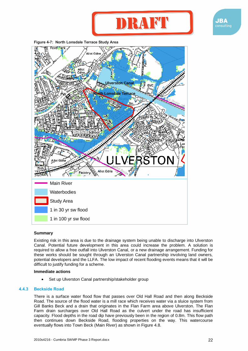
Figure 4-7: North Lonsdale Terrace Study Area
Summary
Existing risk in this area is due to the drainage system being unable to discharge into Ulverston Canal. Potential future development in this area could increase the problem. A solution is required to allow a free outfall into Ulverston Canal, or a new drainage arrangement. Funding for these works should be sought through an Ulverston Canal partnership involving land owners, potential developers and the LLFA. The low impact of recent flooding events means that it will be difficult to justify funding for a scheme.
Immediate actions
Set up Ulverston Canal partnership/stakeholder group
4.4.3 Beckside Road
There is a surface water flood flow that passes over Old Hall Road and then along Beckside Road. The source of the flood water is a mill race which receives water via a sluice system from Gill Banks Beck and a drain that originates in the Flan Farm area above Ulverston. The Flan Farm drain surcharges over Old Hall Road as the culvert under the road has insufficient capacity. Flood depths in the road dip have previously been in the region of 0.8m. This flow path then continues down Beckside Road, flooding properties on the way. This watercourse eventually flows into Town Beck (Main River) as shown in Figure 4.8.
Legend
Main River
Waterbodies
Study Area
1 in 30 yr sw flood
1 in 100 yr sw flood
Ulverston Canal
North Lonsdale Terrace
coyled
Draft
2010s4216 - Cumbria SWMP Phase 3 Report.docx 23
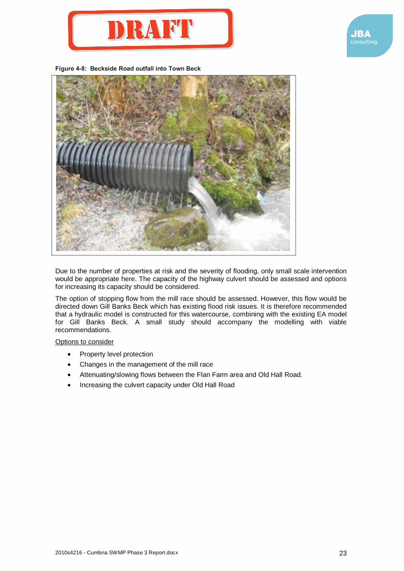
Figure 4-8: Beckside Road outfall into Town Beck
Due to the number of properties at risk and the severity of flooding, only small scale intervention would be appropriate here. The capacity of the highway culvert should be assessed and options for increasing its capacity should be considered.
The option of stopping flow from the mill race should be assessed. However, this flow would be directed down Gill Banks Beck which has existing flood risk issues. It is therefore recommended that a hydraulic model is constructed for this watercourse, combining with the existing EA model for Gill Banks Beck. A small study should accompany the modelling with viable recommendations.
Options to consider
Property level protection
Changes in the management of the mill race
Attenuating/slowing flows between the Flan Farm area and Old Hall Road.
Increasing the culvert capacity under Old Hall Road
coyled
Draft
2010s4216 - Cumbria SWMP Phase 3 Report.docx 24
Figure 4-9: Beckside Road Study Area
Summary – Small scale flood risk where a low cost quick win may be possible. Funding would need to come from local sources (i.e. LLFA, SLDC, local levy, local beneficiaries).
Table 4-4 – Beckside Road Options and Costs
Location Options
Co
st
Esti
mate
(£k)
Comments
PV
B
en
efi
ts
(£k)
Co
st
Ben
efi
t
rati
o
Pro
pert
ies
(1%
even
t)
Beckside Road
1 - Increasing the culvert capacity under Old Hall Road (30m length) £288
The size of the culvert is not yet known and whether there is enough room beneath the road deck to install a larger culvert. £180 0.6 20
Legend
Main River
Waterbodies
Study Area
1 in 30 yr sw flood
1 in 100 yr sw flood
Mill race begins
Old Hall Road
Beckside
Road
Gill Banks Beck
coyled
Draft
2010s4216 - Cumbria SWMP Phase 3 Report.docx 25
Immediate actions
Modelling and feasibility study
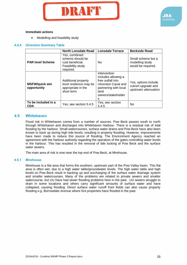
4.4.4 Ulverston Summary Table
North Lonsdale Road Lonsdale Terrace Beckside Road
PAR level Scheme
Yes, combined scheme should be cost beneficial. Feasibility study required.
No Small scheme but a modelling study would be required.
MSFW/quick win opportunity
Additional property level resilience may be appropriate in the short term.
Intervention includes allowing a free outfall into Ulverston Canal and partnering with local land owners/stakeholders
Yes, options include culvert upgrade and upstream attenuation.
To be included in a CDA
Yes, see section 5.4.5 Yes, see section 5.4.5
No
4.5 Whitehaven
Flood risk in Whitehaven comes from a number of sources. Pow Beck passes south to north through Whitehaven and discharges into Whitehaven Harbour. There is a residual risk of tidal flooding by the harbour. Small watercourses, surface water drains and Pow Beck have also been known to back up during high tide levels, resulting in property flooding. However, improvements have been made to reduce this source of flooding. The Environment Agency reached an agreement with the harbour authority regarding the operation of the gates controlling water levels in the harbour. This has resulted in the removal of tide locking of Pow Beck and the surface water sewers.
The main area of risk is now near the top end of Pow Beck, at Mirehouse.
4.5.1 Mirehouse
Mirehouse is a flat area that forms the southern, upstream part of the Pow Valley basin. This flat area is often wet, due to a high water table/groundwater levels. The high water table and high levels on Pow Beck result in backing up and surcharging of the surface water drainage system and smaller watercourses. Many of the problems are related to private sewers and smaller watercourse, but UU have had sewer flooding problems here in the past. UU sewers struggle to drain in some locations and others carry significant amounts of surface water and have collapsed, causing flooding. Direct surface water runoff from fields can also cause property flooding e.g. Borrowdale Avenue where five properties have flooded in the past.
coyled
Draft
2010s4216 - Cumbria SWMP Phase 3 Report.docx 26
Figure 4-10: Mirehouse Study Area
Legend
Main River
Waterbodies
Study Area
1 in 30 yr sw flood
1 in 100 yr sw flood
Meadow and Latrigg
Road
Snedbra storage
area
Greenbank
Farm
coyled
Draft

2010s4216 - Cumbria SWMP Phase 3 Report.docx 27
Figure 4-11: The water table and marshy land at Mirehouse
Just downstream of Mirehouse, Pow Beck passes through a large undeveloped boggy area. This area has been used to attenuate flood flows from Snedbra Beck as it flows into Pow Beck and has the potential for environmental improvement (see Figure 4.12).
Providing a solution to the flooding at Mirehouse will be difficult as properties have been constructed in an area that has a high water table. Getting a free outfall from Mirehouse and into Pow Beck is the main problem. Resewering appears to be the only long term option, but this is expensive and disruptive. The level of flood risk indicates that a large scale capital scheme will not be cost beneficial.
coyled
Draft
2010s4216 - Cumbria SWMP Phase 3 Report.docx 28
Figure 4-12: Pow Beck near to the Snedbra storage area
Summary and appraisal
Flood risk at Mirehouse comes from a number of sources with multiple potential partners. High levels in Pow Beck can lead to surface water outfalls backing up (UU sewers, small Copeland BC drains and Cumbria Highway sewers). Mirehouse has been developed in a flat area with a high water table further adding to the drainage/outfall problems. A combined scheme tackling all sources and multiple partners may be possible. A small amount of funding could deliver some benefits e.g. property level protection.
The majority of the historic flooding aligns with a surface water flow path to the west of Pow Beck (along Meadow and Latrigg Road). This flow path originates further to the east, near Greenbank Farm. Measures to attenuate the flow of these ditches could reduce some of the risk downstream risk. Other surface water/natural drainage flow paths in the same area flow northwards and enter the surface water/highway drainage system. Flows paths in this flat area should be assessed in more detail to see if more flows could be directed south into the St Bees Pow Beck catchment, or attenuated at the top of both catchments.
There is also an opportunity to improve the Snedbra/Pow Beck boggy area into a more effective wetland. A combined scheme to reduce flood risk at Mirehouse and improve this area could attract other environmental and community funding sources.
Recommendations for new development should include a restriction on surface water discharges into the Pow Valley area.
coyled
Draft

2010s4216 - Cumbria SWMP Phase 3 Report.docx 29
Table 4-5 – Mirehouse Options and Costs
Location Options
Co
st
Esti
mate
(£k)
Comments
PV
B
en
efi
ts
(£k)
Co
st
Ben
efi
t ra
tio
Pro
pert
ies
(1%
even
t)
Mirehouse
3. Resewer parts of the drainage area (UU, highways and Copeland) £1,416 £613 0.4 60
4. Works on Pow Beck (dredging) reinstate outfalls and enhance the downstream storage area. £1,805
This may conflict with WFD objectives. Dredging has taken place in the past. £613 0.3
5. Property level protection £374 £613 1.6
6. Investigate and attenuate/redirect flow paths at the top of the catchment (e.g. Green Bank Farm flow path) £567
This would not provide a full, complete scheme. £613 1.1
coyled
Draft

2010s4216 - Cumbria SWMP Phase 3 Report.docx 30
Table 4-6 – Mirehouse Initial Options Appraisal
Option N
o.
Option
Reduce R
isk
Econom
ic
Socia
l
Environm
enta
l
Pra
cticalit
y
Overa
ll Comments
1 Do nothing -2 -2 -2 -2 0 -8
Increase in flooding from sewer collapse, blocked culverts etc. Not a viable option.
2 Do minimum -1 -1 -1 -1 1 -3
Flooding would still occur at the current level. Due to low cost benefit scores for intervention, this may be the option in the short term.
3 Resewer parts of the drainage area
2 -1 2 1 -2 2
Extensive resewering would be expensive but should sufficiently reduce the risk if practical. The practicality of a solution could be a major constraint due to the topography and high water table. However, this option could attract multiple funders (UU).
4 Dredge Pow Beck reinstate outfalls and enhance, storage area
1 -1 -1 2 1 2
This option involves indirect action and may not completely remove the risk so public approval may be low. This option also struggles on cost/benefits but has environmental benefits and the possibility of joint EA funding.
5 Property level protection
1 0 0 -1 1 1
This appears to be the most cost beneficial option but would not remove flood water from the area
6 Attenuate/redirect flow paths at the top of the catchment
-1 0 0 1 1 1
This is indirect intervention that may not completely remove the risk. The costs could be reduced after a more detailed assessment and there are potential environmental benefits.
Summary
Some intervention is economically beneficial although the cost benefit ratio is low. The scale of any intervention means that FDGiA should be applied for. However, the low cost/benefit scores means that a scheme could struggle to attract FDGiA without significant partnership funding.
Options 3 (resewering) and 4 (dredge Pow Beck reinstate outfalls and enhance, storage area) appear to come out on top in this initial appraisal. However, any scheme will be dependent on multiple funders and is likely to involve a combination of the above options. Property level protection on its own is not a sustainable option.
Immediate actions
MSFW group to discuss the options for reducing risk and future work plans (e.g. UU Amp work in this area and EA plans for Pow Beck in the Mirehouse/Snedbra storage area).
Study into the drainage network and flood pathways for the main risk locations (e.g. west of Pow Beck).
coyled
Draft
2010s4216 - Cumbria SWMP Phase 3 Report.docx 31
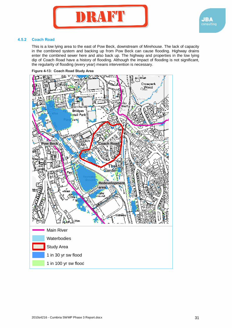
4.5.2 Coach Road
This is a low lying area to the east of Pow Beck, downstream of Mirehouse. The lack of capacity in the combined system and backing up from Pow Beck can cause flooding. Highway drains enter the combined sewer here and also back up. The highway and properties in the low lying dip of Coach Road have a history of flooding. Although the impact of flooding is not significant, the regularity of flooding (every year) means intervention is necessary.
Figure 4-13: Coach Road Study Area
Legend
Main River
Waterbodies
Study Area
1 in 30 yr sw flood
1 in 100 yr sw flood
Coach Road Pow Beck
Redevelopment
area
coyled
Draft

2010s4216 - Cumbria SWMP Phase 3 Report.docx 32
Figure 4-14: Properties at risk from the Coach Road Culvert
Summary
Flood risk at Coach Road is from a UU combined sewer and highway sewers. Flood risk is also linked to high levels on Pow Beck. As there are combined responsibilities here, there may be a number of potential funders. There is the option for high cost intervention and lower cost measures. Due to the low number of properties at risk, the high cost option may not be appropriate.
However, UU may plan to invest in this location as part of their investment programme, more information is required on UU’s future plans. It will be important to collaborate with UU to provide a complete solution. In addition to this, new development in this area should not discharge surface water into the Coach Road combined sewer.
Table 4-7 – Coach Road Options and Costs
Location Options
Co
st
Esti
mate
(£
k)
Comments
PV
B
en
efi
ts
(£k)
Co
st
Ben
efi
t
rati
o
Pro
pert
ies
(1
% e
ven
t)
Coach Road
1 - Upgrade Coach Road combined sewer and the highway drains £232 £270 1.2
6
2 - Property level protection for the small number of properties at risk £66 £270 4.1
Property level protection appears to be the most cost beneficial approach for reducing risk to properties. However, the highway will still be liable to flooding and reducing highway flooding may be one of the MSFW group’s objectives.
Immediate actions
MSFW group to continue work and studies led by Cumbria Highways and UU.
coyled
Draft
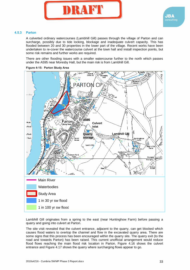
2010s4216 - Cumbria SWMP Phase 3 Report.docx 33
4.5.3 Parton
A culverted ordinary watercourses (Lambhill Gill) passes through the village of Parton and can surcharge, possibly due to tide locking, blockage and inadequate culvert capacity. This has flooded between 20 and 30 properties in the lower part of the village. Recent works have been undertaken to re-cover the watercourse culvert at the town hall and install inspection points, but some risk remains and further works are required.
There are other flooding issues with a smaller watercourse further to the north which passes under the A595 near Moresby Hall, but the main risk is from Lambhill Gill.
Figure 4-15: Parton Study Area
Lambhill Gill originates from a spring to the east (near Huntinghow Farm) before passing a quarry and going into culvert at Parton.
The site visit revealed that the culvert entrance, adjacent to the quarry, can get blocked which causes flood waters to overtop the channel and flow in the excavated quarry area. There are some signs that this process has been encouraged within the quarry site. The quarry exit (to the road and towards Parton) has been raised. This current unofficial arrangement would reduce flood flows reaching the main flood risk location in Parton. Figure 4.16 shows the culvert entrance and Figure 4.17 shows the quarry where surcharging flows appear to go.
Legend
Main River
Waterbodies
Study Area
1 in 30 yr sw flood
1 in 100 yr sw flood
Lambhill Gill Quarry
storage
A595 Culvert
inlet
coyled
Draft

2010s4216 - Cumbria SWMP Phase 3 Report.docx 34
Figure 4-16: The entrance to Lambhill Gill culvert
coyled
Draft

2010s4216 - Cumbria SWMP Phase 3 Report.docx 35
Figure 4-17: The quarry near where Lambhill Gill has been surcharging
Summary and solution
A blocked culvert in the village hall grounds was identified as the underlying cause of flooding in Parton during the last major event in 2006. After opening and cleaning, the culvert was reinstated. However, it is not known if this has fully solved the problem in Parton.
In order to provide a sustainable solution, a study is required. Modelling Lambhill Gill and options to reduce the risk options should be considered. The modelling should include joint tidal fluvial probability scenarios to assess the hydraulic gradeline of the tidal boundary. All of the other sources of flooding should also be investigated, including the highway gullies and the watercourse by Moresby Hall. The flow pathways of these other sources should be identified to see which are significantly contributing to flood risk in different parts of Parton.
Options to reduce risk should include works on Lambhill Gill before it enters Parton. This watercourse flows in a steep gulley before entering a culvert at Lambhill Quarry. A screen has been placed over this culvert entrance which was blocked at the time of the site visit. This has the effect of reducing the flow and therefore flood risk downstream. However, with the current informal arrangement in place, flood waters will enter the excavated quarry area. This may not be acceptable to the quarry owners and they may clear the culvert and insure that it does not get blocked, reinstating the main flood source to Parton. Further intervention upstream on Lambill Gill (e.g. slowing the flood flows) could reduce flood risk to Parton. Alternatively, the current flood flow route into the quarry could be formalised, in agreement with the quarry owners. Consultation with the quarry owners should form part of the solution here.
coyled
Draft
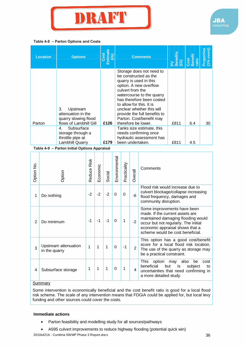
2010s4216 - Cumbria SWMP Phase 3 Report.docx 36
Table 4-8 – Parton Options and Costs
Location Options
Co
st
Esti
mate
(£
k)
Comments
PV
B
en
efi
ts
(£k)
Co
st
Ben
efi
t ra
tio
Pro
pert
ies
(1%
even
t)
Parton
3. Upstream attenuation in the quarry slowing flood flows of Lambhill Gill £126
Storage does not need to be constructed as the quarry is used in this option. A new overflow culvert from the watercourse to the quarry has therefore been costed to allow for this. It is unclear whether this will provide the full benefits to Parton. Cost/benefit may therefore be lower. £811 6.4 30
4. Subsurface storage through a throttle pipe at Lambhill Quarry £179
Tanks size estimate, this needs confirming once hydraulic assessment has been undertaken. £811 4.5
Table 4-9 – Parton Initial Options Appraisal
Option N
o.
Option
Reduce R
isk
Econom
ic
Socia
l
Environm
enta
l
Pra
cticalit
y
Overa
ll Comments
1 Do nothing -2 -2 -2 0 0 -6
Flood risk would increase due to culvert blockage/collapse increasing flood frequency, damages and community disruption.
2 Do minimum -1 -1 -1 0 1 -2
Some improvements have been made. If the current assets are maintained damaging flooding would occur but not regularly. The initial economic appraisal shows that a scheme would be cost beneficial.
3 Upstream attenuation in the quarry
1 1 1 0 -1 2
This option has a good cost/benefit score for a local flood risk location. The use of the quarry as storage may be a practical constraint.
4 Subsurface storage 1 1 1 0 1 4
This option may also be cost beneficial but is subject to uncertainties that need confirming in a more detailed study.
Summary
Some intervention is economically beneficial and the cost benefit ratio is good for a local flood risk scheme. The scale of any intervention means that FDGiA could be applied for, but local levy funding and other sources could cover the costs.
Immediate actions
Parton feasibility and modelling study for all sources/pathways
A595 culvert improvements to reduce highway flooding (potential quick win)
coyled
Draft
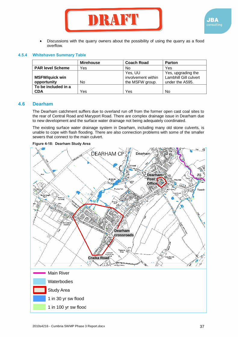
2010s4216 - Cumbria SWMP Phase 3 Report.docx 37
Discussions with the quarry owners about the possibility of using the quarry as a flood overflow.
4.5.4 Whitehaven Summary Table
Mirehouse Coach Road Parton
PAR level Scheme Yes No Yes
MSFW/quick win opportunity No
Yes, UU involvement within the MSFW group.
Yes, upgrading the Lambhill Gill culvert under the A595.
To be included in a CDA Yes Yes No
4.6 Dearham
The Dearham catchment suffers due to overland run off from the former open cast coal sites to the rear of Central Road and Maryport Road. There are complex drainage issue in Dearham due to new development and the surface water drainage not being adequately coordinated.
The existing surface water drainage system in Dearham, including many old stone culverts, is unable to cope with flash flooding. There are also connection problems with some of the smaller sewers that connect to the main culvert.
Figure 4-18: Dearham Study Area
Legend
Main River
Waterbodies
Study Area
1 in 30 yr sw flood
1 in 100 yr sw flood
Dearham
crossroads
Craika Road
Dearham Post
Office
coyled
Draft
2010s4216 - Cumbria SWMP Phase 3 Report.docx 38
4.6.1 Dearham Crossroads
The specific parts of Dearham Crossroads that are at risk include Maryport Road, Craika Road, Central Road and Lonsdale Terrace. There are issues relating to inadequate and damaged culverted watercourses adjacent to the Ploughman’s Inn public house and the Commercial Inn public house (on the cross road of Central Road and the A594).
The contributing catchment to this flood risk location is very small (just from the top of Craika Road). Overland runoff can flow down Craika Road and to the crossroads flood risk area. The watercourse that should take this runoff into culvert by the Ploughman Inn has been filled in. UU have also had flooding issues here (Lonsdale Terrace) so a collaborative approach should be considered.
Some improvement to the top end of Dearham (the south west part of the village) have been undertaken. This includes UU mitigation works in the Lonsdale View and Road End View areas. Further investigations are being undertaken by UU.
Summary and solution
As the drainage issues are complex, a large capital scheme would be required to provide a complete solution for Dearham. The number of properties at risk probably would not justify a large scheme. However, UU have had some flooding issues here and as there is the potential for significant development. Dearham could feature on UU’s investment plans and developer funds could make a scheme more realistic. Section 4.10 provides more detail on the future development and critical drainage area.
Smaller scale schemes have been undertaken in the past through the MSFW group with good results. A collaborative approach (UU, Allerdale BC, Cumbria CC) and access to quick win funding appears to be the best approach. The MSFW group should continue with any improvements but the future development should lead in the overall improvement to Dearham through the drainage impact assessment and combined funding (developer, LLFA, UU, MSFW etc). Liaison with the Allerdale planners is therefore recommended for this location.
Table 4-10 – Dearham Crossroads Options and Costs
Location Options
Co
st
Esti
mate
(£
k)
Comments
PV
B
en
efi
ts
(£k)
Co
st
Ben
efi
t
rati
o
Pro
pert
ies
(1%
even
t)
Dearham Crossroads
1. Property level protection £81 £111 1.4
13 2. Re sewering £432
Replace and reinstate the sewers in this risk area £111 0.3
Cost benefit scores are low, property level protection may be the best way forward. Some smaller scale actions (rather than complete resewering) could bring improvements over time (see actions below).
Immediate actions
Developer led improvement to the new development areas and Dearham as a whole. Meetings with Allerdale LPA to plan for this.
MSFW group to undertake smaller scale drainage system improvements (e.g. to connections)
Obtain funding and prioritise small scale quick wins:
Newlands Park Run off from opencast site west of the village. Land drainage problem. Further research required.
Craika Road Run off from opencast site to rear of properties.
coyled
Draft
2010s4216 - Cumbria SWMP Phase 3 Report.docx 39
Dearham Bridge. The UU bridge acts as throttle, raising river levels and flooding property. Gully pipe to be provided. Property owner has done some work here.
4.6.2 Dearham Post Office
The flood flow path at Dearham Crossroads continues down Central Road where the post office and several properties to the rear are prone to flooding. This is a small flood risk location where a quick win should be possible.
Table 4-11 – Dearham Post Office Options and Costs
Location Options
Co
st
Esti
mate
(£
k)
Comments
PV
B
en
efi
ts
(£k)
Co
st
Ben
efi
t ra
tio
Pro
pert
ies
(1%
even
t)
Dearham (post office)
1. Property level protection £19 £43 2.3 3
Due to the small scale nature of the risk, property level protection or raising kerbs appears to be the only viable option.
Immediate actions
Visit 9a Main Street Near Post Office to confirm risk and solution. Gullies exist in low spot. Private road drainage is poor.
4.6.3 Dearham Summary Table
Dearham Crossroads Dearham Post Office
PV Damages PAR level Scheme Possibly No
MSFW/quick win opportunity Yes Yes To be included in a CDA Yes Yes
4.7 Keswick
4.7.1 Ambleside Road
In this location, a small catchment is the source of a significant surface water flood risk in Keswick (according to anecdotal information). The catchment includes Castlehead Wood to the south of Keswick (see Figure 4.19). However, the surface water mapping shows that there is a flood flow path from Brockle Beck (to the south) flowing south to north and contributing to this flood location. The source of flooding should therefore be confirmed in a future study.
Runoff from this catchment or Brockle Beck enters a culvert at Ambleside Road. This culvert flows southwards into the River Greta and is prone to surcharging at Ambleside Road. This creates a flow path over Ambleside Road and down Eskin/Greta Street, passing over Penrith Road and into the River Greta, following the line of the culvert. A flood wall has recently been constructed along the River Greta. This exacerbates the problem as the flood flow path is now unable to discharge directly into the Greta and will flood the surrounding properties on Penrith Road.
coyled
Draft

2010s4216 - Cumbria SWMP Phase 3 Report.docx 40
Figure 4-19: Ambleside Road Study Area
This flow path floods many properties along its route. Some of the properties have basements and low door thresholds exacerbating the risk.
Legend
Main River
Waterbodies
Study Area
1 in 30 yr sw flood
1 in 100 yr sw flood
Ambleside Road
Brockle Beck
Castlehead
Wood
Penrith Road
River Greta
coyled
Draft
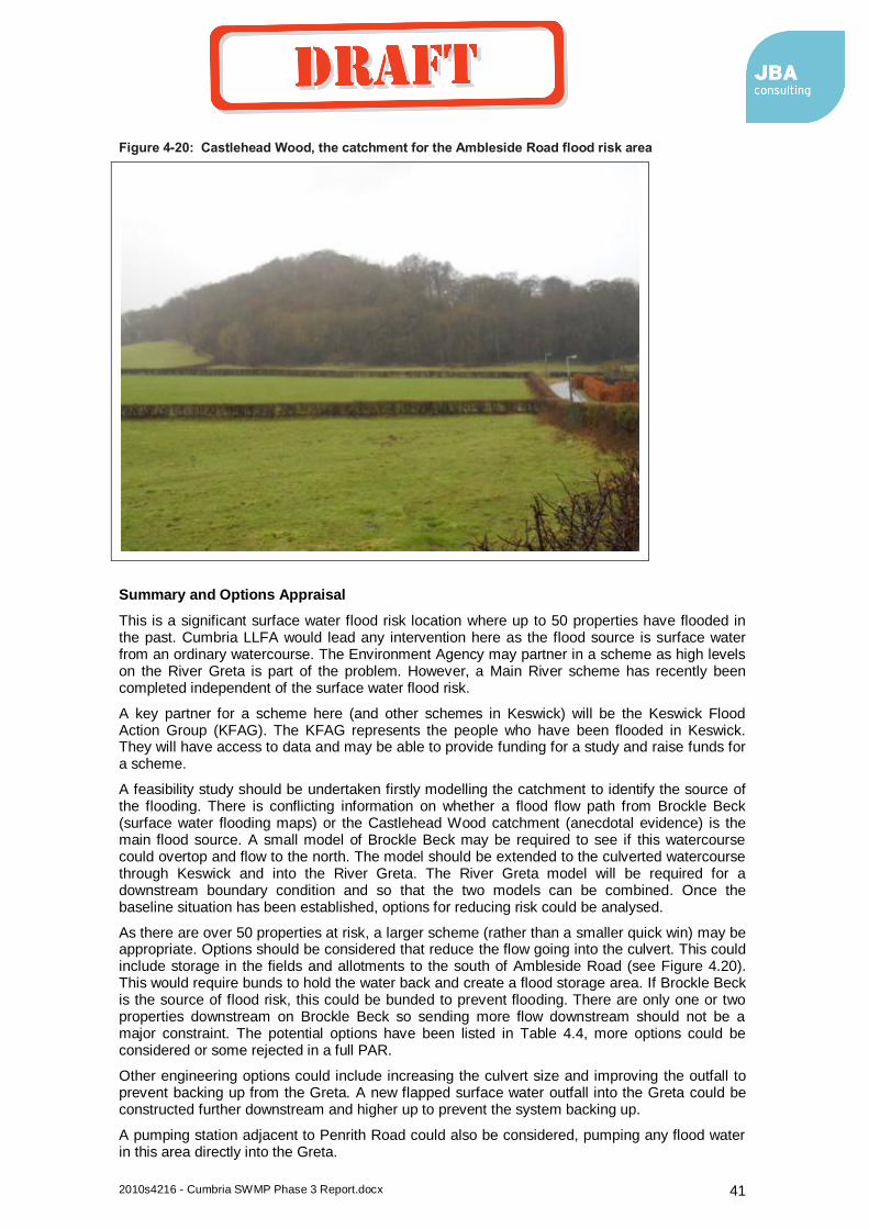
2010s4216 - Cumbria SWMP Phase 3 Report.docx 41
Figure 4-20: Castlehead Wood, the catchment for the Ambleside Road flood risk area
Summary and Options Appraisal
This is a significant surface water flood risk location where up to 50 properties have flooded in the past. Cumbria LLFA would lead any intervention here as the flood source is surface water from an ordinary watercourse. The Environment Agency may partner in a scheme as high levels on the River Greta is part of the problem. However, a Main River scheme has recently been completed independent of the surface water flood risk.
A key partner for a scheme here (and other schemes in Keswick) will be the Keswick Flood Action Group (KFAG). The KFAG represents the people who have been flooded in Keswick. They will have access to data and may be able to provide funding for a study and raise funds for a scheme.
A feasibility study should be undertaken firstly modelling the catchment to identify the source of the flooding. There is conflicting information on whether a flood flow path from Brockle Beck (surface water flooding maps) or the Castlehead Wood catchment (anecdotal evidence) is the main flood source. A small model of Brockle Beck may be required to see if this watercourse could overtop and flow to the north. The model should be extended to the culverted watercourse through Keswick and into the River Greta. The River Greta model will be required for a downstream boundary condition and so that the two models can be combined. Once the baseline situation has been established, options for reducing risk could be analysed.
As there are over 50 properties at risk, a larger scheme (rather than a smaller quick win) may be appropriate. Options should be considered that reduce the flow going into the culvert. This could include storage in the fields and allotments to the south of Ambleside Road (see Figure 4.20). This would require bunds to hold the water back and create a flood storage area. If Brockle Beck is the source of flood risk, this could be bunded to prevent flooding. There are only one or two properties downstream on Brockle Beck so sending more flow downstream should not be a major constraint. The potential options have been listed in Table 4.4, more options could be considered or some rejected in a full PAR.
Other engineering options could include increasing the culvert size and improving the outfall to prevent backing up from the Greta. A new flapped surface water outfall into the Greta could be constructed further downstream and higher up to prevent the system backing up.
A pumping station adjacent to Penrith Road could also be considered, pumping any flood water in this area directly into the Greta.
coyled
Draft
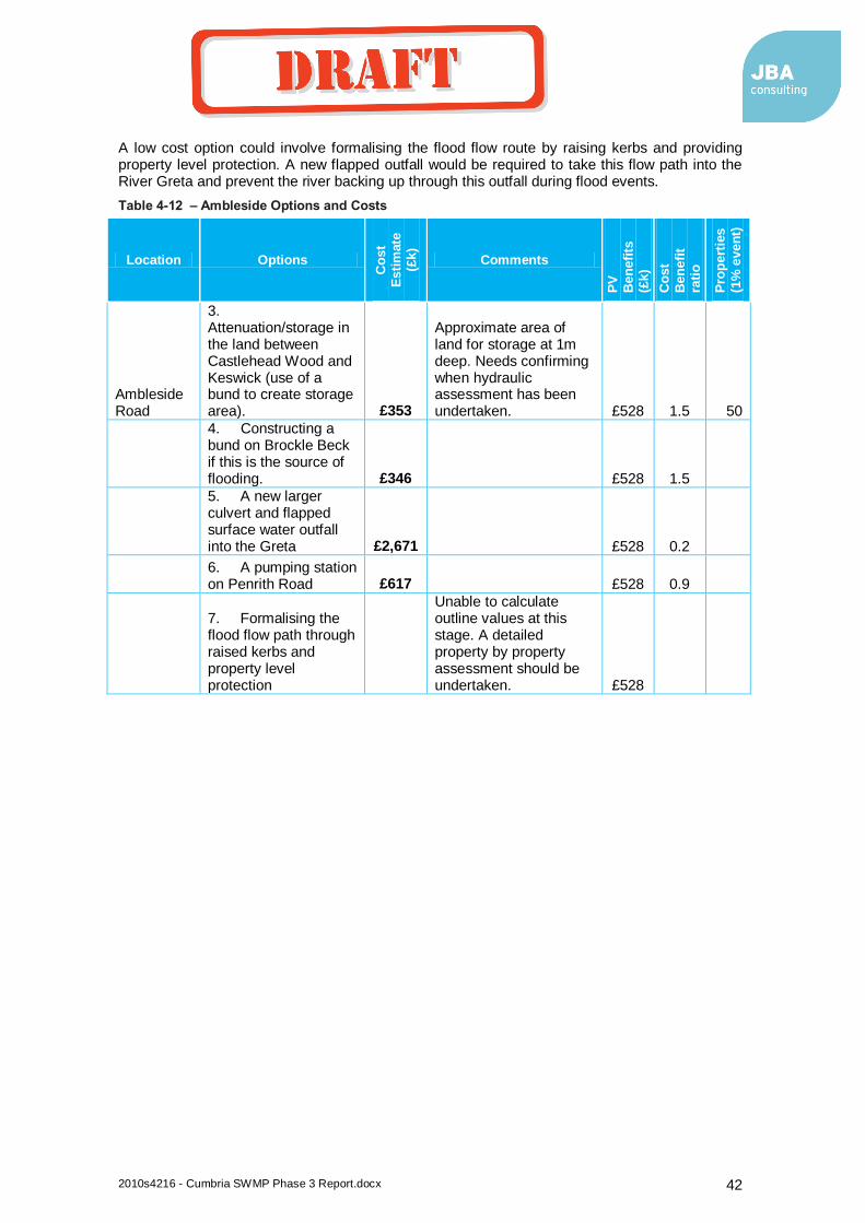
2010s4216 - Cumbria SWMP Phase 3 Report.docx 42
A low cost option could involve formalising the flood flow route by raising kerbs and providing property level protection. A new flapped outfall would be required to take this flow path into the River Greta and prevent the river backing up through this outfall during flood events.
Table 4-12 – Ambleside Options and Costs
Location Options
Co
st
Esti
mate
(£
k)
Comments
PV
Ben
efi
ts
(£k)
Co
st
Ben
efi
t ra
tio
Pro
pert
ies
(1%
even
t)
Ambleside Road
3. Attenuation/storage in the land between Castlehead Wood and Keswick (use of a bund to create storage area). £353
Approximate area of land for storage at 1m deep. Needs confirming when hydraulic assessment has been undertaken. £528 1.5 50
4. Constructing a bund on Brockle Beck if this is the source of flooding. £346 £528 1.5
5. A new larger culvert and flapped surface water outfall into the Greta £2,671 £528 0.2
6. A pumping station on Penrith Road £617 £528 0.9
7. Formalising the flood flow path through raised kerbs and property level protection
Unable to calculate outline values at this stage. A detailed property by property assessment should be undertaken. £528
coyled
Draft
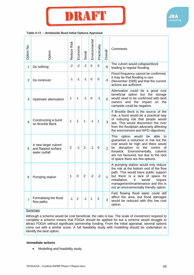
2010s4216 - Cumbria SWMP Phase 3 Report.docx 43
Table 4-13 – Ambleside Road Initial Options Appraisal
Option N
o.
Option
Reduce R
isk
Econom
ic
Socia
l
Environm
enta
l
Pra
cticalit
y
Overa
ll Comments
1 Do nothing -2 -2 -2 0 0 -6 The culvert would collapse/block leading to regular flooding.
2 Do minimum -1 -1 -1 0 0 -3
Flood frequency cannot be confirmed, it may be that flooding is rare (November 2009) and that the current actions are sufficient.
3 Upstream attenuation 1 1 -1 0 -1 0
Attenuation could be a good cost beneficial option but the storage would need to be confirmed with land owners and the impact on the campsite could be negative.
4 Constructing a bund on Brockle Beck
1 1 1 -1 1 3
If Brockle Beck is the source of the risk, a bund would be a practical way of reducing risk that people would see. This would disconnect the river from the floodplain adversely affecting the environment and WFD objectives.
5 A new larger culvert and flapped surface water outfall
2 -1 2 -1 0 2
This option would be able to guarantee a reduction in risk but the cost would be high and there would be disruption to the centre of Keswick. Environmentally, culverts are not favoured, but due to the lack of space there are few options.
6 Pumping station 1 0 2 -2 -2 -1
A pumping station would only reduce the risk at the bottom end of the flow path. This would have public support but there is a lack of space for installation, it would require management/maintenance and this is not an environmentally friendly option.
7 Formalising the flood flow paths
-1 2 -1 1 2 3
Fast flowing flood water could still affect the area, but flood damages would be reduced with this low cost option.
Summary
Although a scheme would be cost beneficial, the ratio is low. The scale of investment required to complete a scheme means that FDGiA should be applied for but a scheme would struggle to attract FDGiA without significant partnership funding. From the initial appraisal, several options come out with a similar score. A full feasibility study with modelling should be undertaken to identify the best option.
Immediate actions
Modelling and feasibility study
coyled
Draft

2010s4216 - Cumbria SWMP Phase 3 Report.docx 44
4.7.2 Penrith Road
This surface water flood location is due to a number of surface water flow pathways that combine at Penrith Road where most of the damage is caused.
Highway sheet flow from Chesnut Hill (A591), The Hawthornes (A591) and Eleventrees, floods properties along their route before combining at Penrith Road (A5271). At this point, some of the surface flow can enter the River Greta through a small double pipe installed by Cumbria Highways. However the majority of the flow continues into Keswick along Penrith Road and floods 5-10 properties (Figure 4.22) before discharging into the River Greta.
Figure 4-21: Penrith Road Study Area
This part of Keswick has many small watercourses running through it that have been constrained by development and roads. During flood conditions, trash and leaves can collect on watercourse/culvert grids in different locations, which causes flooding down the hill onto Penrith Road. Some of the bridges are also undercapacity which can also lead to surcharging, surface flow and property flooding. Figure 4.23 shows one of the watercourse screens.
Surcharging highway culverts and natural springs within this part of Keswick flood properties and adding to the main flow path. The highway runoff enters properties as the kerbs are not high enough to keep the flow on the roads.
Legend
Main River
Waterbodies
Study Area
1 in 30 yr sw flood
1 in 100 yr sw flood
Penrith Road
River Greta
The Hawthorns
Chesnut Hill
Town Field Latrigg
Close
coyled
Draft

2010s4216 - Cumbria SWMP Phase 3 Report.docx 45
Figure 4-22: Properties flooded on Penrith Road
Figure 4-23: Blocked grids in Keswick
Summary and Solutions
coyled
Draft
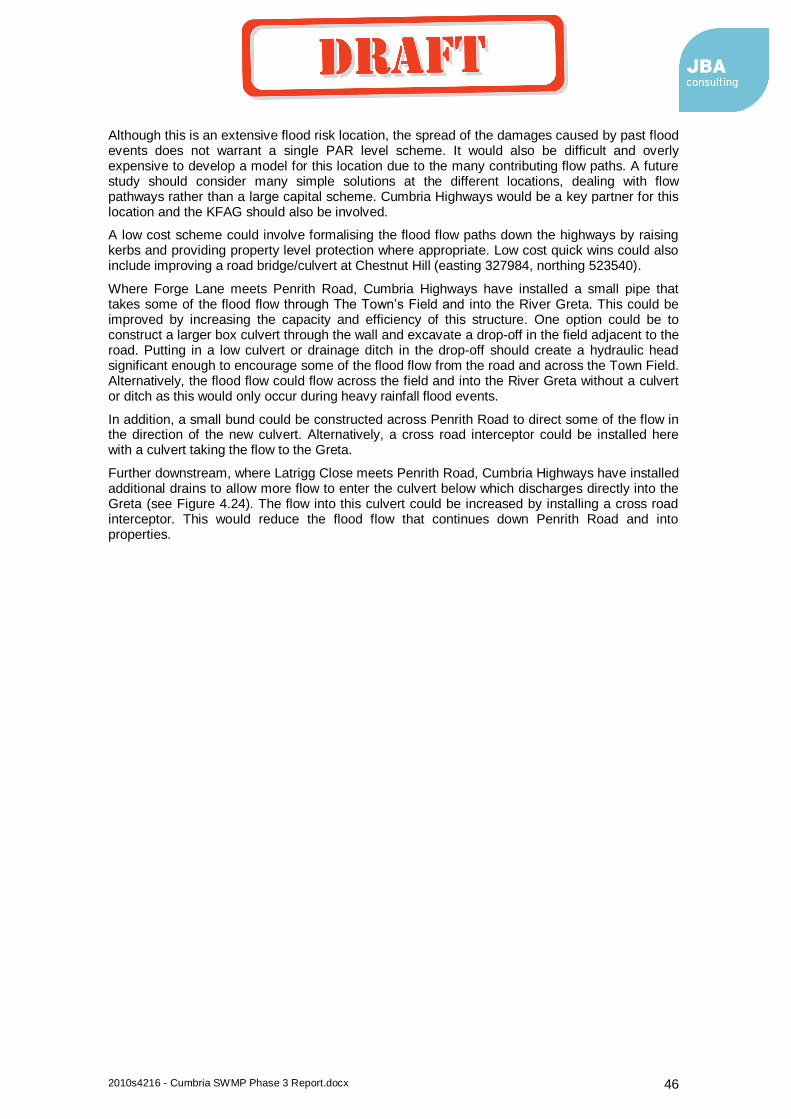
2010s4216 - Cumbria SWMP Phase 3 Report.docx 46
Although this is an extensive flood risk location, the spread of the damages caused by past flood events does not warrant a single PAR level scheme. It would also be difficult and overly expensive to develop a model for this location due to the many contributing flow paths. A future study should consider many simple solutions at the different locations, dealing with flow pathways rather than a large capital scheme. Cumbria Highways would be a key partner for this location and the KFAG should also be involved.
A low cost scheme could involve formalising the flood flow paths down the highways by raising kerbs and providing property level protection where appropriate. Low cost quick wins could also include improving a road bridge/culvert at Chestnut Hill (easting 327984, northing 523540).
Where Forge Lane meets Penrith Road, Cumbria Highways have installed a small pipe that takes some of the flood flow through The Town’s Field and into the River Greta. This could be improved by increasing the capacity and efficiency of this structure. One option could be to construct a larger box culvert through the wall and excavate a drop-off in the field adjacent to the road. Putting in a low culvert or drainage ditch in the drop-off should create a hydraulic head significant enough to encourage some of the flood flow from the road and across the Town Field. Alternatively, the flood flow could flow across the field and into the River Greta without a culvert or ditch as this would only occur during heavy rainfall flood events.
In addition, a small bund could be constructed across Penrith Road to direct some of the flow in the direction of the new culvert. Alternatively, a cross road interceptor could be installed here with a culvert taking the flow to the Greta.
Further downstream, where Latrigg Close meets Penrith Road, Cumbria Highways have installed additional drains to allow more flow to enter the culvert below which discharges directly into the Greta (see Figure 4.24). The flow into this culvert could be increased by installing a cross road interceptor. This would reduce the flood flow that continues down Penrith Road and into properties.
coyled
Draft
2010s4216 - Cumbria SWMP Phase 3 Report.docx 47
Figure 4-24: Additional highway drains on Penrith Road, alternative option below
Alternative option from St Ives will allow more flow to be intercepted
coyled
Draft

2010s4216 - Cumbria SWMP Phase 3 Report.docx 48
Table 4-14 – Penrith Road Options and Costs
Location Options
Co
st
Esti
mate
(£
k)
Comments
PV
Ben
efi
ts
(£k)
Co
st
Ben
efi
t ra
tio
*
Pro
pert
ies
(1%
even
t)
Ambleside Road
3. Increasing the flow into The Town’s Field by constructing a larger culvert, a road hump and a drop-off. £144
15m length culvert cost £216
4. Install a cross road interceptor and culvert at the Town Filed. Installing a cross road interceptor adjacent to Latrigg Close to intercept the remaining flow.
Unable to calculate values at this stage. This type of asset has rarely been used. Highways should assist with cost estimates. An example can be found in Penbeagle Lane, Saint Ives. £216
5. Property level protection for the properties at risk. £96 £216
6. Raising kerbs to formalise the flood flow pathways down the highways and allowing the flood flow to continue down to Penrith Road and not into properties. Some property level protection could also be installed for any residual risk.
Unable to calculate values at this stage. £216
*As a combination of the above options would constitute a complete scheme, providing cost benefit ratios for the individual elements would be misleading. Cost benefit ratios have therefore not been provided.
coyled
Draft

2010s4216 - Cumbria SWMP Phase 3 Report.docx 49
Table 4-15 – Penrith Road Initial Options Appraisal
Option N
o.
Option
Reduce R
isk
Econom
ic
Socia
l
Environm
enta
l
Pra
cticalit
y
Overa
ll Comments
1 Do nothing -2 -2 -2 0 0 -6
The minor culverts and grills would be permanently blocked leading to flooding on a regular basis down the highways and into people’s homes.
2 Do minimum -1 -1 -1 0 0 -3
Cleaning culverts and grills would need to continue and more effectively. This would maintain the current level of risk. The culverts would still not be able to take extreme, heavy downpours.
3
Constructing a larger culvert, a road hump and a drop-off at Town Field.
1 1 1 0 1 4
This option may not completely remove the risk as come flood waters may continue across and there is some upstream damage. But this looks to be a viable option as the council own Town Field.
4
Install a cross road interceptor and culvert at the Town Field and Latrigg Close
1 1 1 0 1 4
This option could intercept the flood flow at two points potentially reducing the risk by a greater degree. This is an easy to implement solution which is likely to be low cost.
5 Property level protection for the properties at risk
1 2 0 0 1 4
As the properties at risk are spread out, targeted property level protection could be a cost effective, practical solution. There would still be flood waters in the highway.
6 Raising kerbs to formalise the flood flow pathways
1 2 0 0 1 4
This is an alternative version to property level protection and would cost less but would increase flood flow velocities and volumes in the highways.
Summary
Indications are that there is a cost beneficial scheme for this location, a number of options exist and have a similar score in the initial appraisal. A combination of these measures may therefore be appropriate. More work is needed to estimate costs and damages. Modelling would not be required for this as scheme costs would be more appropriate for local levy funding (rather than FDGiA) and it is not possible to model the surface water flooding without an over expensive modelling exercise.
Immediate actions
More detailed (but low cost) assessment of costs and benefits, working predominantly with Cumbria Highways in the MSFW group.
Any of the above options could be investigated further and completed now as quick wins.
A quick win could involve improvements to the bridge/culvert on Chestnut Road (easting 327984, northing 523540) which could include a new single span highways bridge and improved trash screen design.
coyled
Draft

2010s4216 - Cumbria SWMP Phase 3 Report.docx 50
4.7.3 Elliot Park
Elliot Park is a relatively new residential area that is prone to flooding from a number of sources. This residential area is in a shallow basin next to the River Greta and flooding occurs from the River Greta, combined sewer and surface water sewers. There is an ongoing capital project to address the river and combined sewer flooding. UU will install a pumping station at Rawnsley which will alleviate the existing combined sewer flooding problem at Elliot Park. The Environment Agency have improved the flood defences to reduce the risk of overtopping at Elliot Park.
Once these schemes have been completed, there will still be a risk of surface water flooding at Elliot Park from highway drains and private surface water sewers that become river locked when there are high levels in the River Greta. This remaining risk is the responsibility of the LLFA and should therefore be considered in the SWMP and Local Strategy.
Due to the regularity of property flooding at Elliot Park, Cumbria CC as LLFA have commissioned a more detailed study. This study will assess the risk in more detail and appraise options for reducing risk.
Figure 4-25: Elliot Park Study Area
Potential solutions include using and enhancing the existing (soon to be redundant) UU pumping station. Any new pumps may need to be fitted with non return valves depending on the River Greta outfall level.
Legend
Main River
Waterbodies
Study Area
1 in 30 yr sw flood
1 in 100 yr sw flood
River Greta Elliot
Park
coyled
Draft
2010s4216 - Cumbria SWMP Phase 3 Report.docx 51
There are partnership and funding opportunities with Impact Housing, Local Residents, Cumbria Highways, Booths Supermarket, Environment Agency and United Utilities. The Keswick FAG have a sub group covering Elliot Park and should be involved in the selection of a solution.
Options being considered:
New pumping station at the redundant UU site
Diversion of surface water flow path and property level protection
Immediate actions
Undertake feasibility study and funding assessment
4.7.4 Keswick Summary Table
Ambleside Road Penrith Road Elliot Park
PAR level Scheme Yes No Yes MSFW/quick win opportunity Possibly Yes No To be included in a CDA Yes Yes Yes
4.8 Windermere
There are extensive surface water flooding issues across Windermere. Section 2.2.13 of the Phase 2 report provides a detailed assessment of these strategic flood risks. The main problem in Windermere is that during heavy rainfall events, large volumes of surface water enters public sewers and other council owned and private drains and culverts. It is unclear where many of these sewers and culverts go. These sewers and culverts have not been designed to take significant flood flows, so surcharging and flooding occurs in many different locations across Windermere.
Windermere is built just above the bed rock, which leads to rapid runoff and low infiltration. The sewers are laid on bedrock and are prone to leakage. Some of the manholes are not adequately constructed, having been built directly into rock with rubble wall construction. During the November 2009 flood event, every manhole was surcharging in Windermere (from the lake to the top of the town).
Figure 4.27 shows a public sewer built on bed rock with a stone wall constructed and a significant surface water flow.
coyled
Draft

2010s4216 - Cumbria SWMP Phase 3 Report.docx 52
Figure 4-26: Windermere Study Area
Legend
Main River
Waterbodies
Study Area
1 in 30 yr sw flood
1 in 100 yr sw flood
Lake
Windermere
coyled
Draft

2010s4216 - Cumbria SWMP Phase 3 Report.docx 53
Figure 4-27: Surface water flow in the sewer system
Private sewers and drains appear the source of flooding in other areas, specifically due to poor connections (including down pipe connections) and connecting large pipes to smaller pipes. There is also the potential for siltation and pipe blockage as a result of highway runoff getting into these private drains. In addition, groundwater levels rising along the lines of what may have been original watercourses, can contribute to the risk.
Figure 4.28 shows a new trash screen that has been built over one of the larger watercourses in Windermere. This prevents blockage and flooding further downstream in the culvert.
High lake levels also lead to direct flooding and backing up of the outfalls. Figure 5.29 shows a surface water outfall into Lake Windermere.
There are a number of surface water flooding issues across the town where the hills meet the urban area. Sheet flow from the adjacent hills can go straight into properties as no drainage has been provided for these heavy rainfall flood flow paths. There are many flood hotspots in different parts of Windermere due to the high energy watercourses coming from the steep hills and passing through the town into the lake.
coyled
Draft
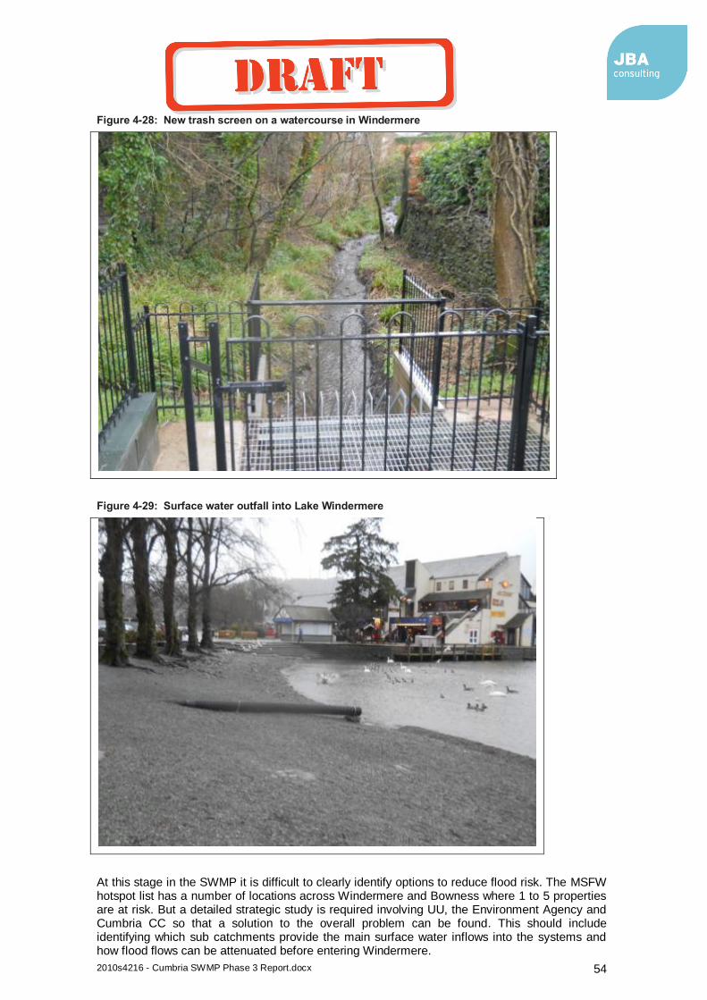
2010s4216 - Cumbria SWMP Phase 3 Report.docx 54
Figure 4-28: New trash screen on a watercourse in Windermere
Figure 4-29: Surface water outfall into Lake Windermere
At this stage in the SWMP it is difficult to clearly identify options to reduce flood risk. The MSFW hotspot list has a number of locations across Windermere and Bowness where 1 to 5 properties are at risk. But a detailed strategic study is required involving UU, the Environment Agency and Cumbria CC so that a solution to the overall problem can be found. This should include identifying which sub catchments provide the main surface water inflows into the systems and how flood flows can be attenuated before entering Windermere.
coyled
Draft

2010s4216 - Cumbria SWMP Phase 3 Report.docx 55
This fits in well with a holistic drainage strategy for the wider Windermere Catchment that UU are currently undertaking for their AMP 6 (2015-2020) Business Plan. For this study, UU will be undertaking a considerable amount of monitoring, investigations and assessments with a view of developing a solution. This will also involve a study of the UU sewer network around the entire lake to see where future investment could improve sewer performance and reduce overflows.
UU are in continual discussion with the Environment Agency and are in the process of setting up meetings with wider stakeholders in order to communicate their proposals. Cumbria CC as LLFA should be included in the wider stakeholder group, this should be one of the actions for Windermere.
Options to consider
Surface water sewer separation and catchment splitting
Manage runoff before it enters Windermere e.g. through small scale agricultural attenuation methods.
Diverting flood flow paths that come directly from the hills and into property.
Raising kerbs and reprofiling to direct surface water flows into green areas.
Immediate actions
Meet with UU and get on their stakeholder group for Windermere, exchange of ideas and identify quick wins and joint funding for these.
4.9 Quick Win and Smaller Works Summary
In addition to the more detailed location assessed above, there are other places in Cumbria where smaller scale intervention is required. This includes quick wins, where a simple low cost solution can deliver significant results. All potential quick win/ smaller schemes have been collated and summarised in the Action Plan (Appendix B), including those from the detailed location assessment above.
All of the Cumbria local authorities having Making Space for Water (MSFW) groups. These groups meet to discuss the main flood risk problem locations for their area and include representatives from all the major Risk Management Authorities (RMAs). The group produces a hot spots list, recording the problem locations and actions needed. The hotspots lists include small scale problems and solutions. Many of these are surface water related and the high priority ones are included in the quick win/small scheme list.
Some of the risk locations are from multiple sources and with multiple partners. This may include locations with a significant flood risk but the main source is Main River. Cumbria CC would still have involvement here is LLFA, but the lead on these would be the Environment Agency. Pure UU problem locations have not been listed.
There is also another level of flood risk locations across Cumbria that are low priority and of even smaller scale. These are generally minor flood risk locations that are too small to be classed as a quick win/small scheme where local levy funding may be available. These minor problem locations can be found on the LA’s MSFW and Cumbria CC lists and should be dealt with from ordinary highways and maintenance budgets. Cumbria CC may decide to prioritise these locations according to risk, so that funding can be distributed effectively when available.
4.10 Critical Drainage Areas and Planning Recommendations
4.10.1 Introduction;
As part of the SWMP process the County has identified areas where drainage from new development sites may exacerbating existing flood risk problems. The terminology used to identify these areas is ‘Critical Drainage Areas’, CDA s.
The new National Planning Framework states that “areas at risk of flooding” means land within Flood Zones 2 and 3; or land within Flood Zone 1 which has critical drainage problems and which has been notified to the local planning authority by the Environment Agency.
coyled
Draft
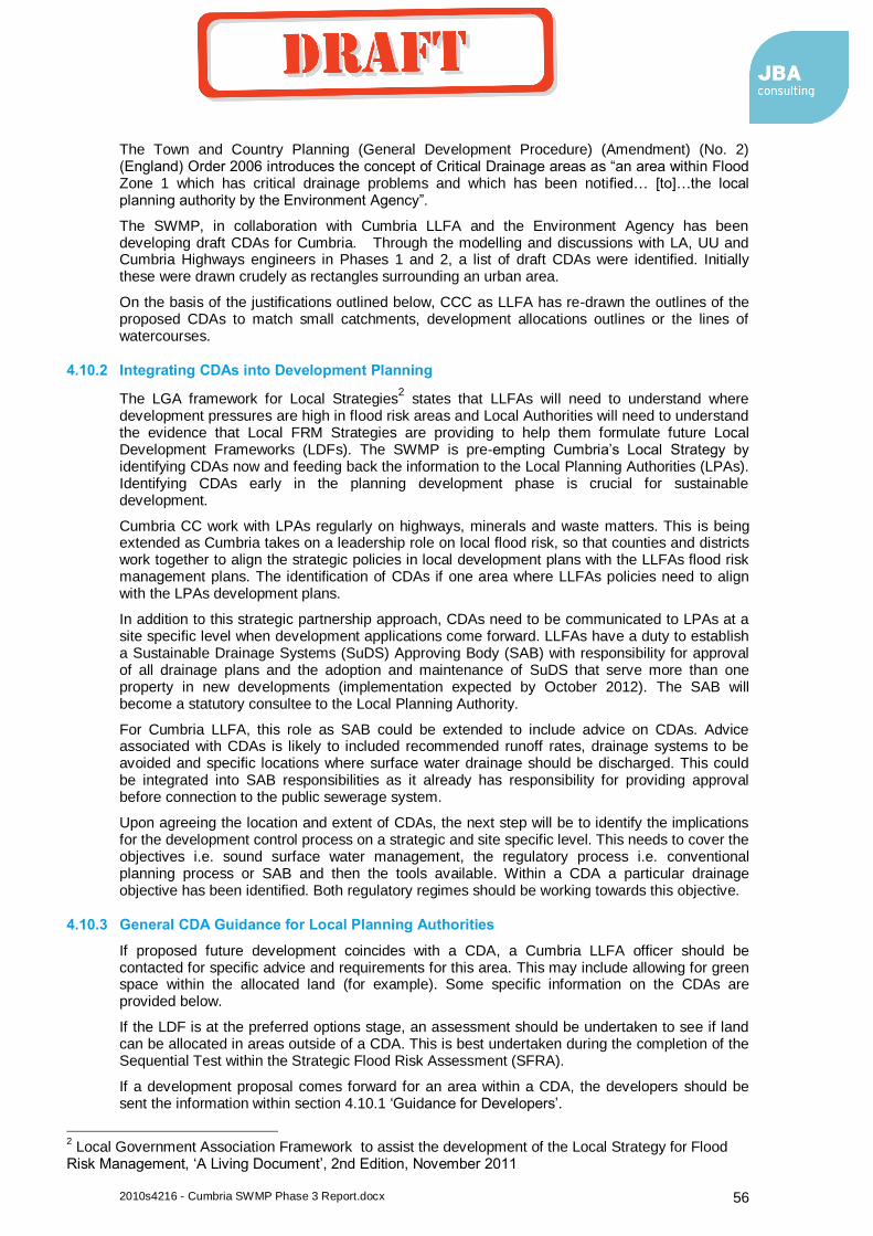
2010s4216 - Cumbria SWMP Phase 3 Report.docx 56
The Town and Country Planning (General Development Procedure) (Amendment) (No. 2) (England) Order 2006 introduces the concept of Critical Drainage areas as “an area within Flood Zone 1 which has critical drainage problems and which has been notified… [to]…the local planning authority by the Environment Agency”.
The SWMP, in collaboration with Cumbria LLFA and the Environment Agency has been developing draft CDAs for Cumbria. Through the modelling and discussions with LA, UU and Cumbria Highways engineers in Phases 1 and 2, a list of draft CDAs were identified. Initially these were drawn crudely as rectangles surrounding an urban area.
On the basis of the justifications outlined below, CCC as LLFA has re-drawn the outlines of the proposed CDAs to match small catchments, development allocations outlines or the lines of watercourses.
4.10.2 Integrating CDAs into Development Planning
The LGA framework for Local Strategies2 states that LLFAs will need to understand where
development pressures are high in flood risk areas and Local Authorities will need to understand the evidence that Local FRM Strategies are providing to help them formulate future Local Development Frameworks (LDFs). The SWMP is pre-empting Cumbria’s Local Strategy by identifying CDAs now and feeding back the information to the Local Planning Authorities (LPAs). Identifying CDAs early in the planning development phase is crucial for sustainable development.
Cumbria CC work with LPAs regularly on highways, minerals and waste matters. This is being extended as Cumbria takes on a leadership role on local flood risk, so that counties and districts work together to align the strategic policies in local development plans with the LLFAs flood risk management plans. The identification of CDAs if one area where LLFAs policies need to align with the LPAs development plans.
In addition to this strategic partnership approach, CDAs need to be communicated to LPAs at a site specific level when development applications come forward. LLFAs have a duty to establish a Sustainable Drainage Systems (SuDS) Approving Body (SAB) with responsibility for approval of all drainage plans and the adoption and maintenance of SuDS that serve more than one property in new developments (implementation expected by October 2012). The SAB will become a statutory consultee to the Local Planning Authority.
For Cumbria LLFA, this role as SAB could be extended to include advice on CDAs. Advice associated with CDAs is likely to included recommended runoff rates, drainage systems to be avoided and specific locations where surface water drainage should be discharged. This could be integrated into SAB responsibilities as it already has responsibility for providing approval before connection to the public sewerage system.
Upon agreeing the location and extent of CDAs, the next step will be to identify the implications for the development control process on a strategic and site specific level. This needs to cover the objectives i.e. sound surface water management, the regulatory process i.e. conventional planning process or SAB and then the tools available. Within a CDA a particular drainage objective has been identified. Both regulatory regimes should be working towards this objective.
4.10.3 General CDA Guidance for Local Planning Authorities
If proposed future development coincides with a CDA, a Cumbria LLFA officer should be contacted for specific advice and requirements for this area. This may include allowing for green space within the allocated land (for example). Some specific information on the CDAs are provided below.
If the LDF is at the preferred options stage, an assessment should be undertaken to see if land can be allocated in areas outside of a CDA. This is best undertaken during the completion of the Sequential Test within the Strategic Flood Risk Assessment (SFRA).
If a development proposal comes forward for an area within a CDA, the developers should be sent the information within section 4.10.1 ‘Guidance for Developers’.
2 Local Government Association Framework to assist the development of the Local Strategy for Flood
Risk Management, ‘A Living Document’, 2nd Edition, November 2011
coyled
Draft

2010s4216 - Cumbria SWMP Phase 3 Report.docx 57
4.10.4 CDA Guidance for Developers
If there is a planning application for major development in a CDA, pre application discussions with a Cumbria LLFA officer should be undertaken. The officer will outline specific drainage requirements for the development and should approve the drainage proposals.
Surface water flood flow routes should be maintained and not developed over or culverted. These flood flow routes are identified in the SWMP mapping.
Development in CDAs should look to re-use as much surface water as possible within the CDA.
In addition to this, standard Environment Agency advice for development in CDAs should be followed (see link below) and the allowable discharge rates adhered to:
http://www.environment-agency.gov.uk/static/documents/Utility/FRAGuidanceNote1_v3.1.pdf
The total discharge from the site should aim to mimic greenfield rates. These shall be no more than the theoretical greenfield run-off rates from each of the corresponding 1, 10, 30 and 100 year storms. When these values are less than 5 litres/second, a rate of 5 litres/second can be used. Attenuation may not be necessary if the discharge is directly to coastal waters. In these cases the impact on the receiving environment in terms of habitat, erosion and water quality should be assessed.
Underground attenuation and piped sections should be designed for a minimum of the 30 year storm. However total discharge rates from the site must still be controlled from the 100-year storm at the greenfield run-off rate from the 100 year storm. Attenuation of events exceeding the piped system may be achieved by temporary flooding of open spaces or car parks. If surface flooding of open areas is not appropriate, the formal drainage system should be designed to accommodate the 100 year storm.
4.10.5 CDA Locations justification summary and specific requirements
Keswick –
Justification;
Given sensitivities along the edge of the urban area, the extents of sub-catchments draining to the problem areas have been used to define the CDA. These encompass certain areas that might be identified for future development
The catchment boundary incorporates small quickly responding sub catchments to the south and east of Keswick which drain into culverts with capacity. During heavy rainfall events, the roads convey the surcharging drainage system and flood properties in locations predominantly in the south of Keswick. These well documented problems on the urban rural boundary and at highways structures provide sound evidence to justify a sensitive approach to future development within the area identified.
coyled
Draft
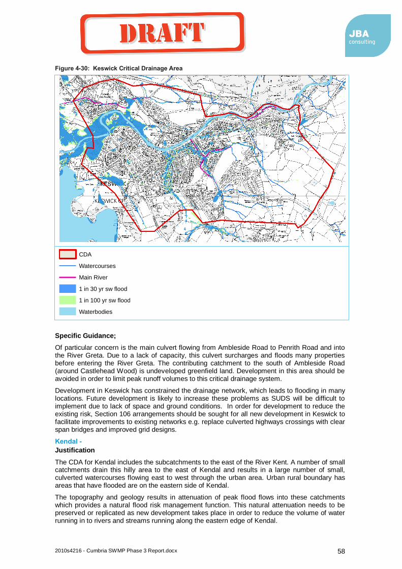
2010s4216 - Cumbria SWMP Phase 3 Report.docx 58
Figure 4-30: Keswick Critical Drainage Area
Specific Guidance;
Of particular concern is the main culvert flowing from Ambleside Road to Penrith Road and into the River Greta. Due to a lack of capacity, this culvert surcharges and floods many properties before entering the River Greta. The contributing catchment to the south of Ambleside Road (around Castlehead Wood) is undeveloped greenfield land. Development in this area should be avoided in order to limit peak runoff volumes to this critical drainage system.
Development in Keswick has constrained the drainage network, which leads to flooding in many locations. Future development is likely to increase these problems as SUDS will be difficult to implement due to lack of space and ground conditions. In order for development to reduce the existing risk, Section 106 arrangements should be sought for all new development in Keswick to facilitate improvements to existing networks e.g. replace culverted highways crossings with clear span bridges and improved grid designs.
Kendal -
Justification
The CDA for Kendal includes the subcatchments to the east of the River Kent. A number of small catchments drain this hilly area to the east of Kendal and results in a large number of small, culverted watercourses flowing east to west through the urban area. Urban rural boundary has areas that have flooded are on the eastern side of Kendal.
The topography and geology results in attenuation of peak flood flows into these catchments which provides a natural flood risk management function. This natural attenuation needs to be preserved or replicated as new development takes place in order to reduce the volume of water running in to rivers and streams running along the eastern edge of Kendal.
Legend
CDA
Watercourses
Main River
1 in 30 yr sw flood
1 in 100 yr sw flood
Waterbodies
coyled
Draft

2010s4216 - Cumbria SWMP Phase 3 Report.docx 59
Any increase in runoff through a reducing in natural attenuation will increase the risk of surface water flooding in Kendal. Areas to the west are believed to have adequate drainage capacity hence stopping the CDA along the line of River Kent.
Figure 4-31: Kendal Critical Drainage Area
Specific Guidance
New development sites should look to preserve and utilise as many of the existing landscape features as these will help to recreate the natural greenfield run off processes.
Prior to development in the Stock Beck catchment, a Flood Risk Assessment (FRA) should be undertaken that investigates current pinch points on Stock Beck to see if improvements could help facilitate development elsewhere in the Stock Beck catchment.
Ulverston -
Justification
Legend
CDA
Watercourses
Main River
1 in 30 yr sw flood
1 in 100 yr sw flood
Waterbodies
coyled
Draft
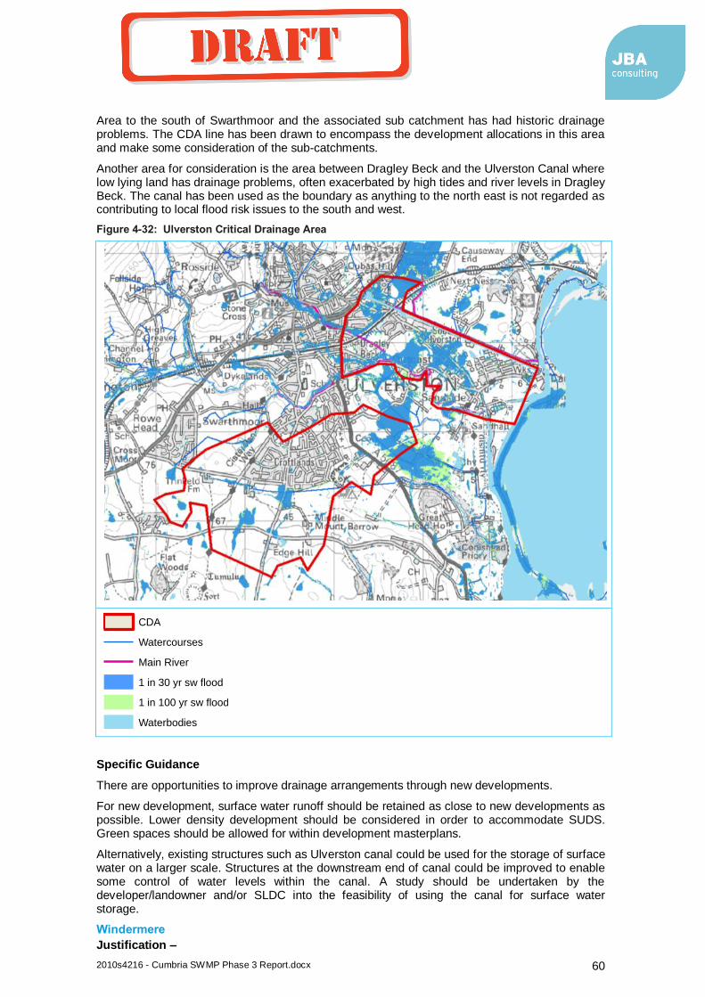
2010s4216 - Cumbria SWMP Phase 3 Report.docx 60
Area to the south of Swarthmoor and the associated sub catchment has had historic drainage problems. The CDA line has been drawn to encompass the development allocations in this area and make some consideration of the sub-catchments.
Another area for consideration is the area between Dragley Beck and the Ulverston Canal where low lying land has drainage problems, often exacerbated by high tides and river levels in Dragley Beck. The canal has been used as the boundary as anything to the north east is not regarded as contributing to local flood risk issues to the south and west.
Figure 4-32: Ulverston Critical Drainage Area
Specific Guidance
There are opportunities to improve drainage arrangements through new developments.
For new development, surface water runoff should be retained as close to new developments as possible. Lower density development should be considered in order to accommodate SUDS. Green spaces should be allowed for within development masterplans.
Alternatively, existing structures such as Ulverston canal could be used for the storage of surface water on a larger scale. Structures at the downstream end of canal could be improved to enable some control of water levels within the canal. A study should be undertaken by the developer/landowner and/or SLDC into the feasibility of using the canal for surface water storage.
Windermere
Justification –
Legend
CDA
Watercourses
Main River
1 in 30 yr sw flood
1 in 100 yr sw flood
Waterbodies
coyled
Draft
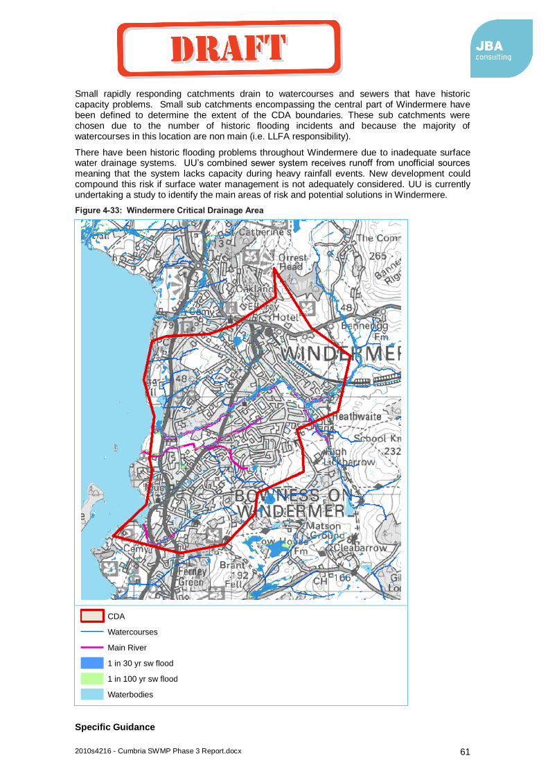
2010s4216 - Cumbria SWMP Phase 3 Report.docx 61
Small rapidly responding catchments drain to watercourses and sewers that have historic capacity problems. Small sub catchments encompassing the central part of Windermere have been defined to determine the extent of the CDA boundaries. These sub catchments were chosen due to the number of historic flooding incidents and because the majority of watercourses in this location are non main (i.e. LLFA responsibility).
There have been historic flooding problems throughout Windermere due to inadequate surface water drainage systems. UU’s combined sewer system receives runoff from unofficial sources meaning that the system lacks capacity during heavy rainfall events. New development could compound this risk if surface water management is not adequately considered. UU is currently undertaking a study to identify the main areas of risk and potential solutions in Windermere.
Figure 4-33: Windermere Critical Drainage Area
Specific Guidance
Legend
CDA
Watercourses
Main River
1 in 30 yr sw flood
1 in 100 yr sw flood
Waterbodies
coyled
Draft

2010s4216 - Cumbria SWMP Phase 3 Report.docx 62
Similar to Keswick, watercourses in Windermere have been constrained by development. Future development is likely to increase these problems as SUDS will be difficult to implement due to lack of space and ground conditions. Green space should be allowed for in development proposals to account for surface water flood flow pathways. UU should be consulted on future development plans in order to align with their surface water management plans.
Whitehaven
Justification –
The topography and geology of Whitehaven results in an extensive area of flood risk from surface water and sewer system along the Pow Beck Valley. This area would be sensitive to any additional flows as a result of future development. Urban extents and hydraulic boundaries have formed the CDA boundary.
Figure 4-34: Whitehaven Critical Drainage Area
Specific Guidance
Legend
CDA
Watercourses
Main River
1 in 30 yr sw flood
1 in 100 yr sw flood
Waterbodies
coyled
Draft
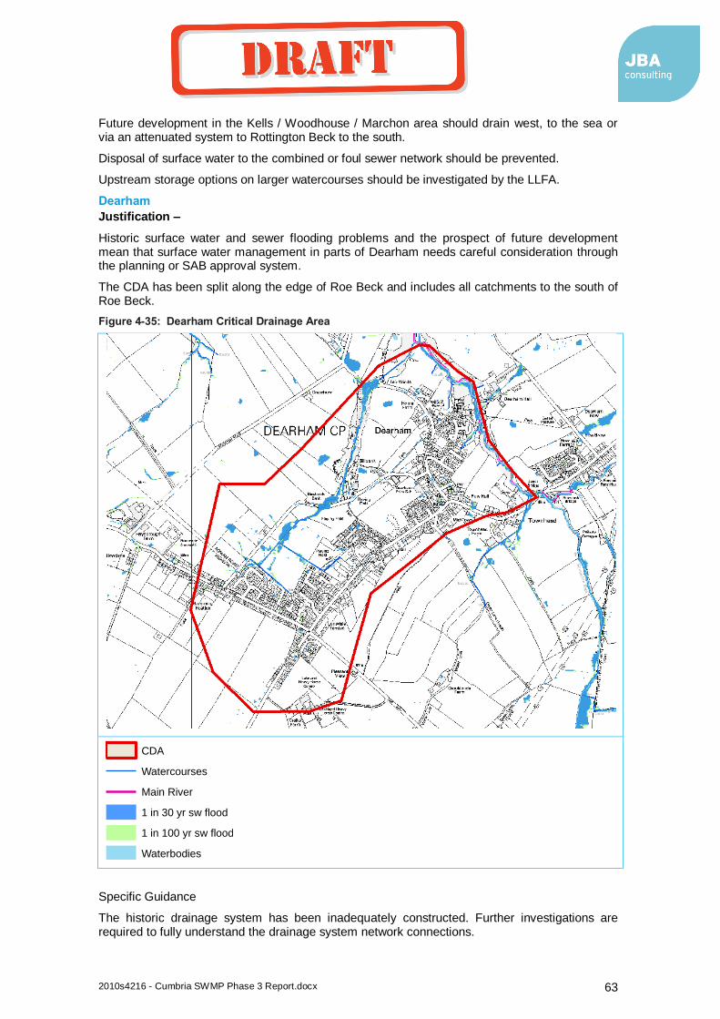
2010s4216 - Cumbria SWMP Phase 3 Report.docx 63
Future development in the Kells / Woodhouse / Marchon area should drain west, to the sea or via an attenuated system to Rottington Beck to the south.
Disposal of surface water to the combined or foul sewer network should be prevented.
Upstream storage options on larger watercourses should be investigated by the LLFA.
Dearham
Justification –
Historic surface water and sewer flooding problems and the prospect of future development mean that surface water management in parts of Dearham needs careful consideration through the planning or SAB approval system.
The CDA has been split along the edge of Roe Beck and includes all catchments to the south of Roe Beck.
Figure 4-35: Dearham Critical Drainage Area
Specific Guidance
The historic drainage system has been inadequately constructed. Further investigations are required to fully understand the drainage system network connections.
Legend
CDA
Watercourses
Main River
1 in 30 yr sw flood
1 in 100 yr sw flood
Waterbodies
coyled
Draft
2010s4216 - Cumbria SWMP Phase 3 Report.docx 64
Before connection to the drainage system, the developer should undertake a study to understand what they are connecting to and where it is draining. Alternatively, surface water should be dealt with on site and not discharged into the existing system.
Grasmere
Justification –
Although Grasmere is on the original list of proposed CDAs, having revisited, it seems inappropriate given likely scale of future development.
4.11 Action Plan
A key part of the Cumbria SWMP is the Action Plan. This contains all the surface water management actions from the analysis over the three phases of this study. This includes larger PAR level schemes, smaller/quick win schemes and CDA planning recommendations.
Actions have been assigned to a lead organisation, with several other partner organisations. The lead organisation will have ultimate responsibility for the action and the partners should assist with future studies and schemes (including data provision). It is therefore important for all lead and partner organisations to read through the actions to confirm that they will be willing to be involved and take forward the actions that are specific to them. This should take place during the SWMP consultation process, changes can be made to actions and the allocated organisations before the report is finalised.
The Cumbria SWMP Action Plan can be found in Appendix B.
coyled
Draft

2010s4216 - Cumbria SWMP Phase 3 Report.docx 65
5 Conclusions and Next Steps
5.1 Conclusions
Phase 3 off the SWMP took the strategic assessment and detailed reviews from the previous phases to assess flood risk management options for the six locations at greatest risk of surface water flooding in Cumbria. This included an initial options appraisal against objectives and a cost benefit appraisal using outline figures. However, there are also recommendations for many other locations, across Cumbria, not just the six locations of greatest risk. All of the actions have been compiled and allocated to a lead partner within the Cumbria SWMP Action Plan. This can be found in Appendix B.
The following conclusions have been made for the six locations of greatest risk.
5.1.1 Ulverston
There is significant surface water flood risk at North Lonsdale Road in Ulverston. The sources of risk include the surface water drainage system and a Main River. This means there will be multiple partners for any future scheme. Some intervention is economically beneficial although the cost benefit ratio is low. A scheme may therefore be reliant on others and their objectives (UU or Environment Agency). Property level protection or redirecting some of the surface water sewers appear to be the best options.
Just to the North is North Lonsdale Terrace, the risk is not as significant here as North Lonsdale Road. Existing risk in this area is due to the drainage system being unable to discharge into Ulverston Canal. Potential future development in this area could increase the problem. A solution is required to allow a free outfall into Ulverston Canal, or a new drainage arrangement. Funding for these works should be sought through an Ulverston Canal partnership involving land owners, potential developers and the LLFA.
Also in Ulverston is Beckside Road, where there is a relatively minor ordinary watercourse problem. Due to the number of properties at risk and the severity of flooding, only small scale intervention would be appropriate here following a feasibility study.
5.1.2 Whitehaven
The most significant and complex risk location here is Mirehouse. Flood risk at Mirehouse comes from a number of sources with multiple potential partners. There is Main River flood risk from Pow Beck. High levels in Pow Beck can lead to surface water outfalls backing up (UU sewers, small Copeland BC drains and Cumbria Highway sewers). Mirehouse has been developed in a flat area with a high water table further adding to the drainage/outfall problems. A combined scheme tackling all sources and multiple partners may be possible but the flood sources and solutions are complex.
Of a smaller scale is Coach Road in Whitehaven. Flood risk at Coach Road is from a UU combined sewer and highway sewers. Flood risk is also linked to high levels on Pow Beck. Property level protection appears to be the most cost beneficial approach for reducing risk to properties. However, the highway will still be liable to flooding and this may be a key objective for the MSFW group.
Just outside of Whitehaven is the village of Parton. A culverted ordinary watercourses (Lambhill Gill) passes through the village of Parton and can surcharge, possibly due to tide locking, blockage and inadequate culvert capacity. This has flooded between 20 and 30 properties in the lower part of the village. Recent works have been undertaken but the risk remains and further works are required. Options to reduce risk should include works on Lambhill Gill before it enters Parton, near to the quarry.
coyled
Draft

2010s4216 - Cumbria SWMP Phase 3 Report.docx 66
5.1.3 Dearham
The Dearham catchment suffers due to overland run off from the former open cast coal sites to the rear of Central Road and Maryport Road. There are complex drainage issue in Dearham due to developments and surface water drainage not being coordinated properly.
Smaller scale schemes have been undertaken in the past through the MSFW group with good results. A collaborative approach (UU, Allerdale BC, Cumbria CC) and access to quick win funding appears to be the best approach. Future development should lead in the overall improvement to Dearham through the drainage impact assessment and combined funding. Liaison with the Allerdale planners is therefore recommended for this location.
5.1.4 Keswick
Keswick has three significant surface water flooding locations at Ambleside Road, Penrith Road and Elliot Park.
Up to 50 properties have flooded in the past at Ambleside Road. Cumbria LLFA would need to lead any intervention here as the flood source is surface water from an ordinary watercourse. Although a scheme would be cost beneficial, the ratio is low so the scheme would struggle to attract FDGiA without significant partnership funding. From the initial appraisal, several options come out with a similar score. A full feasibility study with modelling should be undertaken to identify the best option.
Flooding at Penrith Road is due to a combination of a number of surface water flow pathways that combine at Penrith Road where most of the damage is caused. Although this is an extensive flood risk location, the spread of the damages caused by past flood events does not warrant a single PAR level scheme. A future study should consider many simple solutions at the different locations, dealing with flow pathways rather than a large capital scheme.
Elliot Park is a relatively new residential area that is prone to surface water flooding from highway drains and private surface water sewers that become river locked when there are high levels in the River Greta. This residential area is in a shallow basin next to the River Greta and flooding occurs from the River Greta, combined sewer and surface water sewers. A feasibility study is currently being commissioned by Cumbria CC. Potential solutions include using and enhancing the existing (soon to be redundant) UU pumping station.
5.1.5 Windermere
At this stage in the SWMP it is difficult to clearly identify options to reduce flood risk at Windermere. A detailed strategic study is required involving UU, the Environment Agency and Cumbria CC so that a strategic solution to the overall problem can be found. This should include identifying which sub catchments that provide the main surface water inflows into the systems and how flood flows can be attenuated before entering Windermere.
This fits in well with a holistic drainage strategy for the wider Windermere Catchment that UU are currently undertaking for their AMP 6 (2015-2020) Business Plan. This will also involve a study of the UU sewer network around the entire lake to see where future investment could improve sewer performance and reduce overflows.
5.2 Next Steps
5.2.1 Consultation
Following the submission of the Cumbria SWMP, the report should be reviewed by the Steering Group to ensure they are in agreement with the content and conclusions. A key part of the SWMP is the Action Plan. This lists all the actions coming out of the plan and allocates a lead organisation and partner organisation. All of the organisations allocated an action as lead or partner, should be consulted for agreement before the report goes out to public consultation. The following organisations are within the action plan, this is predominantly the Steering Group but does include others:
Cumbria Resilience Flooding Subgroup
United Utilities
coyled
Draft

2010s4216 - Cumbria SWMP Phase 3 Report.docx 67
Cumbria CC
Allerdale BC (engineers and planners)
Carlisle CC (engineers)
Eden DC (engineers)
South Lakeland DC (engineers and planners)
Copeland BC (engineers and planners)
Barrow BC (engineers)
Elliot Park consultees as part of the feasibility study (Booths and Impact Housing)
Keswick FAG
Ulverston FAG
Cockermouth FAG
Ulverston land and canal owners
Following feedback and agreement, the plan can then be sent out to public consultation. Efforts should be made to use the Flood Action Groups to disseminate the findings. Public open days may be appropriate for some of the key flood risk locations.
5.2.2 Feasibility Studies and Schemes
The majority of the actions are for feasibility studies where the SWMP has indicated that a scheme would be beneficial according to the initial appraisal. A feasibility study normally involves a detailed options appraisal and cost benefit analysis. This is required so that the most sustainable flood risk management option can be identified and also so that government funding can be applied for. In order to apply for FDGiA, a detailed assessment of the potential costs and benefits of the preferred scheme is required. This type of information will also prove useful when applying to the RFCC for Local Levy funding (for smaller schemes).
Feasibility studies require funding and as budgets are limited, the LLFA will need to prioritise which studies should be undertaken first. This should be based on the severity and return period of flooding but also on the likelihood of a scheme being able to raise funds. Schemes with a lower cost benefit ratios could be prioritised above a higher scoring scheme as it may have already secured partnership funding, which would release FDGiA.
There are several schemes that are a priority now for Cumbria CC, these are Ambleside Road and Elliot Park in Keswick. These feasibility studies should be undertaken now but some type of scheme prioritisation will be required for the remainder. This ties in with Cumbria CC’s Local Flood Risk Management Strategy, which is required under the Flood and Water Management Act.
5.2.3 Local Strategy Investment Plan
A key part of the Local Strategy is to choose measures to meet the agreed FRM objectives, establish how and when measures will be implemented and estimate the costs, benefits of the measures and how they will be funded.
The SWMP has identified all of the locations where local flood risk management measures are required. Initial costs and benefits of the majority of these locations have been estimated. This information should be reviewed and updated so that there is a full list of flood risk management locations with the estimated cost of the scheme. It will then be possible to identify the funding shortfall if all these schemes are to be undertaken.
It is unlikely that many of the schemes will have outcome measure (OM) scores high enough to attract full FDGiA funding. It will therefore be important to consider other potential sources of funding. An initial alternative funding assessment could be undertaken at this stage. Potential sources of partnership funding will be identified (e.g. major businesses and landowners, CIL contributions from development and local levees). The funding shortfall can then be reassessed with these alternative sources taken into account.
coyled
Draft

2010s4216 - Cumbria SWMP Phase 3 Report.docx 68
An investment plan will set out the scale of investment required over a time period and the potential to fill the funding gaps.
It should then become clear which schemes will struggle to get off the ground through a lack of funding and which schemes should be prioritised due to the high cost benefit score and potential for funds. Schemes that struggle should either look to reduce costs or be removed from the investment plan.
coyled
Draft

2010s4216 - Cumbria SWMP Phase 3 Report.docx 69
Appendices
A Phase 2a Summaries
coyled
Draft
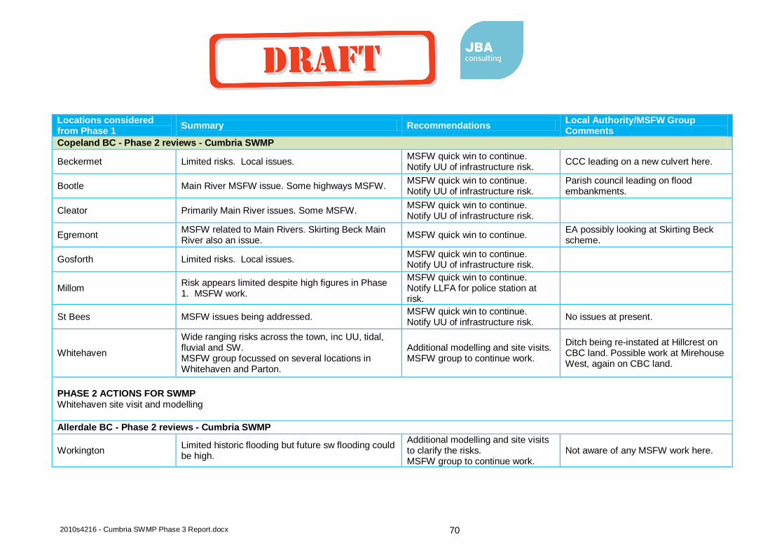
2010s4216 - Cumbria SWMP Phase 3 Report.docx 70
Locations considered from Phase 1
Summary Recommendations Local Authority/MSFW Group Comments
Copeland BC - Phase 2 reviews - Cumbria SWMP
Beckermet Limited risks. Local issues. MSFW quick win to continue. Notify UU of infrastructure risk.
CCC leading on a new culvert here.
Bootle Main River MSFW issue. Some highways MSFW. MSFW quick win to continue. Notify UU of infrastructure risk.
Parish council leading on flood embankments.
Cleator Primarily Main River issues. Some MSFW. MSFW quick win to continue. Notify UU of infrastructure risk.
Egremont MSFW related to Main Rivers. Skirting Beck Main River also an issue.
MSFW quick win to continue. EA possibly looking at Skirting Beck scheme.
Gosforth Limited risks. Local issues. MSFW quick win to continue. Notify UU of infrastructure risk.
Millom Risk appears limited despite high figures in Phase 1. MSFW work.
MSFW quick win to continue. Notify LLFA for police station at risk.
St Bees MSFW issues being addressed. MSFW quick win to continue. Notify UU of infrastructure risk.
No issues at present.
Whitehaven
Wide ranging risks across the town, inc UU, tidal, fluvial and SW. MSFW group focussed on several locations in Whitehaven and Parton.
Additional modelling and site visits. MSFW group to continue work.
Ditch being re-instated at Hillcrest on CBC land. Possible work at Mirehouse West, again on CBC land.
PHASE 2 ACTIONS FOR SWMP Whitehaven site visit and modelling
Allerdale BC - Phase 2 reviews - Cumbria SWMP
Workington Limited historic flooding but future sw flooding could be high.
Additional modelling and site visits to clarify the risks. MSFW group to continue work.
Not aware of any MSFW work here.
coyled
Draft

2010s4216 - Cumbria SWMP Phase 3 Report.docx 71
Locations considered from Phase 1
Summary Recommendations Local Authority/MSFW Group Comments
Cockermouth Limitied historic sw flooding and future sw flooding is not expected to be significant. Some minor MSFW issues though
Additional modelling to clarify the risks. MSFW group to continue work.
2 areas under consideration in MSFW group but no funding
Wigton Primarily Main River issues. No action. EA fluvial flooding loction.
No work planned.
Maryport Little historic flooding, potential for future sw flooding but consequences relativley low.
No action No work planned
Flimby Critical services at risk are wind turbines. Flood risk from several Main River culverts. There are linked sw flooding issues though.
Flooding issues are too localised for additional modelling to be of any use. Discuss issues with Allerdale BC and identify quick wins or further action in MSFW list.
Trash screen replacement going ahead
Braithwaite Limited risks. Minor local issues. Critical services at risk from Main Rivers.
No action. No work planned
Rosthwaite Limited risks. Minor local issues. Critical services at risk from Main Rivers.
No action. No work planned
Allonby Highlighted as a school is shown to be at risk. Very localised with little else at risk.
Confirm the risk with Allerdale BC and look for quick win if there is a risk.
No risk to school
Keswick One of the main sw flood risk locations although the sw flood mapping does not reflect this.
Additional modelling and site visits. MSFW group to continue work.
Scope for work if funding available
Silloth Very low current and future risks (possible error in sw flood maps)
No action. Low / no risk. No work planned
Caldbeck Limited risks. Flood risk is from Main Rivers. No action. No work planned
Dearham Reviewed due to amount of historic flooding incidents. Many DG5 flooding records.
Additional modelling and site visits to clarify the risks. See if sewer model outputs align with historic flooding locations. MSFW group to continue work.
Liaising with planners & developers to design out flood risk
coyled
Draft
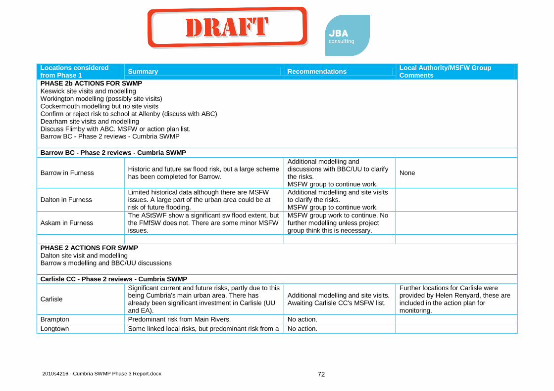
2010s4216 - Cumbria SWMP Phase 3 Report.docx 72
Locations considered from Phase 1
Summary Recommendations Local Authority/MSFW Group Comments
PHASE 2b ACTIONS FOR SWMP Keswick site visits and modelling Workington modelling (possibly site visits) Cockermouth modelling but no site visits Confirm or reject risk to school at Allenby (discuss with ABC) Dearham site visits and modelling Discuss Flimby with ABC. MSFW or action plan list. Barrow BC - Phase 2 reviews - Cumbria SWMP
Barrow BC - Phase 2 reviews - Cumbria SWMP
Barrow in Furness Historic and future sw flood risk, but a large scheme has been completed for Barrow.
Additional modelling and discussions with BBC/UU to clarify the risks. MSFW group to continue work.
None
Dalton in Furness Limited historical data although there are MSFW issues. A large part of the urban area could be at risk of future flooding.
Additional modelling and site visits to clarify the risks. MSFW group to continue work.
Askam in Furness The AStSWF show a significant sw flood extent, but the FMfSW does not. There are some minor MSFW issues.
MSFW group work to continue. No further modelling unless project group think this is necessary.
PHASE 2 ACTIONS FOR SWMP Dalton site visit and modelling Barrow s modelling and BBC/UU discussions
Carlisle CC - Phase 2 reviews - Cumbria SWMP
Carlisle
Significant current and future risks, partly due to this being Cumbria's main urban area. There has already been significant investment in Carlisle (UU and EA).
Additional modelling and site visits. Awaiting Carlisle CC's MSFW list.
Further locations for Carlisle were provided by Helen Renyard, these are included in the action plan for monitoring.
Brampton Predominant risk from Main Rivers. No action.
Longtown Some linked local risks, but predominant risk from a No action.
coyled
Draft

2010s4216 - Cumbria SWMP Phase 3 Report.docx 73
Locations considered from Phase 1
Summary Recommendations Local Authority/MSFW Group Comments
Main River (Lochinver Beck).
PHASE 2 ACTIONS FOR SWMP Carlisle site visit and modelling
Eden DC - Phase 2 reviews - Cumbria SWMP
Penrith
Extensive historic flooding information but a scheme has been completed that will reduce some of this. Future flooding not extensive but consequence relatively high due to this being one of the larger urban areas.
Additional modelling and possibly site visits. MSFW group to continue work.
Shap A large number of historic and potential future flooding for a small urban area.
Following discussions with Eden DC, further modelling and site visits.
Crosby Ravensworth Primarily Main River issues although there are some other minor local issues.
MSFW monitoring to continue.
Kirkby Stephen Some Main River flooding but no evidence of linked surface water flooding
No action
Patterdale Primarily Main River issue. MSFW monitoring to continue.
Whilst one area is a Main River issue there are a number of sites in the Patterdale are which flood from surface water flooding. This is a direct result of run-off from the hills (it falls on the rock and there is little/no percolation). I’m not sure that there is much that can be done here because of the topography and the relatively few properties affected at each location.
Howtown Local risks minor consequences MSFW quick win to continue.
Little Strickland Only risk is to an electricity substation Notify asset owner of infrastructure risk.
coyled
Draft

2010s4216 - Cumbria SWMP Phase 3 Report.docx 74
Locations considered from Phase 1
Summary Recommendations Local Authority/MSFW Group Comments
PHASE 2 ACTIONS FOR SWMP Penrith (site visit and) modelling Shap site visit and modelling if confirmed with Eden DC. Notify asset owner of risk to Little Stickland South Lakeland DC - Phase 2 reviews - Cumbria SWMP
South Lakeland DC - Phase 2 reviews - Cumbria SWMP
Kendal According to the sw flood maps this is the number one surface water flood risk location in Cumbria.
Additional modelling, site visit and meeting.
Ulverston
A significant surface water flood risk location within Cumbria. Extensive surface water flood extents putting many properties at risk and a recent flood history.
Additional modelling, site visit and meeting.
Coniston Significant flood risk but main source of flooding is Main River. No evidence of local issues linked to Main River flooding.
Flood mechanisms to be confirmed with SLDC (i.e. confirm it is all Main River and not sw flooding).
Windermere
Complex sw flooding problem linked with Main Rivers, Lake Windermere and other sources with multiple responsibility. Moderate flood consequences and history.
Additional modelling, site visit and meeting.
Kirkby Lonsdale Some sw flood risk but little history and the consequences are low.
Confirm the risk with SLDC for quick win or no further action
Grasmere Although a small location there are complex surface water flooding problems with a history but a relativley low/moderate number of properties at risk.
Additional modelling and site visit. Depending on the scale of the problem, a quick win or options appraisal.
Ambleside
Some flood history and surface water flood outlines showing properties to be at risk in the town centre. Appears to be Main River flooding but this should be confirmed through further modelling and discussions on the mechanism of flooding.
Additional modelling, site visit and meeting.
Flookburgh and Cark Local small scale risks with no flood history. Meeting with SLDC to confirm risks and any potential quick wins
coyled
Draft

2010s4216 - Cumbria SWMP Phase 3 Report.docx 75
Locations considered from Phase 1
Summary Recommendations Local Authority/MSFW Group Comments
Grange Over Sands
Although not significant, sw flood risk is focused in one location. There is a history of regular and damaging flooding in this location (SLDC's top MSFW list location).
Additional modelling and site visit. Depending on the scale of the problem, a quick win or options appraisal.
Cartmel Risk is associated with Main Rivers and there is no evidence for interaction with other local sources.
No action.
Milnthorpe Very little historic flooding and the consequences of flooding according to the surface water flood maps are low.
No action.
Satterthwaite Telephone exchange at risk from a Main River. No evidence of local flood risks.
No action
Broughton Beck Electricity installation at risk from a Main River. No evidence of local flood risks.
No action
PHASE 2 ACTIONS FOR SWMP Grange, SLDC meetings, additional modelling and site visit. Flookburgh - SLDC meeting. No modelling/site visit Kirkby Lonsdale - SLDC meeting. No modelling/site visit Coniston - SLDC meeting. No modelling/site visit Ulverston, SLDC meetings, additional modelling and site visit. Grasmere, SLDC meetings, additional modelling and site visit. Kendal, SLDC meetings, additional modelling and site visit. Windermere, SLDC meetings, additional modelling and site visit. Ambleside, SLDC meetings, additional modelling and site visit.
coyled
Draft
2010s4216 - Cumbria SWMP Phase 3 Report.docx 76
B Cumbria SWMP Action Plan
coyled
Draft
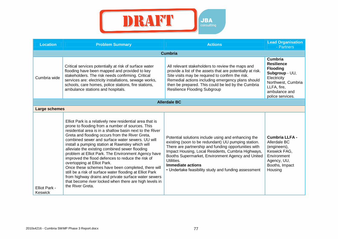
2010s4216 - Cumbria SWMP Phase 3 Report.docx 77
Location Problem Summary Actions Lead Organisation
- Partners
Cumbria
Cumbria wide
Critical services potentially at risk of surface water flooding have been mapped and provided to key stakeholders. The risk needs confirming. Critical services are: electricity installations, sewage works, schools, care homes, police stations, fire stations, ambulance stations and hospitals.
All relevant stakeholders to review the maps and provide a list of the assets that are potentially at risk. Site visits may be required to confirm the risk. Remedial actions including emergency plans should then be prepared. This could be led by the Cumbria Resilience Flooding Subgroup
Cumbria Resilience Flooding Subgroup - UU, Electricity Northwest, Cumbria LLFA, fire, ambulance and police services.
Allerdale BC
Large schemes
Elliot Park - Keswick
Elliot Park is a relatively new residential area that is prone to flooding from a number of sources. This residential area is in a shallow basin next to the River Greta and flooding occurs from the River Greta, combined sewer and surface water sewers. UU will install a pumping station at Rawnsley which will alleviate the existing combined sewer flooding problem at Elliot Park. The Environment Agency have improved the flood defences to reduce the risk of overtopping at Elliot Park. Once these schemes have been completed, there will still be a risk of surface water flooding at Elliot Park from highway drains and private surface water sewers that become river locked when there are high levels in the River Greta.
Potential solutions include using and enhancing the existing (soon to be redundant) UU pumping station. There are partnership and funding opportunities with Impact Housing, Local Residents, Cumbria Highways, Booths Supermarket, Environment Agency and United Utilities. Immediate actions • Undertake feasibility study and funding assessment
Cumbria LLFA - Allerdale BC (engineers), Keswick FAG, Environment Agency, UU, Booths, Impact Housing
coyled
Draft

2010s4216 - Cumbria SWMP Phase 3 Report.docx 78
Location Problem Summary Actions Lead Organisation
- Partners
Penrith Road - Keswick
This surface water flood location is due to a combination of a number of surface water flow pathways that combine at Penrith Road where most of the damage is caused. Highway sheet flow from Chesnut Hill (A591) The Hawthornes (A591) and Eleventrees, floods properties along their route before combining at Penrith Road (A5271). At this point, some of the surface flow can enter the River Greta through a small double pipe installed by Cumbria Highways. However the majority of the flow continues into Keswick along Penrith Road and floods 5-10 properties before discharging into the River Greta.
Indications are that there is a cost beneficial scheme for this location, a number of options exist and have a similar score in the initial appraisal. A combination of these measures may therefore be appropriate. More work is needed to estimate costs and damages. Modelling would not be required for this as scheme costs would be more appropriate for local levy funding (rather than FDGiA) and it is not possible to model the surface water flooding without an over expensive modelling exercise. Immediate actions • More detailed (but low cost) assessment of costs and benefits, working predominantly with Cumbria Highways in the MSFW group. • Any of the above options could be investigated further and completed now as quick wins. • Bridge/culvert improvement on Chestnut Road (easting 327984, northing 523540). New single span highways bridge and Improved trash screen design.
Cumbria LLFA - Allerdale BC (engineers), Keswick FAG.
coyled
Draft

2010s4216 - Cumbria SWMP Phase 3 Report.docx 79
Location Problem Summary Actions Lead Organisation
- Partners
Ambleside Road - Keswick
This is a significant surface water flood risk location where up to 50 properties have flooded in the past. Cumbria LLFA would need to lead any intervention here as the flood source is surface water from an ordinary watercourse. The Environment Agency may partner in a scheme as high levels on the River Greta is part of the problem. However, a Main River scheme has recently been completed without consideration of the surface water flood risk.
Although a scheme would be cost beneficial, the ratio is low. The scale of investment required to complete a scheme means that FDGiA should be applied for but a scheme would struggle to attract FDGiA without significant partnership funding. From the initial appraisal, several options come out with a similar score. A full feasibility study with modelling should be undertaken to identify the best option. Immediate actions Modelling and feasibility study
Cumbria LLFA - Allerdale BC (engineers), Environment Agency, Keswick FAG.
Windermere - strategic issues, link with PR14 study
Smaller Schemes
coyled
Draft

2010s4216 - Cumbria SWMP Phase 3 Report.docx 80
Location Problem Summary Actions Lead Organisation
- Partners
Dearham Crossroads
Risk area include Maryport Road, Craika Road, Central Road and Lonsdale Terrace. Issues relate to inadequate and damaged culverted watercourses adjacent to the Ploughman’s Inn public house and the Commercial Inn public house (on the cross road of Central Road and the A594). The contributing catchment to this flood risk location is very small (just from the top of Craika Road). Overland runoff can flow down Craika Road and to the cross roads flood risk area. UU have also had flooding issues here (Lonsdale Terrace) so a collaborative approach should be considered.
Cost benefit scores are low, property level protection may be the best way forward. Some smaller scale actions could bring improvements over time (see actions below). Immediate actions • Developer led improvement to the new development areas and Dearham as a whole • MSFW group to undertake smaller scale improvements (e.g. to connections) Obtain funding for small scale quick wins: • Newlands Park Run off from Opencast site west of the village. Land drainage problem. Further research required. • Craika Road Run off from Opencast site to rear of properties. • Dearham Bridge Gully/pipe to be provided very soon. Property owner has done much work. UU bridge acts as throttle.
Cumbria LLFA - Allerdale BC (engineers and planners), UU.
Dearham Post Office
The flood flow path at Dearham Crossroads continues down Central Road where the post office and several properties to the rear are prone to flooding. This is a small flood risk location where a quick win should be possible.
Due to the small scale nature of the risk, property level protection appears to be the only viable option. Immediate actions • 9a Main Street Near Post Office. Gullies exist in low spot. Private road drainage is poor. Further research required.
Cumbria LLFA - Allerdale BC (engineers).
coyled
Draft
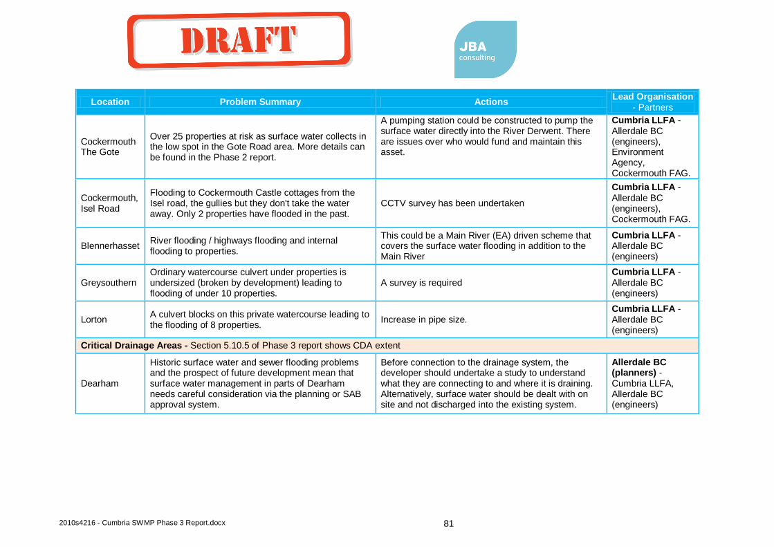
2010s4216 - Cumbria SWMP Phase 3 Report.docx 81
Location Problem Summary Actions Lead Organisation
- Partners
Cockermouth The Gote
Over 25 properties at risk as surface water collects in the low spot in the Gote Road area. More details can be found in the Phase 2 report.
A pumping station could be constructed to pump the surface water directly into the River Derwent. There are issues over who would fund and maintain this asset.
Cumbria LLFA - Allerdale BC (engineers), Environment Agency, Cockermouth FAG.
Cockermouth, Isel Road
Flooding to Cockermouth Castle cottages from the Isel road, the gullies but they don't take the water away. Only 2 properties have flooded in the past.
CCTV survey has been undertaken
Cumbria LLFA - Allerdale BC (engineers), Cockermouth FAG.
Blennerhasset River flooding / highways flooding and internal flooding to properties.
This could be a Main River (EA) driven scheme that covers the surface water flooding in addition to the Main River
Cumbria LLFA - Allerdale BC (engineers)
Greysouthern Ordinary watercourse culvert under properties is undersized (broken by development) leading to flooding of under 10 properties.
A survey is required Cumbria LLFA - Allerdale BC (engineers)
Lorton A culvert blocks on this private watercourse leading to the flooding of 8 properties.
Increase in pipe size. Cumbria LLFA - Allerdale BC (engineers)
Critical Drainage Areas - Section 5.10.5 of Phase 3 report shows CDA extent
Dearham
Historic surface water and sewer flooding problems and the prospect of future development mean that surface water management in parts of Dearham needs careful consideration via the planning or SAB approval system.
Before connection to the drainage system, the developer should undertake a study to understand what they are connecting to and where it is draining. Alternatively, surface water should be dealt with on site and not discharged into the existing system.
Allerdale BC (planners) - Cumbria LLFA, Allerdale BC (engineers)
coyled
Draft
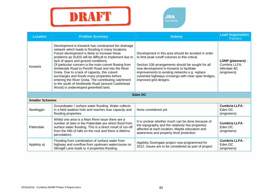
2010s4216 - Cumbria SWMP Phase 3 Report.docx 82
Location Problem Summary Actions Lead Organisation
- Partners
Keswick
Development is Keswick has constrained the drainage network which leads to flooding in many locations. Future development is likely to increase these problems as SUDS will be difficult to implement due to lack of space and ground conditions. Of particular concern is the main culvert flowing from Ambleside Road to Penrith Road and into the River Greta. Due to a lack of capacity, this culvert surcharges and floods many properties before entering the River Greta. The contributing catchment to the south of Ambleside Road (around Castlehead Wood) is undeveloped greenfield land.
Development in this area should be avoided in order to limit peak runoff volumes to this critical. Section 106 arrangements should be sought for all new development in Keswick to facilitate improvements to existing networks e.g. replace culverted highways crossings with clear span bridges, improved grid designs.
LDNP (planners) - Cumbria LLFA, Allerdale BC (engineers)
Eden DC
Smaller Schemes
Newbiggin Groundwater / surface water flooding. Water collects in a field swallow hole and reaches max capacity and flooding properties.
None considered yet. Cumbria LLFA - Eden DC (engineers)
Patterdale
Whilst one area is a Main River issue there are a number of sites in the Patterdale are which flood from surface water flooding. This is a direct result of run-off from the hills (it falls on the rock and there is little/no percolation).
It is unclear whether much can be done because of the topography and the relatively few properties affected at each location. Maybe education and awareness and property level protection.
Cumbria LLFA - Eden DC (engineers)
Appleby a) Flooding from combination of surface water from highway and overflow from upstream watercourse on Skirsgill Lane leads to 4 properties flooding.
Appleby Doomgate project now programmed for 2012. Issues are to be considered as part of project.
Cumbria LLFA - Eden DC (engineers)
coyled
Draft
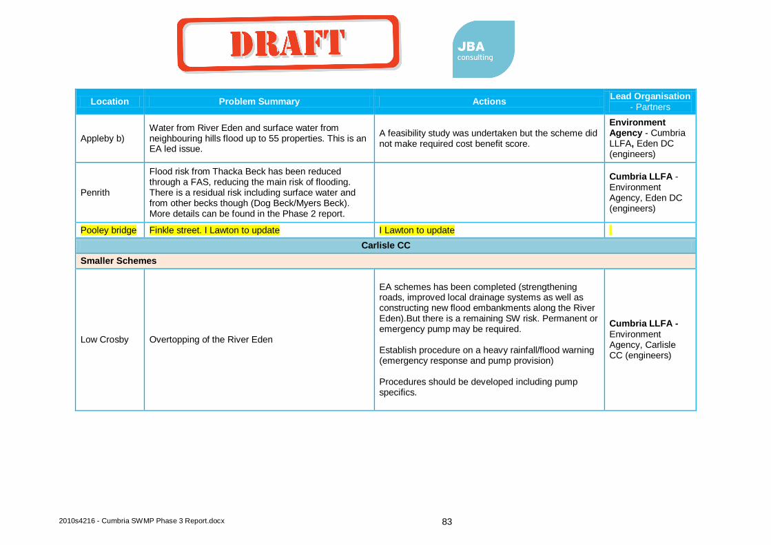
2010s4216 - Cumbria SWMP Phase 3 Report.docx 83
Location Problem Summary Actions Lead Organisation
- Partners
Appleby b) Water from River Eden and surface water from neighbouring hills flood up to 55 properties. This is an EA led issue.
A feasibility study was undertaken but the scheme did not make required cost benefit score.
Environment Agency - Cumbria LLFA, Eden DC (engineers)
Penrith
Flood risk from Thacka Beck has been reduced through a FAS, reducing the main risk of flooding. There is a residual risk including surface water and from other becks though (Dog Beck/Myers Beck). More details can be found in the Phase 2 report.
Cumbria LLFA - Environment Agency, Eden DC (engineers)
Pooley bridge Finkle street. I Lawton to update I Lawton to update
Carlisle CC
Smaller Schemes
Low Crosby Overtopping of the River Eden
EA schemes has been completed (strengthening roads, improved local drainage systems as well as constructing new flood embankments along the River Eden).But there is a remaining SW risk. Permanent or emergency pump may be required. Establish procedure on a heavy rainfall/flood warning (emergency response and pump provision) Procedures should be developed including pump specifics.
Cumbria LLFA - Environment Agency, Carlisle CC (engineers)
coyled
Draft

2010s4216 - Cumbria SWMP Phase 3 Report.docx 84
Location Problem Summary Actions Lead Organisation
- Partners
Carlisle
A lot of work has been completed but a number of locations need further investigation including: • Community Centre, Harraby - Surface water flooding • Wigton Road - Foul flooding/highway drainage • London Road - surface water and claims of water following rising main channel • Vallum Close - Surface water / land drainage • Huntsmans Lane/Moorside Drive - surface water flooding
Asset failure and climate change may lead to further local flooding issues in the future. Due to the high profile flooding in Carlisle, the city should be monitored for local flooding issues. This can be undertaken in the MSFW group but Cumbria CC LLFA should produce a summary report on the potential risks.
Cumbria LLFA - Carlisle CC (engineers)
Great Corby Ordinary Watercourse and surface water / highways flooding to 6 properties
CCC surface water element. Highways alterations to gulleys, verges and roadside walls (some 3rd party interest). Partnership arrangement to resolve problems via negotiation with landowners and residents
Cumbria LLFA - Carlisle CC (engineers)
Wetheral Drainage issues causing internal property flooding to between 5 and 10 houses.
Cumbria LLFA - Carlisle CC (engineers)
South Lakeland DC
Large Schemes
coyled
Draft
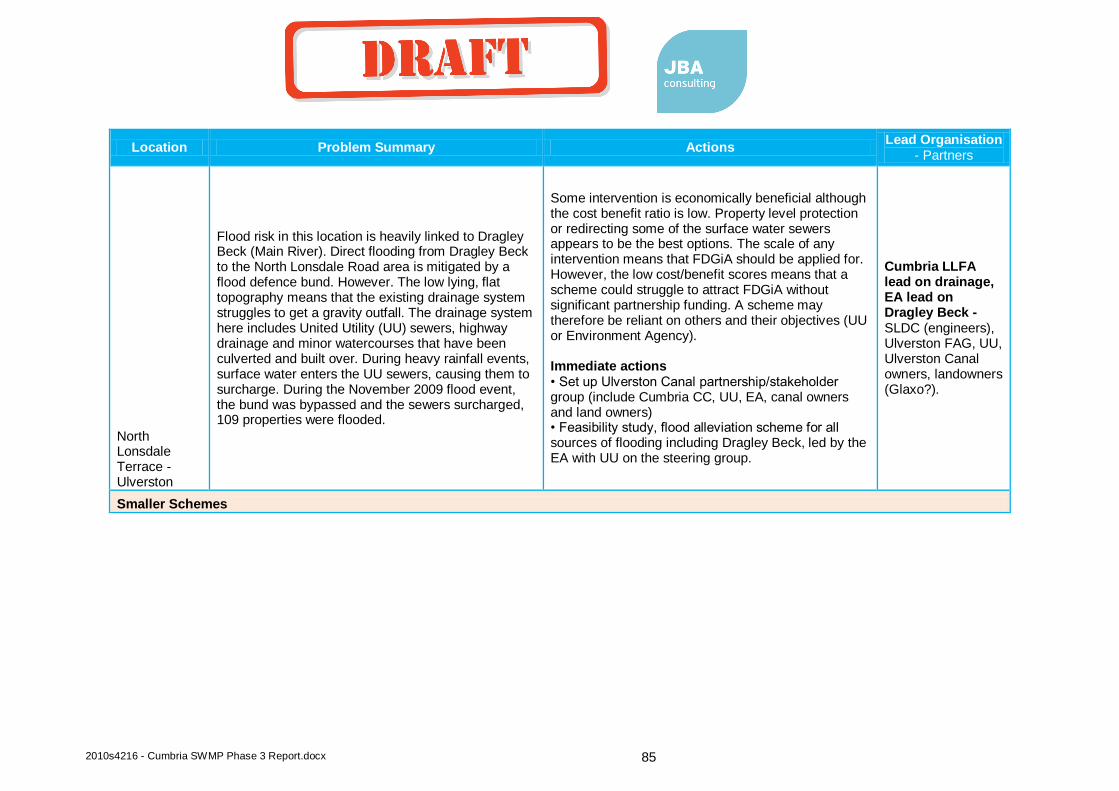
2010s4216 - Cumbria SWMP Phase 3 Report.docx 85
Location Problem Summary Actions Lead Organisation
- Partners
North Lonsdale Terrace - Ulverston
Flood risk in this location is heavily linked to Dragley Beck (Main River). Direct flooding from Dragley Beck to the North Lonsdale Road area is mitigated by a flood defence bund. However. The low lying, flat topography means that the existing drainage system struggles to get a gravity outfall. The drainage system here includes United Utility (UU) sewers, highway drainage and minor watercourses that have been culverted and built over. During heavy rainfall events, surface water enters the UU sewers, causing them to surcharge. During the November 2009 flood event, the bund was bypassed and the sewers surcharged, 109 properties were flooded.
Some intervention is economically beneficial although the cost benefit ratio is low. Property level protection or redirecting some of the surface water sewers appears to be the best options. The scale of any intervention means that FDGiA should be applied for. However, the low cost/benefit scores means that a scheme could struggle to attract FDGiA without significant partnership funding. A scheme may therefore be reliant on others and their objectives (UU or Environment Agency). Immediate actions • Set up Ulverston Canal partnership/stakeholder group (include Cumbria CC, UU, EA, canal owners and land owners) • Feasibility study, flood alleviation scheme for all sources of flooding including Dragley Beck, led by the EA with UU on the steering group.
Cumbria LLFA lead on drainage, EA lead on Dragley Beck - SLDC (engineers), Ulverston FAG, UU, Ulverston Canal owners, landowners (Glaxo?).
Smaller Schemes
coyled
Draft

2010s4216 - Cumbria SWMP Phase 3 Report.docx 86
Location Problem Summary Actions Lead Organisation
- Partners
North Lonsdale Road - Ulverston
In this area, there are problems relating to the disused Ulverston Canal. In the North Lonsdale Terrace area (Honeypot Estate), the highway outfalls are unable to discharge into the canal due to siltation. This causes surcharging and surface water flooding in the surrounding area. The flood extents and depths are not as significant as in North Lonsdale Road, but this is a pure surface water flooding problem. This area has also been highlighted due to the potential future development in the area. Future development may take place either side of the canal, adjacent to the Honeypot Estate. The natural surface water outfall for the new development would be the canal. This solution is therefore linked to the North Lonsdale Road canal storage option.
Works are required to improve the capacity of the canal to allow a free discharge during flood events, or new drainage arrangements for the existing and proposed development. Immediate actions Set up Ulverston Canal partnership/stakeholder group (include Cumbria CC, UU, EA, canal owners and land owners). Stakeholders should be contacted and encouraged to partner in a plan for this area that should include the following issues: surface water discharge into the Canal and backing up, leakage from the canal, surface water recommendations for the development of land around the canal.
Cumbria LLFA - SLDC (engineers and planners), Ulverston FAG, UU, Ulverston Canal owners, landowners (Glaxo?).
Beckside Road - Ulverston
There is a surface water flood flow that passes over Old Hall Road and then along Beckside Road. The source of the flood water is a mill race which receives water via a sluice system from Gill Banks Beck and a drain that originates in the Flan Farm area above Ulverston. The Flan Farm drain passes over Old Hall Road as the culvert under the road has insufficient capacity. Flood depths in the road dip have previously been in the region of 0.8m. This flow path then continues down Beckside Road, flooding properties on the way.
Due to the number of properties at risk and the severity of flooding, only small scale intervention would be appropriate here. The capacity of the highway culvert should be assessed and options for increasing its capacity should be considered. Options to consider • Property level protection • Changes in the management of the mill race • Attenuating/slowing flows between the Flan Farm area and Old Hall Road. • Increasing the culvert capacity under Old Hall Road Immediate actions • Modelling and feasibility study
Cumbria LLFA - EA (mill race and Main River consultation), SLDC (engineers).
coyled
Draft

2010s4216 - Cumbria SWMP Phase 3 Report.docx 87
Location Problem Summary Actions Lead Organisation
- Partners
Grasmere
Blockage of certain culverts is resulting in more water entering a watercourse which cuts across to the Rothay and increases flood risk in Grasmere. The drainage and sewer system is also prone to surface water infiltration. Under 10 properties at risk. More information on flood risk in Grasmere is available in the Phase 2 report.
Investigations are required into culvert crossings on A591 (collapsed culvert?) and across a sports field at Grasmere. CCTV survey to be commissioned. There are also some DG5 registered properties at terraced cottages being investigated by UU.
Cumbria LLFA - SLDC (engineers), LDNP (planners), UU and EA.
Grange over Sands
A culvert that is part Main River and part ordinary watercourse surcharges and floods around 22 properties. More details are in the Phase 2 report
Flood relief culvert through railway arch. Booths development could see £1.2 million invested in flood risk infrastructure via planning condition
Environment Agency - Cumbria LLFA, Booths, SLDC (engineers and planners)
Troutbeck Bridge
Predominantly Main River flooding (Bell Beck) up to 12 properties flooded including a school and hotel. Some related other sources though.
Predominantly a Main River issue but highway works also required. This therefore may not be led by the LLFA.
Environment Agency - Cumbria LLFA, SLDC (engineers and planners)
Milness
Channel conveyance and flood flow routing lead to over 6 properties flooding. This is a complex situation. Ordinary water course/ canal/ Main River. Highways and property flooding.
Cumbria LLFA - SLDC (engineers), EA, canal owner.
Burneside (Steels Row, Bridge Street)
Drainage, sewers and surface water occurs every 2-3 years flooding 5 residential properties.
UU working on solution and NRV installed and aim to divert surface water downstream of NRV. Wall on Bridge Street repaired by EA Ops. SLDC investigating culvert that comes through Croppers Mill.
Cumbria LLFA - SLDC (engineers), EA, UU
coyled
Draft
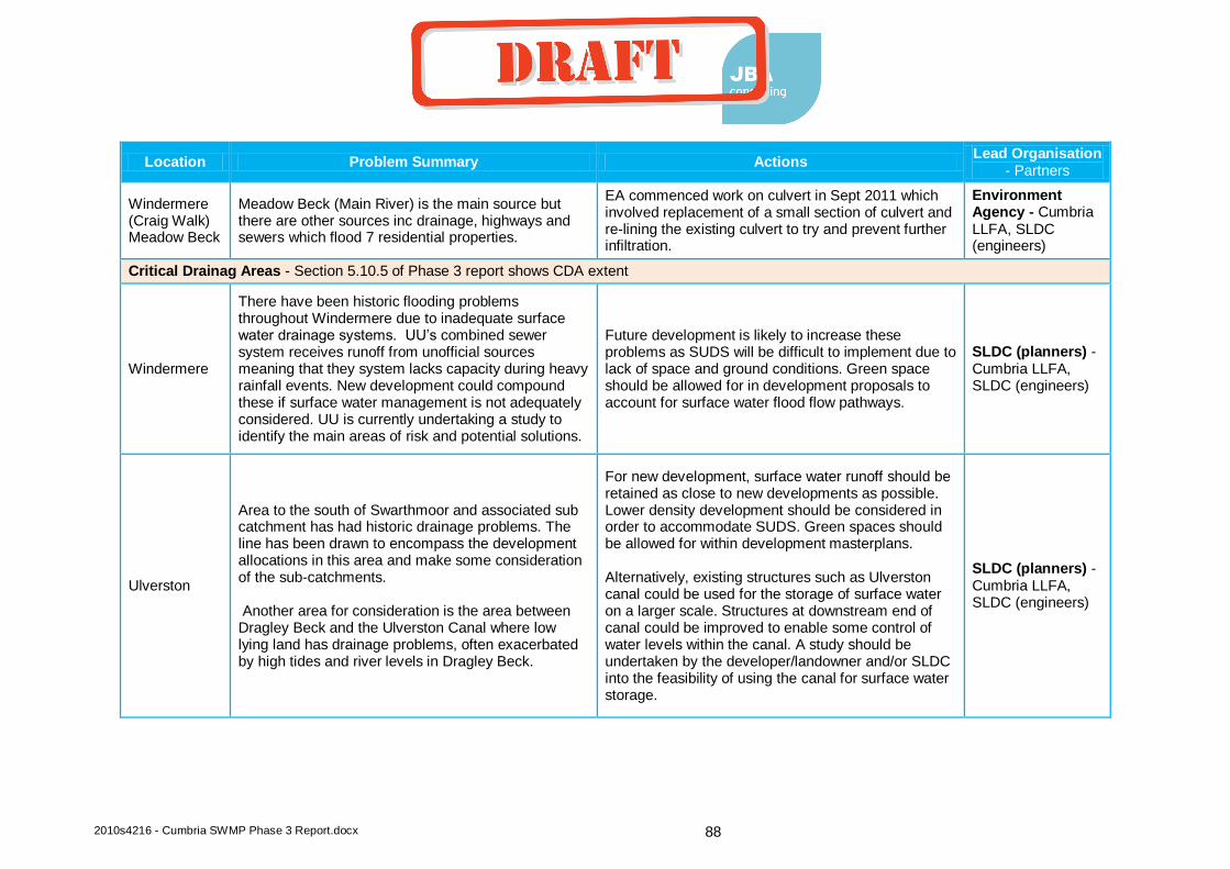
2010s4216 - Cumbria SWMP Phase 3 Report.docx 88
Location Problem Summary Actions Lead Organisation
- Partners
Windermere (Craig Walk) Meadow Beck
Meadow Beck (Main River) is the main source but there are other sources inc drainage, highways and sewers which flood 7 residential properties.
EA commenced work on culvert in Sept 2011 which involved replacement of a small section of culvert and re-lining the existing culvert to try and prevent further infiltration.
Environment Agency - Cumbria LLFA, SLDC (engineers)
Critical Drainag Areas - Section 5.10.5 of Phase 3 report shows CDA extent
Windermere
There have been historic flooding problems throughout Windermere due to inadequate surface water drainage systems. UU’s combined sewer system receives runoff from unofficial sources meaning that they system lacks capacity during heavy rainfall events. New development could compound these if surface water management is not adequately considered. UU is currently undertaking a study to identify the main areas of risk and potential solutions.
Future development is likely to increase these problems as SUDS will be difficult to implement due to lack of space and ground conditions. Green space should be allowed for in development proposals to account for surface water flood flow pathways.
SLDC (planners) - Cumbria LLFA, SLDC (engineers)
Ulverston
Area to the south of Swarthmoor and associated sub catchment has had historic drainage problems. The line has been drawn to encompass the development allocations in this area and make some consideration of the sub-catchments. Another area for consideration is the area between Dragley Beck and the Ulverston Canal where low lying land has drainage problems, often exacerbated by high tides and river levels in Dragley Beck.
For new development, surface water runoff should be retained as close to new developments as possible. Lower density development should be considered in order to accommodate SUDS. Green spaces should be allowed for within development masterplans. Alternatively, existing structures such as Ulverston canal could be used for the storage of surface water on a larger scale. Structures at downstream end of canal could be improved to enable some control of water levels within the canal. A study should be undertaken by the developer/landowner and/or SLDC into the feasibility of using the canal for surface water storage.
SLDC (planners) - Cumbria LLFA, SLDC (engineers)
coyled
Draft
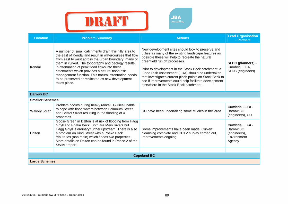
2010s4216 - Cumbria SWMP Phase 3 Report.docx 89
Location Problem Summary Actions Lead Organisation
- Partners
Kendal
A number of small catchments drain this hilly area to the east of Kendal and result in watercourses that flow from east to west across the urban boundary, many of them in culvert. The topography and geology results in attenuation of peak flood flows into these catchments which provides a natural flood risk management function. This natural attenuation needs to be preserved or replicated as new development takes place.
New development sites should look to preserve and utilise as many of the existing landscape features as possible these will help to recreate the natural greenfield run off processes. Prior to development in the Stock Beck catchment, a Flood Risk Assessment (FRA) should be undertaken that investigates current pinch points on Stock Beck to see if improvements could help facilitate development elsewhere in the Stock Beck catchment.
SLDC (planners) - Cumbria LLFA, SLDC (engineers)
Barrow BC
Smaller Schemes
Walney South
Problem occurs during heavy rainfall. Gullies unable to cope with flood waters between Falmouth Street and Bristol Street resulting in the flooding of 4 properties.
UU have been undertaking some studies in this area. Cumbria LLFA - Barrow BC (engineers), UU
Dalton
Goose Green in Dalton is at risk of flooding from Hagg Ghyll and Poaka Beck. Both are Main Rivers but Hagg Ghyll is ordinary further upstream. There is also a problem on King Street with a Poaka Beck tributaries (non main) which floods two properties. More details on Dalton can be found in Phase 2 of the SWMP report.
Some improvements have been made. Culvert cleansing complete and CCTV survey carried out. Improvements ongoing.
Cumbria LLFA - Barrow BC (engineers), Environment Agency
Copeland BC
Large Schemes
coyled
Draft
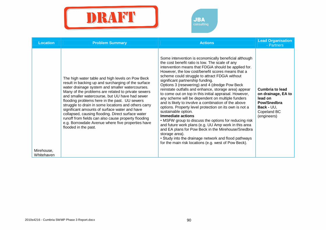
2010s4216 - Cumbria SWMP Phase 3 Report.docx 90
Location Problem Summary Actions Lead Organisation
- Partners
Mirehouse, Whitehaven
The high water table and high levels on Pow Beck result in backing up and surcharging of the surface water drainage system and smaller watercourses. Many of the problems are related to private sewers and smaller watercourse, but UU have had sewer flooding problems here in the past. UU sewers struggle to drain in some locations and others carry significant amounts of surface water and have collapsed, causing flooding. Direct surface water runoff from fields can also cause property flooding e.g. Borrowdale Avenue where five properties have flooded in the past.
Some intervention is economically beneficial although the cost benefit ratio is low. The scale of any intervention means that FDGiA should be applied for. However, the low cost/benefit scores means that a scheme could struggle to attract FDGiA without significant partnership funding. Options 3 (resewering) and 4 (dredge Pow Beck reinstate outfalls and enhance, storage area) appear to come out on top in this initial appraisal. However, any scheme will be dependent on multiple funders and is likely to involve a combination of the above options. Property level protection on its own is not a sustainable option. Immediate actions • MSFW group to discuss the options for reducing risk and future work plans (e.g. UU Amp work in this area and EA plans for Pow Beck in the Mirehouse/Snedbra storage area). • Study into the drainage network and flood pathways for the main risk locations (e.g. west of Pow Beck).
Cumbria to lead on drainage, EA to lead on Pow/Snedbra Back - UU, Copeland BC (engineers)
coyled
Draft

2010s4216 - Cumbria SWMP Phase 3 Report.docx 91
Location Problem Summary Actions Lead Organisation
- Partners
Parton, nr Whitehaven
A culverted ordinary watercourses (Lambhill Gill) passes through the village of Parton and can surcharge, possibly due to tide locking, blockage and inadequate culvert capacity. This has flooded between 20 and 30 properties in the lower part of the village. Recent works have been undertaken to re-cover the watercourse culvert at the town hall and install inspection points, but the risk remains and further works are required. There are other flooding issues with a smaller watercourse further to the north which passes under the A595 near Moresby Hall, but the main risk is from Lambhill Gill.
Some intervention is economically beneficial and the cost benefit ratio good for a local flood risk scheme. The scale of any intervention means that FDGiA could be applied for, but a local levy funding and other sources could cover the costs. Immediate actions • Parton feasibility and modelling study for all sources/pathways • A595 culvert improvements to reduce highway flooding (potential quick win) • Discussions with the quarry owners about the possibility of using the quarry as a flood overflow.
Cumbria LLFA - quarry owners, Copeland BC (engineers), Parton Parish Council.
Smaller Schemes
Coach Road, Whitehaven
This is a low lying area to the east of Pow Beck, downstream of Mirehouse. The lack of capacity in the combined system and backing up from Pow Beck can cause flooding. Highway drains enter the combined sewer here and also back up. The highway and properties in the low lying dip of Coach Road have a history of flooding. Although the impact of flooding is not significant, the regularity of flooding (every year) means intervention is necessary.
Property level protection appears to be the most cost beneficial approach for reducing risk to properties. However, the highway will still be liable to flooding and this may be a key objective for the MSFW group. Immediate actions • MSFW group to continue work and studies led by Cumbria Highways and UU.
Cumbria LLFA and UU joint approach - Copeland BC (engineers)
Lamplugh Three properties flood from field at back of Crossgates. Existing culvert across allotments appear to be too small.
Increase culvert size Cumbria LLFA - Copeland BC (engineers)
coyled
Draft
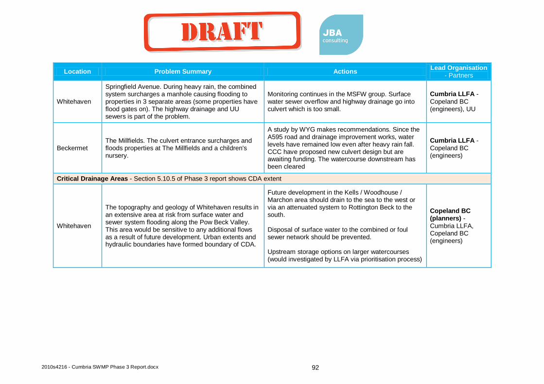
2010s4216 - Cumbria SWMP Phase 3 Report.docx 92
Location Problem Summary Actions Lead Organisation
- Partners
Whitehaven
Springfield Avenue. During heavy rain, the combined system surcharges a manhole causing flooding to properties in 3 separate areas (some properties have flood gates on). The highway drainage and UU sewers is part of the problem.
Monitoring continues in the MSFW group. Surface water sewer overflow and highway drainage go into culvert which is too small.
Cumbria LLFA - Copeland BC (engineers), UU
Beckermet The Millfields. The culvert entrance surcharges and floods properties at The Millfields and a children's nursery.
A study by WYG makes recommendations. Since the A595 road and drainage improvement works, water levels have remained low even after heavy rain fall. CCC have proposed new culvert design but are awaiting funding. The watercourse downstream has been cleared
Cumbria LLFA - Copeland BC (engineers)
Critical Drainage Areas - Section 5.10.5 of Phase 3 report shows CDA extent
Whitehaven
The topography and geology of Whitehaven results in an extensive area at risk from surface water and sewer system flooding along the Pow Beck Valley. This area would be sensitive to any additional flows as a result of future development. Urban extents and hydraulic boundaries have formed boundary of CDA.
Future development in the Kells / Woodhouse / Marchon area should drain to the sea to the west or via an attenuated system to Rottington Beck to the south. Disposal of surface water to the combined or foul sewer network should be prevented. Upstream storage options on larger watercourses (would investigated by LLFA via prioritisation process)
Copeland BC (planners) - Cumbria LLFA, Copeland BC (engineers)
coyled
Draft

Offices at Atherstone
Doncaster
Edinburgh
Haywards Heath
Limerick
Newcastle upon Tyne
Newport
Northallerton
Saltaire
Skipton
Tadcaster
Wallingford
Warrington
Registered Office South Barn
Broughton Hall
SKIPTON
North Yorkshire
BD23 3AE
t:+44(0)1756 799919 e:[email protected]
Jeremy Benn Associates Ltd Registered in England 3246693
Visit our website
www.jbaconsulting.com
coyled
Draft

coyled
Draft