CUMBERLAND RESOURCES LTD GEOL SURVEY JUNE … · WHOLE-ROCK ANALYSIS - ALTERATION SCORES...
42
SZK14ME0028 2.16847 GERRY LAKE Q..Q 2. 16247 LTD. GEOLOGICAL SURVEY JUHE, SEPTEMBER 1994 gaT.T.g HTS: 52K/14 ORTHNESTERH OHTARIO RECEIVED OCT 3 i 1995 MINING LANDS BRAN C o i -L i b;^ pu Thunder Bay, Ontario SUBMITTED BT: NOVEMBER, 1994 M. P. LEWIS GEOLOGICAL SERVICES
Transcript of CUMBERLAND RESOURCES LTD GEOL SURVEY JUNE … · WHOLE-ROCK ANALYSIS - ALTERATION SCORES...
SZK14ME0028 2.16847 GERRY LAKE Q..Q
2. 16247LTD.
GEOLOGICAL SURVEY
JUHE, SEPTEMBER 1994
gaT.T.g
HTS: 52K/14 ORTHNESTERH OHTARIO
RECEIVED
OCT 3 i 1995
MINING LANDS BRAN
C o i -L i b;^pu
Thunder Bay, Ontario SUBMITTED BT:NOVEMBER, 1994 M. P. LEWIS GEOLOGICAL SERVICES

S2K14NE0028 2.16247 GERRY LAKE
TAKLE OF i.
SUMMARY
1.0 INTRODUCTION
2.0 LOCATION, SIZE AMD ACCESS
3.0 PROPERTY SUMMARY AHD CLAIM DISPOSITION
4.0 PREVIOUS WORK
5.O REOIOHAL GEOLOGY AHD METALLOGEHY
6.0 PROPERTY GEOLOGY AMD MINERALIZATION
7.0 STRUCTURE
ALTERATION
01OC
Page
l
l
l
4
5
8
10
118.0 WHOLE-ROCK GEOCHEMISTRY8.1 HA208.2 HOSHIMOTO INDEX8.3 CU8.4 ZH8.5 COMPARISIOH OF ALTERATIOH PATTERMS TO OTHER VMS DEPOSITS8.6 TRACE ELEMEBT GEOCHEMISTRY
9.0 DISCUSSIOH
10.0 PROPOSED EXPLORATION PROGRAM AND BUDGET
REFERENCES
14
14
17
FIGURE l
FIGURE 2
FIGURE 3
FIGURE 4
FIGURE 5
LIST OF FIGURES
PROPERTY LOCATIOB
CLAIM SKETCH
SIGNIFICANT VMS OCCURREI
COMPILATION MAP
PROPOSED DEEPEN SURVEY
2
3
7
9
15

TABLE l
TABLE 11
TABLE 111
TABLE IV
TABLE V
TABLE VI
LIST OF TJ""-gS
SCHEDULE OF CLAIMS
Cu-Zn DEPOSITS AND PROSPECTS
WHOLE-ROCK ANALYSIS - ALTERATION SCORES
COMPARISIOH OF ALTERATION INDICES
PROPOSED BUDGET
4
6
11
13
13
16
APPENDIX l
APPENDIX 2
LIST OF APPrcHDIX
STATEMENT OF QUALIFICATIONS
CERTIFICATES OF ANALYSIS
18
19
PLAN 601-A
PLAN 601-B
PLAN 601-C
PLAN 601-D
PLAN 601-E
LIST OF DRAWINGS
GEOLOGY AHD ALTERATION
HA2O RESULTS
HOSHIMOTO INDEX
CU
ZN

SUMMARY
The Big Falls property is situated 50 km southeast of the mining community of Red Lake and 35 km north of the town of Ear Falls in Northwestern Ontario. The property is comprised of six contiguous mining claims, totalling 68 units. With the exception of 2 claims (18 units), which are part of an earn-in agreement with a local Red Lake prospector, the remaining claims are 100* wholly owned by Cumberland Resources Ltd. of Thunder Bay, Ontario.
The property position covers the eastern extension of favourable VMS hosting felsic stratigraphy which hosts numerous sub-economic massive and stringer base metal occurrences.
A property position immediately west of the Big Falls claims has been subjected to on-going exploration, including diamond drilling by Noranda, as part of a joint venture with a junior mining company, Major General. Two mineralized trends, which host significant massive and stringer base metal occurrences and associated stratabound and cross-cutting hydrothermal alteration, have been traced to the western boundary of Cumberland's Big Falls Property.
In June and September of 1994, a program of linecutting (25 Km), 50 km of geological mapping and lithogeochemistry (34 samples) was carried out on the Big Falls property. This program resulted in the discovery of a new and extensive proximal-type hydrothermal alteration zone in Fill type rhyolites. The alteration zone, which is 300 meters wide, and 1.5 km long, is characterized by a coarse anthophyllite-cordierite, garnet, biotite and chlorite mineral assemblage.
The results of a quantitative evaluation of the intensity of the proximal-type alteration, which is provided by determining alteration scores, and by comparing trace-element geochemistry from other known VMS deposits has greatly enhanced the probability of a VMS deposit on Cumberland's Big Falls property.
A phase 11 exploration program consisting of 16 km of DEBPEM geophysics is recommended at an estimated cost of $16,000.00. Diamond drilling would be contingent on the results of the geophysical survey.
Page l
1.0 IHTRODUCTIOH
During the period June 3rd-13th and September 26 th-October 9th , 1994 a geological survey was carried out on Cumberland Resources Ltd's Big Falls property which is located in the Red Lake area of Northwestern Ontario. The survey was controlled by extending Norex's Joy property baseline from 5100-E to 11000-E. Geological traverses were carried out over 25 km of pace and compass lines and an additional 25 km over a picket line grid established by Vytll Exploration Services of Thunder Bay, Ontario. During the course of the survey a total of 34 selected rock specimens were collected for whole-rock analysis.
2.O LOCATION, SIZE AHD ACCESS
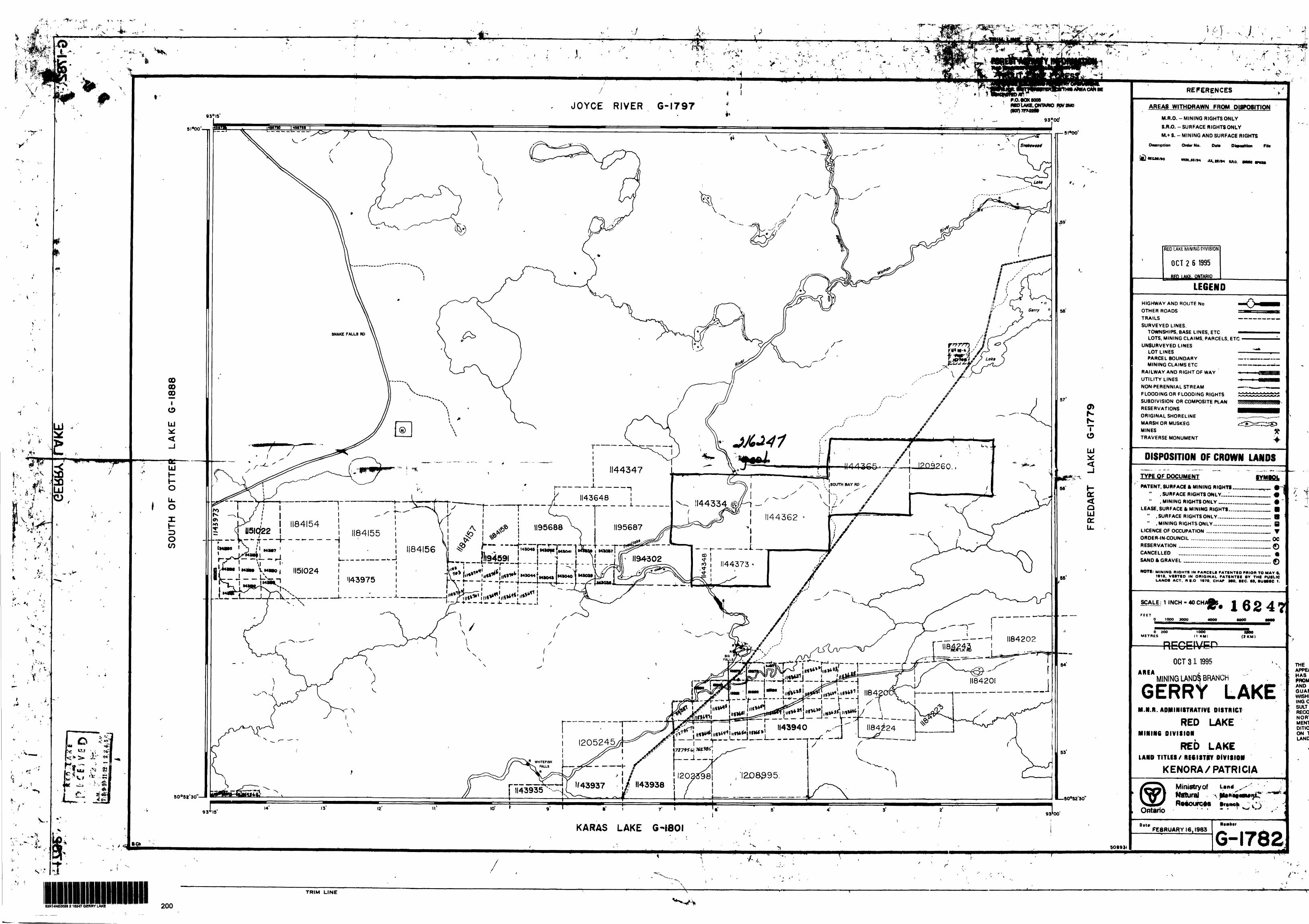
The Big Falls property is located some 35 km north of the community of Ear Falls and 50 km southeast of mining community of Red Lake in Northwestern Ontario. The former producing South Bay Cu, Zn, Ag mine is situated some 35 km to the northeast (Figure 1).
The property is comprised of six contiguous mining claims totalling 68 units covering 7.0 km of a prospective base metal hosting stratigraphy. Excellent access is provided by the all weather South Bay mine road which traverses the center of the property. The Pickle Lake power-line corridor dissects the two most easterly claims.
3.0 PROPERTY SUMMARY AMD CLAIM DISPOSITION
Two of the six claims (114334 and 114348) are contained in an earn- in agreement between a local Red Lake prospector and Cumberland Resources Ltd. The remaining four claims are held 100% by Cumberland Resources Ltd of Thunder Bay, Ontario.
The claims are located in the Gerry Lake area. Map sheet G-1782 and consists of the following holdings (FIGURE 2):

UCHIGREENSTONE
BELT
WABIGOON \ GREENSTONE
BELT
CUMBERLAND RESOURCES LTDPROPERTY LOCATION
BIG FALL PROPERTY

CUMBERLAND RESOURCES LTD. BIG FALLS PROPERTY
CLAIM SKETCHICTRES
FIGURE 2

Page 4
TABLE I: SCHEDULE OF CLAIMS
CLAIM l NO. OF UNITS RECORDING DATE
1144334 (JV)
1144348(JV)
1144362
1144365
1144373
1209260
TOTAL
16
2
16
16
6
12
68
OCT 13 r 1993
DEC 7, 1993
MARCH 16, 1994
MARCH 16, 1994
MARCH 16, 1994
JUNE 22, 1994
4.0 PREVIOUS WORK
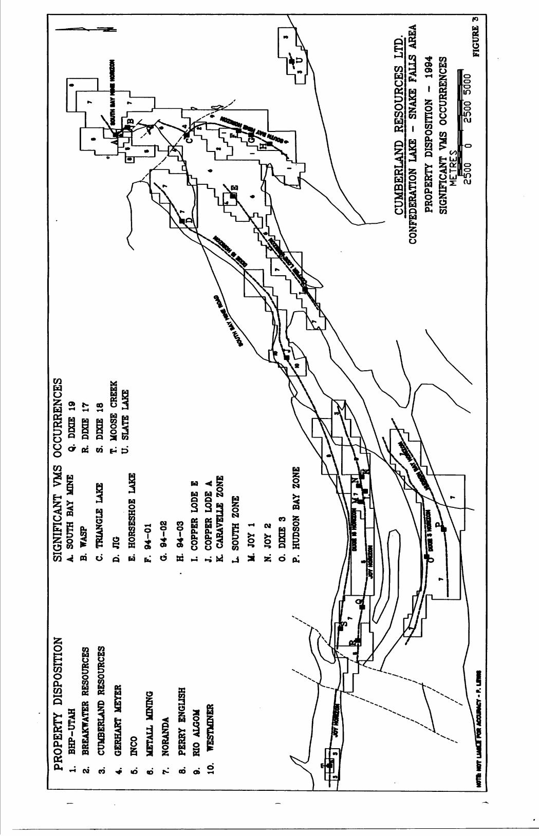
The discovery of the South Bay Mine, a small but high grade Cu-Zn deposit (1.5 million tons grading 2.3% Cu and 14.0% Zn) by Selco in 1969, resulted in extensive base metal exploration which covered an area south from Confederation Lake and southwest to the community of Ear Falls.
To date, all prominent massive sulphide occurrences discovered in the Confederation Lake - Snake Falls area were the direct result of ground follow-up of vintage airborne electromagnetic (AEM) surveys conducted in the 1970's and early 80's. Since these discoveries were made by BP-Selco, the vast majority of base metal exploration has been confined to the immediate vicinity of the occurrences. Little or no effort has been made to extrapolate mineralized time breaks into areas of favourable felsic stratigraphy.
A review of the assessment records revealed that no work has been filed on the Big Falls property. This is likely due to absence of airborne EM targets. The Big Falls claims adjoin the east boundary of Noranda's Joy property, which host four massive sulphides occurrences that are located along two recogonized mineralized tii breaks.

Page 5
Previous work on Noranda's Joy property is summarised as follows:
1969-1970
Five drill holes were drilled by Caravelle Mines Ltd. to test an airborne EM anomaly. Stringer Cu-Zn mineralization up to 5 m wide were intersected with local high grade narrow massive sulphide sections containing assays as high as Q.13% Cu and 21.6% Zn over 0.25 m. To the knowledge of the author the Caravelle zone has not been subjected to further drilling.
1978-1985
BP-Selco carried out a number of geophysical surveys including Magnetometer, HLEM and UTEM. Diamond drill testing of a number of targets encountered best intersections of S.1% CU over 5.7 m in the Joy Zone and 17.2% Zn over 0.60 m in the South Zone.
1990-1994
Noranda acquired the property in 1990 and in 1993 entered into a joint venture with Major General of Vancouver, B.C. A four hole drill program in 1992 encountered a drill hole intersection which assayed 4.01^ Cu and G.17% Zn over 3.35 m. Drilling was also carried out in 1993 and the winter of 1994. Results of the most recent drill programs are unknown.
5.0 REGIONAL GEOLOGY ABD METALLOGENY
The metavolcanics - metasedimentary rocks of the Confederation Lake assemblage have been divided into three mafic to felsic volcanics cycles (Thurston, 1985). The upper sequence. Cycle III, host the South Bay deposit which is contained within what was commonly termed the Mine Series Rhyolite. These rhyolites, which consist of banded and amygdaloidal flows to thick quartz-crystal pyroclastic successions, extend from the South Bay Mine area south into Bowerman and Belanger Townships where they obtain a maximum stratigraphic thickness of 5 km. The supracrustal rocks are then bifurcated into a northern and southern belt by several large felsic intrusives.
The northern belt, which underlies the Big Falls property, extends west from Belanger Township through Fredart Lake, Gerry Lake, and Trout River to join the Red Lake greenstone belt at Gullrock Lake in Willans Township. These rocks are comprised of mainly pillowed and massive mafic flows with interbedded units of felsic pyroclastic tuff and flows. An oxide facies iron formation is located west of Fredart Lake and can be traced some 30 km west where it hosts the Dixie 18 Cu, Zn occurrence.

Page 6
The southern belt, which extends west to the Dixie Lake area, is predominantly underlain by felsic and intermediate pyroclastics and subsidiary mafic metavolcanics.
In the Snake Falls area of the Confederation Lake assemblage base metal mineralization is largely hosted by strongly altered felsic to intermediate pyroclastic rocks. The mineralization is associated with a biotite - garnet - anthophyllite chlorite cordierite alteration mineral assemblage.
A single base metal deposit (former producer) and a number of significant massive sulphide prospects occur along specific mineralized time breaks in the Confederation Lake - Snake Falls areas (Figure 3). Some of major occurrences are listed in Table II.
TABLE II: CU- ZN DEPOSITS AND PROSPECTS
HORIZON
South Bay Nine
MIME/PROSPECT
South Bay
BP-Selco
TONNAGE/GRADE
l .6 million tons
2.3% CU, 14.(^ Zn, 3.5 opt Ag
Copper Lode A
Copper Lode A
Copper Lode
Joy
Joy
JOY
Joy
Dixie
SLATE LAKE
Copper Lode A Westminer
Dixie 18 Noranda
Copper Lode E Noranda
Joy Noranda
Dixie 17 Noranda
Dixie 19 Noranda
Moose Creek INCO
Dixie 3 Noranda
SLATE LAKE CUMBERLAND
425,000 tons1.56 % Cu, 0.98 opt Ag
150,000 tons J.4% ZN
276,000 tons Q.66% Cu, 4.8% Zn
DDH-19924.0^ Cu/3.35 m
DDHX.4% Cu, T.34% ZNX9.5m
DDHX.5% Cu, e.33% Zn/ 3m
DDH1.0* Cu, S.2% Zn70.37m
88,000 tonsQ.60% Cu, 14. 8% Zn
DDH S.7% Cu, Zn/ 0.50m
2. 3. 4.PRO
PER
TY
DIS
POSI
TIO
N1.
B
HP-
UT
AH
BREA
KW
ATE
R R
ESO
UR
CES
CUM
BERL
AN
D
RES
OU
RC
ES
GER
HA
RT M
EYER
5.
INCO
6.
MET
ALL
MIN
ING
7.
NO
RAN
DA
8.
PER
RY
EN
GLI
SH
9.
RIO
ALG
OM
10.
WES
TMIN
ER
SIG
NIF
ICA
NT
VM
S O
CC
UR
REN
CES
A.
SOU
TH B
AY
MIN
E B.
W
ASP
C.
TRIA
NG
LE
LAKE
D.
JIG
E.
HO
RSE
SHO
E LA
KE
F.
94-0
1
G.
94-0
2
H.
94-0
3
I. C
OPP
ER L
OD
E E
J.
CO
PPER
LO
DE
A
Q.
DIX
IE
19R.
D
IXIE
17
S.
DIX
IE
18
T.
MO
OSE
CR
EEK
U
. SL
ATE
LA
KE
K.
CARA
VELL
E ZO
NE
L
SOU
TH Z
ON
E
M.
JOY
l
N.
JOY
2
0.
DIX
IE
3
P.
HU
DSO
N B
AY
ZO
NE
CU
MB
ERLA
ND
R
ESO
UR
CE
S LT
D.
CONF
EDER
ATIO
N LA
KE -
SNAK
E FA
LLS
AREA
PRO
PER
TY D
ISPO
SITI
ON
-
1994
SI
GN
IFIC
AN
T VM
S O
CCU
RREN
CES
ME
TRE
S
FIG
UR
E "S

Page 8
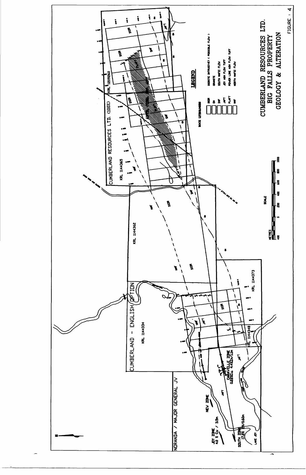
6.0 PROPERTY GEOLOGY AMD MINERALIZATION
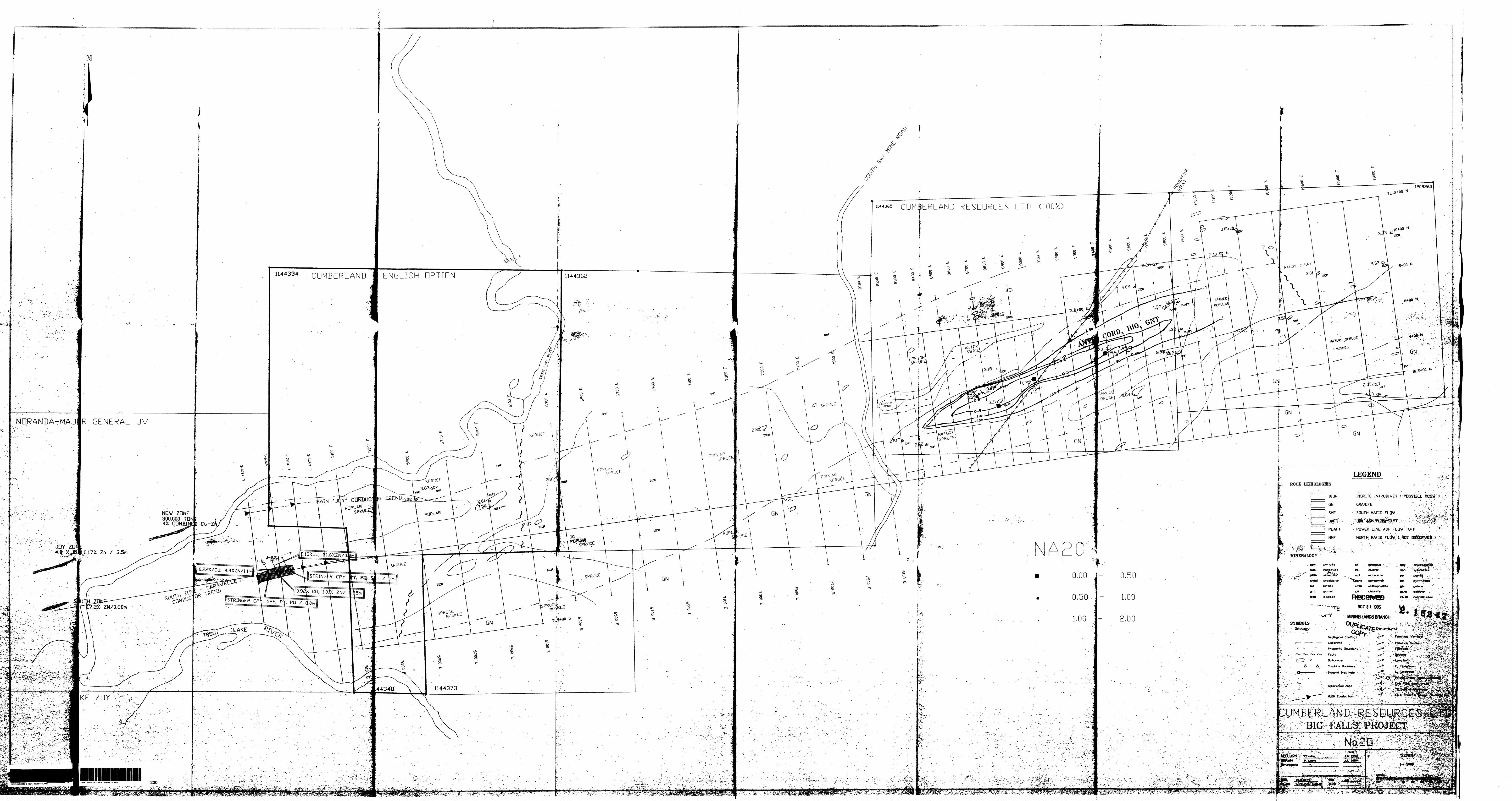
During the course of the June and September, 1994 mappping survey, four major rock types were recognized on the Big Falls property: North mafic flow (andesite), Joy pyroclastic tuff. Power Line ash tuff. South mafic flow, and a dioritic intrusive. The Joy pyroclastic flow and the Power-line ash tuff are part of the same stratigraphic succession that have been dilated by a large diorite sill (Figure 4). From west to east in the direction of younging these stratigraphic units are as follows:
The North Mafic Flow(NMF) is exposed in two closely located outcrops immediately south of Trout Lake River. Both exposures were moderate to well foliated, dark green to black in colour with local speckled and patchy ID-15% feldspar porphyroblast. Numerous pink f elsite/granitic veinlets are randomly distributed through-out the outcrop exposures. Whole-rock analysis (samples 12954, 12955) averaged 49.(^ SiO2 , Q.61% TiO2 and S.42% Na2O.
The Joy Ash Flow tuff(JAFT), which hosts the Joy, Caravelle and the South base metal occurrences, is knowingly exposed in one lone location on line 5900-E. This unit is medium grey in colour, is aphyric and has a medium grained sugary texture. Crude banding is evident with a 740 bearing. The weathered surfaces has a rusty coloration due to the presence of pervasive biotite and muscovite. The whole-rock analysis indicates intermediate composition with a Si02 content of 68.10%, TiO2 content equal to Q.69%, and Na2o equal to S.56%. A unit of simi liar chemical composition exist as a xenolith within the southern felsic intrusive near the southeast corner of the property. The latter exposures differ in appearance from the JAFT in its alteration style. This alteration manifest itself as pervasive biotite, locally observed coarse-grained anthophyllite, and rare garnet porphoblast.
The Power Line Ash Flow Tuff(PLAFT) is exposed east from the South Bay mine road to the eastern boundary of claim 1144365 where the unit obtains a thickness of at least 400 meters.
The unaltered and altered equivalents of the PLAFT are substantially different in appearance. The unaltered PLAFT is finely banded, medium grained , light to a dark grey in colour and contains up to 5% sub 2mm size pink garnet. The altered variety, which is exposed in a number of outcrops over an open-ended strike length of 1.5 kms, is comprised of massive to coarsely bedded, coarse grained anthophyllite, biotite, cordierite, garnet, +/- chlorite. Garnets occur as pervasive sub 2cm porphyrobasts and heavily concentrated (5(^) sub 20 cm beds and palm-size aggregates or clusters. Coarse grained anthophyllite exists as heavily- concentrated tabular to lath-like and radial (half bow-tie) crystals generally in an off-white to grey cordierite-rich matrix. Garnet and anthophyllite mineral assemblage results in an extremely rough and knobby appearance on outcrop surfaces.
CUMBERLAND R
ESOU
RCES
LTD, (lOOX.)
H.I
I44M
5
[CUM
BERL
AND
- EN
GLIS
H/OP
TION
KRL
1144
334
NDRA
NDA
/ MAJOR
GENERAL
JV
HO
RtT
t IN
TKU
StVC
t <
KB
SO
LC F
LOW
GM
MT
t
SOUT
H H
tfK
FLO
W
JOY
ASH
PLOW
rur
rPO
WER LDC ASH PLOW TUFF
NORT
H K*nC PLOW
JOY
ZONE
4,
0 X
Cu
X
VE
LLE
ZO
NE
4.4X
ZnX1
4n
CUM
BERL
AN
D
RES
OU
RC
ES
LTD.
B
IG
FALL
S PR
OPE
RTY
GEO
LOG
Y
A
ALT
ERA
TIO
N20
0 40
0 60
0 80
0 10
00
Page 10
Average SIO2, TIO2, and MA2O content for the altered PLAFT is Tl.38%, D.76% and G.62%, respectively.
The South Mafic flow (SMF) overlies the PLaft and is mainly exposed along the southern portion of claims 114365 and 1209260. This unit ranges from dark green, fine grained and massive to a more dioritic appearance from west to east. The more easterly exposures display a typical salt and pepper dioritic texture composed of mainly hornblende and feldspar. SiO2 , TiO2 and Na2O average 52.1^, X.02% and S.22%, respectively.
Intrusive rocks occur in the form of a diorite sill which extend along the entire 7.0 km strike length of the property. This sill appears to be rather consistent in thickness (approx 300m) and separated Northern Mafic Flow from the felsic ash flow tuffs to the south. Text ur ally the intrusive is typically dioritic consisting of a characteristic salt and pepper -like appearance and is composed of 50% feldspar and 50% hornblende. The unit is generally massive with minor locally observed foliation. Chemically the sill averages 49. 7(^ SiO2 , 1.543; TiO2 , and a.00% NaO2 .
With the exception of minor pyrite no other known mineralization exist on the Big Falls property. Noranda's Joy property to the immediate west hosts four stringer and massive base metal occurrences. These metal rich occurrences appear to be associated with two separate mineralized time breaks. The Joy conductive trend has been delineated geophysically over a distance of approximately 2 km. The Joy Occurrence, which is located at the western end of the delineated mineralizing trend, is a Cu-rich stringer and massive sulphide zone with a reported best intersection of 4.01^ Cu over 3.35 m. The Caravel le trend is located just 500 m south of the Joy trend and contains two massive and associated stringer sulphide occurrences with best intersection of 21.6% Zn/0.25 m and 4.44% Zn/ 1.1 m (Caravelle zone) and 17. 2% Zn/0.60 m (South zone). The known limits of both the Joy and the Caravelle conductive trends extend to the eastern boundary of Noranda's Joy property and hence to the western boundary of Cumberland's Big Falls property.
7. STRUCTURE:
A weak to moderate mineral f oliaton( hornblende, minor biotite and chlorite) is present in most of the mafic rocks. The felsic units (JAFT, PLAFT) display a crude to a moderately well-developed banding and/or bedding. Both foliation and banding are consistentely orientated at 70-800 with a near vertical dip. Personal communications with present day workers in the area indicated that known sulphide lenses dip 650 to the east and plunge at a shallow angle to the northeast.
Inferred faulting south of Trout Lake River and near the eastern limits of the property is based solely on the sudden termination of rather thick stratigraphic units.

Page 11
8.0 WHOLE-ROCK GEOCHEMISTRY : ALTERATION
The felsic volcanics, which host the former producing South Bay Cu, Zn, Ag mine, extend west to the Snake Falls area where they play host to a number of sub-economic massive sulphide occurrences. These massive sulphide occurrences typically display stratabound and cross-cutting hydrothermal footwall alteration which is consistent with all Archean VMS deposits.
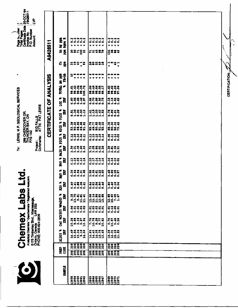
During the course of the Big Falls mapping survey, a total of 34 rock samples were collected for the purpose of whole-rock analysis. These samples were analyzed for various major, minor and trace elements by Chemex Labs of Vancouver, B.C. Analytical results are appended as Appendix 2.
Selected elements and combinations of elements were plotted on a digitized base map. The most effective and accepted way to determine and interpret hydrothermal alteration processes that are commonly associated with volcanogenic massive sulphide deposits is through the identification of depletion or enrichment trends in total Fe and the alkalis. Alteration trends of this nature are known to occur around or, more usually, stratigraphically underlying proximal massive sulphide ore bodies. Trends of MgO, total Fe and less typically K2O enrichment and depletion of Na2O and CaO in felsic volcanic rocks are recognized to form integral parts of the overall ore-forming process. A quantitative evaluation of the alteration processes is best provided by generating alteration indices such as Hoshimoto, Chlorite, Sericite and Spits (Table III). Only the Hoshimoto index will be briefly discussed in this report.
The whole-rock geochemistry and the above mentioned alteration scores define a rather extensive area of massive sulphide-forming type alteration which extend east from the South Bay Mine road for a distance of 1.5 km. This alteration zone, which defines itself mineralogically as a anthophyllite-cordierite-biotite-garnet +/- chlorite mineral assemblage, is 300 meters wide with a 1.5 km open strike length.
8.1 Ha2O: PLANl 6O1-B
A plot of Na2O values shows the alteration zone to be defined by the 1.5% Na2O contour. Of the 11 whole-rock samples which displayed varing degrees of alteration three of the samples contained <0.5% Na2O. Plan 601-B display a typically zoned alteration system with an open strike length of 1.5 km.
8.2 HOSHIMOTO INDEX: PLANf 601-C
The Hoshimoto Index(HI) is derived from the ratio of those oxides (MgO and K2O) expected to be enriched due to alteration versus the total alkali content. As MgO and K2O content of a volcanic rock increases with respect to the total alkali content, the Hoshimoto

88
s: S
S
S
S S 8 800
888 S 8 8
•Jo
88 900
s s 8
88?oboo
8
88? •ve 323 8 88 8*rim
ui
8 32SSS
558
3UI
8III UI UI III 111 111 III
8
8
33885 8 8 S
889SZ
88
ui w
8
f
ii

Page 13
Index approaches 100. Average Hoshimoto values for subalkaline mafic to felsic volcanics lie between 35 and 50. Highly altered volcanics rocks will have a value in excess of 80.
All samples within the alteration zone have values greater than 70 with the exception of sample 12918 which has an abnormally high CaO value(10.801). Values greater than 80 occur throughout the alteration zone.
8.3 Cu: PLAN! 601-D
Cu values are extremely low ranging from l to 146 ppm. The lone anomalous value of 146 ppm was obtained from the Joy ash tuff outcrop and can probably be attributed to the processes that formed the numerous copper-rich massive sulphide occurrences in the general area.
8.4 Zn: PLAN 601-E
Samples from the newly discovered alteration zone generally contain Zn values greater than 50 ppm. A weakly anomalous area is defined over a continous strike length of 1.2 km with highs of 212 and 136 ppm Zn.
8.5 COMPARISON OF ALTERATION PATTERNS TO OTHER VMS DEPOSITS.Table IV demonstrates the comparison between alteration indices for the rhyolitic tuffs of the Big Falls property and those of footwall rocks of well known VMS deposits.
TABLE IV COMPARISON OF ALTERATION INDICES
LOCATION HOSHIMOTO CHLORITE SERICITE SPITS
BIGFALLS*(UNALTERED) ? ? ? ?(ALTERED) 93 95 85 49STURGEON LAKE(UNALTERED) 46 ? 52 4(ALTERED) 75 ? 90 42WINSTON LAKE(UNALTERED) 16 ? 3 2(ALTERED) 82 ? 63 10LYNN LAKE(UNALTERED) 14 ? 15 2(ALTERED) 75 ? 41 14HORNE MINE(UNALTERED) 26 ? 17 3(ALTERED) 99 ? 99 22
Page 14
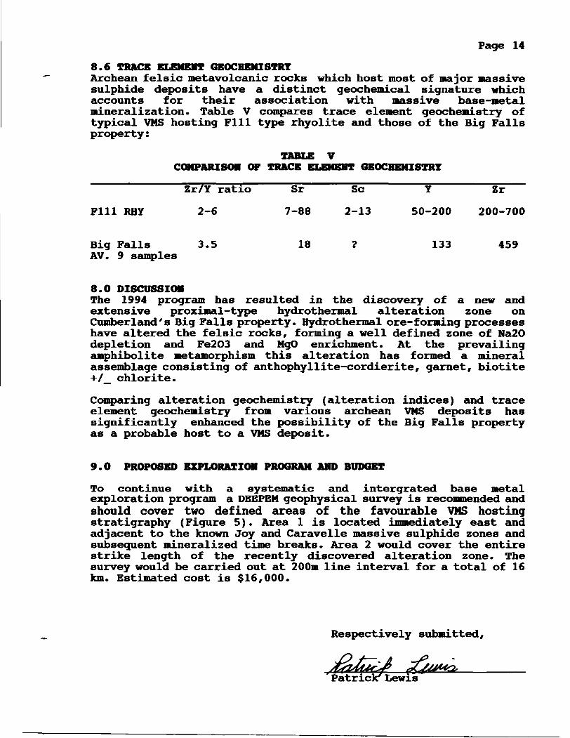
8.6 TRACE ELEMENT GEOCHEMISTRYArchean felsic metavolcanic rocks which host most of major massive sulphide deposits have a distinct geochemical signature which accounts for their association with massive base-metal mineralization. Table V compares trace element geochemistry of typical VMS hosting Fill type rhyolite and those of the Big Falls property:
COMPARISON C
Zr/Y ratio
Fill RHY 2-6
IF TRACE ELEMENT GEOCHEMISTRY
Sr Se Y Zr
7-88 2-13 50-200 200-700
Big Falls 3.5 18 ? 133 459 AV. 9 samples
8.0 DISCUSSIONThe 1994 program has resulted in the discovery of a new and extensive proximal-type hydrothermal alteration zone on Cumberland's Big Falls property. Hydrothermal ore-forming processes have altered the felsic rocks, forming a well defined zone of Na2O depletion and Fe2O3 and MgO enrichment. At the prevailing amphibolite metamorphism this alteration has formed a mineral assemblage consisting of anthophyllite-cordierite, garnet, biotite +/_ chlorite.
Comparing alteration geochemistry (alteration indices) and trace element geochemistry from various archean VMS deposits has significantly enhanced the possibility of the Big Falls property as a probable host to a VMS deposit.
9.0 PROPOSED EXPLORATION PROGRAM AND BUDGET
To continue with a systematic and intergrated base metal exploration program a DEEPEN geophysical survey is recommended and should cover two defined areas of the favourable VMS hosting stratigraphy (Figure 5). Area l is located immediately east and adjacent to the known Joy and Caravelle massive sulphide zones and subsequent mineralized time breaks. Area 2 would cover the entire strike length of the recently discovered alteration zone. The survey would be carried out at 200m line interval for a total of 16 km. Estimated cost is 316,000.
Respectively submitted,
Patrick7 Lewis

xRESOURCES LTD. (1007.)
NDRANDA 7 MAJOR GENERAL?
LEGEND
NEW
JOY ZDC44 Z Cu X 3L9n
rassoLC FUIW
l————laum imc FLOWJOT ASH FLOW TUFF
FfMOt UC ASH FUM TUFF
MRTH NmC FUIW
SOUTH
LMC JOT
CUMBERLAND RESOURCES LTD. BIG FALLS PROPERTY
PROPOSED DEEPEM SURVEYFIGURE
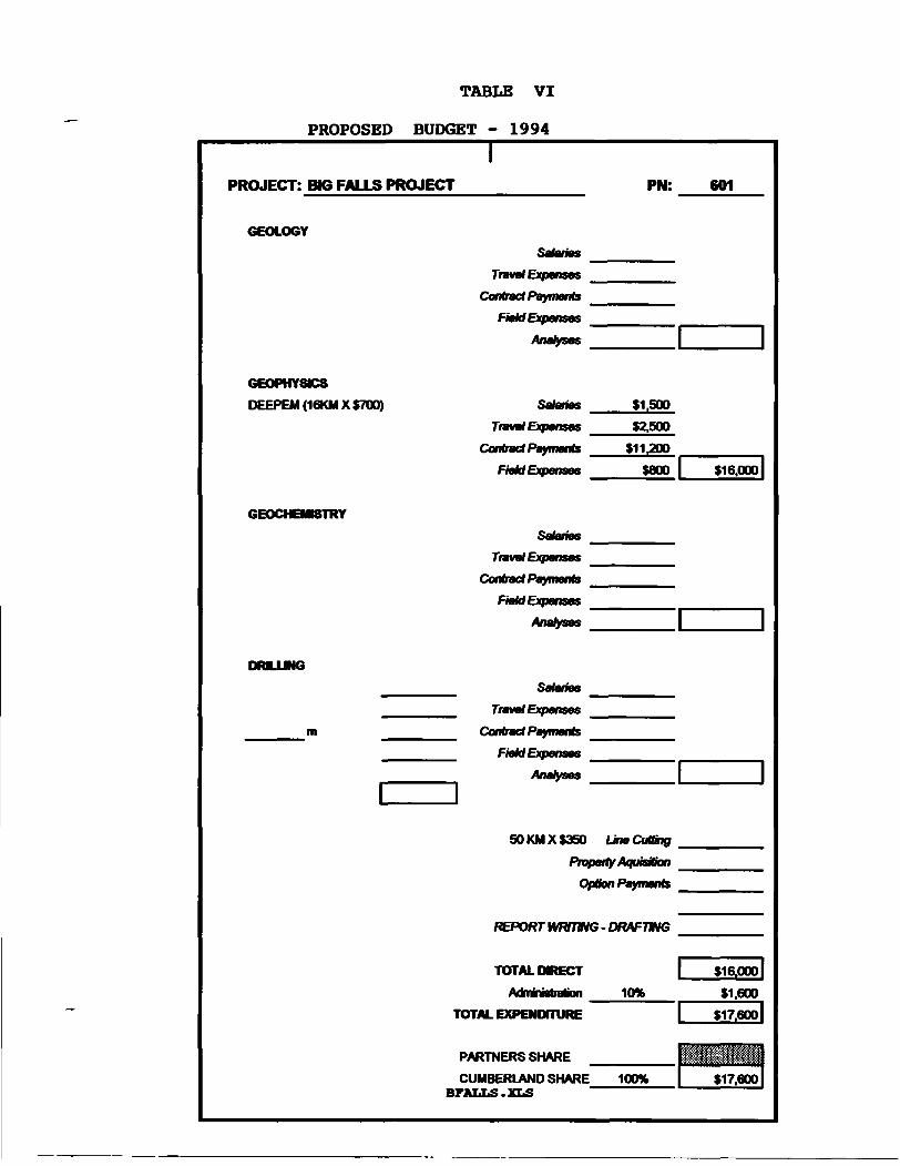
TABLE VI
PROPOSED BUDGET - 1994
PROJECT: BIG FALLS PROJECT PN: 601
GEOLOGY
GEOPHYSICS
DEEPEM (16KM X S700)
6EOCHEMSTRY
DRUJNG
Salaries
Travel Expenses
Contract Payments
Field Expenses
Analyses
Salaries
Travel Expenses
Contract Payments
Field Expenses
Salaries
Travel Expenses
Contract Payments
FieUExpenses
Analyses
Salaries
Travel Expenses
Contract Payments
FieUExpenses
Analyses
S1.50D
S2.500
S11.2DO
seoo l si6.ooo|
50 KM X 9350 Line Cutting
Propotty A/QutsHion
Opfcn Payments
REPORT WFOTING - DRAFTHG
TOTAL HRECT
Adnmistrabon
TOTAL EXPENDITURE
PARTNERS SHARE
CUMBERLAND SHARE BFALLS.XLS
10*
l ?16.000|
*1.600
l S17.eOD|

Page 17
MACDOUQAL, C. (1992)
REFEREHCES
HORAHDA EZPLORATIOH: REPORT OH DIANOHO DRILLING - JOT PROPERTY: ASSESSMENT LIBRARY - RED LAKE

Page 18
APPENDIX l
STATEMENT OF QUALIFICATIONS

STATEMENT OF QUALIFICATIONS
I, M.P. Lewis, hereby certify that:
1. I am a practicing Geologist and sole proprietor of M.P. (Pat) Lewis Geological Services, with an office at 269 Chercover Drive, Thunder Bay, Ontario.
2. I am a graduate of Memorial University of Newfoundland (1976) with a Bachelor of Science Degree - Major in Geology.
3. I have practiced my profession as an Exploration Geologist continuously for the past 17 years.
4. I have an indirect interest in the Properties described in this report.
Signature:M. P.
Date:

Page 19
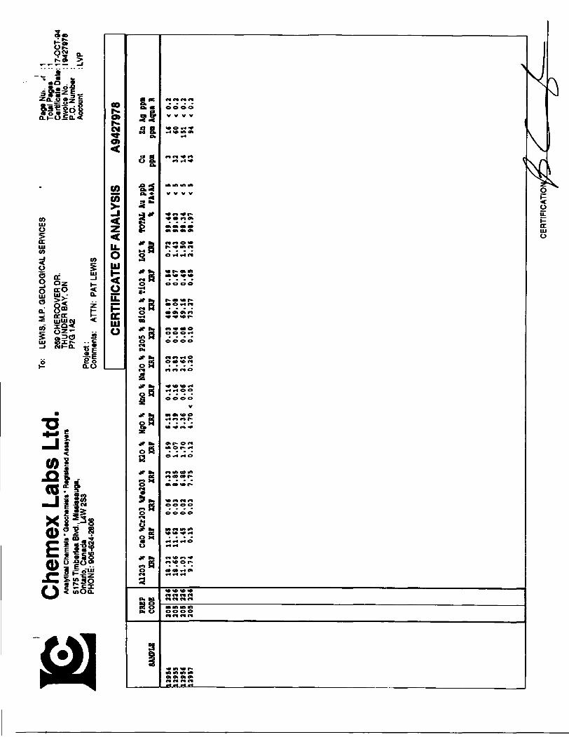
APPENDIX 2
CERTIFICATE OF ANALYSIS

Che
mex
Lab
s Lt
d.An
alytic
al Ch
emist
s * Q
eoch
emlst
s * R
egist
ered
Ass
ayer
s51
75Ti
mbe
rlea
Blvd
., M
issisa
auga
, O
ntar
io, C
anad
a L4
W 2
S3
PHO
NE: 9
05-6
24-2
806
To:
LEW
IS, M
.P. G
EOLO
GIC
AL S
ERVI
CES
269
CHER
COVE
R DR
. TH
UNDE
R BA
Y, O
N P7
Q1A
2
Proj
ect:
Com
men
ts:
ATTN
: PAT
LEW
IS
lPa
g* N
uh.w
er
: 1 To
tal P
ages
: 1
Certi
ficat
e Da
te: 2
8-JU
N-94
In
voice
No.
: 1
9418
093
P.O.
Num
ber
: Ac
coun
t : L
VP
SAMP
LE
1290
1 12
902
1290
3 12
904
1290
5
1290
6 12
907
1290
8 12
909
1291
0
1291
1
PR1
CO 205
205
205
205
205
205
205
205
205
205
205SP DE 22
6 22
6 22
6 22
6 22
6
226
226
226
226
226
226
CERT
IFIC
ATE
OF A
NALY
SIS
A941
8093
A120
3 Ca
O Ct
203
Pe20
3 K2
0 Mg
O Mn
O Nt
20
P205
Si
02
Ti02
LO
I TO
TAL
Ba
Kb
St
Mb
Zr
Y \
\ \
\ \
\ \
\ \
\ \
\ \
ppi
ppi
ppm
ppn
ppm
ppa
11.2
6 2.
49 <
0.0
1 6.
31
0.46
2.
96
0.14
3.
56
0.14
66
.10
0.69
0.
99
99.1
1 IC
O 5
100
40
550
90
14.4
3 9.
44 <
0.0
1 13
.96
0.38
5.
38
0.18
2.
81
0.12
49
.00
1.44
0.
58
97.7
3 11
0 <
5 23
0 10
13
0 40
14
.71
9.59
< 0
.01
13.0
8 0.
50
.16
0.18
2.
97
0.14
48
.40
1.27
0.
88
97.8
9 12
0 S
260
< 10
11
0 30
14
.63
9.89
< 0
.01
13.0
1 0.
35
.20
0.15
2.
81
0.14
49
.30
1.27
0.
68
96.4
4 11
0 <
5 25
0 <
10
100
20
9.59
0.
33 <
0.0
1 8.
28
0.60
.6
9 0.
07
0.31
0.
17
72.4
4 0.
65
2.64
99
.78
110
10
< 10
20
40
0 90
10.1
4 O.
S8 <
0.0
1 10
.72
0.32
.7
2 0.
06
0.81
0.
15
70.0
5 0.
66
1.05
99
.47
90
< S
20
30
490
140
14.3
7 7.
78 <
0.0
1 13
.06
0.55
.7
0 0.
18
3.20
0.
13
51.7
1 1.
75
0.52
97
.96
160
< 5
250
10
110
40
10.9
0 0.
18 <
0.0
1 8.
49
1.37
.5
6 0.
04
0.25
0.
14
72.4
1 0.
69
1.05
100
.10
170
20
< 10
20
40
0 11
0 10
.44
0.49
t 0
.01
10.9
4 0.
11
.06
0.08
1.
11
0.09
70
.69
0.86
0.
49
99.3
7 10
<
5 20
30
50
0 16
0 16
.49
10.2
2 <
0.0
1 10
.48
0.41
7.
41
0.16
2.
92
0.07
48
.40
0.81
1.
14
98.5
2 60
<
S 2
50
< 10
20
10
13.6
6 9.
81 <
0.0
1 12
.50
0.30
6.
19
0.16
2.
62
0.16
51
.13
1.10
0.
63
98.2
7 30
<
5 16
0 <
10
130
30
CERT
IFIC
ATIO
N:^

Che
mex
Lab
s Lt
d,An
alytic
al Ch
emist
s' Qe
oche
mlsl*
* Re
gister
ed A
ssay
ers
5175
Tim
berle
a Bl
vd.,
Miss
issau
ga,
Ont
ario
, Can
ada
L4W
2S3
PH
ONE
: 905
-624
-280
6
o:
LEW
IS, M
.P. G
EOLO
GIC
AL S
ERVI
CES
269
CHER
COVE
R OR
. TH
UNDE
R BA
Y, O
N P7
G1A
2Pr
ojec
t:Co
mm
ents
: AT
TN: P
AT L
EWIS
Page
i oe
r :1
Tota
l Pag
es
: 1 Ce
rtific
ate
Date
: 03-
JUL-
94
Invo
ice N
o.
: 194
1861
2 P.
O. N
umbe
r :
Acco
unt
: LVP
CERT
IFIC
ATE
OF A
NALY
SIS
A941
851 2
SAMP
LE
1291
112
912
1291
312
914
1291
5
1291
612
917
1291
8
PREP
CODE
205
205
205
205
205
205
205
205
226
226
226
226
226
226
226
226
A120
3 Ca
O Cr
203
Pe20
3 K2
0 Mg
O Mn
O Na
20
P205
Si
02
T102
LO
I TO
TAL
B*
Rb
Sr
Nb
Zr
YX
X X
X X
X X
X X
X X
X X
ppm
ppm
ppn
ppn
ppn
ppa
11.4
1 0.
34
0.02
9.
90
0.67
4.
06
0.08
0.
59
0.21
70
.40
0.70
1.
44
99.8
3 17
0 5
10
20
460
130
12.6
3 0.
27 <
0.0
1 12
.31
0.95
5.
49
0.07
0.
55
0.17
64
.28
0.77
1.
43
98.9
3 30
0 S
10
30
500
180
13.9
5 9.
56 <
0.0
1 13
.48
0.39
5.
84
0.19
3.
18
0.31
48
.98
1.72
0.
65
98.2
6 13
0 <
5 29
0 <
10
140
3022
.67
1.73
0.
02
4.48
4.
74
2.23
0.
07
2.98
0.
23
59.0
0 0.
63
2.34
101
.10
1170
12
0 35
0 <
10
ISO
1015
.93
8.94
< 0
.01
11.6
3 0.
54
5.69
0.
17
3.62
0.
2S
50.2
9 1.
42
0.63
99
.12
140
< 5
310
* 10
10
0 30
10.1
6 0.
66
0.01
13
.77
0.72
3.
94
0.07
1.
38
0.18
67
.59
0.78
0.
19
99.4
5 19
0 <
S 20
20
48
0 11
010
.64
0.64
0.
04
3.38
0.
07
7.17
0.
01
1.37
0.
14
72.1
0 0.
83
3.65
100
.05
20
< 5
30
30
460
130
10.8
0 0.
88
0.03
8.
84
0.34
5.
00
0.05
1.
49
0.15
70
.00
0.69
1.
71
99.8
7 60
<
5 40
30
44
0 15
0
CERT
IFIC
ATIO
N:
Che
mex
Lab
s Lt
d,An
alytic
*! Ch
emM
t * Q
*och
*mliu
" H*g
l*t*r*
d As
wyer
*51
75 T
imbe
rtea
Blvd
.. M
lMlsu
uga.
On
tario
, Can
ada
L4W
2S3
PH
ONE:
905
-624
-280
6
To:
LEW
IS, M
.P. Q
EOLO
QIC
AL S
ERVI
CES
269
CHER
COVE
R OR
. TH
UNDE
R BA
Y, O
N P7
Q1A
2
Proj
ect:
Com
men
ts:
ATTN
: PA
T LE
WIS
Page
Nui.
,r :1
Tota
l Pag
es
: 1 Ce
rtific
ate
Date:
17-
OCT-
94
Invo
ice N
o. : 1
9427
976
P.O.
Num
ber
: Ac
coun
t : L
VP
CERT
IFIC
ATE
OF A
NALY
SIS
A942
7978
SAMP
LE
1295
4L2
955
1295
612
957
PREP
CO
DE
205
205
205
205
226
226
226
226
A120
3 \
CaO
\Cr2
03 W
e203
\
K20 \
MgO
\ Mn
O \
Na20
\ P
205 \
8102
\ T
i02
\ LO
I X
TOTA
L Au
ppb
Cu
Zn
Ag
ppn
XRF
XRF
XRF
XRF
XRF
XRF
XRF
XRF
XRF
XRF
XRF
XRF
* FA
+AA
ppa
ppn
Aqua
R
18.3
2 11
.65
0.06
9.
33
0.59
(.
15
0.14
3.
02
0.03
48
.87
0.56
0.
72
99.4
4 <
5 3
16
< 0.
218
.6*
11.6
2 0.
03
8.85
1.
07
4.39
0.
16
3.83
0.
04
49.0
8 0.
67
1.43
99
.83
< S
32
60
< 0.
211
.03
1.45
0.
02
6.88
1.
70
3.3C
0.
06
2.61
0.
08
(9.1
6 0.
49
1.50
98
.34
< 5
14
151
< 0.
29.
74
0.15
0.
03
7.75
0.
12
4.70
< 0
.01
0.20
0.
10
73.2
7 0.
65
2.26
98
.97
< 5
43
94
< 0.
2
CER
TIFI
CAT
IO
Che
mex
Lab
s Lt
d.An
alytic
al Ch
emte
tt* Q
wxhw
nMt "
R*g
M*ra
d As
tayv
ra51
75 T
imbw
tea
Blvd
., M
iatiu
auga
, O
ntar
io, C
anad
a L4
W2S
3 PH
ONE
: 005
-624
-280
6
To:
LEW
IS, M
.P. Q
EOLO
QIC
AL
SER
VIC
ES
269
CH
ERC
OVE
R O
R.
THU
ND
ER B
AY, O
N
P7Q
1A2
Pro
jtct:
Com
man
ta:
BIG
FAL
LS
ATTN
: PA
T LE
WIS
Paga
Nw.n
iwr
:1 To
filP
aoM
:1
Certi
ficat
e Da
te: 2
5OC
T-94
In
volo
tNo.
: 1
0428
511
P.O.
Num
ber
: Ac
coun
t :L
VP
SAMP
LE
1295
812
959
129(
012
9*1
129(
2
129C
312
9(4
129(
512
9((
129(
7
129(
812
9(9
1297
012
971
PR CO 20S
20!
205
20!
205
205
20!
205
20!
205
205
20!
20!
205EP DE 22
622
122
C22
422
6
22C
221
22(
224
226
226
224
224
226
A120
3 \
CaO
XCx2
03 *
F*20
3 \
K20
\ Ng
O *
MnO
* Na
2XR
F XR
F XR
F XR
F XR
F XR
F XR
F
14.4
9 10
.28
O.OS
9.
18
0.40
.3
5 0.
13
313
.84
9.89
0.
01
13.7
0 0.
41
.(4
0.19
3
10.3
4 2.
18
0.03
9.
81
0.88
.9
4 0.
05
29.
15
0.97
0.
02
11.8
1 2.
28
.51
0.13
1
14.5
4 12
.54
0.02
11
.41
0.41
.5
8 O
.K
2
14.8
3 7.
78
0.01
12
.06
0.84
.5
9 0.
15
314
.43
10.7
8 0.
03
12.1
4 0.
53
.55
0.17
3
14.3
5 9.
29
0.02
11
.94
0.58
.(
1 0.
14
315
.78
8.77
0.
01
12.5
3 0.
50
.22
O.K
4
13.4
5 10
.82
0.01
13
.68
0.46
.(
0 O
.K
2
10.3
* 0.
70
0.01
12
.85
1.80
.4
5 O
.K
112
.01
10.9
7 0.
12
10.6
0 0.
40
.96
O.K
2
15.1
9 5.
45
0.05
7.
05
0.18
.2
5 0.
10
311
.92
0.26
0.
01
1.47
8.
04
0.57
0.
02
0
CERT
IFIC
ATE
OF A
NALY
SIS
A942
851 1
0 \
P205
* 8
102
It T1
02 \
LO
I *
TOTA
L An
ppb
Cu
Zn
Ag
ppi
XRF
XRF
XRF
XRF
XRF
\ FA
+AA
ppi
ppi
Aqoa
R
.50
0.12
53
.39
0.81
0.
90
99.6
1 10
33
20
*
0..0
1 0.
19
50.2
3 1.
36
0.96
99
.43
< 18
56
<
0..0
9 O
.K
(8.9
* 0.
92
0.66
99
.04
< 40
71
x
0..6
0 0.
04
(6.8
8 0.
50
1.4*
99
.35
< <
1 30
0 *
0..3
3 0.
11
51.5
2 1.
13
0.97
100
.72
< 95
33
<
0.
.73
0.12
51
.76
1.41
0.
66
98.9
6 <
26
71
* 0.
.05
0.15
49
.77
1.19
0.
70
99.4
9 <
80
31
< 0.
.84
0.15
50
.65
1.20
0.
89
96.8
6 <
32
45
4 0.
.02
0.15
51
.45
1.43
0.
56
99.5
6 <
49
66
* 0.
.26
0.14
52
.32
1.52
0.
75
99.1
7 <
18
79
< 0.
.20
0.08
68
.06
0.78
0.
16
99.6
3 <
< 1
132
< 0.
.81
0.11
50
.36
0.96
1.
16
98.6
2 <
9 31
*
0..3
9 0.
14
5C.3
3 0.
61
4.52
99
.29
* 43
88
<
0.2
.31
0.03
73
.42
0.29
1.
62
97.9
6 <
< 1
43
* 0.
2
CER
TIFI
CA
TIO
N:
OCT.-25'95(0) 13 = 12 MINING/GEOLOGY-KEN
j J^X OCT.-2rttnED) 12:57 HIIIW-IECOUOMU,
*r
TEL:8074682823
TEL:107 727 3553
P. 002
P. 002
Report of Work Conducted After Recording Claim
OnUfta•ir at
i
W* or print aid i to M Mrthg M tnd H^ttUloM Mr r
w or Mi tom mm M
M eWrat ta worn b
52K14NE002a 2.16247 GERRY LAKE llfenBlir~~ "
900
t *- fcc* Ml M*i In Mi MM
LJg^/f \tf MKtCM
\GtT 7/9S
DP

Ministry ofNorthern Developmentand Mine*
Ontario
Report of Work Conducted After Recording Claim
MlfilnQ Act
Tronttction Numbor
IAJ153.0.
i cclsctsd on ttito lonn is obtained under Hw eultiurlty of Ine Mnlnoj Act. Thle infuinielion wil bo ueod for corroopondenco. 4•^u - — a.— — *; —— mhjij- ,tii *-— ^C0^kj^^M4 tsi M*A DMMMMMSA! ftAttM^rf^^v ftCfl^^M* l ^MM^B ft^b^MAM* j^ U*M4f*Aa** n^*^MbMM**A*rfIras OOMCDOn snoun 00 OHOCWQ n vw rroMncw Manager, Mrang Laraa, Naraaoy OT Nonnarn uovwopmoni Sudbury. Ontorto. P3E 6A5. totaphom (705) 670-7264.
4CA ^^Amm Ot*M^4, iav veoar awoi,
Instructions: - Please type or print and submit in duplicate.- Refer to the Mining Act and Regulations for requirements of filing assessment work or consult the Mining
Recorder.-A:- Technical reports and maps must accompany this form in duplicate.- A sketch, showing the claims the work is assigned to, must accompany this form.
mot WJ amt Mminy nn tuiu rKHjuwuun* MN rOTjunaiiiauKi m IIMIIJJ inrouumiioiu nw* m vwiauH um
ecorder. t^, separate copy of this form must be completed for each Work GroupjB e l ft O" X
echnteaJ reports and maps must accompany this form in duplicate. ** ^ 4c
Telephone No.
"* ITnmal
P7S 3P9MWngOwWon
L/HtE.orQPlMiNo.
From: ocwit 3 ,/99V &UTT
lv.
Work Perfonned (Check One Work Group Only)WorkGroup Type
Geotechnical Survey Li/vfeu Try/vfi-PhysMsal Work, Inctudbig OriHing
RECEIV̂Other Authorized OCT 3 1 199 f; '-T 1 1 la*- s^^ v- * l*?*/*^
Assays MINING LANDS
Reserve
Total Assessment Work Claimed on the Attached Statement of Costs3-7
Note: The Minister may reject for assessment work credit all or part of the assessment work submitted H the recorded holder cannot verify expenditures claimed in the statement of costs within 30 days of a request for verification.
Persons and Survey Company Who Perfonned the Work (Give Name and Address of Author of Report)
(attach a schedule If necessary)
Certlflc atlon of Beneficial Interest * See Note No. 1 on reverse sidel oertny that at the ome the work waa performed, the dairna covered in into work report ware recorded In the currant holder's name or held under a l by the current recorded holder. as/frs
Hotter or Agent (SHimttura)
Cei lineation of Work Reportl certify that l ham a personal fcnowtedge of the facts eat forth in this Work report, having performed the work or Ha completion and annexed report to true.
ourinQ wid/or
of Poroon CejwyiriQ P ~76
TetaponsNo.
For Office Us* Only
&CT
ToM Value Or. Recorded Doto Recorded
//*Deemed Appnwel Data
MMng Recorder
Dale Approved
Notice ter AnhdmenC Sem
OCTAM PM

j:. 16*47
fi
irOo
si
'K oc
MINING l
JE' 1•31
ANSJ
^Qi
J 0.-- v. .
5s.
^
|
^ >
LP
1
es.^ Js0
s 1
^N.
0*
sb
5 O
s**iff ffi*
r®otal Value
l •Sf<
^lCredits you are claiming in this report may be cut back. In order to minimize the adverse effects. , which claims you wish to priorize the deletion of credits. Please mark (^) one of the following: -. - l L \̂
^1. D Credits are to be cut back starting with the daim listed last, working backwards.
2. D Credits are to be cut back equally over all daims contained in this report of work.
3. D Credits are to be cut back as priorized on the attached appendix.
In the event that you have not specified your choice of priority, option one wM be implemented.
deletions, please indicate from
Hotel: Examples of beneficial Interest are unrecorded transfers, option agreements, memorandum of agreements, etc.. wHh respect to the mining claims.
Note 2: rf work has been performed on patented or leased land, ptease complete the foOowing:
l certify that the recorded holder had a beneficial interest in the patented or leased land at the time the work was performed.
Dale
ocr

MmistryofNorthern Devetopment
OntarioMMsteredu Dovotoppomont du Nord aides mines
Statement of Costs for Assessment Credit
(ztat des coOts aux fins du credit devaluation
Mining Act/Lol sur les mines
Transaction NoJN* de transaction
Personal information coltocted on this twtn is obtained under the authority of the Mining Act. This information wMI be used lo maintain a record and ongoing status of the mining daim(s). Questions about this collection should be directed to the Provincial Manager. Minings Lands. Ministry of Northern Development and Mines. 4th ROOT. 159 Cedar Street. Sudbury. Ontario P3E 6A5. totophono (70S) 670-7264.
624?s dans to presente formutoLes renseignements personnels contenus dans to presente fonnuto sort
recueims en vertu de b Loi sur tos mines et serviront a tenir a jour un registre des concessions minieres. Adresser toute quesiton sur to cottoce de ces renseignements au chef provincial des terrains miniars. ministere du Devetoppemert du Nord et des Mines. 159. rue Cedar. 4* etaga. Sudbury (Ontario) P3E 6A5. telephone (705) 670-7264.
1. Direct Costs/CoOts directs
Type
Wagaa
Contractor's and Consultant's
Drafts do1 OflvVpfVfMMII'etderexpert-
Supples Used
Location de
Doscnption
Labour Main-d'oeuvre
Field Supervision Supervision sur te terrain
Type
Lflflf,Type
misc.
TUP*
Amount Montant
1 66?
Totals Total global
df l fs t'
tf3'S7^3/330
Total Direct Costs Total des coats direct*
2. Indirect Costs/CoOts indirects* * Note: When claiming Rehabilitation work Infract costs are not
allowable as assessment work. Pour to rembouraement des travaux de rehabilitation, tos coOts indirects ne son! pas admissMes en tant qua travaux d'evaluation.
Type
Transportation Transport
RECE&OCT3
Description
-h
Amount Totato Total global
Alo
Sub Total of Indirect Costs Total partial des coOts indirects '
sbto (not greater than 20* of Direct Coats)t (n'sxcodsnt pas 20 9ft des cuflta dJrecta)
Total Vi(Total of Direct and
Note: The recorded holder win be required lo verify expenditures claimed in this statement of costs within 30 days of a request for verification. If verification is not made, the Minister may reject for assessment work
' aH or part of the assessment work submitted.
Note:LeMula egjstrei Denude venter les daple present etat des coots dans tes 30 jours suivant une demande a cet eftet. Si la verification n'est pas effectuee. le ministre peut rejeter tout ou une partie des travaux d'evaluation present**.
Hang Discounts
1. Wort filed wiminWwo years of completJon is daimed at 1(XWb of the above Total Value of Assessment Credit.
Rsfnlsss pour dJspot
1. Les travaux deposes dans tos deux arts suivant tour achevement sort rembouTsesalOOttdetovaleurlotatesusntertiora^
2. Work filed three, four or five years after completion is claimed at 50* of the above Total Value of Assessment Credit. See calculations below:
Tow Value of Assessment Credit
X 0.50
Certification Verifying Statement of Costs
l hereby certify:that the amounts shown are as accurate as possible and these costs were incurred white conducting assessment work on the lands shown on the accompanying Report of Work form.
that asrded Hoktor. Agent. Position in Company)
to make this certification
2. Les travaux deposes trois. quatreoucinqansapres tour achevement sort rembourses a 50 y deja jtajnuf inlala du rrflfBl d'evaluationaim.a*jmi.jm^A l/jtl.fc^j H^^bJL^M 4W9^MjMA*^*L^^ 3 nsusmennonne. votrnes ua"j|{iajQjge3laa,yay. ̂ ^
P- ̂ ' '^ 4 - ' E'ratMRon Male demand*!Vatour totato du credit i
AMAttestation de v
J'atteste par la presente :que tes montants indiques sort te plus exact possible et que ces depenses ont ete engagees pour effectuer tes travaux d'evaluation sur tes terrains indiques dans la formute de rapport de travail ct-joint.
l am authorized Et qu'a litre deropfAMntovii. posto occup*) (tans te
a faire cette attestation.
je suis autorise
Signature
Nota : Dans cette formuto. kxsqu'il designe des personnes. to masculfh est au sens neutre.

DENNIS SMITH T2T 3393 p.etMMetryofNorthern Developmentand Mines
mtario
Report of Work Conducted After Recording Claim
Mining Act
TfeWMCtsOA
poo
waonalirilOrmatmcoaMted on thto tom) ia obtained under to* ooUectton should be directed lo the Provincial Manager. Mining Land.. MMtouy oi Northern Development md Mine*. Fourth Floor. ISO Cedar Straatjdbury, Ontario. P3E GAS. telephone (TOO) S70-78S4. jy
2e) l fi 9 4wtructJons: - Please type or print and submit in duplicate. * w *v "X
- Refer to the Mining Act and Regulations for requirements of fiing assessment work or consult the Mining Recorder.
- A separate copy of this form must be completed for each Work Group.- Technical reports and maps must accompany this form in duplicate.- A sketch, showing the claims the work is assigned to, must accompany this form.
VMmef SP LMdL . O/vT.TownohifiMrea '
ffeu
Client No./gy^/reiephone MoT
~D3ST weft±6*6-
U or o Plan No.
From: To: '3,/ffV
Voffc Performed (Check One Work Group Only)WorkGroup Typo
Geotechnical Survey **- -*- -. lifnji,rnyeicei wonc. IndurMne OrMng
ReheMtaiion
Other Authorized Work
Assay* UCT 31 1995
Assignment from Reserve MINING LANDS
? *7/Total Assessment Work Claimed on the Attached Statement ofNote: The Minister may reject for assessment work credit aH or part of the assessment work submitted if the recorded
holder cannot verify expendftures claimed in the statement of costs within 30 days of a request for verification.
Persona and Survey Company Who Performed the Work (Give Name and Address of Author of Report)Name Address
Y#r m. E. MM ,
P7G-
/JT-
(anaoli a schedule H necessary)
Certification of Beneficial Interest * See Note No. 1 on reverse eMol certify thai at the time the work wet performed, the daunt cowered m Wa work fepOrtwerereooidadin^ourrenlhotoVsnameorhekluno^abenelKMlnttraet byMcunwineoordedhaWer_____ _______________ l
Certification of Wortc Reportl certify that l have a poraonal knowledge of the facts cot forth kt this Work report, having performed the work or Ma completion end annexed report ia true.
or PeieiNi CoiWykiu
269
9/9Sfor Office Use Only ^^
TotelVaVieCr. Recorded IBete Recorded"RPCPJVFQ itweivgsW^ *- -. F-r:RED LH \E ivll^i^G O!V.
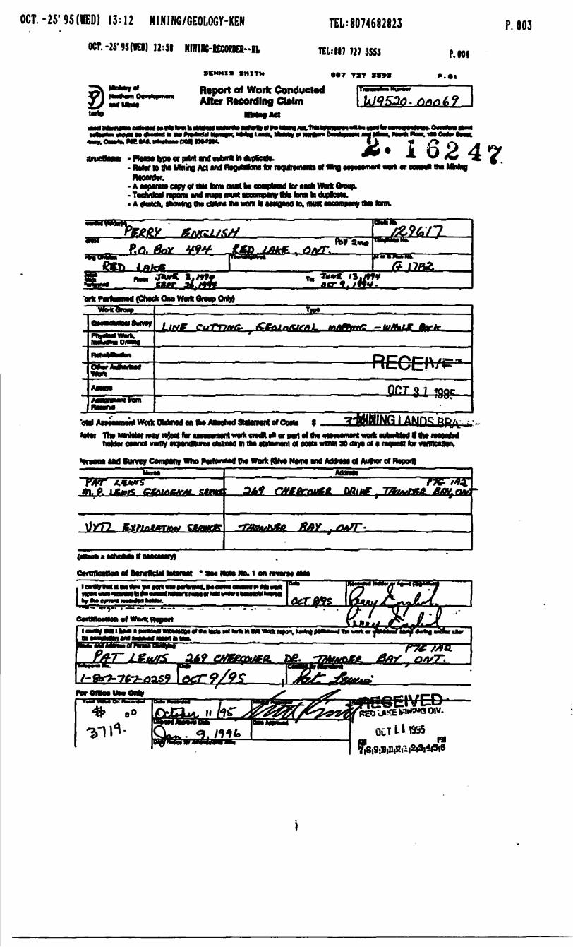
OCT. -25' 95(VED) 13:12 MINING7GEOLOGY-KEN
OCT.-25-93(10) 12:51 HIKIKC-lECOOEI-iL
OCMMI* 9HITH
TEL: 8074682823
TEL.-II7 727 3SS3
T TST 9*99
P. 003
p. M,
Report of Work Conducted After RMOrdlng Ctolm
into
-Ptono lypo or prtni Md- Rktor to die MninB Ad Md ffcojMtons far nojriranMnn of m* i loreoMoiMMMng 7- A Mparato copy of tMt tom* mull b*
VB^kAlM^ MWMA^kB -~ "* MM^M MH^A AM- T cnnioii rapora m nupt mm Mt- A fltattti, fhmlno 8* cWiw BM wM li
far took Vtofc froup.^^ ̂ A^JL^^Mwn n (NimMiilo^ IMM Hoontppny Mi MIIL
oric nrfHBWd (Ctitck Oiw Woift Oioiip OnM
LlP/t CuTTXMS- m/lftVm? — tuft*Lt
l AMHQTttoMntabi tahtorcvir l In KM
i*OTp*j1 al VMof COM vrfMi 30 i"y* of c
Kit*
Md Survey Company *"o PvrfoniMd VM Wtorit (ttvt NMO Md AdMw of AufnroTRmon)
QffflndPolt Of DOfWnCWl BlwMVOt SM llQVB NO* l

l
2. 1 6 2 h r.•^\
^k
^Q&
"1(M Ul
\
-
ill!
fili
iH
l
fiUo\J
M00
- REGOCT
i^lNINIG L/
E(\SI
NOS
.err
99F
dh,: .' ; -
4
OfcCAI en
^
fbabOD
Si
S**
*
tiff
o3
00
19
Credits you are claiming in this report may be cut back. In order to minimize the adverse effects fTfttiftiflalsJipnni rf iyta radrntir which claims you wish to priorize the deletion of credits. Please mark (f) one of the following:^ !U- ^ i i^j j 11
__ P * JT*;-" *ae^ ^"^- J ** fce^^
1. D Credits are to be cut back starting with the claim Ksted last, working backwards. i-'fO LA^E wil^'O Oiv/.2. D Credits are to be cut back equally over all claims contained in this report of work. -li- -
UC l * * '^^^ AM P.M
3. D Credits are to be cut back as priorized on the attached appendix
In the event that you have not specified your choice of priority, option one will be '"iplemente^r,8j9jK)j!!tI2ilj'?'3j'lj5|5
Hotel: Examples of beneficial Interest are unrecorded transfers, option agreements, memorandum of agreements, etc.. with respect to the mining claims.
Note 2: H work has been performed on patented or leased land, please complete the following:
l certify that the recorded holder had a beneficial interest in the patented or teaaod land at the time the work was performed.
Date

OntarioMinistry ofNorthern Developmentand Mines
Ministers duDeveloppement du Nord et des Mines
Geoscience Approvals Office 933 Ramsey Lake Road 6th Floor Sudbury, Ontario P3E 6B5
Telephone: (705) 670-5853 Fax: (705) 670-5863
January 08, 1996Our File: 2.16247 Transaction /: W9520.00068
.00069Mining RecorderMinistry of Northern Development t MinesOntario Government Building227 Howey Street, Box 324Red Lake, OntarioPOV 2MO
Dear Sir:
Subject: APPROVAL OF ASSESSMENT WORK CREDITS OH MIMIMO CLAIMS KRL. 1144373 BT AL IM THE 6ERRT LAKE AREA
Assessment work credits have been approved as outlined on the original submission. The credits have been approved under Section 12, Geology, Mining Act Regulations.
The approval date is January 3, 1996.
Please disregard the Notice of Credit Reduction of December 20, 1995.
If you have any questions regarding this correspondence, please contact Lucille Jerome at (705) 670-5858.
Yours Sincerely, ORIGINAL SIGNED BY:
Ron C. GashinskiSenior Manager, Mining Lands Section Mining and Land Management Branch Mines and Minerals Division
.LJ/J1\Enclosure:
cc: Resident Geologist Red Lake, Ontario
ssessment Files Library Sudbury, Ontario
SOU
TH
OF
OTT
EFLA
KE
G
-1888
FRE
DA
RT
LAK
E
G-1
77
9
Q ?
.

ERLAND RESOURCES LTD. CIOOX)
CUMBERLAND -- ENGLISH DPTIDN
GENERAL JV
ROCK LITHOLOGIES
DIORITE: INTRUSIVE?GRANITE - ' '
SOUTH-HAFIG
JOY ASH FLO W* TUFF
-SPRUCE:.- ^ ' .iViv-* -:-' : V ** -*""'A--.V^-^v-V^:- ",*''Vt V*: '"--J 'NEW ZDlstE
300,000 TONS H 4X CDWBINED
-* ' ^ ."~- * 'S- "i,.^^,v^^?V POVER LINE t&H FtlJV. Wf ^ .. .
NORTH MAFIC FLOW < NOT QBSCRVtPv ^ ^ i-^* e ^
STRINGR CPY.i^!^^^r, -\*
•v -- -•,. -. -•u*:^:?'** j-r-v *-.r-r- .^"- '. r J ,.-, . * ^ , ' * -^TW **r fc , " ,* *' ^. r^ *4. * *-^ ^^ ' ' ~-
CU 1.0k ZN/ i
ZN/0.60M
^^;?" ^*-^.ft, -at** 4 -^ -- -?s- ^. -' - w * ~ S-^B .-,..e;*^f*.-"- * .-, ,^i--^S
g^^'^^^l•' V^ -" "•.i--'- *.-J?^"- 7** , . 1"* ^- "-V-- ^-, j , **^^ ,-~* ^elt *^l
j^ ^K~ t~ * .v - J.* a ^;- . -^ .-J^A _ n
SYMBOLSGeology
^"•^-:
^te^Sa?f^i Geological Contact
Lineament -
Property Boundary
Fault , ,
Outcrops '"
SUpNd* BoUders
Br*t: Hot*
11449:73
i^38?ss^s^^
52K14NE002B 2.16247 GERRY LAKE52K14NEQ01Q 2.16247 GERRY LAKE

1144365 CUMBERLAND RESOURCES LTD, (100X)
12^0+00 N'
mo*
l TpO+OQ N
\' ' v\
1144334 ENGLISH DPTIDNCUMBERLAND 1144362
NDRANDA-MAJER GENERAL JV
LEGENDROCK LJTHOLOGIES
AIN 'JCfY' CDNTOUCTpnpL^
DIORITE INTRUSIVE? C POSSIBLE FLOW
GRANITE ' * . '
SOUTH MAFIC FLOW
JDY ASH FLOW TUFF -
POWER LINE ASH FLOW TUFF
NOfcTH,MAFIC FLOW
NEW ZONE300,000 TONS4X CDMBINEDBu-Zn
' \t POPLAR' l\ r SPRUCE: t
JDY ZDNE4.0 7. C LL 0.17X Zn X 3,5m
MINERALOGY
, 4.4XZNXl.lnSTRINGER CPY,r^- a fc
cu i.ote
pyrite
pyrrhotrte
aaleno
ondotusite
biotite
garnet
corecerrte
anthophyllite
chlorite
STRINGER CP SPH, p.
,aX ZN/O.GOnOCT311995
MINING LANDS BRANCH~~ ^
Structural
SYMBOLS
Geotoo*cal ContactLineanerrt
Property Boundary
FaultOutcrops
Sulphide Boulders
Dtonond ft-ttl Hole
BeddJriQ
Lineatkw
Lloeatiotv
1144373 Alteration Zone
HLDt Conductor
'S' Tot*
Fold, treqri i ptwo^e of hinge line'
**p . *
R p^o n i- 4 rs* o r*" "o i "-"^ IF* t^ b ̂ OtiRGES,.: ti^B*
FALKS PR0J
52K14NE0028 2 16247 GERRY LAKE
H44365 CUMBERLAND RESOURCES LTD (100X)
1144334 ENGLISH EIPTIQNCUMBERLAND 1144362
•NQRANDArKAJ R GENERAL JV
LEGENDROCK LITHOLOGIES
DIORITE: INTRUSIVE? t POSSIBLE f?et3tf * * *:GRANITE
ORDOC
SOUTH MAFIC FLQV
POWER LINE ASH FLOW TUFF
NORTH HAFie
.^..- y -. :JOY ZD0,177. Zn X 3,Sn 6XZN/0
col colctte
act actmottte
anthophy44ite
cWorrt*
0.50 l -
MINING LANDS BRANCHSYMBOLS
~ Geoiogy
Property Boundary
FoUt
Outcrops-
Sulphide loulders
Dtonond DrfU Hole
Mtcro-bor•^
HLEM Conductor
114437344348
BIG
if V\ fr*.;' r ;-;v:"'"- -.u*-'""" ~t ?*f..^•"S"i* :-"i,.* -"-"-' *-' ' si** * N - "^"'j^'^-i ' L ^- - -"^ * **V? 4 * * ^ ". -"'.i *T " fc * -
J*^*-^ , p * t- * T ^" "J^i*" .'"w
52K14NE0028 2 16247 GERRY LAKE52K14NE0010 2 16247 GERRY LAKE
s^-^V,iV *ztf~Y*:-? ; lVvi 'V!^i' ̂ ^'^'".
a*

H44365 r IMBERLAND RESDL S LTD, (1007.)
0 i 10+00*
ENGLISH DPTIDNCUMBERLAND 1144362
NDRANDA-N AJDR GENERAL
- MAIN "
JQV ZONEX Cu, 0.17X Zn X 3,5m
13XCU 31.6XZN/0* . *- ^ -^ *"^—.**-4 w 4---^ - *- -* -•'SM.-Vii'
\_x' k-ySTRINGR CPY, *y. PQ, *H
CU, l.OiX ZN/ Ii5n
RECEIVED200 -7.2X ZNX0.60n
SYMBOLSGeology
f oliotioft Vertical
Fottetwa IrtetowdProp*r-ky Boundary m
Tautt
Outcrops
Sulphide Boulders
Btanond Drill Hote
'S' rdtjt
Fot* ,*r*n* t pKinge o*LAKE ZDY
UMBERLAND BIG FALLS
52K14NE0028 2 16247 GERRY LAKE
jo^'^b^s; ̂ ^ * *

BORLAND RESOURCES
1144334 J p TIjNCMMEE 1144362
GENERA!NDRANDA-MA
LEGENDROCK LITHOLOGIES
- RENDDIORITE INTRUSIVE? ( POSSIBLE FLDV )
GRANITEV
SOUTH MAFIC FLOW
JOY ASH FLOW TUFF
POWER LINE ASH FLQV TUFF
NORTH MAFIC FLOW
NEW ZONE 300,000 TONS
'/. C OMBINED CL
JOY 2DM 4,0 y. C u 0,177. Zn 13XCU 31.6XZN/
0.21X/CU 4 ,4XZNXl.ln siliceous
calcite
actioolite
cordierite
anthophyllite
chlorite
chalcopyrite
sphalerite
pyrite
pyrrhotite
galena
gahnite
calcsiticates
STRINGER CPY, . SPH 7
andal andalusite
bio btot.te
garnet
cRop diopside
x cu i.oix ZN/
7.2X ZN70.60nOCT 311995
TL5+00 S
SYMBOLSGeology
11443731144*8
UHBERLAND RESOURCE^ BIG FALLS PROJECT :.:
GEOLOGY.DRAVt*Revistons*
52K14NEO010 2 16247 GERRY LAKE