CULTURAL RESOURCES SURVEY OF THE PENNYROYAL …
38
CULTURAL RESOURCES SURVEY OF THE PENNYROYAL 115kV SUBSTATION, GEORGETOWN COUNTY, SOUTH CAROLINA CHICORA RESEARCH CONTRIBUTION 462
Transcript of CULTURAL RESOURCES SURVEY OF THE PENNYROYAL …

CULTURAL RESOURCES SURVEY OF THE PENNYROYAL 115kV SUBSTATION,
GEORGETOWN COUNTY, SOUTH CAROLINA
CHICORA RESEARCH CONTRIBUTION 462

CULTURAL RESOURCES SURVEY OF THE PENNYROYAL 115kV SUBSTATION,
GEORGETOWN COUNTY, SOUTH CAROLINA
Prepared By: Michael Trinkley, Ph.D., RPA
and Nicole Southerland
Prepared For: Mr. Tommy L. Jackson
Central Electric Power Cooperative P.O. Box 1455
Columbia, SC 29202
CHICORA RESEARCH CONTRIBUTION 462
Chicora Foundation, Inc.
PO Box 8664 Columbia, SC 29202-8664 803/787-6910 www.chicora.org
December 22, 2006
This report is printed on permanent paper ∞

©2006 by Chicora Foundation, Inc. All rights reserved. No part of this publication may be reproduced, stored in a retrieval system, transmitted, or transcribed in any form or by any means, electronic, mechanical, photocopying, recording, or otherwise without prior permission of Chicora Foundation, Inc. except for brief quotations used in reviews. Full credit must be given to the authors, publisher, and project sponsor.

ABSTRACT
This study reports on an intensive cultural resources survey of a 300 feet square lot in Georgetown County, South Carolina. The work was conducted to assist Central Electric Power Cooperative in complying with Section 106 of the National Historic Preservation Act and the regulations codified in 36CFR800.
The lot is to be used by Santee Electric for the construction of a distribution substation. The topography is flat with moderately well-drained soils consuming most of the property.
The proposed project will require the clearing of the lot, followed by construction of the proposed substation. These activities have the potential to affect archaeological and historical sites that may be on the project lot. For this study an area of potential effect (APE) 0.5 mile around the proposed transmission project was assumed.
An investigation of the archaeological site files at the S.C. Institute of Archaeology and Anthropology failed to identify any previously recorded sites in the project APE.
The S.C. Department of Archives and
History GIS was consulted for any previously recorded sites. No sites were found. The comprehensive architectural survey of Georgetown County failed to identify any sites (Joseph et al. 2006).
The archaeological survey of the lot incorporated shovel testing at 100-foot intervals along transects placed at 100-foot intervals. All shovel test fill was screened through ¼-inch mesh with a total of 12 shovel tests excavated in the substation lot.
As a result of these investigations no sites were identified. This is likely the result of the lack
of a distinct ridge top and construction disturbance.
A survey of public roads within a 0.5 mile of the proposed undertaking was conducted in an effort to identify any architectural sites over 50 years old which also retained their integrity. No such sites were found. Two nineteenth to twentieth century cemeteries were noted nearby, but not recorded since the 2006 architectural survey stated that they recorded only sites that appear to be eligible for the National Register (Joseph et al. 2006).
Finally, it is possible that archaeological remains may be encountered in the project area during clearing activities. Crews should be advised to report any discoveries of concentrations of artifacts (such as bottles, ceramics, or projectile points) or brick rubble to the project engineer, who should in turn report the material to the State Historic Preservation Office or to Chicora Foundation (the process of dealing with late discoveries is discussed in 36CFR800.13(b)(3)). No construction should take place in the vicinity of these late discoveries until they have been examined by an archaeologist and, if necessary, have been processed according to 36CFR800.13(b)(3).
i

ii
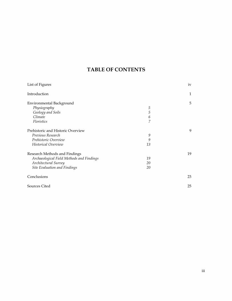
TABLE OF CONTENTS List of Figures iv Introduction 1 Environmental Background 5 Physiography 5 Geology and Soils 5 Climate 6 Floristics 7 Prehistoric and Historic Overview 9 Previous Research 9 Prehistoric Overview 9 Historical Overview 13 Research Methods and Findings 19 Archaeological Field Methods and Findings 19 Architectural Survey 20 Site Evaluation and Findings 20 Conclusions 23 Sources Cited 25
iii

LIST OF FIGURES
Figure 1. Project vicinity in Georgetown County 2 2. Project area 3 3. View of the substation lot in a sparse forest 5 4. View of the ditch on the north boundary of the project area 6 5. Aerial photograph showing the project area with a pond to the south 7 6. Portion of the 1939 Timber map showing the project area 7 7. Generalized cultural sequence for South Carolina 10 8. Portion of Mills’ Atlas showing the project area 14 9. Portion of the 1911 Soil map showing the project area 16 10. Portion of a 1920 Georgetown quadrangle map showing the project area 16 11. Portion of the 1939 General Highway and Transportation Map of Georgetown County 17 12. Substation lot with transects 19 13. Location of the project area and the cemeteries 21 14. View of Beulah Cemetery 22 15. View of Mount Olive Cemetery 22
iv

INTRODUCTION
This investigation was conducted by Dr. Michael Trinkley of Chicora Foundation, Inc. for Mr. Tommy L. Jackson of Central Electric Power Cooperative in Columbia, South Carolina. The work was conducted to assist Central Electric Power Cooperative comply with Section 106 of the National Historic Preservation Act and the regulations codified in 36CFR800.
The project site consists of a lot measuring 300 feet square for use as a substation, situated in Georgetown County, southwest of the city of Georgetown (Figure 1). The substation lot does not appear to connect to an existing transmission line, however a staked corridor, possibly for the construction of a transmission line, was seen running west from the current survey lot.
The lot consists of level land that is forested in a mixed pine and hardwood forest. The lot is bounded by Kiawah Road to the west, a ditch to the north, and a fence to the south.
The lot, as previously mentioned, is intended to be used as a substation for a 115kV distribution station. Landscape alteration, primarily clearing, subsequent erection of the poles and other facilities, erecting lines, and long-term maintenance of the substation will cause damage to the ground surface and any archaeological resources that may be present in the survey area.
Construction, operation, and maintenance
of the substation may also have an impact on historic resources in the project area. Although the project will not remove any structures, substations (as well as other above grade projects) may detract from the visual integrity of historic properties, creating what many consider discordant surroundings. As a result, this architectural survey uses an area of potential effect
(APE) about 0.5 mile in diameter around the proposed facility. Although no historic structures are within view of the facility, a small nineteenth to twentieth century cemetery can be seen from the property.
This study, however, does not consider
any future secondary impact of the project, including increased or expanded development or addition of a transmission line to this portion of Georgetown County.
We were requested by Mr. Tommy L.
Jackson of Central Electric Power Cooperative to perform a cultural resources survey on December 11, 2006. This included examination of the site files at the S.C. Institute of Archaeology and Anthropology. As a result of that work no previously identified sites were found.
Initial background investigations also incorporated a review of the site files at the South Carolina Department of Archives and History. As a result of that work no sites were identified in the 0.5 mile APE. A 2006 comprehensive architectural survey for Georgetown County has been completed and no resources were found in the APE (Joseph et al. 2006). A cartographic survey has also been performed to identify areas with a high probability for archaeological or architectural remains (Hacker and Trinkley 1993).
Archival and historical research was limited to a review of secondary sources available in the Chicora Foundation files.
The archaeological survey was conducted on December 20, 2006 by Ms. Julie Poppel under the direction of Dr. Michael Trinkley.
This report details the investigation of the
1

CULTURAL RESOURCES SURVEY OF THE PENNYROYAL 115kV SUBSTATION
2
Figure 1. Project vicinity in Georgetown County (basemap is USGS South Carolina 1:500,000).

INTRODUCTION
3
Figure 2. Project area (basemap is USGS Georgetown South 7.5’).

CULTURAL RESOURCES SURVEY OF THE PENNYROYAL 115kV SUBSTATION
4
project area undertaken by Chicora Foundation and the results of that investigation.

ENVIRONMENTAL BACKGROUND Physiography The project is situated in Georgetown County. Georgetown County is bounded on the east by the Atlantic Ocean. To the northwest are Horry and Marion counties, while to the south are Berkeley and Charleston counties. Georgetown County is situated in the northern lower coastal plain of South Carolina. The mainland topography consists of subtle undulations in the landscape characteristic of ridge and bay topography of beach ridge plains. Elevations in the county range from sea level to about 75 feet above mean sea level (AMSL) (Mathews et al. 1980:132). The County is drained by five major river systems, four of which (the Waccamaw, Black, Pee Dee, and Santee Rivers) have significant freshwater discharge and only one of which (the Sampit River) is dominated by tidal action. Because of the low topography, however, many broad, low gradient interior drains are present as either extensions of tidal streams and rivers of flooded bays and swales. There are many diverse wetland communities influenced by either the freshwater drainage or tidal flows. Upland vegetation in the County is primarily pine or mixed hardwood and pine. As of 25 years ago, large areas of Georgetown County were forest, with only
6.7% of the acreage being cultivated and 4.2% being urbanized (Mathews et al. 1980:132). The project area is, in this sense, typical – being planted in mixed pines and hardwoods with a low swale area. Geology and Soils The geology is characteristic of the Coastal Plain. The parent materials of the soils are marine or fluvial deposits that consist of varying amounts of sands, silts, and clays. There is one primary geologic formation in the project area, deposited at different periods during alternating transgression and recession of the ocean: the Pamlico Terrace. The Pamlico Terrace includes the land between the recent shore and an abandoned shore line about 25 feet above the present sea level (Cooke 1936:6). The project area is situated in only one soil series, Centenary fine sand (Stuckey 1982). This
5
Figure 3. View of the substation lot in a sparse forest.

CULTURAL RESOURCES SURVEY OF THE PENNYROYAL 115kV SUBSTATION
Climate
moderately well drained soil has an A horizon of grayish brown (10YR5/2) fine sand to a depth of 0.6 foot over a light yellowish brown (10YR6/4) fine sand to a depth of 1.6 feet. The soil survey (Stuckey 1982) shows that some of this area has been used as a borrow pit. Mills (1972 [1826]) comments that the swampland soils are composed of the “richest soil.” He notes for the nearby Marion District that “while the swamp lands reclaimed and secured from freshets, will bring 50 dollars an acre; and the oak and hickory lands 15 dollars an acre; the pine lands will scarcely sell for 1 dollar per acre” (Mills 1972[1826]:623). The flatlands “are, by comparison, sand barrens; yet occasionally presenting some good timber land” (Mills 1972 [1826]: 513). And while the uplands were healthy, with summers free of disease, he observed that, “on the rivers, creeks, and flat lands, this district is subject to bilious fevers, and cannot be called healthy” (Mills 1972[1826]:515). The products cultivated during that time were “cotton, corn, wheat, pease, and potatoes” (Mills 1972[1826]:623).
The general climate of the area is characterized by mild humid conditions. This climate is influenced by the warm Gulf Stream, as well as by the Appalachian Mountains that block the coldest air masses. Other factors include latitude, elevation, distance from the ocean, and location with respect to the average tracts of migratory cyclones. Day to day weather is controlled primarily by the movement of pressure
systems across the nation. However, during the summer months there are few complete exchanges of air masses because tropical maritime air persists for extended periods (Ward 1989).
Figure 4. View of the ditch on the north boundary of the project area.
The average annual precipitation in the area ranges from 49.6 inches and is unevenly distributed through-out the year, with 31.6 inches occurring from April through October, which is the primary growing season (Ward 1989:112). Georgetown County has a winter temperature at 49ºF and a summer temperature at 88ºF. Frozen precipitation occurs only one to three times a year during the winter season. The abundant supply of warm, moist and relatively unstable air produces frequent scattered showers and thunderstorms in the summer. Severe weather usually means violent thunderstorms, tornadoes, and hurricanes. The tropical storm season is in late summer and early fall, although storms may occur as early as May or as late as October (Baldwin 1973). Heavy rains and high winds occur with tropical storms about once every six years. Storms of hurricane intensity are much more infrequent. Notable droughts have occurred twice in modern times – in 1925 and 1954. Typically a serious drought may occur once every
6

ENVIRONMENTAL BACKGROUND
fm( F ptachdasusw ffao
extensive disturbance, including repeated logging operations, and the pine represent an early stage of revegetation. Common on the property are mixed forest, containing both pines and hardwoods. To the east off the tract, land goes down to wetlands of Turkey Creek. To the south, however, Turkey Creek has been contained by a large holding pond (Figure 5). In the early nineteenth century Mills observed that: The pine is the most common tree in the district, though the river swamps abound in the cypress, and along the margins with the various kinds of oak, hickory, poplar,
Figure 5. False color aerial photograph showing the project area witha pond to the south.
ifty years. Less severe dry periods have occurred ore often, normally in late spring or in autumn
Pitts 1974:109).
loristics
There are two major categories of lant communities, based primarily on
opographic location, which exist in or round the project area. The first category onsists of upland vegetation. Supported ere are a mixture of coniferous and eciduous forests dominated by pines nd broadleaf taxa such as upland oaks, weetgum, hickories, and various nderstory species. Incorporated may be mall upland depressions and drainages, hich contain more hydric species.
Portions of the upland area were ound to contain pine forest, typically ound on soils of low fertility, high cidity, and excessive drainage. Most ften, these areas have been subjected to
chestnut, red cedar, beach, sycamore, laurel, ash, cotton-tree, and a variety of others (Mills 1972[1826]:565).
Figure 6. Portion of the1939 Timber map showing the projectarea. Note the church and cemetery to the north(best copy available).
7

CULTURAL RESOURCES SURVEY OF THE PENNYROYAL 115kV SUBSTATION
8
Mills noted that “large canoes . . . are sometimes made from a single [cypress tree]” (Mills 1972[1826]:565). Although missing the portion of the map that shows the project area, the 1939 Timber map for Georgetown County appears to show the project area was covered in Longleaf Pines (Figure 6). The surrounding area has significantly changed in the 33 years as shown on the modern topographic map. As previously mentioned, portions of Turkey Creek have been converted into a pond and to the west land is occupied by numerous industrial facilities.

9
PREHISTORIC AND HISTORIC OVERVIEW Previous Research
In Georgetown County, less than half of the surveys listed in Derting et al. (1991) are compliance reports. None of these compliance reports appear to be near the current survey area. The remaining reports include mostly plantation research, which involves work done closer to the coast.
One survey to the north of the project area
involves the investigation of the Harmony Plantation Tract (Drucker and Zierden 1981) for a housing development. The southern portion of the Ashley River Historic District is two miles north of the current project area. Prehistoric Overview
The Paleoindian period, lasting from 12,000 to 8,000 B.C., is evidenced by basally thinned, side-notched projectile points; fluted, lanceolate projectile points; side scrapers; end scrapers; and drills (Coe 1964; Michie 1977; Williams 1965). The Paleoindian occupation, while widespread, does not appear to have been intensive. Artifacts are most frequently found along major river drainages, which Michie interprets to support the concept of an economy "oriented towards the exploitation of now extinct mega-fauna" (Michie 1977:124).
Unfortunately, little is known about Paleoindian subsistence strategies, settlement systems, or social organization. Generally, archaeologists agree that the Paleoindian groups were at a band level of society (see Service 1966), were nomadic, and were both hunters and foragers. While population density, based on the isolated finds, is thought to have been low, Walthall suggests that toward the end of the period, "there was an increase in population
density and in territoriality and that a number of new resource areas were beginning to be exploited" (Walthall 1980:30).
The Archaic period, which dates from 8000 to 2000 B.C., does not form a sharp break with the Paleoindian period, but is a slow transition characterized by a modern climate and an increase in the diversity of material culture. Associated with this is a reliance on a broad spectrum of small mammals, although the white tailed deer was likely the most commonly exploited mammal. The chronology established by Coe (1964) for the North Carolina Piedmont may be applied with little modification to the South Carolina coastal plain and piedmont. Archaic period assemblages, exemplified by corner-notched and broad-stem projectile points, are fairly common, perhaps because the swamps and drainages offered especially attractive ecotones.
In the Coastal Plain of the South Carolina
there is an increase in the quantity of Early Archaic remains, probably associated with an increase in population and associated increase in the intensity of occupation. While Hardaway and Dalton points are typically found as isolated specimens along riverine environments, remains from the following Palmer phase are not only more common, but are also found in both riverine and interriverine settings. Kirks are likewise common in the coastal plain (Goodyear et al. 1979).
The two primary Middle Archaic phases
found in the coastal plain are the Morrow Mountain and Guilford (the Stanly and Halifax complexes identified by Coe are rarely encountered). Our best information on the Middle Woodland comes from sites investigated west of the Appalachian Mountains, such as the work in

CULTURAL RESOURCES SURVEY OF THE PENNYROYAL 115kV SUBSTATION
10
the Little Tennessee River Valley. The work at Middle Archaic river valley sites, with their evidence of a diverse floral and faunal subsistence base, seems to stand in stark contrast to Caldwell's Middle Archaic "Old Quartz Industry" of Georgia and South Carolina, where axes, choppers, and ground and polished stone tools are very rare.
The Late Archaic is characterized by the appearance of large, square stemmed Savannah
River projectile points (Coe 1964). These people continued the intensive exploitation of the uplands much like earlier Archaic groups. The bulk of our data for this period, however, comes from work in the Uwharrie region of North Carolina.
The Woodland period begins by definition with the introduction of fired clay pottery about 2000 B.C. along the South Carolina coast (the
Figure 7. Generalized cultural sequence for South Carolina.

PREHISTORIC AND HISTORIC OVERVIEW
11
introduction of pottery, and hence the beginning of the Woodland period, occurs much later in the Piedmont of South Carolina). It should be noted that many researchers call the period from about 2500 to 1000 B.C. the Late Archaic because of a perceived continuation of the Archaic lifestyle in spite of the manufacture of pottery. Regardless of terminology, the period from 2500 to 1000 B.C. is well documented on the South Carolina coast and is characterized by Stallings (fiber-tempered) pottery (see Figure 7 for a synopsis of Woodland phases and pottery designations). The subsistence economy during this early period was based primarily on deer hunting and fishing, with supplemental inclusions of small mammals, birds, reptiles, and shellfish.
Like the Stallings settlement pattern, Thom's Creek sites are found in a variety of environmental zones and take on several forms. Thom's Creek sites are found throughout the South Carolina Coastal Zone, Coastal Plain, and up to the Fall Line. The sites are found into the North Carolina Coastal Plain, but do not appear to extend southward into Georgia.
In the Coastal Plain drainage of the
Savannah River there is a change of settlement, and probably subsistence, away from the riverine focus found in the Stallings Phase (Hanson 1982:13; Stoltman 1974:235-236). Thom's Creek sites are more commonly found in the upland areas and lack evidence of intensive shellfish collection. In the Coastal Zone large, irregular shell middens, small, sparse shell middens; and large "shell rings" are found in the Thom's Creek settlement system.
The Deptford phase, which dates from 1100 B.C. to A.D. 600, is best characterized by fine to coarse sandy paste pottery with a check stamped surface treatment. The Deptford settlement pattern involves both coastal and inland sites.
Inland, sites such as 38AK228-W, 38LX5, 38RD60, and 38BM40 indicate the presence of an extensive Deptford occupation on the Fall Line
and the Coastal Plain, although sandy, acidic soils preclude statements on the subsistence base (Anderson 1979; Ryan 1972; Trinkley 1980b). These interior or upland Deptford sites, however, are strongly associated with the swamp terrace edge, and this environment is productive not only in nut masts, but also in large mammals such as deer. Perhaps the best data concerning Deptford "base camps" comes from the Lewis-West site (38AK228-W), where evidence of abundant food remains, storage pit features, elaborate material culture, mortuary behavior, and craft specialization has been reported (Sassaman et al. 1990:96-98).
Throughout much of the Coastal Zone and Coastal Plain north of Charleston, a somewhat different cultural manifestation is observed, related to the "Northern Tradition" (e.g., Caldwell 1958). This recently identified assemblage has been termed Deep Creek and was first identified from northern North Carolina sites (Phelps 1983). The Deep Creek assemblage is characterized by pottery with medium to coarse sand inclusions and surface treatments of cord marking, fabric impressing, simple stamping, and net impressing. Much of this material has been previously designated as the Middle Woodland "Cape Fear" pottery originally typed by South (1976). The Deep Creek wares date from about 1000 B.C. to A.D. 1 in North Carolina, but may date later in South Carolina. The Deep Creek settlement and subsistence systems are poorly known, but appear to be very similar to those identified with the Deptford phase.
The Deep Creek assemblage strongly resembles Deptford both typologically and temporally. It appears this northern tradition of cord and fabric impressions was introduced and gradually accepted by indigenous South Carolina populations. During this time some groups continued making only the older carved paddle-stamped pottery, while others mixed the two styles, and still others (and later all) made exclusively cord and fabric stamped wares.
The Middle Woodland in South Carolina

CULTURAL RESOURCES SURVEY OF THE PENNYROYAL 115kV SUBSTATION
12
is characterized by a pattern of settlement mobility and short-term occupation. On the southern coast it is associated with the Wilmington phase, while on the northern coast it is recognized by the presence of Hanover, McClellanville or Santee, and Mount Pleasant assemblages. The best data concerning Middle Woodland Coastal Zone assemblages comes from Phelps' (1983:32-33) work in North Carolina. Associated items include a small variety of the Roanoke Large Triangular points (Coe 1964:110-111), sandstone abraders, shell pendants, polished stone gorgets, celts, and woven marsh mats. Significantly, both primary inhumations and cremations are found.
On the Coastal Plain of South Carolina, researchers are finding evidence of a Middle Woodland Yadkin assemblage, best known from Coe's work at the Doerschuk site in North Carolina (Coe 1964:25-26). Yadkin pottery is characterized by a crushed quartz temper and cord marked, fabric impressed, and linear check stamped surface treatments. The Yadkin ceramics are associated with medium-sized triangular points, although Oliver (1981) suggests that a continuation of the Piedmont Stemmed Tradition to at least A.D. 300 coexisted with this Triangular Tradition. The Yadkin series in South Carolina was first observed by Ward (1978, 1983) from the White's Creek drainage in Marlboro County, South Carolina. Since then, a large Yadkin village has been identified by DePratter at the Dunlap site (38DA66) in Darlington County, South Carolina (Chester DePratter, personal communication 1985) and Blanton et al. (1986) have excavated a small Yadkin site (38SU83) in Sumter County, South Carolina. Research at 38FL249 on the Roche Carolina tract in northern Florence County revealed an assemblage including Badin, Yadkin, and Wilmington wares (Trinkley et al. 1993:85-102). Anderson et al. (1982:299-302) offer additional typological assessments of the Yadkin wares in South Carolina.
Over the years the suggestion that Cape Fear might be replaced by such types as Deep Creek and Mount Pleasant has raised considerable controversy. Taylor, for example, rejects the use of
the North Carolina types in favor of those developed by Anderson et al. (1982) from their work at Mattassee Lake in Berkeley County (Taylor 1984:80). Cable (1991) is even less generous in his denouncement of ceramic constructs developed nearly a decade ago, also favoring adoption of the Mattassee Lake typology and chronology. This construct, recognizing five phases (Deptford I - III, McClellanville, and Santee I), uses a type variety system.
Regardless of terminology, these Middle Woodland Coastal Plain and Coastal Zone phases continue the Early Woodland Deptford pattern of mobility. While sites are found all along the coast and inland to the Fall Line, shell midden sites evidence sparse shell and artifacts. Gone are the abundant shell tools, worked bone items, and clay balls. Recent investigations at Coastal Zone sites such as 38BU747 and 38BU1214, however, have provided some evidence of worked bone and shell items at Deptford phase middens (see Trinkley 1990).
In many respects the South Carolina Late Woodland may be characterized as a continuation of previous Middle Woodland cultural assemblages. While outside the Carolinas there were major cultural changes, such as the continued development and elaboration of agriculture, the Carolina groups settled into a lifeway not appreciably different from that observed for the previous 500 to 700 years (cf. Sassaman et al. 1990:14-15). This situation would remain unchanged until the development of the South Appalachian Mississippian complex (see Ferguson 1971).
The South Appalachian Mississippian Period (ca. A.D. 1100 to 1640) is the most elaborate level of culture attained by the native inhabitants and is followed by cultural disintegration brought about largely by European disease. The period is characterized by complicated stamped pottery, complex social organization, agriculture, and the construction of temple mounds and ceremonial centers. The earliest phases include the Savannah and Pee Dee (A.D. 1200 to 1550).

PREHISTORIC AND HISTORIC OVERVIEW
13
Historic Overview
The first white settlers were drawn to the Waccamaw Neck area around Winyah Bay by the lure of lure of lucrative Indian trade. The English, Scots, and French acquired land through proprietary and royal land grants, beginning as early as 1705. However, the majority of lands were granted in the 1730s (Rogers 1970:12, 20, 26). Access to water was an important factor in land development. The earliest policy was to grant narrow river frontage in order to give more settlers river access. Among the first grantees was Percival Pawley, who, through a series of land grants, obtained 24,000 acres on the Pee Dee, Sampit, and Waccamaw rivers in 1711 (Rogers 1970:16-21).
Indigo was one of the area’s first major
crops, but had a relatively short life of less than 50 years. Production, which began in the 1740s and reached its peak from 1754-1760, was artificially stimulated by an English bounty and King George’s War (1739-1749), which cut of England’s supplies in the French and Spanish West Indies. The crop grew particularly well along the Pee Dee, Black, and lower Waccamaw rivers. The processing of indigo required settling through a series of vats that drew flies and mosquitoes rendering it a fairly offensive labor (Kovacik and Winberry 1987:75). One 1755 account mentions:
indigo has a very disagreeable smell, while making and curing; and the feces, when taken out of the steeper, if not immediately buried in the ground (for which it is excellent manure), breeds incredible swarms of flies (Carman 1939:281-290).
Indigo required a fairly major initial investment, estimated at slightly over £2,024 (Gray 1933:I:541). A major benefit, however, was that its production could be integrated with rice on the same plantation. James Governor Glen remarked:
I cannot leave this Subject
without observing how conveniently and profitably, as to the Charge of Labor, both Indigo and Rice may be managed by the same Persons; for the labor attending Indigo being over in the Summer Months those who were employed in it may afterwards manufacture Rice in the ensuing Part of the Year, when it becomes most laborious; and after doing all this, they may have some time to spare for sawing Lumber and making Hogshead and other Staves to supply the Sugar Colonies (quoted in Carman 1939:289).
Unfortunately, indigo was “one of those rank weeds like tobacco, which not only exhaust the substance of the earth, but require the very best and richest lands” (Carman 1939:281-290). In 1753, the Winyah Indigo Society in Georgetown County was officially organized and named Thomas Lynch, Sr. their first president. This group established a free school, a library, and functioned as a business and social club for members. By the end of the eighteenth century, planters along the Waccamaw, east of the survey area, as elsewhere, had abandoned indigo due to a market surplus and a devastation of caterpillars (Winberry 1979:92, 98; Lawson 1972:3-4; see also Huneycutt 1949). The early economy in Georgetown also depended on navel stores, and to a lesser extent, on salt processing. In 1733, exports from the port of Georgetown included 7,361 barrels of pitch, 1,092 barrels of tar, and 1,926 barrels of turpentine (Bridwell 1982:12; Rogers 1970:46-47). In the mid-1700s shipbuilding was an important Georgetown industry. Bridwell notes that there is evidence of shipbuilding as early as 1738 and that by the late 1740s an active industry flourished in the Winyah Bay area (Bridwell 1982:14). By the mid-1750s this industry began to decline as other enterprises developed and the supply of shipwrights declined
CULTURAL RESOURCES SURVEY OF THE PENNYROYAL 115kV SUBSTATION
14
(Bridwell 1982:16). Another crop was to have a more enduring and extensive effect on the economic and cultural life of the Waccamaw River in Georgetown County. Tidal rice culture began here in the 1730s and became the lifeblood of the Waccamaw until the slave system upon which it depended was ended by the Civil War. George C. Rogers, in his study, The History of Georgetown County, attributes the rise of rice production in the area to four factors: rice cultivation had already been successfully developed in the province, a stable slave labor supply existed, land titles were stable and allowed for the accumulation of large tracts of property, and there were men who were ready to exploit this potential. Georgetown District was the nation’s major rice-growing area. In 1826, Robert Mills observed that in Georgetown: Everything is fed on rice, horses
and cattle eat the straw and hogs, fowls, etc. are sustained by the refuse, and man subsists upon the marrow of the grain . . . . The most valuable lands in the district are those called the tide lands . . . . The yield of these lands is immense . . . they average three barrels or 2000 pounds to the acre (Mills 1972 [1826]:558).
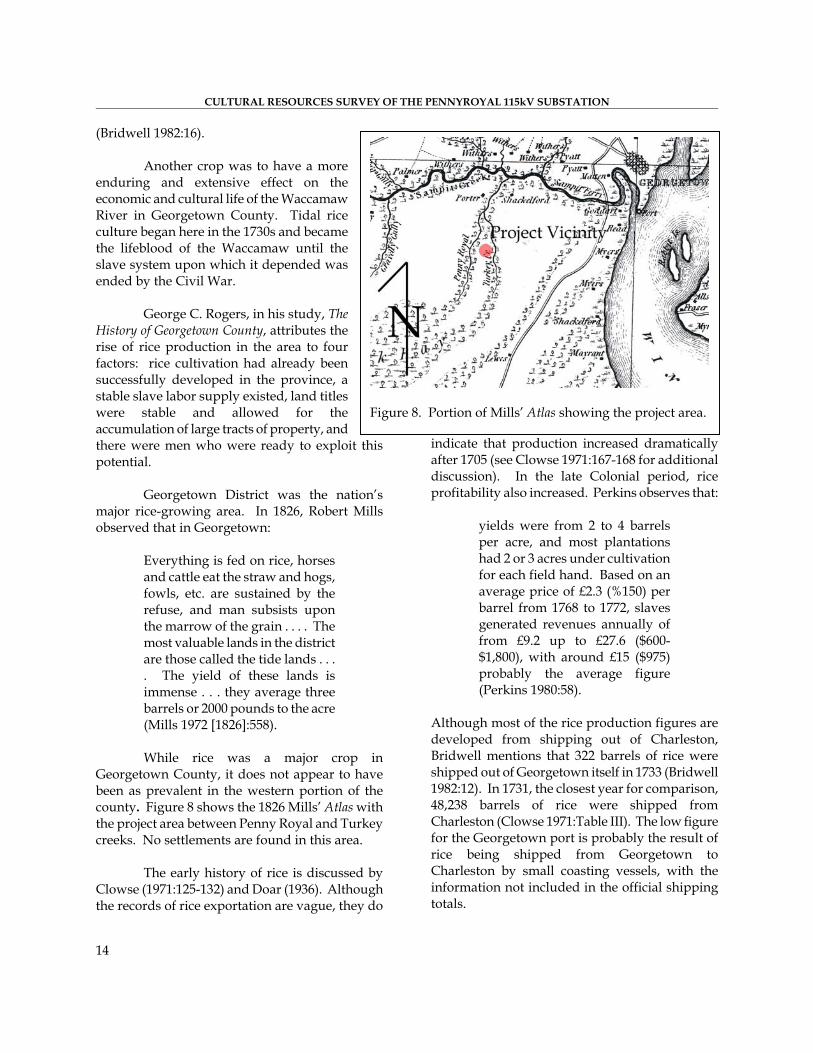
While rice was a major crop in Georgetown County, it does not appear to have been as prevalent in the western portion of the county. Figure 8 shows the 1826 Mills’ Atlas with the project area between Penny Royal and Turkey creeks. No settlements are found in this area.
The early history of rice is discussed by
Clowse (1971:125-132) and Doar (1936). Although the records of rice exportation are vague, they do
indicate that production increased dramatically after 1705 (see Clowse 1971:167-168 for additional discussion). In the late Colonial period, rice profitability also increased. Perkins observes that: yields were from 2 to 4 barrels
per acre, and most plantations had 2 or 3 acres under cultivation for each field hand. Based on an average price of £2.3 (%150) per barrel from 1768 to 1772, slaves generated revenues annually of from £9.2 up to £27.6 ($600-$1,800), with around £15 ($975) probably the average figure (Perkins 1980:58).
Although most of the rice production figures are developed from shipping out of Charleston, Bridwell mentions that 322 barrels of rice were shipped out of Georgetown itself in 1733 (Bridwell 1982:12). In 1731, the closest year for comparison, 48,238 barrels of rice were shipped from Charleston (Clowse 1971:Table III). The low figure for the Georgetown port is probably the result of rice being shipped from Georgetown to Charleston by small coasting vessels, with the information not included in the official shipping totals.
Figure 8. Portion of Mills’ Atlas showing the project area.

PREHISTORIC AND HISTORIC OVERVIEW
15
In 1840, Georgetown District produced 45% of the national rice crop. Between 1850 and 1860, production peaked. In 1850, 46,765,040 pounds of rice were produced in Georgetown County. By 1860, South Carolina produced nearly 64% of the total United States rice crop and one-half of the state’s crop was grown in Georgetown District. The average yield on Georgetown plantations in 1860 was 1,568 lbs. per acre. Prices ranged from 2.0 to 4.3 cents per pound in the 1850s (Easterby 1941:36; Kovacik 1979:49). Profits on rice plantations during the nineteenth century were variable. Governor Robert Francis Withers Allston reported in 1854 that “the profits of a rice plantation of good size and locality are about 8 percent per annum, independent of the privileges and perquisites of the plantation residence” (Easterby 1941:37). Peter Coclanis (1989:134-141) argues that while the annual net rate of return on rice cultivation was around 25 percent in the 1760, it fell to an astounding –28 percent by 1859. Regardless, the plantation system was run almost entirely on credit, paying off each past year’s indebtedness with the sale of the new crop. Although the Georgetown rice economy was in a healthy expanding condition in the antebellum years, the planter’s capital was constantly being invested in land and slaves (Sellers 1934:55-56). R.F.W. Allston was one of the district’s leading slave owners with nine plantations totaling over 6,000 acres. However, in 1859, he replied to the Blue Ridge Railroad Commission that he was unable to invest in the railroad: I have no funds to invest. All
that I am worth lies in South Carolina and is invested in land and Negroes; the annual income from which is pledged before it is realized (Easterby 1941:162).
Large plantations were the rule. The demand for the limited prime coastal lands forced up land values and pushed out marginal planters. By the early 1800s a hierarchy had developed based upon distance from the sea. By 1850, 99
large planters (planters who harvested more than 100,000 pounds each) produced 98% of the District’s total rice crop (Rogers 1970:253; Lawson 1972:8). Because of this reliance on slave labor, Georgetown District had the highest percentage of slaves in South Carolina. From 1810 to 1850, slaves made up 88% of the District’s total population and accounted for 85% of the population in 1860 (Rogers 1970:328,343). The planters of Waccamaw Neck were a small aristocratic group, closely knit by ties of blood as well as common interest. They were rich, even by standards of most of South Carolina’s planters, and lived in a luxurious style. In 1839, planters along the Waccamaw, the Pee Dee, the Black, the Sampit, and Winyah Bay formed the Planters Club on the Pee Dee. In 1845, the men formed another organization, the Hot and Hot Fish Club, for “convivial and social intercourse” (Rogers 1970:228, 196). The Civil War devastated Georgetown’s economy. One popular journal stated, “no other part of the United States knows so well as the Rice Coast what defeat in war can mean, for nowhere else in this country has a full-blown and highly developed civilization perished so completely” (Saas 1941:108). Minimal documentation is available concerning the activities of the Waccamaw plantation freedmen following the war. There were some cases of looting and pillaging of the plantation homes, the “buckra houses.” At first, some freedmen stayed on the confiscated plantations and worked under supervision of the Freedmen’s Bureau. After restoration of the plantations, they signed work agreements with their former masters or other plantation owners whereby they were paid a set fee at the end of the planting season. Others turned from the rice fields to the burgeoning Georgetown timber industry for work. The majority of former slaves, it appears, remained on Waccamaw Neck. Here they could find ready food in the river and sea,

CULTURAL RESOURCES SURVEY OF THE PENNYROYAL 115kV SUBSTATION
1
agrvwpdaGpACFGD opstWt7mwfB
Carolina’s rice production fell nearly 73%. In Georgetown County, the 1879 crop was approximately 10% of the 1860 crop (Kovacik 1979:55). Financing next year’s crop became a critical concern for planters who had traditionally depended on their factors for this service. During this period, a number of things happened to land ownership: bankruptcies were common, the Freedmen’s Bureau confiscated some lands and resettled former slaves on them, and other lands were sold at auction for nonpayment of loans or taxes. Companies such as Lachicotte and Sons and the Guendalos Company
Figure 9. Portion of the 1911 Soil map showing the project area.
6
nd were among old friends and family. Too, the eographic isolation of the Neck may have educed the travel incentive. Elsewhere small illages of freedmen apparently were formed, ith the Moyd settlement on Pennyroyal Road erhaps one example. Travel to Charleston, ifficult and somewhat dangerous, required a boat nd/or several ferry crossings (Lawson 1972:23; enevieve Chandler Peterkin, ersonal communication, 1987; R.F.W. llston Family Papers, South aroliniana Library; see also the reedmen’s Bureau Reports for eorgetown County, South Carolina epartment of Archives and History).
The blockade and occupation f Georgetown in 1862 threatened the lantation system. Union troops eized rice and contraband and set fire o rice fields as they went up the
accamaw. Some planters continued rying to grow crops, but an estimated 5% of the county’s plantation families oved to the interior of the state. The ar was followed by successive crop
ailures in 1865, 1866, and 1867. etween 1860 and 1870, South
tried to profitably combine planting and rice milling to reduce operational costs. Efforts such as these managed to keep the rice industry alive until the turn of the century. By the late nineteenth century, Northern investors were buying up the old rice plantations of Georgetown. Having little, if any, interest in rice cultivation, many of these buyers used the
Figure 10. Portion of a 1920 Georgetown quadrangle mapshowing the project area.
PREHISTORIC AND HISTORIC OVERVIEW
17
plantations as game preserves for sport hunting. The loss of a stable and experienced work force, the competition from western rice lands, and finally the hurricanes of 1893, 1894, 1898, 1906, 1910, and 1911 that wrecked the dike system, ended the long history of rice production on the Georgetown rivers (Devereaux 1976:254-155: Lawson 1972:22-23, 409: Smith 1913:80). Elizabeth Allston Pringle of Chicora Wood wrote in 1906: I fear the storm drops a
dramatic, I may say tragic, curtain on my career as a rice planter. The rice plantation, which for years gave me the exhilaration of making a good income myself, is a thing of the past now – the banks and trunks have been washed away, and there is no money to replace them (Rogers 1970:488-489).
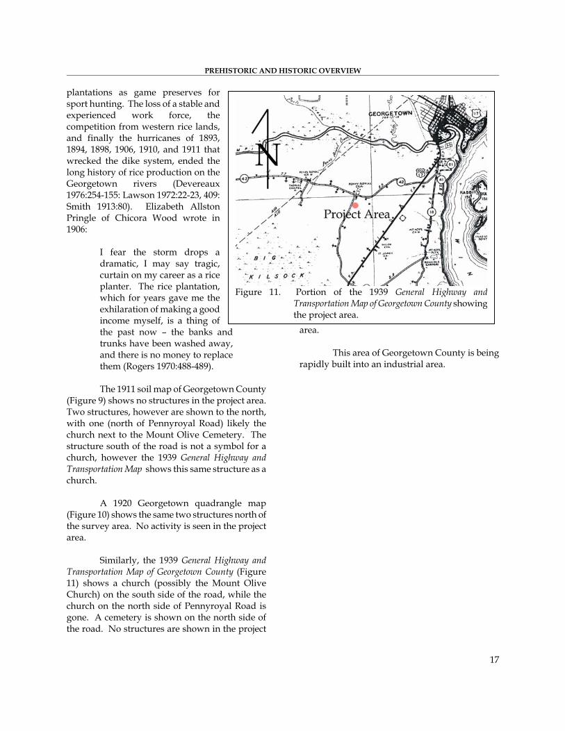
The 1911 soil map of Georgetown County (Figure 9) shows no structures in the project area. Two structures, however are shown to the north, with one (north of Pennyroyal Road) likely the church next to the Mount Olive Cemetery. The structure south of the road is not a symbol for a church, however the 1939 General Highway and Transportation Map shows this same structure as a church. A 1920 Georgetown quadrangle map (Figure 10) shows the same two structures north of the survey area. No activity is seen in the project area. Similarly, the 1939 General Highway and Transportation Map of Georgetown County (Figure 11) shows a church (possibly the Mount Olive Church) on the south side of the road, while the church on the north side of Pennyroyal Road is gone. A cemetery is shown on the north side of the road. No structures are shown in the project
area. This area of Georgetown County is being rapidly built into an industrial area.
Figure 11. Portion of the 1939 General Highway andTransportation Map of Georgetown County showingthe project area.

CULTURAL RESOURCES SURVEY OF THE PENNYROYAL 115kV SUBSTATION
18

RESEARCH METHODS AND FINDINGS Archaeological Field Methods and Findings
The initially proposed field techniques for the substation lot involved the placement of shovel tests at 100-foot intervals along transects placed at 100-foot intervals along Kiawah Road.
All soil would be screened through ¼-inch mesh, with each test numbered sequentially. Each test would measure about 1 foot square and would normally be taken to a depth of at least 1.0 foot or until subsoil was encountered. All cultural remains would be collected, except for mortar and brick, which would be quantitatively noted in the field and discarded. Notes would be maintained for profiles at any sites encountered.
Should sites (defined by the presence of
three or more artifacts from either surface survey or shovel tests within a 50 feet area) be identified, further tests would be used to obtain data on site
boundaries, artifact quantity and diversity, site integrity, and temporal affiliation. These tests would be placed at 25 to 50 feet intervals in a simple cruciform pattern until two consecutive negative shovel tests were encountered. The information required for completion of South Carolina Institute of Archaeology and Anthropology site forms would be collected and photographs would be taken, if warranted in the opinion of the field investigators.
A total of four transects were placed along Kiawah Road from south to north with shovel tests running east (Figure 12). A total of 12 shovel tests were excavated within the substation lot.
Sites would be evaluated for further work based on the eligibility criteria for the National Register of Historic Places. Chicora Foundation only provides an opinion of National Register eligibility and the final determination is made by
the lead agency in consultation with the State Historic Preservation Officer at the South Carolina Department of Archives and History.
Figure 12. Substation lot with transects.
Analysis of collections
would follow professionally accepted standards with a level of intensity suitable to the quantity and quality of the remains.
Nevertheless, the
archaeological survey of the substation lot and transmission corridor failed to identify any remains. This is likely the result of the lack of a distinct ridge top and disturbance of the property by being partially used as a
19

CULTURAL RESOURCES SURVEY OF THE PENNYROYAL 115kV SUBSTATION borrow pit.
Architectural Survey
As previously discussed, we elected to use a 0.5 mile area of potential effect (APE). The architectural survey would record buildings, sites, structures, and objects that appeared to have been constructed before 1950. Typical of such projects, this survey recorded only those which have retained “some measure of its historic integrity” (Vivian n.d.:5) and which were visible from public roads.
For each identified resource we would complete a Statewide Survey Site Form and at least two representative photographs were taken. Permanent control numbers would be assigned by the Survey Staff of the S.C. Department of Archives and History at the conclusion of the study. The Site Forms for the resources identified during this study would be submitted to the S.C. Department of Archives and History. Site Evaluation and Findings
Archaeological sites will be evaluated for further work based on the eligibility criteria for the National Register of Historic Places. Chicora Foundation only provides an opinion of National Register eligibility and the final determination is made by the lead federal agency, in consultation with the State Historic Preservation Officer at the South Carolina Department of Archives and History.
The criteria for eligibility to the National Register of Historic Places is described by 36CFR60.4, which states:
the quality of significance in American history, architecture, archaeology, engineering, and culture is present in districts, sites, buildings, structures, and objects that possess integrity of location, design, setting, materials, workmanship,
feeling, and association, and
a. that are associated with events that have made a significant contribution to the broad patterns of our history; or
b. that are associated with the lives of persons significant in our past; or c. that embody the distinctive characteristics of a type, period, or method of construction or that represent the work of a master, or that possess high artistic values, or that represent a significant and distinguishable entity whose components may lack individual distinction; or
d. that have yielded, or may be likely to yield, information important in prehistory or history. National Register Bulletin 36 (Townsend et
al. 1993) provides an evaluative process that contains five steps for forming a clearly defined explicit rationale for either the site’s eligibility or lack of eligibility. Briefly, these steps are:
▪ identification of the site’s data sets or categories of archaeological information such as ceramics, lithics, subsistence remains, architectural remains, or sub-surface features; ▪ identification of the historic context applicable to the site, providing a framework for the evaluative process; ▪ identification of the important research questions the site might
20

RESEARCH METHODS AND FINDINGS
be able to address, given the data sets and the context; ▪ evaluation of the site’s archaeological integrity to ensure that the data sets were sufficiently well preserved to address the research questions; and ▪ identification of important research questions among all of those which might be asked and answered at the site. This approach, of course, has
been developed for use documenting eligibility of sites being actually nominated to the National Register of Historic Places where the evaluative process must stand alone, with relatively little reference to other documentation and where typically only one site is being considered. As a result, some aspects of the evaluative process have been summarized, but we have tried to focus on an archaeological site’s ability to address significant research topics within the context of its available data sets. As previously mentioned, an architectural survey has been performed for Georgetown County (Joseph et al. 2006). The survey failed to identify any resources in the 0.5 project APE. The survey stated that “the purpose of the project [was] to compile a comprehensive inventory of historic landscapes and historic architectural resources . . . which may be eligible for nomination to the National Register of Historic Places” (Joseph et al. 2006:5). Only 105 properties were surveyed, which did not include the city of Georgetown. Within the surveyed resources only one cemetery independent of a church was recorded, but apparently determined not eligible. One church with a cemetery was determined eligible (the United Methodist Episcopal Church South and Cemetery – 0668). The survey noted that five cemeteries (including 0668) associated
with churches, however the report failed to identify which churches these were.
Figure 13. Location of the project area and the cemeteries.
There are two cemeteries in close proximity to the project area. Since the architectural survey reports that only properties that are eligible for the National Register were recorded, and these two cemeteries were not recorded, they must have been assessed and determined to be not eligible. Consequently, these are not recorded by this study. They are, however, noted. Figure 13 shows the project area and the location of the two cemeteries, Beulah Cemetery (Figure 14) and Mt. Olive Cemetery (Figure 15). One cemetery, modernly named Beulah Cemetery (Figure 14) on the south side of Pennyroyal Road, is within sight of the substation lot. While the current project can be seen from the Beulah Cemetery, they will be separated by at least 300 feet of forest. In addition, a cell tower is located directly across Kiawah Road from the cemetery, providing a direct visual impact. The current project, at least, will be somewhat shielded by vegetation.
21

CULTURAL RESOURCES SURVEY OF THE PENNYROYAL 115kV SUBSTATION
22
Figure 14. View of Beulah Cemetery.
Figure 15. View of Mount Olive Cemetery.
CONCLUSIONS
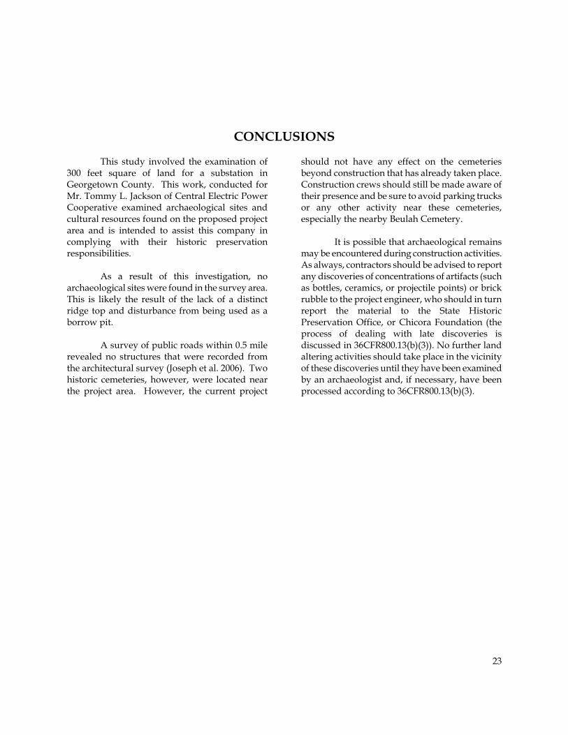
This study involved the examination of 300 feet square of land for a substation in Georgetown County. This work, conducted for Mr. Tommy L. Jackson of Central Electric Power Cooperative examined archaeological sites and cultural resources found on the proposed project area and is intended to assist this company in complying with their historic preservation responsibilities.
As a result of this investigation, no archaeological sites were found in the survey area. This is likely the result of the lack of a distinct ridge top and disturbance from being used as a borrow pit.
A survey of public roads within 0.5 mile
revealed no structures that were recorded from the architectural survey (Joseph et al. 2006). Two historic cemeteries, however, were located near the project area. However, the current project
should not have any effect on the cemeteries beyond construction that has already taken place. Construction crews should still be made aware of their presence and be sure to avoid parking trucks or any other activity near these cemeteries, especially the nearby Beulah Cemetery.
It is possible that archaeological remains may be encountered during construction activities. As always, contractors should be advised to report any discoveries of concentrations of artifacts (such as bottles, ceramics, or projectile points) or brick rubble to the project engineer, who should in turn report the material to the State Historic Preservation Office, or Chicora Foundation (the process of dealing with late discoveries is discussed in 36CFR800.13(b)(3)). No further land altering activities should take place in the vicinity of these discoveries until they have been examined by an archaeologist and, if necessary, have been processed according to 36CFR800.13(b)(3).
23

CULTURAL RESOURCES SURVEY OF THE PENNYROYAL 115kV SUBSTATION
24

SOURCES CITED
Anderson, David G. the Northeastern Perimeter of the Buck Hall Site (38CH644), Francis Marion National Forest, South Carolina. New South Associates, Irmo, South Carolina.
1979 Excavations at Four Fall Line Sites: The Southeastern Beltway Project. Commonwealth Associates, Inc., Jacksonville, Michigan. Submitted to the South Carolina Department of Highways and Public Transportation, Columbia.
Caldwell, Joseph R.
1958 Trend and Tradition in the Prehistory of the Eastern United States. Memoirs of the American Anthropological Association 88.
Anderson, David G., Charles E. Cantley, and A. Lee Novick
1982 The Mattassee Lake Sites: Archaeological Investigations Along
Carman, Harry J., editor the Lower Santee River in the Coastal Plain of South Carolina. Commonwealth Associates, Jackson, Michigan.
1939 American Husbandry. Columbia University Press, New York.
Clowse, Converse D.
1971 Economic Beginnings in Colonial South Carolina: 1670-1730. University of South Carolina Press, Columbia.
Baldwin, John L 1973 Climates of the United States. U.S.
Department of Commerce, National Oceanic and Atmospheric Administration, Washington, D.C.
Coclanis, Peter A.
1989 The Shadow of a Dream: Economic Life and Death in the South Carolina Low Country, 1670-1920. Oxford University Press, New York.
Blanton, Dennis B., Christopher T. Espenshade, and Paul E. Brockington, Jr.
1986 An Archaeological Study of 38SU83: A Yadkin Phase Site in the Upper Coastal Plain of South Carolina. Garrow and Associates, Inc., Atlanta.
Coe, Joffre
1964 The Formative Cultures of the Carolina Piedmont. Transactions of the American Philosophical Society 54(5).
Bridwell, Ronald E.
1982 “That We Should Have A Port”: A History of the Port of Georgetown, South Carolina 1732-1865. Georgetown County Chamber of Commerce, Georgetown.
Cooke, C. Wythe 1936 Geology of the Coastal Plain of
South Carolina. Bulletin 867. U.S. Geological Survey, Washington, D.C.
Cable, John 1991 Archaeological Test Excavations on
25

CULTURAL RESOURCES SURVEY OF THE PENNYROYAL 115kV SUBSTATION Derting, Keith M., Sharon L. Pekrul, and Charles J. Rinehart
1991 A Comprehensive Bibliography of South Carolina Archaeology. Research Manuscript 211. South Carolina Institute of Archaeology and Anthropology, University of South Carolina, Columbia.
Devereaux, Anthony
1976 The Life and Times of Robert F.W. Allston. R.L. Bryan, Columbia.
Doar, David
1936 Rice and Rice Planting in the South Carolina Low Country. Contributions 8. The Charleston Museum, Charleston, South Carolina.
Drucker, Lesley M. and Martha A. Zierden
1981 A Cultural Resources Investigation of Harmony Plantation, Georgetown Harbor, South Carolina. Carolina Archaeological Services, Columbia.
Easterby, James H. 1941 The South Carolina Rice Factor as
Revealed in the Papers of Robert F.W. Allston. Journal of Southern History 7:160-172.
Ferguson, Leland G.
1971 South Appalachian Mississippian. Ph.D. dissertation, University of North Carolina, Chapel Hill. University Microfilms, Ann Arbor, Michigan.
Goodyear, Albert C., John H. House, and Neal W. Ackerly
1979 Laurens-Anderson: An Archaeological Study of the Inter-Riverine Piedmont. Anthropological Studies 4, Occasional Papers of the Institute of Archaeology and
Anthropology, University of South Carolina, Columbia.
Gray, Lewis
1933 History of Agriculture in the Southern United States to 1860. Carnegie Institution Publication 430, Gloucester, Massachusetts.
Hacker, Debi and Michael Trinkley
1993 Cartographic Survey of Historic Sites in Georgetown County, South Carolina. Chicora Foundation Research Contribution 110. Chicora Foundation, Inc., Columbia.
Hanson, Glen T., Jr.
1982 The Analysis of Late Archaic-Early Woodland Adaptive Change Along the Middle Savannah River: A Proposed Strudy. South Carolina Institute of Archaeology and Anthropology Notebook 14:1-38.
Huneycutt, Dwight J.
1949 The Economics of the Indigo Industry in South Carolina. Unpublished M.A. thesis, Department of Economics, University of South Carolina, Columbia.
Joseph, Joe, Summer Ciomek, Brad Botwick, Karen Serio, Mary Beth Reed, and Natalie Adams
2006 Historic Resources Survey of Georgetown County. New South Associates, Stone Mountain, Georgia
Kovacik, Charles F.
1979 South Carolina Rice Coast Landscape Changes. Proceedings of the Tall Timber Ecology and Management Conferences, pp. 47-65. Thomasville, Georgia.
26

SOURCES CITED
Kovacik, Charles F. and John J. Winberry Phelps, David A.
1987 South Carolina: The Making of a Landscape. University of South Carolina Press, Columbia.
1983 Archaeology of the North Carolina Coast and Coastal Plain: Problems and Hypotheses. In The Prehistory of North Carolina: An Archaeological Symposium, edited by Mark A. Mathis and Jeffrey J. Crow, pp. 1-52. North Carolina Division of Archives and History, Department of Cultural Resources, Raleigh.
Lawson, Dennis T.
1972 “No Heir To Take Its Place.” The Georgetown County Historical Commission, Georgetown, South Carolina.
Mathews, Thomas D., Frank W. Stapor, Jr.,
Charles R. Richter, John V. Miglarese, Michael D. McKenzie, and Lee R. Barclay
Pitts, J.J. 1974 Soil Survey of Florence and Sumter
Counties, South Carolina. U.S. Department of Agrculture, Soil Conservation Service, Washington, D.C.
1980 Ecological Characterization of the Sea Island Coastal Region of South Carolina and Georgia, vol. 1. Office of Biological Services, Fish and Wildlife Service, Washington, D.C.
Rogers, George C., Jr.
1970 The History of Georgetown County South Carolina. University of South Carolina Press, Columbia.
Michie, James
1977 The Late Pleistocene Human Occupation of South Carolina. Unpublished Honor's Thesis, Department of Anthropology, University of South Carolina, Columbia.
Ryan, Thomas M.
1972 Archaeological Survey of the Columbia Zoological Park, Richland and Lexington Counties, South Carolina. Research Manuscript Series 37. South Carolina Institute of Archaeology and Anthropology, University of South Carolina, Columbia.
Mills, Robert
1972 [1826]Statistics of South Carolina. Reprinted. The Reprint Press, Spartanburg, South Carolina.
Saas, Herbert Ravenel 1941 The Ten Rice Rivers. Saturday
Evening Post, December 13:20-21, 105-108.
Oliver, Billy L. 1981 The Piedmont Tradition:
Refinement of the Savannah River Stemmed Point Type. Unpublished Master’s thesis, Department of Anthropology, University of North Carolina, Chapel Hill.
Sassaman, Kenneth E., Mark J. Brooks, Glen T. Hanson, and David G. Anderson
1990 Native American Prehistory of the Middle Savannah River Valley. Savannah River Archaeological Research Papers 1. Occasional Papers of the Savannah River Archaeological Research
Perkins, Edwin J.
1980 The Economy of Colonial America. Columbia University Press, New York.
27
CULTURAL RESOURCES SURVEY OF THE PENNYROYAL 115kV SUBSTATION
Program, South Carolina Institute of Archaeology and Anthropology, University of South Carolina.
Townsend, Jan, John H. Sprinkle, Jr., and John Knoerl 1993 Guidelines for Evaluating and
Registering Historical Archaeological Sites and Districts. Bulletin 36. National Park Service, National Register of Historic Places, Washington, D.C.
Sellers, Leila
1934 Charleston Business on the Eve of the American Revolution. University of North Carolina Press, Chapel Hill.
Trinkley, Michael
1980a Additional Investigations at 38LX5. South Carolina Department of Highways and Public Transportation, Columbia.
Service, E.M.
1966 The Hunters. Prentice-hall, Englewood Cliffs.
1980b Investigation of the Woodland Period
along the South Carolina Coast. Ph.D. dissertation. Department of Anthropology, University of North Carolina, Chapel Hill.
Smith, Henry A.M. 1913 Baronies of South Carolina. South
Carolina Historical Magazine 14:61-80.
South, Stanley A.
1990 An Archaeological Context for the South Carolina Woodland Period. Chicora Foundation Research Series 22. Chicora Foundation, Inc., Columbia, S.C.
1976 Archaeological Survey of Southeastern North Carolina. South Carolina Institute of Archaeology and Anthropology Notebook 93.
Stoltman, James B. Trinkley, Michael, Debi Hacker, and Natalie
Adams 1974 Plantation: An Archaeological Study of a South Carolina Locality. Monographs of the Peabody Museum 1, Harvard University, Cambridge.
1993 Life in the Pee Dee: Prehistoric and Historic Research on the Roche Carolina Tract, Florence County, South Carolina. Research Series 39. Chicora Foundation, Inc., Columbia.
Stuckey, Benjamin N.
1982 Soil Survey of Georgetown County, South Carolina. Soil Conservation Service, U.S. Department of Agriculture, Washington, D.C.
Vivian, Daniel J. n.d. South Carolina Statewide Survey of
Historic Properties. S.C. Department of Archives and History, Columbia.
Taylor, Richard L., editor
1984 Resources Survey of the Proposed Pee Dee Electric Generating Facility in Florence County, South Carolina. Common wealth Associates, Jackson, Michigan.
Walthall, John A.
1980 Prehistoric Indians of the Southeast: Archaeology of Alabama. University of Alabama Press, University.
28

SOURCES CITED Ward, Bobby J.
1989 Soil Survey of Williamsburg County, South Carolina. United States Department of Agriculture, Washington, D.C.
Ward, Trawick
1978 The Archaeology of Whites Creek, Marlboro County, South Carolina. Research Laboratories of Anthropology, University of North Carolina, Chapel Hill.
1983 A Review of Archaeology in the
North Carolina Piedmont: A Study in Change. In The Prehistory of North Carolina An Archaeological Symposium. Edited by Mark A. Mathis and Jeffrey J. Crow, pp. 53-81. North Carolina Division of Archives and History, Raleigh.
Williams, Stephen B., editor
1965 The Paleo-Indian Era: Proceedings of the 20th Southeastern Archaeological Conference. Bulletin 2. Southeastern Archaeological Conference.
Winberry, John J.
1979 Indigo in South Carolina: A Historic Geography. Southeastern Geographer 19.
29

CULTURAL RESOURCES SURVEY OF THE PENNYROYAL 115kV SUBSTATION
30

Archaeological Investigations
Historical Research
Preservation
Education
Interpretation
Heritage Marketing
Museum Support
Programs
Chicora Foundation, Inc. PO Box 8664 ▪ 861 Arbutus Drive Columbia, SC 29202-8664 Tel: 803-787-6910 Fax: 803-787-6910 Email: [email protected] www.chicora.org