CTP for Columbus County - NCDOT
22
II-1 II. Recommendations This chapter presents recommendations for each mode of transportation in the 2013 Beaufort County CTP as shown in Figure 1. More detailed information on each recommendation is tabulated in Appendix C. The N.C. Department of Transportation adopted a "Complete Streets 1 " policy in July 2009. The policy directs the Department to consider and incorporate several modes of transportation when building new projects or making improvements to existing infrastructure. Under this policy, the Department will collaborate with cities, towns and communities during the planning and design phases of projects. Together, they will decide how to provide the transportation options needed to serve the community and complement the context of the area. The benefits of this approach include: • making it easier for travelers to get where they need to go; • encouraging the use of alternative forms of transportation; • building more sustainable communities; • increasing connectivity between neighborhoods, streets, and transit systems; • improving safety for pedestrians, cyclists, and motorists. Complete streets are streets designed to be safe and comfortable for all users, including pedestrians, bicyclists, transit riders, motorists and individuals of all ages and capabilities. These streets generally include sidewalks, appropriate bicycle facilities, transit stops, right-sized street widths, context-based traffic speeds, and are well- integrated with surrounding land uses. The complete street policy and concepts were utilized in the development of the CTP. The CTP proposes projects that include multi- modal project recommendations as documented in the problem statements within this chapter. Refer to Appendix C for recommended cross sections for all project proposals and Appendix D for more detailed information on the typical cross sections. Implementation The CTP is based on the projected growth for the planning area. It is possible that actual growth patterns will differ from those logically anticipated. As a result, it may be necessary to accelerate or delay the implementation of some recommendations found within this plan. Some portions of the plan may require revisions in order to accommodate unexpected changes in development. Therefore, any changes made to one element of the CTP should be consistent with the other elements. Initiative for implementing the CTP rests predominately with the policy boards and citizens of the county and its municipalities. As transportation needs throughout the state exceed available funding, it is imperative that the local planning area aggressively pursue funding for priority projects. Projects should be prioritized locally and submitted to the Mid-East RPO for regional prioritization and submittal to NCDOT. Refer to 1 For more information on Complete Streets, go to: http://www.nccompletestreets.org/
Transcript of CTP for Columbus County - NCDOT

II-1
II. Recommendations This chapter presents recommendations for each mode of transportation in the 2013 Beaufort County CTP as shown in Figure 1. More detailed information on each recommendation is tabulated in Appendix C. The N.C. Department of Transportation adopted a "Complete Streets1" policy in July 2009. The policy directs the Department to consider and incorporate several modes of transportation when building new projects or making improvements to existing infrastructure. Under this policy, the Department will collaborate with cities, towns and communities during the planning and design phases of projects. Together, they will decide how to provide the transportation options needed to serve the community and complement the context of the area. The benefits of this approach include:
• making it easier for travelers to get where they need to go; • encouraging the use of alternative forms of transportation; • building more sustainable communities; • increasing connectivity between neighborhoods, streets, and transit systems; • improving safety for pedestrians, cyclists, and motorists.
Complete streets are streets designed to be safe and comfortable for all users, including pedestrians, bicyclists, transit riders, motorists and individuals of all ages and capabilities. These streets generally include sidewalks, appropriate bicycle facilities, transit stops, right-sized street widths, context-based traffic speeds, and are well-integrated with surrounding land uses. The complete street policy and concepts were utilized in the development of the CTP. The CTP proposes projects that include multi-modal project recommendations as documented in the problem statements within this chapter. Refer to Appendix C for recommended cross sections for all project proposals and Appendix D for more detailed information on the typical cross sections. Implementation The CTP is based on the projected growth for the planning area. It is possible that actual growth patterns will differ from those logically anticipated. As a result, it may be necessary to accelerate or delay the implementation of some recommendations found within this plan. Some portions of the plan may require revisions in order to accommodate unexpected changes in development. Therefore, any changes made to one element of the CTP should be consistent with the other elements. Initiative for implementing the CTP rests predominately with the policy boards and citizens of the county and its municipalities. As transportation needs throughout the state exceed available funding, it is imperative that the local planning area aggressively pursue funding for priority projects. Projects should be prioritized locally and submitted to the Mid-East RPO for regional prioritization and submittal to NCDOT. Refer to 1 For more information on Complete Streets, go to: http://www.nccompletestreets.org/
II-2
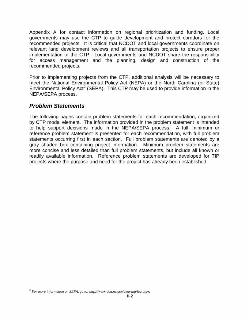
Appendix A for contact information on regional prioritization and funding. Local governments may use the CTP to guide development and protect corridors for the recommended projects. It is critical that NCDOT and local governments coordinate on relevant land development reviews and all transportation projects to ensure proper implementation of the CTP. Local governments and NCDOT share the responsibility for access management and the planning, design and construction of the recommended projects. Prior to implementing projects from the CTP, additional analysis will be necessary to meet the National Environmental Policy Act (NEPA) or the North Carolina (or State) Environmental Policy Act2 (SEPA). This CTP may be used to provide information in the NEPA/SEPA process. Problem Statements The following pages contain problem statements for each recommendation, organized by CTP modal element. The information provided in the problem statement is intended to help support decisions made in the NEPA/SEPA process. A full, minimum or reference problem statement is presented for each recommendation, with full problem statements occurring first in each section. Full problem statements are denoted by a gray shaded box containing project information. Minimum problem statements are more concise and less detailed than full problem statements, but include all known or readily available information. Reference problem statements are developed for TIP projects where the purpose and need for the project has already been established.
2 For more information on SEPA, go to: http://www.doa.nc.gov/clearing/faq.aspx.

II-3
Problem Statements HIGHWAY US 264 (Washington Northern Bypass) from existing TIP No.: R-3422 US 264 to Asbury Church Road (SR 1311) Last Updated: 5/20/2013 Identified Problem US 264 is projected to be near or over capacity by 2040 from approximately 0.8 miles east of Leggett Road (SR 1407) to Asbury Church Road (SR 1311). Improvements are needed to help relieve congestion on the existing facility and improve mobility through Washington such that a minimum Level of Service (LOS) D can be achieved.
R-3422
II-4
Justification of Need US 264 is a major east-west corridor in Beaufort County, connecting to Greenville, Wilson, and Raleigh to the west and to the coastal communities of eastern North Carolina. It is also the primary east-west route through the central business district (CBD) of Washington. The majority of US 264 in Beaufort County is on the regional tier of the North Carolina Multimodal Investment Network (NCMIN)3. The section between US 17 east to Pitt County is on the statewide tier of NCMIN. Statewide tier facilities serve long-distance trips, connect regional centers, have the highest usage, and mostly serve a mobility need. Regional tier facilities can serve statewide transportation, but they usually connect major population centers and provide a more localized function including land access. This section of US 264 is currently a 4 to 5 lane undivided major thoroughfare. Traffic is projected to increase in range from 10,500 to 22,200 vehicles per day (vpd) in 2011 to 22,600 to 33,100 in 2040, compared to a LOS D capacity of 22,200 to 35,700 vpd. Community Vision and Problem History Washington is the county seat of Beaufort County and is the center of activity for the county. Several major regional roads converge in the city bringing traffic from all directions. This facility is a highly congested business route that provides direct access to local businesses in Washington. Due to the anticipated high traffic volumes in the future, residents who live in and around the vicinity of Washington use this facility to access jobs, local shops, restaurants, the Vidant Beaufort Hospital, and other amenities in this urban area. This deficiency was previously identified in the 2000 Washington Thoroughfare Plan. CTP Project Proposal Project Description and Overview The proposed project (TIP No. R-3422) is to construct a four lane freeway on new location from existing US 264, 0.8 miles east of Leggett Road (SR 1407) north around Washington to US 264 at Asbury Church Road (SR 1311). The proposed bypass will utilize existing Asbury Church Road (SR 1311) which is recommended to be upgraded to a four lane freeway. Interchanges are recommended at the eastern and western termini, US 17, and Market Street Extension (SR 1422). Grade separations are recommended at Cherry Run Road (SR 1001), Slatestone Road (SR 1516) and Old Bath Highway (SR 1501).
3 For more information on NCMIN, go to: http://www.ncdot.gov/performance/reform/NCMINmaps/.

II-5
Additionally, during the most recent three year period, three intersections along US 264 corridor were identified as having 10 or more crashes and/or had a severity index above the state’s 4.56 average for the same period. Those intersections included: W 15th Street (SR 1306), US 17 Business, and N Market Street (SR 1422). Refer to Appendix F for more detailed information on these locations. The proposed facility will help reduce congestion and improve mobility within the Washington urban area. Relationship to Land Use Plans This area has a moderate to high density of population with land developed for urban purposes. Land use within this area consists of many local businesses, commercial/industrial properties, restaurants, shops, and nearby schools. US 264 provides access from major routes such as US 17 and NC 32. The November 2008 Beaufort County Joint Coastal Area Management Act (CAMA) Land Use Plan indicates primarily commercial and urban development is expected along this corridor. Linkages to Other Plans and Proposed Project History The proposed project (Washington Northern Bypass) directly connects to proposed freeway improvements on the US 17 Bypass, and on US 264 east of Pitt County. Additionally, the portion of the project from US 264 west of Washington to US 17 north of Washington is designated as a freeway on NCDOT’s Strategic Highway Corridor (SHC) Vision plan adopted by NCDOT on September 24, 2004. The current project limits for the Washington Northern Bypass, TIP No. R-3422, are from Wharton Station Road (SR 1409) west of Washington to Braddy Road (SR 1600) east of Washington. The CTP recommends revising the project limits as described in the project proposal section. The CTP project proposal was included in the 2000 Washington Thoroughfare Plan. Natural & Human Environmental Context Based on a planning level environmental review using available GIS data, portions of the proposed project are within the Tar-Pamlico River Basin water shed area. The proposed project may also potentially impact wetlands and water and sewer pipes. Multi-modal Considerations There are no other modes of transportation associated with this proposed project.

II-6
Public/ Stakeholder Involvement Respondents to the goals and objectives survey identified US 264 through Washington as a heavy traveled business route. From public meetings and other public comment opportunities, the primary public concern on existing US 264 was the high traffic congestion.

II-7
NC 306 Bridge over Pamlico River from the Bayview TIP No.: X-0004 Ferry Terminal to the Aurora Ferry Terminal Last updated: 5/20/2013
Identified Problem In the eastern part of the county there is currently only one north-south facility linking northern and southern Beaufort County. The Bayview-Aurora ferry connects NC 306 from the south with NC 92 to the north. Improvements are needed to enhance the system linkage and improve connectivity and mobility to move people and goods in this part of the county.
X-0004

II-8
Justification of Need Beaufort County is basically two land masses divided by the Pamlico River, with bridge crossings on US 17 Bypass and US 17 Business which are located close to one another on the far western end of the county. The eastern portion of Beaufort County, especially in the south side of the county, relies primarily on the ferry system for transportation to Washington and other areas on the north side of the river. The Bayview-Aurora ferry is free year round with a 30 minute ride from the Bayview Ferry Terminal to the Aurora Ferry Terminal. Departures start at 5:30am and end at 12:30am with 22 crossings per day. A ferry toll is planned for this area possibly beginning sometime in 2014. There were 69,750 vehicles and 94,183 passengers used by the ferry in the mid-year 2011-2012. There were 66,125 vehicles and 90,103 passengers used in the mid-year 2012-2013. The slight decline can be attributed to the anticipation of the ferry toll and people using an alternate route. This route is approximately 3 miles across the Pamlico River. The only alternative route for residents of southeastern Beaufort County to access NC 92 and other northern areas of the county is to travel NC 306 south to NC 33, northwest to US 17, north to US 264 and east to NC 92. The approximate distance of this “alternative” route is 60 miles. Community Vision and Problem History Hospital, medical access, employment, shopping, and all other amenities are located in Washington which lies in the northern part of the county. Residents of southeastern Beaufort County use the ferry system as an extension of NC 306. Mobility throughout Beaufort County is restricted due to the geographical area being split by the Pamlico River, and the use of and reliance on the ferry system. Emergency evacuation and other emergency access/response time to the hospital are limited due to the lack of bridge access in the eastern part of the county. Students and faculty use the ferry to access the community college and other schools on the northern side of the county. Bridge access between Aurora and Bayview would benefit military operations and transport, economic development, tourism, employment opportunities, education, and mobility/connectivity within Beaufort County. This problem was not identified in the 2000 Beaufort County Thoroughfare Plan4. CTP Project Proposal Project Description and Overview The proposed project (TIP No.: X-0004) is to construct a new two lane bridge with bicycle and pedestrian accommodations across the Pamlico River that would replace the existing Bayview-Aurora Ferry route. 4http://archive.org/details/beaufortcountyth2000nort

II-9
The proposed project would enhance the system linkage by providing a more efficient route and improving connectivity and mobility for commuters and residents from the northern to southern portions of eastern Beaufort County. Linkages to Other Plans and Proposed Project History The proposed project first appeared in the Transportation Improvement Program (TIP) in 1978 as an unfunded project. Since then, it has remained unfunded in subsequent program years and is currently scheduled for reprioritization through NCDOT’s strategic prioritization process. In 1980, Wilbur Smith and Associates completed a feasibility study for NCDOT which concluded that a new bridge was not economically feasible. In 1988, NCDOT’s Feasibility Studies Unit reanalyzed this study to determine the feasibility of constructing a new bridge. This update concluded that the transportation benefits and economic development benefits were not great enough to clearly show that constructing the bridge would be a good use of limited transportation resources at that time. Since then, no additional studies have been conducted. The NCDOT Ferry Division is currently in the process of releasing their long term strategic plan within the next 6 months for the Ferry System including this area. Their stance on the Bayview-Aurora ferry is to continue to monitor the traffic data at Pamlico River and provide the necessary level of service to keep up with ridership demands in to the future. Also while maintaining ferry services, the Ferry Division has plans to upgrade, as necessary, any vessel in the future. The proposed project was not included in the 2000 Beaufort County Thoroughfare Plan. Relationship to Land Use Plans This area has a low to moderate density of population with land developed for residential purposes and limited commercial use. Land use within this area consists of few local businesses and residential subdivisions. The largest employer in Beaufort County, Potash of Aurora, resides on the south side of the Pamlico River with many employees relying solely on the ferry system for access to and from work. Access to this manufacturing/mining operation is obtained by NC 33, which is currently a two-lane minor thoroughfare with 11 foot lanes. NC 33 experiences both commercial and commuter traffic. Commercial traffic has to journey from the western end of Beaufort County to access the facility and to reach its final delivery destination. Potash of Aurora was recently issued a 30 year mining permit, which will increase the existing and future commuter and commercial traffic growth. The 2006 Beaufort County Joint CAMA Land Use Plan indicates primarily residential and low commercial development is expected in the project area.

II-10
Natural & Human Environmental Context Based on a planning level environmental review using available GIS data, the southern end of the proposed project is within the Tar-Pamlico River Basin watershed area. The proposed project crosses the Pamlico River. Multi-modal Considerations Bicycle accommodations on both sides of the bridge are recommended along this facility. Public/ Stakeholder Involvement From public meetings and other public comment opportunities, the primary public concern on this part of the county is limited access between the southern or northern part of the county.
II-11
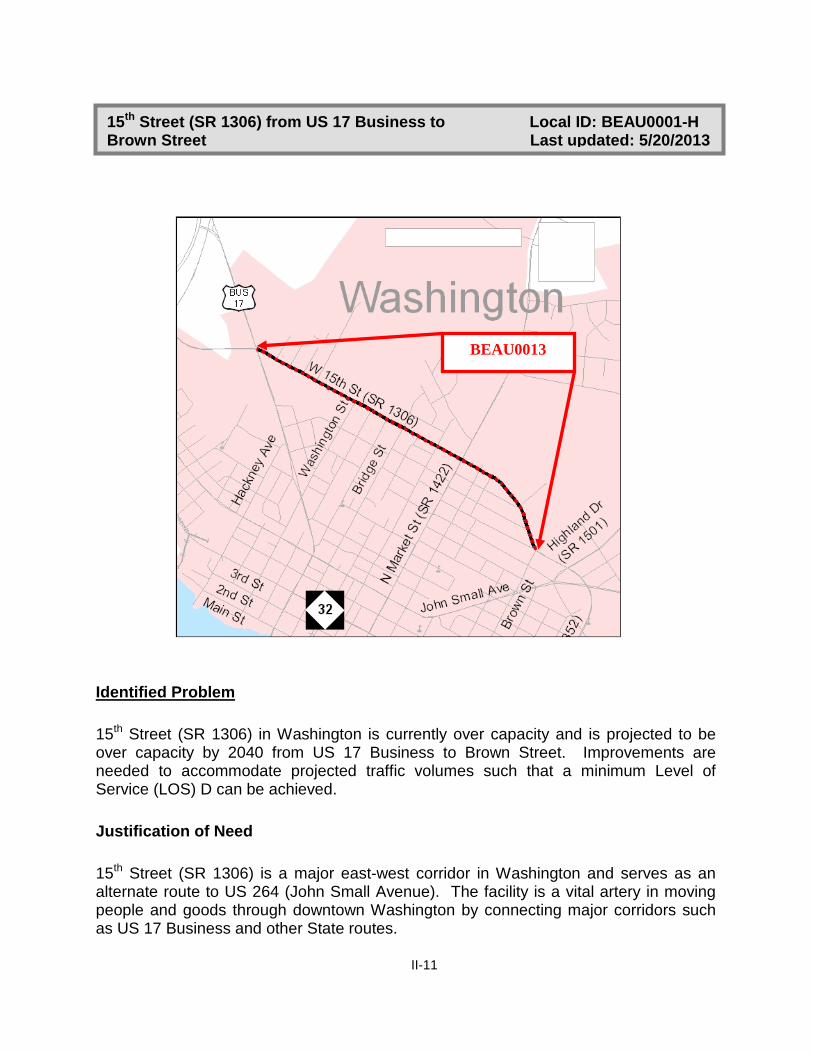
15th Street (SR 1306) from US 17 Business to Local ID: BEAU0001-H Brown Street Last updated: 5/20/2013
Identified Problem 15th Street (SR 1306) in Washington is currently over capacity and is projected to be over capacity by 2040 from US 17 Business to Brown Street. Improvements are needed to accommodate projected traffic volumes such that a minimum Level of Service (LOS) D can be achieved. Justification of Need 15th Street (SR 1306) is a major east-west corridor in Washington and serves as an alternate route to US 264 (John Small Avenue). The facility is a vital artery in moving people and goods through downtown Washington by connecting major corridors such as US 17 Business and other State routes.
BEAU0013

II-12
Currently, 15th Street (SR 1306) is a 4 lane major thoroughfare with 12 foot lanes from US 17 Business to Brown Street. Traffic volumes on this section of 15th Street are projected to increase in range from 20,400 to 23,200 vehicles per day (vpd) in 2011 to 24,200 to 27,500 vpd in 2040 compared to a LOS D capacity of 22,200 vpd. Community Vision and Problem History This facility is a highly congested business route that provides direct access to local businesses in Washington. Residents who live in and around Washington use this facility to access jobs, local shops, restaurants, the Vidant Beaufort Hospital, and other amenities in this urban area. Access to these businesses along this route provides an economic impact that enhances the economic vitality to the community in this area. This problem was identified in the 2000 City of Washington Thoroughfare Plan. CTP Project Proposal Project Description and Overview The proposed project (Local ID: BEAU0001-H) is to improve 15th Street (SR 1306) to a 4-lane divided boulevard from US 17 Business to Brown Street with sidewalks on both sides. Additionally, during the most recent three year period, seven intersections along this corridor were identified as having 10 or more crashes and/or had a severity index above the state’s 4.56 average for the same period. Those intersections included: US 17 Business (Carolina Avenue), 5th Street, Minuteman Lane, Washington Street, Pierce Street, N Market Street (SR 1422), and Brown Street. Refer to Appendix F for more detailed information on these locations. The proposed improvements would improve mobility along this section of 15th Street (SR 1306) and provide for a LOS D or better within the project area. Linkages to Other Plans and Proposed Project History The project proposal for 15th Street (SR 1306) directly connects to proposed improvements on US 17 Business, Market Street Extension (SR 1422), and US 264. The 2000 Washington Thoroughfare Plan5 recommended constructing a new two-lane connector from Avon Avenue (SR 1504) to US 264 to address this deficiency. 5http://archive.org/details/cityofwashington2000nort

II-13
Relationship to Land Use Plans This area has a moderate to high density of population. Land use within this area consists of many local businesses, commercial/industrial properties, restaurants, shops, and nearby schools. 15th Street provides access from major routes such as US 17 and US 264 to nearby amenities such as Wal-Mart and the Beaufort County Regional Hospital. The 2006 Beaufort County Joint CAMA Land Use Plan indicates primarily commercial and urban development is expected to continue along this corridor. Natural & Human Environmental Context Based on a planning level environmental review using available GIS data, the proposed project is within the Tar-Pamlico River Basin water shed area. There are also water and sewer pipes located along this facility. Multi-modal Considerations This CTP includes recommendations for pedestrian facilities throughout the study. Sidewalks on both sides of the road are recommended along this corridor from US 17 Business to Brown Street. Public/ Stakeholder Involvement Respondents to the goals and objectives survey identified 15th Street through Washington as a heavy traveled business route. From public meetings and other public comment opportunities, the primary public concern on this section of 15th Street was the high traffic congestion.
II-14
US 264, Local ID: BEAU0003-H US 264 from Pitt County to the proposed Washington Northern Bypass (R-3422) does not meet the future mobility needs in eastern North Carolina. This facility is intended to provide mobility in Beaufort County and, ultimately, connectivity between Raleigh and Washington. Additionally, US 264 from Leggett Road (SR 1407) to the proposed Washington Northern Bypass, 0.8 miles east of Leggett Road (SR 1407) is projected to be near capacity by 2040. This section of US 264 is designated as a freeway on NCDOT’s Strategic Highway Corridor (SHC) Vision Plan adopted on September 2, 2004. This existing facility is currently a four lane expressway with 12-foot lanes. The 2011 Annual Average Daily Traffic (AADT) volume ranges from 18,300 to 22,000 vpd, compared to a LOS D capacity of 56,100 vpd. The projected 2040 traffic volume ranges from 31,900 to 37,700 vpd. This facility provides direct access to several restaurants, retail stores, the Beaufort County Community College, and local businesses in downtown Washington. The proposed project (Local ID: BEAU0003-H) is to upgrade the existing facility to freeway standards. As development occurs along this corridor every effort should be made to limit access in order to maintain mobility. Based on a planning level environmental assessment using available GIS data, the proposed project may potentially impact water shed and farmland areas. Neither the 2000 Washington Thoroughfare Plan nor the 2000 Beaufort County Thoroughfare included improvements for this section of US 264. US 264, Local ID: BEAU0004-H US 264 from the proposed Washington Northern Bypass, 0.8 miles east of Leggett Road (SR 1407), to NC 32 is expected to be near or over capacity by 2040. Improvements are needed to accommodate projected traffic volumes such that a minimum Level of Service (LOS) D can be achieved. This existing facility is currently a 4 to 5 lane major thoroughfare with 12 foot lanes. Traffic on US 264 between the Washington Northern Bypass, 0.8 miles east of Leggett Road (SR 1407), to NC 32 is projected to increase in range from 10,500 to 22,000 vehicles per day (vpd) in 2011 to 19,300 to 33,100 vpd in 2040, compared to a LOS D capacity of 16,400 to 35,700 vpd. Even with the implementation of the proposed Washington Northern Bypass (R-3422), traffic volumes in 2040 are projected to range from 22,800 to 33,100 vpd. Additionally, during the most recent three year period, four intersections along this section of US 264 were identified as having 10 or more crashes and/or had a severity index above the state’s 4.56 average for the same period. Those
II-15
intersections included: W 15th Street (SR 1306), US 17 Business, N Market Street (SR 1422) and Asbury Church Road (SR 1311). Refer to Appendix F for more detailed information on these locations. This facility provides direct access to several restaurants, retail stores, the Beaufort County Community College, and local businesses in downtown Washington. The proposed project (Local ID: BEAU0004-H) is to upgrade the existing facility to a four lane divided boulevard. Bicycle accommodations are recommended from W 15th Street (SR 1306) to US 17 Business. Sidewalks are recommended from US 17 Bypass to US 17 Business and from Harvey Street to Avon Avenue. Based on a planning level environmental assessment using available GIS data, the proposed project is within the Tar-Pamlico River Basin water shed area. There are also water and sewer pipes located along this facility. Neither the 2000 Washington Thoroughfare Plan nor the 2000 Beaufort County Thoroughfare included improvements on US 264 from 0.8 miles east of Leggett Road (SR 1407) to NC 32. The portion of this project from NC 32 to NC 92 was previously included in the 2000 Beaufort County Thoroughfare Plan as part of TIP project R-2601. TIP project R-2601 included widening US 264 to multi-lanes from NC 32 to NC 99 in Belhaven. However, during the development of this CTP, no transportation deficiency was identified on the section between NC 92 and NC 99 in Belhaven. US 17 (Washington Bypass), TIP No.: R-2510 The section of US 17, from south of Possum Track Road (SR 1127) to north of NC 171, are projected to be near or over capacity by 2040. Additionally, US 17 within Beaufort County is designated as a freeway on NCDOT’s SHC Vision Plan. The 2012-2018 TIP includes project R-2510 that is intended to address this problem. TIP project R -2510 includes constructing a four lane freeway, part of new location. This project is currently in the construction phase. The majority of this project has been completed. The final section of this project, from north of NC 171 to south of Cherry Run Road (SR 1001), is anticipated to be completed in December of 2013. For additional information about this project, contact the NCDOT Resident Engineer’s Office in Greenville at (252) 830-3495 or visit the project website6. US 17, TIP No.: R-2511 US 17 from VOA Road (SR 1410) to north of NC 171 is projected to be near capacity by 2040. Additionally, US 17 within Beaufort County is designated as a freeway on NCDOT’s SHC Vision Plan. TIP project R-2511 is intended to address this problem.

II-16
6http://www.ncdot.gov/projects/us17bypass/ TIP project R-2511 includes widening US 17 to multi-lanes from north of NC 171 to the multi-lanes south of Williamston in Martin County. This project is currently in the project development phase. For additional information about this project, including the Purpose and Need, contact NCDOT’s Project Development and Environmental Analysis Branch. US 17, TIP No.: R-2513 US 17 from south of Possum Track Road (SR 1127) to Craven County does not meet the future mobility needs in Beaufort County and eastern North Carolina. This facility is intended to provide mobility in eastern North Carolina, and ultimately, connectivity between Norfolk, Virginia and Myrtle Beach, South Carolina. US 17 is designated as a freeway on NCDOT’s Strategic Highway Corridor (SHC) Vision plan adopted on September 2, 2004. The existing facility is currently a two lane major thoroughfare with 12 foot lanes. The proposed project (TIP No.: R-2513) is to widen the existing facility to a four lane freeway from south of Possum Track Road (SR 1127) in Beaufort County to Spruill Town Road (SR 1438) in Craven County. As development occurs along this corridor every effort should be made to limit access in order to maintain mobility. Based on a planning level environmental assessment using available GIS data, the proposed project is within the Neuse River Basin water shed area. The proposed project may also potentially impact wetlands and farmland areas. The proposed project was included in the 2000 Beaufort County Thoroughfare Plan and the 2000 Washington Thoroughfare Plan. US 17 Business, Local ID: BEAU0002-H US 17 Business, between Main Street and US 17, is projected to be near capacity by 2040. Improvements are needed to accommodate projected traffic volumes such that a minimum Level of Service (LOS) D can be achieved. This section of US 17 Business is currently a five lane major thoroughfare with 12 foot lanes. Traffic volumes on this section of US 17 Business are projected to increase in range from 9,900 to 13,000 vehicles per day (vpd) in 2011 to 22,600 to 27,900 vpd in 2040, compared to a LOS D capacity of 24,300 to 34,500 vpd. Additionally, during the most recent three year period, three intersections along this section of US 17 were identified as having 10 or more crashes and/or had a severity index above the state’s 4.56 average for the same period. Those intersections included: US 264 (John Small

II-17
Avenue), Entrance to Wal-Mart, and 15th Street. Refer to Appendix F for more detailed information on these locations. The proposed project (Local ID: BEAU0002-H) is to convert the existing facility to a four lane boulevard with curb and gutter. Bicycle accommodations are recommended from Main Street to US 264. Sidewalks are recommended from 4th Street to US 264 and from 11th Street to W 15th Street (SR 1306). Based on a planning level environmental assessment using available GIS data, portions of the proposed project are within the Tar-Pamlico River Basin water shed area. There are also water and sewer lines along the proposed project. The proposed project was not included in the 2000 Washington Thoroughfare Plan. NC 32, Local ID: BEAU0005-H NC 32 between Hudnell Street (SR 1352) and US 17 Business is projected to be near or over capacity by 2040. Improvements are needed to accommodate projected traffic volumes such that a minimum Level of Service (LOS) D can be achieved. NC 32 from Hudnell Street (SR 1352) to US 17 Business is currently a two lane major thoroughfare with 12 foot lanes and a center turn lane. This facility provides direct access to residential homes and local businesses in downtown Washington. Traffic volumes on this section of NC 32 are projected to increase in range from 8,200 to 10,000 vehicles per day (vpd) in 2011 to 13,100 to 15,400 vpd in 2040, compared to a LOS D capacity of 12,700. The proposed project (Local ID: BEAU0005-H) is to reconfigure the existing roadway to recommend bicycle accommodations from Hudnell Street to N Charlotte Street. Sidewalks are recommended from Brown Street to Harvey Street and from Market Street to US 17 Business. Based on a planning level environmental assessment using available GIS data, the proposed project is within the Tar-Pamlico River Basin water shed area. There are also water and sewer lines along the proposed project. 12th Street, Local ID: BEAU0021-H 12th Street between Brown Street and US 264 (John Small Avenue) is projected to be near or over capacity by 2040. Improvements are needed to accommodate projected traffic volumes such that a minimum Level of Service (LOS) D can be achieved.

II-18
12th Street from Brown Street and US 264 (John Small Avenue) is currently a five lane major thoroughfare with 12 foot lanes and a center turn lane. This facility provides direct access to Beaufort County Regional Hospital and local businesses in downtown Washington. Traffic volumes on this section of 12th Street are projected to increase in range from 15,000 vehicles per day (vpd) in 2011 to 17,400 vpd in 2040, compared to a LOS D capacity of 23,500. The proposed project (Local ID: BEAU0020-H) is to reconfigure the existing roadway to a four lane boulevard. Sidewalks are recommended from Brown Street to US 264. Based on a planning level environmental assessment using available GIS data, the proposed project is within the Tar-Pamlico River Basin water shed area. There are also water and sewer lines along the proposed project.
Minor Widening Improvements
The following routes do not have capacity issues, but are recommended to be upgraded to two 12-foot lanes with paved shoulders to improve narrow lane widths and/or to accommodate bicycles.
• NC 32 - (BEAU0006-H): Widen from 10 to 12 foot lanes from Washington County to Terra Ceia Road (SR 1612)
• NC 33 - (BEAU0007-H): Widen from 11 to 12 foot lanes from NC 306 in Aurora to
Gray Road (SR 1136) in Chocowinity and from Amilite Way in Chocowinity to Pitt County
• NC 92/99 - (BEAU0008-H): Widen from 10 to 12 foot lanes from S King Street (SR 1741) in Bath to Pamlico Beach Road (SR 1725) and from Seed Tick Neck Road (SR 1714) to US 264 in Belhaven
• NC 306 - (BEAU0009-H): Widen from 9 to 12 foot lanes from Tunstall Swamp Road (SR 1003) to Craven County
• Asbury Church Road (SR 1311) - (BEAU0010-H): Widen from 11 to 12 foot lanes from US 264 to NC 32
• Brick Kiln Road (SR 1303) - BEAU0011-H: Widen from 10 to 12 foot lanes from
US 264 to NC 32 • Cherry Road (SR 1516) - BEAU0012-H: Widen to include paved shoulders with
the 12 foot lanes from Market Street Extension (SR 1422) to Old Bath Highway (SR 1501)

II-19
• Cherry Run Road (SR 1001) – (BEAU0013-H): Widen to include paved shoulders with 12 foot lanes from VOA Road (SR 1410) to US 17
• Highland Drive (SR 1501) – (BEAU0014-H): Widen 11 to 12 foot lanes from East 12th Street to Corsica Road (SR 1518)
• Market Street Extension (SR 1422) – (BEAU0015-H): Widen to include paved shoulders with 12 foot lanes from West 15th Street (SR 1306) to NC 171
• Mill Road (SR 1511) – (BEAU0016-H): Widen from 10 to 12 foot lanes from US 17 to Market Street Extension (SR 1422)
• Old Blounts Creek Road (SR 1123) - (BEAU0017-H): Widen from 10 to 12 foot
lanes from NC 33 to Hill Road (SR 1125)
• Slatestone Road (SR 1516) – (BEAU0018-H): Widen from 11 to 12 foot lanes from Highland Drive (SR 1501) to Corsica Road (SR 1518)
• Tunstall Swamp Road (SR 1003) – (BEAU0019-H): Widen from 9 to 12 foot lanes
from NC 33 to Craven County
• Wharton Station Road - (BEAU0020-H): Widen from 9 to 12 foot lanes from US 264 to US 17
PUBLIC TRANSPORTATION & RAIL A public transportation and rail assessment was completed during the development of the CTP. There are no recommended improvements associated with these transportation modes. BICYCLE The 2011 Washington Bicycle Plan (to be locally adopted in June 2013) identifies existing and recommended greenways and bicycle facilities throughout the city. These facilities were incorporated into the CTP. Additionally, during the development of the CTP, the following facilities were identified as recommended bicycle routes and will need improvements. In accordance with American Association of State Highway and Transportation Officials (AASHTO), roadways identified as bicycle routes should incorporate the following standards as roadway improvements are made and funding is available: • Curb & gutter sections require at minimum 4 foot bike lanes or 14 foot wide shoulder
lanes.

II-20
• Shoulder sections require a minimum of 4 foot paved shoulder.
• All bridges along the roadways where bike facilities are recommended shall be
equipped with 54 inch railings. On-road bicycle facilities are proposed on the following roads: • US 264 – (BEAU0001-B): Belhaven - from Old County Road to Tinker Lane • US 264 – (BEAU0002-B): Washington - from 15th Street (SR 1306) to US 17
Business
• US 17 Business – (BEAU0003-B): Washington - from Main Street to US 264 (5th Street)
• US 17 Business – (BEAU0004-B): Chocowinity - from Sunset Drive to Bragaw
Lane
• NC 33 – (BEAU0005-B): Aurora – Spring Creek Road (SR 1912) to 7th Street • NC 32 – (BEAU0006-B): Washington – from Hudnell Street (SR 1352) to west
Brick Kiln Road (SR 1303)
• Bonner Street – (BEAU0007-B): Washington - from East Main Street to Water Street
• Clarks Neck Road – (BEAU0008-B): Washington – from US 264 to Pitt County • East Main Street – (BEAU0009-B): Washington - from NC 32 to Bonner Street
• East Main Street – (BEAU0010-B): Washington - from Stewart Parkway to US 17 • Stewart Parkway – (BEAU0011-B): Washington - from Water Street to E Main
Street • 2nd Street – (BEAU0012-B): Washington – from US 17 Business to Hudnell Street
(SR 1352)

II-21
PEDESTRIAN The 2006 City of Washington Master Pedestrian Plan identifies existing and recommended sidewalks for pedestrians throughout the city. These are shown on the Pedestrian Map as existing sidewalks, sidewalks that need improvement or proposed sidewalk. Additionally, during the development of the CTP, the following recommendations were developed. Sidewalks- Recommended (Sidewalks needed on both sides of a facility) • 1st Street – (BEAU0001-P): Aurora – from Main Street to Chapin Street
• 2nd Street – (BEAU0002-P): Aurora – from Middle Street to Main Street
• 5th Street – (BEAU0003-P): Aurora - from Middle Street to Chapin Street
• Middle Street – (BEAU0004-P): Aurora - from 8th Street to 2nd Street
• Main Street – (BEAU0005-P): Aurora - from 3rd Street to Water
• S King Street – (BEAU0006-P): Bath – from NC 92 to Craven Street (SR 1756)
• US 264 Business – (BEAU0007-P): Belhaven - from E Pantego Street to Tinker Ln
• Old Country Road – (BEAU0008-P): Belhaven – from US 264 (Main St) to US 264 Business
• US 17 Business – (BEAU0009-P): Chocowinity - from NC 33 to Patrick Ln (SR 1143)
Additionally, the following multi-use path was recommended during the development of the CTP: • BEAU0001-M: Jake’s Creek Greenway from East Main Street to Market Street with
a link to the skateboard park
II-22
• BEAU0002-M: Runyon Creek Greenway from Park Drive to Chesterfield Drive (SR 1545)
• BEAU0003-M: Tar River Nature Path from US 17 making loop back to US 17
• BEAU0004-M: Washington Park Walkway from Edge Water Avenue to Walnut Street