CÔTE D’IVOIRE EXPLORATION UPDATE
10
15 June 2021 CÔTE D’IVOIRE EXPLORATION UPDATE Highlights Mankono Ouest first phase termite mound sampling has been completed with results indicating a significant, coherent gold anomaly over 6km of strike Bocanda Project initial stream sediment sampling (BLEG methodology) has been completed with results pending Regolith, geological and structural mapping is currently ongoing on all three granted project areas (Mankono, Bocanda and Bouaflé) An experienced in-country team with a proven track record of discovery has been established A clear exploration strategy is in place, with work now ramping up Tanga Resources Limited (ASX: TRL) (Tanga or the Company) is pleased to provide an update on exploration work progress at its Côte d’Ivoire Projects – Mankono, Bouaflé and Bocanda. The Côte d’Ivoire exploration team is rapidly progressing work on all three active Projects, having completed the initial sampling programs over three permits (Bocanda Nord, Bocanda and Mankono Ouest). First gold results have been received from termite mound samples collected on the Mankono Ouest permit, returning a +6km long, coherent and still incomplete gold anomaly. In parallel, surface mapping is ongoing at all three projects, to support future interpretation of the sampling results and compilation of a detailed geological model. The Company’s exploration team is now well established and has a track record of success having recently discovered over 5 million ounces of Gold in Côte d’Ivoire. Tanga’s Chairman, Andrew Pardey, commented: “The first phase of surface sampling completed over two Projects and the mapping in progress at all three granted Project areas, has delivered some impressive results and coherent observations, which will lead to a better interpretation of the real potential for significant gold mineralisation at our Projects.”
Transcript of CÔTE D’IVOIRE EXPLORATION UPDATE

15 June 2021
CÔTE D’IVOIRE EXPLORATION UPDATE
Highlights
Mankono Ouest first phase termite mound sampling has been completed with results indicating a significant, coherent gold anomaly over 6km of strike
Bocanda Project initial stream sediment sampling (BLEG methodology) has been completed with results pending
Regolith, geological and structural mapping is currently ongoing on all three
granted project areas (Mankono, Bocanda and Bouaflé)
An experienced in-country team with a proven track record of discovery has been
established
A clear exploration strategy is in place, with work now ramping up
Tanga Resources Limited (ASX: TRL) (Tanga or the Company) is pleased to provide an update on
exploration work progress at its Côte d’Ivoire Projects – Mankono, Bouaflé and Bocanda.
The Côte d’Ivoire exploration team is rapidly progressing work on all three active Projects, having
completed the initial sampling programs over three permits (Bocanda Nord, Bocanda and Mankono
Ouest). First gold results have been received from termite mound samples collected on the Mankono
Ouest permit, returning a +6km long, coherent and still incomplete gold anomaly. In parallel, surface
mapping is ongoing at all three projects, to support future interpretation of the sampling results and
compilation of a detailed geological model.
The Company’s exploration team is now well established and has a track record of success having
recently discovered over 5 million ounces of Gold in Côte d’Ivoire.
Tanga’s Chairman, Andrew Pardey, commented:
“The first phase of surface sampling completed over two Projects and the mapping in progress at all
three granted Project areas, has delivered some impressive results and coherent observations, which
will lead to a better interpretation of the real potential for significant gold mineralisation at our Projects.”

TORRENSMINING.COM PAGE 2 OF 10
Mankono Project update
Exploration programs at Mankono Ouest commenced with regional termite mound sampling and
regolith and geological mapping.
Termite mounds of cathedral type are very abundant in the Project area (see Figure 1), locally seen
with an estimated 400 mounds per 1 km2 density and provide a very efficient way to quickly access
and sample the upper saprolite or mottled zone levels.
The first phase sampling program is now completed with 1,355 termite mound samples collected in
the field on a 400m grid. The area covered includes the south-east part of the permit, which was not
included in historical soil programs. The samples are analysed using a standard 50g gold fire assay
with an atomic absorption finish. Multi-elements are also analysed by four-acid digest with ICP-AES
and ICP-MS finish.
The first batch of gold results received from the laboratory highlight a +6km long, strong, coherent
gold anomaly at +10ppb, more or less north-south, bounded on its south-east side by a major regional
shear zone. The permit area is predominantly covered by transported soils and ferricrete plateaus
(which has been progressively highlighted by the continuing regolith mapping), which may explain the
poor efficiency of the historical soil sampling to represent underlying gold anomalism at Mankono
Ouest.
These results will lead to the completion of the termite mound sampling program over the continuity
of the anomaly and over the historical soils area. The work programs for the next three months will
focus on completing the mapping and the regional sampling over the entire permit area.
Figure 1 – Mankono Ouest surface geochemistry; +6km new gold anomaly highlighted on the left

TORRENSMINING.COM PAGE 3 OF 10
Figure 2 – Mankono termite mounds sampling team (left) and Bocanda stream sediments sampling (right).
Bocanda Project update
The Bocanda Project is a pure greenfields project, with no detailed historical exploration. The initial
exploration program consisted of stream sediment sampling over both the Bocanda and Bocanda
Nord permits, where 129 samples were collected, sieved, packed and sent to the laboratory for BLEG
analysis (see Figure 3). All results are pending to date.
Regolith and geological mapping is continuing over both the Bocanda and Bocanda Nord permits.
Once the BLEG assay results have been received, a surface sampling program will be planned over
the anomalous catchment areas.
Bouaflé Project update
Following up the initial reconnaissance conducted on the Bouaflé Sud permit1, the exploration team
conducted information sessions with local authorities and work has now commenced with a
systematic rock chip sampling program and structural geological mapping being carried out across
the permit area.
1 See ASX announcement 30 April 2021.

TORRENSMINING.COM PAGE 4 OF 10
Figure 3 – Bocanda Project BLEG samples location
Competent Person’s Statement
The information in this announcement that relates to exploration results at the Mankono, Bouaflé and Bocanda projects is based on information compiled by Company geologists and reviewed by Mr Chris van Wijk, in his capacity as an Executive Director of Tanga Resources Limited. Mr. van Wijk is a Member of the Australian Institute of Mining and Metallurgy and has sufficient experience which is relevant to the style of mineralisation and type of deposit under consideration and to the activity which he is undertaking to qualify as a Competent Person as defined in the 2012 edition of the Australasian Code for Reporting of Exploration Results, Mineral Resources and Ore Reserves. Mr. van Wijk consents to the inclusion in the report of the matters based upon the information in the form and context in which it appears.
This announcement has been authorised for release by the Board of Tanga Resources Limited.
Contact details
Chris van Wijk
Executive Director - Technical
+61 8 9381 5686
TORRENSMINING.COM PAGE 5 OF 10
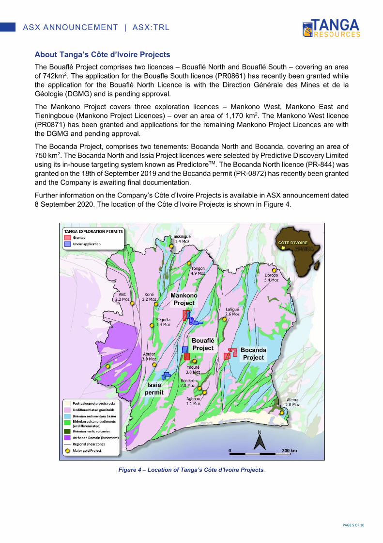
About Tanga’s Côte d’Ivoire Projects
The Bouaflé Project comprises two licences – Bouaflé North and Bouaflé South – covering an area
of 742km2. The application for the Bouafle South licence (PR0861) has recently been granted while
the application for the Bouaflé North Licence is with the Direction Générale des Mines et de la
Géologie (DGMG) and is pending approval.
The Mankono Project covers three exploration licences – Mankono West, Mankono East and
Tieningboue (Mankono Project Licences) – over an area of 1,170 km2. The Mankono West licence
(PR0871) has been granted and applications for the remaining Mankono Project Licences are with
the DGMG and pending approval.
The Bocanda Project, comprises two tenements: Bocanda North and Bocanda, covering an area of
750 km2. The Bocanda North and Issia Project licences were selected by Predictive Discovery Limited
using its in-house targeting system known as PredictoreTM. The Bocanda North licence (PR-844) was
granted on the 18th of September 2019 and the Bocanda permit (PR-0872) has recently been granted
and the Company is awaiting final documentation.
Further information on the Company’s Côte d’Ivoire Projects is available in ASX announcement dated
8 September 2020. The location of the Côte d’Ivoire Projects is shown in Figure 4.
Figure 4 – Location of Tanga’s Côte d’Ivoire Projects.

TORRENSMINING.COM PAGE 6 OF 10
Appendix 1. JORC Table 1 Reporting
Section 1 Sampling Techniques and Data
Criteria JORC Code explanation Commentary
Sampling techniques
Nature and quality of sampling (eg cut channels, random chips, or specific specialised industry standard measurement tools appropriate to the minerals under investigation, such as down hole gamma sondes, or handheld XRF instruments, etc). These examples should not be taken as limiting the broad meaning of sampling.
Include reference to measures taken to ensure sample representivity and the appropriate calibration of any measurement tools or systems used.
Aspects of the determination of mineralisation that are Material to the Public Report.
In cases where ‘industry standard’ work has been done this would be relatively simple (eg ‘reverse circulation drilling was used to obtain 1 m samples from which 3 kg was pulverised to produce a 30 g charge for fire assay’). In other cases, more explanation may be required, such as where there is coarse gold that has inherent sampling problems. Unusual commodities or mineralisation types (eg submarine nodules) may warrant disclosure of detailed information.
Termite mounds targets are of “cathedral type”, measuring from about 1m high to over 6m high. A predefined sampling grid at 400m is used as support in the field.
Sampler teams adjust the position from the selected mound (visually the tallest near the set sampling point). The new coordinates are recorded.
The mound is sampled from the top to its middle height with a geopick. 1.5 to 2.5 kg of sample are collected and stored in a plastic bag.
Mound height, sample color, texture, date, sampler, environment type, topographic slope, regolith type and any relevant comments are written down on sampling sheets.
Field duplicates taken every 20 samples; CRMs or blank material inserted every 20 samples.
Samples despatched to the Bureau Veritas laboratory in Abidjan.
Sample preparation includes drying entire sample, crushing to 70% passing 2mm, riffle splitting and pulverizing 1kg to 85% passing 75µm.
Analysis of gold is by fire assay using a 50g charge with analysis by AAS finish yielding a detection limit of 2 parts per billion (ppb).
Drilling techniques
Drill type (eg core, reverse circulation, open-hole hammer, rotary air blast, auger, Bangka, sonic, etc) and details (eg core diameter, triple or standard tube, depth of diamond tails, face-sampling bit or other type, whether core is oriented and if so, by what method, etc).
Not applicable, no drilling was conducted.
Drill sample recovery
Method of recording and assessing core and chip sample recoveries and results assessed.
Measures taken to maximise sample recovery and ensure representative nature of the samples.
Whether a relationship exists between sample recovery and grade and whether sample bias may have occurred due to preferential loss/gain of fine/coarse material.
Not applicable to soil surveys.
Logging Whether core and chip samples have been geologically and geotechnically logged to a level of detail to support appropriate Mineral Resource estimation, mining studies and metallurgical studies.
Whether logging is qualitative or quantitative in nature. Core (or costean, channel, etc) photography.
Not applicable, no drilling was conducted.

TORRENSMINING.COM PAGE 7 OF 10
Criteria JORC Code explanation Commentary
The total length and percentage of the relevant intersections logged.
Sub-sampling techniques and sample preparation
If core, whether cut or sawn and whether quarter, half or all core taken.
If non-core, whether riffled, tube sampled, rotary split, etc and whether sampled wet or dry.
For all sample types, the nature, quality and appropriateness of the sample preparation technique.
Quality control procedures adopted for all sub-sampling stages to maximise representivity of samples.
Measures taken to ensure that the sampling is representative of the in situ material collected, including for instance results for field duplicate/second-half sampling.
Whether sample sizes are appropriate to the grain size of the material being sampled.
Field duplicates taken every 20 samples; CRMs or blank material inserted every 20 samples.
Quality of assay data and laboratory tests
The nature, quality and appropriateness of the assaying and laboratory procedures used and whether the technique is considered partial or total.
For geophysical tools, spectrometers, handheld XRF instruments, etc, the parameters used in determining the analysis including instrument make and model, reading times, calibrations factors applied and their derivation, etc.
Nature of quality control procedures adopted (eg standards, blanks, duplicates, external laboratory checks) and whether acceptable levels of accuracy (ie lack of bias) and precision have been established.
Samples despatched to the Bureau Veritas laboratory in Abidjan.
Sample preparation includes drying entire sample, crushing to 70% passing 2mm, riffle splitting and pulverizing 1kg to 85% passing 75µm.
Analysis of gold is by fire assay using a 50g charge with analysis by AAS finish yielding a detection limit of 2 parts per billion (ppb).
Verification of sampling and assaying
The verification of significant intersections by either independent or alternative company personnel.
The use of twinned holes. Documentation of primary data, data entry
procedures, data verification, data storage (physical and electronic) protocols.
Discuss any adjustment to assay data.
All field data is manually collected, entered into excel spreadsheets, validated and loaded into a database.
Electronic data is stored on a cloud server and routinely backed up.
Data is exported from the database for processing in a number of software packages.
Location of data points
Accuracy and quality of surveys used to locate drill holes (collar and down-hole surveys), trenches, mine workings and other locations used in Mineral Resource estimation.
Specification of the grid system used. Quality and adequacy of topographic control.
All termite mound samples Eastings, Northings and Elevations are located using a handheld GPS in the WGS84 Zone 30N grid system.
Data spacing and distribution
Data spacing for reporting of Exploration Results.
Whether the data spacing and distribution is sufficient to establish the degree of geological and grade continuity appropriate for the Mineral Resource and Ore Reserve estimation procedure(s) and classifications applied.
Samples are taken on an approximate 400m spaced grid; spacing variations depend on the exact location of the mounds sampled in the field. Soils are not used for Resource Estimation purposes.

TORRENSMINING.COM PAGE 8 OF 10
Criteria JORC Code explanation Commentary
Whether sample compositing has been applied.
Orientation of data in relation to geological structure
Whether the orientation of sampling achieves unbiased sampling of possible structures and the extent to which this is known, considering the deposit type.
If the relationship between the drilling orientation and the orientation of key mineralised structures is considered to have introduced a sampling bias, this should be assessed and reported if material.
Sampling is conducted on a fixed grid designed to achieve uniform coverage over the geological features of interest. As such, sampling is considered unbiased by the grid orientation.
Sample security
The measures taken to ensure sample security.
Pre-printed sampling books with individual tickets ensure unique sample numbers used.
Sample ID written on bag and tickets inserted.
Sampling is supervised by a company geologist and all samples are delivered to the laboratory in Abidjan by company staff.
Audits or reviews
The results of any audits or reviews of sampling techniques and data.
No reviews or audits have been conducted.
Section 2 Reporting of Exploration Results (Criteria listed in the preceding section also apply to this section.)
Criteria JORC Code explanation Commentary
Mineral tenement and land tenure status
Type, reference name/number, location and ownership including agreements or material issues with third parties such as joint ventures, partnerships, overriding royalties, native title interests, historical sites, wilderness or national park and environmental settings.
The security of the tenure held at the time of reporting along with any known impediments to obtaining a licence to operate in the area.
The Bocanda licence is granted under the unique ID PR0872 and is held under Moaye Resources which is a local subsidiary of West African Venture Investments.
The Bouaflé Sud licence is granted under the unique ID PR861. The licence and the other permit application which makes the Bouaflé Project are respectively held under Rampage Resources which is a local subsidiary of West African Venture Investments.
The Mankono Ouest licence is granted under the unique ID PR871. The licence and the other permit application of Mankono Est are held under Moaye Resources which is a local subsidiary of West African Venture Investments.
The Tieningboue permit application and Bocanda Nord licence (granted under the unique ID PR844) are held under Ivoirian Resources which is a local subsidiary of Predictive Discovery.
Further details of the joint ventures can be found in the ASX announcement of September 8th 2020.
All granted tenements are in good standing and there are no material issues

TORRENSMINING.COM PAGE 9 OF 10
Criteria JORC Code explanation Commentary
affecting the tenements.
Exploration done by other parties
Acknowledgment and appraisal of exploration by other parties.
Work completed prior to Tanga Resources includes soils sampling, aircore drilling and diamond drilling, completed by Newcrest Mining Limited under their in-country subsidiary Equigold. This, on both the Mankono Ouest and the Bouaflé Sud licences.
Geology Deposit type, geological setting and style of mineralisation.
The gold mineralisation on the Côte d’Ivoire Projects generally fits the Orogenic hosted Gold deposit model as applied to the Birimian systems of West Africa.
Drill hole Information
A summary of all information material to the understanding of the exploration results including a tabulation of the following information for all Material drill holes: o easting and northing of the drill hole
collar o elevation or RL (Reduced Level –
elevation above sea level in metres) of the drill hole collar
o dip and azimuth of the hole o down hole length and interception depth o hole length.
If the exclusion of this information is justified on the basis that the information is not Material and this exclusion does not detract from the understanding of the report, the Competent Person should clearly explain why this is the case.
Not applicable, no drilling conducted.
Data aggregation methods
In reporting Exploration Results, weighting averaging techniques, maximum and/or minimum grade truncations (eg cutting of high grades) and cut-off grades are usually Material and should be stated.
Where aggregate intercepts incorporate short lengths of high-grade results and longer lengths of low-grade results, the procedure used for such aggregation should be stated and some typical examples of such aggregations should be shown in detail.
The assumptions used for any reporting of metal equivalent values should be clearly stated.
Not applicable for this type of sampling.
Relationship between mineralisation widths and intercept lengths
These relationships are particularly important in the reporting of Exploration Results.
If the geometry of the mineralisation with respect to the drill hole angle is known, its nature should be reported.
If it is not known and only the down hole lengths are reported, there should be a clear statement to this effect (eg ‘down hole length, true width not known’).
Not applicable for this type of sampling.

TORRENSMINING.COM PAGE 10 OF 10
Criteria JORC Code explanation Commentary
Diagrams Appropriate maps and sections (with scales) and tabulations of intercepts should be included for any significant discovery being reported These should include, but not be limited to a plan view of drill hole collar locations and appropriate sectional views.
Plan view maps of all soil results are included.
Balanced reporting
Where comprehensive reporting of all Exploration Results is not practicable, representative reporting of both low and high grades and/or widths should be practiced to avoid misleading reporting of Exploration Results.
All samples with assays have been reported.
Other substantive exploration data
Other exploration data, if meaningful and material, should be reported including (but not limited to): geological observations; geophysical survey results; geochemical survey results; bulk samples – size and method of treatment; metallurgical test results; bulk density, groundwater, geotechnical and rock characteristics; potential deleterious or contaminating substances.
No other exploration data is being reported at this time.
Further work The nature and scale of planned further work (eg tests for lateral extensions or depth extensions or large-scale step-out drilling).
Diagrams clearly highlighting the areas of possible extensions, including the main geological interpretations and future drilling areas, provided this information is not commercially sensitive.
Refer to the text in the announcement for information on follow-up and/or next work programs.