CT DEEP IWRD Application Dam Construction Permit
27
www.geiconsultants.com GEI Consultants, Inc. 455 Winding Brook Drive, Suite 201, Glastonbury, Connecticut 06033 860.368.5300 fax: 860.368.5307 CT DEEP IWRD Application Dam Construction Permit Town of East Hartford Flood Control System Toe Drain Replacement Phase 1 March 2019 Application Documents Submitted • Permit Application Transmittal Form • Certification of Notice Form-Notice of Application (to be submitted separately after application) • Permit Application for Programs Administered by the IWRD (Type of Permit- Dam Construction) Attachment A: Executive Summary Attachment B: USGS Quad Map Attachment C: Doc. Form Inland Wetlands, SCEL, etc.- Not Applicable Attachment D: Doc. Form for Water Diversion Permit - Not Applicable Attachment E: Documentation Form for a Dam Construction Permit Attachment F: Doc. Form for Flood Management Cert. - Not Applicable Attachment G: Plan Sheets and Drawings Attachment H: Engineering Documentation Part 1 Engineering Report Checklist and Engineering Report Part 2 Hydrologic and Hydraulic Consistency Worksheet Attachment I: Flood Contingency Plan Attachment J: Soil Scientist Report - Not Applicable Attachment K: Environmental Report - Not Applicable Attachment L: Mitigation Report - Not Applicable Attachment M: Alternatives Analysis Attachment N: Applicant Compliance Form Attachment O: Applicant Background Information Attachment Q: Other Information (Dam Safety Permit DS-200900926 & NDDB NOD 201901835) H:\TECH\project\East Hartford\2019 Projects\Phase 1 Toe Drain Dam Safety Permit\1. Dam Constr Permit\1. Transmittal & Notice Form\Permit Outline Dam Constr East Hartford Toe Drain.docx Consulting Engineers and Scientists
Transcript of CT DEEP IWRD Application Dam Construction Permit

www.geiconsultants.com GEI Consultants, Inc. 455 Winding Brook Drive, Suite 201, Glastonbury, Connecticut 06033
860.368.5300 fax: 860.368.5307
CT DEEP IWRD Application
Dam Construction Permit
Town of East Hartford Flood Control System
Toe Drain Replacement Phase 1
March 2019
Application Documents Submitted
• Permit Application Transmittal Form
• Certification of Notice Form-Notice of Application (to be submitted
separately after application)
• Permit Application for Programs Administered by the IWRD (Type of
Permit- Dam Construction)
Attachment A: Executive Summary
Attachment B: USGS Quad Map
Attachment C: Doc. Form Inland Wetlands, SCEL, etc.- Not Applicable
Attachment D: Doc. Form for Water Diversion Permit - Not Applicable
Attachment E: Documentation Form for a Dam Construction Permit
Attachment F: Doc. Form for Flood Management Cert. - Not Applicable
Attachment G: Plan Sheets and Drawings
Attachment H: Engineering Documentation
Part 1 Engineering Report Checklist and Engineering Report
Part 2 Hydrologic and Hydraulic Consistency Worksheet
Attachment I: Flood Contingency Plan
Attachment J: Soil Scientist Report - Not Applicable
Attachment K: Environmental Report - Not Applicable
Attachment L: Mitigation Report - Not Applicable
Attachment M: Alternatives Analysis
Attachment N: Applicant Compliance Form
Attachment O: Applicant Background Information
Attachment Q: Other Information (Dam Safety Permit DS-200900926
& NDDB NOD 201901835) H:\TECH\project\East Hartford\2019 Projects\Phase 1 Toe Drain Dam Safety Permit\1. Dam Constr Permit\1. Transmittal & Notice Form\Permit Outline Dam Constr East Hartford
Toe Drain.docx
Consulting
Engineers and
Scientists

DEEP-APP-001 1 of 5 Rev. 07/24/18
Permit Application Transmittal Form
Please complete this transmittal form in accordance with the instructions in order to ensure the proper handling of your application(s) and the associated fee(s). Print legibly or type.
Part I: Applicant Information:
• *If an applicant is a corporation, limited liability company, limited partnership, limited liability partnership, or a statutory trust, it must be registered with the Secretary of State. If applicable, applicant’s name shall be stated
exactly as it is registered with the Secretary of State.
• If an applicant is an individual, provide the legal name (include suffix) in the following format: First Name; Middle Initial; Last Name; Suffix (Jr, Sr., II, III, etc.).
Applicant: Town of East Hartford
Mailing Address: 740 Main Street
City/Town: East Hartford State: CT Zip Code: 06108
Business Phone: 860-291-7383 ext.:
Contact Person: Douglas Wilson Phone: 860-291-7383 ext.
E-Mail: [email protected]
Applicant (check one): individual *business entity federal agency state agency municipality tribal
*If a business entity, list type (e.g., corporation, limited partnership, etc.):
Check if any co-applicants. If so, attach additional sheet(s) with the required information as supplied above.
Please provide the following information to be used for billing purposes only, if different:
Company/Individual Name:
Mailing Address:
City/Town: State: Zip Code:
Contact Person: Phone: ext.
Part II: Project Information
Brief Description of Project: (Example: Development of a 50 slip marina on Long Island Sound)
Replacement of existing levee toe drain system within the Town of East Hartford flood control system. New toe
drain will replace 2,500 +/-ft. of existing toe drain system within the footprint of existing toe drain system.
Location (City/Town): East Hartford
Other Project Related Permits (not included with this form):
Permit
Description
Issuing
Authority
Submittal
Date
Issuance
Date
Denial
Date Permit #
N/A
N/A
CPPU USE ONLY
App #:________________________________
Doc #:________________________________
Check #:______________________________
______________________________________
DEEP-APP-001 2 of 5 Rev. 07/24/18
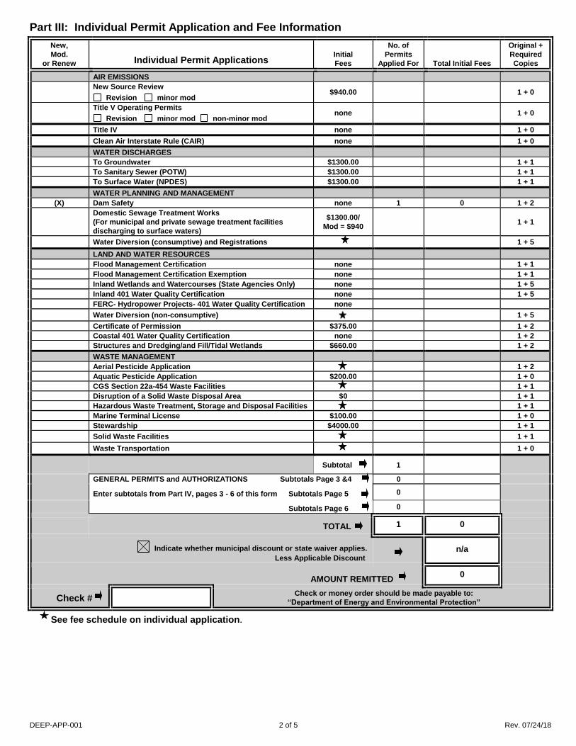
Part III: Individual Permit Application and Fee Information
New,
Mod.
or Renew
Individual Permit Applications
Initial
Fees
No. of
Permits
Applied For
Total Initial Fees
Original +
Required
Copies
AIR EMISSIONS
New Source Review
Revision minor mod $940.00 1 + 0
Title V Operating Permits
Revision minor mod non-minor mod none 1 + 0
Title IV none 1 + 0
Clean Air Interstate Rule (CAIR) none 1 + 0
WATER DISCHARGES
To Groundwater $1300.00 1 + 1
To Sanitary Sewer (POTW) $1300.00 1 + 1
To Surface Water (NPDES) $1300.00 1 + 1
WATER PLANNING AND MANAGEMENT
(X) Dam Safety none 1 0 1 + 2
Domestic Sewage Treatment Works
(For municipal and private sewage treatment facilities
discharging to surface waters)
$1300.00/
Mod = $940 1 + 1
Water Diversion (consumptive) and Registrations 1 + 5
LAND AND WATER RESOURCES
Flood Management Certification none 1 + 1
Flood Management Certification Exemption none 1 + 1
Inland Wetlands and Watercourses (State Agencies Only) none 1 + 5
Inland 401 Water Quality Certification none 1 + 5
FERC- Hydropower Projects- 401 Water Quality Certification none
Water Diversion (non-consumptive) 1 + 5
Certificate of Permission $375.00 1 + 2
Coastal 401 Water Quality Certification none 1 + 2
Structures and Dredging/and Fill/Tidal Wetlands $660.00 1 + 2
WASTE MANAGEMENT
Aerial Pesticide Application 1 + 2
Aquatic Pesticide Application $200.00 1 + 0
CGS Section 22a-454 Waste Facilities 1 + 1
Disruption of a Solid Waste Disposal Area $0 1 + 1
Hazardous Waste Treatment, Storage and Disposal Facilities 1 + 1
Marine Terminal License $100.00 1 + 0
Stewardship $4000.00 1 + 1
Solid Waste Facilities 1 + 1
Waste Transportation 1 + 0
Subtotal 1
GENERAL PERMITS and AUTHORIZATIONS Subtotals Page 3 &4
Enter subtotals from Part IV, pages 3 - 6 of this form Subtotals Page 5
Subtotals Page 6
0
0
0
TOTAL 1 0
Indicate whether municipal discount or state waiver applies.
Less Applicable Discount
n/a
AMOUNT REMITTED 0
Check # Check or money order should be made payable to:
“Department of Energy and Environmental Protection”
See fee schedule on individual application.

DEEP-APP-001 3 of 5 Rev. 07/24/18
Part IV: General Permit Registrations and Requests for Other Authorizations
Application and Fee Information
✓ General Permits and Other Authorizations Initial
Fees
No. of
Permits
Applied For
Total Initial Fees
Original +
Required
Copies
AIR EMISSIONS
Limit Potential to Emit from Major Stationary Sources of Air Pollution $2760.00 1 + 0
Diagnostic and Therapeutic X-Ray Devices (Medical X-Ray) Registration $190.00/Xray
device 1 + 0
Radioactive Materials and Industrial Device Registration (Ionizing
Radiation) $200.00 1 + 0
Emergency/Temporary Authorization
License Revocation Request $0
Other, (please specify):
WATER DISCHARGES
Categorical Industry User to a POTW
Discharges > 10,000 gpd
Discharges < 10,0000 gpd
$6250.00
$3125.00
1 + 0
Comprehensive Discharges to Surface Water and Groundwater
Registration Only
Approval of Registration by DEEP
$625.00
$1250.00
1 + 0
Domestic Sewage $625.00 1 + 0
Food Service Establishment Wastewater No Registration
Groundwater Remediation Wastewater
Registration Only
Approval of Registration by DEEP
$625.00
$1250.00
1 + 0
Miscellaneous Discharges of Sewer Compatible Wastewater
Registration Only
Approval of Registration by DEEP
$500.00
$1000.00
1 + 0
Nitrogen Discharges No Registration
Point Source Discharges from Application of Pesticides $200.00 1 + 0
Stormwater Associated with Commercial Activities $300.00 1 + 0
Stormwater Associated with Industrial Activities
No Exposure Certification
<50 employees–see general permit for additional requirements
>50 employees–see general permit for additional requirements
$250.00
$500.00
$1000.00
1 + 0
Stormwater & Dewatering Wastewaters-Construction Activities 1 + 0
Stormwater from Small Municipal Separate Storm Sewer Systems
(MS4) $625.00 1 + 0
Stormwater from DOT Separate Storm Sewer Systems (DOT MS4) $0 1 + 0
Subsurface Sewage Disposal Systems Serving Existing Facilities 1 + 0
Swimming Pool Wastewater - Public Pools and Contractors $500.00 1 + 0
Vehicle Maintenance Wastewater
Registration Only
Approval of Registration by DEEP
$625.00
$1250.00
1 + 0
Emergency/Temporary Authorization - Discharge to POTW $1500.00 1 + 0
Emergency/Temporary Authorization - Discharge to Surface Water $1500.00 1 + 0
Emergency/Temporary Authorization - Discharge to Groundwater $1500.00 1 + 0
Other, (please specify):
Note: Carry subtotals over to Part III, page 2 of this form. Subtotal
See fee schedule on registration/application. Contact the specific permit program for this information.
(Contact numbers are provided in the instructions)

DEEP-APP-001 4 of 5 Rev. 07/24/18
Part IV: General Permit Registrations and Requests for Other Authorizations (continued)
✓ General Permits and Other Authorizations Initial
Fees
No. of
Permits
Applied For
Total Initial Fee
Original +
Required
Copies
AQUIFER PROTECTION PROGRAM
Registration for Regulated Activities $625.00 1 + 0
Permit Application to Add a Regulated Activity $1250.00 1 + 0
Exemption Application from Registration $1250.00 1 + 0
WATER PLANNING AND MANAGEMENT
Dam Safety Repair and Alteration: Non Filing No Registration
Dam Safety Repair and Alteration: Filing – No PE $100.00 1 + 0
Dam Safety Repair and Alteration: Filing – PE $200.00 1 + 0
Dam Safety Repair and Alteration: Approval of Filing $250.00 1 + 0
Diversion of Remediation Groundwater No Registration
Diversion of Water for Consumptive Use: Reauthorization Categories $2500.00 1 + 0
Diversion of Water for Consumptive Use: Authorization Required $2500.00 1 + 4
Diversion of Water for Consumptive Use: Filing Only $1500.00 1 + 1
Water Resource Construction Activities 1 +0
Emergency/Temporary Authorization
Notice of High Hazard Dam or a Significant Hazard Dam $0 1 +0
Other, (please specify):
LAND AND WATER RESOURCES
Minor Coastal Structures
4/40 Docks/Access Stairs $700.00 1 + 1
Beach Grading No Registration
Buoys or Markers No Registration
Experimental Activities/Scientific Monitoring Devices No Registration
Harbor Moorings No Registration
Non-harbor Moorings $250.00 1 + 1
Osprey Platforms and Perch Poles No Registration
Pump-out Facilities No Registration
Swim Floats No Registration
Coastal Maintenance
Backflow Prevention Structure No Registration
Beach Grading/Raking No Registration
Catch Basin Cleaning No Registration
Coastal Remedial Activities Required by Order $700.00 1 + 1
Coastal Restoration No Registration
DEEP Boat Launch Infrastructures No Registration
DOT Infrastructures No Registration
Marina and Mooring Field Reconfiguration $700.00 1 + 1
Minor Seawall Repair No Registration
Placement of Cultch No Registration
Reconstruction of Legally Existing
Structure/Obstruction/Encroachment
$300.00 1 + 1
Removal of Derelict Structures No Registration
Residential Flood Hazard Mitigation $100.00 1 + 1
Temporary Access of Construction Vehicles/Equipment No Registration
Programmatic General Permit 1 + 1
Emergency/Temporary Authorization
Other, (please specify):
Note: Carry subtotals over to Part III, page 2 of this form. Subtotal
See fee schedule on registration/application. Contact the specific permit program for this information.
(Contact numbers are provided in the instructions)

DEEP-APP-001 5 of 5 Rev. 07/24/18
Part IV: General Permit Registrations and Requests for Other Authorizations (continued)
✓ General Permits and Other Authorizations Initial
Fees
No. of
Permits
Applied For
Total Initial Fee
Original +
Required
Copies
WASTE MANAGEMENT
Addition of Grass Clippings at Registered Leaf Composting Facilities $500.00 1 + 0
Beneficial Use Determination 1 + 0
Collection and Storage of Post Consumer Paint $0 1 + 0
Connecticut Solid Waste Demonstration Project $1000.00 1 + 0
Construct and Operate a Commercial Facility for the Management of
Recyclable Materials and Certain Solid Wastes (Commercial GP) Initial/Mod Fee
Asbestos Containing Materials $1,250.00/$ 625 1 + 0
Ash Residue $1,250.00/$ 625 1 + 0
Clean Wood: Tier III $500.00/$250 1 + 0
Clean Wood: Tier II $250.00/$125 1 + 0
Construction and Demolition Waste: Tier III $1,250.00/$625 1 + 0
Construction and Demolition Waste: Tier II $500.00/$250 1 + 0
Non-RCRA Hazardous Waste/Compatible Solid Wastes $1,250.00/$625 1 + 0
Recyclables $500.00/$250 1 + 0
Universal Wastes/Compatible Solid Wastes $1,250.00/$625 1 + 0
Contaminated Soil and/or Staging Management (Staging/Transfer)
New Registrations
New Approval of Registrations
Renewal of Registrations
Renewal of Approval of Registrations
$250.00
$1500.00
$250.00
$750.00
1 + 0
1 + 0
1 + 0
1 + 0
Disassembling Used Electronics $2000.00 1 + 0
Leaf Composting Facility $0 1 + 1
Municipal Transfer Station $800.00 1 + 1
One Day Collection of Certain Wastes and Household Hazardous
Waste $1000.00 1 + 0
Sheet Leaf Composting Notification $0
Special Waste Authorization
Landfill or RRF Disposal
Asbestos Disposal
homeowner
$660.00
$300.00
$0
1 + 0
Storage and Processing of Asphalt Roofing Shingle Waste $2500.00 1 + 0
Storage and Processing of Scrap Tires for Beneficial Use $1250.00 1 + 0
Emergency/Temporary Authorization
Other, (please specify):
REMEDIATION
In Situ Groundwater Remediation: Enhance Aerobic Biodegradation 1 + 2
In Situ Groundwater Remediation: Chemical Oxidation $500.00 1 + 0
Emergency/Temporary Authorization
Note: Carry subtotals over to Part III, page 2 of this form. Subtotal
See fee schedule on registration/application. Contact the specific permit program for this information.
(Contact numbers are provided in the instructions)
Affirmative Action, Equal Employment Opportunity and Americans with Disabilities
The Connecticut Department of Energy and Environmental Protection is an Affirmative Action/Equal Opportunity Employer that is committed to complying with the requirements of the Americans with Disabilities Act (ADA). Please contact us at (860) 418-5910 or [email protected] if you: have a disability and need a communication aid or service; have limited proficiency in English and may need information in another language; or if you wish to file an ADA or Title VI discrimination complaint.

DEP-IWRD-APP-100 1 of 6 Rev. 10/01/09
Permit Application for Programs Administered
by the Inland Water Resources Division
Please complete this application form in accordance with the instructions (DEP-IWRD-INST-100) in order to ensure the proper handling of your application. Print or type unless otherwise noted. You must submit the Permit Application Transmittal Form (DEP-APP-001) and the initial fee along with this form.
Part I: Application Type
Check the appropriate box identifying the application type.
This application is for (check one):
A new application
A renewal of an existing permit
A modification of an existing permit
Please identify any previous or existing permit/authorization/registration number in the space provided.
Existing permit/authorization/registration number:
Expiration Date:
Part II: Permit Type and Fee Information
Please note: effective August 21, 2003, the application fees for the programs administered by the Inland Water Resources Division have increased as listed in the following table. The fee for municipalities is 50% of the listed rates.
Type of Permit (check all that apply):
Inland Wetlands & Watercourses CGS Sec. 22a-36 et seq.
Dam Construction CGS Sec. 22a-403
401 Water Quality Certificate 33 U.S.C. 1341
Flood Management Certification CGS Sec. 25-68(b) - (h)
Stream Channel Encroachment CGS Sec. 22a-342
No change in grade and no construction of above-ground structures A change in grade and no construction of above-ground structures A change in grade and above-ground structures or buildings
Water Diversion: Consumptive Use CGS Sec. 22a-372(e)
Withdrawal > 0.05 and < 0.5 mgd Withdrawal > 0.5 and < 2.0 mgd Withdrawal > 2.0 mgd
Water Diversion: Nonconsumptive Use CGS Sec. 22a-372(e)
Watershed < 0.5 sq mi Watershed > 0.5 sq mi and < 2.0 sq mi Watershed > 2.0 sq mi
Fee to submit with application:
none
none
none
none
$470.00 $940.00
$4,000.00
$2,050.00 $4,000.00 $6,250.00
$2,050.00 $4,000.00 $6,250.00
DEP USE ONLY
DEP-IWRD-APP-100 2 of 6 Rev. 10/01/09
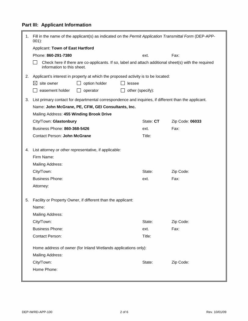
Part III: Applicant Information
1. Fill in the name of the applicant(s) as indicated on the Permit Application Transmittal Form (DEP-APP-001):
Applicant: Town of East Hartford
Phone: 860-291-7380 ext. Fax:
Check here if there are co-applicants. If so, label and attach additional sheet(s) with the required information to this sheet.
2. Applicant's interest in property at which the proposed activity is to be located:
site owner option holder lessee
easement holder operator other (specify): 3. List primary contact for departmental correspondence and inquiries, if different than the applicant.
Name: John McGrane, PE, CFM, GEI Consultants, Inc.
Mailing Address: 455 Winding Brook Drive
City/Town: Glastonbury State: CT Zip Code: 06033
Business Phone: 860-368-5426 ext. Fax:
Contact Person: John McGrane Title:
4. List attorney or other representative, if applicable:
Firm Name:
Mailing Address:
City/Town: State: Zip Code:
Business Phone: ext. Fax:
Attorney:
5. Facility or Property Owner, if different than the applicant:
Name:
Mailing Address:
City/Town: State: Zip Code:
Business Phone: ext. Fax:
Contact Person: Title:
Home address of owner (for Inland Wetlands applications only):
Mailing Address:
City/Town: State: Zip Code:
Home Phone:

DEP-IWRD-APP-100 3 of 6 Rev. 10/01/09
Part III: Applicant Information (continued)
6. List any engineer(s) or other consultant(s) employed or retained to assist in preparing the application or in designing or constructing the activity. Check here if additional sheets are necessary, and label and attach them to this sheet.
Name: GEI Consultants, Inc.
Mailing Address: 455 Winding Brook Drive
City/Town: Glastonbury State: CT Zip Code: 06033
Business Phone: 860-368-5426 ext. Fax:
Contact Person: John McGrane, PE, CFM Title: Sr. Consultant
Service Provided: Project designer
Part IV: Site Information
1. Site Location:
a. Name of facility, if applicable: East Hartford Flood Control System
Street Address or Description of Location: 211 & 301 East River Drive
City/Town: East Hartford State: CT Zip Code: 06108
Project No., if applicable:
b. Tax Assessor's Reference: Map 1 Block na Lot 2&3
(Assessor's reference is not required if requester is an agency of the State of Connecticut.)
c. Latitude and Longitude of the approximate "center of the site" in degrees, minutes, and seconds:
Latitude: 41.765 Longitude: -72.664
Method of determination (check one):
GPS USGS Map Other (please specify): CT ECO Mapping
If a USGS Map was used, provide the quadrangle name:
d. Drainage Basin number(s) wherein the proposed activity will take place: 4000-00-6+ R7
e. Flood Insurance Rate Map Panel Number: 09003C0368G
Date of the map referenced: 9/16/2011
f. If applying for a SCEL permit, identify the property wherein the proposed activity will take place by indicating the following:
SCEL Map number(s):
Property Identifier:
Date of the map referenced:
2. COASTAL BOUNDARY: Is the activity which is the subject of this application located within the coastal boundary as delineated on DEP approved coastal boundary maps? Yes No
If yes, and this application is for a new permit or for a modification of an existing permit, you must submit a Coastal Consistency Review Form (DEP-APP-004) with your application as Attachment P.
Information on the coastal boundary is available at the local town hall or on the “Coastal Boundary Map” available at DEP Maps and Publications (860-424-3555).

DEP-IWRD-APP-100 4 of 6 Rev. 10/01/09
Part IV: Site Information (continued)
3. ENDANGERED OR THREATENED SPECIES: Is the project site located within an area identified as a habitat for endangered, threatened or special concern species as identified on the "State and Federal Listed
Species and Natural Communities Map"? Yes No Date of Map: December 2018
If yes, complete and submit a Connecticut Natural Diversity Data Base (CT NDDB) Review Request Form
(DEP-APP-007) to the address specified on the form. Please note NDDB review generally takes 4 to 6
weeks and may require additional documentation from the applicant. DEP strongly recommends
that applicants complete this process before submitting the subject application.
When submitting this application form, include copies of any correspondence to and from the NDDB, including copies of the completed CT NDDB Review Request Form, as Attachment K (Environmental Report) or in Attachment Q if no environmental report is required.
For more information visit the DEP website at www.ct.gov/dep/endangeredspecies (Review/Data Requests) or call the NDDB at 860-424-3011.
4. AQUIFER PROTECTION AREAS: Is the site located within a town required to establish Aquifer Protection Areas, as defined in section 22a-354a through 354bb of the General Statutes (CGS)?
Yes No
If yes, is the site within an area identified on a Level A or Level B map? Yes No
To view the applicable list of towns and maps visit the DEP website at www.ct.gov/dep/aquiferprotection
To speak with someone about the Aquifer Protection Areas, call 860-424-3020.
5. CONSERVATION OR PRESERVATION RESTRICTION: Is the property subject to a conservation or preservation restriction? Yes No
If Yes, proof of written notice of this application to the holder of such restriction or a letter from the holder of such restriction verifying that this application is in compliance with the terms of the restriction, must be submitted as Attachment Q.
6. Other Permits: List any previous federal, state or local permits or certificates that have already been issued for the site or for the proposed activity:
Type or Nature of Permit Permit No. Issuing Authority Date Issued Expiration Date Permittee Name
CT DEEP Dam Safety 200900926 2010 2012 Town E. Hartford
USACE NAE2008-1144 2013 n/a Town E. Hartford
P&Z n/a 2009 n/a Town E. Hartford
Part V: Supporting Documents
Please check the attachments submitted as verification that all applicable attachments have been submitted with this application form. When submitting any supporting documents, please label the documents as indicated in this part (e.g., Attachment A, etc.) and be sure to include the applicant's name as indicated on the Permit Application Transmittal Form. The specific information required in each attachment is described in the Instructions for Completing A Permit Application for Inland Water Resources Division Activities (DEP-IWRD-INST-100).
Attachment A: Executive Summary
Attachment B: An 8 1/2" x 11" copy of a United States Geological Survey (USGS) Topographic Quadrangle Map (scale: 1:24,000) with the regulated activity or project site outlined or pinpointed, as appropriate.
Attachment C: Documentation Form for: Inland Wetlands and Watercourses Permit, Stream Channel
Encroachment Line Permit, and 401 Water Quality Certification (DEP-IWRD-APP-101)

DEP-IWRD-APP-100 5 of 6 Rev. 10/01/09
Part V: Supporting Documents (continued)
Attachment D: Documentation Form for Water Diversion Permit (DEP-IWRD-APP-102)
Attachment E: Documentation Form for a Dam Construction Permit (DEP-IWRD-APP-103)
Attachment F: Documentation Form for Flood Management Certification (DEP-IWRD-APP-104) (State Agencies Only)
Attachment G: Plan Sheets and Drawings
Attachment H: Engineering Documentation
Part 1: Engineering Report Checklist (DEP-IWRD-APP-105A) and an Engineering Report
Part 2: Hydrologic and Hydraulic Consistency Worksheet (DEP-IWRD-APP-105B)
Section I: Floodplain Management
Section II: Stormwater Management
For state agencies only:
Section III: State Grants and Loans
Section IV: Disposal of State Land
Attachment I: Flood Contingency Plan
Attachment J: Soil Scientist Report (not required for Flood Management Certification)
Attachment K: Environmental Report (not required for Flood Management Certification)
Attachment L: Mitigation Report - wetlands and watercourses, fish and wildlife (not required for Flood
Management Certification)
Attachment M: Alternatives Assessment (not required for Flood Management Certification)
Attachment N: Applicant Compliance Information Form (DEP-APP-002) (not required for Flood Management Certification or 401 Water Quality Certification Approvals)
Attachment O: Applicant Background Information Form (DEP-APP-008) (not required for Flood
Management Certification)
Attachment P: Coastal Consistency Review Form (DEP-APP-004) (if applicable)
Attachment Q: Other Information: any other information the applicant deems relevant or is required by DEP.
Number of Copies of Application:
Submit one original of all application forms, certifications, reports and supporting documents and the number of photocopies of all such materials as noted on the Permit Application Transmittal Form. When applying for more than one permit, you should submit the original and no more than six copies.


Attachment A:
Executive Summary

www.geiconsultants.com GEI Consultants, Inc. 455 Winding Brook Drive, Suite 201, Glastonbury, Connecticut 06033
860.368.5300 fax: 860.368.5307
Attachment A Executive Summary
Town of East Hartford Flood Control System
Toe Drain Replacement Phase 1
IWRD Application
Dam Construction Permit Request
March 2019
The Town of East Hartford is undertaking this project as part of its long-term program to
upgrade and maintain the integrity of its flood control system that was initiated through the
FEMA Levee Accreditation process. The Town has continued with this program to meet
ongoing levee safety compliance standards of the U.S Army Corps of Engineers.
This project involves replacement of and improvement to an existing levee toe drain
system within the Town of East Hartford flood control system between the Bulkeley
Bridge (I-84) on the north and extending southerly to the intersection of East River Drive
and Hartland Street. The new toe drain will replace approximately 2,500 feet of existing
toe drain system essentially within the footprint of existing toe drain system.
The existing Toe Drain for East Hartford Levee system has failed due to deterioration of
the internal pipe system and intrusion of fine sediments into the toe drain system. The new
Toe Drain system will involve installation of new PVC slotted piping and concrete
manholes. The Toe Drains will be in the range of 6 to 10 feet in depth and will be
excavated using standard excavating equipment to remove the old piping and backfill. New
piping and backfill will be installed predominantly within the existing toe drain trench.
Surfaces will be restored in-kind with existing materials, which entirely consist of asphalt
pavement, gravel, and mowed grass surfaces.
The project is on the landward fringe of an NDDB as shown on the December 2018 NDDB
mapping. The Town submitted a request to Ct DEEP for an NDDB determination and
received NDDB Notice of Determination 201901835 which is attached. The
Determination indicated no anticipated negative impacts to State listed species as a result
of the project.
The full extent of the project is within an urbanized area west of East River drive. Land
uses consist of include office and high-rise residential. Existing surface consist of asphalt
pavement, gravel surface under the Riverpoint Condominiums parking deck, and mowed
grassed surface on the levee toe and roadside adjacent to East River Drive.
The work is limited to replacement of an existing Toe Drain system which is on the land
side of the East Hartford Earthen Levee and Concrete Floodwall system. All work is
Consulting
Engineers and
Scientists

Town of East Hartford Flood Control System
Toe Drain Replacement Phase 1
IWRD Application
Dam Construction Permit Request
landward of the levee centerline. The entire footprint of the proposed Toe Drain
replacement is urbanized parking areas, driveways, and roadside areas adjacent to the
levee. The on-site and off-site surface conditions will remain the same as a result of this
project and thus there are no impacts to report.
Based on CT ECO mapping (see attached) and visual observation, there are no identified
wetlands or surface water bodies or watercourses within the project limits or in the in the
vicinity of the project area. The Toe Drain system is designed to collect subsurface water
which will discharge into an existing storm drain system. There are no provisions in the
project to collect surface drainage.
The project area is shown as "Shaded Zone X " meaning that it is protected by an
accredited levee. The Town of East Hartford obtained Levee Accreditation in 2010 and it
remains a currently accredited levee system.
This project was part of a comprehensive levee repair project within the East Hartford
Flood Protection system, which was previously authorized under a CT DEP Dam Safety
Permit in 2010. Although other components of the comprehensive project were
constructed under this Dam Safety Permit, the Toe Drain Replacement portion did not
commence within the permit specified time frame, and thus is the subject of this
application as a stand-alone project. Also, the project did receive several local and federal
authorizations for this project. These permits include the following:
• CT DEEP Dam Safety Permit 200900926 (see copy Attachment Q - Other
Information)
• U.S. Army Corps of Engineers (USACE), Title 33 CFR 208.10 Authorization, as
per permit # NAE-2008-1144 dated July 23, 2008; and including approved
extension letters dated most recently, December 23, 2013.
• Town of East Hartford Zoning Board of Appeals Variance dated June 4, 2009– A
variance from Section 601.10 to permit filling minor amounts of fill within the
floodplain without adding compensatory storage capacity.
Work is scheduled to commence by July 1, 2019 and completed by December 31, 2019.
Appendices to Executive Summary:
Appendix 1: Photos of the project area
Appendix 2: CT ECO map for Poorly or Very Poorly Drained (i.e. Wetlands) Soils
Appendix 3: NDDB Notice of Determination 201901835
H:\TECH\project\East Hartford\2019 Projects\Phase 1 Toe Drain Dam Safety Permit\1. Dam Constr Permit\Attach A Exec Summary\Attach A Exec Summary Doc.docx

Appendix 1:

1
APPENDIX 1
Supplemental Project Information
Photo looking North from southern limit of project. Toe drain replacement
proposed for levee toe area to the left of paved street (East River Drive)

2
Photo looking North. Toe drain replacement proposed for levee toe area
to the left of paved street (East River Drive)

3
Photo looking North. Toe drain replacement proposed for floodwall toe
to right of buttressed concrete floodwall.

4
Photo looking North. Toe drain replacement proposed for floodwall toe to
right of buttressed concrete floodwall (under Riverpoint Condominium deck).

5
Photo looking North (north of Founder Bridge) to northern terminus of project.
Toe drain replacement proposed for levee toe area to left of paved parking area.

Appendix 2:

\\GTB1V-FS01\gis\Projects\EastHartford\Toe Drain Phase I Repairs\Wetland Soils.mxd
WETLAND SOILSTown of East Hartford
Levee Toe Drain System Phase 1 RepairsEast Hartford, Connecticut
Town of East HartfordEast Hartford, Connecticut February 2019 Attachment AProject 124390
ConsultantsConsultants
SITE LOCATION
SOURCE:1. SSURGO USDA NRCS SOILSACCESSED VIA CT DEEP GIS
0 2,000 4,0001,000
SCALE: 1" = 2,000'
LEGEND:Poorly Drained and Very Poorly DrainedSoilsAlluvial and Floodplain Soils

Appendix 3:

79 Elm Street • Hartford, CT 06106-5127 www.ct.gov/deep Affirmative Action/Equal Opportunity Employer
February 8, 2019
John McGrane, PE, CFM GEI Consultants Inc, as agent for Town of East Hartford 455 Winding Brook Drive Glastonbury, CT 06033 jmcgrane@geiconsultants. com Project: Levee toe drain system Phase 1 repairs, East River Drive and Pitkin St, East Hartford, CT NDDB Determination No.: 201901835 Dear Mr. McGrane, I have reviewed Natural Diversity Database (NDDB) maps and files regarding the area of work provided for the proposed levee toe drain system Phase 1 repairs in East Hartford, Connecticut. I do not anticipate negative impacts to State-listed species (RCSA Sec. 26-306) resulting from your proposed activity at the site based upon the information contained within the NDDB. The result of this review does not preclude the possibility that listed species may be encountered on site and that additional action may be necessary to remain in compliance with certain state permits. This determination is good for two years. Please re-submit a new NDDB Request for Review if the scope of work changes or if work has not begun on this project by February 8, 2021. Natural Diversity Data Base information includes all information regarding critical biological resources available to us at the time of the request. This information is a compilation of data collected over the years by the Department of Energy and Environmental Protection’s Natural History Survey, cooperating units of DEEP, landowners, private conservation groups and the scientific community. This information is not necessarily the result of comprehensive or site-specific field investigations. Consultations with the NDDB should not be substitutes for on-site surveys necessary for a thorough environmental impact assessment. Current research projects and new contributors continue to identify additional populations of species and locations of habitats of concern, as well as, enhance existing data. Such new information is incorporated into the database as it becomes available. Please contact me if you have further questions at (860) 424-3378, or [email protected] . Thank you for consulting the Natural Diversity Database. Sincerely, Karen Zyko Environmental Analyst

Attachment B:
USGS Quad Map

Copyright:© 2013 National Geographic Society, i-cubed
\\Gtb1v-fs01\gis\Projects\EastHartford\Toe Drain Phase I Repairs\Site_Location.mxd
SITE LOCATION/OVERVIEWMAP
Town of East HartfordLevee Toe Drain System Phase 1 Repairs
East Hartford, ConnecticutTown of East Hartford
East Hartford, Connecticut February 2019 Attachment AProject 124390ConsultantsConsultants
SITE LOCATION
SOURCE:1. NATIONAL GEOGRAPHIC TOPO!ACCESSED VIAARCGIS ONLINE.COM
0 2,000 4,0001,000
SCALE: 1" = 2,000'