CSE 2009 Geography Answer Key
28
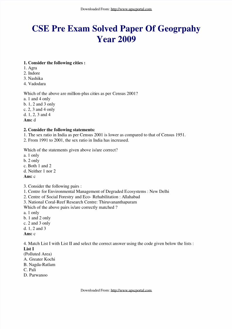
CSE Pre Exam Solved Paper Of Geogrpahy Year 2009 1. Consider the following cities : 1. Agra 2. Indore 3. Nashika 4. Vadodara Which of the above a re mill ion-plus citi es as per Census 2001? a. 1 and 4 only b. 1, 2 and 3 only c. 2, 3 and 4 only d. 1, 2, 3 and 4 Ans: d 2. Consider the following statements : 1. The sex ratio in India as per Census 2001 is lower as compared to that of Census 1951. 2. From 1991 to 2001, the sex ratio in India has increased. Which of the statements given above is/are correct? a. 1 only b. 2 only c. Both 1 and 2 d. Neither 1 nor 2 Ans: c 3. Consider the following pairs : 1. Centre for Environmental Management of Degraded E cosystems : New Delhi 2. Centre of Social F orestry and Eco- Rehabilitation : A llahabad 3. National Coral-Reef Research Centre: Thiruvananthapuram Which of the above pairs is/are correctly matched ? a. 1 only b. 1 and 2 only c. 2 and 3 only d. 1, 2 and 3 Ans: c 4. Match List I with List II and select the correct answer using the code given below the lists : List I (Polluted Area) A. Greater Kochi B. Nagda-Ratlam C. Pali D. Parwanoo Downloaded From: http://www.upscportal.com Downloaded From: http://www.upscportal.com
-
Upload
priya-ranganathan -
Category
Documents
-
view
222 -
download
0
Transcript of CSE 2009 Geography Answer Key
8/8/2019 CSE 2009 Geography Answer Key
http://slidepdf.com/reader/full/cse-2009-geography-answer-key 1/28
CSE Pre Exam Solved Paper Of Geogrpahy
Year 2009
1. Consider the following cities :1. Agra2. Indore3. Nashika4. Vadodara
Which of the above are million-plus cities as per Census 2001?a. 1 and 4 onlyb. 1, 2 and 3 onlyc. 2, 3 and 4 only
d. 1, 2, 3 and 4Ans: d
2. Consider the following statements:1. The sex ratio in India as per Census 2001 is lower as compared to that of Census 1951.2. From 1991 to 2001, the sex ratio in India has increased.
Which of the statements given above is/are correct?a. 1 onlyb. 2 onlyc. Both 1 and 2
d. Neither 1 nor 2Ans: c
3. Consider the following pairs :1. Centre for Environmental Management of Degraded Ecosystems : New Delhi2. Centre of Social Forestry and Eco- Rehabilitation : Allahabad3. National Coral-Reef Research Centre: ThiruvananthapuramWhich of the above pairs is/are correctly matched ?a. 1 onlyb. 1 and 2 onlyc. 2 and 3 onlyd. 1, 2 and 3Ans: c
4. Match List I with List II and select the correct answer using the code given below the lists :List I(Polluted Area)A. Greater KochiB. Nagda-RatlamC. PaliD. Parwanoo
Downloaded From: http://www.upscportal.com
Downloaded From: http://www.upscportal.com
8/8/2019 CSE 2009 Geography Answer Key
http://slidepdf.com/reader/full/cse-2009-geography-answer-key 2/28
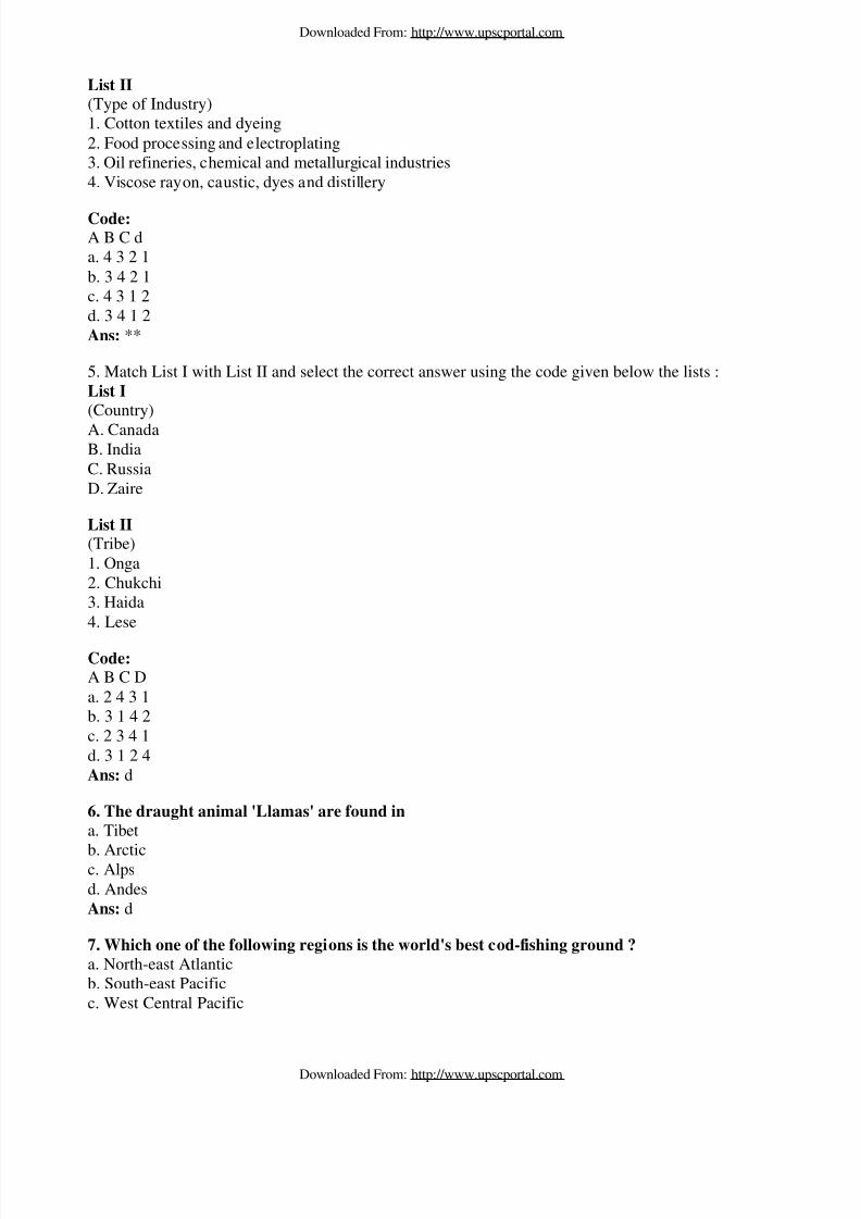
List II(Type of Industry)1. Cotton textiles and dyeing2. Food processing and electroplating3. Oil refineries, chemical and metallurgical industries4. Viscose rayon, caustic, dyes and distillery
Code:A B C da. 4 3 2 1b. 3 4 2 1c. 4 3 1 2d. 3 4 1 2Ans: **
5. Match List I with List II and select the correct answer using the code given below the lists :List I
(Country)
A. CanadaB. IndiaC. RussiaD. Zaire
List II(Tribe)1. Onga2. Chukchi3. Haida4. Lese
Code:A B C Da. 2 4 3 1b. 3 1 4 2c. 2 3 4 1d. 3 1 2 4Ans: d
6. The draught animal 'Llamas' are found in
a. Tibet
b. Arcticc. Alpsd. AndesAns: d
7. Which one of the following regions is the world's best cod-fishing ground ?
a. North-east Atlanticb. South-east Pacificc. West Central Pacific
Downloaded From: http://www.upscportal.com
Downloaded From: http://www.upscportal.com
8/8/2019 CSE 2009 Geography Answer Key
http://slidepdf.com/reader/full/cse-2009-geography-answer-key 3/28
d. Indian OceanAns: a
8. The Dogger Bank, the main fishing area of Europe, lies in
a. Baltic Seab. English Channelc. North Sea
d. Norwegian SeaAns: c
9. Match List I with List II and select the correct answer using the code given below the lists :
List I(Country)A. PhilippinesB. Thailand.C. Sri Lanka
List II
(Names of shifting cultivation the countryis associated with)1. Chena2. Caingin3. Milpa4. Tamrai
Code:
A B Ca. 3 4 1b. 3 1 4
c. 2 4 1d. 2 1 4Ans: c
10. Factory farming is the characteristic of a. North-western North Americab. North-western Europec. Eastern Europed. South-east AsiaAns: b
11. In which one of the following countries is the iron mining centre called Scunthorpe located ?a. Franceb. Germanyc. Swedend. United KingdomAns: d
12. Which of the three countries were members of European Free Trade Association (EFTA)when it was founded in 1960?a. Italy, Belgium, Poland
Downloaded From: http://www.upscportal.com
Downloaded From: http://www.upscportal.com

8/8/2019 CSE 2009 Geography Answer Key
http://slidepdf.com/reader/full/cse-2009-geography-answer-key 4/28
b. Hungary, Finland, Spainc. Austria, Denmark, Norwayd. The Netherlands, France, RomaniaAns: c
13. The coal basin region called Donbas lies to thea. North of Black Sea and the Sea of Azov
b. North of Caspian Seac. East of Gulf of Finlandd. South of White Sea and south-west of ; Kanin PeninsulaAns: a
14. Kampung is a form of rural settlement found ina. Chinab. Malaysiac. Philippinesd. CambodiaAns: b
15. Match List I with List II and select the correct answer using the code given below the lists :List I(Patterns of rural settlements)A. ArrowB. CheckerboardC. CircularD. Fan
List II(Locations associated with)
1. Delta2. Lake3. Mountain slope4. Road crossing at right angle5. Road meeting a river bend
Code:
A B C Da. 5 4 2 1b. 3 4 2 1c. 5 2 4 3
d. 3 2 4 1Ans: a
16. In vertical distribution of ocean deposits, what is the correct sequence (from oceanic surfacetowards bottom) of the following deposits?1. Calcareous oozes2. Siliceous oozes3. Terrigenous deposits4. Red clay
Downloaded From: http://www.upscportal.com
Downloaded From: http://www.upscportal.com

8/8/2019 CSE 2009 Geography Answer Key
http://slidepdf.com/reader/full/cse-2009-geography-answer-key 5/28
Select the correct answer using the code given below :a. 1, 2, 3, 4b. 3, 1, 2, 4c. 3, 2, 1, 4d. 4, 3, 2, 1Ans: b
17. Match List I with List II and select the correct answer using the code given below the lists :List I(Genetic Phases)A. The Sun and the Moon are at right angles with the EarthB. The Sun, the Moon and the Earth are in a straight lineC. The Moon is nearest to the EarthD. The Moon is farthest from the Earth
List II(Resultant Tides)1. Spring tide
2. Neap tide3. Apogean tide4. Perigean tide
Code:A B C Da. 2 1 4 3b. 2 4 1 3c. 3 4 1 2d. 3 1 4 2Ans: a
18. Consider the following pairs : Area : Well-known for1. Kinta Valley : Tin fields2. Sudbury region : Nickel production3. Chihuahua : Silver production
Which of the pairs given above is/are correctly matched ?a. 1 onlyb. 2 and 3 onlyc. 1 and 3 onlyd. 1, 2 and 3
Ans: d19. Match List I with List II and select the correct answer using the code given below the lists :
List I(Oil-field)A. BahreganB. DhahranC. KirkukD. Palembanng
Downloaded From: http://www.upscportal.com
Downloaded From: http://www.upscportal.com

8/8/2019 CSE 2009 Geography Answer Key
http://slidepdf.com/reader/full/cse-2009-geography-answer-key 6/28
List II(Country)1. Iraq2. Iran3. Indonesia4. Saudi Arabia
Code:A B C Da. 2 4 1 3b. 2 1 4 3c. 3 4 1 2d. 3 1 4 2Ans: a
20. With reference to the availability of minerals in India, consider the following statements :1. The highest concentration of manganese is found in the Dharwar system of rocks.2. The chromite mainly occurs in ultrabasic igneous rocks.
Which of the statements given above is/are correct?a. 1 onlyb. 2 onlyc. Both 1 and 2d. Neither 1 nor 2Ans: c
21. With reference to the occurrence of minerals in India, consider the following statements :1. Silver is a mineral of primary origin occurring in acid igneous rocks.2. Bauxite is a secondary mineral mainly associated with lateritic rocks formed during tertiary period.
Which of the statements given above is/are correct ?a. 1 onlyb. 2 onlyc. Both 1 and 24 of 15d. Neither 1 nor 2Ans: **
22. Among the following states, in which one is the percentage of forest area to totalgeographical area the highest ?
a. Arunachal Pradeshb. Himachal Pradeshc. Sikkimd. UttarakhandAns: a
23. Consider the following pairs :
Tree : Location of its natural habitat1. Rosewood : Slopes of Western Ghats of Karnataka and Kerala2. Spruce : Western Himalayas at elevations from 2100 m to 3600 m
Downloaded From: http://www.upscportal.com
Downloaded From: http://www.upscportal.com
8/8/2019 CSE 2009 Geography Answer Key
http://slidepdf.com/reader/full/cse-2009-geography-answer-key 7/28
3. Walnut : Lower elevations of Eastern Himalayas
Which of the pairs given above is/are correctly matched?a. 1 onlyb. 1 and 2 onlyc. 2 and 3 onlyd. 1, 2 and 3Ans: c
24. Consider the following statements :1. The Buckingham Canal runs through the coast from Guntur district to South Arcot district.2. For Indira Gandhi Canal, additional waters of Beas and Yamuna are diverted and the canalterminates in Barmer district.
Which of the statements given above is/are correct ?a. 1 onlyb. 2 onlyc. Both 1 and 2
d. Neither 1 nor 2Ans: a
25. Consider the following statements :
1. The genre de vie of Vidal de la Blache refers to the inherited traits that members of a human grouplearn, what we may call culture:2. The genre de vie is a basic factor in determining which are the various possibilities offered bynature a particular human group will select.
Which of the statements given above is/are correct ?a. 1 only
b. 2 onlyc. Both 1 and 2d. Neither 1 nor 2Ans: c
26. Consider the following statements :1. The Kangra Valley is a strike valley extending from the foot of the Dhaula Dhar Range to the Southof the Beas River.2. The Kulu Valley is a transverse valley in the upper course of Ravi.
Which of the statements given above is/are correct ?
a. 1 onlyb. 2 onlyc. Both 1 and 2d. Neither 1 nor 2Ans: c
27. Match List I with List II and select the correct answer using the code given below the lists :
List I(Wetland)A. Barilla
Downloaded From: http://www.upscportal.com
Downloaded From: http://www.upscportal.com

8/8/2019 CSE 2009 Geography Answer Key
http://slidepdf.com/reader/full/cse-2009-geography-answer-key 8/28
B. DihailaC. PariyejD. Pong
List II(State)1. Bihar
2. Gujarat3. Himachal Pradesh4. Madhya Pradesh
Code:A B C Da. 1 4 2 3b. 1 2 4 3c. 3 4 2 1d. 3 2 4 1Ans: a
28. Consider the following rivers :
1. Banas2. Ghaggar3. Machhu4. Rupen
Which of the above neither flow into the sea nor merge with any major river that flows into the sea,but are lost in the desert?a. 1 and 2 only
b. 2, 3 and 4 onlyc. 1, 3 and 4 onlyd. 1, 2, 3 and 4Ans: d
29. Match List I with List II and select the correct answer using the code given below the lists :
List I(Mangrove Area)A. CoringaB. CoondapurC. Ramnad
D. Vikhroli
List II(State)1. Andhra Pradesh2. Karnataka3. Maharashtra4. Tamil Nadu
Code:
Downloaded From: http://www.upscportal.com
Downloaded From: http://www.upscportal.com
8/8/2019 CSE 2009 Geography Answer Key
http://slidepdf.com/reader/full/cse-2009-geography-answer-key 9/28
A B C Da. 1 2 3 4b. 1 2 4 3c. 2 1 3 4d. 2 1 4 3Ans: b
30. In which of the following places are deposits of Wolfram found ?a. Chandigiri and Amarkantakb. Chendipathar and Deganac. Bellary and Radhanagarid. Guntur and HazaribaghAns: a
31. Consider the following statements:1. The Cochin Shipyard was constructed with the Japanese assistance:2. The Integral Coach Factory was set up with German collaboration.
Which of the statements given above is/are correct ?a. 1 onlyb. 2 onlyc. Both 1 and 2d. Neither 1 nor 2Ans: **
32. Match List I with List II and select the correct answer using the code given below the lists :
List I(National Highway)A. NH 9
B. NH 12C. NH 15D. NH 17
List II(Route)1. Pune-Machilipatnam2. Pathankot-Samakhiali3. Panvel – Edapally4. Jabalpur – Jaipur
Code:A B C Da. 1 2 4 3b. 1 4 2 3c. 3 2 4 1d. 3 4 2 1Ans: b
33. Among the following, the narrowest portion of English Channel lies between ,a. Dover and Calais
Downloaded From: http://www.upscportal.com
Downloaded From: http://www.upscportal.com

8/8/2019 CSE 2009 Geography Answer Key
http://slidepdf.com/reader/full/cse-2009-geography-answer-key 10/28
b. Portsmouth and Le Havrec. Hull and Rotterdamd. Plymouth and BrestAns: a
34. Alps Mountains are spread overa. France, Switzerland, Italy, Romania
b. France, Switzerland, Italy, Austriac. France, Switzerland, Italy, Spaind. France, Switzerland, Italy, BelgiumAns: b
35. The high altitude tropical forest which has dwarfed trees is known asa. Alpine forestb. Elfin forestc. Montane forestd. Sclerophyll forestAns: b
36. Consider the following pairs :1. Coal : Donbas2. Iron ore : Magnitogorsk3. Mica : Mama
Which of the pairs given above is/are correctly matched ?a. 1 only6 of 15b. 1 and 2 onlyc. 2 and 3 only
d. 1, 2 and 3Ans: d
37. Match List I with List II and select the correct answer using the code given below the lists :List I(Island)A. HokkaidaB. HonshuC. ShikokuD. Kyushu
List II(City)1. Takamatsu2. Nagasaki3. Yokohama4. Hakodate
Code:A B C Da. 2 1 3 4
Downloaded From: http://www.upscportal.com
Downloaded From: http://www.upscportal.com
8/8/2019 CSE 2009 Geography Answer Key
http://slidepdf.com/reader/full/cse-2009-geography-answer-key 11/28
b. 2 3 1 4c. 4 1 3 2d. 4 3 1 2Ans: d
38. Consider the following pairs :1. Kumamoto : Ship-building
2. Fukuoka : Chemicals3. Hamamatsu : Musical instruments
Which of the pairs given above is/are correctly matched?a. 1 onlyb. 1 and 2 onlyc. 2 and 3 onlyd. 1, 2 and 3Ans: d
39. The Hanshin region of Japan is an industrial conurbation formed by which one of the
following groups of three cities?a. Tokyo, Kawasaki, Yokohamab. Yawata, Kokura, Maujic. Osaka, Kobe, Kyotod. Osaka, Tokyo, KyotoAns: c
40. Summer rains in Australia broadly decrease froma. East to westb. West to eastc. North to south
d. South to northAns: c
41. Among the following, which one has the largest number of neighbouring countries sharing
the land border ?a. Sudanb. Brazilc. Chinad. ZaireAns: c
42. Which one of the following rivers demarcates the partial boundary between South Africaand Botswana?a. Limpopob. Zambezic. Cubangod. KwandoAns: a
43. Vaal is a major tributary of which one of the following rivers?a. Limpopo
Downloaded From: http://www.upscportal.com
Downloaded From: http://www.upscportal.com

8/8/2019 CSE 2009 Geography Answer Key
http://slidepdf.com/reader/full/cse-2009-geography-answer-key 12/28
b. Nilec. Oranged. ZambeziAns: c
44. The large coffee plantation in Brazil is calleda. Estate
b. Farmc. Fazendasd. KolkhozesAns: c
45. Arakan and Pegu Yomas are located ina. Myanmarb. Nepalc. Bhutand. ChinaAns: a
46. On the banks of which river is the city of Kathmandu located?a. Arunb. Saptakosic. Bagmatid. SunkosiAns: c
47. Of the following, who enunciated that "all history should be studied geographically and allgeography historically"?a. Herodotus
b. Straboc. Hecataeusd. PosidoniusAns: a
48. Consider the following statements :1. Ptolemy presumed that the prime meridian passes through Bermuda Island.2. Ptolemy believed that Ceylon marks the southern limit of the world.
Which of the statements given above is/are correct ?a. 1 only
b. 2 onlyc. Both 1 and 2d. Neither 1 nor 2Ans: b
49. Caledonian orogenic movements are related to the geological history of a. Late Jurassic and early Cretaceous periodb. Late Silurian and early Devonian periodc. Middle Triassic periodd. Late Devonian and early Carboniferous period
Downloaded From: http://www.upscportal.com
Downloaded From: http://www.upscportal.com

8/8/2019 CSE 2009 Geography Answer Key
http://slidepdf.com/reader/full/cse-2009-geography-answer-key 13/28
Ans: b
50. Match List I with List II and select the correct answer using the code given below the lists :List I
(Discontinuities)A. Weichert — Gutenberg discontinuityB. Mohorovicic (Moho) discontinuity
C. Lehman discontinuityD. Conrad discontinuity
List II
(Layers of Earth's interior associated with discontinuity)1. Outer core and inner core2. Lower mantle and outer core3. Upper mantle and lower mantle4. Lower crust and upper mantle5. Division of Sial and Sima within the crust
Code:A B C Da. 5 1 3 2b. 2 1 3 5c. 2 4 1 5d. 5 4 1 2Ans: c
51. Consider the following minerals :1. Corundum2. Quartz
3. Topaz
What is the correct sequence of the above in terms of descending order of their hardness?a. 1-2-3b. 2-3-1c. 1-3-2d. 3-1-2Ans: d
52. A lens-shaped igneous intrusion situated beneath an anticlinal fold or in the base of asyncline is called
a. Lapolithb. Lacolithc. Phacolithd. BatholithAns: c
53. Open folds are those in which the angle between the two limbs of the fold isa. more than 90° but less than 180°b. more than 75° but less than 150°c. more than 45° but less than 90°
Downloaded From: http://www.upscportal.com
Downloaded From: http://www.upscportal.com

8/8/2019 CSE 2009 Geography Answer Key
http://slidepdf.com/reader/full/cse-2009-geography-answer-key 14/28
d. more than 120° but less than 210°Ans: a
54. Consider the following statements :
1. Kaolinite is the weathered silicate clay.2. Kaolinization process occurs due to hydrothermal alteration of feldspar.
Which of the statements given above is/are correct ?a. 1 onlyb. 2 onlyc. Both 1 and 2d. Neither 1 nor 2Ans: **
55. Consider the following statements:
1. Pyramidal peak is a gentle-sided mountain summit.2. Tarn is formed often in the cirques3. The long axis of drumlins are parallel to the direction of glacial movement
Which of the statements given above are correct?a. 1 and 2 onlyb. 2 and 3 onlyc. 1 and 3 onlyd. 1, 2 and 3Ans: b
56. A landform developed by the process of deposition occurring towards the centre of intermontane basins in arid or semi-arid regions is known asa. Pediment
b. Bajadac. Playad. PeneplainAns: b
57. Eskers are of glacio-fluvial origin. Which one of the following statements characterize them?a. They are long, narrow and sinuous ridges of sands.b. They are small, irregular mounds of bedded sands.c. They are small alluvial cones.d. They are flat-topped terraces.Ans: a
58. Consider the following statements regarding the distribution and pattern of isotherms :1. In the northern hemisphere, isotherms bend sharply equator-ward over the continents during winter.2. Temperature gradients are greater in summer than in winter in the northern hemisphere:
Which of the statements given above is/are correct ?a. 1 onlyb. 2 onlyc. Both 1 and 2d. Neither 1 nor 2
Downloaded From: http://www.upscportal.com
Downloaded From: http://www.upscportal.com

8/8/2019 CSE 2009 Geography Answer Key
http://slidepdf.com/reader/full/cse-2009-geography-answer-key 15/28
Ans: a
59. Match List I with List II and select the correct answer using the code given below the lists :List I
(Local Wind)A. HarmattanB. Haboob
C. BoraD. Zonda
List II
(Country /Region)1. Argentina2. Adriatic coast3. West Africa4. Sudan
Code:
A B C Da. 1 2 4 3b. 1 4 2 3c. 3 4 2 1d. 3 2 4 1Ans: c
60. With reference to convectional type of rainfall, consider the following statements:
1. It is a warm weather phenomenon2. This rainfall is associated with cumulonimbus clouds.
Which of the statements given above is/are correct ?a. 1 onlyb. 2 onlyc. Both 1 and 2d. Neither 1 nor 2Ans: c
61. With reference to the sub-tropical high pressure belt, consider the following statements :
1. It is affected by Earth's rotation and descent of winds from higher altitudes.2. It is dynamically induced and characterised with anti-cyclonic conditions.
Which of the statements given above is/are correct ?a. 1 onlyb. 2 onlyc. Both 1 and 2d. Neither 1 nor 2Ans: c
62. In Koppen's classification of world climate. Aw climates refer to
a. Humid tropical wet monsoon climate with a short dry seasonb. Tropical wet and dry climate with dry season in winter
Downloaded From: http://www.upscportal.com
Downloaded From: http://www.upscportal.com

8/8/2019 CSE 2009 Geography Answer Key
http://slidepdf.com/reader/full/cse-2009-geography-answer-key 16/28
c. Tropical desert climated. Humid meso-thermal climatesAns: b
63. With reference to equatorial climate, consider the following statements :1. Thermally induced low pressure belt develops around the equator but the pressure gradient is verylow.
2. Temporal variability in the amount of rainfall is not found.
Which of the statements given above is/are correct ?a. 1 onlyb. 2 onlyc. Both 1 and 2d. Neither 1 nor 2Ans: **
64. Who introduced the term anticyclone for the first time ?a. Fitzroy
b. J. Bjerknesc. F. Galtond. V. BjerknesAns: c
65. For obtaining greater accuracy in the fraction of a division in both linear and angularmeasurements, which scale is used?a. Linear Scaleb. Vernier Scalec. Plane Scaled. Graphic Scale
Ans: b
66. Which one of the following RF represents the 1 cm map distance to 5 km of ground distance?a. 1 : 500b. 1 : 5000c. 1 : 50000d. 1 : 500000Ans: d
67. A form of diagram in which values are plotted as radii from a point of origin, is known asa. Star diagram
b. Columnar diagramc. Block pile diagramd. Dispersion diagramAns: a
68. With reference to Dot method, consider the following statements :1. Dot method is the most convenient method for illustrating the distribution of absolute figures.2. The size of the dots depends upon the frequency of the element to be represented.3. In it each dot has an identical value.4. It is used very effectively when plotting values in detail on a large scale.
Downloaded From: http://www.upscportal.com
Downloaded From: http://www.upscportal.com

8/8/2019 CSE 2009 Geography Answer Key
http://slidepdf.com/reader/full/cse-2009-geography-answer-key 17/28
Which of the statements given above are correct?a. 1, 3 and 4b. 2, 3 and 4c. 1 and 2 onlyd. 1, 2 and 3Ans: d
69. Match List I with List II and select the correct answer using the code given below the lists :List I(Map type)A. ChoroplethB. IsoplethC. ChorochromaticD. Choroschematic
List II(Information Content)1. Quantitative map showing imaginary lines joining places of equal value for any distribution
2. Qualitative map showing areal distribution by symbols, index letters etc.3. Qualitative map showing areal distribution by shades and tints4. Quantitative map showing regional variation of distribution using shades
Code:A B C Da. 2 1 3 4b. 2 3 1 4c. 4 3 1 2d. 4 1 3 2Ans: **
70. A graph showing wavelength and reflectance amount is known asa. Spectral Reflectance Curveb. Spectral Signaturec. Spectral Bandd. Spectral RegionsAns: a
71. For representing the data relating to cost control, quality control and assessment of progress, which of the following is/are the correct use of the diagram ?
a. Cycle diagram
b. Chorochromatic mapsc. Chorographic compass mapsd. Both Chorochromatic and chorographic compass mapsAns: **
72. A vector-based data structure is made for storing terrain information in digital terrain
modelling in which each sample point has an x, y co-ordinate and a eight, or z value. All thepoints are connected by edges to form a network of nonoverlapping triangles that collectivelyrepresent the terrain surface. This network is known asa. TIN
Downloaded From: http://www.upscportal.com
Downloaded From: http://www.upscportal.com

8/8/2019 CSE 2009 Geography Answer Key
http://slidepdf.com/reader/full/cse-2009-geography-answer-key 18/28
b. DTMc. TQMd. TIGERAns: a
73. In the Government of India, under which Ministry is the National River ConservationDirectorate?
a. Ministry of Agriculture :b. Ministry of Earth Sciencesc. Ministry of Environment and Forestsd. Ministry of Water ResourcesAns: c
74. Consider the following statements :
1. The Rhine rift valley stretches for more than 800 km.2. The floor of Dead Sea is more than 1100 m below sea level.
Which of the statements given above is/are correct ?
a. 1 onlyb. 2 onlyc. Both 1 and 2d. Neither 1 nor 2Ans: a
75. Consider the following statements :1. Mistral is a cold wind blowing in North America.2. Sirocco is a hot dry wind blowing across the North African coast.
Which of the statements given above is/are correct ?
a. 1 onlyb. 2 onlyc. Both 1 and 2d. Neither 1 nor 2Ans: b
76. In the context of the inflow of South Westerly monsoon into India, consider the followingstatements :
1. The Arabian Sea current merges with the Bay of Bengal current over the Punjab and adjoiningHimalayas.2. "Breaks" or spells of dry weather are not the characteristic features of southwest monsoon.
Which of the statements given above is/are correct ?a. 1 onlyb. 2 onlyc. Both 1 and 2d. Neither 1 nor 2Ans: a
77. Consider the following statements regarding general characteristics associated with tropicalcyclones :
Downloaded From: http://www.upscportal.com
Downloaded From: http://www.upscportal.com

8/8/2019 CSE 2009 Geography Answer Key
http://slidepdf.com/reader/full/cse-2009-geography-answer-key 19/28
1. Tropical cyclones, move with very low velocity over the oceans but become strong while movingover the land areas.2. They are confined to a particular period of the year (mainly summer) and normally move from eastto west.
Which of the statements given above is/are correct ?a. 1 only
b. 2 onlyc. Both 1 and 2d. Neither 1 nor 2Ans: b
78. There is a submarine ridge in the Bay of Bengal. What is it called ?a. Ninety East ridgeb. Mozambique ridgec. Chagos-Laccadive ridged. Carlsberg ridgeAns: a
79. Consider the following statements :1. The continental shelves of Lakshadweep originated due to coral reefs.2. The continental shelves of western coast are due to faulting and submergence.
Which of the statements given above is/are correct?a. 1 only11 of 15b. 2 onlyc. Both 1 and 2d. Neither 1 nor 2
Ans: c
80. Consider the following statements :
1. Temperature of surface water is comparatively higher in the northern hemisphere than in thesouthern hemisphere.2. The isotherms in the southern hemisphere are not regular and do not follow the latitudes while they(isotherms) are regular and follow the latitudes in the orthern hemisphere.
Which of the statements given above is/are correct?a. 1 onlyb. 2 only
c. Both 1 and 2d. Neither 1 nor 2Ans: a
81. Consider the following :1. Gulf of California2. Mediterranean Sea3. Baltic SeaIn terms of decreasing salinity, which one of the following is the correct sequence?a. 1-2-3
Downloaded From: http://www.upscportal.com
Downloaded From: http://www.upscportal.com
8/8/2019 CSE 2009 Geography Answer Key
http://slidepdf.com/reader/full/cse-2009-geography-answer-key 20/28
b. 2-1-3c. 3-1-2d. 2-3-1Ans: b
82. Consider the following statements:1. Globigerina ooze is a calcareous pelagic deposit.
2. Globigerina ooze is found mostly in the tropical and temperate zones of the Atlantic Ocean.
Which of the statements given above is/are correct ?a. 1 onlyb. 2 onlyc. Both 1 and 2d. Neither 1 nor 2Ans: c
83. Regular oscillations in the water surface of large water bodies are formed because of a. Gravitational effect of Moon
b. Difference in temperature of sea water and the air abovec. Rotation of Earthd. Friction of wind on the water surfaceAns: d
84. Consider the following statements :1. Laterite consists essentially of oxides of iron and aluminium.2. Ferrallitic soils occur widely in the humid tropics where chemical weathering and leaching areintense.
Which of the statements given above is/are correct ?
a. 1 onlyb. 2 onlyc. Both 1 and 2d. Neither 1 nor 2Ans: c
85. Consider the following pairs :1. Podzolization : Eluviation of clays, organic matter, calcium, sodium, iron, and aluminium out of theA horizon2. Gleization : Accumulation of organic matter in a swampy environment
Which of the pairs given above is/are correctly matched?a. 1 onlyb. 2 onlyc. Both 1 and 2d. Neither 1 nor 2Ans: c
86. Chernozems are
a. Silica rich temperate grassland soilsb. Iron rich humid upland soils
Downloaded From: http://www.upscportal.com
Downloaded From: http://www.upscportal.com
8/8/2019 CSE 2009 Geography Answer Key
http://slidepdf.com/reader/full/cse-2009-geography-answer-key 21/28
c. Humus rich dark brown colour soils in semi-arid regiond. Humus rich tropical grassland soilsAns: a
87. In which one of the following regions are the hurricanes apparently absent?a. Coast of Texasb. Gulf of Mexico
c. South-eastern coast of USAd. South-eastern coast of PacificAns: d
88. The shifting cultivation that is leading to soil erosion in Brazil is known asa. Milpab. Conucoc. Tavyd. RocaAns: d
89. Two main cold currents in the North Pacific Ocean are known asa. Oyashio and California currentsb. Alaska and Kuroshio currentsc. North Equatorial and Counter Equatorial currentsd. North Pacific and Kuroshio currentsAns: a
90. Match List I with List II and select the correct answer using the code given below the lists :List I(Author)A. Davis
B. HackC. HuttonD. King L.C
List II(Concept)1. Pediplanation2. Peneplanation3. Dynamic Equilibrium4. Uniformitarianism
Code:A B C Da. 1 4 3 2b. 1 3 4 2c. 2 4 3 1d. 2 3 4 1Ans: d
91. With reference to migration, who of the following formulated the 'Gravity Model' whichdemonstrates the relationship between population size, distance and migration?
Downloaded From: http://www.upscportal.com
Downloaded From: http://www.upscportal.com

8/8/2019 CSE 2009 Geography Answer Key
http://slidepdf.com/reader/full/cse-2009-geography-answer-key 22/28
a. Zipf b. Millerc. Malthusd. ZelinskyAns: a
92. Consider the following statements :
1. The location of objects in geographic space and the associated attributes are handled by GIS.2. Spatial objects are represented by graphical elements of points, lines and polygons.
Which of the statements given above is/are correct?a. 1 onlyb. 2 onlyc. Both 1 and 2d. Neither 1 nor 2Ans: c
93. Match List I with List II and select the correct answer using the code given below the lists:
List I(Country)A. ThailandB. SingaporeC. IndonesiaD. Vietnam
List II(Feature)1. Entrepot2. Mekong delta
3. Pattaya beach4. Banda Aceh
Code:
A B C Da. 2 4 1 3b. 2 1 4 3c. 3 4 1 2d. 3 1 4 2Ans: b
94. Geography was first divided into 'General' and 'Special' bya. Vareniusb. Kantc. Humboldtd. RitterAns: a
95. Consider the following statements :1. Ritter identified races by skin, colour2. Ritter's concepts regarding the Earth's geographical patterns were teleological.
Downloaded From: http://www.upscportal.com
Downloaded From: http://www.upscportal.com

8/8/2019 CSE 2009 Geography Answer Key
http://slidepdf.com/reader/full/cse-2009-geography-answer-key 23/28
Which of the statements given above is/are correct ?a. 1 onlyb. 2 onlyc. Both 1 and 2d. Neither 1 nor 2Ans: c
96. Ratzel coined the term 'Anthropogeography' which he used for thea. Geography of man in terms of individuals and racesb. Geography of man and his works in relation to the Earth's surfacec. Organic theory of society and stated. Study of harmonious reciprocal relation of man and natureAns: b
97. Which one of the following geographers wrote the book 'Influences of GeographicEnvironment'?a. Humboldtb. Ratzel
c. Ritterd. SempleAns: d
98. Diorite is an example of a. Chemically formed sedimentary rockb. Extrusive igneous rockc. Plutonic igneous rockd. Metamorphic rockAns: c
99. Among the following regions of India, which one receives comparatively least amount of annual rainfall ?a. An 80 km wide coastal belt from Nellore to Point Calimereb. The middle and lower Assam valleyc. North-eastern Rajasthand. The coastal plains of Gujarat south of NarmadaAns: c
100. As per Koppen's classification of climate, which one of the following is the suitabledescription for north-east India including north Bengal ?a. Tropical monsoon rainforest (Amw)
b. Sub-tropical monsoon rainforest (Am)c. Humid subtropical with dry winter (Cwg)d. Tropical wet and dry climate (Monsoon savannah, Aw)Ans: c
101. Consider the following statements :1. In India, groundnut is principally grown as rain-fed crop.2. In India, sesamum is grown as kharif crop in northern states but in south it is generally grown duringthe rabi season.
Downloaded From: http://www.upscportal.com
Downloaded From: http://www.upscportal.com

8/8/2019 CSE 2009 Geography Answer Key
http://slidepdf.com/reader/full/cse-2009-geography-answer-key 24/28
Which of the statements given above is/are correct ?a. 1 onlyb. 2 onlyc. Both 1 and 2d. Neither 1 nor 2Ans: c
102. Match List I with List II and select the correct answer using the code given below the lists :List(Crop)A. GingerB. JuteC. MustardD. Turmeric
List II(Major cultivating districts)1. Cuddapah and Guntur
2. Idukki and Wayanad3. Goalpara and Kamrup4. Bharatpur and Ganganagar
Code:A B C Da. 1 4 3 2b. 2 3 4 1c. 1 3 2 4d. 2 4 3 1Ans: c
103. Consider the following pairs :Mineral : District with large/significant / commercially important deposits1. Apatite : Visakhapatnam2. Chromite : Cuttack3. Gold : Nagaur4. Gypsum : Anantapur
Which of the pairs given above are correctly matched?a. 1 and 2 onlyb. 1, 2 and 3
c. 1, 2 and 4d. 2, 3 and 4Ans: a*
104. The Bhakra Nangal Multipurpose Project is a joint venture of a. Punjab and Haryana onlyb. Punjab, Haryana and Rajasthan onlyc. Punjab, Haryana, Rajasthan and Himachal Pradeshd. Punjab and Himachal Pradesh only
Downloaded From: http://www.upscportal.com
Downloaded From: http://www.upscportal.com

8/8/2019 CSE 2009 Geography Answer Key
http://slidepdf.com/reader/full/cse-2009-geography-answer-key 25/28
Ans: b
105. Consider the following statements:1. Maharashtra has more net irrigated area as compared to Madhya Pradesh.2. Punjab has more area under canal irrigation as compared to Haryana.
Which of the statements given above is/are correct ?
a. 1 onlyb. 2 onlyc. Both 1 and 2d. Neither 1 nor 2Ans: d
106. Match List I with List II and select the correct answer using the code given below the lists:List I
(Coalfields)A. MakumB. Kamptee
C. KaranpuraD. Singrauli(Waidhian)
List II(Districts)1. Dibrugarh2. Palarnau and Hazaribagh3. Nagpur4. Sidhi and Sahdol
Code:A B C Da. 1 2 3 4b. 1 3 2 4c. 4 2 3 1d. 4 3 2 1Ans: b
107. The plain formed due to coalescence of series of alluvial fans in the piedmont zone is knownasa. Pediment
b. Bajadac. Pediplaind. HamadaAns: b
108. Aretes are sharp ridges which develop between the adjacenta. Cirquesb. Roche moutonnéec. Medial morainesd. U-shaped valleys
Downloaded From: http://www.upscportal.com
Downloaded From: http://www.upscportal.com

8/8/2019 CSE 2009 Geography Answer Key
http://slidepdf.com/reader/full/cse-2009-geography-answer-key 26/28
Ans: a
109. Calcium carbonate deposited by precipitation from carbonate-saturated waters around ahot spring is called a. Stalactite
b. Stalagmitec. Travertined. LapiesAns: c
110. When a descending air contracts and its volume decreases, what happens to itstemperature?a. Its temperature decreasesb. Its temperature increasesc. Its temperature remains constantd. Its temperature first increases, then decreasesAns: b
111. What are Chinooks?
a. Cold local winds which blow from north-west to south-east direction in Spainb. Extremely dry winds blowing from north-east and east to west in eastern parts of Sahara desertc. Warm and dry winds which blow down the eastern slopes of Rocky Mountains of North Americad. Warm and dry winds along the northern slopes of Alps MountainsAns: c
112. Condensation is a process which occurs whena. Temperature falls below 00Cb. Absolute humidity becomes equal to relative humidityc. Temperature in the air parcel remains staticd. Relative humidity becomes 100% and more
Ans: d
113. Which of the following sequences of clouds in ascending order would one meet 500 metresand above the mean sea level?a. Stratus, Nimbus, Cirrostratus, Cirrusb. Nimbus, Cirrostratus, Cirrocumulus, Stratusc. Cirrostratus, Stratus, Nimbus, Cumulonimbusd. Stratus, Cirrostratus, Cumulo-nimbus, CirrocumulusAns: a
114. A ridge, 64,000 km long and 1000 to 4000 km wide, runs down the middle of the North andthe South Atlantic Ocean basins, into the Indian Ocean basins, then passes between Australia
and Antarctica to enter the South Pacific basin. What is this ridge?a. Socotra-Lakshadweep-Chagos ridgeb. Pacific-Antarctic ridgec. Dolphin-Challenger ridged. Mid-oceanic ridgeAns: d
115. Match List I with List II and select the correct answer using the code given below the lists:List I
Downloaded From: http://www.upscportal.com
Downloaded From: http://www.upscportal.com
8/8/2019 CSE 2009 Geography Answer Key
http://slidepdf.com/reader/full/cse-2009-geography-answer-key 27/28
(Sediment Types)A. TerrigenousB. BiogenousC. HydrogenousD. Comogenous
List II
(Examples)1. Calcareous oozes2. Quartz and clay3. Tektite spheres4. Manganese nodules
Code:
A B C Da. 2 4 1 3b. 2 1 4 3c. 3 1 4 2
d. 3 4 1 2Ans: b*
116. Hard pan and clay pan in soil are found ina. A-horizonb. B-horizonc. C-horizond. A-C horizonAns: b
117. Very thick A-horizon is often found in
a. Chernozem soilb. Chestnut soilc. Brown forest soild. Podzolic soilAns: a*
118. Match List I with List II and select the correct answer using the code given below the lists:
List I(Soil group)A. ChernozemB. Terra Rossa
C. PodsolD. Sierozem
List II(Climatic Regimes)1. Temperate grasslands2. Mediterranean3. Cool temperate4. Hot deserts
Downloaded From: http://www.upscportal.com
Downloaded From: http://www.upscportal.com
8/8/2019 CSE 2009 Geography Answer Key
http://slidepdf.com/reader/full/cse-2009-geography-answer-key 28/28
Code:A B C Da. 4 3 2 1b. 1 2 3 4c. 4 2 3 1d. 1 3 2 4Ans: b
119. Match List I with List II and select the correct answer using the code given below the lists:List I
(Highest Peak)A. Mount LoganB. Mount McKinley1C. Mount Kosciusko
List II(Country)1. Australia
2. U.S.A.3. Canada
Code:
A B Ca. 1 3 2b. 1 2 3c. 3 2 1d. 2 3 1Ans: c
120. In U.S.A. which one of the following regions receives heavy rainfall throughout the yearunder the influence of Westerlies?a. North Westernb. North Easternc. South Westernd. South EasternAns: a
Downloaded From: http://www.upscportal.com