CSCR Government #3: Preparing for Extreme Weather Events. Paul Beyer, DOS.
20
SMART GROWTH: LAND USE AND TRANSPORTATION IN THE ENERGY/CLIMATE EQUATION Paul Beyer – Director of Smart Growth, NYS Department of State
-
Upload
sustainable-tompkins -
Category
Technology
-
view
195 -
download
1
Transcript of CSCR Government #3: Preparing for Extreme Weather Events. Paul Beyer, DOS.
SMART GROWTH:LAND USE AND TRANSPORTATION
IN THE ENERGY/CLIMATE EQUATION
Paul Beyer – Director of Smart Growth, NYS Department of State
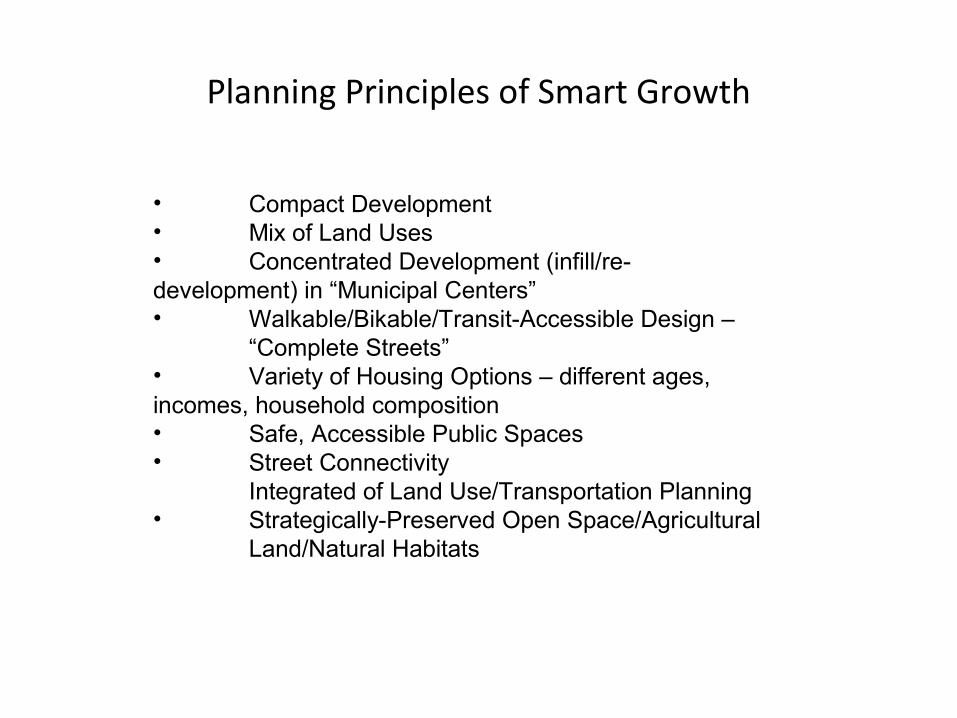
Planning Principles of Smart Growth
• Compact Development• Mix of Land Uses• Concentrated Development (infill/re-development) in “Municipal Centers”• Walkable/Bikable/Transit-Accessible Design –
“Complete Streets”• Variety of Housing Options – different ages, incomes, household composition• Safe, Accessible Public Spaces• Street Connectivity
Integrated of Land Use/Transportation Planning• Strategically-Preserved Open Space/Agricultural
Land/Natural Habitats

Definition of Sprawl:
“… low-density development that disperses the population over the widest possible area, with rigidly separate functions – homes, shops, and workplaces – connected by limited access roadways. The car is the primary mode of transportation; there are few functional sidewalks or lanes for bicycles, and little or no access to transit.”
Two Main Factors
•“Location Efficiency”•Land Use/Transportation Infrastructure Connection

LOCATION EFFICIENCY
Greater proximity, accessibility, and connectivity among land uses; mobility alternatives to automobile travel, such as walking, biking and transit.
The way we arrange our land uses -- in relation to one another, and in relation to infrastructure -- determines the amount of miles and trips we drive in our cars, which determines petroleum energy use in the US.
Smart Growth is Location-EfficientSprawl is Location-Inefficient

The Land Use/Transportation Infrastructure Connection
A ‘CHICKEN-AND-EGG’ DEBATE On the relationship between land use and transportation, the late Senator Moynihan said:
•“Highways determine land use, which is another way of saying they settle the future of the areas in which they are built.”
The American Planning Association went a step further:
•“No single force has had a greater impact on the pattern of land development in American cities in this century [Twentieth] than highways.”

SO WHAT?
•Sprawl and Transportation Energy Use
•Smart Growth/TOD and Transportation Energy Use
Transportation accounts for about 1/3 of all energy use in the country, and 65% of all petroleum use. It is estimated that 50-60% of VMT (Vehicle Miles Travelled) increases are attributable to land use and transportation patterns.

SMART GROWTH IS ENERGY (PETROLEUM) EFFICIENT
•Compact, urban-form development can reduce VMT up to 40%
•Residents of Atlantic State, GA – the largest TOD – drive 35% less that residents in sprawling subdivisions
•People living in twice the density of conventional sprawl, with a mix of land uses, street connectivity and accessible destinations, drive a third less
•People living in higher-density, bike-/pedestrian-friendly communities with convenient access to transit can reduce their driving 15-50%
•A mix of Smart Growth characteristics can reduce greenhouse gas (GHG) emissions from current trends 7-10% by 2050; both Smart Growth and stringent fuel-efficiency standards can bring GHG emissions down to 1990 levels by 2030

Smart Growth Public Infrastructure Policy Act (2010)
Complete Streets Act (2011)
Governor’s Regional Economic Development Councils/Regional Sustainability Plans(Cleaner, Greener NY Communities)
SUPPORTIVE PUBLIC POLICY

SMART GROWTH CRITERIA
TEN CRITERIA -- TWO BROAD CATEGORIES
•“WHERE” – LOCATION
•“HOW” – DESIGN; PROCESS; ENVIRONMENTAL FACTORS; SUSTAINABILITY NJ Future Smart Growth Scorecard:
“How do you know Smart Growth when you see it? Smart Growth has two primary features: the “where” and the “how.” It happens “where” development can be accommodated with minimal adverse impact to the environment, and in places where development takes maximum advantage of public investments already made. Smart Growth also addresses “how” the finished development will work with neighboring development to restore choices that are missing in places marked by sprawl: such as the choice to walk or use public transit, the choice to meet neighbors in attractive common spaces, or the choice to live in an apartment, a house, or a condominium.”

WHERE/LOCATION
EXISTING INFRASTRUCTURE
•“Fix-it-First”
MUNICIPAL CENTERS “areas of concentrated and mixed land uses that serve as centers for various activities”
•Downtowns/Main Streets•Central Business Districts•Hamlets, Village Centers, Urban Centers•Transit-Oriented Development (TOD)•Brownfield Areas
DEVELOPED AREAS
•Infill Development

Centers – Rail StationsLong Island
Source: Long Island Index Study

(Source: en.wikipedia/Daniel Case)
Poughkeepsie Train Station

Centers – Rural Hamlets
Source: Hamlets 3 Study

(Source: Hamlets 3 Study)

TRANSIT-ORIENTED DEVELOPMENT
“TRANSIT-ORIENTED DEVELOPMENT or TOD is typically defined as more compact development within easy walking distance of transit stations (typically a half mile) that contains a mix of uses such as housing, jobs, shops, restaurants and entertainment.”
(Source: Re-Connecting America/Center for Transit-Oriented Development)
In a recent survey, 71% of Baby Boomers said that walking distance to transit was a top amenity on their list of housing demands. (Source: Lesser & Co.)

COMPLETE STREETS/MOBILITY CHOICES
•Reduced Auto Dependency (Walkable, Bikable)•Public Transportation
One Mobility Option -- CARS

Several Mobility Options -- Car, Bike, Pedestrian, Transit
A “Complete” Street
(Source: Project for Public Spaces -- Vision for a road remake in Orange Beach, Alabama)


(Source: NYS DOT)
5-Legged Roundabout in Glens Falls, NY
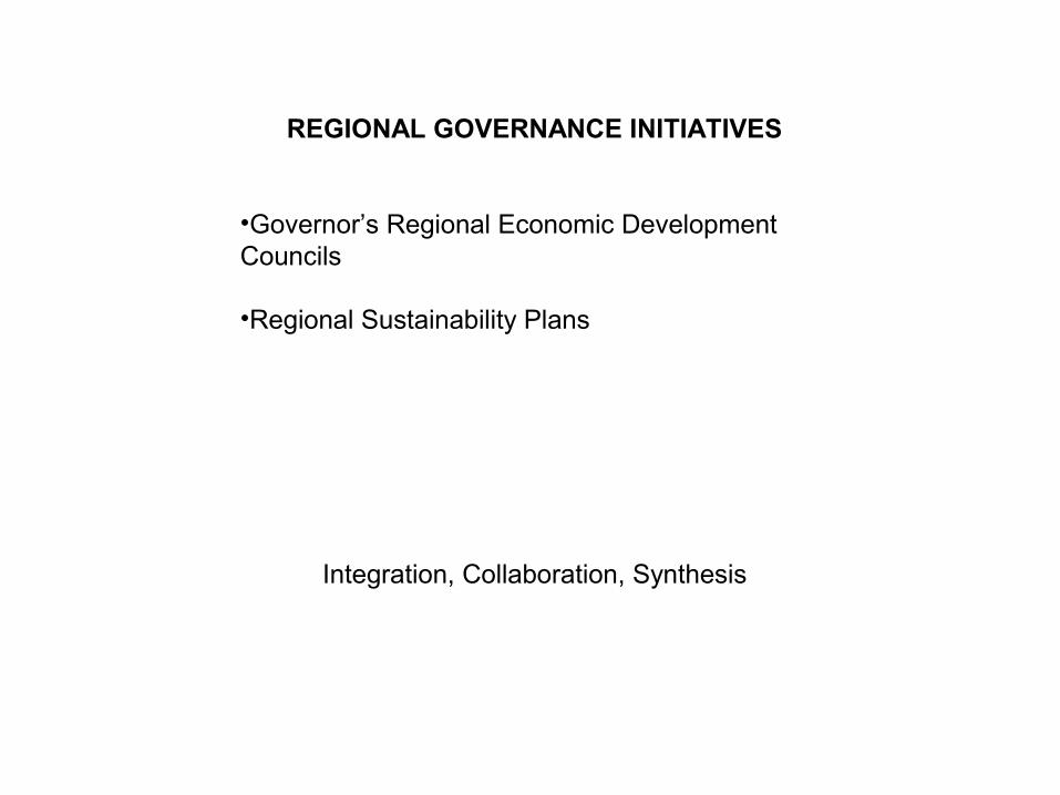
REGIONAL GOVERNANCE INITIATIVES
•Governor’s Regional Economic Development Councils
•Regional Sustainability Plans
Integration, Collaboration, Synthesis


![Dissertation2005 Beyer[1]](https://static.fdocuments.in/doc/165x107/577ce0751a28ab9e78b362d8/dissertation2005-beyer1.jpg)