Crustal Evolution of the GreatBasin and the...
28
p Crustal Evolution of the GreatBasin and the Sierra Nevada Edited by Mary M. Lahren and James H. Trexler, Jr., Department of Geological Sciences, University of Nevada, Reno, NV 89557 and Claude Spinosa Department of Geosciences, Boise State University, Boise, ID 83745 Field Trip Guidebook for the 1993 Joint Meeting of the Cordilleran/Rocky Mountain Sections of the Geological Society of America Reno, Nevada, May 19-21, 1993 Published by Department Geological Sciences Mackay School of Mines University of Nevada, Reno Reno, Nevada 89557
Transcript of Crustal Evolution of the GreatBasin and the...

p
Crustal Evolution of the GreatBasin and the Sierra Nevada
Edited byMary M. Lahren and James H. Trexler, Jr.,
Department of Geological Sciences,University of Nevada, Reno, NV 89557
and
Claude SpinosaDepartment of Geosciences,
Boise State University, Boise, ID 83745
Field Trip Guidebook for the 1993 Joint Meeting of theCordilleran/Rocky Mountain Sections of the Geological Society of America
Reno, Nevada,May 19-21, 1993
Published by Department Geological SciencesMackay School of Mines
University of Nevada, RenoReno, Nevada 89557

OLIGOCENE-MIOCENE CALDERA COMPLEXES, ASH-FLOW SHEETS,AND TECTONISM IN THE CENTRAL AND SOUTHEASTERN GREAT BASIN
Myron G. BestBrigham Young University, Provo, Utah 84602
Robert B. Scott, Peter D. Rowley, W C Swadley, R. Ernest AndersonU.S. Geological Survey, Denver, Colorado 80225
C. Sherman GrommeU.S. Geological Survey, Menlo Park, California 94025
Anne E. HardingUniversity of Colorado, Boulder, Colorado 80309
Alan L. DeinoGeochronology Center, Institute of Human Origins
Berkeley, California 94709Eric H. Christiansen, David. G. Tingey, Kim R. Sullivan
Brigham Young University, Provo, Utah 84602
ABSTRACT
The Great Basin harbors at least sixty Tertiarycalderas and inferred sources of tuff and several tensof thousands of cubic kilometers of ash-flow deposits,making it one of the greatest manifestations ofprolonged ash-flow volcanism in the terrestrial rockrecord. Some individual calderas are exposed east towest across three or four mountain ranges. Simplecooling-unit outflow tuff sheets cover areas of tens ofthousands of square kilometers and range to as muchas hundreds of meters thick. During the "ignimbriteflareup" from about 31 to 22 Ma, when most of theash-flows were erupted, extrusion of lava in the GreatBasin was minor, widely scattered, and did not formmajor edif:ces such as composite volcanoes. Typicalvolcanic sections consist of multiple ash-flow tuffcooling units from nearby caldera sources and onlylocal lava flows and pyroclastic-surge and -falldeposits.
Tuffs older than about 17 Ma in the Great"Basin are high-potassium calc-alkaline rhyolite,dacite, and sparse andesite in which phenocrysts oftwo feldspars, quartz, Fe-Ti oxides, and biotite arecommon. Rhyolite tuff occurs throughout theTertiary, whereas huge volumes of dacite ash flowswere erupted about 31 to 27 Ma and high-temperaturetrachydacite magmas containing phenocrysts ofplagioclase and pyroxene erupted from many centersmostly about 27 to 23 Ma. After 17 Ma, alkalinemetaluminous to mildly peralkaline magmascontaining Fe-rich pyroxene and olivine, sanidine,and quartz phenocrysts began to be erupted.
Regional extension was minimal during most ofthe ignimbrite flareup. However, local extensionoccurred before the flareup and major extensional andlocal strike-slip faulting beginning in the earlyMiocene affected many parts of the Great Basin,including the Caliente and Kane Spring Wash calderacomplexes where synvolcanic faults form manycaldera margins.
INTRODUCTION
The purpose of this brief review and field triproadlog is to sample the results of the waxing andwaning of the Great Basin ignimbrite flareup. For amore detailed report on Great Basin volcanism duringthe Tertiary, see Best and others (l989a). The supportof the National Science Foundation through grantsEAR-8604195, -8618323, and -8904245 to M.G. Bestand E.H. Christiansen is gratefully acknowl-edged. We appreciate helpful reviews by C. Chapin,D.A. John, R.F. Hardyman, and E.H. McKee.
GEOLOGIC SETTING
The pre-volcanic underpinning of the GreatBasin i~ a terrane containing late Precambrian,
"""Phaneiozoic," d local Mesozoic sedimentary rockse ormed during compressional episodes in Paleozoic
and Mesozoic Eras and intruded locally by Mesozoicgranitic plutons. After widespread erosion in lateCretaceous and early Tertiary time which produced aprofound unconformity and, in some places, earlyTertiary sedimentation, volcanism began in theEocene about 43 Ma in northern Nevada and Utah

and swept southward along an arcuate, roughlyeast-west front, reaching southern Nevada by middleMiocene time.
The inventory of Cenozoic rocks in the GreatBasin by Stewart and Carlson (1976; see also Bestand Christiansen, 1991; Figs. 3 and 4) clearly showsthe products of the late Oligocene-early Mioceneignimbrite flareup; the volume of resulting ash-flowdeposits in the Great Basin is not widely appreciatedbut is an order of magnitude larger than in the wellknown San Juan and Mogollon-Datil fields in theeastern Cordillera. However, the Great Basin harborsonly a fraction of the volume of ash flow tuffs in theSierra Madre Occidental of Mexico. During theignimbrite flareup in the Great Basin, the volume ofextruded lava was minor compared to ash-flowdeposits and was less than the volume of lavaextruded before and after the flareup. ScarceOligocene debris flows indicate a general lack oflarge volcanic edifices in contrast to, for example, theSan Juan volcanic field.
Until the early Miocene, at about 24 Ma, calcalkaline volcanism had produced a large volume ofdacite to rhyolite ash-flow tuff and subordinatehigh-potassium andesite and dacite and rhyolite lava;basalt appears only after 22 Ma (Barr and others,1992). During the next 8 m.y., explosive volcanismwaned and a broader compositional spectrum, but stilIdominated by rhyolite, appears in the overall volcanicrecord. Basaltic volcanism has been a significantaspect of Great Basin activity after about 13 Ma,partieularly along the eastern and western margins ofthe region but also locally in the center (McKee andNoble, 1986). Many silicic tuffs and lavas youngerthan about 17 Ma are peralkaline or topaz-bearing(Noble and Parker, 1975; Christiansen and others,1986).
After the middle Miocene, the general east-westorientation of magmatic zones changed to north-south(Best and others, 1980; Stewart, 1983), probablyreflecting a fundamental change in the state of stressin the lithosphere (Best, 1988). .
Extensional tectonism in the Great Basin duringTertiary time was episodic (e.g., Taylor and others,1989), was intense in some areas (e.g., Proffett,1977; Moores and others, 1968; Gans and others,1989) and moderate in others (e.g., the southernPancake Range, Snyder and others, 1972), and ingeneral correlates poorly in space and time with
volcanism (Best and Christiansen, 1991). In and nearthe Caliente and Kane Springs Wash calderacomplexes (Figs. 1 and 2) the main extensionalepisode was in early to middle Miocene time (Scott,1990; Rowley and others, 1992), concurrent withcaldera volcanism, as Great Basin ash-flow activitywaned. During the ignimbrite flareup, however,sparse clastic deposits and few angular discordancesin outflow volcanic sections show that regionaltectonic extension in the Great Basin as a whole waslimited.
CALDERAS
Recognition of calderas is hampered not onlyby erosion and burial beneath younger deposits, butalso in the Great Basin by widespread post-volcanic,and local synvolcanic (Caliente area and StillwaterRange), faulting that has dismembered the calderasinto small segments, blurring their margins andinternal structure. Geographic centering within theoutflow sheet may be misleading as outflow lobes arecommonly not radially symmetric about the sourcecaldera (e.g., Windous Butte Formation, Best andothers, 1989a). Topographic margins are poorlyknown even for some of the better located calderas.Piles of tuff as much as 2-3 km thick are an obviousindicator of a caldera (Ekren and others, 1973; Bestand others, 1989a, Figs. R29, R32-R38), but somedemonstrable proximal outflow tuff deposits pondedin older calderas and on downthrown sides ofsynvolcanic extensional growth faults are also thick(Dixon and others, 1972; Best and others, 1989b,Figs. 5B and 5C). Dense compaction and widespreadpropylitic alteration of compound or multiple coolingunits comprising the intracaldera tuff make it moreresistant to erosion relative to the caldera wall rocksand hence causes the development of invertedtopography that is a common clue to the existence ofthe caldera. Megabreccia and "rafts" of internallyshattered but nonetheless stratigraphically coherentrock, locally more than 2 km across and hundreds ofmeters thick, occur within a few kilometers of somecaldera walls (Bonham and Garside, 1979, p. 40;McKee, 1976; Best and others, 1989a, Figs. R12,R24, R25, R36, and R38).
Caving of the unstable caldera escarpmentenlarges the perimeter of a caldera so that topographicdiameters can be several kilometers greater than thering-fault system (Best and others, 1989a, Fig. R32;Best and others, 1989b, Fig. 5B). Younger postcaldera collanse denosits may completely fill and even

+ 37i\1112\0/
100
DELTA /~
kiloMeters
,/+
/ •..•... ··············l
1+1
I
zl"'Ie< -l>- 1):>- ",.--">,
••••.•~UREKA~ 01" I '
__+-'-~~~_\~-~~'~_:~~--- __<JJ.\ \\I' PRESroN ."..#. I \
\. CURRANT ...... .... •...•.••. I \
\+
Figure 1. Caldera margins and areal extents of some outflow tuff sheets in the southeastern Great Basin (Table1). Caldera margins (heaviest lines) dashed where approximately located; dotted lines indicate indefinitesource areas. Calderas and sources in the Central Nevada caldera complex include the Broken Back 2(BB), source of Stone Cabin Formation (S), Williams Ridge (W), Hot Creek (H), Pancake Range (P), KilnCanyon (KC), Big Ten Peak (BT), unnamed caldera source of tuff of Lunar Cuesta (L), Kawich (K),Goblin Knobs (G), Quinn Canyon Range (Q), and Cathedral Ridge (CR) and in the Indian Peak calderacomplex the source of the Cottonwood Wash Tuff (C), Indian Peak caldera (IP), White Rock (WR), Mt.Wilson (MW), and source of some members of the Isom Formation (I). The Caliente Caldera complex (C)includes inset calderas shown in Figure 2 and discussed in text. To the south are the Kane Springs Washcaldera complex (KS) and nearby Narrow Canyon caldera (NC) and two unnamed sources. Medium linesoutline composite extent of outflow tuff sheets related to the Central Nevada complex (dots, CNCC),extent of the Wah Wah Springs Formation (dashes, WWS), which almost eclipses all other outflow sheetsin the Indian Peak ash-flow field, and extent of the Bauers Tuff Member of the Condor Canyon Formation(dash and dot, BTM) which essentially eclipses all of the sheets related to the Caliente caldera complex.Lightest lines are highways. Stars and numbers are locations of field trip stops on first two days.
overflow the caldera depression. Dismemberment ofmost older Great Basin calderas precludes evaluationof resurgence; however, it is apparent in the IndianPeak caldera (Best and others, 1989b) but not in therelatively well exposed Mt. Jefferson caldera (Boden,
1992) and middle Miocene Kane Springs Washcaldera (Novak, 1984). Pre-caldera collapsetumescence is equally difficult to evaluate. Late-stage,ring-fault controlled extrusion of lava domes is notmanifest in some well-mapped very large Great Basin

+ Timpahute +
,:':--'0 5mi
../ ...1--JL..-"",---+-_~....I
5
Figure 2. Generalized geologic map of the western part of the Caliente caldera complex and the Kane SpringsWash caldera complex and location of field trip stops (stars) 9 through 15. Geology after Ekren and others(1977), modified where significantly changed by our new mapping, and by our interpretations of gravityand aeromagnetic anomalies (Blank and Kucks, 1989) for some margins of the Caliente caldera complexand the Kane Springs Wash caldera complex.

,.="~~T?i
··.It.
EXPlANATION
Clover Creek caldera margin, in north,concealed only, intracalderaBauers TuffMember of Condor CanyonFormation is patterned, Hachures on caldera side of margin
Delamarcaldera margin dashed where approximate,dotted where concealed, intracaldera Hiko Tuffis patterned.Hachureson caldera side of margin
Buckboard Canyoncaldera margin, intracaldera tuffof Rainbow Canyon is patterned. Hachures on caldera side ofmargin
KaneSpringsWash caldera margin,dotted where concealed. Hachures on caidera side of margin
Narrow Canyoncaldera margin. Hachures on caldera side of margin
North and east boundaryof aeromagnetic anomaliyassociated with Narrow Canyon caldera
Paleozoic rocksFault, dashed where approximatelylocated, dottedwhere concealed
Roads
Fieldtripstop numbers
• ~~~i~'Je~olcanic rocks,
G Stock ofJumbo Wash
Mining Districts: Helene, H; Delamar, D; Taylor, T; Pennsylvania, P
_~~Q_~~~~~;~~~7~ary .~_._~_ Calie."lte C;§:lgJn.. E; res..tJ~e~t d0.!'1El..<>!1'J~rro"", Q.aIlYQ.n ~jc:I~~-"L _
calderas that erupted dacite magma (e.g., WilliamsRidge and Indian Peak calderas) but occurs in somerhyolite centers (e.g., Caliente caldera complex).
ASH-FLOW TUFF
By far the largest volume of volcanic rock oflate Oligocene-early Miocene age in the central GreatBasin is ash-flow tuff that is variably welded insimple, compound, and multiple cooling units.Regionally extensive outflow tuff sheets arecommonly tens and in some places hundreds ofmeters thick; several are presently found over areasexceeding 10,000 km2 and the two largest sheets, theWindous Butte and Wah Wah Springs, each coverabout 40,000 km2 (after compensation for 50% postvolcanic east-west crustal extension these areal extentsare reduced to about two-thirds).
Most Great Basin ash-flow tuffs are rhyolite,but range to dacite, trachyte, and sparse andesite andlatite (lUGS classification, Le Maitre, 1989). Pre-17Ma tuffs are potassic and calc-alkaline, but many
middle Miocene tuffs have especially high FeO/(FeO+ MgO) ratios (about 0.9) and are mildlyperalkaline. Phenocryst concentrations in Great Basintuffs are as much as 40% and in rare cases 50%(e.g., Harmony Hills Tuff). All dacite and andesitetuffs are crystal-rich. Quartz and two feldspars are themost common phenocrysts. Mafic phases incalc-alkaline tuffs typically include biotite andmagnetite; less common are hornblende, ilmenite,augite, and hypersthene and, in peralkaline tuffs,Fe-rich phenocrysts including olivine, sodicamphibole, and pyroxene. Most tuffs contain traceamounts of apatite and zircon. Titanite (sphene)occurs in a few tuffs and trace amounts of allanite,perrierite, and/or chevkinite has been found in severalrhyolite tuffs.
Most ash-flow sheets show normalcompositional zoning (usually based on 'whole-rocksamples) toward a more mafic upper part whichcontains larger phenocrysts. The PahranagatFormation is laterally zoned as well and the WindousButte Formation has a normally zoned rhyolite
outflow that trends without a significant compositionalgap to dacite intracaldera tuff.
Although calc-alkaline rhyolite magmas wereerupted throughout the entire span of volcanic activityin the Great Basin, other compositions were alsoerupted from multiple centers during particular timeintervals (e.g., Anderson and Ekren, 1968;Armstrong and others, 1969; Scott and others, 1971;Noble, 1972; McKee, 1976). Three time-dependentcompositional types of ash-flow tuff (Christiansen andBest, 1989; Best and others, 1989a; Noble andParker, 1974) will be examined on the field trip. TheMonotony compositional type consists of crystal-richdacite (compare the "monotonous intermediates" ofHildreth, 1981) and was named for the MonotonyTuff of southeastern Nevada. This type includes fivelarge volume outflow sheets and one intracaldera tuffwhose aggregate volume exceeds 12,000 knr' thatwere emplaced from about 31 to 27 Ma. The secondcompositional type, the Isom, was named after theIsom Formation in the southeastern Great Basin andwas erupted from several centers east to west acrossthe province mostly 27 to 23 Ma as relatively thin(10-20 m), densely welded sheets. This type consistsof calc-alkaline trachydacite that contains less than20% phenocrysts of plagioclase, pyroxene, and Fe-Tioxides and has unusually high concentrations of Ti02 ,
K20, and Zr compared to other rocks of similar Si02
and CaO content (Christiansen and Best, 1989). Thethird compositional type is unnamed but isrepresented in the peralkaline rhyolite tuffs associatedwith the middle Miocene Kane Springs Wash caldera.Multiple magma systems forming each compositionaltype apparently had similar sources and partialmelting and crystallization histories in similar tectonicenvironments.
CORRELATION
Because of pervasive faulting and consequenterosion throughout the Great Basin, the distribution ofdismembered outflow sheets cannot be determined bygeologic mapping alone, necessitating application ofreliable correlation techniques. We and our coworkershave found that in most cases position in stratigraphicsequence combined with phenocryst concentrationratios serve as primary correlation criteria; otherpetrographic features and compositional aspectsdetermined in the laboratory are useful in certaincases. Two powerful techniques, that are especiallyhelpful in establishing synchroneity of compositionallydissimilar outflow and intracaldera tuffs, are high
precision 4°ArrAr dating and quantitativedetermination of thermoremanent-magnetizationdirection. The 40ArrAr technique provides aprecision better than 1% (Dalrymple and Duffield,1988; Deino and Best, 1988; Deino, 1989; McIntoshand others, 1992) allowing greater stratigraphicresolution than conventional K-Ar methods withuncertainties of about 3 % (McKee and Silberman,1970).
Paleomagnetism was used to distinguishbetween and/or correlate ash-flow sheets by Nobleand others (1968) and Gromme and others, (1972) inthe Great Basin, and by Mclntosh and others (1992)in the Mogollon-Datil volcanic field. The method(e.g., Best and others, 1989a; Scott and others, inpress a) depends upon the fact that during cooling anash-flow deposit acquires a stable thermoremanentmagnetization parallel to the geomagnetic field, thuspreserving a sampling of both kinds of its timevariations. These are secular variation of the directionhaving a characteristic time of one to a few centuriesand amplitude of 10-20° of arc, and completereversals of polarity, which occur at random but witha characteristic frequency of a few thousandcenturies. If, after correction for post-emplacementtectonic tilting (in most instances by measurement ofthe eutaxitic compaction foliation), two ash-flowsheets have paleomagnetic directions that are oppositein polarity or are significantly different from eachother, the ash-flows cannot have erupted at the sametime. The converse hypothesis, that if two sheets havethe same paleomagnetic direction they arecontemporaneous, can only be assigned a probabilityof truth depending on how different their commondirection is from the most likely field direction, thatof the geocentric axial dipole.
CENTRAL NEVADA CALDERA COMPLEX
This cluster of calderas, one of four consideredon the field trip, includes ten calderas and twoindefinite source areas (Fig. 1, Table 1). Ourpetrologic, paleomagnetic, and chronologie investigations together with field reconnaissance havesomewhat refined the work two decades ago of E.B.Ekren and W.D. Quinlivan and their associates in theU.S. Geological Survey (see references in Best andothers (1989a) and Gardner and others (1980)).
The oldest magmas erupted at 35.3 Ma to formthe Stone Cabin Formation were equilibrated near theQFM (quartz-fayalite-rnagnetite) buffer; succeeding

magmas which formed the outflow and intracalderatuffs of the Windous Butte Formation, MonotonyTuff, and the titanite-bearing tuff of Orange LichenCreek were progressively more oxidized. The cyclewas repeated with eruption of the 26.7-Ma magma ofthe lower member of the Shingle Pass Tuff, whichhas phenocrysts of quartz, magnetite, and Fe-richolivine, succeeded again by more oxidized magmas,culminating in the titanite-bearing Fraction Tufferupted at 18.3 Ma. We have no explanation as yetfor these two cycles of increasing degree of oxidationof the magmas. The compositionally zoned StoneCabin magmas equilibrated at relatively low waterfugacity and high pressure, about 4 kb (based onhornblende and feldspar geobarometers; Radke,1992), or a depth of about 15 km. The 31.3 MaWindous Butte Formation and related intracaldera tuffis a compositionally zoned sequence ranging fromfirst erupted rhyolite in the outflow sheet to lasterupted dacite (66 to 75 % SiO~ forming theintracaldera pile. Phillips (1989) interpreted thissequence to have erupted at 750 to 790°C; hishornblende compositions suggest equilibration at lessthan 4 kb. The dacite Monotony Tuff (27.3 Ma) isconsistently more mafic (68 to 70 % SiO~ than theWindous Butte outflow sheet and lacks abundantsanidine, but appears to have last equilibrated atlower temperature (750°C) and pressure (3 kb)(Phillips, 1989). Major eruptions of compositionallyzoned rhyolite magma from 26.7 to 26.0 Ma formedat least four rhyolite cooling units of the Shingle PassTuff. The lowest is mineralogically distinctive,containing quartz, two feldspars, Fe-rich olivine andpyroxene and only small quantities of biotite andamphibole (Nielsen, 1992); like the older StoneCabin, the oldest Shingle Pass magma was relativelydry and last equilibrated near QFM at low pressures(about 3 kb) and 730 to 770°C. In contrast, theuppermost magma of the Shingle Pass Tuffcrystallized at higher fugacities of oxygen and wasquite wet, lacking quartz and anhydrous mafic phases.The outflow tuff of the Pahranagat Formation eruptedat 22.6 Ma is laterally and vertically zoned fromhigh- to low-silica rhyolite.
Long intervals of time prior to eruption of theWindous Butte, Monotony, and Pahranagat magmaswere punctuated by many very small extrusions ofandesite, dacite, and rhyolite lava flows and by smallrhyolite ash-flow eruptions.
INDIAN PEAK CALDERA COMPLEX
This complex of southward migrating eruptiveloci lying astride the Nevada-Utah state line has beendescribed by Best and others (1989b). Early eruptionsof rhyolite at about 33 Ma were followed by threedacite ash flows of the Monotony compositionaltype--forming the Cottonwood Wash Tuff, the WahWah Springs Formation, and the Lund Formation-whose aggregate volume is at least 8,000 knr'. TheWah Wah Springs Formation erupted at about 30 Mais unique among Great Basin tuffs because hornblendedominates over biotite in most samples. After thesecond and third dacite eruptions, zoned rhyolite ashflows of an order-of-magnitude smaller volume wereemplaced within the older calderas. Several coolingunits of the trachydacite Isom Formation were eruptedlate in the history of the Indian Peak magmatic systemat about 27 Ma. If a related caldera for the Isomexists, it has been concealed beneath younger tuffsand lava flows at the southeast margin of the IndianPeak caldera complex.
Evolved mafic magma, some of which leaked tothe surface as local andesite lava flows, combinedwith silicic crustal material in vigorously convectingmagma chambers to produce the voluminous dacitemagmas. Mixing processes are indicated by relativelyhigh concentrations of compatible elements (e.g., Ca,Sr, Cr) compared to other magmas from the volcanicfield at a given silica concentration. High Sr- and lowNd-isotope ratios suggest that the silicic end membercame from the continental crust. The late trachydaciteIS0111 magmas were probably produced by fractiona.lcrystallization of andesite with minimal assimilationof crustal material, perhaps because the low meltingtemperature fraction was already removed from thecrust or crystallization was enhanced by the strongthermal contrast with wall rocks during the waningstages of magmatism. The Isom tuffs have highconcentrations of incompatible elements and but lowpyroxene- and feldspar-compatible elements (Co, Sr,Ca), as well as lower Sr- and higher Nd-isotope ratiosthan the older dacitic tuffs erupted from the IndianPeak caldera complex. Nonetheless, both types ofmagma appear to have stalled, partially crystallized,and then erupted from upper crustal magmachambers. Estimates of temperature and pressure forcrystallization of phenocrysts in the Wah Wah Springstuff prior to eruption are 850°C and <2 kb and forthe Isom tuffs they are 950°C and <2 kb.

CALIENTE CALDERA COMPLEX
Early work in the Caliente caldera complex(Figs. 1 and 2) include the stratigraphic studies ofWilliams (1967) and reconnaissance mapping byNoble and others (1968), Noble and McKee (1972),and Ekren and others (1977). Recent and currentwork (referred to in the following pages) consists ofquadrangle mapping by P.D. Rowley and R.E.Anderson, isotopic dating by L.W. Snee and H.H.Mehnert, geophysics by H.R. Blank, igneouspetrology by L.D. Nealey (e.g., Nealy and others, inpress), isotope geochemistry by D.M. Unruh (e.g.,Unruh and others, in press), and paleomagnetism byC.S. Grornme, M.R. Hudson, and J.G. Rosenbaum.
The Caliente caldera complex consists ofnumerous inset calderas (Fig. 2), four of which wehave named (Rowley and Siders, 1988). The oldestknown so far is the Clover Creek caldera, the sourceof the densely welded Bauers Tuff Member (22.7 Ma)and perhaps the slightly older similar Swett TuffMember, both of the Condor Canyon Formation(Rowley and others, in press b). A fault-boundedmass of this caldera is exposed on the northern sideof Caliente. The Delamar caldera, the source of themoderately welded Hiko Tuff (18.6 Ma; Taylor andothers, 1989), makes up the western end of theCaliente caldera complex, as Ekren and others (1977)discovered. It IS possible that different parts of theHiko Tuff and the similar Racer Canyon Tuff eruptedfrom separate but virtually simultaneous vents in theCaliente caldera complex, including a vent south ofthe ghost town of Delamar (Fig. 2). The BuckboardCanyon caldera is probably a trap-door caldera thatsubsided on -its northern side, near Caliente, anderupted the small, poorly welded tuff of RainbowCanyon (15.6-15.2 Ma; Mehnert and others, 1989).Other tuff deposits have no well defined caldera;these include the following: The moderately weldedRacer Canyon Tuff (19.2?-18.7 Ma; L.W. Snee,written commun., 1991) probably derived from theeastern end of the complex; the minor, poorly weldedtuff of Tepee Rocks (17.8 Ma; L.W. Snee, writtencommun., 1991) probably derived from east of theDelamar caldera but produced little surviving outflowtuff; the small, poorly welded tuff of KershawCanyon (15.5?-14.0 Ma) interbedded with outflowunits of the Kane Wash Tuff south of Caliente with apresumed source southeast of town (its outflow isconfined to an area within 15 km of the northern sideof the Caliente caldera complex); the minor,moderately welded tuff of Sawmill Canyon, a thin
outflow unit intertongued within the lower part of thetuff of Kershaw Canyon presumably derived from asource southeast of Caliente; the small-volume,moderately welded tuff of Etna (14.0 Ma; Rowleyand others, 1991) consisting mostly of outflow in andnorth of the Caliente caldera complex and overlyingthe tuff of Kershaw Canyon and derived from asource 9 km south-southwest of Caliente, in theHelene lineament (Fig. 2) on the southern margin ofthe Delamar caldera; the small, poorly welded OxValley Tuff (12.6-11.4 Ma; H.H. Mehnert, writtencommun., 1980) consisting of outflow depositsconfined mostly to the Bull Valley Mountains in Utahand probably derived from the southeastern part ofthe Caliente caldera complex (according to Andersonand Hintze (1991) and unpublished mapping by R.E.Anderson). All known tuffs from the Calientecomplex are rhyolite, those including and older thanthe tuff of Tepee Rocks are low-silica varieties andthe younger units are high silica.
Three episodes of extensional deformation tookplace in the Caliente area. The oldest is poorlyconstrained except that it predates volcanism whichbegan at about 31 Ma, is inferred to be Tertiary, andresulted in detachment faults (see Taylor and Bartley,1992 and included references). The second, mainepisode began before 19 Ma, based on dated dikes infaults zones, and continued to about 12 Ma; 25 Maplutons in the Chief district probably also formedduring this extensional episode (Rowley and others,1992), so that it coincides with the duration ofcaldera-related magmatism 23 to 13 Ma, if notexceeds it. Extension during this episode was bycomplexly intermixed dip-slip and strike-slip faultingand warping. Faults of highly variable dip directionand amount show complex fault-slip characteristicsdeveloped during the main phase of extension(Michel-Noel and others, 1990). One result of thesynchronous extension and caldera development isthat caldera margins are largely bounded by faults,some" of which are related to east-westlineaments. The best example is the Delamar caldera,which is largely bounded on the north by some faultsof the Timpahute lineament of Ekren and others(1977) and on the south by some faults of the Helenelineament (Fig. 2). Another result of the synchronousextension and magmatism is the creation of golddeposits in fault and breccia zones. These relationsare similar to those in the Walker Lane (Hardymanand Oldow, 1991), one of the most important goldbelts in the country. The third episode of extensionwas basin-range faulting, inferred to be post-l0 Ma,

when the present topography dominated bynorth-south ranges formed beyond the limits of theCaliente caldera complex (Anderson, 1989).
Nearby epithermal gold districts include thesmall Chief mining district north of Caliente (Rowleyand others, 1990; Rowley and Shroba, 1991; Rowleyand others, 1991; Rowley and others, 1992), themajor Delamar (Ferguson) mining district justsouthwest of the caldera complex (Swadley andRowley, 1992), the Taylor (Easter) mine, and thePennsylvania and Goldstrike on the south andsoutheast sides of the complex.
KANE SPRINGS WASH CALDERA COMPLEX
Early work in the Delamar and Meadow ValleyMountains began with correlations of ash-flow tuffsby Cook (1965) that lead to petrologic studies of thealkaline metaluminous to mildly peralkaline ash-flowtuffs and minor lavas erupted from the Kane SpringsWash caldera and related sources (e.g., Noble, 1968;Noble and Parker, 1974; Novak, 1984; Novak andMahood, 1986). In addition to interdisciplinarystudies by the same workers as on the Calientecomplex listed above, detailed mapping of thecomplex is by R.B. Scott, W C Swadley, A.E.Harding, W.R. Page, and E. H. Pampeyan andpetrological studies by R.B. Scott, S.W. Novak, andL.D. Nealey. Mapping within and near the KaneSprings Wash caldera was aided by previous work(Novak, 1985; Pampeyan, 1989; and quadrangle mapsreferred to by Scott and others, in press a). We nowrecognize that the Kane Springs Wash caldera is theyoungestof a complex that includes the NarrowCanyon caldera (Scott and others, 1991) and probablytwo others that have not been located, as suggested byNovak (1984). The Kane Wash Tuff has a volume ofabout 150 knr': it has been redefined to consist onlyof the three outflow cooling units derived from theKane Springs Wash caldera (Scott and others, in pressb). The older, single cooling unit of the metaluminousGrapevine Spring Member (14.7 Ma) and theyounger, mildly peralkaline Gregerson BasinMember, which consists of twonearly identicalcooling units (14.55 and 14.4 Ma, L.W. Snee,written commun., 1991), were erupted from a magmachamber zoned from peralkaline rhyolite near 820°Cat the top to a dominant volume of mafic trachytenear lOOO°C (Novak and Mahood, 1986). Zirconiumcontents of the Grapevine Spring range from 600 to800 ppm whereas those of the Gregerson Basin rangefrom 800 to 1300 ppm. Phenocrysts in rhyolitic parts
of the members consist of sanidine, quartz,hedenbergitic clinopyroxene, fayalitic olivine, zircon,chevkinite, and Fe-Ti oxides.
The northern and western margin of the KaneSprings Wash caldera in the Delamar Mountains hasbeen affected by small offsets on northwest-strikingdextral faults. A small stock (post-18.6 and pre-14.7Ma; marked by two Is, Fig. 2) has been offset aboutone km by one of these faults, but the caldera wallindicates less than a few hundred meters of offset onthe same fault. In contrast, the eastern part of theKane Spring Wash caldera in the Meadow ValleyMountains is tilted as much as 30° eastward, cut bynortheast-striking sinistral-oblique and dip-slip faults,and injected by dikes feeding post-collapsecaldera-filling volcanism (Harding, 1991; Hardingand others, in press). The contrasting degree and styleof deformation in the western and eastern parts of this30 km x 13 km caldera demonstrates theheterogeneity of extensional deformation typical inthis part of the Basin and Range (Scott, 1990).
One precursor to the Kane Springs Washcaldera is the Narrow Canyon caldera (Scott andothers, 1991). Remnants of its margin, caldera-wallbreccia, and megabreccia are exposed within NarrowCanyon (NCC in Fig. 2). Although the compositionaltrends and phenocryst mineralogy in the associatedmetaluminous to mildly peralkaline rhyolites aresimilar to those of the Kane Springs Wash caldera,the Narrow Canyon caldera differs in that its marginhas been thoroughly dismembered bynortheast-striking sinistral faults, displays a shallowresurgent trachytic intrusion, and erupted very limitedoutflow tuff. Caldera outflow, intracaldera equivalentsto the outflow units, and post-collapse caldera-fillingvolcanic units are difficult to distinguish becauseexposures of Narrow Canyon caldera units under theblanket of Kane Wash Tuff are limited.
No calderas have been found for thepre-14.7-Ma Sunflower Mountain Tuff or the pre15.6-Ma Delamar Lake Tuff (Scott and others, inpress a) that underlie the Kane Wash Tuff and overliethe Hiko Tuff in the southern Delamar Mountains.However, thicknesses of these units suggest that theirsources lie, respectively, to the southwest and to thenorthwest of the Kane Springs Wash caldera. Both theSunflower Mountain and Delamar Lake are alkalinemetaluminous rhyolites and contain phenocrystssimilar to those of the Kane Wash Tuff.

TABLE 1. STRATIGRAPHY AND PETROGRAPHY OF TUFFS RELATED TO CALDERA COMPLEXES
CENTRAL NEVADA INDIAN PEAK CALIENTE KANE SPRINGS WASH
OX VALLEY TUFF (?) 12.5 Marhyolite 15-49q 55-80s 2-5p 2b 1-3h tc
TUFF OF ETNA (?) 14± Ma mvome20'30q 60-75s 1 p 2-3b tr h Ir c 20-50101
KANE WASH TUFF (Kane Springs Wash)# GREGERSON BASIN MBR 144 and 145 Ma
two zoned cooling units, trachyte topcomendlte below that contuins q, 5. c, I. i
# GRAPEVINE SPRING MBR 14 7 Ma zonedrhyolite 10-25q 60-755 5-1Oc Sf 0-5i 1O~35tOI
TUFFS FROM NARROW CANYON CALDERA? Ma peralkaline rhyolite Q sci
O'SUNFLOWER MOUNTAIN TUFF (?) 147$ Marhyolite 30-55q 40-655 If C If f 5-20101
O'DELAMAR LAKE TUFF (?) 15.6 $ Ma rhyolite2S·50q 40-705 If C 10-25101
TUFFS OF KERSHAW CANYON andSAWMILL CANYON (1) 14.5 Ma rhyolite
TUFF OF RAINBOW CANYON (BuckboardCanyon) 15.6 Ma rhyolite
TUFF OF TEPEE ROCKS (?) 17.8 Marhyolile 3S-55q 20-405 1O-35p 1-7b Ir I
:fI:HIKO TUFF (Delamar) 18.6 Ma zoned rhyolite10-3Sq 15-355 30-65p 5-15b 0-5h Ir c If 130-40tOI
# RACER CANyON TUFF (?) 18.7 Marhyolile 15-44q 5-405 15-BOp 1-13b 5h tr t
1/:HARMONY HILLS TUFF (source probably lies east of caldera complexin Bull Valley Mounlains area) 22.2± Ma anoesue-rracnvandcsue0~10q 0-3s 55-70p 10-20b 0-15h O-Sc 40-60101
# FRACTION TUFF (Cathedral Ridge) 18.3 Ma rhyolite
#PAHRANAGAT FORMATION (Kawich) 22.6 Ma zoned rhyolite21-49q 22-42s 16-42p 1-Gb O-Ih Il-j c 1-1-51101
CONDOR CANYON FORMATIONO'BAUERS TUFF MBR (Clover Creek) 22.7 Ma
zoned rhyolile Ir q 15-45s 35-70p 0-lOb Ir c 10-20101O'SWETT TUFF MBR (Clover Creek?) ? Ma
rhyoJile 65-85p 5-20b 5-15101O'LEACH CANYON FORMATION (?) 23.8 Ma rhyolite
20-50q 5-40s 20-55p 0-15b tr h tr c Ir , 10·30101TUFF OF BIG TEN PEAK (Big Ten Peak) 25 Ma rhyoliteTUFF OF GOBLIN KNOBS (Goblin Knobs) 25.4 Ma dacile
# TUFF OF LUNAR CUESTA (unnamed) 25.4 Mazoned low-Si rhyolile to dacite lS-30q 5~25s 40-70p 5-15b 0-5h 10-30101
150M FORMATION (See tcomotej trachydaclte 70-aOp 5-20c 5-2010t# HOLE-IN-THE-WALL MBR ? Ma
TUFF OF HAMLIGHT CANYON ? Ma 3 or more cooling unitsSHINGLE PASS TUFF (Quinn Canyon Range) rhyolite# UPPER COOLING UNIT 26.0 Ma
tr q 30-40s 50-60p 5-15b lr h Ir c 5-10'0'.. INTERMEDIATE COOLING UNITS 26.4-28.5 Ma
0-5Q 25-505 35-60p 5-10b Ir h O-Sc 5-15101# LOWER COOLING UNIT 26.7 Ma
5-15q 45-605 25-35p tr b Ir h 0-5 c 1 1 Ir a 10-20101TUFF OF ORANGE LICHEN CREEK (Kiln Canyon) 26.8 Ma rhyoJile
41: BALD HILLS MaR 27.0 Ma 2 or more coofingunils.. MONOTONY TUFF (Pancake Range) 27.3 Ma locally 3 cooling units
dacile 5-30q 0-15s 4.5-65p 5-20b 0-10 h o-ioc 10-60101
# PETROGLYPH CLIFF IGNIMBRITE (source nol located bullies betweencentral Nevada and In"jian Peak caldera complexes)27.6± Ma trachydacjte 60-BOp 20-30c 5-1010t
RIPGUT FORMATION (MI. Wilson) ? Ma zoned rhyoliteO'LUND FORMATION (While Rock) 27.9 Ma dacile
TUFF OF HOT CREEK CANYON
(HOI Creek) 29.7 Ma rhyolite O'WAH WAH SPRINGS FORMATION CIndianPeak) between 29.6 and 31.1 Madacite 0-11q 52-68p 5-12b 14-32h 0-4c 11-5010'
#- COTTONWOOD WASH TUFF (?) ? Ma dacile# WINDOUS BUTTE FORMAT'ON (Williams Ridge) 31.3 Ma
intracaldera dacile 1O~30q 0-305 3S-GOp 5~ lOb 0-10h lr c 25-55101outflow zoned rhyolite 10-40q 1D~45s lS-55p 0-20b 0-1011 tr c 20-50101
# PANCAI(E SUMMIT TUFF (Broken Back 2) 34.8 Ma rhyolile'# STONE CABIN FORMATION (?) 35.3 Ma zoned rhyolite coofing units
20-55q 0-45s 1O-60p 0-10b Ir h 23-52101
Tuff unit in bold if seen on field trip. # regionaBy extensive outflow shee~. $ These dates may be 0.4 Ma 100 y<?ung. Name ot Source caklera in parentheses, Queriedwhere indelinilelylocated. Only Ihemembers of the Isom Formation listed here could have come from the indianPeak caldera complexarea. Proportions 01 phenocrysts Withrespect 10 100% as q, Quartz, s, sanidine, p, plagioclase,b, blctke,h. hornblende, c. pyroxene, I, ilmenite, I, Fa-rich olivine, I, titanite (sphene), lot, proportion 01 total phenocrysts in whole rock,

FJELD TRIP ROAD LOG
DAY ONE Saturday May 22, 1993We will see some of the calderas in the central
Nevada caldera complex and some outflow ash-flowsheets in "outflow alley" associated with it and theIndian Peak caldera complex. A stop will be made toexamine a highly extended terrane and associatedcoarse clastic deposits of Pliocene age in the GrantRange.
Tonopah, a Shoshone or Paiute Indian wordmeaning "greasewood spring", was a famous bonanzamining camp from about 1900 to 1930. Bonham andGarside (1979) report that epithermal veins of silversulfides and sulfosalts are cut by and are overlain byseveral rhyolite domes that form the prominent hillsaround Tonopah. Mineralization and alteration seemto be associated with a probable caldera that formedduring eruption of the Fraction Tuff at 19.8 Ma (notto be confused with the Fraction Tuff emplaced at18.3 Ma on the Nellis Air Force Bombing andGunnery Range).
Interval milesCumulative miles
0.0 0.0 Road log begins at intersection of US 95and 6 in the SE part of Tonopah. Head E outof town on US 6.
5.5 5.5 Intersection NV 376. Continue E.1.4 6.9 Intersection of road to right (S) to Tonopah
airport and small refinery which processescrude from Railroad Valley field.
5.0 11.9 Intersection of road to S to Tonopah TestRange, home of the Stealth fighter plane, onthe Nellis Air Force Range. Continue E.
4.7 16.6 Red-brown outflow tuff of PahranagatFormation deposited at 22.6 Ma in hills on bothsides of highway for next two miles.
3.2 19.8 Rhyolite dome to N. To NE, brown cliffabove white tuff is Pahranagat outflow, cappedby mafic lava flow in small hill. Hills ahead areof intracaldera tuff of Lunar Cuesta deposited at25.4 Ma in its unnamed caldera.
8.4 28.2 Hills from 9 to 12 o'clock are coolingunits of intracaldera tuff of Lunar Cuesta,zoned low-silica rhyolite to dacite.
3.1 31.3 Across Stone Cabin Valley to SE is theKawich Range, which forms most of theexposed part of the Kawich caldera thatcollapsed at 22.6 Ma as the Pahranagat ashflow was erupted. The northern margin of thecaldera lies just S of the highway where it
passes between the Kawich Range and the HotCreek Range to the N. On the W flank of theHot Creek Range, to the left of the mostnortherly, black lava-capped hill, is a sliver ofthe Kiln Canyon caldera which formed duringdeposition of the tuff of Orange Lichen Creekat 26.8 Ma. To N, prominent W-dipping cuestais made of cooling units of trachydacite ashflow tuff of the Isom compositional type.Beyond cuesta is the high Monitor Range,which harbors the Big Ten Peak caldera.
5.9 37.2 Intersection of gravel road to right (S) toGolden Arrow and Silver Bow mining districtsnear margin of Kawich caldera.
7.6 44.8 Summit. To E and less than one km S ofhighway at N end of Kawich Range is thetopographic margin of the Kawich caldera,marked by about 30 m of tuff breccia overlainby more than one km of multiple cooling unitsof caldera-filling ash-flow tuff, which containlithic blocks as much as 20 m in diameter andby sedimentary deposits (Gardner and others,1980). These intracaldera rocks of thePahranagat Formation overlie propylitically andargillically altered Monotony Tuff emplaced at27.3 Ma and exposed on either side of thehighway. Large masses of broken Paleozoicrock lie within the Monotony and areinterpreted to be slide blocks within theMonotony source--the Pancake Range caldera.
5.0 49.8 Warm Springs roadhouse (abandoned, buthas hot bath and telephone!) and intersectionwith NV 375. To NE is aptly named PancakeRange and to S of NV 375 is the ReveilleRange. Continue on US 6.
7.5 57.3 To E across Hot Creek Valley in fardistance through pass between Pancake andReveille Ranges is the Quinn Canyon Range,location of the Quinn Canyon caldera that wasthe source of at least four cooling units of theShingle Pass Tuff deposited between 26.7 and26.0 Ma. At 1 o'clock is the topographic wallof the Pancake Range caldera, source ofMonotony Tuff (Fig. 3).
7.1 64.4 STOP 1 (Best, Gromme, and Deino)Pull off highway into rest stop S of Blue Jaymaintenance station for overview of CentralNevada caldera complex. This stop lies withinthe oldest recognized caldera in the complex,the Williams Ridge, whose collapse wasinitiated by eruption of rhyolite ash flows thatformed the Windous Butte Formation aroundthe caldera and continued with eruption of
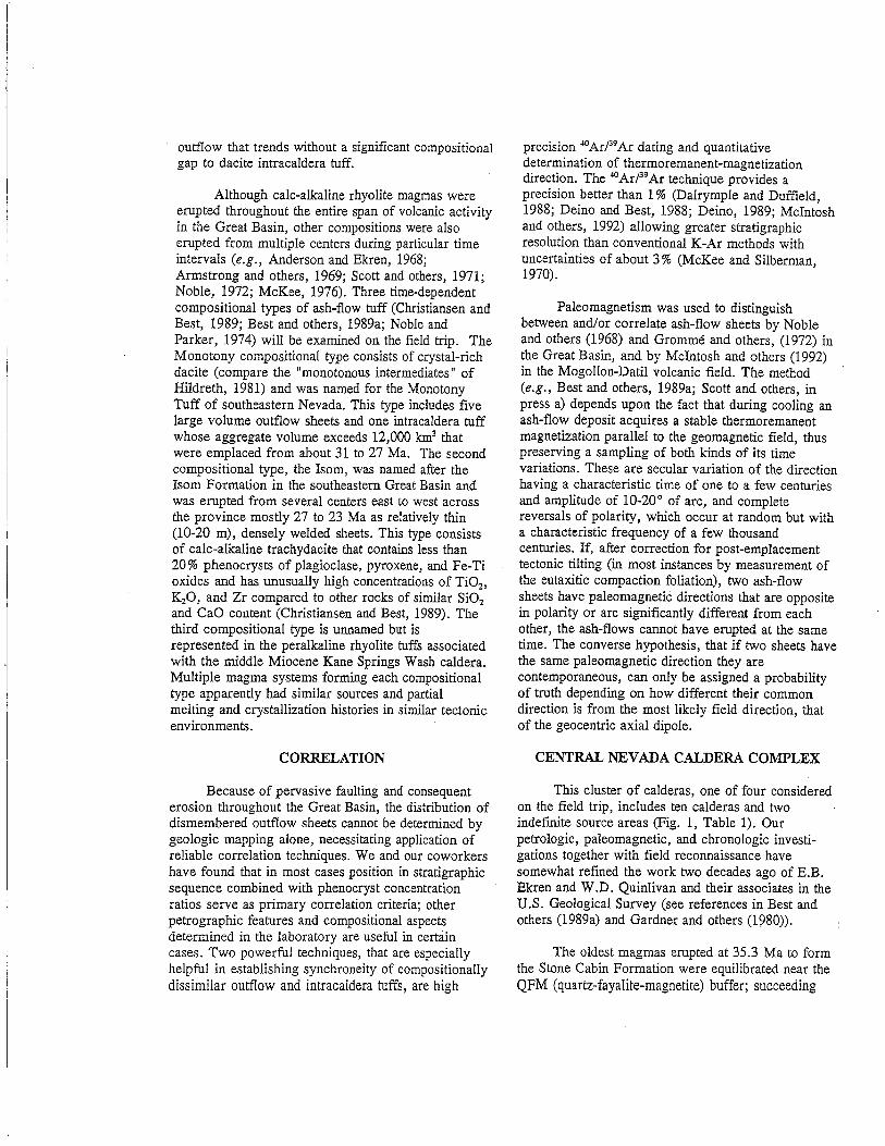
Figure 3. Only exposed topographic margin of thePancake Range caldera, which was the source ofthe Monotony Tuff. As recognized by Ekren andothers (1974), this margin (arrow) is defined bythe post-Monotony Shingle Pass Tuff andoverlying tuff of Lunar Cuesta (cliff) on the rightbanked against and capping the pre-Monotonytuff of Halligan Mesa and overlying tuff ofPalisade Mesa on the left.
dacite that formed the intracaldera tuff ofWilliams Ridge and Morey Peak. Across HotCreek Valley to the N in the Hot Creek Rangehorst, the entire eastern escarpment, about 1km high beneath Morey Peak, is intracalderatuff. Just W of Morey Peak is the N-S-trendingeastern margin of the Hot Creek caldera (John,1987). Additional fill in the Williams Ridgecaldera consists of landslide deposits and localsedimentary material plus subsequent local lava .flows and a much greater volume of severalrhyolite ash-flow deposits derived from thelocal magma system. To the NE, two of theserhyolite tuffs with a combined thickness ofabout 300 m make up most of Palisade Mesa.The upper unit, aptly named the tuff of PalisadeMesa (emplaced at 29.6 Ma), has a spectacularsystem of columnar joints evident from thehighway to the N. Due E of this stop, a 240 mthick section of Shingle Pass Tuff and overlyingoutflow tuff of Lunar Cuesta is bankeddisconformably against the pre-Monotony tuffs(Fig. 3). Ekren and others (1974) interpretedthis to be a segment of the topographic wall ofthe caldera formed as Monotony dacite ashflows were erupted at 27.3 Ma. Stewart andCarlson (1976) designated it the Pancake Rangecaldera.Continue NE on highway.
11.0 75.4 Turn left (N) onto gravel road andproceed toward Moores Station, a remnant ofthe stage-coach era. Mesa tilted toward us iscapped by a 10-Ma basaltic lava flow (Ekrenand others, 1973).
5.6 81.0 Turn sharp left onto dirt track throughsagebrush and head SW.
0.5 81.5 STOP 2 (Best and Christiansen) A1700-m drill hole here (Ekren and others, 1973)inside the Williams Ridge caldera penetratedonly intracaldera dacite tuff, which is exposedjust S of hole. This intracaldera tuff ofWilliams Ridge and Morey Peak has the samepaleomagnetic direction and 40Arj39Ar age(mean of determinations on two samples of31.32 ± 0.08 Ma), within analyticaluncertainty, as the outflow Windous Butte(mean of two, 31.31 ± 0.11 Ma).Turn around and return to highway.
6.1 87.6 Turn left (E) onto highway. To S are thincooling units of Shingle Pass Tuff capped byoutflow tuff of Lunar Cuesta.
1.0 88.6 Road cut in a 300 m-thick simple coolingunit of the Monotony Tuff.
1.4 90.0 Intersection with gravel road S to LunarCrater. The surrounding youthful alkaline basaltfield of lava flows, about 70 cinder cones andat least two maars, developed since 6 Ma alonga NNE-striking fissure system (Scott and Trask,1971). Lunar Crater is a spectacular maareasily reached from this turnoff. Nearly everylava flow and ejecta deposit containsmegacrysts and Ti-Al-rich xenoliths of gabbroand c1inopyroxenite, but only three ventserupted Cr-rich spinel peridotite of mantleorigin (Menzies and others, 1987). LateCenozoic volcanism is concentrated along themargins of the Great Basin and its onlyexpression within the interior is here in theLunar Crater field (Fitton and others, 1988).Youthful "Black Rock" lava flow to E containsabundant megacrysts of olivine, pyroxene, andfeldspar.
9.1 99.1 Black Rock Summit. To NE near relaytower are large slide masses of shattered andaltered Paleozoic carbonate rock resting onaltered intracaldera tuff of the Windous ButteFormation within a few kilometers of themargin of the Williams Ridge caldera(Quinlivan and others, 1974). For next fourmiles, highway follows a Quaternary basalt lavaflow; hills on either side of highway are ofaltered intracaldera tuff and Paleozoic rock.

3.5 102.6 Topographic margin of Williams Ridgecaldera near here.
3.4 106.0 STOP 3 (Christiansen) Two coolingunits of Monotony Tuff; vitrophyre of lowerunit lies at highway level. The Monotonyappears to have been deposited directly onPaleozoic rocks here; the absence of theWindous Butte Formation might imply upliftnear the Williams Ridge caldera prior to itsdeposition.
1.7 107.7 Lockes ranch.7.7 115.4 To N is the E flank of the Pancake
Range where alternating light- and dark-brownlayers are cooling units of the Stone CabinFormation (Radke, 1992). The Railroad Valleyoil field produces from a pre-Windous Butte,post-Stone Cabin tuff and the upper Eocene tolower Oligocene clastic Sheep Pass Formation.
8.0 123.4 Red and brown weathering RaggedRidge to E is a steep NE tilted section ofOligocene rhyolite lava flows, clastic rocks,and overlying regional tuff sheets including, inascending order, the Stone Cabin, WindousButte (on skyline), and Wah Wah SpringsFormations and Shingle Pass Tuff. Overlyingthese sheets is a thick (as much as 3 km)sequence of clastic sedimentary rocks, tuffs,and gravity-slide masses of the Pliocene HorseCamp Formation (Moores, Scott, and Lumsden,1968). The significant post-volcanic extensionalfaults in the Grant Range contrast sharply withthe few faults cutting the flat-lying strata of thePancake Range to the W.
6.0 129.4 Community of Currant. Turn SE ongravel road passing N end of Ragged Ridge.
3.8 133.2 STOP 4 (Scutt) To NW is a low ridgewithin the Horse Camp Basin that contains thelowest of a series of tectonic breccia slices thatwere emplaced as gravity slides duringdeposition of the Pliocene Horse CampFormation (Moores, Scott, and Lumsden,1968). These slices consist of brecciated31.3-Ma Windous Butte Formation and 33-MaRailroad Valley Rhyolite. To SW, units inRagged Ridge dip 40-70° eastward, flooring theHorse Camp depocenter. Dips in the HorseCamp Formation decrease upsection from 70°to 30°. To NE is a hill consisting of tectonicslices of highly attenuated, brecciated, butstratigraphically ordered Cambrian to Devonianstrata within the upper part of the Horse Campsediments. To SE, Red Mountain containsbrecciated slices of the Mississippian Joana
Limestone, Railroad Valley Rhyolite, slightlyyounger sedimentary and ash-flow tuffs, andthe 34.5-Ma Stone Cabin and Windous ButteFormations, tectonically emplaced within theHorse Camp sequence. Farther E, across theRagged Ridge fault that borders the HorseCamp Basin in the Horse Range, severalallochthonous sheets of Paleozoic and Tertiaryrocks overlie autochthonous Paleozoic strata, arelationship typical of detachment-styleextensional tectonics. Presumably, thesedetachments fed the growing Horse Campdepocenter during the Pliocene. Scott (1965;1966; also W.E. Brooks, written commun.,1992) noted that volcanic strata in RaggedRidge have K 20 contents in the range of 8 to10 % in contrast to relatively unaltered rangesof 4 to 6 % elsewhere. This metasomatismcould have happened as the highly attenuatedstrata of Ragged Ridge, buried under about 3km of Pliocene sediments, were juxtaposed viaa basal detachment over warmer middle crust,resulting in hydrothermal circulation that causedalkali exchange (compare Walker and others,1992).
0.7 133.9 Horse Camp Formation; optional stop.4.3 138.2 Calloway Well and Stone Cabin,
namesakes and type sections of the formations.of those names. The rhyolitic Calloway WellFormation (in low hills immediately behindcabin and well), named by Moores, Scott, andLumsden (1968), is a sequence of beddedpyroclastic-surge and -fall deposits alternatingwith massive ash-flow tuff emplaced at 35.3Ma. The overlying Stone Cabin Formation,which has the same 40ArP9Ar age withinanalytical uncertainty, will be examined at thenext stop.
8.7 146.9 STOP 5 (Best, Christiansen, Deino,Gromme) Intersection of 4X4 trail to left (N).Hill to NE is brown, 210-m-thick, Stone CabinFormation overlain in distance by the 280m-thick Windous Butte Formation seen here asa thin ledge of black vitrophyre. Completesections of these two rhyolite tuffs can be seenby hiking to N around W side of hill where thebottom part of the Stone Cabin contains 10-20m of black vitrophyre underlain by several m ofwhite to salmon-colored, weakly weldedash-flow tuff; beneath the Stone Cabin is a fewtens of m of cross-bedded, well-sorted graysandstone overlying Paleozoic rocks. Bycontinuing around hill to E, one can go up

section through the E dipping Stone Cabin intothe overlying conformable Windous Butte,which consists of a few m of weakly weldedsalmon-colored ash-flow tuff overlain by blackvitrophyre and then brown devitrified tuff, both :densely welded. Note the absence of beddedplinian ash-fall deposits at the base of these twotuff sheets. On the SE side of the road, cappingthe low hill, is the dacitic, hornblende-rich WahWah Springs Formation derived from the Indian,Peak caldera in the Indian Peak caldera .complex (Fig. 1). The lowest Wah Wah Springshere is a slabby weathering welded tuff thatgrades upward into about one m of dark grayvitrophyre and then into devitrified red-browntuff. In the low rolling hills to the E are three,thin, devitrified, densely welded ash-flow tuffcooling units. The first is the red-brown lowermember of the Shingle Pass Tuff containingconspicuous phenocrysts of sanidine and lesserplagioclase and a few Fe-rich pyroxene andolivine manifest by rusty spots; this unit acrossa small gully is purplish and grussy weathering.The overlying cooling unit of unknownstratigraphic identity is a brown tuff containingobvious shards and sparse tiny smokey quartzphenocrysts. It is overlain by the upper memberof the Shingle Pass Tuff, which here is apurplish-gray tuff containing light gray pumiceand phenocrysts of two feldspars and biotite.Continue E on gravel road.
12.8 159.7 Intersection with NV 318. Turn left (N).14.5 173.2 Enter farming community of Lund.5.2 178.4 Lanes Ranch Motel, our overnight
accommodation. Community of Preston lies ingrove of trees to W.
DAY TWO Sunday May 23, 1993An extraordinarily complete, well-exposed
section of regional ash-flow outflow sheets will beexamined in White River Narrows along NV 318.The sheets in this "outflow alley" section lie betweentheir sources in three nearby caldera complexes: theCentral Nevada to the west, the Indian Peak to theeast, and the Caliente to the southeast. This section,and the one at stop 5 yesterday, are representative ofnumerous outflow volcanic sections emplaced duringthe ignimbrite flareup in the central and southeasternGreat Basin which contain little or no sediment andangular discordances indicative of regional synvolcanic extension (compare Gans and others, 1989,Fig. 18 and Best and Christiansen, 1991, Fig. 6).
As time permits, late afternoon stops will bemade near Caliente as an introduction to the Calientecaldera complex to see the Clover Creek caldera(source of the Bauers Tuff Member of the CondorCanyon Formation) and the Delamar caldera (HikoTuff).
0.0 0.0 Roadlog begins at Lanes Ranch Motel.Head S on NV 318.
4.3 4.3 Lund.15.4 19.7 Intersection with gravel road on W that
goes to stop 5.8.7 28.4 Intersection with gravel road on E that
goes to Shingle Pass where an exceptionalsection of volcanic units (Best and others,1989a, p.118), including the Shingle Pass Tuff,is well exposed.
5.5 33.9 Sunnyside ranch.23.1 57.0 Intersection with gravel road on E that
goes to Bristol Wells and Pioche.17.6 74.6 STOP 6 (Gromme, Best, and
Christiansen) Intersection with gravel road onW to petroglyphs. Exposed in hill to W (Fig. 4)are, in ascending order, the Petroglyph CliffIgnimbrite (named and briefly described by
'Cook, 1965), Monotony Tuff, tuff of HamiltonSpring (Taylor and others, 1989), and ahornblende-pyroxene andesite lava flow. ThePetroglyph Cliff (27.3-27.9 Ma), legitimately awelded tuff breccia, is one of the oldest of theIsom-compositional-type tuffs in the GreatBasin and is unusual because of its abundantlapilli- and block-size fragments. This coolingunit is found only here and in two ranges to theE and probably vented nearby. The distal partof the Monotony outflow sheet here is fairlythick but poorly welded. The Hamilton Springis another Isom type tuff that may correlate,according to paleomagnetic data (Scott andothers, in press a), with the Baldhills TuffMember of the Isom Formation that is widelyexposed to the E into Utah.
Continue S on highway.0.9 75.5 Site of a famous photograph and diagram
by Cook (1965, Fig. 29) showing a pinch-outof ash-flow sheets over the stubby toe of a thickhornblende-augite andesite lava flow. Cookconcluded that, due to the differential anddiminishing compaction of each successivelydeposited tuff, the topographic relief over thelava flow diminished as each younger ash flowwas emplaced. Assuming the top of each flow

SOUTH
STOP 7R
petroglyphs
lava flow I
M
STOP 6
NORTH
P -
Figure 4. Schematic diagram of volcanic section along west side of NV 318 north of the White RiverNarrows between stops 6 and 7. Vertically exaggerated diagram omits numerous slump blocks andQuaternary deposits. The south dipping contact between the two hornblende-pyroxene andesite lavaflows is apparently depositional; if the contact were a fault, a complementary antithetic fault of just theright amount of displacement would be required to the south in order for the tuff of Hamilton Spring tohave no net offset between stop 6 and the petroglyphs. Stratigraphic units in ascending order are: P,Petroglyph Cliff Ignimbrite; M, Monotony Tuff; H, tuff of Hamilton Spring; R, crystal-rich rhyolitetuff; S, lower member of Shingle Pass Tuff; I, Hole-in-the-Wall Member of the Isom Formation; L,Leach Canyon Formation; C, Condor Canyon Formation.
was initially horizontal, he calculated about50 % compaction.
1.0 76.5 STOP 7 (Gromme, Christiansen, andRowley) At the N end of White River Narrowsare four ash-flow sheets consisting of, inascending order starting at the road cut, acrystal-rich rhyolite tuff of unknownstratigraphic identity, upper member of theShingle Pass Tuff, thin, densely weldedHole-in-the-Wall Tuff Member of the 1somFormation, and thick (104 m) Leach CanyonFormation containing spectacular columnarjoints. The three named units had threedifferent sources, the Central Nevada calderacomplex to the NW, possibly the Indian Peakcomplex to the NE, and Caliente calderacomplex to the SE, respectively.Continue S on highway.
1.2 77.7 STOP 8 (Rowley, Christiansen, andBest) At the S end of White River Narrows arefive regional ash-flow sheets overlying LeachCanyon, which here is a pink, lithic-richdevitrified tuff. These five tuff sheets are, inascending order: Condor Canyon Formationconsisting of Swett and overlying Bauers TuffMembers, Pahranagat Formation, HarmonyHills Tuff (exposed only in a small hill), andHiko Tuff, which has large columnar joints.The Leach Canyon Formation emplaced at 23.8Ma was suggested, on the basis of distributionand isopach data, to have been derived from thenorthern part of the Caliente caldera complex(Williams, 1967), but no source has been
identified; perhaps it is under the Panaca basinbetween Pioche and Caliente. The CondorCanyon Formation was derived from the CloverCreek caldera of the Caliente complex. TheHarmony Hills Tuff (between 22.7 and 21.7Ma; Rowley and others, 1989) has beenproposed to come from the Caliente calderacomplex (Ekren and others, 1977) but morelikely it was derived from the Bull ValleyMountains to the E in Utah (Blank, 1959;Blank and others, 1992).Continue S on highway.
11.0 88.7 Outcrops to E are of Hiko Tuff andunderlying Bauers Tuff Member of the CondorCanyon Formation. The same units are exposedfor next two miles through Hiko Narrows.
8.9 97.6 Community of Hiko (Paiute word for"white man's town")
4.7 102.3 Veer left, continuing on NV 318.0.6 102.9 Turn left (E) on US 93 toward Caliente.2.8 105.7 Pass through Hiko Range. Crystal-rich
rhyolite of the Hiko Tuff, which weathers intobulbous forms much like granite, is overlain bythin, middle Miocene, densely welded KaneWash Tuff.
10.5 116.2 Pahroc Summit Pass. To S is SouthPahroc Range where Hiko outflow is as muchas 350 m thick; to N is North Pahroc Range.R.B. Scott has mapped east-striking strike-slipfaults near the road here that he interprets to bepart of the Timpahute lineament of Ekren andothers (1976).Continue E across Delamar Valley.

10.2 126.4 To S, gravel road to ghost town ofDelamar, on the Wedge of the Delamar Range,and center of the Ferguson mining district, anepithermal gold deposit that was Nevada's mostproductive at the turn of the century.
2.8 129.2 Road cut of Cambrian Highland PeakFormation on left and hills of the same unit toleft and right.
0.5 129.7 Cross NNE-striking Seven Oaks Springfault, which separates Highland Peak Formationon W from both sedimentary rocks (left ofroad) and intracaldera Hiko Tuff (right of road)on E. The sharp peak at 10 o'clock is underlainby a Cambrian section ranging from redZabriskie Quartzite at road level to HighlandPeak Formation at the top. The Zabriskie,however, is highly faulted just N of the roadagainst masses of intracaldera Hiko to the S.Thus, the margin of the Delamar caldera here,as in many other places, is a fault, not a typicalcollapsed structure.
1.4 131.1 Road bends to right and dirt road on leftleads along an ENE-trending valley underlainby the same caldera margin. Continue on US93 ESE through intracaldera Hiko Tuff on bothsides of road which contains numerousinterbeds, some as much as 100 m thick, ofvolcanic mudflow breccia--typical of the upperpart of the Delamar intracaldera fill. Someinterbeds are megabreccia masses fromsloughing of caldera walls, but most clasticbeds are of dacite to andesite flow rocks, andthe deposits are interpreted to be fromstratovolcanoes near the caldera rim that weresynchronous with caldera volcanism andfaulting.
1.7 132.8 Oak Springs Summit, crest of theDelamar Mountains.
3.5 136.3 Roadcuts on left in Newman Canyonshow intertonguing intracaldera beds ofmudflow breccia, megabreccia, and Hiko Tuff.The Delamar caldera was subsequentlycomplexly faulted, mostly during the main, orlatest Oligocene to middle Miocene, episode ofextension along mostly NNW-striking obliqueslip faults. About 200 m farther E the valleywidens into a basin of upper Tertiary gravelsand sand. Cross the major NNW-strikingoblique-slip Dula Canyon fault, which probablyhas several kilometers of right-slip andunknown amounts of down-to-the-E normalslip.
3.0 139.8 Road passes through vertical cuts onboth sides consisting of the gray and pink,E-dipping, 3 m-thick tuff of Etna. The tuff issandwiched between tan sedimentary rocks ofNewman Canyon. Several hundred meters N ofhere, tan sedimentary rocks of this unit that. _overlie tuff of Etna contain a bed of waterlaidpumice deposited at 13.8 Ma (H.H. Mehnert,unpub. data, 1991; Rowley and others, 1991),thus constraining the age of the tuff of Etna.Note numerous NNW-striking oblique-slipfaults in roadcuts. Continue E, tuff of Etnathickens and caps mesas.
1.8 141.6 Toreva block of tuff of Etna on right. Ingulch to left, behind houses and junk cars, theNewman Canyon detachment fault dips gentlytoward road, just above the dark spur. Left ofthe dark spur, in the main gulch, this fault cutsoff a high-angle oblique left-slip fault, theGravel Pit fault of Rowley and others(1992). This fault has at least 2 km of left slip,and in the main gulch here it is intruded by adike of the porphyry of Meadow Valley Washemplaced at 19.4 Ma (Snee and others, 1990;Rowley and others, 1992).
0.7 142.3 Enter town limits of Caliente.0.5 142.8 Church on left. Intersection with NV
317 on right. Continue along US 93 throughtown to just past the post office.
0.7 143.5 Turn right, heading E across UnionPacific Railroad tracks, then right (S) paststores.
0.1 143.6 Turn left and head up small canyonalong a dirt road through a thick, steeplyNE-dipping fanglomerate sequence that containswhite and-yellow air-fall tuff beds correlatedwith the tuff of Kershaw Canyon.
1.5 145.1 At the pass, take a sharp right r:'R)along dirt road to overlook near relay tower.
0.6 145.7 STOP 9 (Anderson and Rowley)Overview of the geology of the N margin of theCaliente caldera complex and synchronousfaults. The Clover Creek caldera is bestdisplayed NE of Caliente, in the canyon ofClover Creek. This caldera, recognized byRowley and Siders (1988), is the source of theBauers Tuff Member (22.7 Ma; Best andothers, 1989a) of the Condor CanyonFormation; about 400 m of intracalderarhyolitic Bauers is exposed on the N wall of thecanyon just E of town. W of that, in MeadowValley Wash and W of Caliente, are two N- to
NNE-striking oblique-slip faults, each with atleast 2 km of left slip. E and N of the 400 mexposures of Bauers is a NNW oblique-slipfault with at least 2 km of right slip and 0.5 kmof normal slip that enters Meadow Valley Wash3 km N of Caliente. A S-dipping low-anglenormal fault that contains the tuff of Etna (14Ma according to dating by H.H. Mehnert) in itshanging wall, passes under the scarp here. TheDelamar caldera (Rowley and Siders, 1988),the source of the rhyolitic Hiko Tuff (18.6 Ma;Taylor and others, 1989), is inset into theClover Creek caldera and underlies us but itsnearest exposures are in English Canyon 2 kmto our E. Tan post-Etna clastic sedimentaryrocks that show lesser deformation upward intheir section are seen in most directions.Return to US 93.
2.2 147.9 Turn right (N) on US 93.0.3 148.2 Turn right (E) just past the row houses,
then, in 50 m, right (SE) again beyond thetracks on a dirt road that runs along the N sideof the Union Pacific tracks, heading E upClover Creek canyon. Thick, gently.N-dippingintracaldera Bauers makes up all the walls ofthe canyon.
1.2 149.4 STOP 10 (Anderson and Rowley)Wash of English Canyon passes under therailroad tracks. Examine Bauers 0.5 km up (S)English Canyon to the fault contact betweenBauers on the N and the same post-Hikofanglomerate sequence exposed E of Caliente.The fault strikes E and dips S and exhibitsoblique-slip (right-lateral and normal) inexposures to the E. The Bauers in the footwallhere dips north, but within 1 km to the east,attitudes swing around and Bauers dips S in thehanging wall, defining an asymmetricalanticline interpreted to have formed by foldingalong this major fault. The fault and numerousother nearby faults and folds can be shown bystructural analysis to represent the samedeformation. The fault also marks the Ntopographic margin of the Delamar calderaalong which subsidence occurred during andafter emplacement of Hiko Tuff; the margin isthus unlike anything described in the literaturebecause it clearly has significant oblique slip.This fault is one of several E-W faults andplutons (including the one that controls theChief mining district NW of Caliente) within anE-W zone at least 5 km wide that Ekren andothers (1976) called the Timpahute
lineament. Another 1 km upstream isunderlying, more densely welded intracalderaHiko and intertongued caldera megabrecciadeposited in the Delamar caldera fromlandslides off the oversteepened fault/calderamargin.
Return to US 93 and Caliente for overnight.
DAY 3 Monday May 24, 1993The first part of the day will continue to
provide a brief overview of the Caliente calderacomplex by way of a traverse southward fromCaliente to Elgin through Rainbow Canyon along NV317 to see the Buckboard Canyon caldera (tuff ofRainbow Canyon) and several outflow tuffs derivedfrom other parts of the complex. Much of the story ofthe complex, however, is about the structuralgeology, for magmatism was in large partsynchronous with the main episode of extensionaldeformation.
The second part of the day we will examine theKane Springs Wash caldera which has been sliced bythe left-lateral oblique-slip Kane Springs Wash fault,and the Narrow Canyon caldera, a peralkaline tometaluminous precursor to the Kane Springs Washcaldera which has been highly deformed byhigh-angle normal faults and by northwest-strikingdextral faults.
0.0 0.0· Start log at intersection of US 93 and NV317 across from the church. Turn left (SE) ontoNV 317 and head S down Rainbow Canyonfollowing Meadow Valley Wash.
0.4 0.4 Jagged hill on E is the deformed hangingwall of the low-angle, S-dipping normal faultmentioned at stop 9. Most rocks are of tuff ofEtna and underlying and overlying clasticsedimentary rocks.
0.6 1.0 Tuff of Etna, a moderately welded,rhyolite outflow tuff is exposed on the E side ofthe road in a rollover in the hanging wall of alow-angle fault. Source of Etna is about 8 kmSSW of here. Two outflow cooling units of themoderately to densely welded peralkalineGregerson Basin Member of the Kane WashTuff (14.7 Ma; Scott and others, in press a) areinterbedded with clastic sedimentary rocksunder the tuff of Etna just S of this stop.
0.5 1.5 On the E, clastic sedimentary rocks underthe tuff of Etna intertongue to the S with whitenonwelded rhyolite ash-flow tuff that we call
the tuff of Kershaw Canyon. The tuff of Etna isthe uppermost resistant bed at most places innorthern Rainbow Canyon. Look W to seeseveral of its cooling units in exposures on theother side of the Canyon.
0.5 2.0 STOP 11 (Rowley, Anderson, L.D.Nealey, D.M. Unruh, Scott, and Harding).Road to E goes to Kershaw-Ryan StateRecreation Area (closed). Walk 0.7 km E alongthe road to examine tuff of Kershaw Canyonand to view a fault that offsets two coolingunits of the Gregerson Basin Member andintertongued outflow(?) tuff of KershawCanyon. The Gregerson Basin units werederived from the Kane Springs Wash caldera.As first noted by R.E. Anderson (see Bowman,1985 and Michel-Noel and others, 1990) theNNW-striking, high-angle, oblique-slip fault onthe N wall of the' canyon offsets the lowercooling unit twice as much as it offsets theupper cooling unit, whereas the tuff of Etna ontop has virtually no offset. The upwarddecreasing amount of offset is due to recurrentmovement along the fault, which is not atypical Gulf-Coast-type growth fault becausemuch of the offset is right-lateral. The latestmovement on the fault reflects some of theyoungest movement during the main episode ofextension in the area, which began at leastbefore 19 Ma and continued to at least 12Ma. As we walk back to the vehicles, lookahead to the SWan the E wall of RainbowCanyon where the fan array of tuff of KershawCanyon and intertongued Gregerson BasinMember resting on mostly pink tuff of RainbowCanyon to the S. Dips are progressivelygreater in progressively older rocks, due torecurrent movement on nearby oblique-slipfaults.
1.2 3.2 Stock pond and ranch to E; mobile homesand Union Pacific warehouse to W. Here,Buckboard Canyon enters Rainbow Canyonfrom the W. Turn right onto former NV317. Cross tracks; rugged gulch straight aheadcontains another major high-angle NW-strikingoblique-slip fault that passes under us andcontinues SE through the N side of a canyonbehind us.
004 3.6 STOP 12 (Rowley, L.D. Nealey, andD.M. Unruh) Most rocks here and around usbelong to the poorly to nonwelded intracalderarhyolite tuff of Rainbow Canyon. The tuff hereis in its source, the Buckboard Canyon caldera
(Rowley and Siders, 1988) that is interpreted tobe a trap-door type caldera in which mostsubsidence was on its N side; the N margin isburied by younger rocks but is inferred to benear Caliente. The tuff has a 40Arj39Ar age of15.6 Ma and a K-Ar age of 15.2 Ma. Therocks SW of the major fault in the gulchmentioned above have been downthrown andinclude the two Gregerson Basin cooling units(also just S of the homes and warehouse) and,under those, a local thick, brown, poorly tomoderately welded outflow ash-flow tuff nearthe bottom of Buckboard Canyon that we callthe tuff of Sawmill Canyon. These threecooling units are interbedded with the tuff ofKershaw Canyon and are overlain by the tuff ofEtna capping the S wall of Buckboard Canyon.As is typical of most of these NNWoblique-slip faults, the rock sequences onopposite sides of the fault display differentfacies of the same stratigraphic units. Thus therocks above the tuff of Rainbow Canyon N ofthe major fault are much thinner and includeonly one Gregerson Basin cooling unit and onlyminor amounts of the tuff of KershawCanyon. Examine tuff of Rainbow Canyon,which makes up all exposures near this stopexcept for a large, badly deformed horse ofHiko Tuff in the zone of the major fault.Return to NV 317.
004 4.0 Turn right (S); continue down RainbowCanyon on NV 317.
0.6 4.6 Sawmill Canyon enters Rainbow Canyonon E. Tuff of Sawmill Canyon, two coolingunits of the Gregerson Basin Member, and tuffof Etna occur in canyon wall to W. From hereto a point about 2 km to the S, observe thesame units interbedded with thick tuff ofKershaw Canyon on E canyon wall broken bynumerous faults. The facies on the E wall ofRainbow Canyon is thicker than that on the Wwall; probably a buried NE-striking fault withstrike-slip offset is beneath us.
1.0 5.6 As we round the corner and head westerly,note the NW-striking high-angle fault ahead thatcuts the tuff of Rainbow Canyon low in thecanyon wall but does not offset the tuff of Etnaon the mesa top.
0.2 5.8 Former railroad stop of Etna. The tuff ofEtna caps all surrounding mesas.
0.3 6.1 A NW-striking fault at 3 o'clock droppedthe tuff of Rainbow Canyon on the N againstthe Hiko Tuff on the S. At 1:30, note a

spectacular fault along which the tuff ofRainbow Canyon on W is dropped downwardagainst the Hiko Tuff on the E. The Hiko onthe E side is overlain disconformably by thetuff of Rainbow Canyon; this contact may bethought of as the floor of the BuckboardCanyon trapdoor caldera, and we infer that thetuff of Rainbow Canyon here is much thinnerthan it was in the N part of the caldera, as atthe last stop.
0.3 6.4 Roadcuts of Hiko Tuff on both sides ofroad.
1.0 7.4 Dula Canyon enters Rainbow Canyon fromthe W. The canyon is underlain by the major 'NNW-striking oblique-slip Dula Canyon fault Ithat can be traced the length of the Caliente 7.51minute quadrangle. The amount of right slip "has not been determined but is doubtless greater'for older rocks than younger and for Hiko Tuffmust be at least a couple of kilometers. Therocks on the SW side of the fault are muchdifferent from those to the NE and consistmostly of rhyolite domes and lava flows.
0.7 8.1 Chokecherry Canyon enters RainbowCanyon from the W. Spectacular exposures of a .rhyolite dome and its underlying pyroclasticcone occur several hundred meters up thecanyon. A rough dirt road that starts here leadsup the canyon and then SW for about 5 km tothe Taylor (Easter) Mine, an epithermal golddeposit consisting of gold-bearing quartz veinsalong a N-dipping normal fault and adjacenthydrothermally altered intracaldera Hiko Tuff.
0.6 8.7 Baldy Mountain to the Wand exposuresextending into Chokecherry Canyon areunderlain by the rhyolite mentioned above. Thehigh fault scarp to the E, with the Dula Canyonfault at its base, is underlain by the AcklinCanyon rhyolite dome, which rests onintracaldera Hiko Tuff. Sharp brown hill aheadis of andesite lava flows that were depositedoutside (S of) the Delamar caldera. The hill isbounded on its W side by a NNW-strikingleft-slip fault under Meadow Valley Wash andon its E by an almost N-striking right-slip fault.
0.5 9.2 S-dipping contact between the andesite (onthe N) and outflow Hiko Tuff occurs in the Eroadcut here. The Dula Canyon fault is about 1km to the E, on the other side of this smallmountain of Acklin Canyon rhyolite flows andtuffs. Most rocks to Ware rhyolite flows andtuffs of the Baldy Mountain dome; farther Wthis dome rests on intracaldera Hiko.
0.2 9.4 Taylor Mine Canyon enters RainbowCanyon from the W. Old shell of a concretebuilding in cottonwood trees at 3 o'clock is theformer pump house for a water line fromMeadow Valley Wash over the DelamarMountains to the town and mines of theDelamar (Ferguson) district, about 18 km to theWSW. Because the water line was installedmidway through the life of the district the goldin the quartzite was originally mined and milleddry, and thus the Delamar district is known asthe "widow maker" because of deaths fromsilicosis. The town survived 17 years until 1909and had a population of as many as 2000 people(Ferris, 1991). The district, located just SW ofthe Delamar caldera (Fig. 2), is an epithermalsystem in massive Lower Cambrian quartziteand has many geologic similarities to the small ,Chief gold district NW of Caliente (Rowley and I
others, 1992). The gold at both places wasdeposited in quartz veins along fractures inquartzite, which shattered during the mainepisode of Tertiary extensional faulting thataccompanied magmatism and associatedconvective hydrothermal activity.
1.1 10.5 Rock Springs Canyon enters RainbowCanyon from the W. Light-gray, nonweldedrhyolite ash-flow tuff visible about 1 km to theWare possible correlatives with pyroclasticdeposits of the Baldy Mountain dome. RockSprings Canyon narrows dramatically 2 km tothe SW where the 400-m-high gorge consists ofthe vertically flow-foliated vent facies tuff ofEtna. The vent cut through intracaldera HikoTuff at the S edge of the Delamar caldera. Themargin of the caldera is an E-W fault zonewithin the E-W Helene lineament (Rowley andothers, in press a) which is at least 5 km wideand characterized across this width by almostcontinuous rhyolite that conceals the actualcaldera margin. In general the rhyolite N of thefault/caldera margin consists of extrusiveproducts (domes and tuff), whereas the rhyoliteS of the margin consists of the deeply erodedand hydrothermally altered intrusive vents fordomes and tuff that were removed by erosion.Almost all vents are marked by dikes thatmostly strike E-W and clearly intruded alongother faults within the lineament. At the SWedge of the Delamar caldera, the E-W rhyolitedikes and faults continue W into the Delamardistrict. A buried silicic pluton is inferred forthe dikes under the district and is hypothesized
to be the heat pump for the convective overturnof groundwater and thus for the mineralization.
1.3 11.8 Pass under the railroad; ranch on NW.Most rocks are hydrothermally altered; localanomalous gold has been reported and, in a fewplaces, mined. Here we are probably S of theDelamar caldera. Based on an analogy with thegold deposits at Delamar, the potential for goldin this E-W faulted rhyolite zone would seem tobe good, but we have not yet sampled the rockshere.
3.1 14.9 Pass under the railroad. Former railroadstop of Boyd about 1 km N of here. Wecontinue S out of the deformed andhydrothermally altered rocks of the Helenelineament and into a simple, gently S-dippinghomoclinal sequence of volcanic rocks,including, from base upward, dark-brownoutflow tuff of the Gregerson Basin Member ofthe Kane Wash Tuff, a sequence ofyellowish-tan, nonwelded rhyolite ash-flow tuffthat is possibly tuff of Kershaw Canyon,and dark-brown, moderately welded outflow ofthe tuff of Etna.
3.9 18.8 Rainbow Canyon narrows as MeadowValley Wash and the road pass through thickoutflow tuff of Etna. Five overlying basalt lavaflows are in turn overlain by thick fluvialsedimentary rocks. Although not dated, thebasalts probably are correlative with flows in asimilar stratigraphic position on the east side ofthe Meadow Valley Mountains dated by H.H.Mehnert (unpublished data, 1983) at 13.2 and13.3 Ma. The sedimentary sequence that formssteep hillsides and cliffs on either side of thecanyon as it opens up around Elgin formed in abasin considerably larger and older than thecurrent structural basin. Small cliffs on leftformed by three layers of young peralkaline(?)ash-flow tuffs(?) are apparently the youngestsilicic volcanic rocks in the area.
1.8 20.6 Intersection with dirt road to the twoinhabited houses remaining in Elgin on thenorth side of Meadow Valley Wash. ContinueSE.
0.6 21.2 End of pavement on NV 317.0.2 21.4 Turn left (S) onto gravel road that climbs
SW out of Rainbow Canyon through thicksedimentary sequence.
0.4 21.8 On the left, NW-dipping sedimentaryrock, basalt, and tuff are deformed against astrand of the Kane Springs Wash normal faultthat makes the SE border of the Elgin structural
basin. These deformed basalts were dated by H.H. Mehnert (unpublished data, 1980) at 8 Maand correlate well with basalts found in thefluvial deposits on the E side of the MeadowValley Mountains, also dated by Mehnert at 8.1Ma. Thus, the original depositional basin forthese fine-grained fluvial sediments persisted atleast 5 million years, a surprisingly longperiod. The strand of the Kane Springs Washfault contains subhorizontal slickenlines thatindicate a left-lateral oblique sense of motion;as we will see farther S at Stop 13, 4-7 km ofsinistral offset has been established by the offsetof the margins of the Kane Springs Washcaldera. It is likely that the Elgin structuralbasin is related to this motion; note that theNE-striking Kane Springs Wash fault joins aWNW-striking fault and a N-striking fault atthe S end of the exposures of Paleozoic rocksNE of Elgin (Fig. 2).
0.9 22.7 On right, new roadcuts expose steeplyNE-dipping sedimentary rocks that are cut by
. NW-dipping normal faults.1.9 24.6 At crest between Kane Springs Valley
and Meadow Valley Wash note that thesedimentary rocks are fine grained even at thishigh topographic elevation; the nearbycoarser-grained rocks exposed at lowertopographic levels to the northwest may requireeither undetected structures or local channels.Continue straight on NV 317 past crossroadsand down Kane Springs Valley, the MeadowValley Mountains are on the left (E), theDelamar Mountains on the right (W). The lowpass in the Meadow Valley Mountains isunderlain by the less resistant Harmony HillsTuff; SW of the pass, the NE wall of the E partof the Kane Springs Wash caldera coincideswith the higher part of the mountains that areunderlain by the more resistant caldera-fillingrhyolites within the caldera. Farther down KaneWash Valley, observe intracaldera equivalentsof the Kane Wash Tuff characterized by thedarker exposures at the base of the MeadowValley Mountains; the yellowish rocks and therocks above them are post-collapsecaldera-filling tuff and rhyolitic lava flows(Harding, 1991; Harding and others, in press).On the right, a NE-trending low ridge ofoutflow tuff from the Narrow Canyon caldera isexposed in the foreground. In the backgroundare E-dipping slopes of the 13.3(?)-Ma basaltcapping the tuff of Etna and the Kane Springs

8.2
0.5
Wash Tuff. Pass the northern wall of the KaneSprings Wash caldera in the DelamarMountains on the way to next stop.32.8 Turn left at faint 4X4 trail towardMeadow Valley Mountains.33.3 STOP 13 (Harding and Scott) Walk toexposures of intracaldera and caldera-fillingunits, S wall of Kane Springs Wash caldera,wall breccia, precaldera units and (perhaps)outflow units outside the caldera wall. Alsowalk along the trace of the Kane Springs Washfault to see low-angle slickenlines indicatingsinistral oblique slip. The footwall block .contains the contact between the uppermost and ;underlying intracaldera units equivalent to thetwo outflow cooling units of the GregersonBasin Member of the Kane Wash Tuff. Thebluish- to greenish-gray thin layers at thequenched base of the upper cooling unit are likethe layers found at the base of its outflowtooling unit. See caldera wall breccia just S ofthe saddle formed by a hanging-wall block ofbasalt and post-collapse caldera-filling rhyoliteflows. and tuffs. Here, the wall consists of apre-caldera trachyte flow containingconspicuous alkali feldspar phenocrysts. Crudebedding in the breccia dips NE into the caldera.Above the breccia, the intracaldera ash-flowtuff has been quenched against the breccia insimilar manner as seen elsewhere within andoutside the caldera. Walk out of the calderatoward the SE; at the crest and down the slopeto the W, note a large block of the GrapevineSpring Member of the Kane Wash Tuff,enveloped by quenched vitrophyre ofintracaldera Gregerson Basin, that sloughed offthe caldera wall. At the wash at the base of thehill, an aphyric dike cuts the caldera wallparallel to the range front fault and passesoutside the caldera into the lower part of thepre-14.7-Ma Sunflower Mountain Tuff. Climbthrough the pre-caldera trachyte flow into theGrapevine Spring Member. On the way back tovehicles, walk through the caldera to observeseveral post-collapse, caldera-filling, rhyoliticash-flow tuffs, rhyolite flows, and a basaltflow. Note that the nonwelded tuff of thissequence is superficially similar to thenonwelded base of the Sunflower MountainTuff; this similarity contributed to pastdifficulties in recognizing the caldera in theMeadow Valley Mountains. Below thissequence is the upper part of the youngest
cooling unit of the intracaldera Gregerson Basinthat contains cognate inclusions and fiamme ofmafic trachyte in a somewhat more trachyticmatrix. Similar evidence for a layered magmachamber can be found in the tops of the outflowcooling units.
0.5 33.8 Rejoin NV 317 and turn right (NE).6.6 40.4 Turn right just past corral on left toward
low pass in Meadow Valley Mountains.Harmony Hills Tuff and Hiko Tuff in thesaddle dip steeply to the NE, away from the Nwall of the caldera, which lies to the right (S).Dikes of a pre-caldera trachyte (about 14.7 Ma)cut these ash-flow tuffs.
1.9 42.3 At water tank in low pass, turn sharplyright on 4X4 trail and drive up an alluvial-fanveneer on a pediment developed on theHarmony Hills Tuff.
0.3 42.6 STOP 14 (Harding and Scott) Park atend of trail and walk W a few hundred metersto exposures of the N wall of the Kane SpringsWash caldera. Everywhere along this segmentof the wall, breccias and intercalated ash-falltuffs dip 10-40° S toward the caldera,perpendicular to the trace of the wall.Erosionally resistant caldera-filling rhyolite lavaflows and ash-flow tuffs dip 20-40° SE and arerepeated by several NW-dipping normal faultsparallel to the Kane Springs Wash range-frontfault. Nonresistant Harmony Hills and HikoTuffs in the wall dip 50-60° N away from thecaldera, forming the valley below us.
2.1 44.7 Rejoin NV 317 and turn right.1.6 46.3 At crest between Kane Springs Valley
and Meadow Valley Wash, turn left (NW)toward the Delamar Mountains, driving throughdissected pediment above older Tertiarysedimentary basin fill.
2.8 49.1 To left are dip slopes of 13.3(?)Mabasalt.
1.7 50.8 Cross basalt. To right in valley arerounded exposures of tuff of Etna.
0.6 51.4 Turn left. On right, exposures of HikoTuff underlie outflow sheets of the NarrowCanyon caldera, which in turn underlie the tuffof Etna; the Kane Wash Tuff is missing here.
0.7 52.1 Distal edge of upper cooling unit of theGregerson Basin Member is plastered on a hillof Hiko Tuff. These chilled relationships aresimilar to those we saw earlier in theintracaldera Gregerson Basin.
1.0 53.1 Cross wash. On left (S) is a ridge ofoutflow Kane Wash Tuff. Although only 10 km

from the caldera, the Kane Wash Tuff is lessthan 100 m thick. On right are exposures ofnearly horizontal Hiko Tuff, against which theKane Wash Tuff is thinned, possibly because oftumescence prior to collapse of the nearbyNarrow Canyon caldera.
0.2 53.3 Cross exposures of a pyroxeneplagioclase andesite(?) flow breccia thatunderlies the Hiko Tuff.
0.7 60.0 STOP 15 (Scott) Wall of the NarrowCanyon caldera marked by megabreccia of theHiko Tuff. Outflow and intracaldera tuffs haveZr contents in the range of 500-1050 ppm, onlyslightly lower than those of the Kane WashTuff (600 to 1300 ppm). Although the outflowhas limited extent, intracaldera tuff is exposedin the N wall of the Kane Springs Wash calderabeneath the pre-caldera trachyte flow at stop13. The caldera wall has been fragmentedtectonically by NW-striking, dextral-slip faultsand high-angle normal faults; in fact, thenarrow, trough-like segment of caldera-fillingtuffs between caldera wall breccia may indicatethat this caldera, like several similar featureswithin the Caliente caldera complex, formedessentially coevally with extension. If so, thestructural depressions created during extensionmay have acted as loci of eruption and/or astopographic depressions in which eruptionspooled. Pre-existing strain and perhaps stressconditions in the upper crust never allowed theclassic "cookie cutter" style caldera to form;instead regional faults control the shape ofcollapse in the caldera. A resurgent trachyticintrusive dome occurs on the western side ofthe Delamar Mountains (centered at R on Fig.2 about 10 km west of here). This dome iscentered on a large 420 nanoTesla positivemagnetic anomaly and what is interpreted to bethe thickest pool of intra caldera material formsa 500-800 nanoTesla negative anomaly about 4km SW of this stop (Blank and Kucks, 1989)(the northern and eastern boundary for theseanomalies are shown as the dashed and dottedline in Figure 2). Caldera-filling ash-flow tuffsdip as much as 80 0 away from the dome on theNand E sides. The Kane Wash Tuff pinchesout abruptly 2 km to the SE of the dome.Megabreccia of Hiko Tuff is exposed in thestream bed, post-collapse caldera-filling tuffsare on either side, and Kane Wash Tuff capsthe surrounding hills. About 250 metersdownstream exposures of intracaldera
megabreccias and extracaldera andesite flowbreccias are only a few tens of metersapart. The age of the Narrow Canyon caldera isbetween that of the Hiko Tuff (18.6 Ma) andthat of the Grapevine Spring Member (about14.7 Ma).Return to NV 317.
7.8 67.8 END OF TRIP Turn right to rejoin US93 to reach Las Vegas about 2.5 hours away;turn left to return to Caliente and northern andwestern destinations.
REFERENCES CITED
Anderson, R.E., 1989, Tectonic evolution of theIntermontane System, Basin and Range,Colorado Plateau, and High Lava Plains,Chapter 10, in Pakiser, L.C., and Mooney,
.. W.D., eds., Geophysical framework of thecontinental United States: Geological Society ofAmerica Memoir 172, p. 163-176.
Anderson, R.E., and Ekren, E.B., 1968, WidespreadMiocene igneous rocks of intermediatecomposition, southern Nye County, Nevada:Geological Society of America Memoir 110, p.57-63.
Anderson, R.E., and Hintze, L.F., 1991, Geologicmap of the Dodge Spring quadrangle, LincolnCounty, Nevada and Washington County,Utah: U.S. Geological Survey Open-FileReport OF-360, scale 1:24,000.
Armstrong, R.L., Ekren, E.B., McKee, E.H., andNoble, D.C., 1969, Space-time relations ofCenozoic silicic volcanism in the Great Basin ofthe western United States: American Journal ofScience, v. 267, p. 478-490.
Barr, D.L., Christiansen, E.H., Tingey, D.G., andBest, M.G., 1992, Time, space, andcomposition patterns of mid-Cenozoic mafic tointermediate composition lavas of the GreatBasin, western U.S.A.: American GeophysicalUnion (EOS) Transactions, v. 73, no. 43, p.658.
Best, M.G., 1988, Early Miocene change in directionof least principal stress, southwestern U.S.:conflicting inferences from dikes andmetamorphic core-detachment fault terranes:Tectonics, v. 7, p. 249-259.
Best, M.G. and Christiansen, E.H., 1991, Limitedextension during peak Tertiary volcanism,Great Basin of Nevada and Utah: Journal ofGeophysical Research, v. 96, p.13,509-13,528.
Best, M.G., Christiansen, E.H., and Blank, H.R.,Jr., 1989b, Oligocene caldera complex andcalc-alkaline tuffs and lavas of the Indian Peakvolcanic field, Nevada and Utah: GeologicalSociety of America Bulletin, v. 101, p.1076-1090.
Best, M.G., Christiansen, E.H., Deino, A.L.,Gromme, C.S., McKee, E.H., and Noble,D.C., 1989a, Eocene through Miocenevolcanism in the Great Basin of the westernUnited States: New Mexico Bureau of Minesand Mineral Resources Memoir 47, p. 91-133.
Best, M.G., McKee, E.H., and Damon, P.E., 1980,Space-time-composition patterns of lateCenozoic volcanism, southwestern Utah andadjoining areas: American Journal of Science,v. 280, p. 1035-1050.
Blank, H.R., 1959, Geology of the Bull Valleydistrict, Washington County, Utah: Seattle,Univ. of Washington, Ph.D. dissertation, 177p.
Blank, H.R., and Kucks, R.P., 1989, Preliminaryaeromagnetic, gravity, and generalized geologicmaps of the USGS Basin and Range-ColoradoPlateau transition zone study area insouthwestern Utah, southeastern Nevada, andnorthwestern Arizona (the "BARCO" project):U.S. Geological Survey Open-File Report89-432, 16 p.
Blank, H.R., Rowley, P.D., and Hacker, D.B.,1992, Miocene monzonitic intrusions andassociated megabreccias of the Iron Axisregion, southwestern Utah, in Wilson, J.R.,ed., Field guide to geologic excursions in Utahand adjacent areas of Nevada, Idaho, andWyoming, Geological Society of AmericaRocky Mountain Section Meeting: UtahGeological Survey Miscellaneous Publication92-3, p. 399-420.
Boden, D.R., 1992, Geologic map of the Toquimacaldera complex, central Nevada: Nevada'Bureau of Mines and Geology, Map 98, scale1:48,000.
Bonham, H.F., Jr. and Garside, L.J., 1979, Geologyof the Tonopah, Lone Mountain, Klondike, andNorthern Mud Lake Quadrangles,Nevada: Nevada Bureau of Mines and GeologyBulletin 92, 142 p.
Bowman, S.A., 1985, Miocene extension andvolcanism in the Caliente caldera complex,Lincoln County, Nevada: Golden, ColoradoSchool of Mines, M.S. thesis, 143 p.
Christiansen, E.H. and Best, M.G., 1989,Compositional contrasts among middleCenozoic ash-flow tuffs of the Great Basin,western United States: New Mexico Bureau ofMines and Mineral Resources Bulletin 131, p.51.
Christiansen, E.H., Sheridan, M.F., and Burt, D.M.,1986, The geology and geochemistry ofCenozoic topaz rhyolites from the westernUnited States: Geological Society of AmericaSpecial Paper 205, 82 p.
Cook, E.F., 1965, Stratigraphy of Tertiary volcanicrocks in eastern Nevada: Nevada Bureau ofMines Report 11, 61 p.
Dalrymple, G.B. and Duffield, W.A., 1988, Highprecision 40Ar/39Ar dating of Oligocenerhyolites from the Mogollon-Datil volcanic fieldusing a continuous laser system: GeophysicalResearch Letters, v. 15, p. 463-466.
Deino, A.L., 1989, Single crystal 4°ArP9Ar dating asan aid in correlation of ash flows: Examplesfrom the Chimney Spring/New Pass Tuffs andthe Nine Hill/Bates Mountain Tuffs ofCalifornia and Nevada: New Mexico Bureau ofMines and Mineral Resources Bulletin 131, p.70.
Deino, A.L., and Best, M.G.,1988, Use ofhigh-precision single-crystal 40ArP9Ar ages andTRM data in correlation of an ash-flow depositin the Great Basin: Geological Society ofAmerica Abstracts with Programs, v. 20, no. 7,p. A397.
Dixon, G.L., Hedlund, D.C., and Ekren, E.B., 1972,Geologic map of the Pritchards Stationquadrangle, Nye County, Nevada: U.S.Geological Survey Miscellaneous InvestigationsSeries Map 1-728, scale 1:48,000.
Ekren, E.B., Bucknam, R.C., Carr, W.J., Dixon,G.L., and Quinlivan, W.D., 1976,East-trending structural lineaments in centralNevada: U.S. Geological Survey ProfessionalPaper 986, 16 p.
Ekren, E.B., Hinrichs, E.N., Quinlivan, w.n., andHoover, D.L., 1973, Geologic map of theMoores Station quadrangle, Nye County,Nevada: U.S. Geological Survey MiscellaneousInvestigations Series Map 1-756, 1:48,000.
Ekren, E.B., Orkild, P.P., Sargent, K.A., andDixon, G.L., 1977, Geologic map of Tertiaryrocks, Lincoln County, Nevada: U.S.Geological Survey Miscellaneous InvestigationsSeries Map 1-1041, scale 1:250,000.

Ekren, E.B., Quinlivan, W.D., Snyder, R.P., andKleinhampl, FJ., 1974, Stratigraphy, structure,and geologic history of the Lunar Lake calderaof northern Nye County, Nevada: U.S.Geological Survey Journal of Research, v. 2,no. 5, p.599-608.
Ferris, D.E., 1991, The best of times, the worst oftimes-A bio-cultural analysis of the Fergusondistrict, 1982-1919: Las Vegas, Univ. ofNevada, Las Vegas, M.A. thesis, 296 p.
Fitton, J.G.~ James, D., Kempton, P.D., Ormerod,D.S., and Leeman, W.P., 1988, The role oflithospheric mantle in the generation of lateCenozoic basic magmas in the southwesternUnited States: Journal of Petrology, SpecialIssue on the Lithosphere, p. 331-349.
Gans, P.B., Manhood, G., and Schermer, E. , 1989,Synextensional magmatism in the Basin andRange province: A case study from the easternGreat Basin: Geological Society of AmericaSpecial Paper 233, 58 p.
Gardner, J.N., Eddy, A.C., Goff, F.E., and Graff..ty,K.S., 1980, Reconnaissance geologic map ofthe northern Kawich and southern ReveilleRanges, Nye County, Nevada: Los AlamosScientific Laboratory LA-8390-MAP, UC-51,scale 1:62,500.
Grornme, C. S., McKee, E. H., and Blake, M.C.,Jr., 1972, Paleomagnetic correlations andpotassium-argon dating of middle Tertiaryash-flow sheets in the eastern Great Basin,Nevada and Utah: Geological Society ofAmerica Bulletin, v. 83, p. 1619-1638.
Harding, A.E., 1991, Evidence of the Kane SpringWash caldera in the Meadow ValleyMountains, southeastern Nevada: Boulder,Univ. of Colorado, M.S. thesis, 121 p.
Harding, A.E., Scott, R.B., Mehnert, H.H., andSnee, L.W., in press, Evidence of the KaneSprings Wash caldera in the Meadow ValleyMountains, southeastern Nevada: in Scott R.B.and Swadley, W C, editors, Geologic studies inthe Basin and Range to Colorado Plateautransition in southeastern Nevada, southwesternUtah, and northwestern Arizona: U.S.Geological Survey Bulletin
Hardyman, R.F., and Oldow, J.S., 1991, Tertiarytectonic framework and Cenozoic history of thecentral Walker Lane, Nevada, in Raines, G.L.,Lisle, R.E., Schafer, R.W., and Wilkinson,W.H., eds., Geology and ore deposits of theGreat Basin: Geological Society of NevadaSymposium Proceedings, v. 1, p. 279-301.
Hildreth, W., 1981, Gradients in silicic magmachambers: Implications for lithosphericmagmatism: Journal of Geophysical Research,v. 86, p. 10153-10192.
John, D.A., 1987, Geologic map of parts of theMorey and Fandango wilderness study areas,Nye County, Nevada: U.S. Geological SurveyMiscellaneous Field Studies Map MF-1847,scale 1:62,500.
Le Maitre, R.W., 1989, A classification of igneousrocks and glossary of terms: Blackwell, Boston,193 p.
McIntosh, W.C., Chapin, C.E., Ratte, J.C., andSutter, J.F., 1992, Time-stratigraphicframework for the Eocene-OligoceneMogollon-Datil volcanic field, southwest NewMexico: Geological Society of AmericaBulletin, v . 104, p. 851-871.
McKee, E.H., 1976, Geology of the northern part ofthe Toquima Range, Lander, Eureka, and NyeCounties, Nevada: U.S. Geological SurveyProfessional Paper 931, 49 p.
McKee, E.H. and Noble, D.C., 1986, Tectonic andmagmatic development of the Great Basin ofwestern United States during late Cenozoictime: Modern Geology, v. 10, p. 39-49.
McKee, E.H., and Silberman, M.L., 1970,Geochronology of Tertiary igneous rocks incentral Nevada: Geological Society of AmericaBulletin, v. 81, p. 2317-2327.
Mehnert, H.H., Anderson, R.E., and Rowley, P.D.,1989, Constraints on age of faulting andyoungest volcanism, western Caliente calderacomplex and vicinity, Lincoln County, Nevada[abs]: EOS (Transactions of AmericanGeophysical Union), v. 70, no. 43, p. 1414.
Menzies, M.A., Arculus, R.J., Best, M.G.,Bergman, S.C., Ehrenberg, S.N., Irving, A.J.,Roden, M.F., and Schultze, D.J., 1987, Arecord of subduction processes and within-platevolcanism in lithospheric xenoliths of thesouthwestern USA: in Nixon, P. H. (ed.),Mantle xenoliths: John Wiley & Sons, NewYork, p. 59-74.
Michel-Noel, G., Anderson, R.E., and Angelier, J.,1990, Fault kinematics and estimates of strainpartitioning of a Neogene extensional faultsystem in southeastern Nevada, in Wernicke,B.P., ed., Basin and Range tectonics near thelatitude of Las Vegas, Nevada: GeologicalSociety of America Memoir 176, p. 155-180.
Moores, E.M., Scott, R. B., and Lumsden, W. W.,1968, Tertiary tectonics of the WhitePine-Grant Range region, east-central Nevada,and some regional implications: GeologicalSociety of America Bulletin, v. 79, p.1703-1726.
Nealey, L.D., Rowley, P.D., Unruh, D.M., Budahn,J.R., Snee, L.W., Mehnert, H.H., andAnderson, R.E., in press, Preliminarygeochemistry of Oligocene and Mioceneash-flow tuffs in and near the Caliente calderacomplex, southeastern Nevada and southwesternUtah, in Scott, R.B., and Swadley, W C, eds.,Geologic studies in the Basin and Range toColorado Plateau transition of southeasternNevada, southwestern Utah, and northwesternArizona: U.S. Geological Survey Bulletin
Nielsen, P.J., 1992, Petrology of the OligoceneShingle Pass Tuff in the northern Basin andRange, Nevada: evolution of a dry, reducedmagma system: Provo, Utah, Brigham YoungUniv., M.S. thesis, 38 p.
Noble, D.C., 1968, Kane Spring Wash volcaniccenter, Lincoln County, Nevada, in Eckel,E.B., ed., Geological Society of AmericaMemoir 110, p. 109-116.
Noble, D.C., 1972, Some observations on theCenozoic volcano-tectonic evolution of theGreat Basin, western United States: Earth andPlanetary Science Letters, v. 17, p. 142-150.
,Noble, D.C., and McKee, E.H., 1972, Descriptionand K-Ar ages of volcanic units of the Calientevolcanic field, Lincoln County, Nevada, andWashington County, Utah: Isochron/West, no.5, p. 17-24.
Noble, D.C., McKee, E.H., Hedge, C.E., andBlank, H.R., 1968, Reconnaissance of theCaliente depression, Lincoln County, Nevada[abs.]: Geological Society of America SpecialPaper 115, p. 435-436.
Noble, D.C. and Parker, D.L., 1975, Peralkalinesilicic volcanic rocks of the western UnitedStates: Bulletin Volcanologique, v. 38, p.803-827.
Novak, S.W., 1984, Eruptive history of the rhyoliticKane Springs Wash volcanic center, Nevada:Journal of Geophysical Research, v. 89, p.8603-8615.
Novak, S.W., 1985, Geology and geochemicalevolution of the Kane Springs Wash volcaniccenter, Lincoln County, Nevada: Palo Alto,Calif., Stanford Univ., Ph.D. diss., 173 p.
Novak, S.W., and Mahood, G.A., 1986, Rise andfall of a basalt-trachyte-rhyolite magma systemat the Kane Springs Wash caldera,Nevada: Contributions to Mineralogy andPetrology, v. 94, p. 352-373.
Pampeyan, E.H., 1989, Preliminary geology of theMeadow Valley Mountains, Lincoln and ClarkCounties, Nevada: U.S. Geological SurveyOpen-File Report 89-182, scale 1:50,000.
Phillips, L.V., 1989, The petrology and magmaticevolution of the large volume ash-flow tuffs ofthe central Nevada caldera complex, NyeCounty, Nevada: Athens, Univ. of Georgia,Ph.D. dissertation, 285 p.
Proffett, J.M., Jr., 1977, Cenozoic geology of theYerington district, Nevada, and its implicationsfor the nature and origin of Basin and Rangefaulting: Geological Society of AmericaBulletin, v. 88, p. 247-266.
Quinlivan, W.D., Rogers, C.L., Dodge, H.W., Jr.,1974, Geologic map of the PortugueseMountain quadrangle, Nye County, Nevada:U.S. Geological Survey MiscellaneousInvestigations Series Map 1-804, scale1:48,000.
Radke, L.E., 1992, Petrology and temporal evolutionof the rhyolite ash-flow tuffs of the 35.4 MaStone Cabin Formation, central Nevada: Provo,Utah, Brigham Young Univ., M.S. thesis, 103p.
Rowley, P.D., Anderson, R.E., Snee, L.W., andMehnert, H.H., 1990, Geology and structuralsetting of the western Caliente caldera complex,Lincoln County, Nevada Cabs]: GeologicalSociety of America Abstracts with Programs, v.22, no. 3, p. 79.
Rowley, P.D., Cunningham, C.G., Steven, T.A.,Mehnert, H.H., and Naeser, C.W., in press a,Cenozoic igneous and tectonic setting of theMarysvale volcanic field, and its origin inrelation to other igneous centers, Utah-Nevada,in Friedman, J.D., ed., Laccolith complexes ofsoutheastern Utah--Tectonic control and time ofemplacement: U.S. Geological SurveyBulletin.
Rowley, P.D., McKee, E.H., and Blank, H.R., Jr.,1989, Miocene gravity slides resulting fromemplacement of the Iron Mountain pluton,southern Iron Springs mining district, IronCounty, Utah (abs.): EOS (AmericanGeophysical Union), v. 70, no. 43, p. 1309.

Rowley, P.D., Nealey, L.D., Unruh, D.M., Snee,L.W., Mehnert, H.H., Anderson, R.E., andGromme, C.S., in press b, Stratigraphy ofOligocene and Miocene ash-flow tuffs in andnear the Caliente caldera complex, southeasternNevada and southwestern Utah, in Scott, R.B.,and Swadley, W C, eds., Geologic studies inthe Basin and Range to Colorado Plateautransition of southeastern Nevada, southwesternUtah, and northwestern Arizona: U.S.Geological Survey Bulletin.
Rowley, P.D., Snee, L.W., Mehnert, H.H.,Anderson, R.E., Axen, G.J., Burke, K.J.,Simonds, F.W., Shroba, R.R., and Olmore,S.D., 1992, Structural setting of the Chiefmining district, eastern Chief Range, LincolnCounty, Nevada, Chapter H, in Thorman,C.H., ed., Application of structural geology tomineral and energy resources of the central andwestern United States: U.S. Geological SurveyBulletin 2012, p. HI-HI7.
Rowley, P.D., and Shroba, R.R., 1991, Geologicmap of the Indian Cove quadrangle, LincolnCounty, Nevada: U.S. Geological SurveyGeologic Quadrangle Map GQ-1701, scale1:24,000.
Rowley, P.D., Shroba, R.R., Simonds, F.W., Burke, 'K.J., Axen, G.J., and Olmore, S.D., 1991,Geologic map of the Chief Mountainquadrangle, Lincoln County, Nevada: U.S.Geological Survey Open-File Report 91-135, 32p., scale 1:24,000.
Rowley, P.D., and Siders, M.A., 1988, Miocenecalderas of the Caliente caldera complex,Nevada-Utah: EOS (Transactions of theAmerican Geophysical Union), v. 69, no. 44,p. 1508.
Scott, D.H. and Trask, N.J., 1971, Geology of theLunar crater volcanic field, Nye County,Nevada: U.S. Geological Survey ProfessionalPaper 599-1, 22 p.
Scott, R.B., 1965, The Tertiary geology andignimbrite petrology of the Grant Range, eastcentral Nevada: Houston, Texas, Rice Univ.,Ph.D. dissertation, 116 p., approx. 1:24,000scale map.
Scott, R.B., 1966, Origin of chemical variationswithin ignimbrite cooling units: AmericanJournal of Sciences, v. 264, p. 273-288.
Scott, R. B., 1990, Significance of mild extension ofa relatively stable area within highly extendedterrane, southeastern Nevada: GeologicalSociety of America Abstracts with Programs, v.
22, no. 3, p. 81.Scott, R.B., Blank, H.R. Jr., and Page W.R., 1991,
Evidence for a precursor to the Kane SpringsWash caldera: Geological Society of AmericaAbstracts with Programs, v. 23, p. 91.
Scott, R.B., Grornme, C.S., Best, M.G, Rosenbaum,J.G., and Hudson, M.R., in press a,Stratigraphic relationships of Tertiary volcanicrocks in central Lincoln County, southeasternNevada: in Scott R.B. and Swadley, W C,editors, Geologic studies in the Basin andRange to Colorado Plateau transition insoutheastern Nevada, southwestern Utah, andnorthwestern Arizona: U.S. Geological SurveyBulletin.
Scott, R.B., Nesbitt, R.W., Armstrong, R.L., andDasch, E.J., 1971, A strontium isotopeevolution model for Cenozoic magma genesis,eastern Great Basin, USA: BulletinVolcanologique, v. 35, p. 1-26.
Scott, R.B., Swadley, W C, and Novak, S.W., inpress b, Geologic map of the Delamar Lakequadrangle, Lincoln County, Nevada: U.S.Geological Survey Geologic Quadrangle MapGQ-1730, scale 1:24,000.
Snee, R.B., Mehnert, H.H., Rowley, P.D.,Anderson, R.E., and Scott, R.B., 1990, Newisotopic ages demonstrate extensional faultingof 19-12 Ma in the western Caliente calderacomplex and vicinity, Lincoln County, Nevada[abs.]: EOS (Transactions of the AmericanGeophysical Union), v. 71, no. 43, p. 1612.
Snyder, R.P., Ekren, E.B., and Dixon, G.L., 1972,Geologic map of the Lunar Crater quadrangle,Nye County, Nevada: U.S. Geological SurveyMiscellaneous Geologic Investigations Map1-700, scale 1:48,000.
Stewart, J .H., 1983, Cenozoic structure and tectonicsof the northern Basin and Range province,California, Nevada, and Utah: GeothermalResources Council Special Report 13, p. 25-40.
Stewart, J.H. and Carlson, I.E., 1976, Cenozoicrocks of Nevada: Nevada Bureau of Mines andGeology Map 52, scale 1:1,000,000.
Swadley, W C, and Rowley, P.D., 1992, Geologicmap of the Pahroc Spring SE quadrangle,Lincoln County, Nevada: U.S. GeologicalSurvey Open-File Report 92-7, 22 p., scale1:24,000.

Taylor, W.J., and Bartley, J.M., 1992, Prevolcanicextensional Seaman breakaway fault and itsgeologic implications for eastern Nevada andwestern Utah: Geological Society of AmericaBulletin, v. 104, p. 255-266.
Taylor, W.J., Bartley, J.M., Lux, D.R., and Axen,G.J., 1989, Timing of Tertiary extension in theRailroad Valley-Pioche transect, Nevada:constraints from 40ArP9Ar ages of volcanicrocks: Journal of Geophysical Research, v. 94,p. 7757-7774.
Unruh, D.M., Nealey, L.D., Rowley, P.D., Snee,L.W., Mehnert, H.H., and Anderson, R.E., inpress, Strontium and neodymium isotope surveyof ash-flow tuffs and related rocks from theCaliente caldera complex, southeastern Nevadaand southwestern Utah, in Scott, R.B., andSwadley, W.C., eds., Geologic studies in theBasin and Range to Colorado Plateau transitionof southeastern Nevada, southwestern Utah, andnorthwestern Arizona: U.S. Geological SurveyBulletin.
Walker, C.T., Francis, R.D., Dennis, J.G., andLumsden, W.W., 1992, Cenozoic attenuationdetachment faulting: a possible control on oiland gas accumulation in east-central Nevada:American Association of Petroleum GeologistsBulletin v. 76, no. 11, p. 1665-1686.
Williams, P.L., 1967, Stratigraphy and petrographyof the Quichapa Group, southwestern Utah andsoutheastern Nevada: Seattle, Univ. ofWashington, Ph.D. dissertation, 139 p.