Croydon Local Plan Review - Issues and Options 2019 (Ch3 ...
25
Chapter 1 / Introduction and Strategic Options Chapter 2 / Themes Chapter 3 / The Places of Croydon Croydon Local Plan 2019 Purley 2 (A23) (A2022) (A235) (A22) (A237) (A2022) Kenley and Caterham Mitcham and Colliers Wood South Croydon Riddlesdown Station Purley Oak Station Woodcote Village Green Foxley Wood Reedham Station Aggregates depot Purley Station Rotary Field Purley Down Golf Club Cumnor House School Sports Grounds Woodcote Schools Playing Fields Coombes Wood 1 RTR2/TE2 South Croydon RTR2/TE2 Coulsdon Schools (Primary and Secondary) Independent Schools District Centre Neighbourhood Centre Scheduled Monument 1. Earthwork Proposed Proposed Green Grid and connections Public Realm Improvements Proposed Road Junction Improvement Proposed Cycle Hub Existing Built Environment Existing Green Grid and connections Metropolitan Green Belt Metropolitan Open Land Non designated green space Registered Historic Park and Gardens Locally listed Historic Parks and Gardens Conservation Areas Local Heritage Areas Enterprise Centre Railway Railway Station Roads 144
Transcript of Croydon Local Plan Review - Issues and Options 2019 (Ch3 ...

Chapter 1 / Introduction and Strategic Options Chapter 2 / Themes Chapter 3 / The Places of Croydon Croydon Local Plan 2019
Purley
Croydon Local Plan 2019Chapter 2. ThemesChapter 1. Introduction and Strategic Options Chapter 3. Places of Croydon
25
(A23
)(A2022)
(A23
5)
(A22)
(A237)
(A2022)
Kenley and Caterham
Mitcham and Colliers Wood
South Croydon
RiddlesdownStation
Purley OaksStation
WoodcoteVillageGreen
FoxleyWood
ReedhamStation
Aggregates depot
PurleyStation
RotaryField
PurleyDown Golf Club
CumnorHouse School Sports
Grounds
WoodcoteSchools PlayingFields
CoombesWood1
RTR2/TE2South Croydon
RTR2/TE2Coulsdon
Schools (Primary and Secondary)
Independent Schools
District Centre
Neighbourhood Centre
Scheduled Monument1. Earthwork
Proposed
Proposed Green Grid and connections
Public Realm Improvements
Proposed Road Junction Improvement
Proposed Cycle Hub
Existing
Built Environment
Existing Green Grid and connections
Metropolitan Green Belt
Metropolitan Open Land
Non designated green space
Registered Historic Park and Gardens
Locally listed Historic Parks and Gardens
Conservation Areas
Local Heritage Areas
Enterprise Centre
Railway
Railway Station
Roads
144

Chapter 1 / Introduction and Strategic Options Chapter 2 / Themes Chapter 3 / The Places of Croydon Croydon Local Plan 2019
Where we want to beAn increasingly vibrant Town Centre with improved public services, physical and social infrastructure, supported by the evolution, and on occasions change, of suburban character.
Opportunities, constraints and change up to 2039• A location for major growth focussed on a regenerated Town Centre and
the most accessible suburban locations. The Town Centre will retain its historic character with a mixture of homes, community and cultural facilities alongside retail, services and town centre uses. High quality residential development around the Town Centre and close to stations will respect the existing residential character and local distinctiveness under Strategic Options 2 and 3, but will result in a gradual evolution of character under Strategic Option 1.
• New development will respect the existing local character and distinctiveness of Purley, referring to the Borough Character Appraisal to inform design quality, with opportunities for public realm improvements primarily focussing on the District Centre whilst seeking to improve links to open space. Any buildings and conversions should be of a high standard of design to ensure the character of the Centre and the Conservation Area are respected. The landscape-first principles of the Webb Estate and Upper Woodcote Village will be preserved and enhanced. The setting of Conservation Areas and heritage assets will also need to be preserved and enhanced in all scenarios.
• Enhanced high quality public realm, including sustainable urban drainage systems, with improved accessibility and links to open space.
• Purley Town Centre needs an attractive focal public space or urban square that presents opportunities for the community to come together and to socialise.
• A vibrant night-time economy with independent shops and restaurants in the Town Centre with community facilities in close proximity, and an improved leisure centre and swimming pool.
• The Registered Historic and Local Historic Parks and Gardens will be retained and new links provided to incorporate them into the Green Grid.
• Flood mitigation and adaptation measures along the Brighton Road and south east towards Kenley need to be considered. Purley Town Centre and the surrounding area may be suitable for a district heat network.
• Improved links to existing open spaces, along with wayfinding around Purley, and to and from the Town Centre. New bus route measures and improvements, will be developed where possible, along the Brighton Road linking Central Croydon with Purley Town Centre, along with improved cycle and pedestrian routes. Cycle facilities at Purley railway station may need to be expanded. Improve the environment for pedestrians in Purley Town Centre making it easier to move about centre. This includes improved connectivity and active frontages.
• The Purley Cross gyratory acts as a barrier in the centre of Purley as well as taking up land. Its reconfiguration could present new opportunities for Purley Town Centre.
• The council will work on the feasibility of a rapid transit route/tram extension from Croydon Town Centre to Purley (via Brighton Road) and Coulsdon in discussion with Transport for London to improve connectivity, air quality and housing growth.
• The council will work to develop future masterplan for Purley to help guide high quality sustainable growth and development of the area. This will include parameters and guidance for higher density developments and appropriate locations for this.
145

Chapter 1 / Introduction and Strategic Options Chapter 2 / Themes Chapter 3 / The Places of Croydon Croydon Local Plan 2019
Purley Growth Scenarios
Strategic option 1 – All residential growth to take place in the existing urban area.
Homes already under construction210
Number of homes in Purley in 20 years (the proposed Place target)7,260 to 9,390
Description of the optionThree-quarters of growth in Purley will be on windfall sites. Purley’s Conservation Areas will see little change. Further, the setting of Conservation Areas and Heritage Assets will need to be preserved and enhanced in all scenarios. Elsewhere there will be significant growth in much of Purley. The Town Centre has a number of site allocations where high density development can be expected. Those areas of Purley within 800m of the Town Centre (or a train station) will either see evolution of their existing character, or, in areas where homes are typically on larger plots of land, more focussed intensification which will see a gradual change of character to higher density forms of development. Elsewhere, in areas where homes are typically on larger plots of land, there will be moderate intensification resulting in a denser form of development that still relates to the existing character of the area. The council will promote extensions of the tram along the Purley Way towards Waddon, north from Purley Town Centre along the Brighton Road towards South Croydon/Central Croydon, and south from Purley Town Centre towards Coulsdon.
Suburban Evolution through InfillLess More
Conservation Areas
Non-residential Built EnvironmentTramway
Potential Tram Extension
Existing Green Grid and Connections
Proposed Green Grid and Connections
Purley Way Urban Evolution
Potential Green Belt ReleaseStrategic Industrial Area
Green space (e.g. MOL)
Area of Focussed IntensificationLocal Heritage Areas
146

Chapter 1 / Introduction and Strategic Options Chapter 2 / Themes Chapter 3 / The Places of Croydon Croydon Local Plan 2019
Strategic option 2 – Major redevelopment of the Purley Way area to reduce some pressure off residential growth in the existing urban area.
Homes already under construction210
Number of homes in Purley in 20 years (the proposed Place target)5,400 to 7,060
Description of the optionAbout two-third’s of growth in Purley will be on windfall sites. Purley’s Conservation Areas will see little change. Elsewhere there will be growth in more accessible areas of Purley44. The Town Centre has a number of site allocations where high density development can be expected. In areas where homes are typically on larger plots of land, and that are more accessible45, there will be moderate intensification resulting in a denser form of development that still relates to the existing character of the area. Elsewhere, areas with homes on larger plots will see some evolution within the existing character of the area. In other areas of Purley there will be less change. The council will promote extensions of the tram along the Purley Way towards Waddon, north from Purley Town Centre along the Brighton Road towards South Croydon/Central Croydon, and south from Purley Town Centre towards Coulsdon.
Suburban Evolution through InfillLess More
Conservation Areas
Non-residential Built EnvironmentTramway
Potential Tram Extension
Existing Green Grid and Connections
Proposed Green Grid and Connections
Purley Way Urban Evolution
Potential Green Belt ReleaseStrategic Industrial Area
Green space (e.g. MOL)
Area of Focussed IntensificationLocal Heritage Areas
44 Those areas within 800m of Purley Town Centre or a train station45 Ibid
147

Chapter 1 / Introduction and Strategic Options Chapter 2 / Themes Chapter 3 / The Places of Croydon Croydon Local Plan 2019
Strategic option 3 – Limited release of Green Belt land for residential development to reduce some pressure off residential growth in the existing urban area.
Homes already under construction210
Number of homes in Purley in 20 years (the proposed Place target)5,400 to 7,060
Description of the optionAbout two-third’s of growth in Purley will be on windfall sites. Purley’s Conservation Areas will see little change. Elsewhere there will be growth in more accessible areas of Purley46. The Town Centre has a number of site allocations where high density development can be expected. In areas where homes are typically on larger plots of land, and that are more accessible47, there will be moderate intensification resulting in a denser form of development that still relates to the existing character of the area. Elsewhere, areas with homes on larger plots will see some evolution within the existing character of the area. In other areas of Purley there will be less change. The council will promote extensions of the tram along the Purley Way towards Waddon, north from Purley Town Centre along the Brighton Road towards South Croydon/Central Croydon, and south from Purley Town Centre towards Coulsdon.
Suburban Evolution through InfillLess More
Conservation Areas
Non-residential Built EnvironmentTramway
Potential Tram Extension
Existing Green Grid and Connections
Proposed Green Grid and Connections
Purley Way Urban Evolution
Potential Green Belt ReleaseStrategic Industrial Area
Green space (e.g. MOL)
Area of Focussed IntensificationLocal Heritage Areas
46 Those areas within 800m of Purley Town Centre or a train station47 Ibid
148

Chapter 1 / Introduction and Strategic Options Chapter 2 / Themes Chapter 3 / The Places of Croydon Croydon Local Plan 2019
Proposed Site AllocationsSite Allocations are identified for future housing and other development, such as schools, health facilities and community facilities. For each site, the location, the proposed use and indicative number of homes (if applicable) is provided
Site ref
Name of site Proposed use Number of homes (if applicable)
New site (not in Croydon Local Plan 2018)applicable)
30 Purley Leisure Centre, car park and former Sainsbury's Supermarket, High Street
Mixed use redevelopment incorporating public car park, new leisure facilities, including a swimming pool, and other community facilities, healthcare facility, creative and cultural industries enterprise centre, retail or residential accommodation.
30 to 171
35 Purley Baptist Church, 2-12 Banstead Road
Mixed use redevelopment comprising new church, community facility and residential
20 to 111
61 Car park, 54-58 Whytecliffe Road South
Residential use with retention of car parking spaces
21 to 119
Site ref
Name of site Proposed use Number of homes (if applicable)
New site (not in Croydon Local Plan 2018)applicable)
64 112a and 112b Brighton Road
Residential, with leisure uses (up to existing floor space)
14 to 52
130 1-9 Banstead Road
Residential 77 to 100
324 Purley Oaks Depot, 505-600 Brighton Road
20 Gypsy and traveller pitches
47 to 175
325 Telephone Exchange, 88-90 Brighton Road
Conversion of existing building to residential use if no longer required as a telephone exchange in the future
19 to 77
347 Tesco, 2 Purley Road
Mixed use residential, healthcare facility (if required by the NHS) and retail development
172 to 990
149

Chapter 1 / Introduction and Strategic Options Chapter 2 / Themes Chapter 3 / The Places of Croydon Croydon Local Plan 2019
Site ref
Name of site Proposed use Number of homes (if applicable)
New site (not in Croydon Local Plan 2018)applicable)
405 Capella Court & Royal Oak Centre, 725 Brighton Road
Residential development and health facility, and the retention and reconfiguration of existing uses and their floor space with no net loss of flood storage capacity
64
410 100 Brighton Road
Mixed use residential and retail development
10 to 37
411 Palmerston House, 814 Brighton Road
Residential redevelopment
4 to 18
490 95-111 Brighton Road and 1-5, 9-15 and 19 Old Lodge Lane
Primary school (on up to 0.4ha of the site) and residential development, to be brought forward in one phase, and limited retail / food and drink (up to existing floor space)
35 to 130 Proposed use and site boundary changed
Site ref
Name of site Proposed use Number of homes (if applicable)
New site (not in Croydon Local Plan 2018)applicable)
495 Dairy Crest dairy, 823-825 Brighton Road
Conversion of buildings fronting Brighton Road to studio space (with potential for a Creative and Cultural Industries Enterprise Centre serving Purley) with new light industrial units to the rear
n/a
683 Purley Back Lanes, 16-28 Pampisford Road
Residential development and public car park including new industrial units to replace those currently on the site
Up to 91
150

Chapter 1 / Introduction and Strategic Options Chapter 2 / Themes Chapter 3 / The Places of Croydon Croydon Local Plan 2019
Possible Local Green SpacesWithin Norbury the following green spaces have been identified as being demonstrably special and of particular significance to the local community. However, for each and every possible Local Green Space the council will require more detailed evidence. The council will contact all relevant individuals, residents’ association and ‘friends of’ groups, asking for further information about the ‘demonstrably special’ feature of the green space.
Possible Local Green Spaces
Reasons why the space may be demonstrably special and of particular significance to the community it serves
Foxley Wood and Sherwood Oaks
Friends of Foxley enhances and manages Foxley Wood for the benefit of local residents and visitors. It works in partnership with the London Borough of Croydon and in consultation with local groups. It manages the wood on behalf of the council in accordance with a 5 Year Management Plan and the activities include path resurfacing, renewing benches and tables, renewing steps, tree planting, creating specialised habitats, wildlife surveying, keeping the network of paths open, cutting firewood, working with other organisations on specific projects and playing a very active role in cattle and sheep grazing regimes. Over the years the Friends of Foxley have organised guided walks, bat walks, corporate work days, and activities for uniformed groups and have held 2 open days.
Schools use the site for outings with the children as part of the curriculum.
Scout events (tracking, stalking, camp skills, bivouacs) also take place on this space.
Possible Local Green Spaces
Reasons why the space may be demonstrably special and of particular significance to the community it serves
Rotary Field Recreation Ground
The field was a gift to the people of Purley. It is used for many community events including funfairs and circuses, the Purley Festival, annual vintage car show arranged by the local Rotary Club, open air cinemas. Used by Used by Christ Church C of E Primary School for their events and to teach children about nature.
Woodcote Village Green The Village Green is a War memorial and hosts the annual Remembrance day service.
151

Chapter 1 / Introduction and Strategic Options Chapter 2 / Themes Chapter 3 / The Places of Croydon Croydon Local Plan 2019
Other green areas to be protected by the Local Plan reviewA number of green spaces, which have not met the Local Green Space designation criteria, will be protected in the Croydon Local Plan under the ‘other green spaces’ policy. Informal green spaces and linear open spaces are not listed below, but would still be protected by the Local Plan review.
Other green areas to be protected by Local Plan review
Type of other green space
Allder Way Playground Neighbourhood parks and play spaces
Copse Hill Spinney Neighbourhood natural open space
Lower Barn Road Green Neighbourhood parks and play spaces
Roke Play Space Neighbourhood parks and play spaces
Help shape the future of the Place of Purley
P1. How should Purley change to help meet the need for homes and infrastructure in the borough?
P2. What other potential development sites in Purley should the Local Plan review allocate for development?
P3. Do you think any proposed sites in Purley should be removed from the Local Plan review? If so, which one(s)? Please explain why.
P4. What community facilities in Purley are important to you?
P5. What new community facilities are required in Purley?
P6. Are there any green spaces in Purley that should be protected as Local Green Spaces? Please provide evidence as to why they are irreplaceable for you.
P7. Are there any other green areas in Purley (that are not informal green spaces, linear open spaces, Metropolitan Open Land or Green Belt) that should be protected? Please explain why.
152
Chapter 1 / Introduction and Strategic Options Chapter 2 / Themes Chapter 3 / The Places of Croydon Croydon Local Plan 2019
Sanderstead
Croydon Local Plan 2019Chapter 2. ThemesChapter 1. Introduction and Strategic Options Chapter 3. Places of Croydon
26
(A2022)
Sanderstead Hill
Purley DownsGolf Course
PurleyBeeches
Kings Wood
SandersteadPlantation
Grounds ofSelsdon Park Hotel
and Golf Course
Sanderstead Station
SandersteadRecreation
Ground
Wettern Tree
Garden
SandersteadPond
All Saints’Churchyard
Purley Oaks and South Croydon
Selsdon andAddington
Hamsey Green and Warlingham
Purley
1
Existing
Built Environment
Existing Green Grid and connections
Metropolitan Green Belt
Metropolitan Open Land
Non designated green space
Locally listed Historic Parks and Gardens
Local Designated View
Croydon Panorama
Railway
Railway Station
Roads
Schools (Primary and Secondary)
District Centre
Neighbourhood Centre
Local Landmarks (Numbered)1. All Saints’ Churchyard
Proposed
Proposed Green Grid and connections
Public Realm Improvements
153

Chapter 1 / Introduction and Strategic Options Chapter 2 / Themes Chapter 3 / The Places of Croydon Croydon Local Plan 2019
Where we want to beSanderstead will continue to be a predominantly 1930s suburb, with a character focussed on the pond and church, surrounded by substantial green space with improved cycle and pedestrian links, served by the Sanderstead and Hamsey Green Local Centres. Most growth will be focussed in the north of the Place in those locations nearest to Sanderstead station.
Opportunities, constraints and change up to 2039• An area of sustainable growth of the suburbs with some opportunity for
windfall sites, growth will mainly be of infilling with dispersed integration of new homes that respect existing residential character and local distinctiveness. In the north of Sanderstead, in areas closest to Sanderstead station, there is potential for more intense development where homes are located on larger plots of land.
• There is potential for an urban extension on land in Green Belt off Mitchley Hill and Borrowdale Drive.
• Employment opportunities will be concentrated in the two Local Centres with predominantly independent shops supporting the local community.
• Any opportunities for public realm improvements will focus on the two Local Centres of Sanderstead and Hamsey Green.
• As a key link in the east part of the Green Grid network of the borough, links to existing green spaces from the residential areas will be improved with further connections added where possible.
• Local residents will enjoy better quality, more frequent and reliable bus services connecting with Central Croydon. Travel plans will look to ease congestion at peak times in the Local Centre by encouraging walking, cycling or public transport especially for school journeys.
• Any buildings and conversions should be of a high standard of design to ensure the characters of the Centres are respected.
• The council will work on the feasibility of a rapid transit route/tram extension from Croydon Town Centre to Sanderstead station and Sanderstead, in discussion with Transport for London, to improve connectivity, air quality and housing growth.
154

Chapter 1 / Introduction and Strategic Options Chapter 2 / Themes Chapter 3 / The Places of Croydon Croydon Local Plan 2019
Sanderstead Growth Scenarios
Strategic option 1 – All residential growth to take place in the existing urban area.
Homes already under construction30
Number of homes in Sanderstead in 20 years (the proposed Place target)1,670 to 2,070
Description of the optionMost development in Sanderstead will be on windfall sites. Some areas in the north of Sanderstead, where homes are typically on larger plots and are in the most accessible locations48, will see some focussed intensification, resulting in a gradual change in character to denser forms of development. Elsewhere, areas with homes on larger plots will see some moderate intensification, resulting in a denser form of development that still relates to the existing character of the area. Within Conservation Areas there will be little change. In other parts of Sanderstead there will be some evolution within the existing character of the area. The council will seek a tram extension from Central Croydon to Sanderstead station & Sanderstead.
48 Locations which have a PTAL of 3 or above or are within 800m of a train station.
Suburban Evolution through InfillLess More
Conservation Areas
Non-residential Built EnvironmentTramway
Potential Tram Extension
Existing Green Grid and Connections
Proposed Green Grid and Connections
Purley Way Urban Evolution
Potential Green Belt ReleaseStrategic Industrial Area
Green space (e.g. MOL)
Area of Focussed IntensificationLocal Heritage Areas
155

Chapter 1 / Introduction and Strategic Options Chapter 2 / Themes Chapter 3 / The Places of Croydon Croydon Local Plan 2019
Strategic option 2 – Major redevelopment of the Purley Way area to reduce some pressure off residential growth in the existing urban area.
Homes already under construction210
Number of homes in Sanderstead in 20 years (the proposed Place target)1,170 to 1,450 Description of the option
Most development in Sanderstead will be on windfall sites. Some areas in the north of Sanderstead, where homes are typically on larger plots and are in the most accessible locations49, will see some moderate intensification, resulting in a denser form of development that still relates to the existing character of the area. Elsewhere, areas with homes on larger plots will see some evolution within the existing character of the area. In other parts of Sanderstead, including Conservation Areas, there will be less change. The council will seek a tram extension from Central Croydon to Sanderstead station & Sanderstead.
49 Locations which have a PTAL of 3 or above or are within 800m of a train station.
Suburban Evolution through InfillLess More
Conservation Areas
Non-residential Built EnvironmentTramway
Potential Tram Extension
Existing Green Grid and Connections
Proposed Green Grid and Connections
Purley Way Urban Evolution
Potential Green Belt ReleaseStrategic Industrial Area
Green space (e.g. MOL)
Area of Focussed IntensificationLocal Heritage Areas
156
Chapter 1 / Introduction and Strategic Options Chapter 2 / Themes Chapter 3 / The Places of Croydon Croydon Local Plan 2019
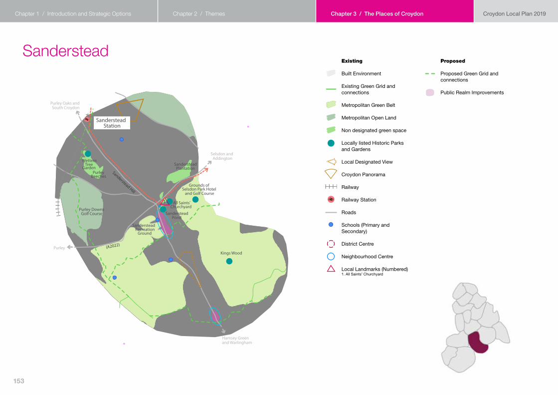
Strategic option 3 – Limited release of Green Belt land for residential development to reduce some pressure off residential growth in the existing urban area.
Homes already under construction30
Number of homes in Sanderstead in 20 years (the proposed Place target)1,170 to 1,450 (plus 680 to 780 new homes on an urban extension on Green Belt land at Borrowdale Drive/Mitchley Hill)
Description of the optionPressure will be taken away from existing residential areas because of limited release of Green Belt land for development at Borrowdale Drive/Mitchley Hill. However, some areas in the north of Sanderstead, where homes are typically on larger plots and are in the most accessible locations50, will still see some moderate intensification, resulting in a denser form of development that still relates to the existing character of the area. Elsewhere, areas with homes on larger plots will see some evolution within the existing character of the area. In other parts of Sanderstead, including Conservation Areas, there will be less change. The council will seek a tram extension from Central Croydon to Sanderstead station & Sanderstead.
50 Locations which have a PTAL of 3 or above or are within 800m of a train station.
Suburban Evolution through InfillLess More
Conservation Areas
Non-residential Built EnvironmentTramway
Potential Tram Extension
Existing Green Grid and Connections
Proposed Green Grid and Connections
Purley Way Urban Evolution
Potential Green Belt ReleaseStrategic Industrial Area
Green space (e.g. MOL)
Area of Focussed IntensificationLocal Heritage Areas
157

Chapter 1 / Introduction and Strategic Options Chapter 2 / Themes Chapter 3 / The Places of Croydon Croydon Local Plan 2019
Proposed Site AllocationsSite Allocations are identified for future housing and other development, such as schools, health facilities and community facilities. For each site, the location, the proposed use and indicative number of homes (if applicable) is provided
Site ref
Name of site Proposed use Number of homes (if applicable)
New site (not in Croydon Local Plan 2018)applicable)
70 Sanderstead Recreation Ground, Limpsfield Road
Expansion of Gresham Primary School
n/a
71 2 Red Gables Beech Avenue
Residential development
23 to 47
79 Waitrose Mixed use residential and retail development, subject to impact on designated views
26 to 54
306 The Good Companions Public House site, 251 Tithe Pit Shaw Lane
Mixed use of residential and retail
8 to 24
Proposed urban extension on Green Belt landThe urban extension proposed in Strategic Spatial Option 3 is only a 12 to 20 minute walk from Riddlesdown station and an 8 to 13 minute walk from Sanderstead Local Centre, with no other designations that preclude development, so is one of the most sustainable Green Belt sites in Croydon, if Green Belt land is to be released for development. Paragraph 138 of the National Planning Policy Framework says that ‘where it has been concluded that it is necessary to release Green Belt land for development, plans should give first consideration to land which has been previously-developed and/or is well-served by public transport’.
At this stage no detailed work has been done on what development on the site would look like. If an urban extension on Green Belt land becomes part of the preferred option for development in the next draft of the Local Plan review, then further work would need to be done on how the site would be developed.
A map of the site is shown below.
158

Chapter 1 / Introduction and Strategic Options Chapter 2 / Themes Chapter 3 / The Places of Croydon Croydon Local Plan 2019
Possible Local Green SpacesWithin Sanderstead the following green spaces have been identified as being demonstrably special and of particular significance to the local community. However, for each and every possible Local Green Space the council will require more detailed evidence. The council will contact all relevant individuals, residents’ association and ‘friends of’ groups, asking for further information about the ‘demonstrably special’ feature of the green space.
Possible Local Green Spaces
Reasons why the space is demonstrably special and is of particular significance to the community it serves
Green outside post office, Elmfield Way
The park has been used to host local events such as tea parties.
Purley Beeches 8th Purley Scouts have their colony base very near the Beeches (at St Mary’s) and use the Beeches for various activities, from woodcraft to orienteering, summer picnics, water play and many more. It is a nice large space that can accommodate groups of beavers, cubs and scouts without infringing on other local activities.
Sanderstead Pond (and Green)
The local scout group, 16th Purley, the beavers, cubs and scouts all use the Gruffy weekly for activities. They also run the annual Gruffy Fayre which is seen locally as the 'village fair’. This fayre has been running for nearly 50 years.
Wettern Tree Garden The Wettern Tree Garden has a unique collection of trees and shrubs, bequeathed to Croydon by Mr Wettern.
Possible Local Green Spaces
Reasons why the space is demonstrably special and is of particular significance to the community it serves
It is a local space used for community events as well as the annual Sanderstead Horticultural Summer Show. It has also been used for outdoor theatre productions by the Sanderstead Drama Club.
Local Brownies group use Wettern Tree Gardens to do activities and walks. Beavers and Scouts have always utilised this space for educational purposes and fun hide and seek.
159

Chapter 1 / Introduction and Strategic Options Chapter 2 / Themes Chapter 3 / The Places of Croydon Croydon Local Plan 2019
Other green areas to be protected by the Local Plan reviewA number of green spaces, which have not met the Local Green Space designation criteria, will be protected in the Croydon Local Plan under the ‘other green spaces’ policy. Informal green spaces and linear open spaces are not listed below, but would still be protected by the Local Plan review.
Other green areas to be protected by Local Plan review
Type of other green space
All Saints Churchyard, Sanderstead
Cemetery or church yard
All Saints Graveyard, Sanderstead
Cemetery or church yard
Help shape the future of the Place of Sanderstead
SA1. How should Sanderstead change to help meet the need for homes and infrastructure in the borough?
SA2. What other potential development sites in Sanderstead should the Local Plan review allocate for development?
SA3. Do you think any proposed sites in Sanderstead should be removed from the Local Plan review? If so, which one(s)? Please explain why.
SA4. What community facilities in Sanderstead are important to you?
SA5. What new community facilities are required in Sanderstead?
SA6. Are there any green spaces in Sanderstead that should be protected as Local Green Spaces? Please provide evidence as to why they are irreplaceable for you.
SA7. Are there any other green areas in Sanderstead (that are not informal green spaces, linear open spaces, Metropolitan Open Land or Green Belt) that should be protected? Please explain why.
160

Chapter 1 / Introduction and Strategic Options Chapter 2 / Themes Chapter 3 / The Places of Croydon Croydon Local Plan 2019
Selsdon
Croydon Local Plan 2019Chapter 2. ThemesChapter 1. Introduction and Strategic Options Chapter 3. Places of Croydon
27
Old Farleigh Road
Farley Road
(A212)
(A2022) Featherbed Lane
(B275)
Selsdon Woods(Bird Sanctuary)
Addington CourtGolf Course
LittleheathWoods
Forestdale
SelsdonRecreation
Ground
Grounds of Addington PalaceAddington Palace Golf Course
Addington Park
Grounds ofSelsdon Park Hotel
and Golf Course
Heath�eld House
Grounds ofHeath�eld
Grounds ofRoyal Russell School
Farleigh and Warlingham
Addington and Hayes
South andCentral Croydon
Sanderstead
Existing
Built Environment
Existing Green Grid and connections
Metropolitan Green Belt
Metropolitan Open Land
Non designated green space
Registered Historic Park and Gardens
Locally listed Historic Parks and Gardens
Local Designated View
Tramway
Roads
Schools (Primary and Secondary)
Independent Schools
District Centre
Neighbourhood Centre
Proposed
Proposed Green Grid and connections
Public Realm Improvements
Old Farleigh Road
Farley Road
(A212)
(A2022) Featherbed Lane
(B275)
Selsdon Woods(Bird Sanctuary)
Addington CourtGolf Course
LittleheathWoods
Forestdale
SelsdonRecreation
Ground
Grounds of Addington PalaceAddington Palace Golf Course
Addington Park
Grounds ofSelsdon Park Hotel
and Golf Course
Heath�eld House
Grounds ofHeath�eld
Grounds ofRoyal Russell School
Farleigh and Warlingham
Addington and Hayes
South andCentral Croydon
Sanderstead
161

Chapter 1 / Introduction and Strategic Options Chapter 2 / Themes Chapter 3 / The Places of Croydon Croydon Local Plan 2019
Where we want to beSelsdon Town Centre will continue to provide a range of services for the residential population in a suburban setting with good links to its green open spaces and countryside. Selsdon Park Road/Featherbed Lane Neighbourhood Centre will be supporting the existing and future community with services and facilities beyond a retail function.
Opportunities, constraints and change up to 2039• An area of sustainable growth of the suburbs with some opportunity for
windfall sites, growth will mainly be of infilling with new homes that respect existing residential character and local distinctiveness.
• Selsdon Town Centre will continue to be the main focus for employment, with the adjacent Selsdon Park Hotel also providing local job opportunities. Community facilities will be focussed on the Town Centre, where public realm improvements will be located.
• Links to existing green spaces from the residential areas will be improved where possible with additional connections to strategic green links enabling more opportunities for walking and cycling in the area.
• With a tram stop to the north edge of Selsdon, local bus services, connections and access will be maintained, but with improved walking and cycling routes where possible, via improvements to the Green Grid. The community will enjoy better quality, more frequent and reliable bus services connecting with Central Croydon. Travel plans will look to ease congestion at peak times in the Town Centre by encouraging walking, cycling or public transport especially for school journeys.
• The council will work on the feasibility of a rapid transit route/tram extension from Croydon Town Centre to Selsdon in discussion with Transport for London to improve connectivity, air quality and housing growth.
162

Chapter 1 / Introduction and Strategic Options Chapter 2 / Themes Chapter 3 / The Places of Croydon Croydon Local Plan 2019
Selsdon Growth Scenarios
Strategic option 1 – All residential growth to take place in the existing urban area.
Homes already under construction40
Number of homes in Selsdon in 20 years (the proposed Place target)870 to 1,070
Description of the optionMost development in Selsdon will be on windfall sites. Those areas within 800m of Selsdon Town Centre or a tram stop will see some evolution of their existing character (apart from in Conservation Areas, which will see little change). Elsewhere there will be less change. The council will investigate the feasibility of a rapid transit route/tram extension with Transport for London to support housing growth, as well as improve connectivity and air quality to improve quality of life for all.
Suburban Evolution through InfillLess More
Conservation Areas
Non-residential Built EnvironmentTramway
Potential Tram Extension
Existing Green Grid and Connections
Proposed Green Grid and Connections
Purley Way Urban Evolution
Potential Green Belt ReleaseStrategic Industrial Area
Green space (e.g. MOL)
Area of Focussed IntensificationLocal Heritage Areas
163

Chapter 1 / Introduction and Strategic Options Chapter 2 / Themes Chapter 3 / The Places of Croydon Croydon Local Plan 2019
Strategic option 2 – Major redevelopment of the Purley Way area to reduce some pressure off residential growth in the existing urban area.
Homes already under construction40
Number of homes in Selsdon in 20 years (the proposed Place target)580 to 710
Description of the optionMost development in Selsdon will be on windfall sites. There will be less change to the existing character of Selsdon. The council will investigate the feasibility of a rapid transit route/tram extension with Transport for London to support housing growth, as well as improve connectivity and air quality to improve quality of life for all.
Suburban Evolution through InfillLess More
Conservation Areas
Non-residential Built EnvironmentTramway
Potential Tram Extension
Existing Green Grid and Connections
Proposed Green Grid and Connections
Purley Way Urban Evolution
Potential Green Belt ReleaseStrategic Industrial Area
Green space (e.g. MOL)
Area of Focussed IntensificationLocal Heritage Areas
164
Chapter 1 / Introduction and Strategic Options Chapter 2 / Themes Chapter 3 / The Places of Croydon Croydon Local Plan 2019
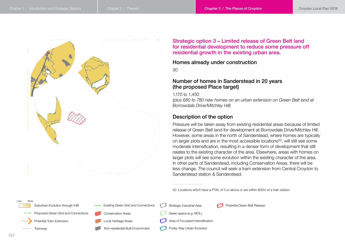
Strategic option 3 – Limited release of Green Belt land for residential development to reduce some pressure off residential growth in the existing urban area.
Homes already under construction40
Number of homes in Selsdon in 20 years (the proposed Place target)580 to 710 (plus 1,300 to 1,540 new homes on an urban extension on Green Belt land at Gravel Hill)
Description of the optionThere will be less change to the existing character of Selsdon. This is because some pressure is taken away from existing residential areas because of limited release of Green Belt land for development, including an urban extension at Gravel Hill. The council will investigate the feasibility of a rapid transit route/tram extension with Transport for London to support housing growth, as well as improve connectivity and air quality to improve quality of life for all.
Suburban Evolution through InfillLess More
Conservation Areas
Non-residential Built EnvironmentTramway
Potential Tram Extension
Existing Green Grid and Connections
Proposed Green Grid and Connections
Purley Way Urban Evolution
Potential Green Belt ReleaseStrategic Industrial Area
Green space (e.g. MOL)
Area of Focussed IntensificationLocal Heritage Areas
165

Chapter 1 / Introduction and Strategic Options Chapter 2 / Themes Chapter 3 / The Places of Croydon Croydon Local Plan 2019
Proposed Site AllocationsSite Allocations are identified for future housing and other development, such as schools, health facilities and community facilities. For each site, the location, the proposed use and indicative number of homes (if applicable) is provided.
Site ref
Name of site Proposed use Number of homes (if applicable)
New site (not in Croydon Local Plan 2018)applicable)
85 The Forestdale Centre
Residential development incorporating a new shopping parade with retail, finance, and food & drink
16 to 41
Proposed urban extension on Green Belt landThe proposed urban extension proposed in Strategic Spatial Option 3 is adjacent to the tram line with Gravel Hill tram stop being located at the north eastern corner of the site. There are also no other designations that preclude development, so is one of the most sustainable Green Belt sites in Croydon, were Green Belt sites to be released for development. Paragraph 138 of the National Planning Policy Framework says that ‘where it has been concluded that it is necessary to release Green Belt land for development, plans should give first consideration to land which has been previously-developed and/or is well-served by public transport.
At this stage no detailed work has been done on what development on the site would look like. If an urban extension on Green Belt land becomes part of the preferred option for development in the next draft of the Local Plan review, then further work would need to be done on how the site would be developed.
A map of the site is shown below.
166

Chapter 1 / Introduction and Strategic Options Chapter 2 / Themes Chapter 3 / The Places of Croydon Croydon Local Plan 2019
Possible Local Green SpacesWithin Selsdon the following green space has been identified as being demonstrably special and of particular significance to the local community. However, for each and every possible Local Green Space the council will require more detailed evidence. The council will contact all relevant individuals, residents’ association and ‘friends of’ groups, asking for further information about the ‘demonstrably special’ feature of the green space.
Possible Local Green Spaces
Reasons why the space may be demonstrably special and of particular significance to the community it serves
Freelands Avenue on junction with Tedder Road
This green land is used for communities to have fun days on. Fetes are held here by Monks Hill Residents Association. The last fete was on Saturday 1st June 2019 when the Mayor and Mayoress of Croydon attended.
Palace Green The grassed area in the centre of Palace Green is used as a community space for annual community barbecue.
Other green areas to be protected by the Local Plan reviewA number of green spaces, which have not met the Local Green Space designation criteria, will be protected in the Croydon Local Plan under the ‘other green spaces’ policy. Informal green spaces and linear open spaces are not listed below, but would still be protected by the Local Plan review.
Other green areas to be protected by Local Plan review
Type of other green space
Ashen Grove Local natural open space
Selsdon Recreation Ground
Town Park
The Ruffet Local natural open space
167
Chapter 1 / Introduction and Strategic Options Chapter 2 / Themes Chapter 3 / The Places of Croydon Croydon Local Plan 2019
Help shape the future of the Place of Selsdon
SE1. How should Selsdon change to help meet the need for homes and infrastructure in the borough?
SE2. What other potential development sites in Selsdon should the Local Plan review allocate for development?
SE3. Do you think the proposed development site in Selsdon should be removed from the Local Plan review? If so, please explain why.
SE4. What community facilities in Selsdon are important to you?
SE5. What new community facilities are required in Selsdon?
SE6. Are there any green spaces in Selsdon that should be protected as Local Green Spaces? Please provide evidence as to why they are irreplaceable for you.
SE7. Are there any other green areas in Selsdon (that are not informal green spaces, linear open spaces, Metropolitan Open Land or Green Belt) that should be protected? Please explain why.
168


![BOXPARK CROYDON - Bars€¦ · BOXPARK CROYDON. INTRODUCTION [03] THE CONCEPT [05] BXPARKO SHOREDITCH [07] CROYDON [16] BXPARKO CROYDON [20] DETAILS [31] CONTENTs. ELUTIONTH EvO Of](https://static.fdocuments.in/doc/165x107/5f105a3e7e708231d448afca/boxpark-croydon-bars-boxpark-croydon-introduction-03-the-concept-05-bxparko.jpg)