Croydon Local Plan: Detailed Policies and Proposals ... that the Croydon Local Plan: Detailed...
399
August 2017 Croydon Local Plan: Detailed Policies and Proposals (Main Modifications)
Transcript of Croydon Local Plan: Detailed Policies and Proposals ... that the Croydon Local Plan: Detailed...
August 2017
Croydon Local Plan: Detailed Policies and Proposals (Main Modifications)
All maps in this document reproduced by permission of Ordnance Survey On behalf of HMSO. © Crown copyright and Database right 2017. Ordnance Survey Licence Number 100019257
Croydon Local Plan: Detailed Policies and Proposals (Main Modifications) A Development Plan forming part of the Croydon Local Plan 29 August – 10 October 2017 Published by Spatial Planning service London Borough of Croydon Bernard Weatherill House 8 Mint Walk Croydon CR0 1EA www.croydon.gov.uk/localplantwo [email protected] 020 8407 1385
Foreword Councillor Alison Butler – Deputy Leader Statutory - Cabinet Member for Homes, Regeneration & Planning & Councillor Paul Scott – Chair of Planning Committee & Deputy Cabinet Member for Planning
Increasing housing supply through sustainable growth; building more affordable homes; facilitating employment and economic growth; protecting and enhancing the special character of places; improving and protecting District and Neighbourhood Centres as well as optimising the potential of Croydon Opportunity Area; and an increased emphasis on culture. These are key elements of Ambitious for Croydon that the Croydon Local Plan: Detailed Policies and Proposals (CLP2) will help to deliver up to 2036. CLP2 supplements the adopted Strategic Policies and their Partial Review (CLP1.1) that sets the strategic vision, objectives and policies. CLP1.1, and consequently CLP2 support the Council’s Growth Zone and Community Strategy through enabling sustainable and necessary growth, supported by new infrastructure to bring increased opportunities for our residents and businesses.
CLP2 focuses on making Croydon a better borough to live, work and visit from stepping out of your front door, going to the local shop, community hall or school or visiting your Neighbourhood Centre, District Centre or Croydon Opportunity Area for shops, work, restaurants and entertainment. It has a renewed focus on District Centres, designates more local Shopping Parades and creates a new designation, Neighbourhood Centres, where services that support local communities such as shops, pubs, faith or community facilities will be encouraged to locate.
CLP2 demonstrates how sustainable growth of Croydon’s suburbs can increase the supply of new homes, including affordable housing whilst continuing to protect the borough’s important green spaces and heritage and cultural assets that make Croydon so special and the place that it is. It shows how Croydon will evolve sustainably from 2016 to 2036 setting out the Detailed Policies that will guide development and the sites that we expect to be developed to help meet the need for new homes, jobs, schools and healthcare facilities that the borough will need.
We are pleased that the Croydon Local Plan: Detailed Policies and Proposals have been endorsed by the Council’s Cabinet for publication prior to its proposed submission to the Planning Inspectorate for its independent examination in public.
1
Contents
Table of Policies .............................................................................................................................................................................................. 5 Table of proposed amendments to the Policies Map by Place ................................................................................................................... 7 Map of the 16 Places of Croydon ................................................................................................................................................................. 10 A quick guide to which policies apply to which types of development ................................................................................................... 11 What the Main Modifications mean in your Place ...................................................................................................................................... 17 1. Introduction ............................................................................................................................................................................................ 22
Preparing the Croydon Local Plan: Detailed Policies and Proposals .......................................................................................................... 22 2. Using and commenting on this document .......................................................................................................................................... 25
Using this document .................................................................................................................................................................................... 25 Commenting on this document .................................................................................................................................................................... 26
3. Strategic Context ................................................................................................................................................................................... 27We are Croydon .......................................................................................................................................................................................... 27 Croydon Local Plan’s spatial vision ............................................................................................................................................................. 28 Strategic Objectives .................................................................................................................................................................................... 30
A Place of Opportunity ................................................................................................................................................................................. 31 4. Homes ..................................................................................................................................................................................................... 32
Housing choice for sustainable communities............................................................................................................................................... 32 Residential care and nursing homes ........................................................................................................................................................... 41 Vacant building credit .................................................................................................................................................................................. 44
5. Employment ........................................................................................................................................................................................... 46Development in Croydon Metropolitan Centre, District and Local Centres .................................................................................................. 46 Development in Neighbourhood Centres .................................................................................................................................................... 52 Development in Shopping Parades ............................................................................................................................................................. 57 Development in Restaurant Quarter Parades.............................................................................................................................................. 61 Development in edge of centre and out of centre locations ......................................................................................................................... 63 Expansion of industrial and warehousing premises in Strategic, Separated and Integrated Industrial Locations ....................................... 68
A Place to Belong ......................................................................................................................................................................................... 70 6. Urban Design and Local Character ...................................................................................................................................................... 71
Design and character .................................................................................................................................................................................. 71 Shop front design and security .................................................................................................................................................................... 93
2
Advertisement hoardings ............................................................................................................................................................................. 96 Refuse and recycling ................................................................................................................................................................................. 100 Public art ................................................................................................................................................................................................... 103 Tall and large buildings ............................................................................................................................................................................. 105 Promoting Healthy Communities ............................................................................................................................................................... 110 Views and Landmarks ............................................................................................................................................................................... 114 Heritage assets and conservation ............................................................................................................................................................. 117
7. Community Facilities ........................................................................................................................................................................... 124Providing and protecting community facilities ............................................................................................................................................ 124 Supporting Selhurst Park as the home stadium of Crystal Palace Football Club ...................................................................................... 127 Protecting Public Houses .......................................................................................................................................................................... 128 Providing for cemeteries and burial grounds ............................................................................................................................................. 131
A Place with a Sustainable Future ............................................................................................................................................................. 133 8. Environment and Climate Change ..................................................................................................................................................... 134
Development and construction .................................................................................................................................................................. 134 Land contamination ................................................................................................................................................................................... 137 Sustainable Drainage Systems and Reducing Flood Risk ........................................................................................................................ 139
9. Green Grid ............................................................................................................................................................................................ 145Metropolitan Green Belt and Metropolitan Open Land .............................................................................................................................. 145 Protecting and enhancing our Biodiversity ................................................................................................................................................ 152 Trees ......................................................................................................................................................................................................... 156
10. Transport and Communication ........................................................................................................................................................ 159Promoting sustainable travel and reducing congestion ............................................................................................................................. 159 Car and cycle parking in new development ............................................................................................................................................... 162 Restricting temporary car parks ................................................................................................................................................................. 168 Facilitating rail and tram improvements ..................................................................................................................................................... 170 Telecommunications ................................................................................................................................................................................. 172
The Places of Croydon ............................................................................................................................................................................... 174 11. The Places of Croydon ..................................................................................................................................................................... 175
The Place-specific policies ........................................................................................................................................................................ 175 Addington .................................................................................................................................................................................................. 183 Addiscombe ............................................................................................................................................................................................... 185 Broad Green and Selhurst ......................................................................................................................................................................... 189 Coulsdon ................................................................................................................................................................................................... 193
3
Croydon Opportunity Area ......................................................................................................................................................................... 195 Crystal Palace & Upper Norwood .............................................................................................................................................................. 206 Kenley and Old Coulsdon .......................................................................................................................................................................... 208 Norbury ..................................................................................................................................................................................................... 210 Purley ........................................................................................................................................................................................................ 213 Sanderstead .............................................................................................................................................................................................. 217 Selsdon ..................................................................................................................................................................................................... 219 Shirley ....................................................................................................................................................................................................... 221 South Croydon .......................................................................................................................................................................................... 224 South Norwood and Woodside .................................................................................................................................................................. 227 Thornton Heath ......................................................................................................................................................................................... 230 Waddon ..................................................................................................................................................................................................... 233
Appendices.................................................................................................................................................................................................. 236 Appendix 1 – About the proposal sites ..................................................................................................................................................... 237 Appendix 2 – Calculating the percentage of units within a Main or Secondary Retail Frontage ......................................................... 239 Appendix 3 – Designated Shopping Frontages ........................................................................................................................................ 242
Croydon Metropolitan Centre .................................................................................................................................................................... 242 District Centres .......................................................................................................................................................................................... 242 Local Centres ............................................................................................................................................................................................ 245 Shopping Parades ..................................................................................................................................................................................... 247 Restaurant Quarter Parades ..................................................................................................................................................................... 253
Appendix 4 – How to assess whether proposals demonstrably relate to a Neighbourhood Centre ................................................... 254 Appendix 5 – Schedule of proposal sites ................................................................................................................................................. 258
Sites numbered between 1 and 50 ............................................................................................................................................................ 258 Sites numbered between 51 and 100 ........................................................................................................................................................ 270 Sites numbered between 101 and 150 ...................................................................................................................................................... 278 Sites numbered between 151 and 200 ...................................................................................................................................................... 290 Sites numbered between 201 and 250 ...................................................................................................................................................... 314 Sites numbered between 251 and 300 ...................................................................................................................................................... 327 Sites numbered between 301 and 350 ...................................................................................................................................................... 332 Sites numbered between 351 and 400 ...................................................................................................................................................... 350 Sites numbered between 401 and 450 ...................................................................................................................................................... 361 Sites numbered between 451 and 500 ...................................................................................................................................................... 372 Sites numbered between 501 and 1000 .................................................................................................................................................... 381
4
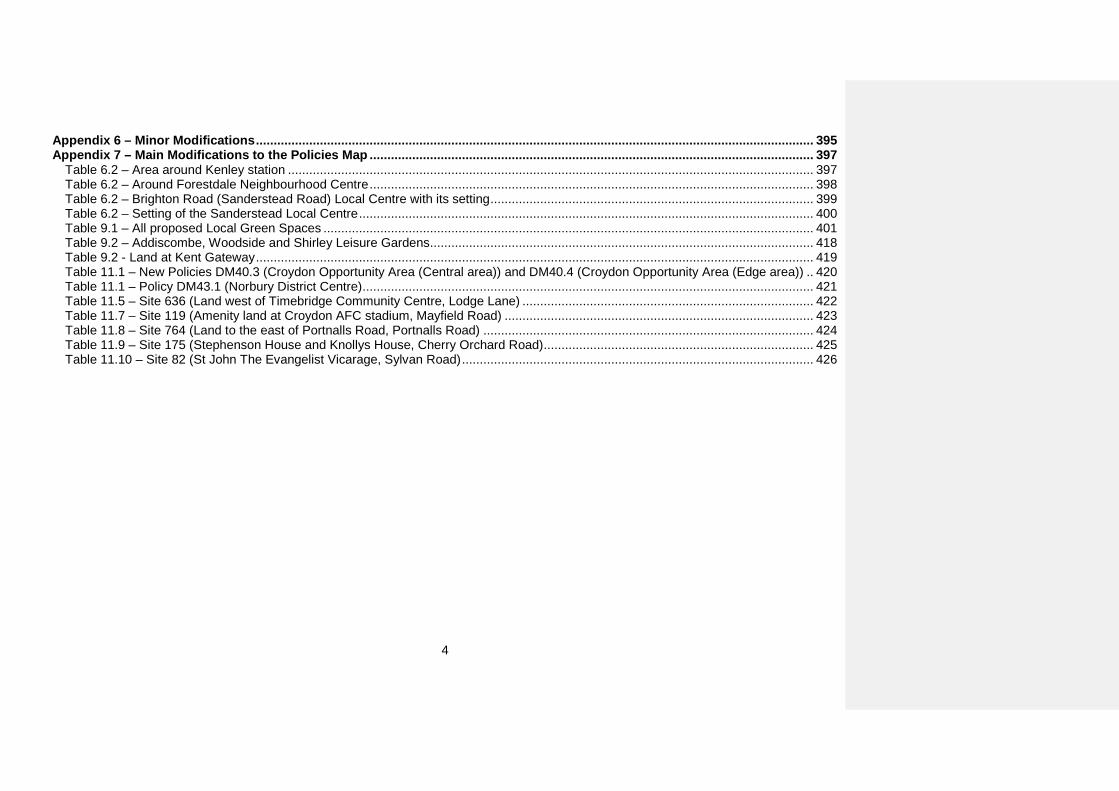
Appendix 6 – Minor Modifications ............................................................................................................................................................. 395 Appendix 7 – Main Modifications to the Policies Map ............................................................................................................................. 397
Table 6.2 – Area around Kenley station .................................................................................................................................................... 397 Table 6.2 – Around Forestdale Neighbourhood Centre ............................................................................................................................. 398 Table 6.2 – Brighton Road (Sanderstead Road) Local Centre with its setting ........................................................................................... 399 Table 6.2 – Setting of the Sanderstead Local Centre ................................................................................................................................ 400 Table 9.1 – All proposed Local Green Spaces .......................................................................................................................................... 401 Table 9.2 – Addiscombe, Woodside and Shirley Leisure Gardens ............................................................................................................ 418 Table 9.2 - Land at Kent Gateway ............................................................................................................................................................. 419 Table 11.1 – New Policies DM40.3 (Croydon Opportunity Area (Central area)) and DM40.4 (Croydon Opportunity Area (Edge area)) .. 420 Table 11.1 – Policy DM43.1 (Norbury District Centre) ............................................................................................................................... 421 Table 11.5 – Site 636 (Land west of Timebridge Community Centre, Lodge Lane) .................................................................................. 422 Table 11.7 – Site 119 (Amenity land at Croydon AFC stadium, Mayfield Road) ....................................................................................... 423 Table 11.8 – Site 764 (Land to the east of Portnalls Road, Portnalls Road) ............................................................................................. 424 Table 11.9 – Site 175 (Stephenson House and Knollys House, Cherry Orchard Road) ............................................................................ 425 Table 11.10 – Site 82 (St John The Evangelist Vicarage, Sylvan Road) ................................................................................................... 426
5
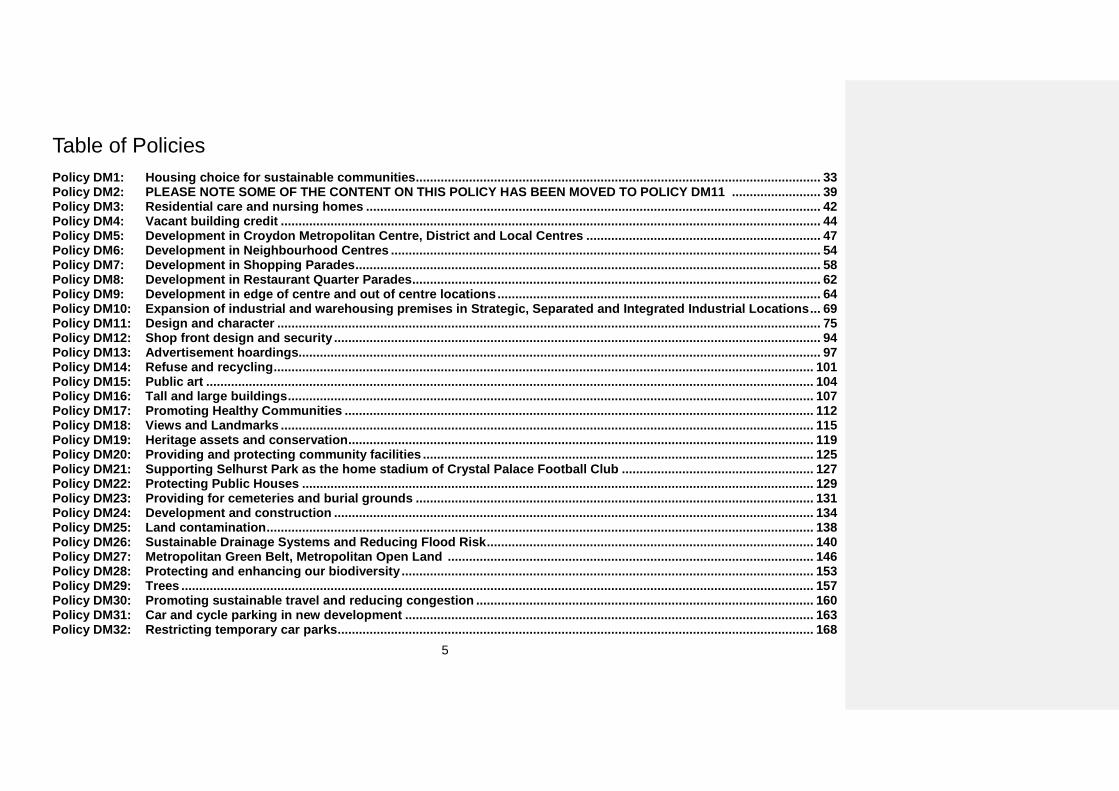
Table of Policies Policy DM1: Housing choice for sustainable communities .................................................................................................................. 33 Policy DM2: PLEASE NOTE SOME OF THE CONTENT ON THIS POLICY HAS BEEN MOVED TO POLICY DM11 ......................... 39 Policy DM3: Residential care and nursing homes ................................................................................................................................ 42 Policy DM4: Vacant building credit ........................................................................................................................................................ 44 Policy DM5: Development in Croydon Metropolitan Centre, District and Local Centres .................................................................. 47 Policy DM6: Development in Neighbourhood Centres ......................................................................................................................... 54 Policy DM7: Development in Shopping Parades ................................................................................................................................... 58 Policy DM8: Development in Restaurant Quarter Parades ................................................................................................................... 62 Policy DM9: Development in edge of centre and out of centre locations ........................................................................................... 64 Policy DM10: Expansion of industrial and warehousing premises in Strategic, Separated and Integrated Industrial Locations ... 69 Policy DM11: Design and character ......................................................................................................................................................... 75 Policy DM12: Shop front design and security ......................................................................................................................................... 94 Policy DM13: Advertisement hoardings................................................................................................................................................... 97 Policy DM14: Refuse and recycling ........................................................................................................................................................ 101 Policy DM15: Public art ........................................................................................................................................................................... 104 Policy DM16: Tall and large buildings .................................................................................................................................................... 107 Policy DM17: Promoting Healthy Communities .................................................................................................................................... 112 Policy DM18: Views and Landmarks ...................................................................................................................................................... 115 Policy DM19: Heritage assets and conservation ................................................................................................................................... 119 Policy DM20: Providing and protecting community facilities .............................................................................................................. 125 Policy DM21: Supporting Selhurst Park as the home stadium of Crystal Palace Football Club ...................................................... 127 Policy DM22: Protecting Public Houses ................................................................................................................................................ 129 Policy DM23: Providing for cemeteries and burial grounds ................................................................................................................ 131 Policy DM24: Development and construction ....................................................................................................................................... 134 Policy DM25: Land contamination .......................................................................................................................................................... 138 Policy DM26: Sustainable Drainage Systems and Reducing Flood Risk ............................................................................................ 140 Policy DM27: Metropolitan Green Belt, Metropolitan Open Land ....................................................................................................... 146 Policy DM28: Protecting and enhancing our biodiversity .................................................................................................................... 153 Policy DM29: Trees .................................................................................................................................................................................. 157 Policy DM30: Promoting sustainable travel and reducing congestion ............................................................................................... 160 Policy DM31: Car and cycle parking in new development ................................................................................................................... 163 Policy DM32: Restricting temporary car parks ...................................................................................................................................... 168
6
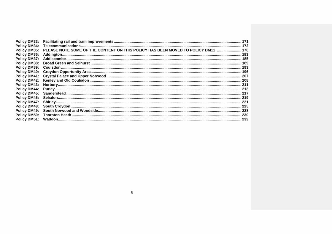
Policy DM33: Facilitating rail and tram improvements ......................................................................................................................... 171 Policy DM34: Telecommunications ........................................................................................................................................................ 172 Policy DM35: PLEASE NOTE SOME OF THE CONTENT ON THIS POLICY HAS BEEN MOVED TO POLICY DM11 ....................... 176 Policy DM36: Addington .......................................................................................................................................................................... 183 Policy DM37: Addiscombe ...................................................................................................................................................................... 185 Policy DM38: Broad Green and Selhurst ............................................................................................................................................... 189 Policy DM39: Coulsdon ........................................................................................................................................................................... 193 Policy DM40: Croydon Opportunity Area ............................................................................................................................................... 196 Policy DM41: Crystal Palace and Upper Norwood ................................................................................................................................ 207 Policy DM42: Kenley and Old Coulsdon ................................................................................................................................................ 208 Policy DM43: Norbury .............................................................................................................................................................................. 211 Policy DM44: Purley ................................................................................................................................................................................. 213 Policy DM45: Sanderstead ...................................................................................................................................................................... 217 Policy DM46: Selsdon .............................................................................................................................................................................. 219 Policy DM47: Shirley ................................................................................................................................................................................ 221 Policy DM48: South Croydon .................................................................................................................................................................. 225 Policy DM49: South Norwood and Woodside ........................................................................................................................................ 228 Policy DM50: Thornton Heath ................................................................................................................................................................. 230 Policy DM51: Waddon.............................................................................................................................................................................. 233
7
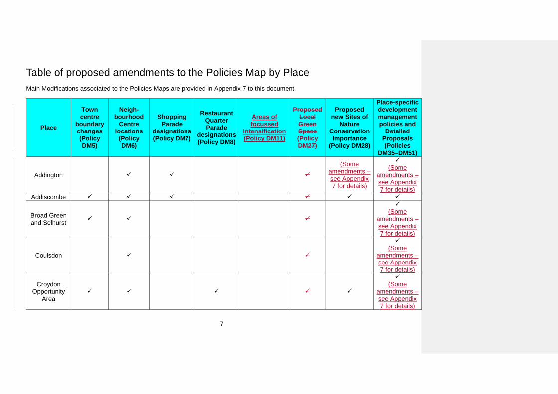
Table of proposed amendments to the Policies Map by Place Main Modifications associated to the Policies Maps are provided in Appendix 7 to this document.
Place
Town centre
boundary changes (Policy DM5)
Neigh-bourhood
Centre locations
(Policy DM6)
Shopping Parade
designations (Policy DM7)
Restaurant Quarter Parade
designations (Policy DM8)
Areas of focussed
intensification (Policy DM11)
Proposed Local Green Space (Policy DM27)
Proposed new Sites of
Nature Conservation Importance
(Policy DM28)
Place-specific development management policies and
Detailed Proposals (Policies
DM35–DM51)
Addington (Some
amendments – see Appendix 7 for details)
(Some
amendments – see Appendix 7 for details)
Addiscombe
Broad Green and Selhurst
(Some
amendments – see Appendix 7 for details)
Coulsdon
(Some
amendments – see Appendix 7 for details)
Croydon Opportunity
Area
(Some
amendments – see Appendix 7 for details)
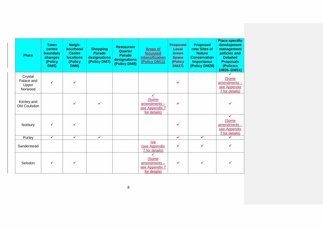
8
Place
Town centre
boundary changes (Policy DM5)
Neigh-bourhood
Centre locations
(Policy DM6)
Shopping Parade
designations (Policy DM7)
Restaurant Quarter Parade
designations (Policy DM8)
Areas of focussed
intensification (Policy DM11)
Proposed Local Green Space (Policy DM27)
Proposed new Sites of
Nature Conservation Importance
(Policy DM28)
Place-specific development management policies and
Detailed Proposals (Policies
DM35–DM51) Crystal
Palace and Upper
Norwood
(Some
amendments – see Appendix 7 for details)
Kenley and Old Coulsdon
(Some
amendments – see Appendix 7
for details)
Norbury
(Some
amendments – see Appendix 7 for details)
Purley
Sanderstead n/a
(see Appendix 7 for details)
Selsdon
(Some
amendments – see Appendix 7
for details)
9
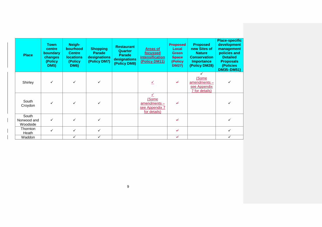
Place
Town centre
boundary changes (Policy DM5)
Neigh-bourhood
Centre locations
(Policy DM6)
Shopping Parade
designations (Policy DM7)
Restaurant Quarter Parade
designations (Policy DM8)
Areas of focussed
intensification (Policy DM11)
Proposed Local Green Space (Policy DM27)
Proposed new Sites of
Nature Conservation Importance
(Policy DM28)
Place-specific development management policies and
Detailed Proposals (Policies
DM35–DM51)
Shirley
(Some
amendments – see Appendix 7 for details)
South Croydon
(Some
amendments – see Appendix 7
for details)
South Norwood and
Woodside
Thornton Heath
Waddon
10
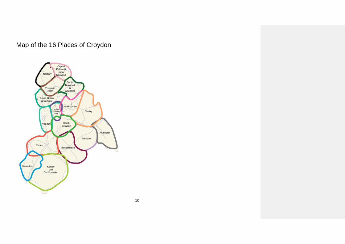
Map of the 16 Places of Croydon
11
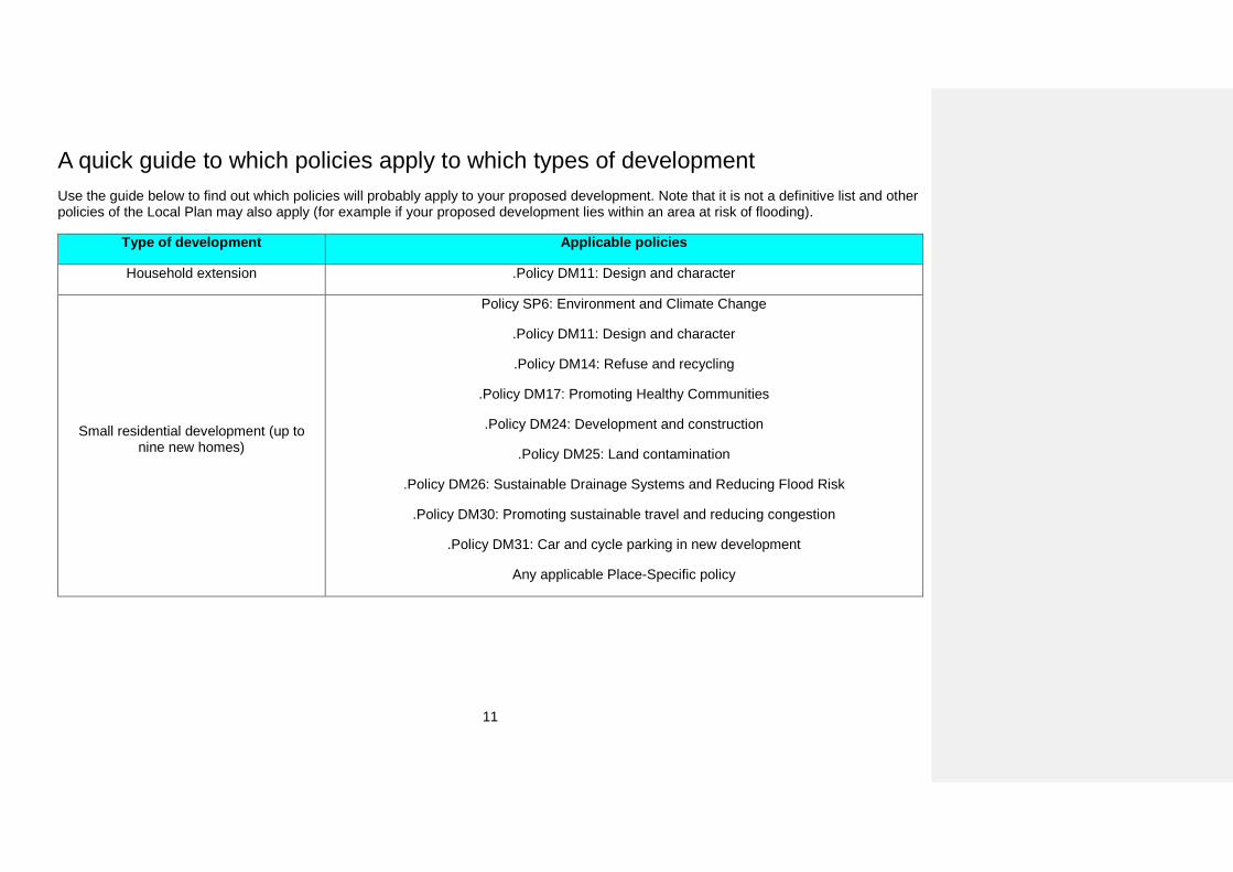
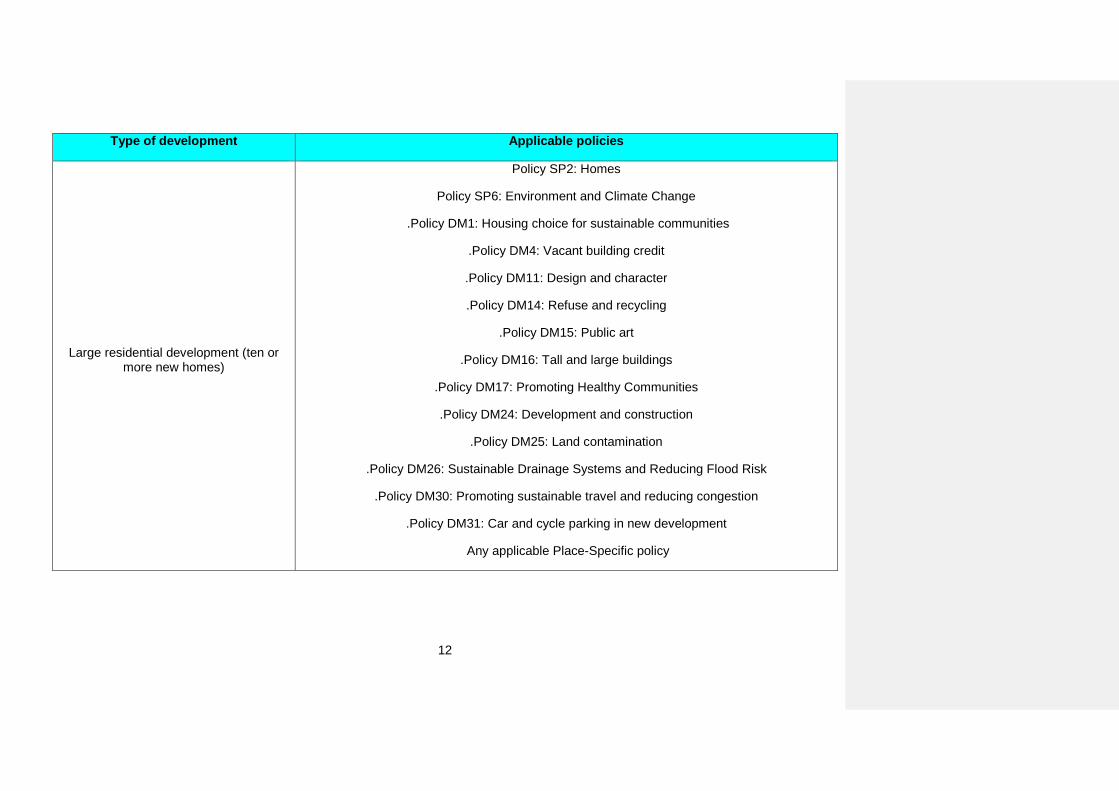
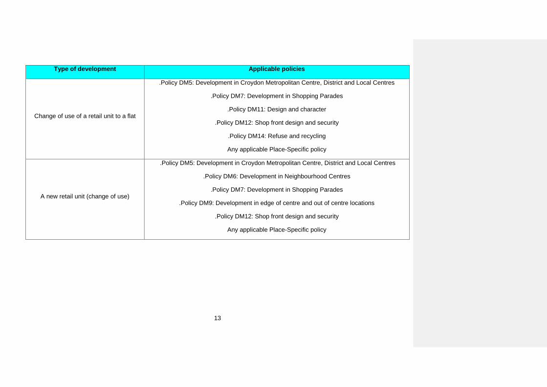
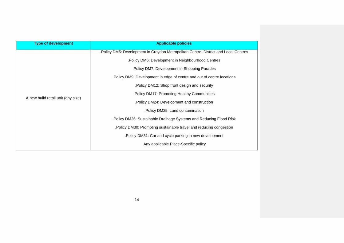
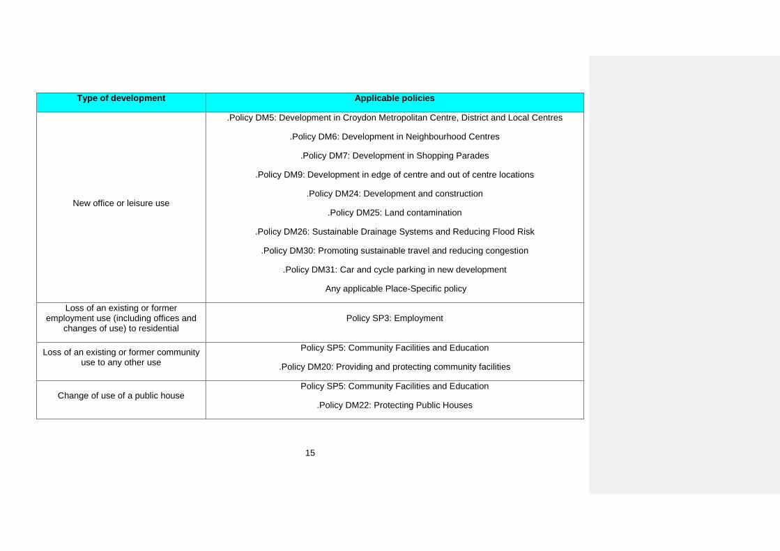
A quick guide to which policies apply to which types of development Use the guide below to find out which policies will probably apply to your proposed development. Note that it is not a definitive list and other policies of the Local Plan may also apply (for example if your proposed development lies within an area at risk of flooding).
Type of development Applicable policies
Household extension .Policy DM11: Design and character
Small residential development (up to nine new homes)
Policy SP6: Environment and Climate Change
.Policy DM11: Design and character
.Policy DM14: Refuse and recycling
.Policy DM17: Promoting Healthy Communities
.Policy DM24: Development and construction
.Policy DM25: Land contamination
.Policy DM26: Sustainable Drainage Systems and Reducing Flood Risk
.Policy DM30: Promoting sustainable travel and reducing congestion
.Policy DM31: Car and cycle parking in new development
Any applicable Place-Specific policy
12
Type of development Applicable policies
Large residential development (ten or more new homes)
Policy SP2: Homes
Policy SP6: Environment and Climate Change
.Policy DM1: Housing choice for sustainable communities
.Policy DM4: Vacant building credit
.Policy DM11: Design and character
.Policy DM14: Refuse and recycling
.Policy DM15: Public art
.Policy DM16: Tall and large buildings
.Policy DM17: Promoting Healthy Communities
.Policy DM24: Development and construction
.Policy DM25: Land contamination
.Policy DM26: Sustainable Drainage Systems and Reducing Flood Risk
.Policy DM30: Promoting sustainable travel and reducing congestion
.Policy DM31: Car and cycle parking in new development
Any applicable Place-Specific policy
13
Type of development Applicable policies
Change of use of a retail unit to a flat
.Policy DM5: Development in Croydon Metropolitan Centre, District and Local Centres
.Policy DM7: Development in Shopping Parades
.Policy DM11: Design and character
.Policy DM12: Shop front design and security
.Policy DM14: Refuse and recycling
Any applicable Place-Specific policy
A new retail unit (change of use)
.Policy DM5: Development in Croydon Metropolitan Centre, District and Local Centres
.Policy DM6: Development in Neighbourhood Centres
.Policy DM7: Development in Shopping Parades
.Policy DM9: Development in edge of centre and out of centre locations
.Policy DM12: Shop front design and security
Any applicable Place-Specific policy
14
Type of development Applicable policies
A new build retail unit (any size)
.Policy DM5: Development in Croydon Metropolitan Centre, District and Local Centres
.Policy DM6: Development in Neighbourhood Centres
.Policy DM7: Development in Shopping Parades
.Policy DM9: Development in edge of centre and out of centre locations
.Policy DM12: Shop front design and security
.Policy DM17: Promoting Healthy Communities
.Policy DM24: Development and construction
.Policy DM25: Land contamination
.Policy DM26: Sustainable Drainage Systems and Reducing Flood Risk
.Policy DM30: Promoting sustainable travel and reducing congestion
.Policy DM31: Car and cycle parking in new development
Any applicable Place-Specific policy
15
Type of development Applicable policies
New office or leisure use
.Policy DM5: Development in Croydon Metropolitan Centre, District and Local Centres
.Policy DM6: Development in Neighbourhood Centres
.Policy DM7: Development in Shopping Parades
.Policy DM9: Development in edge of centre and out of centre locations
.Policy DM24: Development and construction
.Policy DM25: Land contamination
.Policy DM26: Sustainable Drainage Systems and Reducing Flood Risk
.Policy DM30: Promoting sustainable travel and reducing congestion
.Policy DM31: Car and cycle parking in new development
Any applicable Place-Specific policy
Loss of an existing or former employment use (including offices and
changes of use) to residential Policy SP3: Employment
Loss of an existing or former community use to any other use
Policy SP5: Community Facilities and Education
.Policy DM20: Providing and protecting community facilities
Change of use of a public house Policy SP5: Community Facilities and Education
.Policy DM22: Protecting Public Houses
16
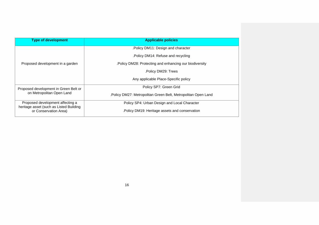
Type of development Applicable policies
Proposed development in a garden
.Policy DM11: Design and character
.Policy DM14: Refuse and recycling
.Policy DM28: Protecting and enhancing our biodiversity
.Policy DM29: Trees
Any applicable Place-Specific policy
Proposed development in Green Belt or on Metropolitan Open Land
Policy SP7: Green Grid
.Policy DM27: Metropolitan Green Belt, Metropolitan Open Land
Proposed development affecting a heritage asset (such as Listed Building
or Conservation Area)
Policy SP4: Urban Design and Local Character
.Policy DM19: Heritage assets and conservation
17
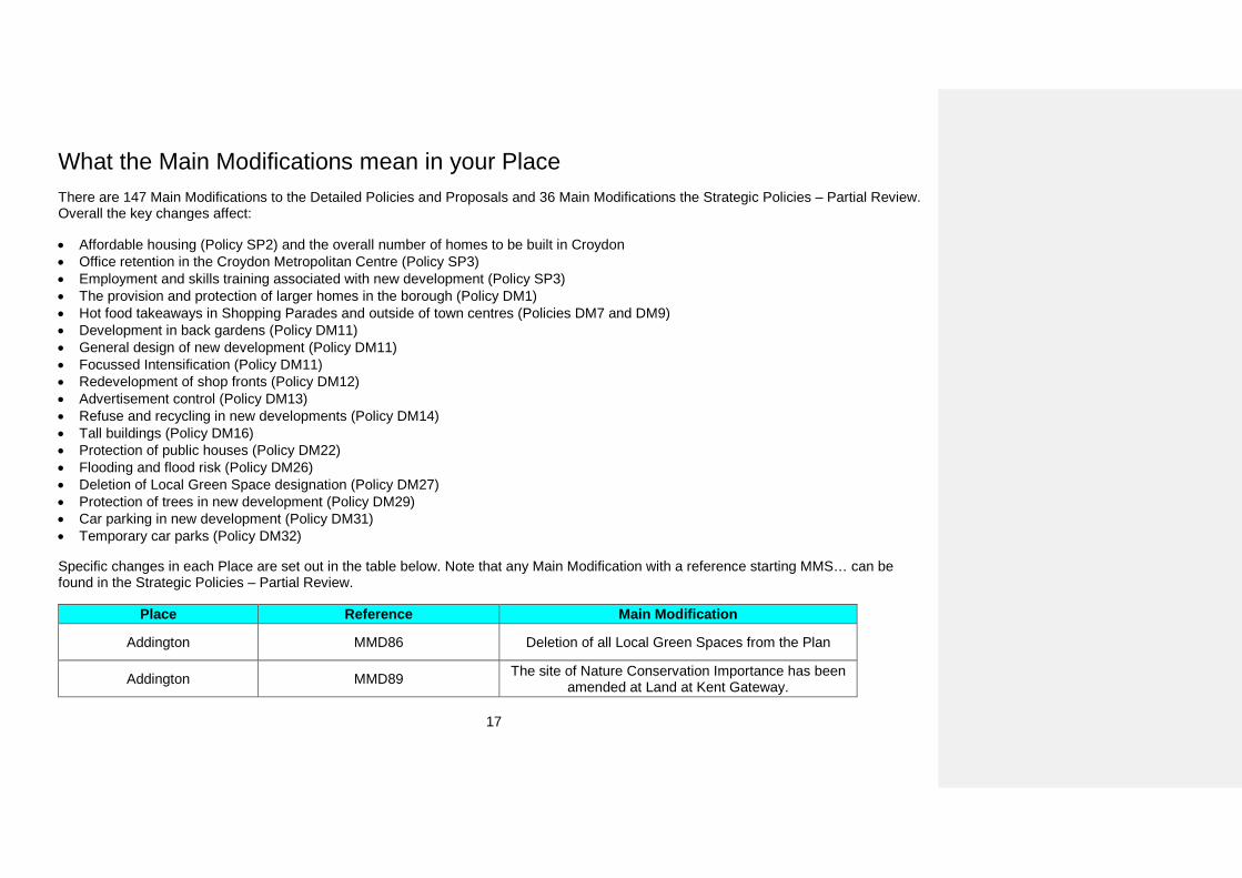
What the Main Modifications mean in your Place There are 147 Main Modifications to the Detailed Policies and Proposals and 36 Main Modifications the Strategic Policies – Partial Review. Overall the key changes affect:
• Affordable housing (Policy SP2) and the overall number of homes to be built in Croydon • Office retention in the Croydon Metropolitan Centre (Policy SP3) • Employment and skills training associated with new development (Policy SP3) • The provision and protection of larger homes in the borough (Policy DM1) • Hot food takeaways in Shopping Parades and outside of town centres (Policies DM7 and DM9) • Development in back gardens (Policy DM11) • General design of new development (Policy DM11) • Focussed Intensification (Policy DM11) • Redevelopment of shop fronts (Policy DM12) • Advertisement control (Policy DM13) • Refuse and recycling in new developments (Policy DM14) • Tall buildings (Policy DM16) • Protection of public houses (Policy DM22) • Flooding and flood risk (Policy DM26) • Deletion of Local Green Space designation (Policy DM27) • Protection of trees in new development (Policy DM29) • Car parking in new development (Policy DM31) • Temporary car parks (Policy DM32)
Specific changes in each Place are set out in the table below. Note that any Main Modification with a reference starting MMS… can be found in the Strategic Policies – Partial Review.
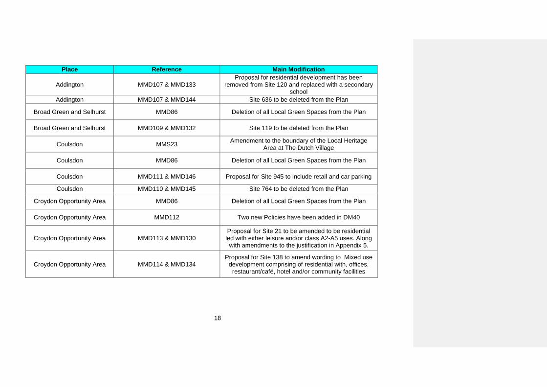
Place Reference Main Modification
Addington MMD86 Deletion of all Local Green Spaces from the Plan
Addington MMD89 The site of Nature Conservation Importance has been amended at Land at Kent Gateway.
18
Place Reference Main Modification
Addington MMD107 & MMD133 Proposal for residential development has been
removed from Site 120 and replaced with a secondary school
Addington MMD107 & MMD144 Site 636 to be deleted from the Plan
Broad Green and Selhurst MMD86 Deletion of all Local Green Spaces from the Plan
Broad Green and Selhurst MMD109 & MMD132 Site 119 to be deleted from the Plan
Coulsdon MMS23 Amendment to the boundary of the Local Heritage Area at The Dutch Village
Coulsdon MMD86 Deletion of all Local Green Spaces from the Plan
Coulsdon MMD111 & MMD146 Proposal for Site 945 to include retail and car parking
Coulsdon MMD110 & MMD145 Site 764 to be deleted from the Plan
Croydon Opportunity Area MMD86 Deletion of all Local Green Spaces from the Plan
Croydon Opportunity Area MMD112 Two new Policies have been added in DM40
Croydon Opportunity Area MMD113 & MMD130 Proposal for Site 21 to be amended to be residential led with either leisure and/or class A2-A5 uses. Along
with amendments to the justification in Appendix 5.
Croydon Opportunity Area MMD114 & MMD134 Proposal for Site 138 to amend wording to Mixed use
development comprising of residential with, offices, restaurant/café, hotel and/or community facilities
19
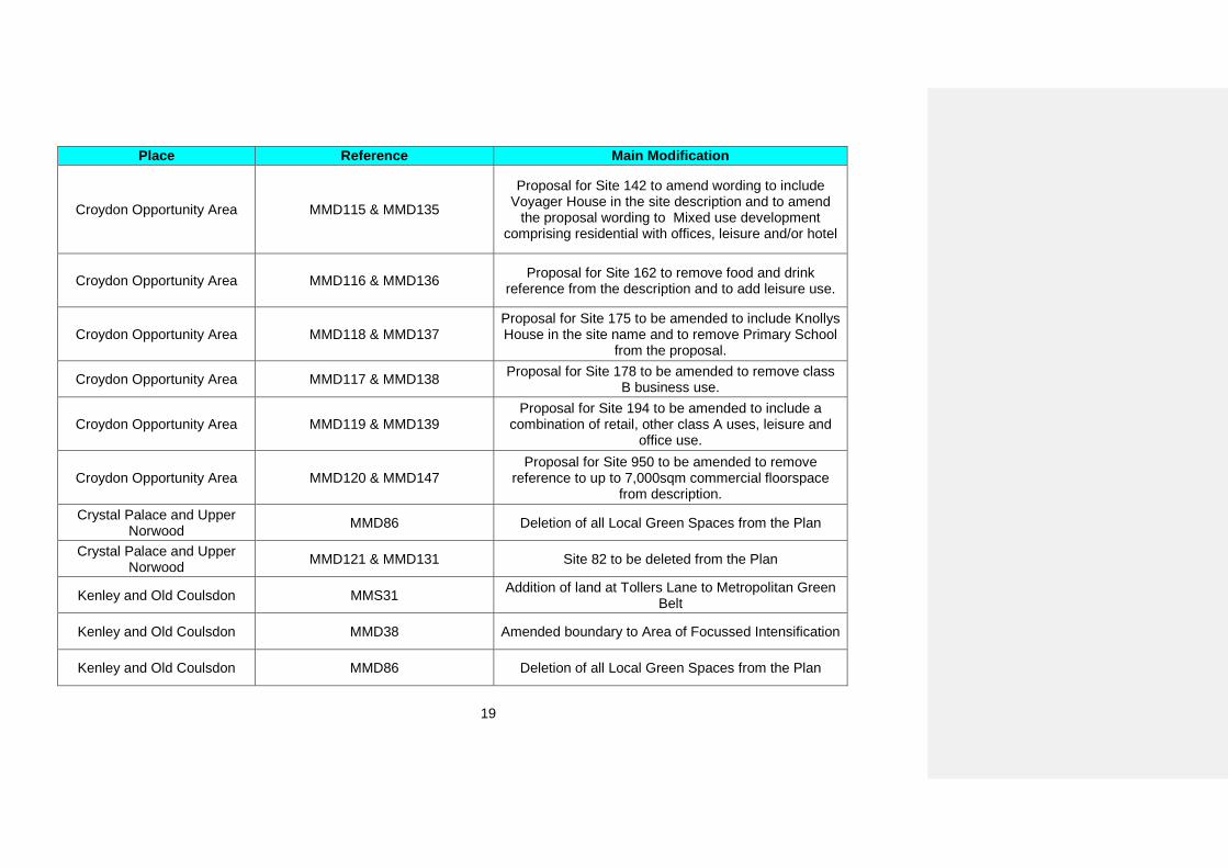
Place Reference Main Modification
Croydon Opportunity Area MMD115 & MMD135
Proposal for Site 142 to amend wording to include Voyager House in the site description and to amend
the proposal wording to Mixed use development comprising residential with offices, leisure and/or hotel
Croydon Opportunity Area MMD116 & MMD136 Proposal for Site 162 to remove food and drink reference from the description and to add leisure use.
Croydon Opportunity Area MMD118 & MMD137 Proposal for Site 175 to be amended to include Knollys House in the site name and to remove Primary School
from the proposal.
Croydon Opportunity Area MMD117 & MMD138 Proposal for Site 178 to be amended to remove class B business use.
Croydon Opportunity Area MMD119 & MMD139 Proposal for Site 194 to be amended to include a
combination of retail, other class A uses, leisure and office use.
Croydon Opportunity Area MMD120 & MMD147 Proposal for Site 950 to be amended to remove
reference to up to 7,000sqm commercial floorspace from description.
Crystal Palace and Upper Norwood MMD86 Deletion of all Local Green Spaces from the Plan
Crystal Palace and Upper Norwood MMD121 & MMD131 Site 82 to be deleted from the Plan
Kenley and Old Coulsdon MMS31 Addition of land at Tollers Lane to Metropolitan Green Belt
Kenley and Old Coulsdon MMD38 Amended boundary to Area of Focussed Intensification
Kenley and Old Coulsdon MMD86 Deletion of all Local Green Spaces from the Plan
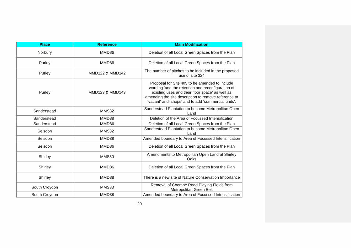
20
Place Reference Main Modification
Norbury MMD86 Deletion of all Local Green Spaces from the Plan
Purley MMD86 Deletion of all Local Green Spaces from the Plan
Purley MMD122 & MMD142 The number of pitches to be included in the proposed use of site 324
Purley MMD123 & MMD143
Proposal for Site 405 to be amended to include wording ‘and the retention and reconfiguration of
existing uses and their floor space’ as well as amending the site description to remove reference to ‘vacant’ and ‘shops’ and to add ‘commercial units’.
Sanderstead MMS32 Sanderstead Plantation to become Metropolitan Open Land
Sanderstead MMD38 Deletion of the Area of Focussed Intensification Sanderstead MMD86 Deletion of all Local Green Spaces from the Plan
Selsdon MMS32 Sanderstead Plantation to become Metropolitan Open Land
Selsdon MMD38 Amended boundary to Area of Focussed Intensification
Selsdon MMD86 Deletion of all Local Green Spaces from the Plan
Shirley MMS30 Amendments to Metropolitan Open Land at Shirley Oaks
Shirley MMD86 Deletion of all Local Green Spaces from the Plan
Shirley MMD88 There is a new site of Nature Conservation Importance
South Croydon MMS33 Removal of Coombe Road Playing Fields from Metropolitan Green Belt
South Croydon MMD38 Amended boundary to Area of Focussed Intensification
21
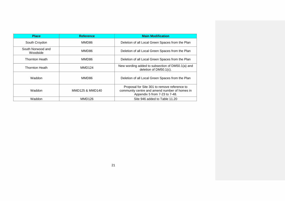
Place Reference Main Modification
South Croydon MMD86 Deletion of all Local Green Spaces from the Plan
South Norwood and Woodside MMD86 Deletion of all Local Green Spaces from the Plan
Thornton Heath MMD86 Deletion of all Local Green Spaces from the Plan
Thornton Heath MMD124 New wording added to subsection of DM50.1(a) and deletion of DM50.1(c).
Waddon MMD86 Deletion of all Local Green Spaces from the Plan
Waddon MMD125 & MMD140 Proposal for Site 301 to remove reference to
community centre and amend number of homes in Appendix 5 from 7-23 to 7-48.
Waddon MMD126 Site 946 added to Table 11.20
22
1. Introduction 1.1 Croydon is a growing borough. It is already the most populous borough in London and aims to be London’s most enterprising borough. Planning is critical to ensuring that Croydon meets the needs of its residents, business community and visitors. The Croydon Local Plan sets out the strategy, sites and planning policies necessary to meet these needs.
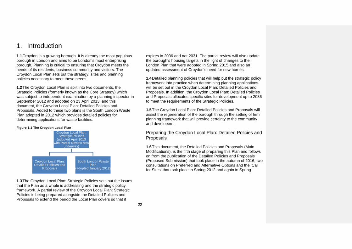
1.2 The Croydon Local Plan is split into two documents, the Strategic Policies (formerly known as the Core Strategy) which was subject to independent examination by a planning inspector in September 2012 and adopted on 23 April 2013; and this document, the Croydon Local Plan: Detailed Policies and Proposals. Added to these two plans is the South London Waste Plan adopted in 2012 which provides detailed policies for determining applications for waste facilities.
Figure 1.1 The Croydon Local Plan
1.3 The Croydon Local Plan: Strategic Policies sets out the issues that the Plan as a whole is addressing and the strategic policy framework. A partial review of the Croydon Local Plan: Strategic Policies is being prepared alongside the Detailed Policies and Proposals to extend the period the Local Plan covers so that it
expires in 2036 and not 2031. The partial review will also update the borough’s housing targets in the light of changes to the London Plan that were adopted in Spring 2015 and also an updated assessment of Croydon’s need for new homes.
1.4 Detailed planning policies that will help put the strategic policy framework into practice when determining planning applications will be set out in the Croydon Local Plan: Detailed Policies and Proposals. In addition, the Croydon Local Plan: Detailed Policies and Proposals allocates specific sites for development up to 2036 to meet the requirements of the Strategic Policies.
1.5 The Croydon Local Plan: Detailed Policies and Proposals will assist the regeneration of the borough through the setting of firm planning framework that will provide certainty to the community and developers.
Preparing the Croydon Local Plan: Detailed Policies and Proposals
1.6 This document, the Detailed Policies and Proposals (Main Modifications), is the fifth stage of preparing this Plan and follows on from the publication of the Detailed Policies and Proposals (Proposed Submission) that took place in the autumn of 2016, two consultations on Preferred and Alternative Options and the ‘Call for Sites’ that took place in Spring 2012 and again in Spring
Croydon Local Plan: Strategic Policies
(adopted April 2013 with Partial Review now
underway)
Croydon Local Plan: Detailed Policies and
Proposals
South London Waste Plan
(adopted January 2012)
23
20141. Following on from the publication of the Proposed Submission draft of the policies and proposals, the Council submitted the draft Detailed Policies and Proposals and all comments made on the Proposed Submission draft to the Planning Inspectorate.
1.7 The hearing sessions of the examination of the Croydon Local Plan: Detailed Policies and Proposals took place in May 2017. The independent Planning Inspector appointed by the Secretary of State to examine the Detailed Policies and Proposals has considered all the duly made representations and the evidence presented to him during the examination. He has now concluded that further modifications to the Detailed Policies and Proposals are required in order for the Detailed Policies and Proposals to be sound.
1.8 The Council is now consulting on the recommended Main Modifications. All duly made comments on the Main Modifications will be sent to the Planning Inspector for his consideration. Following this he will issue his final report setting out the changes (and the reasons for the changes) that the Council will be required to make if it is to adopt the Croydon Local Plan: Detailed Policies and Proposals.
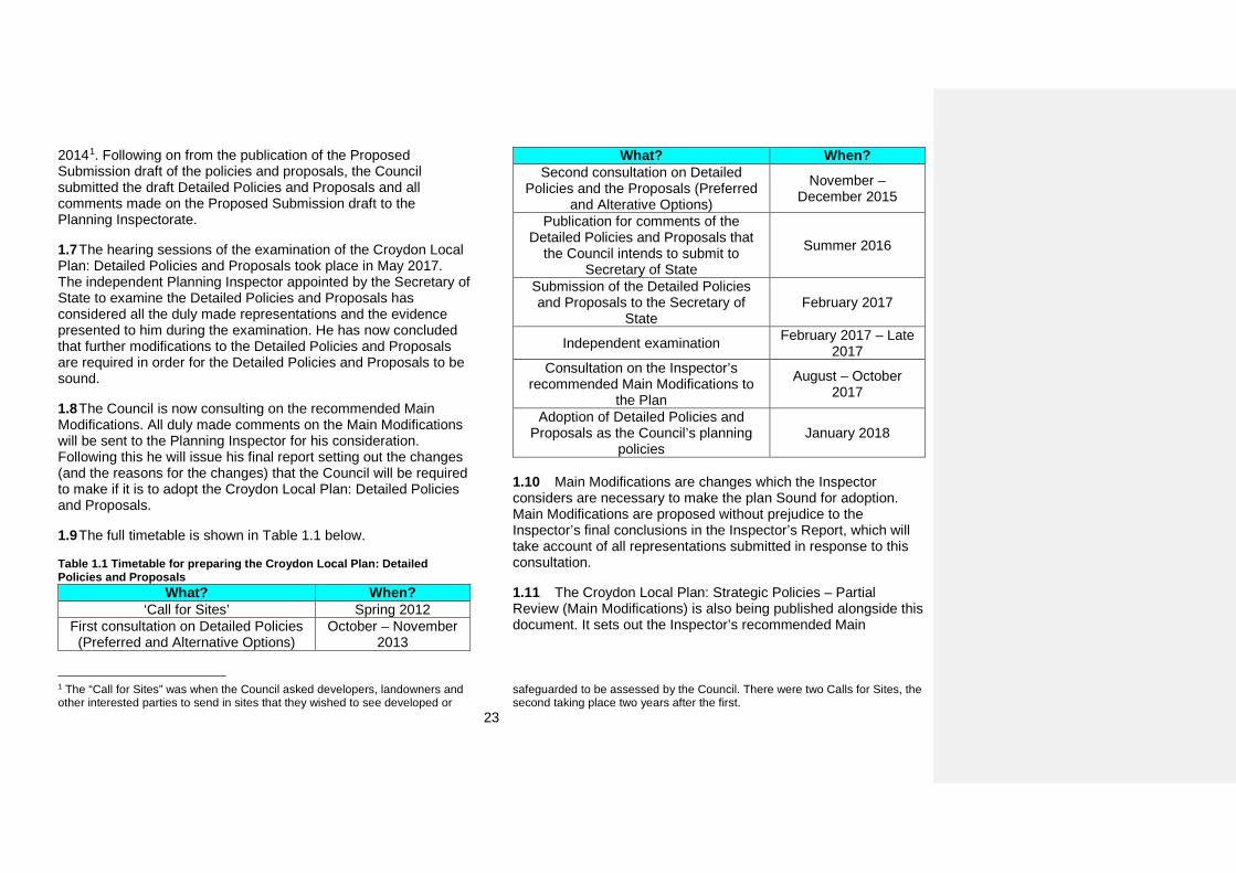
1.9 The full timetable is shown in Table 1.1 below.
Table 1.1 Timetable for preparing the Croydon Local Plan: Detailed Policies and Proposals
What? When? ‘Call for Sites’ Spring 2012
First consultation on Detailed Policies (Preferred and Alternative Options)
October – November 2013
1 The “Call for Sites” was when the Council asked developers, landowners and other interested parties to send in sites that they wished to see developed or
What? When? Second consultation on Detailed
Policies and the Proposals (Preferred and Alterative Options)
November – December 2015
Publication for comments of the Detailed Policies and Proposals that
the Council intends to submit to Secretary of State
Summer 2016
Submission of the Detailed Policies and Proposals to the Secretary of
State February 2017
Independent examination February 2017 – Late 2017
Consultation on the Inspector’s recommended Main Modifications to
the Plan
August – October 2017
Adoption of Detailed Policies and Proposals as the Council’s planning
policies January 2018
1.10 Main Modifications are changes which the Inspector considers are necessary to make the plan Sound for adoption. Main Modifications are proposed without prejudice to the Inspector’s final conclusions in the Inspector’s Report, which will take account of all representations submitted in response to this consultation.
1.11 The Croydon Local Plan: Strategic Policies – Partial Review (Main Modifications) is also being published alongside this document. It sets out the Inspector’s recommended Main
safeguarded to be assessed by the Council. There were two Calls for Sites, the second taking place two years after the first.
24
Modifications to make the Strategic Policies – Partial Review sound.
1.12 The next section of this document explains how the Main Modifications are presented.
25
2. Using and commenting on this documentUsing this document
2.1 This document is set out in the same order as the Croydon Local Plan: Strategic Policies. In this section you can find a guide to how to understand how the policies and proposals are presented.
2.2 Sections 4 to 10 contain proposed development management policies on various topics from Homes to Transport. Section 11 contains Place-specific policies and the detailed proposals.
2.3 The purpose of this document is to show the Inspector’s recommended Main Modifications in the context of where they appear in the Detailed Policies and Proposals. Each Main Modification is shown as a track change to the text and is highlighted in the right margin and looks like the example below:
The Council will designated Restaurant Quarter Parades and will ensure that their vitality and viability is maintained and increased and that they it continues to serve local communities by ensuring new development proposals and changes of use are in accordance with Table 5.7.
2.4 Some of the recommended Main Modifications would result in a change to the draft Policies Map which was published in September 2016 alongside the Proposed Submission draft of the Detailed Policies and Proposals. Where a Main Modification would result in a change this is clearly referenced in the text. A map showing the proposed change to the Policies Map can be found in Appendix 7 of this document.
2.5 The document also contains some minor modifications. These changes are not marked in the text and are not required to make the Detailed Policies and Proposals sound. Comments cannot be made on minor modifications. A full schedule of minor modifications can be found in Appendix 6 of this document.
2.6 All policies in this document should be used in conjunction with the National Planning Policy Framework (2012), the London Plan (2016) and the Croydon Local Plan: Strategic Policies (2013).
Guide to the detailed policies
2.7 For each policy (except the Place-specific policies) the following information is provided:
Strategic Objectives and related Croydon Local Plan strategic policies;
Unitary Development Plan policies to be replaced by this policy;
Why we need this policy; Policy wording; How the policy works; and Key supporting documents.
Guide to the Place-specific policies (including the detailed proposals)
2.8 For each Place-specific policy the following information is provided:
A description of the general character of the Place; The policy wording; A full description of how the policy works; and
[Main Mod]: MMD19
26
A list of all the detailed proposal sites in each place including the proposed use on each site.
2.9 A guide to how the detailed proposals were identified can be found in Appendix 1 and a schedule containing further details of each site including indicative unit numbers and phasing can be found in Appendix 5.
Commenting on this document
2.10 The Croydon Local Plan: Detailed Policies and Proposals (Main Modifications) is being published for a six week period. During this time the Council is inviting comments on the Main Modifications to the policies and proposals that are presented in tracked changes in this document.
2.11 Comments can only be made on the recommended Main Modifications (shown as a track change) or an associated change to the Policies Map.
2.12 All duly made comments received will be forwarded to the Planning Inspectorate for consideration. To be duly made the comments must:
Be received by the Council on or before the 10 October 2017;
Include a name and either an e-mail or postal address all of which must be legible;
Not contain offensive or racist language; and Be related only to a specific Main Modification to the
Policies and Proposals.
2.13 Comments made on unchanged parts of the Detailed Policies and Proposals will not be sent to the Inspector.
2.14 Any comments should be received by the Council on or before 10 October 2017. Comments may be made by e-mail or in writing and must be sent to the addresses below:
Email: [email protected]
Post: Croydon Local Plan: Detailed Policies and Proposals (Main Modifications)
Spatial Planning Bernard Weatherill House 8 Mint Walk Croydon CR0 1EA
2.15 The Council cannot guarantee that comments sent to any address other than those above will be received in the prescribed period in order to be considered duly made. The date of the representation will be determined based on when it is received at [email protected] or by the receipted date stamp.
27
3. Strategic ContextWe are Croydon
3.1 ‘We are Croydon’ is the vision for where Croydon will be in 2040 and the work of 20,000 people, imagining the borough in the future.
3.2 The ‘We are Croydon’ vision is used by Croydon Council’s partners as the basis for future strategies and plans, including the Croydon Local Plan’s own spatial vision.
3.3 'We are Croydon' has informed the Croydon Local Plan’s spatial vision and strategic objectives. These are used to guide the overall strategy and spatial choices about where developments should go in broad terms and how development should take place.
The We are Croydon Vision Enterprising: A place renowned for its enterprise and
innovation with a highly adaptable and skilled workforce and diverse and thriving local economy
Learning : A place that unleashes and nurtures local talent, is recognised for its support and opportunity for lifelong learning
and ambitions for children and young people
Creative: A place that draws people to its culture and creativity – an inspiration and enabler of new artistic and
sporting talent in the country
The We are Croydon Vision Connected: A place that is well connected, easy to get to and around, and supported by infrastructure that enables people to
easily come together, with one of the best digital, communications and transport networks in the country
Sustainable: A place that sets the pace amongst London boroughs on promoting environmental sustainability and where the natural environment forms the arteries and veins of the city
Caring: A place noted for its safety, openness and community spirit where all people are welcome to live and work and where
individuals and communities are supported to fulfil their potential and deliver solutions for themselves
28
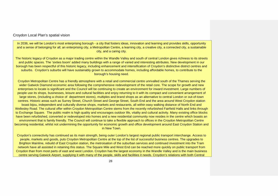
Croydon Local Plan’s spatial vision
In 2036, we will be London’s most enterprising borough - a city that fosters ideas, innovation and learning and provides skills, opportunity and a sense of belonging for all; an enterprising city, a Metropolitan Centre, a learning city, a creative city, a connected city, a sustainable
city, and a caring city.
The historic legacy of Croydon as a major trading centre within the Wandle Valley and south of central London gives richness to its streets and public spaces. The ‘sixties boom' added many buildings with a range of varied and interesting attributes. New development in our
borough has been respectful of this historic legacy, including enhancement and intensification of Croydon’s distinctive district centres and suburbs. Croydon’s suburbs will have sustainably grown to accommodate homes, including affordable homes, to contribute to the
borough’s housing need.
Croydon Metropolitan Centre has a friendly atmosphere with a retail and commercial centre unrivalled south of the Thames serving the wider Gatwick Diamond economic area following the comprehensive redevelopment of the retail core. The scope for growth and new
enterprises to locate is significant and the Council will be continuing to create an environment for inward investment. Large numbers of people use its shops, businesses, leisure and cultural facilities and enjoy returning to it with its compact and convenient arrangement of
large stores, (including a choice of department stores), multiples and brand shops as an alternative to central London or out-of-town centres. Historic areas such as Surrey Street, Church Street and George Street, South End and the area around West Croydon station
boast bijou, independent and culturally diverse shops, markets and restaurants, all within easy walking distance of North End and Wellesley Road. The cultural offer within Croydon Metropolitan Centre stems from the recently refurbished Fairfield Halls and links through to Exchange Square. The public realm is high quality and encourages outdoor life, vitality and cultural activity. Many existing office blocks have been refurbished, converted or redeveloped into homes and a new residential community now resides in the centre which boasts an
environment that is family friendly. The Council will continue to take a flexible approach to offices in the Croydon Metropolitan Centre becoming residential, whilst not undermining the opportunity for economic growth and office development around East Croydon Station and
in New Town.
Croydon’s connectivity has continued as its main strength, being outer London’s largest regional public transport interchange. Access to people, markets and goods, puts Croydon Metropolitan Centre at the top of the list of successful business centres. The upgrades to
Brighton Mainline, rebuild of East Croydon station, the metroisation of the suburban services and continued investment into the Tram network have all assisted in retaining this status. The Square Mile and West End can be reached more quickly on public transport from
Croydon than from most parts of east and west London. Croydon has the largest economy in the Wandle Valley and is the main business centre serving Gatwick Airport, supplying it with many of the people, skills and facilities it needs. Croydon’s relations with both Central
29
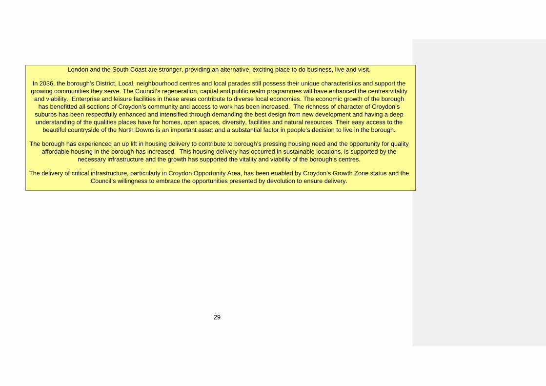
London and the South Coast are stronger, providing an alternative, exciting place to do business, live and visit.
In 2036, the borough’s District, Local, neighbourhood centres and local parades still possess their unique characteristics and support the growing communities they serve. The Council’s regeneration, capital and public realm programmes will have enhanced the centres vitality and viability. Enterprise and leisure facilities in these areas contribute to diverse local economies. The economic growth of the borough
has benefitted all sections of Croydon’s community and access to work has been increased. The richness of character of Croydon’s suburbs has been respectfully enhanced and intensified through demanding the best design from new development and having a deep understanding of the qualities places have for homes, open spaces, diversity, facilities and natural resources. Their easy access to the
beautiful countryside of the North Downs is an important asset and a substantial factor in people’s decision to live in the borough.
The borough has experienced an up lift in housing delivery to contribute to borough’s pressing housing need and the opportunity for quality affordable housing in the borough has increased. This housing delivery has occurred in sustainable locations, is supported by the
necessary infrastructure and the growth has supported the vitality and viability of the borough’s centres.
The delivery of critical infrastructure, particularly in Croydon Opportunity Area, has been enabled by Croydon’s Growth Zone status and the Council’s willingness to embrace the opportunities presented by devolution to ensure delivery.
30
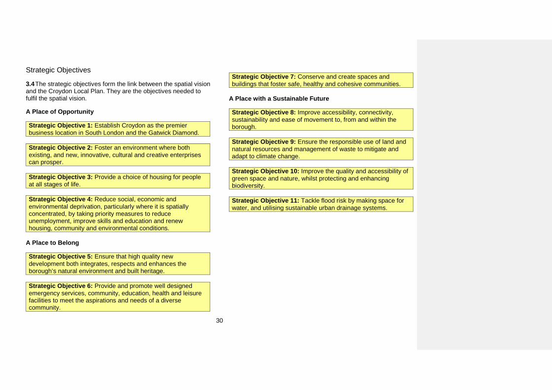
Strategic Objectives
3.4 The strategic objectives form the link between the spatial vision and the Croydon Local Plan. They are the objectives needed to fulfil the spatial vision.
A Place of Opportunity
Strategic Objective 1: Establish Croydon as the premier business location in South London and the Gatwick Diamond.
Strategic Objective 2: Foster an environment where both existing, and new, innovative, cultural and creative enterprises can prosper.
Strategic Objective 3: Provide a choice of housing for people at all stages of life.
Strategic Objective 4: Reduce social, economic and environmental deprivation, particularly where it is spatially concentrated, by taking priority measures to reduce unemployment, improve skills and education and renew housing, community and environmental conditions.
A Place to Belong
Strategic Objective 5: Ensure that high quality new development both integrates, respects and enhances the borough’s natural environment and built heritage.
Strategic Objective 6: Provide and promote well designed emergency services, community, education, health and leisure facilities to meet the aspirations and needs of a diverse community.
Strategic Objective 7: Conserve and create spaces and buildings that foster safe, healthy and cohesive communities.
A Place with a Sustainable Future
Strategic Objective 8: Improve accessibility, connectivity, sustainability and ease of movement to, from and within the borough.
Strategic Objective 9: Ensure the responsible use of land and natural resources and management of waste to mitigate and adapt to climate change.
Strategic Objective 10: Improve the quality and accessibility of green space and nature, whilst protecting and enhancing biodiversity.
Strategic Objective 11: Tackle flood risk by making space for water, and utilising sustainable urban drainage systems.

31
A Place of Opportunity The content of this section is related to the theme of Croydon as ‘A Place of Opportunity’. It adds further detail to the Croydon Local Plan: Strategic Policies on planning for homes and employment.
32
4. Homes Housing choice for sustainable communities
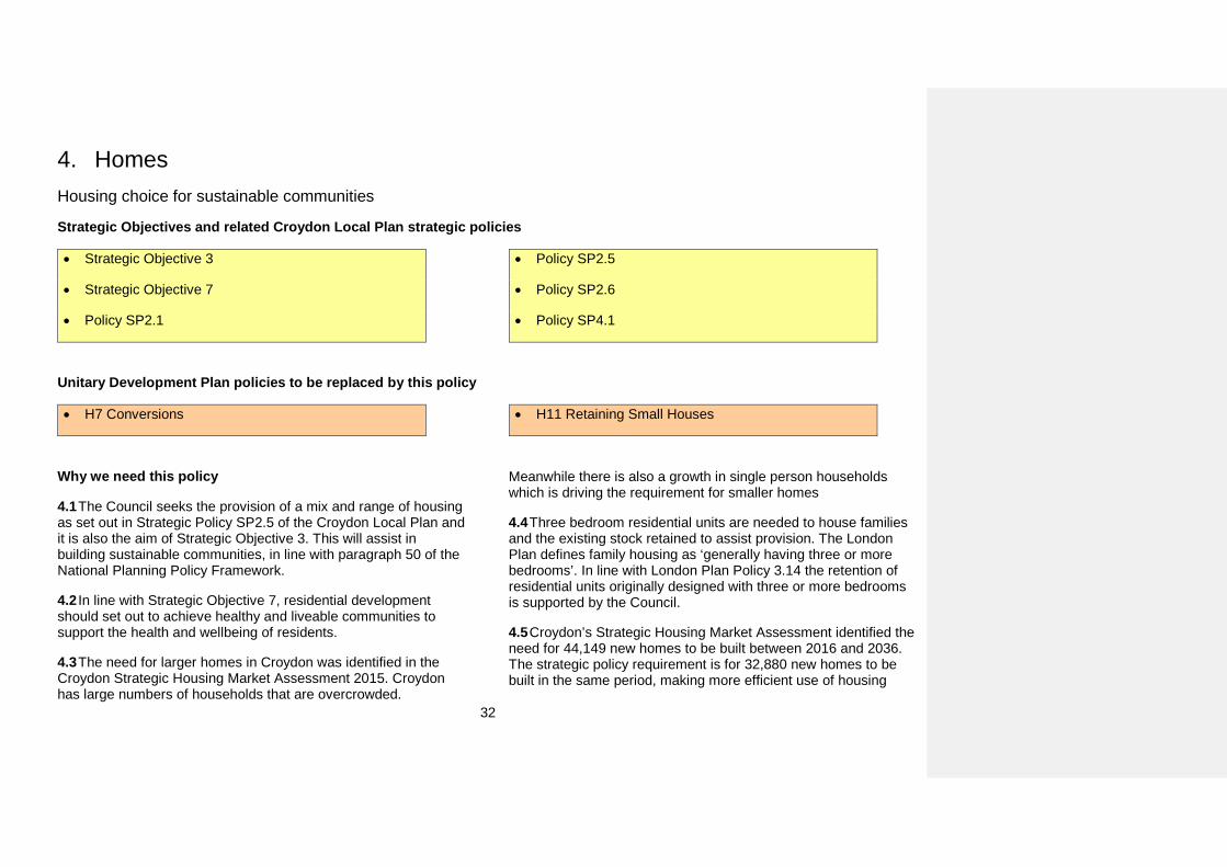
Strategic Objectives and related Croydon Local Plan strategic policies
• Strategic Objective 3
• Strategic Objective 7
• Policy SP2.1
• Policy SP2.5
• Policy SP2.6
• Policy SP4.1
Unitary Development Plan policies to be replaced by this policy
• H7 Conversions • H11 Retaining Small Houses
Why we need this policy
4.1 The Council seeks the provision of a mix and range of housing as set out in Strategic Policy SP2.5 of the Croydon Local Plan and it is also the aim of Strategic Objective 3. This will assist in building sustainable communities, in line with paragraph 50 of the National Planning Policy Framework.
4.2 In line with Strategic Objective 7, residential development should set out to achieve healthy and liveable communities to support the health and wellbeing of residents.
4.3 The need for larger homes in Croydon was identified in the Croydon Strategic Housing Market Assessment 2015. Croydon has large numbers of households that are overcrowded.
Meanwhile there is also a growth in single person households which is driving the requirement for smaller homes
4.4 Three bedroom residential units are needed to house families and the existing stock retained to assist provision. The London Plan defines family housing as ‘generally having three or more bedrooms’. In line with London Plan Policy 3.14 the retention of residential units originally designed with three or more bedrooms is supported by the Council.
4.5 Croydon’s Strategic Housing Market Assessment identified the need for 44,149 new homes to be built between 2016 and 2036. The strategic policy requirement is for 32,880 new homes to be built in the same period, making more efficient use of housing
33
stock a necessity including sub-divisions, conversions and change of use to residential.
4.6 The Strategic Housing Market Assessment 2015 identifies that 50% of the future requirement for market housing is for larger homes. The Strategic Housing Land Availability Assessment has identified that whilst projections of future housing requirements are rising, levels of building have fallen. Existing three bed residential units should therefore be retained and any conversions should ensure that there is no loss of three bed homes.
4.7 Within the Croydon Opportunity Area the Croydon Housing Typologies Study has found that the strongest opportunities for homes suitable for families will be associated with the lower and moderate density sites in the Croydon Metropolitan Centre (including the inner residential area in the Croydon Opportunity Area2). It indicates that there will be more opportunities for studio, one and two bedroom units on the higher density sites in the Croydon Metropolitan Centre.
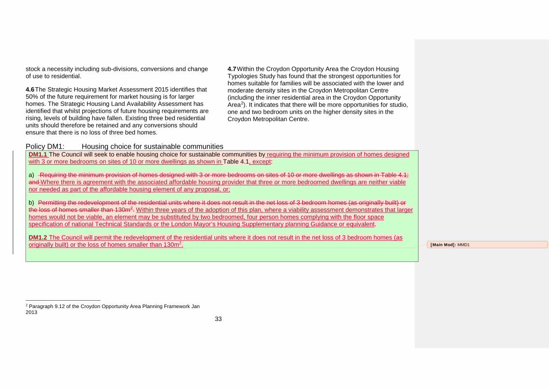
Policy DM1: Housing choice for sustainable communities DM1.1 The Council will seek to enable housing choice for sustainable communities by requiring the minimum provision of homes designed with 3 or more bedrooms on sites of 10 or more dwellings as shown in Table 4.1, except:
a) Requiring the minimum provision of homes designed with 3 or more bedrooms on sites of 10 or more dwellings as shown in Table 4.1;and Where there is agreement with the associated affordable housing provider that three or more bedroomed dwellings are neither viable nor needed as part of the affordable housing element of any proposal, or;
b) Permitting the redevelopment of the residential units where it does not result in the net loss of 3 bedroom homes (as originally built) orthe loss of homes smaller than 130m2. Within three years of the adoption of this plan, where a viability assessment demonstrates that larger homes would not be viable, an element may be substituted by two bedroomed, four person homes complying with the floor space specification of national Technical Standards or the London Mayor’s Housing Supplementary planning Guidance or equivalent.
DM1.2 The Council will permit the redevelopment of the residential units where it does not result in the net loss of 3 bedroom homes (as originally built) or the loss of homes smaller than 130m2.
2 Paragraph 9.12 of the Croydon Opportunity Area Planning Framework Jan 2013
[Main Mod]: MMD1
34
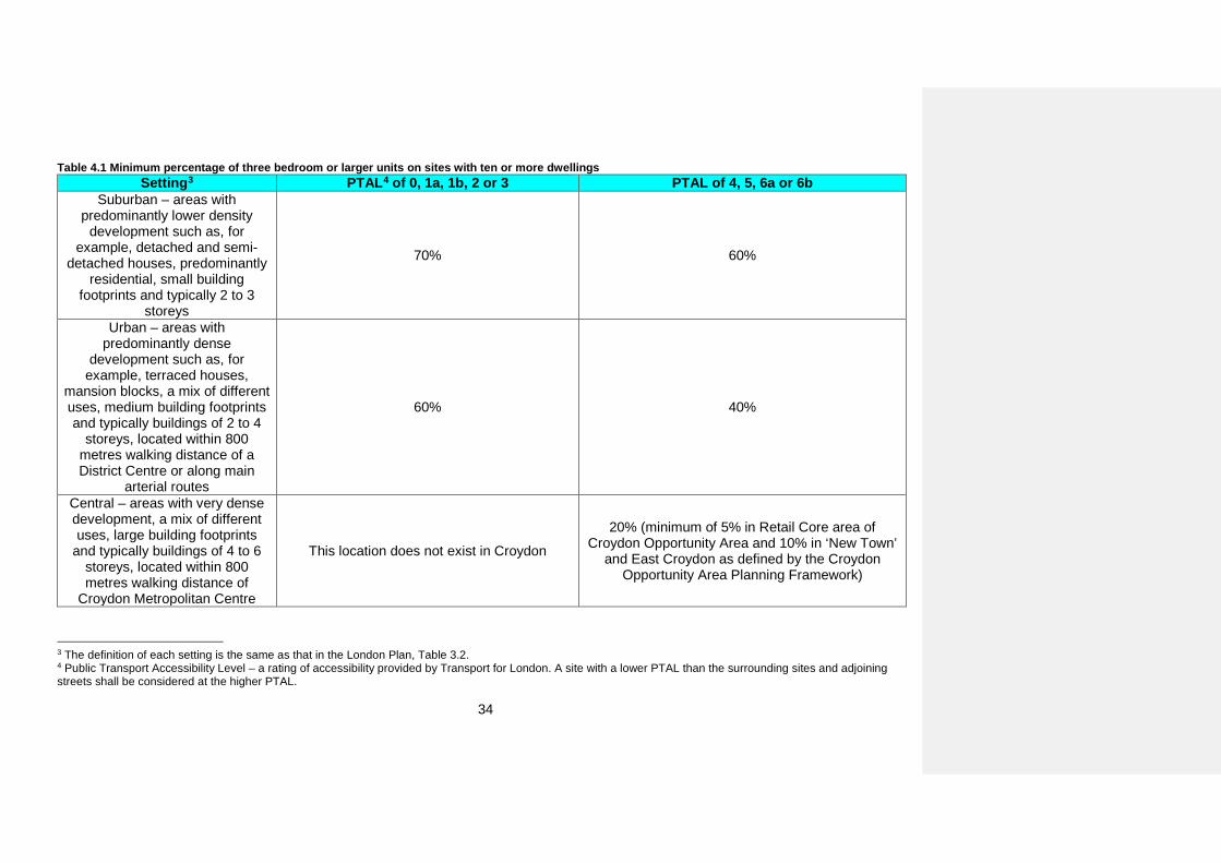
Table 4.1 Minimum percentage of three bedroom or larger units on sites with ten or more dwellings Setting3 PTAL4 of 0, 1a, 1b, 2 or 3 PTAL of 4, 5, 6a or 6b
Suburban – areas with predominantly lower density
development such as, for example, detached and semi-
detached houses, predominantly residential, small building
footprints and typically 2 to 3 storeys
70% 60%
Urban – areas with predominantly dense
development such as, for example, terraced houses,
mansion blocks, a mix of different uses, medium building footprints and typically buildings of 2 to 4
storeys, located within 800 metres walking distance of a District Centre or along main
arterial routes
60% 40%
Central – areas with very dense development, a mix of different uses, large building footprints
and typically buildings of 4 to 6 storeys, located within 800 metres walking distance of
Croydon Metropolitan Centre
This location does not exist in Croydon
20% (minimum of 5% in Retail Core area of Croydon Opportunity Area and 10% in ‘New Town’
and East Croydon as defined by the Croydon Opportunity Area Planning Framework)
3 The definition of each setting is the same as that in the London Plan, Table 3.2. 4 Public Transport Accessibility Level – a rating of accessibility provided by Transport for London. A site with a lower PTAL than the surrounding sites and adjoining streets shall be considered at the higher PTAL.
35
How the policy works
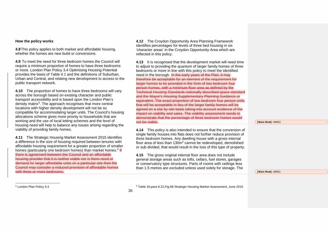
4.8 This policy applies to both market and affordable housing, whether the homes are new build or conversions.
4.9 To meet the need for three bedroom homes the Council will require a minimum proportion of homes to have three bedrooms or more. London Plan Policy 3.4 Optimising Housing Potential provides the basis of Table 4.1 and the definitions of Suburban, Urban and Central, and relating new development to access to the public transport network.
4.10 The proportion of homes to have three bedrooms will vary across the borough based on existing character and public transport accessibility and is based upon the London Plan’s density matrix5. The approach recognises that more central locations with higher density development will not be so compatible for accommodating larger units. The Council’s housing allocations scheme gives more priority to households that are working and the use of local letting schemes and the level of housing need will help to balance any issues arising regarding the viability of providing family homes.
4.11 The Strategic Housing Market Assessment 2015 identifies a difference in the size of housing required between tenures with affordable housing requirement for a greater proportion of smaller homes (particularly one bedroom homes) than market homes.6 If there is agreement between the Council and an affordable housing provider that it is neither viable nor is there need or demand for larger affordable units on a particular site then the Council may consider a reduced provision of affordable homes with three or more bedrooms.
5 London Plan Policy 3.4
4.12 The Croydon Opportunity Area Planning Framework identifies percentages for levels of three bed housing in six ‘character areas’ in the Croydon Opportunity Area which are reflected in this policy.
4.13 It is recognised that the development market will need time to adjust to providing the quantum of larger family homes of three bedrooms or more in line with this policy to meet the identified need in the borough. In the early years of the Plan, it may therefore be acceptable for an element of the requirement for larger homes to be provided in the form of two bedroom four person homes, with a minimum floor area as defined by the Technical Housing Standards nationally described space standard and the Mayor’s Housing Supplementary Planning Guidance or equivalent. The exact proportion of two bedroom four person units that will be acceptable in lieu of the larger family homes will be agreed on a site by site basis taking into account evidence of the impact on viability and sales. The viability assessment needs to demonstrate that the percentage of three bedroom homes would not be viable.
4.14 This policy is also intended to ensure that the conversion of single family houses into flats does not further reduce provision of three bedroom homes. Any dwelling house with a gross internal floor area of less than 130m2 cannot be redeveloped, demolished or sub divided, that would result in the loss of this type of property.
4.15 The gross original internal floor area does not include general storage areas such as lofts, cellars, fuel stores, garages or conservatory type structures. Parts of rooms with ceilings less than 1.5 metres are excluded unless used solely for storage. The
6 Table 34,para 9.22,Fig.68 Strategic Housing Market Assessment, June 2015
[Main Mod]: MMD2
[Main Mod]: MMD3
36
calculation of the Gross Internal Area must comply with the National Technical Housing Standards or equivalent 2015.
Key supporting documents
• Croydon’s Strategic Housing Market Assessment (2015)• Borough Character Appraisal (2015)• Character Typology (2015)• Croydon Housing Typologies Study (2010)• Croydon Opportunity Area Planning Framework (2013)• Mayor of London's Housing Supplementary PlanningDocument (2016)
37
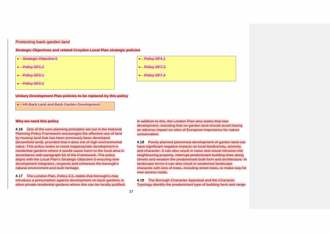
Protecting back garden land
Strategic Objectives and related Croydon Local Plan strategic policies
• Strategic Objective 5
• Policy SP1.2
• Policy SP2.1
• Policy SP2.2
• Policy SP4.1
• Policy SP7.3
• Policy SP7.4
Unitary Development Plan policies to be replaced by this policy
• H5 Back Land and Back Garden Development
Why we need this policy
4.16 One of the core planning principles set out in the National Planning Policy Framework encourages the effective use of land by reusing land that has been previously been developed (brownfield land), provided that it does not of high environmental value. This policy seeks to resist inappropriate development in residential gardens where it would cause harm to the local area in accordance with paragraph 53 of the Framework. The policy aligns with the Local Plan’s Strategic Objective 5 ensuring new development integrates, respects and enhances the borough’s natural environment and built heritage.
4.17 The London Plan, Policy 3.5, states that borough’s may introduce a presumption against development on back gardens or other private residential gardens where this can be locally justified.
In addition to this, the London Plan also states that new development, including that on garden land should avoid having an adverse impact on sites of European importance for nature conservation.
4.18 Poorly planned piecemeal development of garden land can have significant negative impacts on local biodiversity, amenity, and character. It can also result in noise and visual intrusion into neighbouring property, interrupt predominant building lines along streets and weaken the predominant built form and architecture. In landscape terms it can also result in weakened landscape character with loss of trees, including street trees, to make way for new access roads.
4.19 The Borough Character Appraisal and the Character Typology identify the predominant type of building form and range
38
of plot sizes for different residential forms. The Typology shows that nine per cent of the borough area is made up of buildings and thirty five percent occupied by residential garden space. Overall, sixty percent of the borough is made up of residential garden space, recreational space and woodland.
What the evidence says
4.20 The Borough Character Appraisal (Appendix 4) and the Character Typology (Appendix 5) identify the predominant type of building form and range of plot sizes for different residential forms. The Typology shows that nice per cent of the borough area is made up of buildings and thirty five percent of the borough area is made up buildings and thirty five percent occupied by residential garden space. Overall, sixty percent of the borough is made up of residential garden space, recreational space and woodland.
4.21 London’s Strategic Housing Land Availability Assessment, which forms the basis of London Plan housing targets for Croydon, assumes that garden land will not be developed. Therefore, no allowance is made for developing on garden land in the London Plan’s housing target for Croydon. As such, the protection of some gardens from development by this policy will not impact on meeting Croydon’s housing targets.
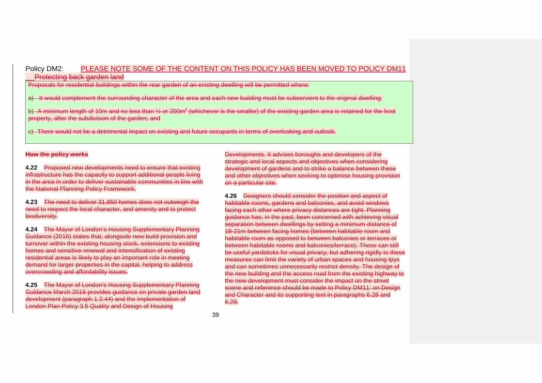
39
Policy DM2: PLEASE NOTE SOME OF THE CONTENT ON THIS POLICY HAS BEEN MOVED TO POLICY DM11Protecting back garden land
Proposals for residential buildings within the rear garden of an existing dwelling will be permitted where:
a) It would complement the surrounding character of the area and each new building must be subservient to the original dwelling;
b) A minimum length of 10m and no less than ½ or 200m2 (whichever is the smaller) of the existing garden area is retained for the hostproperty, after the subdivision of the garden; and
c) There would not be a detrimental impact on existing and future occupants in terms of overlooking and outlook.
How the policy works
4.22 Proposed new developments need to ensure that existing infrastructure has the capacity to support additional people living in the area in order to deliver sustainable communities in line with the National Planning Policy Framework.
4.23 The need to deliver 31,850 homes does not outweigh the need to respect the local character, and amenity and to protect biodiversity.
4.24 The Mayor of London’s Housing Supplementary Planning Guidance (2016) states that, alongside new build provision and turnover within the existing housing stock, extensions to existing homes and sensitive renewal and intensification of existing residential areas is likely to play an important role in meeting demand for larger properties in the capital, helping to address overcrowding and affordability issues.
4.25 The Mayor of London's Housing Supplementary Planning Guidance March 2016 provides guidance on private garden land development (paragraph 1.2.44) and the implementation of London Plan Policy 3.5 Quality and Design of Housing
Developments. It advises boroughs and developers of the strategic and local aspects and objectives when considering development of gardens and to strike a balance between these and other objectives when seeking to optimise housing provision on a particular site.
4.26 Designers should consider the position and aspect of habitable rooms, gardens and balconies, and avoid windows facing each other where privacy distances are tight. Planning guidance has, in the past, been concerned with achieving visual separation between dwellings by setting a minimum distance of 18-21m between facing homes (between habitable room and habitable room as opposed to between balconies or terraces or between habitable rooms and balconies/terrace). These can still be useful yardsticks for visual privacy, but adhering rigidly to these measures can limit the variety of urban spaces and housing tpys and can sometimes unnecessarily restrict density. The design of the new building and the access road from the existing highway to the new development must consider the impact on the street scene and reference should be made to Policy DM11: on Design and Character and its supporting text in paragraphs 6.28 and 6.29.
40
4.27 Policy DM1.1 on landscape and Policy DM29: Trees should be referred to with regards to the protection of existing trees and vegetation in gardens. British Standard 5837, 2012 or equivalent, should be referred to with regard to the protection of existing trees in relation to design, demolition and construction.
4.28 Proposals for development in rear gardens should be subservient to the original dwelling, should not be visible from the public highway or dominate the existing plot. New development should be of a reduced scale when compared to the host dwelling. Account should be taken of the Borough Character Appraisal.
4.29 It is likely that rear gardens will need to be at least 20m long in order to accommodate this type of development and be considered acceptable in terms of character.
4.30 Gardens are important sources of vegetation and open space for wildlife. They also provide the opportunity to grow food and benefit public health through exercise. Housing in parts of Croydon have long gardens with mature planting which may be part of wildlife corridors or adjoin local open space in the borough and provide valuable habitats. It is important that any proposed development ensures the retention of habitats or wildlife corridors' ecological value.
4.31 Development should accord with the provisions set out in DM26 Biodiversity. The Council may require an ecology report to be submitted as part of a planning application for development within the curtilage of a dwelling. The applicant will be required to pay for an independent assessment to be carried out on behalf of the local authority.
4.32 Croydon Local Plan: Strategic Policy SP6.3 Sustainable Design and Construction requires that new-build development complies with the National Technical Housing Standards (2015) and London Plan requirements or equivalent.
4.33 The conversion of an outbuilding to a self-contained unit is development that requires planning permission. If the outbuilding is required for a purpose incidental to the enjoyment of the dwelling house, then, subject to compliance with the other requirements of the legislation, it would be permitted development under Schedule 2, Part 1 Class E of the Town and Country Planning (General Permitted Development) (Amendment) (England) Order 2015. Development is not permitted by Class E if the total area of ground covered by buildings, enclosures and containers within the curtilage would exceed 50% of the total area of the curtilage.
Key supporting documents
• Borough Character Appraisal (2015)• Character Typology (2015)• Mayor of London’s Housing Supplementary Planning Guidance(2016) [Main Mod]: MMD4
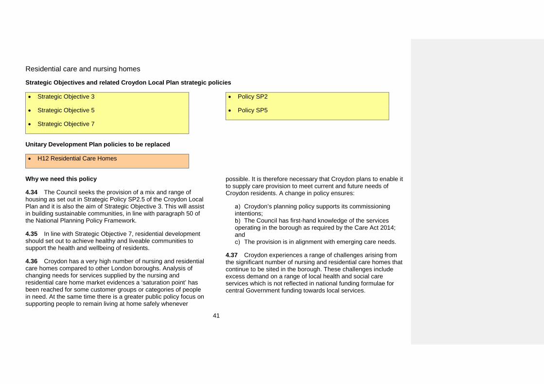
41
Residential care and nursing homes
Strategic Objectives and related Croydon Local Plan strategic policies
• Strategic Objective 3
• Strategic Objective 5
• Strategic Objective 7
• Policy SP2
• Policy SP5
Unitary Development Plan policies to be replaced
• H12 Residential Care Homes
Why we need this policy
4.34 The Council seeks the provision of a mix and range of housing as set out in Strategic Policy SP2.5 of the Croydon Local Plan and it is also the aim of Strategic Objective 3. This will assist in building sustainable communities, in line with paragraph 50 of the National Planning Policy Framework.
4.35 In line with Strategic Objective 7, residential development should set out to achieve healthy and liveable communities to support the health and wellbeing of residents.
4.36 Croydon has a very high number of nursing and residential care homes compared to other London boroughs. Analysis of changing needs for services supplied by the nursing and residential care home market evidences a ‘saturation point’ has been reached for some customer groups or categories of people in need. At the same time there is a greater public policy focus on supporting people to remain living at home safely whenever
possible. It is therefore necessary that Croydon plans to enable it to supply care provision to meet current and future needs of Croydon residents. A change in policy ensures:
Croydon’s planning policy supports its commissioning intentions;
The Council has first-hand knowledge of the services operating in the borough as required by the Care Act 2014; and
The provision is in alignment with emerging care needs.
4.37 Croydon experiences a range of challenges arising from the significant number of nursing and residential care homes that continue to be sited in the borough. These challenges include excess demand on a range of local health and social care services which is not reflected in national funding formulae for central Government funding towards local services.
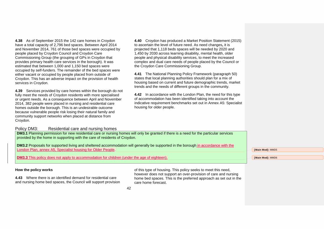
42
4.38 As of September 2015 the 142 care homes in Croydon have a total capacity of 2,796 bed spaces. Between April 2014 and November 2014, 761 of those bed spaces were occupied by people placed by Croydon Council and Croydon Care Commissioning Group (the grouping of GPs in Croydon that provides primary health care services in the borough). It was estimated that between 1,000 and 1,150 bed spaces were occupied by self-funders. The remainder of the bed spaces were either vacant or occupied by people placed from outside of Croydon. This has an adverse impact on the provision of health services in Croydon.
4.39 Services provided by care homes within the borough do not fully meet the needs of Croydon residents with more specialised or urgent needs. As a consequence between April and November 2014, 382 people were placed in nursing and residential care homes outside the borough. This is an undesirable outcome because vulnerable people risk losing their natural family and community support networks when placed at distance from Croydon.
4.40 Croydon has produced a Market Position Statement (2015) to ascertain the level of future need. As need changes, it is projected that 1,118 beds spaces will be needed by 2020 and 1,450 by 2030 across learning disability, mental health, older people and physical disability services, to meet the increased complex and dual care needs of people placed by the Council or the Croydon Care Commissioning Group.
4.41 The National Planning Policy Framework (paragraph 50) states that local planning authorities should plan for a mix of housing based on current and future demographic trends, market trends and the needs of different groups in the community.
4.42 In accordance with the London Plan, the need for this type of accommodation has been identified taking into account the indicative requirement benchmarks set out in Annex A5: Specialist housing for older people.
Policy DM3: Residential care and nursing homes DM3.1 Planning permission for new residential care or nursing homes will only be granted if there is a need for the particular services provided by the home in supporting with the care of residents of Croydon.
DM3.2 Proposals for supported living and sheltered accommodation will generally be supported in the borough in accordance with the London Plan, annex A5, Specialist housing for Older People.
DM3.3 This policy does not apply to accommodation for children (under the age of eighteen).
How the policy works
4.43 Where there is an identified demand for residential care and nursing home bed spaces, the Council will support provision
of this type of housing. This policy seeks to meet this need, however does not support an over-provision of care and nursing home bed spaces. This is the preferred approach as set out in the care home forecast.
[Main Mod]: MMD5
[Main Mod]: MMD6
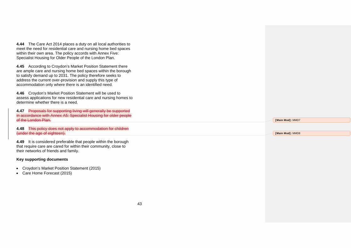
43
4.44 The Care Act 2014 places a duty on all local authorities to meet the need for residential care and nursing home bed spaces within their own area. The policy accords with Annex Five: Specialist Housing for Older People of the London Plan.
4.45 According to Croydon’s Market Position Statement there are ample care and nursing home bed spaces within the borough to satisfy demand up to 2031. The policy therefore seeks to address the current over-provision and supply this type of accommodation only where there is an identified need.
4.46 Croydon’s Market Position Statement will be used to assess applications for new residential care and nursing homes to determine whether there is a need.
4.47 Proposals for supporting living will generally be supported in accordance with Annex A5: Specialist Housing for older people of the London Plan.
4.48 This policy does not apply to accommodation for children (under the age of eighteen).
4.49 It is considered preferable that people within the borough that require care are cared for within their community, close to their networks of friends and family.
Key supporting documents
• Croydon’s Market Position Statement (2015)• Care Home Forecast (2015)
[Main Mod]: MMD7
[Main Mod]: MMD8
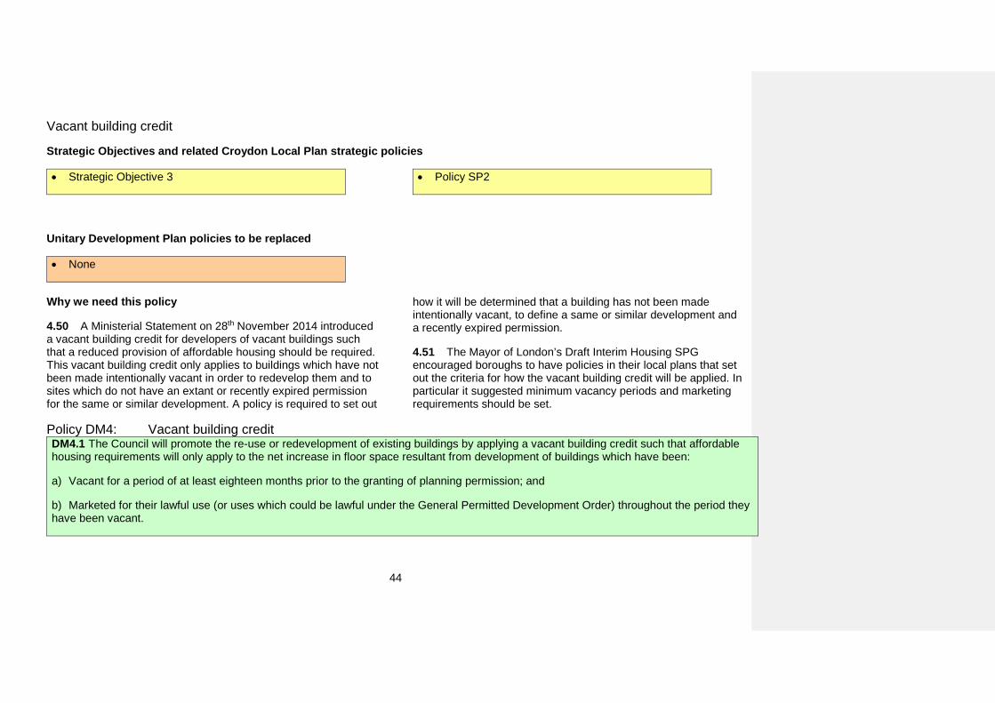
44
Vacant building credit
Strategic Objectives and related Croydon Local Plan strategic policies
• Strategic Objective 3 • Policy SP2
Unitary Development Plan policies to be replaced
• None
Why we need this policy
4.50 A Ministerial Statement on 28th November 2014 introduced a vacant building credit for developers of vacant buildings such that a reduced provision of affordable housing should be required. This vacant building credit only applies to buildings which have not been made intentionally vacant in order to redevelop them and to sites which do not have an extant or recently expired permission for the same or similar development. A policy is required to set out
how it will be determined that a building has not been made intentionally vacant, to define a same or similar development and a recently expired permission.
4.51 The Mayor of London’s Draft Interim Housing SPG encouraged boroughs to have policies in their local plans that set out the criteria for how the vacant building credit will be applied. In particular it suggested minimum vacancy periods and marketing requirements should be set.
Policy DM4: Vacant building credit DM4.1 The Council will promote the re-use or redevelopment of existing buildings by applying a vacant building credit such that affordable housing requirements will only apply to the net increase in floor space resultant from development of buildings which have been:
a) Vacant for a period of at least eighteen months prior to the granting of planning permission; and
b) Marketed for their lawful use (or uses which could be lawful under the General Permitted Development Order) throughout the period theyhave been vacant.
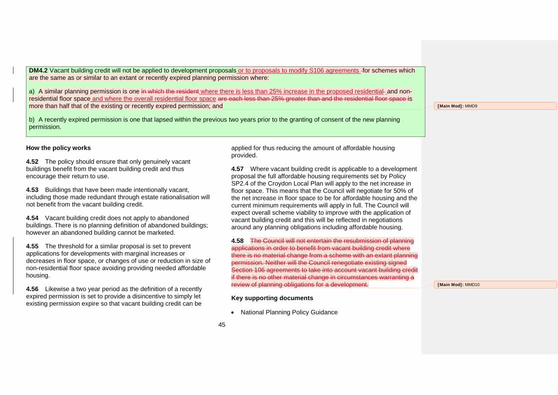
45
DM4.2 Vacant building credit will not be applied to development proposals or to proposals to modify S106 agreements for schemes which are the same as or similar to an extant or recently expired planning permission where:
a) A similar planning permission is one in which the resident where there is less than 25% increase in the proposed residential and non-residential floor space and where the overall residential floor space are each less than 25% greater than and the residential floor space is more than half that of the existing or recently expired permission; and
b) A recently expired permission is one that lapsed within the previous two years prior to the granting of consent of the new planningpermission.
How the policy works
4.52 The policy should ensure that only genuinely vacant buildings benefit from the vacant building credit and thus encourage their return to use.
4.53 Buildings that have been made intentionally vacant, including those made redundant through estate rationalisation will not benefit from the vacant building credit.
4.54 Vacant building credit does not apply to abandoned buildings. There is no planning definition of abandoned buildings; however an abandoned building cannot be marketed.
4.55 The threshold for a similar proposal is set to prevent applications for developments with marginal increases or decreases in floor space, or changes of use or reduction in size of non-residential floor space avoiding providing needed affordable housing.
4.56 Likewise a two year period as the definition of a recently expired permission is set to provide a disincentive to simply let existing permission expire so that vacant building credit can be
applied for thus reducing the amount of affordable housing provided.
4.57 Where vacant building credit is applicable to a development proposal the full affordable housing requirements set by Policy SP2.4 of the Croydon Local Plan will apply to the net increase in floor space. This means that the Council will negotiate for 50% of the net increase in floor space to be for affordable housing and the current minimum requirements will apply in full. The Council will expect overall scheme viability to improve with the application of vacant building credit and this will be reflected in negotiations around any planning obligations including affordable housing.
4.58 The Council will not entertain the resubmission of planning applications in order to benefit from vacant building credit where there is no material change from a scheme with an extant planning permission. Neither will the Council renegotiate existing signed Section 106 agreements to take into account vacant building credit if there is no other material change in circumstances warranting a review of planning obligations for a development.
Key supporting documents
• National Planning Policy Guidance
[Main Mod]: MMD9
[Main Mod]: MMD10
46
5. EmploymentDevelopment in Croydon Metropolitan Centre, District and Local Centres
Strategic Objectives and related Croydon Local Plan strategic policies
• Policy SP3.6
• Policy SP3.7
• Policy SP3.8
• Policy SP3.9
• Policy SP3.10
• Policy SP3.11
• Policy SP3.12
• Policy SP3.13
Unitary Development Plan policies to be replaced by this policy
• SH3 Control of Retail Units outside Primary ShoppingAreas
• SH4 Retail Vitality within Main Retail Frontages andShopping Area Frontages
• SH5 Retail Vitality within Secondary Retail Frontages
Why we need this policy
5.1 Retailing is at the heart of the borough’s town centres. However, they are also places where a wide range of other uses help to ensure vitality and viability is maintained. This policy sets out the approach to uses by location within a centre. For this purpose it sets the following designations:
Boundaries of the Croydon Metropolitan Centre, District and Local Centres (the borough’s town centres);
Primary Shopping Areas; Main Retail Frontages; and Secondary Retail Frontages.
5.2 These boundaries have been reviewed during the preparation of this Plan to ensure they meet the needs of the borough. The review has been supported by an Assessment of Boundaries and Designations for Croydon Metropolitan Centre, District and Local
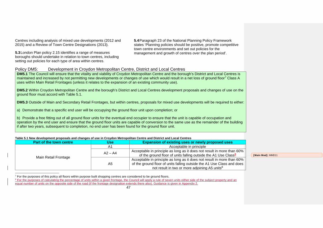
47
Centres including analysis of mixed use developments (2012 and 2015) and a Review of Town Centre Designations (2013).
5.3 London Plan policy 2.15 identifies a range of measures boroughs should undertake in relation to town centres, including setting out policies for each type of area within centres.
5.4 Paragraph 23 of the National Planning Policy Framework states ‘Planning policies should be positive, promote competitive town centre environments and set out policies for the management and growth of centres over the plan period’.
Policy DM5: Development in Croydon Metropolitan Centre, District and Local Centres DM5.1 The Council will ensure that the vitality and viability of Croydon Metropolitan Centre and the borough’s District and Local Centres is maintained and increased by not permitting new developments or changes of use which would result in a net loss of ground floor7 Class A uses within Main Retail Frontages (unless it relates to the expansion of an existing community use).
DM5.2 Within Croydon Metropolitan Centre and the borough’s District and Local Centres development proposals and changes of use on the ground floor must accord with Table 5.1.
DM5.3 Outside of Main and Secondary Retail Frontages, but within centres, proposals for mixed use developments will be required to either:
a) Demonstrate that a specific end user will be occupying the ground floor unit upon completion; or
b) Provide a free fitting out of all ground floor units for the eventual end occupier to ensure that the unit is capable of occupation andoperation by the end user and ensure that the ground floor units are capable of conversion to the same use as the remainder of the building if after two years, subsequent to completion, no end user has been found for the ground floor unit.
Table 5.1 New development proposals and changes of use in Croydon Metropolitan Centre and District and Local Centres Part of the town centre Use Expansion of existing uses or newly proposed uses
Main Retail Frontage
A1 Acceptable in principle
A2 – A4 Acceptable in principle as long as it does not result in more than 60% of the ground floor of units falling outside the A1 Use Class8
A5 Acceptable in principle as long as it does not result in more than 60% of the ground floor of units falling outside the A1 Use Class and does
not result in two or more adjoining A5 units8
7 For the purposes of this policy all floors within purpose built shopping centres are considered to be ground floors. 8 For the purposes of calculating the percentage of units within a given frontage, the Council will apply a rule of seven units either side of the subject property and an equal number of units on the opposite side of the road (if the frontage designation extends there also). Guidance is given in Appendix 2.
[Main Mod]: MMD11
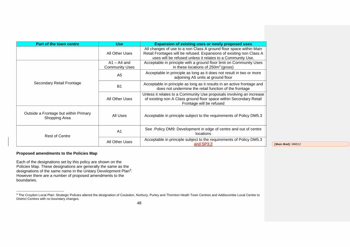
48
Part of the town centre Use Expansion of existing uses or newly proposed uses
All Other Uses All changes of use to a non Class A ground floor space within Main
Retail Frontages will be refused. Expansions of existing non Class A uses will be refused unless it relates to a Community Use.
Secondary Retail Frontage
A1 – A4 and Community Uses
Acceptable in principle with a ground floor limit on Community Uses in these locations of 250m2 (gross)
A5 Acceptable in principle as long as it does not result in two or more adjoining A5 units at ground floor
B1 Acceptable in principle as long as it results in an active frontage and does not undermine the retail function of the frontage
All Other Uses Unless it relates to a Community Use proposals involving an increase
of existing non A Class ground floor space within Secondary Retail Frontage will be refused
Outside a Frontage but within Primary Shopping Area All Uses Acceptable in principle subject to the requirements of Policy DM5.3
Rest of Centre A1 See .Policy DM9: Development in edge of centre and out of centre
locations
All Other Uses Acceptable in principle subject to the requirements of Policy DM5.3 and SP3.2
Proposed amendments to the Policies Map
Each of the designations set by this policy are shown on the Policies Map. These designations are generally the same as the designations of the same name in the Unitary Development Plan9. However there are a number of proposed amendments to the boundaries.
9 The Croydon Local Plan: Strategic Policies altered the designation of Coulsdon, Norbury, Purley and Thornton Heath Town Centres and Addiscombe Local Centre to District Centres with no boundary changes.
[Main Mod]: MMD12
49
Table 5.2 Amendments to designations (see The draft Policies Map for full details. Main Modifications to the Policies Map can be found at Appendix E)
Centre Boundary of Centre
Primary Shopping
Area
Main Retail
Frontage
Secondary Retail
Frontage Croydon
Metropolitan Centre
District Centres Addiscombe
Crystal Palace
(formerly Upper
Norwood)
Norbury
Purley Selsdon South
Norwood
Thornton Heath
Local Centres Beulah Road10
Brighton Road
(Sanderstead Road)
10 Beulah Road is proposed as a new Local Centre
Centre Boundary of Centre
Primary Shopping
Area
Main Retail
Frontage
Secondary Retail
Frontage Brighton
Road (Selsdon
Road)
Broad Green Pollards Hill
Shirley Thornton
Heath Pond
How the policy works
5.5 In part, this policy sets thresholds for uses within the Main and Secondary Retail Frontages. For the purposes of calculating the percentage of units within a given frontage, the Council will apply the rule of seven units either side of the subject property and an equal number of units on the opposite side of the road (if the frontage designation extends there also). Further guidance on this point is available in Appendix 2. This policy limits the saturation of A5 uses as the associated waste and delivery issues can cause harm to residential amenity. The clustering of hot-food takeaways can have an adverse impact on the vitality and viability of town centres, therefore limiting hot-food takeaways will help to ensure residents have a greater choice of retail services.
5.6 Studies have identified that one in three children is overweight or obese by the time they leave primary school and in 2014, an estimated 62% of the adult population were overweight or
[Main Mod]: MMD13
50
obese11.Croydon was selected as a pilot for the Mayor of London’s Food Flagship program and one of the aims of the program is to improve the quality of food available to schools and communities. Limiting the number of hot food takeaways in the borough’s town centres will support the public health agenda of tackling obesity and associated health problems and will promote access to healthier food options.
5.7 Proposals for B1 uses will be supported in Secondary Retail Frontages to create opportunities for office, research & redevelopment and light industrial workshops within town centres. However, these uses should not undermine the retail function of the frontages and will be only permitted if they provide an active frontage.
5.8 The reason why 250m2 is the threshold for community uses within Secondary Retail Frontages in Croydon Metropolitan Centre and District and Local Centres is that it would allow uses such as dentist surgeries and a High Street police office to operate but would deter larger scale activities from potentially undermining the A Use Class focus of these locations.
5.9 Across the borough there are many examples of mixed use developments in town centres but outside of Main and Secondary Retail Frontages where the ground floor units have been left as an empty shell. The costs of fitting out these units to a standard that allows them to be used for their intended purpose can be prohibitive and the resultant boarded up units harm the vitality of the centre. To avoid this all mixed use developments within a town centre but outside of a designated frontage will be required to have either an end user for the unit (evidenced by a pre-let agreement or by the applicant being the end user) at the time of
11 Building the foundations: Tackling obesity through planning and development (Town and Country Planning Association, March 2016)
granting permission or to provide a free fitting out of the unit for the first occupier.
5.10 All speculative schemes in town centres but outside of Main and Secondary Retail Frontages will also be required to be designed in a way that would allow conversion of the ground floor unit to residential or the same use as the remainder of the building if not residential. In some cases the Council may enter a legal agreement with the applicant to ensure that the ground floor unit is let and if not then converted to the same use as the remainder of the building.
5.11 For the purposes of Part 3 Class M of the General Permitted Development Order (2015), which sets out the circumstances where planning permission is not required for changes of use from retail to residential use, Main Retail Frontages and Secondary Retail Frontages are considered to be key shopping areas. In these locations any change of use from a retail use to residential will require an application to be made for planning permission which will be considered against the requirements of this policy.
Key supporting documents
• Croydon’s Monitoring Report (annual)• Borough Wide Retail Needs Study Update (2008)• Croydon Metropolitan Centre Retail Strategy (2009)• Office, Industrial & Warehousing Land/Premises MarketAssessment (2010) • Employment Land Review Update (2013)• Review of Town Centre Designations (2013)

51
• Assessment of boundaries and designations for CroydonMetropolitan Centre, District and Local Centres including analysis of mixed use developments (2012 and 2015) • Appendix 3 – Designated shopping frontages
52
Development in Neighbourhood Centres
Strategic Objectives and related Croydon Local Plan strategic policies
• Strategic Objective 5
• Strategic Objective 6
• Strategic Objective 7
• Policy SP4.9
• Policy SP5.3
• Policy SP5.4
• Policy SP5.5
• Policy SP5.6
• Policy SP5.7
Unitary Development Plan policies to be replaced
• None
Why we need this policy
5.12 The Council seeks to provide a range of services and community facilities to contribute to its aim of creating healthy and liveable neighbourhoods as set out in the Croydon Local Plan Strategic Policy SP5.3 and Strategic Objectives 5, 6 and 7. This will help in promoting healthy communities in line with paragraphs 69 and 70 of the National Planning Policy Framework.
5.13 In appropriate areas, the Council will seek to promote development of community facilities that will serve a neighbourhood demand for these uses.
5.14 Community facilities are defined in the Croydon Local Plan: Strategic Policies as facilities providing for the health and
wellbeing, social, educational, spiritual, recreational, leisure and cultural needs of the community.
5.15 Neighbourhood Centres are not intended to compete with designated District or Local Centres, and should serve a local need smaller in scale to that of a Local Centre. They should be able to meet the day-to-day needs of the local community and allow for modest growth in order to accommodate local needs.
5.16 Typically more limited in retail offer to Local or District Centres, Neighbourhood Centres may contain a place of worship, playground, school, public house, GP and pharmacy.
53
5.17 Neighbourhood Centres serve the whole community, but are particularly important to those who do not have access to a car, are unable to travel far or those with a disability.
5.18 The London Plan states that boroughs should identify and promote the complementary offers of the other smaller centres in the network including neighbourhood centres and local shopping parades. These play a key role in meeting ‘walk to’, everyday needs and are often the core of local ‘Lifetime’ neighbourhoods.
5.19 Neighbourhood Centres typically serve a localised catchment often most accessible by walking and cycling and include local parades and small clusters of shops, mostly for convenience goods and other services. They may include a small supermarket, sub-post office, pharmacy, launderette and other useful local services. They can play a key role in addressing areas deficient in local retail and other services.
5.20 The London Plan sets out its ambitions to plan for a range of social infrastructure required for London’s communities and neighbourhoods to support a high and improving quality of life. It supports a city of diverse, strong, secure and accessible neighbourhoods and seeks to ensure that neighbourhoods provide convenient access, especially by foot, to local goods and services needed on a day to day basis. . Local neighbourhoods should act as a focal point for local communities and enhance their overall attractiveness.
5.21 Surplus commercial capacity should be identified and brought forward to meet housing and local community needs, recognising that this process should contribute to strengthening the ‘offer’ of the Centre as a whole.
5.22 The London Plan advocates a light touch approach regarding neighbourhood centres in order to sustain and improve
their convenience offer while supporting redevelopment of surplus units for housing.
5.23 The Urban Design Compendium notes that ‘local facilities bring residents together, reinforce community and discourage car use’. Furthermore, it states that newsagents should be within a five minute walk, and local shops, health centres and other services which serve a local need, should be a ten minute walk. This approach is also considered appropriate in Shaping Neighbourhoods: A Guide for Health, Sustainability and Vitality.
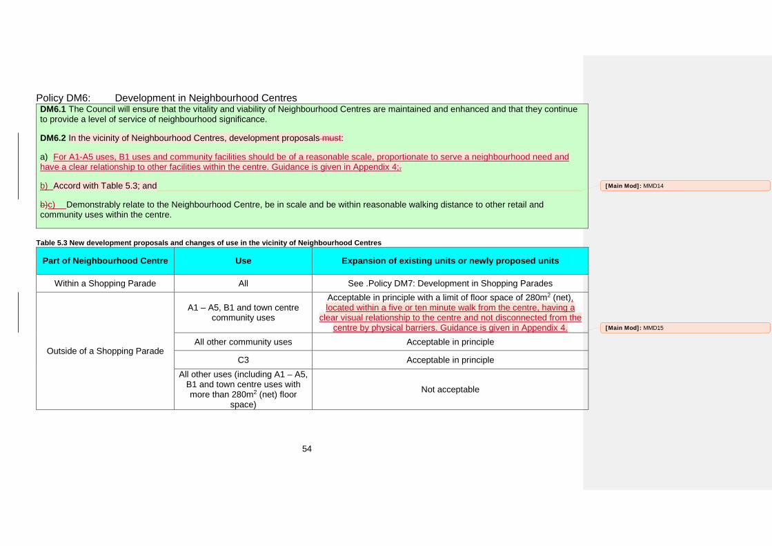
54
Policy DM6: Development in Neighbourhood Centres DM6.1 The Council will ensure that the vitality and viability of Neighbourhood Centres are maintained and enhanced and that they continue to provide a level of service of neighbourhood significance.
DM6.2 In the vicinity of Neighbourhood Centres, development proposals must:
a) For A1-A5 uses, B1 uses and community facilities should be of a reasonable scale, proportionate to serve a neighbourhood need andhave a clear relationship to other facilities within the centre. Guidance is given in Appendix 4;.
b) Accord with Table 5.3; and
b)c) Demonstrably relate to the Neighbourhood Centre, be in scale and be within reasonable walking distance to other retail and community uses within the centre.
Table 5.3 New development proposals and changes of use in the vicinity of Neighbourhood Centres
Part of Neighbourhood Centre Use Expansion of existing units or newly proposed units
Within a Shopping Parade All See .Policy DM7: Development in Shopping Parades
Outside of a Shopping Parade
A1 – A5, B1 and town centre community uses
Acceptable in principle with a limit of floor space of 280m2 (net), located within a five or ten minute walk from the centre, having a
clear visual relationship to the centre and not disconnected from the centre by physical barriers. Guidance is given in Appendix 4.
All other community uses Acceptable in principle
C3 Acceptable in principle All other uses (including A1 – A5,
B1 and town centre uses with more than 280m2 (net) floor
space)
Not acceptable
[Main Mod]: MMD14
[Main Mod]: MMD15
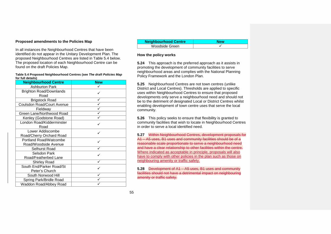
55
Proposed amendments to the Policies Map
In all instances the Neighbourhood Centres that have been identified do not appear in the Unitary Development Plan. The proposed Neighbourhood Centres are listed in Table 5.4 below. The proposed location of each Neighbourhood Centre can be found on the draft Policies Map.
Table 5.4 Proposed Neighbourhood Centres (see The draft Policies Map for full details)
Neighbourhood Centre New Ashburton Park
Brighton Road/Downlands Road
Brigstock Road Coulsdon Road/Court Avenue
Fieldway Green Lane/Northwood Road
Kenley (Godstone Road) London Road/Kidderminster
Road
Lower Addiscombe Road/Cherry Orchard Road
Portland Road/Watcombe Road/Woodside Avenue
Selhurst Road Selsdon Park
Road/Featherbed Lane
Shirley Road South End/Parker Road/St
Peter’s Church
South Norwood Hill Spring Park/Bridle Road
Waddon Road/Abbey Road
Neighbourhood Centre New Woodside Green
How the policy works
5.24 This approach is the preferred approach as it assists in promoting the development of community facilities to serve neighbourhood areas and complies with the National Planning Policy Framework and the London Plan.
5.25 Neighbourhood Centres are not town centres (unlike District and Local Centres). Thresholds are applied to specific uses within Neighbourhood Centres to ensure that proposed developments only serve a neighbourhood need and should not be to the detriment of designated Local or District Centres whilst enabling development of town centre uses that serve the local community.
5.26 This policy seeks to ensure that flexibility is granted to community facilities that wish to locate in Neighbourhood Centres in order to serve a local identified need.
5.27 Within Neighbourhood Centres, development proposals for A1 – A5 uses, B1 uses and community facilities should be of a reasonable scale proportionate to serve a neighbourhood need and have a clear relationship to other facilities within the centre. Where indicated as acceptable in principle, proposals will also have to comply with other policies in the plan such as those on neighbouring amenity or traffic safety.
5.28 Development of A1 – A5 uses, B1 uses and community facilities should not have a detrimental impact on neighbouring amenity or traffic safety.
56
5.29 Proposals for A1 – A5 uses, B1 uses and community facilities should be within a five or ten minute walk from the centre, have a clear visual relationship to the centre and should not be disconnected from the centre by physical barriers. Further guidance is available in Appendix 4.
5.30 Neighbourhood Centres typically serve their immediate residential properties, and as such a five to ten minute walk is considered an appropriate distance.
5.31 The Council will not permit the development or expansion of retail or commercial premises that would significantly increase the ‘offer’ of the Neighbourhood Centre to the detriment of a Local or District Centre. For this reason, development of retail and town centre community uses with a floor space above 280m2 will still be subject to a sequential test in accordance with Policy DM9: Development in edge of centre and out of centre locations.
5.32 For the purposes of Part 3 Class M of the General Permitted Development Order (2015), which sets out the circumstances where planning permission is not required for changes of use from retail to residential use, designated Shopping Parades within Neighbourhood Centres are considered to be key shopping areas. In these locations any change of use from a retail use to residential will require an application to be made for planning permission which will be considered against the requirements of this policy which would not allow for the conversion.
Key supporting documents
• Croydon’s Monitoring Report (annual)• Assessments of boundaries and designations for CroydonMetropolitan Centre, District and Local Centres (2012 and 2015) • Borough Wide Retail Needs Study Update (2008)
• The Urban Design Compendium (2000)• Barton, H., et al. (2003) Shaping Neighbourhoods: A Guide forHealth, Sustainability and Vitality
[Main Mod]: MMD16
57
Development in Shopping Parades
Strategic Objectives and related Croydon Local Plan strategic policies
• Policy SP3.6
• Policy SP3.7
• Policy SP3.8
• Policy SP3.9
• Policy SP3.10
• Policy SP3.11
• Policy SP3.12
• Policy SP3.13
Unitary Development Plan policies to be replaced by this policy
• SH6 Retail Vitality within Shopping Parades
Why we need this policy
5.33 The primary function of Shopping Parades is to provide local convenience shopping facilities. This policy sets out the policy approach to different uses within Shopping Parades and also designates each Shopping Parade in the borough.
5.34 In relation to drawing up Local Plans, paragraph 23 of the National Planning Policy Framework states that local planning authorities should ‘set policies for the consideration of proposals
for main town centre uses which cannot be accommodated in or adjacent to town centres’.
5.35 A review of all retail units outside any town centre or Shopping Parade based on the Croydon Monitoring Report 2014/15 has identified that there are a number of locations in the borough that could benefit from designation as a Shopping Parade.
58
Policy DM7: Development in Shopping Parades The Council will ensure that the vitality and viability of the borough’s Shopping Parades is maintained and increased and that they continue to serve local communities by ensuring new development proposals and changes of use on the ground floor are in accordance with Table 5.5.
Table 5.5 New development proposals and changes of use in Shopping Parades Use Expansion of existing uses or newly proposed uses A1 Changes of use or proposals which do not result in an increase in floor space of the overall Parade are
acceptable in principle. Other development will be subject to the provisions of Policy DM9: Development in edge of centre and out of centre locations.
A2 – A4 and Community Uses
Acceptable in principle as long as it does not result in more than 50% of the ground floor of units (within the entirety of the Parade) falling outside the A1 Use Class
A5 Not acceptable A5 and B1 (Change of use
only) Changes of use to hot food takeaway outlets, office, research & development and light industrial
workshops are acceptable in principle as long as it does not result in more than 50% of the ground floor of units (within the entirety of the Parade) falling outside the A1 Use Class, allows for a range of A2-A4 uses
as well as A5 and B1 and provides an active frontage. Class A5 uses must provide adequate arrangements for dealing with waste (including customers’ waste) and for any delivery service intended.
All Other Uses (including new development of B1)
Unless it relates to a Community Use or change of use to B1 use, proposals involving an increase of non Class A ground floor space within parades will be refused
Proposed amendments to the Policies Map
In most instances the proposed Shopping Parade is unchanged from that included within the current Unitary Development Plan. Those that have changed are detailed in Table 5.6 below.
[Main Mod]: MMD17
59
Table 5.6 Amendments to Shopping Parades designations (see The draft Policies Map for full details)
Shopping Parade New Amended
boundary De-
designated12 Beulah Road
Brighton Road/ Kingsdown
Avenue
Brighton Road/ Biddulph Road
Bywood Avenue
Grovelands Headley Drive
London Road/Mead
Place
London Road/Nova
Road
London Road/Fairholme
Road
Lower Addiscombe
Road/Davidson Road
Morland Road Northwood
Road
12 These Shopping Parades are designated as such in the current Unitary Development Plan but it is proposed that they are not designated in the Croydon Local Plan – Detailed Policies and Proposals.
Shopping Parade New Amended
boundary De-
designated12 Old Lodge
Lane
Portland Road/Sandown
Road
Royal Oak Shirley
Road/Bingham Road
Southbridge Road
The Parade, Coulsdon Road
Thornton Road Waddon Road
Whitehorse Lane
Whitehorse Road
How the policy works
5.36 This policy seeks to ensure that at least 50% of the units within the Shopping Parade are within Class A1 use. Under certain circumstances when one or more units within a Parade are much larger than the other units (for example, when there is an ‘anchor’ store) the 50% threshold may be applied to the gross floor space within the Parade rather than the number of units. Unless it relates to a community use, proposals involving the net
60
loss of ground floor A Class floor space within Shopping Parades will be refused. The Council's annual land use surveys suggest this threshold is generally effective in securing a predominance of A1 Class activity in Shopping Parades but does not render them prone to issues of long-term vacancy.
5.37 The policy limits the opening of new A5 units or changes of use to A5 in shopping parades. This will help to ensure residents have a greater choice of local retail services and will limit associated waste and delivery issues that can cause harm to residential amenity. Controls on the opening of new hot food takeaways support access to healthier food options outside town centres as shopping parades are often located in residential areas in close proximity to open spaces and schools.
5.38 Sui generis activities which serve the local area (such as a laundrette) and community facilities are also acceptable uses within Shopping Parades. Shopping Parades can also provide space for small start-up companies who need office or workshop space so changes of use to Class B1 uses are also acceptable to facilitate this. However all other uses (including sui generis which serve a wider catchment) are not acceptable uses. New development of Class B1 uses are also unacceptable as new development of this type could threaten the retail character of a Shopping Parade in a way that change of use would not.
5.39 For the purposes of Part 3 Class M of the General Permitted Development Order (2015), which sets out the circumstances where planning permission is not required for changes of use from retail to residential use, Shopping Parades are considered to be key shopping areas. In these locations any change of use from a retail use to residential will require an application to be made for planning permission which will be considered against the requirements of this policy.
Key supporting documents
• Croydon’s Monitoring Report (annual)• Assessments of boundaries and designations for ShoppingParades (2012 and 2015) • Appendix 3 – Designated shopping frontages
[Main Mod]: MMD18
61
Development in Restaurant Quarter Parades
Strategic Objectives and related Croydon Local Plan strategic policies
• Policy SP3.6
• Policy SP3.7
• Policy SP3.8
• Policy SP3.9
• Policy SP3.10
• Policy SP3.11
• Policy SP3.12
• Policy SP3.13
Unitary Development Plan policies to be replaced by this policy
• None
Why we need this policy
5.40 The Restaurant Quarter in South End has grown over many years into a popular collection of largely independent bars and restaurants. The area is also home to Scream Studios, a recording studio and live music venue, which, along with other complementary activities, helps to diversify the cultural/leisure offer.
5.41 This policy applies to the ground floor only and seeks to encourage more bar and restaurant activity. The policy differs from that which relates to Shopping Parades by not placing a limit on the number of A3 and A4 uses within the frontage. It creates a new designation, a Restaurant Quarter Parade, to be shown on the Policies Map.
5.42 In relation to drawing up Local Plans, paragraph 23 of the National Planning Policy Framework states that local planning authorities should ‘set policies for the consideration of proposals for main town centre uses which cannot be accommodated in or adjacent to town centres’.
5.43 A survey of South End indicated that the cluster of bars and restaurants is significant not only in terms of the cultural and leisure offer, but also as a generator of direct and indirect employment.
5.44 Policy 4.6c of the London Plan encourages the designation and development of cultural quarters.
62
Policy DM8: Development in Restaurant Quarter Parades The Council will designated Restaurant Quarter Parades and will ensure that their vitality and viability is maintained and increased and that they it continues to serve local communities by ensuring new development proposals and changes of use are in accordance with Table 5.7.
Table 5.7 New development proposals and changes of use in Restaurant Quarter Parades Use Expansion of existing uses or newly proposed uses
A3 - A4 Acceptable in principle A5 Proposals for new A5 uses or extensions to existing A5 uses will be refused
All Other Uses Unless it relates to a Community Use (up to 250m2 gross) proposals involving an increase of non A3 - A4 Class ground floor space within Restaurant Quarter Parades will be refused
Proposed amendments to the Policies Map
Restaurant Quarter Parades are a new designation that will be on the Policies Map. A list of proposed Restaurant Quarter Parades can be found in Table 11.8 below.
Table 5.8 Proposed Restaurant Quarter Parade designations (see The draft Policies Map for full details)
Restaurant Quarter Parade New South End
How the policy works
5.45 This policy seeks to promote bar and restaurant activity by limiting the amount of other uses that can occupy (or extend) the ground floor of premises. A new Restaurant Quarter Parade has, therefore, been designated at 6 - 78 (even) and 1 - 77 (odd).
5.46 The policy limits Class A5 activity (which could undermine the area’s function if restaurants and bars are replaced with hot-food takeaways). This will help to safeguard and promote the Restaurant Quarter.
5.47 Allowing community uses to locate here but limiting their size will enable complementary activities to move into the area but not dominate it.
Key supporting documents
• Appendix 3 – Designated shopping frontages
[Main Mod]: MMD19
63
Development in edge of centre and out of centre locations
Strategic Objectives and related Croydon Local Plan strategic policies
• Policy SP3.6
• Policy SP3.7
• Policy SP3.8
• Policy SP3.9
• Policy SP3.10
• Policy SP3.11
• Policy SP3.12
• Policy SP3.13
Unitary Development Plan policies to be replaced by this policy
• SH3 Locations for Shopping Development
• EM4 Offices outside Croydon Metropolitan Centre andtown centres
• EM7 Redevelopment or Extension for Offices outsideCroydon Metropolitan Centre and the Town, District and Local Centres
• HT1 Visitor Accommodation
• LR2 Development of Leisure and Indoor Sports, Arts,Culture and Entertainment Facilities outside of Croydon Metropolitan Centre and Town and District Centres
Why we need this policy
5.48 In line with the ‘Town Centres First’ principle, commercial activity should be directed to town centres to take advantage of their better transport functions and so as not to undermine the established centres. However, there are circumstances when proposals for town centre uses in edge of centre and out of centre locations may be acceptable.
5.49 In relation to drawing up Local Plans, paragraph 23 of the National Planning Policy Framework states that local planning authorities should ‘set policies for the consideration of proposals for main town centre uses which cannot be accommodated in or adjacent to town centres’.
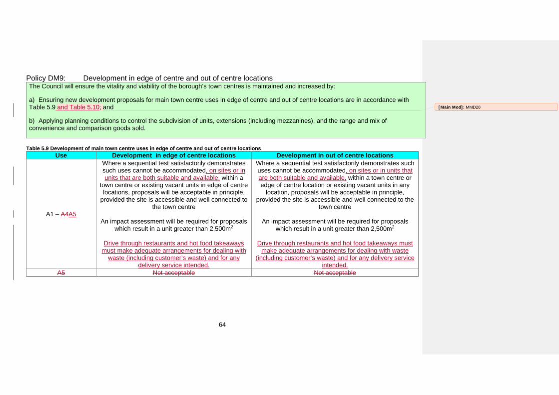
64
Policy DM9: Development in edge of centre and out of centre locations The Council will ensure the vitality and viability of the borough’s town centres is maintained and increased by:
a) Ensuring new development proposals for main town centre uses in edge of centre and out of centre locations are in accordance withTable 5.9 and Table 5.10; and
b) Applying planning conditions to control the subdivision of units, extensions (including mezzanines), and the range and mix ofconvenience and comparison goods sold.
Table 5.9 Development of main town centre uses in edge of centre and out of centre locations Use Development in edge of centre locations Development in out of centre locations
A1 – A4A5
Where a sequential test satisfactorily demonstrates such uses cannot be accommodated, on sites or in units that are both suitable and available, within a
town centre or existing vacant units in edge of centre locations, proposals will be acceptable in principle,
provided the site is accessible and well connected to the town centre
An impact assessment will be required for proposals which result in a unit greater than 2,500m2
Drive through restaurants and hot food takeaways must make adequate arrangements for dealing with
waste (including customer’s waste) and for any delivery service intended.
Where a sequential test satisfactorily demonstrates such uses cannot be accommodated, on sites or in units that are both suitable and available, within a town centre or edge of centre location or existing vacant units in any
location, proposals will be acceptable in principle, provided the site is accessible and well connected to the
town centre
An impact assessment will be required for proposals which result in a unit greater than 2,500m2
Drive through restaurants and hot food takeaways must make adequate arrangements for dealing with waste
(including customer’s waste) and for any delivery service intended.
A5 Not acceptable Not acceptable
[Main Mod]: MMD20

65
Use Development in edge of centre locations Development in out of centre locations
Offices and other main town centre uses
Leisure
Where a sequential test satisfactorily demonstrates such uses cannot be accommodated, on sites or in units that are both suitable and available, within a
town centre or existing vacant units in edge of centre locations, proposals will be acceptable in principle,
provided the site is accessible and well connected to the town centre
An impact assessment will be required for proposals which result in a unit greater than 2,500m2
Where a sequential test satisfactorily demonstrates such uses cannot be accommodated, on sites or in units that are both suitable and available, within a town centre or edge of centre location or existing vacant units in any
location, proposals will be acceptable in principle, provided the site is accessible and well connected to the
town centre
An impact assessment will be required for proposals which result in a unit greater than 2,500m2
Arts, culture and tourism
Where a sequential test satisfactorily demonstrates such uses cannot be accommodated, on sites or in units that are both suitable and available, within a
town centre or existing vacant units in edge of centre locations, proposals will be acceptable in principle,
provided the site is accessible and well connected to the town centre
Where a sequential test satisfactorily demonstrates such uses cannot be accommodated, on sites or in units that are both suitable and available, within a town centre or edge of centre location or existing vacant units in any
location, proposals will be acceptable in principle, provided the site is accessible and well connected to the
town centre Non town centre community uses Acceptable in principle Acceptable in principle
How the policy works
5.50 This policy applies to all commercial uses equating to the National Planning Policy Framework’s main town centre uses. Together these are defined as the following:
Retail development (including warehouse clubs and factory outlet centres);
Leisure, entertainment facilities and the more intensive sport and recreation uses (including cinemas, restaurants, drive-through restaurants, bars and pubs, night-clubs, casinos, health and fitness centres, indoor bowling centres, and bingo halls);
Offices; and Arts, culture and tourism development (including theatres,
museums, galleries and concert halls, hotels and conference facilities).
5.51 For the purposes of this policy edge of centre and out of centre locations are defined as shown in Table 5.10. ‘Well connected’ is defined as a location benefiting from a Public Transport Accessibility Level of 4 and above.
[Main Mod]: MMD21
[Main Mod]: MMD22
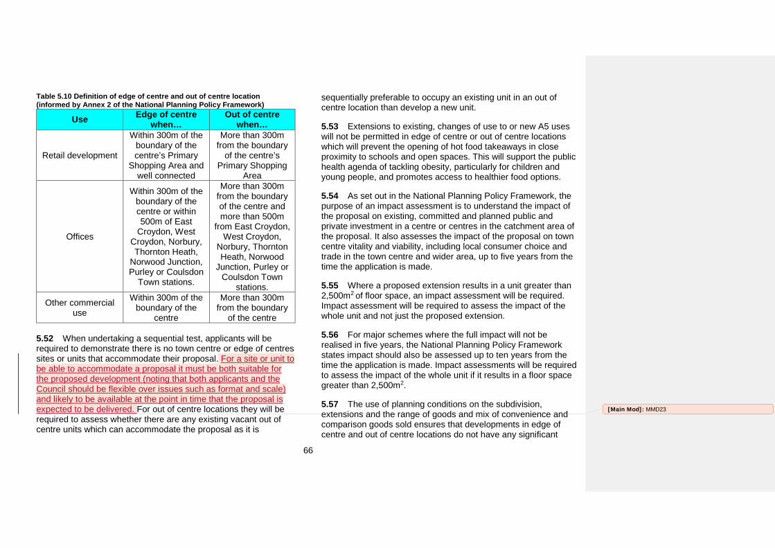
66
Table 5.10 Definition of edge of centre and out of centre location (informed by Annex 2 of the National Planning Policy Framework)
Use Edge of centre when…
Out of centre when…
Retail development
Within 300m of the boundary of the centre’s Primary
Shopping Area and well connected
More than 300m from the boundary
of the centre’s Primary Shopping
Area
Offices
Within 300m of the boundary of the centre or within 500m of East
Croydon, West Croydon, Norbury, Thornton Heath,
Norwood Junction, Purley or Coulsdon
Town stations.
More than 300m from the boundary of the centre and more than 500m
from East Croydon, West Croydon,
Norbury, Thornton Heath, Norwood
Junction, Purley or Coulsdon Town
stations.
Other commercial use
Within 300m of the boundary of the
centre
More than 300m from the boundary
of the centre
5.52 When undertaking a sequential test, applicants will be required to demonstrate there is no town centre or edge of centres sites or units that accommodate their proposal. For a site or unit to be able to accommodate a proposal it must be both suitable for the proposed development (noting that both applicants and the Council should be flexible over issues such as format and scale) and likely to be available at the point in time that the proposal is expected to be delivered. For out of centre locations they will be required to assess whether there are any existing vacant out of centre units which can accommodate the proposal as it is
sequentially preferable to occupy an existing unit in an out of centre location than develop a new unit.
5.53 Extensions to existing, changes of use to or new A5 uses will not be permitted in edge of centre or out of centre locations which will prevent the opening of hot food takeaways in close proximity to schools and open spaces. This will support the public health agenda of tackling obesity, particularly for children and young people, and promotes access to healthier food options.
5.54 As set out in the National Planning Policy Framework, the purpose of an impact assessment is to understand the impact of the proposal on existing, committed and planned public and private investment in a centre or centres in the catchment area of the proposal. It also assesses the impact of the proposal on town centre vitality and viability, including local consumer choice and trade in the town centre and wider area, up to five years from the time the application is made.
5.55 Where a proposed extension results in a unit greater than 2,500m2 of floor space, an impact assessment will be required. Impact assessment will be required to assess the impact of the whole unit and not just the proposed extension.
5.56 For major schemes where the full impact will not be realised in five years, the National Planning Policy Framework states impact should also be assessed up to ten years from the time the application is made. Impact assessments will be required to assess the impact of the whole unit if it results in a floor space greater than 2,500m2.
5.57 The use of planning conditions on the subdivision, extensions and the range of goods and mix of convenience and comparison goods sold ensures that developments in edge of centre and out of centre locations do not have any significant
[Main Mod]: MMD23
67
adverse impact of the vitality and viability of the Metropolitan, District and Local Centres.
5.58 New community facilities in edge of centre or out of centre locations are acceptable in principle. This does not apply to facilities considered to be a D2 use. These main town centre uses will require a sequential test and an impact assessment.
Key supporting documents
• Croydon’s Monitoring Report (annual)• Borough Wide Retail Needs Study Update (2008)• Croydon Metropolitan Centre Retail Strategy (2009)
68
Expansion of industrial and warehousing premises in Strategic, Separated and Integrated Industrial Locations
Strategic Objectives and related Croydon Local Plan strategic policies
• Strategic Objective 1
• Policy SP3.1
• Policy SP3.2
Unitary Development Plan policies to be replaced by this policy
• EM2 Industry and Warehousing in Employment Areas
Why we need this policy
5.59 Croydon continues to lose industrial/warehouse capacity at a rate which exceeds the forecast decline in demand. A natural response to this situation could be to adopt a more restrictive approach to the loss of such premises than was previously the case. However, such an approach would not be consistent with the London Plan or the National Planning Policy Framework.
5.60 Alternatively, the Council could seek to allocate more land for industrial/warehouse activities by extending one or more of the existing Strategic, Separated or Integrated Industrial Locations. However, the physical constraints associated with the Locations (railway lines, quarry walls, Metropolitan Open Land and neighbouring residential uses) means this is not practical.
5.61 The Office, Industrial & Warehousing Land/Premises Market Assessment recommends that the Council promote improved estate management at Purley Way North (Mill Lane area), Selsdon Road (north and central parts of estate) and
Vulcan Way with the intention of encouraging redevelopment and intensification of land use, and improving environmental quality.
5.62 The Employment Land Review Update (2013) found that forecasts for demand and supply of industrial/warehousing land in Croydon was broadly consistent with the Office, Industrial & Warehousing Land/Premises (2010) and the Land for Industry and Transport Supplementary Planning Guidance (2012).
5.63 The Mayor of London’s Supplementary Planning Guidance on Land for Industry and Transport sets out an annual indicative industrial land release benchmark for Croydon of 0.5 hectare with a total release benchmark for 2011 – 2031 of 9 hectares. However, as Croydon lost 9 hectares of industrial land in a single five year period between 2006 and 2010, it is likely that expansion in Strategic and Separated Industrial Locations will be required to compensate for losses to the industrial stock elsewhere.
69
Policy DM10: Expansion of industrial and warehousing premises in Strategic, Separated and Integrated Industrial Locations Within the Strategic, Separated and Integrated Industrial Locations identified in Table 4.3 of the Croydon Local Plan: Strategic Policies, the Council will encourage the redevelopment of low density industrial and warehousing premises with higher density industrial and warehousing premises.
How the policy works
5.64 The approach promoted by this policy is to encourage greater density of occupation within the current boundaries of the Strategic, Separated and Integrated Industrial Locations. There are isolated examples where higher densities have been achieved without compromising the operational ability of the premises and the Council is keen to see more of this type of development.
Key supporting documents
• Office, Industrial & Warehousing Land/Premises MarketAssessment (2010) • Employment Land Review Update (2013)• Land for Industry and Transport Supplementary PlanningGuidance (2012)
70
A Place to Belong The content of this section is related to the vision theme of Croydon as ‘A Place to Belong’. It adds further detail to the Croydon Local Plan: Strategic Policies on local character and community facilities and considers how the borough can become a place noted for its openness, safety and community spirit where all are welcome to live and work, in an attractive environment, where the past is valued and where the community is supported.
.
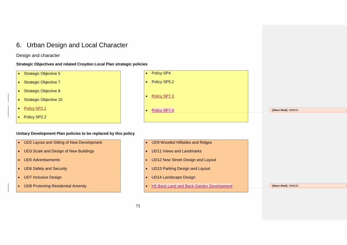
71
6. Urban Design and Local CharacterDesign and character
Strategic Objectives and related Croydon Local Plan strategic policies
• Strategic Objective 5
• Strategic Objective 7
• Strategic Objective 8
• Strategic Objective 10
• Policy SP2.1
• Policy SP2.2
• Policy SP4
• Policy SP5.2
• Policy SP7.3
• Policy SP7.4
Unitary Development Plan policies to be replaced by this policy
• UD2 Layout and Sitting of New Development
• UD3 Scale and Design of New Buildings
• UD5 Advertisements
• UD6 Safety and Security
• UD7 Inclusive Design
• UD8 Protecting Residential Amenity
• UD9 Wooded Hillsides and Ridges
• UD11 Views and Landmarks
• UD12 New Street Design and Layout
• UD13 Parking Design and Layout
• UD14 Landscape Design
• H5 Back Land and Back Garden Development
[Main Mod]: MMD24
[Main Mod]: MMD25
72
Why we need this policy
6.1 The Council recognises that the built environment and landscape play a vital role in creating and reinforcing positive perceptions, and engendering a sense of place. Croydon Local Plan Strategic Policy SP4, ‘Urban Design and Local Character’ supports the creation of places that are well designed, safe, accessible, inclusive and enrich the quality of life for all those who live in, work in and visit the borough. To achieve this, the Council will encourage and continue to work with developers to ensure that all developments are of high quality. Croydon has strategic objectives to ensure that high quality new development both integrates respects and enhances the borough’s natural environment and historic environment, to create spaces and buildings that foster safe, healthy communities. The borough has the largest population of any London borough. Provision of outdoor amenity space is important for health and wellbeing, particularly as the north of the borough is urban in character and has less open space compared to south, where most of the borough’s Metropolitan Green Belt can be found. Private and communal outdoor amenity space can assist in mitigation of climate change with vegetation that contributes to biodiversity and space that is multi-functional; for socialising, play, and sport, food growing and gardening. The provision of space that is easily accessible and designed in the context of local character will assist in providing a sense of ownership to the local community and will contribute to the health, well-being and perception of the security of Croydon’s community.
6.2 A fundamental part of achieving high quality built environments is through understanding the local character and the qualities which contribute to local distinctiveness.
6.2A In specific areas where it is unclear which predominant character should be referenced, additional place specific development management policies have been included
6.2B In other areas where no Place-specific development management policy applies the character can be managed through other policies within this Plan along with the masterplans, Conservation Area Appraisal and Management Plans, Local Heritage Areas and the Croydon Opportunity Area Planning Framework.
6.2C The Place-specific policies also include all the Detailed Proposal sites in each Place. Full details of each Detailed Proposal including the reasons why particular uses are proposed can be found in Appendix 5.
6.3 The National Planning Policy Framework paragraph 58 directs local authorities to develop a set of robust and comprehensive policies which are based upon objectives for the future of the area and an understanding and evaluation of its defining characteristics.
6.4 Paragraph 56 of the National Planning Policy Framework states that ‘Good design is indivisible from good planning’. It advocates good design to ensure attractive, usable, durable, adaptable and sustainable development.
6.5 The Croydon Local Plan Strategic Policy SP4.1 and London Plan Policy 7.6 set out the need to ensure that developments are of a high quality.
6.6 The Croydon Local Plan: Strategic Policies provides policy on urban design, local character and public realm. However, in line with the National Planning Policy Framework, there is a need to provide detailed guidance on scale, density massing, height, landscape, layout, materials and access. This will provide greater clarity for applicants.
[Main Mod]: MMD26
73
6.7 Paragraph 57 of the National Planning Policy Framework advises planning authorities to ‘plan positively for the achievement of high quality and inclusive design for all developments, including individual buildings, public and private spaces and wider area development schemes. Good design should contribute positively to making places better for people. Design which is inappropriate in its context, or which fails to take the opportunities available for improving the character and quality of an area and the way it functions, should not be accepted.’
6.8 Additionally a review of the borough’s existing Unitary Development Plan, carried out by the Council’s Development Management and Spatial Planning services, identified a need for policies relating to layout, form and design
6.9 The existing policy review identified a need for a roofscape policy that acknowledges the visual contribution roof-forms make and the need to provide guidance on the way in which the transition between new and old developments are addressed. Guidance for roof-form (roofscape) has not been included within the National Planning Policy Framework or the Croydon Local Plan: Strategic Policies.
6.10 The National Planning Policy Framework in paragraph 50 encourages location authorities to plan for the delivery for a wide choice of high quality homes and sustainable communities. It advises that in doing so, development plans should be based on evidence of local needs and demands. The notions of balance and risk are also recognise in the National Planning Policy Framework, which states that the cumulative impact of standards and polices should not put the implementation of the plan at serious risk (paragraph 174).
6.10A The need to deliver 32,880 homes does not outweigh the need to respect the local character, and amenity and to protect biodiversity.
6.10B The Mayor of London’s Housing Supplementary Planning Guidance (2016) states that, alongside new build provision and turnover within the existing housing stock, extensions to existing homes and sensitive renewal and intensification of existing residential areas is likely to play an important role in meeting demand for larger properties in the capital, helping to address overcrowding and affordability issues.
6.10C The Mayor of London’s Housing Supplementary Planning Guidance March 2016 provides guidance on private garden land development (paragraph 1.2.44) and the implementation of London Plan Policy 3.5 Quality and Design of Housing Developments. It advise Borough’s and developers of the strategic and local aspects and objectives when considering development of gardens and to strike a balance between these and other objectives when seeking to optimise housing provision on a particular site.
6.10D This policy seeks to resist inappropriate development in residential gardens where it would cause harm to the local area in accordance with paragraph 53 of the Framework. The policy aligns with the Local Plan’s Strategic Objective 5 ensuring new development integrates, respects and enhances the borough’s natural environment and built heritage.
6.10E The London Plan, Policy 3.5, states that borough’s may introduce a presumption against development on back gardens or other private residential gardens where this can be locally justified. In addition to this, the London Plan also states that new development, including that on garden land should avoid having an adverse impact on sites of European importance for nature conservation.
6.10F Poorly planned piecemeal development of garden land can have significant negative impacts on local biodiversity, amenity, and character. It can also result in noise and visual intrusion into
74
neighbouring property, interrupt predominant building lines along streets and weaken the predominant built form and architecture. In landscape terms it can also result in weakened landscape character with loss of trees, including street trees, to make way for new access roads.
6.10G The Borough Character Appraisal and the Character Typology identify the predominant type of building form and range of plot sizes for different residential forms. The Typology shows that nine per cent of the borough area is made up of buildings and thirty five percent occupied by residential garden space. Overall, sixty percent of the borough is made up of residential garden space, recreational space and woodland.
6.11 The London Plan’s Policy 3.2D introduces an additional requirement for new development to be mindful of health issues. New development should be designed, contracted and managed in ways that improve health and heathy lifestyles to help to reduce health inequalities. The provision of communal outdoor amenity will provide opportunities for outdoor activities and social interaction.
6.12 The London Plan (in Policy 3.5B) also requires that ‘all new housing developments should enhance the quality of local places, taking into account physical context, local character, density; tenure and land use mix; and relationships with, and provision of public, communal and open spaces, taking account of the needs of children and old people’. This supports the need to increase the communal amenity space standards from those identified in the Mayor of London's Housing Supplementary Planning Guidance for sites in the borough to reflect local character or where there is a deficiency in open space.
6.13 The Mayor of London's Housing Supplementary Planning Guidance expands on the London Plan’s Policy 3.5 and Chapter 7 policies on design and acknowledges the need for site layout and
design to consider the provision of useable amenity space alongside the siting of the building. This is incorporated in the preferred option.
6.14 The Mayor of London's Housing Supplementary Planning Guidance in Annex 1 ‘Summary of the Quality and Design Standards for private outdoor space’ has a minimum standard of 5m2 of private outdoor space for 1-2 person dwellings and an extra 1m2 to be provided for each additional occupant.
6.15 Paragraph 4.10.2 of Annex 1 of the Mayor of London's Housing Supplementary Planning Guidance applies to all the borough and states that private outdoor spaces should have level access, and in 4.10.3 that the minimum depth and width of all balconies and other private external spaces is 1.5m.
6.16 The minimum standard of 10m2 per child of children's play space, where there are 10 or more children living in the development is from the Mayor's Housing Supplementary Planning Guidance (2.16) and, although it applies to publicly funded housing development and that on GLA land, it is considered best practice. The Mayor's Supplementary Planning Guidance Providing for Children and Young People's Play and Informal Recreation also recommends a minimum benchmark of 10m2 of dedicated play space per child.
6.17 The Mayor's Housing Supplementary Planning Guidance refers to the Baseline Standard 1.2.3 for communal open space which states that development proposals should demonstrate that the communal open space is overlooked by surrounding development, is accessible to wheelchair users and other disabled people, is designed to take advantage of direct sunlight, and has suitable management arrangements in place. It also refers to the Baseline Standard 2.2.8 which explains that this will ensure the outdoor space remains useful and welcoming to all its intended users. With the exception of management arrangements which
[Main Mod]: MMD27
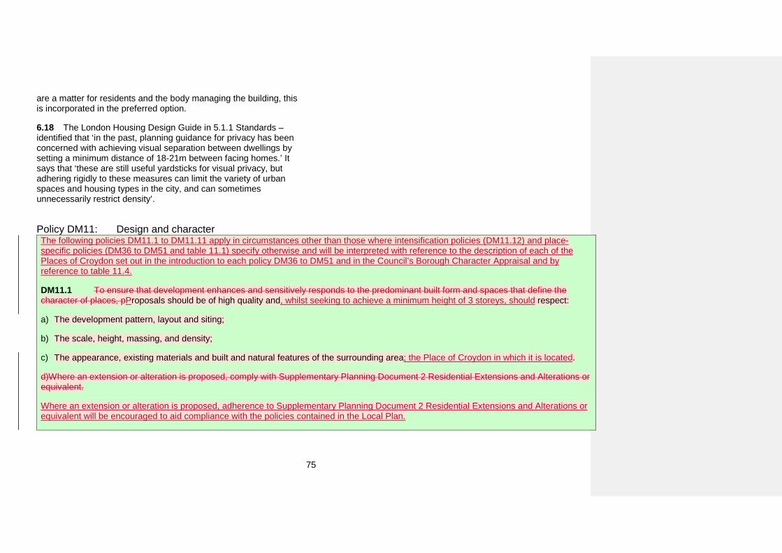
75
are a matter for residents and the body managing the building, this is incorporated in the preferred option.
6.18 The London Housing Design Guide in 5.1.1 Standards – identified that ‘in the past, planning guidance for privacy has been concerned with achieving visual separation between dwellings by setting a minimum distance of 18-21m between facing homes.’ It says that ‘these are still useful yardsticks for visual privacy, but adhering rigidly to these measures can limit the variety of urban spaces and housing types in the city, and can sometimes unnecessarily restrict density’.
Policy DM11: Design and character The following policies DM11.1 to DM11.11 apply in circumstances other than those where intensification policies (DM11.12) and place-specific policies (DM36 to DM51 and table 11.1) specify otherwise and will be interpreted with reference to the description of each of the Places of Croydon set out in the introduction to each policy DM36 to DM51 and in the Council’s Borough Character Appraisal and by reference to table 11.4.
DM11.1 To ensure that development enhances and sensitively responds to the predominant built form and spaces that define the character of places, pProposals should be of high quality and, whilst seeking to achieve a minimum height of 3 storeys, should respect:
a) The development pattern, layout and siting;
b) The scale, height, massing, and density;
c) The appearance, existing materials and built and natural features of the surrounding area; the Place of Croydon in which it is located.
d)Where an extension or alteration is proposed, comply with Supplementary Planning Document 2 Residential Extensions and Alterations or equivalent.
Where an extension or alteration is proposed, adherence to Supplementary Planning Document 2 Residential Extensions and Alterations or equivalent will be encouraged to aid compliance with the policies contained in the Local Plan.
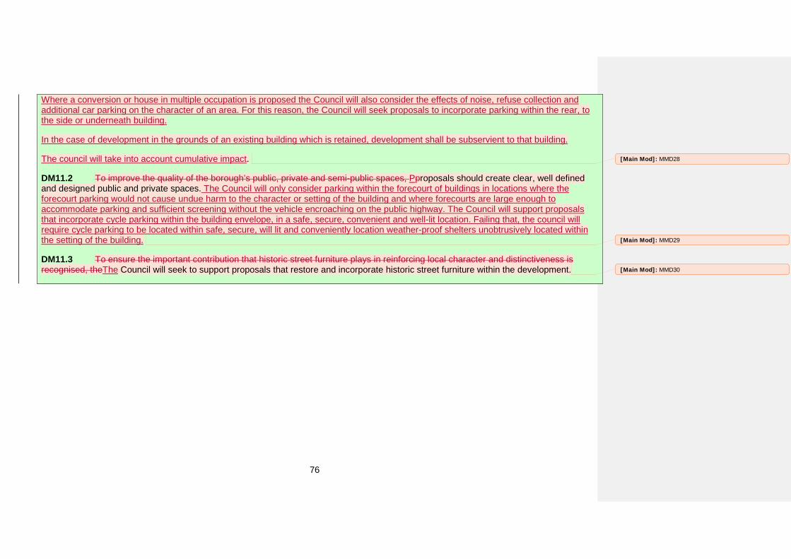
76
Where a conversion or house in multiple occupation is proposed the Council will also consider the effects of noise, refuse collection and additional car parking on the character of an area. For this reason, the Council will seek proposals to incorporate parking within the rear, to the side or underneath building.
In the case of development in the grounds of an existing building which is retained, development shall be subservient to that building.
The council will take into account cumulative impact.
DM11.2 To improve the quality of the borough’s public, private and semi-public spaces, Pproposals should create clear, well defined and designed public and private spaces. The Council will only consider parking within the forecourt of buildings in locations where the forecourt parking would not cause undue harm to the character or setting of the building and where forecourts are large enough to accommodate parking and sufficient screening without the vehicle encroaching on the public highway. The Council will support proposals that incorporate cycle parking within the building envelope, in a safe, secure, convenient and well-lit location. Failing that, the council will require cycle parking to be located within safe, secure, will lit and conveniently location weather-proof shelters unobtrusively located within the setting of the building.
DM11.3 To ensure the important contribution that historic street furniture plays in reinforcing local character and distinctiveness is recognised, theThe Council will seek to support proposals that restore and incorporate historic street furniture within the development.
[Main Mod]: MMD28
[Main Mod]: MMD29
[Main Mod]: MMD30
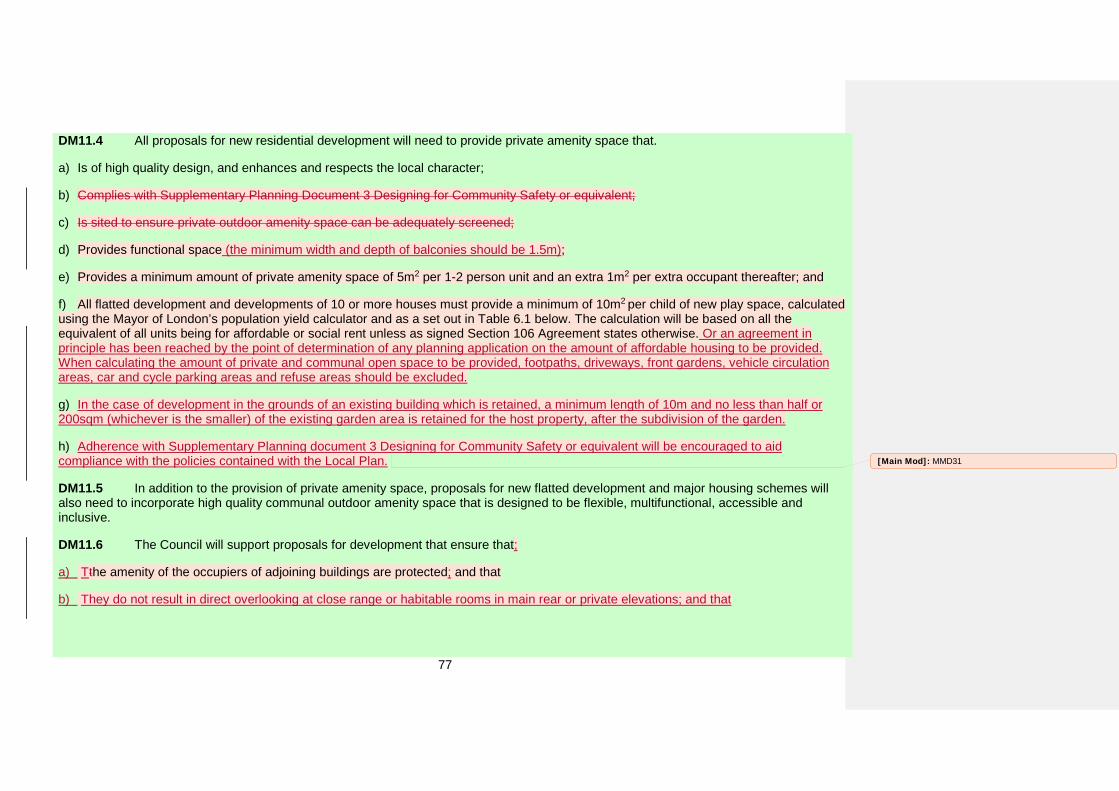
77
DM11.4 All proposals for new residential development will need to provide private amenity space that.
a) Is of high quality design, and enhances and respects the local character;
b) Complies with Supplementary Planning Document 3 Designing for Community Safety or equivalent;
c) Is sited to ensure private outdoor amenity space can be adequately screened;
d) Provides functional space (the minimum width and depth of balconies should be 1.5m);
e) Provides a minimum amount of private amenity space of 5m2 per 1-2 person unit and an extra 1m2 per extra occupant thereafter; and
f) All flatted development and developments of 10 or more houses must provide a minimum of 10m2 per child of new play space, calculatedusing the Mayor of London’s population yield calculator and as a set out in Table 6.1 below. The calculation will be based on all the equivalent of all units being for affordable or social rent unless as signed Section 106 Agreement states otherwise. Or an agreement in principle has been reached by the point of determination of any planning application on the amount of affordable housing to be provided. When calculating the amount of private and communal open space to be provided, footpaths, driveways, front gardens, vehicle circulation areas, car and cycle parking areas and refuse areas should be excluded.
g) In the case of development in the grounds of an existing building which is retained, a minimum length of 10m and no less than half or200sqm (whichever is the smaller) of the existing garden area is retained for the host property, after the subdivision of the garden.
h) Adherence with Supplementary Planning document 3 Designing for Community Safety or equivalent will be encouraged to aidcompliance with the policies contained with the Local Plan.
DM11.5 In addition to the provision of private amenity space, proposals for new flatted development and major housing schemes will also need to incorporate high quality communal outdoor amenity space that is designed to be flexible, multifunctional, accessible and inclusive.
DM11.6 The Council will support proposals for development that ensure that;
a) Tthe amenity of the occupiers of adjoining buildings are protected; and that
b) They do not result in direct overlooking at close range or habitable rooms in main rear or private elevations; and that
[Main Mod]: MMD31

78
c) They do not result in direct overlooking of private outdoor space (with the exception of communal open space) or within 10mperpendicular to the rear elevation of a dwelling; and that
d) Provide adequate sunlight and daylight to potential future occupants; and that
e) They do not result in significant loss of existing sunlight or daylight levels of adjoining occupiers.
DM11.7 To create a high quality built environment, proposals should demonstrate that:
a) The architectural detailing will result in a high quality building and when working with existing buildings, original architectural featuressuch as mouldings, architraves, chimneys or porches that contribute to the architectural character of a building should, where possible, be retained;
b) High quality, durable and sustainable materials that respond to the local character in terms of quality, durability, attractiveness,sustainability, texture and colour are incorporated; and
c) Services, utilities and rainwater goods will be discreetly incorporated within the building envelope13; and.
d) To ensure the design of roof-form positively contributes to the character of the local and wider area; proposals should ensure the designis sympathetic with its local context.
[Main Mod]: MMD32
[Main Mod]: MMD33
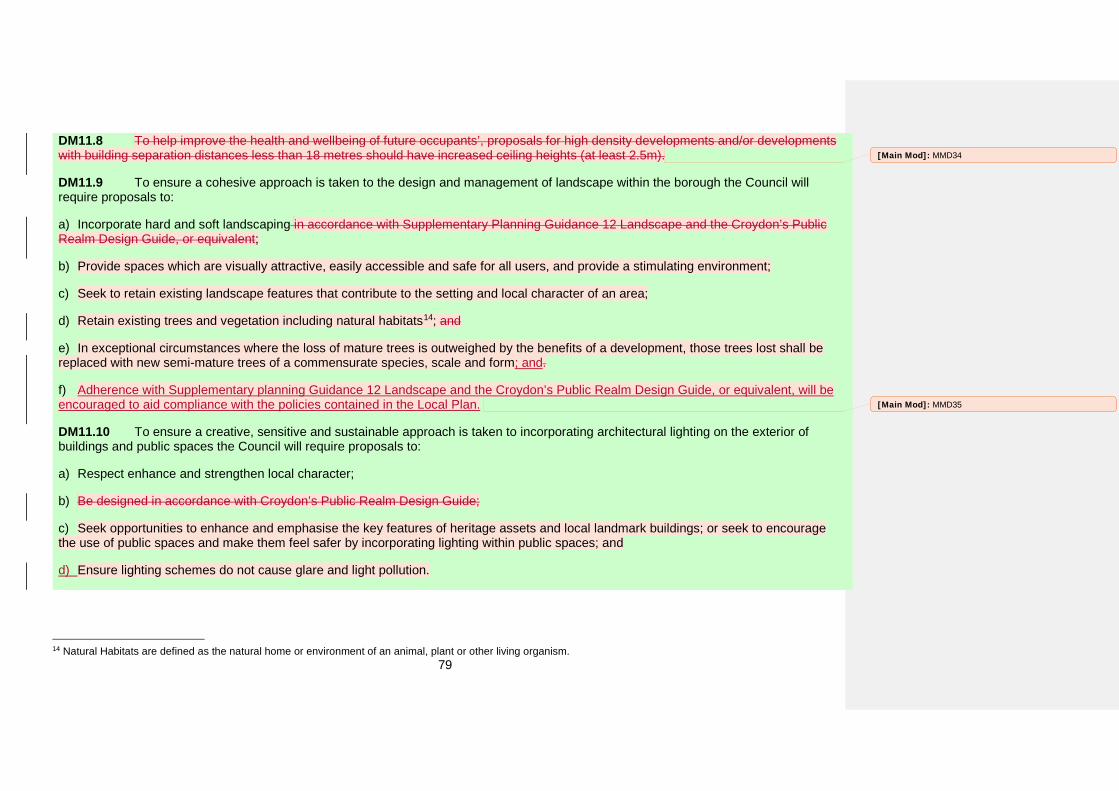
79
DM11.8 To help improve the health and wellbeing of future occupants’, proposals for high density developments and/or developments with building separation distances less than 18 metres should have increased ceiling heights (at least 2.5m).
DM11.9 To ensure a cohesive approach is taken to the design and management of landscape within the borough the Council will require proposals to:
a) Incorporate hard and soft landscaping in accordance with Supplementary Planning Guidance 12 Landscape and the Croydon’s PublicRealm Design Guide, or equivalent;
b) Provide spaces which are visually attractive, easily accessible and safe for all users, and provide a stimulating environment;
c) Seek to retain existing landscape features that contribute to the setting and local character of an area;
d) Retain existing trees and vegetation including natural habitats14; and
e) In exceptional circumstances where the loss of mature trees is outweighed by the benefits of a development, those trees lost shall bereplaced with new semi-mature trees of a commensurate species, scale and form; and.
f) Adherence with Supplementary planning Guidance 12 Landscape and the Croydon’s Public Realm Design Guide, or equivalent, will beencouraged to aid compliance with the policies contained in the Local Plan.
DM11.10 To ensure a creative, sensitive and sustainable approach is taken to incorporating architectural lighting on the exterior of buildings and public spaces the Council will require proposals to:
a) Respect enhance and strengthen local character;
b) Be designed in accordance with Croydon’s Public Realm Design Guide;
c) Seek opportunities to enhance and emphasise the key features of heritage assets and local landmark buildings; or seek to encouragethe use of public spaces and make them feel safer by incorporating lighting within public spaces; and
d) Ensure lighting schemes do not cause glare and light pollution.
14 Natural Habitats are defined as the natural home or environment of an animal, plant or other living organism.
[Main Mod]: MMD34
[Main Mod]: MMD35
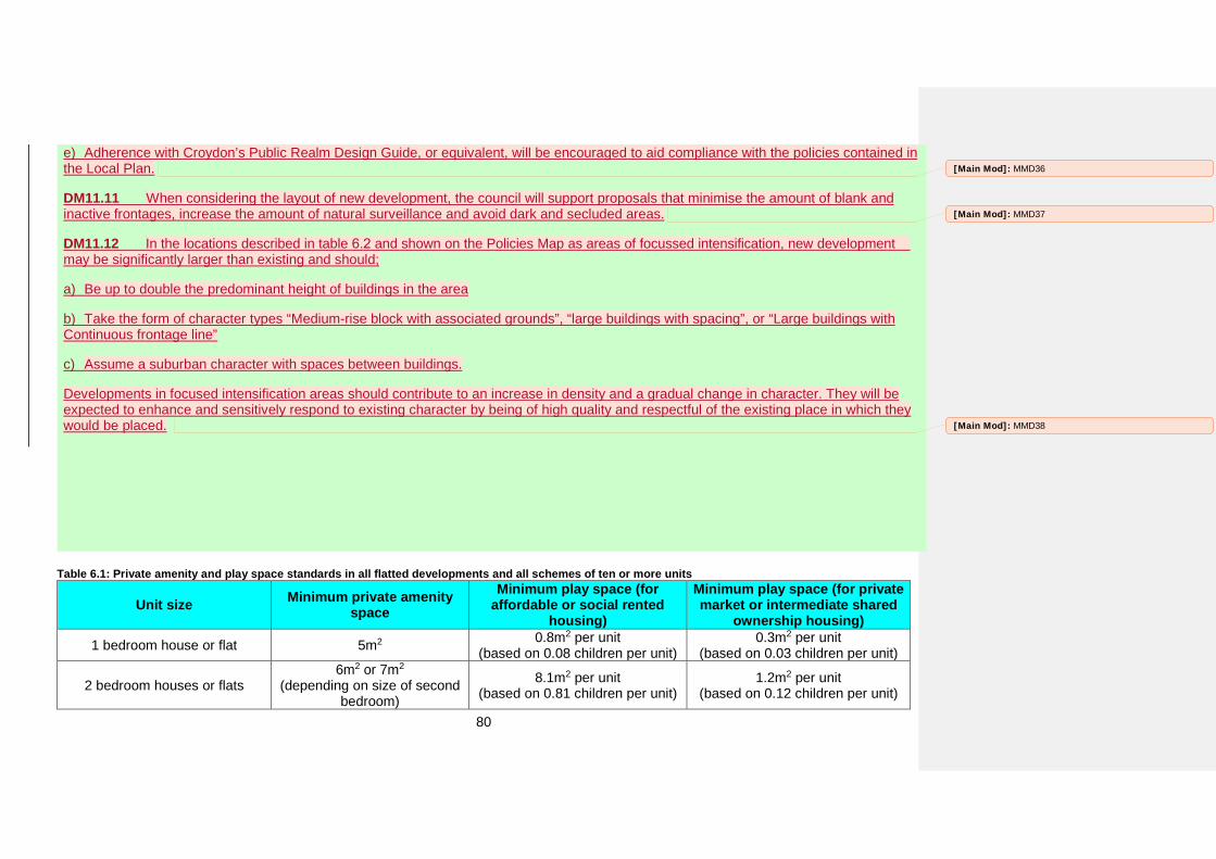
80
e) Adherence with Croydon’s Public Realm Design Guide, or equivalent, will be encouraged to aid compliance with the policies contained inthe Local Plan.
DM11.11 When considering the layout of new development, the council will support proposals that minimise the amount of blank and inactive frontages, increase the amount of natural surveillance and avoid dark and secluded areas.
DM11.12 In the locations described in table 6.2 and shown on the Policies Map as areas of focussed intensification, new development may be significantly larger than existing and should;
a) Be up to double the predominant height of buildings in the area
b) Take the form of character types “Medium-rise block with associated grounds”, “large buildings with spacing”, or “Large buildings withContinuous frontage line”
c) Assume a suburban character with spaces between buildings.
Developments in focused intensification areas should contribute to an increase in density and a gradual change in character. They will be expected to enhance and sensitively respond to existing character by being of high quality and respectful of the existing place in which they would be placed.
Table 6.1: Private amenity and play space standards in all flatted developments and all schemes of ten or more units
Unit size Minimum private amenity space
Minimum play space (for affordable or social rented
housing)
Minimum play space (for private market or intermediate shared
ownership housing) 1 bedroom house or flat 5m2 0.8m2 per unit
(based on 0.08 children per unit) 0.3m2 per unit
(based on 0.03 children per unit)
2 bedroom houses or flats 6m2 or 7m2
(depending on size of second bedroom)
8.1m2 per unit (based on 0.81 children per unit)
1.2m2 per unit (based on 0.12 children per unit)
[Main Mod]: MMD36
[Main Mod]: MMD37
[Main Mod]: MMD38
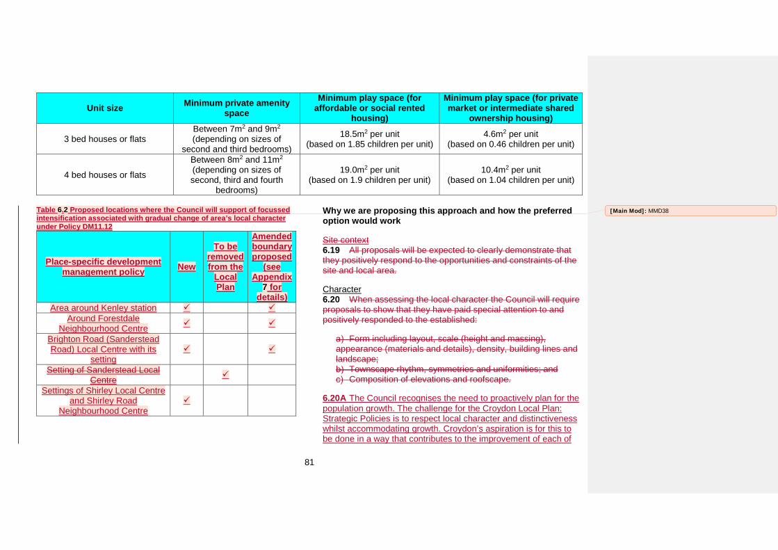
81
Unit size Minimum private amenity space
Minimum play space (for affordable or social rented
housing)
Minimum play space (for private market or intermediate shared
ownership housing)
3 bed houses or flats Between 7m2 and 9m2 (depending on sizes of
second and third bedrooms)
18.5m2 per unit (based on 1.85 children per unit)
4.6m2 per unit (based on 0.46 children per unit)
4 bed houses or flats
Between 8m2 and 11m2 (depending on sizes of second, third and fourth
bedrooms)
19.0m2 per unit (based on 1.9 children per unit)
10.4m2 per unit (based on 1.04 children per unit)
Table 6.2 Proposed locations where the Council will support of focussed intensification associated with gradual change of area’s local character under Policy DM11.12
Place-specific development management policy New
To be removed from the
Local Plan
Amended boundary proposed
(see Appendix
7 for details)
Area around Kenley station Around Forestdale
Neighbourhood Centre
Brighton Road (Sanderstead Road) Local Centre with its
setting
Setting of Sanderstead Local Centre
Settings of Shirley Local Centre and Shirley Road
Neighbourhood Centre
Why we are proposing this approach and how the preferred option would work
Site context 6.19 All proposals will be expected to clearly demonstrate that they positively respond to the opportunities and constraints of the site and local area.
Character 6.20 When assessing the local character the Council will require proposals to show that they have paid special attention to and positively responded to the established:
Form including layout, scale (height and massing), appearance (materials and details), density, building lines and landscape;
Townscape rhythm, symmetries and uniformities; and Composition of elevations and roofscape.
6.20A The Council recognises the need to proactively plan for the population growth. The challenge for the Croydon Local Plan: Strategic Policies is to respect local character and distinctiveness whilst accommodating growth. Croydon’s aspiration is for this to be done in a way that contributes to the improvement of each of
[Main Mod]: MMD38
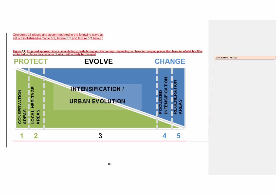
82
Croydon’s 16 places and accommodated in the following ways as set out in Table 11.3 Table 6.2, Figure 6.1 and Figure 6.2 below :
Figure 6.1: Proposed approach to accommodating growth throughout the borough depending on character, ranging places the character of which will be protected to places the character of which will actively be changed
[Main Mod]: MMD39
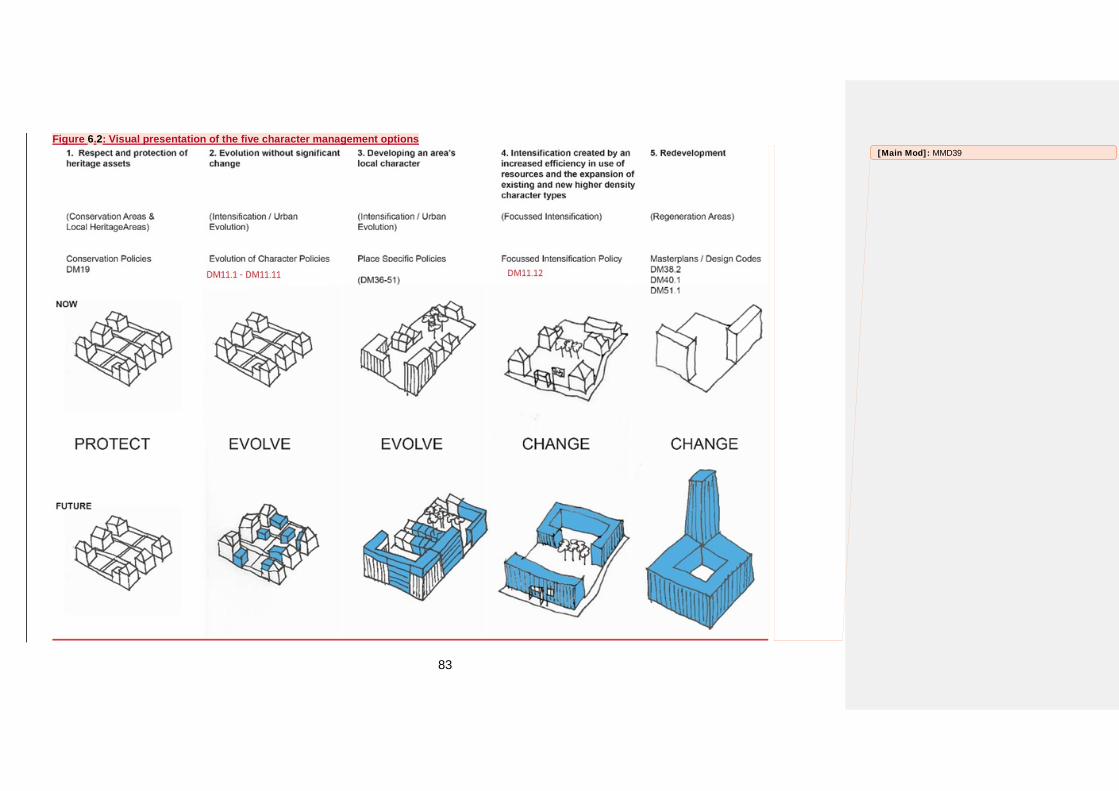
83
Figure 6.2: Visual presentation of the five character management options [Main Mod]: MMD39
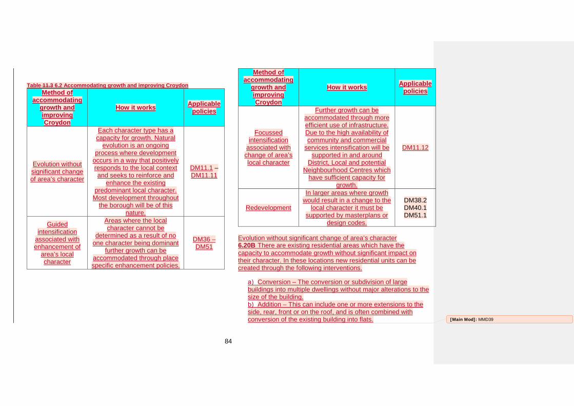
84
Table 11.3 6.2 Accommodating growth and improving Croydon Method of
accommodating growth and improving Croydon
How it works Applicable policies
Evolution without significant change of area’s character
Each character type has a capacity for growth. Natural
evolution is an ongoing process where development
occurs in a way that positively responds to the local context and seeks to reinforce and
enhance the existing predominant local character.
Most development throughout the borough will be of this
nature.
DM11.1 – DM11.11
Guided intensification
associated with enhancement of
area’s local character
Areas where the local character cannot be
determined as a result of no one character being dominant
further growth can be accommodated through place specific enhancement policies.
DM36 – DM51
Method of accommodating
growth and improving Croydon
How it works Applicable policies
Focussed intensification
associated with change of area’s local character
Further growth can be accommodated through more efficient use of infrastructure. Due to the high availability of community and commercial
services intensification will be supported in and around
District, Local and potential Neighbourhood Centres which
have sufficient capacity for growth.
DM11.12
Redevelopment
In larger areas where growth would result in a change to the
local character it must be supported by masterplans or
design codes.
DM38.2 DM40.1 DM51.1
Evolution without significant change of area’s character 6.20B There are existing residential areas which have the capacity to accommodate growth without significant impact on their character. In these locations new residential units can be created through the following interventions.
Conversion – The conversion or subdivision of large buildings into multiple dwellings without major alterations to the size of the building.
Addition – This can include one or more extensions to the side, rear, front or on the roof, and is often combined with conversion of the existing building into flats. [Main Mod]: MMD39
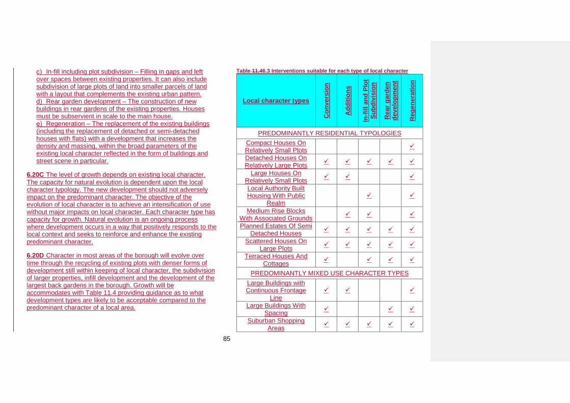
85
In-fill including plot subdivision – Filling in gaps and left over spaces between existing properties. It can also include subdivision of large plots of land into smaller parcels of land with a layout that complements the existing urban pattern.
Rear garden development – The construction of new buildings in rear gardens of the existing properties. Houses must be subservient in scale to the main house.
Regeneration – The replacement of the existing buildings (including the replacement of detached or semi-detached houses with flats) with a development that increases the density and massing, within the broad parameters of the existing local character reflected in the form of buildings and street scene in particular.
6.20C The level of growth depends on existing local character. The capacity for natural evolution is dependent upon the local character typology. The new development should not adversely impact on the predominant character. The objective of the evolution of local character is to achieve an intensification of use without major impacts on local character. Each character type has capacity for growth. Natural evolution is an ongoing process where development occurs in a way that positively responds to the local context and seeks to reinforce and enhance the existing predominant character.
6.20D Character in most areas of the borough will evolve over time through the recycling of existing plots with denser forms of development still within keeping of local character, the subdivision of larger properties, infill development and the development of the largest back gardens in the borough. Growth will be accommodates with Table 11.4 providing guidance as to what development types are likely to be acceptable compared to the predominant character of a local area.
Table 11.46.3 Interventions suitable for each type of local character
Local character types
Con
vers
ion
Add
ition
s
In-fi
ll an
d Pl
ot
Subd
ivis
ion
Rea
r gar
den
deve
lopm
ent
Reg
ener
atio
n
PREDOMINANTLY RESIDENTIAL TYPOLOGIES Compact Houses On Relatively Small Plots
Detached Houses On Relatively Large Plots
Large Houses On Relatively Small Plots
Local Authority Built Housing With Public
Realm
Medium Rise Blocks With Associated Grounds
Planned Estates Of Semi Detached Houses
Scattered Houses On Large Plots
Terraced Houses And Cottages
PREDOMINANTLY MIXED USE CHARACTER TYPES Large Buildings with Continuous Frontage
Line
Large Buildings With Spacing
Suburban Shopping Areas
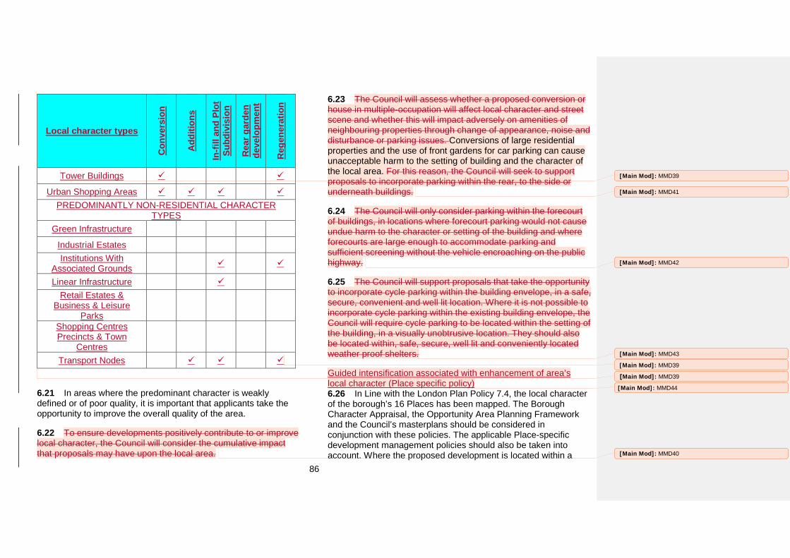
86
Local character types
Con
vers
ion
Add
ition
s
In-fi
ll an
d Pl
ot
Subd
ivis
ion
Rea
r gar
den
deve
lopm
ent
Reg
ener
atio
n
Tower Buildings
Urban Shopping Areas PREDOMINANTLY NON-RESIDENTIAL CHARACTER
TYPES Green Infrastructure
Industrial Estates Institutions With
Associated Grounds
Linear Infrastructure Retail Estates &
Business & Leisure Parks
Shopping Centres Precincts & Town
Centres Transport Nodes
6.21 In areas where the predominant character is weakly defined or of poor quality, it is important that applicants take the opportunity to improve the overall quality of the area.
6.22 To ensure developments positively contribute to or improve local character, the Council will consider the cumulative impact that proposals may have upon the local area.
6.23 The Council will assess whether a proposed conversion or house in multiple-occupation will affect local character and street scene and whether this will impact adversely on amenities of neighbouring properties through change of appearance, noise and disturbance or parking issues. Conversions of large residential properties and the use of front gardens for car parking can cause unacceptable harm to the setting of building and the character of the local area. For this reason, the Council will seek to support proposals to incorporate parking within the rear, to the side or underneath buildings.
6.24 The Council will only consider parking within the forecourt of buildings, in locations where forecourt parking would not cause undue harm to the character or setting of the building and where forecourts are large enough to accommodate parking and sufficient screening without the vehicle encroaching on the public highway.
6.25 The Council will support proposals that take the opportunity to incorporate cycle parking within the building envelope, in a safe, secure, convenient and well lit location. Where it is not possible to incorporate cycle parking within the existing building envelope, the Council will require cycle parking to be located within the setting of the building, in a visually unobtrusive location. They should also be located within, safe, secure, well lit and conveniently located weather proof shelters.
Guided intensification associated with enhancement of area’s local character (Place specific policy) 6.26 In Line with the London Plan Policy 7.4, the local character of the borough’s 16 Places has been mapped. The Borough Character Appraisal, the Opportunity Area Planning Framework and the Council’s masterplans should be considered in conjunction with these policies. The applicable Place-specific development management policies should also be taken into account. Where the proposed development is located within a
[Main Mod]: MMD39
[Main Mod]: MMD40
[Main Mod]: MMD41
[Main Mod]: MMD42
[Main Mod]: MMD43
[Main Mod]: MMD39
[Main Mod]: MMD39
[Main Mod]: MMD44
87
Conservation Area further guidance should also be sought from Croydon’s Conservation Area Appraisal Management Plan and the Conservation Area General Guidance.
6.26A Place specific policy guides development (and assists growth) by setting out policies on design in specific locations that seek to more towards a more consistent or appropriate character in these locations, deliver the spatial vision for the Borough and wider Local Plan policies and objectives (including delivery of new homes).
6.26B The character of the areas will evolve towards a more consistent one (as opposed to multiple character typologies); or one that might be expected in a District or Local Centre as sites are redeveloped. The policies often seek to permit development that is one or two storeys higher than the predominant building height so as to facilitate a level of growth and enable development. However, they are character policies first and foremost, not a policy about growth
6.26C To accommodate growth which would complement the existing individual character of Places of Croydon and improve efficiency of land use, the Council promotes a minimum building height of three storeys.
Layout 6.27 Streets form an integral part of a place, creating movement networks that serve the built form rather than dominate it. Consideration should be given at a sufficiently early stage of the design process to how the development site links to the local and wider area. Additionally, the creation of routes punctuated by landmark buildings or features, public squares or spaces helps to make a place easy to understand.
6.28 The Council will require detailed design of roads, footpaths and cycleways to be clearly communicated. Early planning of road
and site layouts enables applicants to incorporate parking and servicing in locations where their presence will not dictate the urban form and their visual impact can be minimised. When designing parking and road layouts, careful consideration should be given to creating layouts that are safe, secure, accessible, and permeable and balance the needs of all users. Particular attention should be paid to ensure safe and accessible pedestrian routes are accommodated within the development.
6.29 When considering the layout, proposals should demonstrate a clear and logical arrangement of buildings that provides a high quality design solution on the site. Buildings, other than on back land developments, should positively address the street and the public realm and particular care should be taken to address how they enclose private secure spaces, car parks and servicing areas.
6.30 When considering the layout of new development, the Council will support proposals that minimise the amount of blank and inactive frontages, increase the amount of natural surveillance, and avoid dark and secluded areas. Supplementary Planning Document 3 Designing for Community Safety or equivalent should be referred to for aspects of safety in layout, and design. The provision of sufficient lighting, in line with EU lighting uniformity requirements, will encourage greater pedestrian access, movement and reduce opportunity for undesirable behaviour.
6.31 The Council considers the health and wellbeing of those living and working within the borough to be of the upmost importance. New developments can impact upon the amenity of the occupants of neighbouring properties. Site layouts should be designed to protect or improve conditions for occupants of nearby properties and future occupants. In line with the Housing Supplementary Planning Guidance, when assessing site layouts
[Main Mod]: MMD45
[Main Mod]: MMD46
88
the Council will consider a development’s impact on visual amenity, overlooking, outlook, and sunlight and daylight.
Amenity space 6.32 This policy willPolicies DM11.4 and DM11.5 apply to all new residential developments and conversions. Croydon’s local character is the leading consideration on the quantum of private and communal open space to be provided for developments. The minimum standards in the Mayor’s Housing Supplementary Planning Guidance for private open space may need to be exceeded in order to achieve a design solution that respects local character. When calculating the amount of private and communal open space to be provided the following elements should be excluded:
Footpaths; Driveways; Front gardens; Vehicle circulation areas; Parking areas; Cycle parking areas; and Refuse areas.
6.33 Private open space is defined as amenity space which is accessible only to, useable for and screened for the purposes of individual dwellings at the rear or in the case of flatted schemes within the grounds.
6.34 Communal open space is defined as amenity space that is shared, accessible to all within the development and could be for their exclusive use.
6.35 Balconies, winter gardens or roof terraces may be included as thehelp to meet a development’s private amenity space provision requirement where they are not detrimental to but will have to comply with the privacy requirements of adjoining
occupierspolicy DM11.6 so enclosure may need to be opaque. and They may be an innovative way of providing private or communal amenity space in areas of high density. The minimum width and depth of balconies should be 1.5m. Where there are privacy issues balcony enclosures should not be transparent.
6.36 Private amenity space can be indoors inIn exceptional circumstances where site constraints make it impossible to provide private outdoor space for all dwellings, indoor private amenity space may help to meet policy requirements. The area provided should be equivalent to the private outdoor amenity space requirement and this area added to the minimum Gross Internal Area.
6.37 The provision of private and communal amenity space per unit, including child play space of 10m2 per child, based on the calculation of numbers of children yielded from the development as set out in the Table 6.1 may be pooled to create a communal amenity space for a flatted development that meets all the requirements of this policy.
6.38 The amenity space provided for play space can be part of the shared amenity area; it may be a void deck within a tall flatted development, possibly on the ground floor and in small developments of less than ten dwellings it could be part of the shared or private garden.
6.39 The Play Space Standards are based on Wandsworth yield calculator which the London Plan Supplementary Planning Guidance (Supplementary Planning Guidance) Shaping Neighbourhoods: Children and Young People Play and Informal Recreation is based on. This Supplementary Planning Guidance should be referred to for the allocation and design guidance for play space. The requirements for play space will be calculated on the basis that all units are for affordable or social rent. This is because many applications are made by private developers which
[Main Mod]: MMD47
[Main Mod]: MMD48
[Main Mod]: MMD49
89
are then later sold, prior to occupation, to a Registered Provider of affordable housing and let on an affordable rent basis. In order to ensure that these affordable homes have sufficient play space for all the child occupiers it is necessary to require that all developments meet the higher play space requirements of affordable and social rented homes unless there is a signed Section 106 agreement specifically stating a different mix of housing tenures in a development.
6.40 Evidence will be required to demonstrate that privacy is protected, and the character of the area is respected in the layout of private and communal amenity space as part of development proposals. There should be a A minimum separation of 18-21m between directly facing habitable room windows on main rear elevations. This distance is a best practice ‘yardstick’ in common usage and should be applied flexibly, dependent on the context of the development to ensure that development is provided at an acceptable density in the local context. For new major developments as long as the perimeter buildings take account of this local context, the density may vary within the development.
6.40A Designers should consider the position and aspect of habitable rooms, gardens and balconies, and avoid windows facing each other where privacy distances are tight. Planning guidance has, in the past, been concerned with achieving visual separation between dwellings by setting a minimum distance of 18-21m between facing homes (between habitable room and habitable room as opposed to between balconies or terraces or between habitable rooms and balconies/terrace). These can still be useful yardsticks for visual privacy, but adhering rigidly to these measures can limit the variety of urban spaces and housing types and can sometimes unnecessarily restrict density.
6.41 Overlooking of a portion of a private outdoor space may be permissible provided that a distance of 10m perpendicular from the rear elevation of the property is screened to ensure the
immediately accessible area, where sitting outside the property is more likely, has some privacy from overlooking.
6.42 A planning condition may require a management plan to provide the Council with some assurance that the communal amenity space will be maintained, and therefore continue to be useable. A well maintained appearance will assist with enhancement of the development, with a sense of ownership of residents, and increase the perception of safety in the neighbourhood.
6.43 Amenity, including sunlight and daylight need to be considered in the layout of private and communal open space and Building Research Establishment Guidelines referred to.
Design 6.44 The need for good design is supported in Paragraph 56 of the National Planning Policy Framework. Both the London Plan (policy 7.4b) and the Croydon Local Plan Strategic Policy SP4.1 identify the need for high quality design. To achieve high quality designs, proposals should consider the physical appearance and functionality of the development site and local area. In accordance with the London Plan, Croydon is committed to working with applicants to create modern, high quality innovative and well-designed buildings and places that are, safe, accessible, and inclusive and enrich the quality of life for all those who live, work and visit them.
6.45 The quality of materials can play an important role determining whether the integrity of the design concept is realised. The choice of materials and the quality of craftsmanship is vital to the overall success of the development in terms of function and appearance. When assessing proposed materials the Council will consider the quality, durability, attractiveness, sustainability, texture, colour and compatibility with existing buildings. Additionally, when working with existing buildings, original
[Main Mod]: MMD50
[Main Mod]: MMD51
[Main Mod]: MMD52
90
architectural features; such as mouldings, architraves, chimneys or porches that contribute to the architectural character of a building should, whenever possible, be retained.
6.46 The design, position and rhythm of windows and doors can contribute or detract from the overall appearance of the building and the character of an area. The Council will seek to encourage applicants at an early stage of the design process to give careful consideration to the detailing of the overall design (including setbacks and reveals) of windows and doors. The Mayor of London’s Housing Supplementary Planning Guidance provides guidelines on window sizes and the required levels of light to protect the residential amenity and well-being of future residents.
6.47 Servicing equipment such as plant, utility boxes, ventilation systems (including heating and cooling), lift, mechanical equipment, fire escapes and rainwater goods form an integral part of the operational components of a building. Early consideration will enable it be incorporated within the building envelope without compromising the integrity of the original design concept.
6.48 Roof-form plays an important role in creating and contributing to the visual character of an area and in some instances their visual prominence creates local landmarks or frames designated views. When considering the pitch, shape and materials of roofs, care should be taken to ensure that design is of high quality and appropriate to neighbouring buildings. The Council will also consider the impact of a scheme in terms of its effect on Local Designated Views (as shown on the Policies Map).
6.49 Information and guidance about the relationships of proposed extensions to neighbouring properties is available in the
15 The public realm is defined as public spaces that are accessible to all without charge. These can include public, semi-public and privately owned spaces.
Residential Extensions and Alterations Supplementary Planning Document or equivalent.
6.50 The design of our built environment can affect our health and psychological and physiological well-being, and can have long-term implications for quality of life. Good house design should not be limited to the appearance of building and setting, it should also consider the wellbeing of the end user.
6.51 Croydon’s Local Plan Strategic Policies SP5.2b set out the Council’s objective to ensure new development provides healthy living by encouraging good house design. This is increasingly important in locations where densities are increased and/or separation distances are reduced. In these locations, to assist in the creation of buildings that improve the health and wellbeing of future occupiers, developments will be expected to exceed the minimum standards outlined in the Mayor’sHousing SPG.
Public Realm 6.52 A well-designed, cared for and high quality public realm15 plays an important role in reinforcing the perception of Croydon as a welcoming, safe and accessible place. Croydon’s aspirations for its public realm are outlined in the Croydon Local Plan Strategic Policies SP4.6 to SP4.10.
6.53 Most proposals include an element of public realm. This can range from large scale public realm improvements such as the design of hard and soft landscaped areas (including footways) throughout a site or smaller scale public realm improvements to the forecourt; and in some cases, the area adjoining it.
[Main Mod]: MMD53
[Main Mod]: MMD53
91
6.54 Where public realm improvements have been included within a proposal, these should result in a high quality public realm that is usable, permeable, legible and accessible.
6.55 As outlined in the Strategic Policy SP4.10, the Croydon Public Realm Design Guide sets out materials and layout guidelines. Further details, including a materials palette can be found in the Croydon Public Realm Design Guide.
6.56 Historic street furniture such as traditional red telephone boxes, post boxes, ornamental lamp columns, drinking fountains, cattle troughs, monuments and memorials can make a positive contribution to local character by reinforcing a sense of place. Opportunities to retain, restore and incorporate historic street furniture should be taken.
Landscape 6.57 The character of a place can be significantly affected by the quality of the landscape and the way it is maintained. Sensitively designed landscape can enrich and reinforce existing wildlife habitats and improve the ecological value of sites and their surroundings. The Council considers landscape as an integral part of all development and would therefore require proposals for new developments and extensions to be accompanied by plans detailing all existing and proposed hard and soft landscaping affected by or to be incorporated into the scheme.
6.58 Supplementary Planning Guidance 12 Landscape Design is referenced in the policy and provides detailed guidance and clarity on what the Council is seeking from development proposals on providing safe well-designed landscaped schemes. The Croydon Public Realm Design Guide also sets out detailed guidance and clarity on what the Council is seeking from the public realm components of development proposals. If these documents are superseded the equivalent Council documents should be referred to.
Lighting 6.59 Lighting plays an important role in creating the perception of safe and welcoming place for people to use and interact with. A well-designed lighting scheme can improve the borough’s image and if creatively implemented can give dimension to a building and the landscape surrounding it.
6.60 Architectural lighting is most effective when used to highlight a few structural elements such as colonnades, towers spires, sculpture or walls or by emphasising texture, such as brick, stone and steelwork rather than flooding every surface with light.
Design and Access Statements 6.61 The Council will require applicants to justify and fully demonstrate how the principles of good design are being met. Design and Access Statements should be proportional to the size of the scheme and should fully demonstrate:
A thorough understanding and analysis of the physical, social and economic and policy context;
A clear understanding of the development objectives and brief;
Clear design principles and design concept; and The evolution of the design and how the final design
solution was arrived at.
6.62 The Statement should refer to By Design, Supplementary Planning Document 3 Designing for Community Safety or equivalent and Supplementary Planning Guidance 12 Landscape Design or equivalent, and demonstrate how the National Planning Policy Framework, the London Plan and the Croydon Local Plan design policies are being met. Advice on the content of the Design and Access Statements can be found in the Council’s advisory note ‘Preparing Design Statements Advice Note for Applicants
92
and Agents’ and CABE’s ‘Design and Access Statements, How to write, read and use them’
Focused intensification associated with gradual change of area’s local character 6.62A Focussed intensification aims to maximise use of the existing growth capacity and to support sustainable spatial vision for the borough through an increase in density of development and a gradual change in character to similar but higher density forms of development. Sites will be redeveloped with denser forms of development of a different character to that which exists in the local area currently. At the heart of each area of Focused Intensification is an area with no one predominant character type. As each area of Focused Intensification is currently low density it would not be justified, when there is unmet housing need, to seek to move towards a more consistent character that replicates surrounding low density development types.
6.62B Each of the Areas of focussed intensification are, in part, at risk of fluvial, surface water or groundwater flooding. However, a Strategic Flood Risk Assessment has identified that developments in these areas could be made safe from flooding without increasing flood risk elsewhere.
Key supporting documents
• CABE Design and Access Statements, How to write, read anduse them (2006) • Supplementary Planning Document 2 Residential Alterationsand Extensions • Supplementary Planning Document 3 Designing forCommunity Safety • The Mayor Of London's Housing Supplementary PlanningGuidance: The London Plan Implementation Framework (March 2016)
• The Mayor of London’s Draft Sustainable Design andConstruction Supplementary Planning Guidance (2013) • The Borough Character Appraisal (2015)• Character Typology (2015)• The Mayor’s Supplementary Planning Guidance – ShapingNeighbourhoods: Children and Young People’s Play And Informal Recreation (2012) • Croydon Public Realm Design Guide (2012)• Croydon’s Conservation Area Appraisal Management Plans(various) • Conservation Area General Guidance (2013)• Croydon Opportunity Area Planning Framework (2013)• East Croydon Masterplan (2011)• Fair Field Masterplan (2013)• Mid Croydon Masterplan (2012)• West Croydon Masterplan (2011)• Old Town Masterplan (2014)
[Main Mod]: MMD54
93
Shop front design and security
Strategic Objectives and related Croydon Local Plan strategic policies
• Strategic Objective 5
• Strategic Objective 7
• Strategic Objective 10
• Policy SP4
Unitary Development Plan policies to be replaced by this policy
• UD4 Shopfront Design
Why we need this policy
6.63 Given the renewed interest in shop front security brought about as a result of the civil unrest on 8 August 2011, the Council acknowledges the key benefits of a robust shop front design. It is necessary to develop a security policy that will enable the delivery of secure well-designed shop fronts which improve Croydon’s public realm, urban environment, and vitality of its town centres.
6.64 There is a need to ensure that opportunities are taken to promote a succinct and cohesive approach to shop front design and security. Additional guidance that provides clear and concise policies is required to help commercial premises across the borough to incorporate shop front designs which maintain local distinctiveness and provide adequate levels of security whilst reducing the requirement for enforcement action.
6.65 The new Shop Front Policy will apply greater emphasis in favour of quality shop front design and security in line with the
revised addendum to Supplementary Planning Guidance No.1 Shop Fronts & Signs.
6.66 Over recent years, changes in retail patterns and a growing demand for housing have led to many of these shops being converted into residential accommodation. Many of these conversions have been carried out in a way which often destroyed the inherent adaptability of shop units and the shop fronts. This policy will provide guidance to ensure that conversions are carried out sympathetically and flexibly to allow for future change.
6.67 Paragraph 56 of the National Planning Policy Framework (requiring good design) outlines the need for robust and comprehensive policies that ‘establish a strong sense of place, using streetscapes and buildings to create attractive and comfortable places to live, work and visit’. Furthermore policies should aim to ‘create safe and accessible environments where crime and disorder, and the fear of crime, do not undermine quality of life or community cohesion’.
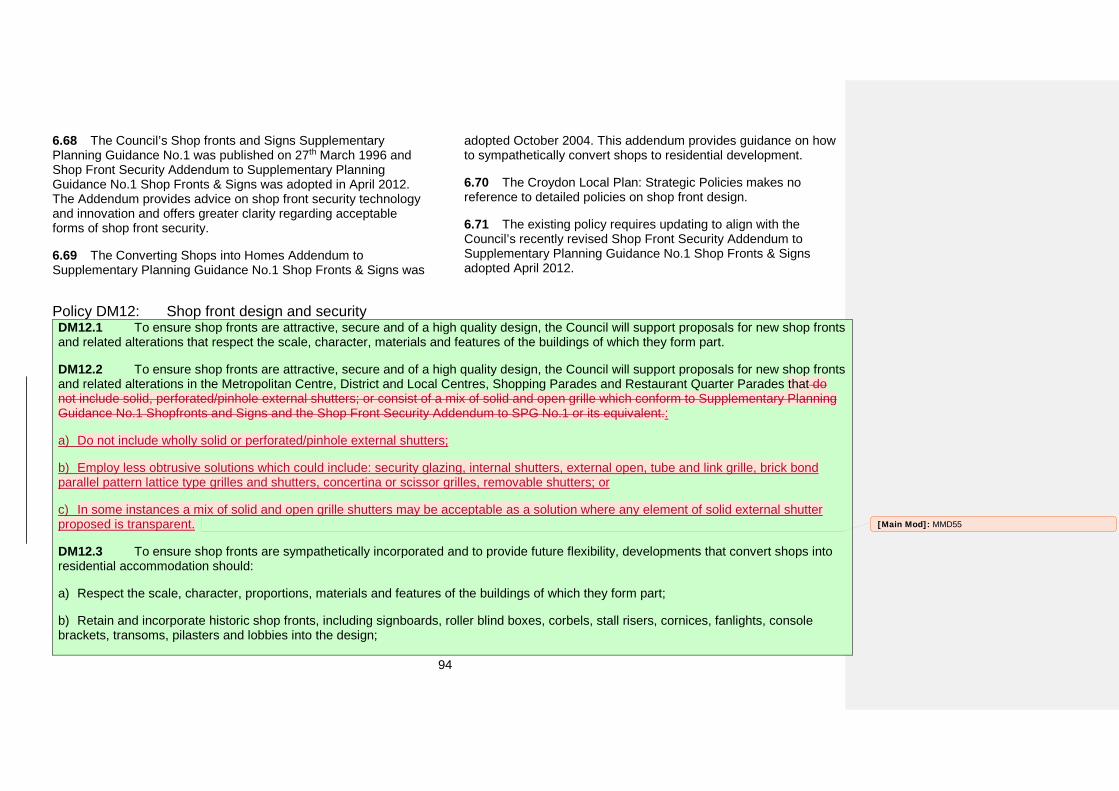
94
6.68 The Council’s Shop fronts and Signs Supplementary Planning Guidance No.1 was published on 27th March 1996 and Shop Front Security Addendum to Supplementary Planning Guidance No.1 Shop Fronts & Signs was adopted in April 2012. The Addendum provides advice on shop front security technology and innovation and offers greater clarity regarding acceptable forms of shop front security.
6.69 The Converting Shops into Homes Addendum to Supplementary Planning Guidance No.1 Shop Fronts & Signs was
adopted October 2004. This addendum provides guidance on how to sympathetically convert shops to residential development.
6.70 The Croydon Local Plan: Strategic Policies makes no reference to detailed policies on shop front design.
6.71 The existing policy requires updating to align with the Council’s recently revised Shop Front Security Addendum to Supplementary Planning Guidance No.1 Shop Fronts & Signs adopted April 2012.
Policy DM12: Shop front design and security DM12.1 To ensure shop fronts are attractive, secure and of a high quality design, the Council will support proposals for new shop fronts and related alterations that respect the scale, character, materials and features of the buildings of which they form part.
DM12.2 To ensure shop fronts are attractive, secure and of a high quality design, the Council will support proposals for new shop fronts and related alterations in the Metropolitan Centre, District and Local Centres, Shopping Parades and Restaurant Quarter Parades that do not include solid, perforated/pinhole external shutters; or consist of a mix of solid and open grille which conform to Supplementary Planning Guidance No.1 Shopfronts and Signs and the Shop Front Security Addendum to SPG No.1 or its equivalent.:
a) Do not include wholly solid or perforated/pinhole external shutters;
b) Employ less obtrusive solutions which could include: security glazing, internal shutters, external open, tube and link grille, brick bondparallel pattern lattice type grilles and shutters, concertina or scissor grilles, removable shutters; or
c) In some instances a mix of solid and open grille shutters may be acceptable as a solution where any element of solid external shutterproposed is transparent.
DM12.3 To ensure shop fronts are sympathetically incorporated and to provide future flexibility, developments that convert shops into residential accommodation should:
a) Respect the scale, character, proportions, materials and features of the buildings of which they form part;
b) Retain and incorporate historic shop fronts, including signboards, roller blind boxes, corbels, stall risers, cornices, fanlights, consolebrackets, transoms, pilasters and lobbies into the design;
[Main Mod]: MMD55
95
c) For new elements, adopt and reinterpret the language of shop front design; and
d) Optimise window and door openings
e) Ensure the design includes elements that provide privacy for the occupiers
How the policy works
6.72 The Council expects all shop front design to be of a high design quality and craftsmanship and whenever possible, use sustainable or recycled materials.
6.73 The Council encourages improved shop front security and public realm through the integration of innovative technologies.
6.74 By encouraging shop owners to consider the inclusion of internal shop front shutters during the early stages of the design process. Proposals will respect the distinctive local character of an area whilst maintaining a welcoming environment and public realm.
6.75 Those seeking planning permission for shop front improvements and new shop fronts should seek additional guidance from the Council’s Shopfronts and Signs Supplementary Planning Guidance No.1 published on 27th March 1996 and Shop Front Security Addendum to Supplementary Planning Guidance No.1 Shop Fronts & Signs adopted in April 2012 or equivalent guidance.
6.76 Changes in retail patterns and a growing demand for housing have led to the piecemeal change of shops converted to residential. Construction works often associated with these changes in use (usually brick-infill) often destroy the inherent adaptability of shop units and shop fronts and detract from the character of the area.
6.77 Wherever possible it is preferable to keep and adapt existing historic shop fronts. Key features such as large windows, details and proportions of the shop front can make for an unique, adaptable and attractive home that enhances and compliments the character of the local area.
6.78 When designing conversions of retail units to residential use, careful consideration should be given to the designing-in of privacy, given that retail units are commonly hard against the pavement. This could include retention or replacement of existing shop fronts and integration of a winter garden space at the front of the former retail unit to create a degree of environmental protection, privacy and private amenity space. Those seeking planning permission to convert shops into homes should seek additional guidance from the Addendum to Supplementary Planning Guidance No.1 Converting Shops into Homes, adopted October 2004.
Key supporting documents
• Shop fronts and Signs Supplementary Planning Guidance No.1(1996) • Shopfronts Security Addendum to Supplementary PlanningGuidance No.1 (2012) • Converting Shops into Homes Addendum to SupplementaryPlanning Guidance No.1, Addendum No. 2
96
Advertisement hoardings
Strategic Objectives and related Croydon Local Plan strategic policies
• Strategic Objective 5 • Strategic Objective 7
Unitary Development Plan policies to be replaced
• UD5 Advertisements
Why we need this policy
6.79 Advertising is closely associated with urban life and can be one of the most dominant elements of the environment. In the right context advertisement hoardings can enhance the appearance and vitality of an area. However, where they are poorly designed or located and where too many signs have been installed they can cause considerable damage to visual amenity by cluttering the built environment and detracting from the quality of the area.
6.80 Changes in legislation and national policy have resulted in the need for updated guidance. The provision of a policy for advertisement hoardings would align with paragraph 67 of the National Planning Policy Framework which highlights a need for controls on advertisements to be efficient, effective and simple in concept and operation. This policy provides guidance that is clear and concise.
16 National Planning Policy Framework paragraph 67.
6.81 The National Planning Policy Framework acknowledges the impact that advertisements can have on the appearance of the built and natural environment. It highlights the importance of the need for detailed assessment where ‘advertisements would have an appreciable impact on a building or on their surroundings. Advertisements should be subject to control only in the interests of amenity and public safety, taking account of cumulative impacts’16. The Advertisement and Hoardings & Other Advertisements Supplementary Planning Guidance No.8 (February 2003) provided guidance about acceptable locations, number, scale and type of advertisements such as wall mounted and Free standing hoardings and ‘A’ boards, panels, signs and window advertisements. The Supplementary Planning Guidance highlights the need to ensure advertisements are sensitively located and design to minimise the impact on residential areas and on heritage assets.
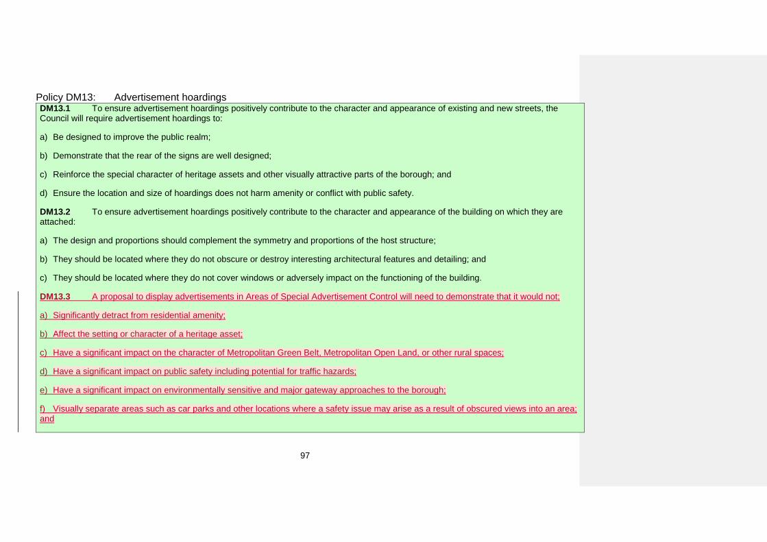
97
Policy DM13: Advertisement hoardings DM13.1 To ensure advertisement hoardings positively contribute to the character and appearance of existing and new streets, the Council will require advertisement hoardings to:
a) Be designed to improve the public realm;
b) Demonstrate that the rear of the signs are well designed;
c) Reinforce the special character of heritage assets and other visually attractive parts of the borough; and
d) Ensure the location and size of hoardings does not harm amenity or conflict with public safety.
DM13.2 To ensure advertisement hoardings positively contribute to the character and appearance of the building on which they are attached:
a) The design and proportions should complement the symmetry and proportions of the host structure;
b) They should be located where they do not obscure or destroy interesting architectural features and detailing; and
c) They should be located where they do not cover windows or adversely impact on the functioning of the building.
DM13.3 A proposal to display advertisements in Areas of Special Advertisement Control will need to demonstrate that it would not;
a) Significantly detract from residential amenity;
b) Affect the setting or character of a heritage asset;
c) Have a significant impact on the character of Metropolitan Green Belt, Metropolitan Open Land, or other rural spaces;
d) Have a significant impact on public safety including potential for traffic hazards;
e) Have a significant impact on environmentally sensitive and major gateway approaches to the borough;
f) Visually separate areas such as car parks and other locations where a safety issue may arise as a result of obscured views into an area;and
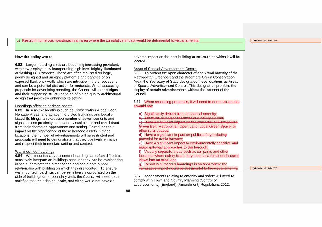
98
g) Result in numerous hoardings in an area where the cumulative impact would be detrimental to visual amenity.
How the policy works
6.82 Larger hoarding sizes are becoming increasing prevalent, with new displays now incorporating high level brightly illuminated or flashing LCD screens. These are often mounted on large, poorly designed and unsightly platforms and gantries or on exposed flank brick walls which are intrusive in the street scene and can be a potential distraction for motorists. When assessing proposals for advertising hoarding, the Council will expect signs and their supporting structures to be of a high quality architectural design that positively enhances its setting.
Hoardings affecting heritage assets 6.83 In sensitive locations such as Conservation Areas, Local Heritage Areas, and adjacent to Listed Buildings and Locally Listed Buildings, an excessive number of advertisements and signs in close proximity can lead to visual clutter and can detract from their character, appearance and setting. To reduce their impact on the significance of these heritage assets in these locations, the number of advertisements will be restricted and proposals will need to demonstrate that they positively enhance and respect their immediate setting and context.
Wall mounted hoardings 6.84 Wall mounted advertisement hoardings are often difficult to sensitively integrate on buildings because they can be overbearing in scale, dominate the street scene and can create a poor relationship with building on which they are located. To ensure wall mounted hoardings can be sensitively incorporated on the side of buildings or on boundary walls the Council will need to be satisfied that their design, scale, and siting would not have an
adverse impact on the host building or structure on which it will be located.
Areas of Special Advertisement Control 6.85 To protect the open character of and visual amenity of the Metropolitan Greenbelt and the Bradmore Green Conservation Area, the Secretary of State designated these locations as Areas of Special Advertisement Control. This designation prohibits the display of certain advertisements without the consent of the Council.
6.86 When assessing proposals, it will need to demonstrate that it would not:
Significantly detract from residential amenity; Affect the setting or character of a heritage asset; Have a significant impact on the character of Metropolitan
Green Belt, Metropolitan Open Land, Local Green Space or other rural spaces;
Have a significant impact on public safety including potential for traffic hazards;
Have a significant impact to environmentally sensitive and major gateway approaches to the borough;
Visually separate areas such as car parks and other locations where safety issue may arise as a result of obscured views into an area; and
Result in numerous hoardings in an area where the cumulative impact would be detrimental to the visual amenity.
6.87 Assessments relating to amenity and safety will need to comply with Town and Country Planning (Control of advertisements) (England) (Amendment) Regulations 2012.
[Main Mod]: MMD56
[Main Mod]: MMD57

99
Key supporting documents
• Advertisement and Hoardings & Other AdvertisementsSupplementary Planning Guidance No.8 (2003)
100
Refuse and recycling
Strategic Objectives and related Croydon Local Plan strategic policies
• Strategic Objective 5
• Strategic Objective 7
• Policy SP4.5
• Policy SP4.6
Unitary Development Plan policies to be replaced by this policy
• UD15 Refuse and Recycling Storage
Why we need this policy
6.88 Most residential and non-residential developments generate waste which will need to be temporarily stored on site. The current kerbside recycling scheme necessitates the need to provide sufficient room to store separated waste within all developments.
6.89 Both the London Plan and the National Planning Policy Framework do not contain policies relating to refuse and recycling within developments. Additionally the Croydon Local Plan: Strategic Policies refers to the Detailed Policies and Proposals for specific design guidance.
6.90 This policy will provide developers working on residential and non-residential schemes greater clarity about what the Council will expect them to provide.
6.91 The Croydon Local Plan: Strategic Policies does not provide specific design guidance and refers to the Detailed Policies and Proposals for specific design guidance.
6.92 The existing Unitary Development Plan policies have proved useful to both the Council and those applying for planning permission by providing guidance about the location and design of facilities which are integral to the functional running of each development.
6.93 The Mayor’s Housing Supplementary Planning Guidance provides some general guidance, however, it states that it should be used in conjunction with local guidance. The Mayor’s Housing Supplementary Planning Guidance does not address non-residential development.
[Main Mod]: MMD58
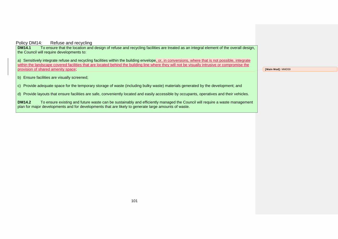
101
Policy DM14: Refuse and recycling DM14.1 To ensure that the location and design of refuse and recycling facilities are treated as an integral element of the overall design, the Council will require developments to:
a) Sensitively integrate refuse and recycling facilities within the building envelope, or, in conversions, where that is not possible, integratewithin the landscape covered facilities that are located behind the building line where they will not be visually intrusive or compromise the provision of shared amenity space;
b) Ensure facilities are visually screened;
c) Provide adequate space for the temporary storage of waste (including bulky waste) materials generated by the development; and
d) Provide layouts that ensure facilities are safe, conveniently located and easily accessible by occupants, operatives and their vehicles.
DM14.2 To ensure existing and future waste can be sustainably and efficiently managed the Council will require a waste management plan for major developments and for developments that are likely to generate large amounts of waste.
[Main Mod]: MMD59
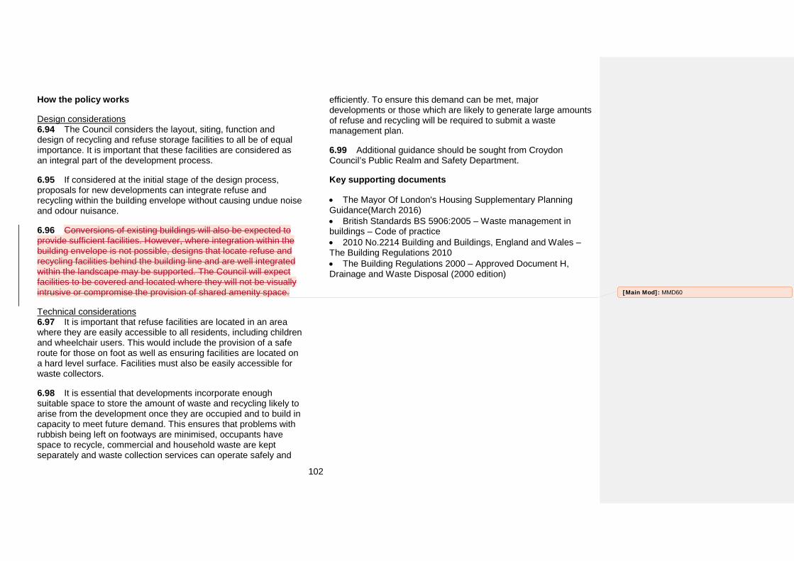
102
How the policy works
Design considerations 6.94 The Council considers the layout, siting, function and design of recycling and refuse storage facilities to all be of equal importance. It is important that these facilities are considered as an integral part of the development process.
6.95 If considered at the initial stage of the design process, proposals for new developments can integrate refuse and recycling within the building envelope without causing undue noise and odour nuisance.
6.96 Conversions of existing buildings will also be expected to provide sufficient facilities. However, where integration within the building envelope is not possible, designs that locate refuse and recycling facilities behind the building line and are well integrated within the landscape may be supported. The Council will expect facilities to be covered and located where they will not be visually intrusive or compromise the provision of shared amenity space.
Technical considerations 6.97 It is important that refuse facilities are located in an area where they are easily accessible to all residents, including children and wheelchair users. This would include the provision of a safe route for those on foot as well as ensuring facilities are located on a hard level surface. Facilities must also be easily accessible for waste collectors.
6.98 It is essential that developments incorporate enough suitable space to store the amount of waste and recycling likely to arise from the development once they are occupied and to build in capacity to meet future demand. This ensures that problems with rubbish being left on footways are minimised, occupants have space to recycle, commercial and household waste are kept separately and waste collection services can operate safely and
efficiently. To ensure this demand can be met, major developments or those which are likely to generate large amounts of refuse and recycling will be required to submit a waste management plan.
6.99 Additional guidance should be sought from Croydon Council’s Public Realm and Safety Department.
Key supporting documents
• The Mayor Of London's Housing Supplementary PlanningGuidance(March 2016) • British Standards BS 5906:2005 – Waste management inbuildings – Code of practice • 2010 No.2214 Building and Buildings, England and Wales –The Building Regulations 2010 • The Building Regulations 2000 – Approved Document H,Drainage and Waste Disposal (2000 edition)
[Main Mod]: MMD60
103
Public art
Strategic Objectives and related Croydon Local Plan strategic policies
• Strategic Objective 5
• Strategic Objective 7
• Policy SP4.5
• Policy SP4.6
Unitary Development Plan policies to be replaced by this policy
• UD16 Public Art
Why we need this policy
6.100 Despite its size there are relatively few examples of public art within the borough. The Council acknowledges the important role that public art can play in enhancing the setting of a building and creating a visually stimulating public realm and strengthening local distinctiveness.
6.101 There is a need to ensure that opportunities to incorporate public art within new developments or public realm improvements are taken and that it relates to the local character contributes to the sense of place and reinforces local distinctiveness.
6.102 The incorporation of public art offers the opportunity to work with the local community to create distinctive works that help engender a sense of ownership and strengthen the sense of place.
6.103 Croydon’s Supplementary Planning Guidance 19 provided a useful guidance for those wishing to incorporate public art within their development,. however, this document referenced ‘percent
for art’, a policy that is no longer live. This policy DM 15,refers to the Council’s Public Realm Design Guide which provides more detailed guidance.

104
Policy DM15: Public art To enhance and express local character, the Council will support the inclusion of public art and require all major17 schemes to include public art that:
a) Is integrated into proposals at an early stage of the design process;
b) Enhances and creates local distinctiveness and reinforces a sense of place;
c) Responds to local character;
d) Makes a positive contribution to the public realm; and
e) Engages the local community in its creation.
How the policy works
6.104 By considering public art during the early stages of the design process and clarifying the scope at the beginning of the pre-application process, opportunities can be taken to integrate public art into the fabric of the development itself in more imaginative ways. Public art should not be confined to statues, but can be incorporated in imaginative, simple and cost effective ways such as bespoke paving, gates, lighting, signage, street furniture, playground equipment, railings and landscaping, murals (painted or ceramic), decorative bargeboards or works of art incorporated on elevations where they will be visible to pedestrians.
6.105 The Council expects all public art to be of the highest design quality and craftsmanship and whenever possible, encourage the use of sustainable or recycled materials. When commissioning public art, developers should place equal weight on creating the right piece of work, the craftsmanship of the artist
17 Major schemes are defined as being over 0.5 hectares or residential schemes over 10 units or developments over 1000m2
and those installing the piece and the maintenance after it has been installed.
6.106 Those commissioning public art should seek additional guidance from Croydon’s Public Realm Design Guide.
Key supporting documents
• Public Realm Design Guide (2012)
105
Tall and large buildings
Strategic Objectives and related Croydon Local Plan strategic policies
• Strategic Objective 5
• Strategic Objective 7
• Policy SP4.5
• Policy SP4.6
Unitary Development Plan policies to be replaced by this policy
• None
Why we need this policy
6.107 The Council acknowledges the positive contribution that well-designed tall buildings of high architectural quality can make. If sensitively and appropriately located, these buildings can facilitate regeneration through the provision of new jobs, homes and community facilities and an attractive built environment.
6.108 The need for this policy has been identified in the borough’s Croydon Local Plan: Strategic Policies which sets out the Council’s intention to include detailed tall buildings policies within the Detailed Policies and Proposals plan. The Detailed Policies and Proposals also provide a link to the Croydon Opportunity Area Planning Framework and contain the Place-specific development management policies which identify areas suitable for tall buildings.
6.109 The borough’s Open Space Needs Assessment identified significant gaps in the provision of amenity green space, particularly in the north of the borough. To address this there is a
need to ensure tall and large residential developments are located in areas with sufficient green infrastructure or provide new green infrastructure to meet the increased demand.
6.110 London Plan Policy 7.7 refers to tall and large buildings. This policy advises boroughs to work with the Mayor to identify areas that are appropriate, sensitive or inappropriate for tall or large buildings.
6.111 The Croydon Opportunity Area Planning Framework identifies locations within the OAPF that are suitable for tall buildings. It provides guidance on indicative tall building heights, form and typologies. This approach reflects the Mayor’s aspirations for new residential development within the Croydon Opportunity Area.
6.112 The base line information used to select locations outside of the Croydon Opportunity Area included mapping of the

106
residential and non-residential character analysis and mapping, PTAL18 ratings and open space deficiency mapping.
18 Public Transport Accessibility Level – a rating of accessibility provided by Transport for London

107
Policy DM16: Tall and large buildings DM16.1 To ensure tall or large buildings respect and enhance local character, and do not harm the setting of heritage assets, proposals will be permitted where they:
a) Are located in areas identified for such buildings in Policies DM36 to DM51, in masterplans and in the Croydon Opportunity AreaPlanning Framework;
b) Are located in areas meeting a minimum Public Transport Accessibility Level (PTAL) rating of 4 with direct public transport connections tothe Croydon Opportunity Area;
c) The design should be of exceptional quality and demonstrate that a sensitive approach has been taken in the articulation andcomposition of the building form which is proportionate to its scale; and
d) The building height, footprint and design relates positively to any nearby heritage assets, and conserves or enhances the significanceand setting of the assets of the wider historic environment;
d)e) To improve the quality of and access to open space development including buildings taller than 40 storeys will need to incorporate amenity space, whether at ground level such as atria or above ground level, such as sky gardens, atriums and roof terraces, that is accessible to the public as well as residents of the development; and
e)f) To ensure tall and large buildings are well integrated with the local area, they should include at least an active ground floor and inclusive public realm.
DM16.2 To ensure tall and large buildings are well integrated with the local area, the ground and first floors should incorporate a mix of publically accessible uses and spaces.
How the policy works
6.113 Tall and large buildings have been defined as those which are significantly taller and larger; in terms of scale, mass and height than the predominant surrounding buildings, causing a significant change to the skyline.
6.114 When assessing whether a development can be considered to be tall or large, the context within which the building is situated must be taken into account. This would mean that a proposal for six storeys; in an area where predominant building heights are two storeys, would be considered to be a tall building.
[Main Mod]: MMD61
[Main Mod]: MMD62
108
In an area where an urban block19 comprises of buildings with narrow frontages, a proposal for a building with a scale that differs from this would be considered to be large.
6.115 This definition closely aligns with the Croydon Local Plan Strategic Policy SP4.5, London Plan Policy 7.25 and CABE and Historic England’s guidance which refer to tall and large buildings.
6.116 There is a need to expand the current definition of tall buildings to include large buildings. This policy will expand the definition of tall buildings to include large buildings and ensure development is sensitive to its local context.
6.117 This policy in conjunction with the Place-specific development management policies (Policies DM36 to DM51) will establish clear principles and more certainty for developers about the locations for tall and large buildings.
6.118 Proposals for tall or large buildings will need to include urban design analysis that demonstrates how they align with the Opportunity Area Planning Framework and the Fair Field, Mid Croydon, Old Town and East and West Croydon Masterplans. In locations outside of these areas proposals for tall or large buildings will be expected to demonstrate that they will not cause unacceptable harm to the character of the surrounding area and to the wider setting of heritage assets and meet all policy requirements, including those relating to tall buildings.
6.119 Proposals for tall or large developments within sensitive locations20 will be expected to demonstrate that it meets the requirements of the London Plan Policies 7.6 and 7.7.
19 An urban block is a rectangular area in a city surrounded by streets and usually containing several buildings.
6.120 Paragraph 6.23 of the Croydon Opportunity Area Framework outlines the importance of creating slender tall buildings in locations were the proposed building will be taller than the predominant surrounding development heights. This criterion will help to minimise the impact that the proposed building will have upon the setting and character in terms of microclimate, overshadowing and wind turbulence. This criterion is equally applicable in locations outside of the Croydon Opportunity Area (as listed in the Places of Croydon Policies DM36 to DM51) where opportunities for tall or large buildings may be available.
6.121 Due to their size and scale and the increased densities arising from tall buildings, their impact on surroundings are greater than those of more conventionally sized buildings. Tall and large buildings, in areas such as the Metropolitan Centre that have been identified for growth, will place additional pressure on existing resources such as community facilities and public space. There is an opportunity to address the shortage of space by incorporating high quality public amenity spaces such as sky gardens, atrium spaces and roof terraces in tall buildings. To ensure that these buildings address current and future need for amenity space provision full public access to these spaces will be supported. The Council will work with developers to secure legal agreements for this type of amenity space provision.
6.122 The design quality of the top of tall buildings is equally as important as the base. A base with a design that has been carefully considered can have a significant impact on the streetscape, local views and how the building physically and visually integrates with the street and the spaces surrounding it. To ensure a tall building is well integrated within its immediate local area it should incorporate active and publically accessible
20 Sensitive locations, include sites close to heritage assets, residential amenity spaces, schools, or where topography changes would result in the development crowding or blocking designated views or viewing corridors.,
109
ground and first floors and a stimulating and inclusive public realm. To make the public realm around the building feel safe and attractive for pedestrians, the façade should be transparent with have sufficient openings to assist overlooking and passive supervision.
Key supporting documents
• Croydon Opportunity Area Planning Framework (2013)• East Croydon Masterplan (2011)• West Croydon Masterplan (2011)• Mid Croydon Masterplan (2012)• Infrastructure Delivery Plan (annually updated)• Borough Character Appraisal (2015)• Character Typology (2015)
[Main Mod]: MMD63
110
Promoting Healthy Communities
Strategic Objectives and related Croydon Local Plan strategic policies
• Strategic Objective 4
• Strategic Objective 6
• Strategic Objective 7
• SP5.2
• SP5.4
Unitary Development Plan policies to be replaced by this policy
• None
Why we need this policy
6.123 The links between planning and health are well established. Chapter 8 of the National Planning Policy Framework sets out the role of the planning system in promoting healthy communities, facilitating social interaction and creating healthy and inclusive places. The National Planning Practice Guidance recommends that health and wellbeing and health infrastructure are considered in Local Plan and planning decisions.
6.124 Policy 3.2 of the London Plan Improving health and addressing health inequalities states that boroughs should work with key partners to identify and address significant health issues facing their areas and that new developments should be designed, constructed and managed in ways that improve health and
promote healthy lifestyles to help reduce health inequalities. It recommends that Health Impact Assessments are used to consider the impact of major developments on health and wellbeing of communities.
6.125 SP5.2 of the Croydon Local Plan: Strategic Policies sets out the Council will work in partnership with health authorities to improve health in Croydon and will ensure new developments provide opportunity for healthy living.
6.126 Croydon, like many places, has a number of health inequalities. These health inequalities can be addressed by ensuring the planning system and new developments are
111
considering health and wellbeing. This will allow local communities to lead healthy lifestyles and adopt healthy behaviours through living quality homes, participating in physical activity and have access to quality open spaces.
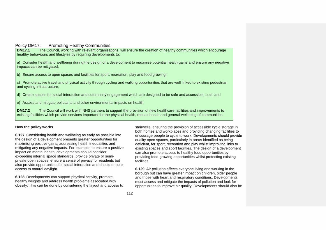
112
Policy DM17: Promoting Healthy Communities DM17.1 The Council, working with relevant organisations, will ensure the creation of healthy communities which encourage healthy behaviours and lifestyles by requiring developments to:
a) Consider health and wellbeing during the design of a development to maximise potential health gains and ensure any negativeimpacts can be mitigated;
b) Ensure access to open spaces and facilities for sport, recreation, play and food growing;
c) Promote active travel and physical activity through cycling and walking opportunities that are well linked to existing pedestrianand cycling infrastructure;
d) Create spaces for social interaction and community engagement which are designed to be safe and accessible to all; and
e) Assess and mitigate pollutants and other environmental impacts on health.
DM17.2 The Council will work with NHS partners to support the provision of new healthcare facilities and improvements to existing facilities which provide services important for the physical health, mental health and general wellbeing of communities.
How the policy works
6.127 Considering health and wellbeing as early as possible into the design of a development presents greater opportunities for maximising positive gains, addressing health inequalities and mitigating any negative impacts. For example, to ensure a positive impact on mental health, developments should consider exceeding internal space standards, provide private or semi-private open spaces, ensure a sense of privacy for residents but also provide opportunities for social interaction and should ensure access to natural daylight.
6.128 Developments can support physical activity, promote healthy weights and address health problems associated with obesity. This can be done by considering the layout and access to
stairwells, ensuring the provision of accessible cycle storage in both homes and workplaces and providing changing facilities to encourage people to cycle to work. Developments should provide quality open spaces, particularly in areas identified as being deficient, for sport, recreation and play whilst improving links to existing spaces and sport facilities. The design of a development can also promote access to healthy food opportunities by providing food growing opportunities whilst protecting existing facilities.
6.129 Air pollution affects everyone living and working in the borough but can have greater impact on children, older people and those with heart and respiratory conditions. Developments must assess and mitigate the impacts of pollution and look for opportunities to improve air quality. Developments should also be
113
designed to be energy efficient and well insulated to ensure residents are able to live in warm homes and are protected against noise pollution
6.130 Health Impact Assessments are a tool which can be used to assess the impact of development proposals on health and wellbeing. They should be used to set out how health and wellbeing have been considered during the design of a development, how positive impacts have been maximised and how any negative impacts have been mitigated, particularly where developments are located in the borough’s most deprived wards. Health Impact Assessments should be undertaken as early in the process as possible to ensure the assessment is meaningful and can involve engagement from Croydon Public Health and NHS partners.
6.131 New development in the borough needs to be supported by health and social infrastructure to ensure communities have access to facilities and services they require at every stage of their lives. Facilities should be accessible to all and should be easily reached by walking, cycling or public transport. The Council will continue to work with NHS partners to identify requirements for new facilities to meet the need arising from the borough’s growing population. It will support improvements to existing facilities and will also work with NHS partners to identify opportunities for facilities to come forward as part of mixed-use schemes, particularly where there is an identified need. The impact of developments on existing healthcare facilities should be considered through a Health Impact Assessment.
Key supporting documents
• The Mayor of London’s Social Infrastructure SPG (2015)
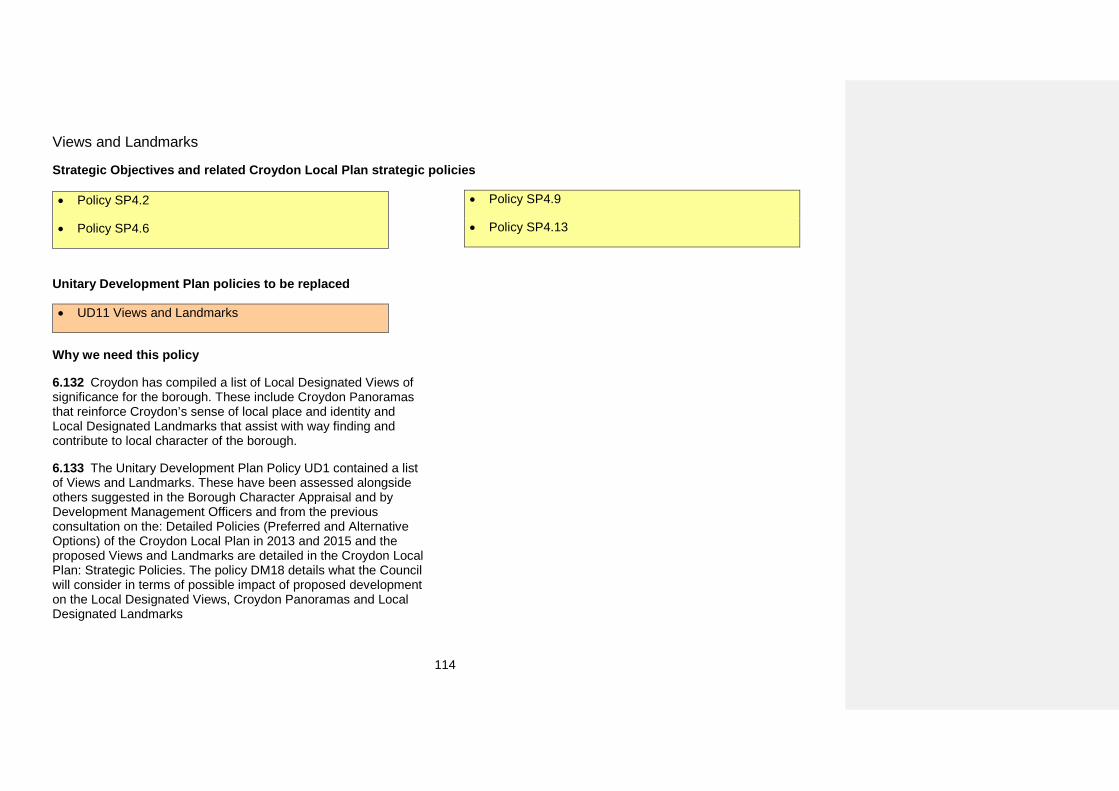
114
Views and Landmarks
Strategic Objectives and related Croydon Local Plan strategic policies
• Policy SP4.2
• Policy SP4.6
• Policy SP4.9
• Policy SP4.13
Unitary Development Plan policies to be replaced
• UD11 Views and Landmarks
Why we need this policy
6.132 Croydon has compiled a list of Local Designated Views of significance for the borough. These include Croydon Panoramas that reinforce Croydon’s sense of local place and identity and Local Designated Landmarks that assist with way finding and contribute to local character of the borough.
6.133 The Unitary Development Plan Policy UD1 contained a list of Views and Landmarks. These have been assessed alongside others suggested in the Borough Character Appraisal and by Development Management Officers and from the previous consultation on the: Detailed Policies (Preferred and Alternative Options) of the Croydon Local Plan in 2013 and 2015 and the proposed Views and Landmarks are detailed in the Croydon Local Plan: Strategic Policies. The policy DM18 details what the Council will consider in terms of possible impact of proposed development on the Local Designated Views, Croydon Panoramas and Local Designated Landmarks
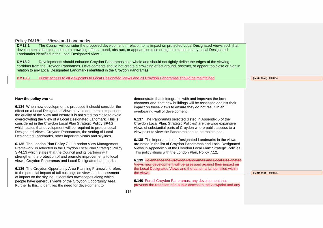
115
Policy DM18: Views and Landmarks DM18.1 The Council will consider the proposed development in relation to its impact on protected Local Designated Views such that developments should not create a crowding effect around, obstruct, or appear too close or high in relation to any Local Designated Landmarks identified in the Local Designated View.
DM18.2 Developments should enhance Croydon Panoramas as a whole and should not tightly define the edges of the viewing corridors from the Croydon Panoramas. Developments should not create a crowding effect around, obstruct, or appear too close or high in relation to any Local Designated Landmarks identified in the Croydon Panoramas.
DM18.3 Public access to all viewpoints to Local Designated Views and all Croydon Panoramas should be maintained
How the policy works
6.134 When new development is proposed it should consider the effect on a Local Designated View to avoid detrimental impact on the quality of the View and ensure it is not sited too close to avoid overcrowding the View of a Local Designated Landmark. This is considered in the Croydon Local Plan Strategic Policy SP4.2 which states that development will be required to protect Local Designated Views, Croydon Panoramas, the setting of Local Designated Landmarks, other important vistas and skylines.
6.135 The London Plan Policy 7.11 ‘London View Management Framework’ is reflected in the Croydon Local Plan Strategic Policy SP4.13 which states that the Council and its partners will strengthen the protection of and promote improvements to local views, Croydon Panoramas and Local Designated Landmarks.
6.136 The Croydon Opportunity Area Planning Framework refers to the potential impact of tall buildings on views and assessment of impact on the skyline. It identifies townscapes along which people have generous views of the Croydon Opportunity Area. Further to this, it identifies the need for development to
demonstrate that it integrates with and improves the local character and, that new buildings will be assessed against their impact on these views to ensure they do not result in an overbearing wall of development.
6.137 The Panoramas selected (listed in Appendix 5 of the Croydon Local Plan: Strategic Policies) are the wide expansive views of substantial parts of Croydon where public access to a view point to view the Panorama should be maintained.
6.138 The important Local Designated Landmarks in the views are noted in the list of Croydon Panoramas and Local Designated Views in Appendix 5 of the Croydon Local Plan: Strategic Policies. This policy aligns with the London Plan, Policy 7.12.
6.139 To enhance the Croydon Panoramas and Local Designated Views new development will be assessed against their impact on the Local Designated Views and the Landmarks identified within the views.
6.140 For all Croydon Panoramas, any development that prevents the retention of a public access to the viewpoint and any
[Main Mod]: MMD64
[Main Mod]: MMD65
116
development that does not comply with this policy in relation to the Local Designated Landmarks will be considered intrusive and unacceptable. Elevations of the proposed development seen from the viewpoint of the Croydon Panorama will be required as part of an assessment of impact of new development on these views.
Key supporting documents
• Borough Character Appraisal (2015)• Croydon Opportunity Area Planning Framework (2013)
[Main Mod]: MMD66
117
Heritage assets and conservation
Strategic Objectives and related Croydon Local Plan strategic policies
• Strategic Objective 5
• Strategic Objective 7
• Policy SP1
• Policy SP2.2
• Policy SP4.1
• Policy SP4.12
• Policy SP4.13
Unitary Development Plan policies to be replaced
• UC2 Control of Demolition on Conservation Areas
• UC3 Development Proposals in Conservation Areas
• UC4 Changes of Use in Conservation Areas
• UC5 Local Areas of Special Character
• UC8 Use of Listed Buildings
• UC9 Buildings on the Local List
• UC10 Historic Parks and Gardens
• UC11 Development Proposals on ArchaeologicalSites
• UC13 Preserving Locally Important Remains
• UC14 Enabling Development
Why we need this policy
6.141 Croydon has a rich and varied heritage that provides depth of character to the borough’s environment. The historic environment contributes to local character and distinctiveness and enables an understanding of the pattern of historic development of an area. In order to maintain the borough’s character it is vital that heritage assets are protected and sensitively adapted and that
their setting is not harmed. The historic environment is a finite resource and, once lost, cannot be replaced.
6.142 The Council recognises the value of the historic environment, especially in relation to the positive contribution it can make to creating and maintaining sustainable communities, and considers it to be important to conserve the valued components of the borough’s historic environment for the future. This view is supported by the National Planning Policy Framework
118
(Chapter 12), the London Plan (Chapter 7) and the strategic objectives and policies of the Croydon Local Plan. The strategic policies state that ‘Croydon needs to ensure protection of its heritage assets and their settings, to retain local distinctiveness and character’. This is particularly important given the context of the significant change that Croydon, in particular the Croydon Opportunity Area, has seen in the last century and is likely to continue to experience. The Council also supports the principles of heritage-led regeneration.
6.143 This policy seeks to improve the protection afforded to heritage assets in the borough. Heritage assets are the valued elements of the historic environment and make an important contribution to the quality of the borough’s architectural, historic and townscape character. A heritage asset is a building, monument, site, place, area or landscape identified as having a degree of significance meriting consideration in planning decisions, because of its heritage interest. Heritage assets can be identified in various ways, for example through statutory designation as heritage assets of national significance, such as Listed Buildings, Conservation Areas, Scheduled Monuments, and Registered Historic Parks and Gardens, or through designation by the Local Planning Authority, which includes Locally Listed Buildings, Local Heritage Areas and Locally Listed Historic Parks and Gardens. Heritage assets can also be identified through area assessments, master planning or during the planning process itself.
6.144 Through the planning process the Council will consider the significance of all sites and areas identified as having heritage significance. The Council will monitor proposed removals and additions to the established lists of heritage assets as and when appropriate. The Council will continue to make information relating to heritage assets available to view on the Croydon Council website.
6.145 The special character of a heritage asset is the principle reason for why the asset is considered to have a degree of significance. It is usually defined by its architectural character or other distinguishing features, for example landscape features, historic importance, or, in the case of an historic area, the distinctive character of the area as a wholeHeritage assets may be nationally or locally designated, or undesignated: the reason for their being identified is their special interest. This may be historic, architectural, artistic, or archaeological and these are the attributes that make up their unique quality or significance.
6.146 The setting of a heritage asset is defined in the glossary of the National Planning Policy Framework as ‘the surroundings in which a heritage asset is experienced. Its extent is not fixed and may change as the asset and its surroundings evolve.’
6.147 This policy addresses detailed issues that relate to the detailed application of Croydon Local Plan: Strategic Policies to heritage assets in the borough and fulfils the aim outlined in strategic Policy SP4 to strengthen the protection afforded to heritage assets in the borough.
6.148 The National Planning Policy Framework paragraph 126 states that ‘local planning authorities should set out in their Local Plan a positive strategy for the conservation and enjoyment of the historic environment’.
6.149 The London Plan Policy 7.8G states that boroughs should ‘include appropriate policies in their LDFs for identifying, protecting, enhancing and improving access to the historic environment and heritage assets and their settings where appropriate, and to archaeological assets, memorials and historic and natural landscape character within their area’.
6.150 The Croydon Local Plan: Strategic Policies provides general policies SP4.11 to SP4.15 that relate to the historic
[Main Mod]: MMD67
119
environment. However, there is a need to provide detailed policy on specific issues in order to provide additional policy protection to
the borough’s heritage assets and to enable the Council to meet its statutory duties.
Policy DM19: Heritage assets and conservation DM19.1 To preserve and enhance the character, appearance and setting of heritage assets within the borough, the Council will determine all development proposals that affect heritage assets in accordance with the following:
a) Development affecting heritage assets will only be permitted if their significance is preserved or enhanced;
b) Proposals for development will only be permitted if they enhance the setting of the heritage asset affected or have no adverse impact onthe existing setting;
c) Proposals for changes of use should retain the significance of a building and will be supported only if they are necessary to keep thebuilding in active use; and
d) Where there is evidence of intentional damage or deliberate neglect to a heritage asset, its current condition will not be taken intoaccount in the decision-making process; and.
e) Proposals for enabling development must have public benefits that outweigh the detriment of departing from other planning policies andthe proposed development must be the minimum necessary to secure the heritage asset’s long-term future.
DM19.2 Applications for development proposals that affect heritage assets or their setting must demonstrate:
a) How particular attention has been paid to scale, height, massing, historic building lines, the pattern of historic development, use, design,detailing and materials;
b) That it is of a high quality design that integrates with and makes a positive contribution to the historic environment; and
c) How the integrity and significance of any retained fabric is preserved.
DM19.3 To preserve and enhance Listed Buildings, Scheduled Monuments and Registered Parks and Gardens within the borough, the Council will determine all development proposals that affect these heritage assets in accordance with the following:
a) Substantial harm to or loss of a Grade II Listed Building or Registered Park and Garden should be exceptional;
b) Substantial harm to or loss of a Grade I or II* Listed Building or a Scheduled Monument should be wholly exceptional; and
[Main Mod]: MMD68
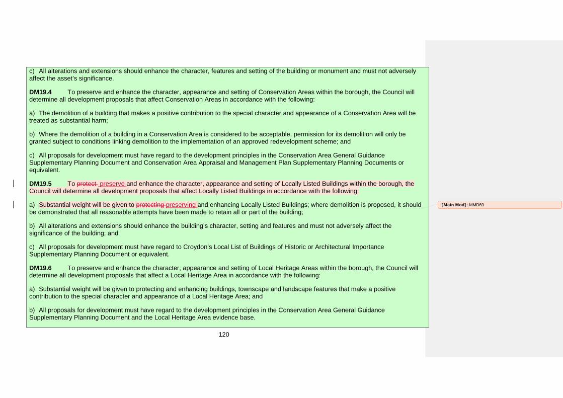
120
c) All alterations and extensions should enhance the character, features and setting of the building or monument and must not adverselyaffect the asset’s significance.
DM19.4 To preserve and enhance the character, appearance and setting of Conservation Areas within the borough, the Council will determine all development proposals that affect Conservation Areas in accordance with the following:
a) The demolition of a building that makes a positive contribution to the special character and appearance of a Conservation Area will betreated as substantial harm;
b) Where the demolition of a building in a Conservation Area is considered to be acceptable, permission for its demolition will only begranted subject to conditions linking demolition to the implementation of an approved redevelopment scheme; and
c) All proposals for development must have regard to the development principles in the Conservation Area General GuidanceSupplementary Planning Document and Conservation Area Appraisal and Management Plan Supplementary Planning Documents or equivalent.
DM19.5 To protect preserve and enhance the character, appearance and setting of Locally Listed Buildings within the borough, the Council will determine all development proposals that affect Locally Listed Buildings in accordance with the following:
a) Substantial weight will be given to protecting preserving and enhancing Locally Listed Buildings; where demolition is proposed, it shouldbe demonstrated that all reasonable attempts have been made to retain all or part of the building;
b) All alterations and extensions should enhance the building’s character, setting and features and must not adversely affect thesignificance of the building; and
c) All proposals for development must have regard to Croydon’s Local List of Buildings of Historic or Architectural ImportanceSupplementary Planning Document or equivalent.
DM19.6 To preserve and enhance the character, appearance and setting of Local Heritage Areas within the borough, the Council will determine all development proposals that affect a Local Heritage Area in accordance with the following:
a) Substantial weight will be given to protecting and enhancing buildings, townscape and landscape features that make a positivecontribution to the special character and appearance of a Local Heritage Area; and
b) All proposals for development must have regard to the development principles in the Conservation Area General GuidanceSupplementary Planning Document and the Local Heritage Area evidence base.
[Main Mod]: MMD69
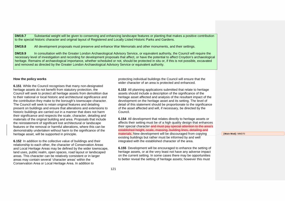
121
DM19.7 Substantial weight will be given to conserving and enhancing landscape features or planting that makes a positive contribution to the special historic character and original layout of Registered and Locally Listed Historic Parks and Gardens.
DM19.8 All development proposals must preserve and enhance War Memorials and other monuments, and their settings.
DM19.9 In consultation with the Greater London Archaeological Advisory Service, or equivalent authority, the Council will require the necessary level of investigation and recording for development proposals that affect, or have the potential to affect Croydon’s archaeological heritage. Remains of archaeological importance, whether scheduled or not, should be protected in situ or, if this is not possible, excavated and removed as directed by the Greater London Archaeological Advisory Service or equivalent authority.
How the policy works
6.151 While the Council recognises that many non-designated heritage assets do not benefit from statutory protection, the Council will seek to protect all heritage assets from demolition due to their national or local historic and architectural significance and the contribution they make to the borough’s townscape character. The Council will seek to retain original features and detailing present on buildings and ensure that alterations and extensions to historic buildings are carried out in a manner that does not harm their significance and respects the scale, character, detailing and materials of the original building and area. Proposals that include the reinstatement of significant lost architectural or landscape features or the removal or harmful alterations, where this can be demonstrably undertaken without harm to the significance of the heritage asset, will be supported in principle.
6.152 In addition to the collective value of buildings and their relationship to each other, the character of Conservation Areas and Local Heritage Areas may be defined by the wider townscape, land uses, public realm, open spaces, road layout or landscaped areas. This character can be relatively consistent or in larger areas may contain several ‘character areas’ within the Conservation Area or Local Heritage Area. In addition to
protecting individual buildings the Council will ensure that the wider character of an area is protected and enhanced.
6.153 All planning applications submitted that relate to heritage assets should include a description of the significance of the heritage asset affected and analysis of the resultant impact of the development on the heritage asset and its setting. The level of detail of this statement should be proportionate to the significance of the asset affected and will, if necessary, be directed by the Council.
6.154 All development that relates directly to heritage assets or affects their setting must be of a high quality design that enhances their special character and must pay special attention to the area’s established height, scale, massing, building lines, detailing and materials. New development will be discouraged from copying existing buildings but rather must be informed by and well integrated with the established character of the area.
6.155 Development will be encouraged to enhance the setting of heritage assets, or at the very least not have any adverse impact on the current setting. In some cases there may be opportunities to better reveal the setting of heritage assets; however this must
[Main Mod]: MMD70
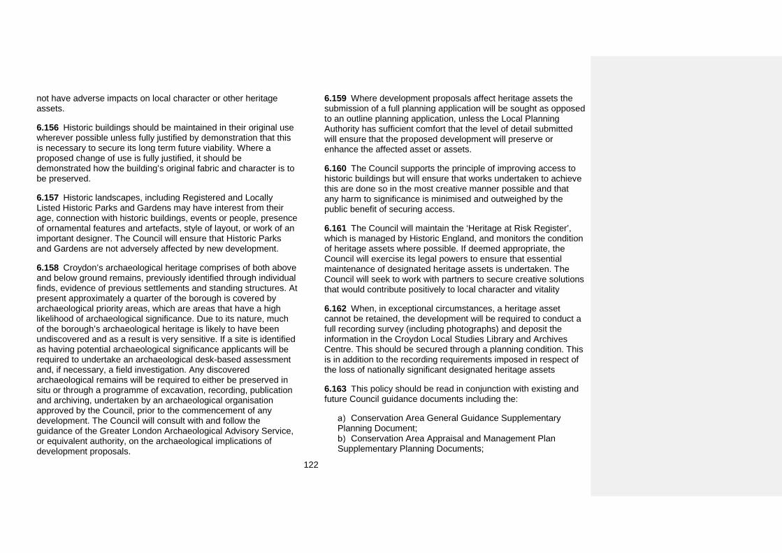
122
not have adverse impacts on local character or other heritage assets.
6.156 Historic buildings should be maintained in their original use wherever possible unless fully justified by demonstration that this is necessary to secure its long term future viability. Where a proposed change of use is fully justified, it should be demonstrated how the building’s original fabric and character is to be preserved.
6.157 Historic landscapes, including Registered and Locally Listed Historic Parks and Gardens may have interest from their age, connection with historic buildings, events or people, presence of ornamental features and artefacts, style of layout, or work of an important designer. The Council will ensure that Historic Parks and Gardens are not adversely affected by new development.
6.158 Croydon’s archaeological heritage comprises of both above and below ground remains, previously identified through individual finds, evidence of previous settlements and standing structures. At present approximately a quarter of the borough is covered by archaeological priority areas, which are areas that have a high likelihood of archaeological significance. Due to its nature, much of the borough’s archaeological heritage is likely to have been undiscovered and as a result is very sensitive. If a site is identified as having potential archaeological significance applicants will be required to undertake an archaeological desk-based assessment and, if necessary, a field investigation. Any discovered archaeological remains will be required to either be preserved in situ or through a programme of excavation, recording, publication and archiving, undertaken by an archaeological organisation approved by the Council, prior to the commencement of any development. The Council will consult with and follow the guidance of the Greater London Archaeological Advisory Service, or equivalent authority, on the archaeological implications of development proposals.
6.159 Where development proposals affect heritage assets the submission of a full planning application will be sought as opposed to an outline planning application, unless the Local Planning Authority has sufficient comfort that the level of detail submitted will ensure that the proposed development will preserve or enhance the affected asset or assets.
6.160 The Council supports the principle of improving access to historic buildings but will ensure that works undertaken to achieve this are done so in the most creative manner possible and that any harm to significance is minimised and outweighed by the public benefit of securing access.
6.161 The Council will maintain the ‘Heritage at Risk Register’, which is managed by Historic England, and monitors the condition of heritage assets where possible. If deemed appropriate, the Council will exercise its legal powers to ensure that essential maintenance of designated heritage assets is undertaken. The Council will seek to work with partners to secure creative solutions that would contribute positively to local character and vitality
6.162 When, in exceptional circumstances, a heritage asset cannot be retained, the development will be required to conduct a full recording survey (including photographs) and deposit the information in the Croydon Local Studies Library and Archives Centre. This should be secured through a planning condition. This is in addition to the recording requirements imposed in respect of the loss of nationally significant designated heritage assets
6.163 This policy should be read in conjunction with existing and future Council guidance documents including the:
Conservation Area General Guidance Supplementary Planning Document;
Conservation Area Appraisal and Management Plan Supplementary Planning Documents;
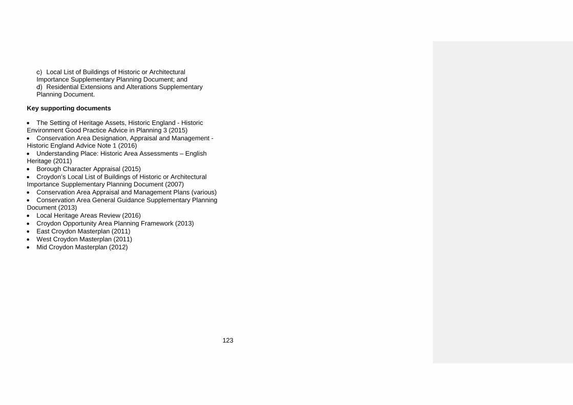
123
Local List of Buildings of Historic or Architectural Importance Supplementary Planning Document; and
Residential Extensions and Alterations Supplementary Planning Document.
Key supporting documents
• The Setting of Heritage Assets, Historic England - HistoricEnvironment Good Practice Advice in Planning 3 (2015) • Conservation Area Designation, Appraisal and Management -Historic England Advice Note 1 (2016) • Understanding Place: Historic Area Assessments – EnglishHeritage (2011) • Borough Character Appraisal (2015)• Croydon’s Local List of Buildings of Historic or ArchitecturalImportance Supplementary Planning Document (2007) • Conservation Area Appraisal and Management Plans (various)• Conservation Area General Guidance Supplementary PlanningDocument (2013) • Local Heritage Areas Review (2016)• Croydon Opportunity Area Planning Framework (2013)• East Croydon Masterplan (2011)• West Croydon Masterplan (2011)• Mid Croydon Masterplan (2012)
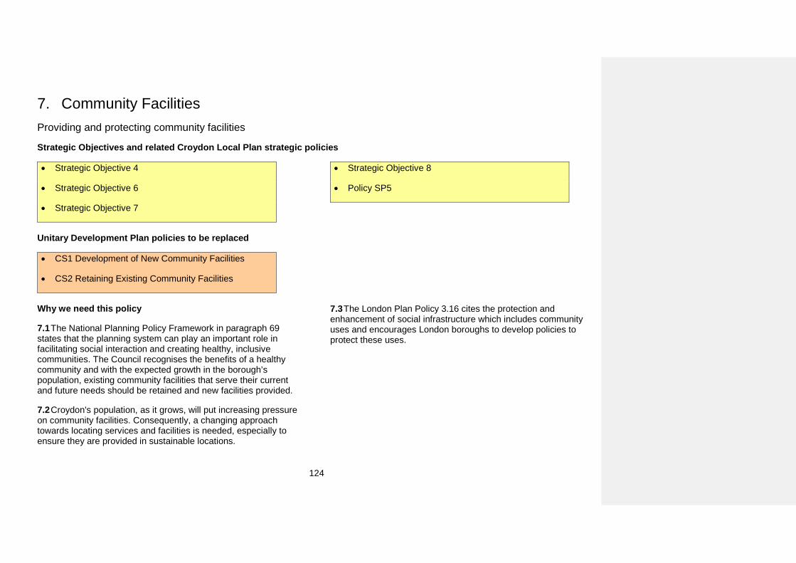
124
7. Community FacilitiesProviding and protecting community facilities
Strategic Objectives and related Croydon Local Plan strategic policies
• Strategic Objective 4
• Strategic Objective 6
• Strategic Objective 7
• Strategic Objective 8
• Policy SP5
Unitary Development Plan policies to be replaced
• CS1 Development of New Community Facilities
• CS2 Retaining Existing Community Facilities
Why we need this policy
7.1 The National Planning Policy Framework in paragraph 69 states that the planning system can play an important role in facilitating social interaction and creating healthy, inclusive communities. The Council recognises the benefits of a healthy community and with the expected growth in the borough’s population, existing community facilities that serve their current and future needs should be retained and new facilities provided.
7.2 Croydon's population, as it grows, will put increasing pressure on community facilities. Consequently, a changing approach towards locating services and facilities is needed, especially to ensure they are provided in sustainable locations.
7.3 The London Plan Policy 3.16 cites the protection and enhancement of social infrastructure which includes community uses and encourages London boroughs to develop policies to protect these uses.
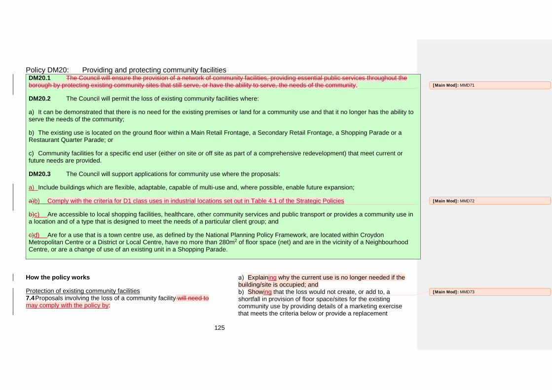
125
Policy DM20: Providing and protecting community facilities DM20.1 The Council will ensure the provision of a network of community facilities, providing essential public services throughout the borough by protecting existing community sites that still serve, or have the ability to serve, the needs of the community.
DM20.2 The Council will permit the loss of existing community facilities where:
a) It can be demonstrated that there is no need for the existing premises or land for a community use and that it no longer has the ability toserve the needs of the community;
b) The existing use is located on the ground floor within a Main Retail Frontage, a Secondary Retail Frontage, a Shopping Parade or aRestaurant Quarter Parade; or
c) Community facilities for a specific end user (either on site or off site as part of a comprehensive redevelopment) that meet current orfuture needs are provided.
DM20.3 The Council will support applications for community use where the proposals:
a) Include buildings which are flexible, adaptable, capable of multi-use and, where possible, enable future expansion;
a)b) Comply with the criteria for D1 class uses in industrial locations set out in Table 4.1 of the Strategic Policies
b)c) Are accessible to local shopping facilities, healthcare, other community services and public transport or provides a community use in a location and of a type that is designed to meet the needs of a particular client group; and
c)d) Are for a use that is a town centre use, as defined by the National Planning Policy Framework, are located within Croydon Metropolitan Centre or a District or Local Centre, have no more than 280m2 of floor space (net) and are in the vicinity of a Neighbourhood Centre, or are a change of use of an existing unit in a Shopping Parade.
How the policy works
Protection of existing community facilities 7.4 Proposals involving the loss of a community facility will need to may comply with the policy by:
Explaining why the current use is no longer needed if the building/site is occupied; and
Showing that the loss would not create, or add to, a shortfall in provision of floor space/sites for the existing community use by providing details of a marketing exercise that meets the criteria below or provide a replacement
[Main Mod]: MMD71
[Main Mod]: MMD72
[Main Mod]: MMD73
126
community facility for a specific end user either on site as part of a mixed use development or elsewhere on a site with no current community use.
7.5 7.6 The marketing exercise associated with this policy evidence should be for a minimum period of eighteen months. Space should be offered at a reasonable charge for community groups/voluntary sector organisations reflecting its existing use value unfettered by any hope value. In the event that a community facility is listed on the Assets of Community Value register and is offered for sale, the local community is given six months to prepare a bid to buy it. In such circumstances the marketing statement could be reduced to a period of a minimum continuous period of twelve months in addition to the six months that the community has to prepare a bid to buy it.
7.6 7.5 ExceptionsDevelopments subject to this policy may include proposals involving the loss of an existing profit-making community use (such as a private gym or cinema) which would require . These could submit evidence to be submitted to demonstrate that the existing community use is not financially viable and so no longer has the ability to serve the needs of the community. This evidence will be assessed on behalf of the Council by an independent RICS valuer (paid for by the applicant).
7.7 In cases where a community use ceases it has to be successfully demonstrated that there is no local need or demand for alternative community uses.
7.8 Policy DM20.2(b) disapplies Tthe protection of community facilities will not apply to from Main Retail Frontages, Secondary Retail Frontages, Shopping Parades and Restaurant Quarter Parades as these are locations where Class A uses are the preferred uses. Policies DM5, DM7 and DM8 permit the extension and change of use of units in these designations (with the exception that change of use is not permitted in Main Retail
Frontages).In order to allow any unit converted to a community use in one of these location to revert to a Class A use the protection of community use does not apply within one of these designations .As Policies DM4, DM6 and DM7 permit the change of use of units in these designations to a community use there should be a supply of units within the same area to replace a lost community use if needed.
Proposals for new community facilities 7.9 The use of a building and the needs of communities can change over time. Therefore, new community facilities should be designed to be flexible and adaptable to changing circumstances including being capable of multi-use and expansion.
7.10 New community facilities should be located so that they are close to schools, local shopping facilities and public transport and other community services to reduce the number of trips people need to make to access them. However, it is acknowledged that there may be circumstances where the needs of a particular group or client base mean that it that it does not need to be located close to other services. In such instances applications would need to be supported with information demonstrating how the lack of access to other services will not have a negative impact on the end users of the new community facility and the amenity of the surrounding area.
[Main Mod]: MMD74
[Main Mod]: MMD75
[Main Mod]: MMD76
127
Supporting Selhurst Park as the home stadium of Crystal Palace Football Club
Strategic Objectives and related Croydon Local Plan strategic policies
• Strategic Objective 1
Unitary Development Plan policies to be replaced
• RO16 Selhurst Park
Why we need this policy
7.11 Selhurst Park has been home to Crystal Palace Football Club since 1924.
7.12 The Council recognises the existing role that CPFC has in the community identifying it as a large scale community and
leisure facility that continues to make a significant contribution to local area regeneration, creating opportunities for people to share a sense of pride in where they live, as well as delivering initiatives that support community cohesion and facilitate greater social inclusion.
Policy DM21: Supporting Selhurst Park as the home stadium of Crystal Palace Football Club The Council will continue to support Selhurst Park as the home stadium of Crystal Palace Football Club and ensure that any redevelopment would enhance the club’s position with a football stadium which makes a significant contribution to the Borough
How the policy works
7.13 The presence of a major Football Club within Croydon brings many economic, social and cultural benefits. It is therefore important to protect the facilities that are considered necessary for the retention of such a club.
7.14 London Plan policy 4.6 provides support for the continued success of professional sporting enterprises and the cultural, social and economic benefits that they offer to residents, workers and visitors.
128
Protecting Public Houses
Strategic Objectives and related Croydon Local Plan strategic policies
• Strategic Objective 6
• Policy SP5
Unitary Development Plan policies to be replaced
• CS1 Development of New Community Facilities
• CS2 Retaining Existing Community Facilities
Why we need this policy
7.15 The National Planning Policy Framework in paragraph 69 states that the planning system can play an important role in facilitating social interaction and creating healthy, inclusive communities. The loss of public houses over recent years has increased due to rising property values. The importance of public houses as a community asset has been acknowledged through the National Planning Policy Framework which requires local authorities to ‘plan positively’ for such uses. There is also a body of evidence produced by organisations such as CAMRA (The Campaign for Real Ale), the All Party Parliamentary Beer Group and the Institute for Public Policy Research which also supports this view.
7.16 The Institute of Public Policy Research’s ‘The Social Value of Community Pubs’ details the social and community importance of public houses and their importance as hubs for development of social networks. It notes the significant long term consequences and associated costs for communities with a lack of social infrastructure which can support the wellbeing of individuals and communities. In May 2013 CAMRA advised that public house losses had been running at 26 per week in the six months to March 2013.
7.17 The London Plan Policy 3.16 cites the protection and enhancement of social infrastructure which can include public houses and encourages London boroughs to develop policies to protect public houses as a community asset.
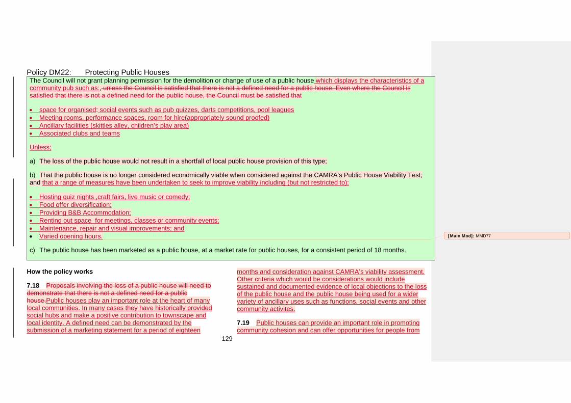
129
Policy DM22: Protecting Public Houses The Council will not grant planning permission for the demolition or change of use of a public house which displays the characteristics of a community pub such as:, unless the Council is satisfied that there is not a defined need for a public house. Even where the Council is satisfied that there is not a defined need for the public house, the Council must be satisfied that
• space for organised: social events such as pub quizzes, darts competitions, pool leagues• Meeting rooms, performance spaces, room for hire(appropriately sound proofed)• Ancillary facilities (skittles alley, children’s play area)• Associated clubs and teams
Unless;
a) The loss of the public house would not result in a shortfall of local public house provision of this type;
b) That the public house is no longer considered economically viable when considered against the CAMRA’s Public House Viability Test;and that a range of measures have been undertaken to seek to improve viability including (but not restricted to):
• Hosting quiz nights ,craft fairs, live music or comedy;• Food offer diversification;• Providing B&B Accommodation;• Renting out space for meetings, classes or community events;• Maintenance, repair and visual improvements; and• Varied opening hours.
c) The public house has been marketed as a public house, at a market rate for public houses, for a consistent period of 18 months.
How the policy works
7.18 Proposals involving the loss of a public house will need to demonstrate that there is not a defined need for a public house.Public houses play an important role at the heart of many local communities. In many cases they have historically provided social hubs and make a positive contribution to townscape and local identity. A defined need can be demonstrated by the submission of a marketing statement for a period of eighteen
months and consideration against CAMRA’s viability assessment. Other criteria which would be considerations would include sustained and documented evidence of local objections to the loss of the public house and the public house being used for a wider variety of ancillary uses such as functions, social events and other community activites.
7.19 Public houses can provide an important role in promoting community cohesion and can offer opportunities for people from
[Main Mod]: MMD77
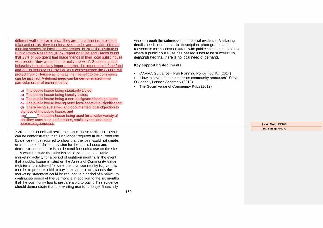
130
different walks of like to mix. They are more than just a place to relax and drinks; they can host evets, clubs and provide informal meeting spaces for local interest groups. In 2012 the Institute of Public Policy Research (IPPR) report on Pubs and Places found that 23% of pub goers had made friends in their local public house with people “they would not normally mix with”. Supporting such industries is particularly important given the importance of the food and drinks industry to Croydon. As a consequence the Council will protect Public Houses as long as their benefit to the community can be justified. A defined need can be demonstrated in no particular order of preference by:
The public house being statutorily Listed; The public house being Locally Listed; The public house being a non-designated heritage asset; The public house having other local contextual significance; There being sustained and documented local objection to
the loss of the public house; and The public house being used for a wider variety of
ancillary uses such as functions, social events and other community activities.
7.20 The Council will resist the loss of these facilities unless it can be demonstrated that is no longer required in its current use. Evidence will be required to show that the loss would not create, or add to, a shortfall in provision for the public house and demonstrate that there is no demand for such a use on the site. This would include the submission of evidence of suitable marketing activity for a period of eighteen months. In the event that a public house is listed on the Assets of Community Value register and is offered for sale, the local community is given six months to prepare a bid to buy it. In such circumstances the marketing statement could be reduced to a period of a minimum continuous period of twelve months in addition to the six months that the community has to prepare a bid to buy it. This evidence should demonstrate that the existing use is no longer financially
viable through the submission of financial evidence. Marketing details need to include a site description, photographs and reasonable terms commensurate with public house use. In cases where a public house use has ceased it has to be successfully demonstrated that there is no local need or demand.
Key supporting documents
• CAMRA Guidance – Pub Planning Policy Tool Kit (2014)• ‘How to save London’s pubs as community resources’- SteveO’Connell, London Assembly (2013) • The Social Value of Community Pubs (2012)
[Main Mod]: MMD78
[Main Mod]: MMD78
131
Providing for cemeteries and burial grounds
Strategic Objectives and related Croydon Local Plan strategic policies
• Strategic Objective 6
• Policy SP5
Unitary Development Plan policies to be replaced
• CS1 Development of New Community Facilities
Why we need this policy
7.21 In 2012 Croydon had less than two years supply of burial space remaining in its cemeteries within the borough and at Greenlawns Memorial Park in Tandridge district and Bandon Hill Cemetery in the London Borough of Sutton.
7.22 A planning application was made to Tandridge District Council to extend the existing burial ground at Greenlawns Memorial Park following consideration of all known options within
the London Borough of Croydon itself. The planning application was refused and the refusal was upheld upon appeal.
7.23 Therefore, Croydon needs to find an alternative site for a new burial ground and a policy is proposed to guide the search for a site and to help determine any subsequent planning application.
7.24 The Burial Land Need and Provision Study identifies that space needs to be found for 1,900 burial spaces in the borough up to 2031.
Policy DM23: Providing for cemeteries and burial grounds The Council will support applications for new cemeteries and burial grounds where the proposals:
a) Have good means of access from roads and are near bus routes or other transport nodes;
b) Are located in areas of with no risk of flooding from all potential sources of flooding;
c) Are not located in a Groundwater Source Protection Zone;
d) Would not have unacceptable adverse impact on the biodiversity of the borough; and
132
e) Are not located in Metropolitan Green Belt or on Metropolitan Open Land unless it has been demonstrated that there are no suitable sitesthat are not in Metropolitan Green Belt or on Metropolitan Open Land, there is no impact on openness and existing provision of public access is maintained.
How the policy works
7.25 A new cemetery or burial ground needs to be well accessed from roads and bus routes or other transport nodes in order to be accessible for residents of the borough to visit and attend to gravestones.
7.26 Cemeteries and burial grounds would be particularly adversely affected by flooding. Therefore, they must not be located in areas of flood risk (from any source of flooding). Applications will be refused if there is any risk of flooding to the site irrespective of whether a sequential test demonstrates that there are no other suitable sites within the borough.
7.27 They also have a greater potential to contaminate groundwater supplies. Groundwater provides a third of our drinking water in England and Wales, and it also maintains the flow in many rivers. In some areas of Southern England, groundwater supplies up to 80% tap water. It is crucial that these supplies and sources are looked after and ensure that tap water is completely safe to drink. The Environment Agency has defined Groundwater Source Protection Zones for groundwater sources such as wells, boreholes and springs used for public drinking water supply. These zones show the risk of contamination from any activities that might cause pollution in the area. The closer the activity, the greater the risk. Maps are available from the Environment Agency (on their website) showing the extent of Groundwater Source Protection Zones in Croydon.
7.28 The National Planning Policy Framework lists facilities for cemeteries as potentially being acceptable in Green Belt.
However, the presumption is that this is for existing cemeteries and that new cemeteries and burial grounds need to demonstrate exceptional circumstances before being permitted in Green Belt (and by default, Metropolitan Open Land).
7.29 Therefore, a new cemetery or burial ground will only be permitted in Metropolitan Green Belt or Metropolitan Open Land if it has first been demonstrated that there are no suitable sites outside of Metropolitan Green Belt or Metropolitan Open Land. These sites do not have to be within the borough boundary of Croydon. Furthermore, any ancillary facilities associated with a new cemetery or burial ground must be kept to a minimum so that there is no impact on openness of Metropolitan Green Belt or Metropolitan Open Land. Existing public access to any site in Metropolitan Green Belt or Metropolitan Open Land must also be maintained.
7.30 Cemeteries and Burial Grounds are not acceptable on Local Green Space.
Key supporting documents
• Burial Land Need and Provision Study (2010)
[Main Mod]: MMD79
133
A Place with a Sustainable Future The content of this section is related to the theme of Croydon as ‘A Place with a Sustainable Future.’ It adds further detail to the Croydon Local Plan: Strategic Policies on how the borough can become a sustainable, well connected place and an environment prepared for the impacts of a changing climate.
134
8. Environment and Climate ChangeDevelopment and construction
Strategic Objectives and related Croydon Local Plan strategic policies
• Strategic Objective 5
• Strategic Objective 9
• Strategic Objective 10
• Strategic Objective 11
• Policy SP6.2
• Policy SP6.3
Unitary Development Plan policies to be replaced
• EP1 Control of Potentially Polluting Uses
Why we need this policy
8.1 As part of its commitment to achieving sustainable development and promoting the economic and social wellbeing of the borough, the Council needs to ensure that there is effective
protection of the environment and prudent use of natural resources. To do this the Council needs to assess the environmental impacts of development and take action to ensure that sustainable development objectives are met. The entire borough of Croydon is also an Air Quality Management Area.
Policy DM24: Development and construction The Council will promote high standards of development and construction throughout the borough by:
a) Ensuring that future development, that may be liable to cause or be affected by pollution through air, noise, dust, or vibration, will not bedetrimental to the health, safety and amenity of users of the site or surrounding land;
b) Ensuring that developments are air quality neutral and do not lead to further deterioration of existing poor air quality;
135
c) Ensuring mitigation measures are put in place to reduce the adverse impacts to acceptable levels. Where necessary, the Council will setplanning conditions to reduce the impact on adjacent land uses to acceptable levels, relative to ambient noise levels and the character of the locality; and
d) Encouraginge the use of sustainable and innovative construction materials and techniques in buildingsdevelopments.
Why we are proposing this approach
8.2 In Croydon developments of 10 or more new homes or 500m2 or more of non-residential floor space are expected to meet high sustainable construction standards in accordance with the Croydon Local Plan.
8.3 Developers should seek to minimise the adverse environmental impacts of development during construction in line with the Sustainable Design and Construction Supplementary Planning Guidance 2014 and by considering the following best practice measures:
Identifying potential sources of dust and other air pollution as early as possible from the earliest stages of project design and planning;
Locating activities likely to generate air pollution or dust away from sensitive uses such as hospitals, schools, housing and wildlife sites where possible;
Minimising dust generation by dampening stockpiles and covering skips;
Dampening and sweeping construction sites, access roads and dust generating activities such as stone cutting as required;
Accommodating wheel washer facilities as necessary; and Making use of techniques such as framed construction and
prefabricated components in order to minimise construction noise and disruption on site.
8.4 Solid wall insulation will also be encouraged in existing developments where planning permission may be required.
Air quality 8.5 The entire borough of Croydon is an Air Quality Management Area (AQMA) and therefore developers should give careful consideration to the air quality impacts of their proposed development through an Air Quality Assessment.
8.6 Since very few developments are ‘zero emission’ developments, most development will have a negative impact on air quality. As Croydon is an AQMA new developments should be at least ‘air quality neutral’. Developers should consider measures to minimise emissions of air pollution at the design stage and should incorporate best practice in the design, construction and operation of the development. Where a development has a negative impact on air quality, developers should identify mitigation measures that will minimise or offset the emissions from the development. These mitigation measures should be implemented on-site. This is especially important where provision has been made for a large number of parking spaces, where the development will generate a significant number of trips, will give rise to other potentially significant sources of pollution or will be used by large numbers of those particularly vulnerable to poor air quality, such as children or older people. Poor air quality is linked to the development of chronic diseases and can increase the risk of respiratory illness. Tackling poor air quality can improve health problems and minimise the impacts on vulnerable groups,
[Main Mod]: MMD80
136
especially asthma in children and heart and respiratory diseases in older people.
8.7 The Council has produced an Interim Policy Guidance (Standards and Requirements for Improving Local Air Quality) on requirements for improving local air quality, which sets out situations when an assessment may be required and suggests methods of undertaking such an assessment within the Croydon area. Developers or architects involved in new residential development, new industrial and commercial development, or mixed use development with housing should consult the Interim Planning Guidance on Improving Local Air Quality and the Mayor of London’s Control of Dust and Emissions Supplementary Planning Guidance.
Noise 8.8 There is a need to ensure that residents and businesses are protected from environmental disturbance during the construction of major developments.
8.9 The Council’s Code of Practice has been prepared to help developers and their contractors ensure that they undertake their works in the most considerate manner, in order to reduce the impact of the work on local communities. It also provides guidance on a Construction Logistic Plan required for major developments and the assessment of traffic movements.
8.10 Most planning applications received by the Council are assessed for the impact of environmental noise on the new development. This to ensure that the proposed development has adequate sound insulation in order to minimise the adverse impact of noise from a railway or a busy road, aircraft or an industrial activity. Residential developments close to railways and other noise sensitive sites will need a noise assessment.
Key supporting documents
• Standards and Requirements for Improving Local Air QualityInterim Policy Guidance (2014) • The Mayor of London’s Sustainable Design and ConstructionSupplementary Planning Guidance (2014) • The Mayor of London’s Control of Dust and EmissionsSupplementary Planning Guidance (2014)
137
Land contamination
Strategic Objectives and related Croydon Local Plan strategic policies
• Strategic Objective 9 • Policy SP6.3
Unitary Development Plan policies to be replaced
• EP2 Land Contamination – Ensuring land is suitablefor development
• EP3 Land Contamination – Development on landknown to be contaminated
Why we need this policy
8.11 Whilst a site may contain elevated levels of ‘contaminants’, it may or may not be defined in legislation as contaminated land.
8.12 The legislation defines contaminated land as ‘any land which appears to the local authority in whose area it is situated, to be in such a condition, by reasons of substances in, on or under the land that:
Significant harm is being, or there is a significant possibility of such harm being caused; or
Pollution of controlled waters is being or is likely to be caused.’
8.13 Land contamination is likely to have arisen from the activities of past industrial and waste disposal practices. Elevated levels of heavy metals, oils, pesticides, and asbestos or landfill gas are a few examples of substances or materials which could be
considered contaminants and which, where not properly managed, could cause harm to health or the environment.
8.14 The planning system aims to ensure that the effects of historical contamination do not cause any harm to the future users of a site. Provisions in the planning process ensure that, where contamination is an issue on a site, it is cleaned up or remediated before or as part of its redevelopment. Contaminated sites can be redeveloped into uses such as housing, schools and hospitals.
8.15 Before the introduction of the Environmental Protection Act 1990, there were instances where the previous controls dealing with contamination were not so effective, and going back further in time, controls were, themselves limited or non-existent. This may have resulted in contamination not being addressed or satisfactorily dealt with prior to or during the site’s development. It is these sites that the legislation aims to deal with by ensuring that, where potentially contaminated sites do exist, they are found and cleaned up.
138
8.16 It is the responsibility of the Council to determine whether it considers the site to be contaminated. Planning controls through the imposition of conditions assists in helping to govern these sites.
Policy DM25: Land contamination DM25.1 The Council will permit development proposals located on or near potentially contaminated sites, provided that detailed site investigation is undertaken prior to the start of construction in order to assess:
a) The nature and extent of contamination; and
b) The production of landfill gases and the potential risks to human health, adjacent land uses and the local environment.
DM25.2 Where the assessment identifies unacceptable risks to human health, adjacent land uses or the local environment, site remediation and aftercare measures will be agreed or secured by condition to protect the health of future occupants or users.
DM25.3 All development proposals on contaminated sites should be accompanied by a full risk assessment, which takes into account existing site conditions.
How the policy works
8.17 In addressing contamination, it is recognised that retrospective remedial actions, carried out after a site has been developed, will be significantly more expensive and difficult, than if the remediation is carried out prior to or as part of a site's development. As a consequence of this, when a site is to be developed, the Council will seek to ensure that any issues of contamination are addressed through the imposition of planning conditions prior to its development. The scale of remediation of the land should reflect the nature and risk posed by any contaminants. The Council’s Contaminated Land Officer will advise on remedial measures and that measures are successfully implemented.
Key supporting documents
• Environmental Protection Act 1990
139
Sustainable Drainage Systems and Reducing Flood Risk
Strategic Objectives and related Croydon Local Plan strategic policies
• Strategic Objective 9
• Strategic Objective 11
• Policy SP6.4
• Policy SP6.5
Unitary Development Plan policies to be replaced
• None
Why we need this policy
8.18 The National Planning Policy Framework states that development should be directed away from areas at a highest risk of flooding and that Local Plans should apply a sequential, risk-based approach to the location of development. Where development is required in areas at risk of flooding, it should be
safe for the lifetime of development without increasing flood risk elsewhere.
8.19 The National Planning Policy Framework and Planning Practice Guidance state that sustainable drainage systems should be given priority in major developments unless demonstrated to be inappropriate. However, the use of sustainable drainage systems in all developments provides the opportunity to manage surface water as close to the source as possible and provide wider amenity and biodiversity benefits.
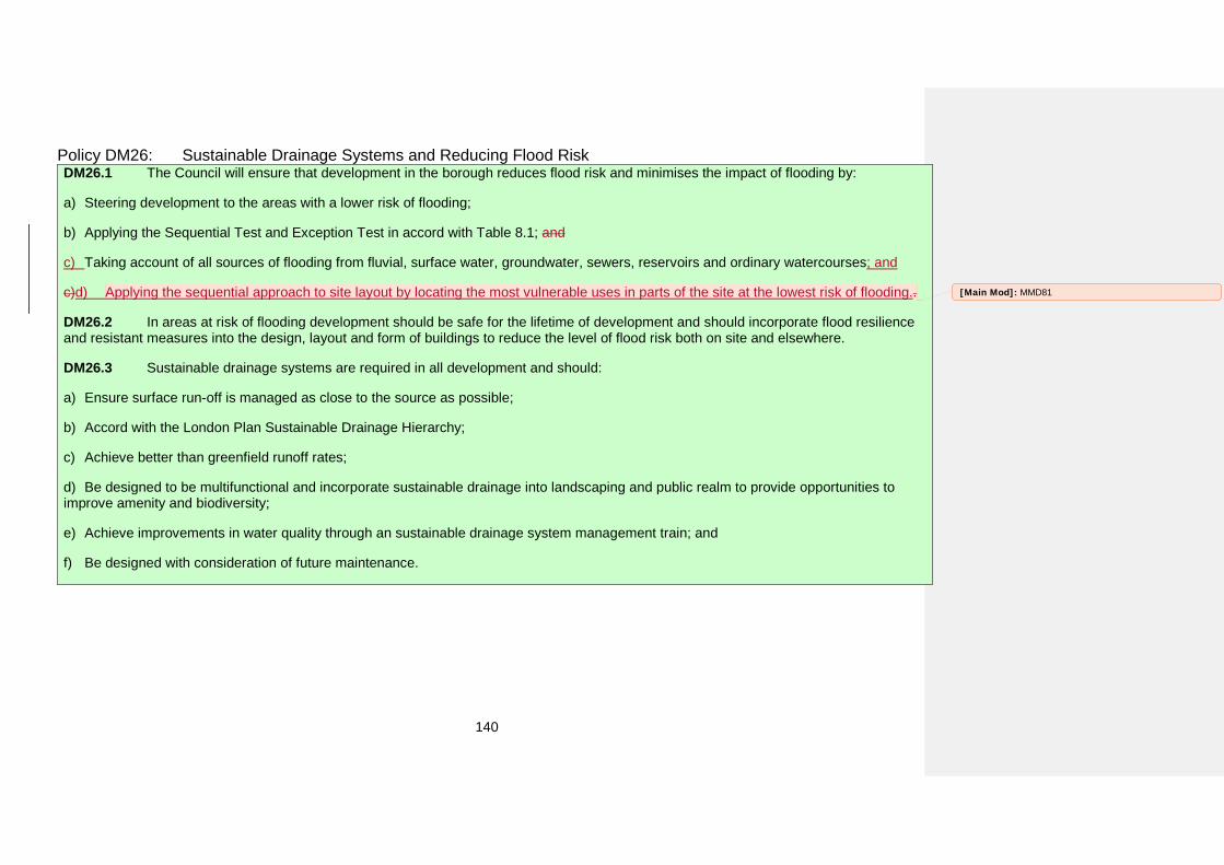
140
Policy DM26: Sustainable Drainage Systems and Reducing Flood Risk DM26.1 The Council will ensure that development in the borough reduces flood risk and minimises the impact of flooding by:
a) Steering development to the areas with a lower risk of flooding;
b) Applying the Sequential Test and Exception Test in accord with Table 8.1; and
c) Taking account of all sources of flooding from fluvial, surface water, groundwater, sewers, reservoirs and ordinary watercourses; and
c)d) Applying the sequential approach to site layout by locating the most vulnerable uses in parts of the site at the lowest risk of flooding..
DM26.2 In areas at risk of flooding development should be safe for the lifetime of development and should incorporate flood resilience and resistant measures into the design, layout and form of buildings to reduce the level of flood risk both on site and elsewhere.
DM26.3 Sustainable drainage systems are required in all development and should:
a) Ensure surface run-off is managed as close to the source as possible;
b) Accord with the London Plan Sustainable Drainage Hierarchy;
c) Achieve better than greenfield runoff rates;
d) Be designed to be multifunctional and incorporate sustainable drainage into landscaping and public realm to provide opportunities toimprove amenity and biodiversity;
e) Achieve improvements in water quality through an sustainable drainage system management train; and
f) Be designed with consideration of future maintenance.
[Main Mod]: MMD81
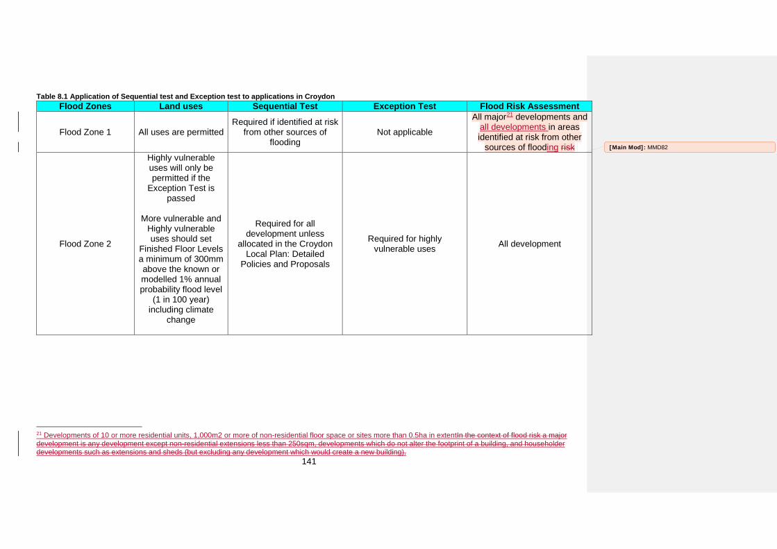
141
Table 8.1 Application of Sequential test and Exception test to applications in Croydon Flood Zones Land uses Sequential Test Exception Test Flood Risk Assessment
Flood Zone 1 All uses are permitted Required if identified at risk
from other sources of flooding
Not applicable
All major21 developments and all developments in areas identified at risk from other
sources of flooding risk
Flood Zone 2
Highly vulnerable uses will only be permitted if the
Exception Test is passed
More vulnerable and Highly vulnerable uses should set
Finished Floor Levels a minimum of 300mm above the known or modelled 1% annual probability flood level
(1 in 100 year) including climate
change
Required for all development unless
allocated in the Croydon Local Plan: Detailed
Policies and Proposals
Required for highly vulnerable uses All development
21 Developments of 10 or more residential units, 1,000m2 or more of non-residential floor space or sites more than 0.5ha in extentIn the context of flood risk a major development is any development except non-residential extensions less than 250sqm, developments which do not alter the footprint of a building, and householder developments such as extensions and sheds (but excluding any development which would create a new building).
[Main Mod]: MMD82
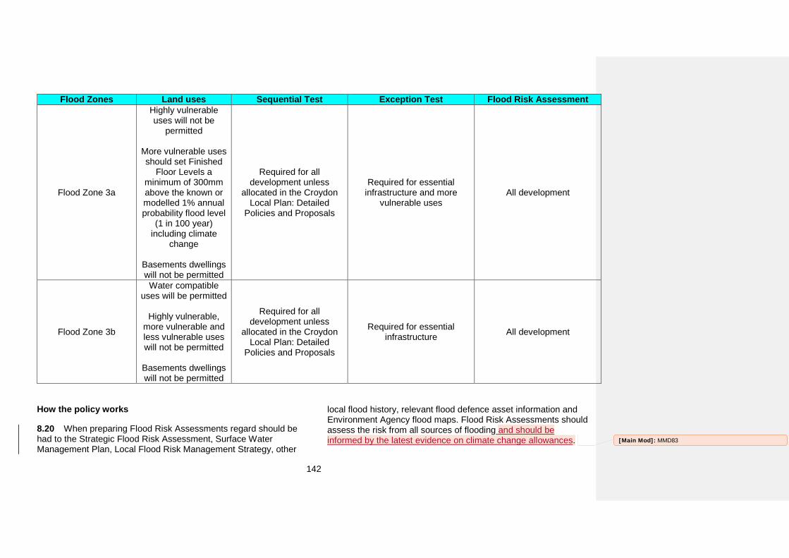
142
Flood Zones Land uses Sequential Test Exception Test Flood Risk Assessment
Flood Zone 3a
Highly vulnerable uses will not be
permitted
More vulnerable uses should set Finished
Floor Levels a minimum of 300mm above the known or modelled 1% annual probability flood level
(1 in 100 year) including climate
change
Basements dwellings will not be permitted
Required for all development unless
allocated in the Croydon Local Plan: Detailed
Policies and Proposals
Required for essential infrastructure and more
vulnerable uses All development
Flood Zone 3b
Water compatible uses will be permitted
Highly vulnerable, more vulnerable and less vulnerable uses will not be permitted
Basements dwellings will not be permitted
Required for all development unless
allocated in the Croydon Local Plan: Detailed
Policies and Proposals
Required for essential infrastructure All development
How the policy works
8.20 When preparing Flood Risk Assessments regard should be had to the Strategic Flood Risk Assessment, Surface Water Management Plan, Local Flood Risk Management Strategy, other
local flood history, relevant flood defence asset information and Environment Agency flood maps. Flood Risk Assessments should assess the risk from all sources of flooding and should be informed by the latest evidence on climate change allowances. [Main Mod]: MMD83
143
8.21 The Sequential Test and Exception Test are not required for sites allocated in this Plan, for minor development22 or change of use23. For all other development in Flood Zones 2 and 3 the Sequential test and Exception Test should form part of the Flood Risk Assessment, having regard to the guidance in the Strategic Flood Risk Assessment. A Sequential Test is required for development in Flood Zone 1 if the area has been identified at risk from other sources of flooding.
8.22 For residential development, proposals should be assessed sequential test may be made against the Council’s published five year supply of housing land and should demonstrate that the five year supply of housing land cannot be met on sites with a lower risk of flooding. For all other uses the Sequential Test should be based on the catchment of the proposed use. The design and layout of development should also take account of the sequential approach, with the most vulnerable uses located in parts of the site at the lowest risk of flooding.
8.23 Where a site is at risk of groundwater, the Council will request a Basement Impact Assessment as part of the Flood Risk Assessment for any basement application. These assessments should be informed by ground investigations to help assess the flood risks to basement development.
8.24 Croydon has experienced a number of surface water flood events and has been ranked by Department of Environmental, Food and Rural Affairs as the 4th settlement in England most
22 In relation to flood risk minor development means: minor non-residential extensions with a footprint less than 250 square metres; alterations that do not increase the size of buildings; household development within the curtilage of the existing dwelling and physical extensions to the existing dwelling itself. This excludes the creation of a separate dwelling within the curtilage of the existing dwelling. 23 This excludes change of use to a caravan, camping or chalet site or to a mobile home or park home site.
susceptible to surface water flooding24. The Local Flood Risk Management Strategy identifies up to 33,614 residential properties at risk from surface water in the borough25. Extensive records are held of surface water flooding across the borough with particularly significant episodes at Purley Cross roundabout and Brighton Road, Kenley station, Brighton Road (Coulsdon), Hamsey Green, Purley Oaks Road, Norbury and Thornton Heath26. Due to the risk posed by surface water flooding in Croydon development should utilise sustainable drainage systems to achieve better than greenfield runoff rates from the site. Greenfield runoff rates are defined as the runoff rates from a site, in its natural state, prior to any redevelopment and are typically between two and eight litres per second per hectare27. If better than greenfield runoff rates cannot be achieved this should be justified to the Local Planning Authority and Lead Local Flood Authority as part of a drainage strategy. In these instances greenfield runoff rates should be achieved as a minimum in line with the London Plan.
8.25 Sustainable drainage systems should always be considered as early in the design process to inform the design of the development. Proposals should demonstrate an understanding of how surface water will flow across the site, taking account of topography and locating drainage features accordingly. A drainage strategy should demonstrate that the site will achieve better than greenfield runoff rates and that sustainable drainage systems have been designed in line with the London Plan drainage hierarchy. Drainage design should follow the
24 National Rank Order of Settlements Susceptible to Surface Water Flooding, Defra 2009 25 London Borough of Croydon Local Flood Risk Management Strategy 26 London Borough of Croydon, Merton, Wandsworth Strategic Flood Risk Assessment Level 1 27 London Plan Sustainable Design and Construction Supplementary Planning Guidance
[Main Mod]: MMD84
144
principles of water sensitive urban design and demonstrate a sustainable drainage management train. A sustainable drainage management train identifies the different stages of movement of water through and across a site, identifying suitable sustainable drainage techniques for each stage. For example, a management train could consist of a green roof, a soakaway and permeable paving used in different parts of a development. The drainage strategy should also demonstrate how the drainage system will be managed and maintained for the lifetime of the development.
8.26 Sustainable drainage systems provide wider benefits than just reducing surface water runoff from a site. They provide opportunities to improve water quality by removing pollutants, improve the quality and attractiveness of public realm and open spaces and enhance biodiversity through the creation of habitats such as ponds and wetlands. Sustainable drainage systems should be designed to manage water as close to the source as possible and include treatment stages which not only manage the flow of water but provide wider benefits to the site. The contribution of trees in reducing flood risk should be recognised in developing sustainable drainage systems and the wider benefits that can be realised. Detailed guidance on sustainable drainage systems will be produced by the Lead Local Flood Authority.
Key supporting documents
• Stemming the flow – the role of trees and woods in floodprotections (May 2014) • Strategic Flood Risk Assessment (2015)• Surface Water Management Plan (2011)• Local Flood Risk Management Strategy (2015)• Ministerial Statement HCWS161 (2014)• Woodland actions for biodiversity and their role in watermanagement (March 2008)
[Main Mod]: MMD85
145
9. Green GridMetropolitan Green Belt, and Metropolitan Open Land and Local Green Spaces
Strategic Objectives and related Croydon Local Plan strategic policies
• Strategic Objective 9
• Strategic Objective 10
• Policy SP7.2
Unitary Development Plan policies to be replaced by this policy
• RO1 Maintaining open character of MetropolitanGreen Belt and Metropolitan Open Land
• RO2 Control of Development Associated withResidential Properties in Metropolitan Green Belt and Metropolitan Open Land
• RO3 Changes of Use of Existing Buildings inMetropolitan Green Belt and Metropolitan Open Land
• RO4 Conversions of buildings to residential use inMetropolitan Green Belt and Metropolitan Open Land
• RO6 Protecting the Setting of the Metropolitan GreenBelt and Metropolitan Open Land
• RO8 Protecting Local Open Land
• RO9 Education Open Space
• RO15 Outdoor Space and Recreation
Why we need this policy
9.1 Croydon has a strategic objective to ensure the responsible use of land and natural resources and also to increase the quality of, and access to, green spaces and nature. The borough’s trees and green spaces are also important in mitigating higher temperatures as a result of climate change. Protecting the
borough’s Metropolitan Green Belt, Metropolitan Open Land and Local Green Spaces ensures communities have access to open space for physical activity, recreation and play. The Croydon Local Plan: Strategic Policies seeks to protect and safeguard the extent of the borough’s Metropolitan Green Belt, Metropolitan Open Land and Local Green Spaces
[Main Mod]: MMD86
146
Policy DM27: Metropolitan Green Belt, Metropolitan Open Land and Local Green Spaces DM27.1 The Council will protect and safeguard the extent of the borough’s Metropolitan Green Belt and, Metropolitan Open Land and Local Green Spaces as designated on the Policies Map by applying the same level of protection afforded to Metropolitan Green Belt in national planning policy to Metropolitan Open Land and Local Green Spaces in the borough.
DM27.2 Extensions to existing buildings in Metropolitan Green Belt and, Metropolitan Open Land and Local Green Spaces should not be more than 20% of their original28 floor space or volume, or 100m2 (whichever is the smaller) unless they are for agricultural use, forestry, or facilities for outdoor sport, outdoor recreation or cemeteries.
DM27.3 Extensions to existing buildings in Metropolitan Green Belt, and Metropolitan Open Land and Local Green Spaces that are less than 20% of the original floor space or volume, or less than 100m2 in extent (whichever is the smaller) and extensions for agricultural use, forestry, or facilities for outdoor sport, outdoor recreation or cemeteries may still be disproportionate. In considering whether they are disproportionate and also whether a new replacement dwelling is materially larger or, if any proposed structure harms the openness of Metropolitan Green Belt, or Metropolitan Open Land or Local Green Spaces, the Council will have regard to:
a) Changes in the floor space and volume of buildings;
b) The floor space and volume of all previous extensions (since 1948), alterations and developments within the curtilage of the dwelling;
c) Use of basements and roof spaces as living areas;
d) Whether there is an increase in the spread of buildings across the site, in particular where visible from public vantage points;
e) The size of the curtilage and character of the surrounding area; and
f) Whether ancillary structures have an urbanising effect.
Proposed amendments to the Policies Map
Local Green Space is a new designation and all areas so designated will need to be shown on the Policies Map. A list of all proposed Local Green Spaces is shown in.
28 The original floor space and volume is as built, or as existed in 1948 for all buildings built prior to this date.
Table 9.1 Proposed Local Green Spaces (see The draft Policies Map for full details)
Local Green Space New Addiscombe Railway Park
Addiscombe Recreation Ground All Saints Churchyard, Sanderstead All Saints Graveyard, Sanderstead
[Main Mod]: MMD86
[Main Mod]: MMD86
147
Local Green Space New All Saints with St Margaret’s Churchyard, Upper
Norwood
Allder Way Playground Apsley Road Playground
Ashburton Park Ashen Grove
Beaulieu Heights Beulah Hill Pond
Biggin Wood Boulogne Road Playground
Bourne Park Brickfields Meadow
Canterbury Road Recreation Ground Castle Hill Avenue playground
Chaldon Way Gardens College Green Convent Wood
Copse Hill Spinney Coulsdon Coppice (Bleakfield Shaw)
Coulsdon Coppice (North) Coulsdon Coppice (Stonyfield Shaw)
Coulsdon Memorial Ground Dartnell Road Recreation Ground
Duppas Hill Former Godstone Road allotments Foxley Wood and Sherwood Oaks
Glade Wood Grangewood Park
Green Lane Sports Ground Haling Grove
Heavers Meadow & allotments Higher Drive Recreation Ground
King Georges Field
Local Green Space New Land rear of Hilliars Heath Road
Land to rear of Honeysuckle Gardens Little Road Playground
Lower Barn Road Green Millers Pond Norbury Hall Norbury Park
Normanton Meadow Northwood Road Recreation Ground
Park Hill Recreation Ground Parkfields Recreation Ground
Peabody Close playing field and allotments Pollards Hill
Pollards Hill Triangle Promenade du Verdun
Purley Beeches Queen's Road Cemetery
Roke Play Space Rotary Field
St James’ Church Garden St John's Church
St John’s Church Memorial Garden St John's Memorial Garden (east) St John's Memorial Garden (north)
St Peter’s Churchyard Sanderstead Plantation
Sanderstead Pond (and Green) Scrub Shaw
Selsdon Recreation Ground Shirley Oaks playing field and wood
Shirley Recreation Ground South Croydon Recreation Ground South Norwood Recreation ground
[Main Mod]: MMD86
[Main Mod]: MMD86
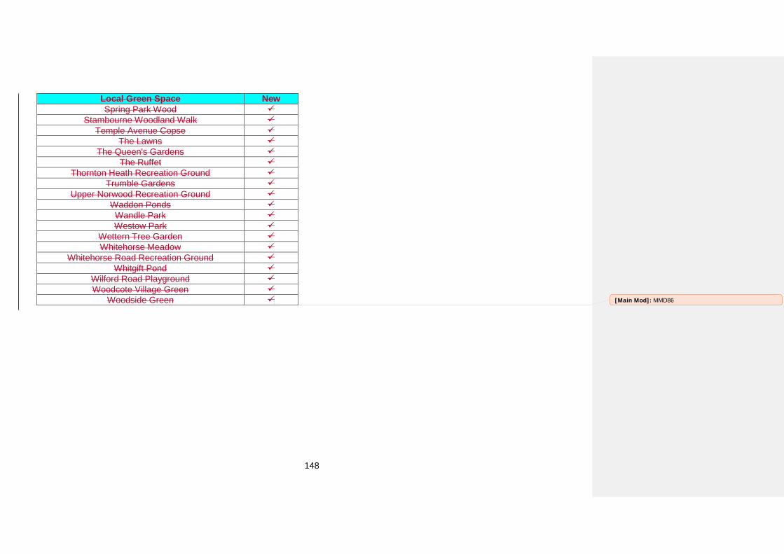
148
Local Green Space New Spring Park Wood
Stambourne Woodland Walk Temple Avenue Copse
The Lawns The Queen's Gardens
The Ruffet Thornton Heath Recreation Ground
Trumble Gardens Upper Norwood Recreation Ground
Waddon Ponds Wandle Park Westow Park
Wettern Tree Garden Whitehorse Meadow
Whitehorse Road Recreation Ground Whitgift Pond
Wilford Road Playground Woodcote Village Green
Woodside Green [Main Mod]: MMD86
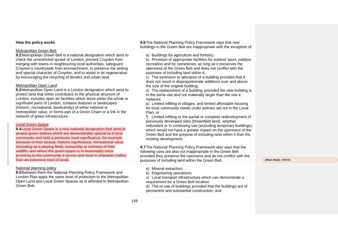
149
How the policy works
Metropolitan Green Belt 9.2 Metropolitan Green Belt is a national designation which aims to check the unrestricted sprawl of London, prevent Croydon from merging with towns in neighbouring local authorities, safeguard Croydon’s countryside from encroachment, to preserve the setting and special character of Croydon, and to assist in its regeneration by encouraging the recycling of derelict and urban land.
Metropolitan Open Land 9.3 Metropolitan Open Land is a London designation which aims to protect land that either contributes to the physical structure of London, includes open air facilities which serve either the whole or significant parts of London, contains features or landscapes (historic, recreational, biodiversity) of either national or metropolitan value, or forms part of a Green Chain or a link in the network of green infrastructure.
Local Green Space 9.4 Local Green Space is a new national designation that aims to protect green spaces which are demonstrably special to a local community and hold a particular local significance, for example because of their beauty, historic significance, recreational value (including as a playing field), tranquillity or richness of their wildlife, and where the green space is in reasonably close proximity to the community it serves and local in character (rather than an extensive tract of land).
National planning policy 9.5 Between them the National Planning Policy Framework and London Plan apply the same level of protection to the Metropolitan Open Land and Local Green Spaces as is afforded to Metropolitan Green Belt.
9.6 The National Planning Policy Framework says that new buildings in the Green Belt are inappropriate with the exception of:
Buildings for agriculture and forestry; Provision of appropriate facilities for outdoor sport, outdoor
recreation and for cemeteries, as long as it preserves the openness of the Green Belt and does not conflict with the purposes of including land within it;
The extension or alteration of a building provided that it does not result in disproportionate additions over and above the size of the original building;
The replacement of a building, provided the new building is in the same use and not materially larger than the one it replaces;
Limited infilling in villages, and limited affordable housing for local community needs under policies set out in the Local Plan; or
Limited infilling or the partial or complete redevelopment of previously developed sites (brownfield land), whether redundant or in continuing use (excluding temporary buildings), which would not have a greater impact on the openness of the Green Belt and the purpose of including land within it than the existing development.
9.7 The National Planning Policy Framework also says that the following uses are also not inappropriate in the Green Belt provided they preserve the openness and do not conflict with the purposes of including land within the Green Belt:
Mineral extraction; Engineering operations; Local transport infrastructure which can demonstrate a
requirement for a Green Belt location; The re-use of buildings provided that the buildings are of
permanent and substantial construction; and
[Main Mod]: MMD86
150
Development brought forward under a Community Right to Build Order.
9.8 At a local level cemeteries, burial grounds and telecommunications development may be acceptable in Metropolitan Green Belt and on Metropolitan Open Land if it can be demonstrated that there are no other suitable sites and that there is no impact on the openness of the Green Belt or the reason for the site being designated as Metropolitan Open Land. In addition for cemeteries and burial grounds existing levels of public access to sites in Metropolitan Green Belt and Metropolitan Open Land need to be maintained. Neither cemeteries, burial grounds nor telecommunications development are acceptable on Local Green Space.
Local Green Space in Croydon 9.9 Local Green Space is designated by the Croydon Local Plan. Sites have been designated based on the following criteria which reflect the National Planning Policy Framework’s definition of Local Green Space.
9.10 Sites designated as Local Green Space are in close proximity to the land that they serve.
9.11 Sites designated as Local Green Space are local in character and not part of an extensive tract of land.
9.12 Sites designated as Local Green Space are at least three of the following or are publically accessible and at least one of the following:
Historic Park or Garden; Community garden; Children’s play area; Tranquil area; Natural and semi-natural open space;
Cemetery, church yard or burial ground; Site of Nature Conservation Importance; or Playing field or recreation ground.
Extensions and replacement of existing buildings 9.13 The policy defines disproportionate extensions for development proposals which are considered to be inappropriate development in the Green Belt, Metropolitan Open Land and Local Green Space. Any extension of more than 20% of the original floor space or volume, or greater than 100m2 in extent (whichever is smaller) of an existing building will be considered disproportionate.
9.14 It does not apply to proposals to extend uses that the National Planning Policy Framework considers to be acceptable in Green Belt. For these uses, development proposals will still be required to preserve the openness of the Green Belt and not conflict with the purposes of including land within it.
9.15 In considering applications for the replacement of existing buildings in Metropolitan Green Belt or, on Metropolitan Open Land or in Local Green Space the Council may seek alterations in the position of the footprint on the site, or other changes that will reduce the impact on the open character of the area.
9.16 Where a proposed change of use of an existing building in Metropolitan Green Belt, or on Metropolitan Open Land or in Local Green Space involves extensions or changes to the use of the surrounding land the Council will exercise strict control to ensure that the proposal does not conflict with openness or the purposes of including land in the designation. The form, bulk and general design of any new structures should be in keeping with their surroundings. In considering such proposals, the Council will have regard to the history of the building and will not look favourably on the conversion of buildings constructed under permitted development rights, if it is considered that there was an intention of early conversion to another use. Conditions removing permitted
[Main Mod]: MMD86
[Main Mod]: MMD86
[Main Mod]: MMD86
[Main Mod]: MMD86
151
development rights and legal agreements may be sought to achieve these aims.
Visual amenity of Metropolitan Green Belt and Metropolitan Open Land 9.17 Openness is a primary consideration in designating Metropolitan Green Belt and Metropolitan Open Land. Their openness can be harmed by development not actually located within the designations. Therefore, development conspicuous from the Metropolitan Green Belt or Metropolitan Open Land will not be permitted if it would harm their visual amenity. [Main Mod]: MMD87
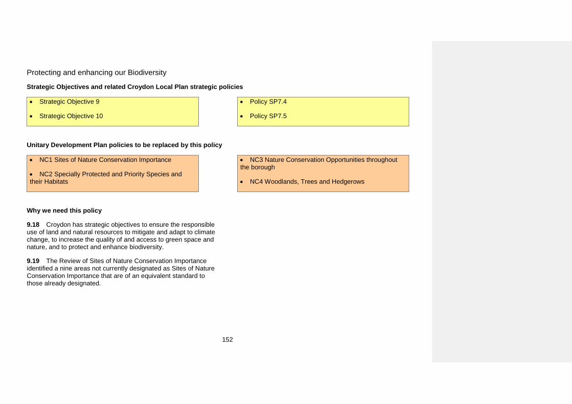
152
Protecting and enhancing our Biodiversity
Strategic Objectives and related Croydon Local Plan strategic policies
• Strategic Objective 9
• Strategic Objective 10
• Policy SP7.4
• Policy SP7.5
Unitary Development Plan policies to be replaced by this policy
• NC1 Sites of Nature Conservation Importance
• NC2 Specially Protected and Priority Species andtheir Habitats
• NC3 Nature Conservation Opportunities throughoutthe borough
• NC4 Woodlands, Trees and Hedgerows
Why we need this policy
9.18 Croydon has strategic objectives to ensure the responsible use of land and natural resources to mitigate and adapt to climate change, to increase the quality of and access to green space and nature, and to protect and enhance biodiversity.
9.19 The Review of Sites of Nature Conservation Importance identified a nine areas not currently designated as Sites of Nature Conservation Importance that are of an equivalent standard to those already designated.
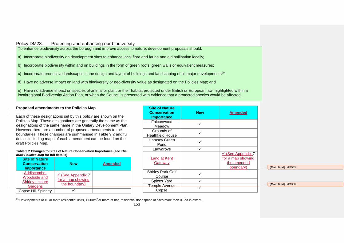
153
Policy DM28: Protecting and enhancing our biodiversity To enhance biodiversity across the borough and improve access to nature, development proposals should:
a) Incorporate biodiversity on development sites to enhance local flora and fauna and aid pollination locally;
b) Incorporate biodiversity within and on buildings in the form of green roofs, green walls or equivalent measures;
c) Incorporate productive landscapes in the design and layout of buildings and landscaping of all major developments29;
d) Have no adverse impact on land with biodiversity or geo-diversity value as designated on the Policies Map; and
e) Have no adverse impact on species of animal or plant or their habitat protected under British or European law, highlighted within alocal/regional Biodiversity Action Plan, or when the Council is presented with evidence that a protected species would be affected.
Proposed amendments to the Policies Map
Each of these designations set by this policy are shown on the Policies Map. These designations are generally the same as the designations of the same name in the Unitary Development Plan. However there are a number of proposed amendments to the boundaries. These changes are summarised in Table 9.2 and full details including maps of each amendment can be found on the draft Policies Map.
Table 9.2 Changes to Sites of Nature Conservation Importance (see The draft Policies Map for full details)
Site of Nature Conservation Importance
New Amended
Addiscombe, Woodside and Shirley Leisure
Gardens
(See Appendix 7for a map showing
the boundary)
Copse Hill Spinney
29 Developments of 10 or more residential units, 1,000m2 or more of non-residential floor space or sites more than 0.5ha in extent.
Site of Nature Conservation Importance
New Amended
Falconwood Meadow
Grounds of Heathfield House
Hamsey Green Pond
Ladygrove
Land at Kent Gateway
(See Appendix 7for a map showing
the amended boundary)
Shirley Park Golf Course
Spices Yard Temple Avenue
Copse [Main Mod]: MMD88
[Main Mod]: MMD89
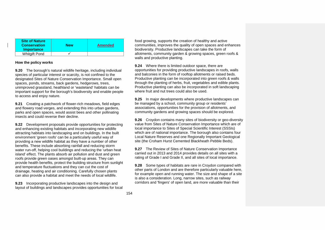
154
Site of Nature Conservation Importance
New Amended
Whitgift Pond
How the policy works
9.20 The borough’s natural wildlife heritage, including individual species of particular interest or scarcity, is not confined to the designated Sites of Nature Conservation Importance. Small open spaces, ponds, streams, back gardens, hedgerows, trees, unimproved grassland, heathland or ‘wasteland’ habitats can be important support for the borough’s biodiversity and enable people to access and enjoy nature.
9.21 Creating a patchwork of flower-rich meadows, field edges and flowery road verges, and extending this into urban gardens, parks and open spaces, would assist bees and other pollinating insects and could reverse their decline.
9.22 Development proposals provide opportunities for protecting and enhancing existing habitats and incorporating new wildlife attracting habitats into landscaping and on buildings. In the built environment 'green roofs' can be a particularly useful way of providing a new wildlife habitat as they have a number of other benefits. These include absorbing rainfall and reducing storm water run-off, helping cool buildings and reducing the 'urban heat island' effect. The plants absorb air pollution and dust and green roofs provide green oases amongst built-up areas. They can provide health benefits, protect the building structure from sunlight and temperature fluctuations and they can cut the cost of drainage, heating and air conditioning. Carefully chosen plants can also provide a habitat and meet the needs of local wildlife.
9.23 Incorporating productive landscapes into the design and layout of buildings and landscapes provides opportunities for local
food growing, supports the creation of healthy and active communities, improves the quality of open spaces and enhances biodiversity. Productive landscapes can take the form of allotments, community garden & growing spaces, green roofs & walls and productive planting.
9.24 Where there is limited outdoor space, there are opportunities for providing productive landscapes in roofs, walls and balconies in the form of rooftop allotments or raised beds. Productive planting can be incorporated into green roofs & walls through the planting of herbs, fruit, vegetables and edible plants. Productive planting can also be incorporated in soft landscaping where fruit and nut trees could also be used.
9.25 In major developments where productive landscapes can be managed by a school, community group or residents’ associations, opportunities for the provision of allotments, and community gardens and growing spaces should be explored.
9.26 Croydon contains many sites of biodiversity or geo-diversity value from Sites of Nature Conservation Importance which are of local importance to Sites of Special Scientific Interest (SSSIs) which are of national importance. The borough also contains four Local Nature Reserves and one Regionally Important Geological site (the Croham Hurst Cemented Blackheath Pebble Beds).
9.27 The Review of Sites of Nature Conservation Importance carried out in 2013 and 2014 provides details on all sites with a rating of Grade I and Grade II, and all sites of local importance.
9.28 Some types of habitats are rare in Croydon compared with other parts of London and are therefore particularly valuable here, for example open and running water. The size and shape of a site is also a consideration. Long, narrow sites, such as railway corridors and 'fingers' of open land, are more valuable than their
155
size alone would suggest as they bring wildlife close to a larger number of adjacent properties and people.
9.29 Proposals that might affect such sites will therefore need to be carefully assessed. Any assessment should take into account both operations during construction and the changes likely to be brought about by the new use.
9.30 Occasionally, protection of nature conservation features may be outweighed by the need to provide essential infrastructure to support growth in the borough and beyond when there is no other suitable site. When assessing whether there are no other suitable sites the cost of site acquisition is not a consideration and applicants will need to demonstrate that the proposed infrastructure cannot be disaggregated on to smaller sites within the borough or elsewhere. In circumstances where it is deemed that the need to provide essential infrastructure outweighs the protection of nature conservation features harm may be permitted. Compensatory measures of an equivalent nature conservation value will be required to offset the harm caused by the development. It should be noted that some habitats take hundreds of years to become established in their current form and therefore it may be impossible to secure a like-for-like replacement.
9.31 Some species of flora and fauna are protected by national and international legislation. The habitats of certain wildlife species are also specifically protected, although the retention of the habitats and adequate foraging areas of all protected species are considered essential for their survival. Specially protected species can be found throughout the borough, they are not restricted to designated sites of nature conservation interest. It is therefore always necessary to consider the presence of specially protected species.
9.32 An ecological assessment will be required for developments which will impact land with biodiversity or geo-
diversity value. An assessment is also required if a development impacts on species or habits protected by British or European law, included within a Biodiversity Action Plan or when the Council is presented with evidence of protected species. Where an ecological assessment is needed to support a planning application the Council will require the applicant to pay for an additional independent assessment to be carried on out on behalf of the local authority.
Key supporting documents
• Review of Sites of Nature Conservation Importance (2013 and2014)
[Main Mod]: MMD90
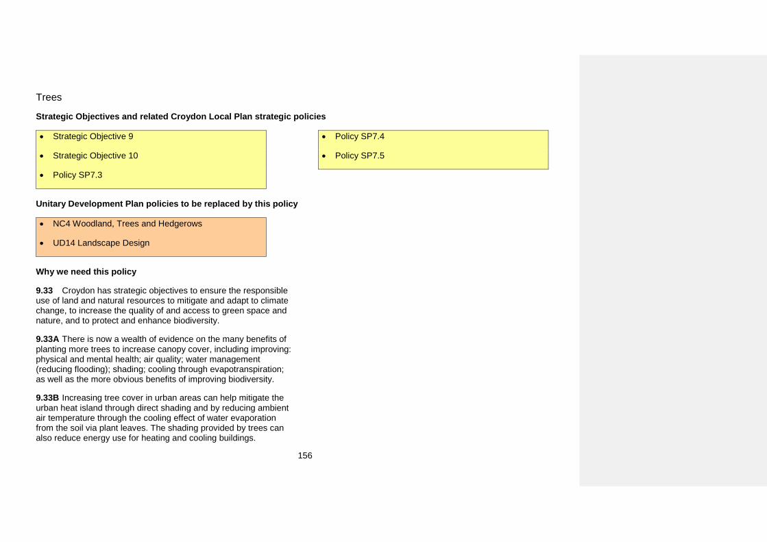
156
Trees
Strategic Objectives and related Croydon Local Plan strategic policies
• Strategic Objective 9
• Strategic Objective 10
• Policy SP7.3
• Policy SP7.4
• Policy SP7.5
Unitary Development Plan policies to be replaced by this policy
• NC4 Woodland, Trees and Hedgerows
• UD14 Landscape Design
Why we need this policy
9.33 Croydon has strategic objectives to ensure the responsible use of land and natural resources to mitigate and adapt to climate change, to increase the quality of and access to green space and nature, and to protect and enhance biodiversity.
9.33A There is now a wealth of evidence on the many benefits of planting more trees to increase canopy cover, including improving: physical and mental health; air quality; water management (reducing flooding); shading; cooling through evapotranspiration; as well as the more obvious benefits of improving biodiversity.
9.33B Increasing tree cover in urban areas can help mitigate the urban heat island through direct shading and by reducing ambient air temperature through the cooling effect of water evaporation from the soil via plant leaves. The shading provided by trees can also reduce energy use for heating and cooling buildings.
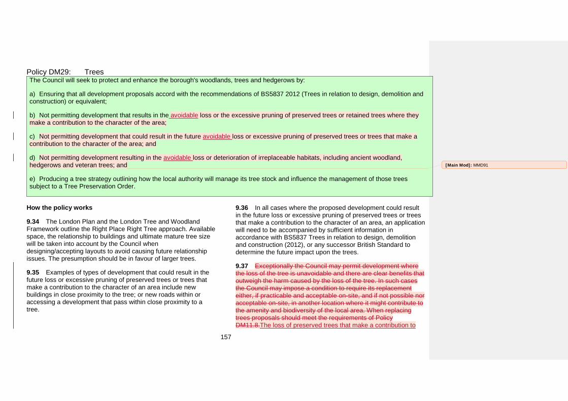
157
Policy DM29: Trees The Council will seek to protect and enhance the borough's woodlands, trees and hedgerows by:
a) Ensuring that all development proposals accord with the recommendations of BS5837 2012 (Trees in relation to design, demolition andconstruction) or equivalent;
b) Not permitting development that results in the avoidable loss or the excessive pruning of preserved trees or retained trees where theymake a contribution to the character of the area;
c) Not permitting development that could result in the future avoidable loss or excessive pruning of preserved trees or trees that make acontribution to the character of the area; and
d) Not permitting development resulting in the avoidable loss or deterioration of irreplaceable habitats, including ancient woodland,hedgerows and veteran trees; and
e) Producing a tree strategy outlining how the local authority will manage its tree stock and influence the management of those treessubject to a Tree Preservation Order.
How the policy works
9.34 The London Plan and the London Tree and Woodland Framework outline the Right Place Right Tree approach. Available space, the relationship to buildings and ultimate mature tree size will be taken into account by the Council when designing/accepting layouts to avoid causing future relationship issues. The presumption should be in favour of larger trees.
9.35 Examples of types of development that could result in the future loss or excessive pruning of preserved trees or trees that make a contribution to the character of an area include new buildings in close proximity to the tree; or new roads within or accessing a development that pass within close proximity to a tree.
9.36 In all cases where the proposed development could result in the future loss or excessive pruning of preserved trees or trees that make a contribution to the character of an area, an application will need to be accompanied by sufficient information in accordance with BS5837 Trees in relation to design, demolition and construction (2012), or any successor British Standard to determine the future impact upon the trees.
9.37 Exceptionally the Council may permit development where the loss of the tree is unavoidable and there are clear benefits that outweigh the harm caused by the loss of the tree. In such cases the Council may impose a condition to require its replacement either, if practicable and acceptable on-site, and if not possible nor acceptable on-site, in another location where it might contribute to the amenity and biodiversity of the local area. When replacing trees proposals should meet the requirements of Policy DM11.8.The loss of preserved trees that make a contribution to
[Main Mod]: MMD91
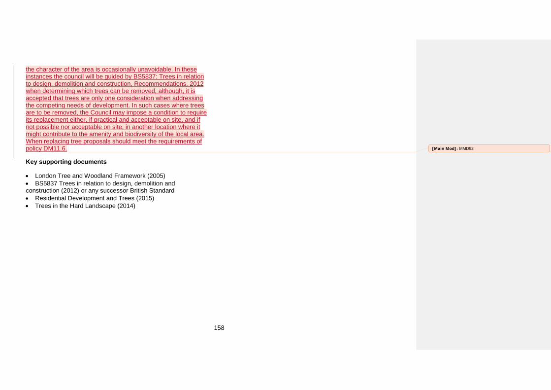
158
the character of the area is occasionally unavoidable. In these instances the council will be guided by BS5837: Trees in relation to design, demolition and construction, Recommendations, 2012 when determining which trees can be removed, although, it is accepted that trees are only one consideration when addressing the competing needs of development. In such cases where trees are to be removed, the Council may impose a condition to require its replacement either, if practical and acceptable on site, and if not possible nor acceptable on site, in another location where it might contribute to the amenity and biodiversity of the local area. When replacing tree proposals should meet the requirements of policy DM11.6.
Key supporting documents
• London Tree and Woodland Framework (2005)• BS5837 Trees in relation to design, demolition andconstruction (2012) or any successor British Standard • Residential Development and Trees (2015)• Trees in the Hard Landscape (2014)
[Main Mod]: MMD92
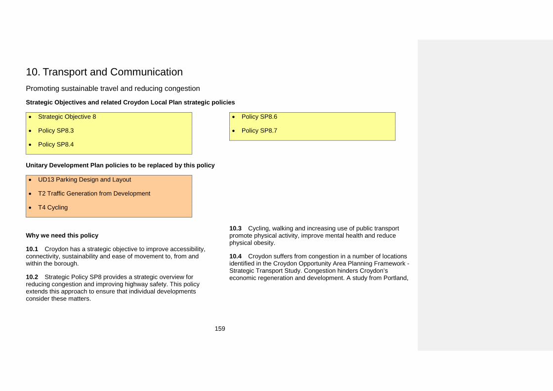
159
10. Transport and CommunicationPromoting sustainable travel and reducing congestion
Strategic Objectives and related Croydon Local Plan strategic policies
• Strategic Objective 8
• Policy SP8.3
• Policy SP8.4
• Policy SP8.6
• Policy SP8.7
Unitary Development Plan policies to be replaced by this policy
• UD13 Parking Design and Layout
• T2 Traffic Generation from Development
• T4 Cycling
Why we need this policy
10.1 Croydon has a strategic objective to improve accessibility, connectivity, sustainability and ease of movement to, from and within the borough.
10.2 Strategic Policy SP8 provides a strategic overview for reducing congestion and improving highway safety. This policy extends this approach to ensure that individual developments consider these matters.
10.3 Cycling, walking and increasing use of public transport promote physical activity, improve mental health and reduce physical obesity.
10.4 Croydon suffers from congestion in a number of locations identified in the Croydon Opportunity Area Planning Framework - Strategic Transport Study. Congestion hinders Croydon’s economic regeneration and development. A study from Portland,
160
USA has calculated that congestion costs it $844m annually30. Congestion and use of private transport also leads to increased carbon emissions in the borough. Croydon produces 1,660kt of CO2 a year which puts it at seventh highest out of 33 London
boroughs. The London Plan includes a target to reduce CO2 emissions by 60% by 2025, the Climate Change Act sets out that emissions will be reduced by 80% by 2050 (based on 1990 levels).
Policy DM30: Promoting sustainable travel and reducing congestion To promote sustainable growth in Croydon and reduce the impact of traffic congestion development should:
a) Promote measures to increase the use of public transport, cycling and walking;
b) Have a positive impact and must not have a detrimental impact on highway safety for pedestrians, cyclists, public transport users andprivate vehicles; and
c) Not result in a severe impact on the transport networks local to the site which would detract from the economic and environmentalregeneration of the borough by making Croydon a less accessible and less attractive location in which to develop.
How the policy works
10.5 All development has an impact on traffic movement in the borough. In order to reduce the impact on traffic movement the Council will require new development to promote measures to increase the use of public transport, cycling and walking. This includes ensuring new development has good access to public transport and has good links to main pedestrian and cycle routes in the borough. The design of new developments should prioritise walking and cycling routes into and through developments over routes for cars. Designs should also prioritise access to public transport over accessibility to private motor cars.
10.6 Some development would result in a severe impact on the local transport networks. A severe impact is one which would detract from the economic and environmental regeneration of the
30 http://www.portofportland.com/PDFPOP/Trade_Trans_Studies_CoC Report1128Final.pdf
borough by making Croydon less accessible and a less attractive location in which to develop. Such development will not be permitted. Transport for London and Network Rail will be consulted on planning applications that could result in such an impact on the borough.
10.7 All major development proposals31 should demonstrate by means of a Transport Assessment; Travel Plan; Construction Logistics Plan; and Delivery & Servicing Plan, or equivalents, how they will promote measures to increase the use of public transport, cycling and walking and that they will not result in a severe impact on the local transport networks.
10.8 The extent of the local road network will vary depending on the location, scale and type of the development but will always include the routes from the development site to the Strategic Road
31 Residential development of 10 or more units, 1,000m2 of non-residential floor space or a development of 0.5ha or more in extent
[Main Mod]: MMD93
[Main Mod]: MMD94
161
Network. For developments located on a Strategic Road the local road network will include the entire Strategic Road Network within and leading into the borough.
10.9 The extent of the local public transport network includes bus routes within a 10 minute walk, tram routes and train stations within a 15 minute walk and cycle and walking routes within 15 minutes of the development. The exact extent of the local transport networks should be considered in the Transport Assessment.
10.10 The Croydon Local Plan: Strategic Policies require new developments to increase the permeability and connectivity for pedestrians and cyclists of their sites and to create new cycle routes in their developments.
162
Car and cycle parking in new development
Strategic Objectives and related Croydon Local Plan strategic policies
• Strategic Objective 8
• Strategic Objective 9
• Policy SP8.15
• Policy SP8.16
• Policy SP8.17
Unitary Development Plan policies to be replaced by this policy
• UD13 Parking Design and Layout
• T8 Car Parking Standards in New Development
Why we need this policy
10.11 Croydon has strategic objectives to improve accessibility, connectivity, sustainability and ease of movement to, from and within the borough and to ensure the responsible use of land and natural resources and management of waste to mitigate and adapt to climate change.
10.12 Croydon Local Plan Strategic Policy SP8 sets basic car parking standards by referring to pan-London standards set by the London Plan. These are sufficient for managing the overall provision of car parking in new development. However as some potential users of car parking have particular requirements these need to be covered in a Croydon-specific policy.
10.13 This policy provides further requirements in terms of the quality of provision and how the parking should be provided.
10.14 Occupiers of affordable housing also require car parking spaces although on average car ownership is 30-60% less than that of owner occupied homes.
163
Policy DM31: Car and cycle parking in new development To promote sustainable growth in Croydon and reduce the impact of car parking new development must:
a) Reduce the impact of car parking in any development located in areas of good public transport accessibility32 or areas of existing on-street parking stress;
b) Ensure that the movement of pedestrians, cycles, public transport and emergency services is not impeded by the provision of carparking;
c) Ensure that highway safety is not compromised by the provision of car parking including off street parking where it requires a newdropped kerb on the strategic road network and other key roads identified on the Policies Map;
d) If the development would result in the loss of existing car parking spaces, demonstrate that there is no need for these car parking spacesby reference to occupancy rates at peak times;
e) Provide car and cycle parking spaces as set out in Table 10.1;
f) Ensure that cycle parking is designed so that it is secure and can also be used for parking for mobility scooters and motor cycles; and
g) Provide car parking for affordable homes at an average rate not less than 2/3 that of other tenures.
32 Public Transport Accessibilty Level (PTAL) rating of 4 or more
[Main Mod]: MMD95
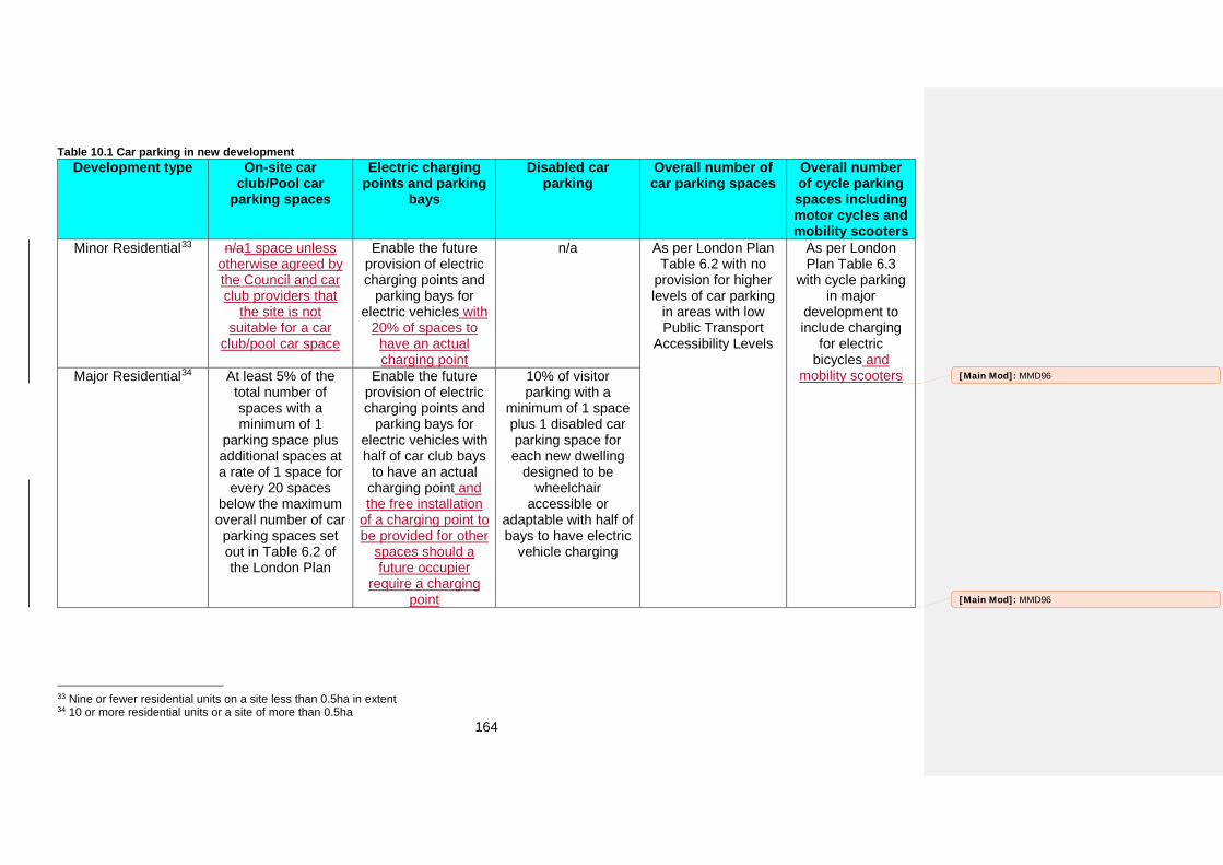
164
Table 10.1 Car parking in new development Development type On-site car
club/Pool car parking spaces
Electric charging points and parking
bays
Disabled car parking
Overall number of car parking spaces
Overall number of cycle parking spaces including motor cycles and mobility scooters
Minor Residential33 n/a1 space unless otherwise agreed by the Council and car club providers that
the site is not suitable for a car
club/pool car space
Enable the future provision of electric charging points and
parking bays for electric vehicles with
20% of spaces to have an actual charging point
n/a As per London Plan Table 6.2 with no
provision for higher levels of car parking
in areas with low Public Transport
Accessibility Levels
As per London Plan Table 6.3
with cycle parking in major
development to include charging
for electric bicycles and
mobility scooters Major Residential34 At least 5% of the total number of spaces with a minimum of 1
parking space plus additional spaces at a rate of 1 space for
every 20 spaces below the maximum overall number of car parking spaces set out in Table 6.2 of the London Plan
Enable the future provision of electric charging points and
parking bays for electric vehicles with half of car club bays
to have an actual charging point and the free installation
of a charging point to be provided for other
spaces should a future occupier
require a charging point
10% of visitor parking with a
minimum of 1 space plus 1 disabled car parking space for each new dwelling
designed to be wheelchair
accessible or adaptable with half of bays to have electric
vehicle charging
33 Nine or fewer residential units on a site less than 0.5ha in extent 34 10 or more residential units or a site of more than 0.5ha
[Main Mod]: MMD96
[Main Mod]: MMD96
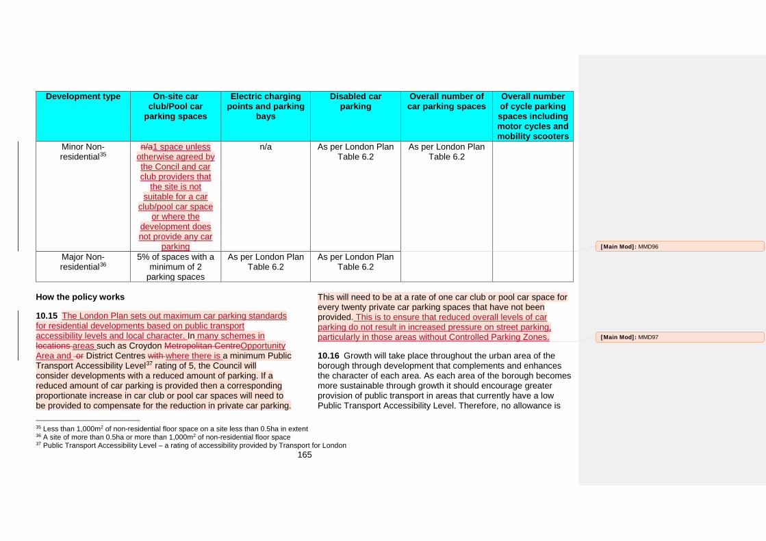
165
Development type On-site car club/Pool car
parking spaces
Electric charging points and parking
bays
Disabled car parking
Overall number of car parking spaces
Overall number of cycle parking spaces including motor cycles and mobility scooters
Minor Non-residential35
n/a1 space unless otherwise agreed by the Concil and car club providers that
the site is not suitable for a car
club/pool car space or where the
development does not provide any car
parking
n/a As per London Plan Table 6.2
As per London Plan Table 6.2
Major Non-residential36
5% of spaces with a minimum of 2
parking spaces
As per London Plan Table 6.2
As per London Plan Table 6.2
How the policy works
10.15 The London Plan sets out maximum car parking standards for residential developments based on public transport accessibility levels and local character. In many schemes in locations areas such as Croydon Metropolitan CentreOpportunity Area and or District Centres with where there is a minimum Public Transport Accessibility Level37 rating of 5, the Council will consider developments with a reduced amount of parking. If a reduced amount of car parking is provided then a corresponding proportionate increase in car club or pool car spaces will need to be provided to compensate for the reduction in private car parking.
35 Less than 1,000m2 of non-residential floor space on a site less than 0.5ha in extent 36 A site of more than 0.5ha or more than 1,000m2 of non-residential floor space 37 Public Transport Accessibility Level – a rating of accessibility provided by Transport for London
This will need to be at a rate of one car club or pool car space for every twenty private car parking spaces that have not been provided. This is to ensure that reduced overall levels of car parking do not result in increased pressure on street parking, particularly in those areas without Controlled Parking Zones.
10.16 Growth will take place throughout the urban area of the borough through development that complements and enhances the character of each area. As each area of the borough becomes more sustainable through growth it should encourage greater provision of public transport in areas that currently have a low Public Transport Accessibility Level. Therefore, no allowance is
[Main Mod]: MMD96
[Main Mod]: MMD97
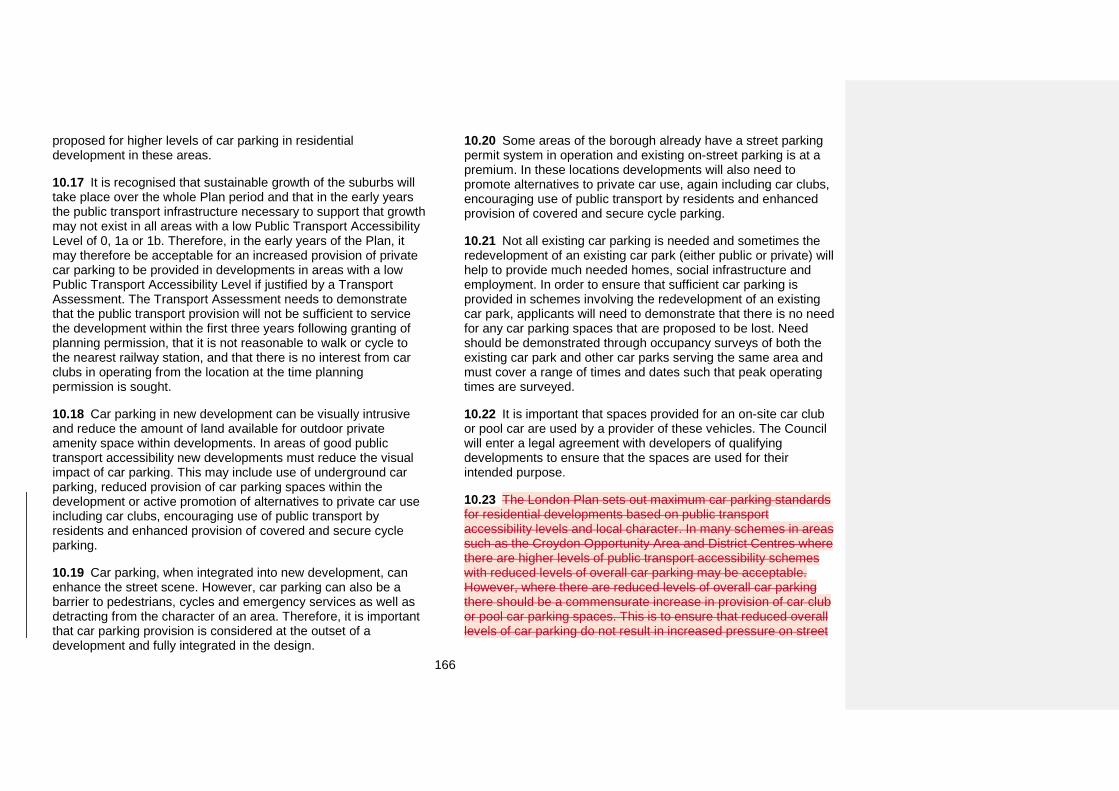
166
proposed for higher levels of car parking in residential development in these areas.
10.17 It is recognised that sustainable growth of the suburbs will take place over the whole Plan period and that in the early years the public transport infrastructure necessary to support that growth may not exist in all areas with a low Public Transport Accessibility Level of 0, 1a or 1b. Therefore, in the early years of the Plan, it may therefore be acceptable for an increased provision of private car parking to be provided in developments in areas with a low Public Transport Accessibility Level if justified by a Transport Assessment. The Transport Assessment needs to demonstrate that the public transport provision will not be sufficient to service the development within the first three years following granting of planning permission, that it is not reasonable to walk or cycle to the nearest railway station, and that there is no interest from car clubs in operating from the location at the time planning permission is sought.
10.18 Car parking in new development can be visually intrusive and reduce the amount of land available for outdoor private amenity space within developments. In areas of good public transport accessibility new developments must reduce the visual impact of car parking. This may include use of underground car parking, reduced provision of car parking spaces within the development or active promotion of alternatives to private car use including car clubs, encouraging use of public transport by residents and enhanced provision of covered and secure cycle parking.
10.19 Car parking, when integrated into new development, can enhance the street scene. However, car parking can also be a barrier to pedestrians, cycles and emergency services as well as detracting from the character of an area. Therefore, it is important that car parking provision is considered at the outset of a development and fully integrated in the design.
10.20 Some areas of the borough already have a street parking permit system in operation and existing on-street parking is at a premium. In these locations developments will also need to promote alternatives to private car use, again including car clubs, encouraging use of public transport by residents and enhanced provision of covered and secure cycle parking.
10.21 Not all existing car parking is needed and sometimes the redevelopment of an existing car park (either public or private) will help to provide much needed homes, social infrastructure and employment. In order to ensure that sufficient car parking is provided in schemes involving the redevelopment of an existing car park, applicants will need to demonstrate that there is no need for any car parking spaces that are proposed to be lost. Need should be demonstrated through occupancy surveys of both the existing car park and other car parks serving the same area and must cover a range of times and dates such that peak operating times are surveyed.
10.22 It is important that spaces provided for an on-site car club or pool car are used by a provider of these vehicles. The Council will enter a legal agreement with developers of qualifying developments to ensure that the spaces are used for their intended purpose.
10.23 The London Plan sets out maximum car parking standards for residential developments based on public transport accessibility levels and local character. In many schemes in areas such as the Croydon Opportunity Area and District Centres where there are higher levels of public transport accessibility schemes with reduced levels of overall car parking may be acceptable. However, where there are reduced levels of overall car parking there should be a commensurate increase in provision of car club or pool car parking spaces. This is to ensure that reduced overall levels of car parking do not result in increased pressure on street
167
parking, particularly in those areas without Controlled Parking Zones.
10.24 In circumstances where the car club is not accessible to the wider community, in low density areas or where it is not commercially viable, the Council will expect developers to work with a car club operator to find a suitable site from which a car club would operate. In these circumstances the developer will be expected to fund a Traffic Regulation Order and the lining and signing of an on-street parking bay. This will ensure the parking space will be used by a car club operator and is accessible to both the development and the wider community.
10.25 Croydon recognises that in many residential developments parking spaces are allocated to particular units and that electric car charging points may not be provided in the correct spaces. Therefore, all spaces in residential developments need to be enabled for future use by electric cars by ensuring the necessary infrastructure with the exception of actual charging points is integrated from the start.
10.26 Non-residential developments are less likely to have a single assigned parking space per unit. Therefore, electric car parking spaces should be provided in accord with London Plan standards.
10.27 New development should also provide cycle parking in accord with the standards set out in the London Plan.
10.28 The Croydon Opportunity Area Planning Framework provides further guidance on provision of car parking within the Croydon Opportunity Area.
Key supporting documents
• Croydon Opportunity Area Planning Framework
[Main Mod]: MMD98
[Main Mod]: MMD99
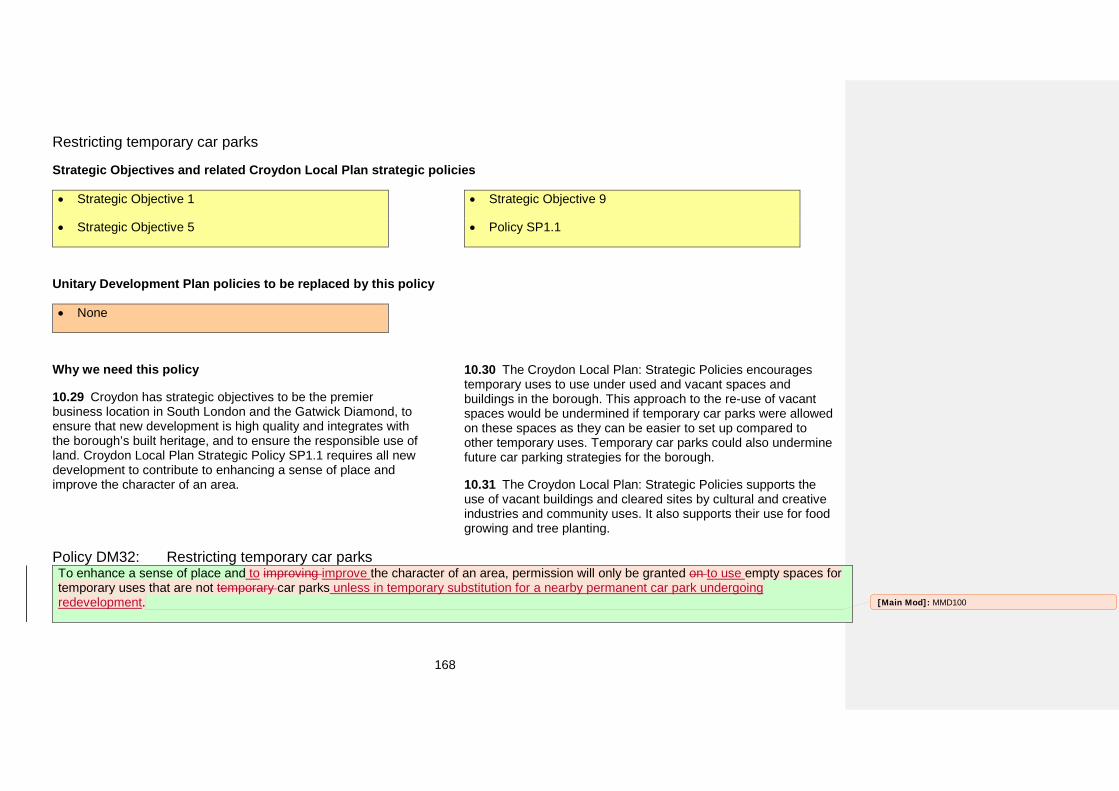
168
Restricting temporary car parks
Strategic Objectives and related Croydon Local Plan strategic policies
• Strategic Objective 1
• Strategic Objective 5
• Strategic Objective 9
• Policy SP1.1
Unitary Development Plan policies to be replaced by this policy
• None
Why we need this policy
10.29 Croydon has strategic objectives to be the premier business location in South London and the Gatwick Diamond, to ensure that new development is high quality and integrates with the borough’s built heritage, and to ensure the responsible use of land. Croydon Local Plan Strategic Policy SP1.1 requires all new development to contribute to enhancing a sense of place and improve the character of an area.
10.30 The Croydon Local Plan: Strategic Policies encourages temporary uses to use under used and vacant spaces and buildings in the borough. This approach to the re-use of vacant spaces would be undermined if temporary car parks were allowed on these spaces as they can be easier to set up compared to other temporary uses. Temporary car parks could also undermine future car parking strategies for the borough.
10.31 The Croydon Local Plan: Strategic Policies supports the use of vacant buildings and cleared sites by cultural and creative industries and community uses. It also supports their use for food growing and tree planting.
Policy DM32: Restricting temporary car parks To enhance a sense of place and to improving improve the character of an area, permission will only be granted on to use empty spaces for temporary uses that are not temporary car parks unless in temporary substitution for a nearby permanent car park undergoing redevelopment. [Main Mod]: MMD100
169
How the policy works
10.32 Cultural and creative industries and community uses are considered preferable to temporary car parks as they are likely to bring greater economic and regeneration benefits to the borough. Temporary car parks are also less likely to improve the character of an area or contribute to enhancing a sense of place.
10.33 Temporary uses can include both specialist organisations such as ACAVA and Acme Studios and community groups, along with temporary landscaping or urban agriculture.
10.34 Where a temporary car park is required because a nearby permanent car park is undergoing redevelopment (including replacement car parking), the Council may accept a proposal for a temporary car park to ensure that there is continued provision of car parking in a locality whilst redevelopment takes place.
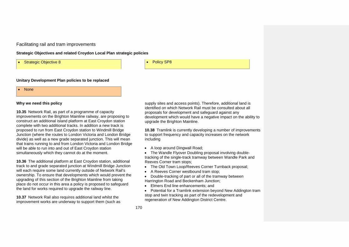
170
Facilitating rail and tram improvements
Strategic Objectives and related Croydon Local Plan strategic policies
• Strategic Objective 8 • Policy SP8
Unitary Development Plan policies to be replaced
• None
Why we need this policy
10.35 Network Rail, as part of a programme of capacity improvements on the Brighton Mainline railway, are proposing to construct an additional island platform at East Croydon station complete with two additional tracks. In addition a new track is proposed to run from East Croydon station to Windmill Bridge Junction (where the routes to London Victoria and London Bridge divide) as well as a new grade separated junction. This will mean that trains running to and from London Victoria and London Bridge will be able to run into and out of East Croydon station simultaneously which they cannot do at the moment.
10.36 The additional platform at East Croydon station, additional track to and grade separated junction at Windmill Bridge Junction will each require some land currently outside of Network Rail’s ownership. To ensure that developments which would prevent the upgrading of this section of the Brighton Mainline from taking place do not occur in this area a policy is proposed to safeguard the land for works required to upgrade the railway line.
10.37 Network Rail also requires additional land whilst the improvement works are underway to support them (such as
supply sites and access points). Therefore, additional land is identified on which Network Rail must be consulted about all proposals for development and safeguard against any development which would have a negative impact on the ability to upgrade the Brighton Mainline.
10.38 Tramlink is currently developing a number of improvements to support frequency and capacity increases on the network including
• A loop around Dingwall Road;• The Wandle Flyover Doubling proposal involving double-tracking of the single-track tramway between Wandle Park and Reeves Corner tram stops; • The Old Town Loop/Reeves Corner Turnback proposal;• A Reeves Corner westbound tram stop;• Double-tracking of part or all of the tramway betweenHarrington Road and Beckenham Junction; • Elmers End line enhancements; and• Potential for a Tramlink extension beyond New Addington tramstop and twin tracking as part of the redevelopment and regeneration of New Addington District Centre.
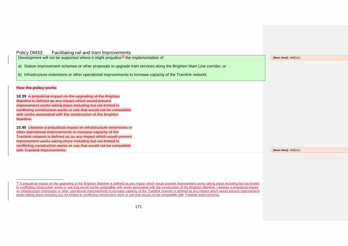
171
Policy DM33: Facilitating rail and tram improvements Development will not be supported where it might prejudice38 the implementation of:
a) Station improvement schemes or other proposals to upgrade train services along the Brighton Main Line corridor; or
b) Infrastructure extensions or other operational improvements to increase capacity of the Tramlink network.
How the policy works
10.39 A prejudicial impact on the upgrading of the Brighton Mainline is defined as any impact which would prevent improvement works taking place including but not limited to conflicting construction works or use that would not be compatible with works associated with the construction of the Brighton Mainline.
10.40 Likewise a prejudicial impact on infrastructure extensions or other operational improvements to increase capacity of the Tramlink network is defined as as any impact which would prevent improvement works taking place including but not limited to conflicting construction works or use that would not be compatible with Tramlink improvements.
38 A prejudicial impact on the upgrading of the Brighton Mainline is defined as any impact which would prevent improvement works taking place including but not limited to conflicting construction works or use that would not be compatible with works associated with the construction of the Brighton Mainline. Likewise a prejudicial impact on infrastructure extensions or other operational improvements to increase capacity of the Tramlink network is defined as any impact which would prevent improvement works taking place including but not limited to conflicting construction work or use that would not be compatible with Tramlink improvements.
[Main Mod]: MMD101
[Main Mod]: MMD101
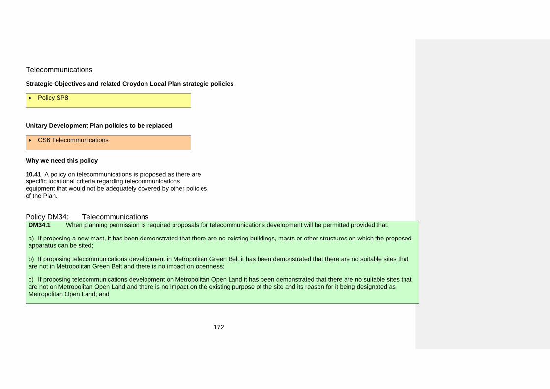
172
Telecommunications
Strategic Objectives and related Croydon Local Plan strategic policies
• Policy SP8
Unitary Development Plan policies to be replaced
• CS6 Telecommunications
Why we need this policy
10.41 A policy on telecommunications is proposed as there are specific locational criteria regarding telecommunications equipment that would not be adequately covered by other policies of the Plan.
Policy DM34: Telecommunications DM34.1 When planning permission is required proposals for telecommunications development will be permitted provided that:
a) If proposing a new mast, it has been demonstrated that there are no existing buildings, masts or other structures on which the proposedapparatus can be sited;
b) If proposing telecommunications development in Metropolitan Green Belt it has been demonstrated that there are no suitable sites thatare not in Metropolitan Green Belt and there is no impact on openness;
c) If proposing telecommunications development on Metropolitan Open Land it has been demonstrated that there are no suitable sites thatare not on Metropolitan Open Land and there is no impact on the existing purpose of the site and its reason for it being designated as Metropolitan Open Land; and
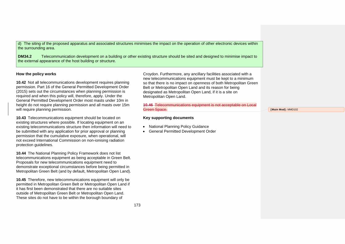
173
d) The siting of the proposed apparatus and associated structures minimises the impact on the operation of other electronic devices withinthe surrounding area.
DM34.2 Telecommunication development on a building or other existing structure should be sited and designed to minimise impact to the external appearance of the host building or structure.
How the policy works
10.42 Not all telecommunications development requires planning permission. Part 16 of the General Permitted Development Order (2015) sets out the circumstances when planning permission is required and when this policy will, therefore, apply. Under the General Permitted Development Order most masts under 10m in height do not require planning permission and all masts over 15m will require planning permission.
10.43 Telecommunications equipment should be located on existing structures where possible. If locating equipment on an existing telecommunications structure then information will need to be submitted with any application for prior approval or planning permission that the cumulative exposure, when operational, will not exceed International Commission on non-ionising radiation protection guidelines.
10.44 The National Planning Policy Framework does not list telecommunications equipment as being acceptable in Green Belt. Proposals for new telecommunications equipment need to demonstrate exceptional circumstances before being permitted in Metropolitan Green Belt (and by default, Metropolitan Open Land).
10.45 Therefore, new telecommunications equipment will only be permitted in Metropolitan Green Belt or Metropolitan Open Land if it has first been demonstrated that there are no suitable sites outside of Metropolitan Green Belt or Metropolitan Open Land. These sites do not have to be within the borough boundary of
Croydon. Furthermore, any ancillary facilities associated with a new telecommunications equipment must be kept to a minimum so that there is no impact on openness of both Metropolitan Green Belt or Metropolitan Open Land and its reason for being designated as Metropolitan Open Land, if it is a site on Metropolitan Open Land.
10.46 Telecommunications equipment is not acceptable on Local Green Space.
Key supporting documents
• National Planning Policy Guidance• General Permitted Development Order
[Main Mod]: MMD102
174
The Places of Croydon The content of this section is related to the theme of Croydon as ‘A Place of Opportunity’. It adds further detail to the Croydon Local Plan: Strategic Policies on planning for the sixteen Places of Croydon. It contains the Council’s policies that would specifically apply to a Place and all the Detailed Proposals.
.
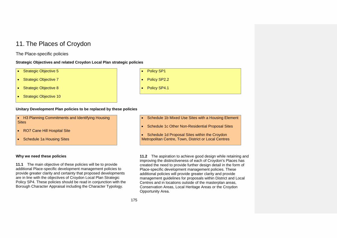
175
11. The Places of CroydonThe Place-specific policies
Strategic Objectives and related Croydon Local Plan strategic policies
• Strategic Objective 5
• Strategic Objective 7
• Strategic Objective 8
• Strategic Objective 10
• Policy SP1
• Policy SP2.2
• Policy SP4.1
Unitary Development Plan policies to be replaced by these policies
• H3 Planning Commitments and Identifying HousingSites
• RO7 Cane Hill Hospital Site
• Schedule 1a Housing Sites
• Schedule 1b Mixed Use Sites with a Housing Element
• Schedule 1c Other Non-Residential Proposal Sites
• Schedule 1d Proposal Sites within the CroydonMetropolitan Centre, Town, District or Local Centres
Why we need these policies
11.1 The main objective of these policies will be to provide additional Place-specific development management policies to provide greater clarity and certainty that proposed developments are in line with the objectives of Croydon Local Plan Strategic Policy SP4. These policies should be read in conjunction with the Borough Character Appraisal including the Character Typology.
11.2 The aspiration to achieve good design while retaining and improving the distinctiveness of each of Croydon’s Places has created the need to provide further design detail in the form of Place-specific development management policies. These additional policies will provide greater clarity and provide management guidelines for proposals within District and Local Centres and in locations outside of the masterplan areas, Conservation Areas, Local Heritage Areas or the Croydon Opportunity Area.
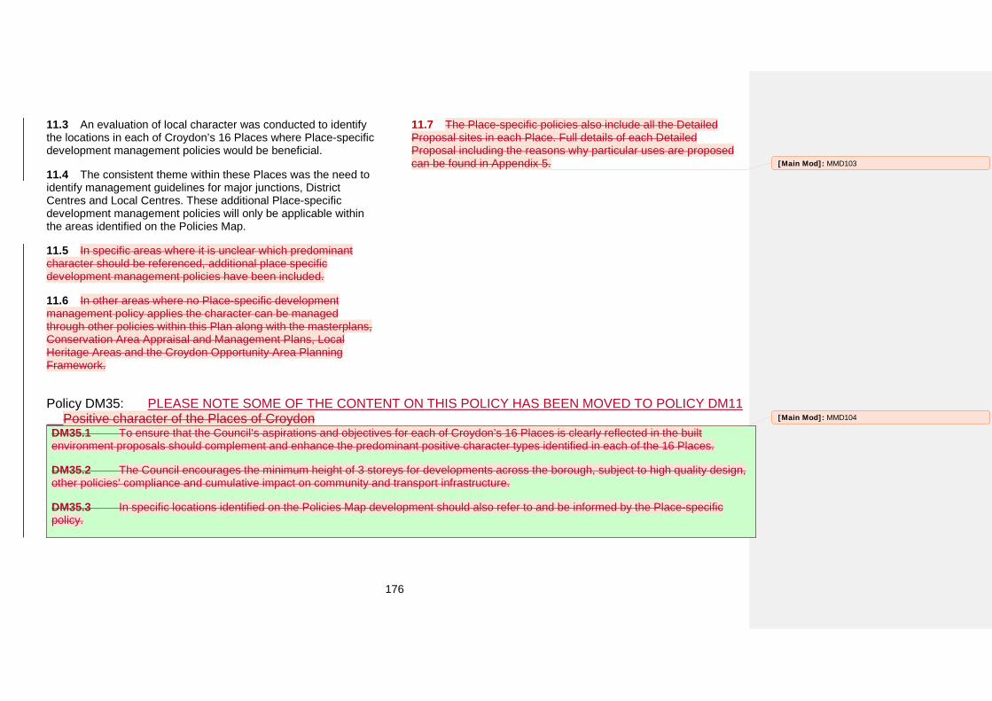
176
11.3 An evaluation of local character was conducted to identify the locations in each of Croydon’s 16 Places where Place-specific development management policies would be beneficial.
11.4 The consistent theme within these Places was the need to identify management guidelines for major junctions, District Centres and Local Centres. These additional Place-specific development management policies will only be applicable within the areas identified on the Policies Map.
11.5 In specific areas where it is unclear which predominant character should be referenced, additional place specific development management policies have been included.
11.6 In other areas where no Place-specific development management policy applies the character can be managed through other policies within this Plan along with the masterplans, Conservation Area Appraisal and Management Plans, Local Heritage Areas and the Croydon Opportunity Area Planning Framework.
11.7 The Place-specific policies also include all the Detailed Proposal sites in each Place. Full details of each Detailed Proposal including the reasons why particular uses are proposed can be found in Appendix 5.
Policy DM35: PLEASE NOTE SOME OF THE CONTENT ON THIS POLICY HAS BEEN MOVED TO POLICY DM11Positive character of the Places of Croydon
DM35.1 To ensure that the Council’s aspirations and objectives for each of Croydon’s 16 Places is clearly reflected in the built environment proposals should complement and enhance the predominant positive character types identified in each of the 16 Places.
DM35.2 The Council encourages the minimum height of 3 storeys for developments across the borough, subject to high quality design, other policies’ compliance and cumulative impact on community and transport infrastructure.
DM35.3 In specific locations identified on the Policies Map development should also refer to and be informed by the Place-specific policy.
[Main Mod]: MMD103
[Main Mod]: MMD104
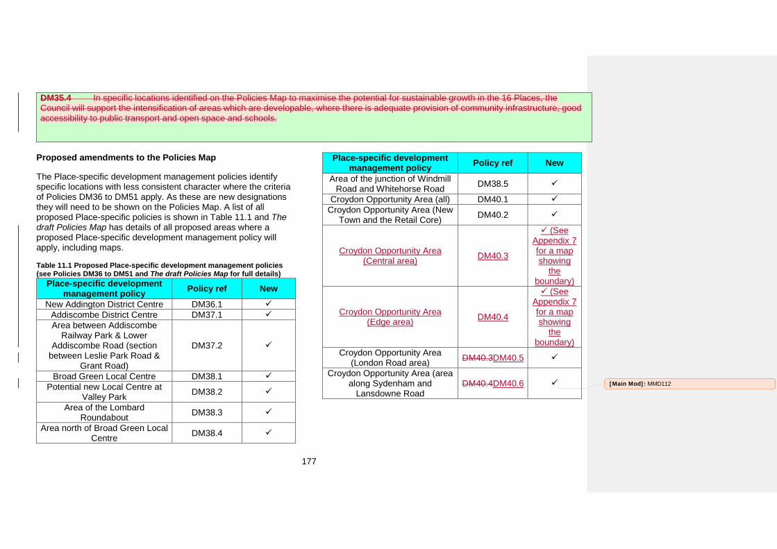
177
DM35.4 In specific locations identified on the Policies Map to maximise the potential for sustainable growth in the 16 Places, the Council will support the intensification of areas which are developable, where there is adequate provision of community infrastructure, good accessibility to public transport and open space and schools.
Proposed amendments to the Policies Map
The Place-specific development management policies identify specific locations with less consistent character where the criteria of Policies DM36 to DM51 apply. As these are new designations they will need to be shown on the Policies Map. A list of all proposed Place-specific policies is shown in Table 11.1 and The draft Policies Map has details of all proposed areas where a proposed Place-specific development management policy will apply, including maps.
Table 11.1 Proposed Place-specific development management policies (see Policies DM36 to DM51 and The draft Policies Map for full details)
Place-specific development management policy Policy ref New
New Addington District Centre DM36.1 Addiscombe District Centre DM37.1 Area between Addiscombe
Railway Park & Lower Addiscombe Road (section
between Leslie Park Road & Grant Road)
DM37.2
Broad Green Local Centre DM38.1 Potential new Local Centre at
Valley Park DM38.2
Area of the Lombard Roundabout DM38.3
Area north of Broad Green Local Centre DM38.4
Place-specific development management policy Policy ref New
Area of the junction of Windmill Road and Whitehorse Road DM38.5
Croydon Opportunity Area (all) DM40.1 Croydon Opportunity Area (New
Town and the Retail Core) DM40.2
Croydon Opportunity Area (Central area) DM40.3
(SeeAppendix 7 for a map showing
the boundary)
Croydon Opportunity Area (Edge area) DM40.4
(SeeAppendix 7 for a map showing
the boundary)
Croydon Opportunity Area (London Road area) DM40.3DM40.5
Croydon Opportunity Area (area along Sydenham and
Lansdowne Road DM40.4DM40.6 [Main Mod]: MMD112
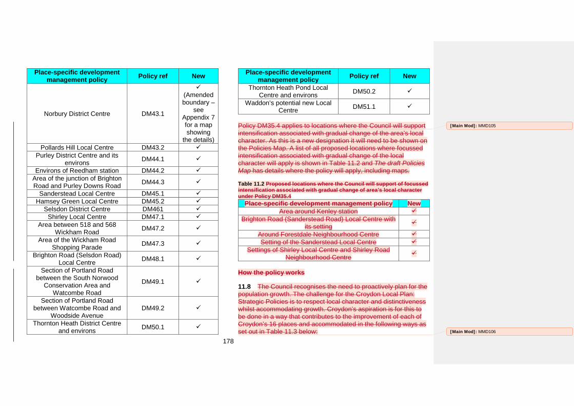
178
Place-specific development management policy Policy ref New
Norbury District Centre DM43.1
(Amended boundary –
see Appendix 7 for a map showing
the details) Pollards Hill Local Centre DM43.2
Purley District Centre and its environs DM44.1
Environs of Reedham station DM44.2 Area of the junction of Brighton Road and Purley Downs Road DM44.3
Sanderstead Local Centre DM45.1 Hamsey Green Local Centre DM45.2
Selsdon District Centre DM461 Shirley Local Centre DM47.1
Area between 518 and 568 Wickham Road DM47.2
Area of the Wickham Road Shopping Parade DM47.3
Brighton Road (Selsdon Road) Local Centre DM48.1
Section of Portland Road between the South Norwood
Conservation Area and Watcombe Road
DM49.1
Section of Portland Road between Watcombe Road and
Woodside Avenue DM49.2
Thornton Heath District Centre and environs DM50.1
Place-specific development management policy Policy ref New
Thornton Heath Pond Local Centre and environs DM50.2
Waddon’s potential new Local Centre DM51.1
Policy DM35.4 applies to locations where the Council will support intensification associated with gradual change of the area’s local character. As this is a new designation it will need to be shown on the Policies Map. A list of all proposed locations where focussed intensification associated with gradual change of the local character will apply is shown in Table 11.2 and The draft Policies Map has details where the policy will apply, including maps.
Table 11.2 Proposed locations where the Council will support of focussed intensification associated with gradual change of area’s local character under Policy DM35.4
Place-specific development management policy New Area around Kenley station
Brighton Road (Sanderstead Road) Local Centre with its setting
Around Forestdale Neighbourhood Centre Setting of the Sanderstead Local Centre
Settings of Shirley Local Centre and Shirley Road Neighbourhood Centre
How the policy works
11.8 The Council recognises the need to proactively plan for the population growth. The challenge for the Croydon Local Plan: Strategic Policies is to respect local character and distinctiveness whilst accommodating growth. Croydon’s aspiration is for this to be done in a way that contributes to the improvement of each of Croydon’s 16 places and accommodated in the following ways as set out in Table 11.3 below:
[Main Mod]: MMD105
[Main Mod]: MMD106
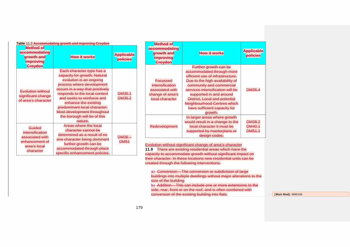
179
Table 11.3 Accommodating growth and improving Croydon Method of
accommodating growth and improving Croydon
How it works Applicable policies
Evolution without significant change of area’s character
Each character type has a capacity for growth. Natural
evolution is an ongoing process where development
occurs in a way that positively responds to the local context and seeks to reinforce and
enhance the existing predominant local character.
Most development throughout the borough will be of this
nature.
DM35.1 DM35.2
Guided intensification
associated with enhancement of
area’s local character
Areas where the local character cannot be
determined as a result of no one character being dominant
further growth can be accommodated through place specific enhancement policies.
DM36 – DM51
Method of accommodating
growth and improving Croydon
How it works Applicable policies
Focussed intensification
associated with change of area’s local character
Further growth can be accommodated through more efficient use of infrastructure. Due to the high availability of community and commercial
services intensification will be supported in and around
District, Local and potential Neighbourhood Centres which
have sufficient capacity for growth.
DM35.4
Redevelopment
In larger areas where growth would result in a change to the
local character it must be supported by masterplans or
design codes.
DM38.2 DM40.1 DM51.1
Evolution without significant change of area’s character 11.9 There are existing residential areas which have the capacity to accommodate growth without significant impact on their character. In these locations new residential units can be created through the following interventions.
Conversion – The conversion or subdivision of large buildings into multiple dwellings without major alterations to the size of the building.
Addition – This can include one or more extensions to the side, rear, front or on the roof, and is often combined with conversion of the existing building into flats. [Main Mod]: MMD106
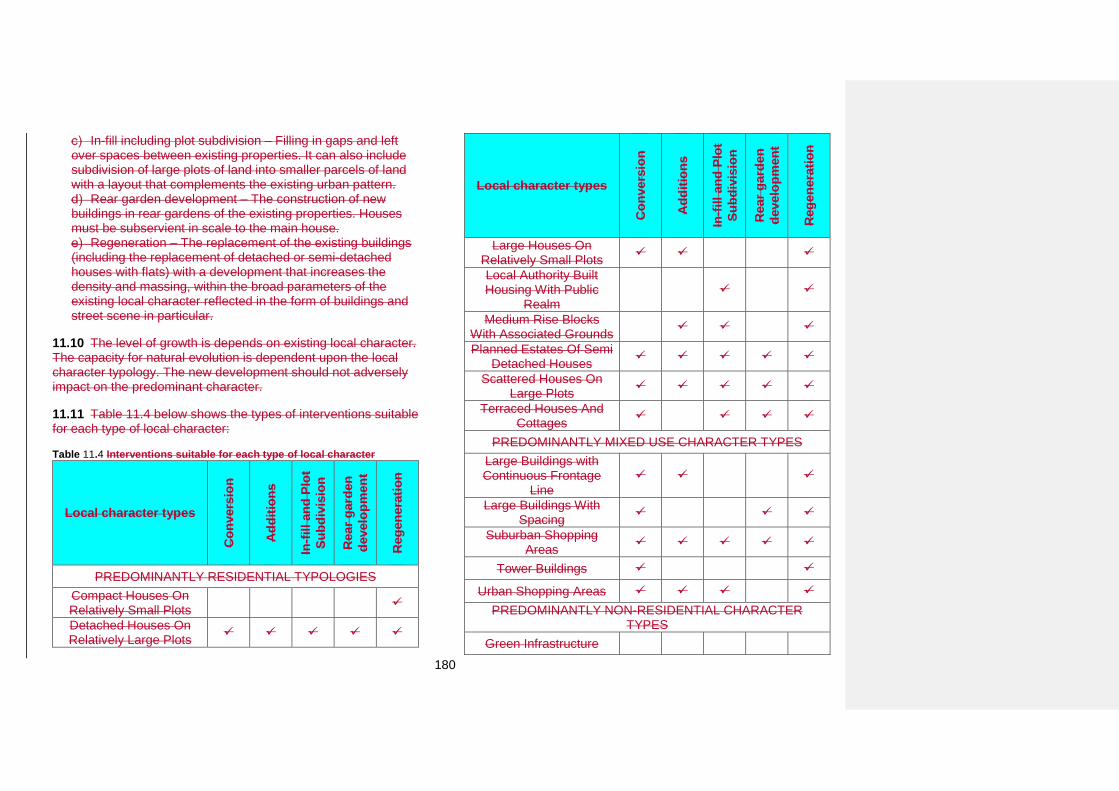
180
In-fill including plot subdivision – Filling in gaps and left over spaces between existing properties. It can also include subdivision of large plots of land into smaller parcels of land with a layout that complements the existing urban pattern.
Rear garden development – The construction of new buildings in rear gardens of the existing properties. Houses must be subservient in scale to the main house.
Regeneration – The replacement of the existing buildings (including the replacement of detached or semi-detached houses with flats) with a development that increases the density and massing, within the broad parameters of the existing local character reflected in the form of buildings and street scene in particular.
11.10 The level of growth is depends on existing local character. The capacity for natural evolution is dependent upon the local character typology. The new development should not adversely impact on the predominant character.
11.11 Table 11.4 below shows the types of interventions suitable for each type of local character:
Table 11.4 Interventions suitable for each type of local character
Local character types
Con
vers
ion
Add
ition
s
In-fi
ll an
d Pl
ot
Subd
ivis
ion
Rea
r gar
den
deve
lopm
ent
Reg
ener
atio
n
PREDOMINANTLY RESIDENTIAL TYPOLOGIES Compact Houses On Relatively Small Plots
Detached Houses On Relatively Large Plots
Local character types
Con
vers
ion
Add
ition
s
In-fi
ll an
d Pl
ot
Subd
ivis
ion
Rea
r gar
den
deve
lopm
ent
Reg
ener
atio
n
Large Houses On Relatively Small Plots
Local Authority Built Housing With Public
Realm
Medium Rise Blocks With Associated Grounds
Planned Estates Of Semi Detached Houses
Scattered Houses On Large Plots
Terraced Houses And Cottages
PREDOMINANTLY MIXED USE CHARACTER TYPES Large Buildings with Continuous Frontage
Line
Large Buildings With Spacing
Suburban Shopping Areas
Tower Buildings
Urban Shopping Areas PREDOMINANTLY NON-RESIDENTIAL CHARACTER
TYPES Green Infrastructure
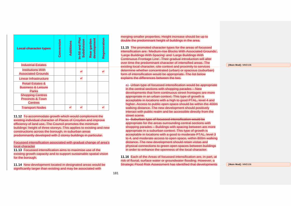
181
Local character types
Con
vers
ion
Add
ition
s
In-fi
ll an
d Pl
ot
Subd
ivis
ion
Rea
r gar
den
deve
lopm
ent
Reg
ener
atio
n
Industrial Estates Institutions With
Associated Grounds
Linear Infrastructure Retail Estates &
Business & Leisure Parks
Shopping Centres Precincts & Town
Centres Transport Nodes
11.12 To accommodate growth which would complement the existing individual character of Places of Croydon and improve efficiency of land use, The Council promotes the minimum buildings’ height of three storeys. This applies to existing and new constructions across the borough, in suburban areas predominantly developed with 2 storey buildings in particular.
Focussed intensification associated with gradual change of area’s local character 11.13 Focussed intensification aims to maximise use of the existing growth capacity and to support sustainable spatial vision for the borough.
11.14 New development located in designated areas would be significantly larger than existing and may be associated with
merging smaller properties. Height increase should be up to double the predominant height of buildings in the area.
11.15 The promoted character types for the areas of focussed intensification are: ‘Medium-rise Blocks With Associated Grounds’, ‘Large Buildings With Spacing’ and ‘Large Buildings With Continuous Frontage Line’. Their gradual introduction will alter over time the predominant character of intensified areas. The existing local character, site context and proximity to services determine whether concentrated (urban) or spacious (suburban) form of intensification would be appropriate. The list below explains the differences between the two.
Urban type of focussed intensification would be appropriate in the central sections with shopping parades – New developments that form continuous street frontages are more appropriate in an urban context. This type of growth is acceptable in locations with a high to good PTAL, level 4 and higher. Access to public open space should be within the 400m walking distance. The new development should positively interact with public realm and be accessible directly from the street scene.
Suburban type of focussed intensification would be appropriate for the areas surrounding central sections with shopping parades – Buildings with spacing between are more appropriate in a suburban context. This type of growth is acceptable in locations with a good to moderate PTAL, level 3 to 4, and moderate access to open space, within 800m walking distance. The new development should retain vistas and physical connections to green open spaces between buildings in order to enhance the openness of the local character.
11.16 Each of the Areas of focussed intensification are, in part, at risk of fluvial, surface water or groundwater flooding. However, a Strategic Flood Risk Assessment has identified that developments
[Main Mod]: MMD106
[Main Mod]: MMD106
182
in these areas could be made safe from flooding without increasing flood risk elsewhere. [Main Mod]: MMD106
183
Addington
General character
11.17 The character of Addington is defined by extensive areas of Metropolitan Green Belt such as Birch Wood, Frith Wood, Rowdown Wood and North Downs. These green areas provide the setting for the Addington Village; and the 20th century housing estates in New Addington which consist of ‘Local Authority Built Housing with Public Realm’ and ‘Compact Houses on Relatively Small Plots’ in Fieldway, both with scattered sections ‘Medium Rise Blocks With Associated Grounds’ and ‘Tower Buildings’.
11.18 Apart from the historic Addington Village, the Place is served by two ‘Suburban Shopping Character Areas’, Central Parade in New Addington (the District Centre) and Wayside in Fieldway.
11.19 The spine of Central Parade separates the less green ‘Suburban Shopping Character Area’ of New Addington’s District Centre from the area containing leisure and community facilities, with a character of ‘Institutions with Associated Grounds’. In addition to these character types, Addington has a number of areas, located to the west and east of Central Parade, with an ‘Industrial Estate’ character. With the exception of Central Parade, these character areas are generally consistent and can be successfully managed through the policies of this Plan.
11.20 The Addington Village Conservation Area incorporates a historic village with medieval origins in a rural setting. The village's architecture represents a variety of character types from various historical periods. The predominant types are: ‘Scattered Houses on Large Plots’ and ‘Detached Houses on Relatively Large Plots’.
Policy DM36: Addington DM36.1 Within the New Addington District Centre, to ensure that the District Centre characteristics are respected and enhanced proposals should:
a) Make use of opportunities to create buildings with a larger footprint to the west of Central Parade; or
b) Create buildings with smaller footprints that complement existing predominant building heights of 3 storeys up to 12 storeys withinCentral Parade.
DM36.2 Within Addington allocate sites for development as set out in Table 11.5.
How the policy works
New Addington District Centre 11.21 The area in which DM36.1 applies is shown on the draft Policies Map.
11.22 The ‘Suburban Shopping Area’ character on Central Parade is characterised by consistent building lines, setbacks and rhythm of facades and fenestration. This uniformity can be managed through other policies in the Croydon Local Plan However, additional policies are required to manage the area to the west of Central Parade where there are precedents of large
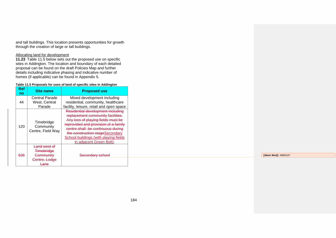
184
and tall buildings. This location presents opportunities for growth through the creation of large or tall buildings.
Allocating land for development 11.23 Table 11.5 below sets out the proposed use on specific sites in Addington. The location and boundary of each detailed proposal can be found on the draft Policies Map and further details including indicative phasing and indicative number of homes (if applicable) can be found in Appendix 5.
Table 11.5 Proposals for uses of land of specific sites in Addington Ref no Site name Proposed use
44 Central Parade West, Central
Parade
Mixed development including residential, community, healthcare
facility, leisure, retail and open space
120 Timebridge Community
Centre, Field Way
Residential development including replacement community facilities. Any loss of playing fields must be
reprovided and provision of a family centre shall be continuous during the construction stageSecondary
School buildings (with playing fields in adjacent Green Belt).
636
Land west of Timebridge Community
Centre, Lodge Lane
Secondary school [Main Mod]: MMD107
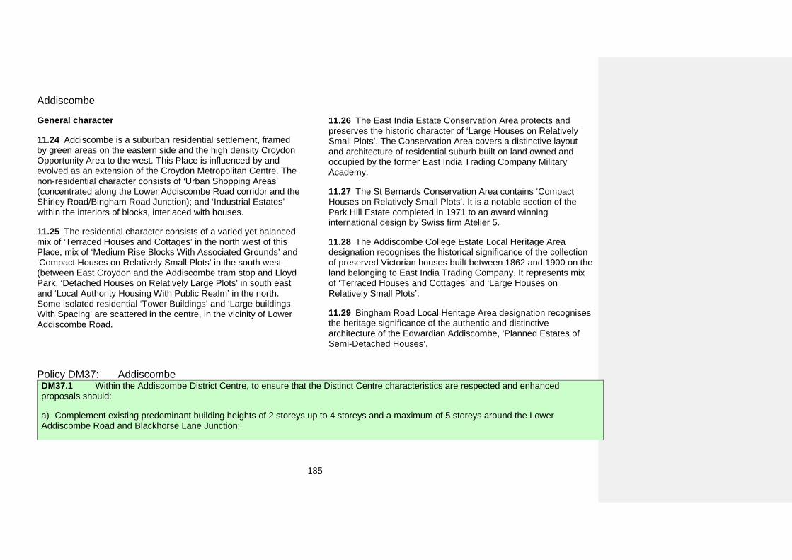
185
Addiscombe
General character
11.24 Addiscombe is a suburban residential settlement, framed by green areas on the eastern side and the high density Croydon Opportunity Area to the west. This Place is influenced by and evolved as an extension of the Croydon Metropolitan Centre. The non-residential character consists of ‘Urban Shopping Areas’ (concentrated along the Lower Addiscombe Road corridor and the Shirley Road/Bingham Road Junction); and ‘Industrial Estates’ within the interiors of blocks, interlaced with houses.
11.25 The residential character consists of a varied yet balanced mix of ‘Terraced Houses and Cottages’ in the north west of this Place, mix of ‘Medium Rise Blocks With Associated Grounds’ and ‘Compact Houses on Relatively Small Plots’ in the south west (between East Croydon and the Addiscombe tram stop and Lloyd Park, ‘Detached Houses on Relatively Large Plots’ in south east and ‘Local Authority Housing With Public Realm’ in the north. Some isolated residential ‘Tower Buildings’ and ‘Large buildings With Spacing’ are scattered in the centre, in the vicinity of Lower Addiscombe Road.
11.26 The East India Estate Conservation Area protects and preserves the historic character of ‘Large Houses on Relatively Small Plots’. The Conservation Area covers a distinctive layout and architecture of residential suburb built on land owned and occupied by the former East India Trading Company Military Academy.
11.27 The St Bernards Conservation Area contains ‘Compact Houses on Relatively Small Plots’. It is a notable section of the Park Hill Estate completed in 1971 to an award winning international design by Swiss firm Atelier 5.
11.28 The Addiscombe College Estate Local Heritage Area designation recognises the historical significance of the collection of preserved Victorian houses built between 1862 and 1900 on the land belonging to East India Trading Company. It represents mix of ‘Terraced Houses and Cottages’ and ‘Large Houses on Relatively Small Plots’.
11.29 Bingham Road Local Heritage Area designation recognises the heritage significance of the authentic and distinctive architecture of the Edwardian Addiscombe, ‘Planned Estates of Semi-Detached Houses’.
Policy DM37: Addiscombe DM37.1 Within the Addiscombe District Centre, to ensure that the Distinct Centre characteristics are respected and enhanced proposals should:
a) Complement existing predominant building heights of 2 storeys up to 4 storeys and a maximum of 5 storeys around the LowerAddiscombe Road and Blackhorse Lane Junction;
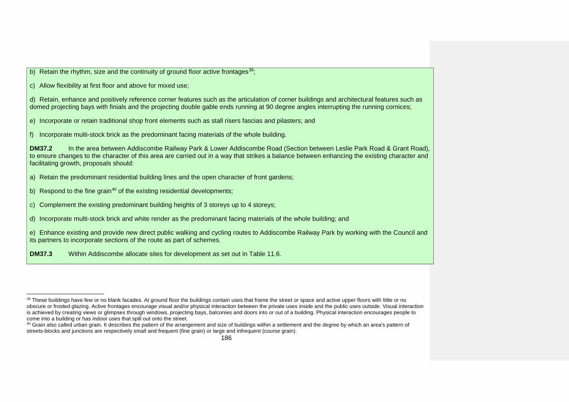
186
b) Retain the rhythm, size and the continuity of ground floor active frontages39;
c) Allow flexibility at first floor and above for mixed use;
d) Retain, enhance and positively reference corner features such as the articulation of corner buildings and architectural features such asdomed projecting bays with finials and the projecting double gable ends running at 90 degree angles interrupting the running cornices;
e) Incorporate or retain traditional shop front elements such as stall risers fascias and pilasters; and
f) Incorporate multi-stock brick as the predominant facing materials of the whole building.
DM37.2 In the area between Addiscombe Railway Park & Lower Addiscombe Road (Section between Leslie Park Road & Grant Road), to ensure changes to the character of this area are carried out in a way that strikes a balance between enhancing the existing character and facilitating growth, proposals should:
a) Retain the predominant residential building lines and the open character of front gardens;
b) Respond to the fine grain40 of the existing residential developments;
c) Complement the existing predominant building heights of 3 storeys up to 4 storeys;
d) Incorporate multi-stock brick and white render as the predominant facing materials of the whole building; and
e) Enhance existing and provide new direct public walking and cycling routes to Addiscombe Railway Park by working with the Council andits partners to incorporate sections of the route as part of schemes.
DM37.3 Within Addiscombe allocate sites for development as set out in Table 11.6.
39 These buildings have few or no blank facades. At ground floor the buildings contain uses that frame the street or space and active upper floors with little or no obscure or frosted glazing. Active frontages encourage visual and/or physical interaction between the private uses inside and the public uses outside. Visual interaction is achieved by creating views or glimpses through windows, projecting bays, balconies and doors into or out of a building. Physical interaction encourages people to come into a building or has indoor uses that spill out onto the street. 40 Grain also called urban grain. It describes the pattern of the arrangement and size of buildings within a settlement and the degree by which an area's pattern of streets-blocks and junctions are respectively small and frequent (fine grain) or large and infrequent (course grain).
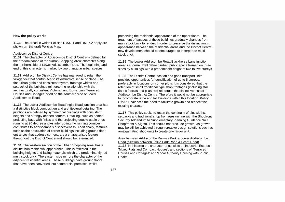
187
How the policy works
11.30 The areas in which Policies DM37.1 and DM37.2 apply are shown on the draft Policies Map.
Addiscombe District Centre 11.31 The character of Addiscombe District Centre is defined by the predominance of the ‘Urban Shopping Area’ character along the northern side of Lower Addiscombe Road. The beginning and end of this character is marked by two triangular urban spaces.
11.32 Addiscombe District Centre has managed to retain the village feel that contributes to its distinctive sense of place. The fine urban grain and consistent rhythm, frontage widths and setback of the buildings reinforce the relationship with the architecturally consistent Victorian and Edwardian ‘Terraced Houses and Cottages’ sited on the southern side of Lower Addiscombe Road.
11.33 The Lower Addiscombe Road/Inglis Road junction area has a distinctive block composition and architectural detailing. The junctions are defined by symmetrical buildings with consistent heights and strongly defined corners. Detailing, such as domed projecting bays with finials and the projecting double gable ends running at 90 degree angles interrupting the running cornices, contributes to Addiscombe’s distinctiveness. Additionally, features, such as the articulation of corner buildings including ground floor entrances that address corners, are a characteristic feature throughout the District Centre and should be referenced.
11.34 The western section of the ‘Urban Shopping Area’ has a distinct non-residential appearance. This is reflected in the building heights and facing materials which are predominantly red multi stock brick. The eastern side mirrors the character of the adjacent residential areas. These buildings have ground floors that have been converted into commercial premises, whilst
preserving the residential appearance of the upper floors. The treatment of facades of these buildings gradually changes from multi stock brick to render. In order to preserve the distinction in appearance between the residential areas and the District Centre, new development should be encouraged to incorporate multi-stock brick.
11.35 The Lower Addiscombe Road/Blackhorse Lane junction area is a formal, well defined urban public space framed on three sides by buildings with a predominant height of two to five storeys.
11.36 The District Centre location and good transport links provides opportunities for densification of up to 5 storeys, preferably in locations on corner plots. It is considered that the retention of small traditional type shop frontages (including stall riser’s fascias and pilasters) reinforces the distinctiveness of Addiscombe District Centre. Therefore it would not be appropriate to incorporate large and tall buildings within this location. Policy DM37.1 balances the need to facilitate growth and respect the existing character.
11.37 This policy seeks to retain the continuity of plot widths, setbacks and traditional shop frontages (in line with the Shopfront Security Addendum to Supplementary Planning Guidance No.1 Shopfronts & Signs). This should not preclude growth, as growth may be still be achieved through creative design solutions such as amalgamating shop units to create one larger unit.
Area between Addiscombe Railway Park & Lower Addiscombe Road (Section between Leslie Park Road & Grant Road) 11.38 In this area the character of consists of ‘Industrial Estates’, ‘Mixed Flats and Compact Houses’, and sections of ‘Terraced Houses and Cottages’ and ‘Local Authority Housing with Public Realm’.
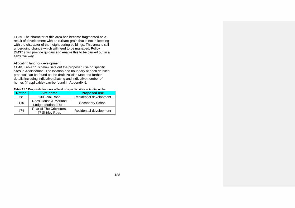
188
11.39 The character of this area has become fragmented as a result of development with an (urban) grain that is not in keeping with the character of the neighbouring buildings. This area is still undergoing change which will need to be managed. Policy DM37.2 will provide guidance to enable this to be carried out in a sensitive way.
Allocating land for development 11.40 Table 11.6 below sets out the proposed use on specific sites in Addiscombe. The location and boundary of each detailed proposal can be found on the draft Policies Map and further details including indicative phasing and indicative number of homes (if applicable) can be found in Appendix 5.
Table 11.6 Proposals for uses of land of specific sites in Addiscombe Ref no Site name Proposed use
68 130 Oval Road Residential development
116 Rees House & Morland Lodge, Morland Road Secondary School
474 Rear of The Cricketers, 47 Shirley Road Residential development
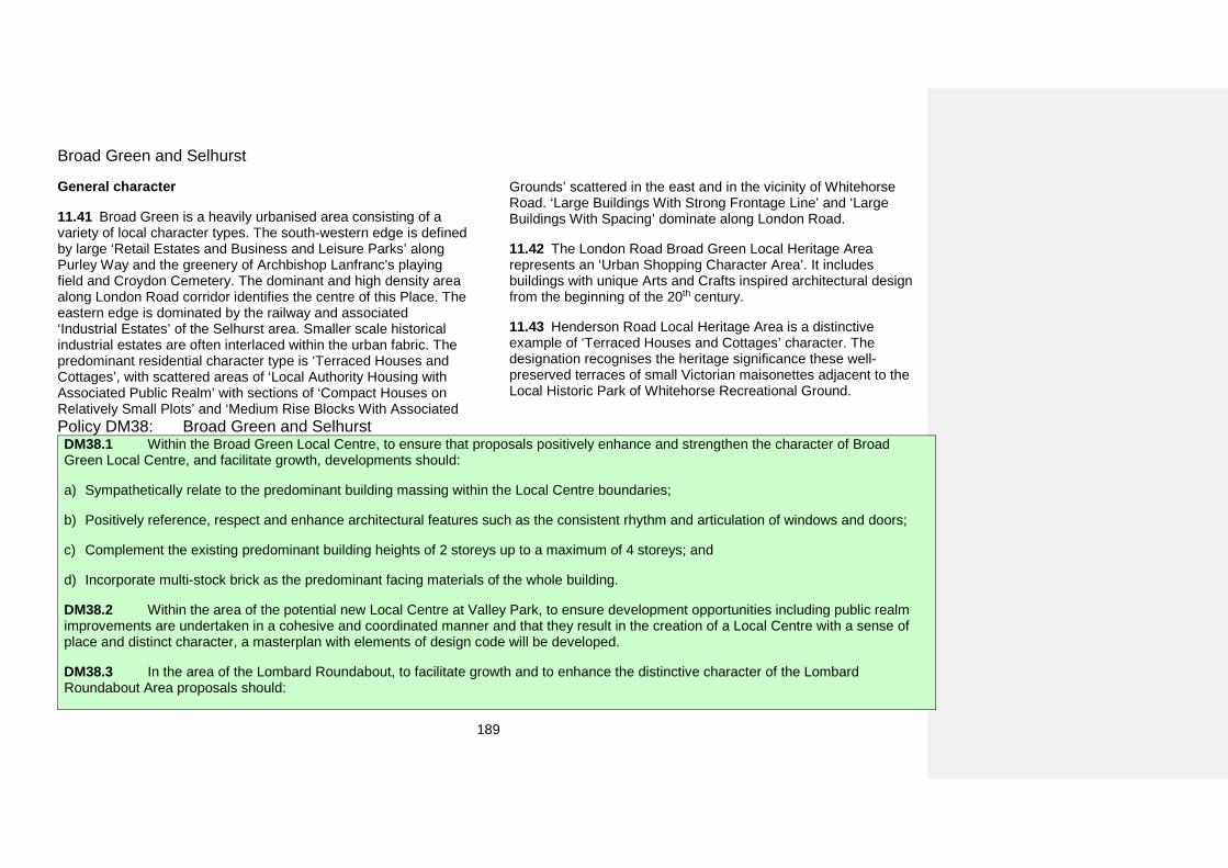
189
Broad Green and Selhurst
General character
11.41 Broad Green is a heavily urbanised area consisting of a variety of local character types. The south-western edge is defined by large ‘Retail Estates and Business and Leisure Parks’ along Purley Way and the greenery of Archbishop Lanfranc's playing field and Croydon Cemetery. The dominant and high density area along London Road corridor identifies the centre of this Place. The eastern edge is dominated by the railway and associated ‘Industrial Estates’ of the Selhurst area. Smaller scale historical industrial estates are often interlaced within the urban fabric. The predominant residential character type is ‘Terraced Houses and Cottages’, with scattered areas of ‘Local Authority Housing with Associated Public Realm’ with sections of ‘Compact Houses on Relatively Small Plots’ and ‘Medium Rise Blocks With Associated
Grounds’ scattered in the east and in the vicinity of Whitehorse Road. ‘Large Buildings With Strong Frontage Line’ and ‘Large Buildings With Spacing’ dominate along London Road.
11.42 The London Road Broad Green Local Heritage Area represents an ‘Urban Shopping Character Area’. It includes buildings with unique Arts and Crafts inspired architectural design from the beginning of the 20th century.
11.43 Henderson Road Local Heritage Area is a distinctive example of ‘Terraced Houses and Cottages’ character. The designation recognises the heritage significance these well-preserved terraces of small Victorian maisonettes adjacent to the Local Historic Park of Whitehorse Recreational Ground.
Policy DM38: Broad Green and Selhurst DM38.1 Within the Broad Green Local Centre, to ensure that proposals positively enhance and strengthen the character of Broad Green Local Centre, and facilitate growth, developments should:
a) Sympathetically relate to the predominant building massing within the Local Centre boundaries;
b) Positively reference, respect and enhance architectural features such as the consistent rhythm and articulation of windows and doors;
c) Complement the existing predominant building heights of 2 storeys up to a maximum of 4 storeys; and
d) Incorporate multi-stock brick as the predominant facing materials of the whole building.
DM38.2 Within the area of the potential new Local Centre at Valley Park, to ensure development opportunities including public realm improvements are undertaken in a cohesive and coordinated manner and that they result in the creation of a Local Centre with a sense of place and distinct character, a masterplan with elements of design code will be developed.
DM38.3 In the area of the Lombard Roundabout, to facilitate growth and to enhance the distinctive character of the Lombard Roundabout Area proposals should:
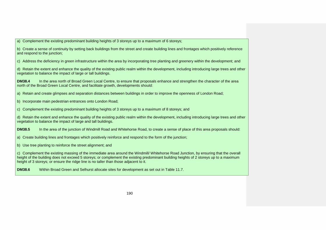
190
a) Complement the existing predominant building heights of 3 storeys up to a maximum of 6 storeys;
b) Create a sense of continuity by setting back buildings from the street and create building lines and frontages which positively referenceand respond to the junction;
c) Address the deficiency in green infrastructure within the area by incorporating tree planting and greenery within the development; and
d) Retain the extent and enhance the quality of the existing public realm within the development, including introducing large trees and othervegetation to balance the impact of large or tall buildings.
DM38.4 In the area north of Broad Green Local Centre, to ensure that proposals enhance and strengthen the character of the area north of the Broad Green Local Centre, and facilitate growth, developments should:
a) Retain and create glimpses and separation distances between buildings in order to improve the openness of London Road;
b) Incorporate main pedestrian entrances onto London Road;
c) Complement the existing predominant building heights of 3 storeys up to a maximum of 8 storeys; and
d) Retain the extent and enhance the quality of the existing public realm within the development, including introducing large trees and othervegetation to balance the impact of large and tall buildings.
DM38.5 In the area of the junction of Windmill Road and Whitehorse Road, to create a sense of place of this area proposals should:
a) Create building lines and frontages which positively reinforce and respond to the form of the junction;
b) Use tree planting to reinforce the street alignment; and
c) Complement the existing massing of the immediate area around the Windmill/ Whitehorse Road Junction, by ensuring that the overallheight of the building does not exceed 5 storeys; or complement the existing predominant building heights of 2 storeys up to a maximum height of 3 storeys; or ensure the ridge line is no taller than those adjacent to it.
DM38.6 Within Broad Green and Selhurst allocate sites for development as set out in Table 11.7.
191
How the policy works
11.44 The areas in which Policies DM38.1 to DM38.5 apply are shown on the draft Policies Map.
Broad Green Local Centre 11.45 Broad Green Local Centre is dominated by the London Road traffic. It is an area with potential for growth.
11.46 The edge of the Broad Green Local Centre is eroding and is beginning to lose its separate identity and sense of place. This could lead to the Local Centre being amalgamated into the homogenous urban form of the London Road.
11.47 The detailed policies in DM38.1 will help to strengthen the identity of the Local Centre by setting design parameters such as consistent scale, street frontage treatment and public realm requirements.
Potential new Local Centre at Valley Park 11.48 The area is currently dominated by large scale ‘Retail Estates and Business and Leisure Parks’ and associated parking, separated from the adjoining area by embankments, Purley Way and the tram infrastructure.
11.49 There is a mix of uses similar to an urban centre. However, large amounts of car dominated spaces make this area less pedestrian and cycle friendly. Additionally, the presence of large undefined spaces has contributed to this area's lack of a sense of place.
11.50 There is potential for growth and for transformation into a new Local Centre. To enable potential development opportunities to be undertaken in a cohesive and coordinated manner, a masterplan will be considered.
Lombard Roundabout area 11.51 This is an area at the edge of two character types that contrast in scale. These are ‘Terraced Houses and Cottages’ and ‘Large Buildings in an Urban Setting’. The area has potential for growth. The Place-specific development management policy is required to facilitate growth that enhances the distinctive character of the Lombard Roundabout Area.
11.52 These policies will encourage new developments to establish a transitional zone between the existing uniform low rise residential areas and the larger scale structures around the Lombard Roundabout.
Area north of Broad Green Local Centre 11.53 The edge of the Broad Green Local Centre is eroding and is beginning to lose its separate identity and sense of place. This could result in its being absorbed into the homogenous urban form of London Road.
11.54 The area north of Broad Green Local Centre is already experiencing growth. A cohesive approach needs to be taken to ensure that Local Centre edge is well defined and that the buildings along London Road have spacing.
Area of the junction of Windmill Road and Whitehorse Road 11.55 There is a poor relationship between the street layout and the building frontages at the Windmill Road/Whitehorse Road junction area. This has resulted in an area lacking a sense of place. The character within this area is a mix of low rise ‘Terraced Houses and Cottages’, ‘Industrial Estates’ and ‘Retail Estates and Business and Leisure Parks’.
11.56 There is a potential for growth and an opportunity for improving the definition of frontages and street edge, as well as overall quality of urban environment. This could include
[Main Mod]: MMD108
192
addressing the deficiency in green infrastructure by ensuring tree planting and greenery is an intrinsic part of the development.
Allocating land for development 11.57 Table 11.7 below sets out the proposed use on specific sites in Broad Green and Selhurst. The location and boundary of each detailed proposal can be found on the draft Policies Map and further details including indicative phasing and indicative number of homes (if applicable) can be found in Appendix 5.
Table 11.7 Proposals for uses of land of specific sites in Broad Green and Selhurst
Ref no Site name Proposed use 78 114-118 Whitehorse
Road Residential conversion and
extension
119 Amenity land at Croydon AFC stadium, Mayfield
Road
Primary school with access to playing field for
community use outside of school hours
157 Canterbury Mill, 103 Canterbury Road New primary school
314 Valley Park (B&Q and
Units A-G Daniell Way), Hesterman Way
Redevelopment of this area to a mixture of residential, retail, healthcare facility (if
required by the NHS), community and leisure to form the basis of a new
residential community and local centre.
Ref no Site name Proposed use
334 Valley Leisure Park, Hesterman Way
Redevelopment of this area to a mixture of residential, retail, healthcare facility (if
required by the NHS), community and leisure to form the basis of a new
residential community and local centre.
337 Zodiac Court, 161-183 London Road Residential redevelopment
348 Homebase & Matalan stores, 60-66 Purley Way
Mixed use residential and retail development
396 Praise House, 145-149 London Road
Redevelopment for mixed use residential and
community use
404 Vistec House & 14
Cavendish Road, 185 London Road
Residential development
416 Challenge House, 618 Mitcham Road
Residential redevelopment or conversion. Conversion would need to adhere to
Local Plan and London Plan Standards to improve the
sustainability of the development.
471 Masonic Hall car park, 1- 1B Stanton Road Residential development
517 Milton House, 2-36 Milton Avenue
Residential and employment uses
[Main Mod]: MMD109
193
Coulsdon
General character
11.58 Coulsdon is a small suburban settlement surrounded by areas of Green Belt. The Green Belt in this area is characterised by open views of open spaces and wooded mature tree belts. Coulsdon’s District Centre has a well-defined and consistent ‘Urban Shopping Area’ character and two parallel strips containing ‘Retail Estates and Business and Leisure Parks’ and ‘Industrial Estates’ separated by the bypass and railway lines.
11.59 Coulsdon’s built environment is located within the valleys alongside railway lines and main roads. The predominant residential characters are ‘Detached Houses on Relatively Large Plots With Minimum Public Realm’ to the north and east, an estate of ‘Compact Houses on Relatively Small Plots’ to the east, ‘Planned Estates of Semi Detached Houses’ with garages, and low density, ‘Scattered Houses on Large Plots’ in the south.
11.60 The Chipstead Valley Road (St Dunstan’s Cottages) Local Heritage Area designation recognises the distinctive architecture of workers’ houses from c.1900 representing the ‘Terraced Houses and Cottages’ character. Their layout reveals the location of the historic site of the former Surrey Iron Railway.
11.61 The Station Approach (Coulsdon) Local Heritage Area represents the ‘Terraced Houses and Cottages’ character. It contains modest Victorian railway cottages with aesthetic style inspired features set in the distinctive townscape.
11.62 The Dutch Village Local Heritage Area has the ‘Detached Houses on Relatively Large Plots’ character. This distinctive estate was designed by the Dutch architect Wouter Hamdorff as a ‘modern Dutch garden village’ in late 1930’s.
Policy DM39: Coulsdon Within Coulsdon allocate sites for development as set out in Table 11.8.
How the policy works
11.63 Coulsdon has the potential for growth. Much of this is concentrated within the Cane Hill area.
11.64 The District Centre and environs is an area with a broad mix of uses. This has resulted in a variety of character areas with diverse set of transitions between characters.
11.65 Coulsdon District Centre is well served by public transport. This provides an opportunity for it to function as a destination. The
sense of place requires strengthening and enhancing of its attractiveness to residents and those visiting the area.
11.66 Each of the character areas within Coulsdon is well defined and consistent. Future development can be successfully guided by general policies and there is no place specific development management policy for this area.
Allocating land for development 11.67 Table 11.8 below sets out the proposed use on specific sites in Coulsdon. The location and boundary of each detailed proposal can be found on the draft Policies Map and further
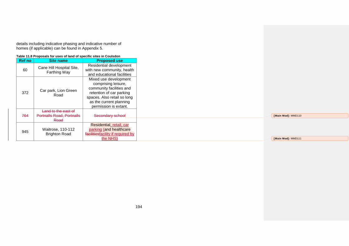
194
details including indicative phasing and indicative number of homes (if applicable) can be found in Appendix 5.
Table 11.8 Proposals for uses of land of specific sites in Coulsdon Ref no Site name Proposed use
60 Cane Hill Hospital Site, Farthing Way
Residential development with new community, health
and educational facilities
372 Car park, Lion Green Road
Mixed use development comprising leisure,
community facilities and retention of car parking
spaces. Also retail so long as the current planning permission is extant.
764 Land to the east of
Portnalls Road, Portnalls Road
Secondary school
945 Waitrose, 110-112 Brighton Road
Residential, retail, car parking (and healthcare
facilitiesfacility if required by the NHS)
[Main Mod]: MMD110
[Main Mod]: MMD111
195
Croydon Opportunity Area
General character
11.68 Croydon Opportunity Area is an urban area with diverse character types. It is the only one of Croydon’s 16 Places to contain all nine non-residential character types, each of which influences the way in which this Place has developed. The centre of Croydon is typically characterised by the dominant intersecting ‘Linear Infrastructure’ of the roads (such as the Wellesley Road, Park Lane and the Flyover) rail and tram lines which create distinct separations between the different character types. The ‘Shopping Centres and Precincts’ and ‘Tower Buildings’ are located to the west and east of the central spine along Wellesley Road. These areas have a larger grain and predominantly contain modern and contemporary buildings. The character of Wellesley Road has also been influenced by the number of ‘Large Buildings in an Urban Setting’ which are concentrated to the north and east of this road and in close proximity to the ‘Transport Nodes’. There are also a small number of ‘Large Buildings With Strong Frontage Line’ located to the south. Radiating southwards from the ‘Shopping Centres and Precincts’ are the ‘Urban Shopping Area’ character. The urban grain of these areas reflects the surrounding residential character with a smaller finer grain.
11.69 The residential areas are located around the edge of this place and consist of a predominant mix of ‘Large Houses on Relatively Small Plots’, ‘Terraced Houses and Cottages’ and ‘Medium Rise Blocks With Associated Grounds’. Interspersed amongst the residential areas are small pockets of ‘Industrial Estates’, ‘Retail Estates and Business and Leisure Parks’, and ‘Institutions with Associated Grounds’.
11.70 The Central Croydon Conservation Area represents the historic character of ‘Urban Shopping Character Areas’. It is focused on Croydon's historic municipal and commercial heart,
including a great variety of historic Listed and Locally Listed Buildings from several centuries.
11.71 The Church Street Conservation Area represents the historic character of ‘Urban Shopping Character Areas’. It is focused on the historic thoroughfare which curves through Croydon's Old Town, linking the High Street with the area around the Croydon Minster. The Conservation Area has a number of Listed and Locally Listed Buildings dated from the early 18th century onwards.
11.72 The Croydon Minster Conservation Area represents the historic character of ‘Urban Shopping Character Areas’ and ‘Institutions with Associated Grounds’. It is focused on the heart of Croydon's old town, encompassing the highly significant medieval and Victorian Parish Church of St John and the former Archbishop's Palace, both Grade I Listed Buildings.
11.73 The Chatsworth Road Conservation Area represents the authentic residential character of ‘Large Houses on Relatively Small Plots’. It contains well-preserved large Victorian and Edwardian houses, in a range of notable styles.
11.74 The Wellesley Road (North) Conservation Area represents the authentic residential character of ‘Large Houses on Relatively Small Plots’. It is a collection of early/mid Victorian houses, which are some of the oldest surviving properties in the town centre and a remarkable contrast to the redeveloped adjacent modernist areas.
11.75 The Laud Street Local Heritage Area recognises the heritage significance of its well-preserved historic architecture and townscape of ‘Terraced Houses and Cottages’ character.
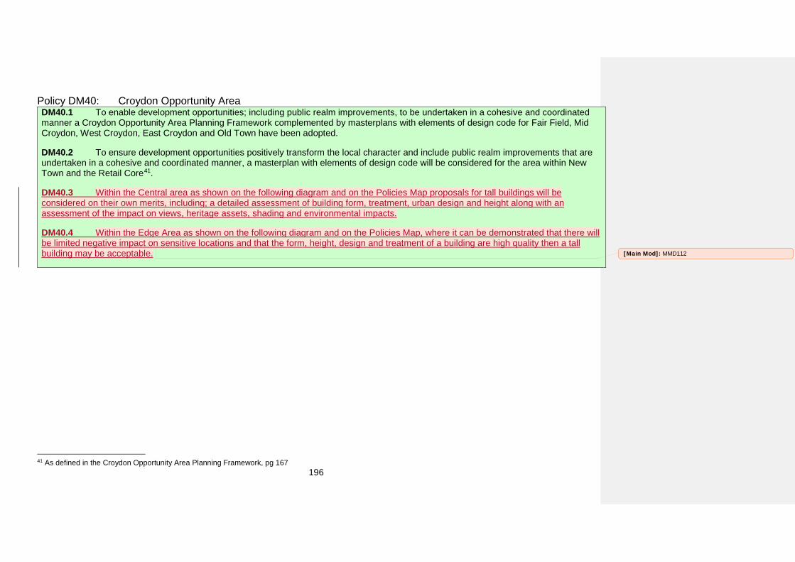
196
Policy DM40: Croydon Opportunity Area DM40.1 To enable development opportunities; including public realm improvements, to be undertaken in a cohesive and coordinated manner a Croydon Opportunity Area Planning Framework complemented by masterplans with elements of design code for Fair Field, Mid Croydon, West Croydon, East Croydon and Old Town have been adopted.
DM40.2 To ensure development opportunities positively transform the local character and include public realm improvements that are undertaken in a cohesive and coordinated manner, a masterplan with elements of design code will be considered for the area within New Town and the Retail Core41.
DM40.3 Within the Central area as shown on the following diagram and on the Policies Map proposals for tall buildings will be considered on their own merits, including; a detailed assessment of building form, treatment, urban design and height along with an assessment of the impact on views, heritage assets, shading and environmental impacts.
DM40.4 Within the Edge Area as shown on the following diagram and on the Policies Map, where it can be demonstrated that there will be limited negative impact on sensitive locations and that the form, height, design and treatment of a building are high quality then a tall building may be acceptable.
41 As defined in the Croydon Opportunity Area Planning Framework, pg 167
[Main Mod]: MMD112
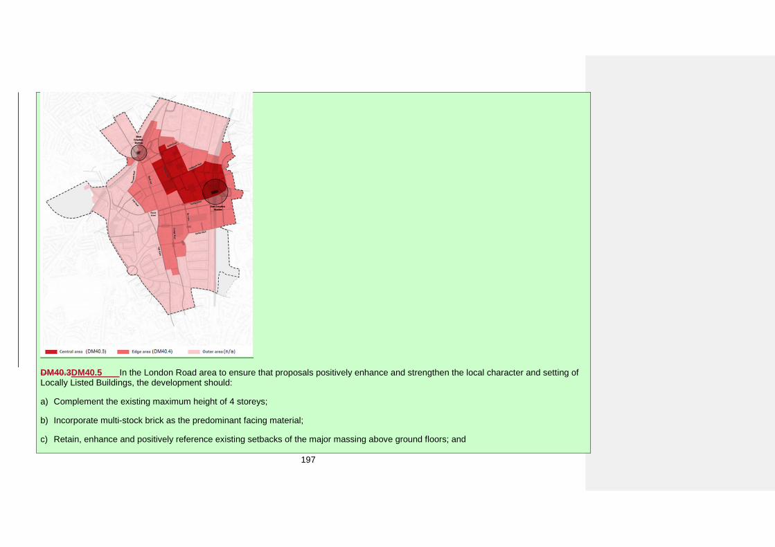
197
DM40.3DM40.5 In the London Road area to ensure that proposals positively enhance and strengthen the local character and setting of Locally Listed Buildings, the development should:
a) Complement the existing maximum height of 4 storeys;
b) Incorporate multi-stock brick as the predominant facing material;
c) Retain, enhance and positively reference existing setbacks of the major massing above ground floors; and
198
d) Retain, enhance and positively reference architectural detailing on Locally Listed Buildings.
DM40.4DM40.6 In the area along Sydenham and Lansdowne Road, to facilitate growth and enhance the sense of place, developments should retain and create glimpses and separation distances between buildings in order to improve openness within the edge of the town centre.
DM40.5DM40.7 Within Croydon Opportunity Area allocate sites for development as set out in Table 11.9.
How the policy works
11.76 The areas in which Policies DM40.2 to DM40.6 apply are shown on the draft Policies Map.
11.77 The extent of Croydon Opportunity Area is mostly covered by the Masterplans for Fair Field, Mid Croydon, Old Town, West Croydon and East Croydon which address the complex issues within these areas. With the exception of the London Road area and along Sydenham and Lansdowne Roads the character elsewhere in the opportunity area can be successfully managed by the general policies.
London Road area 11.78 London Road is the northern gateway to Croydon Metropolitan Centre. Buildings range from Listed Victorian high street buildings to large modernist residential and commercial buildings along with run down and derelict units. Similarly, there is a mixed quality public realm, from the welcoming and colourful entrance at West Croydon station to large unused spaces and car yards to the north of London Road. West Croydon station, the Lidl supermarket and the proximity of the Retail Core and the University Hospital are some of the major attractions that draw people into the area. The area has been undergoing change due to proximity to the town centre and a major transport interchange of West Croydon station. Additionally a number of redevelopment opportunities have arisen from the civil unrest damages.
11.79 The London Road area has a variety of fine examples of architecture which has been recognised by being designated as Locally Listed Buildings. Though their articulation varies, they have a number of common characteristics such as: regular rhythm of elevations marked by windows and the way they are framed, high quality workmanship and materials. There are fine examples of brickwork and render. A number of buildings, which were originally set back from the street, have been extended on the ground floor. These create a feel of openness, more human scale and introduce formal diversity to the street.
11.80 In order to accommodate growth in a way that respects and enhances the diversity of the London Road character, new development should be informed and inspired by these qualities.
Area along Sydenham and Lansdowne Road 11.81 Areas along Sydenham and Lansdowne Road have a very mixed character due to undergoing densification and redevelopment. The original character of ‘Large Buildings on Relatively Small Plots’ is being gradually replaced with ‘Mixed Type Flats’. Residential buildings of a detached form, with spacing between them, set back and forecourts are key features of urban pattern in the area.
11.82 In order to maintain and enhance the distinctive character of the residential edge of the town centre, and to prevent further
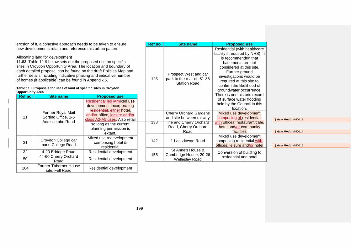
199
erosion of it, a cohesive approach needs to be taken to ensure new developments retain and reference this urban pattern.
Allocating land for development 11.83 Table 11.9 below sets out the proposed use on specific sites in Croydon Opportunity Area. The location and boundary of each detailed proposal can be found on the draft Policies Map and further details including indicative phasing and indicative number of homes (if applicable) can be found in Appendix 5.
Table 11.9 Proposals for uses of land of specific sites in Croydon Opportunity Area
Ref no Site name Proposed use
21 Former Royal Mail Sorting Office, 1-5 Addiscombe Road
Residential led Mmixed use development incorporating
residential, either hotel, and/or office, leisure and/or
class A2-A5 uses. Also retail so long as the current planning permission is
extant.
31 Croydon College car park, College Road
Mixed use redevelopment comprising hotel &
residential 32 4-20 Edridge Road Residential development
50 44-60 Cherry Orchard Road Residential development
104 Former Taberner House site, Fell Road Residential development
Ref no Site name Proposed use
123 Prospect West and car
park to the rear of, 81-85 Station Road
Residential (with healthcare facility if required by NHS). It
is recommended that basements are not
considered at this site. Further ground
investigations would be required at this site to
confirm the likelihood of groundwater occurrence.
There is one historic record of surface water flooding held by the Council in this
location.
138
Cherry Orchard Gardens and site between railway line and Cherry Orchard Road, Cherry Orchard
Road
Mixed use development comprising of residential,
with offices, restaurant/café, hotel and/or community
facilities
142 1 Lansdowne Road Mixed use development
comprising residential with, offices, leisure and/or hotel
155 St Anne's House &
Cambridge House, 20-26 Wellesley Road
Conversion of building to residential and hotel
[Main Mod]: MMD113
[Main Mod]: MMD114
[Main Mod]: MMD115
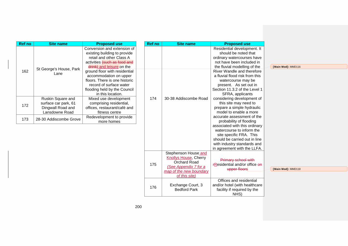
200
Ref no Site name Proposed use
162 St George's House, Park Lane
Conversion and extension of existing building to provide
retail and other Class A activities (such as food and
drink) and leisure on the ground floor with residential accommodation on upper
floors. There is one historic record of surface water
flooding held by the Council in this location.
172
Ruskin Square and surface car park, 61 Dingwall Road and Lansdowne Road
Mixed use development comprising residential,
offices, restaurant/café and fitness centre
173 28-30 Addiscombe Grove Redevelopment to provide more homes
Ref no Site name Proposed use
174 30-38 Addiscombe Road
Residential development. It should be noted that
ordinary watercourses have not have been included in the fluvial modelling of the
River Wandle and therefore a fluvial flood risk from this
watercourse may be present. As set out in
Section 11.3.2 of the Level 1 SFRA, applicants
considering development of this site may need to
prepare a simple hydraulic model to enable a more
accurate assessment of the probability of flooding
associated with this ordinary watercourse to inform the site specific FRA. This
should be carried out in line with industry standards and in agreement with the LLFA.
175
Stephenson House and Knollys House, Cherry
Orchard Road (See Appendix 7 for a
map of the new boundary of this site)
Primary school with rResidential and/or office on
upper floors
176 Exchange Court, 3 Bedford Park
Offices and residential and/or hotel (with healthcare
facility if required by the NHS)
[Main Mod]: MMD116
[Main Mod]: MMD118
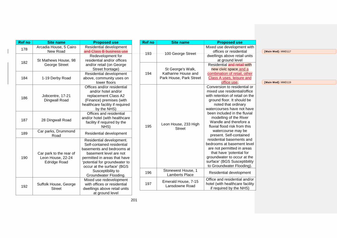
201
Ref no Site name Proposed use 178 Arcadia House, 5 Cairo
New Road Residential development and Class B business use
182 St Mathews House, 98 George Street
Redevelopment for residential and/or offices and/or retail (on George
Street frontage)
184 1-19 Derby Road Residential development
above, community uses on lower floors
186 Jobcentre, 17-21 Dingwall Road
Offices and/or residential and/or hotel and/or
replacement Class A2 (Finance) premises (with
healthcare facility if required by the NHS)
187 28 Dingwall Road
Offices and residential and/or hotel (with healthcare
facility if required by the NHS)
189 Car parks, Drummond Road Residential development
190 Car park to the rear of
Leon House, 22-24 Edridge Road
Residential development. Self-contained residential
basements and bedrooms at basement level are not
permitted in areas that have ‘potential for groundwater to occur at the surface’ (BGS
Susceptibility to Groundwater Flooding.
192 Suffolk House, George Street
Mixed use redevelopment with offices or residential
dwellings above retail units at ground level
Ref no Site name Proposed use
193 100 George Street
Mixed use development with offices or residential
dwellings above retail units at ground level
194 St George's Walk,
Katharine House and Park House, Park Street
Residential and retail with new civic space and a
combination of retail, other Class A uses, leisure and
office use.
195 Leon House, 233 High Street
Conversion to residential or mixed use residential/office with retention of retail on the
ground floor. It should be noted that ordinary
watercourses have not have been included in the fluvial
modelling of the River Wandle and therefore a fluvial flood risk from this
watercourse may be present. Self-contained
residential basements and bedrooms at basement level
are not permitted in areas that have ‘potential for
groundwater to occur at the surface’ (BGS Susceptibility to Groundwater Flooding).
196 Stonewest House, 1 Lamberts Place Residential development
197 Emerald House, 7-15 Lansdowne Road
Office and residential and/or hotel (with healthcare facility
if required by the NHS)
[Main Mod]: MMD117
[Main Mod]: MMD119
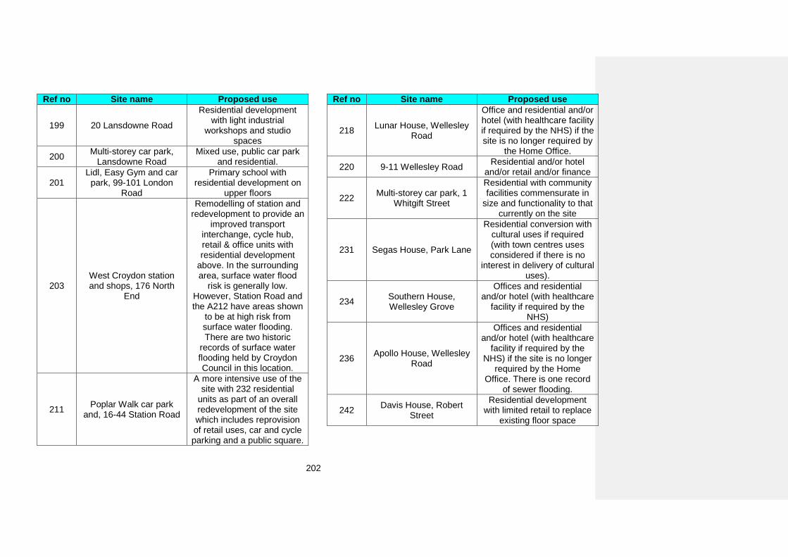
202
Ref no Site name Proposed use
199 20 Lansdowne Road
Residential development with light industrial
workshops and studio spaces
200 Multi-storey car park, Lansdowne Road
Mixed use, public car park and residential.
201 Lidl, Easy Gym and car
park, 99-101 London Road
Primary school with residential development on
upper floors
203 West Croydon station and shops, 176 North
End
Remodelling of station and redevelopment to provide an
improved transport interchange, cycle hub, retail & office units with residential development
above. In the surrounding area, surface water flood
risk is generally low. However, Station Road and the A212 have areas shown
to be at high risk from surface water flooding. There are two historic
records of surface water flooding held by Croydon Council in this location.
211 Poplar Walk car park and, 16-44 Station Road
A more intensive use of the site with 232 residential
units as part of an overall redevelopment of the site which includes reprovision of retail uses, car and cycle parking and a public square.
Ref no Site name Proposed use
218 Lunar House, Wellesley Road
Office and residential and/or hotel (with healthcare facility if required by the NHS) if the site is no longer required by
the Home Office.
220 9-11 Wellesley Road Residential and/or hotel and/or retail and/or finance
222 Multi-storey car park, 1 Whitgift Street
Residential with community facilities commensurate in
size and functionality to that currently on the site
231 Segas House, Park Lane
Residential conversion with cultural uses if required (with town centres uses considered if there is no
interest in delivery of cultural uses).
234 Southern House, Wellesley Grove
Offices and residential and/or hotel (with healthcare
facility if required by the NHS)
236 Apollo House, Wellesley Road
Offices and residential and/or hotel (with healthcare
facility if required by the NHS) if the site is no longer
required by the Home Office. There is one record
of sewer flooding.
242 Davis House, Robert Street
Residential development with limited retail to replace
existing floor space
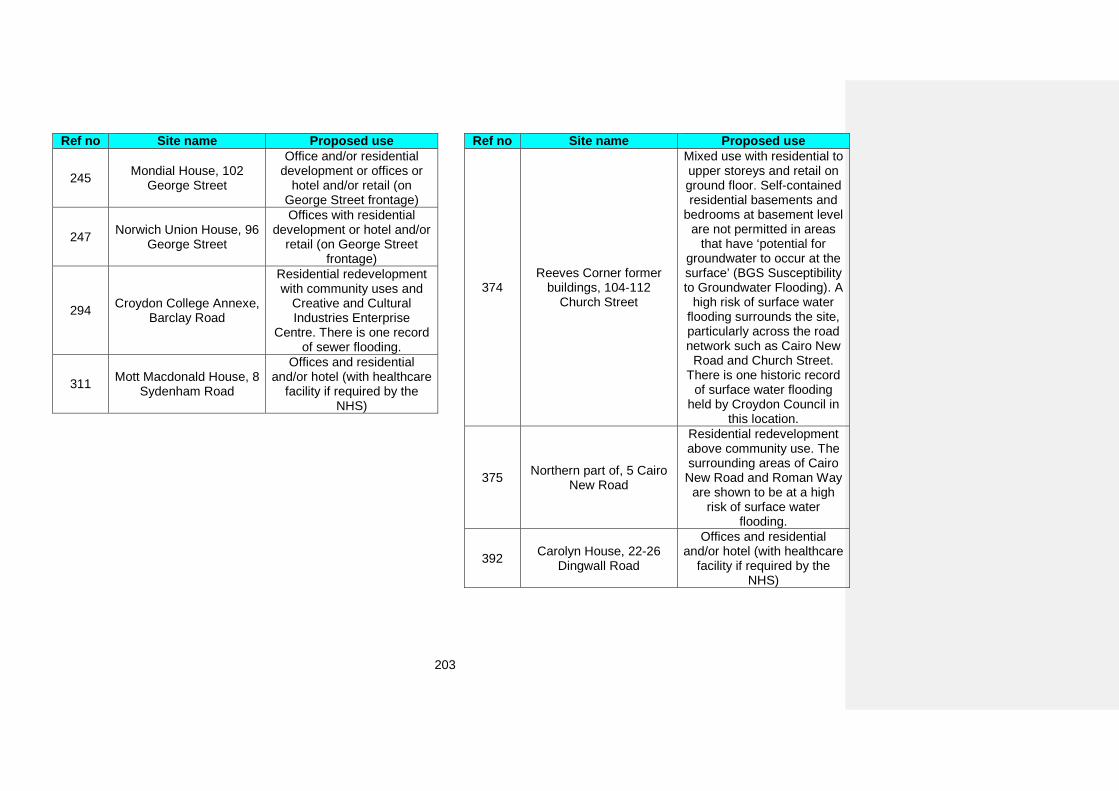
203
Ref no Site name Proposed use
245 Mondial House, 102 George Street
Office and/or residential development or offices or
hotel and/or retail (on George Street frontage)
247 Norwich Union House, 96 George Street
Offices with residential development or hotel and/or
retail (on George Street frontage)
294 Croydon College Annexe, Barclay Road
Residential redevelopment with community uses and
Creative and Cultural Industries Enterprise
Centre. There is one record of sewer flooding.
311 Mott Macdonald House, 8 Sydenham Road
Offices and residential and/or hotel (with healthcare
facility if required by the NHS)
Ref no Site name Proposed use
374 Reeves Corner former
buildings, 104-112 Church Street
Mixed use with residential to upper storeys and retail on ground floor. Self-contained residential basements and
bedrooms at basement level are not permitted in areas
that have ‘potential for groundwater to occur at the surface’ (BGS Susceptibility to Groundwater Flooding). A
high risk of surface water flooding surrounds the site, particularly across the road network such as Cairo New
Road and Church Street. There is one historic record
of surface water flooding held by Croydon Council in
this location.
375 Northern part of, 5 Cairo New Road
Residential redevelopment above community use. The surrounding areas of Cairo
New Road and Roman Way are shown to be at a high
risk of surface water flooding.
392 Carolyn House, 22-26 Dingwall Road
Offices and residential and/or hotel (with healthcare
facility if required by the NHS)
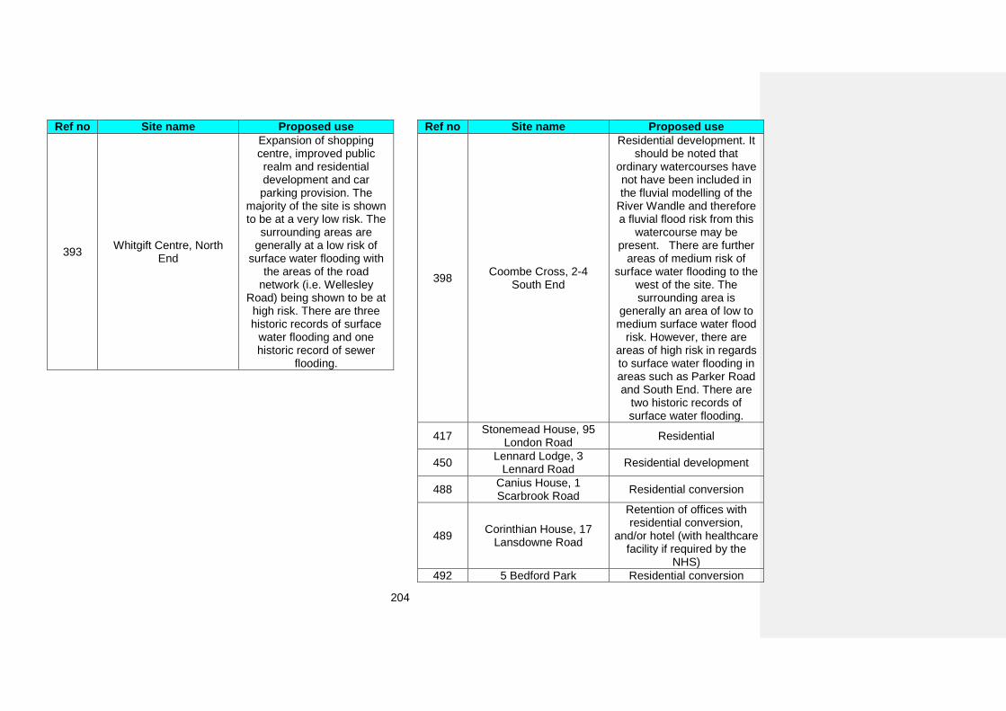
204
Ref no Site name Proposed use
393 Whitgift Centre, North End
Expansion of shopping centre, improved public realm and residential development and car parking provision. The
majority of the site is shown to be at a very low risk. The
surrounding areas are generally at a low risk of
surface water flooding with the areas of the road
network (i.e. Wellesley Road) being shown to be at high risk. There are three historic records of surface
water flooding and one historic record of sewer
flooding.
Ref no Site name Proposed use
398 Coombe Cross, 2-4 South End
Residential development. It should be noted that
ordinary watercourses have not have been included in the fluvial modelling of the
River Wandle and therefore a fluvial flood risk from this
watercourse may be present. There are further
areas of medium risk of surface water flooding to the
west of the site. The surrounding area is
generally an area of low to medium surface water flood
risk. However, there are areas of high risk in regards to surface water flooding in areas such as Parker Road and South End. There are
two historic records of surface water flooding.
417 Stonemead House, 95 London Road Residential
450 Lennard Lodge, 3 Lennard Road Residential development
488 Canius House, 1 Scarbrook Road Residential conversion
489 Corinthian House, 17 Lansdowne Road
Retention of offices with residential conversion,
and/or hotel (with healthcare facility if required by the
NHS) 492 5 Bedford Park Residential conversion
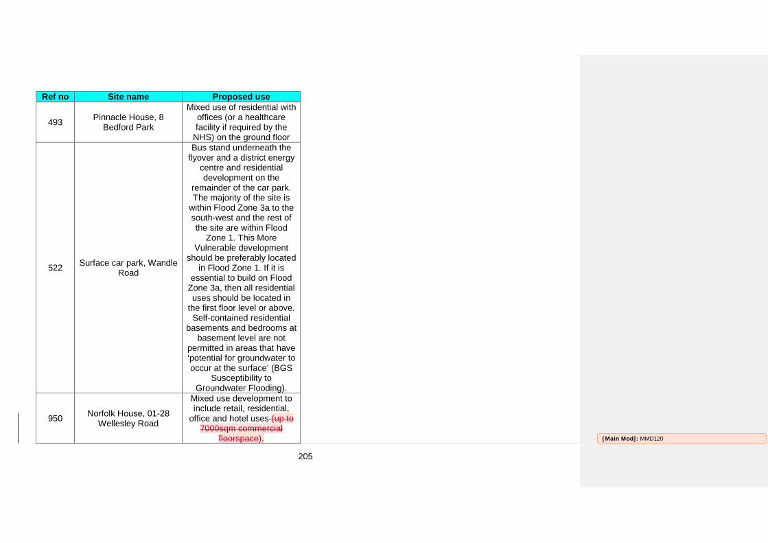
205
Ref no Site name Proposed use
493 Pinnacle House, 8 Bedford Park
Mixed use of residential with offices (or a healthcare facility if required by the
NHS) on the ground floor
522 Surface car park, Wandle Road
Bus stand underneath the flyover and a district energy
centre and residential development on the
remainder of the car park. The majority of the site is
within Flood Zone 3a to the south-west and the rest of the site are within Flood
Zone 1. This More Vulnerable development
should be preferably located in Flood Zone 1. If it is
essential to build on Flood Zone 3a, then all residential uses should be located in
the first floor level or above. Self-contained residential
basements and bedrooms at basement level are not
permitted in areas that have ‘potential for groundwater to occur at the surface’ (BGS
Susceptibility to Groundwater Flooding).
950 Norfolk House, 01-28 Wellesley Road
Mixed use development to include retail, residential,
office and hotel uses (up to 7000sqm commercial
floorspace). [Main Mod]: MMD120
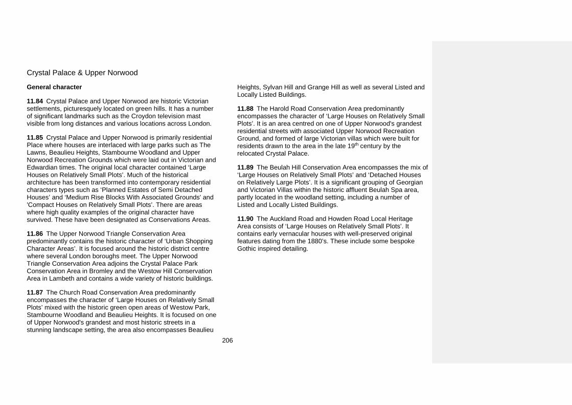
206
Crystal Palace & Upper Norwood
General character
11.84 Crystal Palace and Upper Norwood are historic Victorian settlements, picturesquely located on green hills. It has a number of significant landmarks such as the Croydon television mast visible from long distances and various locations across London.
11.85 Crystal Palace and Upper Norwood is primarily residential Place where houses are interlaced with large parks such as The Lawns, Beaulieu Heights, Stambourne Woodland and Upper Norwood Recreation Grounds which were laid out in Victorian and Edwardian times. The original local character contained ‘Large Houses on Relatively Small Plots’. Much of the historical architecture has been transformed into contemporary residential characters types such as ‘Planned Estates of Semi Detached Houses’ and ‘Medium Rise Blocks With Associated Grounds' and 'Compact Houses on Relatively Small Plots’. There are areas where high quality examples of the original character have survived. These have been designated as Conservations Areas.
11.86 The Upper Norwood Triangle Conservation Area predominantly contains the historic character of ‘Urban Shopping Character Areas’. It is focused around the historic district centre where several London boroughs meet. The Upper Norwood Triangle Conservation Area adjoins the Crystal Palace Park Conservation Area in Bromley and the Westow Hill Conservation Area in Lambeth and contains a wide variety of historic buildings.
11.87 The Church Road Conservation Area predominantly encompasses the character of ‘Large Houses on Relatively Small Plots’ mixed with the historic green open areas of Westow Park, Stambourne Woodland and Beaulieu Heights. It is focused on one of Upper Norwood's grandest and most historic streets in a stunning landscape setting, the area also encompasses Beaulieu
Heights, Sylvan Hill and Grange Hill as well as several Listed and Locally Listed Buildings.
11.88 The Harold Road Conservation Area predominantly encompasses the character of ‘Large Houses on Relatively Small Plots’. It is an area centred on one of Upper Norwood's grandest residential streets with associated Upper Norwood Recreation Ground, and formed of large Victorian villas which were built for residents drawn to the area in the late 19th century by the relocated Crystal Palace.
11.89 The Beulah Hill Conservation Area encompasses the mix of ‘Large Houses on Relatively Small Plots’ and ‘Detached Houses on Relatively Large Plots’. It is a significant grouping of Georgian and Victorian Villas within the historic affluent Beulah Spa area, partly located in the woodland setting, including a number of Listed and Locally Listed Buildings.
11.90 The Auckland Road and Howden Road Local Heritage Area consists of ‘Large Houses on Relatively Small Plots’. It contains early vernacular houses with well-preserved original features dating from the 1880’s. These include some bespoke Gothic inspired detailing.

207
Policy DM41: Crystal Palace and Upper Norwood Within Crystal Palace and Upper Norwood allocate sites for development as set out in Table 11.10.
How the policy works
11.91 Crystal Palace and Upper Norwood has a predominately consistent character which, can be managed by other policies. Additionally the high concentration of heritage assets within this Place will enable its character to be managed through Conservation Area Appraisals and Management Plans and Croydon’s Conservation Area General Guidance.
Allocating land for development 11.92 Table 11.10 below sets out the proposed use on specific sites in Crystal Palace and Upper Norwood. The location and boundary of each detailed proposal can be found on the draft Policies Map and further details including indicative phasing and indicative number of homes (if applicable) can be found in Appendix 5.
Table 11.10 Proposals for uses of land of specific sites in Crystal Palace and Upper Norwood
Ref no Site name Proposed use 28 Bowyers Yard,
Bedwardine Road Cultural and Creative
Industries Enterprise Centre
80 Victory Place
Ground floor retail, restaurant and studio space
with hotel, office/or and residential uses on other
floors
82 St John The Evangelist Vicarage, Sylvan Road
Redevelopment to provide new hall and residential
dwellings
Ref no Site name Proposed use
357 Norwood Heights Shopping Centre,
Westow Street
Retail, replacement community use and
residential 420 87-91 Biggin Hill Residential development
[Main Mod]: MMD121
208
Kenley and Old Coulsdon
General character
11.93 Kenley and Old Coulsdon is a suburban area with green wooded hillsides (Dollypers Hill, Roydons Wood) and green open spaces (Kenley Common, Riddlesdown, Kenley Aerodrome) located within and around it. There is a strong link between the green infrastructure and the built environment. This creates a feeling of spaciousness or openness can be seen in the layout of the built environment.
11.94 The built areas of Kenley and Old Coulsdon predominantly consist of the following residential character types: ‘Detached Houses on Relatively Large Plots’ and ‘Planned Estates of Semi-Detached Houses’. The residential character is reinforced by consistent building lines and setbacks that create large green front gardens or (in the case of flatted development) grounds and rear gardens with tree planting.
11.95 Kenley and Old Coulsdon's shopping and community facilities are concentrated in the area between the Godstone Road and Kenley station. The area is framed by green space of Riddlesdown to the north and railway to the south.
11.96 Kenley’s public realm, with features such as grass verges with tree planting, reflects the close coexistence of nature and built environment. Narrow lanes with extensive tree canopy cover and streets often with one footway and green areas of planting on the opposite side are all characteristic features of the public realm.
11.97 In areas where there are no grass verges, mature trees located within front gardens of residential developments provide extensive tree canopy cover, contributing to the impression of tree lined streets.
11.98 The Bradmore Green Conservation Area is the heart of the historic Old Coulsdon. It preserves the historic village character made by the green spaces of Bradmore Green and Grange Park mixed with ‘Suburban Shopping Character Area’, ‘Detached Houses on Relatively Large Plots’ and ‘Planned Estates of Semi-Detached Houses’. The area contains a number of historic Listed and Locally Listed Buildings such as the 18th century farmhouse and the 13th century Grade I Listed church of St John.
11.99 The Kenley Aerodrome Conservation Area is one of the most complete fighter airfield associated with the Battle of Britain to have survived, making it a battlefield site of particular national historic significance. The Conservation Area includes a number of scheduled monuments.
Policy DM42: Kenley and Old Coulsdon Within Kenley and Old Coulsdon allocate sites for development as set out in Table 11.11.
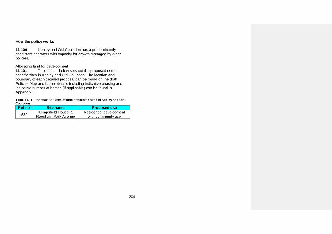
209
How the policy works
11.100 Kenley and Old Coulsdon has a predominantly consistent character with capacity for growth managed by other policies.
Allocating land for development 11.101 Table 11.11 below sets out the proposed use on specific sites in Kenley and Old Coulsdon. The location and boundary of each detailed proposal can be found on the draft Policies Map and further details including indicative phasing and indicative number of homes (if applicable) can be found in Appendix 5.
Table 11.11 Proposals for uses of land of specific sites in Kenley and Old Coulsdon
Ref no Site name Proposed use 937 Kempsfield House, 1
Reedham Park Avenue Residential development
with community use
210
Norbury
General character
11.102 Norbury is a suburban town with its District and Local Centres located along the long linear route of London Road. The built form of ‘Large Buildings With Strong Frontage Line’ and ‘Medium Rise Blocks With Associated Grounds’ emphasises this linear route and its dominance on the area.
11.103 Norbury has a residential character that predominantly consists of ‘Terraced Houses and Cottages’, ‘Large Houses on Relatively Small Plots’ and ‘Local Authority Housing with Public Realm’, enriched by green spaces of Norbury Park through which Norbury Brook flows, Biggin Wood, Norbury Hall Park and Pollards Hill Park
11.104 The Norwood Grove Conservation Area is focused around the historic Grade II registered landscape of Norwood Grove predominantly surrounded by ‘Detached Houses on Relatively Large Plots’. It contains a number of well preserved and distinctive Listed and Locally Listed Georgian and Edwardian houses. The Conservation Area adjoins the Streatham Common Conservation Area in Lambeth.
11.105 The Norbury Estate Conservation Area represents the unified and consistent residential character type of ‘Local Authority Built Housing with Public Realm’. This dense development from 1914-1921 represents a unique example of Arts and Crafts terraces and is the first outer London cottage estate built by the London County Council.
11.106 The London Road Norbury Local Heritage Area is an example of an ‘Urban Shopping Area’ character type. The shopping parades represent a high quality cross-section of architectural styles from the turn of the 19th and 20th centuries, with the unified form of shopfronts at ground floor level and rhythms of red brick facades with decorative brick and sandstone features above.
11.107 The Beatrice Avenue Local Heritage Area predominantly consists of ‘Terraced Houses and Cottages’. It has a good range of well-preserved late Victorian suburban houses laid out between 1900 and 1936, with many original and bespoke Arts and Crafts inspired features. The prominent St Phillip’s Church terminates views from the tree-lined residential street.
11.108 The Pollards Hill South Local Heritage Area consists of terraced houses which complement the predominant character of the area of ‘Planned Estates of Semi-Detached Houses’ in a particularly creative way. This distinctive grouping represents a unique example of individual Arts and Crafts terraces laid out to appear as large U-shaped buildings with a number of distinctive architectural features. The well preserved and distinctive 1930’s townscape is an example of an innovative approach to defining street frontages through sequence of courtyards.
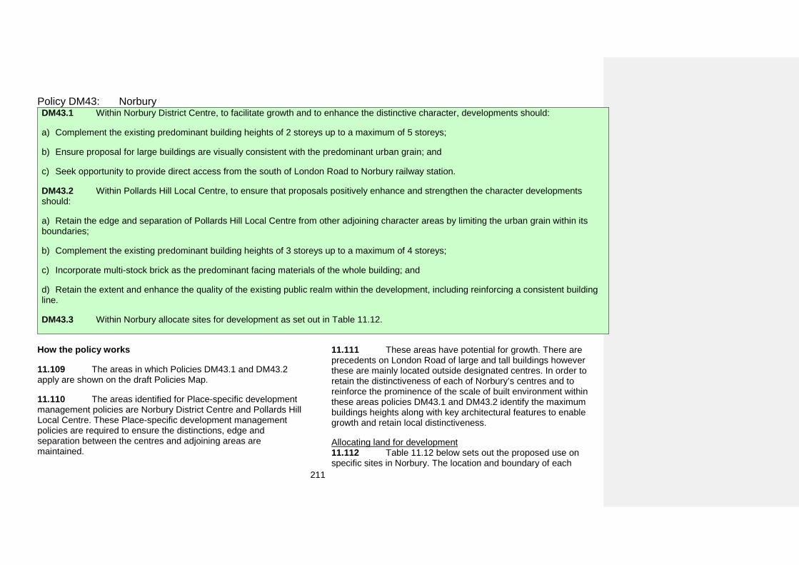
211
Policy DM43: Norbury DM43.1 Within Norbury District Centre, to facilitate growth and to enhance the distinctive character, developments should:
a) Complement the existing predominant building heights of 2 storeys up to a maximum of 5 storeys;
b) Ensure proposal for large buildings are visually consistent with the predominant urban grain; and
c) Seek opportunity to provide direct access from the south of London Road to Norbury railway station.
DM43.2 Within Pollards Hill Local Centre, to ensure that proposals positively enhance and strengthen the character developments should:
a) Retain the edge and separation of Pollards Hill Local Centre from other adjoining character areas by limiting the urban grain within itsboundaries;
b) Complement the existing predominant building heights of 3 storeys up to a maximum of 4 storeys;
c) Incorporate multi-stock brick as the predominant facing materials of the whole building; and
d) Retain the extent and enhance the quality of the existing public realm within the development, including reinforcing a consistent buildingline.
DM43.3 Within Norbury allocate sites for development as set out in Table 11.12.
How the policy works
11.109 The areas in which Policies DM43.1 and DM43.2 apply are shown on the draft Policies Map.
11.110 The areas identified for Place-specific development management policies are Norbury District Centre and Pollards Hill Local Centre. These Place-specific development management policies are required to ensure the distinctions, edge and separation between the centres and adjoining areas are maintained.
11.111 These areas have potential for growth. There are precedents on London Road of large and tall buildings however these are mainly located outside designated centres. In order to retain the distinctiveness of each of Norbury’s centres and to reinforce the prominence of the scale of built environment within these areas policies DM43.1 and DM43.2 identify the maximum buildings heights along with key architectural features to enable growth and retain local distinctiveness.
Allocating land for development 11.112 Table 11.12 below sets out the proposed use on specific sites in Norbury. The location and boundary of each
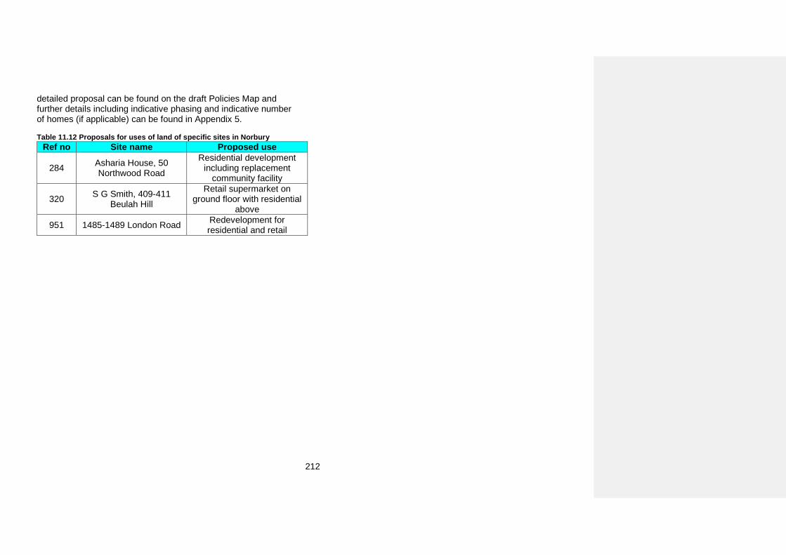
212
detailed proposal can be found on the draft Policies Map and further details including indicative phasing and indicative number of homes (if applicable) can be found in Appendix 5.
Table 11.12 Proposals for uses of land of specific sites in Norbury Ref no Site name Proposed use
284 Asharia House, 50 Northwood Road
Residential development including replacement
community facility
320 S G Smith, 409-411 Beulah Hill
Retail supermarket on ground floor with residential
above
951 1485-1489 London Road Redevelopment for residential and retail
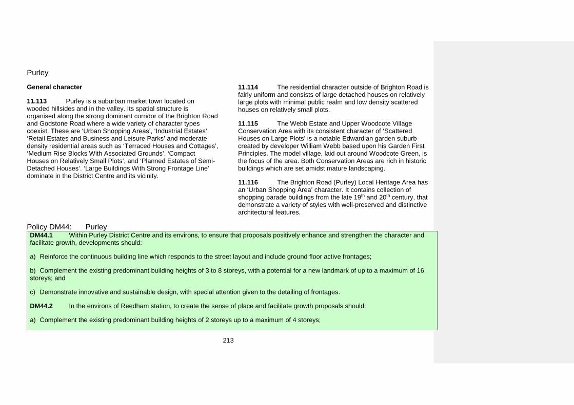
213
Purley
General character
11.113 Purley is a suburban market town located on wooded hillsides and in the valley. Its spatial structure is organised along the strong dominant corridor of the Brighton Road and Godstone Road where a wide variety of character types coexist. These are ‘Urban Shopping Areas’, ‘Industrial Estates’, ‘Retail Estates and Business and Leisure Parks’ and moderate density residential areas such as ‘Terraced Houses and Cottages’, ‘Medium Rise Blocks With Associated Grounds’, ‘Compact Houses on Relatively Small Plots’, and ‘Planned Estates of Semi-Detached Houses’. ‘Large Buildings With Strong Frontage Line’ dominate in the District Centre and its vicinity.
11.114 The residential character outside of Brighton Road is fairly uniform and consists of large detached houses on relatively large plots with minimal public realm and low density scattered houses on relatively small plots.
11.115 The Webb Estate and Upper Woodcote Village Conservation Area with its consistent character of ‘Scattered Houses on Large Plots’ is a notable Edwardian garden suburb created by developer William Webb based upon his Garden First Principles. The model village, laid out around Woodcote Green, is the focus of the area. Both Conservation Areas are rich in historic buildings which are set amidst mature landscaping.
11.116 The Brighton Road (Purley) Local Heritage Area has an ‘Urban Shopping Area’ character. It contains collection of shopping parade buildings from the late 19th and 20th century, that demonstrate a variety of styles with well-preserved and distinctive architectural features.
Policy DM44: Purley DM44.1 Within Purley District Centre and its environs, to ensure that proposals positively enhance and strengthen the character and facilitate growth, developments should:
a) Reinforce the continuous building line which responds to the street layout and include ground floor active frontages;
b) Complement the existing predominant building heights of 3 to 8 storeys, with a potential for a new landmark of up to a maximum of 16storeys; and
c) Demonstrate innovative and sustainable design, with special attention given to the detailing of frontages.
DM44.2 In the environs of Reedham station, to create the sense of place and facilitate growth proposals should:
a) Complement the existing predominant building heights of 2 storeys up to a maximum of 4 storeys;
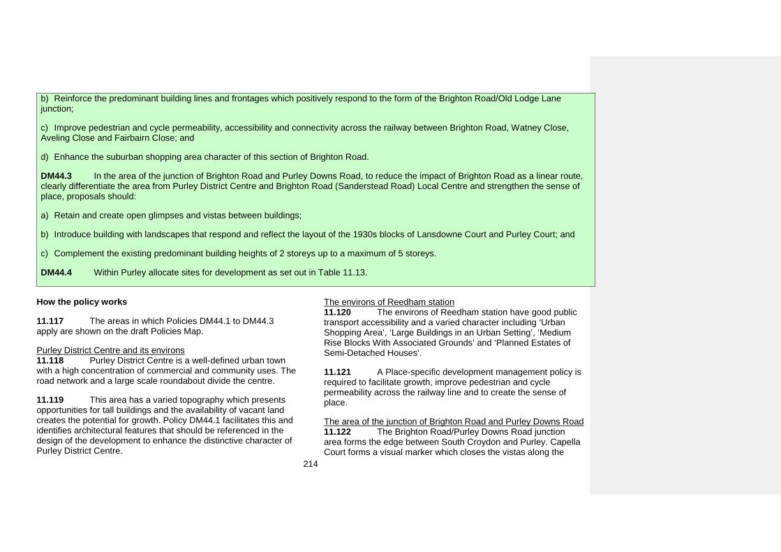
214
b) Reinforce the predominant building lines and frontages which positively respond to the form of the Brighton Road/Old Lodge Lanejunction;
c) Improve pedestrian and cycle permeability, accessibility and connectivity across the railway between Brighton Road, Watney Close,Aveling Close and Fairbairn Close; and
d) Enhance the suburban shopping area character of this section of Brighton Road.
DM44.3 In the area of the junction of Brighton Road and Purley Downs Road, to reduce the impact of Brighton Road as a linear route, clearly differentiate the area from Purley District Centre and Brighton Road (Sanderstead Road) Local Centre and strengthen the sense of place, proposals should:
a) Retain and create open glimpses and vistas between buildings;
b) Introduce building with landscapes that respond and reflect the layout of the 1930s blocks of Lansdowne Court and Purley Court; and
c) Complement the existing predominant building heights of 2 storeys up to a maximum of 5 storeys.
DM44.4 Within Purley allocate sites for development as set out in Table 11.13.
How the policy works
11.117 The areas in which Policies DM44.1 to DM44.3 apply are shown on the draft Policies Map.
Purley District Centre and its environs 11.118 Purley District Centre is a well-defined urban town with a high concentration of commercial and community uses. The road network and a large scale roundabout divide the centre.
11.119 This area has a varied topography which presents opportunities for tall buildings and the availability of vacant land creates the potential for growth. Policy DM44.1 facilitates this and identifies architectural features that should be referenced in the design of the development to enhance the distinctive character of Purley District Centre.
The environs of Reedham station 11.120 The environs of Reedham station have good public transport accessibility and a varied character including ‘Urban Shopping Area’, ‘Large Buildings in an Urban Setting’, ‘Medium Rise Blocks With Associated Grounds’ and ‘Planned Estates of Semi-Detached Houses’.
11.121 A Place-specific development management policy is required to facilitate growth, improve pedestrian and cycle permeability across the railway line and to create the sense of place.
The area of the junction of Brighton Road and Purley Downs Road 11.122 The Brighton Road/Purley Downs Road junction area forms the edge between South Croydon and Purley. Capella Court forms a visual marker which closes the vistas along the
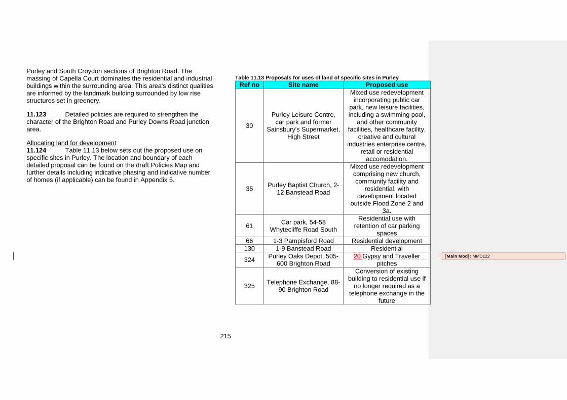
215
Purley and South Croydon sections of Brighton Road. The massing of Capella Court dominates the residential and industrial buildings within the surrounding area. This area's distinct qualities are informed by the landmark building surrounded by low rise structures set in greenery.
11.123 Detailed policies are required to strengthen the character of the Brighton Road and Purley Downs Road junction area.
Allocating land for development 11.124 Table 11.13 below sets out the proposed use on specific sites in Purley. The location and boundary of each detailed proposal can be found on the draft Policies Map and further details including indicative phasing and indicative number of homes (if applicable) can be found in Appendix 5.
Table 11.13 Proposals for uses of land of specific sites in Purley Ref no Site name Proposed use
30
Purley Leisure Centre, car park and former
Sainsbury's Supermarket, High Street
Mixed use redevelopment incorporating public car
park, new leisure facilities, including a swimming pool,
and other community facilities, healthcare facility,
creative and cultural industries enterprise centre,
retail or residential accomodation.
35 Purley Baptist Church, 2-12 Banstead Road
Mixed use redevelopment comprising new church, community facility and
residential, with development located
outside Flood Zone 2 and 3a.
61 Car park, 54-58 Whytecliffe Road South
Residential use with retention of car parking
spaces 66 1-3 Pampisford Road Residential development
130 1-9 Banstead Road Residential
324 Purley Oaks Depot, 505-600 Brighton Road
20 Gypsy and Traveller pitches
325 Telephone Exchange, 88-90 Brighton Road
Conversion of existing building to residential use if
no longer required as a telephone exchange in the
future
[Main Mod]: MMD122
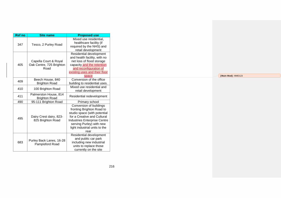
216
Ref no Site name Proposed use
347 Tesco, 2 Purley Road
Mixed use residential, healthcare facility (if
required by the NHS) and retail development
405 Capella Court & Royal
Oak Centre, 725 Brighton Road
Residential development and health facility, with no net loss of flood storage
capacity and the retention and reconfiguration of
existing uses and their floor space
409 Beech House, 840 Brighton Road
Conversion of the office building to residential uses.
410 100 Brighton Road Mixed use residential and retail development
411 Palmerston House, 814 Brighton Road Residential redevelopment
490 95-111 Brighton Road Primary school
495 Dairy Crest dairy, 823-825 Brighton Road
Conversion of buildings fronting Brighton Road to
studio space (with potential for a Creative and Cultural
Industries Enterprise Centre serving Purley) with new light industrial units to the
rear
683 Purley Back Lanes, 16-28 Pampisford Road
Residential development and public car park
including new industrial units to replace those currently on the site
[Main Mod]: MMD123
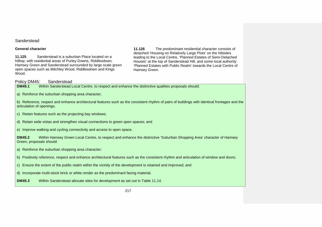
217
Sanderstead
General character
11.125 Sanderstead is a suburban Place located on a hilltop, with residential areas of Purley Downs, Riddlesdown, Hamsey Green and Sanderstead surrounded by large scale green open spaces such as Mitchley Wood, Riddlesdown and Kings Wood.
11.126 The predominant residential character consists of detached ‘Housing on Relatively Large Plots’ on the hillsides leading to the Local Centre, ‘Planned Estates of Semi-Detached Houses’ at the top of Sanderstead Hill, and some local authority ‘Planned Estates with Public Realm’ towards the Local Centre of Hamsey Green.
Policy DM45: Sanderstead DM45.1 Within Sanderstead Local Centre, to respect and enhance the distinctive qualities proposals should:
a) Reinforce the suburban shopping area character;
b) Reference, respect and enhance architectural features such as the consistent rhythm of pairs of buildings with identical frontages and thearticulation of openings;
c) Retain features such as the projecting bay windows;
d) Retain wide vistas and strengthen visual connections to green open spaces; and
e) Improve walking and cycling connectivity and access to open space.
DM45.2 Within Hamsey Green Local Centre, to respect and enhance the distinctive ‘Suburban Shopping Area’ character of Hamsey Green, proposals should:
a) Reinforce the suburban shopping area character;
b) Positively reference, respect and enhance architectural features such as the consistent rhythm and articulation of window and doors;
c) Ensure the extent of the public realm within the vicinity of the development is retained and improved; and
d) Incorporate multi-stock brick or white render as the predominant facing material.
DM45.3 Within Sanderstead allocate sites for development as set out in Table 11.14.
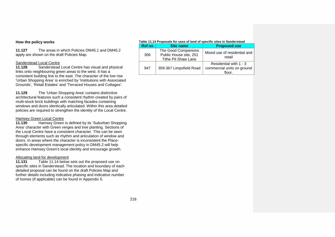
218
How the policy works
11.127 The areas in which Policies DM45.1 and DM45.2 apply are shown on the draft Policies Map.
Sanderstead Local Centre 11.128 Sanderstead Local Centre has visual and physical links onto neighbouring green areas to the west. It has a consistent building line to the east. The character of the low rise ‘Urban Shopping Area’ is enriched by ‘Institutions with Associated Grounds’, ‘Retail Estates’ and ‘Terraced Houses and Cottages’.
11.129 The ‘Urban Shopping Area’ contains distinctive architectural features such a consistent rhythm created by pairs of multi-stock brick buildings with matching facades containing windows and doors identically articulated. Within this area detailed policies are required to strengthen the identity of the Local Centre.
Hamsey Green Local Centre 11.130 Hamsey Green is defined by its ‘Suburban Shopping Area’ character with Green verges and tree planting. Sections of the Local Centre have a consistent character. This can be seen through elements such as rhythm and articulation of window and doors. In areas where the character is inconsistent the Place-specific development management policy in DM45.2 will help enhance Hamsey Green's local identity and encourage growth.
Allocating land for development 11.131 Table 11.14 below sets out the proposed use on specific sites in Sanderstead. The location and boundary of each detailed proposal can be found on the draft Policies Map and further details including indicative phasing and indicative number of homes (if applicable) can be found in Appendix 5.
Table 11.14 Proposals for uses of land of specific sites in Sanderstead Ref no Site name Proposed use
306 The Good Companions Public House site, 251 Tithe Pit Shaw Lane
Mixed use of residential and retail
947 359-367 Limpsfield Road Residential with 1 - 3
commercial units on ground floor.
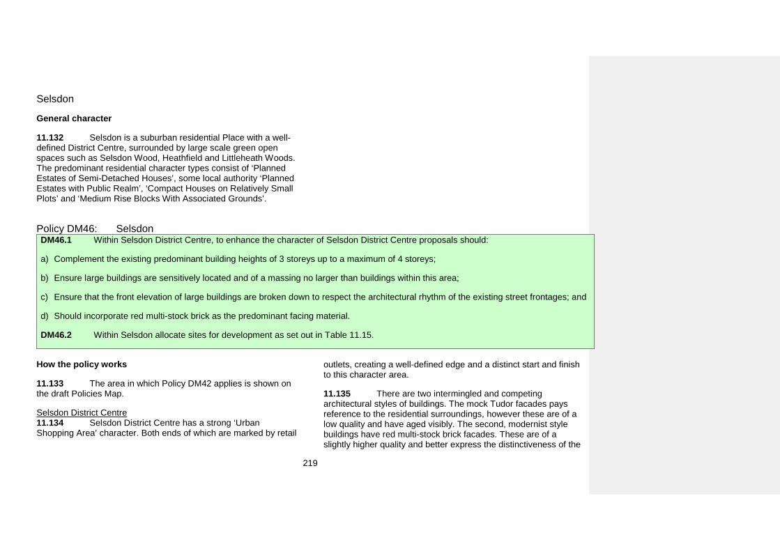
219
Selsdon
General character
11.132 Selsdon is a suburban residential Place with a well-defined District Centre, surrounded by large scale green open spaces such as Selsdon Wood, Heathfield and Littleheath Woods. The predominant residential character types consist of ‘Planned Estates of Semi-Detached Houses’, some local authority ‘Planned Estates with Public Realm’, ‘Compact Houses on Relatively Small Plots’ and ‘Medium Rise Blocks With Associated Grounds’.
Policy DM46: Selsdon DM46.1 Within Selsdon District Centre, to enhance the character of Selsdon District Centre proposals should:
a) Complement the existing predominant building heights of 3 storeys up to a maximum of 4 storeys;
b) Ensure large buildings are sensitively located and of a massing no larger than buildings within this area;
c) Ensure that the front elevation of large buildings are broken down to respect the architectural rhythm of the existing street frontages; and
d) Should incorporate red multi-stock brick as the predominant facing material.
DM46.2 Within Selsdon allocate sites for development as set out in Table 11.15.
How the policy works
11.133 The area in which Policy DM42 applies is shown on the draft Policies Map.
Selsdon District Centre 11.134 Selsdon District Centre has a strong ‘Urban Shopping Area’ character. Both ends of which are marked by retail
outlets, creating a well-defined edge and a distinct start and finish to this character area.
11.135 There are two intermingled and competing architectural styles of buildings. The mock Tudor facades pays reference to the residential surroundings, however these are of a low quality and have aged visibly. The second, modernist style buildings have red multi-stock brick facades. These are of a slightly higher quality and better express the distinctiveness of the
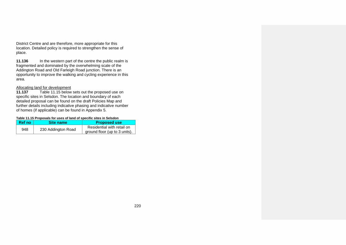
220
District Centre and are therefore, more appropriate for this location. Detailed policy is required to strengthen the sense of place.
11.136 In the western part of the centre the public realm is fragmented and dominated by the overwhelming scale of the Addington Road and Old Farleigh Road junction. There is an opportunity to improve the walking and cycling experience in this area.
Allocating land for development 11.137 Table 11.15 below sets out the proposed use on specific sites in Selsdon. The location and boundary of each detailed proposal can be found on the draft Policies Map and further details including indicative phasing and indicative number of homes (if applicable) can be found in Appendix 5.
Table 11.15 Proposals for uses of land of specific sites in Selsdon Ref no Site name Proposed use
948 230 Addington Road Residential with retail on ground floor (up to 3 units).
221
Shirley
General character
11.138 Shirley is predominantly a suburban residential settlement surrounded by natural areas of Green Belt. This place is defined by the tree lined streets, the regular rhythm of well-spaced buildings with well-kept landscaped areas to the front, that allow oblique long range views beyond the rear gardens.
11.139 Shirley’s residential character predominantly consists of ‘Planned Estates of Semi-Detached Houses’ with garages and ‘Compact Houses on Relatively Small Plots’ set in large green spaces. This combination creates an open varied and interesting skyline and roofscape. The southern part is dominated by ‘Scattered Houses on Large Plots’ surrounded by expansive areas of greenery, including woodland of Addington Hills.
11.140 Shirley has three urban and one suburban shopping area characters along Wickham and Shirley Roads. The suburban feel of these shopping areas are strengthened by tree lined streets, green verges with planting and small green spaces and parking accommodated in slip roads. These features play a vital role in creating Shirley’s sense of place.
11.141 The Upper Shirley Road Local Heritage Area predominantly consists of the ‘Terraced Houses and Cottages’ character type. Buildings represent a range of styles and architectural forms dating from the 18th century, with well-preserved original features. The grouping, its design and layout are a record of the local history of building design and development in this area.
11.142 The Stuart Crescent Local Heritage Area lies in the heart of the Spring Farm area which has a consistent character of ‘Planned Estates of Semi-Detached Houses’. The layout is arranged around the remnants of a circular historic copse. The mature landscaping reveals the historic character of the landscape which pre-dates development.
11.143 The Bishops Walk Local Heritage Area represents a distinctive high quality historic landscape and townscape with a ‘Scattered Houses on Large Plots’ residential character. The southern section of Bishops Walk’s mature landscaping reveals the historic design of Addington Park which pre-dated and allows for scenic views within and outside of the area. The distinctive design of the northern section creates a well-integrated topography, planting and built environment.
Policy DM47: Shirley DM47.1 Within Shirley Local Centre, to retain the unique qualities development should:
a) Retain the continuity of ground floor active frontages and allow flexibility at first floor and above for mixed use;
b) Reference, respect and enhance architectural features such as the consistent rhythm and articulation of fenestration and retain featuressuch as the triangular bay windows;
c) Complement the existing predominant building heights of 2 storeys up to a maximum of 4 storeys; and
222
d) Incorporate or retain traditional shop front elements such as fascias, pilasters and stall risers.
DM47.2 In the area between 518 and 568 Wickham Road, to improve the character proposals should reference the ‘Suburban Shopping Area’ character type.
DM47.3 In the area of the Wickham Road Shopping Parade, to retain the distinctive character of the 794-850 Wickham Road proposals should:
a) Complement the existing predominant building heights up to a maximum of 2 storeys; and
b) Retain the ‘Suburban Shopping Area’ character.
DM47.4 Within Shirley allocate sites for development as set out in Table 11.16.
How the policy works
11.144 The areas in which Policies DM47.1 to DM47.3 apply are shown on the draft Policies Map.
Shirley Local Centre 11.145 Shirley Local Centre consists of the combination of three different character types an ‘Urban Shopping Area’, ‘Scattered Houses on Large Plots’ and a ‘Suburban Shopping Area’. The northern side of the Local Centre is more tightly built-up, while the southern more is spacious with green verges, tree lined streets and parking within slip roads. In this area the potential for growth is limited.
Wickham Road Each of Shirley’s shopping areas has a distinct character which should be enhanced and strengthened. This character is informed by the layout, scale, urban grain and, architectural features such as the brick work, fascias and stall rises. In order to ensure that the distinctive elements that contribute to Shirley’s sense of place are not lost these features have been included in the detailed policies.
Allocating land for development 11.146 Table 11.16 below sets out the proposed use on specific sites in Shirley. The location and boundary of each detailed proposal can be found on the draft Policies Map and further details including indicative phasing and indicative number of homes (if applicable) can be found in Appendix 5.
Table 11.16 Proposals for uses of land of specific sites in Shirley Ref no Site name Proposed use
128 Land at, Poppy Lane Residential development
502 Coombe Farm, Oaks Road
Residential development so long as the development has no greater footprint,
volume or impact on openness on the
Metropolitan Green Belt than the existing buildings
on the site
223
Ref no Site name Proposed use
504 Stroud Green Pumping Station, 140 Primrose
Lane
Residential development (including the conversion of the Locally Listed pumping
station) if the site is no longer required for its
current use in the future. It should be noted that
ordinary watercourses have not have been included in the fluvial modelling of the
River Wandle and therefore a fluvial flood risk from this
watercourse may be present.
224
South Croydon
General character
11.147 South Croydon is organised in a south to north alignment along the Brighton Road. Its fragmented character can be attributed to the Brighton Road and railway infrastructure. The areas to the east are rich in green open spaces including areas of Green Belt such as Lloyd Park. The ‘Industrial Estates’ are primarily concentrated along the railway. Small pockets of ‘Industrial Estates’ are also scattered amongst residential blocks.
11.148 The predominant residential character consists of ‘Terraced Houses and Cottages’, located within the central strip, with the mix of ‘Medium Rise Blocks With Associated Grounds and ‘Compact Houses on Relatively Small Plots’ to the west and north. The areas to the east contain ‘Detached Houses on Relatively Large Plots’ and ‘Large Houses on Relatively Small Plots’, a number of which have been Locally Listed.
11.149 The Croham Manor Road Conservation Area represents the ‘Detached Houses on Relatively Large Plots’ character type. It is a notable collection of early 20th century Locally Listed houses with a wealth of well-preserved arts and crafts features.
11.150 The South End Local Heritage Area has an ‘Urban Shopping Area’ character. It represents an early vernacular architectural style from late 19th with a wide range of well-preserved highly decorative architectural features. Its historic townscape composition consists of the street frontage and a triangular square with the prominent former Swan and Sugarloaf building terminating vistas along Brighton Road.
11.151 The ‘Urban Shopping Areas’ of Ye Market Local Heritage Area is a distinctive early 20th century ‘mock Tudor’ style
shopping parade with a range of preserved original decorative features and detailing.
11.152 St Peter’s Road Local Heritage Area is focused around the Grade II Listed St Peter’s Church with its high quality historic landscape that enables long vistas over South Croydon and reveals a panorama of the Croydon Opportunity Area and glimpses across the area. The character consists of the ‘Institutions with Associated Grounds’ surrounded by ‘Large Houses on Relatively Small Plots’ of well-preserved Victorian villas set in the high quality townscape.
11.153 The Birdhurst Road Local Heritage Area predominantly contains the ‘Large Houses on Relatively Small Plots’ residential character type. It represents a collective value of high quality, well-designed and well-preserved Victorian Villas dating from before 1890. There is a distinctive relationship between the mature landscape of the street scene, the design of the buildings and the plan layout.
225
Policy DM48: South Croydon DM48.1 Within the Brighton Road (Selsdon Road) Local Centre, to encourage a balance to be struck between strengthening and enhancing the character and facilitating growth, proposals should:
a) Complement the existing predominant building heights up to a maximum of 3 storeys;
b) Positively reinforce, strengthen and enhance characteristic features such as the articulation of corner buildings and continuous buildingline;
c) Incorporate main entrances onto Brighton Road; and
d) Positively reference, respect and enhance the articulation of shop fronts, including consistent rhythm and size of windows and doors.
DM48.2 Within South Croydon allocate sites for development as set out in Table 11.17.
How the policy works
11.154 The area in which Policies DM48.1 applies is shown on the draft Policies Map.
Brighton Road (Selsdon Road) Local Centre 11.155 The two Local Centres along the Brighton Road are dominated by the road infrastructure. The predominant character of ‘Urban Shopping Areas’ is characterised by the consistency of architecture and landmark buildings that serve as focal points and close the vistas at the apexes of Brighton Road and South End.
11.156 The street frontages in the area are active and continuous. Ground floors are strongly articulated, have a consistent rhythm and size of ground floor doors and windows. The predominantly hard surfaced public realm has narrow footways that do not encourage walking.
11.157 Place-specific development management policies are required to ensure a balance is struck between strengthening
and enhancing the character of the Local Centres and facilitating growth.
Allocating land for development 11.158 Table 11.17 below sets out the proposed use on specific sites in South Croydon. The location and boundary of each detailed proposal can be found on the draft Policies Map and further details including indicative phasing and indicative number of homes (if applicable) can be found in Appendix 5.
226
Table 11.17 Proposals for uses of land of specific sites in South Croydon Ref no Site name Proposed use
54 BMW House, 375-401 Brighton Road
Mixed use residential and supermarket. The site is
located within Flood Zone 3a associated with the
culverted River Wandle. At this location, the culverted
River Wandle has been incorporated into the
surface water sewer system as it flows north below the
A235 Brighton Road. A Flood Warning and
Evacuation Management Plan must be prepared for
the site.
345 Normanton Park Hotel, 34-36 Normanton Road
Residential development with primary school
expansion if required (otherwise the whole site
may be used for residential development).
662 Coombe Road Playing Fields, Coombe Road
Secondary school with retention of playing pitches
227
South Norwood and Woodside
General character
11.159 South Norwood has retained its Victorian urban centre, which has been recognised in its Conservation Area designation. It is predominantly a residential Place with a character of ‘Terraced Houses and Cottages’ with some patches of ‘Medium Rise Blocks With Associated Grounds and ‘Compact Houses on Relatively Small Plots’. Some larger buildings including residential ‘Tower Buildings’ and ‘Large Buildings With Spacing’ are scattered in the District Centre, in the vicinity of the railway line. Larger ‘Industrial Estates’ are located along the railways and scattered within smaller residential blocks. The Place’s only ‘Retail Estate and Business and Leisure Park’ lies on the western edge next to Selhurst Park football stadium.
11.160 Portland Road, one of the two historic high streets in South Norwood, links the District Centre with Woodside Green. It has a predominant ‘Urban Shopping Area’ character interlaced with residential developments, predominantly ‘Medium Rise Blocks with Associated Grounds’ and ‘Large Buildings With Strong Frontages’.
11.161 Woodside Green contains some of the few remaining parts of the historic medieval village. The surrounding street pattern radiates from this open area. Larger green spaces such as South Norwood Country Park and South Norwood Lake are located along the northern edge and form a boundary between this Place and neighbouring boroughs. The small green open spaces are scattered throughout South Norwood and Woodside.
11.162 The South Norwood Conservation Area predominantly consists of an ‘Urban Shopping Area’ character mixed with ‘Terraced Houses and Cottages’. Following the development of railway station, the district centre grew quickly
during Victorian times resulting in fine buildings on the High Street and grand residences at its perimeter. The Grade II Listed Stanley Halls is one of the area's most significant historic assets.
11.163 The Portland Road Terraces, Portland Road Mission Hall and The Market Parade Local Heritage Areas have an ‘Urban Shopping Area’ character. These areas contain distinctive collections of mid-19th to early 20th century shopping parades, with bespoke Arts and Crafts and gothic inspired features that record the gradual historic development of the area.
11.164 Ingatestone Road Local Heritage Area has a ‘Terraced Houses and Cottages’ character. It represents a fine example of high density Edwardian development with unique features such as balconies with ornate ironwork, exposed red brick cladding with elaborate white stucco decorations.
228
Policy DM49: South Norwood and Woodside DM49.1 Along the section of Portland Road between the South Norwood Conservation Area and Watcombe Road, to facilitate growth and strengthen the edge of the South Norwood District Centre proposals should:
a) Relate to the predominant character in adjacent residential areas;
b) Complement the existing predominant height up to a maximum height of 3 storeys with accommodation in roof space;
c) Incorporate main pedestrian entrances onto Portland Road; and
d) Maintain the rhythm and size of ground floor windows and doors.
DM49.2 Along the section of Portland Road between Watcombe Road and Woodside Avenue, to create a cohesive sense of place in this area, proposals should complement the existing predominant building heights of 2 storeys up to a maximum of 3 storeys.
DM49.3 Within South Norwood and Woodside allocate sites for development as set out in Table 11.18.
How the policy works
11.165 The areas in which Policies DM49.1 and DM49.2 apply are shown on the draft Policies Map.
Section of Portland Road between the South Norwood Conservation Area and Watcombe Road 11.166 Portland Road links South Norwood District Centre with Woodside Green. This street has a predominant ‘Urban Shopping Area’ character that has recently seen significant change which has resulted in the number of unsympathetic conversions from shops to residential use and a reduction of commercial uses.
11.167 To facilitate growth, strengthen definition of the edge of the District Centre and manage conversions a Place-specific development management policy is required.
Section of Portland Road between Watcombe Road and Woodside Avenue 11.168 The character of the area consists of small ‘Urban Shopping Areas’ and ‘Institutions with Associated Grounds’ interlaced with ‘Medium Rise Blocks with Associated Grounds’. These character areas are surrounded by ‘Terraced Houses and Cottages’.
11.169 A Place-specific development management policy is required to create a cohesive sense of place.
Allocating land for development 11.170 Table 11.18 below sets out the proposed use on specific sites in South Norwood and Woodside. The location and boundary of each detailed proposal can be found on the draft Policies Map and further details including indicative phasing and indicative number of homes (if applicable) can be found in Appendix 5.
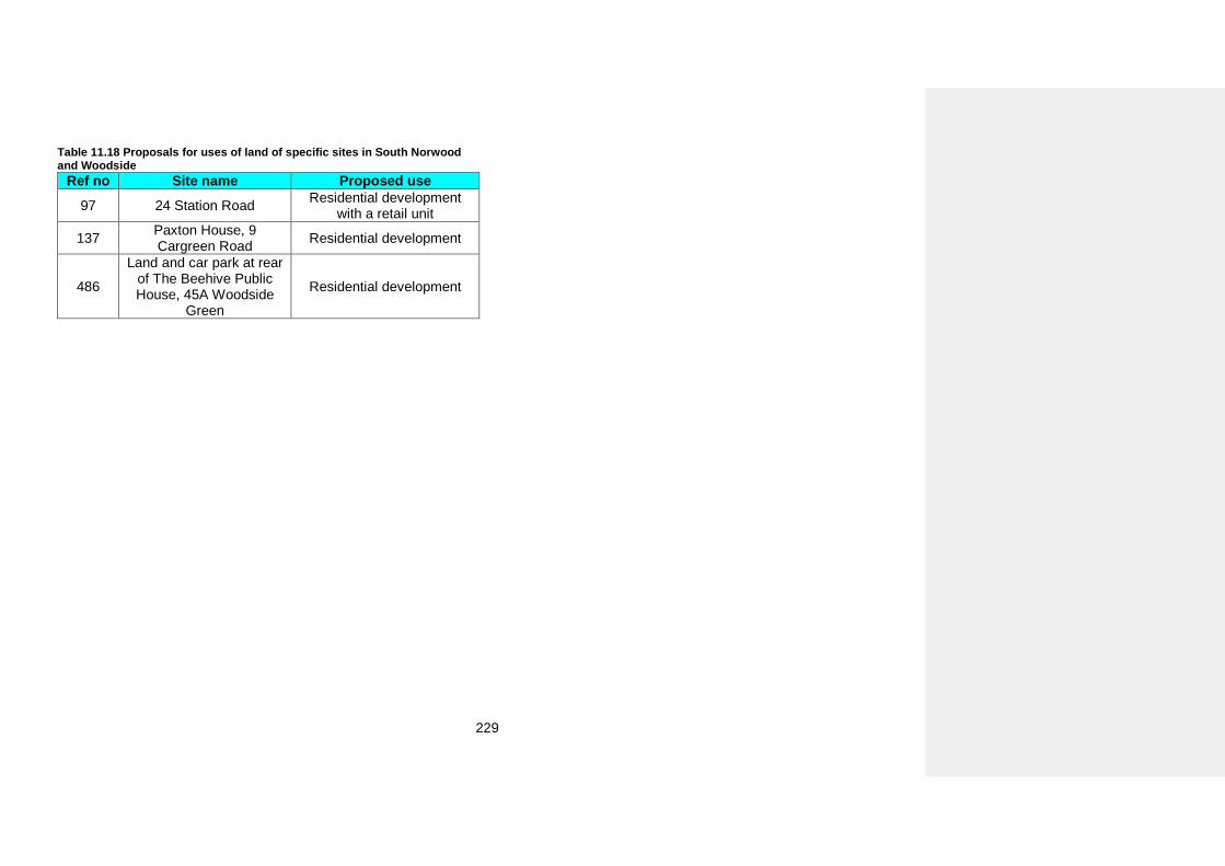
229
Table 11.18 Proposals for uses of land of specific sites in South Norwood and Woodside
Ref no Site name Proposed use 97 24 Station Road Residential development
with a retail unit
137 Paxton House, 9 Cargreen Road Residential development
486
Land and car park at rear of The Beehive Public House, 45A Woodside
Green
Residential development
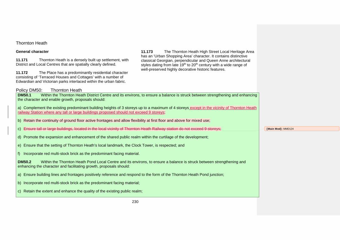
230
Thornton Heath
General character
11.171 Thornton Heath is a densely built up settlement, with District and Local Centres that are spatially clearly defined.
11.172 The Place has a predominantly residential character consisting of ‘Terraced Houses and Cottages’ with a number of Edwardian and Victorian parks interlaced within the urban fabric.
11.173 The Thornton Heath High Street Local Heritage Area has an ‘Urban Shopping Area’ character. It contains distinctive classical Georgian, perpendicular and Queen Anne architectural styles dating from late 19th to 20th century with a wide range of well-preserved highly decorative historic features.
Policy DM50: Thornton Heath DM50.1 Within the Thornton Heath District Centre and its environs, to ensure a balance is struck between strengthening and enhancing the character and enable growth, proposals should:
a) Complement the existing predominant building heights of 3 storeys up to a maximum of 4 storeys except in the vicinity of Thornton Heathrailway Station where any tall or large buildings proposed should not exceed 9 storeys;
b) Retain the continuity of ground floor active frontages and allow flexibility at first floor and above for mixed use;
c) Ensure tall or large buildings, located in the local vicinity of Thornton Heath Railway station do not exceed 9 storeys;
d) Promote the expansion and enhancement of the shared public realm within the curtilage of the development;
e) Ensure that the setting of Thornton Heath’s local landmark, the Clock Tower, is respected; and
f) Incorporate red multi-stock brick as the predominant facing material.
DM50.2 Within the Thornton Heath Pond Local Centre and its environs, to ensure a balance is struck between strengthening and enhancing the character and facilitating growth, proposals should:
a) Ensure building lines and frontages positively reference and respond to the form of the Thornton Heath Pond junction;
b) Incorporate red multi-stock brick as the predominant facing material;
c) Retain the extent and enhance the quality of the existing public realm;
[Main Mod]: MMD124

231
d) Complement the existing predominant building heights of 3 storeys up to a maximum of 6 storeys; and
e) Ensure transitions between buildings of different sizes create sense of continuity at the street level.
DM50.3 Within Thornton Heath allocate sites for development as set out in Table 11.19.
How the policy works
11.174 The areas in which these Policies DM50.1 and DM50.2 apply are shown on the draft Policies Map.
Thornton Heath District Centre and environs 11.175 The character of Thornton High Street is defined by elements such as red multi-stock brick with white detailing around windows, a consistent scale of three storey buildings with active frontages and strong tree lines and the local landmark clock tower.
11.176 The character around the railway station is less consistent changing from smaller scale buildings (up to three storeys) with narrow footways to tall and large buildings (up to nine storeys) with wider footways. The building lines within this area step back and forward resulting in inconsistent street frontages.
11.177 There are opportunities for growth within this area. To facilitate grown, manage spatial quality and enhance and strengthen the character of the District Centre a Place-specific development management policy is required.
Thornton Pond Local Centre and environs 11.178 The edge of the Thornton Pond Local Centre is beginning to lose its separate identity and sense of place. This could result in the Local Centre being absorbed into the homogenous urban form of the London Road.
11.179 Densities in areas around of Thornton Pond Local Centre are beginning to increase. A cohesive approach needs to be taken to ensure that edge of the Local Centre remains well defined and that the Local Centre has a distinct sense of place.
Allocating land for development 11.180 Table 11.19 below sets out the proposed use on specific sites in Thornton Heath. The location and boundary of each detailed proposal can be found on the draft Policies Map and further details including indicative phasing and indicative number of homes (if applicable) can be found in Appendix 5.
Table 11.19 Proposals for uses of land of specific sites in Thornton Heath Ref no Site name Proposed use
115 Cheriton House, 20 Chipstead Avenue Residential redevelopment
129 843 London Road Primary school
136 Supermarket, car park, 54 Brigstock Road
Mixed use of residential, retail along Brigstock Road,
and employment use 248 18-28 Thornton Road Residential development 286 35-47 Osborne Road Residential development 295 2 Zion Place Residential development
326 Ambassador House, 3-17 Brigstock Road
Mixed use conversion comprising residential, retail
and community facilities
400 Day Lewis House, 324-338 Bensham Lane Residential redevelopment
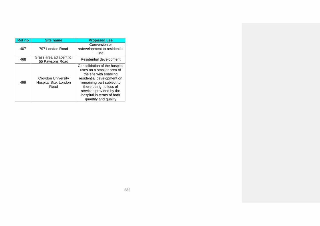
232
Ref no Site name Proposed use
407 797 London Road Conversion or
redevelopment to residential use
468 Grass area adjacent to, 55 Pawsons Road Residential development
499 Croydon University
Hospital Site, London Road
Consolidation of the hospital uses on a smaller area of
the site with enabling residential development on remaining part subject to
there being no loss of services provided by the hospital in terms of both
quantity and quality
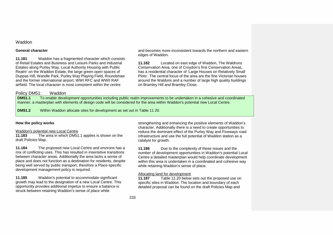
233
Waddon
General character
11.181 Waddon has a fragmented character which consists of Retail Estates and Business and Leisure Parks and Industrial Estates along Purley Way, Local Authority Housing with Public Realm’ on the Waddon Estate, the large green open spaces of Duppas Hill, Wandle Park, Purley Way Playing Field, Roundshaw and the former international airport, WWI RFC and WWII RAF airfield. The local character is most consistent within the centre
and becomes more inconsistent towards the northern and eastern edges of Waddon.
11.182 Located on east edge of Waddon, The Waldrons Conservation Area, one of Croydon’s first Conservation Areas, has a residential character of ‘Large Houses on Relatively Small Plots’. The central focus of the area are the fine Victorian houses around the Waldons and a number of large high quality buildings on Bramley Hill and Bramley Close.
Policy DM51: Waddon DM51.1 To enable development opportunities including public realm improvements to be undertaken in a cohesive and coordinated manner, a masterplan with elements of design code will be considered for the area within Waddon's potential new Local Centre.
DM51.2 Within Waddon allocate sites for development as set out in Table 11.20.
How the policy works
Waddon's potential new Local Centre 11.183 The area in which DM51.1 applies is shown on the draft Policies Map.
11.184 The proposed new Local Centre and environs has a mix of conflicting uses. This has resulted in insensitive transitions between character areas. Additionally the area lacks a sense of place and does not function as a destination for residents, despite being well served by public transport, therefore a Place-specific development management policy is required.
11.185 Waddon's potential to accommodate significant growth may lead to the designation of a new Local Centre. This opportunity provides additional impetus to ensure a balance is struck between retaining Waddon’s sense of place while
strengthening and enhancing the positive elements of Waddon’s character. Additionally there is a need to create opportunities to reduce the dominant effect of the Purley Way and Fiveways road infrastructure and use the full potential of Waddon station as a catalyst for growth.
11.186 Due to the complexity of these issues and the number of development opportunities in Waddon’s potential Local Centre a detailed masterplan would help coordinate development within this area is undertaken in a coordinated and cohesive way while retaining Waddon’s sense of place.
Allocating land for development 11.187 Table 11.20 below sets out the proposed use on specific sites in Waddon. The location and boundary of each detailed proposal can be found on the draft Policies Map and
234
further details including indicative phasing and indicative number of homes (if applicable) can be found in Appendix 5.
Table 11.20 Proposals for uses of land of specific sites in Waddon Ref no Site name Proposed use
11 Croydon Garden
Centre, 89 Waddon Way
Residential development
16 Heath Clark, Stafford Road
Secondary School and residential development
subject to access from Stafford Road
25 Morrisons
Supermarket, 500 Purley Way
Redevelopment of a mix of residential, retail, commercial and community uses to form the basis of a new residential
community. It is recommended that basements are not
considered at this site. Further ground investigations would be required at this site to confirm
the the likelihood of groundwater occurrence.
48 294-330 Purley Way
Mixed use development comprising retail store, commercial space and
residential units
301 Sea Cadet Training
Centre, 34 The Waldrons
Residential use with community use
Ref no Site name Proposed use
316 PC World, 2 Trojan Way
Redevelopment of this area to a mixture of residential, retail
and commercial use, healthcare facility (if required by the NHS) and community
uses to form the basis of a new residential community
332 Superstores, Drury Crescent
Redevelopment of this area to a mixture of residential, retail, healthcare facility (if required by the NHS) and community
uses to form the basis of a new residential community
349 Harveys Furnishing Group Ltd, 230-250
Purley Way
Redevelopment of this area to a mixture of residential, retail
and commercial use, healthcare facility (if required by the NHS) and community
uses to form the basis of a new residential community. As the
site is partly within a Flood Zone 3 it will be subject to the Sequential Test as part of the
Strategic Flood Risk Assessment.
350 Wing Yip, 544 Purley Way
Redevelopment of a mix of residential, retail, commercial and community uses to form the basis of a new residential
community
[Main Mod]: MMD125
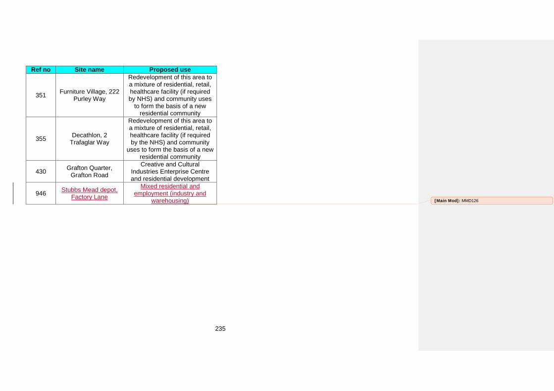
235
Ref no Site name Proposed use
351 Furniture Village, 222 Purley Way
Redevelopment of this area to a mixture of residential, retail, healthcare facility (if required by NHS) and community uses
to form the basis of a new residential community
355 Decathlon, 2 Trafaglar Way
Redevelopment of this area to a mixture of residential, retail, healthcare facility (if required by the NHS) and community
uses to form the basis of a new residential community
430 Grafton Quarter, Grafton Road
Creative and Cultural Industries Enterprise Centre and residential development
946 Stubbs Mead depot, Factory Lane
Mixed residential and employment (industry and
warehousing) [Main Mod]: MMD126

236
Appendices Picture break
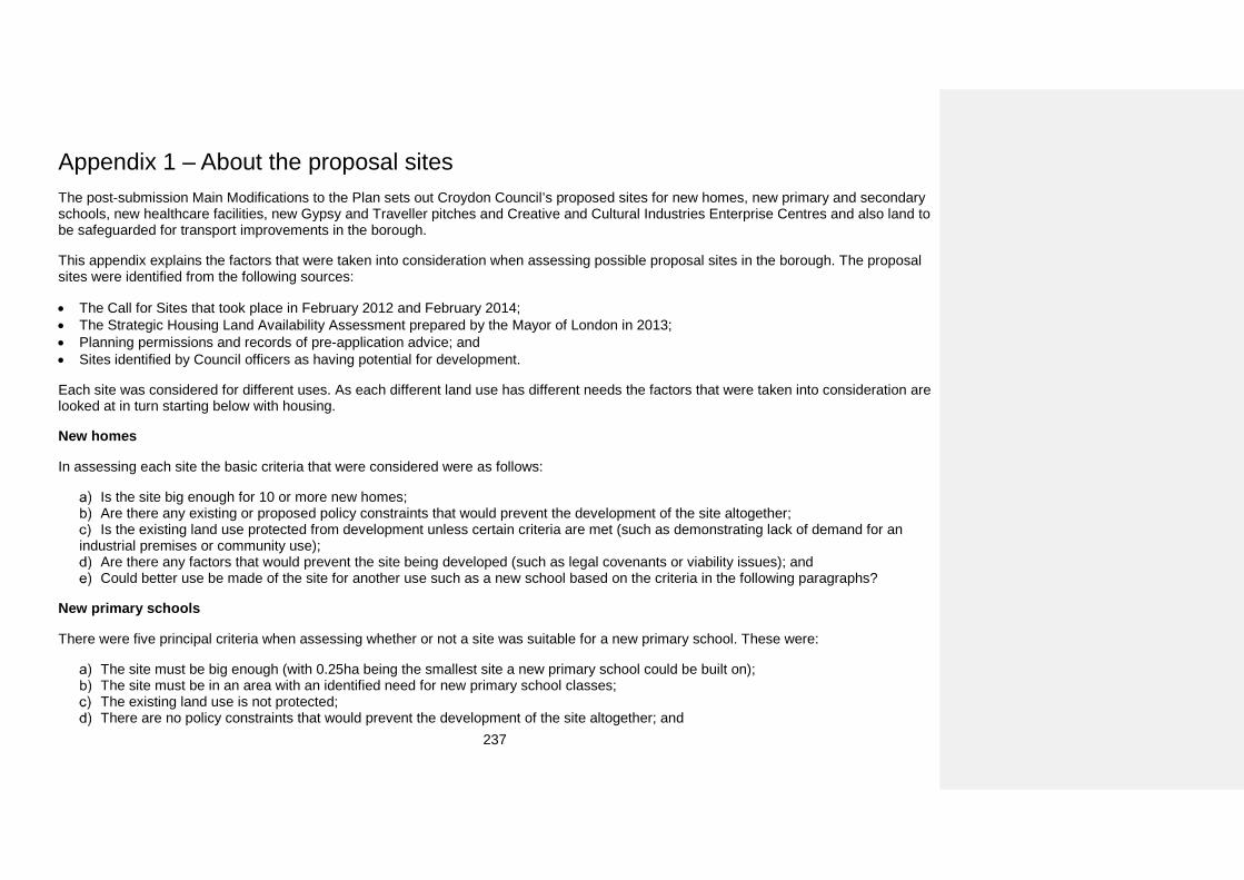
237
Appendix 1 – About the proposal sites The post-submission Main Modifications to the Plan sets out Croydon Council’s proposed sites for new homes, new primary and secondary schools, new healthcare facilities, new Gypsy and Traveller pitches and Creative and Cultural Industries Enterprise Centres and also land to be safeguarded for transport improvements in the borough.
This appendix explains the factors that were taken into consideration when assessing possible proposal sites in the borough. The proposal sites were identified from the following sources:
• The Call for Sites that took place in February 2012 and February 2014;• The Strategic Housing Land Availability Assessment prepared by the Mayor of London in 2013;• Planning permissions and records of pre-application advice; and• Sites identified by Council officers as having potential for development.
Each site was considered for different uses. As each different land use has different needs the factors that were taken into consideration are looked at in turn starting below with housing.
New homes
In assessing each site the basic criteria that were considered were as follows:
Is the site big enough for 10 or more new homes; Are there any existing or proposed policy constraints that would prevent the development of the site altogether; Is the existing land use protected from development unless certain criteria are met (such as demonstrating lack of demand for an
industrial premises or community use); Are there any factors that would prevent the site being developed (such as legal covenants or viability issues); and Could better use be made of the site for another use such as a new school based on the criteria in the following paragraphs?
New primary schools
There were five principal criteria when assessing whether or not a site was suitable for a new primary school. These were:
The site must be big enough (with 0.25ha being the smallest site a new primary school could be built on); The site must be in an area with an identified need for new primary school classes; The existing land use is not protected; There are no policy constraints that would prevent the development of the site altogether; and
238
There are no known factors that prevent the site being developed.
Not every area of the borough has a need for new primary school classes beyond 2017. Only the North West, Centre and South West have been identified as needing more classrooms that will require the construction of a new primary school. The remaining areas of the borough (the North East, the East and the South East), either do not have any need for new classrooms or the need is small enough to be accommodated through the expansion of existing primary schools.
New secondary schools
The assessment criteria for secondary schools were similar to primary schools, the main differences being the size of the site required and that secondary school places are required across the borough. The minimum site size for a new secondary school is 1.1ha.
New healthcare facilities
The Council has worked with NHS England, the Croydon Commissioning Group, the South London and Maudsley NHS Trust, the Croydon University Hospital NHS Trust, the London Healthy Urban Development Unit and NHS Property Services to identify sites that would be suitable for new healthcare facilities and are in areas of demand.
Sites for Gypsy and Traveller pitches
Gypsy and Traveller pitches are initially considered in the same way as a site for housing as in planning terms it is the same use of land. However, new Gypsy and Traveller pitches have their own specific requirements as well which were:
The site must be big enough for three pitches (with 0.15ha being the minimum site size required for three new pitches); and The site should have no existing buildings (on the grounds that it would not be viable to demolish existing buildings and replace them
with Gypsy and Traveller pitches), or the existing building could be used to provide an amenity block for new pitches.
Creative and Cultural Industries Enterprise Centres
The Croydon Local Plan: Strategic Policies sets out in Policy SP3.3 that it will create a network of Creative and Cultural Industries Enterprise Centres with one each in Croydon Metropolitan Centre, Crystal Palace, Purley and South Norwood/Portland Road. Sites in these locations have been considered as potential locations for a Creative and Cultural Industries Centre where there is an existing policy designation protecting the existing use, but where the site could be realistically used to support creative and cultural industries in the borough.
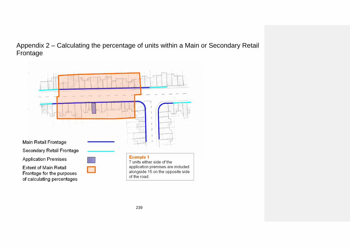
239
Appendix 2 – Calculating the percentage of units within a Main or Secondary Retail Frontage
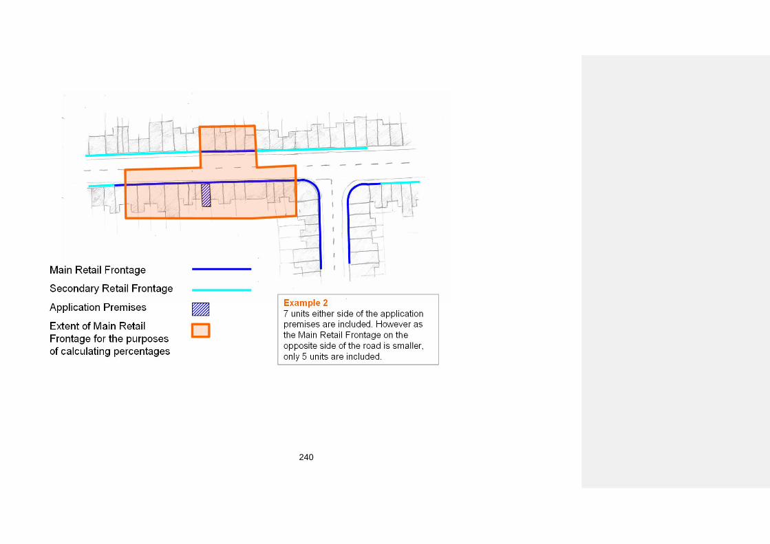
240
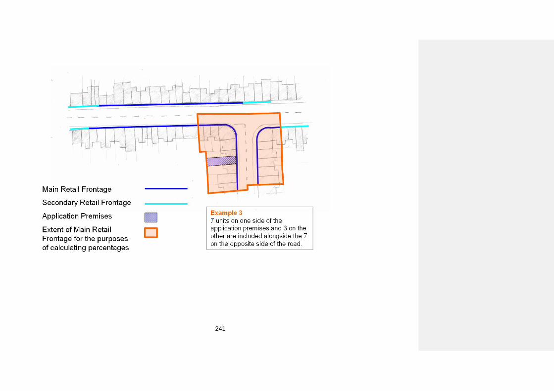
241
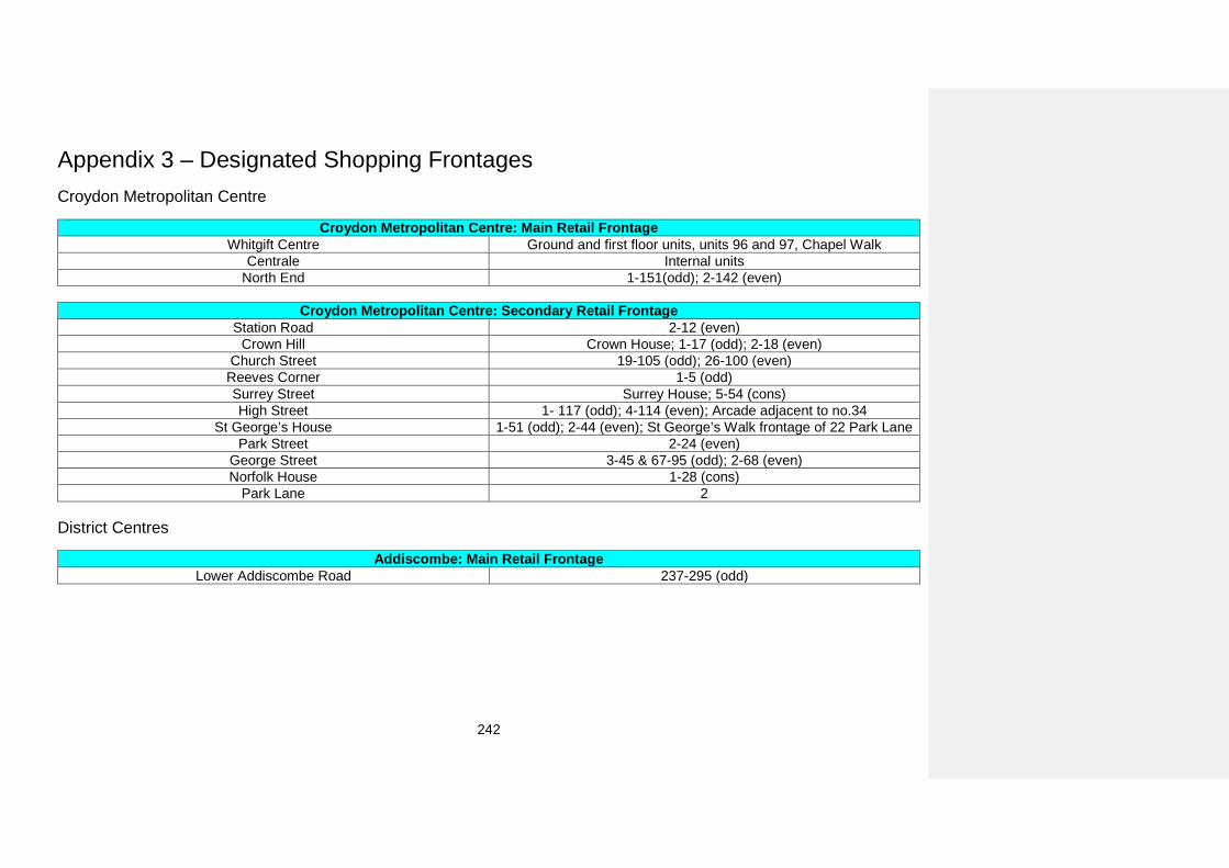
242
Appendix 3 – Designated Shopping Frontages Croydon Metropolitan Centre
Croydon Metropolitan Centre: Main Retail Frontage Whitgift Centre Ground and first floor units, units 96 and 97, Chapel Walk
Centrale Internal units North End 1-151(odd); 2-142 (even)
Croydon Metropolitan Centre: Secondary Retail Frontage
Station Road 2-12 (even) Crown Hill Crown House; 1-17 (odd); 2-18 (even)
Church Street 19-105 (odd); 26-100 (even) Reeves Corner 1-5 (odd) Surrey Street Surrey House; 5-54 (cons) High Street 1- 117 (odd); 4-114 (even); Arcade adjacent to no.34
St George’s House 1-51 (odd); 2-44 (even); St George’s Walk frontage of 22 Park Lane Park Street 2-24 (even)
George Street 3-45 & 67-95 (odd); 2-68 (even) Norfolk House 1-28 (cons)
Park Lane 2 District Centres
Addiscombe: Main Retail Frontage Lower Addiscombe Road 237-295 (odd)
243
Addiscombe: Secondary Retail Frontage
Lower Addiscombe Road
185-205 & 207-227 & 229-231 (odd); 1-9 Bingham Corner (cons)
297-331 (odd); 272-284 & 286-308 (even);
Coulsdon: Main Retail Frontage Brighton Road 110-148 (even)
Chipstead Valley Road 2-40 (even); 3-39 (odd)
Coulsdon: Secondary Retail Frontage Brighton Road 96-108 & 150-234 (even); 129-159 & 165-185 (odd)
Chipstead Valley Road 41-55 (odd); 42-48 (even)
Crystal Palace: Main Retail Frontage Hollybush Terrace 1-4 (cons)
Westow Street 1-23 (odd); 2-64 (even) Westow Hill 2-24 (even)
Crystal Palace: Secondary Retail Frontage Central Hill 1-19 (odd)
Church Road 6-48 & 52-96 (even); 99-113 (odd) Westow Hill 26-88 (even)
Westow Street 25-71 (odd); 74-78 (even)
New Addington: Main Retail Frontage Central Parade 7-50 (cons)
New Addington: Secondary Retail Frontage Central Parade 51-54 (cons)
Norbury: Main Retail Frontage London Road 1384-1434 (even)
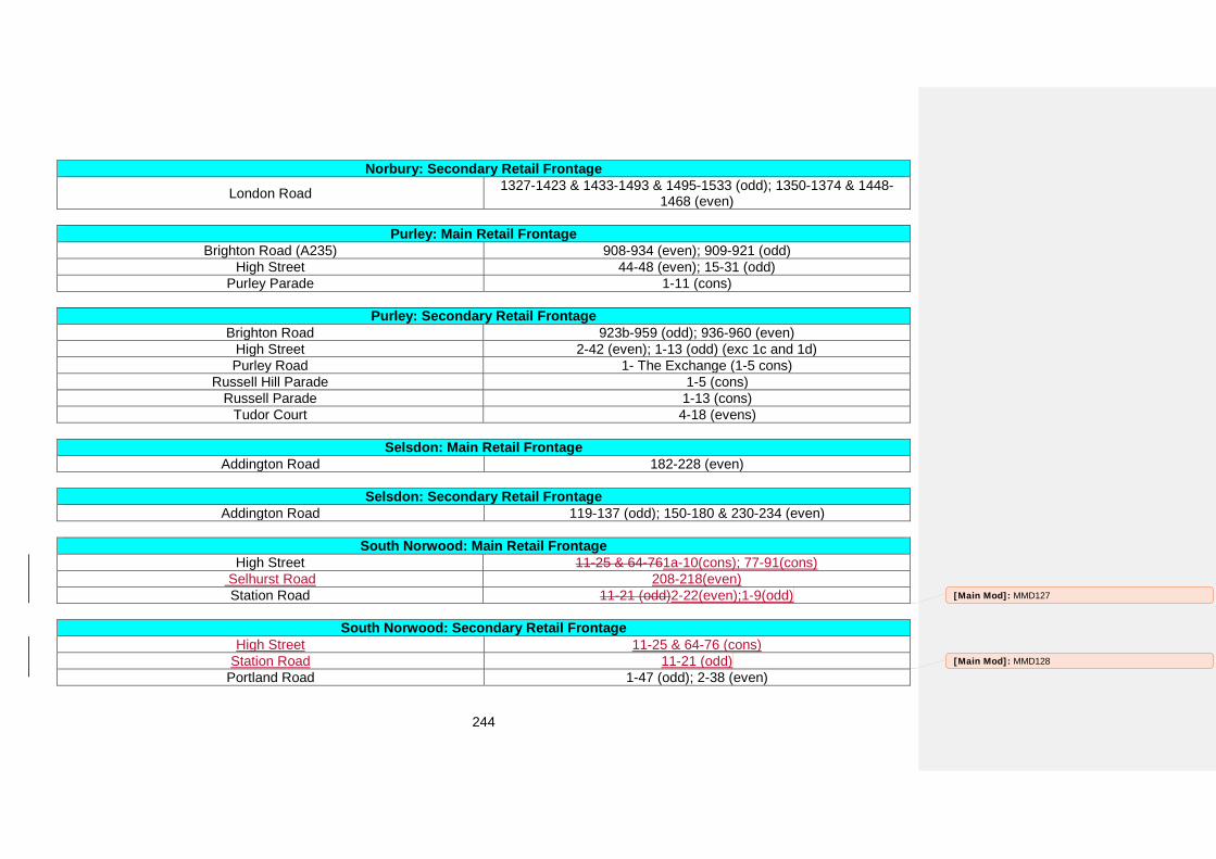
244
Norbury: Secondary Retail Frontage London Road 1327-1423 & 1433-1493 & 1495-1533 (odd); 1350-1374 & 1448-
1468 (even)
Purley: Main Retail Frontage Brighton Road (A235) 908-934 (even); 909-921 (odd)
High Street 44-48 (even); 15-31 (odd) Purley Parade 1-11 (cons)
Purley: Secondary Retail Frontage Brighton Road 923b-959 (odd); 936-960 (even)
High Street 2-42 (even); 1-13 (odd) (exc 1c and 1d) Purley Road 1- The Exchange (1-5 cons)
Russell Hill Parade 1-5 (cons) Russell Parade 1-13 (cons)
Tudor Court 4-18 (evens)
Selsdon: Main Retail Frontage Addington Road 182-228 (even)
Selsdon: Secondary Retail Frontage Addington Road 119-137 (odd); 150-180 & 230-234 (even)
South Norwood: Main Retail Frontage High Street 11-25 & 64-761a-10(cons); 77-91(cons)
Selhurst Road 208-218(even) Station Road 11-21 (odd)2-22(even);1-9(odd)
South Norwood: Secondary Retail Frontage High Street 11-25 & 64-76 (cons)
Station Road 11-21 (odd) Portland Road 1-47 (odd); 2-38 (even)
[Main Mod]: MMD127
[Main Mod]: MMD128
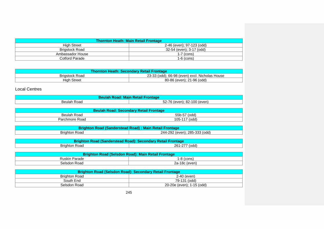
245
Thornton Heath: Main Retail Frontage High Street 2-46 (even); 97-123 (odd)
Brigstock Road 32-54 (even); 3-17 (odd) Ambassador House 1-7 (cons)
Cotford Parade 1-6 (cons)
Thornton Heath: Secondary Retail Frontage Brigstock Road 23-33 (odd); 66-98 (even) excl. Nicholas House
High Street 80-86 (even); 21-96 (odd)
Local Centres
Beulah Road: Main Retail Frontage Beulah Road 52-76 (even); 82-100 (even)
Beulah Road: Secondary Retail Frontage Beulah Road 55b-57 (odd)
Parchmore Road 105-117 (odd)
Brighton Road (Sanderstead Road) : Main Retail Frontage Brighton Road 244-292 (even); 285-333 (odd)
Brighton Road (Sanderstead Road): Secondary Retail Frontage Brighton Road 261-277 (odd)
Brighton Road (Selsdon Road): Main Retail Frontage Ruskin Parade 1-8 (cons) Selsdon Road 2a-18c (even)
Brighton Road (Selsdon Road): Secondary Retail Frontage Brighton Road 2-40 (even)
South End 79-131 (odd) Selsdon Road 20-20e (even); 1-15 (odd)
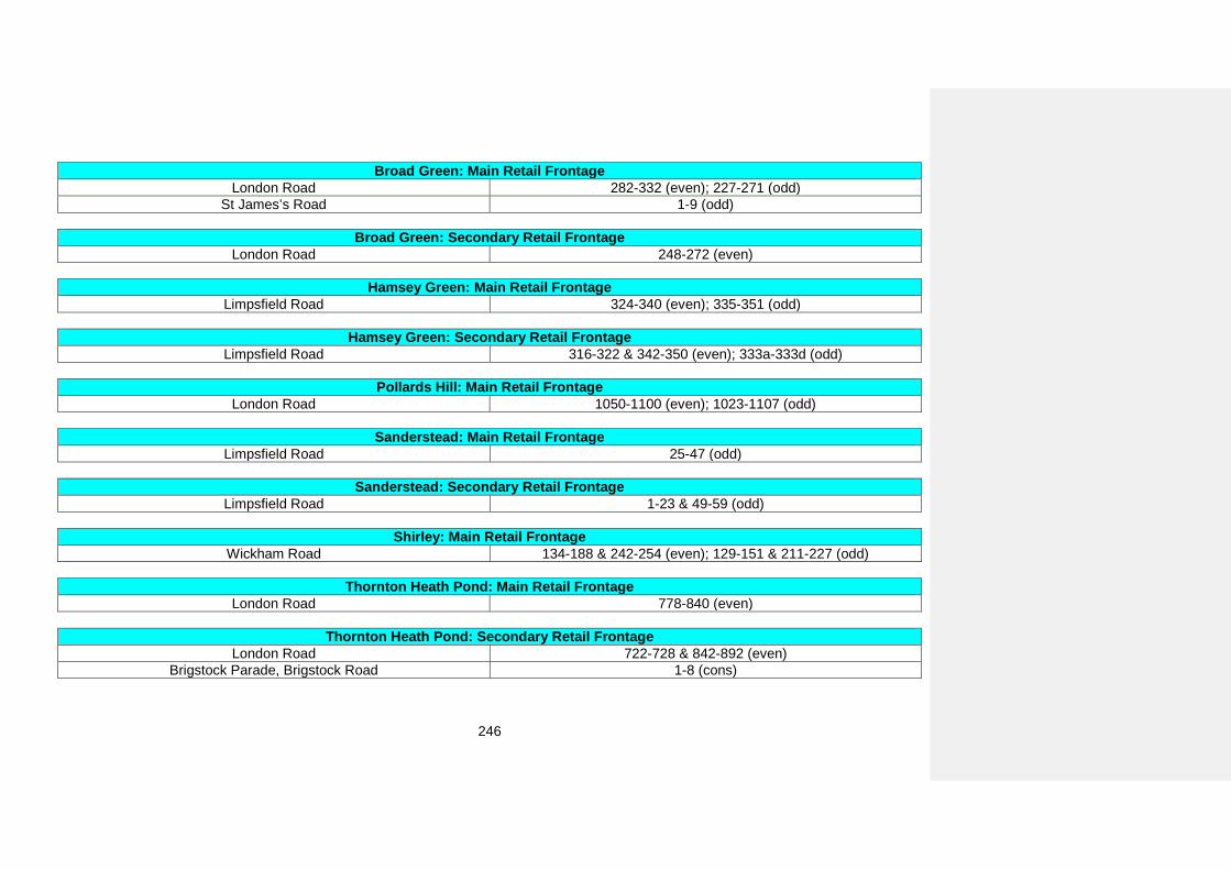
246
Broad Green: Main Retail Frontage London Road 282-332 (even); 227-271 (odd)
St James’s Road 1-9 (odd)
Broad Green: Secondary Retail Frontage London Road 248-272 (even)
Hamsey Green: Main Retail Frontage Limpsfield Road 324-340 (even); 335-351 (odd)
Hamsey Green: Secondary Retail Frontage Limpsfield Road 316-322 & 342-350 (even); 333a-333d (odd)
Pollards Hill: Main Retail Frontage London Road 1050-1100 (even); 1023-1107 (odd)
Sanderstead: Main Retail Frontage Limpsfield Road 25-47 (odd)
Sanderstead: Secondary Retail Frontage Limpsfield Road 1-23 & 49-59 (odd)
Shirley: Main Retail Frontage Wickham Road 134-188 & 242-254 (even); 129-151 & 211-227 (odd)
Thornton Heath Pond: Main Retail Frontage London Road 778-840 (even)
Thornton Heath Pond: Secondary Retail Frontage London Road 722-728 & 842-892 (even)
Brigstock Parade, Brigstock Road 1-8 (cons)
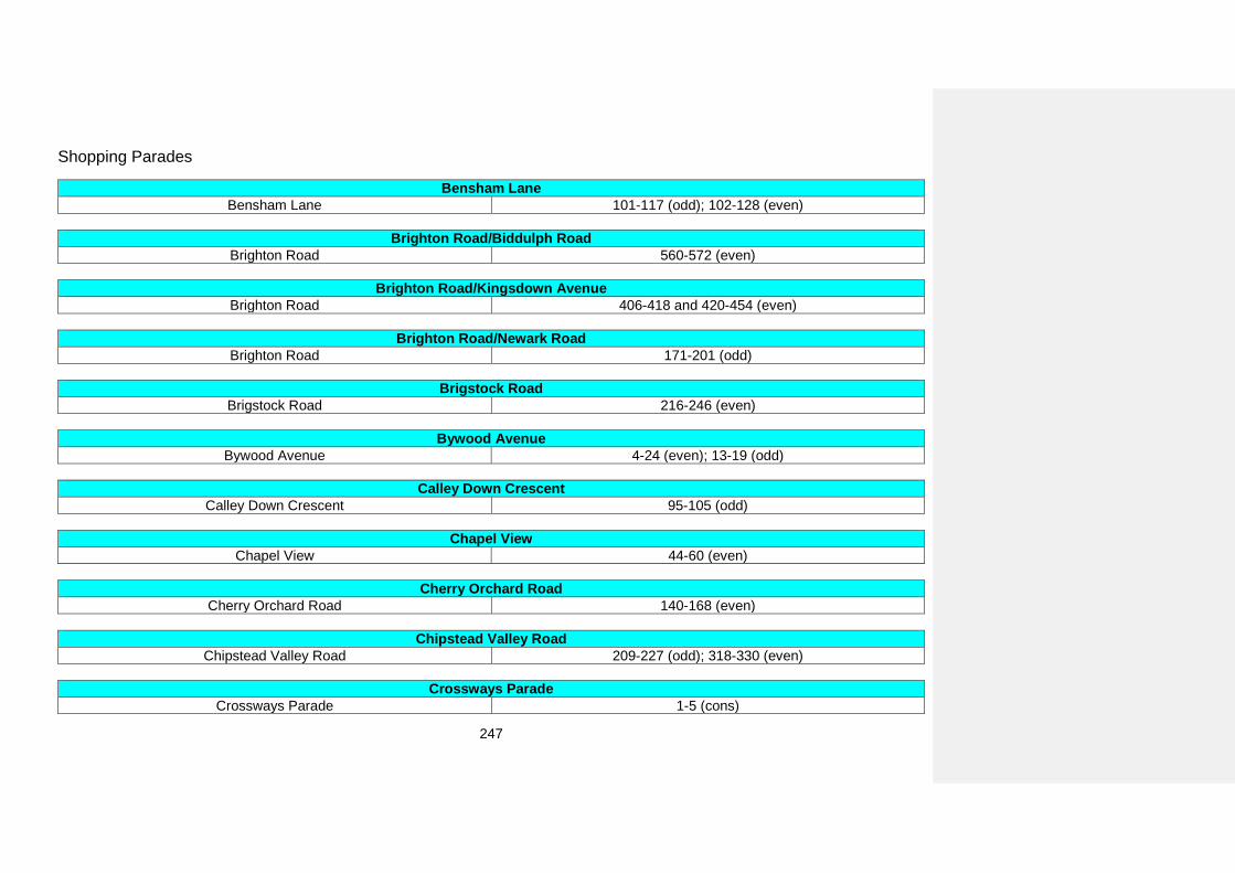
247
Shopping Parades
Bensham Lane Bensham Lane 101-117 (odd); 102-128 (even)
Brighton Road/Biddulph Road Brighton Road 560-572 (even)
Brighton Road/Kingsdown Avenue Brighton Road 406-418 and 420-454 (even)
Brighton Road/Newark Road Brighton Road 171-201 (odd)
Brigstock Road Brigstock Road 216-246 (even)
Bywood Avenue Bywood Avenue 4-24 (even); 13-19 (odd)
Calley Down Crescent Calley Down Crescent 95-105 (odd)
Chapel View Chapel View 44-60 (even)
Cherry Orchard Road Cherry Orchard Road 140-168 (even)
Chipstead Valley Road Chipstead Valley Road 209-227 (odd); 318-330 (even)
Crossways Parade Crossways Parade 1-5 (cons)
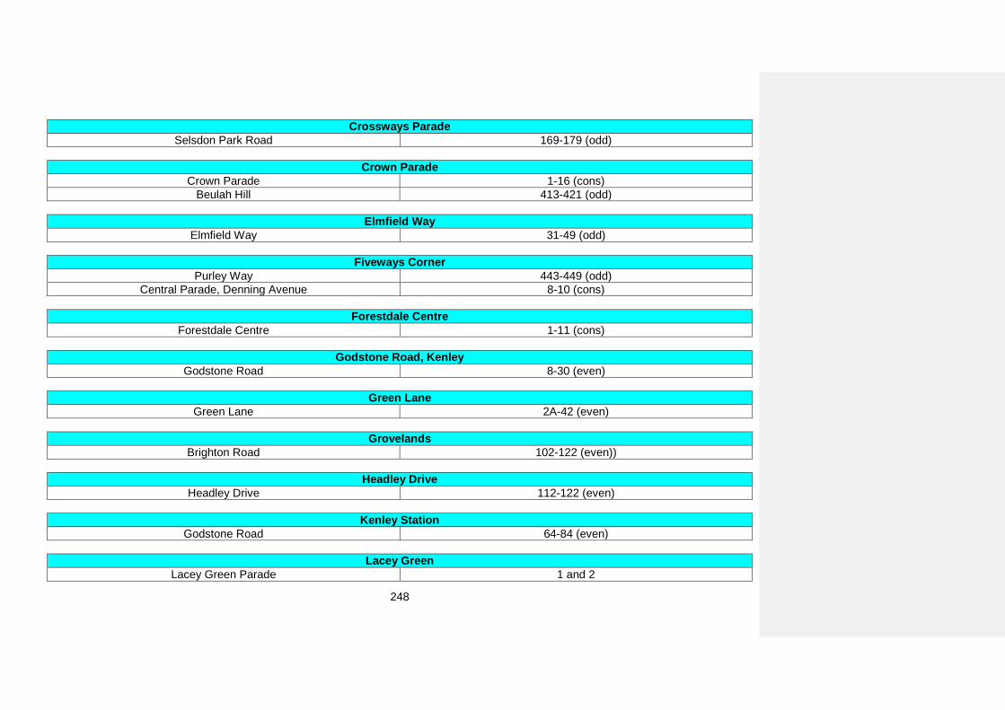
248
Crossways Parade Selsdon Park Road 169-179 (odd)
Crown Parade Crown Parade 1-16 (cons)
Beulah Hill 413-421 (odd)
Elmfield Way Elmfield Way 31-49 (odd)
Fiveways Corner Purley Way 443-449 (odd)
Central Parade, Denning Avenue 8-10 (cons)
Forestdale Centre Forestdale Centre 1-11 (cons)
Godstone Road, Kenley Godstone Road 8-30 (even)
Green Lane Green Lane 2A-42 (even)
Grovelands Brighton Road 102-122 (even))
Headley Drive Headley Drive 112-122 (even)
Kenley Station Godstone Road 64-84 (even)
Lacey Green Lacey Green Parade 1 and 2
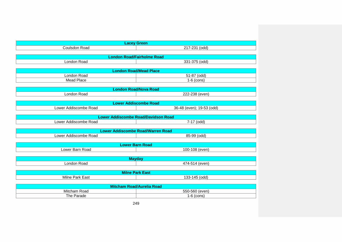
249
Lacey Green Coulsdon Road 217-231 (odd)
London Road/Fairholme Road London Road 331-375 (odd)
London Road/Mead Place London Road 51-87 (odd) Mead Place 1-6 (cons)
London Road/Nova Road London Road 222-238 (even)
Lower Addiscombe Road Lower Addiscombe Road 36-48 (even); 19-53 (odd)
Lower Addiscombe Road/Davidson Road Lower Addiscombe Road 7-17 (odd)
Lower Addiscombe Road/Warren Road Lower Addiscombe Road 85-99 (odd)
Lower Barn Road Lower Barn Road 100-108 (even)
Mayday London Road 474-514 (even)
Milne Park East Milne Park East 133-145 (odd)
Mitcham Road/Aurelia Road Mitcham Road 550-560 (even)
The Parade 1-6 (cons)
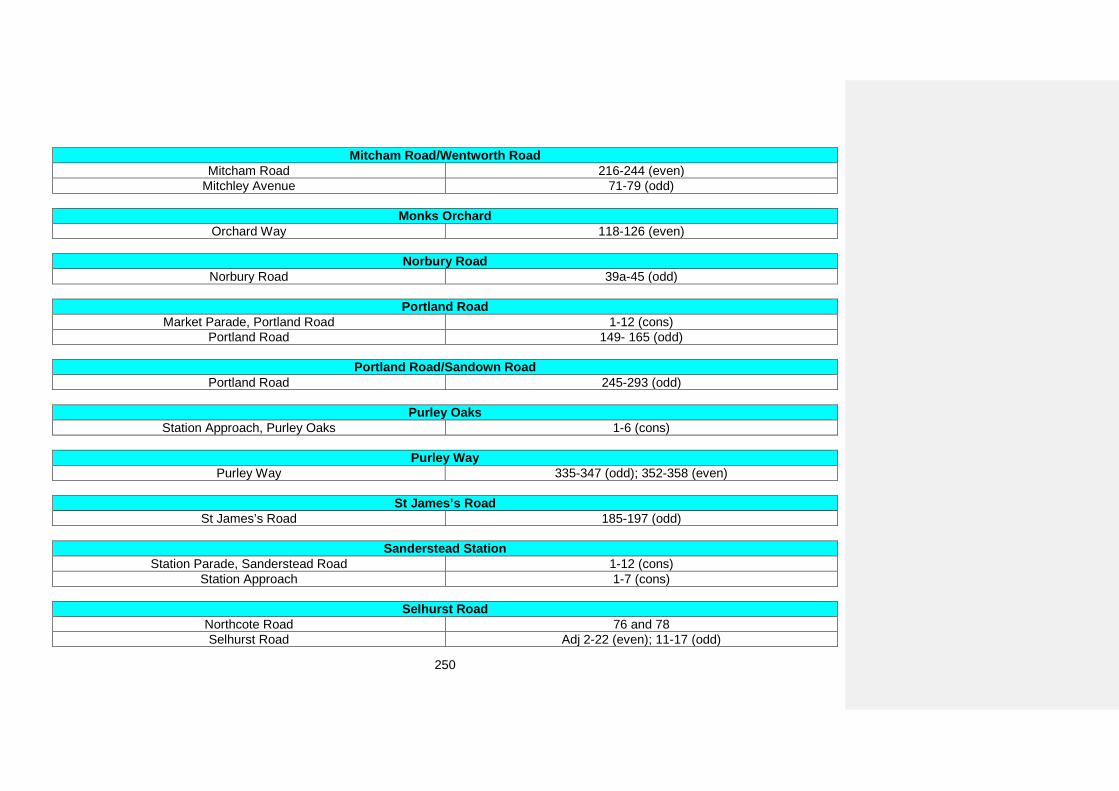
250
Mitcham Road/Wentworth Road Mitcham Road 216-244 (even)
Mitchley Avenue 71-79 (odd)
Monks Orchard Orchard Way 118-126 (even)
Norbury Road Norbury Road 39a-45 (odd)
Portland Road Market Parade, Portland Road 1-12 (cons)
Portland Road 149- 165 (odd)
Portland Road/Sandown Road Portland Road 245-293 (odd)
Purley Oaks Station Approach, Purley Oaks 1-6 (cons)
Purley Way Purley Way 335-347 (odd); 352-358 (even)
St James’s Road St James’s Road 185-197 (odd)
Sanderstead Station Station Parade, Sanderstead Road 1-12 (cons)
Station Approach 1-7 (cons)
Selhurst Road Northcote Road 76 and 78 Selhurst Road Adj 2-22 (even); 11-17 (odd)
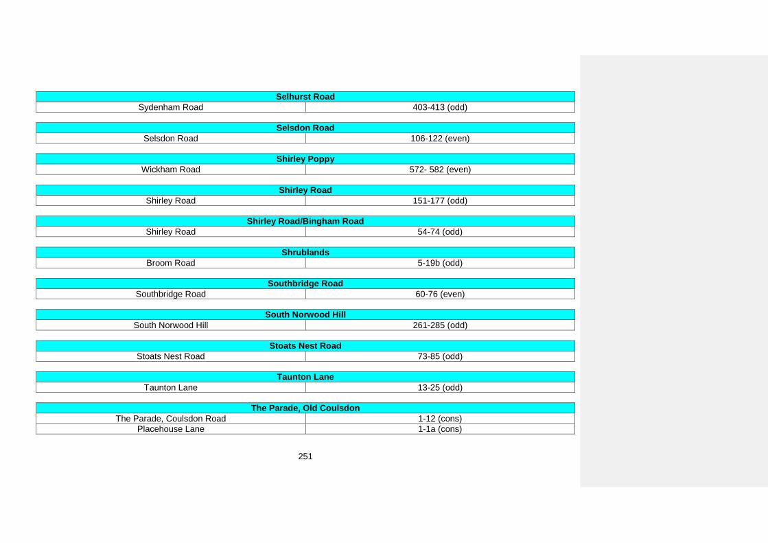
251
Selhurst Road Sydenham Road 403-413 (odd)
Selsdon Road Selsdon Road 106-122 (even)
Shirley Poppy Wickham Road 572- 582 (even)
Shirley Road Shirley Road 151-177 (odd)
Shirley Road/Bingham Road Shirley Road 54-74 (odd)
Shrublands Broom Road 5-19b (odd)
Southbridge Road Southbridge Road 60-76 (even)
South Norwood Hill South Norwood Hill 261-285 (odd)
Stoats Nest Road Stoats Nest Road 73-85 (odd)
Taunton Lane Taunton Lane 13-25 (odd)
The Parade, Old Coulsdon The Parade, Coulsdon Road 1-12 (cons)
Placehouse Lane 1-1a (cons)
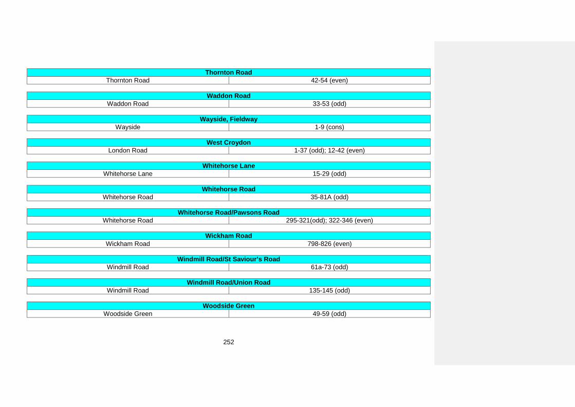
252
Thornton Road Thornton Road 42-54 (even)
Waddon Road Waddon Road 33-53 (odd)
Wayside, Fieldway Wayside 1-9 (cons)
West Croydon London Road 1-37 (odd); 12-42 (even)
Whitehorse Lane Whitehorse Lane 15-29 (odd)
Whitehorse Road Whitehorse Road 35-81A (odd)
Whitehorse Road/Pawsons Road Whitehorse Road 295-321(odd); 322-346 (even)
Wickham Road Wickham Road 798-826 (even)
Windmill Road/St Saviour’s Road Windmill Road 61a-73 (odd)
Windmill Road/Union Road Windmill Road 135-145 (odd)
Woodside Green Woodside Green 49-59 (odd)
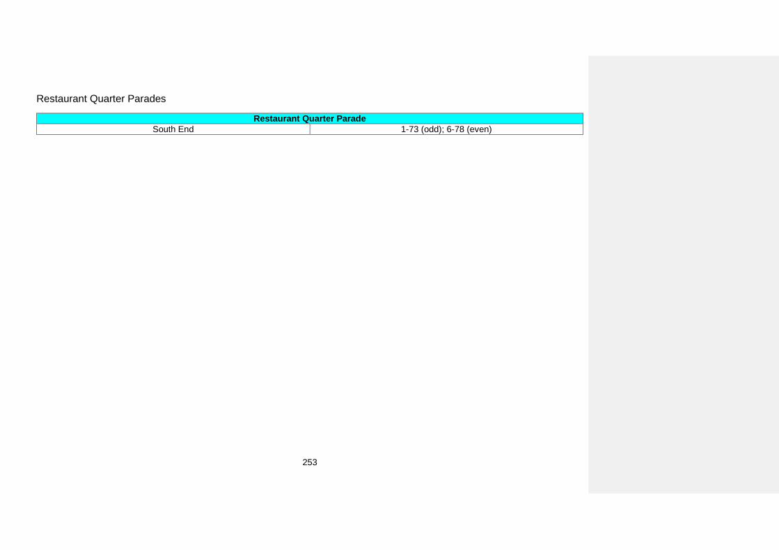
253
Restaurant Quarter Parades
Restaurant Quarter Parade South End 1-73 (odd); 6-78 (even)
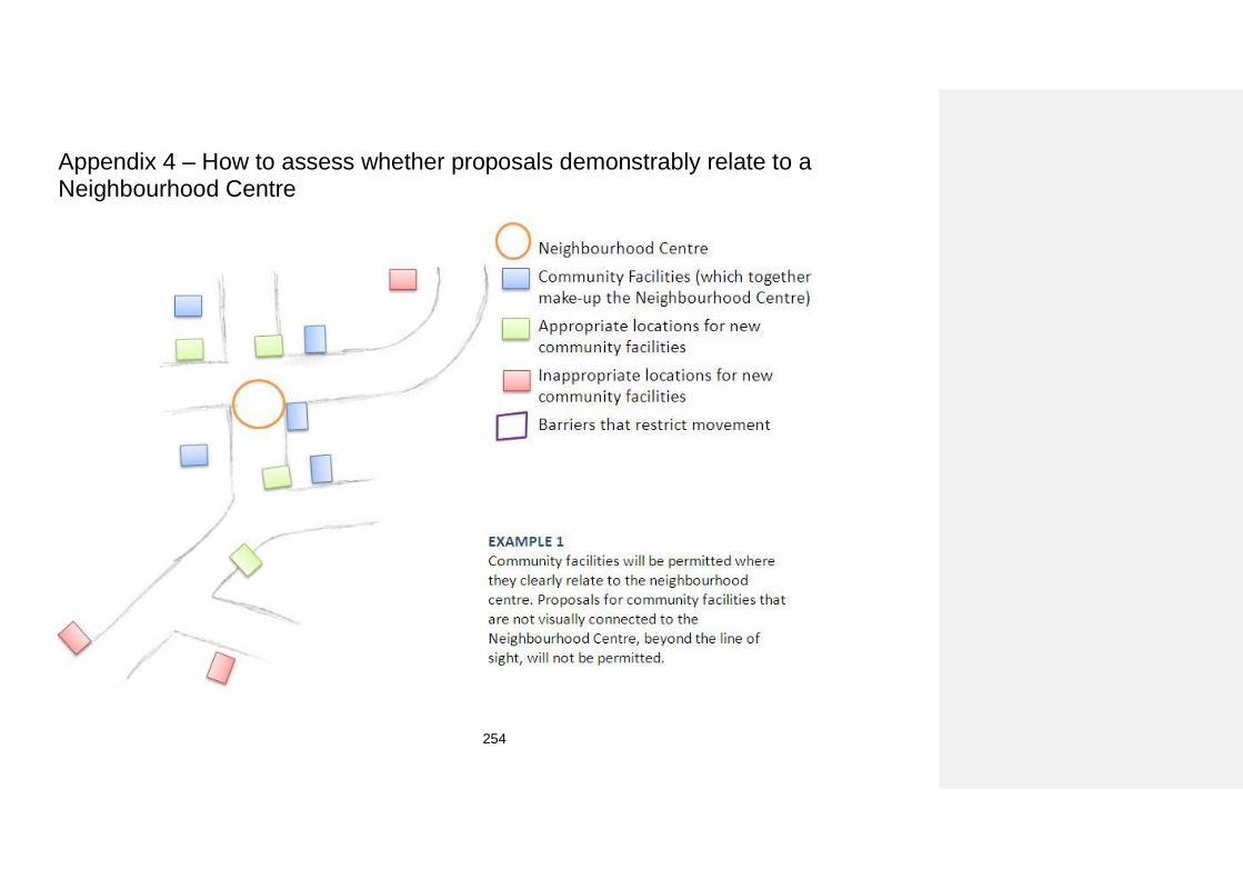
254
Appendix 4 – How to assess whether proposals demonstrably relate to a Neighbourhood Centre
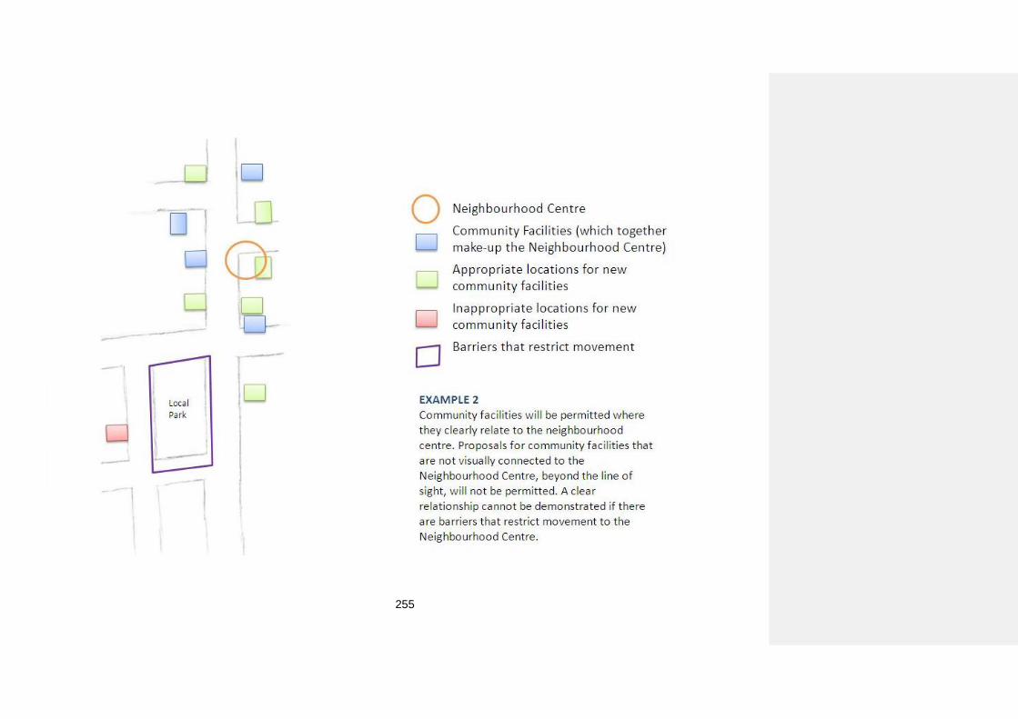
255
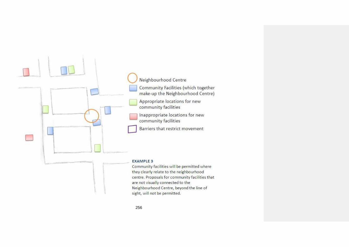
256
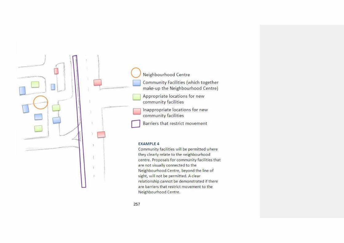
257
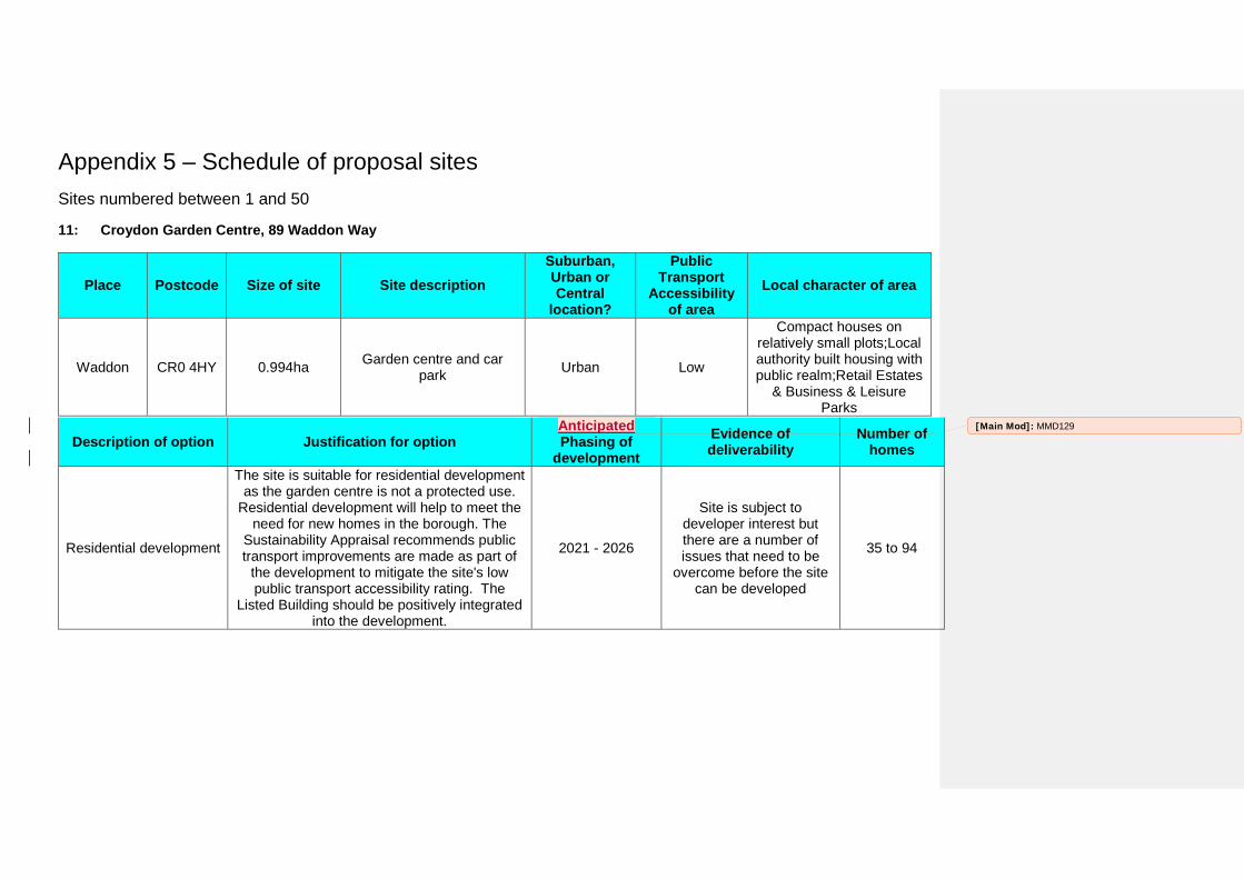
Appendix 5 – Schedule of proposal sites Sites numbered between 1 and 50
11: Croydon Garden Centre, 89 Waddon Way
Place Postcode Size of site Site description Suburban, Urban or Central
location?
Public Transport
Accessibility of area
Local character of area
Waddon CR0 4HY 0.994ha Garden centre and car park Urban Low
Compact houses on relatively small plots;Local authority built housing with public realm;Retail Estates
& Business & Leisure Parks
Description of option Justification for option Anticipated Phasing of
development Evidence of deliverability
Number of homes
Residential development
The site is suitable for residential development as the garden centre is not a protected use.
Residential development will help to meet the need for new homes in the borough. The
Sustainability Appraisal recommends public transport improvements are made as part of
the development to mitigate the site's low public transport accessibility rating. The
Listed Building should be positively integrated into the development.
2021 - 2026
Site is subject to developer interest but there are a number of issues that need to be
overcome before the site can be developed
35 to 94
[Main Mod]: MMD129
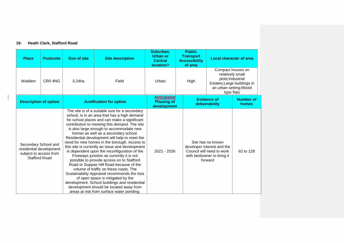
16: Heath Clark, Stafford Road
Place Postcode Size of site Site description Suburban, Urban or Central
location?
Public Transport
Accessibility of area
Local character of area
Waddon CR0 4NG 3.24ha Field Urban High
Compact houses on relatively small plots;Industrial
Estates;Large buildings in an urban setting;Mixed
type flats
Description of option Justification for option Anticipated Phasing of
development Evidence of deliverability
Number of homes
Secondary School and residential development subject to access from
Stafford Road
The site is of a suitable size for a secondary school, is in an area that has a high demand for school places and can make a significant contribution to meeting this demand. The site
is also large enough to accommodate new homes as well as a secondary school.
Residential development will help to meet the need for new homes in the borough. Access to this site is currently an issue and development is dependent upon the reconfiguration of the
Fiveways junction as currently it is not possible to provide access on to Stafford Road or Duppas Hill Road because of the
volume of traffic on these roads. The Sustainability Appraisal recommends the loss
of open space is mitigated by the development. School buildings and residential
development should be located away from areas at risk from surface water ponding.
2021 - 2026
Site has no known developer interest and the Council will need to work with landowner to bring it
forward
62 to 128
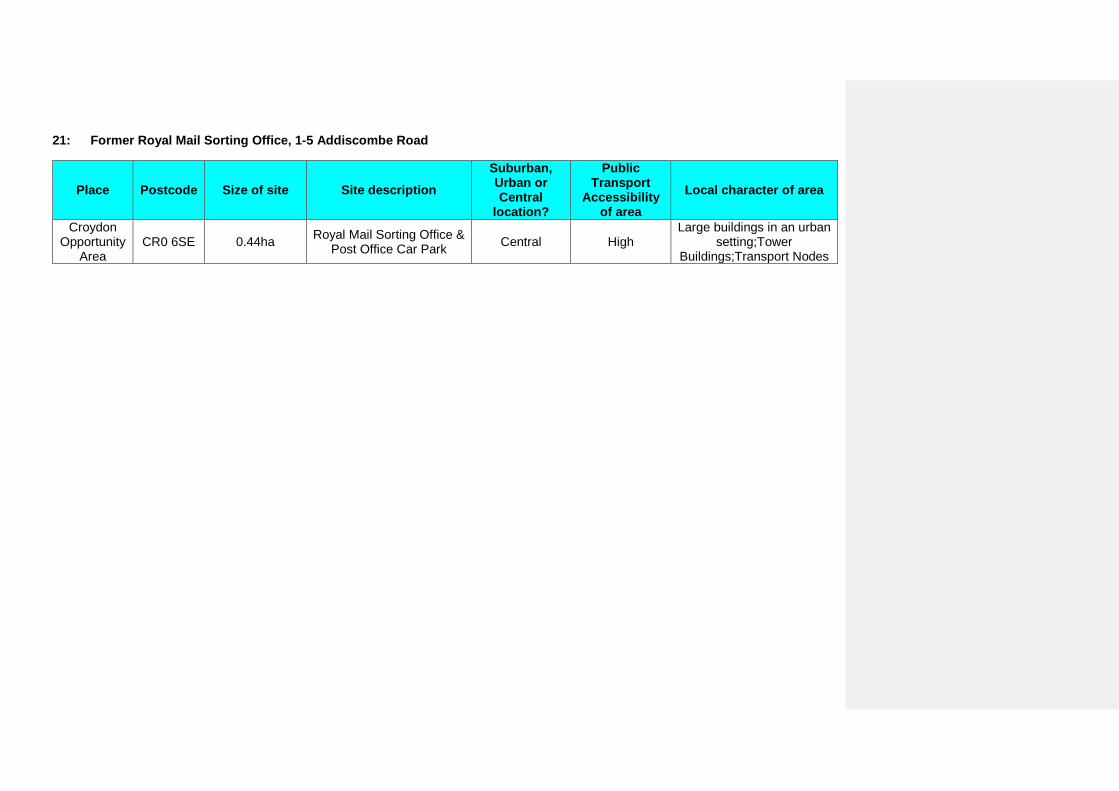
21: Former Royal Mail Sorting Office, 1-5 Addiscombe Road
Place Postcode Size of site Site description Suburban, Urban or Central
location?
Public Transport
Accessibility of area
Local character of area
Croydon Opportunity
Area CR0 6SE 0.44ha Royal Mail Sorting Office &
Post Office Car Park Central High Large buildings in an urban
setting;Tower Buildings;Transport Nodes
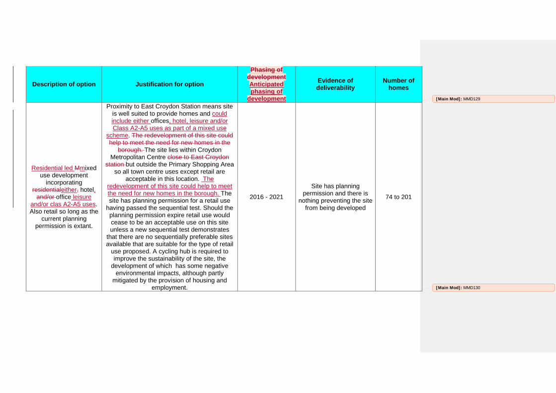
Description of option Justification for option
Phasing of development Anticipated phasing of
development
Evidence of deliverability
Number of homes
Residential led Mmixed use development
incorporating residentialeither, hotel,
and/or office leisure and/or clas A2-A5 uses. Also retail so long as the
current planning permission is extant.
Proximity to East Croydon Station means site is well suited to provide homes and could include either offices, hotel, leisure and/or Class A2-A5 uses as part of a mixed use
scheme. The redevelopment of this site could help to meet the need for new homes in the
borough. The site lies within Croydon Metropolitan Centre close to East Croydon
station but outside the Primary Shopping Area so all town centre uses except retail are
acceptable in this location. The redevelopment of this site could help to meet the need for new homes in the borough. The site has planning permission for a retail use
having passed the sequential test. Should the planning permission expire retail use would cease to be an acceptable use on this site unless a new sequential test demonstrates
that there are no sequentially preferable sites available that are suitable for the type of retail
use proposed. A cycling hub is required to improve the sustainability of the site, the
development of which has some negative environmental impacts, although partly
mitigated by the provision of housing and employment.
2016 - 2021
Site has planning permission and there is
nothing preventing the site from being developed
74 to 201
[Main Mod]: MMD129
[Main Mod]: MMD130
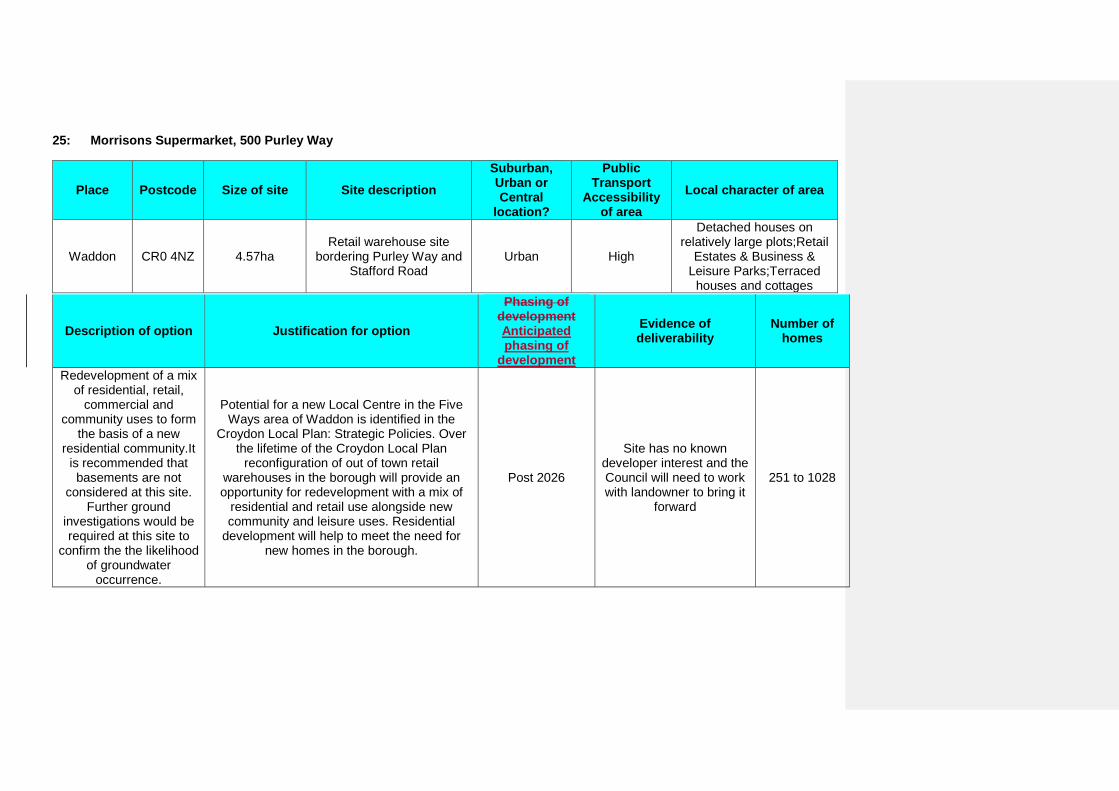
25: Morrisons Supermarket, 500 Purley Way
Place Postcode Size of site Site description Suburban, Urban or Central
location?
Public Transport
Accessibility of area
Local character of area
Waddon CR0 4NZ 4.57ha Retail warehouse site
bordering Purley Way and Stafford Road
Urban High
Detached houses on relatively large plots;Retail
Estates & Business & Leisure Parks;Terraced
houses and cottages
Description of option Justification for option
Phasing of development Anticipated phasing of
development
Evidence of deliverability
Number of homes
Redevelopment of a mix of residential, retail,
commercial and community uses to form
the basis of a new residential community.It
is recommended that basements are not
considered at this site. Further ground
investigations would be required at this site to
confirm the the likelihood of groundwater
occurrence.
Potential for a new Local Centre in the Five Ways area of Waddon is identified in the
Croydon Local Plan: Strategic Policies. Over the lifetime of the Croydon Local Plan
reconfiguration of out of town retail warehouses in the borough will provide an opportunity for redevelopment with a mix of
residential and retail use alongside new community and leisure uses. Residential
development will help to meet the need for new homes in the borough.
Post 2026
Site has no known developer interest and the Council will need to work with landowner to bring it
forward
251 to 1028
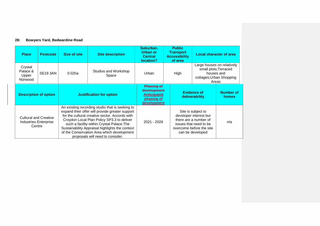
28: Bowyers Yard, Bedwardine Road
Place Postcode Size of site Site description Suburban, Urban or Central
location?
Public Transport
Accessibility of area
Local character of area
Crystal Palace &
Upper Norwood
SE19 3AN 0.02ha Studios and Workshop Space Urban High
Large houses on relatively small plots;Terraced
houses and cottages;Urban Shopping
Areas
Description of option Justification for option
Phasing of development Anticipated phasing of
development
Evidence of deliverability
Number of homes
Cultural and Creative Industries Enterprise
Centre
An existing recording studio that is seeking to expand their offer will provide greater support for the cultural creative sector. Accords with Croydon Local Plan Policy SP3.3 to deliver
such a facility within Crystal Palace.The Sustainability Appraisal highlights the context of the Conservation Area which development
proposals will need to consider.
2021 - 2026
Site is subject to developer interest but there are a number of issues that need to be
overcome before the site can be developed
n/a
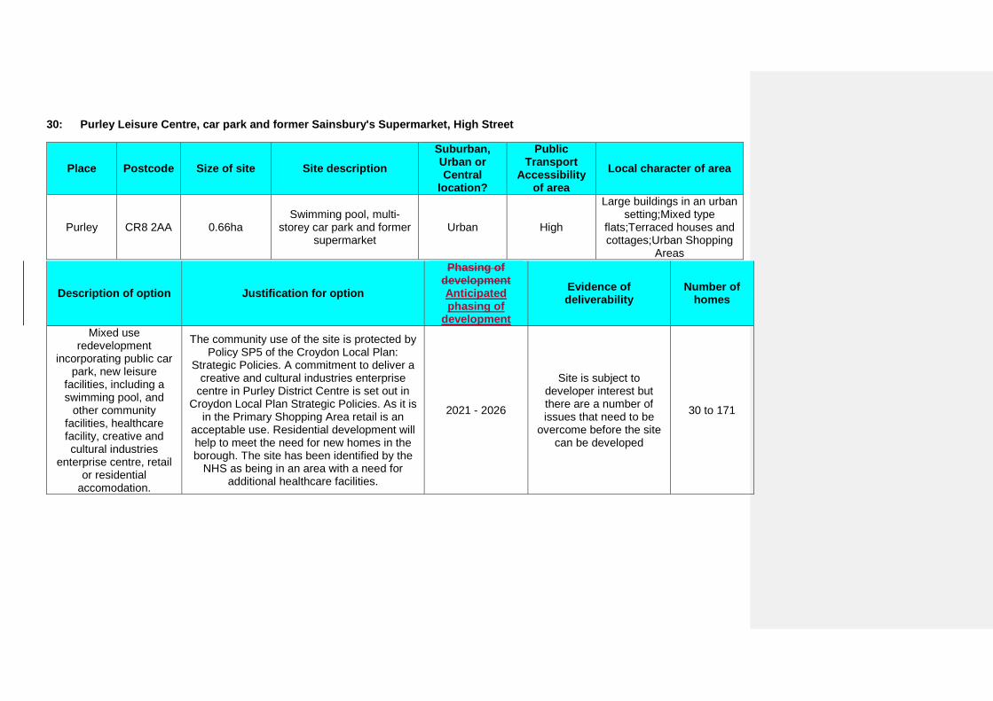
30: Purley Leisure Centre, car park and former Sainsbury's Supermarket, High Street
Place Postcode Size of site Site description Suburban, Urban or Central
location?
Public Transport
Accessibility of area
Local character of area
Purley CR8 2AA 0.66ha Swimming pool, multi-
storey car park and former supermarket
Urban High
Large buildings in an urban setting;Mixed type
flats;Terraced houses and cottages;Urban Shopping
Areas
Description of option Justification for option
Phasing of development Anticipated phasing of
development
Evidence of deliverability
Number of homes
Mixed use redevelopment
incorporating public car park, new leisure
facilities, including a swimming pool, and
other community facilities, healthcare facility, creative and cultural industries
enterprise centre, retail or residential
accomodation.
The community use of the site is protected by Policy SP5 of the Croydon Local Plan:
Strategic Policies. A commitment to deliver a creative and cultural industries enterprise
centre in Purley District Centre is set out in Croydon Local Plan Strategic Policies. As it is
in the Primary Shopping Area retail is an acceptable use. Residential development will help to meet the need for new homes in the borough. The site has been identified by the
NHS as being in an area with a need for additional healthcare facilities.
2021 - 2026
Site is subject to developer interest but there are a number of issues that need to be
overcome before the site can be developed
30 to 171
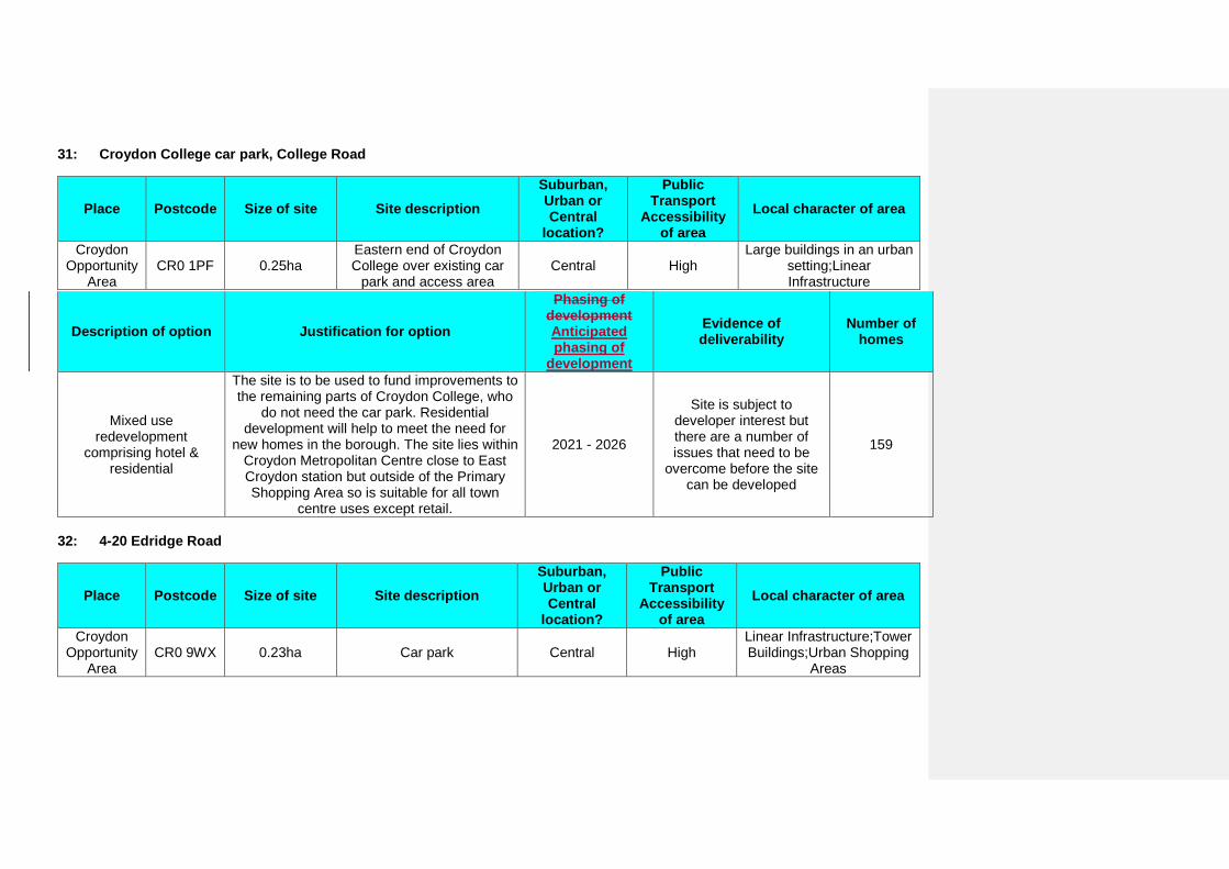
31: Croydon College car park, College Road
Place Postcode Size of site Site description Suburban, Urban or Central
location?
Public Transport
Accessibility of area
Local character of area
Croydon Opportunity
Area CR0 1PF 0.25ha
Eastern end of Croydon College over existing car
park and access area Central High
Large buildings in an urban setting;Linear Infrastructure
Description of option Justification for option
Phasing of development Anticipated phasing of
development
Evidence of deliverability
Number of homes
Mixed use redevelopment
comprising hotel & residential
The site is to be used to fund improvements to the remaining parts of Croydon College, who
do not need the car park. Residential development will help to meet the need for
new homes in the borough. The site lies within Croydon Metropolitan Centre close to East Croydon station but outside of the Primary Shopping Area so is suitable for all town
centre uses except retail.
2021 - 2026
Site is subject to developer interest but there are a number of issues that need to be
overcome before the site can be developed
159
32: 4-20 Edridge Road
Place Postcode Size of site Site description Suburban, Urban or Central
location?
Public Transport
Accessibility of area
Local character of area
Croydon Opportunity
Area CR0 9WX 0.23ha Car park Central High
Linear Infrastructure;Tower Buildings;Urban Shopping
Areas
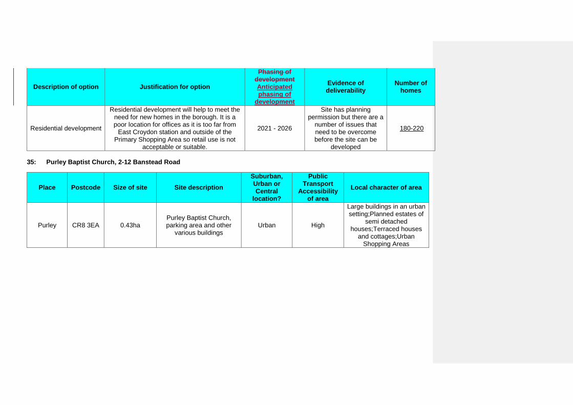
Description of option Justification for option
Phasing of development Anticipated phasing of
development
Evidence of deliverability
Number of homes
Residential development
Residential development will help to meet the need for new homes in the borough. It is a poor location for offices as it is too far from
East Croydon station and outside of the Primary Shopping Area so retail use is not
acceptable or suitable.
2021 - 2026
Site has planning permission but there are a
number of issues that need to be overcome before the site can be
developed
180-220
35: Purley Baptist Church, 2-12 Banstead Road
Place Postcode Size of site Site description Suburban, Urban or Central
location?
Public Transport
Accessibility of area
Local character of area
Purley CR8 3EA 0.43ha Purley Baptist Church, parking area and other
various buildings Urban High
Large buildings in an urban setting;Planned estates of
semi detached houses;Terraced houses
and cottages;Urban Shopping Areas
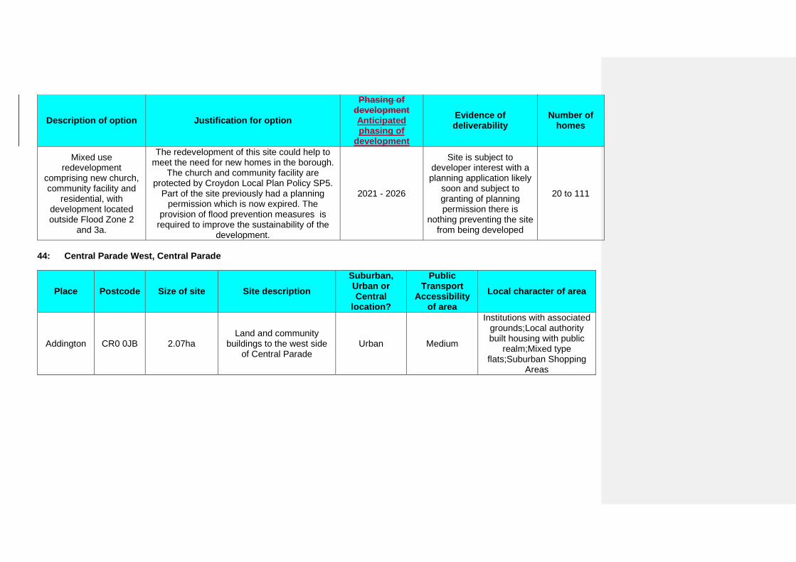
Description of option Justification for option
Phasing of development Anticipated phasing of
development
Evidence of deliverability
Number of homes
Mixed use redevelopment
comprising new church, community facility and
residential, with development located outside Flood Zone 2
and 3a.
The redevelopment of this site could help to meet the need for new homes in the borough.
The church and community facility are protected by Croydon Local Plan Policy SP5.
Part of the site previously had a planning permission which is now expired. The
provision of flood prevention measures is required to improve the sustainability of the
development.
2021 - 2026
Site is subject to developer interest with a planning application likely
soon and subject to granting of planning permission there is
nothing preventing the site from being developed
20 to 111
44: Central Parade West, Central Parade
Place Postcode Size of site Site description Suburban, Urban or Central
location?
Public Transport
Accessibility of area
Local character of area
Addington CR0 0JB 2.07ha Land and community
buildings to the west side of Central Parade
Urban Medium
Institutions with associated grounds;Local authority built housing with public
realm;Mixed type flats;Suburban Shopping
Areas
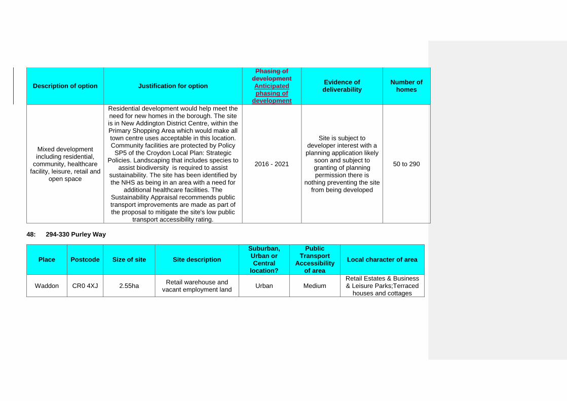
Description of option Justification for option
Phasing of development Anticipated phasing of
development
Evidence of deliverability
Number of homes
Mixed development including residential,
community, healthcare facility, leisure, retail and
open space
Residential development would help meet the need for new homes in the borough. The site is in New Addington District Centre, within the Primary Shopping Area which would make all town centre uses acceptable in this location. Community facilities are protected by Policy
SP5 of the Croydon Local Plan: Strategic Policies. Landscaping that includes species to
assist biodiversity is required to assist sustainability. The site has been identified by the NHS as being in an area with a need for
additional healthcare facilities. The Sustainability Appraisal recommends public transport improvements are made as part of the proposal to mitigate the site's low public
transport accessibility rating.
2016 - 2021
Site is subject to developer interest with a planning application likely
soon and subject to granting of planning permission there is
nothing preventing the site from being developed
50 to 290
48: 294-330 Purley Way
Place Postcode Size of site Site description Suburban, Urban or Central
location?
Public Transport
Accessibility of area
Local character of area
Waddon CR0 4XJ 2.55ha Retail warehouse and vacant employment land Urban Medium
Retail Estates & Business & Leisure Parks;Terraced
houses and cottages
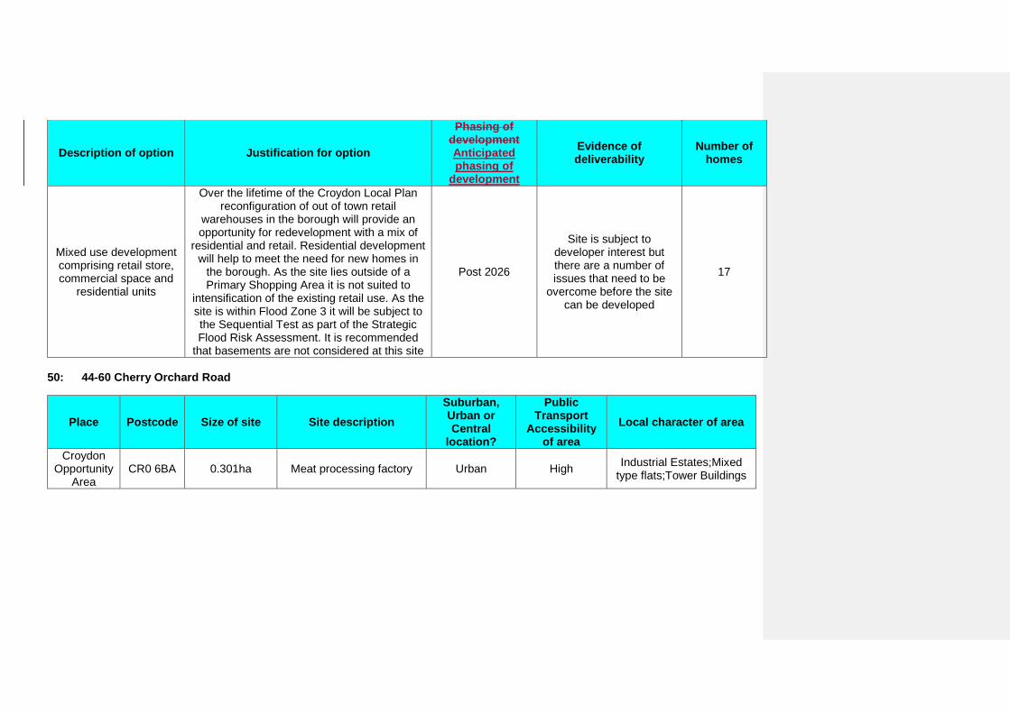
Description of option Justification for option
Phasing of development Anticipated phasing of
development
Evidence of deliverability
Number of homes
Mixed use development comprising retail store, commercial space and
residential units
Over the lifetime of the Croydon Local Plan reconfiguration of out of town retail
warehouses in the borough will provide an opportunity for redevelopment with a mix of
residential and retail. Residential development will help to meet the need for new homes in
the borough. As the site lies outside of a Primary Shopping Area it is not suited to
intensification of the existing retail use. As the site is within Flood Zone 3 it will be subject to the Sequential Test as part of the Strategic Flood Risk Assessment. It is recommended
that basements are not considered at this site
Post 2026
Site is subject to developer interest but there are a number of issues that need to be
overcome before the site can be developed
17
50: 44-60 Cherry Orchard Road
Place Postcode Size of site Site description Suburban, Urban or Central
location?
Public Transport
Accessibility of area
Local character of area
Croydon Opportunity
Area CR0 6BA 0.301ha Meat processing factory Urban High Industrial Estates;Mixed
type flats;Tower Buildings
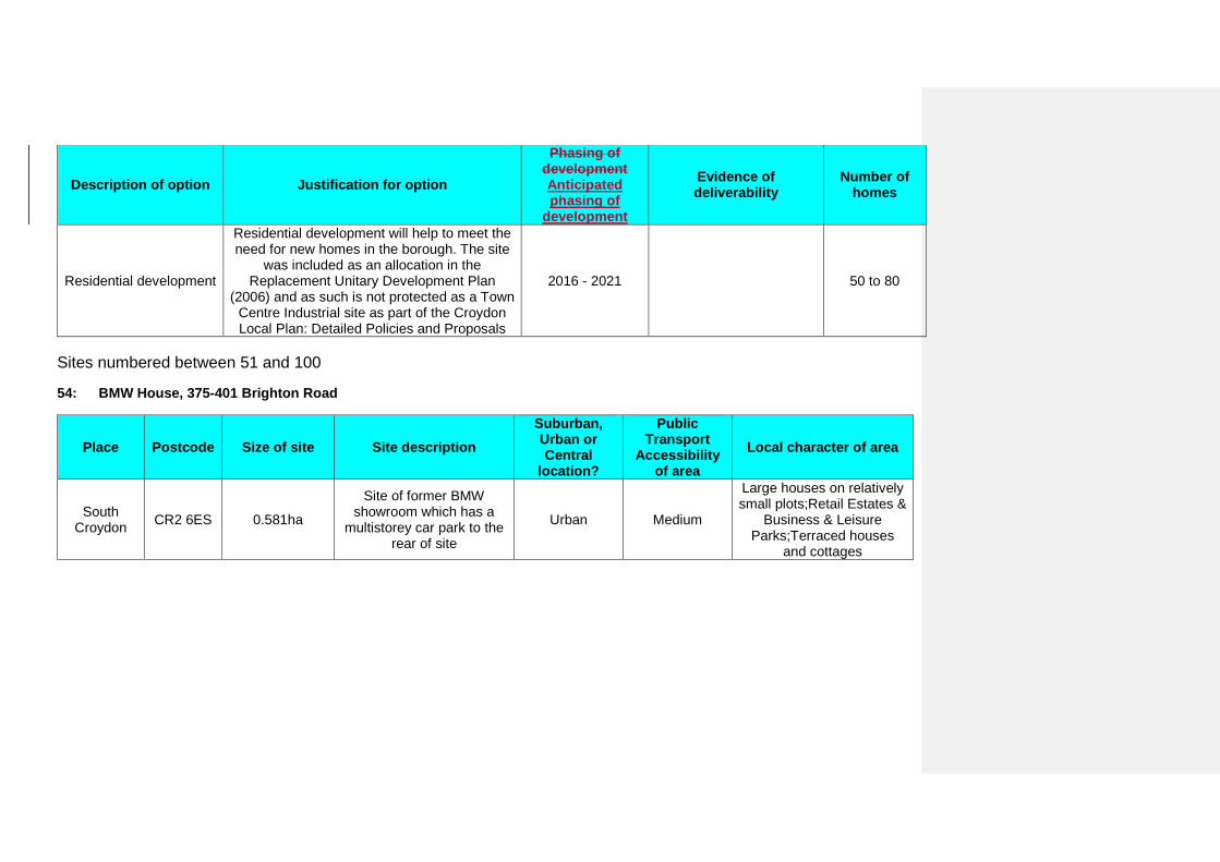
Description of option Justification for option
Phasing of development Anticipated phasing of
development
Evidence of deliverability
Number of homes
Residential development
Residential development will help to meet the need for new homes in the borough. The site
was included as an allocation in the Replacement Unitary Development Plan
(2006) and as such is not protected as a Town Centre Industrial site as part of the Croydon Local Plan: Detailed Policies and Proposals
2016 - 2021 50 to 80
Sites numbered between 51 and 100
54: BMW House, 375-401 Brighton Road
Place Postcode Size of site Site description Suburban, Urban or Central
location?
Public Transport
Accessibility of area
Local character of area
South Croydon CR2 6ES 0.581ha
Site of former BMW showroom which has a
multistorey car park to the rear of site
Urban Medium
Large houses on relatively small plots;Retail Estates &
Business & Leisure Parks;Terraced houses
and cottages
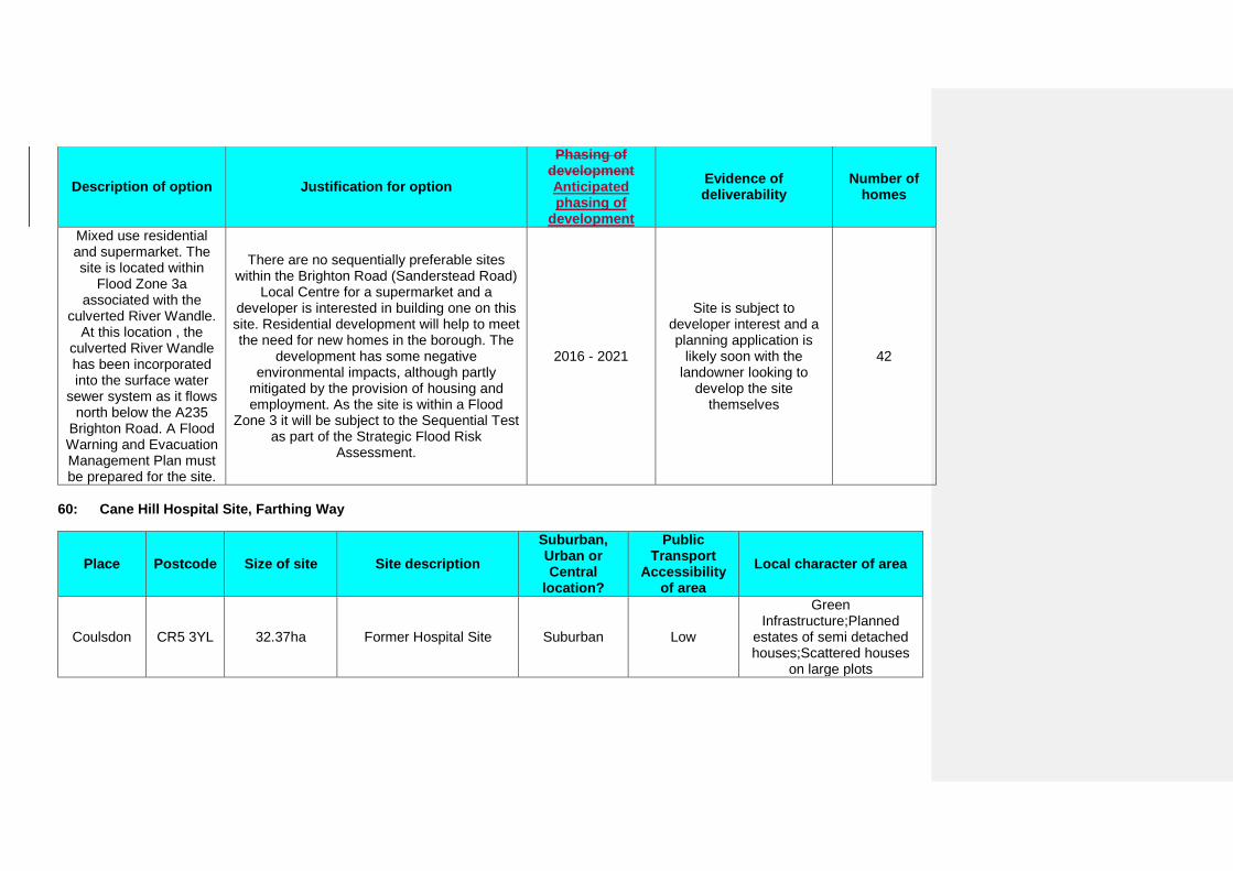
Description of option Justification for option
Phasing of development Anticipated phasing of
development
Evidence of deliverability
Number of homes
Mixed use residential and supermarket. The site is located within
Flood Zone 3a associated with the
culverted River Wandle. At this location , the
culverted River Wandle has been incorporated into the surface water
sewer system as it flows north below the A235
Brighton Road. A Flood Warning and Evacuation Management Plan must be prepared for the site.
There are no sequentially preferable sites within the Brighton Road (Sanderstead Road)
Local Centre for a supermarket and a developer is interested in building one on this site. Residential development will help to meet the need for new homes in the borough. The
development has some negative environmental impacts, although partly
mitigated by the provision of housing and employment. As the site is within a Flood
Zone 3 it will be subject to the Sequential Test as part of the Strategic Flood Risk
Assessment.
2016 - 2021
Site is subject to developer interest and a planning application is
likely soon with the landowner looking to
develop the site themselves
42
60: Cane Hill Hospital Site, Farthing Way
Place Postcode Size of site Site description Suburban, Urban or Central
location?
Public Transport
Accessibility of area
Local character of area
Coulsdon CR5 3YL 32.37ha Former Hospital Site Suburban Low
Green Infrastructure;Planned
estates of semi detached houses;Scattered houses
on large plots
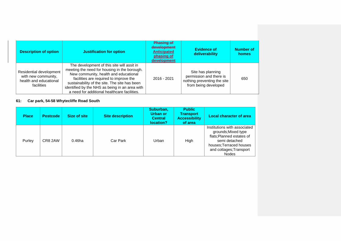
Description of option Justification for option
Phasing of development Anticipated phasing of
development
Evidence of deliverability
Number of homes
Residential development with new community,
health and educational facilities
The development of this site will assit in meeting the need for housing in the borough.
New community, health and educational facilities are required to improve the
sustainability of the site. The site has been identified by the NHS as being in an area with
a need for additional healthcare facilities.
2016 - 2021
Site has planning permission and there is
nothing preventing the site from being developed
650
61: Car park, 54-58 Whytecliffe Road South
Place Postcode Size of site Site description Suburban, Urban or Central
location?
Public Transport
Accessibility of area
Local character of area
Purley CR8 2AW 0.46ha Car Park Urban High
Institutions with associated grounds;Mixed type
flats;Planned estates of semi detached
houses;Terraced houses and cottages;Transport
Nodes
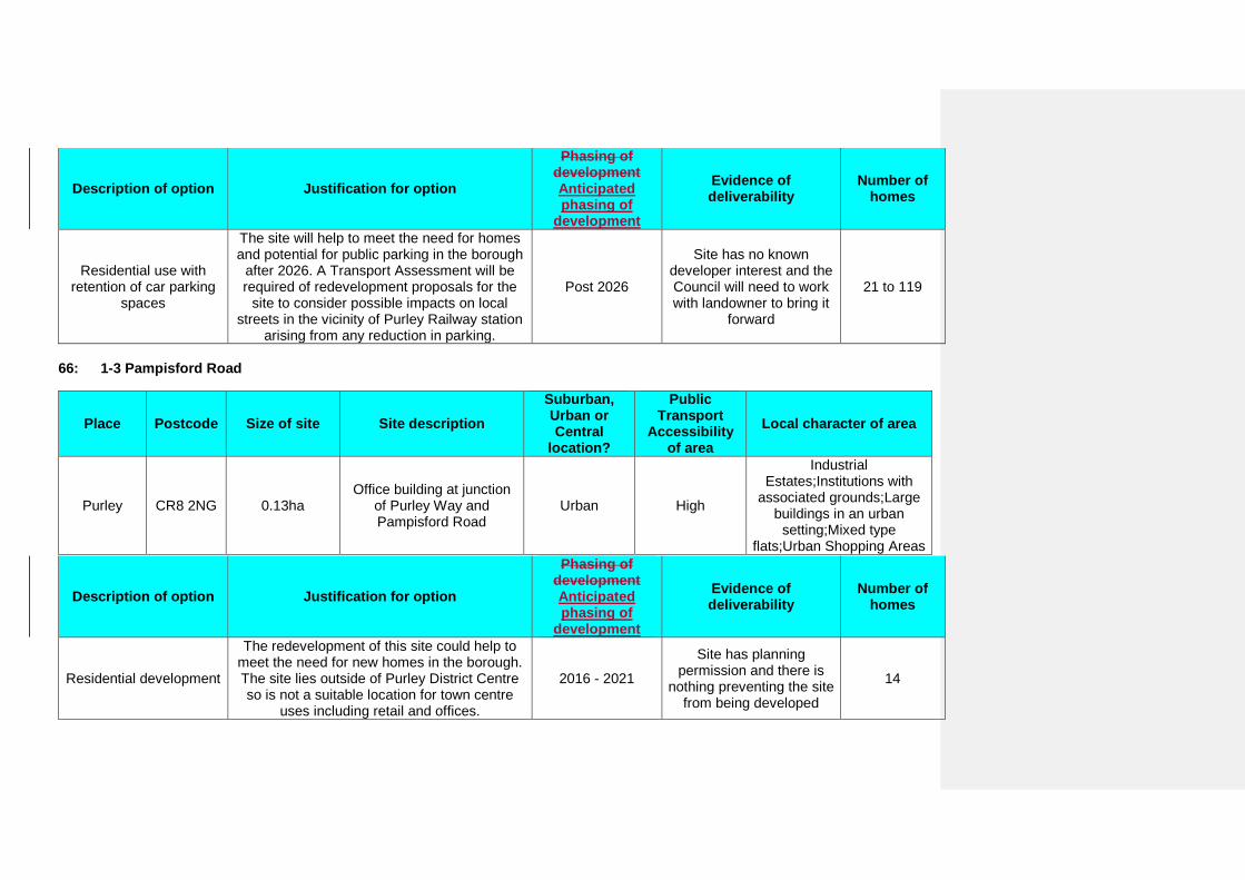
Description of option Justification for option
Phasing of development Anticipated phasing of
development
Evidence of deliverability
Number of homes
Residential use with retention of car parking
spaces
The site will help to meet the need for homes and potential for public parking in the borough
after 2026. A Transport Assessment will be required of redevelopment proposals for the
site to consider possible impacts on local streets in the vicinity of Purley Railway station
arising from any reduction in parking.
Post 2026
Site has no known developer interest and the Council will need to work with landowner to bring it
forward
21 to 119
66: 1-3 Pampisford Road
Place Postcode Size of site Site description Suburban, Urban or Central
location?
Public Transport
Accessibility of area
Local character of area
Purley CR8 2NG 0.13ha Office building at junction
of Purley Way and Pampisford Road
Urban High
Industrial Estates;Institutions with
associated grounds;Large buildings in an urban
setting;Mixed type flats;Urban Shopping Areas
Description of option Justification for option
Phasing of development Anticipated phasing of
development
Evidence of deliverability
Number of homes
Residential development
The redevelopment of this site could help to meet the need for new homes in the borough. The site lies outside of Purley District Centre so is not a suitable location for town centre
uses including retail and offices.
2016 - 2021
Site has planning permission and there is
nothing preventing the site from being developed
14
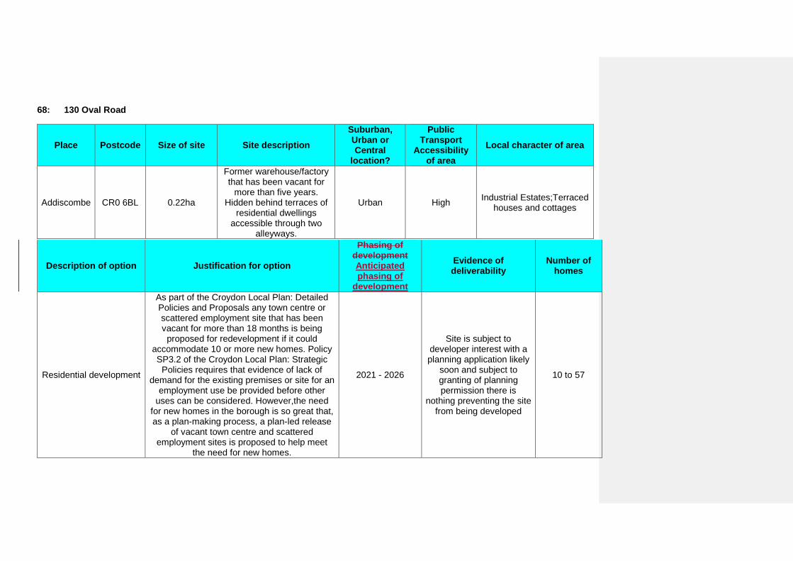
68: 130 Oval Road
Place Postcode Size of site Site description Suburban, Urban or Central
location?
Public Transport
Accessibility of area
Local character of area
Addiscombe CR0 6BL 0.22ha
Former warehouse/factory that has been vacant for
more than five years. Hidden behind terraces of
residential dwellings accessible through two
alleyways.
Urban High Industrial Estates;Terraced houses and cottages
Description of option Justification for option
Phasing of development Anticipated phasing of
development
Evidence of deliverability
Number of homes
Residential development
As part of the Croydon Local Plan: Detailed Policies and Proposals any town centre or scattered employment site that has been vacant for more than 18 months is being
proposed for redevelopment if it could accommodate 10 or more new homes. Policy SP3.2 of the Croydon Local Plan: Strategic
Policies requires that evidence of lack of demand for the existing premises or site for an
employment use be provided before other uses can be considered. However,the need
for new homes in the borough is so great that, as a plan-making process, a plan-led release
of vacant town centre and scattered employment sites is proposed to help meet
the need for new homes.
2021 - 2026
Site is subject to developer interest with a planning application likely
soon and subject to granting of planning permission there is
nothing preventing the site from being developed
10 to 57
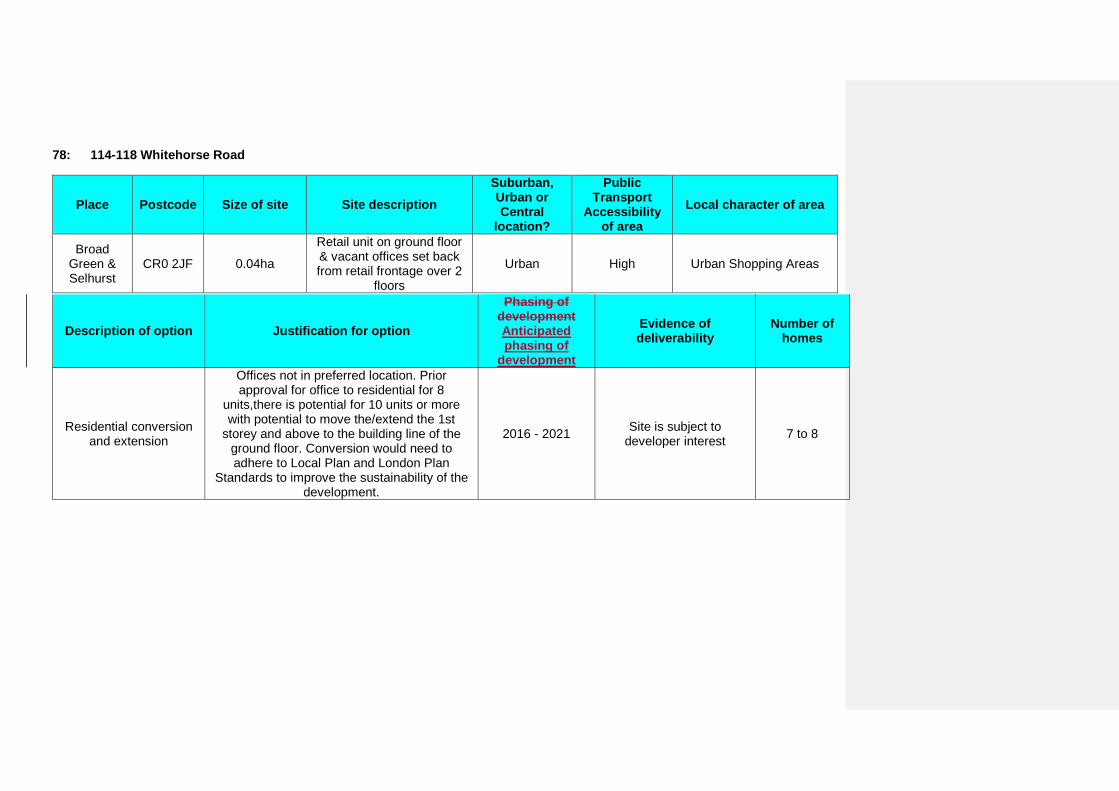
78: 114-118 Whitehorse Road
Place Postcode Size of site Site description Suburban, Urban or Central
location?
Public Transport
Accessibility of area
Local character of area
Broad Green & Selhurst
CR0 2JF 0.04ha
Retail unit on ground floor & vacant offices set back from retail frontage over 2
floors
Urban High Urban Shopping Areas
Description of option Justification for option
Phasing of development Anticipated phasing of
development
Evidence of deliverability
Number of homes
Residential conversion and extension
Offices not in preferred location. Prior approval for office to residential for 8
units,there is potential for 10 units or more with potential to move the/extend the 1st
storey and above to the building line of the ground floor. Conversion would need to adhere to Local Plan and London Plan
Standards to improve the sustainability of the development.
2016 - 2021 Site is subject to developer interest 7 to 8
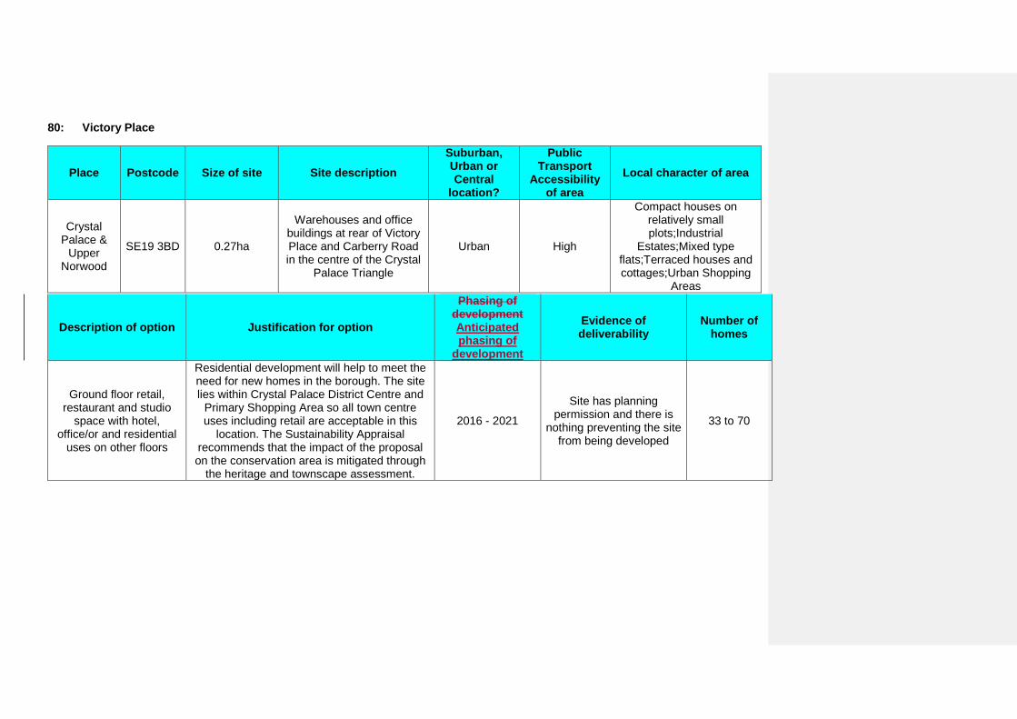
80: Victory Place
Place Postcode Size of site Site description Suburban, Urban or Central
location?
Public Transport
Accessibility of area
Local character of area
Crystal Palace &
Upper Norwood
SE19 3BD 0.27ha
Warehouses and office buildings at rear of Victory Place and Carberry Road in the centre of the Crystal
Palace Triangle
Urban High
Compact houses on relatively small plots;Industrial
Estates;Mixed type flats;Terraced houses and cottages;Urban Shopping
Areas
Description of option Justification for option
Phasing of development Anticipated phasing of
development
Evidence of deliverability
Number of homes
Ground floor retail, restaurant and studio
space with hotel, office/or and residential
uses on other floors
Residential development will help to meet the need for new homes in the borough. The site lies within Crystal Palace District Centre and
Primary Shopping Area so all town centre uses including retail are acceptable in this
location. The Sustainability Appraisal recommends that the impact of the proposal on the conservation area is mitigated through
the heritage and townscape assessment.
2016 - 2021
Site has planning permission and there is
nothing preventing the site from being developed
33 to 70
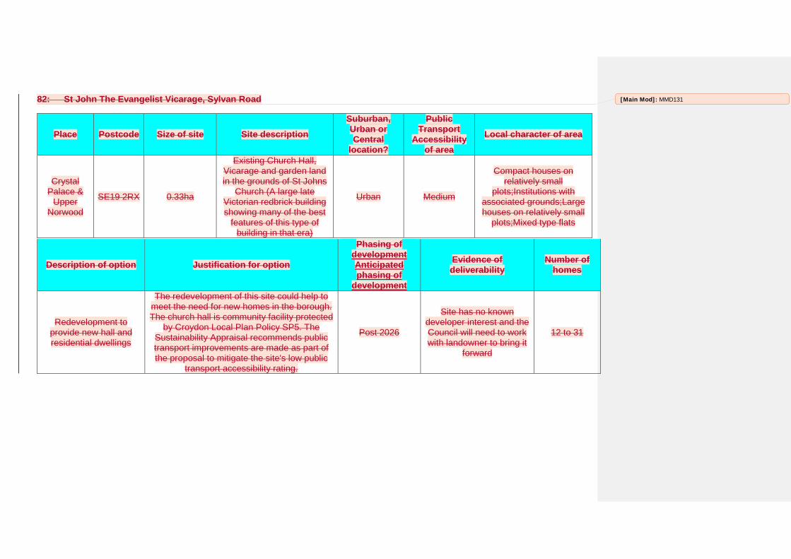
82: St John The Evangelist Vicarage, Sylvan Road
Place Postcode Size of site Site description Suburban, Urban or Central
location?
Public Transport
Accessibility of area
Local character of area
Crystal Palace &
Upper Norwood
SE19 2RX 0.33ha
Existing Church Hall, Vicarage and garden land in the grounds of St Johns
Church (A large late Victorian redbrick building showing many of the best
features of this type of building in that era)
Urban Medium
Compact houses on relatively small
plots;Institutions with associated grounds;Large houses on relatively small
plots;Mixed type flats
Description of option Justification for option
Phasing of development Anticipated phasing of
development
Evidence of deliverability
Number of homes
Redevelopment to provide new hall and residential dwellings
The redevelopment of this site could help to meet the need for new homes in the borough. The church hall is community facility protected
by Croydon Local Plan Policy SP5. The Sustainability Appraisal recommends public transport improvements are made as part of the proposal to mitigate the site's low public
transport accessibility rating.
Post 2026
Site has no known developer interest and the Council will need to work with landowner to bring it
forward
12 to 31
[Main Mod]: MMD131
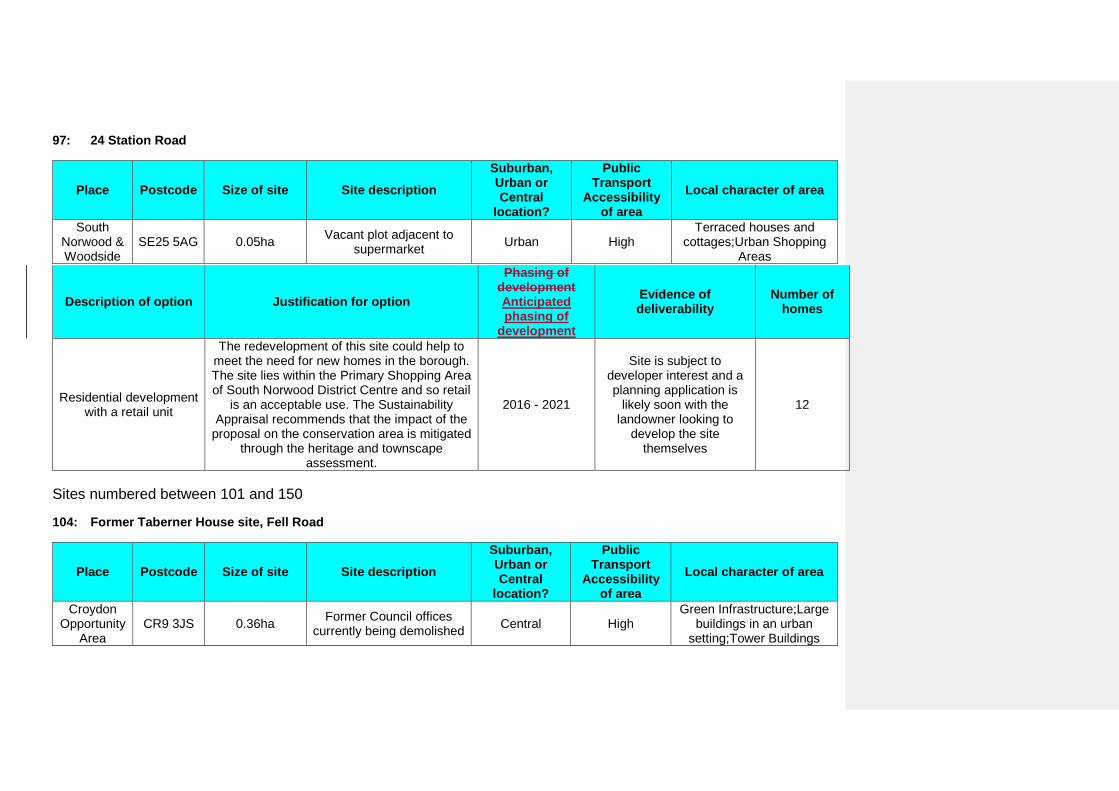
97: 24 Station Road
Place Postcode Size of site Site description Suburban, Urban or Central
location?
Public Transport
Accessibility of area
Local character of area
South Norwood & Woodside
SE25 5AG 0.05ha Vacant plot adjacent to supermarket Urban High
Terraced houses and cottages;Urban Shopping
Areas
Description of option Justification for option
Phasing of development Anticipated phasing of
development
Evidence of deliverability
Number of homes
Residential development with a retail unit
The redevelopment of this site could help to meet the need for new homes in the borough. The site lies within the Primary Shopping Area of South Norwood District Centre and so retail
is an acceptable use. The Sustainability Appraisal recommends that the impact of the
proposal on the conservation area is mitigated through the heritage and townscape
assessment.
2016 - 2021
Site is subject to developer interest and a planning application is
likely soon with the landowner looking to
develop the site themselves
12
Sites numbered between 101 and 150
104: Former Taberner House site, Fell Road
Place Postcode Size of site Site description Suburban, Urban or Central
location?
Public Transport
Accessibility of area
Local character of area
Croydon Opportunity
Area CR9 3JS 0.36ha Former Council offices
currently being demolished Central High Green Infrastructure;Large
buildings in an urban setting;Tower Buildings
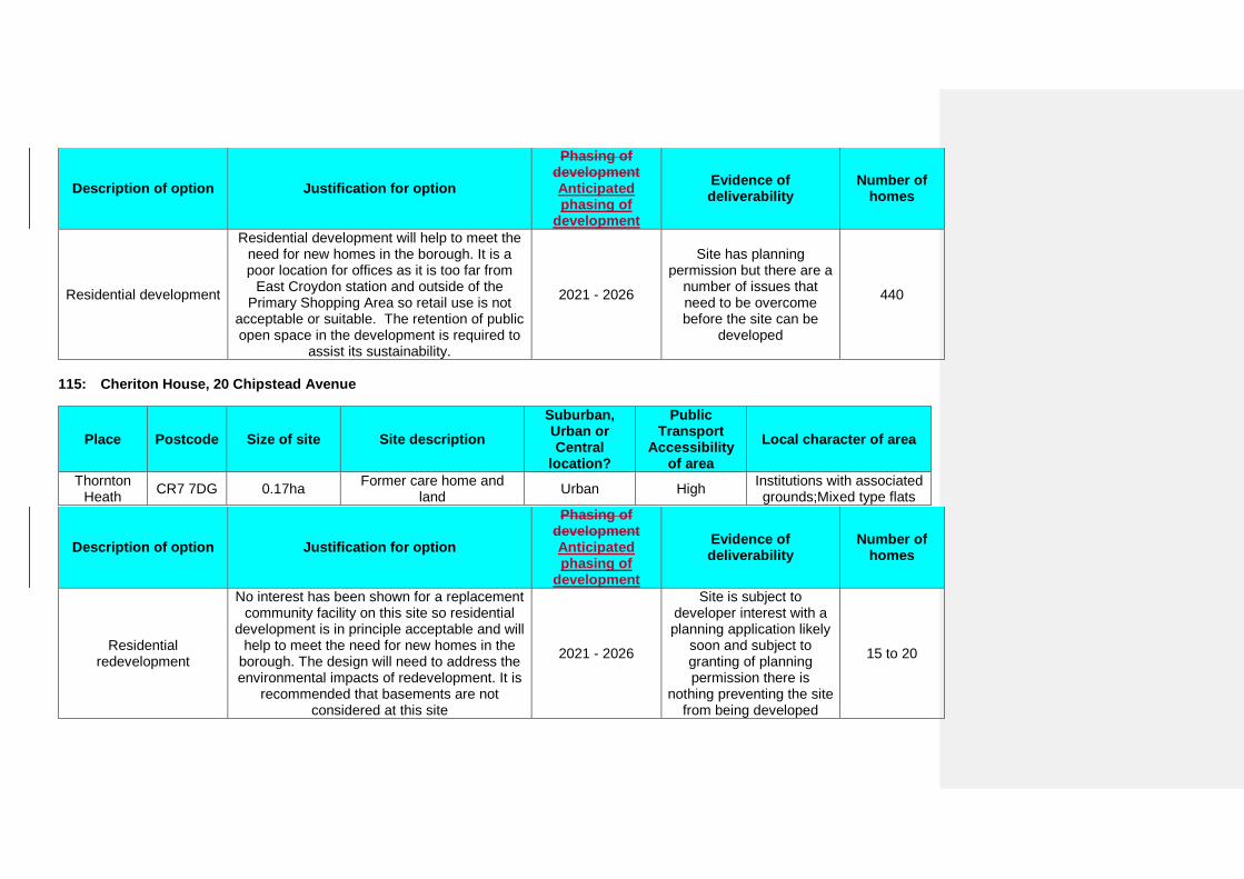
Description of option Justification for option
Phasing of development Anticipated phasing of
development
Evidence of deliverability
Number of homes
Residential development
Residential development will help to meet the need for new homes in the borough. It is a poor location for offices as it is too far from
East Croydon station and outside of the Primary Shopping Area so retail use is not
acceptable or suitable. The retention of public open space in the development is required to
assist its sustainability.
2021 - 2026
Site has planning permission but there are a
number of issues that need to be overcome before the site can be
developed
440
115: Cheriton House, 20 Chipstead Avenue
Place Postcode Size of site Site description Suburban, Urban or Central
location?
Public Transport
Accessibility of area
Local character of area
Thornton Heath CR7 7DG 0.17ha Former care home and
land Urban High Institutions with associated grounds;Mixed type flats
Description of option Justification for option
Phasing of development Anticipated phasing of
development
Evidence of deliverability
Number of homes
Residential redevelopment
No interest has been shown for a replacement community facility on this site so residential
development is in principle acceptable and will help to meet the need for new homes in the
borough. The design will need to address the environmental impacts of redevelopment. It is
recommended that basements are not considered at this site
2021 - 2026
Site is subject to developer interest with a planning application likely
soon and subject to granting of planning permission there is
nothing preventing the site from being developed
15 to 20
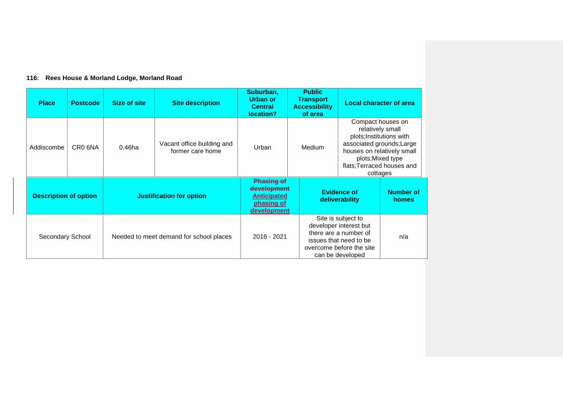
116: Rees House & Morland Lodge, Morland Road
Place Postcode Size of site Site description Suburban, Urban or Central
location?
Public Transport
Accessibility of area
Local character of area
Addiscombe CR0 6NA 0.46ha Vacant office building and former care home Urban Medium
Compact houses on relatively small
plots;Institutions with associated grounds;Large houses on relatively small
plots;Mixed type flats;Terraced houses and
cottages
Description of option Justification for option
Phasing of development Anticipated phasing of
development
Evidence of deliverability
Number of homes
Secondary School Needed to meet demand for school places 2016 - 2021
Site is subject to developer interest but there are a number of issues that need to be
overcome before the site can be developed
n/a
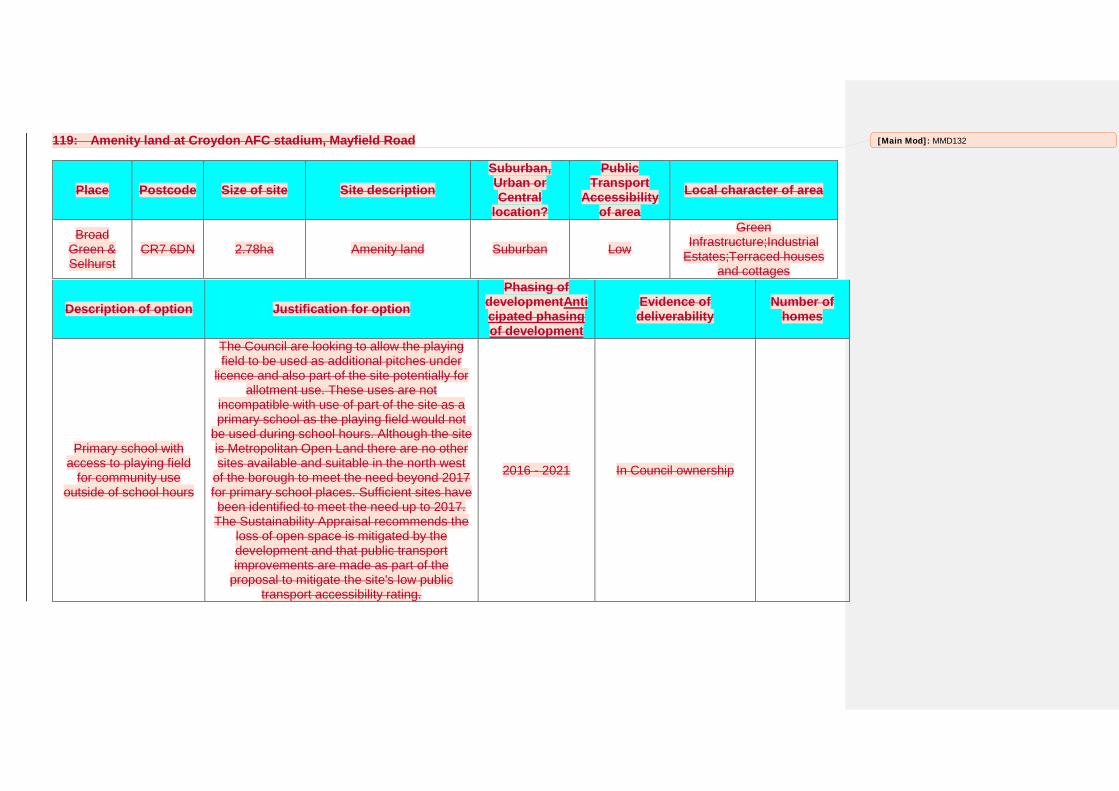
119: Amenity land at Croydon AFC stadium, Mayfield Road
Place Postcode Size of site Site description Suburban, Urban or Central
location?
Public Transport
Accessibility of area
Local character of area
Broad Green & Selhurst
CR7 6DN 2.78ha Amenity land Suburban Low
Green Infrastructure;Industrial
Estates;Terraced houses and cottages
Description of option Justification for option Phasing of
developmentAnticipated phasing of development
Evidence of deliverability
Number of homes
Primary school with access to playing field
for community use outside of school hours
The Council are looking to allow the playing field to be used as additional pitches under
licence and also part of the site potentially for allotment use. These uses are not
incompatible with use of part of the site as a primary school as the playing field would not
be used during school hours. Although the site is Metropolitan Open Land there are no other sites available and suitable in the north west
of the borough to meet the need beyond 2017 for primary school places. Sufficient sites have been identified to meet the need up to 2017. The Sustainability Appraisal recommends the
loss of open space is mitigated by the development and that public transport improvements are made as part of the
proposal to mitigate the site's low public transport accessibility rating.
2016 - 2021 In Council ownership
[Main Mod]: MMD132
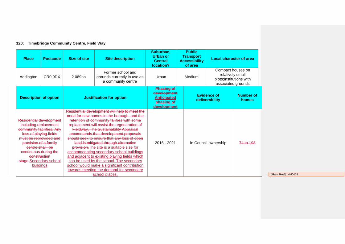
120: Timebridge Community Centre, Field Way
Place Postcode Size of site Site description Suburban, Urban or Central
location?
Public Transport
Accessibility of area
Local character of area
Addington CR0 9DX 2.089ha Former school and
grounds currently in use as a community centre
Urban Medium
Compact houses on relatively small
plots;Institutions with associated grounds
Description of option Justification for option
Phasing of development Anticipated phasing of
development
Evidence of deliverability
Number of homes
Residential development including replacement
community facilities. Any loss of playing fields
must be reprovided and provision of a family
centre shall be continuous during the
construction stage.Secondary school
buildings
Residential development will help to meet the need for new homes in the borough, and the
retention of community failities with some replacement will assist the regeneration of
Fieldway. The Sustainability Appraisal recommends that development proposals
should seek to ensure that any loss of open land is mitigated through alternative
provision.The site is a suitable size for accommodating secondary school buildings and adjacent to existing playing fields which can be used by the school. The secondary
school would make a significant contribution towards meeting the demand for secondary
school places.
2016 - 2021 In Council ownership 74 to 198
[Main Mod]: MMD133
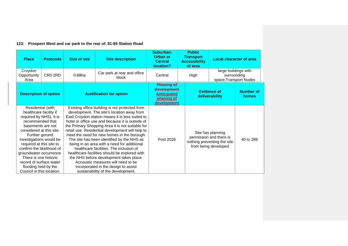
123: Prospect West and car park to the rear of, 81-85 Station Road
Place Postcode Size of site Site description Suburban, Urban or Central
location?
Public Transport
Accessibility of area
Local character of area
Croydon Opportunity
Area CR0 2RD 0.88ha Car park at rear and office
block Central High large buildings with
surrounding space;Transport Nodes
Description of option Justification for option
Phasing of development Anticipated phasing of
development
Evidence of deliverability
Number of homes
Residential (with healthcare facility if
required by NHS). It is recommended that basements are not
considered at this site. Further gorund
investigations would be required at this site to
confirm the likelihood of groundwater occurrence.
There is one historic record of surface water
flooding held by the Council in this location.
Existing office building is not protected from development. The site's location away from
East Croydon station means it is less suited to hotel or office use and because it is outside of the Primary Shopping Area it is not suitable for retail use. Residential development will help to meet the need for new homes in the borough.
The site has been identified by the NHS as being in an area with a need for additional
healthcare facilities. The inclusion of healthcare facilities should be explored with the NHS before development takes place.
Accoustic measures will need to be incorporated in the design to assist sustainability of the development.
Post 2026
Site has planning permission and there is
nothing preventing the site from being developed
40 to 288

128: Land at, Poppy Lane
Place Postcode Size of site Site description Suburban, Urban or Central
location?
Public Transport
Accessibility of area
Local character of area
Shirley CR0 8YT 1.43ha Cleared site Suburban Low
Green Infrastructure;Institutions
with associated grounds;Mixed type flats
Description of option Justification for option
Phasing of development Anticipated phasing of
development
Evidence of deliverability
Number of homes
Residential development
This site does not meet the criteria for designation as Metropolitan Open Land as it
does not contribute to the physical structure of London, it does not include open air facilities
which serve whole or significant parts of London and it does not contain features or
landscapes of national or metropolitan importance. For this reason it has been
assessed by the same criteria as other non-Metropolitan Open Land sites and is
considered acceptable for development. Residential development will help to meet the
need for new homes in the borough.
Post 2026
Site is subject to developer interest but there are a number of issues that need to be
overcome before the site can be developed
51 to 107
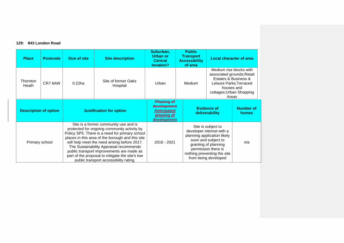
129: 843 London Road
Place Postcode Size of site Site description Suburban, Urban or Central
location?
Public Transport
Accessibility of area
Local character of area
Thornton Heath CR7 6AW 0.22ha Site of former Oaks
Hospital Urban Medium
Medium rise blocks with associated grounds;Retail
Estates & Business & Leisure Parks;Terraced
houses and cottages;Urban Shopping
Areas
Description of option Justification for option
Phasing of development Anticipated phasing of
development
Evidence of deliverability
Number of homes
Primary school
Site is a former community use and is protected for ongoing community activity by
Policy SP5. There is a need for primary school places in this area of the borough and this site will help meet the need arising before 2017. The Sustainability Appraisal recommends
public transport improvements are made as part of the proposal to mitigate the site's low
public transport accessibility rating.
2016 - 2021
Site is subject to developer interest with a planning application likely
soon and subject to granting of planning permission there is
nothing preventing the site from being developed
n/a
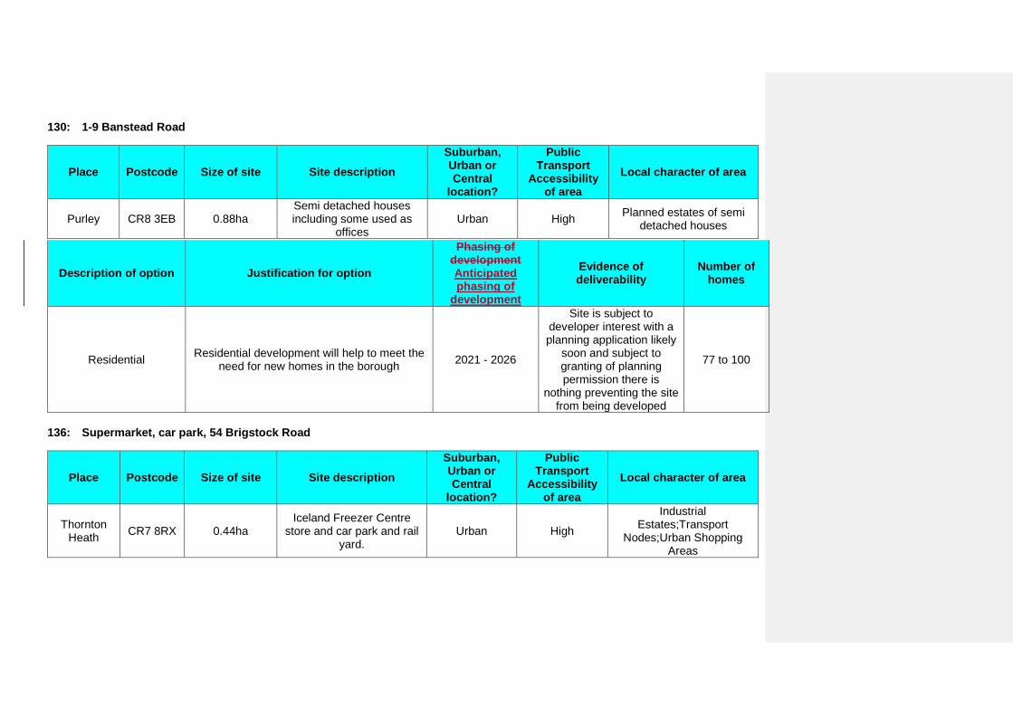
130: 1-9 Banstead Road
Place Postcode Size of site Site description Suburban, Urban or Central
location?
Public Transport
Accessibility of area
Local character of area
Purley CR8 3EB 0.88ha Semi detached houses including some used as
offices Urban High Planned estates of semi
detached houses
Description of option Justification for option
Phasing of development Anticipated phasing of
development
Evidence of deliverability
Number of homes
Residential Residential development will help to meet the need for new homes in the borough 2021 - 2026
Site is subject to developer interest with a planning application likely
soon and subject to granting of planning permission there is
nothing preventing the site from being developed
77 to 100
136: Supermarket, car park, 54 Brigstock Road
Place Postcode Size of site Site description Suburban, Urban or Central
location?
Public Transport
Accessibility of area
Local character of area
Thornton Heath CR7 8RX 0.44ha
Iceland Freezer Centre store and car park and rail
yard. Urban High
Industrial Estates;Transport
Nodes;Urban Shopping Areas
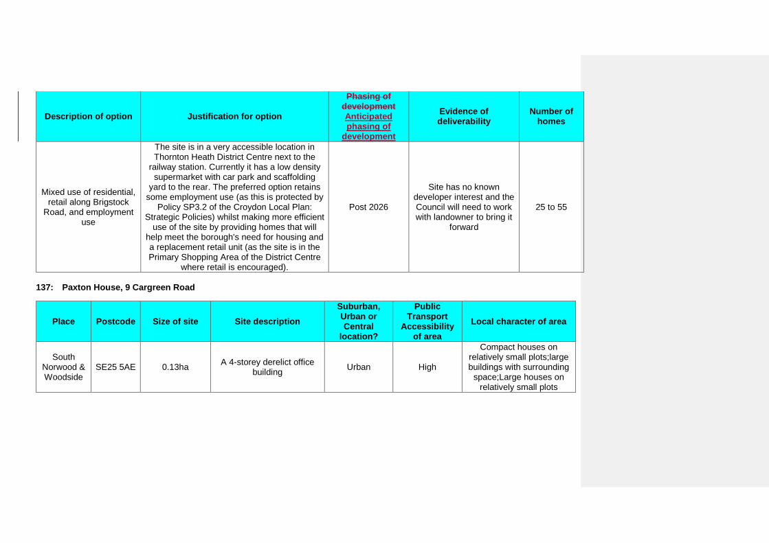
Description of option Justification for option
Phasing of development Anticipated phasing of
development
Evidence of deliverability
Number of homes
Mixed use of residential, retail along Brigstock
Road, and employment use
The site is in a very accessible location in Thornton Heath District Centre next to the
railway station. Currently it has a low density supermarket with car park and scaffolding
yard to the rear. The preferred option retains some employment use (as this is protected by
Policy SP3.2 of the Croydon Local Plan: Strategic Policies) whilst making more efficient
use of the site by providing homes that will help meet the borough's need for housing and a replacement retail unit (as the site is in the Primary Shopping Area of the District Centre
where retail is encouraged).
Post 2026
Site has no known developer interest and the Council will need to work with landowner to bring it
forward
25 to 55
137: Paxton House, 9 Cargreen Road
Place Postcode Size of site Site description Suburban, Urban or Central
location?
Public Transport
Accessibility of area
Local character of area
South Norwood & Woodside
SE25 5AE 0.13ha A 4-storey derelict office building Urban High
Compact houses on relatively small plots;large buildings with surrounding
space;Large houses on relatively small plots
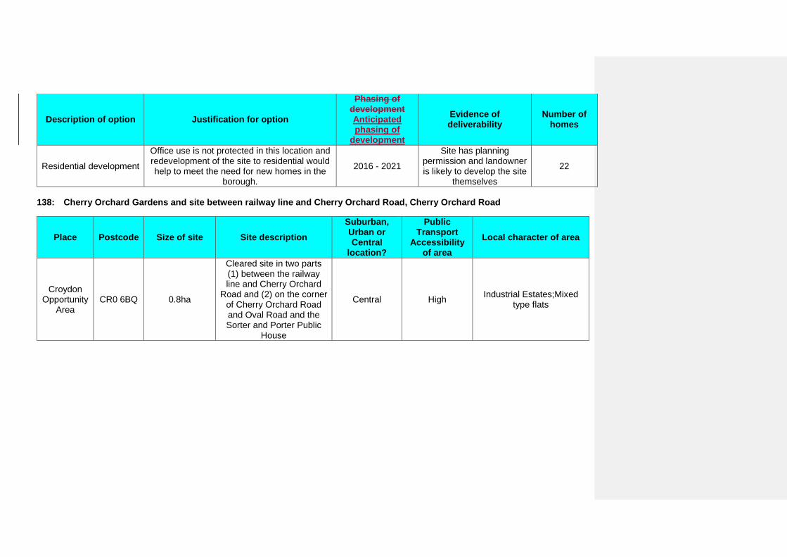
Description of option Justification for option
Phasing of development Anticipated phasing of
development
Evidence of deliverability
Number of homes
Residential development
Office use is not protected in this location and redevelopment of the site to residential would help to meet the need for new homes in the
borough.
2016 - 2021
Site has planning permission and landowner is likely to develop the site
themselves
22
138: Cherry Orchard Gardens and site between railway line and Cherry Orchard Road, Cherry Orchard Road
Place Postcode Size of site Site description Suburban, Urban or Central
location?
Public Transport
Accessibility of area
Local character of area
Croydon Opportunity
Area CR0 6BQ 0.8ha
Cleared site in two parts (1) between the railway line and Cherry Orchard
Road and (2) on the corner of Cherry Orchard Road and Oval Road and the Sorter and Porter Public
House
Central High Industrial Estates;Mixed type flats
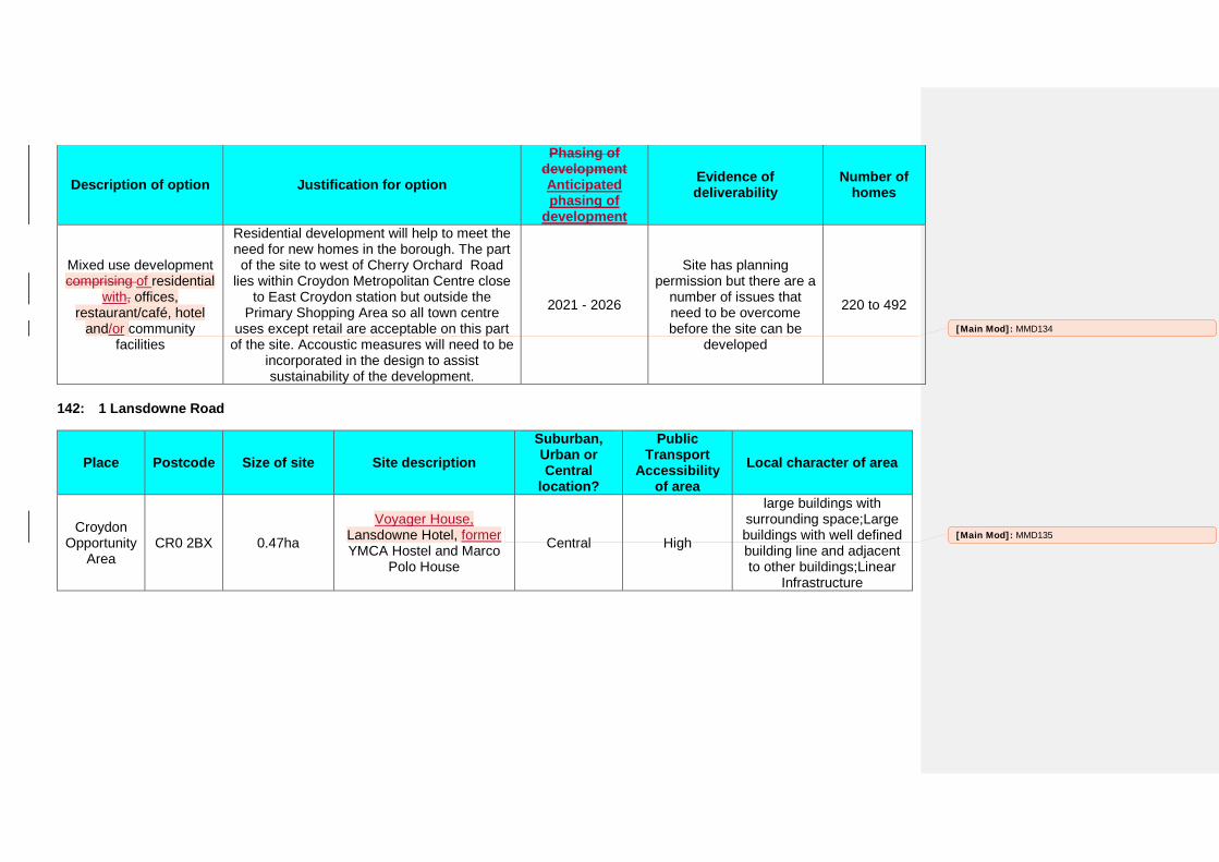
Description of option Justification for option
Phasing of development Anticipated phasing of
development
Evidence of deliverability
Number of homes
Mixed use development comprising of residential
with, offices, restaurant/café, hotel
and/or community facilities
Residential development will help to meet the need for new homes in the borough. The part of the site to west of Cherry Orchard Road
lies within Croydon Metropolitan Centre close to East Croydon station but outside the
Primary Shopping Area so all town centre uses except retail are acceptable on this part
of the site. Accoustic measures will need to be incorporated in the design to assist sustainability of the development.
2021 - 2026
Site has planning permission but there are a
number of issues that need to be overcome before the site can be
developed
220 to 492
142: 1 Lansdowne Road
Place Postcode Size of site Site description Suburban, Urban or Central
location?
Public Transport
Accessibility of area
Local character of area
Croydon Opportunity
Area CR0 2BX 0.47ha
Voyager House, Lansdowne Hotel, former YMCA Hostel and Marco
Polo House
Central High
large buildings with surrounding space;Large buildings with well defined building line and adjacent to other buildings;Linear
Infrastructure
[Main Mod]: MMD134
[Main Mod]: MMD135
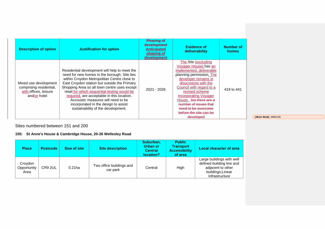
Description of option Justification for option
Phasing of development Anticipated phasing of
development
Evidence of deliverability
Number of homes
Mixed use development comprising residential,
with offices, leisure and/or hotel
Residential development will help to meet the need for new homes in the borough. Site lies within Croydon Metropolitan Centre close to East Croydon station but outside the Primary Shopping Area so all town centre uses except
retail for which sequential testing would be required, are acceptable in this location.
Accoustic measures will need to be incorporated in the design to assist sustainability of the development.
2021 - 2026
The Site (excluding Voyager House) has an
implemented, deliverable planning permission. The
developer remains in disucssions with the
Council with regard to a revised scheme
incorporating Voyager House. but there are a number of issues that need to be overcome before the site can be
developed
419 to 441
Sites numbered between 151 and 200
155: St Anne's House & Cambridge House, 20-26 Wellesley Road
Place Postcode Size of site Site description Suburban, Urban or Central
location?
Public Transport
Accessibility of area
Local character of area
Croydon Opportunity
Area CR9 2UL 0.21ha Two office buildings and
car park Central High
Large buildings with well defined building line and
adjacent to other buildings;Linear
Infrastructure
[Main Mod]: MMD135
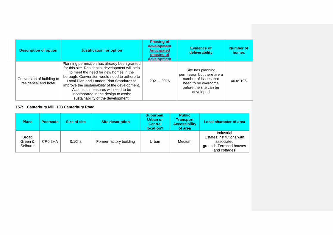
Description of option Justification for option
Phasing of development Anticipated phasing of
development
Evidence of deliverability
Number of homes
Conversion of building to residential and hotel
Planning permission has already been granted for this site. Residential development will help
to meet the need for new homes in the borough. Conversion would need to adhere to
Local Plan and London Plan Standards to improve the sustainability of the development.
Accoustic measures will need to be incorporated in the design to assist sustainability of the development.
2021 - 2026
Site has planning permission but there are a
number of issues that need to be overcome before the site can be
developed
46 to 196
157: Canterbury Mill, 103 Canterbury Road
Place Postcode Size of site Site description Suburban, Urban or Central
location?
Public Transport
Accessibility of area
Local character of area
Broad Green & Selhurst
CR0 3HA 0.10ha Former factory building Urban Medium
Industrial Estates;Institutions with
associated grounds;Terraced houses
and cottages
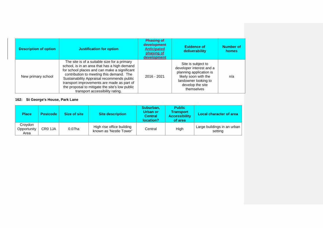
Description of option Justification for option
Phasing of development Anticipated phasing of
development
Evidence of deliverability
Number of homes
New primary school
The site is of a suitable size for a primary school, is in an area that has a high demand for school places and can make a significant
contribution to meeting this demand. The Sustainability Appraisal recommends public transport improvements are made as part of the proposal to mitigate the site's low public
transport accessibility rating.
2016 - 2021
Site is subject to developer interest and a planning application is
likely soon with the landowner looking to
develop the site themselves
n/a
162: St George's House, Park Lane
Place Postcode Size of site Site description Suburban, Urban or Central
location?
Public Transport
Accessibility of area
Local character of area
Croydon Opportunity
Area CR0 1JA 0.07ha High rise office building
known as 'Nestle Tower' Central High Large buildings in an urban setting
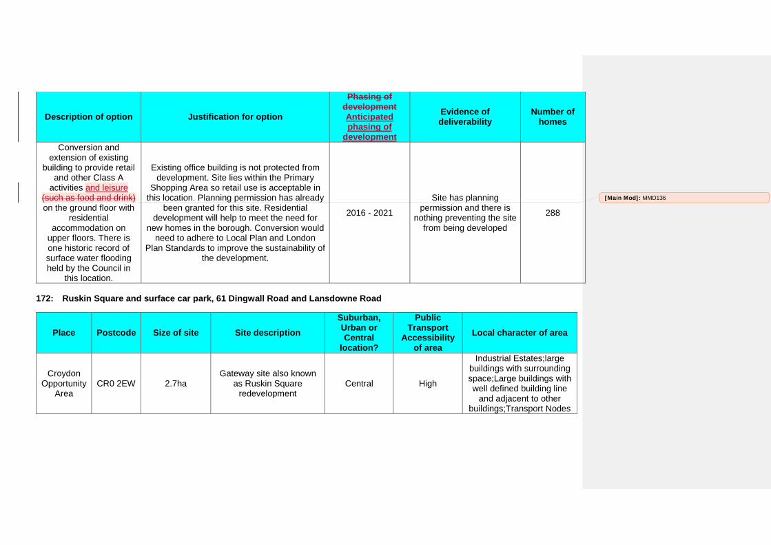
Description of option Justification for option
Phasing of development Anticipated phasing of
development
Evidence of deliverability
Number of homes
Conversion and extension of existing
building to provide retail and other Class A
activities and leisure (such as food and drink) on the ground floor with
residential accommodation on
upper floors. There is one historic record of surface water flooding held by the Council in
this location.
Existing office building is not protected from development. Site lies within the Primary
Shopping Area so retail use is acceptable in this location. Planning permission has already
been granted for this site. Residential development will help to meet the need for
new homes in the borough. Conversion would need to adhere to Local Plan and London
Plan Standards to improve the sustainability of the development.
2016 - 2021
Site has planning permission and there is
nothing preventing the site from being developed
288
172: Ruskin Square and surface car park, 61 Dingwall Road and Lansdowne Road
Place Postcode Size of site Site description Suburban, Urban or Central
location?
Public Transport
Accessibility of area
Local character of area
Croydon Opportunity
Area CR0 2EW 2.7ha
Gateway site also known as Ruskin Square
redevelopment Central High
Industrial Estates;large buildings with surrounding space;Large buildings with well defined building line
and adjacent to other buildings;Transport Nodes
[Main Mod]: MMD136
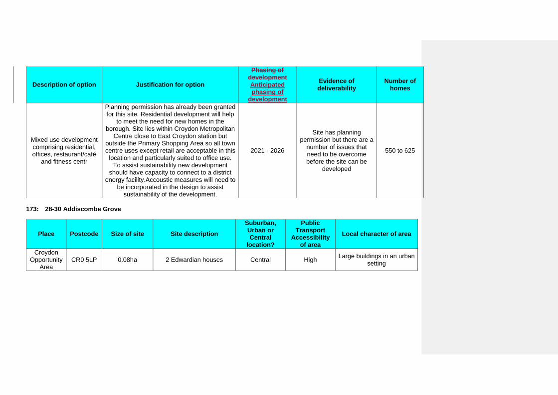
Description of option Justification for option
Phasing of development Anticipated phasing of
development
Evidence of deliverability
Number of homes
Mixed use development comprising residential, offices, restaurant/café
and fitness centr
Planning permission has already been granted for this site. Residential development will help
to meet the need for new homes in the borough. Site lies within Croydon Metropolitan
Centre close to East Croydon station but outside the Primary Shopping Area so all town centre uses except retail are acceptable in this
location and particularly suited to office use. To assist sustainability new development
should have capacity to connect to a district energy facility.Accoustic measures will need to
be incorporated in the design to assist sustainability of the development.
2021 - 2026
Site has planning permission but there are a
number of issues that need to be overcome before the site can be
developed
550 to 625
173: 28-30 Addiscombe Grove
Place Postcode Size of site Site description Suburban, Urban or Central
location?
Public Transport
Accessibility of area
Local character of area
Croydon Opportunity
Area CR0 5LP 0.08ha 2 Edwardian houses Central High Large buildings in an urban
setting
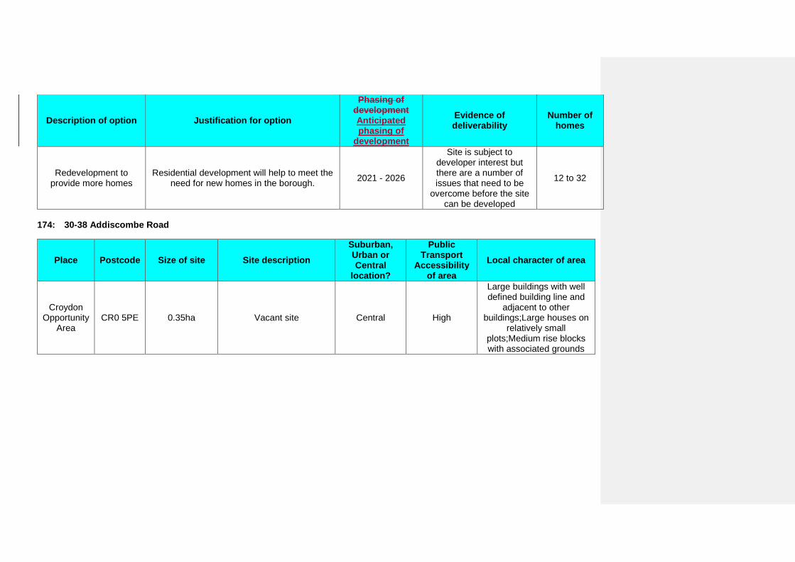
Description of option Justification for option
Phasing of development Anticipated phasing of
development
Evidence of deliverability
Number of homes
Redevelopment to provide more homes
Residential development will help to meet the need for new homes in the borough. 2021 - 2026
Site is subject to developer interest but there are a number of issues that need to be
overcome before the site can be developed
12 to 32
174: 30-38 Addiscombe Road
Place Postcode Size of site Site description Suburban, Urban or Central
location?
Public Transport
Accessibility of area
Local character of area
Croydon Opportunity
Area CR0 5PE 0.35ha Vacant site Central High
Large buildings with well defined building line and
adjacent to other buildings;Large houses on
relatively small plots;Medium rise blocks with associated grounds
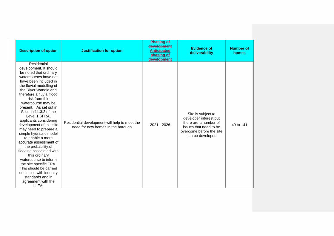
Description of option Justification for option
Phasing of development Anticipated phasing of
development
Evidence of deliverability
Number of homes
Residential development. It should be noted that ordinary watercourses have not have been included in the fluvial modelling of the River Wandle and therefore a fluvial flood
risk from this watercourse may be
present. As set out in Section 11.3.2 of the
Level 1 SFRA, applicants considering
development of this site may need to prepare a simple hydraulic model
to enable a more accurate assessment of
the probability of flooding associated with
this ordinary watercourse to inform the site specific FRA. This should be carried out in line with industry
standards and in agreement with the
LLFA.
Residential development will help to meet the need for new homes in the borough 2021 - 2026
Site is subject to developer interest but there are a number of issues that need to be
overcome before the site can be developed
49 to 141
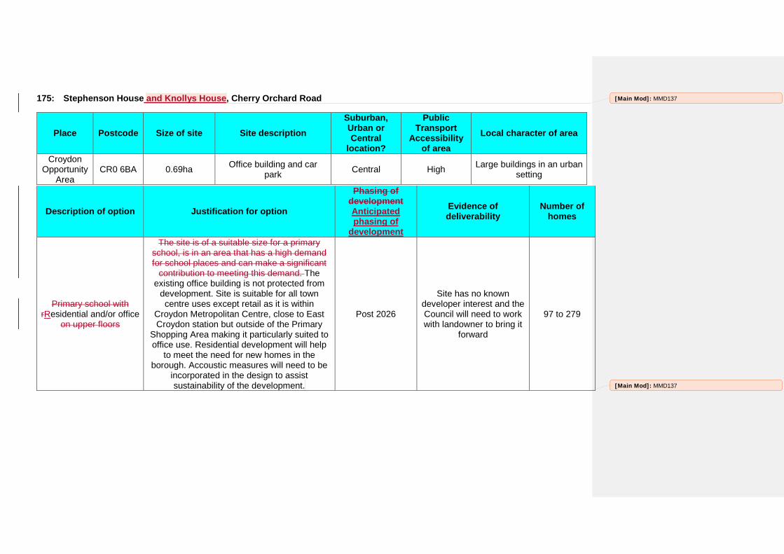
175: Stephenson House and Knollys House, Cherry Orchard Road
Place Postcode Size of site Site description Suburban, Urban or Central
location?
Public Transport
Accessibility of area
Local character of area
Croydon Opportunity
Area CR0 6BA 0.69ha Office building and car
park Central High Large buildings in an urban setting
Description of option Justification for option
Phasing of development Anticipated phasing of
development
Evidence of deliverability
Number of homes
Primary school with rResidential and/or office
on upper floors
The site is of a suitable size for a primary school, is in an area that has a high demand for school places and can make a significant
contribution to meeting this demand. The existing office building is not protected from
development. Site is suitable for all town centre uses except retail as it is within
Croydon Metropolitan Centre, close to East Croydon station but outside of the Primary
Shopping Area making it particularly suited to office use. Residential development will help
to meet the need for new homes in the borough. Accoustic measures will need to be
incorporated in the design to assist sustainability of the development.
Post 2026
Site has no known developer interest and the Council will need to work with landowner to bring it
forward
97 to 279
[Main Mod]: MMD137
[Main Mod]: MMD137
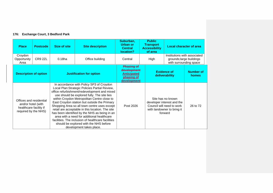
176: Exchange Court, 3 Bedford Park
Place Postcode Size of site Site description Suburban, Urban or Central
location?
Public Transport
Accessibility of area
Local character of area
Croydon Opportunity
Area CR9 2ZL 0.18ha Office building Central High
Institutions with associated grounds;large buildings with surrounding space
Description of option Justification for option
Phasing of development Anticipated phasing of
development
Evidence of deliverability
Number of homes
Offices and residential and/or hotel (with
healthcare facility if required by the NHS)
In accordance with Policy SP3 of Croydon Local Plan:Strategic Policies Partial Review,
office refurbishment/redevelopment and mixed use should be explored fully. The site lies
within Croydon Metropolitan Centre close to East Croydon station but outside the Primary Shopping Area so all town centre uses except retail are acceptable in this location. The site has been identified by the NHS as being in an
area with a need for additional healthcare facilities. The inclusion of healthcare facilities
should be explored with the NHS before development takes place.
Post 2026
Site has no known developer interest and the Council will need to work with landowner to bring it
forward
26 to 72
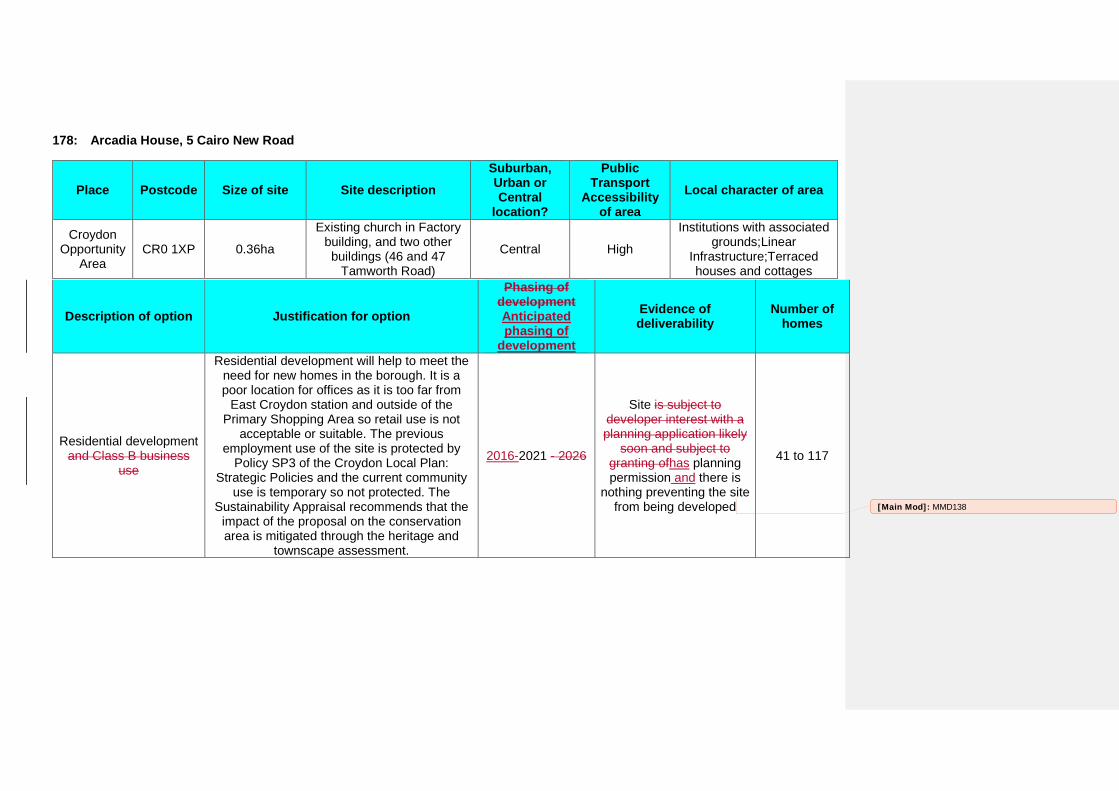
178: Arcadia House, 5 Cairo New Road
Place Postcode Size of site Site description Suburban, Urban or Central
location?
Public Transport
Accessibility of area
Local character of area
Croydon Opportunity
Area CR0 1XP 0.36ha
Existing church in Factory building, and two other buildings (46 and 47
Tamworth Road)
Central High
Institutions with associated grounds;Linear
Infrastructure;Terraced houses and cottages
Description of option Justification for option
Phasing of development Anticipated phasing of
development
Evidence of deliverability
Number of homes
Residential development and Class B business
use
Residential development will help to meet the need for new homes in the borough. It is a poor location for offices as it is too far from
East Croydon station and outside of the Primary Shopping Area so retail use is not
acceptable or suitable. The previous employment use of the site is protected by
Policy SP3 of the Croydon Local Plan: Strategic Policies and the current community
use is temporary so not protected. The Sustainability Appraisal recommends that the
impact of the proposal on the conservation area is mitigated through the heritage and
townscape assessment.
2016-2021 - 2026
Site is subject to developer interest with a planning application likely
soon and subject to granting ofhas planning permission and there is
nothing preventing the site from being developed
41 to 117
[Main Mod]: MMD138
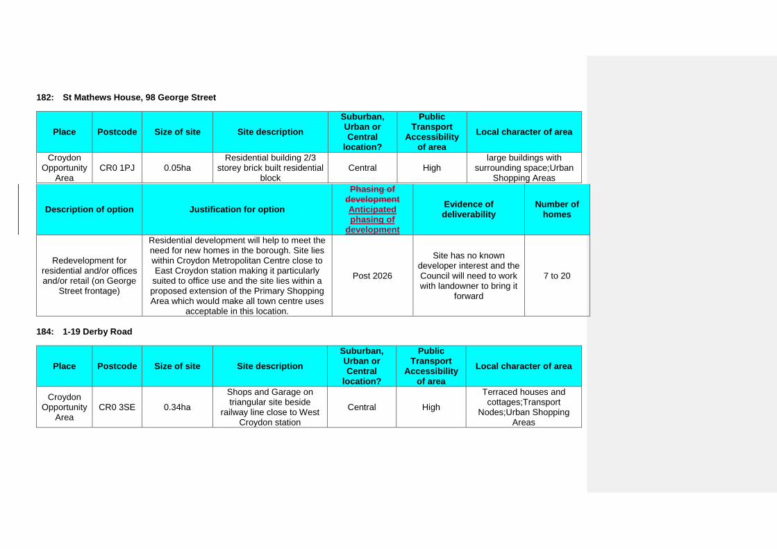
182: St Mathews House, 98 George Street
Place Postcode Size of site Site description Suburban, Urban or Central
location?
Public Transport
Accessibility of area
Local character of area
Croydon Opportunity
Area CR0 1PJ 0.05ha
Residential building 2/3 storey brick built residential
block Central High
large buildings with surrounding space;Urban
Shopping Areas
Description of option Justification for option
Phasing of development Anticipated phasing of
development
Evidence of deliverability
Number of homes
Redevelopment for residential and/or offices and/or retail (on George
Street frontage)
Residential development will help to meet the need for new homes in the borough. Site lies within Croydon Metropolitan Centre close to East Croydon station making it particularly
suited to office use and the site lies within a proposed extension of the Primary Shopping Area which would make all town centre uses
acceptable in this location.
Post 2026
Site has no known developer interest and the Council will need to work with landowner to bring it
forward
7 to 20
184: 1-19 Derby Road
Place Postcode Size of site Site description Suburban, Urban or Central
location?
Public Transport
Accessibility of area
Local character of area
Croydon Opportunity
Area CR0 3SE 0.34ha
Shops and Garage on triangular site beside
railway line close to West Croydon station
Central High
Terraced houses and cottages;Transport
Nodes;Urban Shopping Areas
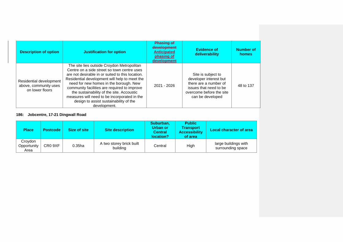
Description of option Justification for option
Phasing of development Anticipated phasing of
development
Evidence of deliverability
Number of homes
Residential development above, community uses
on lower floors
The site lies outside Croydon Metropolitan Centre on a side street so town centre uses are not desirable in or suited to this location. Residential development will help to meet the
need for new homes in the borough. New community facilities are required to improve
the sustainability of the site. Accoustic measures will need to be incorporated in the
design to assist sustainability of the development.
2021 - 2026
Site is subject to developer interest but there are a number of issues that need to be
overcome before the site can be developed
48 to 137
186: Jobcentre, 17-21 Dingwall Road
Place Postcode Size of site Site description Suburban, Urban or Central
location?
Public Transport
Accessibility of area
Local character of area
Croydon Opportunity
Area CR0 9XF 0.35ha A two storey brick built
building Central High large buildings with surrounding space
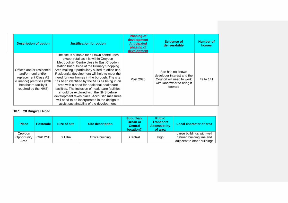
Description of option Justification for option
Phasing of development Anticipated phasing of
development
Evidence of deliverability
Number of homes
Offices and/or residential and/or hotel and/or
replacement Class A2 (Finance) premises (with
healthcare facility if required by the NHS)
The site is suitable for all town centre uses except retail as it is within Croydon
Metropolitan Centre close to East Croydon station but outside of the Primary Shopping
Area making it particularly suited to office use. Residential development will help to meet the need for new homes in the borough. The site has been identified by the NHS as being in an
area with a need for additional healthcare facilities. The inclusion of healthcare facilities
should be explored with the NHS before development takes place. Accoustic measures
will need to be incorporated in the design to assist sustainability of the development.
Post 2026
Site has no known developer interest and the Council will need to work with landowner to bring it
forward
49 to 141
187: 28 Dingwall Road
Place Postcode Size of site Site description Suburban, Urban or Central
location?
Public Transport
Accessibility of area
Local character of area
Croydon Opportunity
Area CR0 2NE 0.11ha Office building Central High
Large buildings with well defined building line and
adjacent to other buildings
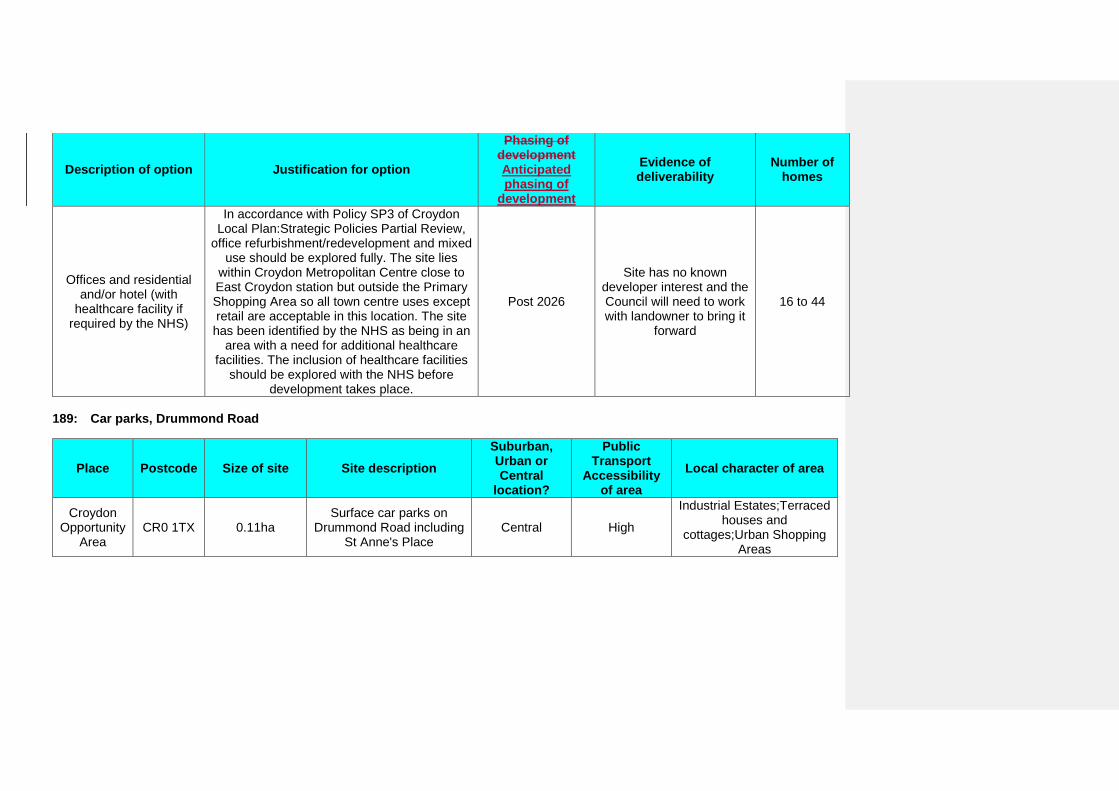
Description of option Justification for option
Phasing of development Anticipated phasing of
development
Evidence of deliverability
Number of homes
Offices and residential and/or hotel (with
healthcare facility if required by the NHS)
In accordance with Policy SP3 of Croydon Local Plan:Strategic Policies Partial Review,
office refurbishment/redevelopment and mixed use should be explored fully. The site lies
within Croydon Metropolitan Centre close to East Croydon station but outside the Primary Shopping Area so all town centre uses except retail are acceptable in this location. The site has been identified by the NHS as being in an
area with a need for additional healthcare facilities. The inclusion of healthcare facilities
should be explored with the NHS before development takes place.
Post 2026
Site has no known developer interest and the Council will need to work with landowner to bring it
forward
16 to 44
189: Car parks, Drummond Road
Place Postcode Size of site Site description Suburban, Urban or Central
location?
Public Transport
Accessibility of area
Local character of area
Croydon Opportunity
Area CR0 1TX 0.11ha
Surface car parks on Drummond Road including
St Anne's Place Central High
Industrial Estates;Terraced houses and
cottages;Urban Shopping Areas

Description of option Justification for option
Phasing of development Anticipated phasing of
development
Evidence of deliverability
Number of homes
Residential development
Subject to the Old Town Masterplan which states parking is required here for the period
of the masterplan, but that residential redevelopment could be considered later . The redevelopment of this site could help to meet the need for new homes in the borough. The Sustainability Appraisal highlights the context of the Conservation Area which development
proposals will need to consider.
Post 2026 In Council ownership 12 to 32
190: Car park to the rear of Leon House, 22-24 Edridge Road
Place Postcode Size of site Site description Suburban, Urban or Central
location?
Public Transport
Accessibility of area
Local character of area
Croydon Opportunity
Area CR0 9XT 0.40ha 2 storey parking area
serving Leon House Urban High large buildings with surrounding space
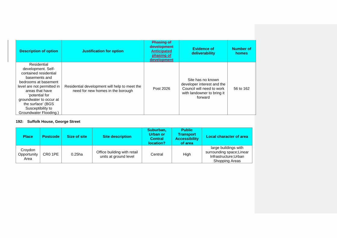
Description of option Justification for option
Phasing of development Anticipated phasing of
development
Evidence of deliverability
Number of homes
Residential development. Self-
contained residential basements and
bedrooms at basement level are not permitted in
areas that have ‘potential for
groundwater to occur at the surface’ (BGS Susceptibility to
Groundwater Flooding.)
Residential development will help to meet the need for new homes in the borough Post 2026
Site has no known developer interest and the Council will need to work with landowner to bring it
forward
56 to 162
192: Suffolk House, George Street
Place Postcode Size of site Site description Suburban, Urban or Central
location?
Public Transport
Accessibility of area
Local character of area
Croydon Opportunity
Area CR0 1PE 0.25ha Office building with retail
units at ground level Central High
large buildings with surrounding space;Linear
Infrastructure;Urban Shopping Areas
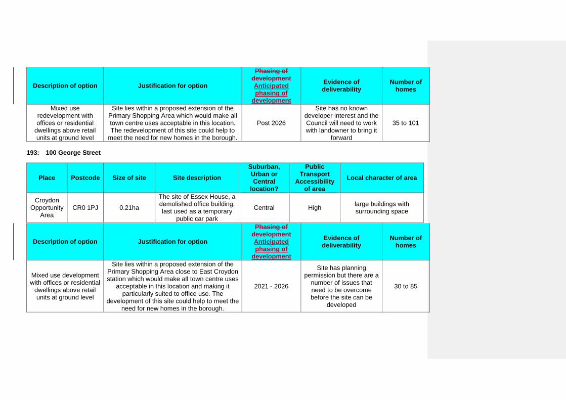
Description of option Justification for option
Phasing of development Anticipated phasing of
development
Evidence of deliverability
Number of homes
Mixed use redevelopment with offices or residential
dwellings above retail units at ground level
Site lies within a proposed extension of the Primary Shopping Area which would make all town centre uses acceptable in this location. The redevelopment of this site could help to
meet the need for new homes in the borough.
Post 2026
Site has no known developer interest and the Council will need to work with landowner to bring it
forward
35 to 101
193: 100 George Street
Place Postcode Size of site Site description Suburban, Urban or Central
location?
Public Transport
Accessibility of area
Local character of area
Croydon Opportunity
Area CR0 1PJ 0.21ha
The site of Essex House, a demolished office building, last used as a temporary
public car park
Central High large buildings with surrounding space
Description of option Justification for option
Phasing of development Anticipated phasing of
development
Evidence of deliverability
Number of homes
Mixed use development with offices or residential
dwellings above retail units at ground level
Site lies within a proposed extension of the Primary Shopping Area close to East Croydon station which would make all town centre uses
acceptable in this location and making it particularly suited to office use. The
development of this site could help to meet the need for new homes in the borough.
2021 - 2026
Site has planning permission but there are a
number of issues that need to be overcome before the site can be
developed
30 to 85
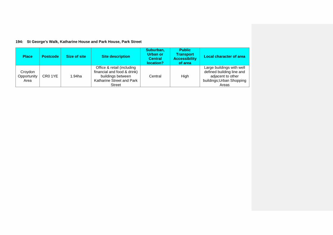
194: St George's Walk, Katharine House and Park House, Park Street
Place Postcode Size of site Site description Suburban, Urban or Central
location?
Public Transport
Accessibility of area
Local character of area
Croydon Opportunity
Area CR0 1YE 1.94ha
Office & retail (including financial and food & drink)
buildings between Katharine Street and Park
Street
Central High
Large buildings with well defined building line and
adjacent to other buildings;Urban Shopping
Areas
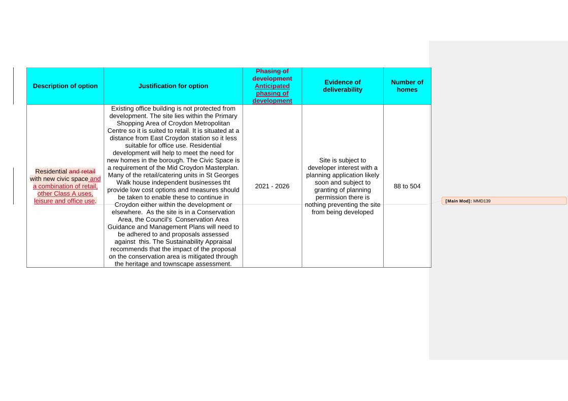
Description of option Justification for option
Phasing of development Anticipated phasing of
development
Evidence of deliverability
Number of homes
Residential and retail with new civic space and a combination of retail,
other Class A uses, leisure and office use.
Existing office building is not protected from development. The site lies within the Primary
Shopping Area of Croydon Metropolitan Centre so it is suited to retail. It is situated at a distance from East Croydon station so it less
suitable for office use. Residential development will help to meet the need for
new homes in the borough. The Civic Space is a requirement of the Mid Croydon Masterplan. Many of the retail/catering units in St Georges
Walk house independent businesses tht provide low cost options and measures should
be taken to enable these to continue in Croydon either within the development or
elsewhere. As the site is in a Conservation Area, the Council's Conservation Area
Guidance and Management Plans will need to be adhered to and proposals assessed
against this. The Sustainability Appraisal recommends that the impact of the proposal on the conservation area is mitigated through
the heritage and townscape assessment.
2021 - 2026
Site is subject to developer interest with a planning application likely
soon and subject to granting of planning permission there is
nothing preventing the site from being developed
88 to 504
[Main Mod]: MMD139
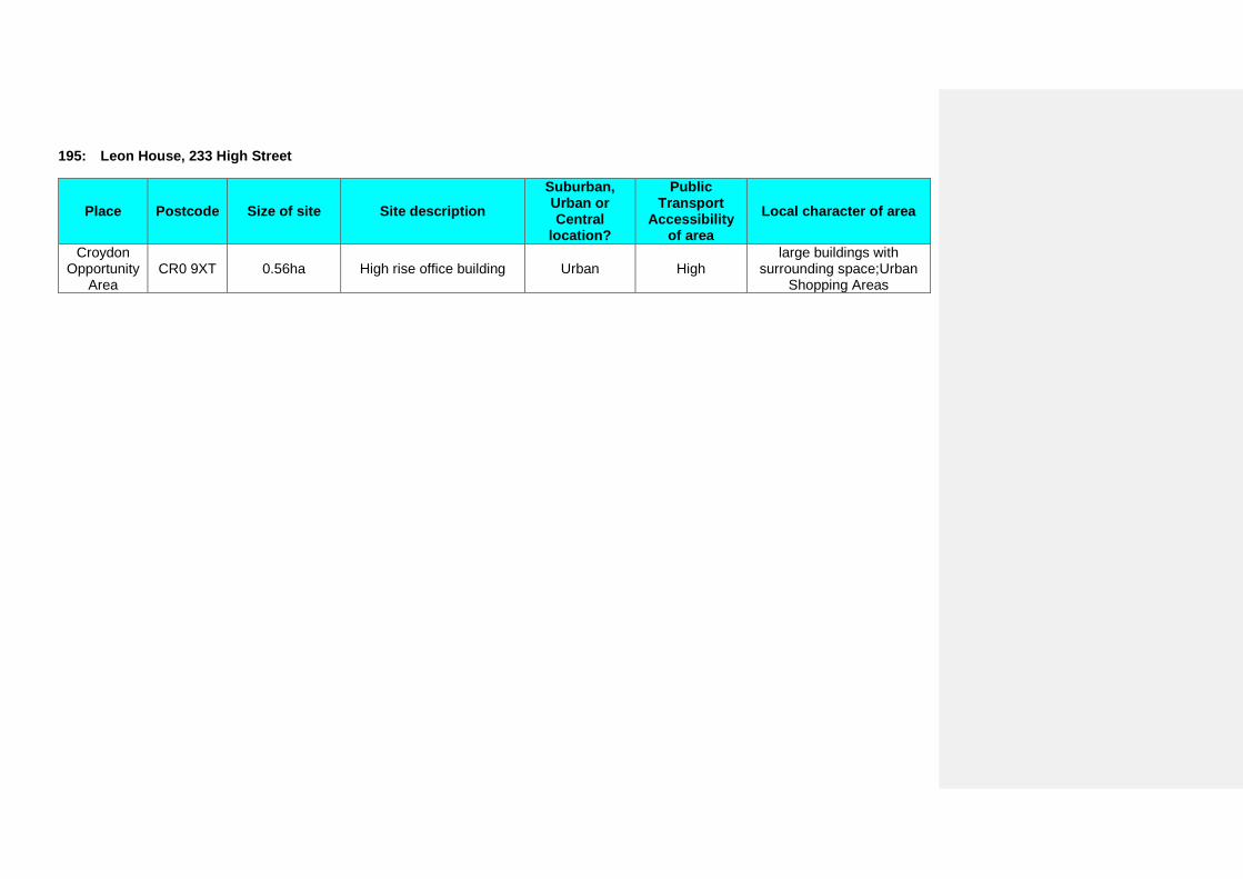
195: Leon House, 233 High Street
Place Postcode Size of site Site description Suburban, Urban or Central
location?
Public Transport
Accessibility of area
Local character of area
Croydon Opportunity
Area CR0 9XT 0.56ha High rise office building Urban High
large buildings with surrounding space;Urban
Shopping Areas
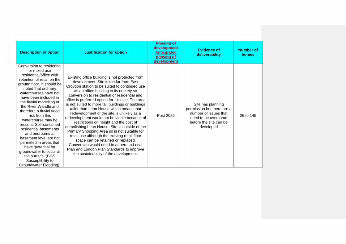
Description of option Justification for option
Phasing of development Anticipated phasing of
development
Evidence of deliverability
Number of homes
Conversion to residential or mixed use
residential/office with retention of retail on the
ground floor. It should be noted that ordinary
watercourses have not have been included in the fluvial modelling of the River Wandle and therefore a fluvial flood
risk from this watercourse may be
present. Self-contained residential basements
and bedrooms at basement level are not permitted in areas that
have ‘potential for groundwater to occur at
the surface’ (BGS Susceptibility to
Groundwater Flooding).
Existing office building is not protected from development. Site is too far from East
Croydon station to be suited to continued use as an office building in its entirety so
conversion to residential or residential and office is preferred option for this site. The area is not suited to more tall buildings or buildings
taller than Leon House which means that redevelopment of the site is unlikely as a
redevelopment would not be viable because of restrictions on height and the cost of
demolishing Leon House. Site is outside of the Primary Shopping Area so is not suitable for
retail use although the existing retail floor space can be retained or replaced.
Conversion would need to adhere to Local Plan and London Plan Standards to improve
the sustainability of the development.
Post 2026
Site has planning permission but there are a
number of issues that need to be overcome before the site can be
developed
26 to 145
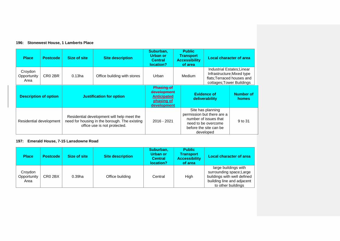
196: Stonewest House, 1 Lamberts Place
Place Postcode Size of site Site description Suburban, Urban or Central
location?
Public Transport
Accessibility of area
Local character of area
Croydon Opportunity
Area CR0 2BR 0.13ha Office building with stores Urban Medium
Industrial Estates;Linear Infrastructure;Mixed type
flats;Terraced houses and cottages;Tower Buildings
Description of option Justification for option
Phasing of development Anticipated phasing of
development
Evidence of deliverability
Number of homes
Residential development Residential development will help meet the
need for housing in the borough. The existing office use is not protected.
2016 - 2021
Site has planning permission but there are a
number of issues that need to be overcome before the site can be
developed
9 to 31
197: Emerald House, 7-15 Lansdowne Road
Place Postcode Size of site Site description Suburban, Urban or Central
location?
Public Transport
Accessibility of area
Local character of area
Croydon Opportunity
Area CR0 2BX 0.39ha Office building Central High
large buildings with surrounding space;Large buildings with well defined building line and adjacent
to other buildings
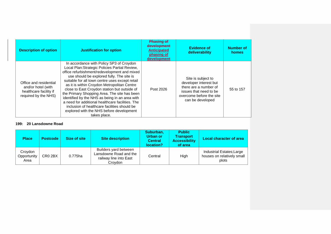
Description of option Justification for option
Phasing of development Anticipated phasing of
development
Evidence of deliverability
Number of homes
Office and residential and/or hotel (with
healthcare facility if required by the NHS)
In accordance with Policy SP3 of Croydon Local Plan:Strategic Policies Partial Review,
office refurbishment/redevelopment and mixed use should be explored fully. The site is
suitable for all town centre uses except retail as it is within Croydon Metropolitan Centre close to East Croydon station but outside of
the Primary Shopping Area. The site has been identified by the NHS as being in an area with a need for additional healthcare facilities. The
inclusion of healthcare facilities should be explored with the NHS before development
takes place.
Post 2026
Site is subject to developer interest but there are a number of issues that need to be
overcome before the site can be developed
55 to 157
199: 20 Lansdowne Road
Place Postcode Size of site Site description Suburban, Urban or Central
location?
Public Transport
Accessibility of area
Local character of area
Croydon Opportunity
Area CR0 2BX 0.775ha
Builders yard between Lansdowne Road and the
railway line into East Croydon
Central High Industrial Estates;Large
houses on relatively small plots
Description of option Justification for option
Phasing of development Anticipated phasing of
development
Evidence of deliverability
Number of homes
Residential development with light industrial
workshops and studio spaces
Site is a town centre employment site. Policy SP3.2 of the Croydon Local Plan: Strategic
Policies requires that evidence of lack of demand for the existing premises or site for an
employment use be provided before other uses can be considered.
Post 2026
Site is subject to developer interest but there are a number of issues that need to be
overcome before the site can be developed
109 to 313
200: Multi-storey car park, Lansdowne Road
Place Postcode Size of site Site description Suburban, Urban or Central
location?
Public Transport
Accessibility of area
Local character of area
Croydon Opportunity
Area CR0 2BX 0.95ha Multi storey car park Central High
large buildings with surrounding space;Large buildings with well defined building line and adjacent
to other buildings
Description of option Justification for option
Phasing of development Anticipated phasing of
development
Evidence of deliverability
Number of homes
Mixed use, public car park and residential.
The Croydon Opportunity Area Planning Framework (2013) allows for the loss of 200
car parking spaces in the New Town and East Croydon Area. In light of this, the preferred
option includes for an element of car parking to remain alongside residential and missed
use development.
Post 2026
Site has no known developer interest and the Council will need to work with landowner to bring it
forward
133 to 384
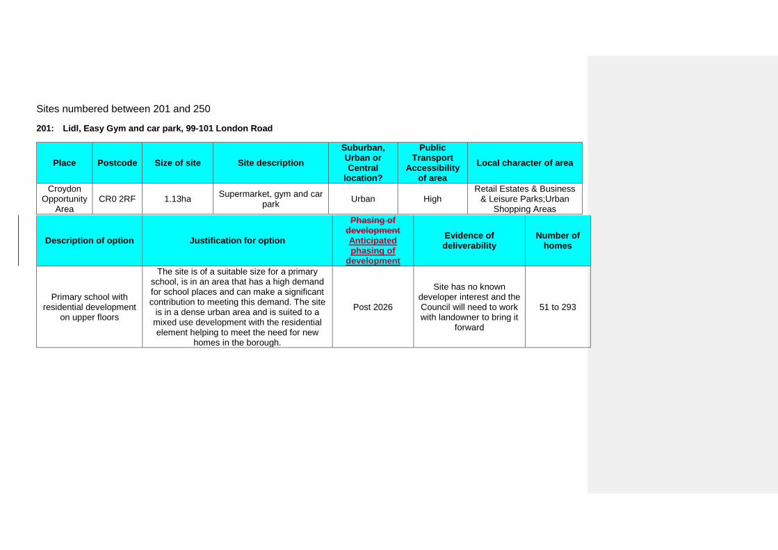
Sites numbered between 201 and 250
201: Lidl, Easy Gym and car park, 99-101 London Road
Place Postcode Size of site Site description Suburban, Urban or Central
location?
Public Transport
Accessibility of area
Local character of area
Croydon Opportunity
Area CR0 2RF 1.13ha Supermarket, gym and car
park Urban High Retail Estates & Business
& Leisure Parks;Urban Shopping Areas
Description of option Justification for option
Phasing of development Anticipated phasing of
development
Evidence of deliverability
Number of homes
Primary school with residential development
on upper floors
The site is of a suitable size for a primary school, is in an area that has a high demand for school places and can make a significant contribution to meeting this demand. The site
is in a dense urban area and is suited to a mixed use development with the residential element helping to meet the need for new
homes in the borough.
Post 2026
Site has no known developer interest and the Council will need to work with landowner to bring it
forward
51 to 293
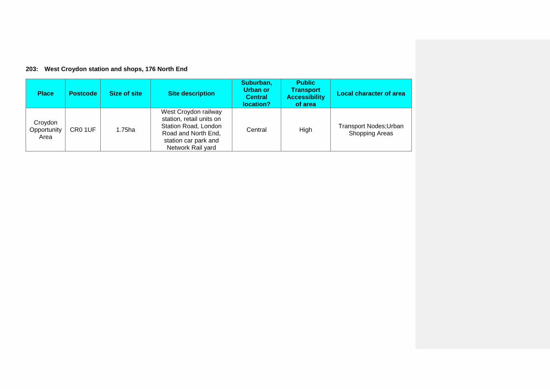
203: West Croydon station and shops, 176 North End
Place Postcode Size of site Site description Suburban, Urban or Central
location?
Public Transport
Accessibility of area
Local character of area
Croydon Opportunity
Area CR0 1UF 1.75ha
West Croydon railway station, retail units on Station Road, London Road and North End, station car park and Network Rail yard
Central High Transport Nodes;Urban Shopping Areas
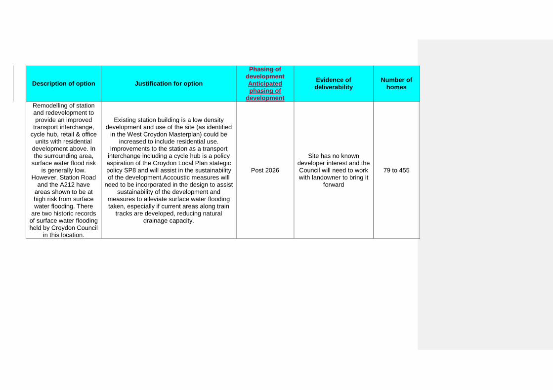
Description of option Justification for option
Phasing of development Anticipated phasing of
development
Evidence of deliverability
Number of homes
Remodelling of station and redevelopment to provide an improved
transport interchange, cycle hub, retail & office
units with residential development above. In the surrounding area,
surface water flood risk is generally low.
However, Station Road and the A212 have
areas shown to be at high risk from surface water flooding. There
are two historic records of surface water flooding held by Croydon Council
in this location.
Existing station building is a low density development and use of the site (as identified
in the West Croydon Masterplan) could be increased to include residential use.
Improvements to the station as a transport interchange including a cycle hub is a policy aspiration of the Croydon Local Plan stategic policy SP8 and will assist in the sustainability of the development.Accoustic measures will
need to be incorporated in the design to assist sustainability of the development and
measures to alleviate surface water flooding taken, especially if current areas along train
tracks are developed, reducing natural drainage capacity.
Post 2026
Site has no known developer interest and the Council will need to work with landowner to bring it
forward
79 to 455
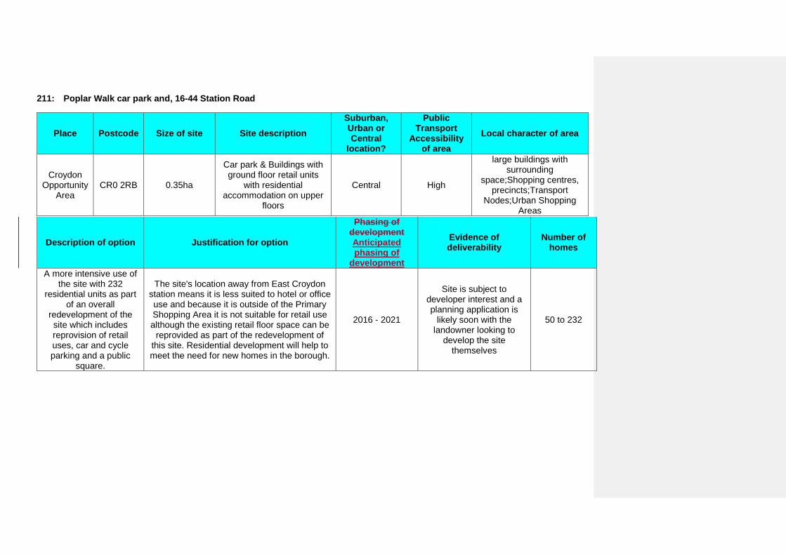
211: Poplar Walk car park and, 16-44 Station Road
Place Postcode Size of site Site description Suburban, Urban or Central
location?
Public Transport
Accessibility of area
Local character of area
Croydon Opportunity
Area CR0 2RB 0.35ha
Car park & Buildings with ground floor retail units
with residential accommodation on upper
floors
Central High
large buildings with surrounding
space;Shopping centres, precincts;Transport
Nodes;Urban Shopping Areas
Description of option Justification for option
Phasing of development Anticipated phasing of
development
Evidence of deliverability
Number of homes
A more intensive use of the site with 232
residential units as part of an overall
redevelopment of the site which includes reprovision of retail uses, car and cycle parking and a public
square.
The site's location away from East Croydon station means it is less suited to hotel or office use and because it is outside of the Primary Shopping Area it is not suitable for retail use although the existing retail floor space can be
reprovided as part of the redevelopment of this site. Residential development will help to meet the need for new homes in the borough.
2016 - 2021
Site is subject to developer interest and a planning application is
likely soon with the landowner looking to
develop the site themselves
50 to 232
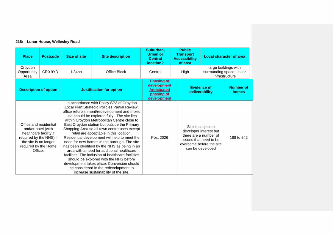
218: Lunar House, Wellesley Road
Place Postcode Size of site Site description Suburban, Urban or Central
location?
Public Transport
Accessibility of area
Local character of area
Croydon Opportunity
Area CR0 9YD 1.34ha Office Block Central High
large buildings with surrounding space;Linear
Infrastructure
Description of option Justification for option
Phasing of development Anticipated phasing of
development
Evidence of deliverability
Number of homes
Office and residential and/or hotel (with
healthcare facility if required by the NHS) if
the site is no longer required by the Home
Office.
In accordance with Policy SP3 of Croydon Local Plan:Strategic Policies Partial Review,
office refurbishment/redevelopment and mixed use should be explored fully. The site lies
within Croydon Metropolitan Centre close to East Croydon station but outside the Primary Shopping Area so all town centre uses except
retail are acceptable in this location. Residential development will help to meet the need for new homes in the borough. The site has been identified by the NHS as being in an
area with a need for additional healthcare facilities. The inclusion of healthcare facilities
should be explored with the NHS before development takes place. Conversion should
be considered in the redevelopment to increase sustainability of the site.
Post 2026
Site is subject to developer interest but there are a number of issues that need to be
overcome before the site can be developed
188 to 542
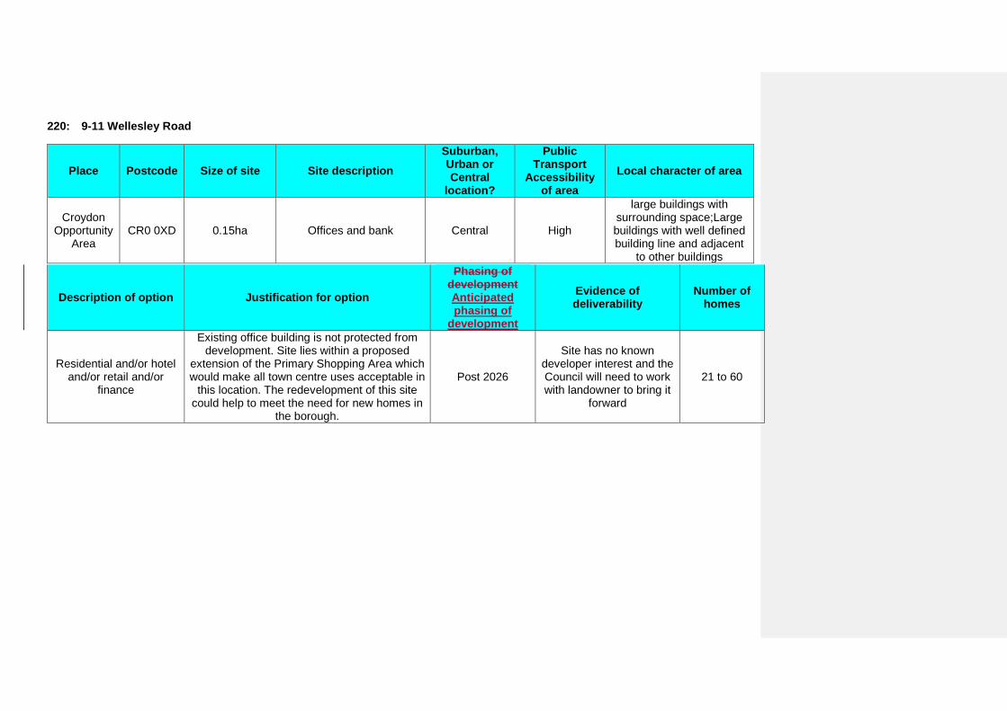
220: 9-11 Wellesley Road
Place Postcode Size of site Site description Suburban, Urban or Central
location?
Public Transport
Accessibility of area
Local character of area
Croydon Opportunity
Area CR0 0XD 0.15ha Offices and bank Central High
large buildings with surrounding space;Large buildings with well defined building line and adjacent
to other buildings
Description of option Justification for option
Phasing of development Anticipated phasing of
development
Evidence of deliverability
Number of homes
Residential and/or hotel and/or retail and/or
finance
Existing office building is not protected from development. Site lies within a proposed
extension of the Primary Shopping Area which would make all town centre uses acceptable in
this location. The redevelopment of this site could help to meet the need for new homes in
the borough.
Post 2026
Site has no known developer interest and the Council will need to work with landowner to bring it
forward
21 to 60
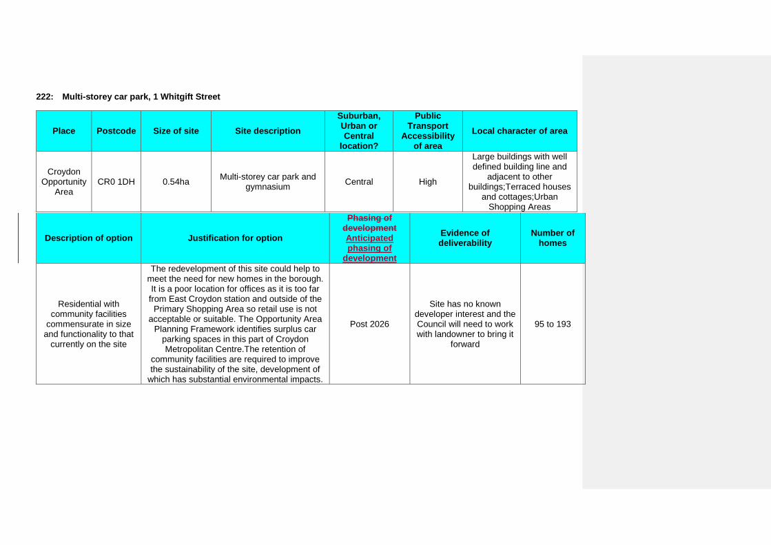
222: Multi-storey car park, 1 Whitgift Street
Place Postcode Size of site Site description Suburban, Urban or Central
location?
Public Transport
Accessibility of area
Local character of area
Croydon Opportunity
Area CR0 1DH 0.54ha Multi-storey car park and
gymnasium Central High
Large buildings with well defined building line and
adjacent to other buildings;Terraced houses
and cottages;Urban Shopping Areas
Description of option Justification for option
Phasing of development Anticipated phasing of
development
Evidence of deliverability
Number of homes
Residential with community facilities
commensurate in size and functionality to that
currently on the site
The redevelopment of this site could help to meet the need for new homes in the borough. It is a poor location for offices as it is too far from East Croydon station and outside of the
Primary Shopping Area so retail use is not acceptable or suitable. The Opportunity Area
Planning Framework identifies surplus car parking spaces in this part of Croydon Metropolitan Centre.The retention of
community facilities are required to improve the sustainability of the site, development of
which has substantial environmental impacts.
Post 2026
Site has no known developer interest and the Council will need to work with landowner to bring it
forward
95 to 193
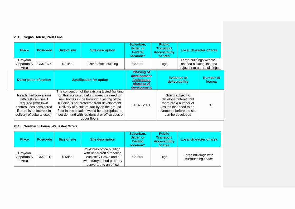
231: Segas House, Park Lane
Place Postcode Size of site Site description Suburban, Urban or Central
location?
Public Transport
Accessibility of area
Local character of area
Croydon Opportunity
Area CR0 1NX 0.19ha Listed office building Central High
Large buildings with well defined building line and
adjacent to other buildings
Description of option Justification for option
Phasing of development Anticipated phasing of
development
Evidence of deliverability
Number of homes
Residential conversion with cultural uses if required (with town
centres uses considered if there is no interest in
delivery of cultural uses).
The conversion of the existing Listed Building on this site could help to meet the need for new homes in the borough. Existing office
building is not protected from development. Delivery of a cultural facility on the ground
floor in this location would be appropriate to meet demand with residential or office uses on
upper floors.
2016 - 2021
Site is subject to developer interest but there are a number of issues that need to be
overcome before the site can be developed
40
234: Southern House, Wellesley Grove
Place Postcode Size of site Site description Suburban, Urban or Central
location?
Public Transport
Accessibility of area
Local character of area
Croydon Opportunity
Area CR9 1TR 0.58ha
24-storey office building with undercroft straddling Wellesley Grove and a
two-storey period property converted to an office
Central High large buildings with surrounding space
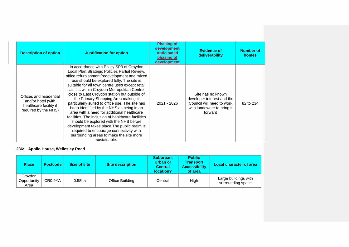
Description of option Justification for option
Phasing of development Anticipated phasing of
development
Evidence of deliverability
Number of homes
Offices and residential and/or hotel (with
healthcare facility if required by the NHS)
In accordance with Policy SP3 of Croydon Local Plan:Strategic Policies Partial Review,
office refurbishment/redevelopment and mixed use should be explored fully. The site is
suitable for all town centre uses except retail as it is within Croydon Metropolitan Centre close to East Croydon station but outside of
the Primary Shopping Area making it particularly suited to office use. The site has been identified by the NHS as being in an area with a need for additional healthcare
facilities. The inclusion of healthcare facilities should be explored with the NHS before
development takes place.The public realm is required to encourage connectivity with
surrounding areas to make the site more sustainable.
2021 - 2026
Site has no known developer interest and the Council will need to work with landowner to bring it
forward
82 to 234
236: Apollo House, Wellesley Road
Place Postcode Size of site Site description Suburban, Urban or Central
location?
Public Transport
Accessibility of area
Local character of area
Croydon Opportunity
Area CR0 9YA 0.58ha Office Building Central High Large buildings with
surrounding space

Description of option Justification for option
Phasing of development Anticipated phasing of
development
Evidence of deliverability
Number of homes
Offices and residential and/or hotel (with
healthcare facility if required by the NHS) if
the site is no longer required by the Home Office. There is one
record of sewer flooding.
In accordance with Policy SP3 of Croydon Local Plan:Strategic Policies Partial Review,
office refurbishment/redevelopment and mixed use should be explored fully. The site is
suitable for all town centre uses except retail as it is within Croydon Metropolitan Centre close to East Croydon station but outside of
the Primary Shopping Area. The site has been identified by the NHS as being in an area with a need for additional healthcare facilities. The
inclusion of healthcare facilities should be explored with the NHS before development
takes place. To assist sustainability the development must incorporate accoustic measures to reduce noise impact on the
development.
Post 2026
Site is subject to developer interest but there are a number of issues that need to be
overcome before the site can be developed
82 to 234
242: Davis House, Robert Street
Place Postcode Size of site Site description Suburban, Urban or Central
location?
Public Transport
Accessibility of area
Local character of area
Croydon Opportunity
Area CR0 1QQ 0.13ha Office building and shops Central High
Large buildings with well defined building line and
adjacent to other buildings;Urban Shopping
Areas
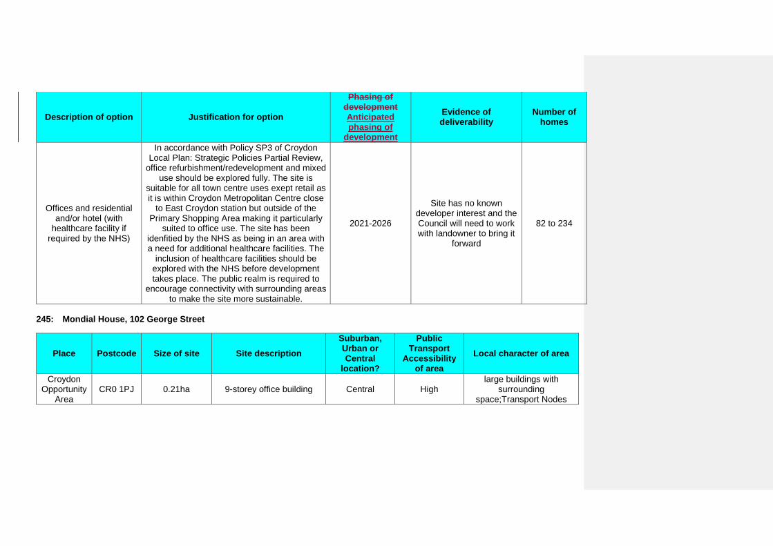
Description of option Justification for option
Phasing of development Anticipated phasing of
development
Evidence of deliverability
Number of homes
Offices and residential and/or hotel (with
healthcare facility if required by the NHS)
In accordance with Policy SP3 of Croydon Local Plan: Strategic Policies Partial Review,
office refurbishment/redevelopment and mixed use should be explored fully. The site is
suitable for all town centre uses exept retail as it is within Croydon Metropolitan Centre close
to East Croydon station but outside of the Primary Shopping Area making it particularly
suited to office use. The site has been idenfitied by the NHS as being in an area with a need for additional healthcare facilities. The
inclusion of healthcare facilities should be explored with the NHS before development takes place. The public realm is required to
encourage connectivity with surrounding areas to make the site more sustainable.
2021-2026
Site has no known developer interest and the Council will need to work with landowner to bring it
forward
82 to 234
245: Mondial House, 102 George Street
Place Postcode Size of site Site description Suburban, Urban or Central
location?
Public Transport
Accessibility of area
Local character of area
Croydon Opportunity
Area CR0 1PJ 0.21ha 9-storey office building Central High
large buildings with surrounding
space;Transport Nodes
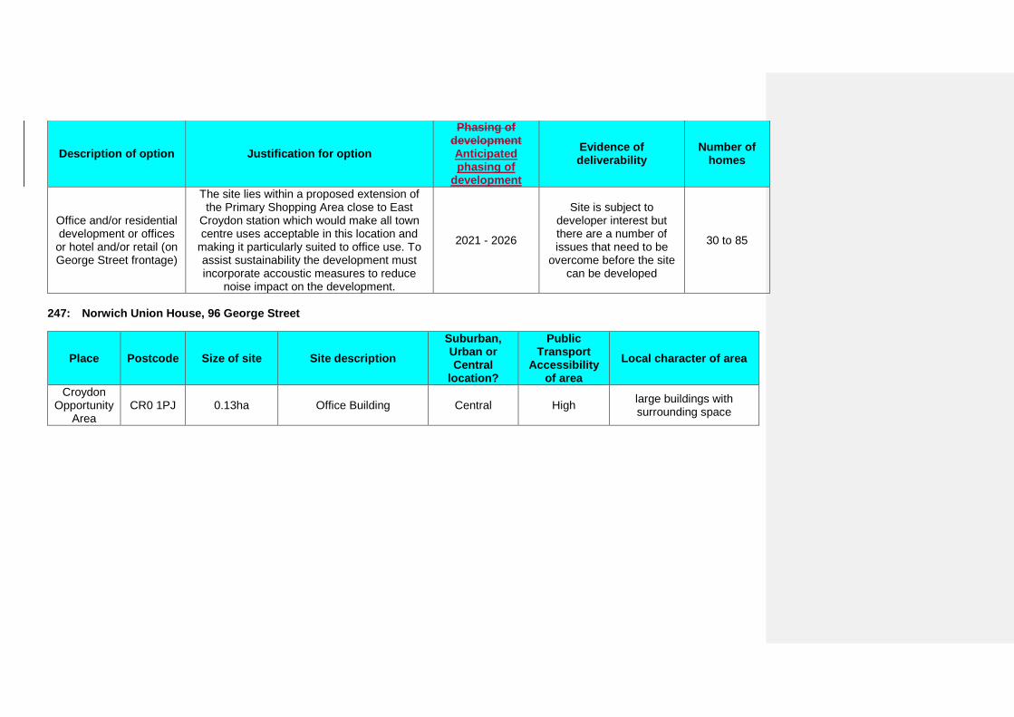
Description of option Justification for option
Phasing of development Anticipated phasing of
development
Evidence of deliverability
Number of homes
Office and/or residential development or offices
or hotel and/or retail (on George Street frontage)
The site lies within a proposed extension of the Primary Shopping Area close to East
Croydon station which would make all town centre uses acceptable in this location and
making it particularly suited to office use. To assist sustainability the development must incorporate accoustic measures to reduce
noise impact on the development.
2021 - 2026
Site is subject to developer interest but there are a number of issues that need to be
overcome before the site can be developed
30 to 85
247: Norwich Union House, 96 George Street
Place Postcode Size of site Site description Suburban, Urban or Central
location?
Public Transport
Accessibility of area
Local character of area
Croydon Opportunity
Area CR0 1PJ 0.13ha Office Building Central High large buildings with
surrounding space
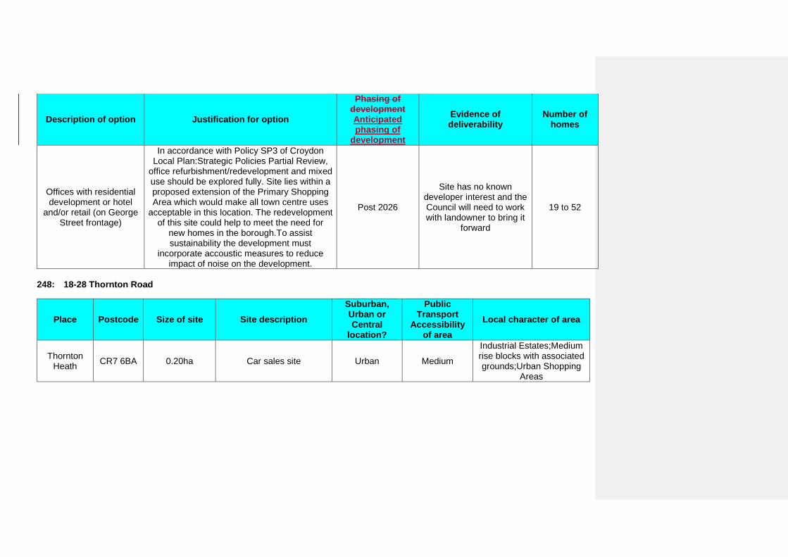
Description of option Justification for option
Phasing of development Anticipated phasing of
development
Evidence of deliverability
Number of homes
Offices with residential development or hotel
and/or retail (on George Street frontage)
In accordance with Policy SP3 of Croydon Local Plan:Strategic Policies Partial Review,
office refurbishment/redevelopment and mixed use should be explored fully. Site lies within a proposed extension of the Primary Shopping Area which would make all town centre uses
acceptable in this location. The redevelopment of this site could help to meet the need for
new homes in the borough.To assist sustainability the development must
incorporate accoustic measures to reduce impact of noise on the development.
Post 2026
Site has no known developer interest and the Council will need to work with landowner to bring it
forward
19 to 52
248: 18-28 Thornton Road
Place Postcode Size of site Site description Suburban, Urban or Central
location?
Public Transport
Accessibility of area
Local character of area
Thornton Heath CR7 6BA 0.20ha Car sales site Urban Medium
Industrial Estates;Medium rise blocks with associated grounds;Urban Shopping
Areas
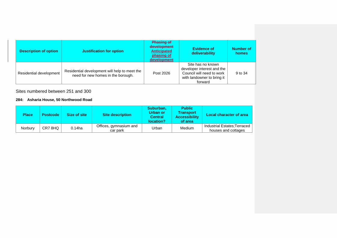
Description of option Justification for option
Phasing of development Anticipated phasing of
development
Evidence of deliverability
Number of homes
Residential development Residential development will help to meet the need for new homes in the borough. Post 2026
Site has no known developer interest and the Council will need to work with landowner to bring it
forward
9 to 34
Sites numbered between 251 and 300
284: Asharia House, 50 Northwood Road
Place Postcode Size of site Site description Suburban, Urban or Central
location?
Public Transport
Accessibility of area
Local character of area
Norbury CR7 8HQ 0.14ha Offices, gymnasium and car park Urban Medium Industrial Estates;Terraced
houses and cottages

Description of option Justification for option
Phasing of development Anticipated phasing of
development
Evidence of deliverability
Number of homes
Residential development including replacement
community facility
Residential development will help to meet the need for new homes in the borough. The community use of the site is protected by
Policy SP5 of the Croydon Local Plan: Strategic Policies.The retention of a
community facility will assist the sustainability of the site. The Sustainability Appraisal
recommends public transport improvements are made as part of the proposal to mitigate the site's low public transport accessibility
rating.
Post 2026
Site has no known developer interest and the Council will need to work with landowner to bring it
forward
7 to 23
286: 35-47 Osborne Road
Place Postcode Size of site Site description Suburban, Urban or Central
location?
Public Transport
Accessibility of area
Local character of area
Thornton Heath CR7 8PD 0.37ha Disused warehouse and
factory buldings Urban Medium Industrial Estates;Terraced houses and cottages
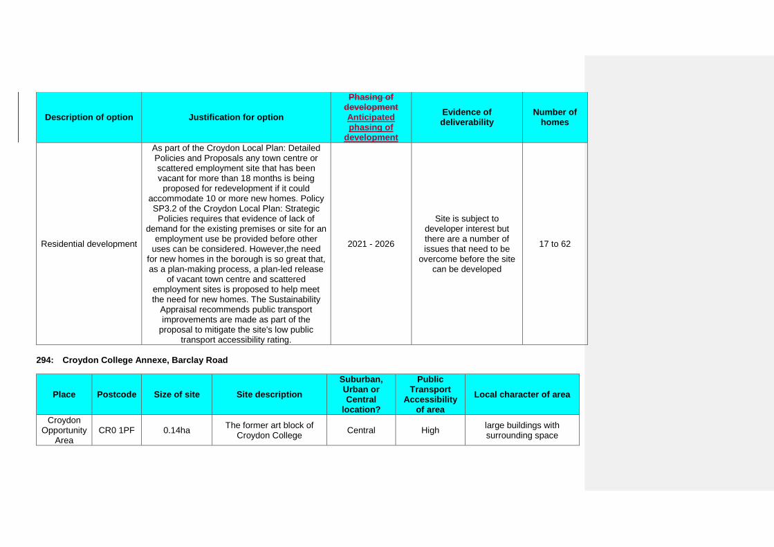
Description of option Justification for option
Phasing of development Anticipated phasing of
development
Evidence of deliverability
Number of homes
Residential development
As part of the Croydon Local Plan: Detailed Policies and Proposals any town centre or scattered employment site that has been vacant for more than 18 months is being
proposed for redevelopment if it could accommodate 10 or more new homes. Policy SP3.2 of the Croydon Local Plan: Strategic
Policies requires that evidence of lack of demand for the existing premises or site for an
employment use be provided before other uses can be considered. However,the need
for new homes in the borough is so great that, as a plan-making process, a plan-led release
of vacant town centre and scattered employment sites is proposed to help meet the need for new homes. The Sustainability
Appraisal recommends public transport improvements are made as part of the
proposal to mitigate the site's low public transport accessibility rating.
2021 - 2026
Site is subject to developer interest but there are a number of issues that need to be
overcome before the site can be developed
17 to 62
294: Croydon College Annexe, Barclay Road
Place Postcode Size of site Site description Suburban, Urban or Central
location?
Public Transport
Accessibility of area
Local character of area
Croydon Opportunity
Area CR0 1PF 0.14ha The former art block of
Croydon College Central High large buildings with surrounding space
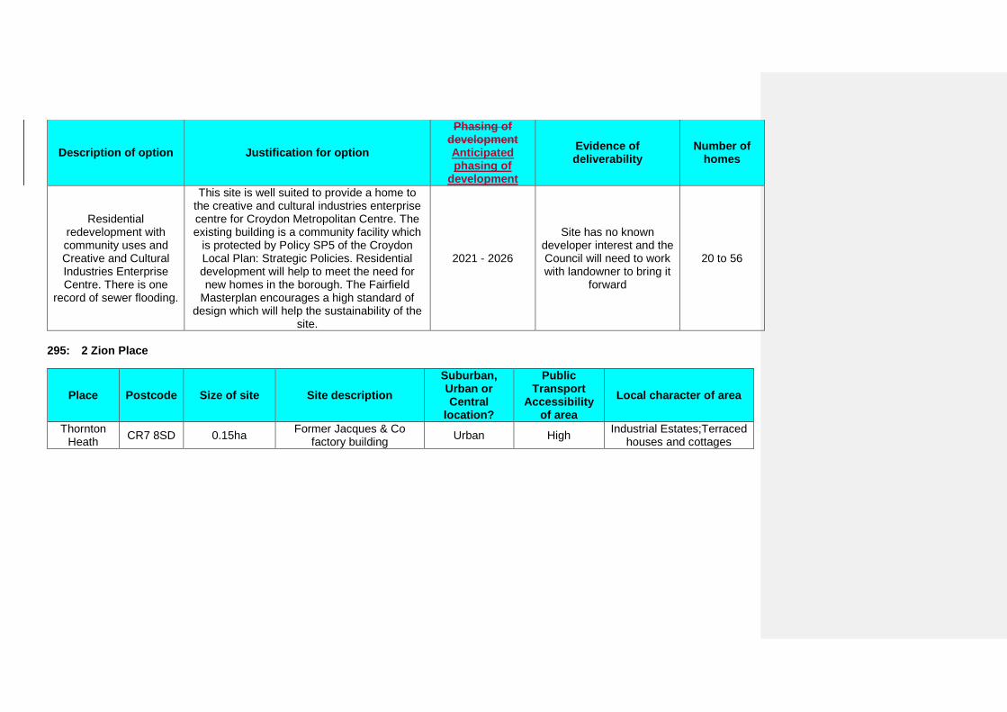
Description of option Justification for option
Phasing of development Anticipated phasing of
development
Evidence of deliverability
Number of homes
Residential redevelopment with community uses and Creative and Cultural Industries Enterprise Centre. There is one
record of sewer flooding.
This site is well suited to provide a home to the creative and cultural industries enterprise centre for Croydon Metropolitan Centre. The existing building is a community facility which
is protected by Policy SP5 of the Croydon Local Plan: Strategic Policies. Residential development will help to meet the need for new homes in the borough. The Fairfield
Masterplan encourages a high standard of design which will help the sustainability of the
site.
2021 - 2026
Site has no known developer interest and the Council will need to work with landowner to bring it
forward
20 to 56
295: 2 Zion Place
Place Postcode Size of site Site description Suburban, Urban or Central
location?
Public Transport
Accessibility of area
Local character of area
Thornton Heath CR7 8SD 0.15ha Former Jacques & Co
factory building Urban High Industrial Estates;Terraced houses and cottages
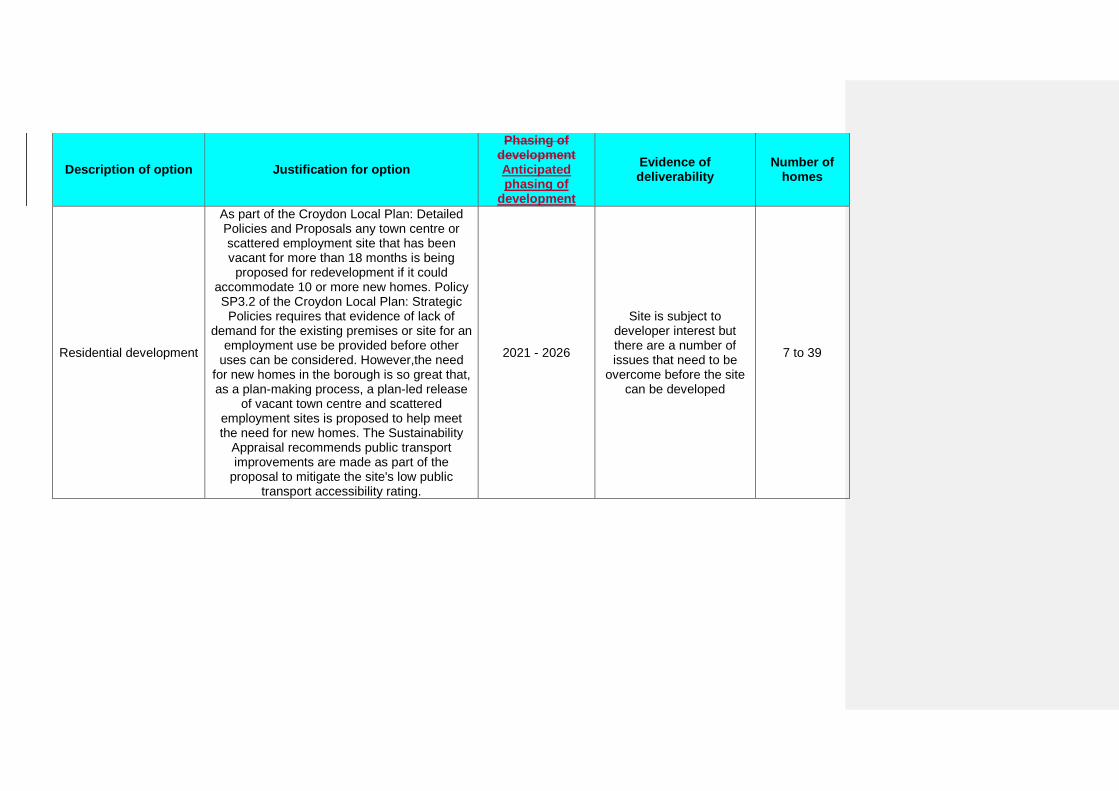
Description of option Justification for option
Phasing of development Anticipated phasing of
development
Evidence of deliverability
Number of homes
Residential development
As part of the Croydon Local Plan: Detailed Policies and Proposals any town centre or scattered employment site that has been vacant for more than 18 months is being
proposed for redevelopment if it could accommodate 10 or more new homes. Policy SP3.2 of the Croydon Local Plan: Strategic
Policies requires that evidence of lack of demand for the existing premises or site for an
employment use be provided before other uses can be considered. However,the need
for new homes in the borough is so great that, as a plan-making process, a plan-led release
of vacant town centre and scattered employment sites is proposed to help meet the need for new homes. The Sustainability
Appraisal recommends public transport improvements are made as part of the
proposal to mitigate the site's low public transport accessibility rating.
2021 - 2026
Site is subject to developer interest but there are a number of issues that need to be
overcome before the site can be developed
7 to 39
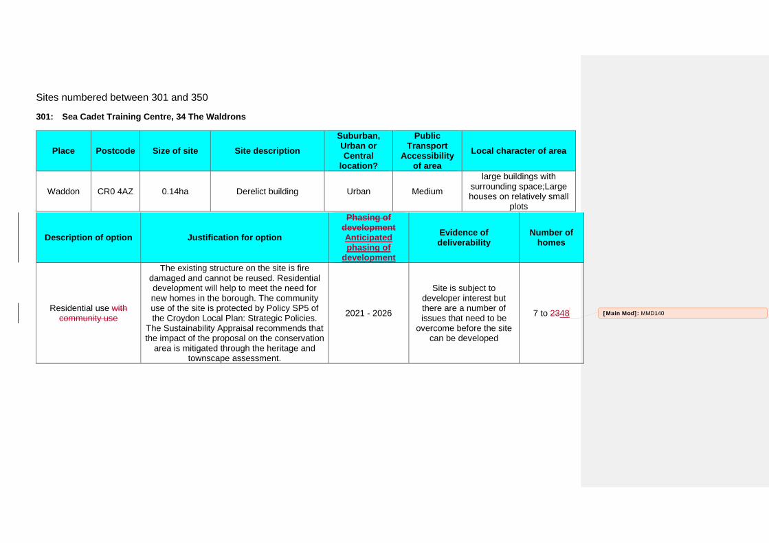
Sites numbered between 301 and 350
301: Sea Cadet Training Centre, 34 The Waldrons
Place Postcode Size of site Site description Suburban, Urban or Central
location?
Public Transport
Accessibility of area
Local character of area
Waddon CR0 4AZ 0.14ha Derelict building Urban Medium
large buildings with surrounding space;Large houses on relatively small
plots
Description of option Justification for option
Phasing of development Anticipated phasing of
development
Evidence of deliverability
Number of homes
Residential use with community use
The existing structure on the site is fire damaged and cannot be reused. Residential development will help to meet the need for new homes in the borough. The community use of the site is protected by Policy SP5 of the Croydon Local Plan: Strategic Policies.
The Sustainability Appraisal recommends that the impact of the proposal on the conservation
area is mitigated through the heritage and townscape assessment.
2021 - 2026
Site is subject to developer interest but there are a number of issues that need to be
overcome before the site can be developed
7 to 2348 [Main Mod]: MMD140
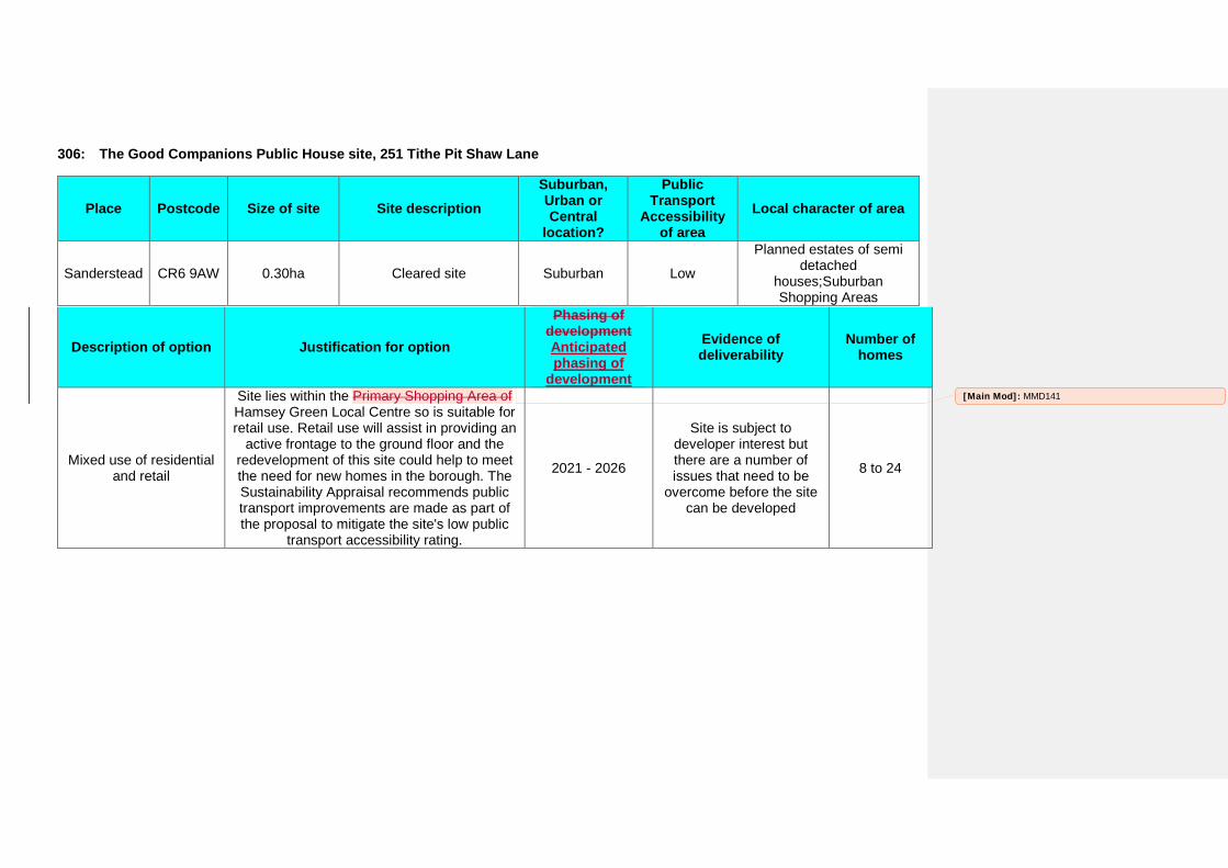
306: The Good Companions Public House site, 251 Tithe Pit Shaw Lane
Place Postcode Size of site Site description Suburban, Urban or Central
location?
Public Transport
Accessibility of area
Local character of area
Sanderstead CR6 9AW 0.30ha Cleared site Suburban Low
Planned estates of semi detached
houses;Suburban Shopping Areas
Description of option Justification for option
Phasing of development Anticipated phasing of
development
Evidence of deliverability
Number of homes
Mixed use of residential and retail
Site lies within the Primary Shopping Area of Hamsey Green Local Centre so is suitable for retail use. Retail use will assist in providing an
active frontage to the ground floor and the redevelopment of this site could help to meet the need for new homes in the borough. The Sustainability Appraisal recommends public transport improvements are made as part of the proposal to mitigate the site's low public
transport accessibility rating.
2021 - 2026
Site is subject to developer interest but there are a number of issues that need to be
overcome before the site can be developed
8 to 24
[Main Mod]: MMD141
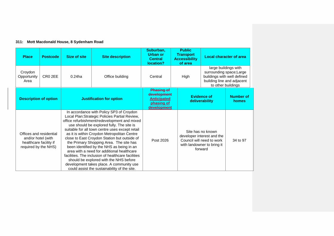
311: Mott Macdonald House, 8 Sydenham Road
Place Postcode Size of site Site description Suburban, Urban or Central
location?
Public Transport
Accessibility of area
Local character of area
Croydon Opportunity
Area CR0 2EE 0.24ha Office building Central High
large buildings with surrounding space;Large buildings with well defined building line and adjacent
to other buildings
Description of option Justification for option
Phasing of development Anticipated phasing of
development
Evidence of deliverability
Number of homes
Offices and residential and/or hotel (with
healthcare facility if required by the NHS)
In accordance with Policy SP3 of Croydon Local Plan:Strategic Policies Partial Review,
office refurbishment/redevelopment and mixed use should be explored fully. The site is
suitable for all town centre uses except retail as it is within Croydon Metropolitan Centre
close to East Croydon Station but outside of the Primary Shopping Area. The site has been identified by the NHS as being in an area with a need for additional healthcare
facilities. The inclusion of healthcare facilities should be explored with the NHS before
development takes place. A community use could assist the sustainability of the site.
Post 2026
Site has no known developer interest and the Council will need to work with landowner to bring it
forward
34 to 97
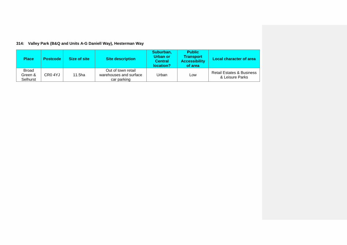
314: Valley Park (B&Q and Units A-G Daniell Way), Hesterman Way
Place Postcode Size of site Site description Suburban, Urban or Central
location?
Public Transport
Accessibility of area
Local character of area
Broad Green & Selhurst
CR0 4YJ 11.5ha Out of town retail
warehouses and surface car parking
Urban Low Retail Estates & Business & Leisure Parks
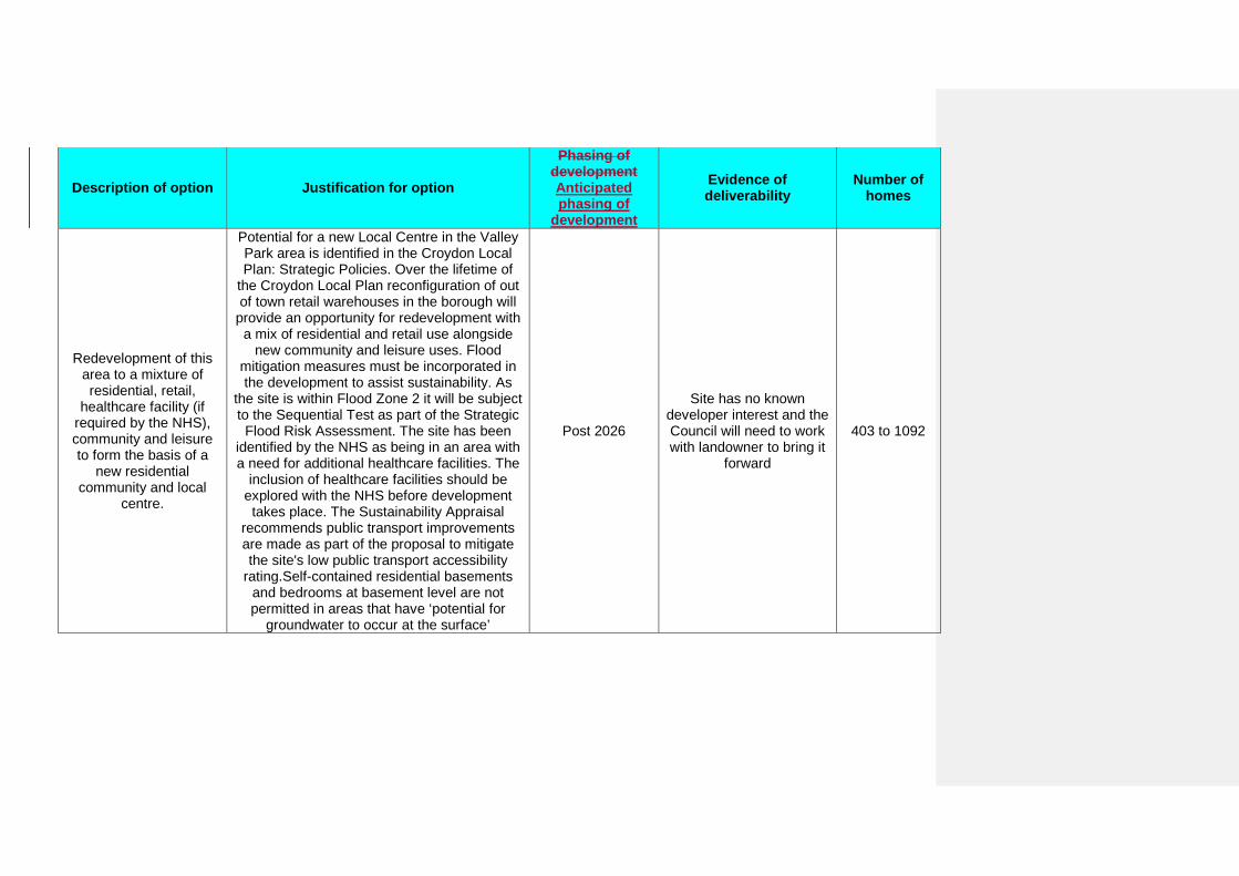
Description of option Justification for option
Phasing of development Anticipated phasing of
development
Evidence of deliverability
Number of homes
Redevelopment of this area to a mixture of residential, retail,
healthcare facility (if required by the NHS), community and leisure to form the basis of a
new residential community and local
centre.
Potential for a new Local Centre in the Valley Park area is identified in the Croydon Local Plan: Strategic Policies. Over the lifetime of
the Croydon Local Plan reconfiguration of out of town retail warehouses in the borough will
provide an opportunity for redevelopment with a mix of residential and retail use alongside
new community and leisure uses. Flood mitigation measures must be incorporated in the development to assist sustainability. As
the site is within Flood Zone 2 it will be subject to the Sequential Test as part of the Strategic
Flood Risk Assessment. The site has been identified by the NHS as being in an area with a need for additional healthcare facilities. The
inclusion of healthcare facilities should be explored with the NHS before development takes place. The Sustainability Appraisal
recommends public transport improvements are made as part of the proposal to mitigate the site's low public transport accessibility
rating.Self-contained residential basements and bedrooms at basement level are not permitted in areas that have ‘potential for
groundwater to occur at the surface’
Post 2026
Site has no known developer interest and the Council will need to work with landowner to bring it
forward
403 to 1092
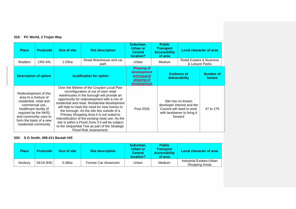
316: PC World, 2 Trojan Way
Place Postcode Size of site Site description Suburban, Urban or Central
location?
Public Transport
Accessibility of area
Local character of area
Waddon CR0 4XL 1.03ha Retail Warehouse and car park Urban Medium Retail Estates & Business
& Leisure Parks
Description of option Justification for option
Phasing of development Anticipated phasing of
development
Evidence of deliverability
Number of homes
Redevelopment of this area to a mixture of
residential, retail and commercial use,
healthcare facility (if required by the NHS)
and community uses to form the basis of a new residential community
Over the lifetime of the Croydon Local Plan reconfiguration of out of town retail
warehouses in the borough will provide an opportunity for redevelopment with a mix of
residential and retail. Residential development will help to meet the need for new homes in
the borough. As the site lies outside of a Primary Shopping Area it is not suited to
intensification of the existing retail use. As the site is within a Flood Zone 3 it will be subject to the Sequential Test as part of the Strategic
Flood Risk Assessment.
Post 2026
Site has no known developer interest and the Council will need to work with landowner to bring it
forward
47 to 175
320: S G Smith, 409-411 Beulah Hill
Place Postcode Size of site Site description Suburban, Urban or Central
location?
Public Transport
Accessibility of area
Local character of area
Norbury SE19 3HD 0.36ha Former Car showroom Urban Medium Industrial Estates;Urban Shopping Areas
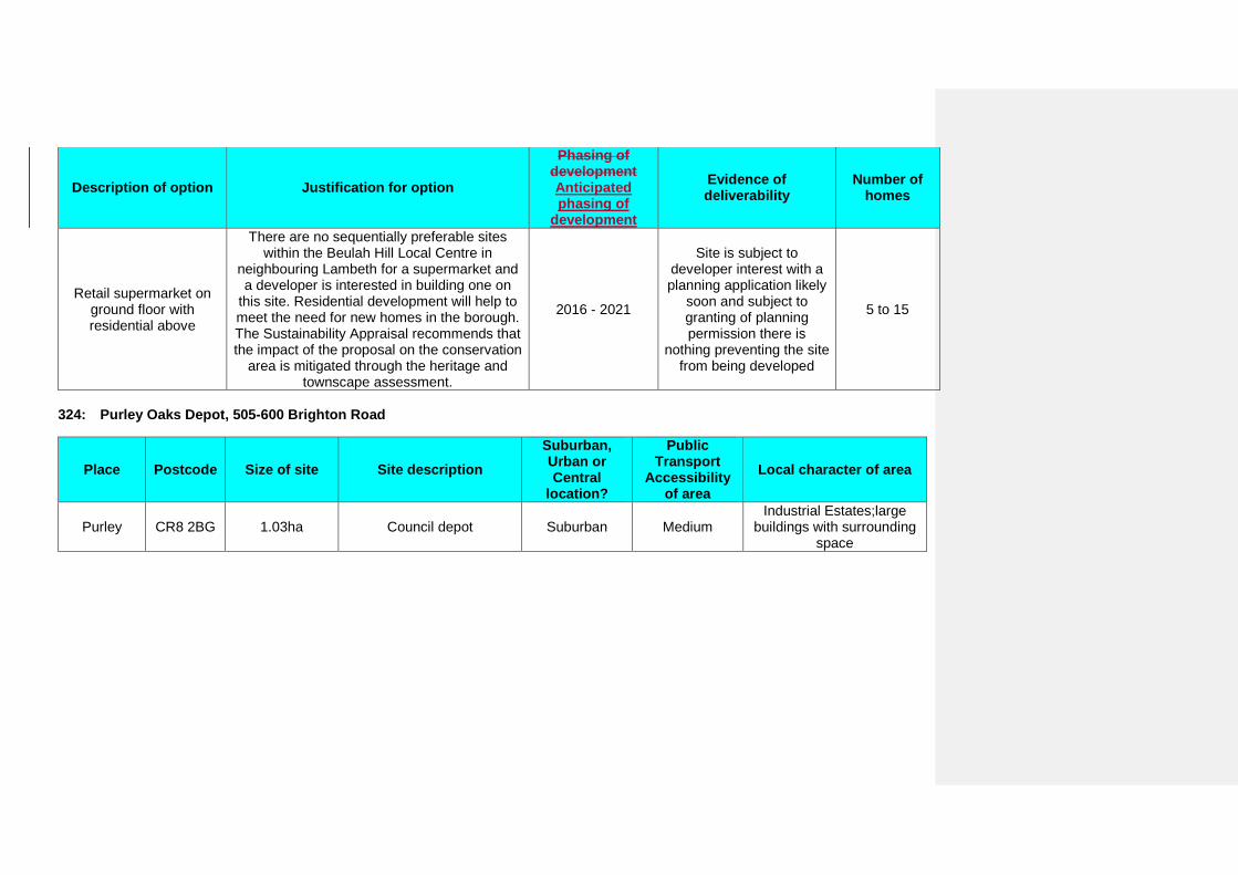
Description of option Justification for option
Phasing of development Anticipated phasing of
development
Evidence of deliverability
Number of homes
Retail supermarket on ground floor with residential above
There are no sequentially preferable sites within the Beulah Hill Local Centre in
neighbouring Lambeth for a supermarket and a developer is interested in building one on
this site. Residential development will help to meet the need for new homes in the borough. The Sustainability Appraisal recommends that the impact of the proposal on the conservation
area is mitigated through the heritage and townscape assessment.
2016 - 2021
Site is subject to developer interest with a planning application likely
soon and subject to granting of planning permission there is
nothing preventing the site from being developed
5 to 15
324: Purley Oaks Depot, 505-600 Brighton Road
Place Postcode Size of site Site description Suburban, Urban or Central
location?
Public Transport
Accessibility of area
Local character of area
Purley CR8 2BG 1.03ha Council depot Suburban Medium Industrial Estates;large
buildings with surrounding space
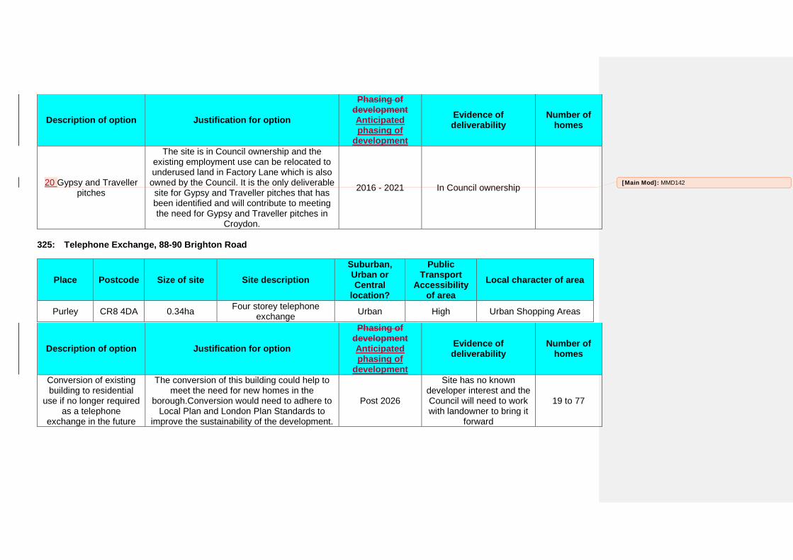
Description of option Justification for option
Phasing of development Anticipated phasing of
development
Evidence of deliverability
Number of homes
20 Gypsy and Traveller pitches
The site is in Council ownership and the existing employment use can be relocated to underused land in Factory Lane which is also
owned by the Council. It is the only deliverable site for Gypsy and Traveller pitches that has been identified and will contribute to meeting the need for Gypsy and Traveller pitches in
Croydon.
2016 - 2021 In Council ownership
325: Telephone Exchange, 88-90 Brighton Road
Place Postcode Size of site Site description Suburban, Urban or Central
location?
Public Transport
Accessibility of area
Local character of area
Purley CR8 4DA 0.34ha Four storey telephone exchange Urban High Urban Shopping Areas
Description of option Justification for option
Phasing of development Anticipated phasing of
development
Evidence of deliverability
Number of homes
Conversion of existing building to residential
use if no longer required as a telephone
exchange in the future
The conversion of this building could help to meet the need for new homes in the
borough.Conversion would need to adhere to Local Plan and London Plan Standards to
improve the sustainability of the development.
Post 2026
Site has no known developer interest and the Council will need to work with landowner to bring it
forward
19 to 77
[Main Mod]: MMD142
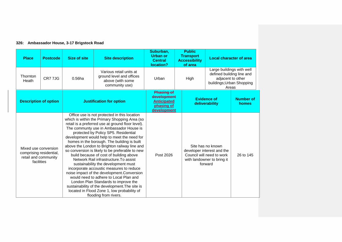
326: Ambassador House, 3-17 Brigstock Road
Place Postcode Size of site Site description Suburban, Urban or Central
location?
Public Transport
Accessibility of area
Local character of area
Thornton Heath CR7 7JG 0.56ha
Various retail units at ground level and offices
above (with some community use)
Urban High
Large buildings with well defined building line and
adjacent to other buildings;Urban Shopping
Areas
Description of option Justification for option
Phasing of development Anticipated phasing of
development
Evidence of deliverability
Number of homes
Mixed use conversion comprising residential, retail and community
facilities
Office use is not protected in this location which is within the Primary Shopping Area (so retail is a preferred use at ground floor level). The communty use in Ambassador House is
protected by Policy SP5. Residential development would help to meet the need for
homes in the borough. The building is built above the London to Brighton railway line and so conversion is likely to be preferable to new
build because of cost of building above Network Rail infrastructure.To assist sustainability the development must
incorporate accoustic measures to reduce noise impact of the development.Conversion
would need to adhere to Local Plan and London Plan Standards to improve the
sustainability of the development.The site is located in Flood Zone 1, low probability of
flooding from rivers.
Post 2026
Site has no known developer interest and the Council will need to work with landowner to bring it
forward
26 to 145
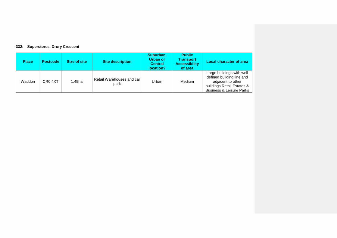
332: Superstores, Drury Crescent
Place Postcode Size of site Site description Suburban, Urban or Central
location?
Public Transport
Accessibility of area
Local character of area
Waddon CR0 4XT 1.45ha Retail Warehouses and car park Urban Medium
Large buildings with well defined building line and
adjacent to other buildings;Retail Estates & Business & Leisure Parks
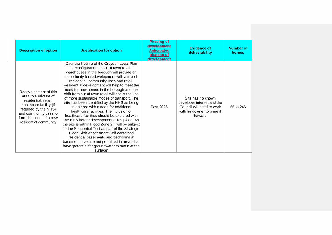
Description of option Justification for option
Phasing of development Anticipated phasing of
development
Evidence of deliverability
Number of homes
Redevelopment of this area to a mixture of residential, retail,
healthcare facility (if required by the NHS)
and community uses to form the basis of a new residential community
Over the lifetime of the Croydon Local Plan reconfiguration of out of town retail
warehouses in the borough will provide an opportunity for redevelopment with a mix of
residential, community uses and retail. Residential development will help to meet the need for new homes in the borough and the shift from out of town retail will assist the use of more sustainable modes of transport. The site has been identified by the NHS as being
in an area with a need for additional healthcare facilities. The inclusion of
healthcare facilities should be explored with the NHS before development takes place. As
the site is within Flood Zone 2 it will be subject to the Sequential Test as part of the Strategic
Flood Risk Assessment.Self-contained residential basements and bedrooms at
basement level are not permitted in areas that have ‘potential for groundwater to occur at the
surface’
Post 2026
Site has no known developer interest and the Council will need to work with landowner to bring it
forward
66 to 246
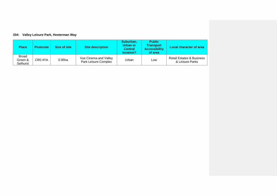
334: Valley Leisure Park, Hesterman Way
Place Postcode Size of site Site description Suburban, Urban or Central
location?
Public Transport
Accessibility of area
Local character of area
Broad Green & Selhurst
CR0 4YA 0.95ha Vue Cinema and Valley Park Leisure Complex Urban Low Retail Estates & Business
& Leisure Parks
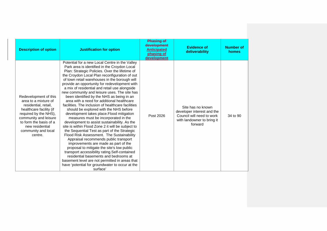
Description of option Justification for option
Phasing of development Anticipated phasing of
development
Evidence of deliverability
Number of homes
Redevelopment of this area to a mixture of residential, retail,
healthcare facility (if required by the NHS), community and leisure to form the basis of a
new residential community and local
centre.
Potential for a new Local Centre in the Valley Park area is identified in the Croydon Local Plan: Strategic Policies. Over the lifetime of
the Croydon Local Plan reconfiguration of out of town retail warehouses in the borough will
provide an opportunity for redevelopment with a mix of residential and retail use alongside
new community and leisure uses. The site has been identified by the NHS as being in an area with a need for additional healthcare
facilities. The inclusion of healthcare facilities should be explored with the NHS before
development takes place.Flood mitigation measures must be incorporated in the
development to assist sustainability. As the site is within Flood Zone 2 it will be subject to the Sequential Test as part of the Strategic Flood Risk Assessment. The Sustainability
Appraisal recommends public transport improvements are made as part of the
proposal to mitigate the site's low public transport accessibility rating.Self-contained
residential basements and bedrooms at basement level are not permitted in areas that have ‘potential for groundwater to occur at the
surface’
Post 2026
Site has no known developer interest and the Council will need to work with landowner to bring it
forward
34 to 90

337: Zodiac Court, 161-183 London Road
Place Postcode Size of site Site description Suburban, Urban or Central
location?
Public Transport
Accessibility of area
Local character of area
Broad Green & Selhurst
CR0 2RJ 0.71ha Residential building with ground floor commercial
units Urban High
Large buildings with well defined building line and
adjacent to other buildings;Urban Shopping
Areas
Description of option Justification for option
Phasing of development Anticipated phasing of
development
Evidence of deliverability
Number of homes
Residential redevelopment
Redevelopment provides an opportunity to intensify the use of the site. However, it is noted that there are significant issues with
viability of redevelopment that will need to be overcome before this site could be
developed.Self-contained residential basements and bedrooms at basement level are not permitted in areas that have ‘potential
for groundwater to occur at the surface’
Post 2026
Site has no known developer interest and the Council will need to work with landowner to bring it
forward
32 to 184
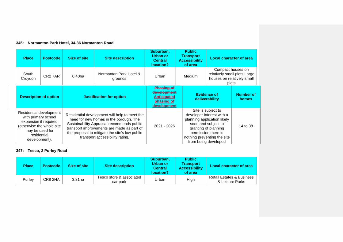
345: Normanton Park Hotel, 34-36 Normanton Road
Place Postcode Size of site Site description Suburban, Urban or Central
location?
Public Transport
Accessibility of area
Local character of area
South Croydon CR2 7AR 0.40ha Normanton Park Hotel &
grounds Urban Medium
Compact houses on relatively small plots;Large houses on relatively small
plots
Description of option Justification for option
Phasing of development Anticipated phasing of
development
Evidence of deliverability
Number of homes
Residential development with primary school
expansion if required (otherwise the whole site
may be used for residential
development).
Residential development will help to meet the need for new homes in the borough. The
Sustainability Appraisal recommends public transport improvements are made as part of the proposal to mitigate the site's low public
transport accessibility rating.
2021 - 2026
Site is subject to developer interest with a planning application likely
soon and subject to granting of planning permission there is
nothing preventing the site from being developed
14 to 38
347: Tesco, 2 Purley Road
Place Postcode Size of site Site description Suburban, Urban or Central
location?
Public Transport
Accessibility of area
Local character of area
Purley CR8 2HA 3.81ha Tesco store & associated car park Urban High Retail Estates & Business
& Leisure Parks
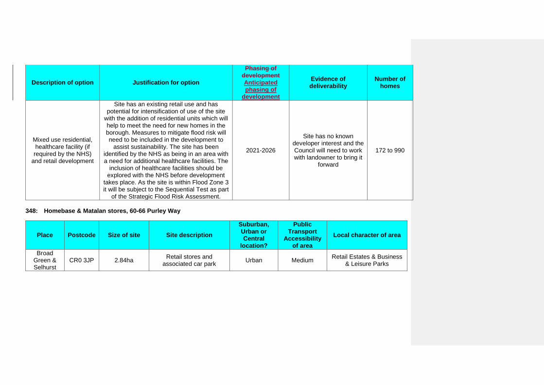
Description of option Justification for option
Phasing of development Anticipated phasing of
development
Evidence of deliverability
Number of homes
Mixed use residential, healthcare facility (if required by the NHS)
and retail development
Site has an existing retail use and has potential for intensification of use of the site
with the addition of residential units which will help to meet the need for new homes in the borough. Measures to mitigate flood risk will need to be included in the development to
assist sustainability. The site has been identified by the NHS as being in an area with a need for additional healthcare facilities. The
inclusion of healthcare facilities should be explored with the NHS before development
takes place. As the site is within Flood Zone 3 it will be subject to the Sequential Test as part
of the Strategic Flood Risk Assessment.
2021-2026
Site has no known developer interest and the Council will need to work with landowner to bring it
forward
172 to 990
348: Homebase & Matalan stores, 60-66 Purley Way
Place Postcode Size of site Site description Suburban, Urban or Central
location?
Public Transport
Accessibility of area
Local character of area
Broad Green & Selhurst
CR0 3JP 2.84ha Retail stores and associated car park Urban Medium Retail Estates & Business
& Leisure Parks
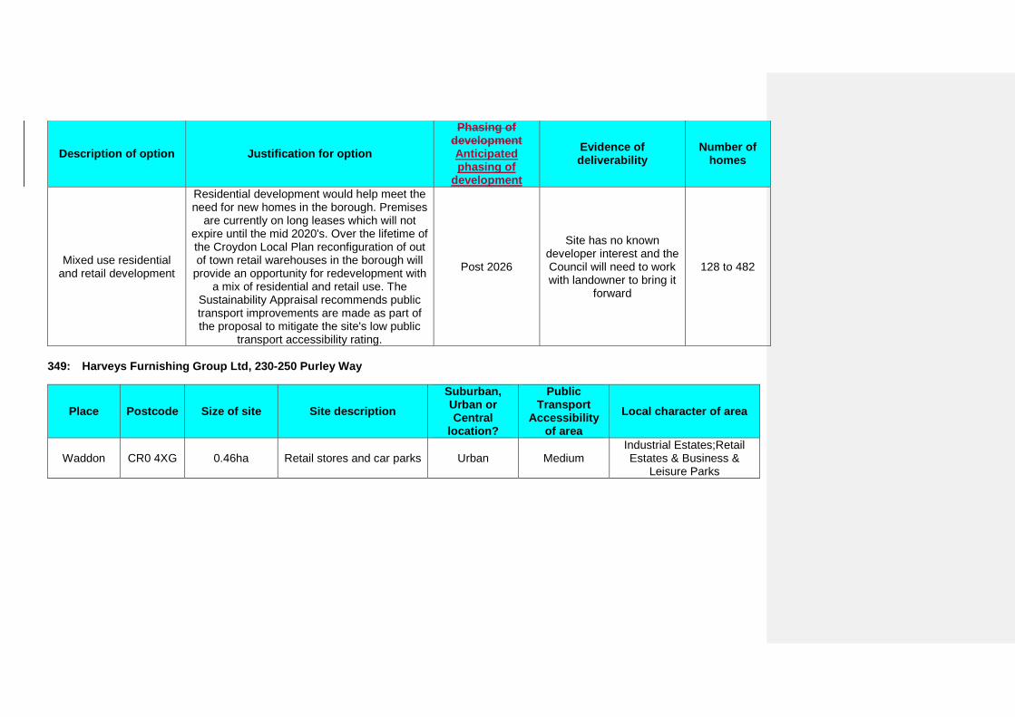
Description of option Justification for option
Phasing of development Anticipated phasing of
development
Evidence of deliverability
Number of homes
Mixed use residential and retail development
Residential development would help meet the need for new homes in the borough. Premises
are currently on long leases which will not expire until the mid 2020's. Over the lifetime of the Croydon Local Plan reconfiguration of out of town retail warehouses in the borough will
provide an opportunity for redevelopment with a mix of residential and retail use. The
Sustainability Appraisal recommends public transport improvements are made as part of the proposal to mitigate the site's low public
transport accessibility rating.
Post 2026
Site has no known developer interest and the Council will need to work with landowner to bring it
forward
128 to 482
349: Harveys Furnishing Group Ltd, 230-250 Purley Way
Place Postcode Size of site Site description Suburban, Urban or Central
location?
Public Transport
Accessibility of area
Local character of area
Waddon CR0 4XG 0.46ha Retail stores and car parks Urban Medium Industrial Estates;Retail Estates & Business &
Leisure Parks
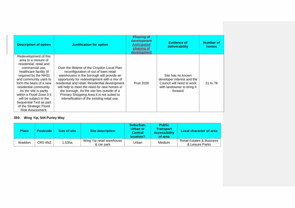
Description of option Justification for option
Phasing of development Anticipated phasing of
development
Evidence of deliverability
Number of homes
Redevelopment of this area to a mixture of
residential, retail and commercial use,
healthcare facility (if required by the NHS)
and community uses to form the basis of a new residential community.
As the site is partly within a Flood Zone 3 it
will be subject to the Sequential Test as part of the Strategic Flood
Risk Assessment.
Over the lifetime of the Croydon Local Plan reconfiguration of out of town retail
warehouses in the borough will provide an opportunity for redevelopment with a mix of
residential and retail. Residential development will help to meet the need for new homes in
the borough. As the site lies outside of a Primary Shopping Area it is not suited to intensification of the existing retail use.
Post 2026
Site has no known developer interest and the Council will need to work with landowner to bring it
forward
21 to 78
350: Wing Yip, 544 Purley Way
Place Postcode Size of site Site description Suburban, Urban or Central
location?
Public Transport
Accessibility of area
Local character of area
Waddon CR0 4NZ 1.53ha Wing Yip retail warehouse & car park Urban Medium Retail Estates & Business
& Leisure Parks
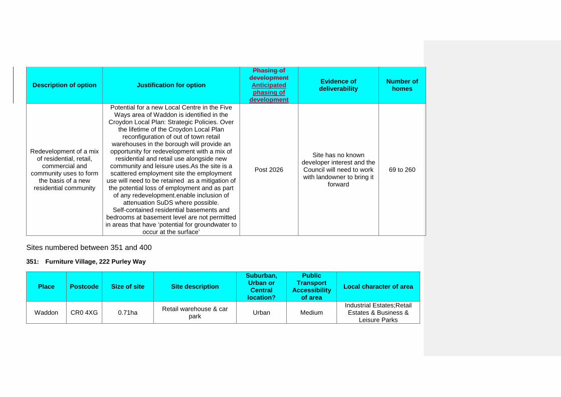
Description of option Justification for option
Phasing of development Anticipated phasing of
development
Evidence of deliverability
Number of homes
Redevelopment of a mix of residential, retail,
commercial and community uses to form
the basis of a new residential community
Potential for a new Local Centre in the Five Ways area of Waddon is identified in the
Croydon Local Plan: Strategic Policies. Over the lifetime of the Croydon Local Plan
reconfiguration of out of town retail warehouses in the borough will provide an opportunity for redevelopment with a mix of
residential and retail use alongside new community and leisure uses.As the site is a scattered employment site the employment
use will need to be retained as a mitigation of the potential loss of employment and as part
of any redevelopment.enable inclusion of attenuation SuDS where possible.
Self-contained residential basements and bedrooms at basement level are not permitted in areas that have ‘potential for groundwater to
occur at the surface’
Post 2026
Site has no known developer interest and the Council will need to work with landowner to bring it
forward
69 to 260
Sites numbered between 351 and 400
351: Furniture Village, 222 Purley Way
Place Postcode Size of site Site description Suburban, Urban or Central
location?
Public Transport
Accessibility of area
Local character of area
Waddon CR0 4XG 0.71ha Retail warehouse & car park Urban Medium
Industrial Estates;Retail Estates & Business &
Leisure Parks

Description of option Justification for option
Phasing of development Anticipated phasing of
development
Evidence of deliverability
Number of homes
Redevelopment of this area to a mixture of residential, retail,
healthcare facility (if required by NHS) and
community uses to form the basis of a new
residential community
Over the lifetime of the Croydon Local Plan reconfiguration of out of town retail
warehouses in the borough will provide an opportunity for redevelopment with a mix of
residential and retail. Residential development will help to meet the need for new homes in
the borough. As the site lies outside of a Primary Shopping Area it is not suited to
intensification of the existing retail use. As the site is partly within a Flood Zone 3 it will be subject to the Sequential Test as part of the
Strategic Flood Risk Assessment.enable inclusion of attenuation SuDS where possible.
Self-contained residential basements and bedrooms at basement level are not permitted in areas that have ‘potential for groundwater to
occur at the surface’
Post 2026
Site has no known developer interest and the Council will need to work with landowner to bring it
forward
32 to 120
355: Decathlon, 2 Trafaglar Way
Place Postcode Size of site Site description Suburban, Urban or Central
location?
Public Transport
Accessibility of area
Local character of area
Waddon CR0 4XT 1.30ha Decathlon store & car park Urban Medium Retail Estates & Business & Leisure Parks

Description of option Justification for option
Phasing of development Anticipated phasing of
development
Evidence of deliverability
Number of homes
Redevelopment of this area to a mixture of residential, retail,
healthcare facility (if required by the NHS)
and community uses to form the basis of a new residential community
Over the lifetime of the Croydon Local Plan reconfiguration of out of town retail
warehouses in the borough will provide an opportunity for redevelopment with a mix of
residential, community uses and retail. Residential development will help to meet the
need for new homes in the borough. Measures to mitigate flood risk will need to be
included in the development to assist sustainability. The site has been identified by the NHS as being in an area with a need for
additional healthcare facilities. The inclusion of healthcare facilities should be explored with
the NHS before development takes place. The Sustainability Appraisal recommends public transport improvements are made as part of the proposal to mitigate the site's low public transport accessibility rating. As the site is
within a Flood Zone 3 it will be subject to the Sequential Test as part of the Strategic Flood
Risk Assessment.
Post 2026
Site has no known developer interest and the Council will need to work with landowner to bring it
forward
59 to 221
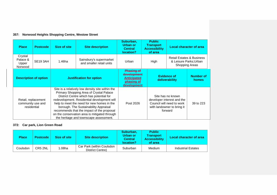
357: Norwood Heights Shopping Centre, Westow Street
Place Postcode Size of site Site description Suburban, Urban or Central
location?
Public Transport
Accessibility of area
Local character of area
Crystal Palace &
Upper Norwood
SE19 3AH 1.46ha Sainsbury's supermarket and smaller retail units Urban High
Retail Estates & Business & Leisure Parks;Urban
Shopping Areas
Description of option Justification for option
Phasing of development Anticipated phasing of
development
Evidence of deliverability
Number of homes
Retail, replacement community use and
residential
Site is a relatively low density site within the Primary Shopping Area of Crystal Palace
District Centre which has potential for redevelopment. Residential development will help to meet the need for new homes in the
borough. The Sustainability Appraisal recommends that the impact of the proposal on the conservation area is mitigated through
the heritage and townscape assessment.
Post 2026
Site has no known developer interest and the Council will need to work with landowner to bring it
forward
39 to 223
372: Car park, Lion Green Road
Place Postcode Size of site Site description Suburban, Urban or Central
location?
Public Transport
Accessibility of area
Local character of area
Coulsdon CR5 2NL 1.08ha Car Park (within Coulsdon District Centre) Suburban Medium Industrial Estates
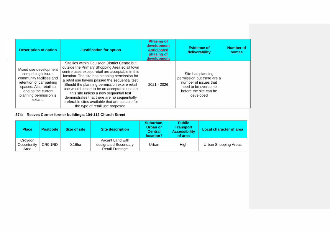
Description of option Justification for option
Phasing of development Anticipated phasing of
development
Evidence of deliverability
Number of homes
Mixed use development comprising leisure,
community facilities and retention of car parking spaces. Also retail so
long as the current planning permission is
extant.
Site lies within Coulsdon District Centre but outside the Primary Shopping Area so all town centre uses except retail are acceptable in this location. The site has planning permission for a retail use having passed the sequential test. Should the planning permission expire retail use would cease to be an acceptable use on
this site unless a new sequential test demonstrates that there are no sequentially
preferable sites available that are suitable for the type of retail use proposed.
2021 - 2026
Site has planning permission but there are a
number of issues that need to be overcome before the site can be
developed
374: Reeves Corner former buildings, 104-112 Church Street
Place Postcode Size of site Site description Suburban, Urban or Central
location?
Public Transport
Accessibility of area
Local character of area
Croydon Opportunity
Area CR0 1RD 0.16ha
Vacant Land with designated Secondary
Retail Frontage Urban High Urban Shopping Areas
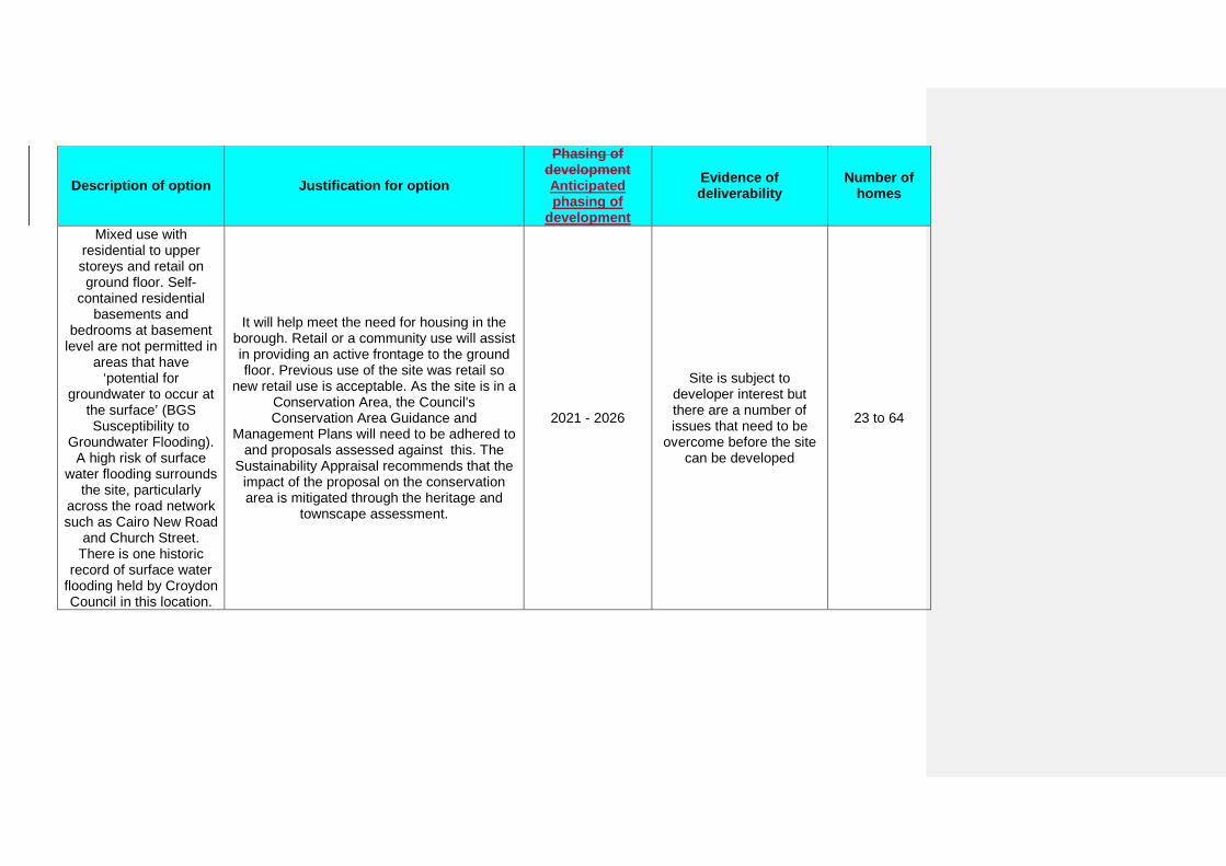
Description of option Justification for option
Phasing of development Anticipated phasing of
development
Evidence of deliverability
Number of homes
Mixed use with residential to upper storeys and retail on ground floor. Self-
contained residential basements and
bedrooms at basement level are not permitted in
areas that have ‘potential for
groundwater to occur at the surface’ (BGS Susceptibility to
Groundwater Flooding). A high risk of surface
water flooding surrounds the site, particularly
across the road network such as Cairo New Road
and Church Street. There is one historic
record of surface water flooding held by Croydon Council in this location.
It will help meet the need for housing in the borough. Retail or a community use will assist in providing an active frontage to the ground floor. Previous use of the site was retail so
new retail use is acceptable. As the site is in a Conservation Area, the Council's Conservation Area Guidance and
Management Plans will need to be adhered to and proposals assessed against this. The
Sustainability Appraisal recommends that the impact of the proposal on the conservation area is mitigated through the heritage and
townscape assessment.
2021 - 2026
Site is subject to developer interest but there are a number of issues that need to be
overcome before the site can be developed
23 to 64
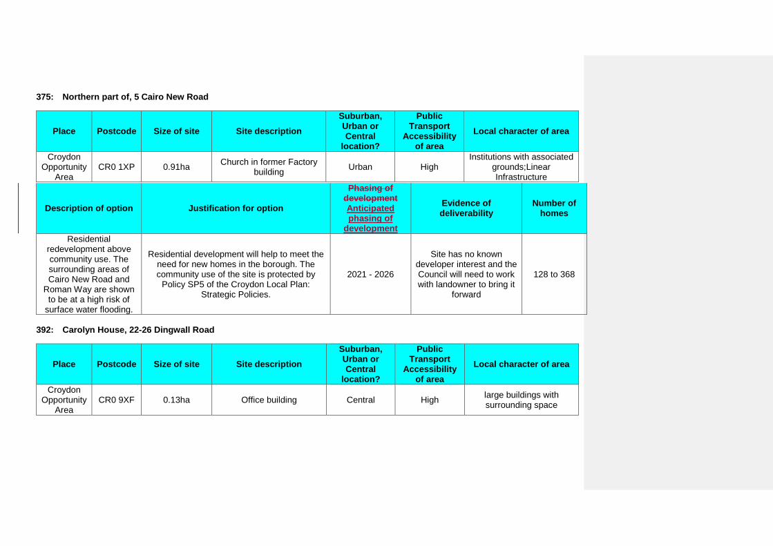
375: Northern part of, 5 Cairo New Road
Place Postcode Size of site Site description Suburban, Urban or Central
location?
Public Transport
Accessibility of area
Local character of area
Croydon Opportunity
Area CR0 1XP 0.91ha Church in former Factory
building Urban High Institutions with associated
grounds;Linear Infrastructure
Description of option Justification for option
Phasing of development Anticipated phasing of
development
Evidence of deliverability
Number of homes
Residential redevelopment above community use. The surrounding areas of Cairo New Road and
Roman Way are shown to be at a high risk of
surface water flooding.
Residential development will help to meet the need for new homes in the borough. The community use of the site is protected by
Policy SP5 of the Croydon Local Plan: Strategic Policies.
2021 - 2026
Site has no known developer interest and the Council will need to work with landowner to bring it
forward
128 to 368
392: Carolyn House, 22-26 Dingwall Road
Place Postcode Size of site Site description Suburban, Urban or Central
location?
Public Transport
Accessibility of area
Local character of area
Croydon Opportunity
Area CR0 9XF 0.13ha Office building Central High large buildings with
surrounding space
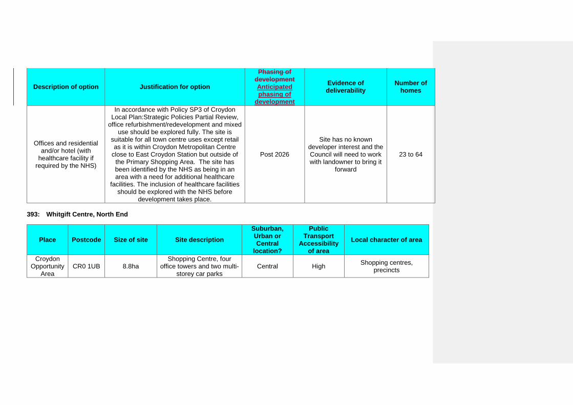
Description of option Justification for option
Phasing of development Anticipated phasing of
development
Evidence of deliverability
Number of homes
Offices and residential and/or hotel (with
healthcare facility if required by the NHS)
In accordance with Policy SP3 of Croydon Local Plan:Strategic Policies Partial Review,
office refurbishment/redevelopment and mixed use should be explored fully. The site is
suitable for all town centre uses except retail as it is within Croydon Metropolitan Centre
close to East Croydon Station but outside of the Primary Shopping Area. The site has been identified by the NHS as being in an area with a need for additional healthcare
facilities. The inclusion of healthcare facilities should be explored with the NHS before
development takes place.
Post 2026
Site has no known developer interest and the Council will need to work with landowner to bring it
forward
23 to 64
393: Whitgift Centre, North End
Place Postcode Size of site Site description Suburban, Urban or Central
location?
Public Transport
Accessibility of area
Local character of area
Croydon Opportunity
Area CR0 1UB 8.8ha
Shopping Centre, four office towers and two multi-
storey car parks Central High Shopping centres,
precincts
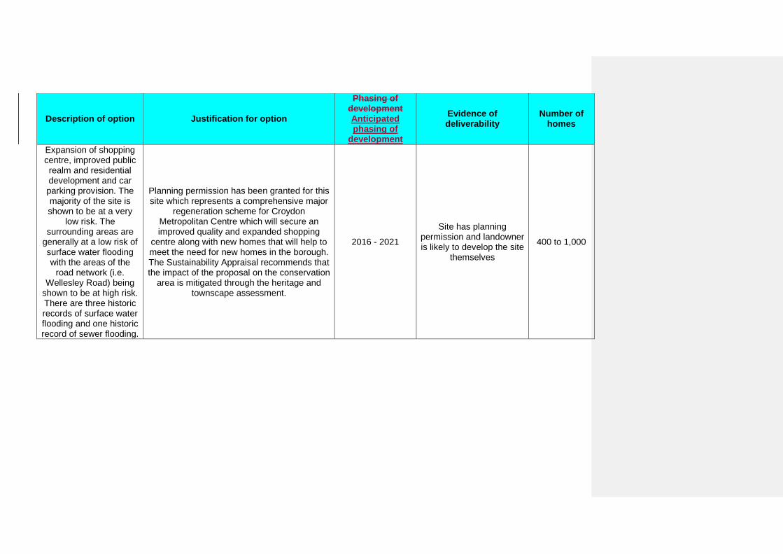
Description of option Justification for option
Phasing of development Anticipated phasing of
development
Evidence of deliverability
Number of homes
Expansion of shopping centre, improved public realm and residential development and car parking provision. The majority of the site is shown to be at a very
low risk. The surrounding areas are
generally at a low risk of surface water flooding with the areas of the
road network (i.e. Wellesley Road) being
shown to be at high risk. There are three historic records of surface water flooding and one historic record of sewer flooding.
Planning permission has been granted for this site which represents a comprehensive major
regeneration scheme for Croydon Metropolitan Centre which will secure an improved quality and expanded shopping
centre along with new homes that will help to meet the need for new homes in the borough. The Sustainability Appraisal recommends that the impact of the proposal on the conservation
area is mitigated through the heritage and townscape assessment.
2016 - 2021
Site has planning permission and landowner is likely to develop the site
themselves
400 to 1,000
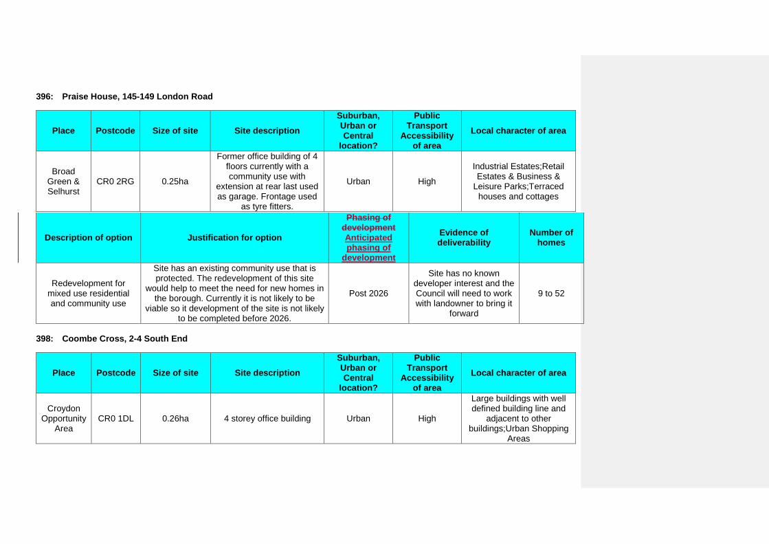
396: Praise House, 145-149 London Road
Place Postcode Size of site Site description Suburban, Urban or Central
location?
Public Transport
Accessibility of area
Local character of area
Broad Green & Selhurst
CR0 2RG 0.25ha
Former office building of 4 floors currently with a community use with
extension at rear last used as garage. Frontage used
as tyre fitters.
Urban High
Industrial Estates;Retail Estates & Business &
Leisure Parks;Terraced houses and cottages
Description of option Justification for option
Phasing of development Anticipated phasing of
development
Evidence of deliverability
Number of homes
Redevelopment for mixed use residential and community use
Site has an existing community use that is protected. The redevelopment of this site
would help to meet the need for new homes in the borough. Currently it is not likely to be
viable so it development of the site is not likely to be completed before 2026.
Post 2026
Site has no known developer interest and the Council will need to work with landowner to bring it
forward
9 to 52
398: Coombe Cross, 2-4 South End
Place Postcode Size of site Site description Suburban, Urban or Central
location?
Public Transport
Accessibility of area
Local character of area
Croydon Opportunity
Area CR0 1DL 0.26ha 4 storey office building Urban High
Large buildings with well defined building line and
adjacent to other buildings;Urban Shopping
Areas
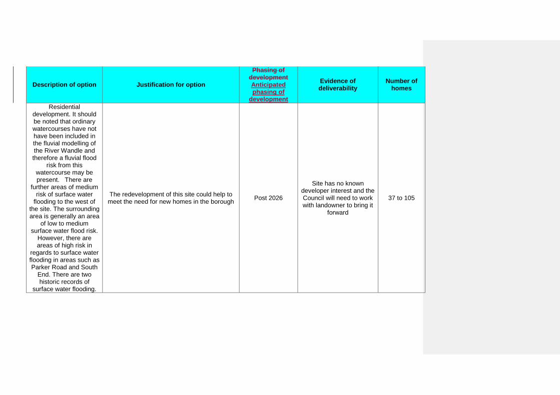
Description of option Justification for option
Phasing of development Anticipated phasing of
development
Evidence of deliverability
Number of homes
Residential development. It should be noted that ordinary watercourses have not have been included in the fluvial modelling of the River Wandle and therefore a fluvial flood
risk from this watercourse may be present. There are
further areas of medium risk of surface water
flooding to the west of the site. The surrounding area is generally an area
of low to medium surface water flood risk.
However, there are areas of high risk in
regards to surface water flooding in areas such as Parker Road and South
End. There are two historic records of
surface water flooding.
The redevelopment of this site could help to meet the need for new homes in the borough Post 2026
Site has no known developer interest and the Council will need to work with landowner to bring it
forward
37 to 105
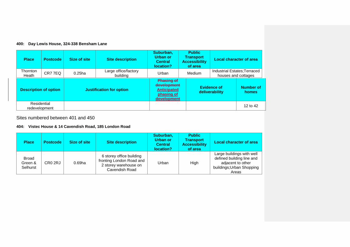
400: Day Lewis House, 324-338 Bensham Lane
Place Postcode Size of site Site description Suburban, Urban or Central
location?
Public Transport
Accessibility of area
Local character of area
Thornton Heath CR7 7EQ 0.25ha Large office/factory
building Urban Medium Industrial Estates;Terraced houses and cottages
Description of option Justification for option
Phasing of development Anticipated phasing of
development
Evidence of deliverability
Number of homes
Residential redevelopment 12 to 42
Sites numbered between 401 and 450
404: Vistec House & 14 Cavendish Road, 185 London Road
Place Postcode Size of site Site description Suburban, Urban or Central
location?
Public Transport
Accessibility of area
Local character of area
Broad Green & Selhurst
CR0 2RJ 0.69ha
6 storey office building fronting London Road and
2 storey warehouse on Cavendish Road
Urban High
Large buildings with well defined building line and
adjacent to other buildings;Urban Shopping
Areas
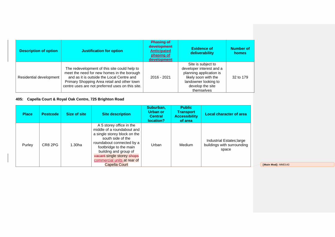
Description of option Justification for option
Phasing of development Anticipated phasing of
development
Evidence of deliverability
Number of homes
Residential development
The redevelopment of this site could help to meet the need for new homes in the borough
and as it is outside the Local Centre and Primary Shopping Area retail and other town
centre uses are not preferred uses on this site.
2016 - 2021
Site is subject to developer interest and a planning application is
likely soon with the landowner looking to
develop the site themselves
32 to 179
405: Capella Court & Royal Oak Centre, 725 Brighton Road
Place Postcode Size of site Site description Suburban, Urban or Central
location?
Public Transport
Accessibility of area
Local character of area
Purley CR8 2PG 1.30ha
A 5 storey office in the middle of a roundabout and a single storey block on the
south side of the roundabout connected by a
footbridge to the main building and group of
vacant single storey shops commercial units at rear of
Capella Court
Urban Medium Industrial Estates;large
buildings with surrounding space
[Main Mod]: MMD143
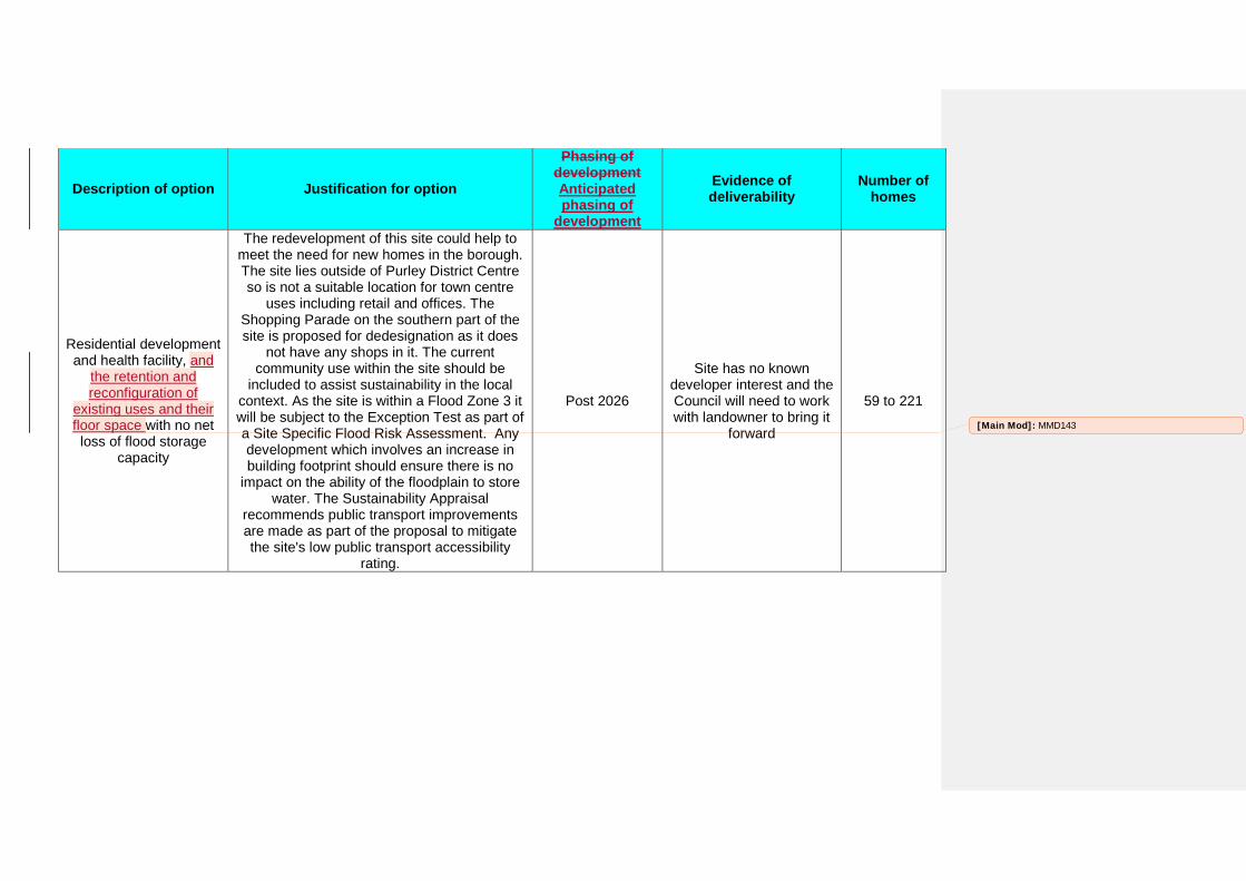
Description of option Justification for option
Phasing of development Anticipated phasing of
development
Evidence of deliverability
Number of homes
Residential development and health facility, and
the retention and reconfiguration of
existing uses and their floor space with no net loss of flood storage
capacity
The redevelopment of this site could help to meet the need for new homes in the borough. The site lies outside of Purley District Centre so is not a suitable location for town centre
uses including retail and offices. The Shopping Parade on the southern part of the site is proposed for dedesignation as it does
not have any shops in it. The current community use within the site should be
included to assist sustainability in the local context. As the site is within a Flood Zone 3 it will be subject to the Exception Test as part of a Site Specific Flood Risk Assessment. Any development which involves an increase in building footprint should ensure there is no
impact on the ability of the floodplain to store water. The Sustainability Appraisal
recommends public transport improvements are made as part of the proposal to mitigate the site's low public transport accessibility
rating.
Post 2026
Site has no known developer interest and the Council will need to work with landowner to bring it
forward
59 to 221 [Main Mod]: MMD143
407: 797 London Road
Place Postcode Size of site Site description Suburban, Urban or Central
location?
Public Transport
Accessibility of area
Local character of area
Thornton Heath CR7 6AW 0.15ha
Six storey office building and car park at least part
vacant Urban Medium
large buildings with surrounding space;Urban
Shopping Areas
Description of option Justification for option
Phasing of development Anticipated phasing of
development
Evidence of deliverability
Number of homes
Conversion or redevelopment to
residential use
Office use is not protected in this location and residential use would help meet the borough's need for new homes.Conversion would need
to adhere to Local Plan and London Plan Standards to improve the sustainability of the
development.
Post 2026
Site has no known developer interest and the Council will need to work with landowner to bring it
forward
7 to 25
409: Beech House, 840 Brighton Road
Place Postcode Size of site Site description Suburban, Urban or Central
location?
Public Transport
Accessibility of area
Local character of area
Purley CR8 2BH 0.14ha 4 storey office building Urban High
Large buildings in an urban setting;large buildings with surrounding space;Large buildings with well defined building line and adjacent
to other buildings
Description of option Justification for option
Phasing of development Anticipated phasing of
development
Evidence of deliverability
Number of homes
Conversion of the office building to residential
uses.
Located outside the proposed District Centre boundary so residential would be the preferred use, however the existing office use could be retained on the site. Residential development will help to meet the need for new homes in
the borough. Conversion would need to adhere to Local Plan and London Plan
Standards to improve the sustainability of the development. As 22% of the site is in Flood
Zone 2 any proposal for redevelopment should locate buildings within Flood Zone 1.
2016 - 2021
Site has planning permission and there is
nothing preventing the site from being developed
36 to 45
410: 100 Brighton Road
Place Postcode Size of site Site description Suburban, Urban or Central
location?
Public Transport
Accessibility of area
Local character of area
Purley CR8 4DA 0.22ha Co-op funeral service premises Urban Medium Urban Shopping Areas
Description of option Justification for option
Phasing of development Anticipated phasing of
development
Evidence of deliverability
Number of homes
Mixed use residential and retail development
Site has an existing retail use and has potential for intensification with the addition of
residential units which will help to meet the need for new homes in the borough.
Post 2026
Site has no known developer interest and the Council will need to work with landowner to bring it
forward
10 to 37
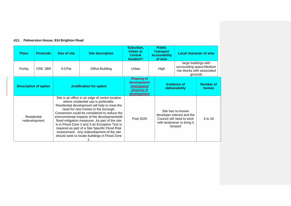
411: Palmerston House, 814 Brighton Road
Place Postcode Size of site Site description Suburban, Urban or Central
location?
Public Transport
Accessibility of area
Local character of area
Purley CR8 2BR 0.07ha Office Building Urban High
large buildings with surrounding space;Medium rise blocks with associated
grounds
Description of option Justification for option
Phasing of development Anticipated phasing of
development
Evidence of deliverability
Number of homes
Residential redevelopment
Site is an office in an edge of centre location where residential use is preferable.
Residential development will help to meet the need for new homes in the borough.
Conversion could be considered to reduce the environmental impacts of the developmentwith flood mitigation measures. As part of the site is in Flood Zone 2 and 3 an Exception Test is required as part of a Site Specific Flood Risk Assessment. Any redevelopment of the site should seek to locate buildings in Flood Zone
1.
Post 2026
Site has no known developer interest and the Council will need to work with landowner to bring it
forward
4 to 18
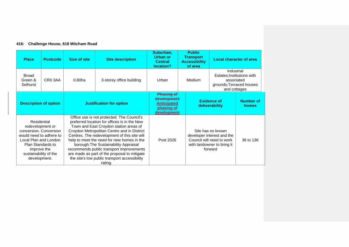
416: Challenge House, 618 Mitcham Road
Place Postcode Size of site Site description Suburban, Urban or Central
location?
Public Transport
Accessibility of area
Local character of area
Broad Green & Selhurst
CR0 3AA 0.80ha 3-storey office building Urban Medium
Industrial Estates;Institutions with
associated grounds;Terraced houses
and cottages
Description of option Justification for option
Phasing of development Anticipated phasing of
development
Evidence of deliverability
Number of homes
Residential redevelopment or
conversion. Conversion would need to adhere to Local Plan and London
Plan Standards to improve the
sustainability of the development.
Office use is not protected. The Council's preferred location for offices is in the New Town and East Croydon station areas of
Croydon Metropolitan Centre and in District Centres. The redevelopment of this site will help to meet the need for new homes in the
borough.The Sustainability Appraisal recommends public transport improvements are made as part of the proposal to mitigate the site's low public transport accessibility
rating.
Post 2026
Site has no known developer interest and the Council will need to work with landowner to bring it
forward
36 to 136
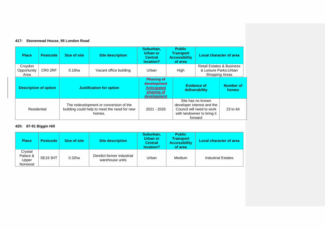
417: Stonemead House, 95 London Road
Place Postcode Size of site Site description Suburban, Urban or Central
location?
Public Transport
Accessibility of area
Local character of area
Croydon Opportunity
Area CR0 2RF 0.16ha Vacant office building Urban High
Retail Estates & Business & Leisure Parks;Urban
Shopping Areas
Description of option Justification for option
Phasing of development Anticipated phasing of
development
Evidence of deliverability
Number of homes
Residential The redevelopment or conversion of the
building could help to meet the need for new homes.
2021 - 2026
Site has no known developer interest and the Council will need to work with landowner to bring it
forward
23 to 64
420: 87-91 Biggin Hill
Place Postcode Size of site Site description Suburban, Urban or Central
location?
Public Transport
Accessibility of area
Local character of area
Crystal Palace &
Upper Norwood
SE19 3HT 0.32ha Derelict former industrial warehouse units Urban Medium Industrial Estates
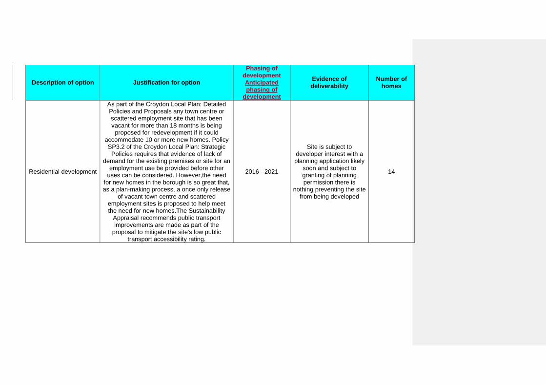
Description of option Justification for option
Phasing of development Anticipated phasing of
development
Evidence of deliverability
Number of homes
Residential development
As part of the Croydon Local Plan: Detailed Policies and Proposals any town centre or scattered employment site that has been vacant for more than 18 months is being
proposed for redevelopment if it could accommodate 10 or more new homes. Policy SP3.2 of the Croydon Local Plan: Strategic
Policies requires that evidence of lack of demand for the existing premises or site for an
employment use be provided before other uses can be considered. However,the need
for new homes in the borough is so great that, as a plan-making process, a once only release
of vacant town centre and scattered employment sites is proposed to help meet the need for new homes.The Sustainability
Appraisal recommends public transport improvements are made as part of the
proposal to mitigate the site's low public transport accessibility rating.
2016 - 2021
Site is subject to developer interest with a planning application likely
soon and subject to granting of planning permission there is
nothing preventing the site from being developed
14
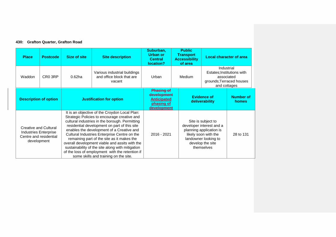
430: Grafton Quarter, Grafton Road
Place Postcode Size of site Site description Suburban, Urban or Central
location?
Public Transport
Accessibility of area
Local character of area
Waddon CR0 3RP 0.62ha Various industrial buildings
and office block that are vacant
Urban Medium
Industrial Estates;Institutions with
associated grounds;Terraced houses
and cottages
Description of option Justification for option
Phasing of development Anticipated phasing of
development
Evidence of deliverability
Number of homes
Creative and Cultural Industries Enterprise
Centre and residential development
It is an objective of the Croydon Local Plan: Strategic Policies to encourage creative and cultural industries in the borough. Permitting residential development on part of this site enables the development of a Creative and Cultural Industries Enterprise Centre on the
remaining part of the site as it makes the overall development viable and assits with the sustainability of the site along with mitigation
of the loss of employment with the retention if some skills and training on the site.
2016 - 2021
Site is subject to developer interest and a planning application is
likely soon with the landowner looking to
develop the site themselves
28 to 131
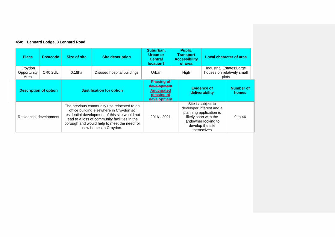
450: Lennard Lodge, 3 Lennard Road
Place Postcode Size of site Site description Suburban, Urban or Central
location?
Public Transport
Accessibility of area
Local character of area
Croydon Opportunity
Area CR0 2UL 0.18ha Disused hospital buildings Urban High
Industrial Estates;Large houses on relatively small
plots
Description of option Justification for option
Phasing of development Anticipated phasing of
development
Evidence of deliverability
Number of homes
Residential development
The previous community use relocated to an office building elsewhere in Croydon so
residential development of this site would not lead to a loss of community facilities in the
borough and would help to meet the need for new homes in Croydon.
2016 - 2021
Site is subject to developer interest and a planning application is
likely soon with the landowner looking to
develop the site themselves
9 to 46
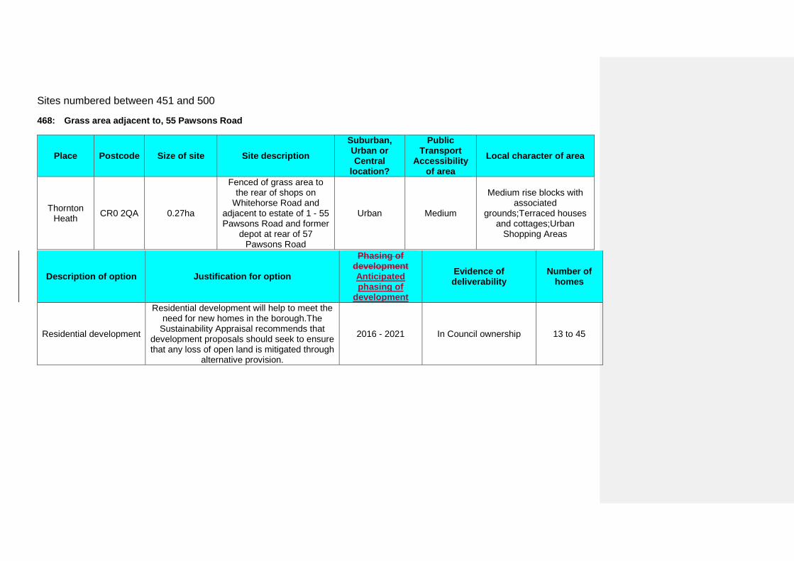
Sites numbered between 451 and 500
468: Grass area adjacent to, 55 Pawsons Road
Place Postcode Size of site Site description Suburban, Urban or Central
location?
Public Transport
Accessibility of area
Local character of area
Thornton Heath CR0 2QA 0.27ha
Fenced of grass area to the rear of shops on
Whitehorse Road and adjacent to estate of 1 - 55 Pawsons Road and former
depot at rear of 57 Pawsons Road
Urban Medium
Medium rise blocks with associated
grounds;Terraced houses and cottages;Urban
Shopping Areas
Description of option Justification for option
Phasing of development Anticipated phasing of
development
Evidence of deliverability
Number of homes
Residential development
Residential development will help to meet the need for new homes in the borough.The
Sustainability Appraisal recommends that development proposals should seek to ensure that any loss of open land is mitigated through
alternative provision.
2016 - 2021 In Council ownership 13 to 45
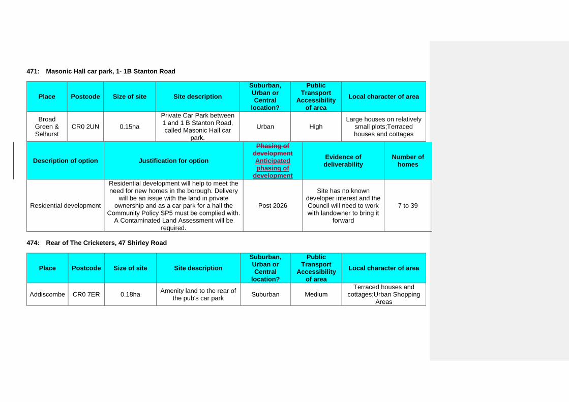
471: Masonic Hall car park, 1- 1B Stanton Road
Place Postcode Size of site Site description Suburban, Urban or Central
location?
Public Transport
Accessibility of area
Local character of area
Broad Green & Selhurst
CR0 2UN 0.15ha
Private Car Park between 1 and 1 B Stanton Road, called Masonic Hall car
park.
Urban High Large houses on relatively
small plots;Terraced houses and cottages
Description of option Justification for option
Phasing of development Anticipated phasing of
development
Evidence of deliverability
Number of homes
Residential development
Residential development will help to meet the need for new homes in the borough. Delivery
will be an issue with the land in private ownership and as a car park for a hall the
Community Policy SP5 must be complied with. A Contaminated Land Assessment will be
required.
Post 2026
Site has no known developer interest and the Council will need to work with landowner to bring it
forward
7 to 39
474: Rear of The Cricketers, 47 Shirley Road
Place Postcode Size of site Site description Suburban, Urban or Central
location?
Public Transport
Accessibility of area
Local character of area
Addiscombe CR0 7ER 0.18ha Amenity land to the rear of the pub's car park Suburban Medium
Terraced houses and cottages;Urban Shopping
Areas
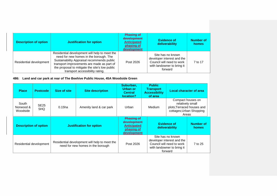
Description of option Justification for option
Phasing of development Anticipated phasing of
development
Evidence of deliverability
Number of homes
Residential development
Residential development will help to meet the need for new homes in the borough. The
Sustainability Appraisal recommends public transport improvements are made as part of the proposal to mitigate the site's low public
transport accessibility rating.
Post 2026
Site has no known developer interest and the Council will need to work with landowner to bring it
forward
7 to 17
486: Land and car park at rear of The Beehive Public House, 45A Woodside Green
Place Postcode Size of site Site description Suburban, Urban or Central
location?
Public Transport
Accessibility of area
Local character of area
South Norwood & Woodside
SE25 5HQ 0.15ha Amenity land & car park Urban Medium
Compact houses on relatively small
plots;Terraced houses and cottages;Urban Shopping
Areas
Description of option Justification for option
Phasing of development Anticipated phasing of
development
Evidence of deliverability
Number of homes
Residential development Residential development will help to meet the need for new homes in the borough Post 2026
Site has no known developer interest and the Council will need to work with landowner to bring it
forward
7 to 25
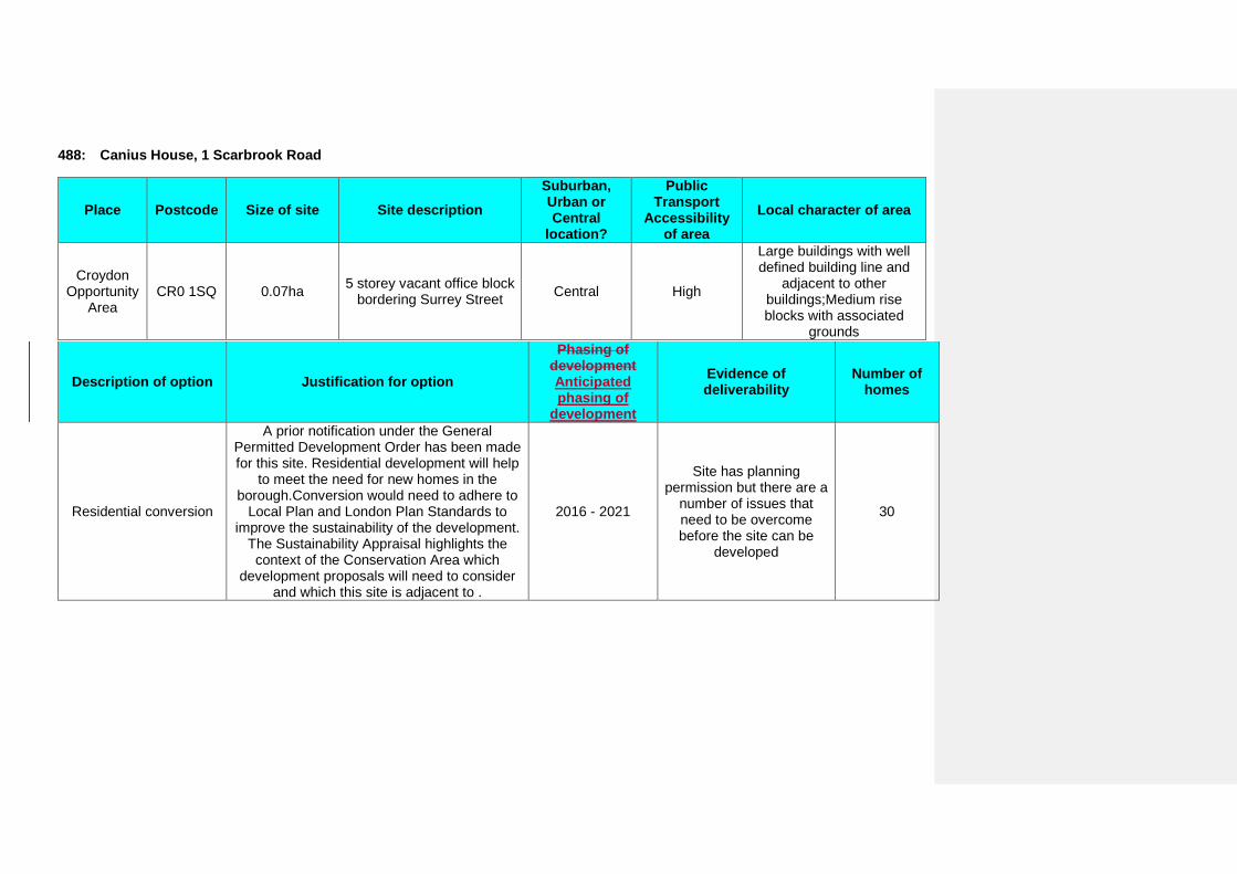
488: Canius House, 1 Scarbrook Road
Place Postcode Size of site Site description Suburban, Urban or Central
location?
Public Transport
Accessibility of area
Local character of area
Croydon Opportunity
Area CR0 1SQ 0.07ha 5 storey vacant office block
bordering Surrey Street Central High
Large buildings with well defined building line and
adjacent to other buildings;Medium rise blocks with associated
grounds
Description of option Justification for option
Phasing of development Anticipated phasing of
development
Evidence of deliverability
Number of homes
Residential conversion
A prior notification under the General Permitted Development Order has been made for this site. Residential development will help
to meet the need for new homes in the borough.Conversion would need to adhere to
Local Plan and London Plan Standards to improve the sustainability of the development.
The Sustainability Appraisal highlights the context of the Conservation Area which
development proposals will need to consider and which this site is adjacent to .
2016 - 2021
Site has planning permission but there are a
number of issues that need to be overcome before the site can be
developed
30
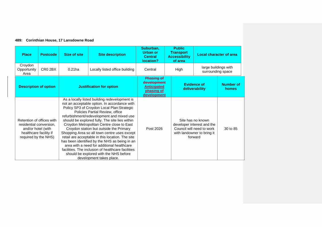
489: Corinthian House, 17 Lansdowne Road
Place Postcode Size of site Site description Suburban, Urban or Central
location?
Public Transport
Accessibility of area
Local character of area
Croydon Opportunity
Area CR0 2BX 0.21ha Locally listed office building Central High large buildings with
surrounding space
Description of option Justification for option
Phasing of development Anticipated phasing of
development
Evidence of deliverability
Number of homes
Retention of offices with residential conversion,
and/or hotel (with healthcare facility if
required by the NHS)
As a locally listed building redevelopment is not an acceptable option. In accordance with Policy SP3 of Croydon Local Plan:Strategic
Policies Partial Review, office refurbishment/redevelopment and mixed use should be explored fully. The site lies within Croydon Metropolitan Centre close to East
Croydon station but outside the Primary Shopping Area so all town centre uses except retail are acceptable in this location. The site has been identified by the NHS as being in an
area with a need for additional healthcare facilities. The inclusion of healthcare facilities
should be explored with the NHS before development takes place.
Post 2026
Site has no known developer interest and the Council will need to work with landowner to bring it
forward
30 to 85
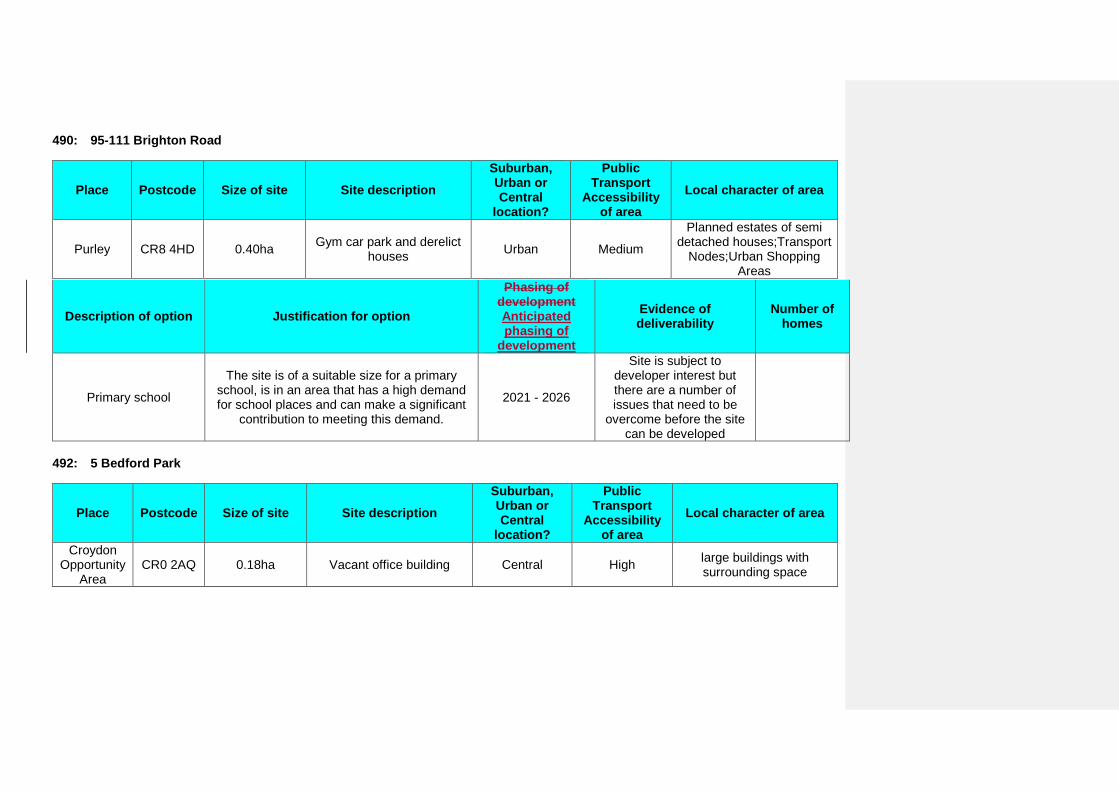
490: 95-111 Brighton Road
Place Postcode Size of site Site description Suburban, Urban or Central
location?
Public Transport
Accessibility of area
Local character of area
Purley CR8 4HD 0.40ha Gym car park and derelict houses Urban Medium
Planned estates of semi detached houses;Transport
Nodes;Urban Shopping Areas
Description of option Justification for option
Phasing of development Anticipated phasing of
development
Evidence of deliverability
Number of homes
Primary school
The site is of a suitable size for a primary school, is in an area that has a high demand for school places and can make a significant
contribution to meeting this demand.
2021 - 2026
Site is subject to developer interest but there are a number of issues that need to be
overcome before the site can be developed
492: 5 Bedford Park
Place Postcode Size of site Site description Suburban, Urban or Central
location?
Public Transport
Accessibility of area
Local character of area
Croydon Opportunity
Area CR0 2AQ 0.18ha Vacant office building Central High large buildings with
surrounding space
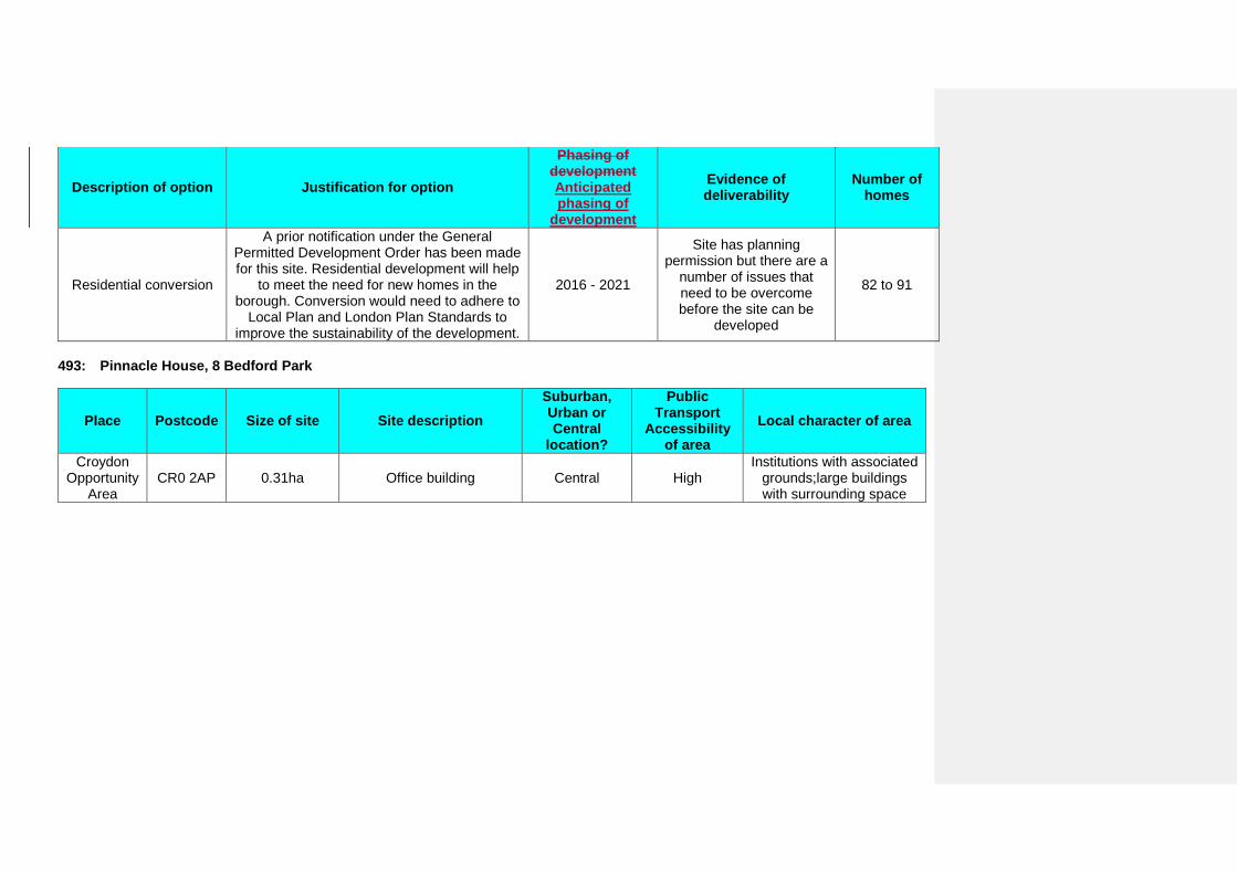
Description of option Justification for option
Phasing of development Anticipated phasing of
development
Evidence of deliverability
Number of homes
Residential conversion
A prior notification under the General Permitted Development Order has been made for this site. Residential development will help
to meet the need for new homes in the borough. Conversion would need to adhere to
Local Plan and London Plan Standards to improve the sustainability of the development.
2016 - 2021
Site has planning permission but there are a
number of issues that need to be overcome before the site can be
developed
82 to 91
493: Pinnacle House, 8 Bedford Park
Place Postcode Size of site Site description Suburban, Urban or Central
location?
Public Transport
Accessibility of area
Local character of area
Croydon Opportunity
Area CR0 2AP 0.31ha Office building Central High
Institutions with associated grounds;large buildings with surrounding space
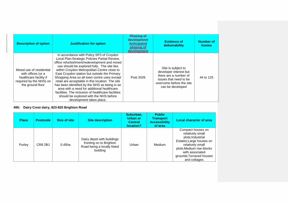
Description of option Justification for option
Phasing of development Anticipated phasing of
development
Evidence of deliverability
Number of homes
Mixed use of residential with offices (or a
healthcare facility if required by the NHS) on
the ground floor
In accordance with Policy SP3 of Croydon Local Plan:Strategic Policies Partial Review,
office refurbishment/redevelopment and mixed use should be explored fully. The site lies
within Croydon Metropolitan Centre close to East Croydon station but outside the Primary Shopping Area so all town centre uses except retail are acceptable in this location. The site has been identified by the NHS as being in an
area with a need for additional healthcare facilities. The inclusion of healthcare facilities
should be explored with the NHS before development takes place.
Post 2026
Site is subject to developer interest but there are a number of issues that need to be
overcome before the site can be developed
44 to 125
495: Dairy Crest dairy, 823-825 Brighton Road
Place Postcode Size of site Site description Suburban, Urban or Central
location?
Public Transport
Accessibility of area
Local character of area
Purley CR8 2BJ 0.45ha
Dairy depot with buildings fronting on to Brighton
Road being a locally listed building
Urban Medium
Compact houses on relatively small plots;Industrial
Estates;Large houses on relatively small
plots;Medium rise blocks with associated
grounds;Terraced houses and cottages
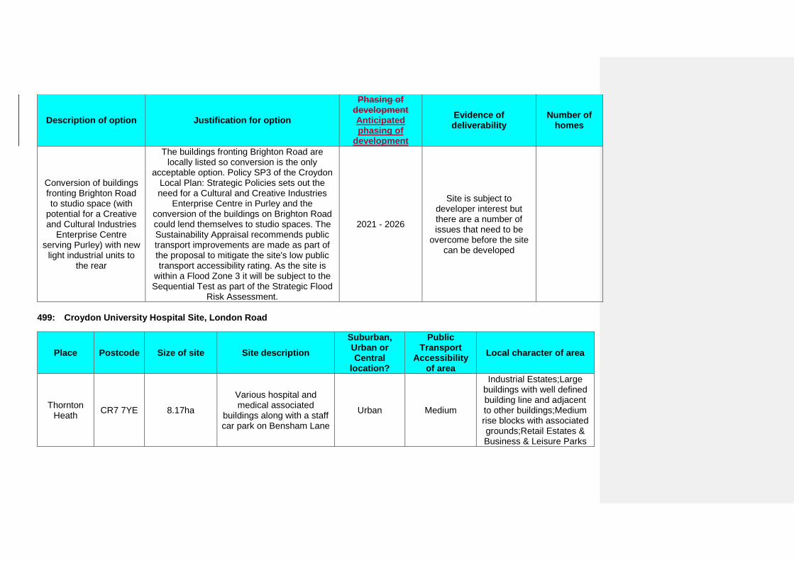
Description of option Justification for option
Phasing of development Anticipated phasing of
development
Evidence of deliverability
Number of homes
Conversion of buildings fronting Brighton Road to studio space (with
potential for a Creative and Cultural Industries
Enterprise Centre serving Purley) with new
light industrial units to the rear
The buildings fronting Brighton Road are locally listed so conversion is the only
acceptable option. Policy SP3 of the Croydon Local Plan: Strategic Policies sets out the need for a Cultural and Creative Industries
Enterprise Centre in Purley and the conversion of the buildings on Brighton Road could lend themselves to studio spaces. The Sustainability Appraisal recommends public transport improvements are made as part of the proposal to mitigate the site's low public transport accessibility rating. As the site is
within a Flood Zone 3 it will be subject to the Sequential Test as part of the Strategic Flood
Risk Assessment.
2021 - 2026
Site is subject to developer interest but there are a number of issues that need to be
overcome before the site can be developed
499: Croydon University Hospital Site, London Road
Place Postcode Size of site Site description Suburban, Urban or Central
location?
Public Transport
Accessibility of area
Local character of area
Thornton Heath CR7 7YE 8.17ha
Various hospital and medical associated
buildings along with a staff car park on Bensham Lane
Urban Medium
Industrial Estates;Large buildings with well defined building line and adjacent to other buildings;Medium rise blocks with associated grounds;Retail Estates & Business & Leisure Parks
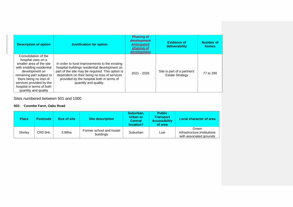
Description of option Justification for option
Phasing of development Anticipated phasing of
development
Evidence of deliverability
Number of homes
Consolidation of the hospital uses on a
smaller area of the site with enabling residential
development on remaining part subject to
there being no loss of services provided by the hospital in terms of both
quantity and quality
In order to fund improvements to the existing hospital buildings residential development on part of the site may be required. This option is dependent on their being no loss of services
provided by the hospital both in terms of quantity and quality.
2021 - 2026 Site is part of a partners' Estate Strategy 77 to 290
Sites numbered between 501 and 1000
502: Coombe Farm, Oaks Road
Place Postcode Size of site Site description Suburban, Urban or Central
location?
Public Transport
Accessibility of area
Local character of area
Shirley CR0 5HL 3.99ha Former school and hostel buildings Suburban Low
Green Infrastructure;Institutions with associated grounds
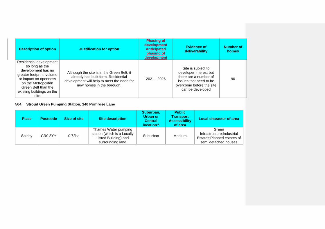
Description of option Justification for option
Phasing of development Anticipated phasing of
development
Evidence of deliverability
Number of homes
Residential development so long as the
development has no greater footprint, volume or impact on openness
on the Metropolitan Green Belt than the
existing buildings on the site
Although the site is in the Green Belt, it already has built form. Residential
development will help to meet the need for new homes in the borough.
2021 - 2026
Site is subject to developer interest but there are a number of issues that need to be
overcome before the site can be developed
90
504: Stroud Green Pumping Station, 140 Primrose Lane
Place Postcode Size of site Site description Suburban, Urban or Central
location?
Public Transport
Accessibility of area
Local character of area
Shirley CR0 8YY 0.72ha
Thames Water pumping station (which is a Locally
Listed Building) and surrounding land
Suburban Medium
Green Infrastructure;Industrial
Estates;Planned estates of semi detached houses
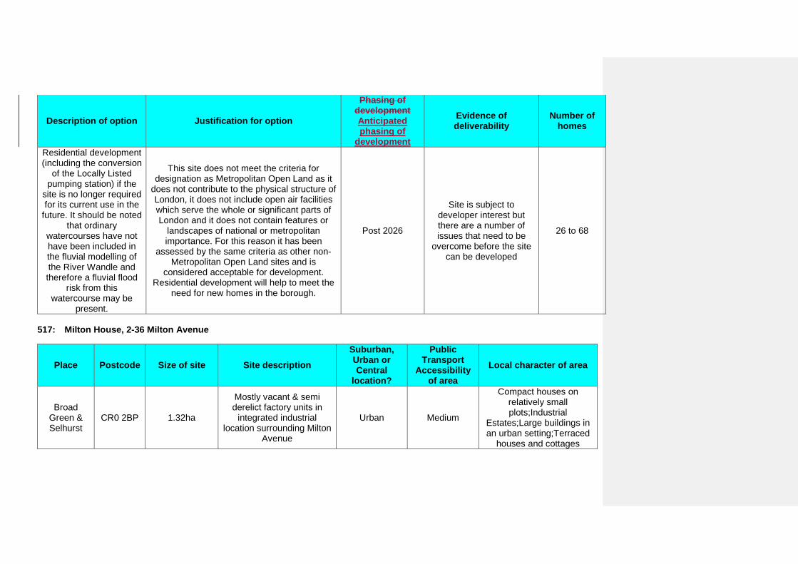
Description of option Justification for option
Phasing of development Anticipated phasing of
development
Evidence of deliverability
Number of homes
Residential development (including the conversion
of the Locally Listed pumping station) if the
site is no longer required for its current use in the
future. It should be noted that ordinary
watercourses have not have been included in the fluvial modelling of the River Wandle and therefore a fluvial flood
risk from this watercourse may be
present.
This site does not meet the criteria for designation as Metropolitan Open Land as it
does not contribute to the physical structure of London, it does not include open air facilities which serve the whole or significant parts of London and it does not contain features or
landscapes of national or metropolitan importance. For this reason it has been
assessed by the same criteria as other non-Metropolitan Open Land sites and is
considered acceptable for development. Residential development will help to meet the
need for new homes in the borough.
Post 2026
Site is subject to developer interest but there are a number of issues that need to be
overcome before the site can be developed
26 to 68
517: Milton House, 2-36 Milton Avenue
Place Postcode Size of site Site description Suburban, Urban or Central
location?
Public Transport
Accessibility of area
Local character of area
Broad Green & Selhurst
CR0 2BP 1.32ha
Mostly vacant & semi derelict factory units in
integrated industrial location surrounding Milton
Avenue
Urban Medium
Compact houses on relatively small plots;Industrial
Estates;Large buildings in an urban setting;Terraced
houses and cottages
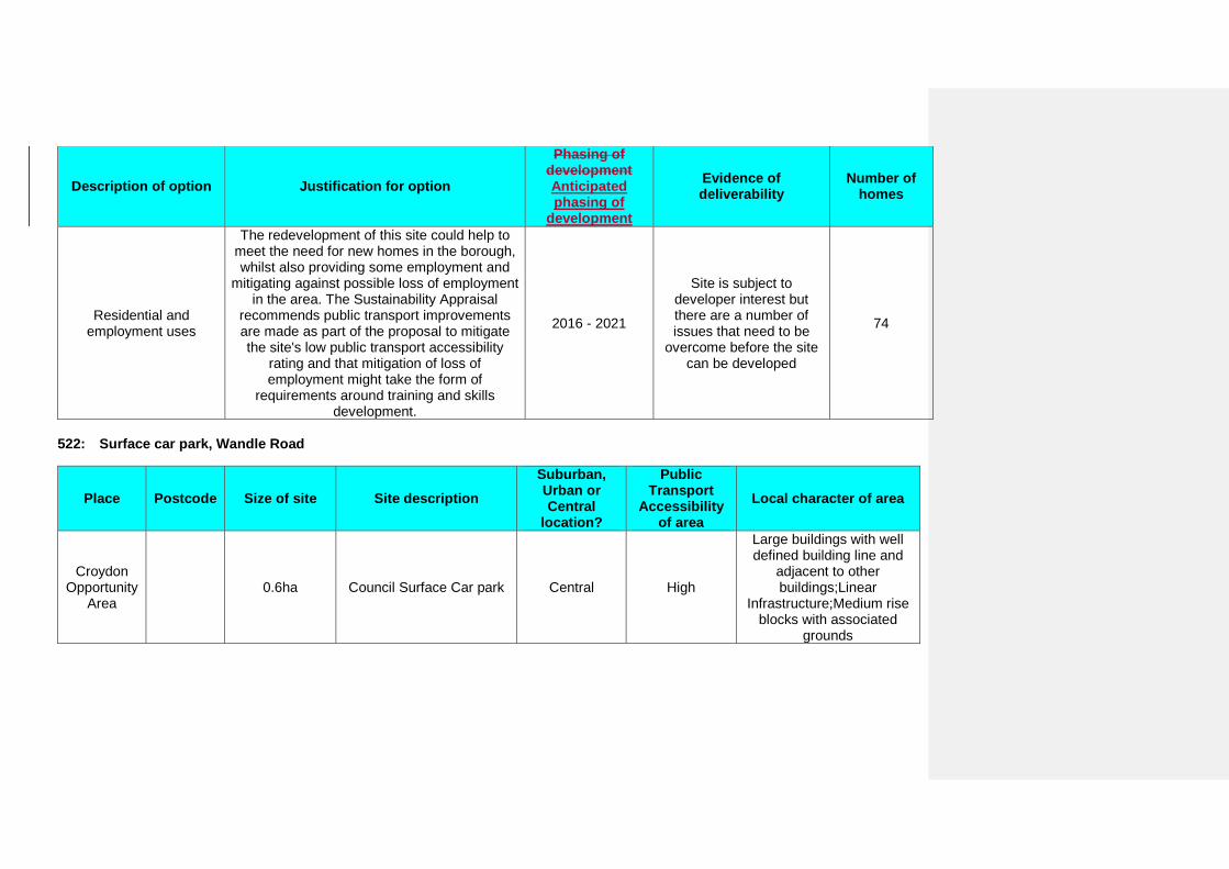
Description of option Justification for option
Phasing of development Anticipated phasing of
development
Evidence of deliverability
Number of homes
Residential and employment uses
The redevelopment of this site could help to meet the need for new homes in the borough, whilst also providing some employment and
mitigating against possible loss of employment in the area. The Sustainability Appraisal
recommends public transport improvements are made as part of the proposal to mitigate the site's low public transport accessibility
rating and that mitigation of loss of employment might take the form of
requirements around training and skills development.
2016 - 2021
Site is subject to developer interest but there are a number of issues that need to be
overcome before the site can be developed
74
522: Surface car park, Wandle Road
Place Postcode Size of site Site description Suburban, Urban or Central
location?
Public Transport
Accessibility of area
Local character of area
Croydon Opportunity
Area 0.6ha Council Surface Car park Central High
Large buildings with well defined building line and
adjacent to other buildings;Linear
Infrastructure;Medium rise blocks with associated
grounds
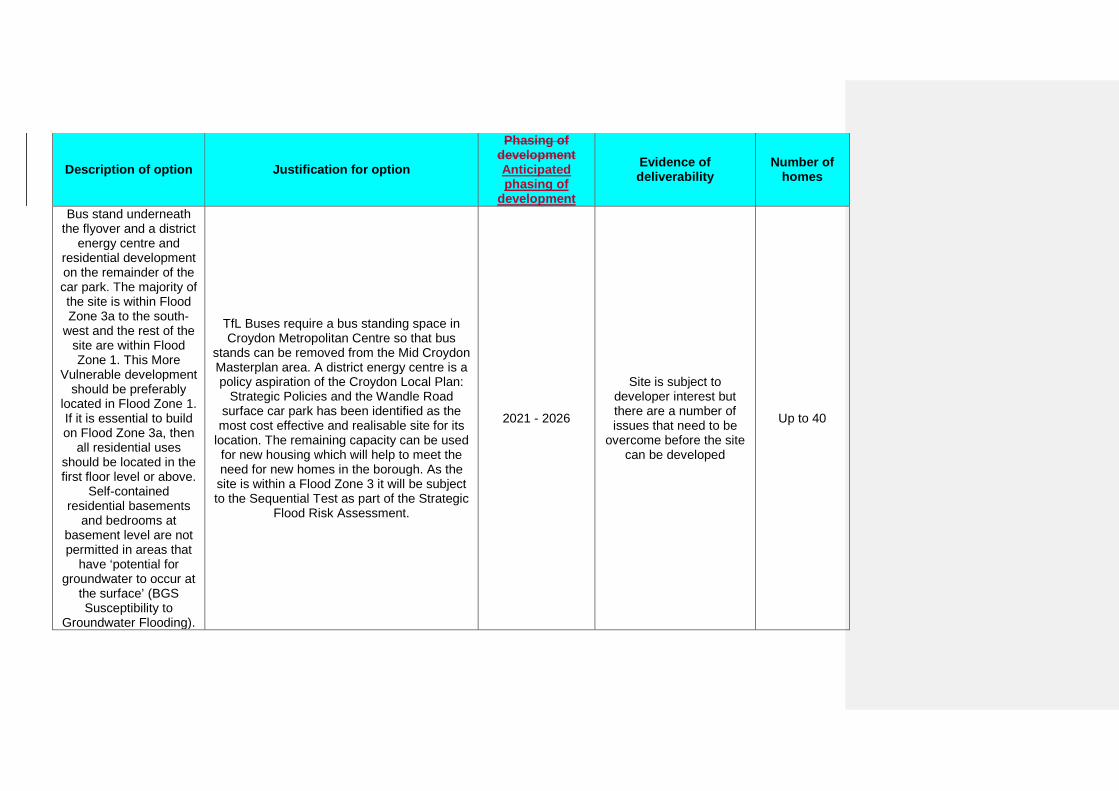
Description of option Justification for option
Phasing of development Anticipated phasing of
development
Evidence of deliverability
Number of homes
Bus stand underneath the flyover and a district
energy centre and residential development on the remainder of the car park. The majority of the site is within Flood Zone 3a to the south-
west and the rest of the site are within Flood Zone 1. This More
Vulnerable development should be preferably
located in Flood Zone 1. If it is essential to build on Flood Zone 3a, then
all residential uses should be located in the first floor level or above.
Self-contained residential basements
and bedrooms at basement level are not permitted in areas that
have ‘potential for groundwater to occur at
the surface’ (BGS Susceptibility to
Groundwater Flooding).
TfL Buses require a bus standing space in Croydon Metropolitan Centre so that bus
stands can be removed from the Mid Croydon Masterplan area. A district energy centre is a policy aspiration of the Croydon Local Plan:
Strategic Policies and the Wandle Road surface car park has been identified as the most cost effective and realisable site for its
location. The remaining capacity can be used for new housing which will help to meet the need for new homes in the borough. As the site is within a Flood Zone 3 it will be subject to the Sequential Test as part of the Strategic
Flood Risk Assessment.
2021 - 2026
Site is subject to developer interest but there are a number of issues that need to be
overcome before the site can be developed
Up to 40
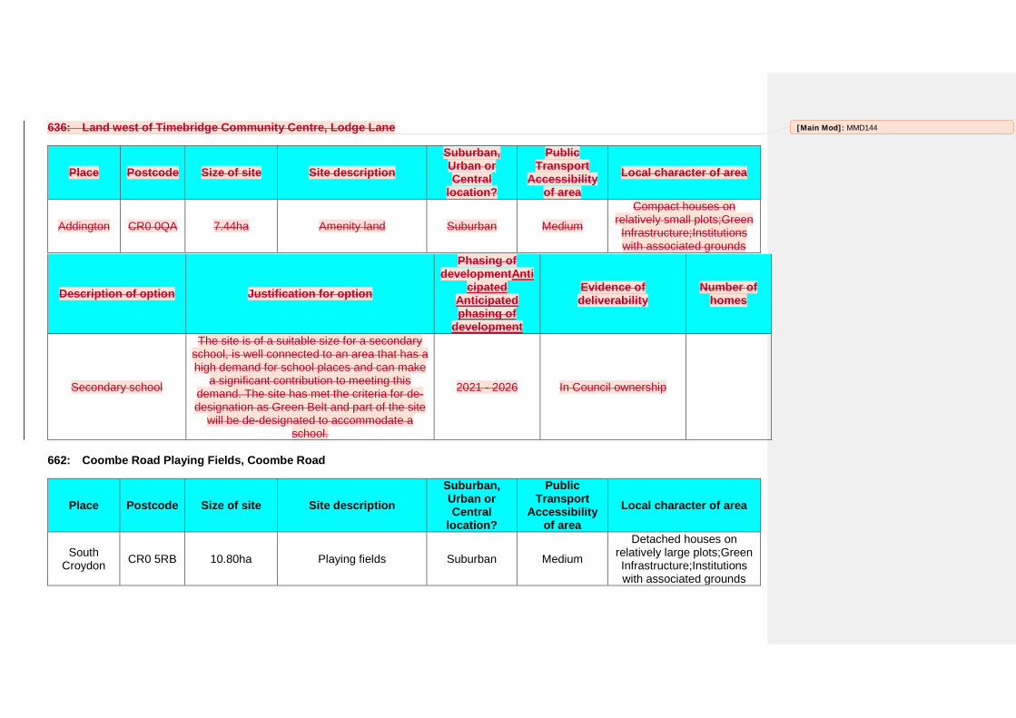
636: Land west of Timebridge Community Centre, Lodge Lane
Place Postcode Size of site Site description Suburban, Urban or Central
location?
Public Transport
Accessibility of area
Local character of area
Addington CR0 0QA 7.44ha Amenity land Suburban Medium
Compact houses on relatively small plots;Green Infrastructure;Institutions with associated grounds
Description of option Justification for option
Phasing of developmentAnti
cipated Anticipated phasing of
development
Evidence of deliverability
Number of homes
Secondary school
The site is of a suitable size for a secondary school, is well connected to an area that has a high demand for school places and can make
a significant contribution to meeting this demand. The site has met the criteria for de-designation as Green Belt and part of the site
will be de-designated to accommodate a school.
2021 - 2026 In Council ownership
662: Coombe Road Playing Fields, Coombe Road
Place Postcode Size of site Site description Suburban, Urban or Central
location?
Public Transport
Accessibility of area
Local character of area
South Croydon CR0 5RB 10.80ha Playing fields Suburban Medium
Detached houses on relatively large plots;Green Infrastructure;Institutions with associated grounds
[Main Mod]: MMD144
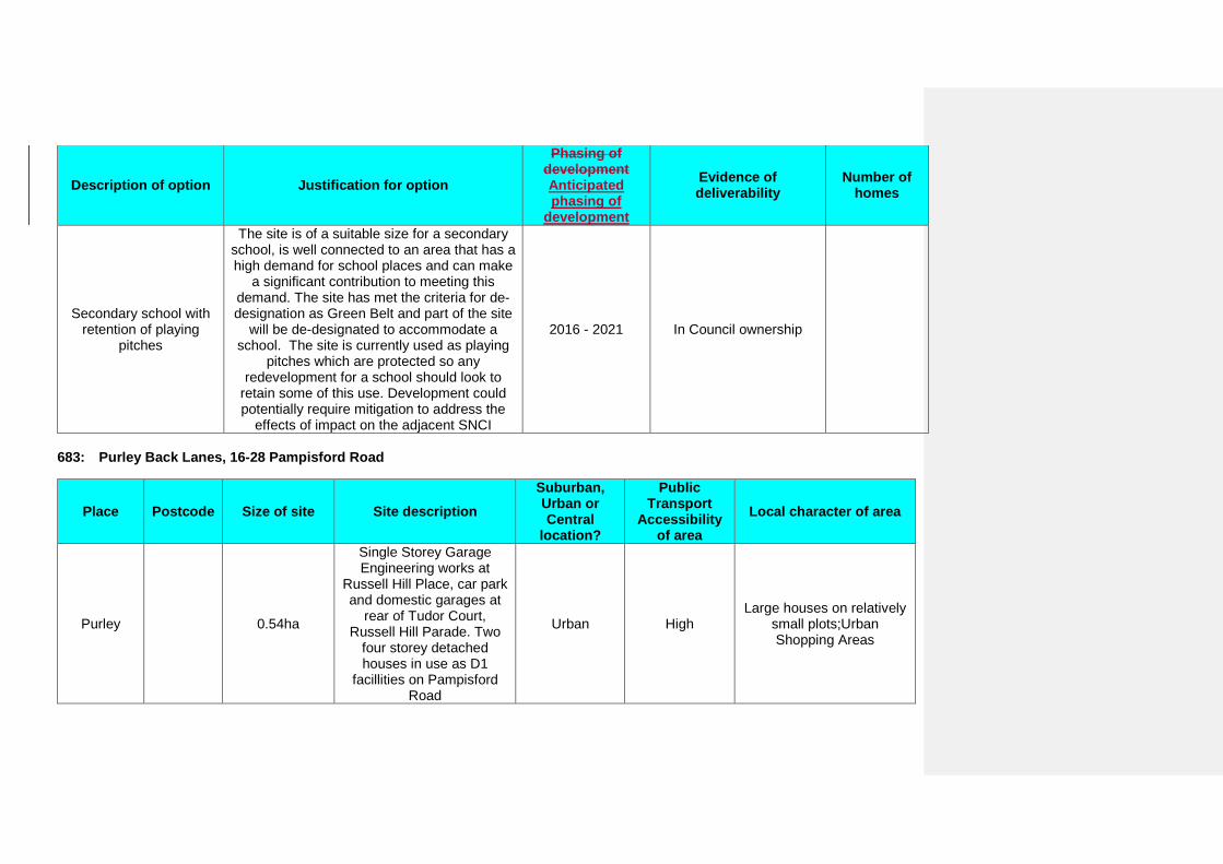
Description of option Justification for option
Phasing of development Anticipated phasing of
development
Evidence of deliverability
Number of homes
Secondary school with retention of playing
pitches
The site is of a suitable size for a secondary school, is well connected to an area that has a high demand for school places and can make
a significant contribution to meeting this demand. The site has met the criteria for de-designation as Green Belt and part of the site
will be de-designated to accommodate a school. The site is currently used as playing
pitches which are protected so any redevelopment for a school should look to
retain some of this use. Development could potentially require mitigation to address the
effects of impact on the adjacent SNCI
2016 - 2021 In Council ownership
683: Purley Back Lanes, 16-28 Pampisford Road
Place Postcode Size of site Site description Suburban, Urban or Central
location?
Public Transport
Accessibility of area
Local character of area
Purley 0.54ha
Single Storey Garage Engineering works at
Russell Hill Place, car park and domestic garages at
rear of Tudor Court, Russell Hill Parade. Two
four storey detached houses in use as D1
facillities on Pampisford Road
Urban High Large houses on relatively
small plots;Urban Shopping Areas
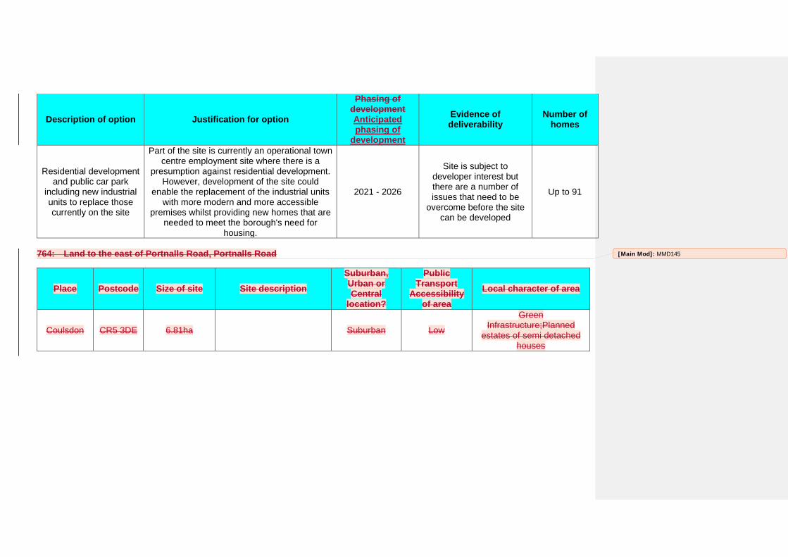
Description of option Justification for option
Phasing of development Anticipated phasing of
development
Evidence of deliverability
Number of homes
Residential development and public car park
including new industrial units to replace those currently on the site
Part of the site is currently an operational town centre employment site where there is a
presumption against residential development. However, development of the site could
enable the replacement of the industrial units with more modern and more accessible
premises whilst providing new homes that are needed to meet the borough's need for
housing.
2021 - 2026
Site is subject to developer interest but there are a number of issues that need to be
overcome before the site can be developed
Up to 91
764: Land to the east of Portnalls Road, Portnalls Road
Place Postcode Size of site Site description Suburban, Urban or Central
location?
Public Transport
Accessibility of area
Local character of area
Coulsdon CR5 3DE 6.81ha Suburban Low
Green Infrastructure;Planned
estates of semi detached houses
[Main Mod]: MMD145
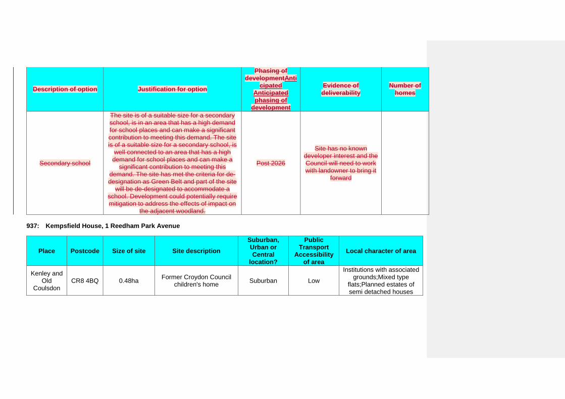
Description of option Justification for option
Phasing of developmentAnti
cipated Anticipated phasing of
development
Evidence of deliverability
Number of homes
Secondary school
The site is of a suitable size for a secondary school, is in an area that has a high demand for school places and can make a significant contribution to meeting this demand. The site is of a suitable size for a secondary school, is
well connected to an area that has a high demand for school places and can make a
significant contribution to meeting this demand. The site has met the criteria for de-designation as Green Belt and part of the site
will be de-designated to accommodate a school. Development could potentially require mitigation to address the effects of impact on
the adjacent woodland.
Post 2026
Site has no known developer interest and the Council will need to work with landowner to bring it
forward
937: Kempsfield House, 1 Reedham Park Avenue
Place Postcode Size of site Site description Suburban, Urban or Central
location?
Public Transport
Accessibility of area
Local character of area
Kenley and Old
Coulsdon CR8 4BQ 0.48ha Former Croydon Council
children's home Suburban Low
Institutions with associated grounds;Mixed type
flats;Planned estates of semi detached houses
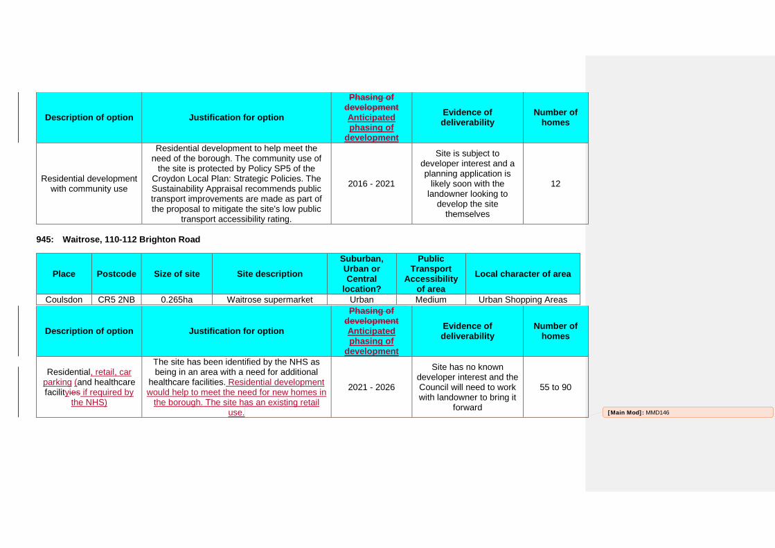
Description of option Justification for option
Phasing of development Anticipated phasing of
development
Evidence of deliverability
Number of homes
Residential development with community use
Residential development to help meet the need of the borough. The community use of
the site is protected by Policy SP5 of the Croydon Local Plan: Strategic Policies. The Sustainability Appraisal recommends public transport improvements are made as part of the proposal to mitigate the site's low public
transport accessibility rating.
2016 - 2021
Site is subject to developer interest and a planning application is
likely soon with the landowner looking to
develop the site themselves
12
945: Waitrose, 110-112 Brighton Road
Place Postcode Size of site Site description Suburban, Urban or Central
location?
Public Transport
Accessibility of area
Local character of area
Coulsdon CR5 2NB 0.265ha Waitrose supermarket Urban Medium Urban Shopping Areas
Description of option Justification for option
Phasing of development Anticipated phasing of
development
Evidence of deliverability
Number of homes
Residential, retail, car parking (and healthcare facilityies if required by
the NHS)
The site has been identified by the NHS as being in an area with a need for additional
healthcare facilities. Residential development would help to meet the need for new homes in
the borough. The site has an existing retail use.
2021 - 2026
Site has no known developer interest and the Council will need to work with landowner to bring it
forward
55 to 90
[Main Mod]: MMD146
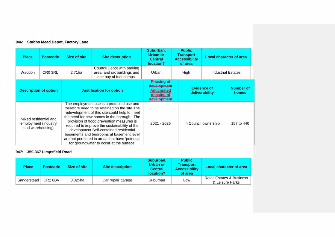
946: Stubbs Mead Depot, Factory Lane
Place Postcode Size of site Site description Suburban, Urban or Central
location?
Public Transport
Accessibility of area
Local character of area
Waddon CR0 3RL 2.71ha Council Depot with parking area, and six buildings and
one bay of fuel pumps. Urban High Industrial Estates
Description of option Justification for option
Phasing of development Anticipated phasing of
development
Evidence of deliverability
Number of homes
Mixed residential and employment (industry
and warehousing)
The employment use is a protected use and therefore need to be retained on the site.The redevelopment of this site could help to meet the need for new homes in the borough. The
provision of flood prevention measures is required to improve the sustainability of the
development.Self-contained residential basements and bedrooms at basement level are not permitted in areas that have ‘potential
for groundwater to occur at the surface’
2021 - 2026 In Council ownership 157 to 440
947: 359-367 Limpsfield Road
Place Postcode Size of site Site description Suburban, Urban or Central
location?
Public Transport
Accessibility of area
Local character of area
Sanderstead CR2 8BV 0.325ha Car repair garage Suburban Low Retail Estates & Business & Leisure Parks
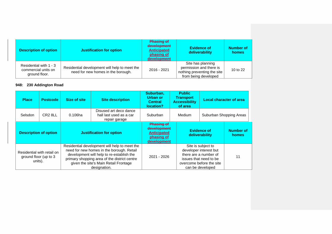
Description of option Justification for option
Phasing of development Anticipated phasing of
development
Evidence of deliverability
Number of homes
Residential with 1 - 3 commercial units on
ground floor.
Residential development will help to meet the need for new homes in the borough. 2016 - 2021
Site has planning permission and there is
nothing preventing the site from being developed
10 to 22
948: 230 Addington Road
Place Postcode Size of site Site description Suburban, Urban or Central
location?
Public Transport
Accessibility of area
Local character of area
Selsdon CR2 8LL 0.106ha Disused art deco dance hall last used as a car
repair garage Suburban Medium Suburban Shopping Areas
Description of option Justification for option
Phasing of development Anticipated phasing of
development
Evidence of deliverability
Number of homes
Residential with retail on ground floor (up to 3
units).
Residential development will help to meet the need for new homes in the borough. Retail development will help to re-establish the
primary shopping area of the district centre given the site's Main Retail Frontage
designation.
2021 - 2026
Site is subject to developer interest but there are a number of issues that need to be
overcome before the site can be developed
11
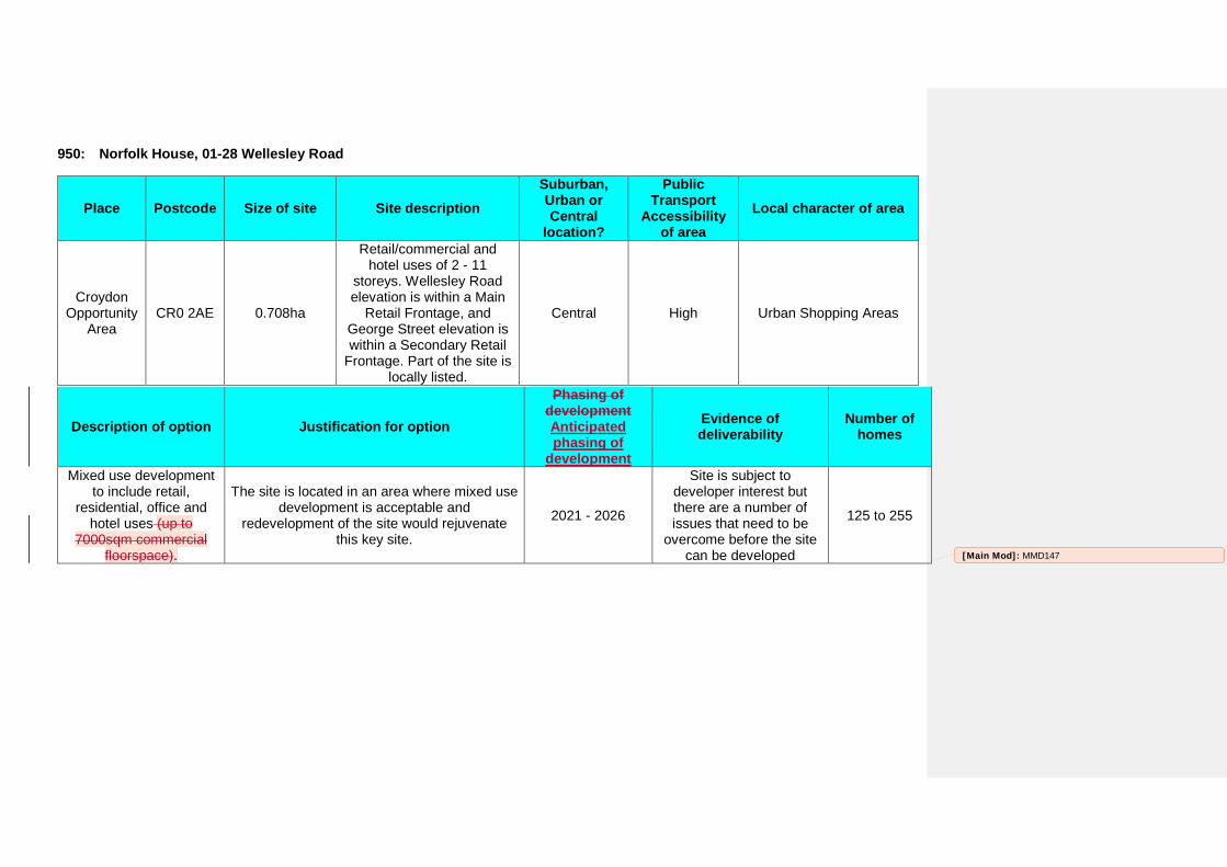
950: Norfolk House, 01-28 Wellesley Road
Place Postcode Size of site Site description Suburban, Urban or Central
location?
Public Transport
Accessibility of area
Local character of area
Croydon Opportunity
Area CR0 2AE 0.708ha
Retail/commercial and hotel uses of 2 - 11
storeys. Wellesley Road elevation is within a Main
Retail Frontage, and George Street elevation is within a Secondary Retail
Frontage. Part of the site is locally listed.
Central High Urban Shopping Areas
Description of option Justification for option
Phasing of development Anticipated phasing of
development
Evidence of deliverability
Number of homes
Mixed use development to include retail,
residential, office and hotel uses (up to
7000sqm commercial floorspace).
The site is located in an area where mixed use development is acceptable and
redevelopment of the site would rejuvenate this key site.
2021 - 2026
Site is subject to developer interest but there are a number of issues that need to be
overcome before the site can be developed
125 to 255
[Main Mod]: MMD147
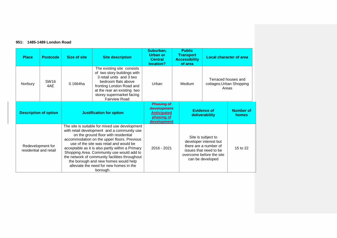
951: 1485-1489 London Road
Place Postcode Size of site Site description Suburban, Urban or Central
location?
Public Transport
Accessibility of area
Local character of area
Norbury SW16 4AE 0.1664ha
The existing site consists of two story buildings with
3 retail units and 3 two bedroom flats above
fronting London Road and at the rear an existing two storey supermarket facing
Fairview Road
Urban Medium Terraced houses and
cottages;Urban Shopping Areas
Description of option Justification for option
Phasing of development Anticipated phasing of
development
Evidence of deliverability
Number of homes
Redevelopment for residential and retail
The site is suitable for mixed use development with retail development and a community use
on the ground floor with residential accommodation on the upper floors. Previous
use of the site was retail and would be acceptable as it is also partly within a Primary Shopping Area. Community use would add to the network of community facilities throughout
the borough and new homes would help alleviate the need for new homes in the
borough.
2016 - 2021
Site is subject to developer interest but there are a number of issues that need to be
overcome before the site can be developed
15 to 22
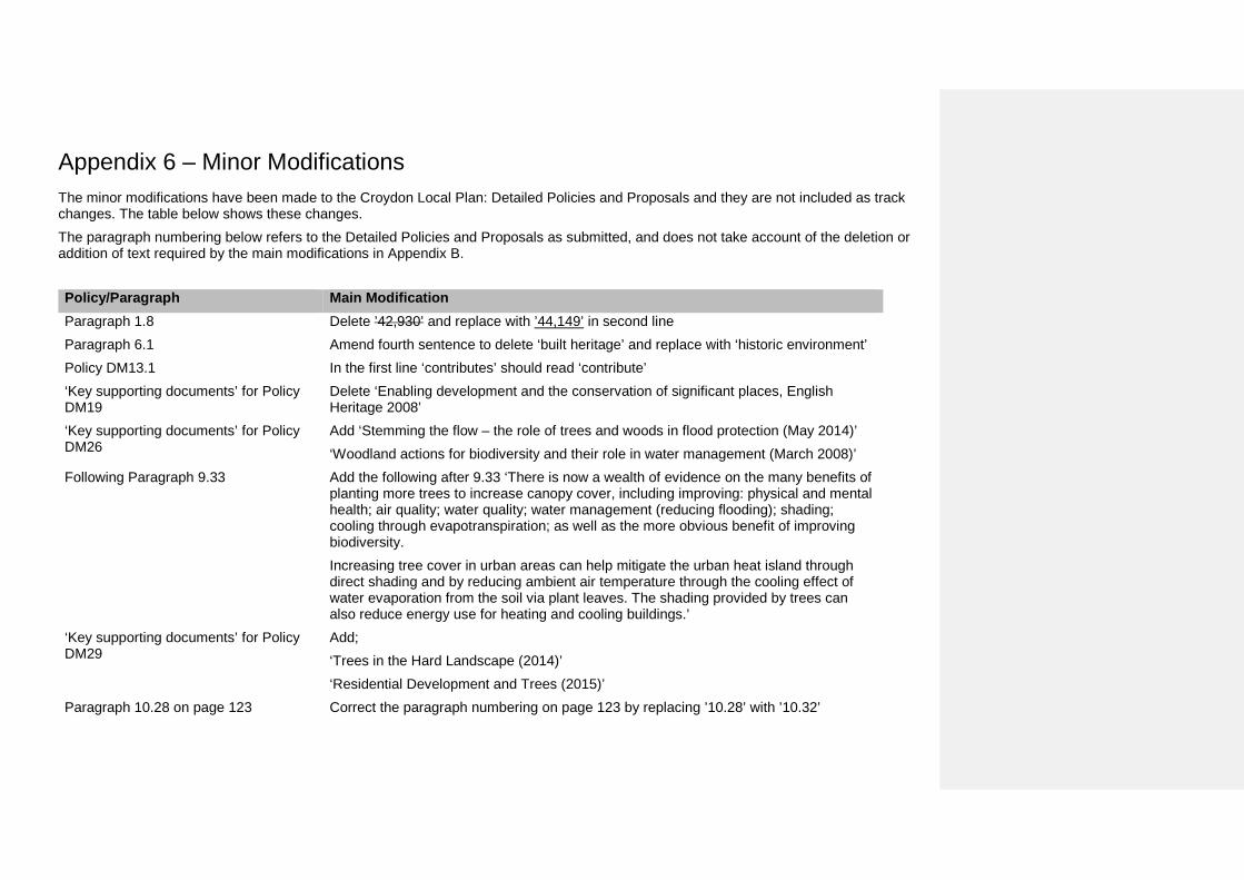
Appendix 6 – Minor Modifications The minor modifications have been made to the Croydon Local Plan: Detailed Policies and Proposals and they are not included as track changes. The table below shows these changes. The paragraph numbering below refers to the Detailed Policies and Proposals as submitted, and does not take account of the deletion or addition of text required by the main modifications in Appendix B.
Policy/Paragraph Main Modification Paragraph 1.8 Delete ’42,930’ and replace with ’44,149’ in second line Paragraph 6.1 Amend fourth sentence to delete ‘built heritage’ and replace with ‘historic environment’ Policy DM13.1 In the first line ‘contributes’ should read ‘contribute’ ‘Key supporting documents’ for Policy DM19
Delete ‘Enabling development and the conservation of significant places, English Heritage 2008’
‘Key supporting documents’ for Policy DM26
Add ‘Stemming the flow – the role of trees and woods in flood protection (May 2014)’ ‘Woodland actions for biodiversity and their role in water management (March 2008)’
Following Paragraph 9.33 Add the following after 9.33 ‘There is now a wealth of evidence on the many benefits of planting more trees to increase canopy cover, including improving: physical and mental health; air quality; water quality; water management (reducing flooding); shading; cooling through evapotranspiration; as well as the more obvious benefit of improving biodiversity. Increasing tree cover in urban areas can help mitigate the urban heat island through direct shading and by reducing ambient air temperature through the cooling effect of water evaporation from the soil via plant leaves. The shading provided by trees can also reduce energy use for heating and cooling buildings.’
‘Key supporting documents’ for Policy DM29
Add; ‘Trees in the Hard Landscape (2014)’ ‘Residential Development and Trees (2015)’
Paragraph 10.28 on page 123 Correct the paragraph numbering on page 123 by replacing ’10.28’ with ’10.32’
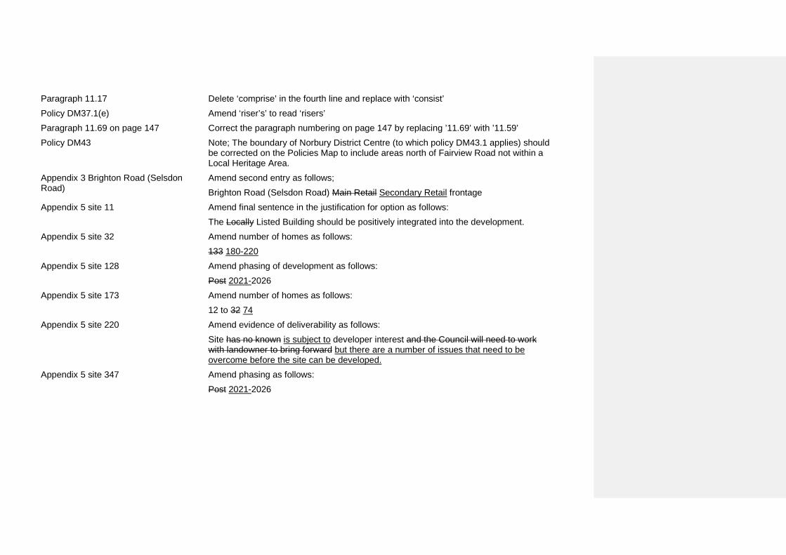
Paragraph 11.17 Delete ‘comprise’ in the fourth line and replace with ‘consist’ Policy DM37.1(e) Amend ‘riser’s’ to read ‘risers’ Paragraph 11.69 on page 147 Correct the paragraph numbering on page 147 by replacing ’11.69’ with ’11.59’ Policy DM43 Note; The boundary of Norbury District Centre (to which policy DM43.1 applies) should
be corrected on the Policies Map to include areas north of Fairview Road not within a Local Heritage Area.
Appendix 3 Brighton Road (Selsdon Road)
Amend second entry as follows; Brighton Road (Selsdon Road) Main Retail Secondary Retail frontage
Appendix 5 site 11 Amend final sentence in the justification for option as follows: The Locally Listed Building should be positively integrated into the development.
Appendix 5 site 32 Amend number of homes as follows: 133 180-220
Appendix 5 site 128 Amend phasing of development as follows: Post 2021-2026
Appendix 5 site 173 Amend number of homes as follows: 12 to 32 74
Appendix 5 site 220 Amend evidence of deliverability as follows: Site has no known is subject to developer interest and the Council will need to work with landowner to bring forward but there are a number of issues that need to be overcome before the site can be developed.
Appendix 5 site 347 Amend phasing as follows: Post 2021-2026