Crowdsourcing & GIS
10
PAYAL GUNAKI CROWD SOURCING & GIS
-
Upload
payalgunaki -
Category
Environment
-
view
44 -
download
0
Transcript of Crowdsourcing & GIS

PAYAL GUNAKI
CROWD SOURCING & GIS

Crowd Sourcing
Gained prominence in June 2006 article The Rise of Crowd Sourcing by Jeff Howe, in the Wired Magazine
Revolutionized how business firms, governments and humanitarian organizations viewed the internet and mobile phone market
“the act of taking a job traditionally performed by a designated agent (usually an employee) and outsourcing it to an undefined, generally large group of people in the form of an open call”

Deepwater Horizon Oil Spill
The Gulf of Mexico Oil Spill one of the worst environmental disasters in recent times
Volunteers and citizens recorded incidents, captured images & videos and blogged on conditions in real time
Volunteered reports & data were used effectively to focus on most significant problems

Map The Spill, Trimble
Users can upload photos, videos and reports, also download all freely available information
Oiled shorelines, stressed or dead wildlife, and other spill-related information can be reported
Turns cell phone into Citizen Reporting Tool

Internet
GISTO
TCC
Smart Device Users
Web Users
Vis/Query/Report
E T L
Other GISServices & Portals
ArcExplorerArcGIS Desktop + MustangArcGIS Server + Mustang
ArcSDE
Web BrowserArcExplorer
ArcGIS Desktop
Internet
MAP SERVICES
GPX SERVICE
SHAPEFILE EXPORT
ArcGIS Server
Map the Spill Website
Map the Spill App

Victorian Bushfires
Australia ravaged by Bushfires during hot and dry summer months
The state of Victoria, Australia has a long history of catastrophic bushfires
Large areas of land ravaged every year causing loss of life and property

Country Fire Authority, Victoria
Handy map interface allowing users to see where fires are located
Users can share details of incident to their social networks straight from app
People feel they are contributing in emergency situations. Sends a huge signal to community that says: “We are all in this together.”

OpenStreetMap
A collaborative project to create free, editable map of the world. Over 1 million registered users who can collect data using GPS devices, aerial photography, and other free sources
restrictions on use/ availability of map information and the advent of inexpensive portable satellite navigation devices major driving forces
These crowdsourced data are then made available under Open Database License
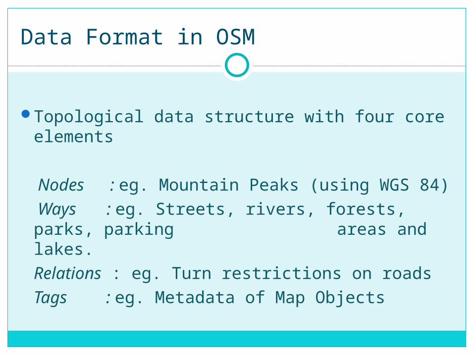
Data Format in OSM
Topological data structure with four core elements
Nodes : eg. Mountain Peaks (using WGS 84)
Ways : eg. Streets, rivers, forests, parks, parking areas and lakes.Relations : eg. Turn restrictions on roadsTags : eg. Metadata of Map Objects

Thank You