Aquis - Initial Advice Statement · Page i Initial Advice Statement Revision 2

Cross River Rail
Initial Advice Statement
February 2010

CrossRiverRail 16 February 2010

CrossRiverRail Initial Advice Statement - February 2010 Page 1 of 47
Contents
Executive Summary.................................................................................................. 2
1 Introduction................................................................................................ 11
1.1 Background......................................................................................................................11
1.2 The proponent..................................................................................................................12
1.3 Purpose and scope of this document .............................................................................12
1.4 Environmental assessment and approval process ........................................................13
1.5 Indicative timeline for environmental impact statement process ..................................14
1.6 Community and stakeholder engagement ......................................................................15
2 The proposal .............................................................................................. 16
2.1 Project description...........................................................................................................16
2.2 Location of study corridor...............................................................................................18
2.3 Key issues ........................................................................................................................20
2.4 Project objectives ............................................................................................................22
2.5 Project justification and alternatives considered ...........................................................23
2.6 Strategic significance of the project ...............................................................................23
2.7 Construction and operational processes........................................................................24
2.8 Associated infrastructure requirements .........................................................................25
2.9 Level of investment and employment opportunities ......................................................25
3 Project Approvals ...................................................................................... 27
3.1 Local planning instruments.............................................................................................27
3.2 Local Laws .......................................................................................................................28
3.3 Other Legislation and Approvals.....................................................................................28
4 Existing environment................................................................................. 31
4.1 Natural environment ........................................................................................................31
4.2 Built environment.............................................................................................................34
4.3 Land tenure and ownership.............................................................................................35
4.4 Planning schemes and government policies..................................................................35
5 Potential environmental impacts.............................................................. 38
5.1 Potential environmental impact studies..........................................................................38
5.2 Transport system.............................................................................................................38
5.3 Biophysical environment impacts...................................................................................39
5.4 Socio-economic impacts .................................................................................................41
5.5 Built environment.............................................................................................................44
5.6 Hazard, risk and health and safety ..................................................................................44
6 Environmental management ..................................................................... 46
7 References.................................................................................................. 47

CrossRiverRail Initial Advice Statement - February 2010 Page 2 of 47
Executive Summary
Cross River Rail is a major project for the city of Brisbane, South East Queensland and the state of
Queensland. It will provide a new north-south rail line in Brisbane’s inner city that includes a new river
crossing and inner city train stations. From the existing southern rail network, it will pass under the
central business district (CBD) of Brisbane and connect with the existing northern rail network via the
Exhibition loop. The project will include a tunnel under the Brisbane River and new and upgraded
train stations.
The population of the South East Queensland region is expected to double over the next 50 years
from 2.8 million in 2006 to 6 million in 2056. Brisbane’s CBD is the region’s primary activity centre and
the population of Brisbane city is forecast to grow from 991 000 people in 2006 to 1.27 million people
by 2031. Employment in Brisbane city is forecast to increase from 692 362 jobs in 2006 to more than
1 million jobs in 2031. Employment in Brisbane’s inner city areas is forecast to increase from 300 000
jobs to 475 000 jobs.
Brisbane’s rail network is the hub of the rail network in South East Queensland, with all services
passing through the inner city. By 2016, rail network extensions and service increases will be required
to meet demand. The limited capacity of the Merivale Bridge and existing inner Brisbane rail tunnels
significantly limit the number of additional trains that can be introduced on the rail lines servicing the
region to meet passenger demand. The Queensland Government has initiated Cross River Rail to
respond to the identified need for more inner city rail infrastructure, including a new rail crossing of the
Brisbane River, by 2016.
The project will strongly influence the shape, economic diversification, and accessibility of the city over
the next 30 years and beyond, and support future employment and population growth and distribution
in the Brisbane CBD and broader inner city area. The project is a key component of an inner city
transport and land use strategy, currently being jointly developed by the state government and
Brisbane City Council. Without the increase in capacity to the network that will be delivered by the
project, the future productive output of the capital would be significantly diminished.
Good public transport is vital to successful urban areas, enabling people to access jobs and services,
employers to access labour markets, and businesses to reach customers for their services. There are
well-established links between improved transport efficiency and economic growth. Maintaining
adequate rail service and access is vital for the economic well-being of Queensland's largest city.
The efficient movement of freight is essential for economic growth. Recent studies indicate that freight
services are expected to double by 2020. A major challenge for the rail network will be to
accommodate the anticipated significant growth in passenger demand over the next 20 years while
also supporting growth in freight traffic.
The Queensland Government, through the Department of Transport and Main Roads, is the proponent
for Cross River Rail. The detailed feasibility phase of Cross River Rail is jointly funded by the
Queensland Government and the Australian Government.
This initial advice statement has been prepared as part of the application for a declaration as a
significant project under the State Development and Public Works Organisation Act 1971 to provide

CrossRiverRail Initial Advice Statement - February 2010 Page 3 of 47
information for the Coordinator-General to decide whether to declare Cross River Rail a significant
project for which an environmental impact statement (EIS) is required.
Cross River Rail is a major transport infrastructure project that will deliver substantial, long-term
benefits to Brisbane, South East Queensland and Queensland. It will have a significant capital cost
and provide extensive benefits to the city and South East Queensland rail network and opportunities
for improved rail public transport. Cross River Rail will result in significant long-term benefits to city
and regional road and transport networks, and provide opportunities for future integration of land use
and public transport at nominated hubs. It will also provide benefits to communities, environmental
amenity (improved air quality), enhanced accessibility and liveability.
There is significant potential for construction and operation impacts that will need to be mitigated
under transparent and carefully developed management measures. The proponent will undertake
extensive consultation throughout the EIS process to ensure that the community is well informed and
has opportunities to make suggestions and express their views about the project.
No significant impact on matters of national environmental significance under the Environment
Protection and Biodiversity Conservation Act 1999 is anticipated. However, for certainty, the
proponent will refer the project to the Commonwealth Minister for the Environment, Heritage and the
Arts for a decision as to whether the project is a ‘controlled action’. If the Commonwealth Minister for
the Environment, Heritage and the Arts was to determine that the project is a “controlled action”, the
environmental assessment process under the State Development and Public Works Organisation Act
1971 can satisfy the assessment processes under the Environment Protection and Biodiversity
Conservation Act 1999 in accordance with the Bilateral Agreement between the Australian
Government and the State of Queensland.
The project governance structure includes a steering committee that provides guidance and comment
on the project development and assessment. The steering committee membership includes
representatives of federal, state and local government agencies, including senior representation from
Brisbane City Council. There will be numerous opportunities for community input into the Cross River
Rail EIS from early 2010 to completion of the process.
The Cross River Rail project
Cross River Rail aims to improve rail services in South East Queensland by increasing the capacity of
the inner city rail system so that more train services can operate more often right across the South
East Queensland rail network. Cross River Rail also is intended to improve rail access to key inner
city destinations by building new rail stations in the inner city so that people get to where they want to
go and have a wider choice of efficient public transport services.
Project objectives have been established in consideration of the key issues identified above,
particularly in response to issues relating to service, access and sustainability. These objectives will
form and shape concept development within the study corridor, and were used to establish a range of
possible options that form the basis of the study corridor selection.
Cross River Rail will provide a new underground rail connection from the existing southern rail
network, pass beneath Brisbane’s inner city and connect with the existing northern rail network at or
near the Exhibition loop. The project will include tunnels under the Brisbane River and new stations,
which may include underground stations in the inner city, Woolloongabba and Park Road.

CrossRiverRail Initial Advice Statement - February 2010 Page 4 of 47
South of the river, Cross River Rail will be constructed in tunnel north of Fairfield station and generally
follow the existing rail corridor to Park Road station, before passing beneath Woolloongabba. The
project will then follow a north-west alignment under the Brisbane River and the CBD in tunnels, and
then emerge onto the existing Exhibition rail loop. A new underground station at the southern end of
the CBD will facilitate potential development and provide better access to existing facilities, and the
project may include additional underground platforms at one of the existing stations at the northern
end of the CBD. The project may include possible additional tracks within the Mayne Rail yards and
additional tracks northwards to a location just south of Eagle Junction station. The existing Exhibition
rail loop will be widened to accommodate a further two tracks to support Cross River Rail, passenger
and other North Coast line freight services.
The detailed feasibility phase of the project will determine tunnel alignments, construction approaches,
points of connection into the existing network, station locations and design, and identify any
associated requirements for upgrades to existing above ground infrastructure.
The planning for this project will also consider the long-term requirements of the infrastructure as it
relates to the South East Queensland Regional Plan 2009-2031 and the draft Connecting SEQ 2031:
An Integrated Regional Transport Plan for South East Queensland. As part of this consideration of
longer term requirements, the planning for this project will further consider the creation of an inner city
tunnel beneath Spring Hill linked to the Ipswich line. The possible inner city tunnel may include a new
rail tunnel in inner city from Roma Street station to Exhibition Line and additional track between
Merivale Bridge and Roma Street Station.
The proponent identified alternatives to the project and explored variations to previously identified
options. A more detailed examination was then undertaken of technical issues and assumptions
including vertical geometric constraints, the length of tunnelling required, station locations and
dimensions, tunnel design and construction options, and probable costs and program requirements.
The detailed examination used multi-criteria analysis to identify the study corridor for the EIS and to
ensure that the project aligns with the project objectives. The evaluation process included stakeholder
review and endorsement from the project steering committee and technical advisory groups.
Location of study corridor
The study corridor, containing the proposed new infrastructure, is the area that will be the primary
focus of impact assessment and identification of required mitigation measures. Project impacts outside
the study corridor, which may include spoil haulage and placement, construction deliveries, and
potential improvements in regional air quality will also be assessed. Benefits that may be achieved
beyond the study corridor as a result of the project, including improved rail services, will also be
described.
The study corridor is approximately 19 kilometres long and begins just south of Salisbury Station. It
generally follows the existing rail corridor to the north including Yeerongpilly, Yeronga, Fairfield and
Dutton Park stations. The corridor widens to encompass the junction at Park Road Station and the
‘GoPrint’ site at Woolloongabba. From Woolloongabba, the study corridor travels north crossing the
Brisbane River and includes part of the central business district and an area to the west of Roma
Street Station. The corridor then continues north and includes the Exhibition loop, the Mayne Rail
yards and extends to just south of Eagle Junction Station.

CrossRiverRail Initial Advice Statement - February 2010 Page 5 of 47
The study corridor is located within the Commonwealth Government areas of Moreton, Griffith, Lilley
and Brisbane, state government electorates of Yeerongpilly, South Brisbane, Brisbane Central and
Clayfield and the Brisbane City Council local government area including the wards of Hamilton,
Central, Gabba, Moorooka and Tennyson.
Strategic significance of the project
Cross River Rail will support the achievement of the transport and transit outcomes in the South East
Queensland Regional Plan 2009-2031 and in so doing will support the ongoing role and function of the
Brisbane CBD as the primary centre for commerce and employment in Queensland.
Cross River Rail is the flagship initiative in the draft regional transport plan accompanying the SEQ
Regional Plan called Connecting SEQ 2031: An Integrated Regional Transport Plan. This plan, due for
finalisation in 2010, outlines how rail is the backbone and investment priority for the SEQ transport
system to support compact urban settlement and emission targets within the SEQ Regional Plan and
Climate Q: toward a greener Queensland. Cross River Rail is the enabler of the long-term viability of
the rail network.
Cross River Rail will also complement the investment in transport infrastructure in and around
Brisbane, including investment in rail network improvements, busways, the road network and active
transport.
The project also supports achievement of ‘strong’ and ‘green’ targets in Toward Q2: Tomorrow’s
Queensland by:
• Strong – support economic growth by developing the rail network and fast commuter
links to ensure people and goods can move more reliably and efficiently
• Green – support cutting Queenslanders’ carbon footprint by one third through reduced
motor vehicle use.
The consequence of not addressing the rail network constraints identified above would have long
term, adverse economic, social and environmental impacts.
Construction and operational processes
A range of construction methods will be considered as part of the reference design development.
These methods may include tunnelling works, open excavation work, station infrastructure, possible
building development above station and construction sites and modifications within or adjacent to
existing rail corridors.
Construction impacts will be very similar to those experienced with the construction of Brisbane’s road
tunnels. Surface works will generate environmental impacts such as noise, vibration and air quality,
while underground works will generate impacts such as noise and vibration, groundwater movement
and demand for energy for the operation of tunnelling machinery. Construction traffic impacts will
include the transport of construction materials and construction spoil to spoil placement sites, and
possibly the rearrangement of traffic flows to accommodate surface works adjacent to stations.

CrossRiverRail Initial Advice Statement - February 2010 Page 6 of 47
The environmental effects of the operational phase of Cross River Rail are likely to be confined to
specific localities such as the tunnel portals and the stations. Such effects may include noise and
vibration from train movements, an increased demand for energy and the movement of people to and
from stations.
Level of investment and employment opportunities
Cross River Rail has evolved from the Inner City Rail Capacity Study (2008). The staging and
estimated total cost for the south to north corridor was up to $8.2 billion in 2008 dollars. The funding
requirement for land acquisitions for this north-south corridor was estimated to be at least $300 million.
These costs are indicative only and will require significant refinement as part of the detailed feasibility
studies when more detailed investigations and consultation is undertaken.
Construction of Cross River Rail will be a major source of employment with people being employed to
assess, design, construct and manage the infrastructure and through opportunities for the supply of
materials and equipment to the project.
When operational, Cross River Rail will generate additional employment opportunities within Brisbane,
the South East Queensland region and the state of Queensland through improved transport
opportunities, improved connectivity, urban renewal, and multiplier effects from the economic activity
generated by the project.
Based on previous studies for projects of this nature, Cross River Rail may create in the order of
15 000 to 60 000 direct and indirect jobs, depending on how the project is delivered and the final scale
of the project.
Commonwealth, state and local government requirements
Project approvals for all elements of Cross River Rail will be identified during the EIS process.
Relevant instruments for assessment of the project include both local and state planning instruments,
and the Commonwealth Environment Protection and Biodiversity Conservation Act 1999. Under the
provisions of City Plan, the tunnel, stations and associated infrastructure works would be defined
generally as a ‘Utility Installation’ unless explicitly exempted by special provisions.
Approvals required for the project will be identified during the EIS process and relevant requirements
with State and Commonwealth legislation, City Plan Codes, Planning Scheme Policies and local laws
will be considered.
Existing environment
The study corridor passes through a range of landforms and beneath the Brisbane River, and is
underlain by rock of generally high strength overlain in areas of lower topography by sands, gravels
and clays. These landforms have been deeply eroded by the Brisbane River system during periods of
low sea level. The underlying geological strata includes both fractured rock aquifer systems and, in
places, overlying alluvial aquifers. The fractured rock aquifer systems have very low primary porosity
and any groundwater movement will be through secondary features such as joints and fractures.
Groundwater levels along the study corridor are variable and generally reflect the topography, except
in areas where the water table has been impacted by existing infrastructure and areas of reduced

CrossRiverRail Initial Advice Statement - February 2010 Page 7 of 47
recharge due to development. The study corridor contains a range of different soil types, and in
places acid sulfate soils and potential acid sulfate soils may be present.
The environment in the vicinity of the study corridor has been heavily modified over many years.
Modified green spaces in the study corridor include the City Botanic Gardens, the Roma Street
Parklands and the banks of the Brisbane River. Existing records indicate a range of flora and fauna
species present within the study corridor, although many of these records extend over a much broader
range than that likely to be influenced by the project, and therefore the existing species present needs
to be further assessed.
The Brisbane River is the only major waterway potentially affected by works, although track upgrade
works may occur both to the north and south along existing alignments within the Enoggera Creek,
Kedron Brook, Norman Creek and Oxley Creek catchments. Further, local flows may occur in
overland flow paths in some areas of the study corridor. The CBD is adjacent to the Brisbane River,
where there has been flooding under very infrequent extreme events. The hydrographs for similar
events have been modified by upstream dams. In addition, flooding from overland flow at a number of
locations throughout the study corridor has been experienced under extreme rainfall events.
The existing environment is typical of the centre of a large city, with road traffic the dominant air and
noise influence. The air and noise characteristics have been extensively monitored as part of ongoing
programs and other construction projects.
The study corridor includes urban areas that support residential, commercial, industrial and
recreational activities. A large number of people from across the South East Queensland region travel
to these areas for business, employment, recreation and shopping. In recent times there has been a
significant increase in the number of residents as inner city living has resurged in popularity. There is
considerable social diversity within these areas, varying with location and time, both daily and across
the week.
The study corridor includes many features important to both the broader Brisbane and Queensland
society, and a number of facilities visited by tourists, mostly in the city centre. This area was the centre
of initial European development for Brisbane and contains many features of historic interest.
Historic use by indigenous peoples of the area contained within the study corridor is known to have
been extensive. The views of indigenous groups with interests in the study corridor will be important
inputs to the documentation of the cultural values and significance of the area.
The annual cost of road congestion and projected traffic growth for Queensland has been estimated
by the Bureau of Infrastructure Transport and Regional Economics (BITRE) to increase from $1.2
billion in 2008 to $3 billion in 2020.
Planning schemes and government policies
The project will be developed with reference to a number of state and local government instruments,
including:
• the Queensland Government South East Queensland Regional Plan 2009-2031 and South East Queensland Infrastructure Plan and Program 2009-2026

CrossRiverRail Initial Advice Statement - February 2010 Page 8 of 47
• the Brisbane City Council City Plan 2000, City Centre Neighbourhood Plan, and City Centre Master Plan
Potential environmental impacts
Detailed investigations, preliminary design and community and stakeholder engagement will be
undertaken as part of the EIS process. The studies required to support and complete the EIS may
include, but are not limited to:
• preliminary project design, including urban design and landscape design, and construction planning
• traffic and transport, including railway operations, pedestrian and cycle access, road network impacts and other public transport
• land use, planning scheme provisions and urban renewal opportunities
• studies of potential bio-physical impacts
• studies of potential socio-economic impacts
• waste management
• hazard and risk.
Cross River Rail will provide substantial environmental, social and economic benefits at the regional,
city and local scales through improvements to the rail network with corresponding benefits to the road
network. The project will increase the capacity of the rail network with more frequent services and
easier interchange between trains and other transport. Building new inner city rail infrastructure will
cater for the growing number of rail passengers in both the CBD and the wider South East
Queensland rail network. Cross River Rail is anticipated to provide the ability to move up to 120 000
people in the morning peak period into the inner city.
During construction there is the potential at the local level for some adverse impacts to local road
traffic, which will need to be carefully considered and mitigated against through considered design and
management approaches.
The biophysical environment of the study corridor has been heavily modified over many years.
Significant impacts to flora, fauna and aquatic habitats are not anticipated due to the highly urbanised
environment within the project corridor and recent experience on other major transport tunnel projects
in Brisbane.
Construction of the Cross River Rail tunnel has potential to impact the groundwater regime along the
corridor, with potential to cause consolidation and settlement, mobilisation of contaminated
groundwater, activation of acid sulphate soils in low-lying alluvial areas, and the need to dispose of
inflows to the tunnels during and post construction. Hydrogeological investigations involving drilling
and testing will be undertaken during the detailed feasibility studies to inform the EIS process.
Tunnelling will be beneath the bed level of the Brisbane River, greatly reducing the potential for impact
on the Brisbane River. The findings from this approach with the Clem7 road tunnel are that impacts on
the river system are very unlikely. Construction works near overland flow paths or smaller local
waterways will need to be appropriately managed to ensure that they are protected and that no
adverse impacts result in the Brisbane River. No adverse impacts are anticipated on the Brisbane
River or the Ramsar wetlands downstream.
CrossRiverRail Initial Advice Statement - February 2010 Page 9 of 47
There is the potential for a significant amount of waste to be generated during construction of the
project including demolition materials and construction waste. The location for the disposal of material
excavated from the tunnel has not been selected. Similarly, the method of transporting construction
spoil has yet to be determined and will be the subject of feasibility studies informing the EIS.
Depending on the nature of the excavated material, there may be an opportunity to exploit a
proportion of the spoil as a valuable construction resource.
Contaminated land investigations will be undertaken as part of the EIS and management procedures
developed. The removal of soil from sites registered on the Environmental Management Register will
require the approval from the Department of Environment and Resource Management.
By increasing the use of electric powered public rail transport, it is expected that Cross River Rail will
help reduce air quality emissions and road traffic noise across Brisbane into the future, compared to
the ‘do-nothing’ case. This would result in a reduction in the number of motor vehicles that otherwise
would use the road network with a corresponding reduction in vehicle exhaust and noise emissions.
The potential for corresponding greenhouse and health benefits will be assessed.
Construction experience on other major tunnels and building excavations in Brisbane indicates that
potential adverse water quality, air quality, noise and vibration impacts can be managed with
appropriate and carefully managed mitigation measures.
Potential impacts on properties and people near the project sites will be assessed as part of the EIS
including the development of predictive models where necessary. Appropriate construction site
management practices will be developed to mitigate predicted impacts and monitoring programs set
out to ensure required outcomes are achieved. These management programs will be linked with
consultation requirements to ensure businesses and residents are kept informed and problems are
identified and minimised.
It is likely that underground stations and tunnels will have some ventilation requirements to provide
fresh air, but in the absence of emissions of pollutants in large quantities, the potential impact on the
ambient air quality will be very low. Potential effects of ventilation outlets on the surrounding
community and changes in air quality resulting from reduced traffic volumes will be assessed as part
of the EIS.
There is limited risk of long-term noise or vibration impact since most of the project will be
underground. A noise and vibration assessment will be undertaken to determine impacts and any
required mitigation measures, especially in areas where the project operational works are on or close
to the surface.
The project is expected to deliver strong social outcomes at a regional and local level, providing
people with a choice of transport mode and improved lifestyles compared to the situation if the project
did not proceed. The project may also create opportunities for local businesses and urban renewal.
There are also a number of potentially adverse effects that may occur in the project corridor, including
land acquisition and potential displacement, disruption of local access during construction, and
adverse impacts on amenity. Social and economic impact assessment will be undertaken as part of
the EIS and include consultation with the community to identify issues, both positive and negative, and
the development of appropriate measures to address these.

CrossRiverRail Initial Advice Statement - February 2010 Page 10 of 47
Preliminary economic assessment undertaken has indicated substantial benefits available from the
Cross River Rail investment. Environmental impact studies will include comprehensive cost benefit
assessments as part of a wider economic assessment that will include all significant economic
benefits and impacts of the project. The project may also enable significant urban renewal
opportunities at stations and nearby areas.
The construction and delivery of Cross River Rail may involve the acquisition of properties in the
vicinity of the portals and the stations. Some land acquired for construction will also be required to
support the operation of Cross River Rail. Land will also be acquired volumetrically to support the
passage of the project beneath the surface. Property severance, if any, as a result of the project is
expected to be minor given that most of the project will be constructed in tunnel and stations
underground. There may be impacts on future development above and immediately adjacent to the
underground sections of the project.
Consultation with local indigenous groups will be undertaken to identify and manage any cultural
heritage issues within the study corridor. Native title issues will also be considered through the EIS
process.
Cross River Rail is very likely to pass by or beneath a number of listed heritage sites and the potential
exists for direct or indirect (vibration) effects to occur during construction. The project is not anticipated
to have any adverse impacts on cultural heritage. Assessments will be undertaken as part of the EIS
of all matters relevant to cultural heritage to ensure that any potential impacts are predicted and
mitigations provided to ensure no discernable adverse impacts occur.
Most of the project is anticipated to be underground and accordingly there will be relatively low
impacts on the landscape, with any minor impacts related to portal areas, underground station access
points and temporary construction sites. Above ground station components will be designed to
complement and enhance the local urban design environment.
The project may provide health and safety benefits including improved separation of passenger and
freight services, improved station facilities and accessibility, and resulting improved rail passenger
safety. There are also a range of potential hazards that could occur during construction and
operation, if not appropriately managed, and risk management approaches will be developed.
Consultation will be undertaken with relevant government agencies on issues such as fire and life
safety, disability access and personal safety.
An environmental management plan will be developed as part of the EIS. The environmental
management plan will seek to address the full range of aspects related to the project including design,
construction, operation and maintenance. The intent of the environmental management plan is to
outline the measures that are proposed to be implemented to manage the impacts of the project on
the environment.

CrossRiverRail Initial Advice Statement - February 2010 Page 11 of 47
1 Introduction
1.1 Background
Brisbane is the administrative, commercial and cultural centre of Queensland, and is a leading growth
centre in Australia. A key aspect of maintaining sustainable growth in Brisbane is the ongoing
development of safe, attractive and efficient transport systems. The Queensland Government and
Brisbane City Council have been working to provide a range of measures to continue to develop the
transport system within the city in ways that also provide extended regional benefits.
The South East Queensland Regional Plan 2009-2031 is the Queensland Government’s long-term
plan that will shape South East Queensland over the next 20 years, and is supported by the Council of
Mayors. The current South East Queensland Regional Plan 2009-2031 notes that over the 25 years to
2004, South East Queensland’s residential population increased from around 1.5 million people to
more than 2.5 million, and identifies sufficient land to accommodate a projected population of 4.4
million people and their employment and economic development needs up to 2031. The South East
Queensland Regional Plan 2009-2031 aims to reduce the impacts of traffic congestion by locating
self-contained activities in well defined nodes along existing and planned transport corridors, and
reducing car dependency by providing alternative transport options including increasing the availability
of high-quality public transport.
The South East Queensland Regional Plan 2009-2031 recognises that the Brisbane CBD is the
region’s primary activity centre and the focus of the region’s radial public transport system. As it is the
centre of highest employment mix and density, and it supports a large, in-centre residential population,
the CBD generates and attracts a large number of transport trips. The role of Brisbane’s CBD as the
primary activity centre has expanded over time into the surrounding areas including Fortitude Valley,
Spring Hill, Milton, Albion, Newstead, Woolloongabba, Bowen Hills, South Brisbane and West End.
The SEQ Regional Plan is supported by the draft regional transport plan called Connecting SEQ 2031:
An Integrated Regional Transport Plan. This draft plan, due to be finalised in 2010, outlines the
transport response to the framework for managing growth in the region outlined in the SEQ Regional
Plan. The draft Connecting SEQ 2031 aims to address the transport challenges facing the region
through integrated infrastructure, services and policy responses. Rail is identified as the backbone and
investment priority for the region with Cross River Rail the enabler of keeping the region moving out to
2031 and beyond.
Implementing the SEQ Regional Plan’s principles at a local level for the inner city will occur through a
new plan called the River City Blueprint. Brisbane City Council, in partnership with the Queensland
Government, has started developing this overarching plan to guide development of the inner city to
2031 and beyond.
Brisbane’s rail network is the hub of the rail network in South East Queensland, with all services
passing through the inner city. By 2016, rail network extensions and service increases will be required
to meet demand. The limited capacity of the Merivale Bridge and existing inner Brisbane rail tunnels
significantly limit the number of additional trains that can be introduced on the rail lines servicing the
region to meet passenger demand.

CrossRiverRail Initial Advice Statement - February 2010 Page 12 of 47
In response, the Queensland Government through the 2008 Inner City Rail Capacity Study identified
and assessed options to accommodate increased rail services as part of an integrated inner city
transport network that would support the future expansion of the CBD and inner city. The study
considered both underground and above ground rail line options in view of the intensive development
in the inner city. The Queensland Government has initiated Cross River Rail to respond to the
identified need for more inner city rail infrastructure, including a new rail crossing of the Brisbane
River, by 2016.
The South East Queensland Regional Plan 2009-2031 incorporates the Inner City Rail Capacity Study
(2008) findings that four additional rail tracks will be required in two corridors through the inner city to
meet rail system demand over the next 20 years, while upgrades to the road network and the
construction of an orbital motorway system will also help manage congestion and travel demand. The
transport and transit components of the South East Queensland Regional Plan 2009-2031 will be
reviewed to accommodate anticipated growth to 2031 and beyond.
The proponent for Cross River Rail has reviewed the findings of the Inner City Rail Capacity Study
(2008) against updated demographic information, revised city planning requirements and the draft
Connecting SEQ 2031: An Integrated Regional Transport Plan. This has included a broad assessment
of the three options identified in the Inner City Rail Capacity Study (2008) and a number of potential
alternatives. All options were re-assessed in light of the project objectives and to identify the proposed
Cross River Rail corridor described in Section 2.
1.2 The proponent
The Queensland Government, through the Department of Transport and Main Roads, is the proponent
for Cross River Rail. Contact details for the proponent are:
Project Director, Cross River Rail
Office address: Level 6, Transport House 230 Brunswick Street Fortitude Valley QLD 4006
Postal Address: GPO Box 213 Brisbane QLD 4001
Phone, fax and e-mail: Phone 1800 462 730 Fax 3253 4639 [email protected]
The detailed feasibility phase of Cross River Rail is jointly funded by the Queensland Government and
the Australian Government. The Australian Government as part of its “Building Australia Fund” has
contributed $20 million towards the detailed feasibility phase of the project and the Queensland
Government has contributed $5 million.
1.3 Purpose and scope of this document
The proponent is seeking to have Cross River Rail declared by the Coordinator-General a “significant
project for which an EIS is required” under s.26 of the State Development and Public Works
Organisation Act 1971. Should such a declaration be made, the Coordinator-General will evaluate the
environmental effect of the project and any other related matters, including any proposed mitigation
measures.
This initial advice statement has been prepared as part of the application for a declaration as a
significant project under the State Development and Public Works Organisation Act 1971 and as
required under s.27AB of the Act to provide enough information to allow the Coordinator-General to
decide whether to declare Cross River Rail a significant project for which an EIS is required. The initial

CrossRiverRail Initial Advice Statement - February 2010 Page 13 of 47
advice statement is also prepared to provide information to enable advisory agencies and the public to
have input into the terms of reference for the environmental impact statement.
In making a declaration for a significant project, the Coordinator-General must have regard to one or
more of the following1:
a) detailed information about the project given by the proponent in an initial advice statement
b) relevant planning schemes or policy frameworks, including those of a relevant local government or of the State or the Commonwealth
c) the project’s potential effect on relevant infrastructure
d) the employment opportunities that will be provided by the project
e) the potential environmental effects of the project
f) the complexity of local, State and Commonwealth requirements for the project
g) the level of investment necessary for the proponent to carry out the project
h) the strategic significance of the project to the locality, region or the state.
1.4 Environmental assessment and approval process
Cross River Rail is a major transport infrastructure project that will deliver substantial, long-term
benefits to Brisbane, South East Queensland and Queensland. It will have a significant capital cost,
and provide extensive benefits to the city and South East Queensland rail network and opportunities
for improved rail public transport. Cross River Rail will result in significant long-term benefits to city
and regional road and transport networks, and provide opportunities for future integration of land use
and public transport at nominated hubs. It will also provide benefits to communities, environmental
amenity (improved air quality), enhanced accessibility and liveability.
There is significant potential for construction and operation impacts that will need to be mitigated
under transparent and carefully developed management measures. The proponent will undertake
extensive consultation throughout the EIS process to ensure that the community is well informed and
has opportunities to make suggestions and express their views about the project.
The implementation of Cross River Rail will require a range of approvals, as set out in Section 2.12.
The proponent is seeking to have the environmental assessment required for the project conducted
under the requirements of Part 4 of State Development and Public Works Organisation Act 1971. The
State Development and Public Works Organisation Act 1971 contains requirements for environmental
assessment and public review of an EIS, and the relationship of the environmental impact assessment
process with the Sustainable Planning Act 2009. Other assessment could be carried out under
alternative processes, including through the guidelines process for a community infrastructure
designation or non-statutory environmental assessment processes. The proponent considers that the
EIS process under the State Development and Public Works Organisation Act 1971 provides an
effective and transparent option for a rigorous statutory assessment of the environmental effects of
this significant infrastructure project.
The EIS process under the State Development and Public Works Organisation Act 1971 will involve
an extensive process of consultation, integrated with the technical environmental studies and concept
1 State Development & Public Works Organisation Act 1971, section 27

CrossRiverRail Initial Advice Statement - February 2010 Page 14 of 47
development. The consultation process will include the statutory notifications for the draft terms of
reference for the EIS, and the EIS.
Consideration also needs to be given to the potential for impacts on matters of national environmental
significance identified under the Commonwealth Environment Protection and Biodiversity
Conservation Act 1999. No significant impact on matters of national environmental significance is
anticipated. However, for certainty, the proponent will refer the project to the Commonwealth Minister
for the Environment, Heritage and the Arts for a decision as to whether the project is a ‘controlled
action’ under the Environment Protection and Biodiversity Conservation Act 1999.
If the Commonwealth Minister for the Environment, Heritage and the Arts was to determine that the
project is a “controlled action”, the environmental assessment process under the State Development
and Public Works Organisation Act 1971 can satisfy the assessment processes under the
Environment Protection and Biodiversity Conservation Act 1999 in accordance with the Bilateral
Agreement between the Australian Government and the State of Queensland.
1.5 Indicative timeline for environmental impact statement process
Public notification of EIS January-February 2011
EIS submitted to Coordinator-General December 2010
Final terms of reference April 2010
Public consultation on draft terms of reference March-April 2010
Declaration of Cross River Rail as a significant project for which an EIS is required
February 2010
Application for declaration as significant project for which an EIS is required under s.26 SDPWO Act
January 2010
Supplementary Report to the EIS/ Response to submissions March 2011
Coordinator-General’s evaluation report under s.35 of the SDPWO Act May 2011
Referral of the Project under the EPBC Act
March 2010
Controlled action decision under the EPBC Act April 2010

CrossRiverRail Initial Advice Statement - February 2010 Page 15 of 47
1.6 Community and stakeholder engagement
The proponent is committed to extensive engagement with the community and stakeholders
throughout the project, especially as an integral part of the EIS process. This will include engagement
with a broad and diverse range of stakeholders involving the community, local government, state
government, federal government, interest groups and industry. This will allow all interested parties the
opportunity to be well informed about the project, to have input into its development and to ensure that
all concerns are addressed during the environmental impact assessment processes.
The project governance structure includes a steering committee that provides guidance and comment
on the project development and assessment. The steering committee membership includes
representatives of federal and local government agencies, including senior representation from
Brisbane City Council.
Brisbane City Council has the primary responsibility for planning the future of Brisbane and ensuring
development occurs in accordance with those plans. Brisbane City Council is seen as a key partner in
the determination of the final configuration of the project and the development of the required
measures that will guide its construction, and how the project fits into the city fabric during operation.
There will be numerous opportunities for community input into the Cross River Rail EIS from early
2010 to completion of the process including:
• commenting on the draft terms of reference which sets the scope of the EIS
• giving input into community values and which issues and opportunities need to be explored in the preparation of an initial design and completion of the EIS
• reviewing and giving feedback on the alignment, station and construction options
• commenting on the EIS.
Throughout the EIS period, information about Cross River Rail will be available on the project website
and the project team will be available to answer queries. Community engagement is an essential part
of the Department of Transport and Main Roads’ strategic priorities and an integral part of the planning
of Cross River Rail. Engagement activities are planned to maximise the opportunity for members of
the public to have a say about the project. These activities will be varied, offering many different ways
to give feedback including public displays, information sessions, online forums, pre-paid feedback
forms and one-on-one meetings.

CrossRiverRail Initial Advice Statement - February 2010 Page 16 of 47
2 The proposal
2.1 Project description
Cross River Rail will provide a new underground rail connection from the existing southern rail
network, pass beneath Brisbane’s inner city and connect with the existing northern rail network at or
near the Exhibition loop. The project will include tunnels under the Brisbane River and new stations,
which may include underground stations in the inner city, Woolloongabba and Park Road.
South of the river, Cross River Rail will be constructed in tunnel north of Fairfield station and generally
follow the existing rail corridor passing through Fairfield, Dutton Park and Park Road stations, before
passing beneath Woolloongabba. The tunnel location and alignment will be determined during the
development of the project reference design. Additional tracks and construction staging areas may be
required within the existing rail corridor in the south beginning just south of Salisbury station, and
including the Yeerongpilly and Yeronga stations.
The project will then follow a north-west alignment under the Brisbane River and the CBD in tunnels,
and then emerge onto the existing Exhibition rail loop. A new underground station at the southern end
of the CBD will facilitate potential development and provide better access to recreation, parkland
facilities, Queensland University of Technology and the government precinct. The study corridor
includes a large proportion of the central business district and an area to the west of Roma Street
station. The final route and station locations will be determined during the development of the project
reference design.
The project may include possible additional tracks within the Mayne Rail yards and infrastructure to
remove junction conflicts. The existing Exhibition rail loop will be widened to accommodate a further
two tracks to support Cross River Rail, passenger and other North Coast line freight services.
The project will include:
• A passenger rail tunnel (either twin tube or single tube) between Fairfield station and
Exhibition station to provide a significant enhancement in inner city rail capacity. The tunnel
would be designed to allow for use by all existing and new City train rolling stock to ensure
flexibility in operations.
• New underground stations at Woolloongabba and in the southern end of the CBD, with further
consideration of the value of an underground Spring Hill station or improved connectivity to
the Spring Hill commercial precinct.
• Underground stations would incorporate the development of 250m long platforms to allow for
the introduction of nine carriage trains on the network in future.
• Possible underground platforms at the current Park Road station and at Roma Street station
or Central station to enhance passenger interchanging between Cross River Rail and existing
rail lines.
• Potential to upgrade surface rail stations at Bowen Hills, Park Road, Exhibition and potential
station upgrades between Dutton Park and Salisbury.
• Quadruplication of track on the Exhibition line between tunnel connection and Mayne Yards to
allow for all train movements – passenger, freight and stabling manoeuvres.
• Infrastructure to remove junction conflicts between Bowen Hills and north of Wooloowin
station to allow sufficient capacity for all train movements – passenger and freight.

CrossRiverRail Initial Advice Statement - February 2010 Page 17 of 47
• Additional track capacity between Fairfield and Salisbury to allow for an increased frequency
of passenger movements in the peak periods, and passenger and freight movements in the
off-peak in a strategically important rail freight corridor. In the development of the reference
design, consideration will be given to the benefits and costs for freight, passengers and the
surrounding community in extending the tunnel further to the south.
• Consideration of grade separation of the Cleveland and South Coast lines at Park Road
junction to remove inefficient crossing movements.
The detailed feasibility phase of the project will determine tunnel alignments, points of connection into
the existing network, station locations and design, and identify any associated requirements for
upgrades to existing above ground infrastructure.
The location and size of construction worksites as well as the methods and potential impacts of the
removal of spoil and transportation of materials will also be determined as part of the detailed
feasibility phase.
The planning for this project will also consider the long-term requirements of the infrastructure as it
relates to the South East Queensland Regional Plan 2009-2031 and the draft Connecting SEQ 2031:
An Integrated Regional Transport Plan for South East Queensland. As part of this consideration of
longer term requirements, the planning for this project will further consider the creation of an inner city
tunnel beneath Spring Hill linked to the Ipswich line. The possible inner city tunnel may include a new
rail tunnel in inner city from Roma Street station to Exhibition Line and additional track between
Merivale Bridge and Roma Street Station.
Cross River Rail will also consider potential implications of the project on the proposed future metro
system from Toowong to Newstead, which is not part of Cross River Rail. The proposed future metro
rail system has been outlined in press releases by the Premier and will be further developed through
the review of the proposed draft Connecting SEQ 2031 later this year.
The detailed feasibility phase of the project will include the following activities:
• development of a reference design
• an environmental assessment
• preparation of a business case detailing the economic impacts and benefits of the project, and
• community and stakeholder engagement throughout the process.
The tasks that follow the detailed feasibility phase include:
• government approvals to proceed
• land acquisition
• procurement for construction
• detailed design and construction
• operation and maintenance.

CrossRiverRail Initial Advice Statement - February 2010 Page 18 of 47
2.2 Location of study corridor
The study corridor is approximately 19 kilometres long and begins just south of Salisbury Station. It
generally follows the existing rail corridor to the north including Yeerongpilly, Yeronga, Fairfield and
Dutton Park stations. The corridor widens to encompass the junction at Park Road Station and the
‘GoPrint’ site at Woolloongabba.
From Woolloongabba, the study corridor travels north crossing the Brisbane River and includes part of
the central business district and an area to the west of Roma Street Station. The corridor then
continues north and includes the Exhibition loop, the Mayne Rail yards and extends to just south of
Eagle Junction Station.
The study corridor is located within the Commonwealth Government areas of Moreton, Griffith, Lilley
and Brisbane, state government electorates of Yeerongpilly, South Brisbane, Brisbane Central and
Clayfield and the Brisbane City Council local government area including the wards of Hamilton,
Central, Gabba, Moorooka and Tennyson.
The study corridor, containing the proposed new infrastructure, is the area that will be the primary
focus of impact assessment and identification of required mitigation measures. Project impacts outside
the study corridor, which may include spoil haulage and placement, construction deliveries, and
potential improvements in regional air quality will also be assessed. Benefits that may be achieved
beyond the study corridor as a result of the project, including improved rail services, will also be
described.

CrossRiverRail Initial Advice Statement - February 2010 Page 19 of 47
Figure 1: Cross River Rail preferred corridor for further investigation

CrossRiverRail Initial Advice Statement - February 2010 Page 20 of 47
2.3 Key issues
The population of the South East Queensland region is expected to double over the next 50 years
from 2.8 million in 2006 to 6 million in 2056.
Brisbane’s CBD is the region’s primary activity centre and the population of Brisbane city is forecast to
grow from 991 000 people in 2006 to 1.27 million people by 2031 – an increase of 28% (South East
Queensland Regional Plan 2009-2031, p.17). Employment in Brisbane city is forecast to increase
from 692 362 jobs in 2006 to more than 1 million jobs in 2031 – an increase of more than 300 000
jobs. Employment in Brisbane’s inner city areas is forecast to increase from 300 000 jobs to 475 000
jobs, which is a 58% increase.
The bulk of the region’s population growth is expected to be accommodated outside of Brisbane.
However, Brisbane will retain its place as the region’s primary activity centre which will see around
175 000 more people working in inner Brisbane by 2031. This will lead to a massive increase in
commuter trips originating in the outer region to Brisbane with rail best placed to capture this demand.
In 2008, 53 000 people travelled into the inner city by rail between 7.00 am and 9.00 am each
weekday. This is expected to increase to between 70 000 and 80 000 by 2016 and between 150 000
and 200 000 by 2031 (draft Connecting SEQ 2031, 2009). More train services from the outer regions
to inner Brisbane will be required to both cope with demand and ensure public transport remains an
attractive alternative to driving.
The efficient movement of freight is essential for economic growth. Recent studies indicate that freight
services are expected to double by 2020. A key transport policy goal identified in the draft Connecting
SEQ 2031 is to support the economic prosperity and employment growth in the region, by moving
freight and business traffic efficiently and reliably. This is a major challenge for the rail network: to
accommodate the anticipated significant growth in passenger demand over the next 20 years while
also supporting growth in freight traffic.
In 2008, 56 train services were required in the one-hour morning peak to move passengers into the
inner city. By 2016, this could rise to 91 train services. Based on current infrastructure and operating
paradigms, the current inner city rail network cannot handle this increased number of train services.
If inner city rail infrastructure is not expanded, additional rail services cannot be added and
passengers will inevitably be left behind in the morning peak or they will use alternative travel – the rail
system will be at full capacity. There will simply not be enough capacity in the system to accommodate
the required number of trains into the inner city.
The key capacity constraints in the inner city are as follows:
• there are currently four tracks through the inner city, and the ability to add additional tracks in the existing corridor, or upgrade stations, is extremely limited
• the inner city rail network is the 'hub' of the rail network in South East Queensland, and its capacity limits the number of additional trains which can be introduced on the lines servicing the region
• the inner city capacity 'threshold' can be lifted to 42 trains per hour each way (total 84) – this is expected to be reached by 2016
• updated passenger demand forecasts have identified the rate of growth is exceeding previous forecasts – passenger rail services to cater for this demand, if introduced on the network, would exceed inner city capacity prior to 2016

CrossRiverRail Initial Advice Statement - February 2010 Page 21 of 47
• current service forecasts indicate 92 trains per hour by 2016, and 141 trains per hour by 2026, highlighting a need for two new rail corridors in the inner city by 2026 to cater for this growth
• freight services traversing the inner city network are also expected to grow, with between 100 and 200 additional services each week by 2026 depending on growth scenarios that may eventuate.
A number of major inner city destinations are not currently accessible by rail. Rail passengers
travelling to inner Brisbane are able to access Central, Roma Street, South Brisbane, South Bank,
Milton, Albion, Fortitude Valley and Bowen Hills. Major inner city areas that are less accessible by rail,
being outside the preferred distance from a station that defines a walkable catchment include:
• Parliament/Queensland University of Technology (QUT)
• financial district of CBD (Eagle Street area)
• Woolloongabba/Kangaroo Point
• Newstead
• RNA/Royal Brisbane and Women’s Hospital
• West End
• New Farm
• Kelvin Grove.
In addition, the location of existing inner city stations restricts accessibility to key destinations.
Brisbane’s stations are located on the periphery of the CBD. Consequently many passengers who use
the rail network are forced to walk more than one kilometre from their place of work or study to access
a station. To improve accessibility, more rail stations are needed in more parts of inner Brisbane. This
will establish new trip opportunities, attract more passengers to the rail system, alleviate pressure on
the bus network and contribute to a reduction in urban congestion into the future. The long-term plan
for Brisbane is for an integrated public transport system that uses a variety of modes, including metro
rail services, which promote interchange opportunities to improve service and access across the
region.
The rail network will need to play a much larger role in supporting the region’s freight and passenger
needs and securing Brisbane’s transport and economic future. Maintaining adequate rail service and
access is vital for the economic well-being of the state’s capital city. There are well-established links
between improved transport efficiency and economic growth. South East Queensland’s growing
transport task is best addressed by an overall, balanced and sustainable approach to investment in
multiple modes of transport, including public transport, road transport and active transport.
Traffic congestion is a growing problem in the region. Congestion stifles productivity and bears a
significant economic cost. If freight vehicles are consistently caught in traffic congestion, the region will
lose its ability to attract and retain industry (draft Connecting SEQ 2031). By 2020, it is expected that
congestion will cost the Brisbane economy around $3 billion per annum (Urban Transport Challenge,
p.3).
Rail based public transport provides a more effective use of community resources and public transport
generally provides for more efficient and equitable access to employment and services. Rail
specifically provides a more sustainable form of transport with lower environmental and health impacts
in comparison to road-based transport. Motor vehicles cause almost half of all air pollutants in South
East Queensland. Well-located public transport encourages development along defined and

CrossRiverRail Initial Advice Statement - February 2010 Page 22 of 47
accessible transport corridors and in defined centres thereby limiting urban sprawl and protecting
green spaces.
2.4 Project objectives
Cross River Rail aims to improve rail services in South East Queensland by increasing the capacity of
the inner city rail system so that more train services can operate more often right across the South
East Queensland rail network. Cross River Rail also is intended to improve rail access to key inner city
destinations by building new rail stations in the inner city so that people get to where they want to go
and have a wider choice of efficient public transport services.
Project objectives have been established in consideration of the key issues identified above,
particularly in response to issues relating to service, access and sustainability. These objectives will
form and shape concept development within the study corridor, and were used to establish a range of
possible options that form the basis of the study corridor selection.
Service
• to ensure the inner city rail infrastructure caters for patronage and service growth
over the next 20 years
• to enable a transformation of passenger rail services in South East Queensland
through new technology and standards delivering higher capacity and enhanced
service quality
• to remove the conflicts between different rail service types and improve freight
capacity.
Access
• to improve access to inner city attractors/generators and future inner city
development
• to provide high quality strategic interchange facilities within the public transport
network
• to ensure the project aligns with a longer term plan for the development of the
transport network in South East Queensland.
Sustainability
• to ensure the project represents value for money, taking account of project risk
• to support sustained economic growth of the region through improved access to
employment and effective movement of freight
• to increase rail’s mode share and reduce energy consumption and greenhouse
gas emissions and manage traffic congestion
• to integrate with and be a catalyst for urban redevelopment consistent with
planning scheme intentions and opportunities
• to facilitate transit oriented development that incorporate the sustainable social
and lifestyle benefits associated with proximity to high quality public transport
• to minimise impacts during construction and operation.

CrossRiverRail Initial Advice Statement - February 2010 Page 23 of 47
2.5 Project justification and alternatives considered
In response to the project objectives identified in 2.4 above, a range of possible alternatives was
considered, leading to the identification of the study corridor as described in Section 2.1.
The Inner City Rail Capacity Study (2008) prefeasibility study was undertaken in 2007 and 2008 to
identify viable solutions to address capacity constraints for Brisbane’s inner city rail network. The Inner
City Rail Capacity Study (2008) study area broadly included the rail network triangle between Bowen
Hills, Park Road and Milton rail stations. The objectives of the Inner City Rail Capacity Study (2008)
were to:
• identify a preferred integrated land use and transport strategy for inner city Brisbane, particularly in relation to the rail network
• identify and assess the options for future development of the rail network, including river crossing(s)
• support best value integrated transport and land use outcomes
• provide input to the 2008 update of the South East Queensland Infrastructure Plan and Program 2009-2026.
The Inner City Rail Capacity Study (2008):
• identified more than 70 potential options (using a ‘paired approach’ – the aim was to identify options that contained both a 2016 alignment and a 2026 alignment to handle identified growth)
• selected 10 preferred options for further assessment against agreed criteria
• reduced these 10 options to six options for detailed assessment
• recommended a short list of three options for detailed technical feasibility.
Based on updated information, a further review was undertaken in mid-2009 of the Inner City Rail
Capacity Study (2008) outcomes. The review identified three options worthy of further consideration:
• Woolloongabba, Spring Hill, Gregory Terrace and the RNA in tunnel
• Woolloongabba, Newstead, and Fortitude Valley in tunnel
• Merivale Bridge or tunnel.
The proponent then identified other alternatives to the project, and explored variations to previously
identified options. A more detailed examination was then undertaken of technical issues and
assumptions including vertical geometric constraints, the length of tunnelling required, station
locations and dimensions, tunnel design and construction options, and probable costs and program
requirements. The detailed examination used multi-criteria analysis to identify the study corridor for
the EIS and to ensure that the project aligns with the project objectives. The evaluation process
included stakeholder review and endorsement from the project steering committee and technical
advisory groups.
2.6 Strategic significance of the project
Cross River Rail will support the achievement of the transport and transit outcomes in the South East
Queensland Regional Plan 2009-2031 by fostering compact urban form and connecting communities.
It will also support the ongoing role and function of the Brisbane CBD as the primary centre for
commerce and employment in Queensland.

CrossRiverRail Initial Advice Statement - February 2010 Page 24 of 47
Cross River Rail is the flagship initiative in the draft regional transport plan accompanying the SEQ
Regional Plan called Connecting SEQ 2031: An Integrated Regional Transport Plan. This plan, due for
finalisation in 2010, outlines how rail is the backbone and investment priority for the SEQ transport
system to support compact urban settlement and emission targets within the SEQ Regional Plan and
Climate Q: toward a greener Queensland. Cross River Rail is the enabler of the long-term viability of
the rail network.
Cross River Rail will support achievement of ‘strong’ and ‘green’ targets in Toward Q2: Tomorrow’s
Queensland by:
• Strong – support economic growth by developing the rail network and fast commuter
links to ensure people and goods can move more reliably and efficiently
• Green – support cutting Queenslanders’ carbon footprint by one third through reduced
motor vehicle use.
The consequence of not addressing the rail network constraints identified above would have long
term, adverse economic, social and environmental impacts.
2.7 Construction and operational processes
A range of construction methods and options may be applied to the project, to be determined during
the detailed feasibility phase of the project as part of the reference design development. These
methods may include:
• tunnelling works that, subject to the ground conditions and potential surface impacts, may include construction by tunnel boring machines, excavation by road headers, rock breakers and blasting
• open excavation work for both some sections of the new railway including open cuttings and cut and cover work) and station infrastructure
• station construction and access arrangements
• possible building development above station and construction sites
• modifications within or adjacent to existing rail corridors including the realignment of existing tracks and the construction of new tracks.
Construction impacts will be very similar to those experienced with the construction of Brisbane’s road
tunnels. Surface works will generate environmental impacts such as noise, vibration and air quality,
while underground works will generate impacts such as noise and vibration, groundwater movement
and demand for energy for the operation of tunnelling machinery. Construction traffic impacts will
include the transport of construction materials and construction spoil-to-spoil placement sites, and
possibly the rearrangement of traffic flows to accommodate surface works adjacent to stations.
The quantities of construction materials and of construction spoil will be determined through the
detailed feasibility studies, and rely as much on the proposed horizontal and vertical alignments as on
the type of construction and method of delivery. Furthermore, the means of transportation will be
determined through the detailed feasibility studies (eg road, rail, river, others). The design
development will inform the EIS and enable an assessment of the impacts of construction transport
requirements on the transport system.

CrossRiverRail Initial Advice Statement - February 2010 Page 25 of 47
The operation of the project and how it is integrated into the South East Queensland rail network will
be considered as part of the reference design development and assessed in the EIS.
The environmental effects of the operational phase of Cross River Rail are likely to be confined to
specific localities such as the tunnel portals and the stations. Such effects may include noise and
vibration from train movements, an increased demand for energy and the movement of people to and
from stations.
The purpose of the EIS is to identify these construction and operational impacts, and propose effective
measures to mitigate and manage such impacts to the extent possible. The consultation program will
keep the community informed as to the potential scale and intensity of the impacts, and enable input
to the development and refinement of possible mitigation measures.
2.8 Associated infrastructure requirements
Cross River Rail will include the following infrastructure requirements:
• establishment of work sites and access arrangements to facilitate the construction works
• utility provision and relocation (including potable water, sewage, gas, telecommunications, power, and stormwater drain provision and relocation)
• rail tracks both at the surface and in tunnels
• tunnels, including fire and life safety systems, ventilation systems and lighting and communications systems
• underground stations including access and egress provisions, passenger amenity facilities and safety features
• possible enhancements to existing stations
• connections to the existing rail network
• ventilation of underground stations and possibly tunnels, although no noxious emissions are anticipated from electrically powered rail operations
• provision of power for construction and operations including feeder cables and substations
• provision of telecommunications and data provision within the operating project.
2.9 Level of investment and employment opportunities
Cross River Rail has evolved from the Inner City Rail Capacity Study (2008). The staging and
estimated total cost for the south to north corridor was up to $8.2 billion in 2008 dollars. Submissions
to Infrastructure Australia estimated a funding requirement of $20 million to undertake the detailed
feasibility study that included the identification of a preferred north-south corridor to be constructed by
2016, the development of a business case and the undertaking of extensive community and
stakeholder consultation. The funding requirement for land acquisitions for this north south corridor
was estimated to be at least $300 million.
These costs are indicative only and will require significant refinement as part of the detailed feasibility
studies when more detailed investigations and consultation is undertaken. Elements contributing to
this cost are likely to include, but not be limited to:
• study costs (ground survey, preliminary design, detailed design, transport and EIS,)
• land acquisition costs and compensation
• other necessary compensatory or mitigation measures

CrossRiverRail Initial Advice Statement - February 2010 Page 26 of 47
• construction costs (earthworks, trackwork, signalling and electrification, possible substations, stations and station facility upgrades, road relocations, relocation of utilities, tunnels, bridges, culverts, noise treatments, visual treatments and landscaping).
Construction of Cross River Rail will be a major source of employment with people being employed to
assess, design, construct and manage the infrastructure and through opportunities for the supply of
materials and equipment to the project.
When operational, Cross River Rail will generate additional employment opportunities within Brisbane,
the South East Queensland region and the state of Queensland through improved transport
opportunities, improved connectivity, urban renewal, and multiplier effects from the economic activity
generated by the project.
Cross River Rail is a significant project and will create a substantial number of new jobs. While further
assessment will be undertaken as part of the EIS process to determine the potential employment
created by the project, previous studies for a project of this nature indicate that for every one billion
dollars spent, around five to eight thousand jobs are created. That means that this project may create
in the order of 15 000 to 60 000 direct and indirect jobs, depending on how the project is delivered and
the final scale of the project. It is likely that a project of this size and nature may create in excess of
twenty thousand direct and indirect jobs during the construction phase alone.
A detailed assessment of job creation, skills development and training opportunities will be included
within the EIS.

CrossRiverRail Initial Advice Statement - February 2010 Page 27 of 47
3 Project Approvals
Project approvals for all elements of Cross River Rail will be identified during the EIS process.
Relevant instruments for assessment of the project include both local and state planning instruments,
and the Commonwealth Environment Protection and Biodiversity Conservation Act 1999.
3.1 Local planning instruments
Under the provisions of Brisbane City Council’s City Plan the tunnel, stations and associated
infrastructure works would be defined generally as a ‘Utility Installation’ unless explicitly exempted by
special provisions. There will be above ground surface works associated with station entries and
connections to the existing rail infrastructure that would include a range of development including:
• carrying out building work
• carrying out operational work
• reconfiguring a lot
• making a material change of use of premises.
Any development approvals required for the project will be identified during the EIS process.
City Plan Codes
The following City Plan codes may be relevant to the project during both construction and operation.
Any requirements under these codes will be addressed during the EIS process:
• Acid Sulfate Soils Code
• Biodiversity Code
• Filling and Excavation Code
• Industrial Amenity and Performance Code
• Industrial Design Code
• Landscaping Code
• Light Nuisance Code
• Operational Works Code
• Services, Works and Infrastructure Code
• Stormwater Management Code
• Subdivision Code
• Transport, Access, Parking and Servicing Code
• Waterway Code
• Wetland Code.
City Plan Policies
The following City Plan policies may be relevant to the project during both construction and operation.
Any requirements under these planning scheme policies will be addressed during the EIS process:
• Acid Sulfate Soil Planning Scheme Policy
• Air Quality Planning Scheme Policy

CrossRiverRail Initial Advice Statement - February 2010 Page 28 of 47
• Brisbane River Corridor Planning Scheme Policy
• Community Impact Assessment Planning Scheme Policy
• Consultation Planning Scheme Policy
• Environmental Impact Assessment Planning Scheme Policy
• Hazard and Risk Assessment Planning Scheme Policy
• Heritage Register Planning Scheme Policy
• Impact Assessable Uses Planning Scheme Policy
• Management of Urban Stormwater Planning Scheme Policy
• Natural Assets Planning Scheme Policy
• Noise Impact Assessment Planning Scheme Policy
• Planting Species Planning Scheme Policy
• Transport, Access, Parking and Servicing Planning Scheme Policy
• Transport and Traffic Facilities Planning Scheme Policy
3.2 Local Laws
The following Brisbane City Council local laws may be relevant to the project during construction or
operation. Any requirements under these local laws will be addressed during the EIS process:
• The ‘Gabba Traffic Area Local Law 2000
• Heavy and Long Vehicle Parking Local Law 1999
• Natural Assets Local Law 2003
• Streets, Bridges, Culverts Etc 2003
• Public Health, Safety and Convenience, 2003
• Parking and Control of Traffic, 2007.
3.3 Other Legislation and Approvals
The approvals that will be required will depend on a number of factors, including physical location, site
characteristics and construction methodology. Commonwealth and Queensland legislation that may
be relevant to the project, including related permits and approvals, are set out below:
Legislation Department Trigger Permit/Licence
Commonwealth Legislation
Environment Protection and Biodiversity Conservation Act 2000
Department of the Environment, Water, Heritage and the Arts
Development that has a significant impact on:
- World Heritage places
- National heritage places
- Ramsar wetlands
- the Great Barrier Reef marine park
- listed threatened species and - ecological communities
- listed migratory species
- development involving a Commonwealth marine area
- nuclear actions
- the environment on Commonwealth land
Approval from the Commonwealth Minister for Environment, Heritage and the Arts is required if activity is likely to have a significant impact on a matter of national environmental significance.
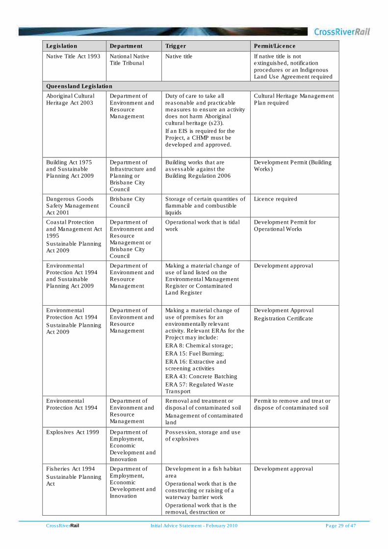
CrossRiverRail Initial Advice Statement - February 2010 Page 29 of 47
Legislation Department Trigger Permit/Licence
Native Title Act 1993 National Native Title Tribunal
Native title If native title is not extinguished, notification procedures or an Indigenous Land Use Agreement required
Queensland Legislation
Aboriginal Cultural Heritage Act 2003
Department of Environment and Resource Management
Duty of care to take all reasonable and practicable measures to ensure an activity does not harm Aboriginal cultural heritage (s23).
If an EIS is required for the Project, a CHMP must be developed and approved.
Cultural Heritage Management Plan required
Building Act 1975 and Sustainable Planning Act 2009
Department of Infrastructure and Planning or Brisbane City Council
Building works that are assessable against the Building Regulation 2006
Development Permit (Building Works)
Dangerous Goods Safety Management Act 2001
Brisbane City Council
Storage of certain quantities of flammable and combustible liquids
Licence required
Coastal Protection and Management Act 1995
Sustainable Planning Act 2009
Department of Environment and Resource Management or Brisbane City Council
Operational work that is tidal work
Development Permit for Operational Works
Environmental Protection Act 1994 and Sustainable Planning Act 2009
Department of Environment and Resource Management
Making a material change of use of land listed on the Environmental Management Register or Contaminated Land Register
Development approval
Environmental Protection Act 1994
Sustainable Planning Act 2009
Department of Environment and Resource Management
Making a material change of use of premises for an environmentally relevant activity. Relevant ERAs for the Project may include:
ERA 8: Chemical storage;
ERA 15: Fuel Burning;
ERA 16: Extractive and screening activities
ERA 43: Concrete Batching
ERA 57: Regulated Waste Transport
Development Approval
Registration Certificate
Environmental Protection Act 1994
Department of Environment and Resource Management
Removal and treatment or disposal of contaminated soil
Management of contaminated land
Permit to remove and treat or dispose of contaminated soil
Explosives Act 1999 Department of Employment, Economic Development and Innovation
Possession, storage and use of explosives
Fisheries Act 1994
Sustainable Planning Act
Department of Employment, Economic Development and Innovation
Development in a fish habitat area
Operational work that is the constructing or raising of a waterway barrier work
Operational work that is the removal, destruction or
Development approval
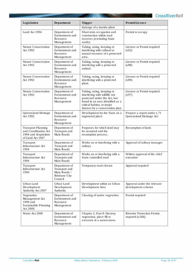
CrossRiverRail Initial Advice Statement - February 2010 Page 30 of 47
Legislation Department Trigger Permit/Licence
damage of a marine plant
Land Act 1994 Department of Environment and Resource Management
Short term occupation and construction within road reserves (excluding State roads)
Permit to occupy
Nature Conservation Act 1992
Department of Environment and Resource Management
Taking, using, keeping or interfering with cultural or natural resource of a protected area.
License or Permit required (s62)
Nature Conservation Act 1992
Department of Environment and Resource Management
Taking, using, keeping or interfering with a protected animal.
License or Permit required (s88)
Nature Conservation Act 1992
Department of Environment and Resource Management
Taking, using, keeping or interfering with a protected plant.
License or Permit required (s89)
Nature Conservation Act 1992
Department of Environment and Resource Management
Taking, using, keeping or interfering with wildlife not protected under the Act, but found in an area identified as a critical habitat, or major interest by a conservation plan
License or Permit required (s97)
Queensland Heritage Act 1992
Department of Environment and Resource Management
Development by the State on a registered place
Prepare a report under s.71 Queensland Heritage Act
Transport Planning and Coordination Act 1994 and Acquisition of Land Act 1967
Department of Transport and Main Roads
Purposes for which land may be resumed and the resumption process.
Resumption of land.
Transport Infrastructure Act 1994
Department of Transport and Main Roads
Works on or interfering with a railway
Approval of railway manager
Transport Infrastructure Act 1994
Department of Transport and Main Roads
Works on or interfering with a State controlled road
Written approval of the chief executive
Transport Infrastructure Act 1994
Department of Transport and Main Roads / Brisbane City Council
Temporary road closure Approval required
Urban Land Development Authority Act 2007
Urban Land Development Authority
Development within an Urban Development Area
Approval under the relevant development scheme
Vegetation Management Act 1999 and Sustainable Planning Act 2009.
Department of Environment and Resource Management
Clearing of native vegetation Permit required
Water Act 2000 Department of Environment and Resource Management
Chapter 2, Part 8: Destroy vegetation, place fill or excavate in a watercourse
Riverine Protection Permit required (s266)

CrossRiverRail Initial Advice Statement - February 2010 Page 31 of 47
4 Existing environment
4.1 Natural environment
Terrain
The study corridor passes through a range of topographical land forms and elements.
The topography of the southern part of the study corridor consists of undulating terrain with minor
surface catchments between hills. The study corridor passes to the east of the ridge on which Dutton
Park and Boggo Road precincts lie. North along the alignment from the Park Road rail station the
topography is relatively flat across Woolloongabba before gradually rising to a maximum of about 30
metres above sea level at the crest of the remnant quarry wall cliffs at Kangaroo Point. From the cliffs
there is a fall to the Brisbane River.
After crossing the Brisbane River there is a gradual rise through the City Botanic Gardens to the CBD.
The elevation is relatively constant through the CBD before a steady rise to Spring Hill. From there,
the landform falls steadily to the floodplain of Enoggera Creek at Bowen Hills and Mayne. North of
Enoggera Creek, the terrain of the study corridor rises along a valley formed by a series of connected
hills and ridges along Lutwyche Road, Windsor, to an elevated saddle across to Albion and the higher
ground of Hamilton and Clayfield. From this saddle, the study corridor falls gently to the north towards
Wooloowin.
Geology, hydrogeology and soils
The study corridor is underlain by the Neranleigh-Fernvale Formation and the Bunya Phyllite, which is
the oldest bedrock in the Brisbane region, formed about 420 to 350 million years ago. In some areas
these formations are covered by Brisbane Tuff formed from volcanic ash falls about 220 million years
ago. The Triassic age Brisbane Tuff generally comprises fine to coarse grained volcanic rocks formed
as the result of pyroclastic (volcanic ash) flows. The rock is generally of very high strength.
Following the Triassic volcanic eruptions, rivers deposited sands and gravels along channels and
floodplains to produce the conglomerates and sands of the Aspley Formation and more mature finer
silts and shales of the Tingalpa Formation of predominantly mudstones with interbedded sandstones
and conglomerates. In the recent past, after widespread erosion, deposition of Quaternary Alluvium
occurred particularly during high stands of the sea over the last two million years.
This geology has been deeply eroded by the Brisbane River system during periods of low sea level.
The course of the Brisbane River has changed little since Tertiary times, and appears to have been
established even earlier. As sea levels rose, the deeply dissected land surface was subsequently in-
filled by alluvial and estuarine sediments to form the flat, low-lying plains of the Brisbane River.
The hydrogeological regime of the study corridor within which tunnelling will be undertaken comprises
two broad aquifer types:
• a fractured rock aquifer system of either the Brisbane Tuff, Neranleigh-Fernvale Beds or Tingalpa Formation; and
• narrow and isolated Quaternary alluvial systems associated with valleys that have eroded into the older bedrock.

CrossRiverRail Initial Advice Statement - February 2010 Page 32 of 47
Overriding these aquifer systems is the impact of the Brisbane River which is incised through Brisbane
Tuff and the underlying Neranleigh-Fernvale Beds.
The Neranleigh-Fernvale Beds that occur along the study corridor predominantly on the northern side
of the river, comprise mainly quartz arenite and phyllite with occasional quartzite and localized meta-
basalt. From a hydrogeological perspective the Neranleigh-Fernvale Beds can be described as an
aquifer of very low to low permeability.
The Brisbane Tuff is a very hard welded tuff or ignimbrite. It has effectively no primary porosity and
any groundwater movement will be through secondary features such as joints and fractures. It occurs
along the study corridor on the southern side of the river, between the river and Park Road Station,
and on the northern side in the area of Exhibition and Bowen Hills Stations.
The Tingalpa Formation that comprises variable sandstones and shales, is present at the southern
end of the study corridor between Fairfield and Park Road Stations. Testing of the formation for other
tunnel projects indicates that it is generally of low permeability.
Quaternary alluvium comprising variable deposits of clay, silt, sand and gravel, but with clay
predominating, infills topographic depressions and low-lying areas along the study corridor. The
alluvium is expected to be relatively thin (<10m) and is confined to the upper catchment of Norman
Creek on the southern side of the river, an area along the northern side of the Brisbane River and in
the Victoria Park area at the northern end of the study corridor.
Groundwater levels along the study corridor will be variable and will generally be a subdued reflection
of the topography, except in areas where the water table has been impacted by existing infrastructure.
Similarly groundwater quality will be variable with pH ranging from slightly acidic to slightly alkaline
and the total dissolved salts ranging from fresh to saline, the brackish to saline groundwater occurring
in areas close to the Brisbane River which is tidal. Previous experience on the S1 Sewer project and
Department of Environment and Resource Management databases indicate that areas of groundwater
contamination may be present with the potential to be mobilised by any induced groundwater flows.
The development of Brisbane over time has impacted the groundwater regime through lowering of
groundwater levels due to the construction of deep drains, sewers and tunnels and a reduction of
recharge as a result of tree-clearing and construction of buildings, pavements and roadways.
The study corridor contains different soil types including prairie soils with some sandy alluvial surface
soils, lithosols and shallow podzolic soils. Most surface soils are classed as easily erodable to
erodable. Acid sulfate soils and potential acid sulfate soils are expected in the study corridor.
Ecosystems
The environment in the vicinity of the study corridor has been heavily modified over many years.
Modified green spaces in the study corridor include the City Botanic Gardens, the Roma Street
Parklands and the banks of the Brisbane River.
The Department of Environment and Resource Management online database lists records of sightings
of one vulnerable amphibian, one vulnerable bird, one presumed extinct bird, two vulnerable insects
and one rare plant occurring within or in the vicinity of the study corridor. The Department of the
Environment, Water, Heritage and the Arts Protected Matters Tool Database lists matters of national

CrossRiverRail Initial Advice Statement - February 2010 Page 33 of 47
environmental significance and other matters protected by the Environment Protection and
Biodiversity Conservation Act 1999. A number of species are noted as potentially occurring within the
study area, although the database considers Ramsar wetlands downstream in Moreton Bay and
Marine species.
Watercourses and aquatic habitats
The Brisbane River is the only major waterway potentially affected by works, although track upgrade
works may occur both to the north and south along existing alignments within the Enoggera Creek,
Kedron Brook, Norman Creek and Oxley Creek catchments. Further, local flows may occur in
overland flow paths in some areas of the study corridor.
The original waterways in the CBD were moved into lined drains many years ago. Tunnelling will be
beneath the bedrock level of the Brisbane River similar to works undertaken by the Clem7 road tunnel.
The CBD is adjacent to the Brisbane River, where there has been flooding under very infrequent
extreme events. The hydrographs for similar events have been modified by upstream dams. In
addition flooding from overland flow at a number of locations throughout the study corridor has been
experienced under extreme rainfall events.
Aquatic habitats along the Brisbane River are dominated by mangroves, with an associated range of
fauna. In addition, there are heavily modified parkland environments in the City Botanic Gardens and
the Roma Street Parklands that will contain limited aquatic habitat supportive of a range of fauna.
Air and noise
The existing environment is typical of the centre of a large city, with road traffic the dominant air and
noise influence. The air and noise characteristics have been extensively monitored as part of ongoing
programs and other construction projects.
The existing acoustic environments in the vicinity of the project portals and connections with the
surface rail network are influenced by road and rail traffic and other urban activities at both the
northern and southern ends of the study corridor.
Social
The study corridor includes the urban areas of Acacia Ridge, Fairfield, Dutton Park, Woolloongabba,
CBD Spring Hill and Eagle Junction. These are substantial urban areas that support residential,
commercial, industrial and recreational activities. A large number of people from across the South
East Queensland region travel to these areas for business, employment, recreation and shopping. In
recent times there has been a significant increase in the number of residents as inner city living has
resurged in popularity. There is considerable social diversity within these areas, varying both with
location and time, both daily and across the week.
Community and tourist facilities
The study corridor includes many features important to both the broader Brisbane and Queensland
society, and a number of facilities visited by tourists, mostly in the city centre. These features within or
proximate to the study corridor include the Queensland Parliament, Brisbane City Council
headquarters and the public library, the City Botanic Gardens, the Roma Street Parklands, the Queen
Street Mall and surrounding retail outlets, the Queensland University of Technology, the RNA

CrossRiverRail Initial Advice Statement - February 2010 Page 34 of 47
Showgrounds, Kangaroo Point Cliffs, the Brisbane Cricket Ground (the Gabba), historic buildings and
places, the Treasury Casino, and the focal point for the city busway network.
This area was the centre of initial European development for Brisbane and contains many features of
historic interest. There are also a number of restaurants and cafes frequented by visitors and
residents.
Cultural heritage
Historic use by indigenous peoples of the area contained within the study corridor is known to have
been extensive. The views of indigenous groups with interests in the study corridor will be important
inputs to the documentation of the cultural values and significance of the area.
The study corridor has been subjected to extensive waves of development over more than one
hundred years that will have already extensively impacted any archaeological materials.
There are also a number of non-indigenous cultural heritage sites within the study corridor that include
areas of initial European settlement in Brisbane. These include sites listed on the Queensland
Heritage Register, Brisbane City Council’s local heritage register, the Register of the National Estate
and the Commonwealth Heritage List.
Economic characterisation
Brisbane is the capital of the fastest growing state in Australia. Queensland is projected to have the
second largest state population by 2030. The Brisbane CBD is the economic centre of both Brisbane
and Queensland. The South East Queensland region's transport system is under significant pressure
due to rapid population and economic growth, increasing private vehicle use and growing freight
movements resulting in worsening peak hour traffic congestion and overcrowding of passenger
transport services. Public transport use has grown considerably over the past few years and increased
capacity is required to provide adequate public transport access both to the CBD, and between the
CBD and major regional hubs across the region.
The cost of road congestion and projected traffic growth for Queensland has been estimated by the
Bureau of Infrastructure Transport and Regional Economics (BITRE) to increase from $1.2 billion in
2008 to $3 billion in 2020. The national figure is expected to grow from $9 billion to $20 billion by
2020. Queensland's contribution to national road congestion is expected to rise from around 13 per
cent to 15 per cent over this period (BITRE Working Paper 71, 2007).
Employment in the CBD is forecast to grow from approximately 140 000 jobs in 2006 to 260 000 jobs
by 2026, based on National Institute of Economic and Industry Research forecasts. The rail system
delivers a significant number of the highly skilled workforce to the Brisbane CBD.
4.2 Built environment
The built environment within the study corridor is dominated by urban development.
Brisbane is the capital of Queensland and its business and administration centre. It has been
extensively developed for commercial, institutional, cultural, educational, religious, recreational and
residential uses.

CrossRiverRail Initial Advice Statement - February 2010 Page 35 of 47
The southern areas of Fairfield, Park Road and Dutton Park contain a mix of residential, commercial
and light industrial uses and much of the residential precincts are dominated by character housing
within a development control precinct of Brisbane City Council’s City Plan.
The suburb of Woolloongabba, about one kilometre south of the Brisbane CBD, contains a mix of
retail, commercial, industrial and residential uses, and residential dwellings range from character
housing to modern residential towers. Woolloongabba contains the Brisbane Cricket Ground (‘the
Gabba’), the Mater hospital complex and the South Brisbane dental hospital. The state government
owns a large site housing Go Print and the Land Centre.
The built form within the Brisbane CBD is characteristic of a city centre, with many tall buildings and
deep basements. The detailed feasibility studies will address and locate building basements, together
with the use of such buildings as part of the design and impact assessment studies. The location of
proposed stations in the CBD will also be determined in relation to the existing and planned future built
form controlled by City Plan.
Spring Hill was one of the first parts of Brisbane to be settled, around the 1850s and contains some of
the city’s oldest buildings. The area has undergone substantial redevelopment for commercial,
institutional and residential uses. Major developments include St Joseph’s College, Centenary Aquatic
Centre, St Andrews War Memorial Hospital, Brisbane Central Primary School, Brisbane Grammar
Schools and Victoria Parkland.
Bowen Hills was declared an Urban Development Area on 27 March 2008 and the Bowen Hills
Development Scheme came into effect on the 3 July 2009. Future development within walking
distance of the Bowen Hills railway station will promote inner city transit oriented development (TOD).
Throughout the study corridor, especially in the CBD, there are older buildings with heritage value.
4.3 Land tenure and ownership
Land tenure within the study corridor is held under a variety of tenure arrangements including freehold,
reserve or leasehold tenure, as well as unallocated state land.
State and Council controlled land within the study corridor may include:
• parklands, including the City Botanic Gardens, Kangaroo Point cliffs, Roma Street Parkland and Victoria Park
• council, state and commonwealth owned buildings
• roads
• existing rail corridors.
4.4 Planning schemes and government policies
The Queensland Government South East Queensland Regional Plan 2009-2031 provides a
framework for managing population growth and development in the region to 2031. The South East
Queensland Infrastructure Plan and Program 2009-2026 outlines the Queensland Government’s
infrastructure priorities for the South East Queensland region to support the South East Queensland
Regional Plan 2009-2031. The plan identifies $124 billion in estimated infrastructure investment
(inclusive of federal government contributions and other revenue sources), which is expected to create
900 000 jobs through to 2026. The South East Queensland Infrastructure Plan and Program 2009-

CrossRiverRail Initial Advice Statement - February 2010 Page 36 of 47
2026 supports TOD outcomes at major public transport nodes, public transport corridors, existing
activity centres and state landholdings within a 10-kilometre radius of the CBD, including Bowen Hills
and Woolloongabba.
The SEQ Regional Plan is supported by the draft regional transport plan called Connecting SEQ 2031:
An Integrated Regional Transport Plan. This draft plan, due to be finalised in 2010, outlines the
transport response to the framework for managing growth in the region outlined in the SEQ Regional
Plan.
Brisbane’s CBD will be developed according to the provisions of the City Centre Neighbourhood Plan.
The City Centre Neighbourhood Plan became effective on 1 January 2009 following extensive public
consultation and state government approval. The plan is based on the principles of the City Centre
Master Plan. The Master Plan was released in August 2006 to provide a 20-year blueprint for the
development of Brisbane’s city centre. The Neighbourhood Plan is the statutory document that
manages development of land in the city centre. The vision for the city centre included in the plan
includes:
• the further development of the city centre in its role as Queensland’s principal centre for business and administration
• a reduced dependence on private vehicle usage and increased reliance on public transport, cycling and walking.
The plan anticipates an underground heavy rail link to connect Spring Hill with the city core.
The City Centre Master Plan includes transport strategies to service the busiest parts of the city
centre. The strategies link key generators and attractors in the city frame, and look at introducing new
bus and train routes and stations, ferries and mass transit options. The Master Plan identifies the need
to improve public transport provision to and within the CBD and surrounding areas. It proposed key
transport elements:
• an underground heavy rail link between Woolloongabba and Bowen Hills via Eagle Street and Parliament House to serve the eastern sector of the CBD and provide increased river crossing and city station capacity
• an accessible and recognisable mass transit service linking West End, South Brisbane, CBD, Fortitude Valley, Teneriffe and New Farm to cater for the high growth and urban renewal.
The Master Plan does not specify the mode to provide the mass transit service but indicates that it
should be a ‘highly visible, extremely accessible high-capacity mode’ and be integrated with other
public transport services to provide a circulation system to enliven the city and connect key attractions.
Brisbane City Council’s Transport Plan for Brisbane 2008–2026 has been developed as an Integrated
Local Transport Plan under the objectives of the South East Queensland Regional Plan 2009-2031.
The Transport Plan notes that the Queensland Government is undertaking studies into options for
future capacity upgrading of inner city rail and bus systems, and that council planning and projects will
be aligned with these study findings as they are made available. The Transport Plan also notes that
Brisbane City Council will be undertaking studies to determine what steps need to be taken to achieve
the projected public transport mode share target in an earlier timeframe than 2026, and that the
necessary conditions to achieve this would include a significant increase in rail capacity, making full
use of rail corridors to move more than 30 000 passengers per hour which should include serious
consideration of an inner Brisbane metro system.

CrossRiverRail Initial Advice Statement - February 2010 Page 37 of 47
The Transport Plan notes as a key driver that by 2016, almost 50 per cent of Brisbane’s population is
expected to live in outer suburbs. Further pressure is also expected from people commuting to
Brisbane from surrounding local areas like Logan, Ipswich, Redland, Beaudesert, Redcliffe,
Caboolture and Pine Rivers. By 2016, it is projected that more than one million people will live in these
areas and by 2026 1.2 million. At the same time, employment is expected to increase in Brisbane by
55 per cent but in these surrounding areas by only 35 per cent.
Brisbane City Council, in partnership with the Queensland Government, has started developing an
overarching plan to guide development of the inner city – the River City Blueprint. The River City
Blueprint will draw together all existing plans, studies and strategies for suburbs within a five kilometre
radius of the CBD to generate a single, consolidated vision for the area. It will create a cohesive
framework to manage growth and infrastructure delivery to 2031 and beyond. The draft River City
Blueprint is expected by mid 2010 with a final release in late 2010.

CrossRiverRail Initial Advice Statement - February 2010 Page 38 of 47
5 Potential environmental impacts
5.1 Potential environmental impact studies
Investigations completed to date have been aimed at identifying the optimal corridor for the north-
south Cross River Rail connection. Detailed investigations, preliminary design and community and
stakeholder engagement will be undertaken as part of the EIS process. The studies required to
support and complete the EIS may include, but are not limited to:
• preliminary project design, including urban design and landscape design, and construction planning
• traffic and transport, including railway operations, pedestrian and cycle access, road network impacts and other public transport
• land use, planning scheme provisions and urban renewal opportunities
• studies of potential bio-physical impacts (eg ecology, groundwater, contaminated land, surface water, noise, vibration and air quality)
• studies of potential socio-economic impacts (eg visual, cultural heritage, social, economic including cost-benefit analysis, construction effects)
• waste management
• hazards and risks.
5.2 Transport system
Cross River Rail will provide opportunities for improved performance across the South East
Queensland regional rail network with corresponding benefits to road transport networks and
especially road-based public transport.
Cross River Rail will help transform South East Queensland’s rail system by providing new inner city
rail infrastructure that will deliver benefits to not only inner city travel, but the wider South East
Queensland rail network.
The project will increase the capacity of the rail network with more frequent services and easier
interchange between trains and other transport. Building new inner city rail infrastructure will cater for
the growing number of rail passengers in both the CBD and the wider South East Queensland rail
network. The new rail tracks provided by Cross River Rail will provide future opportunities for changes
to the way the greater South East Queensland rail network is operated providing greater flexibility and
capacity across the entire network. Cross River Rail is anticipated to provide the ability to move up to
120 000 people in the morning peak period into the inner city.
When completed Cross River Rail will provide substantial environmental, social and economic benefits
at the regional, city and local scales through improvements to the rail network with corresponding
benefits to the road network. During construction there is the potential at the local level for some
adverse impacts to local road traffic, which will need to be carefully considered and mitigated against
through considered design and management approaches.
A more detailed assessment of these benefits and impacts will be undertaken as part of the EIS.

CrossRiverRail Initial Advice Statement - February 2010 Page 39 of 47
5.3 Biophysical environment impacts
Flora, fauna and aquatic habitats
The biophysical environment of the study corridor has been heavily modified over many years,
particularly since European settlement. The preparation of the EIS and selection of the final project
alignment within the study corridor will allow any potential impacts to flora, fauna and aquatic habitats
to be identified and assessed. Significant impacts to flora, fauna and aquatic habitats are not
anticipated due to the highly urbanised environment within the project corridor and recent experience
on other major transport tunnel projects in Brisbane.
Ecological studies will be undertaken to determine the presence, if any, of significant species and the
current ecological conditions. Such studies will inform the scope of possible mitigation measures to
ensure the existing environmental values are protected from potential adverse effects.
No adverse impacts are anticipated on the Brisbane River or the Ramsar wetlands downstream,
principally because much of Cross River Rail is expected to be constructed underground, mostly in
bedrock and beneath the Brisbane River.
Predicted impacts will be minimised through sensitive planning and design development. An
environmental management plan will be developed to assist in mitigating impacts as part of the EIS.
Geology and groundwater
Construction of the Cross River Rail tunnel has potential to impact the groundwater regime along the
corridor.
Potential impacts that will be considered include:
• the potential to intersect open fractures and joints
• consolidation and settlement where the tunnel passes under and drains saturated alluvial sediments
• reduction of available water for groundwater dependant ecosystems due to lowering of the groundwater table
• mobilisation of contaminated groundwater to “drained” sections of the tunnel
• the potential occurrence of acid sulphate soils in low-lying alluvial areas where there is potential for tunnel construction to lower water table levels
• groundwater impacting on or ‘attacking’ concrete and steel
• disposal of inflows to the tunnels during and post construction.
Hydrogeological investigations involving drilling and testing will be undertaken during the detailed
feasibility studies to inform the EIS process.
Flooding, water quality and sediment control
Tunnelling will be beneath the bed level of the Brisbane River, greatly reducing the potential for impact
on the Brisbane River. The findings from this approach with the Clem7 road tunnel are that impacts on
the river system are very unlikely.
Construction works near overland flow paths or smaller local waterways will need to be appropriately
managed to ensure that they are protected and that no adverse impacts result in the Brisbane River.

CrossRiverRail Initial Advice Statement - February 2010 Page 40 of 47
The management of construction water quality and sediment control for major building excavations is
well established in the Brisbane City area and will be appropriately assessed and documented as part
of the construction planning informing the EIS.
The design of the project will need to achieve design objectives with regards an acceptable flood
immunity, and that any works associated with the project do not have adverse effects on existing flood
regimes in any of the local catchments.
Any construction work involving excavation has the potential for water quality and sediment impacts if
not appropriately managed. Recent experience on other major transport tunnel projects in Brisbane
indicates that these potential impacts can be mitigated through the provision of enclosed construction
portals, routine controls on surface works and water treatment if necessary before discharge to any
waterways. Groundwater discharges may be required at times during underground excavation and
any discharges will need to be appropriately treated, and the potential impacts of groundwater
drawdown and the induced movement of any existing contamination understood. The EIS will assess
these issues.
Spoil and waste management
There is the potential for a significant amount of waste to be generated during construction of the
project including demolition materials and construction waste.
The location for the disposal of material excavated from the tunnel has not been selected. Similarly,
the method of transporting construction spoil has yet to be determined and will be the subject of
feasibility studies informing the EIS. Depending on the nature of the excavated material, there may be
an opportunity to exploit a proportion of the spoil as a valuable construction resource.
Studies of the nature and volume of waste materials and spoil will be undertaken as part of the design
and construction planning studies informing EIS. The proposal for spoil and waste management will be
described and assessed.
Contaminated land investigations will be undertaken as part of the EIS and management procedures
developed. The removal of soil from sites registered on the Environmental Management Register will
require the approval from the Department of Environment and Resource Management.
Strategies will be developed, in accordance with the waste hierarchy, to avoid where possible, and
then reuse, recycle and appropriately dispose of the remainder.
Air quality, noise and vibration
By increasing the use of electric powered public rail transport, it is expected that Cross River Rail will
help reduce air quality emissions and road traffic noise across Brisbane into the future, compared to
the ‘do-nothing’ case. This would result in a reduction in the number of motor vehicles that otherwise
would use the road network with a corresponding reduction in vehicle exhaust and noise emissions.
The potential for corresponding greenhouse and health benefits will be assessed.
The existing residential amenity for individuals along the corridor will need to be understood and
protected. Further assessment of the current air and noise conditions will be undertaken as part of the
EIS to inform requirements for air and noise migrations during project construction.

CrossRiverRail Initial Advice Statement - February 2010 Page 41 of 47
Construction experience on other major tunnels and building excavations in Brisbane indicates that
potential adverse air quality, noise and vibration impacts can be managed with appropriate and
carefully managed mitigation measures. Potential air quality impacts may arise from dust generation
during excavation and construction activities, dust released during spoil removal, the distribution of
dust by wind, and exhaust emissions from increased traffic and machinery use on site. Noise impacts
can result from construction activities and indirectly from regenerated noise due to vibration. Vibration
can affect individual amenity, buildings (especially heritage sites due to construction techniques and
finishes) and sensitive equipment.
Potential impacts on properties and people near the project sites will be assessed as part of the EIS
including the development of predictive models where necessary. Appropriate construction site
management practices will be developed to mitigate predicted impacts and monitoring programs set
out to ensure required outcomes are achieved. These management programs will be linked with
consultation requirements to ensure businesses and residents are kept informed and problems are
identified.
It is likely that underground stations and tunnels will have some ventilation requirements to provide
fresh air, but in the absence of emissions of pollutants in large quantities, the potential impact on the
ambient air quality will be very low. Potential effects of ventilation outlets on the surrounding
community and changes in air quality resulting from reduced traffic volumes will be assessed as part
of the EIS.
In areas where surface traffic volumes are significantly reduced, it is expected that air quality adjacent
to benefited roads will be improved.
There is limited risk of long-term noise or vibration impact since most of the project will be
underground. A noise and vibration assessment will be undertaken to determine impacts and any
required mitigation measures, especially in areas where the project operational works are on or close
to the surface.
5.4 Socio-economic impacts
The project is expected to deliver strong social outcomes at a regional and local level, providing
people with a choice of transport mode and improved lifestyles compared to the situation if the project
did not proceed. Positive social outcomes expected to result from the project include:
• improved access to services and public transport
• improved amenity, especially in terms of air quality, noise, visual effects and urban renewal
• reduced severance of communities by road traffic
• greater choice and availability of employment opportunities
• improved economic well-being.
There are also a number of potentially adverse effects that may occur in the project corridor, during
both construction and operation. These may include:
• land acquisition and potential displacement
• disruption of local access during construction
• effects on community structure and functioning, including severance
• adverse impacts on residential and workplace amenity.

CrossRiverRail Initial Advice Statement - February 2010 Page 42 of 47
A social impact assessment will be undertaken as part of the EIS and include consultation with the
community to identify issues, both positive and negative, and the development of appropriate
measures to address these.
The economic impacts, both positive and negative, will also be evaluated, and the impacts of and
opportunities for the project on local businesses and urban renewal will be considered.
Property impacts and severance
The construction and delivery of Cross River Rail will involve the acquisition of properties in the vicinity
of the portals and the stations. Some land acquired for construction will also be required to support the
operation of Cross River Rail. Land will also be acquired volumetrically to support the passage of the
project beneath the surface.
The process of acquiring interests in land on the surface and in strata may be undertaken through the
provisions of the Acquisition of Land Act 1967 and the Transport Planning and Coordination Act 1994.
Any future acts on land on which native title has not been extinguished will need to be consistent with
the Native Title Act 1993 (Commonwealth) and the Native Title (Queensland) Act 1993.
Impacts on properties directly affected by construction will be assessed and may include
redevelopment of some properties directly above station locations, or cut and cover works near tunnel
portals. Properties immediately adjacent to construction areas may experience some construction
impacts such as vibration and the EIS will assess these potential impacts and develop appropriate
mitigations.
Property severance, if any, as a result of the project is expected to be minor given that most of the
project will be constructed in tunnel and stations underground. There may be impacts on future
development above and immediately adjacent to the underground sections of the project. This will be
assessed during the EIS including related issues associated with the acquisition of volumetric title
required for the underground sections of the works.
Changes in the tenure of affected land may occur, and the rationalisation of final tenure arrangements
will be considered as the project progresses.
As a consequence of the proposed investment and benefits delivered by Cross River Rail, changes in
land use are expected to occur, over time, at key locations along the project alignment.
The conversion of land usage along the route may be required at proposed stations, portals and
ventilations outlets, with current land usage (residential, commercial, industry, exhibition land)
replaced by rail transport infrastructure and facilities. Some of these locations are governed by specific
legislation (primarily the RNA Exhibition Grounds) or are under a planning regime administered other
than by Brisbane City Council (Bowen Hills Urban Land Development Area). The process of dealing
with land use changes will be developed throughout the EIS.
Cultural heritage
Consultation with local indigenous groups and the Cultural Heritage Branch of the Department of
Environment and Resource Management will be undertaken to determine if there are any sites of
indigenous significance within the project corridor. It is possible that there are sites of significance to

CrossRiverRail Initial Advice Statement - February 2010 Page 43 of 47
the indigenous people of the area. Their input will be sought as part of an indigenous cultural heritage
study will be undertaken across the project corridor as part of the EIS.
Cross River Rail is very likely to pass by or beneath a number of listed heritage sites and the potential
exists for direct or indirect (vibration) effects to occur during construction. A detailed assessment of the
potential impacts of the proposed works on all buildings along the final route will be undertaken during
the EIS, especially heritage-listed structures or other buildings of historic interest.
The project is not anticipated to have any adverse impacts on cultural heritage but will enable greater
access to buildings and places with cultural heritage values in inner Brisbane and throughout South
East Queensland. Assessments will be undertaken as part of the EIS of all matters relevant to cultural
heritage to ensure that any potential impacts are predicted and mitigations provided to ensure no
discernable adverse impacts occur. This will include the assessment of the potential effects of
construction on all adjacent structures, with particular attention to the potential effects of vibration.
Urban design, landscape and visual effects
Most of the project is anticipated to be underground and accordingly there will be relatively low
impacts on the landscape, with any minor impacts related to portal areas, underground station access
points and temporary construction sites. Above ground station components will be designed to
complement and enhance the local urban design environment. The assessment of visual impacts is
often subjective and consultation will be undertaken as part of the EIS to identify preferred visual
approaches.
Economic
Traffic congestion is a growing problem in South East Queensland, and as the region continues to
grow, congestion will worsen. Congestion stifles productivity and bears a significant economic cost. By
2020, it is expected that congestion will cost the Brisbane economy around $3 billion per annum if
current trends continue (Urban Transport Challenge, p.3). In the longer term and if the whole of South
East Queensland is considered, this cost will be substantially higher. Cross River Rail will provide vital
public transport to cut congestion, providing access to job markets and remove cars from the roads,
helping to maintain highway capacity for the shipment of goods and services (APTA, 2003). High
quality public transport reduces traffic congestion by attracting travellers who would otherwise drive.
Studies show that as public transport services improve, congestion levels on parallel roadways tend to
decline (Litman 2009, p11).
The project will strongly influence the shape, economic diversification, and accessibility of the city over
the next 30 years, and support future employment and population growth and distribution in the
Brisbane CBD and broader inner city area. The project is a key component of an inner city transport
and land use strategy, currently being jointly developed by the state government and Brisbane City
Council. Without the increase in capacity to that network that will be delivered by the project the future
productive output of the capital would be significantly diminished.
Good public transport is vital to successful urban areas, enabling people to access jobs and services,
employers to access labour markets, and businesses to reach customers for their services. There are
well-established links between improved transport efficiency and economic growth. Maintaining
adequate rail service and access is vital for the economic well-being of Queensland's largest city.

CrossRiverRail Initial Advice Statement - February 2010 Page 44 of 47
Further benefits will be derived for rail freight movements across the Brisbane urban area, providing
improved access to the Port of Brisbane and support for the Australian Trade Coast industry base.
Preliminary economic assessment undertaken has indicated substantial benefits available from the
Cross River Rail investment. Environmental impact studies will include comprehensive cost benefit
assessments as part of a wider economic assessment that will include all significant economic
benefits and impacts of the project.
5.5 Built environment
The project will have a positive impact on the built environment within the project corridor through the
provision of an underground public rail transport facility, hence reducing the impact of motor vehicles
on the city and reducing the need for surface road transport infrastructure and parking.
The impact of construction on building, especially from vibration, will be assessed and mitigations
determined as part of the EIS.
The project may enable significant urban renewal opportunities at stations and nearby areas in the
CBD and at other locations along the project corridor including Woolloongabba and Bowen Hills. High
quality public transport can help reduce social disadvantage by providing opportunities for affordable
housing at transit oriented developments and access from more remote cheaper housing areas. The
new rail corridor would promote sites for infill development, and activate a range of land use
opportunities at locations along the corridor, both large and small in scale.
5.6 Hazard, risk and health and safety
There are a number of potential hazards, risk and health and safety issues that may occur during
Cross River Rail. The project may also provide health and safety benefits including improved
separation of passenger and freight services, improved station facilities and accessibility, and resulting
improved rail passenger safety.
Construction activities that may generate a hazard include:
• operation of vehicles and construction equipment in the confined tunnel space with resulting increased risk levels from spillages, fire and poor air quality
• operation of vehicles and construction equipment, and the storage of dangerous goods in relatively compact construction sites
• construction failures and accidents including tunnel collapse or subsidence, flooding and worker injuries and death
• the use of oils, fuels and other dangerous goods including explosives, and their transport to construction areas
• increased traffic risks as a result of the transport of excavated materials to disposal areas.
Operation activities that may generate a hazard include:
• passenger safety incidents including personal safety and injury
• staff accidents and incidents in the tunnel during maintenance works
• major train incidents including derailment and fire
• acts of terrorism leading to major fires and explosions resulting in injury to passengers and staff

CrossRiverRail Initial Advice Statement - February 2010 Page 45 of 47
• tunnel and other structural components collapse, subsidence or failure
• flooding and inundation from both surface and groundwater sources.
Further risk studies will be undertaken during the EIS and effective mitigations developed and
documented. Consultation will be undertaken with relevant government agencies on issues such as
fire and life safety, disability access and personal safety through design.

CrossRiverRail Initial Advice Statement - February 2010 Page 46 of 47
6 Environmental management
An environmental management plan will be developed as part of the EIS. The environmental
management plan will seek to address the full range of aspects related to the project including design,
construction, operation and maintenance. The intent of the environmental management plan is to
outline the measures that are proposed to be implemented to manage the impacts of the project on
the environment.
The environmental management plan will be used to assist in the compliance to applicable
environmental legislation, best practise environmental management and local authority requirements.
Throughout the project the plan shall be reviewed and updated periodically to reflect the knowledge
gained and experiences encountered.
The environmental management plan would address:
• design requirements
• pre-construction activities
• construction/ commissioning
• operation.

CrossRiverRail Initial Advice Statement - February 2010 Page 47 of 47
7 References
The following documents or studies are referred to within the Cross River Rail IAS:
• South East Queensland Regional Plan 2009-2031
• South East Queensland Infrastructure Plan and Program 2009-2026 (Litman 2009, p11)
• Transport Plan for Brisbane 2008–2026
• Draft Connecting SEQ 2031: An Integrated Regional Transport Plan for South East Queensland
• City Centre Master Plan
• City Centre Neighbourhood Plan
• CityShape Implementation Strategy
• Bowen Hills Development Scheme
• BITRE Working Paper 71, 2007
• National Institute of Economic and Industry Research
• Department of Environment and Resource Management Wildlife online database
• City Plan
• Inner City Rail Capacity Study (2008).