CRM vol. 23, no. 10 (2000) - National Park Service · CULTURAL RESOURCE MANAGEMENT VOLUME 23 NO. 10...
44
CULTURAL RESOURCE MANAGEMENT VOLUME 23 NO. 10 2000 U.S. DEPARTMENT OF THE INTERIOR National Park Service Cultural Resources CRM Play Ball! Sports in American Life
Transcript of CRM vol. 23, no. 10 (2000) - National Park Service · CULTURAL RESOURCE MANAGEMENT VOLUME 23 NO. 10...

CULTURAL RESOURCE MANAGEMENT
VOLUME 23 NO. 10 2000
U.S. DEPARTMENT OF THE INTERIOR National Park Service Cultural Resources
CRM
Play Ball!
Sports in American Life

PUBLISHED BY THE NATIONAL PARK SERVICE
Information for parks, federal agencies, Indian tribes, states, local governments, and the private sector that promotes and maintains high standards for preserving and managing cultural resources
DIRECTOR Robert Stanton
ASSOCIATE DIRECTOR CULTURAL RESOURCE STEWARDSHIP
AND PARTNERSHIPS
Katherine H. Stevenson
EDITOR Ronald M. Greenberg
ASSOCIATE EDITOR Janice C. McCoy
GUEST EDITORS David A Poirier Cece Saunders
ADVISORS David Andrews
Editor, NPS
Joan Bacharach Curator, NPS
Randall J. Biallas Historical Architect, NPS
John A. Burns Architect, NPS
Harry A. Butowsky Historian, NPS
Pratt Cassity Executive Director,
National Alliance of Preservation Commissions
Muriel Crespi Cultural Anthropologist, NPS
Mary Cullen Director, Historical Services Branch
Parks Canada
Mark Edwards Hstoric Preservation and Cultural Resource Group Manager
URS Greiner Woodward Clyde Federal Services
Roger E. Kelly Archeologist, NPS
Antoinette J. Lee Hstorian, NPS
ASSISTANT Denise M. Mayo
An electronic version of this issue of CRM can be accessed through the CRM homepage at <http://www.cr.nps.gov/crm>.
Design and Imaging McCoy Publishing Services
jan@mccoypublish .com
f\ ^ r % + r > r % + r » VOLUME 23 NO. 10 2000 vOniGniS ISSN 1068-4999
Play Ball! Sports in American Life
Play Ball!—Sports in American Life 3 David A. Poirier and Cece Saunders
Vintage Postcards as Historical Images—Ghosts from the Gipper's Era 5 Robert A. Olmsted
Bats, Balls, and Baseball Cards—Safeguarding Collections at the National Baseball Hall of Fame and Museum 10
Susan L. MacKay
Fenway Park's "Green Monster" 13 Kimberly Anne Konrad
Assessing Golf Courses as Cultural Resources 16 Susan E. Smead and Marc C. Wagner
Lilli-putt-ian Landmarks—History and Significance of Miniature Golf Courses . . . .22 Susan R. Chandler
West Point's Michie Stadium—Balancing History and 21st Century Collegiate Sport Programs 25
Steven M. Bedford
Boston's Curious Bowling History 28 Ann-Eliza H. Lewis
Adriaen's Landing—Archeology, Geology, and Palynology in Connecticut's Central Valley 30
Daniel T. Forrest, Robert M.Thorson, and Michael S. Raber
Exhumation at the Citadel's Johnson Hagood Stadium 33 Jonathan M. Leader and Randy Burbage
McCoy Stadium—Legacy or Folly? 36 Chuck Arning and Kevin Klyberg
The Ballpark at St. George Station, Staten Island, New York 38 Samuel Less
Archeology of Bank One Ballpark, Phoenix, Arizona 40 Karolyn J. Jackman
Cover: artifacts from the Barry Halper Collection, Baseball Hall of Fame and Museum. Photo by Milo Stewart. Jr.
Statements of fact and views are the responsibility of the authors and do not necessarily reflect an opinion or endorsement on the part of the editors, the CRM
advisors and consultants, or the National Park Service. Send articles and correspondence to the Editor, CRM, U.S. Department of the Interior, National Park
Service, 1849 C Street, NW, Suite 350NC, Washington, DC 20240 (U.S. Postal Service) or 800 North Capitol St, NW, Suite 350, Washington, DC 20002 (Federal
Express); ph. 202-343-3411, fax 202-343-5260; email: <[email protected]>, to subscribe and to make inquiries; <[email protected]> to submit articles.
CRM No 10—2000 2

David A. Poirier and Cece Saunders
Play Ball! Sports in American Life
Play Ball!—a simple phrase that warms the hearts of many Americans. Our national passion for sports and athletic events is so
pervasive that even time is measured in sporting terms—baseball's spring training (April) and World Series (October), college basketball's March Madness, and football's college bowl frenzy (New Year's Day). Unfortunately, "Going, Going, Gone" may be a more apt baseball metaphor for the usual circumstances when historic preservation and America's athletic venues interface. Recent times have witnessed the demolition of several notable stadia including Seattle's Kingdome, Detroit's Tiger Stadium, Houston's Astrodome, Milwaukee's County Stadium, and San Francisco's Candlestick Park. The Boston Red Sox are for sale and a political-economic intrigue surrounds the future of historic Fenway Park. Internationally, England's 1 -0 loss to Germany in October 2000 was the last professional soccer game ever to be played at the soon to-be-demolished Wembley Stadium.
Sports play an increasingly important and complex role in American society. Baseball is characterized as the "national pastime" with its "World Series." Basketball is referred to as a truly "American game" with its Olympic "Dream Team." Indeed, athletic success often captures the attention of the American public. However, sports also mirror American society. Segregation, gender bias, moral turpitude, economic inequity, political corruption, integration and diversity, and management-labor relations have been (and continue to be) played out on the sports field. Baseball's Negro Leagues reverberates a nation's attitudes, a lack of social mobility, and injustice. Pumpsie Green's much-delayed promotion to the "Bigs" reflects sadly on the Boston Red Sox organization, the last professional baseball team to integrate. The "gentleman's" game of golf excluded both African Americans and females well into the 20th century (Cece recalls having to enter clubhouses through a separate "women's
entrance" and being denied entry into the sacrosanct, men-only grill room). Pete McDaniel's Uneven Lies: The Heroic Story of African-Americans in Golf (Greenwich: American Golfer, 2000) provides critical insights on the history and design of American golf from an important minority perspective.
Bill James' observations on the criteria and selection process for baseball's Hall of Fame are particularly cogent:
For 60 years the Hall of Fame has wandered this way and wandered that way, its border becoming more of a splatter than a map. The Hall of Fame teases its suitors with inconsistent favors and uncertain standards; yesterday I did, today I won't; I did for him, I won't for you. (page 35)
and
For 50 years there have been attempts to create a new and more rigorous standard, and for 50 years those efforts have always backfired, ultimately bringing into the Hall of Fame a class of very marginal candidates, (page 45)
Serendipitously, James' comments ricochet aptly across the criteria for the National Register of Historic Places. Both the Hall of Fame and the National Register selection processes are occasional venues for unbridled public lobbying for or against particular candidates. Likewise, do questionable prior listings establish a permanent threshold for all subsequent decision making? Is the proper philosophical approach to be inclusive or exclusive, subjective or objective? How many "good" shortstops or "representative" Greek Revivals should be sanctified? Equally challenging is the professional evaluation of sports-related cultural resources that for the most part have been hitherto unassessed. In the following articles, Smead and Wagner's experience with southern golf courses provides a comparative framework for National Register decision making. Likewise, Chandler provides a historic context for miniature golf, a passion for many historic preservationists.
CRM No 10—2000 3

America and sports are inseparable. Sports are more than statistical performances, meteoric careers, and tomorrow's headlines. Athletics are a window onto America's ever-changing sociological and cultural landscape. Will the success of Tiger Woods or the Women's World Cup translate into enhanced opportunities for minorities and women? Does the evolving popularity of the X Games and extreme sports echo merely the exuberance of a younger generation, media-created sports alternatives, or a significant cultural change from team sports to an emphasis upon individual creativity? Will professional sport owner's obsession for new and enlarged facilities eventually result in a bland sameness of sports stadia in the 21st century? Will National Register or National Historic Landmark designations for sports facilities serve a meaningful purpose? These are unanswerable questions and clearer reasons why the preservation community needs to better understand America's sports-related passion, its athletic infrastructure, cultural mythology, and surviving legacy.
Since sports are a significant component of American life, athletic-related issues impinge upon cultural resource management in diverse ways. The articles in this CRM highlight the intersection of sports and historic preservation which has become increasingly frequent with the new economic demands being placed on sport
facilities by owners, players, and fans. In this regard, Forrest and Jackman demonstrate in their articles the resulting pressure placed upon the archeological heritage of urban centers by the partnering of sport business and politics. Similarly, Konrad assesses the fiscal dilemma facing Boston Red Sox ownership and fans concerning the continued use of historic but "out-dated" Fenway Park.
If we are to better understand our lost and disappearing sport icons, whether at the national or neighborhood level, historical research and comparative analysis are critical. Hopefully, this thematic issue of CRM provides an introductory context for future in-depth discussions of America's ever-changing sports-related cultural landscape.
Reference James, Bill. Whatever Happened to the Hall of Fame.
New York: Simon & Schuster, 1995.
David A. Poirier is staffarcheologist with the Connecticut State Historic Preservation Office. He has co-edited In Remembrance: Archaeology and Death (with Nicholas Bellantoni) and Dangerous Places: Health, Safety, and Archaeology (with Kenneth L. Feder).
Cece Saunders is co-partner of Historical Perspectives Inc., a cultural resource management consulting firm. She serves as the historical archeologist for Connecticut's Review Board for the National Register of Historic Places.
Rally behind Fenway Park's "Green Monster," All-Star Game 1999, see article p. 13. Photo by Kimberly Konrad, Save Fenway Park!
CRM No 10—2000 4

Robert A. Olmsted
Vintage Postcards as Historical Images Ghosts from the Gipper's Era
Aerial view of Ebbets Field, Brooklyn, New York. The Dodgers played in Ebbets Field from 1913 to1957. Linen era card.
Postcards are an excellent source of historical images, even of our sporting past. Often the only pictures that can be found of old
buildings, street scenes, expositions or sports venues are on cards buried in a trunk in Aunt Minnie's attic. Postcard collectors usually specialize. Some are interested in views of a particular geographical location, perhaps their hometown, a scenic or vacation area, or a particular state. Others may zero in on specific topics: amusement parks, world's fairs, people, sports, main street views, ships or trains. If a train appears on a card, the price may double. Pictures of old sports stadiums (or stadia if you prefer) also tend to command high prices.
Postcard Images of our Sporting Past Vintage postcards of athletic events and
venues, although not nearly as common as trains or main street views, exist, providing historians, architectural preservationists, and anthropologists a "snapshot" of the past. A separate hobby has evolved around cards depicting players (e.g., baseball cards), but these are not postcards. An interesting early sports postcard set was published by the Boston Post-Card Company for the 1905 Ivy League football season. These cards depicted portraits of the players of each team arranged like the spots on a domino (hence called by the publisher "Dominoe Cards"). One game represented was a controversial Harvard-Yale game that almost led to the demise of college football due to an incident on the field between opposing players. College football was saved after President Theodore Roosevelt called a conference that rewrote the rules of the game. Views of sports arenas from the pioneer era (1893-1898) or golden age (1898-1915) of postcard production are rare, but are fairly common
from the linen era card (1930-1940s). Professional football is a more recent sport than professional baseball; hence professional football stadiums appear mostly on newer color photo cards. However, many linen era cards can be found of college football stadiums; to list a few, the Rose Bowl, Princeton's Palmer Stadium, Cornell's Shoellkoff Stadium, the Yale Bowl and Harvard Stadium—alternate sites of the boisterous Harvard-Yale rivalry, and the Notre Dame Stadium in South Bend. But Knute Rockne's inspirational plea "to win one for the Gipper" took place at halftime during the 1928 Notre Dame-Army game played not in South Bend or West Point, but in Yankee Stadium as the Fighting Irish played their arch rivals, Army, in Yankee Stadium from 1925 to 1946.
Some of us can remember when life was simple and there were only 16 baseball teams in the major leagues. Only three of the nostalgic stadiums of that era remain: Boston's Fenway Park (1912) with its notorious "Green Monster" outfield wall; Chicago's Wrigley Field (1914) with its ivy-covered red brick walls; and New York's Yankee Stadium (1923), "the House that Ruth Built," home of the feared Bronx Bombers. The other stadiums are gone, and postcard views command good prices. Who can forget Ebbets Field (1913-1957) where Jackie Robinson broke
CRM No 10—2000 5

White border era card of Notre Dame Stadium, home of the Fighting Irish, c. 1933.
the color barrier and home of "dem bums," the Brooklyn Dodgers (so named because Brooklynites were nicknamed "trolley dodgers" after the borough's slow horse cars were replaced by faster electric trolley cars). Indeed, the tears and moans that went up when the team moved west in 1958 can still be heard. And what Dodger fan can forget New York's Polo Grounds (1912-1963) where Bobby Thomson's shot heard around the world dashed the bum's 1951 World Series hope and where the "Amazin's," the New York Mets, started life in 1962. Gone too are Philly's Shibe (Connie Mack) Park (1909-1970); Boston's Braves Field (1915-1952)—yes, the Braves were once in Beantown; Chicago's old Comiskey Park (1910-1990); Cincinnati's Crosley Field (1912-1970), home of Johnny Vander Meer's consecutive no-hitters; Pittsburgh's Forbes Field (1909-1970); and only last year, Detroit's Tiger Stadium (1912-1999) bit the dust.
Sports stadiums are notoriously short-lived. Twenty-five years is old. Due to changing economics, obsolete designs, and new desires, most of the new stadiums of the early expansion days have been replaced. Stadiums designed for baseball and football compromised too much and failed. Owners sought new revenue sources from premium-priced luxury boxes for corporate customers, television franchises, and naming rights, while patrons wanted column-free sight lines and the intimate ambience of the old fields, not the sterility of a large concrete bowl. After brief lives, baseball has left San Francisco's windy Candlestick (3Com) Park (1960-1999), Houston's sunless Astrodome (1965-1999), and Seattle's Kingdome (1977-1999) for newer fields; and Minnesota's Metropolitan Stadium (1961-
1981) was displaced by the country's largest shopping mall. Even the New York Met's Shea Stadium (1964) may soon be replaced by a Camden Yards imitation.
When stadiums disappear, postcard views become collector's items. A postcard collection can also record changes to stadiums over time. To increase seating capacity and attendance, stadiums get enlarged and altered, decks are added and lights are installed for night games. Sometimes, as in the case of Yankee Stadium in 1976, a stadium gets completely renovated, changing its appearance. An early postcard of the Polo Grounds about the time it opened in 1912, for example, shows emblems of the eight National League teams mounted on the roof frieze. A much later picture (c. 1950s) shows that they had been removed during a renovation. Compare a linen era card (1930-1940s) of Yankee Stadium with a modern photo card, and you can see the changes resulting from the 1976 renovation. Postcard views can also show a stadium's setting in the urban environment. A card of an early ballpark, Ebbett's Field (1913-1957) for example, will show it as part of the urban fabric. A card of the St. Louis Busch Memorial Stadium (1966) will show its relation to the Mississippi River and the Gateway Arch. And a card of Dodger Stadium (1962) will show it rising from an endless parking lot surrounded by a sea of cars.
Postcard Collections A century ago, long before the advent of
pocket-sized point-and-shoot cameras, camcorders, digital imaging, and pictures by email, the picture postcard was king. Visitors to Chicago's 1893 Columbian Exposition mailed souvenir postal cards all over the world and enthusiasts have been amassing postcard collections ever since. As a measure of their popularity, in a single day in 1906, some 200,000 postcards were reportedly mailed from Brooklyn's Coney Island alone! In the heyday of the postcard craze, over a billion cards were sold annually. The hobby of collecting postcards even has its own name, deltiology, and collectors are deltiologists, although some purists refer to a deltiologist as one who is interested in the history of postcards and a collector as a deltiophile. The words derive from the Greek, meaning a collector of small writings or pictures.
Where does one find vintage postcards? Many dealers set up tables at flea markets,
CRM No 10—2000 6

Forbes Field, Pittsburgh, Pennsylvania. The Pirates played in Forbes Field from 1909 to 1970. Linen era card from a souvenir folder.
antique or ephemera (paper) shows; the fancier the show, the higher the prices. Auctions are often fruitful sources. There are many postcard clubs in the United States and these clubs often have public shows. You frequently run across the same dealers as they move from show to show. You can bargain with some dealers and not others. Most give a discount for large purchases. The price of cards can range from as low as a few dollars, to 10, 20, or even 50 dollars or more, depending on the subject, condition and scarcity. Shop around at a show. A card may be four dollars at one table and the identical card 10 dollars at another. Condition is important. However, a postcard collector may overlook the condition if the card is scarce or is needed to add to a collection.
The list of topics is virtually endless, varying from disasters to political and social subjects to greetings. Greeting cards include not only holiday greetings, but also greetings from a particular place (e.g., "Greetings from Niagara Falls"). The German "Gruss Aus" cards are especially popular. While some collectors eye the stamps or unique cancellations, a true deltioligist shows more interest in the subject, not the stamp. Most postcards are printed on cardboard, but other materials such as leather, wood and even metal, have been used.
A number of artists made their living producing pictures specifically for postcards. One of the most popular "signed" artists was Ellen Clapsaddle (1865-1934) who produced thousands of cards bearing delightful pictures of children. She is one of my favorites if only because she was a tenant in my grandmother's rooming house in New York City when I was a child. Another early favorite artist whose cards are
sought by collectors was Frances Brundage (1854-1937), but there were many others as well.
Postcard History Postcard history is evolutionary. The idea of
sending a piece of cardboard through the mail seems to have originated in the 1860s in Austria and other European countries. However, these were not picture postcards, but cards with blank backs reserved for messages, provided the writer did not care who read the message. Cards were cheaper than paper and postage was often calculated by the number of sheets mailed. The concept took off in the United States in 1861 when H. L. Lipman of Philadelphia began privately printing cards that could be mailed once a stamp was affixed. One side (front) was left blank for a message, the other side (back) for the address; companies quickly caught on that printing messages or illustrations on the backs of cards (advertising cards) was an inexpensive way to advertise their products to a larger audience. The United States government issued its first postal card on May 13, 1873, a forerunner of today's United State Postal Service's postal card, except that the "penny" card now sells in a post office for 21 cents (a penny for the card, 20 cents for postage). These early postal cards, too, were mostly used for advertising, and there are many collectors who specialize in collecting advertising cards. But it was the 1893 Chicago World's Fair that started the picture postcard frenzy.
Understanding the developmental sequence of postcards—size, materials, colors, etc., over time—can date a postcard and its image.
Pioneer Era (1893-1898) The 1893 Columbian Exposition kicked off
the five-year pioneer era of picture postcards. At that time, the U.S. Post Office enjoyed a monopoly on post(al) cards, as only government printed cards could be mailed for the one-cent rate. Privately printed cards, however, could be sent through the mail, but at the higher letter rate of two cents. (The distinction between postal cards and postcards is that postal cards are government issued with pre-printed postage, while postcards are privately printed and require stamps to be affixed.) The backs of cards were still undivided and intended only for writing the name and address. Deltiologists refer to these cards as "undivided backs." As messages were not allowed on the back, many cards of this era often have writing on the front below or alongside the picture. Frequently the writing was more interesting
CRM No 10—2000 7

Modern era chrome card of Dodger Stadium, Los Angeles, California. The Dodgers have played here since 1962 following their move from Brooklyn, New York, in 1958.
than the picture. Cards of this era were often called souvenir cards or mail cards. For the Columbian Exposition, Charles Goldsmith, using government postal stock, printed several sets of official souvenir postcards bearing pictures of the exposition's grounds and buildings on the front. These cards, in essence the first picture postcards in America, were extremely popular, and the picture postcard craze took off like a rocket.
The Golden Age of Postcards (1898-1915) The best and most collectable postcards
were produced in the golden age of postcards. Printing and coloring were of high quality and these cards are in high demand. The golden age began with the passage of the Private Mailing Card Act of 1898, which allowed privately produced cards to be mailed for one-cent, thus stimulating production and demand. Still, no messages were allowed on the back, which remained undivided for the address only. Until 1901, these cards were required to carry the notation, "Private Mailing Card, Authorized by Act of Congress, May 19, 1898." But on December 24, 1901, the law was amended to allow the use of words "Post Card" instead. Finally, on March 1, 1907, the undivided back requirement was dropped and to this day postcards have a vertical line dividing the back, the left side for a message, the right side for the address. Deltiologists refer to post-1907 cards as "divided backs." Pre-1900 cards are rare.
The golden age of postcards continued until about 1915 when World War I intervened. Many of the cards of this period were printed in
Europe, especially in Germany, where the quality of printing was high. The cards were hand-colored, although at times the colorer's imagination went a bit wild as to the true colors. Sometimes the printer would delete an object to make the picture look better or less cluttered. A person or a vehicle might be erased, or non-existent flagpoles might miraculously appear. Hence it is not uncommon to find a scene on one card and obviously the same scene on another card with everything identical (e.g., all the people having exactly the same pose), but with some object, perhaps a wagon, removed with its shadow remaining. Thus one must be careful in using old postcards as a source of historically correct images. Postcard collecting was very popular during the golden age and special albums were sold to keep collections organized instead of being stuffed into shoeboxes. No parlor was respectable unless there was a postcard album on the equivalent of a coffee table.
Many companies jumped on the postcard bandwagon. One of the most prolific producers of postcards was the Detroit Publishing Company, which printed thousands (one source says 16,000) of splendid cards using a special color process they called "photstint," an adaptation of a secret Swiss process. The quality of Detroit's view cards depicting cities and scenic areas of the country, especially the West, are excellent. The western views were photographed by William Henry Jackson, a well-known landscape photographer who some call "the father of the picture postcard." Jackson joined the company and left a legacy of 40,000 glass negatives. The Rotograph Company was another publisher
of high quality view cards. Both their black and white and color cards of city views are especially crisp. An English company, Raphael Tuck & Sons, also produced quality cards for the American market. A favorite of many collectors, Tuck published cards on many topics, such as a series on New York City. Especially popular are their "Oilette" cards, which resemble oil paintings and were produced by Tuck's many artists. But dozens of other companies also participated in the postcard publishing business. Where the market was too small for a publisher, local photographers filled the gap making postcards from their photographs (called "real photo" cards), sometimes
CRM No 10—2000 8

Linen era card of Yankee Stadium before installation of the lights in 1946 and before 1976 renovation. Home of the Bronx Bombers since 1923.
even sending the negatives to Germany for printing. Real Photo cards of small towns are highly collectable.
The White Border Era (1915-1930) After the German supply was cut off, post
cards were printed in the United States. Quality went downhill as American producers used cheap printing processes. They also skimped on the amount of ink used by placing a white border around the card. Colors were poor and the images were often not sharp and distinct. Collectors often shun these cards, but nevertheless white border cards may be the only source of a picture of a particular subject. Obviously, prices tend to be lower than golden age cards. The white border era lasted until the Depression.
The Linen Era (1930-1940s) With the onset of the Depression, card pro
ducers changed to a card with a high rag content which gave the card a linen-like texture. But overall quality of the cards did not improve as cheap gaudy ink was used. Images continued to be fuzzy and unclear. Yet millions of these cards were printed until after World War II. These cards are very common and usually fairly inexpensive. Again, a linen card may be the only source of an image of a particular subject. Collectors of stadiums and sports venues will find more cards available from this era.
The Modern Era (1940s-present) Improvements in color photography and
printing made the linen card obsolete. In 1939, the Union Oil Company issued a series of colored postcards using a process called photochrome. After Kodachrome film became popular,
this era was sometimes called the chrome era. With continued advances in color photography, virtually all cards today are essentially high quality glossy color photographs that are inexpensive to produce. Images are true representations of the subject. These cards are collectable, but because they are new and depict subjects that largely still exist, they can hardly be called vintage postcards. Accordingly, demand and prices are low. Anyone with an inexpensive point-and-shoot camera can take their own pictures as good as those on modern postcards and have them developed in an hour. But as time passes, these cards too will be valuable records of today's world. When Shea Stadium is gone and Camden Yards is replaced (if historical trends are any indication, it will be some day), today's cards will be a valuable historical resource.
Yes, postcards can remind us of the age of the Gipper, the Bambino, and dem bums. Postcards of stadiums, sporting events, and grandstands can provide evidence of vanished structures, missing architectural elements, and neighborhood landscapes.
References Lowe, James L. and Ben Papell. Detroit Publishing
Company Collectors' Guide. Newton Square, Pennsylvania: Deltiologists of America, 1975.
McCulloch, Lou W. Paper Americana: A Collector's Guide. San Diego and New York: A. S. Barnes & Company, Inc, 1980.
Miller, George and Dorothy. Picture Postcards in the United States 1893-1918. New York: Clarkson N. Potter, Inc. Publisher, 1976. (The definitive history of postcards.)
Nicholson, Susan Brown. The Encyclopedia of Antique Postcards. Radnor, Pennsylvania: Wallace Homestead Book Company, 1994.
Range, Thomas E. The Book of Postcard Collecting. New York: E. P. Dutton, 1980.
Robinson, Ray and Christopher Jennison. Yankee Stadium: 75 Years of Drama, Glamor, and Glory. New York: Penguin Studio, 1998.
Smith, Ron. The Ballpark Book. St Louis: The Sporting News, 2000.
Von Goeben, Robert. Ballparks. New York: MetroBooks, Friedman/Fairfax Publishers, 2000.
Robert A. Olmsted is a retired civil engineer, a postcard collector, and a baseball fan. He is a former planning director at the New York Metropolitan Transportation Authority.
CRMNo 10—2000 9

Susan L. MacKay
Bats, Balls, and Baseball Cards Safeguarding Collections at the National Baseball Hall of Fame and Museum
Barry Halper Gallery, National Baseball Hall of Fame and Museum.
The National Baseball Hall of Fame and Museum in Cooperstown, New York, collected its first artifact, the
Doubleday baseball, in 1937. At that time, the museum's charge was "to establish, equip, maintain and operate a repository to collect, classify, preserve and protect records, relics, articles, and other things of historic interest connected with or pertaining to the origin, development and growth of baseball." This early mission statement fostered the growth of a fledgling institution which has become the world's leading repository of baseball history.
After the war years, interest in the "national pastime" significantly increased and the museum's collections began to grow in earnest. In 1963, the museum received the largest number of donations with almost 4,000 objects accessioned into the permanent collection. During the early years, bequests were numerous and collectors were generous. The museum presently accessions between 300 and 400 gifts per year.
Collection development occurs solely through the generosity of the general public and amateur and professional baseball players and organizations. An Accessions Committee, composed of the Curator of Collections, Registrar, Chief Curator, Librarian, and Vice President of Communications and Education, reviews potential donations and loans. This committee is charged with accepting only those items of historic significance that support the museum's education and exhibition program.
The Hall of Fame receives many inquiries regarding authentication and/or appraisal of baseball material. Although the museum is not permitted to recommend specific individuals for the authentication, appraisal, or selling of memorabilia, there are a number of organizations that can assist in this regard. Several are located on the museum's web site <www.baseballhalloffame.org>.
The museum is a not-for-profit educational institution dedicated to fostering an appreciation for the historical development of the game of baseball and its impact on our culture by collecting, preserving, exhibiting, and interpreting its collections for a global audience as well as honoring those who have made outstanding contributions to our "national pastime."
Annual visits to the museum regularly approach 350,000 and have exceeded 400,000 on several occasions. The Hall of Fame is open year-round and is closed only on Thanksgiving, Christmas, and New Year's Day. A new membership program, "Friends of the Hall of Fame," has been established in order to further the museum's
10 CRM No 10—2000

Artifacts from the National Baseball Hall of Fame and Museum Collection.
Main Lobby, National Baseball Hall of Fame and Museum.
educational programs, help preserve the treasures of the game, and recount baseball's exciting and complex history.
The collections currently contain over 30,000 objects that represent all facets of the game from its inception to the present. Holdings include approximately 5,000 baseballs, 1,700 bats, 900 uniforms, 500 gloves, 250 pairs of spikes, 300 pieces of artwork, and 132,000 baseball cards. Other curated materials include ballpark-related artifacts, awards, tickets, collectibles, and assorted memorabilia.
The National Baseball Library and Archives houses the photo collection, the Giamatti Research Center, and the Recorded Media division. The photo collection contains over 400,000 images of players, teams, stadiums, events, and miscellaneous subjects. The collection includes black and white prints, color prints, slides, transparencies, and negatives. Individual collections include depictions of Hall of Fame and non-Hall of Fame players, executives, owners, and other baseball-
related personalities. Also archived are representations of major, minor, Negro, women's, and amateur league team photos. The oversize files house numerous original photographs dating back to the 1880s and include advertisements and cartoons.
The Giamatti Research Center houses a vast collection of baseball books, magazines, newspaper clippings, and archival materials. Thousands of volumes include biographies, histories, encyclopedias, directories, dictionaries, fiction, poetry, children's books, and foreign language books. Additional material includes 19th- and 20th-century newspapers, files on every man who ever played Major League baseball, material on many Negro League players, women players, umpires, owners, executives, broadcasters, writers, scouts, and other related individuals, baseball guides, team publications, player contract cards, day-by-day statistics, and special collections relating to teams, owners, officials, and players.
The Recorded Media division contains thousands of hours of moving image and sound recordings. The collection contains interviews, game highlights, television and radio broadcasts, animation, and music. Special highlights include material relating to the Hall of Fame induction ceremonies, game broadcasts, interviews and oral histories, documentary productions, kinescopes from the 1950s and 1960s, and hundreds of baseball songs in the recorded sound and sheet music collection.
The millions of artifacts at the National Baseball Hall of Fame are the foundation of the institution and are relied upon to support the public programming, loan program, traveling exhibitions, education program, and research needs. It is essential that the entire collection of
CRM No 10—2000 11

National Baseball Hall of Fame and Museum, Cooperstown, New York.
objects be conserved and preserved for future generations to enjoy. Our updated mission seeks to preserve history, honor excellence, and inspire generations. The National Baseball Hall of Fame and Museum is committed to: • Collecting through dona
tion, baseball artifacts, works of art, literature, photographs, memorabilia and related material that focus on the history of the game over time, its players, and those elected to the Hall of Fame.
• Preserving the collections by adhering to professional museum standards with respect to conservation and maintaining a permanent record of its holdings through documentation, study, research, cataloging, and publication.
• Exhibiting material in permanent gallery space, organizing on-site changing exhibitions on various themes, with works from the Hall of Fame collection or other sources, working with other individuals or organizations to exhibit loaned material of significance to baseball and providing related research facilities.
• Interpreting artifacts through its exhibition and education programs to enhance awareness, understanding and appreciation of the game to a diverse audience.
• Honoring by enshrinement, those individuals who had exceptional careers, and recognizing others for their significant achievements.
The museum is committed to the conservation of archival materials by transporting textiles, works on paper, and other objects to professional conservation labs on a regular basis. The museum facilities were upgraded in the 1990s to protect collections by installing a state-of-the-art HVAC system which regulates humidity and temperature throughout the building. Collections are housed in climate controlled repositories and maintained by a professional staff using accepted museum practices.
Preventative conservation efforts are fundamental to the long-term preservation of any collection. It is clear that preventative conservation is paramount if the collections are to be available for future generations to enjoy. The museum recently received a full conservation assessment of exhibition and storage space. The comprehensive
report reviewed lighting, storage and exhibition atmospheric conditions, and overall philosophy.
The objects on display at the Baseball Hall of Fame are all unique and irreplaceable. Many of these artifacts are light sensitive and as such, they have a finite and short life expectancy in display conditions. It is a common museum practice to rotate exhibit objects in the interest of extending overall display life. For objects that possess special significance, all reasonable measures should be taken to preserve them by displaying them for shorter periods in order to preserve them as long as possible. However, because of this significance, these are precisely the objects that bring people long distances to the Hall—so there is a conflicting need to keep these objects on display as long as possible.
The Hall is in the process of upgrading its facility and received a $25,000 matching grant awarded by New York State Electric & Gas, the museum's energy provider. The lighting in five major exhibits have been converted to fiber-optics and as a result, the life expectancy of baseball's most treasured artifacts has increased considerably. The new fiber-optic system eliminates light-generated heat and ultraviolet and infrared light from the exhibits and is now utilized in over two-thirds of the museum's exhibited collection. The completion of this on-going project will ensure that baseball's greatest treasures will be preserved for centuries.
Susan L. MacKay is Registrar at the National Baseball Hall of Fame and Museum, Inc. and is a graduate of the Cooperstown Graduate Program in History Museum Studies.
Photos by Milo Stewart, Jr.
12 CRM No 10—2000
Kimberly Anne Konrad
Fenway Park's "Green Monster"
Constructed in 1912, Fenway Park is the oldest major league ballpark in active use in the country. Shoehorned into the street layout
of its urban setting and featuring brick, concrete, and steel materials, and a seating configuration close to the field, Fenway Park reflects the distinctive characteristics of ballparks built during the early 20th century. Fenway Park played an important role in the national development of the cultural and social institution of baseball and is also significant for its historical association with important figures in baseball history, including legends such as Babe Ruth, Ty Cobb, Shoeless Joe Jackson, Ted Williams, Joe DiMaggio, and Carl Yastrzemski.
Fenway is further significant as one of only three surviving parks from the so-called "Golden Age" of baseball parks (1909-1923). Parks of this era were notable for their urban locations, a desire to place seats as close to the playing field as possible, classical architectural detail, and larger (for their day) capacities. As with many of these parks, Fenway Park was inserted into an existing street pattern, resulting in an oddly shaped footprint and a unique field configuration. These "classic" parks, constructed of concrete and steel, were a departure from the earlier wood framed designs. Only three of these parks remain today: Wrigley Field, Fenway Park, and Tiger Stadium. Other parks built during this era, such as Brooklyn's Ebbetts Field, Pittsburgh's Forbes Field, and New York's Polo Grounds have long disappeared, while other parks such as Yankee Stadium have lost their historic integrity due to extensive reconstruction. Tiger Stadium opened the same day as Fenway Park and was unfortunately vacated after the 1999 baseball season. Its demolition is expected, making Fenway Park the oldest Major League baseball park in the country. While Fenway Park has evolved over the years, it still maintains its architectural integrity through the retention of its distinctive and original tapestry brick facade, fenestration patterns, wall heights, field configurations, and intimate seating. To Red Sox fans and general baseball
aficionados alike, Fenway Park is a national baseball landmark and a veritable mecca. Its tangible and intangible qualities have attracted pilgrims from across the country and around the world and make it the romantic ideal of the glory of America's "national pastime." Its significance extends beyond the realm of the game of baseball and it could be said that Fenway Park is the most recognizable of any sports facility in the entire country by both name and appearance. Tourists from all walks of life include Fenway Park on their visits of historic Boston. The Boston Red Sox and the Greater Boston Convention & Visitors Bureau claim that Fenway Park is Massachusetts' number one tourist attraction.
Rules Change for the 21st Century As the oldest Major League ballpark,
Fenway Park represents an era of baseball when the sport was more accessible. As baseball has developed into an industry and big business, the design of the baseball sports facility has reflected these changes. New parks may have brought more comfort and revenue generating opportunities, but certain classic elements of the game have been lost. "New facilities standardized and depersonalized the sport while allowing more fans to see the game. The modern structures further separate the players from the fans, and generally remove much of the previous informality."1
Fenway Park's historical significance is heightened further when considering these recent trends in the baseball industry and the current plans to replace it with a larger new stadium. The Red Sox' "official" web site states:
One of the joys of New England life is returning to the Chapel that is the home of the Boston Red Sox: Fenway Park. Unlike other Shrines, though, this House of Worship generates electricity. It is a place where visitors can see the invisible murals that have been painted and left behind by the men who have played there in years gone by. Though generations have come and gone, Fenway remains, much like it did the day it opened on April 20, 1912. Fenway Park is a standing museum commemorating the names and feats of the players whose names alone evoke emotions.
CRM No 10—2000 13

The web site also references the significance of the famous left field wall stating, "There is nothing else like it in baseball. It has its own name and history. It has become one of the most recognizable features in all of sport. Many have tried to imitate it, but none have been able to match the uniqueness of the 'Green Monster'."2 Fenway Park's "Green Monster" will soon be sacrificed to honor the "Greed Monster" as the Red Sox follow the lead of countless other Major League teams to build a "retro-style" stadium with luxury seating, expanded food courts, personal seat licenses, and the prominent name of a corporate sponsor. Ironically, the Red Sox themselves will attempt to imitate and match the uniqueness of the "Green Monster," the invisible murals of baseball's history, and the intangible draw that is unique only to Fenway Park. This is a story not of how ballparks have evolved over time to accommodate more spectators, but rather how America's favorite pastime and its historic venues have been lost to the power of big money and a political system that serves the rich and powerful at the expense of the average fan and the average taxpayer.
Over the past decade the symmetrical, synthetic-turfed, multipurpose "mega-stadiums" built in the 1960s and 1970s have been replaced with single-use baseball parks that attempt to emulate the characteristics of the nation's historic ballparks, particularly Fenway Park. As a result, new ballparks have sprouted up across the country with designs and layouts that have incorporated the best features of the classic parks. The formula used for these new "nostalgic" parks include locating them in downtown areas, providing open vistas to city skylines, and creating playing fields that possess irregular characteristics such as an asymmetrical layout, varied outfield wall sizes, and irregular angulation. Fenway was, in fact, looked to as a model for the most well known of these newer parks—Oriole Park at Camden Yards in Baltimore and Jacobs Field in Cleveland. As "classic" baseball parks like Comiskey Park in Chicago and Tiger Stadium in Detroit continue to disappear as a result of the new stadium wave, the opportunity to experience a Major League baseball game in an authentic traditional setting is quickly fading away. The loss of Fenway Park would mean the physical end of baseball's long history and traditional connection to the core of the America's favorite pastime and the demise of a sports culture that has permeated the life of New Englanders and Red Sox fans across the country.
This threat to Boston's Fenway Park as the wrecking ball waits to take its first swing is a preservation issue of the utmost importance.
Another Loss for Historic Preservation and Baseball Tradition The Red Sox management, which has long
used Fenway Park's history as a selling point to market the team to fans, is now prepared to obliterate that history along with the surrounding community that shares its name. Although the ball club has claimed it will preserve the essence of Fenway by retaining a portion of the c. 1912 facade and by incorporating a piece of the left field wall in a prominent location in the proposed complex across the street, the construction of the new $665 million ballpark will involve the eminent domain taking and demolition of adjacent commercial properties in the area, and substantial changes to the residential character of the nearby Fenway neighborhood. The public purpose being served to justify the use of eminent domain according to the recently passed legislation is that of "urban renewal" and the prevention of blight. This "need" for urban renewal is contrary to the fact that the Fenway area boasts land values among the most expensive in Boston and is under intensive development pressure as it undergoes a long awaited resurgence.
Red Sox management has argued that Fenway Park does not meet current revenue needs necessary to remain both profitable and competitive. The project requires a mix of public and private funds and if built will be the most expensive stadium project in U.S. history. The only way for this project to actually make money for the Red Sox is for the public to play a major partnering role in this venture. By keeping the private share of the project at a minimum, the team ownership is guaranteed to win. Loyal Red Sox fans are rightfully torn, particularly when told that the new stadium is necessary to guarantee the successful performance of the team on the field and perhaps offers a chance at winning a World Series. Baseball is more than a game in Boston—it is the city's number one sport. The Red Sox management recognizes the unique loyalty that exists among the fans and has pulled on their heartstrings to justify management's case.
Advocating for an Alternative Building a new Boston baseball stadium and
tearing down the legendary park poses incredible risk to the team. Any attempt to simulate the "look" of the old ballpark in new construction
14 CRM No 10—2000

cannot compensate for the loss of the real place where generations of fans and players have joined each other for some of the greatest baseball played in the 20th century. The Red Sox are a mythic franchise and a beloved New England institution. Fenway Park is largely responsible for this special status among baseball clubs. The team and its park have been entwined and identified with each other for close to a century. Abandoning this essential part of the team's heritage will extinguish the special aura of tradition that surrounds the ball club today and will undoubtedly have a negative economic impact as well. Save Fenway Park!, a grassroots organization of individuals and organizations, Boston area residents, and business owners—fans all—believes that Fenway Park is the Red Sox' most valuable asset. Whether the team wins or loses, the Red Sox have always enjoyed strong attendance. Save Fenway Park! has recognized this unexplained anomaly and attributes Fenway Park's unique history, physical features, and "sense of place" combined to form the "Fenway Factor" as the motivation for people to attend ball games there. Recognizing that the park is in need of modernization and thoughtful expansion, Save Fenway Park! has been advocating for a compromise that meets the needs of the team, the fans, and the taxpayers. The new stadium proposed by the Red Sox has failed to garner support of the Fenway community, a majority of taxpayers, and countless fans. Critics cite the tremendous cost, the requirement for more than $300 million in public funding, the destruction of dozens of viable businesses, and the questionable legality of public land takings for a private stadium project as objectionable elements of the new stadium plans. In response to these issues, Save Fenway Park! has promoted an alternative that calls for a renovation of the ballpark on its existing site rather than a newly constructed facility. Only a renovated ballpark can fully capitalize on the history and passion integral to the existing site. It alone offers the opportunity to market the best of the "old" with the "new." The addition of 10,000 new seats through the construction of a second deck and a sufficient number of luxury suites, concessions, an expanded concourse area for improved accessibility and circulation, and fully modern team amenities would meet the Red Sox programmatic needs. The renovation alternative would also increase the team's revenue streams putting Fenway Park on par with the new "retro-
style" ballparks around the country. The renovation alternative, estimated to be approximately half the project cost of a new stadium, avoids the need for public funding or questionable use of eminent domain land seizures while preserving the authentic experience that fans have enjoyed since 1912. The playing field, the walls (including, of course, the "Green Monster"), the bleachers, and the brick exterior of the original ballpark would remain as they have for decades. Familiar, accessible, intimate, and historic—preserved through thoughtful renovation, Fenway Park would continue to embody the characteristics that contribute most to the fan's desirable experience.'
Save Fenway Park! offers a solution that combines the amenities of a new park with the many layers of history and association that makes Fenway so special while minimizing the impacts on its neighborhood.
Notes 1 Robert F. Bluthardt. "Fenway Park and the Golden
Age of the Baseball Park 1909-1915." Journal of Popular Culture ( Summer 1987), 51.
2 The Red Sox Official Website, Copyright 1996-2000, The Boston Red Sox and New England Sports Network, Ltd.: (www.redsox.com).
' Joanna Cagan and Neil deMause. Field of Schemes: How the Great Stadium Swindle Turns Public Money into Private Profit Monroe, ME: Common Courage Press, 1998. Field of Schemes details many of the stories from Baltimore, Cleveland, Minneapolis, and Seattle of sports team owners using their money and their political muscle to get their way even against stiff public opposition. It also tells the stories of how spirited local groups—like those in the Tiger Stadium Fan Club in Detroit and Save Our Sox in Chicago—who fought an uphill battle to stop wealthy owners from sabotaging the games they love and picking the public's pocket for private profit.
4 Matthew Bolster Bronski. The Garden in the Machine: The Cultural Landscape of the Major League Baseball Parks of 1909-1923, (M.A. thesis, University of Pennsylvania, 1995), 59.
' Save Fenway Park: An Economic and Planning Analysis, March 1998. Save Fenway Park! P.O. Box 873, Boston, MA 02103. (www.savefenwaypark.com).
Kimberly Anne Konrad is a preservation planner with the Boston architectural and planning firm, Goody, Clancy & Associates. She leads the grassroots, non-profit advocacy group, Save Fenway Park!, which was established in 1997 to promote the preservation of the unique character of Fenway Park while allowing its modernization and expansion to meet contemporary needs.
CRM No 10—2000 15

Susan E. Smead and Marc C. Wagner
Assessing Golf Courses as Cultural Resources
Hermitage Golf, Henrico County, Virginia. View from the first hole looking toward the club house (west) in c. 1948. Photo courtesy Dementi Studio, Richmond, Virginia.
G olf courses are gradually emerging as an important cultural resource in the United States, able to reveal much about social
history and the development of community planning and recreational landscape design. After its beginnings in this country in the late 19th century, golf grew tremendously in popularity during the 1910s and 1920s. What has been called the "Golden Age of Golf" occurred during this era, when most of our greatest courses were designed and constructed. Golf's popularity, and the redesign of existing courses and the construction of new ones, has continued nearly unabated since. American golf courses and their associated structures and buildings are nearly all 20th century in origin and as cultural resources, they have rarely been threatened, other than by the updating of facilities. Typically, there has been little pressure to identify and evaluate golf courses. This situation is changing. Golf courses were usually constructed on the outskirts of communities or at resort developments. As suburban America alters with the expansion of sprawl and as interest increases in the history of suburbia, land planning, and landscape architecture and design, the need to
understand the importance of the golf course as a cultural resource has increased.
The popular location for golf courses in the tamed, pastoral land between the city and rural America speaks of the continuing attraction that this environment holds, which in large part accounts for the appeal of the suburbs. Ideally incorporating convenient access to the city with the most attractive attributes of life in the country, this was an advantageous location for golf courses where generally large open land parcels offered terrain that could be manipulated into a successful course. Golf courses were often built as part of a planned residential community, or as a feature at a country club, with the very name of this social and recreational institution evoking the favorable associations given the suburban environment. Frequently, golf courses and their associated buildings from the early and mid-20th century reveal much about the stratification of American society by economic class, ethnic and racial identification, and gender. Changes in golf course buildings and their uses often reflect the changes that have occurred in American society, as doors have been opened to those previously barred from full participation in various aspects of American life. Golf courses and their associated buildings can function as a record of important social development. As landscapes, golf courses evolve over time through natural change, use, and redesign, and thereby present challenges in cultural resource evaluation.
History of Golf in the United States The origins of golf in the United States are
not clearly known, just as they are shrouded in myth and mystery in Europe. What is apparent is that the game came from Scotland to the United States, moving fairly quickly in the late 19th century from an amateur's informal pastime played on rough open land to an organized game conducted on a constructed course. Golf is believed to have originated in Holland, where in its early form it was actively played by the early 16th century. However, it has long been a pastime in Scotland, where it is variously credited with dat-
16 CRM No 10—2000

ing to the late 1400s, the mid-14th century, and even to the 12th century. In the United States, there are documented references to the game in the 18th century. It was not until the late 1880s that lasting interest in the game was established by John Reid, a Scottish immigrant living in Yonkers, New York. Reid had prospered sufficiently in his industrial ventures that he had enough free time and extra money for leisure activities. Tiring of other recreational pursuits, Reid determined to try golf and in 1887, he obtained golf equipment from the legendary links at St. Andrews in Scotland. In 1888, Reid and a circle of adventurous friends formed the St. Andrews Golf Club, considered the first permanent club in the United States and began playing the game using three holes laid out in Reid's cow pasture.
From these modest beginnings, golf's popularity quickly spread and golfing clubs were formed and courses were set up in other U.S. cities. Golf's popularity grew largely as a game played by wealthy men at private clubs with public facilities such as the course at New York's Van Courtland Park a rare exception.
The prosperous 1920s saw a rapid rise in interest in golf. By 1930, there were 2.25 million Americans engaging in the game; from 742 golf courses in 1916, the number of facilities grew to 5,691 by 1930. During the next two decades, as the Great Depression crippled the American economy and World War II took young men off to war, pursuit of the game of golf became a luxury to most of those who might otherwise have played and fewer courses were constructed. By the late 1940s, golf competitions were reviving and interest in the sport was again gaining ground. As new courses were built and existing courses modified, course lengths were often increased, offering more yardage at each hole to accommodate the greater distance that improved clubs and stronger players could drive the ball. While American golf courses of the 20th century's early decades were almost invariably modeled on the well-known links in Scotland, an American style gradually appeared as simultaneous advances in course maintenance equipment and turf management led to a more cultivated type of golf course.
Golf Course Architects Two of the best known and most talented
golf course architects working in the United States in the early 20th century were Donald J.
Ross (1872-1948) and Albert Warren Tillinghast (1874-1942). Donald Ross emigrated from Scotland in 1899, after gaining a wealth of knowledge about the game of golf and Scottish golf course design. He had set himself the task of learning all that he could about the game with the intention of applying his knowledge in America as golf grew in fashion in his newly adopted country. His training included a stint at St. Andrews studying with "Old Tom" Morris (1821-1908), the revered golf pro who managed the St. Andrews green and was the first recognized golf course architect.
A.W Tillinghast was born to a monied family in Philadelphia and, after years of experience playing the game of golf, fell into course design in response to a friend's invitation to lay out a country club course in 1909. This started Tillinghast on a life-long career during which he designed or reworked courses throughout the country. While not as prolific as Ross, who estimated that he worked in 45 of the 48 states during his career, Tillinghast more frequently visited sites where his golf course designs were being installed and often oversaw their construction. Tillinghast is known for the variety of his courses with no two alike. Ross designed well over 400 courses and because of the era's impediments to speedy travel, he was not able to visit them all or to make more than one or two inspections of those he did see. To serve his many clients, he maintained a winter office in Pinehurst, North Carolina, a summer office in New England, and three branch offices, while often relying on his employees to oversee construction from his detailed drawings. Ross is known for upholding the Scottish tradition of course design by relying on naturalness in construction and building simple, but strategically calculated holes that would punish the overly bold player. Emphasis on natural features is also found in Tillinghast's work, as both Ross and Tillinghast looked for favorable natural conditions when siting golf courses and sought to alter the natural terrain, vegetation, and soil conditions as little as possible. Sandy soil with dunes, hillocks, and rolling ground were considered ideal and were epitomized by conditions found on parts of Long Island, New York; near Cape Cod, Massachusetts; and in the sand barrens of Pinehurst, North Carolina.
Golf Course, Structures, and Buildings While golf courses vary widely in their lay
outs and topographic characteristics, there are
CRM No 10—2000 17

certain constant components. The primary resource is the landscape. A regulation course, at least by the 1940s, was understood as having 18 holes with a total length of between 5,000 to 7,000 yards (the total measurement from the tee to the putting green hole of all 18 holes). Each hole consists of three distinctive primary sections: the teeing ground, the fairway (containing the putting green), and the rough. On the teeing ground, the grass is maintained at a lower cut and the surface is even. This is the area where the player hits the golf ball into play. The fairway is the long section between the teeing ground and the putting green, where the grass is usually at moderate length. At the putting green, the 4.25 inch diameter hole is cut as the eventual target for the player. Putting green grass is low and very fine in order to offer better ball rolling characteristics. Around the tee, fairway, and putting green are areas referred to as the rough. The rough usually includes less carefully maintained grass, shrubs, and trees.
The design signature of the master golf architect is how he or she lays out the circulation pattern and manipulates the land mass to challenge the player's effort to place the ball in the 18 holes. Each hole will have characteristics that make it more or less challenging. Hazards, or obstacles that challenge the player, take several forms. Bunkers and water features are the most common hazards. The bunker is a recess or hole, typically containing sand, and water hazards may be a brook, a stream, a natural marsh, a natural seaside, or a lake inlet. The master designer will take advantage of, or improve upon, land forms to create further challenges. Dramatic or subtle shifts in the levels and planes of the land are common; swales and mounding can add to the difficulty of a course. The visual line of play can also offer challenges. Strategically-sited trees and other natural plantings form visual barriers and sometimes holes are laid out in dogleg form with a right or left jog in the fairway before it gives way to the putting green. Other minor features that may be found on golf courses include practice putting greens, most often located near the club house and driving ranges.
Some of the earliest course designs in the United States had peculiar geometric characteristics that recalled the lines of classical French geometric landscapes of the 18th century. The bunkers on these earlier courses were neat rectangular forms, much like small swimming pools;
land forms called chocolate drop mounds, with an appearance befitting their descriptive name, were often used. This type of course fell from favor as the influence of naturalistic Scottish designs reached America in the early 20th century taking inspiration from famous courses in Scotland such as St. Andrews and North Berwick. The practice of making stylistic references to precedence in golf course design is not unlike the use of stylistic references in building design and landscape architecture.
A major component of most golf courses is the club house. While some of the most celebrated courses in the United States have large architect-designed club houses or building complexes, many have more modest buildings and some of the early clubs never expanded into multi-service complexes with other facilities such as swimming pools and tennis courts. Nonetheless, there are very impressive architect-designed buildings on some historic courses. Clifford Charles Wendehack published Golf& Country Clubs in 1929 in which notable architects who designed golf course club houses are listed throughout the work, including Holabird and Roche, Albert Kahn, Mellor, Meigs and Howe, Addison Miner, and George B. Post and Sons. Occasionally, the club house may have been a pre-existing residence. Because golf courses were often built in rural areas, surviving farm buildings sometimes became golf course service buildings; barns and equipment sheds were often retained to house maintenance equipment or golf carts.
Some club houses reflect the important social evolution of the game of golf. Caddies were more popular before the advent of golf carts in the 1950s and in many clubs there was a separate area or even a separate building for caddies. As women pursued more active athletic lifestyles as the 20th century progressed, locker rooms and separate facilities were incorporated into previously male dominated institutions. There are historic courses that have lost their original club house or the building may survive in heavily remodeled condition. Secondary features that are often included on golf courses are storm shelters, water fountains, ball cleaning stands, benches, maintenance buildings (usually on remote parts of the course), walls, bridges, and fences. There may also be a separate residence for the assigned professional golfer or the course manager. In elaborate, often architect-designed complexes,
18 CRM No 10—2000
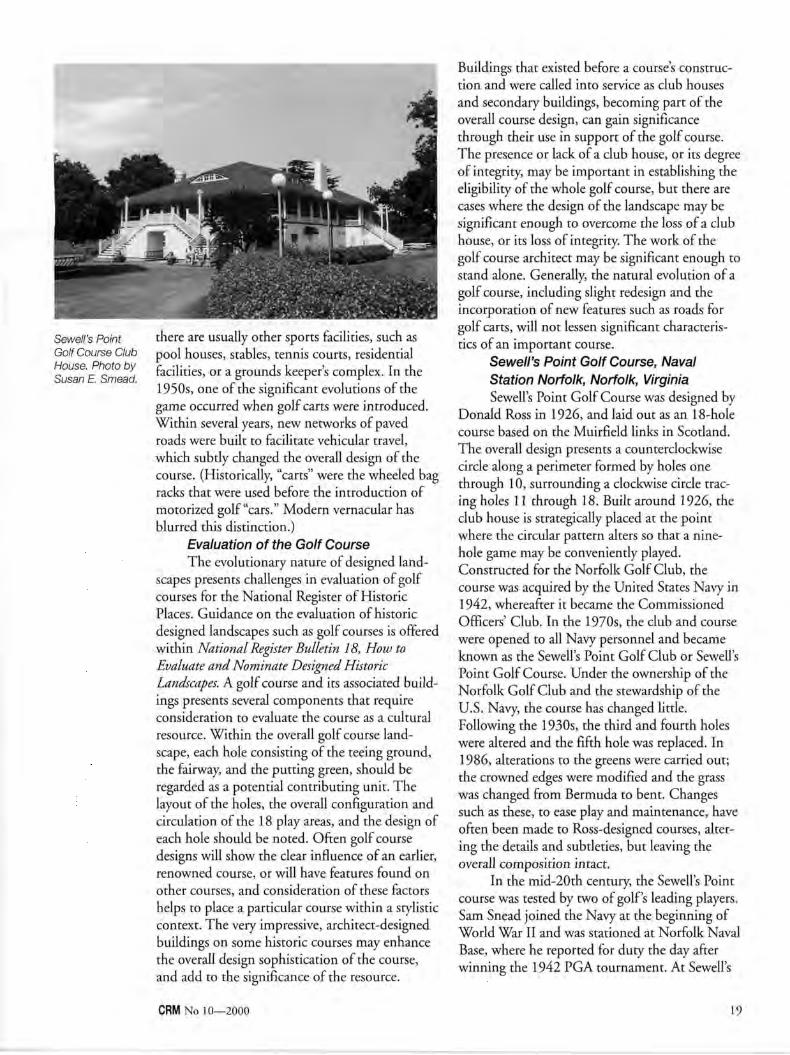
Sewell's Point Golf Course Club House. Photo by Susan E. Smead.
there are usually other sports facilities, such as pool houses, stables, tennis courts, residential facilities, or a grounds keeper's complex. In the 1950s, one of the significant evolutions of the game occurred when golf carts were introduced. Within several years, new networks of paved roads were built to facilitate vehicular travel, which subtly changed the overall design of the course. (Historically, "carts" were the wheeled bag racks that were used before the introduction of motorized golf "cars." Modern vernacular has blurred this distinction.)
Evaluation of the Golf Course The evolutionary nature of designed land
scapes presents challenges in evaluation of golf courses for the National Register of Historic Places. Guidance on the evaluation of historic designed landscapes such as golf courses is offered within National Register Bulletin 18, How to Evaluate and Nominate Designed Historic Landscapes. A golf course and its associated buildings presents several components that require consideration to evaluate the course as a cultural resource. Within the overall golf course landscape, each hole consisting of the teeing ground, the fairway, and the putting green, should be regarded as a potential contributing unit. The layout of the holes, the overall configuration and circulation of the 18 play areas, and the design of each hole should be noted. Often golf course designs will show the clear influence of an earlier, renowned course, or will have features found on other courses, and consideration of these factors helps to place a particular course within a stylistic context. The very impressive, architect-designed buildings on some historic courses may enhance the overall design sophistication of the course, and add to the significance of the resource.
Buildings that existed before a course's construction and were called into service as club houses and secondary buildings, becoming part of the overall course design, can gain significance through their use in support of the golf course. The presence or lack of a club house, or its degree of integrity, may be important in establishing the eligibility of the whole golf course, but there are cases where the design of the landscape may be significant enough to overcome the loss of a club house, or its loss of integrity. The work of the golf course architect may be significant enough to stand alone. Generally, the natural evolution of a golf course, including slight redesign and the incorporation of new features such as roads for golf carts, will not lessen significant characteristics of an important course.
Sewell's Point Golf Course, Naval Station Norfolk, Norfolk, Virginia Sewell's Point Golf Course was designed by
Donald Ross in 1926, and laid out as an 18-hole course based on the Muirfield links in Scotland. The overall design presents a counterclockwise circle along a perimeter formed by holes one through 10, surrounding a clockwise circle tracing holes 11 through 18. Built around 1926, the club house is strategically placed at the point where the circular pattern alters so that a nine-hole game may be conveniently played. Constructed for the Norfolk Golf Club, the course was acquired by the United States Navy in 1942, whereafter it became the Commissioned Officers' Club. In the 1970s, the club and course were opened to all Navy personnel and became known as the Sewell's Point Golf Club or Sewell's Point Golf Course. Under the ownership of the Norfolk Golf Club and the stewardship of the U.S. Navy, the course has changed little. Following the 1930s, the third and fourth holes were altered and the fifth hole was replaced. In 1986, alterations to the greens were carried out; the crowned edges were modified and the grass was changed from Bermuda to bent. Changes such as these, to ease play and maintenance, have often been made to Ross-designed courses, altering the details and subtleties, but leaving the overall composition intact.
In the mid-20th century, the Sewell's Point course was tested by two of golf's leading players. Sam Snead joined the Navy at the beginning of World War II and was stationed at Norfolk Naval Base, where he reported for duty the day after winning the 1942 PGA tournament. At Sewell's
CRM No 10—2000 19

Point, Snead gave golf lessons to officers. In 1954, Arnold Palmer, teamed with a club pro, presented an exhibition round of golf.
Evaluation of the Sewell's Point Golf Course and Club House was conducted by the U.S. Navy in consultation with the Virginia Department of Historic Resources (state historic preservation office), as part of the Navy's comprehensive evaluation of historic resources at the Norfolk Naval Base. The golf course and club house were found eligible for listing in the National Register. The club house was designed in the English Arts and Crafts style by an unidentified architect. It is of frame construction, clad with shingles, and stands two stories tall. A wide wrap-around veranda skirts the second level offering views out onto the course and is tucked under the building's broad hipped roof which terminates in deep, downward-curving eaves. Wide eyebrow dormers break the slope of the roof, from which a massive stucco-clad chimney rises. A split staircase ascends to the veranda on the west side, framing the entrance to the building's first level; a broad staircase rises to the veranda on the south. French doors open onto the porch along the second level, accessing a ballroom, in which a massive Arts and Crafts-style fireplace is the dominant feature.
The Sewell's Point course is one of nine golf courses in Virginia attributed to Donald Ross, where he either prepared the initial designs or remodeled existing facilities. These courses have not been evaluated, other than the course at The Homestead in Hot Springs, which is a contributing landscape feature at this late-19th-century resort, which is listed on the National Register. Although assessments have not been made with respect to Ross' other golf courses in Virginia, the high integrity of the Sewell's Point course, its distinctive design based on Scotland's Muirfield links, and the architectural integrity of the original club house made it clear that the course is eligible for the National Register. In contrast, the course was not considered historic for its association with Sam Snead and Arnold Palmer. While they are nationally important figures in golf history, their use of the course for training and exhibition plays reflects only a minor association with their extraordinary careers.
Belmont Park Golf Course Belmont Golf Course is located in Henrico
County in the northern suburbs of Richmond, Virginia. It is among a handful of Virginia golf
courses that trace their history to the early 1900s. Today, Belmont is a municipal course, but it began as the Hermitage Golf Club in October 1900. The Hermitage Club used old exposition grounds located several miles south of the present course as its initial course and eventually employed the services of Arthur Warren Tillinghast to design the present course by 1917. The course was finished for the cost of $3,000: $1,000 for Tillinghast's fee, $1,200 for grass seed, and $800 for labor. The course was redesigned by Donald Ross at an uncertain date, either 1927 or 1940.
The Hermitage Club hosted the inaugural Virginia State Open championship in 1924. After World War II, it was the site of the Richmond Open in 1945 and 1946. In 1949, the club hosted the only Professional Golf Association championship ever held in Virginia, where Virginia native Sam Snead won. The Hermitage Golf Club expanded in the 1950s, buying another tract where William and David Gordon of Philadelphia laid out the Ethelwood Course. The original course was sold to Henrico County in 1977. Renamed Belmont Park, the course continues in regular operation as a public facility.
While Belmont Park has never been formally evaluated, it harbors a strong potential for eligibility to the National Register. The 18-hole course exhibits good design and landscape integrity. While Tillinghast or Ross drawings for the course have not been located, Virginia golf historian Bruce Matson notes that the course retains essentially the same configuration and design features of the 1949 PGA championship period. The historic club house predates the course, serving originally as the center of the Warren Farm and dating to the mid-19th century. The modest Italianate-style farmhouse was expanded by the Hermitage Golf Club and historic photographs reflect c. 1920s Arts and Crafts embellishments. Although the building has been recently remodeled and is now used as a recreation center, it still retains sufficient integrity to be a contributing resource. Recently constructed tennis courts and a pro shop building do not contribute to the historic period of 1916 to 1950.
The 6,449-yard course features a layout split into two similar-sized areas by a major thoroughfare. Hilliard Road has bisected the course for over 50 years. A road underpass for golfers
20 CRM No 10—2000

was built to provide safer passage from one side
of the course to the other. Like the Sewell's Point
Course, this course does not include any highly
dramatic features. Often typical of Ross' designs,
the challenges are more subtle. While the vegeta
tion and playing surfaces have been rehabilitated
over the years, the circulation and overall layout
are largely intact with respect to the Donald Ross
redesign. T h e course is also the only one in
Virginia ever used for a PGA Championship
tournament . T h e Hermitage Golf C lub is further
significant as one of six clubs to form the Virginia
State Golf League (now called the Virginia State
Golf Association) in 1904. While the Hermitage
Golf Club has relocated, the Belmont Park
course's period of significance spans the founding
years of the Hermitage Club, when it played an
important role in the evolution of golf in
Virginia, especially during the 1940s.
T h e documentat ion and evaluation of golf
courses adds an exciting and revealing compo
nent to an understanding of America's cultural
history. As with the evolution of American archi
tecture, the history of golf course design reflects
the influence of European ideas early on, giving
way to the gradual emergence of an American
design tradition; these developments also show
an increasing democratization of design. Virginia
is fortunate in possessing notable examples by
two of America's foremost golf course architects,
which, combined with other significant
American golf courses, provide benchmarks for
evaluation of golf courses as cultural resources.
References Belmont Golf Course and Recreation Center. County
of Henrico, Virginia, Division of Recreation and Parks brochure, 2000.
Hermitage Country Club. Internet site, <www. hermitagecountryclub.com>.
The Homestead, Hot Springs, Virginia. Internet site, <www.thehomestead.com/hist.cfm>.
Hutchinson, Horatio G. Golf. London: Longmans, Green, and Co. 1902.
Keller, J. Timothy, and Genevieve P. National Register Bulletin 18: How to Evaluate and Nominate Designed Historic Landscapes. National Park Service, 1994.
Matson, Bruce." Hermitage Country Club: Its First 100 Years." Virginia Golfer, Jan./Feb. 2000, 8-12.
"The Roots of Golf in Virginia: The Founding of Golf In Norfolk." Virginia Golfer, Jan./Feb. 1999, 20-23.
National Register Bulletin 15: How to Apply the National Register Criteria for Evaluation. 1990 National Park Service, revised 1991, 1995.
National Register of Historic Places Nomination for The Homestead, Hot Springs, Virginia. Virginia Department of Historic Resources Archives. 1979.
Ross, Donald J. Golf Has Never Failed Me: The Lost Commentaries of Legendary Golf Architect Donald J. Ross. Chelsea, MI: Sleeping Bear Press, 1996.
Sewell's Point Golf Course. Sewell's Point Golf Course, Naval Station Norfolk, Virginia, leaflet, 2000.
Shackelford, Geoff. The Golden Age of Golf Design. Chelsea, MI: Sleeping Bear Press, 1999.
Tillinghast, A.W. The Course Beautiful: A Collection of Original Articles and Photographs on Golf Course Design. Richard C. Wolffe, Jr., and Robert S. Trebus. eds. Tree Wolf Productions, 1995.
Tufts, Richard S. The Scottish Invasion: Being A Brief Review of American Golf in Relation to Pinehurst and the Sixty Second National Amateur. Pinehurst, NC: Pinehurst Publishers, 1962.
Wendehack, Clifford C. Golfdr Country Clubs: A Survey of the Requirement of Planning, Construction, and Equipment of the Modern Club House. New York: William Helburn, Inc., 1929.
Wind, Herbert W , ed. The Complete Golfer. New York: Simon and Shuster, 1954.
Wind, Herbert W The Story of American Golf: Its Champions and Its Championships. New York: Simon and Shuster, 1956.
Susan E. Smead is with the Virginia Department of Historic Resources where she serves as an architectural historian and Preservation Program Coordinator.
Marc C. Wagner is with the Virginia Department of Historic Resources where he serves as National Register Manager (architectural historian).
Acknowledgments T h e authors would like to thank several
individuals for contributing information on source materials and for providing valuable insights into understanding golf course design. Bruce Matson, an authority on the history of Virginia's golf courses, has undertaken extensive research on the topic and provided information on both the Belmont and Sewell's Point golf courses. Michael Newbill, Historic Preservation Officer-Navy Region Mid-Atlantic, arranged a tour of the Sewell's Point course and also directed us to important sources, as did Mary Harding Sadler of Sadler and Whitehead Architects. Thanks are also due to Chris Gregson of the County of Henrico Division of Recreation and Parks and to our colleagues in the state historic preservation offices who offered information about significant golf courses and related their experiences evaluating golf courses.
CRM No 10—2000 21

Susan R. Chandler
Lilli-putt-ian Landmarks History and Significance of Miniature Golf Courses
A middle-era course featuring "whimsies," but no moving parts. Whales are a common motif of the 1950s. For example, the Lomma brothers created an animated whale obstacle with a shot-sensitive blowhole.
The miniature golf course, as we know it today, is a purely American creation. Combining sport, architecture, fad, and fan
tasy, mini-golf has a colorful history which stretches back almost a century.
Early History The traditional game of golf experienced a
wild surge of popularity in the years immediately following World War I. Small "practice" putting courses are reported to have been constructed by aficionados of the sport in both Europe and the United States during this period. One of the most elaborate, and best documented, was built on an estate in Pinehurst, North Carolina in 1916. There, James Barber retained an amateur architect named Edward H. Wiswell to design "Thistle Dhu," an 18-hole course intended to duplicate the challenges of the "big game" on a diminutive scale.1 This private course, placed in a garden setting complete with walkways, flowerbeds, a fountain, benches, and a summer house, was a forerunner of things to come.
Six years later, another golf fanatic, Thomas McCulloch Fairbairn, attempted to build a small
private course on his cotton plantation in Mexico, but was frustrated by the parched climate and his inability to establish suitable greens. After much trial and error, he developed a formula for a putting surface using cottonseed hulls, sand, oil, and green dye—a discovery he later patented. With the invention of artificial turf came the first opportunity to create a durable putting green for anyone, anywhere. Before long, two New Yorkers, Drake Delanoy and John N. Ledbetter, used the new turf to turn miniature golf into a popular commercial enterprise— establishing over 150 putting courses on the rooftops of Manhattan's skyline.
The "Madness of 1930" The biggest names in the history of little
golf are Garnet and Frieda Carter, owners of the Fairyland Inn high atop Lookout Mountain on the border of Tennessee and Georgia. In 1926, Frieda Carter, the creative spirit behind the design of the prestigious resort, created a "Tom Thumb" golf course on the front lawn of the inn.2 It is at this point in the development of the game that the design of greens takes a profoundly whimsical turn. Friedas "midget" links featured cleverly constructed hazards and fairytale sculptures (elves, gnomes, and Little Red Riding Hood, among them). This course was more than just a pint-sized imitation of the traditional sport, it was a unique and diverting "amusement" which had enormous appeal to adults and children alike.^
The overwhelming success of the Tom Thumb course inspired Garnet Carter to patent its design in 1929 and obtain the rights to use Fairbairn's cottonseed hull turf. Despite the market crash, Tom Thumb Golf courses were soon being manufactured and distributed nationally in partnership with several factories. A craze for mini-golf gripped the country. Carter sold the courses, which included a customized plan with prefabricated parts, for $4,500. By mid-1930,
22 CRM No 10—2000

Tom Thumb Golf had hundreds of competitors and it is estimated that between 25,000 and 50,000 courses had been built across the United States. Most of these courses were located in urban areas on rooftops, in basements and ballrooms, or on vacant lots. On an average day, four million Americans played the game. Miniature golf attracted stars like Mary Pickford and Douglas Fairbanks, stimulated the publication of "how to" books and trade magazines, and inspired fashion and songs.
The courses of 1930 had many of the landscape and architectural features that we associate with today's versions. A plan typically included 18 holes, each easily distinguished from the next by use of Rube Goldberg-style hazards, miniature architectural structures, and amusing figures. Theme courses were popular and the use of elaborate decoration and live musical accompaniment was common. Some courses even featured trained animals. Along with football and baseball, miniature golf was one of the early outdoor sports to use night lighting. It was not unusual to see evening players wearing furs and formal attire. Some indoor courses featured air-conditioning. Important innovations of the period included the scoring table and the "bottomless" 18th hole. But even with all the fancy trappings, at 25 to 50 cents a game, the diversion remained—like the movies—a truly democratic activity. However, like so many other fads of the era, the fever for miniature golf quickly burned out. By late 1931, the frenzy was over. Courses across the nation were abandoned and later destroyed.
Golf Hits the Road It took 20 years for the sport to be rediscov
ered. The baby boom of the 1950s and the sprawl of suburbia fueled a quiet resurgence. Unlike the red-hot fad of the 1930s, mini-golf was marketed as a wholesome family pastime. It is during this period that miniature golf begins to be paired with food concessions (most often soft-serve ice cream), motels, drive-in movie theaters, driving ranges, and other commercial concerns along the American roadside. Courses also sprouted up on beachfronts, near campgrounds, and other tourist areas.'
Al and Ralph Lomma are often credited as the fathers of modern-day miniature golf. The brothers were instrumental in the renaissance of inspired, stunt courses which featured moving hazards and required accuracy and concentration. Their first course was built in Scranton,
Pennsylvania in 1956. Soon, they had established a business manufacturing and selling prefabricated courses. To solve the problem of turf, the Lommas had a company in South Carolina produce a special indoor/outdoor carpet, one of the first of its kind, expressly for use on their greens. Even today, one of the selling features of Lomma golf is that a course can be installed in one day and moved indoors seasonally if desired.
Large franchises, like Don Clayton's Putt-Putt Golf and Games®, also grew popular in the 1950s.' However, many of the roadside courses of the period were homemade, folk art creations. Using poured concrete, chicken wire, and lumber, these mom and pop courses proliferated like theme parks, souvenir shops, and other tourist attractions spurred by the automobile culture.
The pattern of development established in the 1950s endured into the 1960s. Miniature golf courses grew with the baby boom, becoming bigger and more outrageous in their design. The American Southeast established itself as the heartland of putting activity, with Myrtle Beach, South Carolina, as its capital. There along a 50-mile stretch of Kings Highway miniature golf continues to reign supreme. As a result, the area has become a tourist destination for players from around the United States.8
Course Design Certain elements of a typical miniature golf
course mirror those of big golf. There is a teeing ground for each hole. This area can be defined by a vinyl mat with tee points or be merely the first level section of carpet or green. The fairway includes the putting green and other landscape features between the tee and the hole. Standard obstacles along the green may include sand traps, water hazards (usually brilliant disinfectant blue) , swales, mounds, undulations, and encroaching rough (gravel and Astroturf are often used). Greens may feature banks or other modulations in the land to redirect a ball in play or change its speed. Both physical and visual barriers which disrupt the line of play are common. Use of jogs and doglegs in the design of greens is also a favored approach. A version of the clubhouse, where "greens fees" are paid, brightly-colored balls and putters are chosen, and score cards with tiny pencils are issued, is often the only full-sized example of architecture on the course proper. As grand or whimsical as a course may be, the clubhouse is most often a simple shack, with its only
CRM No 10—2000 23

The loop-di-loop, a classic hazard developed in the 1920s.
ornament large signs concerning behavior and the rules of play.
Components of the small sport, unknown to the big game, are many. Some miniature golf courses adopt a billiards approach to fairways, creating the opportunity to ricochet the ball off a bumper or other obstacle to minimize strokes to the hole. Tricky shortcuts, requiring skill
and daring, are also possible. As with many courses with moving obstacles, a second, longer way to the cup is usually offered for those feint-of-heart. Arguably the piece-de-resistance in the design of mid-to-late 20th-century courses is the bi-level or tri-level green with water hazards. A player must send the ball into one or more cups connected by plastic pipe to another stage of the green, avoiding swiftly moving areas of water and the potential loss of the ball along the way.
Courses as Cultural Resources Evaluating miniature golf courses poses
some difficulties. Compared with its one-time competitor, the movie theater, the history and evolution of properties associated with this American recreation are woefully under-documented. And, not surprisingly, much of the existing research, while excellent, focuses on the fascinating social and "artistic" nature of the phenomenon rather than the specifics of design that architectural historians crave.
Research suggests that all the earliest putting courses have been destroyed. What remains from the 1930s era is unclear, though the oldest courses typically seen along the road across America today appear to date from the second phase of popularity. Most of these have been altered to one degree or another to remain fashionable. The ready availability of new and recycled components, such as fiberglass figures and other novelties, adds to the complexity of dating an individual course and evaluating its integrity. Though greatly different in scale, for purposes of analysis the amusement park is perhaps the resource type most akin to the miniature golf course.
Links to the Future A third wave of putting enthusiasm began
in the 1970s and continues to influence the courses being constructed today. The greens of the last 20 years—the Steven Spielberg/George Lucas era—tend to create a "stage" for play. These new courses most often employ one coherent theme (Jungle, Pirate, Safari), extreme terrain (man-made mountains and caves), waterfalls and lagoons, and special effects (lights and sound). Obstacles and tricks emblematic of the game, like loop-di-loops and waterwheels, are fast being retired in favor of more high-tech and "maintenance-free" devices. Miniature golf, in one form or another, appears to be here to stay. The soft-serve cones may taste just as good in the future, but I'll miss the windmills.
Notes 1 John Margolies, Miniature Golf (New York:
Abbeville Press, 1987), 14-15. A plan and photograph of "Thistle Dhu," from Country Life, 1920, are illustrated. Ibid. 22-24. Margolies describes Fairyland as a "storybook playground for millionaires." Besides the inn, the resort included an impressive swimming pool, 10 guest cottages known as "Mother Goose Village," tennis courts, and nationally-famous golf links.
* The course was demolished in 1958, four years after Garnet Carter's death. Chester H. Liebs, Main Street to Miracle Mile: American Roadside Architecture (Baltimore: Johns Hopkins University Press, 1985). 151. Margolies, 32.
5 Chester H. Liebs, Main Street to Miracle Mile: American Roadside Architecture (Baltimore: Johns Hopkins University Press, 1985), 145.
° Interview with Ralph Lomma, September 14, 2000. The first Lomma course was destroyed by the construction of an interstate highway in 1962. For the past 20 years, Lomma has also offered specially-designed indoor-only courses. Indoor miniature golf is now one third of the company's business. There are 6,500 Lomma golf courses worldwide. Ibid. 74-76. Don Clayton was a strong advocate of miniaturegolf as a serious, competitive sport. Putt-Putt Golf® courses feature long fairways and straight shots with no tricks or gimmicks, much like the earliest versions of the game. The first Putt-Putt® course opened in Fayetteville, North Carolina in 1954, and the company continues to thrive today with 260 locations.
s John Margolies, Fun Along the Road: American Tourist Attractions (Boston: Little, Brown and Company, 1998) 104.
Susan R. Chandler is the historical architect for the Connecticut State Historic Preservation Office and a frequent competitor in the prestigious Cape May Cup.
24 CRM No 10—2000

Steven M. Bedford
West Point's Michie Stadium Balancing History and 21st Century Collegiate Sport Programs
Aerial view of Michie Stadium, United States Military Academy, West Point (c. 1980). Photo by John E. Pellino.
M any of the stadia associated with major collegiate athletic programs were built more than 50 years ago and are
associated with numerous great moments in sports. Some are located in National Register historic districts and their massive presence often forms an important component of college campuses. However, most stadia were designed for athletic programs whose level of competition was far less intense than today. Prized student athletes now often reject a college's overtures if the athletic facilities are not state-of-the-art. Television contracts to air Saturday afternoon gridiron conflicts are often dependent upon press box technological capabilities. These problems are most telling at our country's military academies, which are bound by federal regulations to preserve the historic character of their sites, but require modern facilities in order to attract the top student athletes and lucrative media contracts. The United States Military Academy's (USMA) efforts to upgrade West Point's Michie Stadium are a noteworthy case study.
As most of us know from our high school history, the geologic setting of the West Point
area had its greatest influence during the Revolutionary War. The narrow width of the Hudson River at West Point, coupled with its sharp bend and swift currents, made this an ideal spot for colonial fortification. The Great Chain spanned the Hudson between Constitution Island and what is now the North Dock area and prevented British ships from sailing up the river beyond this point. American fortifications, including Fort Putnam and Redoubt #4, located 480 feet above river level and overlooking what is now Michie Stadium, gave the colonists control of the Hudson and the Highlands. This military strategy prevented the British from geographically splitting the colonies along the Hudson River.
The Academy, first established in 1802 at West Point, New York, has expanded over time to embrace thousands of acres and hundreds of buildings. However, it was not until the mid-19th century that U.S. Military Academy maps included the Michie Stadium parcel within official boundaries. Late-19th-century topographic surveys depict the area as low-lying and undeveloped.
In 1902, Congress appropriated $5,500,000 to improve the Academy's physical plant. A competition for the design of the improvements, held in 1903, was won by Cram Ferguson & Goodhue in association with the Olmsted Brothers firm. This massive project created much of the current USMA campus. The Academy's decision to embrace the Gothic style created what architectural critic Montgomery Schuyler described as an "inspiring success" ["The New West Point," Architectural Record, 29 (1911): 94]. The Lusk Reservoir, which adjoins Michie Stadium, was built in the first years of the 20th century and is depicted in the 1904 plans of proposed improvements to the entire military reservation. Mills Road, which defines the public approach to Michie Stadium, was also depicted on this early facilities plan. However, Cram
CRM No 10—2000 25

Ferguson & Goodhue had made no provisions for an athletic stadium.
The creation of Michie Stadium dates from the period when college football began as one of America's great spectator sports and U.S. Military Academy teams were among the best in the country. Prior to the construction of the stadium, Army football games were held on the main parade ground and were viewed from temporary steel bleachers that annually required 1,600 man-hours to erect and an equal amount of time to disassemble and store. This use of the main parade ground prevented its use for any other purpose during football season and removal and erection of the bleachers were costly. In 1922, the Academy's superintendent formed a committee to investigate the issue of creating a new and permanent football stadium with seating for approximately 20,000 to be located somewhere within the Academy's reservation.
At the same time, several other colleges and universities, many of whom were U.S. Military Academy opponents on the gridiron, were in the process of building (or had just completed) equally large or larger stadiums, including among others Ohio State University (1920), Brown University (1926), Northwestern (1926), University of Pennsylvania (1923), Cornell University (1925), University of California (1921), Princeton University (1920), and the Rose Bowl (1925). Collegiate football powerhouses, Harvard and Yale, had completed their massive stadiums in the first decade of the 20th century. By 1931, there were 40 large stadiums in the United States whose capacity ranged from 20,000 to 125,000. Twenty-two of these stadiums belonged to educational institutions ["Stadium Planning and Design," Architectural Record®: 151-176(1931)].
After evaluating four potential sites on the Academy's grounds, the committee and superintendent agreed that open land adjacent to the Lusk Reservoir had sufficient room, adequate vehicular access, and proximity to the campus gymnasium. The site was a wet marshy area just to the west of Lusk Reservoir and was often described as a frog pond. Initial plans calling for wood bleachers similar to those at Yankee Stadium were submitted by Major C.P. Gross, USMA's Engineering Officer, in April 1923. In May 1923, it was decided to make the stadium suitable for both intercollegiate football and baseball, which would require additional land and a
realignment of the road along Lusk Reservoir (The West Point Stadium, 1924).
Earth moving activities for the new stadium began in August 1923. Massive amounts of bedrock were removed from the southern edge of the Fort Putnam ridge and extensive filling was necessary to stabilize what had once been a low-lying, seasonally inundated area (Michie Stadium, photographic files, US MA Archives). As construction on the field progressed, the enthusiasm and support of USMA's athletic community increased and so did the overall scope of the project. Wood bleachers gave way to steel and finally to concrete. The Osborne Engineering Company of Cleveland Ohio, designers of Yankee Stadium, donated initial plans for a concrete stadium. By a special provision in the Military Academy Bill of May 1924, additional funds were loaned to the Athletic Board, the USMA entity responsible for the operation of the stadium. Construction then proceeded on a concrete stadium whose cost totaled approximately $300,000 (The West Point Stadium, 1924).
By December 1924, the broad, U-shaped stadium had taken its place on the western side of the football field. Its gothic towers and crenella-tion were in complete design harmony with the rest of the Academy. Formed in concrete, Gothic arches completed the image. The eastern side of the stadium was left open to accommodate a baseball outfield. During football season, wooden bleachers lined the eastern sidelines of the football field. Shortly after completion of the main body of the stadium, gothicized gates, panels and ticket booths were designed by Osborne Engineering and installed between 1925 and 1928 (The West Point Stadium, 1924; stadium files, USMA Archives). In 1928, the facility was christened Michie Stadium after Dennis Michie, the captain of the Academy's first football team. Lt. Michie was later killed in Cuba during the Spanish American War (letter, Major General Wm. R. Smith to Major General Fred W Sladen, June 19, 1928, stadium files, USMA Archives).
Michie Stadium was the Academy's athletic home during the glory years of West Point football. During the mid-1940s, the Army football team was the best in the nation. Under the leadership of legendary coach Earl Blaik, Army was unbeaten for three years (1944-1946) and produced two Heisman trophy winners. "During World War II while commanding U.S. forces in the Pacific, (Douglas) MacArthur set the war
26 CRM No 10—2000

Corps of cadets cheering on Army football in Michie Stadium.
aside every Monday morning each fall to spend hours pouring over reports of Army's latest (football) game. After each victory, he wired congratulations; after each loss, he wrote lengthy advice to Coach Earl "Red" Blaik (Watson 1999).
In I960, the historic core of the U.S. Military Academy was designated a national historic landmark. Approximately 15 years later, the U.S. Military Academy Historic District was established, which covers over 227 buildings including the Michie Stadium athletic complex. A National Park Service study (1993) concluded that more than 350 additional Academy buildings, located in the immediate area surrounding the historic district, are historically significant. Cultural resources within the USMA Historic District range from 18th-century redoubts to early-20th-century barracks, classroom buildings, chapels, and designed landscapes. Each building or structure, as well as the landscape, retains historic integrity and clearly conveys a strong association with military use and education.
Over time, structural and functional aspects of Michie Stadium have been altered or changed. In the 1960s, the eastern bleachers became permanent concrete structures, while several tiers of stands were added to the western side of the stadium as well. In order to accommodate the bleachers, the adjoining Mills Road was straightened and Lusk Reservoir was filled in slightly. Despite these alterations, Michie Stadium possesses sufficient historic and design integrity to be considered a contributing structure in the historic district.
Michie Stadium clearly does not exist in a vacuum. It is surrounded by historic resources of all kinds, most importantly Fort Putnam, which
is open to the public, and Redoubt #4, located on the promontories above the natural bowl formed by Lusk Reservoir. Michie Stadium forms an important part of the viewscape in the area surrounding Lusk Reservoir. Due to the topography of the United States Military Academy, the stadium is not visible from the lower sections of the Academy and consequently any potential visual impact would be either on the approaches to the site or on vistas from above the stadium.
The stadium is bounded on the north by historic Fort Putnam, on the east side by Mills Road, which is an Olmsted-designed campus corridor, and Howze Field, an open grass playing field, on the south elevation. Michie Stadium's west side has been significantly altered over the last two decades. In the early 1980s, the 131,000-square-foot Holleder Sports Center was completed outside the southwest corner of Michie Stadium. Although the architecture of the hockey and basketball Holleder Sports Center complex is not reflective of the dominant historic elements of the landmark campus, it is fortunately separated and visually buffered from the main campus by Howze Field.
The west side of the stadium is further compromised by a road system that abuts the stadium's security fencing and a series of terraced parking lots. Created by landfill, these lots are artificial terraces. As with the Holleder Sports Center, this road and parking complex is separated from the pedestrian-oriented main campus.
The U.S. Military Academy is in the process of upgrading its facilities around Michie Stadium. Life safety issues require a seismic retrofit for the stadium. In addition to creating improved training facilities, the USMA needs to improve structural and aesthetic conditions at the Michie Stadium complex in order to make the prospect of televising football games from the stadium more appealing.
Consequently, the USMA has proposed construction of the Kimsey Athletic Center-Randall Hall; erection of new scoreboards and a press box; and improvement of the lighting in the stadium. The athletic center will physically abut Michie Stadium's southern grandstand and be approximately 20 feet taller than the existing facilities; the new structure will visually subordinate, to some extent, the stadium. The eastern edge of the Kimsey Athletic Center-Randall Hall will be stepped back with a curved facade that somewhat echoes the architectural character of
CRM No 10—2000 2^

Michie Stadium. The proposed new press box will rise one story above the existing press facility, while an electronic scoreboard will extend four stories above the northern grandstand. These impacts have been assessed by Historical Perspectives Inc. during a series of environmental studies.
Individually and collectively, these alterations pose difficult design choices due to the stadium's location within the viewshed of two Revolutionary War-era forts and in the middle of a nationally significant historic district. The U.S. Military Academy has initiated consultation with the New York State Historic Preservation Office with respect to creating a design concept that will minimize physical alterations to the historic integrity of Michie Stadium, be visually compatible with the national historic landmark district, and accomplish a much-needed facilities upgrade
to ensure the successful participation of Army's 20th-century intercollegiate athletic programs.
References Anonymous. "Stadium Planning and Design."
Architectural Record 69 (1931): 151-176. Kutz, Charles W. Map of a Part of the Reservation of
West Point, New York. Prepared under the direction of Major Charles W. Kutz, Corps of Engineers, 1908.
National Park Service. United States Military Academy National Register of Historic Places Inventory-Nomination Form, 1979.
Oliver, Richard. Bertram Grosvenor Goodhue. New YorkAHF, 1983.
United States Military Academy Archives. Photographic files (undated), Michie Stadium.
The West Point Stadium. Stadium files, 1924. Correspondence, Major General William R. Smith to
Major General Fred W Sladen, Stadium Files, 1928.
Steven M. Bedford is an architectural historian with Fitzgerald & Halliday Inc. and is a consultant for the Michie Stadium environmental assessment. He is the author of John Russell Pope, Architect of Empire (Rizzoli 1998).
Ann-Eliza H. Lewis
Boston's Curious Bowling History
Boston is often defined by its history, which is made tangible in its architecture and complicated street patterns. Because it is home
to great sports teams including the Red Sox, the Celtics, and the Bruins, those less interested in history often define Boston as a great sports town. Boston is also home to the largest and most complex construction project in the United States, the Central Artery Project. Better known as the Big Dig, this project includes replacing the elevated portions of Interstate 93 with a wider underground tunnel and building a third tunnel under Boston Harbor to Logan International Airport and a new bridge over the Charles River. The archeological investigations that preceded construction led to some of the more significant archeological excavations ever conducted in downtown Boston. Although Boston is not known as a great bowling town, this massive construction project has helped the city merge the historic with the sporting through a unique artifact, North America's oldest bowling ball.
It is not a particularly eye-catching artifact, but the bowling ball is certainly one of the most well-known artifacts in the Big Dig archeological
collection. Archeologists recovered the ball from a privy at the Cross Street Site. This site was home in the 1600s to Katherine Nanny Naylor, the daughter of Rev. John Wheelwright, a prominent Boston minister who was banished from Boston for supporting the religiously radical Anne Hutchinson.
The archeological collection includes a typical variety of goods found in the home of a wealthy Boston merchant. The conditions in the privy were perfect for the preservation of organic materials, which includes the wooden bowling ball. The wheel-shaped bowling ball, which is more properly called a bowle, is made of lathe-turned oak and at one time held a small lead weight and had a decorative cover over the hole. It was recovered from the Cross Street privy in 1994, promptly identified as a bowling ball, and added to the list of interesting small finds. We were unprepared, however, for the crush of public interest in the bowle when its existence was announced in a local newspaper article about the Central Artery archeological collection.
It was this interest that led the Massachusetts Historical Commission to examine more closely the history of bowling in Boston. This
CRM No 10—2000 28

North America's oldest bowling ball. Photo courtesy the Massachusetts Historical Commission, Office of the Secretary of the Commonwealth, Cross Street Backlot Site, Boston, Massachusetts.
particular bowle would have been used for lawn bowling, a game more similar to bocce than to modern American ten-pin games. Early English literature on bowling suggests that you could bowl in any relatively flat area out of doors. Lawn bowlers would roll out a smaller ball, the jack, and then compete with their own bowles to come as close as possible to the jack. There were at least three different types of bowles (spherical, wheel shaped, and biased) and much of the art of the game came from choosing the right bowle for the chosen field. Modern lawn bowling shares many similarities, but overall the modern game is much more structured than the 17th-century version.
The greatest surprise was bowling's legal status. As early as the 16th century, English royalty banned bowling among the poorer classes in an effort to keep recreation better focused on military sports. The prohibition against bowling made it to the New World, but the reasons for it were different. Boston's early colonial leaders actively legislated against recreation in an effort to control personal behavior. In 1647, the court passed a law banning shuffleboard in taverns citing complaints of "great disorder" in houses of "common entertainment" where shuffleboard was played. In 1650, the law was expanded to issue fines for bowling, fining the tavern owner 20 shillings and each player 5 shillings. The problem wasn't the bowling itself, but the gambling and carousing that went along with it. The prohibition against bowling didn't last long and by the early 1700s, taverns were advertising in the Boston Newsletter that they had a bowling green
available. However, the Cross Street bowle comes from a deposit firmly dated to bowling's illegal period.
Soon after the Central Artery collection came to the Archaeological Curation Center at the Massachusetts Historical Commission for permanent curation, the International Bowling Museum and Hall of Fame in St. Louis, Missouri, called to tell us that, as far as they knew, our bowle was the oldest bowling ball in North America. The status of the bowle as the "oldest" may be challenged in the future as new sites are excavated and new finds made, but the bowle will remain one of the collection's more interesting and important artifacts. It is important, in part, because of the insight it provides into Boston's colonial past, but equally so because of its popularity with the general public. The bowle has provided a window on the past that is so familiar to modern audiences that we engage our audience much more quickly and hold their interest longer. Merging sports and Boston history has provided a benefit we never expected, but which will have a long-lasting, positive effect on our programs.
Artifacts from the Central Artery Collection, including the lawn bowle, are on display in Archaeology of the Central Artery Project: Highway to the Past at the Commonwealth Museum in Boston through July 2001. The exhibit is sponsored by William Francis Calvin, Secretary of the Commonwealth and Chairman of the Massachusetts Historical Commission and supported by the Gillette Company.
References Cheek, Charles D., ed."Perspectives on the Archaeo
logy of Colonial Boston: The Archaeology of the Central Artery/Tunnel Project, Boston, Massachusetts." Historical Archaeology 32(3) (1998).
Cook, Lauren J. "Katherine Nanny, alias Naylor: A Life in Puritan Boston." Historical Archaeology 32(1) (1998): 15-19.
Cook, Lauren J., and Joseph Balicki, Technical Report, Archaeological Data Recovery, The Paddy's Alley and Cross Street Back Lot Sites (BOS-HA-12/13) Boston, Massachusetts. Volume 1. Report on file at the Massachusetts Historical Commission.(1998).
Daniels, Bruce C. Puritans at Play: Leisure and Recreation in Colonial New England. NY: St. Martin's Press, 1995.
Lewis, Ann-Eliza H., "A Recreation to Great Persons: Bowling in Colonial Boston." Northeast Historical Archaeology 27 (1998): 121-133.
Ann-Eliza H. Lewis is the Archaeological Collections Manager at the Massachusetts Historical Commission.
29 CRM No 10—2000

Daniel T. Forrest, Robert M. Thorson, and Michael S. Raber
Adriaen's Landing Archeology, Geology, and Palynology in Connecticut's Central Valley
The history of human settlement in New England is closely tied to the regions major rivers, which have long channeled the flow of
people and material across the landscape. From the rugged mountains of New Hampshire and Vermont to the rolling hills of Massachusetts and Connecticut, no river has exerted so great an influence as the Connecticut. Extending over 360 miles from northern New Hampshire to the edge of Long Island Sound, the Connecticut River and the Central Valley through which it flows are the primary links connecting a large portion of the New England countryside.
Despite the importance of the Connecticut River and the Central Valley to the people of the region, both past and present, many important elements of the river's history and early human settlement remain unknown. Thanks to an ambitious program of urban revitalization focused on Hartford's historic riverfront, a more detailed understanding of this story is now emerging. Spurred by the potential relocation of the New England Patriots National Football League franchise to Hartford, city and state agencies began planning a large open air stadium within the downtown area in the winter of 1998. By spring 1999, the Patriot organization had withdrawn their relocation offer.
The revitalization program, known as the Adriaen's Landing project, includes a complex of entertainment, retail, housing, and convention facilities which will re-establish the historical link between Hartford and the Connecticut River. The Capital City Economic Development Authority and the Connecticut Office of Policy and Management (OPM) have joined to administer the project, which now includes a multiphase investigation of the site's paleoenvironmen-tal record. As the City of Hartford and the State of Connecticut move to re-establish the historical link between the capital and the river, a diverse team of researchers is working to frame this rela
tionship in a broader context of cultural and environmental change over the course of the last 10,000 years.
Adriaen's Landing is located immediately north of the Connecticut and Park River confluence along a section of the floodplain named for the Dutch explorer, Adriaen Block, who sailed nearly 60 miles up the Connecticut River in 1614. The area has experienced substantial modification since the arrival of Europeans, including the channelization of the Park River beneath a highway, the localized infilling of the lower flood-plain, and the construction, operation, and demolition of numerous commercial and industrial facilities. Following catastrophic floods in 1936 and 1938, large levees were constructed between the river and the city. Interstate 91 now sits atop these levees immediately east of Adriaen's Landing. Although several substantial buildings are located within the project's boundaries, most of the project area is now used for parking.
The Public Archaeology Survey Team Inc. (PAST) and Raber Associates were retained to identify potential significant cultural resources within the project boundaries. Despite the heavy overprint of historic and modern development, background investigations indicated that the Adriaen's Landing area was an attractive location for paleoenvironmental research. Even with the Connecticut River's low natural gradient and consequent meandering, most sediments underlying much of the project area have not been reworked by lateral channel migration. A prominent bedrock ridge located just west of the current channel location has protected the local floodplain and enabled the accumulation of an unusually complete Holocene alluvial sequence. The regular flooding of the Connecticut River and the rapid vertical accretion of the floodplain present an opportunity to examine environmental change at a fine temporal scale. The research team hypothesized a rapid burial of the flood-
30 CRM No 10—2000

Adriaen's Landing project area and locations ofgeo-technical borings.
plain surface, particularly during the early to middle Holocene interval. This rapid burial process may have reduced bioturbation and inhibited soil formation and preserved the primary sedimentary features of the buried deposits, which might provide valuable data on the character of flood events in the distant past. Rapid burial would also enhance pollen preservation and increase the potential for the reconstruction of local plant communities through time. Finally, the project is located far enough inland to escape the disruptive effects of Holocene sea-level rise, while still retaining an indirect record of eustatic adjustments. Growth of the Connecticut River floodplain was closely linked to post-glacial sea level change and data from Adriaen's Landing could contribute to the study of Holocene coastal evolution in southern New England.
Given these favorable conditions, the Connecticut State Historic Preservation Office, OPM, and the research team agreed that the evaluation of the project's archeological sensitivity should include a paleoenvironmental investigation. Several practical concerns encouraged this approach. An extensive environmental characterization of the entire project area was already planned and PAST could "piggy-back" its preliminary sampling with that proposed by the environmental consultants, thereby reducing costs and logistical problems associated with a wholly independent investigation. Existing geo-technical data also suggested that early Holocene sediments could be buried more than 10 meters below the present surface. The tremendous costs associated with exposing these sediments through a typical archeological testing program could not be justi
fied without a clear indication that significant archeological materials would likely be encountered. In light of the fiscal and logistical considerations, a sampling program was recommended in order to assess the archeological sensitivity of the project area.
The priority of the archeological research program at Adriaen's Landing is the reconstruction of past land-use patterns within the project area. This paleoenvironmental investigation also has potential ramifications for the interpretation of sites throughout the entire region. As the Connecticut River valley was a major focus of Native American settlement from the Mid-Holocene onwards (McBride 1984), significant geological and environmental changes within the river valley probably had wide-ranging repercussions. Reconstruction of these changes may enhance our understanding of shifting settlement patterns extending well outside of the current study area.
In April and May 1999, archeolo-gists from PAST and Raber Associates monitored the drilling of 15 two-inch diameter borings on the buried flood-plain section of the project area. Continuously-sampled cores were extracted with standard 24-inch-long "split-spoon" samplers. Macrostratigraphy was recorded for each of the cores. Pollen, phytolith, and
CRM No 10—2000 31

radiocarbon samples were collected from a subset of five borings. A total of 47 pollen samples and five radiocarbon samples was collected (Raber, et al. 2000).
Based on these preliminary field investigations, a simple five-stage model for floodplain accretion was developed. Within this sequence, pollen/phytolith analyses undertaken by Linda Scott Cummings (Paleo Research Laboratories) suggested at least two stable surfaces on which mature soils developed near the beginning and end of the floodplain sequence.
Research Implications This model has important implications for
archeologists studying aboriginal settlement and subsistence patterns in the Holocene. The evolution of post-glacial environments was probably a dominant influence on the shifting settlement patterns observed in the region's archeological record (e.g., McBride 1984). Nicholas (1988) has argued that the early post-glacial period was marked by rich ecological mosaics in former glacial lake basins. Such areas may have been critical nodes in the settlement patterns of early Holocene foragers as they offered high resource diversity and predictability during a time of heightened climatic instability. The gradual loss of ecological diversity within these basins, coupled with the development of rich floodplain and eventually coastal environments, might have encouraged the diversification of subsistence patterns and the use of a wider variety of environments. While portions of Nicholas' model are now receiving empirical support (Forrest 1999, Jones 1999), a comprehensive evaluation requires an understanding of how and when key landscape features were formed. The evolution of wetlands has been the focus of traditional paleoenvi-ronmental research and as a consequence, changes in these environments are well documented. The Adriaen's Landing project is now providing detailed data on contemporaneous changes to the largest riverine system in the area, in a type of floodplain environment from which palynological evidence is collected less frequently. It is our hope that this data will allow more confident reconstruction of past settlement patterns throughout the region.
To further this goal, the preliminary flood-plain accretion model is now being tested during a second, more intensive phase of the investigation. Recent changes in overall project design preclude any disturbance of deposits located
below historic fill levels. Potential project-related effects upon aboriginal archeological resources appear limited to deep piles and caissons, very small areas in which conventional and safe archeological investigation is not cost-effective.
The paleoenvironmental data appear particularly significant and additional geotechnical borings, using more sophisticated technology, were undertaken during June 2000. Geoprobe equipment has yielded finer-grained sampling information with additional new, datable organic remains. As analysis and interpretation continues, PAST expects to provide increasingly detailed descriptions of past local environments and flood regimes and correlate the results with regional patterns. Samples from recent strata will also facilitate better interpretation of historic landfill and land use practices.
References Forrest, Daniel. Beyond Presence and Absence:
Establishing Diversity in Connecticut's Early Holocene Archaeological Record. Archaeological Society of Connecticut Bulletin 62 (1999): 79-100.
Jones, Brian. The Middle Archaic Period in Connecticut: The View from Mashantucket. Archaeological Society of Connecticut Bulletin 62 (1999): 101-124.
McBride, Kevin. Prehistory of the Lower Connecticut River Valley. Ph.D. dissertation, University of Connecticut, 1984.
McBride, Kevin and Mary Soulsby. Prehistory of Eastern Connecticut: Phase I, II, and III Archaeological Surveys for the Relocation of Route 611-84 Project. Storrs, CT: PAST.
Nicholas, George. "Ecological Levelling: The Archaeology and Environmental Dynamics of Early Postglacial Land Use." In: Holocene Human Ecology in Northeastern North America, George Nicholas, ed., pp. 257-296, New York: Plenum Press, 1988.
Raber, Michael, Robert Thorson, Daniel Forrest, Linda Cummings and Bruce Clouette. Cultural Resource Investigations Made for the Environmental Impact Evaluation of the Adriaen's landing Project, Hartford, Connecticut. Storrs, CT: PAST.
Daniel T. Forrest is a senior archeologist with the Public Archaeology Survey Team Inc. and a doctoral candidate in anthropology at the University of Connecticut, Storrs.
Robert M. Thorson is a professor of geology and geophysics at the University of Connecticut, Storrs, and senior geologist with the Public Archaeology Survey Team Inc.
Michael S. Raber received a Ph.D. in anthropology from Yale University and is the owner of Raber Associates, a
firm specializing in cultural resource management.
32 CRM No 10—2000

Jonathan M. Leader and Randy Burbage
Exhumation at the Citadel's Johnson Hagood Stadium
Volunteers on skirmish line clearing fill dirt on top of the cemetery located inside of the stadium. Photo courtesy Tirza I. Leader, SCIAA.
Twenty-six Confederate sailors and marines, and the remains of a three-year-old child, were carefully recovered from under the
floor of the Johnson Hagood Stadium during June and July 1999. On November 12, 1999, they were reburied in the Soldiers Ground at Magnolia Cemetery, Charleston, South Carolina. How these people came to be buried under the floor of the stadium and how the Charleston community came together to rescue them is a tale of dedication, perseverance, and luck. It is also a story of community relationship and interdependency.
When South Carolina seceded from the Union, the Charleston Mariner's home donated its burial ground to the state for use as a military cemetery. It was used by the Confederacy until the capitulation of Charleston in 1865. The majority of the war-related dead in the area were sent to the larger cemeteries, such as Magnolia Cemetery Soldier's Ground. But a significant number of Confederate and Union dead are still to be found in smaller, less centralized cemeteries scattered throughout the state. The Confederate Naval and Marine Cemetery was maintained by the ladies of Charleston. In 1922, the cemetery was spruced up by the addition of a fence made of
white concrete pillars with black iron pipe rails and the placement of an obelisk, which enumerated the names of those who were known to be buried there. Burial information was derived by the ladies from the surviving headstones. However, it is important and cautionary to note that extensive vandalism between 1865 and 1922 had destroyed a significant number of the headstones. The obelisk further noted that there were "ten unknowns" and "four torpedo boatmen" from H.L. Hunley buried at the site.
Starting in the 1900s, the area surrounding the cemetery was used as a fairground and livestock exhibit area for many years. Given this extensive use, it is not surprising that Charleston would consider the fairgrounds an ideal location for a public stadium. The military cemetery was still clearly marked in the 1940s when the decision was finally made to build a stadium. The city negotiated with a developer to have the cemetery moved and the stadium constructed on the cemetery site and adjoining grounds. It is at this point that historical events become murky. It appears that the developer moved the stones to a place or places unknown and the obelisk was relocated to Magnolia Cemetery Soldier's Ground. Unbeknown to the city, the graves were left behind.
The stadium was completed in 1947. The majority of the construction work for the stadium was done by hand; very little in the way of heavy equipment was used. The girder supports were attached to floaters rather than pylons, which was a departure from normal engineering. The soft sands of Charleston are not stable and pylons sunk to great depths are usually used to provide support. The floaters were for the most part 5 foot by 6 or 7 foot concrete pads roughly 28 inches deep. While clearly a design exception in terms of earthquake-related safety, the use of floaters proved to be an unintended asset for archeological preservation. No pylons extended through the burials. Conversely, it became clear that the workmen had unearthed the dead on at least four separate occasions while preparing the
CRN! No 10—2000 33

Union and Confederate re-enactor volunteers' honor guard for the Confederate Sailors and Marines burial. Photo courtesy Daryl P. Miller, SCIAA.
in-ground molds for the floaters and had poured the concrete directly on top of skeletal remains.
The stadium was subsequently presented as a gift to the Citadel, South Carolina's Military University, in 1967. The Citadel staff had no idea that the stadium was on a former cemetery site. In the early 1990s, a group of local historians, re-enactors, civic organizations, and genealogical groups banded together as the Confederate Heritage Trust (CHT). The CHT, a non-political non-profit organization, has as its mission the preservation of historic battlegrounds, camps, graves, and the history of the Civil War. As part of this mission, the Confederate Heritage Trust made it a specific task to search for Civil War graves at the Magnolia Cemetery's Soldier's Ground. Needless to say, they didn't find the graves. Backtracking from that revelation, the Trust came to the conclusion that the graves might not have been removed from their original location.
The CHT contacted the Citadel and eventually were permitted to search for those historic graves that based on the plat should have extended into the stadium's parking lot. In 1993, the Trust located 14 graves and recovered 13 bodies. The failure of the developer to move the
bodies was no longer a supposition, it was now a fact. Negotiations with the Citadel for the recovery of the remaining bodies took several years. The reasons for this were quite ordinary and understandable. The projected cost of the recovery from beneath the stadium was quite expensive. None of the groups, including the Citadel, had the available monies. The danger to both the structure and researchers undertaking any recovery program was also considerable. Undermining a historic stadium with known structural defects is not the type of project one does without due consideration, study, and care. Last, and certainly not the least, was scheduling-related concerns. The Citadel is a highly-active military academy and university with intensive community interactions. Many organizations, schools, and groups rely on the Citadel for sports-related facilities support and consequently the stadium is in constant use.
Fortunately, the Citadel temporarily closed the stadium in 1999 to accomplish much needed repairs. The South Carolina Institute of Archaeology and Anthropology (SCIAA) performed ground penetrating radar investigation of the stadium's interior in order to ascertain whether there were burials still in place under the structure. The results were positive. Coordinating with the Citadel, the SCIAA and the CHT, with the active support of Senator McConnell, were able to obtain permission to exhume the skeletal remains. During June and July 1999, over 300 cubic yards of earth were excavated by 120 volunteer workers. All burials were drawn and photographed in situ, then respectfully transported to the SCIAA for analysis. The project area was mapped, which as it turned out was the first and only time that the stadium had an actual plan drawing. All activities at the site were recorded by the site registrar who also kept track of the visitors and community donors.
Volunteers included Euro-Americans, African Americans, and Native Americans. The oldest volunteers were in their eighties, the youngest under 12. It was a very nice cross-section of Charleston's population. All were bonded together by the understanding that no one's dead should be dealt with anything less than dignity and respect. The volunteers frequently opined that if they couldn't protect a military cemetery at the Citadel, whose burials would be safe anywhere in the state? This was a serious point in a state undergoing rapid development.
34 CRM No 10—2000

The outpouring of support from the Charleston community was amazing. Coffee and rolls, lunch, and afternoon snack were provided every day for the volunteers from private individuals and local restaurants. Other items such as heavy duty aluminum foil and film were provided by community businesses. The Charleston Police Department and the Citadel University Police provided security for the site.
The cemetery turned out to occupy only a small fraction of the area originally set aside for its use. The original fence post holes from the 1860s were located very early in the project. Based on the field work, it appears that the ladies relocated the fence in order to enclose only the area where the bodies were located. The postholes from this later work along with the public and "dead" gates were also located. A significant in situ scattering of large broken marble chips suggests that the grave markers were simply rent from the earth and piled up in pieces by the workmen. It seems very unlikely that any would have survived intact.
The first burial was encountered on the first day of field excavations. Sandy soils made the identification of grave shafts remarkably easy. A nondenominational service was held the next day at the site for the dead and then exhumation commenced. It quickly became apparent that the burials were laid out in an east-west orientation and that they were arranged in ordered rows. A number of the burials were located beneath the stadium's walls and floaters. In consultation with structural experts and with the permission of General Grinalds, president of the Citadel, these individuals were carefully recovered. There is little doubt that additional burials still reside under the support structure of the stadium in areas too dangerous at present to work. The stadium is scheduled for demolition and rebuilding in the next several years and SCIAA and C H T are scheduled to return at that time.
Four of the sailors were found as pairs in single interments. Skeletal evidence and historic documents made it possible to identify these individuals as probable members of the first crew of H.L. Hunley, the first submarine to sink an enemy vessel in time of war. Five of the first crew perished when the vessel sank at its moorings at Fort Johnson. Considered to be a secret weapon, considerable efforts were taken to keep its operation and the subsequent deaths hidden. This secrecy became moot when it sank a second time
claiming the life of its benefactor, Horace L. Hunley, and many of the mechanics who had helped build it at the Lyons Machine shop in Alabama. Hunley and the ill-fated second crew were buried at Magnolia Cemetery in a donated plot.
Reburial of the 23 sailors, marines, and child took place on November 12, 1999, at the Soldiers' Ground at Magnolia Cemetery. Fifteen horse-drawn canons with burial platforms were used to transport the deceased to the cemetery. The funeral march started at the Charleston Battery and was lead and escorted by Civil War re-enactors in full period uniform. Many of the re-enactors had worked as volunteers on the project.
The reburial ceremonies were well attended. Several thousand people lined the 4-and-1/2-mile parade route to the cemetery. Over 2,500 people attended the burial service. It was a positive and moving experience, which demonstrated what can be accomplished when the public and cultural resource professionals unite for the common good. Every once in a while, a project comes along that epitomizes the best activities of the discipline. This was one of those instances. The South Carolina Institute of Archaeology and Anthropology has been engaged in the struggle for the preservation and protection of burial grounds, cemeteries, and graveyards for decades. Approximately 100 queries from the public regarding burial issues are received each year by the Office of the State Archaeologist.
The public funding for the agency over the last several years has been stable, but not in step with either rising costs or inflation. This has made reliance on volunteers to assist with field studies and on private donors for funding a very important component of how we do business and conduct research.
The Citadel's football team is famous for developing a playing strategy called the "wishbone." The field had been traditionally called the "Boneyard" in honor of that innovative play. The athletic staff of the university unilaterally chose to remove the traditional sign from the stadium as a further sign of respect for the dead.
Jonathan M. Leader is state archeologist for South Carolina and was field director of the Citadel's Johnson Hagood Stadium project.
Randy Burbage, whose research initiated the Citadel's Johnson Hagood Stadium project, is Director of the Confederate Heritage Trust.
CRM No 10—2000 35

Chuck Arning and Kevin Klyberg
McCoy Stadium Legacy or Folly?
Even before construction began, controversy and intrigue surrounded McCoy Stadium, home of the Pawtucket Red Sox, a minor
league affiliate of the Boston Red Sox. The original plans called for a stadium seating 15,000 fans; but when completed in 1942, the facility only seated 5,800. The original cost for the stadium was projected to be about $600,000. When the project was started in 1936, Mayor Thomas P. McCoy predicted that the federal government would contribute $500,000 through the Works Progress Administration (WPA) and the City of Pawtucket would ante up just $100,000. "That's a bargain in any man's land," Mayor McCoy was quoted as saying.'
By 1940, the estimated cost for the still unfinished stadium had escalated to roughly $1.2 million dollars. This construction cost exceeded that for the Yale Bowl, which seated 70,896 fans, and Harvard Stadium combined. Even Boston's majestic Fenway Park had an assessed valuation of only $764,500 and it seated 34,000 baseball enthusiasts. It is no wonder that the press and critics of the mayor dubbed this New Deal project "McCoy's Folly!"
As a Democratic mayor of a depression-wracked industrial city, McCoy saw the tremendous opportunity that the WPA represented. Under Mayor McCoy's guidance, Pawtucket benefited greatly from the influx of federal dollars that put city residents back to work building important community structures. With WPA funding, McCoy constructed a water filtration plant (1934), a new high school (1938), and an impressive city hall (1935). But it was Mayor McCoy's love of baseball that generated the greatest controversy and legacy of his administration.
"McCoy's Folly" was either the vision of a great mayor with bull-headed tenacity or the work of a corrupt political machine bilking the City of Pawtucket out of hundreds of thousands of dollars for a baseball field built in a swamp. Stories are still told about workers returning to work the next day to find that all the previous day's work was for naught as not only were the freshly laid footings gone, but so was the bulldozer that was parked next to them—all victims of the Hammond Pond Swamp. Yet today, McCoy Stadium is viewed as one of the most significant and fan-friendly sports complexes in Rhode Island. Where does the truth lie?
The story begins in 1920, when the U.S. Finishing Company, a local textile firm, wanted to give the Hammond Pond site to the city for use as recreational fields. The City of Pawtucket turned down the offer because its engineers had determined that the land was too wet, containing quicksand or water-bearing silt. City engineers "experienced considerable difficulty laying a sewer main in an adjoining street. They reported that workers did not seem to sink as rapidly as men usually do in quicksand, but that if a man stayed very long on one spot he would sink."^
Yet, just 15 years later, Pawtucket purchased the Hammond Pond site and several adjacent plots for a total of $39,455.4 The challenge of draining the pond and surrounding swamp area was considerable. The Hammond Pond quagmire sucked up cement, vehicles, pipe, and man-hours at an incredible rate. By October 1, 1941, over a million man-hours of labor had gone into the draining, excavating, and filling of the Hammond Pond site. Over a mile of storm sewer pipes was installed to drain off the pond water and still concrete slipped beneath the mud of the pond. Floodlights were installed in February 1938 to quicken the pace of draining the site. Two 125-men crews worked two shifts draining
36 CRM No 10—2000
Interior of McCoy Stadium looking toward home plate and the third base line.

New seating along the third base line and in right field and center field. Paw Sox bullpen can also be seen next to the special event deck.
the site and preparing the land grading. By August, four 6-hour shifts of WPA workers struggled to complete the concrete piers. While this seems to be an incredible use of manpower, Mayor McCoy was only too happy to oblige. His political power base was dependent upon Pawtucket's ethnic working class. Every new worker receiving a city paycheck was another voter he could count on in November.
By October, the 50 concrete piers had consumed 5,000 cubic yards of cement, 420 tons of steel, and 10,000 cubic yards of gravel. Still, problems persisted. Engineers found that underground springs were flooding the concrete piers causing them to sink. The solution was to drive wooden piles deep into the ground to support the concrete piers. Contemporary newspaper reports tell of workmen standing "in mud, water, and ice driving more than 800 piles 30 feet long and a foot in diameter straight into the ground around the new concrete
"7 piers. ' Based on its engineers' evalua
tions, the Works Progress Administration pulled out of the project thereby precluding further federal funds until "definite assurances was received that a safely constructed stadium could be built at a reasonable cost."8
Despite harsh criticism and scathing headlines, the mayor's project moved ahead. On a cold November 4, 1940, which just happened to be the morning before Election Day, Mayor McCoy laid the cornerstone for the Hammond Pond Stadium. The coincidence of the cornerstone ceremony and the upcoming election was no accident. McCoy took advantage of the occasion to blast his critics. "As for those carping critics, let me say to them, this stadium will bring pleasure and happiness to the people of this city long after they have returned to the dust whence they came."9
On July 4, 1942, the Pawtucket Slaters took the field for the first time at their new home, the Hammond Pond Stadium. Mayor McCoy took the opportunity to chide "our critics who have
whined about the cost."10 The stadium proved to be one of the last major projects completed under Mayor McCoy, who passed away while in office in 1945. The next year, Hammond Pond Stadium was renamed in his honor.
The Slater's 4-2 victory over the Lynn team that day was the beginning of the city's long relationship with professional baseball, though not always a smooth one. The Slaters, an independent franchise, belonged to the old New England League. Many future Hall of Famer's would perfect their skills here. For example, the Class B Nashua Dodgers came to town with future big league stars Don Newcomb and Roy Campanella. Many major league teams would play exhibition games at the stadium including the Brooklyn Dodgers, Philadelphia Phillies, and the Boston Braves. By far, the largest attendance came when 14,000 fans turned out to see the New York Yankees take on the hometown team. Center
CRMNo 10—2000 37

field at that time was 505 feet from home plate and the fans stood behind restraining ropes. *
For 30 years, a series of minor league and semi-pro teams used the field. In 1973, the Boston Red Sox moved their AAA farm team from Louisville, Kentucky to Pawtucket. This team struggled along near bankruptcy for a few seasons until 1977, when Ben Mondor, a successful renovator of old mills in the Blackstone Valley, bought the barely breathing franchise and turned it into one of the most successful and highly regarded minor league teams in the country.
Nonetheless, half a century of great games and championship teams could not change the fact that McCoy Stadium was constructed over a swamp. In 1993, the Pawtucket Red Sox had envisioned a 2,500-seat expansion along the right field line. The proposal was thwarted when soil testing proved that the ground would not support the structure. The ghost of Hammond Pond forced another change in construction plans. Fortunately, the Pawtucket Red Sox creatively installed 700 additional bleacher seats to help hold overflow crowds at this immensely popular minor league facility. Finally, in 1998-1999, a $16 million renovation project increased capacity to 10,000 and added several new amenities to the
oldest park in AAA-baseball. Today, McCoy Stadium is viewed as one of the jewels of the International League and physical testimony of Pawtucket's political and environmental history. Mayor Thomas McCoy would also be proud that $ 12 million for the renovations came from a statewide bond issue, which once more brought new construction jobs to Pawtucket.
Notes 1-8 Joseph A. Kelly, "McCoy's Dream Stadium To Cost
$1,100,000 Or More." Providence Journal, October 26, 1941.
° "Mayor Lays Cornerstone At Hammond Pond Stadium." Pawtucket Times, November 4, 1940.
'" "Thousands Gather To View Opening of City Stadium." Pawtucket Times, July 6, 1942.
11 George Patrick Duffy, "Hammond Pond Becomes Site of McCoy Stadium in the 1940s." The Evening Times (Pawtucket, RI), July 11, 1988.
Chuck Arning is a National Park Service ranger at the John H. Chafee Blackstone River National Heritage Corridor and was the 1997 Freeman Tilden Award recipient.
Kevin Klyberg is a National Park Service ranger at the John H. Chafee Blackstone River National Heritage Corridor and a 20-year fan of the Pawtucket Red Sox at McCoy Stadium.
Photos courtesy Pawtucket Red Sox.
Samuel Less
The Ballpark at St. George Station, Staten Island, New York
Stephen King may have considered it and then discarded the story line as too improbable. Imagine, if you will, a parcel of land that seems to
demonstrate a preference for the development it will support; or, that through the years during which it quietly endured abuse as a railyard, it insidiously steers human affairs so that it can relive its past glory and realize its destiny. A haunted stadium? Give you goose bumps?
The environmental impact statement prepared for the new minor league baseball stadium that will become the home of the Staten Island Yankees, a minor league affiliate of the New York Yankees, will clearly not read like a Stephen King
novel, but some chance discoveries almost instill this administtative document with a literary plot.
When a baseball stadium project was proposed in 1999, the development site served as a commuter parking facility for the Staten Island Ferry. Little evidence remained of its past use, which for 80 years, was a railroad freight yard. While the layer of rail yard history is a rich and hallowed ground for many, it only obscured the irony that a baseball stadium, actually a long forgotten covered grandstand, had previously existed on the site. In addition, the baseball nine that formerly played there bore the name of the major league rival of the future stadium's occupants.
The waterfront area in the vicinity of the stadium site in what was known as New Brighton
38 CRM No 10—2000

was rural until the 1830s. Upland of the site, fashionable hotels faced the picturesque Kill Van Kull and New York Harbor until the first half of the 19th century. Around the time ferry and rail routes were being consolidated by local developer Erastus Wiman (1834-1904), the area was renamed St. George, not in anticipation of George Steinbrenner (current New York Yankees owner), but rather for entrepreneur George Law whose land was used for the ferry terminal.
Wiman had purchased the 1884 league champion New York Metropolitans in 1885 and brought them from the Polo Grounds in Manhatten to his Staten Island Amusement Co. property, located at the base of Wall Street and 300 feet from the ferry landing. The "Mets" had lost the 1884 playoff to the Providence Grays of the National League in what is considered by many to be the first World Series. The Staten Island Amusement Co.'s entertainment complex featured baseball, lacrosse, concerts, electric displays, illuminated fountains, and fireworks. It also included a dining facility and ice cream salon.
In 1886, advertisements proclaimed the Staten Island facility as the home of the New York Metropolitan Club ("Mets") of the American Association. Characterized in Harper's Weekly as a handsome and convenient building for spectators, the grandstand, which formally opened April 22, 1886, was a major feature of the Staten Island Amusement Co. and was constructed at a cost of more than $85,000. The 5,000-seat grandstand commanded views of the game and of the harbor. This concept has inspired present-day designers who now offer Manhattan as a target to tantalize (and frustrate) the would-be
slugger. Likewise, the proposed stadium will have a similar seating capacity (6,500).
In 1886, the "Great Mets" of New York City under the management of James M. Gifford were part of the American Association which featured "nines" from Brooklyn, Philadelphia, Baltimore, Pittsburgh, Cincinnati, Louisville, and St. Louis. The total aggregate league payroll in 1886 was $150,000, not even starting salary for a single major league player today. The "Mets" home ballpark in Staten Island was short-lived (Wiman sold the team in 1887 to the Brooklyn Trolly Dodgers). Construction of the new stadium is underway and the "birthright" of the site has been reconfirmed.
Samuel Less is a senior project manager at Parsons Brinckerhoffand managed the preparation of the environmental impact statement for the new stadium project.
CRM No 10—2000 39

Karolyn J. Jackman
Archeology of Bank One Ballpark, Phoenix, Arizona
Excavation in progress.
With the coming of professional baseball to Phoenix, Arizona, it was necessary to construct a stadium to
house the Arizona Diamondbacks. In a partnership between the Maricopa County Stadium District, the taxpayers, and the Diamondbacks organization, the stadium was built in downtown Phoenix in the southeast corner of the original townsite. Archeological investigations were voluntarily undertaken and done by Archaeological Consulting Services Ltd. of Tempe as a sub-consultant to SCS Engineers. During more than one year of excavations that tested 22.2 acres of downtown Phoenix, some 379 features were recorded, 180 of which were fully excavated. Over 100,000 artifacts were recovered and analyzed. Most features and artifacts were associated with the historic settlement of Phoenix, but a small portion were prehistoric and provided information on the agricultural practices of the ancient Hohokam. All data from the excavation have been published and the artifacts curated with the Phoenix Museum of History where they are being used to educate the citizens of Arizona on the history of their capital city.
40
The Team Putting together cultural resource investiga
tions the size of the Bank One Ballpark project is very similar to the task of fielding a new baseball team. It takes management, sponsors, team leaders, and cooperative, hard-working players. When professional baseball came to Arizona in 1995, the newly organized Arizona Diamondbacks needed a stadium to be constructed in downtown Phoenix. The Maricopa County Stadium District contracted with SCS Engineers to conduct environmental investigations prior to construction. Archaeological Consulting Services, Ltd. (ACS) acted as a subconsultant for archeological testing and data recovery. Personnel from ACS included Shereen Lerner, Principal Investigator, Barbara S. Macnider, Senior Project Manager, and this author. Holly DeMaagd and Thomas Jones assisted in crew supervision. Funding for the stadium was provided by Maricopa County taxpayers and the Arizona Diamondbacks. The effort to identify, evaluate, and mitigate the impacts to historic properties was voluntary on the part of the Stadium District and was done with the full participation of the Phoenix Historic Preservation Office and the Arizona State Historic Preservation Office. Because of the extremely tight construction schedule, data recovery efforts followed immediately after the identification of archeological resources. Construction equipment often shared the site with archeolo-gists, impatiently waiting for excavation to be concluded. The Stadium District required that the stadium be completed in time for the 1998 spring baseball season and penalties were to be paid by any contractor who delayed construction.
The location of the new stadium was the southeast corner of the original Phoenix townsite first surveyed in 1870. The structure would occupy 8 and 1/2 city blocks or some 22 acres of land. Most of the acreage had never been examined for archeological evidence of either prehistoric or historic use of the area. However, excavations had occurred nearby providing evidence that the prehistoric Hohokam had irrigated their
CRM No 10—2000

fields of corn via an extensive system of canals that drew water from the nearby Salt River. Because of frequent floods, Hohokam residential areas were established on the higher terraces to the north. It was therefore anticipated that the majority of the archeological discoveries would be historic, dating to the Euro-American settlement of Phoenix.
The Sponsors Phoenix, unlike most southwestern pioneer
towns, was a planned community. Earlier settlement had occurred several miles to the east in response to the needs of the military at Fort McDowell. The lush grasses that grew in abundance along the banks of the Salt River proved to be an inexpensive source of livestock feed and several enterprising men such as John Y. T (Yours Truly) Smith, entered into contracts with the army to cut the grasses for delivery to the fort. Eventually, the economic and agricultural potential of the valley was recognized, land was cleared, and fields of grain were planted. Re-excavated and refurbished prehistoric Hohokam canals delivered water from the river. Population in the Salt River Valley grew rapidly and it soon became evident that it would be advantageous to all concerned to have an established, organized townsite. As a compromise between conflicting interests, the residents of three older settlements decided to plot a new community in an area to the west on land where no prehistoric ruins would interfere with construction activities (Mawn 1979).
Destined to become the state capital, the settlement was surveyed in 1870 by John T Alsap and included 320 acres of unimproved desert lands. The new community was named Phoenix, re-using the ancient symbol of a new settlement rising out of the ashes of one long dead (Luckingham 1989). The sale of city lots was brisk and soon adobe businesses and homes lined the new 80-foot wide city streets. Cottonwood trees, watered by small irrigation ditches, shaded the dry and dusty roads. Phoenix was soon home to hotels, livery stables, saloons, theaters, and elegant homes. Prosperity seemed to be assured, but disastrous floods in the 1880s slowed growth. The southeast corner of the townsite was lower in elevation and suffered more devastation than the blocks to the north. Any landowner with sufficient financial resources quickly sold and moved to higher ground, leaving the flood-prone areas to the more economically disadvantaged. The area soon became a barrio of Mexican-American
immigrants and African Americans. Commercial interaction between neighborhood residents and Native Americans on nearby reservations was common and locally made goods were an inexpensive resource.
The neighborhood was home to economic and social minorities for many years and the location of numerous saloons, brothels, and billiard parlors. One block (infamous Block 41) became the officially designated "red light district" when the Phoenix City Council specifically set it aside "... to confine prostitutes to a certain locality within the city" (Luckingham 1994:137). In 1898, the "red-light district' was outlawed by the city, but prostitution continued unabated until well into the 1940s, sharing real estate with churches, hotels, and schools.
The initial economic development of Phoenix was impeded because it lacked access to goods and markets on the east and west coasts. The community lay between two transcontinental rail lines, necessitating that all goods be hauled by wagon from the railheads at Prescott to the north or Maricopa to the south. This was resolved in 1878 with the arrival of the Maricopa and Phoenix Railroad, whose tracks entered Phoenix from the east and passed through the townsite on Harrison Street, which bordered the southern edge of the growing community. Enterprising businessmen immediately recognized the commercial potential of the new rail line and much of the project area was transformed into a warehouse district. Citrus warehouses and packing sheds, a large tannery, and other commercial enterprises moved in. The railroad also contributed to a new look for this western town as access to less expensive cut lumber led to a more "Americanized" architecture as the old adobe structures were demolished. Lumber also had its inherent problems and devastating fires ravaged the downtown area several times before strict fire regulations were enacted.
The flooding problem was solved in 1911 with the completion of Roosevelt Dam, located in the mountains to the west of the Salt River Valley. This was the first of the federal government's water reclamation projects and meant that Phoenix and a growing number of neighboring communities would have sufficient water for both agricultural and culinary use. As Phoenix continued to grow, increasingly wealthy warehouse owners pressured the Mexican, Chinese, and Black residents to sell their homes. These
CRM No 10—2000 41

Toys on Navajo rug recovered during demolition. Photo courtesy Arizona Diamondbacks.
minorities continued to live in mostly segregated communities in South Phoenix in and around the railroads, the warehouses, and brothels. The Frederick Douglass School for "colored children" was constructed in 1911 making educational segregation in Phoenix official. The school was located on Block 30 on the northern side of the stadium property. Black residents, angered at having to live in a community surrounded by prostitution and its associated vices, appealed to the city council to use a 1903 law forbidding that type of business to be located within 400 yards of a public building. The council was forced to act and the brothels were forced to close down or move, officially at least. Segregation remained a major part of Phoenix public education until 1953, when the Superior Court of Arizona ruled it illegal. The Douglass School had been little used after 1945 as population shifts changed the demography of the neighborhood and the school was demolished by 1947.
Commercial use of the stadium site increased dramatically throughout the mid-to-late 1900s and by the time the land was needed for the new stadium, only one original home remained in the area, a small frame structure housing one last resident, an elderly descendant of one of the first Mexican Americans to purchase land in Phoenix. This pre-1900 residence and three warehouses listed on the National Register fell to the wrecker's ball in 1995. As part of the historic preservation effort, two walls of the Arizona Citrus Growers warehouse were preserved and became a part of the new stadium. The loading docks that once received citrus from throughout the valley for shipment throughout the nation, now receive shipments of popcorn,
peanuts, and crackerjacks for sale to thousands of avid baseball fans.
Warm Up Several research goals were identified to
guide fieldwork and artifact analysis. The sheer magnitude of the excavation had the potential to address numerous issues such as the history of soft drink manufacture in the Valley of the Sun, children's activities in early Phoenix, minority participation in the overall Phoenix economy, prostitution in early Phoenix, the benefits of municipal sewage systems, and meat procurement and distribution in a pioneering settlement. Because of budget constraints, research goals were restricted to those related to the cultural history of this portion of the old townsite. Research questions included: • What changes occurred due to the transition
of the area from mainstream Euro-American settlement to minority dominance and then in turn to a commercial center?
• Was the use of a portion of the area as the official "red-light district" discernible in the arche-ological record?
• Could the general health of the residents be evaluated by their use of proprietary and prescription drugs and by analysis of privy soils to determine the presence of parasites?
• What were the social and economic effects of the coming of the railroad and the resultant transition of the area from residential to commercial use?
In order to provide a substantive background for excavation, extensive documentary research preceded fieldwork. A thorough architectural study of the area to be impacted by stadium construction was prepared by Strand and Fraser (1996), while a second study discussed the Arizona citrus industry and its relationship to the citrus warehouses that were demolished to make room for the stadium (Strand and Fraser 1995). In addition, all Phoenix City Directories were consulted and organized by both address and year. Copies of all pertinent Sanborn Insurance maps were obtained and coordinated with information from the city directories. Research also included consultation with representatives of the African-American community and a visit to the nearby museum of Phoenix Black History. This museum is housed in nearby Carver High School, buildings that once housed a segregated high school. A few individuals associated with the museum were willing to share their experiences
42 CRM No 10—2000

while growing up in the project area. All information included in reports from earlier archeo-logical investigations on nearby blocks was also examined. By compiling this archival information, target areas on each block were identified and backhoe trenching was directed toward known potential historical resources.
Let the Game Begin Guided by Sanborn Insurance maps, exca
vation began in August 1995 during one of Arizona's hottest summers. Temperatures regularly climbed to 115 degrees, intensified by the surrounding skyscrapers and blacktop parking lots. As is typical of many urban archeology projects, the excavation schedule was governed by the demolition and construction schedule for the stadium. Coordination was the key to the completion of our work, and with large penalties to be paid for delay, most construction contractors were more than willing to cooperate. Because of the extensive demolition required, it was necessary to deal with each half block as it was purchased and cleared of debris. It was common to be digging investigative trenches on one part of the block while demolition crews were removing standing structures on another part.
Occupational Health and Safety Act (OSHA) regulations also played a large part in the excavation methodology and schedule. All backhoe trenches were limited to a depth of five feet. However, most features, especially wells and privies, extended far beyond this depth. It was therefore necessary to "step back" all excavations to prevent exceeding the maximum depth allowable. This required additional backhoe time and made it impossible to produce complete profile maps of these features or a thorough study of their depositional histories. In the case of 11 wells, which averaged 12-13 feet in depth, even the backhoe could not move enough dirt to satisfy OSHA regulations and these features were completed by a mechanical "grab sample." Additional safety guidelines required that all personnel wear long pants and hard hats when heavy equipment was on site. And this in the Arizona summer sunshine! Needless to say, the crew consumed gallons of cold water and Gatorade and the ice cream vendor was the favorite daily visitor.
It's a Home Run! By the time the 13-month investigation was
completed, 129 backhoe trenches had been excavated, opening up 766,601 square feet or 1.3% of the 22.2-acre site. No trenching was undertaken within the existing streets as they were needed by construction equipment. In total, 379 features were recorded throughout the site of which 180 were excavated. The remainder were profiled and mapped. Thirty-seven features were prehistoric, most of which were canal segments. Privies accounted for 61 of the historic features, 11 were wells, and 114 were related to trash disposal activities. The remainder were structural (basements, foundations, walls, etc.). Because of time and budget constraints, excavation generally was done in one-foot levels with all artifact-bearing soils screened through 1/4-inch mesh. Soil and pollen samples were collected from most undisturbed levels. All prehistoric artifacts were collected, while Euro-American items were cursorily examined in the field by a historical archeolo-gist. This prevented time being spent collecting items from modern trash deposits. In total, 7,123 bags of artifacts and soil samples were collected.
Artifacts from those features with integrity of provenience were subsequently analyzed. Approximately 100,000 individual items were identified. Representative soil and pollen samples and a large percentage of the faunal bone collection were also analyzed. In addition, 11 soil
CRM No 10—2000 43

samples were sent to Karl Reinhard, a specialist in archaeoparasitology, for a parasite study; only one parasite egg was found. Apparently, the Arizona heat and sun had salutary effects on parasite-borne diseases. Archaeomagnetic dating was conducted on seven samples, four from burned features and three from canal sediments. The resultant dates suggested two periods of prehistoric occupation: A D . 600-750 and A.D. 850-925.
All analyzed artifacts were dated when possible and assigned to one of 22 contexts relating to human activities. The collection from each feature was then cross-checked with the demographic history of the closest address and the families or tenants known to have lived there. All data recovered from each feature, including artifacts, were included in the appendices of the final report for use by anyone wishing to conduct further associative studies (Jackman, et.al. 1999).
The information compiled during the ballpark excavations has provided tantalizing results in relation to our suggested research questions. It would appear that residents were free of parasite-born diseases and that the inhabitants of the "red-light district" lived as well as, if not better than, their neighbors. Finally, all artifacts and field records have been curated with the Phoenix Museum of History, where they are being used for interpretative displays on Phoenix history, as research data for museum interns, and as educational aids for teaching school age children about archeological methods. Some of the unanalyzed
faunal bone was sent to the University of Arizona where it is being used in a type-collection and to train students of faunal analysis. The archeological data from the Bank One Ballpark continues to educate and fascinate Phoenix's residents.
References Jackman, Karolyn, Shereen Lerner, Bruce G. Phillips,
Margaret Glass, Deborah Ferguson, John Rapp, Karl Reinhard, Barbara S. Macnider. From the Outhouse to the Outfield: The Archaeology of Bank One Ballpark. Archaeological Consulting Services, Ltd. Cultural Resources Report No. 108. Tempe, 1999.
Luckingham, Bradford. Phoenix: The History of a Southwestern Metropolis. Tucson: University of Arizona Press, 1989.
Luckingham, Bradford. Minorities in Phoenix: A Profile of Mexican American, Chinese American, and African American Communities, 1860-1992. Tucson: University of Arizona Press, 1994.
Mawn, Geoffrey Padraic. Phoenix, Arizona: Central City of the Southwest, 1870-1920. M.A. thesis, Department of History, Arizona State University, Tempe, 1979.
Strand, Jenifer H., and Clayton B. Fraser. Arizona Citrus Growers Fruit Packing Complex, Phoenix, Arizona. Loveland, CO: FRASERdesign, 1995.
Strand, Jenifer H., and Clayton B. Fraser. Ballpark; Bank One Ballpark Historic District. Loveland, CO: FRASERdesign, 1996.
Karolyn J. Jackman is a native Arizonan and the historical archeologist and Laboratory Director for Archaeological Consulting Services Ltd. in Tempe, Arizona.
U.S. Department of the Interior
National Park Service Cultural Resources (Suite 350NC) 1849 C Street, NW Washington, DC 20240
OFFICIAL BUSINESS PENALTY FOR PRIVATE USE $300
FIRST CLASS MAIL Postage & Fees Paid U. S. Department of the Interior G-83
VOLUME 23 • NO. 10 Cultural Resources Washington, DC