Critical Fire Weather Conditions Today · Hazards, Timing and Duration: Red Flag Warning for...
4
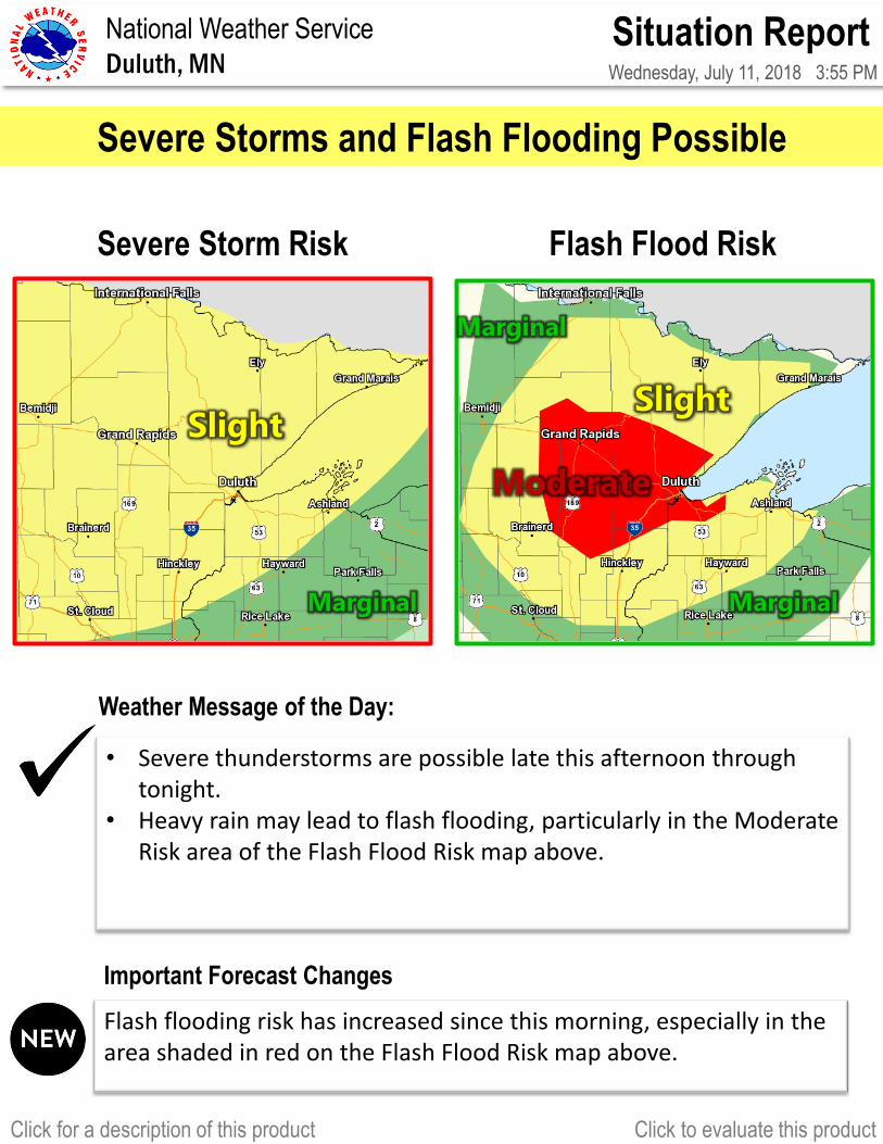
Situation Report Wednesday, July 11, 2018 3:55 PM National Weather Service Duluth, MN Click for a description of this product Click to evaluate this product Severe Storm Risk • Severe thunderstorms are possible late this afternoon through tonight. • Heavy rain may lead to flash flooding, particularly in the Moderate Risk area of the Flash Flood Risk map above. Flash flooding risk has increased since this morning, especially in the area shaded in red on the Flash Flood Risk map above. Weather Message of the Day: Important Forecast Changes Severe Storms and Flash Flooding Possible Marginal Slight Marginal Marginal Slight Flash Flood Risk Moderate
Transcript of Critical Fire Weather Conditions Today · Hazards, Timing and Duration: Red Flag Warning for...
Situation Report Wednesday, July 11, 2018 3:55 PM
National Weather Service
Duluth, MN
Click for a description of this product Click to evaluate this product
Severe Storm Risk Headline
Headline
Headline
Summarize the threat in one or two bullets
• Severe thunderstorms are possible late this afternoon through tonight.
• Heavy rain may lead to flash flooding, particularly in the Moderate Risk area of the Flash Flood Risk map above.
Flash flooding risk has increased since this morning, especially in the area shaded in red on the Flash Flood Risk map above.
Weather Message of the Day:
Important Forecast Changes
Severe Storms and Flash Flooding Possible
Use banner color that matches risk level
Marginal
Slight
Marginal
Marginal
Slight
Flash Flood Risk
Moderate
Situation Report Wednesday, July 11, 2018 3:55 PM
National Weather Service
Duluth, MN
Click for a description of this product Click to evaluate this product
This page is required in order to address these critical elements: 1. Hazards 2. Areas Impacted 3. Timing & Duration 4. Impacts 5. Forecast Certainty and Considerations 6. Historical Perspective (how rare is this event?) is recommended to include especially in larger events. However, this format may be modified and offices may use graphics/other text (encompassing other slides if needed) as they see fit or as requested by local partner feedback to address these critical elements.
Key Points
Impacts: Hail damage to roofs, vehicles, siding, and windows is
possible. Flash flooding may cause road closures and washouts.
Strong winds may break large tree branches, topple, and break
trees, and cause roof damage.
Timing & Duration: Thunderstorms are expected to redevelop this
afternoon or evening along an approaching cool front and move east
to southeast tonight. The flood risk is highest this evening and
overnight.
Areas Impacted: All of northern Minnesota and northwest
Wisconsin. Greatest risk is over central and north-central Minnesota.
Hazards: Some thunderstorms may produce large hail, some
stones larger than golfballs, and damaging wind gusts. Tornadoes
are also possible. Heavy rainfall is likely with these storms and may
lead to flash flooding, especially late this evening and overnight.
The following are examples of phrases you could use for each point Hazards Strong to severe thunderstorms Severe thunderstorms Impacts Some storms could produce small hail and gusty winds Some storms will produce large hail and damaging winds Dangerous storms producing large hail and damaging winds Damaging winds may lead to numerous trees down and power outages Timing Storms will develop mid to late in the afternoon and move east into the evening. Storms will track into the Northland overnight tonight. Certainty We are confident storms will develop, but not all storms will be severe. While we are not confident that storms may develop, if they DO develop they will quickly become dangerous.
Large Hail
Larger than 1 inch likely
Golfball-size possible
Damaging Winds
Gusts over 60 mph
Tornadoes
Possible
Flash Flooding
Flash Flood Watch in Effect
Flash flooding possible
Situation Report Wednesday, July 11, 2018 3:55 PM
National Weather Service
Duluth, MN
Click for a description of this product Click to evaluate this product
Flash Flood Watch
Image: Day 3 Excessive Rainfall
Backup Images:
Marginal 1
2
4
5
Slight
Moderate
High
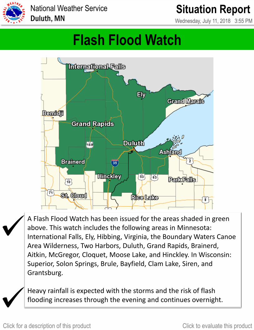
A Flash Flood Watch has been issued for the areas shaded in green above. This watch includes the following areas in Minnesota: International Falls, Ely, Hibbing, Virginia, the Boundary Waters Canoe Area Wilderness, Two Harbors, Duluth, Grand Rapids, Brainerd, Aitkin, McGregor, Cloquet, Moose Lake, and Hinckley. In Wisconsin: Superior, Solon Springs, Brule, Bayfield, Clam Lake, Siren, and Grantsburg. Heavy rainfall is expected with the storms and the risk of flash flooding increases through the evening and continues overnight.
Situation Report Wednesday, July 11, 2018 3:55 PM
National Weather Service
Duluth, MN
Click for a description of this product Click to evaluate this product
Select Appropriate Info Box from the right. Feel free to modify or make new info boxes depending on the weather threat.
Enter event messaging themes & resources. Inform core partners of the message of the day and the safety message of the day
This page is required Info Boxes:
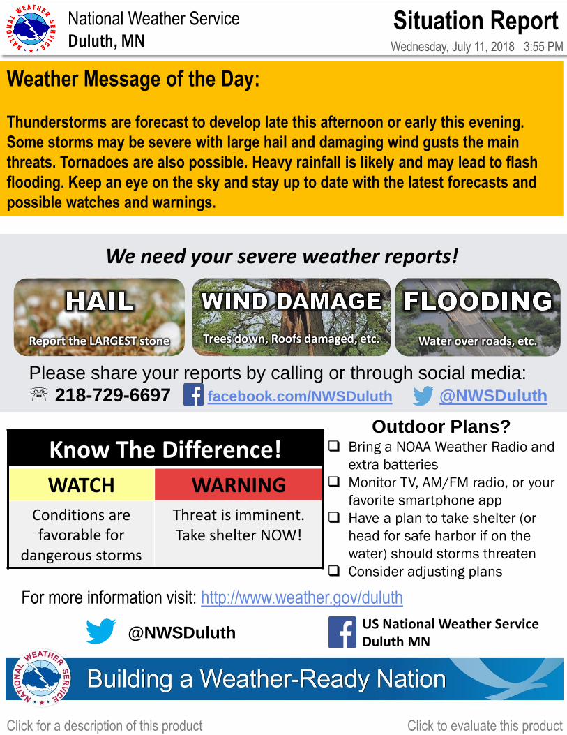
Weather Message of the Day:
Thunderstorms are forecast to develop late this afternoon or early this evening.
Some storms may be severe with large hail and damaging wind gusts the main
threats. Tornadoes are also possible. Heavy rainfall is likely and may lead to flash
flooding. Keep an eye on the sky and stay up to date with the latest forecasts and
possible watches and warnings.
@NWSDuluth US National Weather Service Duluth MN
For more information visit: http://www.weather.gov/duluth
Please share your reports by calling or through social media:
218-729-6697 facebook.com/NWSDuluth @NWSDuluth
Report the LARGEST stone
Trees down, Roofs damaged, etc.
Water over roads, etc.
We need your severe weather reports!
Have multiple ways to be alerted!
NOAA Weather Radio
Commercial TV/Radio
Reliable Weather Apps
Outdoor warning sirens
Know The Difference!
WATCH WARNING
Conditions are favorable for
dangerous storms
Threat is imminent. Take shelter NOW!
Outdoor Plans? Bring a NOAA Weather Radio and
extra batteries
Monitor TV, AM/FM radio, or your
favorite smartphone app
Have a plan to take shelter (or
head for safe harbor if on the
water) should storms threaten
Consider adjusting plans