
CRB Primer, Tolan
47
Field Guides doi: 10.1130/2009.fld015(28) 2009;15;599-643 Field Guides Burt Terry L. Tolan, Barton S. Martin, Stephen P. Reidel, James L. Anderson, Kevin A. Lindsey and Walter Basalt Group field trips Columbia River Flood-Basalt Province: A primer for the GSA Columbia River An introduction to the stratigraphy, structural geology, and hydrogeology of the Email alerting services cite this article to receive free e-mail alerts when new articles www.gsapubs.org/cgi/alerts click Subscribe to subscribe to Field Guides www.gsapubs.org/subscriptions/ click Permission request to contact GSA http://www.geosociety.org/pubs/copyrt.htm#gsa click viewpoint. Opinions presented in this publication do not reflect official positions of the Society. positions by scientists worldwide, regardless of their race, citizenship, gender, religion, or political article's full citation. GSA provides this and other forums for the presentation of diverse opinions and articles on their own or their organization's Web site providing the posting includes a reference to the science. This file may not be posted to any Web site, but authors may post the abstracts only of their unlimited copies of items in GSA's journals for noncommercial use in classrooms to further education and to use a single figure, a single table, and/or a brief paragraph of text in subsequent works and to make GSA, employment. Individual scientists are hereby granted permission, without fees or further requests to Copyright not claimed on content prepared wholly by U.S. government employees within scope of their Notes © 2009 Geological Society of America on May 20, 2010 fieldguides.gsapubs.org Downloaded from
Transcript of CRB Primer, Tolan
Field Guides
doi: 10.1130/2009.fld015(28) 2009;15;599-643Field Guides
BurtTerry L. Tolan, Barton S. Martin, Stephen P. Reidel, James L. Anderson, Kevin A. Lindsey and Walter Basalt Group field tripsColumbia River Flood-Basalt Province: A primer for the GSA Columbia River An introduction to the stratigraphy, structural geology, and hydrogeology of the
Email alerting servicescite this article
to receive free e-mail alerts when new articleswww.gsapubs.org/cgi/alertsclick
Subscribe to subscribe to Field Guideswww.gsapubs.org/subscriptions/click
Permission request to contact GSAhttp://www.geosociety.org/pubs/copyrt.htm#gsaclick
viewpoint. Opinions presented in this publication do not reflect official positions of the Society.positions by scientists worldwide, regardless of their race, citizenship, gender, religion, or politicalarticle's full citation. GSA provides this and other forums for the presentation of diverse opinions and articles on their own or their organization's Web site providing the posting includes a reference to thescience. This file may not be posted to any Web site, but authors may post the abstracts only of their unlimited copies of items in GSA's journals for noncommercial use in classrooms to further education andto use a single figure, a single table, and/or a brief paragraph of text in subsequent works and to make
GSA,employment. Individual scientists are hereby granted permission, without fees or further requests to Copyright not claimed on content prepared wholly by U.S. government employees within scope of their
Notes
© 2009 Geological Society of America
on May 20, 2010fieldguides.gsapubs.orgDownloaded from
599
The Geological Society of AmericaField Guide 15
2009
An introduction to the stratigraphy, structural geology, and hydrogeology of the Columbia River Flood-Basalt Province:
A primer for the GSA Columbia River Basalt Group fi eld trips
Terry L. TolanGSI Water Solutions, 1020 North Center Parkway, Suite F, Kennewick, Washington 99336, USA
Barton S. MartinDepartment of Geology and Geography, Ohio Wesleyan University, 61 South Sandusky Street, Delaware, Ohio 43015, USA
Stephen P. ReidelWashington State University–Tri-Cities, 2710 University Drive, Richland, Washington 99354, USA
James L. AndersonGeology Department, University of Hawaii at Hilo, 200 West Kawili Street, Hilo, Hawaii 96720, USA
Kevin A. LindseyGSI Water Solutions, 1020 North Center Parkway, Suite F, Kennewick, Washington 99336, USA
Walter BurtGSI Water Solutions, 55 SW Yamhill, Suite 300, Portland, Oregon 97202, USA
ABSTRACT
The Miocene Columbia River Basalt Group (CRBG) covers a large part of Ore-gon, Washington, and Idaho and is one of the youngest and perhaps the best studied fl ood-basalt province on Earth. Decades of study have established a regional strati-graphic framework for the CRBG, have demonstrated the CBRG fl ows can be corre-lated with dikes and vents, have documented a wide variety of physical features with-in the CRBG fl ows, and have demonstrated that many characteristics of the CRBG are recognizable throughout its extent. Detailed studies of individual fl ows and their feeder dikes have allowed the development of models for the emplacement of volu-minous basaltic lava fl ows. The interplay between the regional structure, contempo-raneous deformation, preexisting topography, and paleodrainage systems helped to control the emplacement of individual CRBG fl ows. These features have also affected the nature of late Neogene sedimentation in the region covered by basalt fl ows. Final-ly, the distribution of sediments within the CRBG and the character of the intrafl ow and interfl ow structures have played a signifi cant role in the development of aquifers within the CRBG. In this paper we present an overview of the regional aspects of the stratigraphy, structural geology, tectonics, and hydrogeology of the CRBG.
Tolan, T.L., Martin, B.S., Reidel, S.P., Anderson, J.L., Lindsey, K.A., and Burt, W., 2009, An introduction to the stratigraphy, structural geology, and hydrogeology of the Columbia River Flood-Basalt Province: A primer for the GSA Columbia River Basalt Group fi eld trips, in O’Connor, J.E., Dorsey, R.J., and Madin, I.P., eds., Volcanoes to Vineyards: Geologic Field Trips through the Dynamic Landscape of the Pacifi c Northwest: Geological Society of America Field Guide 15, p. 599–643, doi: 10.1130/2009.fl d015(28). For permission to copy, contact [email protected]. ©2009 The Geological Society of America. All rights reserved.
on May 20, 2010fieldguides.gsapubs.orgDownloaded from
600 Tolan et al.
INTRODUCTION
Four fi eld trip guides in this volume examine the geology, tectonics, and hydrogeology of the Miocene Columbia River Basalt Group (CRBG), a fl ood-basalt province covering a large part of Oregon, Washington, and Idaho (Tolan et al., this volume; Wells et al., this volume; Lindsey et al., this volume; Burt et al., this volume). Decades of study have established a regional stra-tigraphy and nomenclature for the CRBG and have demonstrated that many characteristics of the CRBG are recognizable through-out its extent. The purpose of this paper is to present an overview of the common regional aspects of the stratigraphy, structural geology, and hydrogeology of the CRBG and to provide a basic stratigraphic framework for all of the fi eld trips in the region.
The Columbia River Basalt Group is an example of a con-tinental fl ood-basalt province, a type of large igneous province erupted onto largely continental crust and dominated by great thicknesses of basaltic lava fl ows (Jerram and Widdowson, 2005). The CRBG erupted between 17 and 6 Ma and inundated more than 200,000 km2 of Washington, Oregon, and Idaho (Fig. 1). It is one of the youngest and best preserved continental fl ood-basalt provinces on Earth. Although the province includes the Steens Basalt and related fl ows of southeast Oregon as part of the CRBG (Camp et al., 2003; Camp and Ross, 2004), our focus in this paper is on the area covered by the fi eld trips on the Colum-bia Plateau and in western Oregon and Washington.
The CRBG also hosts an important regional aquifer system that is the primary water supply for numerous communities and a multibillion-dollar agricultural economy. Understanding the basic geology and structural geology of the CRBG has played an important role in interpreting and defi ning the characteristics and behavior of the CRBG aquifer system across this province. The following sections will provide an introduction to (1) the regional setting and stratigraphic framework of the CRBG, (2) physical characteristics of CRBG fl ows, (3) eruptive history and mode of emplacement of CRBG fl ows, (4) structural geology, and (5) hydrogeology of the CRBG.
REGIONAL SETTING
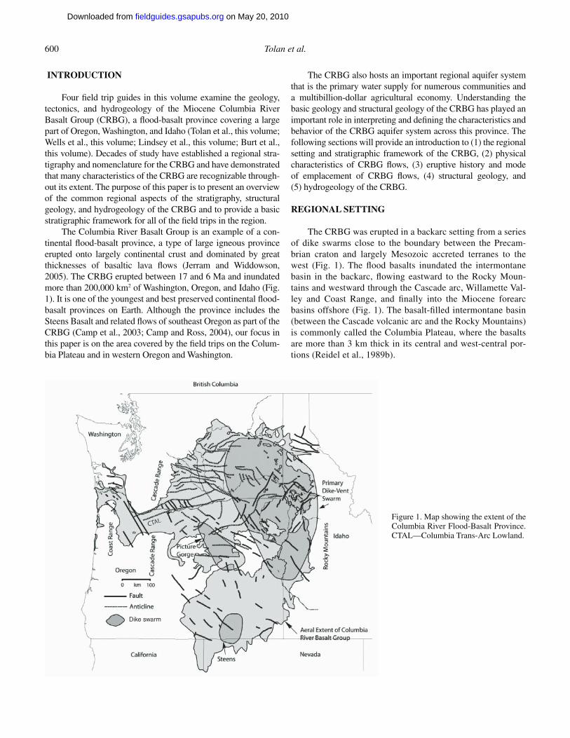
The CRBG was erupted in a backarc setting from a series of dike swarms close to the boundary between the Precam-brian craton and largely Mesozoic accreted terranes to the west (Fig. 1). The fl ood basalts inundated the intermontane basin in the backarc, fl owing eastward to the Rocky Moun-tains and westward through the Cascade arc, Willamette Val-ley and Coast Range, and fi nally into the Miocene forearc basins offshore (Fig. 1). The basalt-fi lled intermontane basin (between the Cascade volcanic arc and the Rocky Mountains) is commonly called the Columbia Plateau, where the basalts are more than 3 km thick in its central and west-central por-tions (Reidel et al., 1989b).
Dike swarm
Figure 1. Map showing the extent of the Columbia River Flood-Basalt Province. CTAL—Columbia Trans-Arc Lowland.
on May 20, 2010fieldguides.gsapubs.orgDownloaded from
Introduction to the CRBG 601
Rocks older than the CRBG are exposed around the margins of the fl ood-basalt province and in deep boreholes. To the northeast, the CRBG laps onto a cratonic assemblage of Proterozoic metased-iments of the Windermere and Belt Supergroups, miogeosynclinal lower Paleozoic shallow marine rocks, rocks associated with the Kootenay Arc, and granitic rocks of the Idaho Batholith and other Jurassic and Cretaceous intrusions (Stoffel et al., 1991). The struc-tural grain of these rocks is north to northeast. To the southeast, the CRBG overlies lower to middle Tertiary volcanic rocks and related volcaniclastic rocks mostly assigned to the Clarno and John Day Formations, which themselves overlie northeast-trending belts of Cretaceous to Permian accreted terranes of intra-arc and volcanic arc origin (Walker, 1979; Walker and MacLeod, 1991).
The Cascade volcanic arc forms a broad, south-plunging arch along the western margin of the Columbia Plateau. The CRBG is uplifted 300 to >600 m on the fl anks of the arch, and fault bounded pre-Tertiary terranes and Eocene and Oligocene sediment-fi lled rift basins of the North Cascades plunge to the southeast beneath the basalt (Tabor et al., 1984; Campbell, 1989).
Where the arch plunges to the south, the fl ood-basalt fl ows of the CRBG crossed the Miocene Cascade volcanic arc into the forearc via a 60-km-wide, east-northeast–trending lowland gap (Columbia Trans-Arc Lowland; Beeson et al., 1989a; Fig. 1). Cascade arc volcanism continued after emplacement of the fl ood basalt, and arc volcanic rocks overlie the CRBG in northern Ore-gon and southern Washington. Advancing westward, the fl ood basalts covered much of the northern Willamette Valley region and crossed the Coast Range (Fig. 1). Eventually the CRBG fl ows reached the Pacifi c Ocean (Fig. 1) and advanced out onto the continental shelf (Niem and Niem, 1985). In the forearc, the CRBG typically unconformably overlies marine strata, forearc related volcanics, and accreted oceanic terranes (Armentrout et al., 1983; Niem and Niem, 1985; Yeats et al., 1991; Wells, 2006).
STRATIGRAPHIC FRAMEWORK OF THE COLUMBIA RIVER BASALT GROUP
Historical Perspective
The pioneering studies of Waters (1961), Mackin (1955, 1961), and Grolier and Bingham (1971, 1978) developed a basic Columbia River basalt stratigraphic framework that could be cor-related and mapped over geographically large areas. Subsequent studies of the Columbia River basalt employing traditional map-ping methods along with geochemical and paleomagnetic fi n-gerprinting, demonstrated that mappable units of regional extent (Fig. 2) could be uniquely defi ned (Swanson et al., 1979a, 1979b, 1980, 1981; Beeson and Moran, 1979).
Most of the research efforts in the CRBG from the late 1970s to 1988 were funded by the U.S. Department of Energy’s (USDOE) Basalt Waste Isolation Project (BWIP), which exam-ined the suitability of constructing a deep repository in the CRBG for the fi nal disposal of high-level nuclear waste beneath Hanford in south-central Washington State.
A tremendous amount of data and information on CRBG geology and hydrogeology was produced by BWIP and its cooperative research partners. Results from BWIP’s investiga-tions are summarized in the fi rst three volumes of the Site Char-acterization Plan (U.S. Department of Energy [USDOE], 1988). Geological Society of America Special Paper 239 (Reidel and Hooper, eds., 1989) presents a comprehensive summary of the results of this period of cooperative research into the regional stratigraphic framework and tectonics of the Columbia River Flood-Basalt Province. In the post-BWIP era, much of the effort in CRBG research has been directed into investigating the emplacement process and history of these huge fl ood-basalt fl ows (e.g., Reidel and Tolan, 1992; Reidel et al., 1994b; Ho and Cashman, 1997; Self et al., 1996, 1997; Reidel, 1998), refi n-ing the stratigraphy of the CRBG, especially the monotonous Grande Ronde Basalt, and understanding the hydrogeology of the CRBG (Oberlander and Miller, 1981; Livesay, 1986; Drost and Whiteman, 1986; Lite and Grondin, 1988; Davies-Smith et al., 1988; USDOE, 1988; Burt, 1989; Johnson et al., 1993; Hansen et al., 1994; Spane and Webber, 1995; Wozniak, 1995; Steinkampf and Hearn, 1996; Packard et al., 1996; Sabol and Downey, 1997; Tolan et al., 2000b; Ground Water Manage-ment Area [GWMA], 2007a, 2007b). The following sections describe our current understanding of the physical characteris-tics and emplacement mechanism of CRBG fl ows.
General
The CRBG (Fig. 2) consists of a thick sequence of more than 300 continental tholeiitic fl ood-basalt fl ows that were erupted over an 11 million year period from ca. 17 to 6 Ma (Swanson et al., 1979b; Tolan et al., 1989). These fl ood-basalt fl ows cover an area over 200,000 km2 in Washington, Oregon, and western Idaho (Fig. 1) and have a total estimated volume of more than 224,000 km3 (Camp et al., 2003). These volumet-ric fi gures include the Steens Basalt and correlative units in southeast Oregon, which are now considered to be part of the CRBG. The source for most of the fl ows was a series of north- northwest–trending linear fi ssure systems located in eastern Washington, eastern Oregon, and western Idaho (Fig. 1).
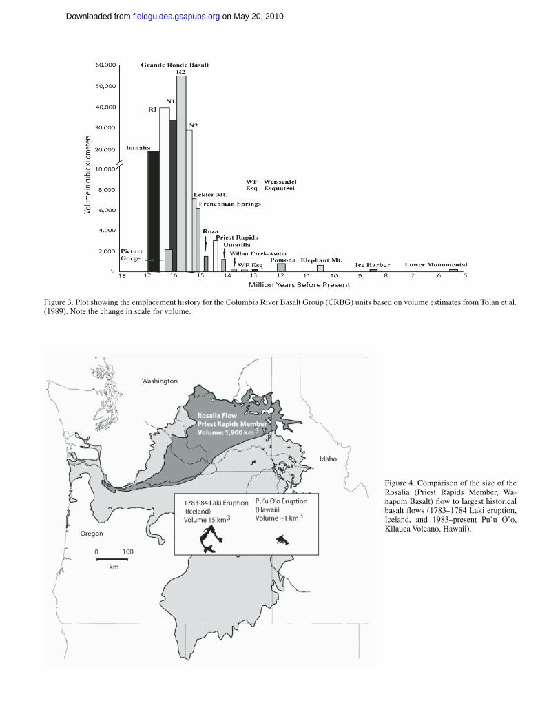
Although the eruptive activity associated with the CRBG spans an 11 million year period, more than 96% of the volume of the CRBG was erupted over a period of ~2.5 million years, from 17 to 14.5 Ma (Swanson et al., 1979b; Fig. 3). New radiometric ages (Barry et al., 2008) indicate that the entire Grande Ronde Basalt may have erupted in only 250,000 yr. During this peak period of activity, many of the fl ows that were erupted were of extraordinary size, exceeding 1000 km3 in volume with some as much as 5000 km3, and traveled many hundreds of kilometers from their vent system (Tolan et al., 1989; Reidel et al., 1989a; Reidel, 1998, 2005). These gigan-tic CRBG fl ows are hundreds to thousands of times larger than any lava fl ow erupted during recorded human history. Figure 4 presents a same-scale comparison between a CRBG fl ow,
on May 20, 2010fieldguides.gsapubs.orgDownloaded from
602 Tolan et al.
the Laki (Skaftar Fires) fl ow fi eld (largest basalt eruption in recorded human history; Thordarson and Self, 1993) and the ongoing Pu’u O’o eruption on the Big Island of Hawaii. CRBG fl ows represent the largest individual lava fl ows known on Earth (Tolan et al., 1989).
The fl ow of lava away from the vent systems was directed by major tectonic features of the Palouse Slope, Columbia Basin, and Columbia Trans-Arc Lowland (Fig. 1) and continued regional subsidence (Reidel et al., 1994a; Beeson et al., 1989a; Reidel and Tolan, 1992). They combined to produce a regional gradient to the west for the fl ows.
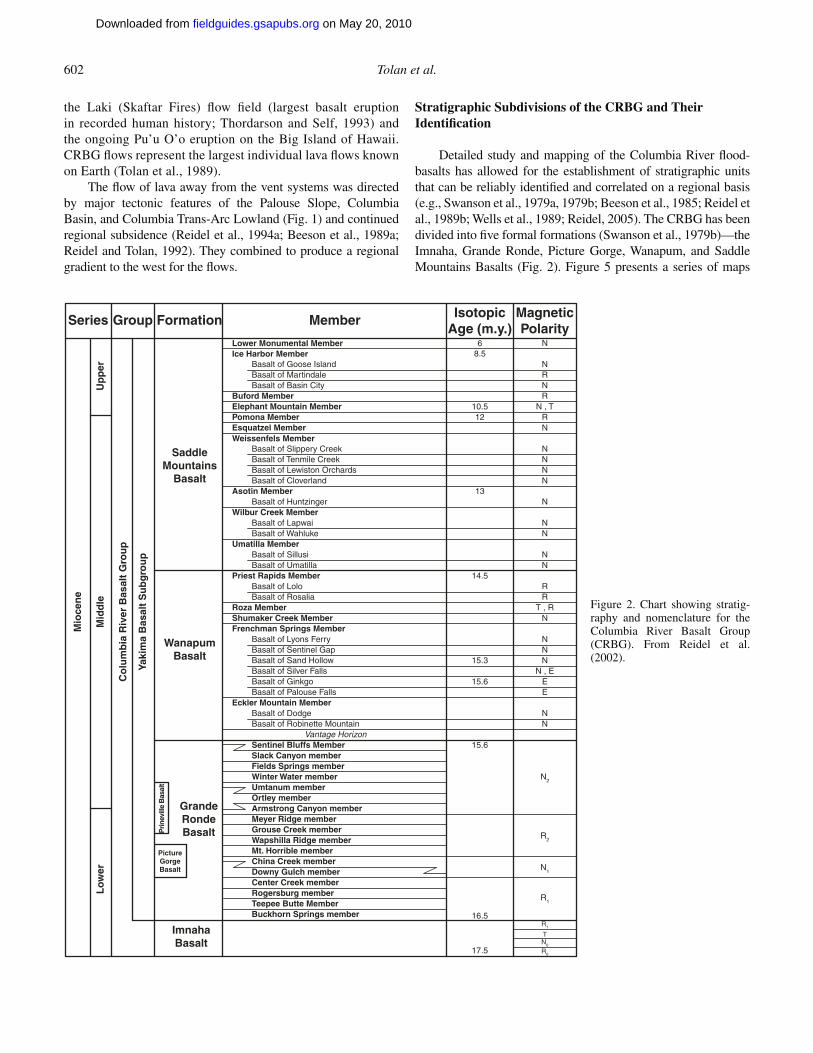
Stratigraphic Subdivisions of the CRBG and Their Identifi cation
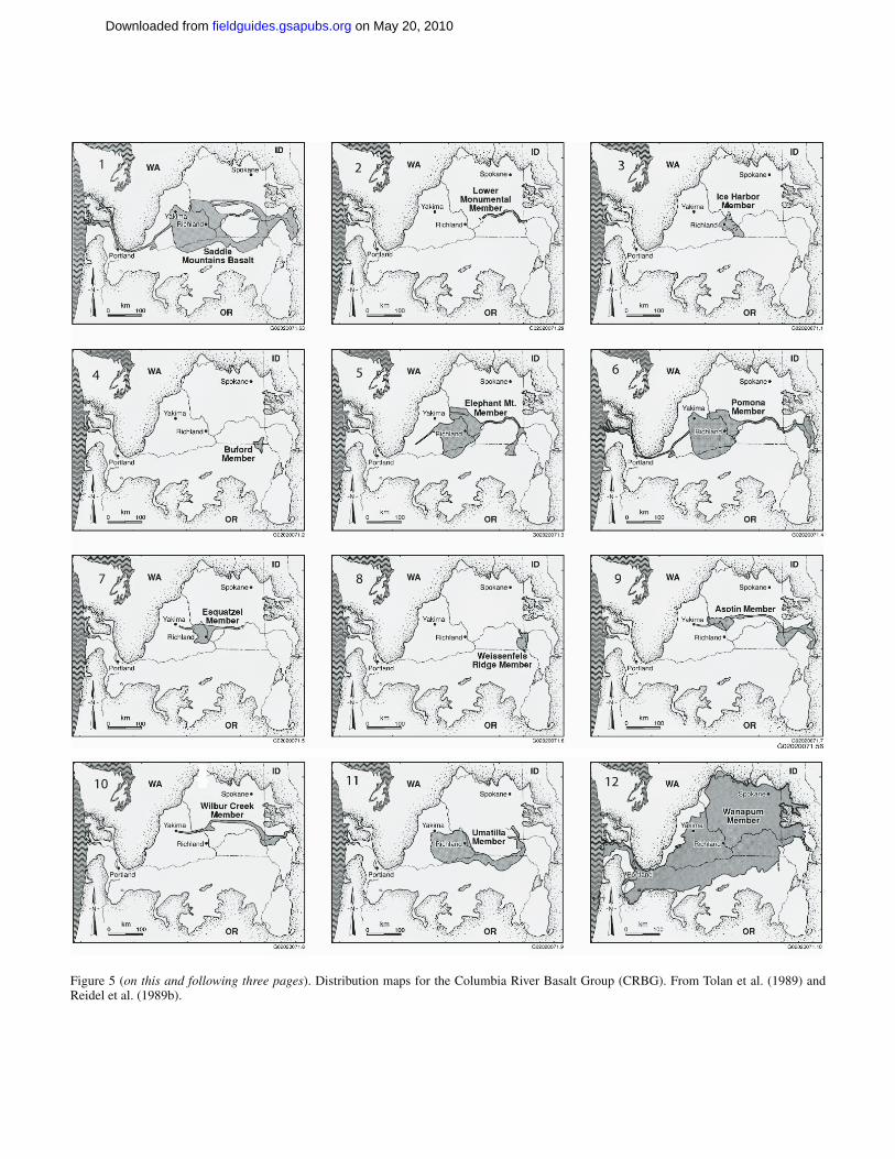
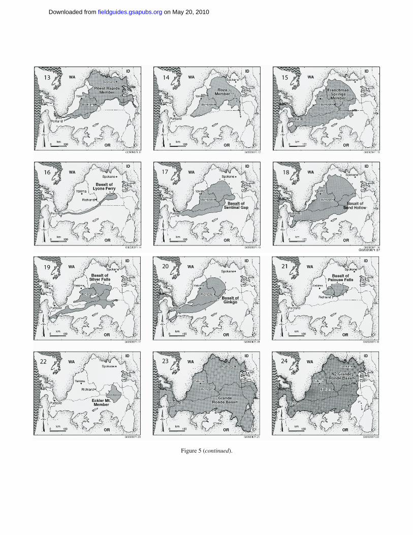
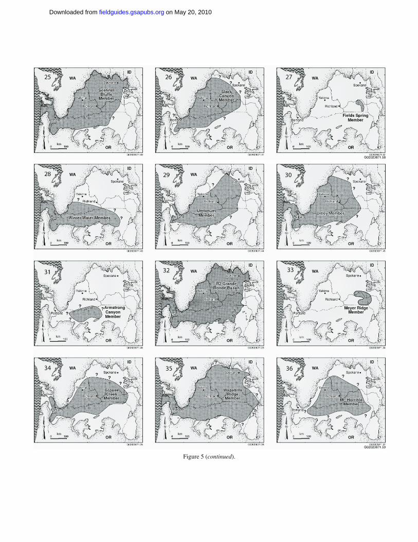
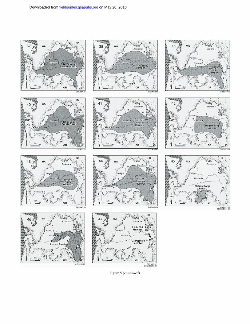
Detailed study and mapping of the Columbia River fl ood-basalts has allowed for the establishment of stratigraphic units that can be reliably identifi ed and correlated on a regional basis (e.g., Swanson et al., 1979a, 1979b; Beeson et al., 1985; Reidel et al., 1989b; Wells et al., 1989; Reidel, 2005). The CRBG has been divided into fi ve formal formations (Swanson et al., 1979b)—the Imnaha, Grande Ronde, Picture Gorge, Wanapum, and Saddle Mountains Basalts (Fig. 2). Figure 5 presents a series of maps
Mio
cen
e
Mid
dle
Up
per
Lo
wer
Co
lum
bia
Riv
er B
asal
t G
rou
p
Yaki
ma
Bas
alt
Su
bg
rou
p
ImnahaBasalt
GrandeRondeBasalt
WanapumBasalt
SaddleMountains
Basalt
Series Group Formation Member IsotopicAge (m.y.)
MagneticPolarity
PictureGorgeBasalt
Prin
evill
e B
asal
t
Lower Monumental MemberIce Harbor Member
Basalt of Goose IslandBasalt of MartindaleBasalt of Basin City
Buford MemberElephant Mountain MemberPomona MemberEsquatzel MemberWeissenfels Member
Basalt of Slippery CreekBasalt of Tenmile CreekBasalt of Lewiston OrchardsBasalt of Cloverland
Asotin MemberBasalt of Huntzinger
Wilbur Creek MemberBasalt of LapwaiBasalt of Wahluke
Umatilla MemberBasalt of SillusiBasalt of Umatilla
Priest Rapids MemberBasalt of LoloBasalt of Rosalia
Roza MemberShumaker Creek MemberFrenchman Springs Member
Basalt of Lyons FerryBasalt of Sentinel GapBasalt of Sand HollowBasalt of Silver FallsBasalt of GinkgoBasalt of Palouse Falls
Eckler Mountain MemberBasalt of DodgeBasalt of Robinette Mountain
Vantage HorizonSentinel Bluffs MemberSlack Canyon memberFields Springs memberWinter Water memberUmtanum memberOrtley memberArmstrong Canyon memberMeyer Ridge memberGrouse Creek memberWapshilla Ridge memberMt. Horrible memberChina Creek memberDowny Gulch memberCenter Creek memberRogersburg memberTeepee Butte MemberBuckhorn Springs member
68.5
10.512
13
14.5
15.3
15.6
15.6
16.5
17.5
N
N
NR
RN , T
RN
NNNN
N
NN
NN
RR
T , RN
NNN
N , EEE
NN
N2
R2
N1
R1
R1
TN0
R0
Figure 2. Chart showing stratig-raphy and nomenclature for the Columbia River Basalt Group (CRBG). From Reidel et al. (2002).
on May 20, 2010fieldguides.gsapubs.orgDownloaded from
Introduction to the CRBG 603
Figure 3. Plot showing the emplacement history for the Columbia River Basalt Group (CRBG) units based on volume estimates from Tolan et al. (1989). Note the change in scale for volume.
Figure 4. Comparison of the size of the Rosalia (Priest Rapids Member, Wa-napum Basalt) fl ow to largest historical basalt fl ows (1783–1784 Laki eruption, Iceland, and 1983–present Pu’u O’o, Kilauea Volcano, Hawaii).
on May 20, 2010fieldguides.gsapubs.orgDownloaded from
604 Tolan et al.
Figure 5 (on this and following three pages). Distribution maps for the Columbia River Basalt Group (CRBG). From Tolan et al. (1989) and Reidel et al. (1989b).
on May 20, 2010fieldguides.gsapubs.orgDownloaded from
Introduction to the CRBG 605
Figure 5 (continued).
on May 20, 2010fieldguides.gsapubs.orgDownloaded from
606 Tolan et al.
Figure 5 (continued).
on May 20, 2010fieldguides.gsapubs.orgDownloaded from
Introduction to the CRBG 607
Figure 5 (continued).
on May 20, 2010fieldguides.gsapubs.orgDownloaded from
608 Tolan et al.
showing the distribution of currently defi ned CRBG units. The fi eld trips will examine mainly units belonging to the Grande Ronde, Wanapum, and Saddle Mountains Basalts.
CRBG units are identifi ed using a combination of lithol-ogy, paleomagnetic properties, and geochemical composition with regard to superposition (Swanson et al., 1979b; Beeson et al., 1985, 1989a; Reidel et al., 1989b; Wells et al., 1989; Reidel, 1998, 2005). Lithology, paleomagnetic polarity, and superposi-tion can be used to identify and map CRBG units in the fi eld. The most important aspect of the lithology of CRBG units is the pres-ence or absence of plagioclase phenocrysts (e.g., see Swanson et al., 1979b; Beeson et al., 1985; Reidel et al., 1989b). Variations in the relative abundance, sizes, and habits of the plagioclase phenocryst are often the best fi eld diagnostic criterion for cer-tain CRBG units. Some CRBG units (e.g., Frenchman Springs Member fl ows; Fig. 2) have several distinct size populations of plagioclase phenocryst. If the plagioclase phenocrysts are very small in size (0.1–0.5 cm), they are often referred to a “micro-phenocrysts” (“microphyric”) to distinguish them from larger (0.5 to >3 cm) plagioclase phenocrysts or clots of plagioclase phenocrysts (“glomerocrysts”). Macroscopic olivine and augite phenocrysts are rare but do occur in a few CRBG units (e.g., Pomona Member, Saddle Mountains Basalt; Meyer Ridge Mem-ber, Grande Ronde Basalt) and serve as a distinguishing charac-teristic in the fi eld.
Determination of the paleomagnetic polarity of CRBG fl ows (using a portable fl uxgate magnetometer in the fi eld) has proved to be an important criterion in the identifi cation and mapping of CRBG units. Paleomagnetic laboratory analysis of oriented, small-diameter cores from CRBG fl ows have established that certain CRBG fl ows possess distinctive paleomagnetic directions (e.g., Rietman, 1966; Kienle, 1971; Coe et al., 1978; Choiniere and Swanson, 1979; Van Alstine and Gillette, 1981; Magill et al., 1982; Reidel et al., 1984; Beeson et al., 1985; USDOE, 1988; Wells et al., 1989, this volume). Although fi eld collection of ori-ented cores can require much effort and be challenging, paleo-magnetic data from this work has proved to be extremely useful in helping to establish and correlate CRBG units.
Over the past 30 years the CRBG has been extensively ana-lyzed for major oxides, minor oxides, and trace and rare earth elements, which, coupled with other fi eld criteria, has been used to establish a regional-scale, mappable, stratigraphy (Wright et al., 1973, 1989; Swanson et al., 1979b; Beeson et al., 1985; Reidel et al., 1989b; Wells et al., 1989; Hooper, 2000; Reidel, 2005). A major reason that CRBG geochemical stratigraphy was possible on a regional scale was due to the remarkable “bulk” geochemical homogeneity of individual CRBG eruptions despite their huge volumes and distances traveled (Wright et al., 1973, 1989; Beeson et al., 1985; Reidel et al., 1989b; Hooper, 2000). Apparent geochemical heterogeneity within CRBG fl ows is often due to varying degrees of secondary weathering and altera-tion of the CRBG fl ow that may not always be obvious (Wells et al., this volume). Therefore care must be exercised to always obtain the freshest rock for analysis, especially when the data
are used for Grande Ronde Basalt and Frenchman Springs Mem-ber (Wanapum Basalt) unit identifi cation. There are a few docu-mented examples of primary geochemical heterogeneity within CRBG fl ows (e.g., minor crystal settling—Reidel and Tolan, 1992; surface mixing of CRBG fl ows—Reidel and Fecht, 1987; Reidel, 1998, 2005), but these appear to be the exception rather than the rule.
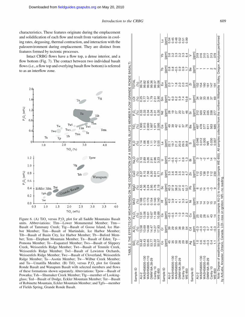
Table 11 presents geochemical composition of selected CRBG units. Although this selection does not include every CRBG unit known, it provides geochemical compositions of many of the CRBG units that will be encountered during the fi eld trips.
Generally the most diagnostic elements to consider are TiO2,
P2O
5, Cr, MgO, Zr, and Ba.Saddle Mountains Basalt units typically have a much wider
and diverse range of geochemical composition than the other older CRBG formations (Figs. 6A and 6B; Wright et al., 1989; Hooper, 2000; Reidel et al., 2002). The geochemical composition of Wanapum Basalt units generally falls into two broad group-ings, the fi rst encompassing the Shumaker Creek, Priest Rapids, Roza, and Frenchman Springs Members, and the second consist-ing of the older Eckler Mountain Member units (Fig. 6B; Wright et al., 1989; Hooper, 2000). Flows of the Wanapum Basalt typically will have higher TiO
2 than the Grande Ronde Basalt.
Grande Ronde Basalt members display a relatively narrow range of geochemical compositions that typically exhibit small, but sig-nifi cant, variations in TiO
2, P
2O
5, Cr, and MgO (Fig. 6B; Table 1
[see footnote 1]).When collecting CRBG samples for analysis, care should
always be taken to obtain the freshest samples possible. This is especially important when dealing with CRBG units (e.g., Grande Ronde Basalt members) where the diagnostic geochemi-cal variations have a small range. Table 2 presents a series of analyses from samples, collected at different locations, from the center portion of the same Sentinel Bluffs Member fl ow (Grande Ronde Basalt) in the northern Willamette Valley, Oregon. Degree of weathering for the samples reported in Table 2 increases from none (fresh, dark-gray–black-appearing basalt—sample AU-2) to moderate (light-gray oxidized-appearing basalt—sample WE-850). As shown in Table 2, even slight to moderate weather-ing can signifi cantly alter the geochemical “signature” of CRBG fl ows. This underscores the importance of using the multiple cri-teria approach for the identifi cation of CRBG units and not rely-ing on a single criterion, such as geochemistry, alone.
Intrafl ow Structures
Intrafl ow structures are primary, internal features or stratifi ed portions of basalt fl ows exhibiting grossly uniform macroscopic
1GSA Data Repository Item 2009244, Table 1, geochemical data on selected CRBG units, is available at www.geosociety.org/pubs/ft2009.htm, or on request from [email protected], Documents Secretary, GSA, P.O. Box 9140, Boulder, CO 80301-9140, USA.
on May 20, 2010fieldguides.gsapubs.orgDownloaded from
Introduction to the CRBG 609
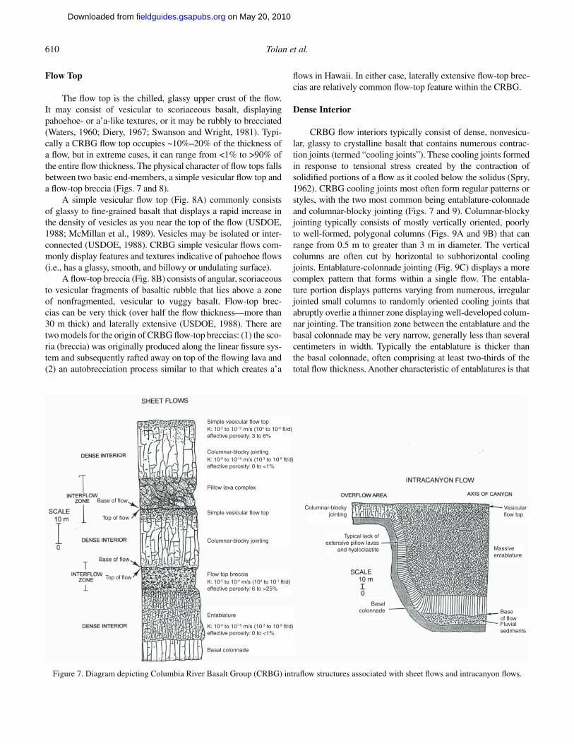
characteristics. These features originate during the emplacement and solidifi cation of each fl ow and result from variations in cool-ing rates, degassing, thermal contraction, and interaction with the paleoenvironment during emplacement. They are distinct from features formed by tectonic processes.
Intact CRBG fl ows have a fl ow top, a dense interior, and a fl ow bottom (Fig. 7). The contact between two individual basalt fl ows (i.e., a fl ow top and overlying basalt fl ow bottom) is referred to as an interfl ow zone.
P2O
5 (w
t%)
P2O
5 (w
t%)
TiO2 (%)
TiO2 (wt%)
Figure 6. (A) TiO2 versus P
2O
5 plot for all Saddle Mountains Basalt
units. Abbreviations: Tlm—Lower Monumental Member; Ttm— Basalt of Tammany Creek; Tig—Basalt of Goose Island, Ice Har-bor Member; Tim—Basalt of Martindale, Ice Harbor Member; Tib— Basalt of Basin City, Ice Harbor Member; Tb—Buford Mem-ber; Tem—Elephant Mountain Member; Tn—Basalt of Eden; Tp— Pomona Member; Te—Esquatzel Member; Tws—Basalt of Slippery Creek, Weissenfels Ridge Member; Twt—Basalt of Tenmile Creek, Weissenfels Ridge Member; Twl—Basalt of Lewiston Orchards, Weissenfels Ridge Member; Twc—Basalt of Cloverland, Weissenfels Ridge Member; Ta—Asotin Member; Tw—Wilbur Creek Member; and Tu—Umatilla Member. (B) TiO
2 versus P
2O
5 plot for Grande
Ronde Basalt and Wanapum Basalt with selected members and fl ows of these formations shown separately. Abreviations: Tpow—Basalt of Powatka; Tsh—Shumaker Creek Member; Tlg—member of Looking-glass; Ted—Basalt of Dodge, Eckler Mountain Member; Ter—Basalt of Robinette Mountain, Eckler Mountain Member; and Tgfs—member of Fields Spring, Grande Ronde Basalt.
TA
BLE
2. T
HE
EF
FE
CT
S O
F W
EA
TH
ER
ING
ON
TH
E C
OM
PO
SIT
ION
OF
A S
EN
TIN
EL
BLU
FF
S M
EM
BE
R F
LOW
(G
RA
ND
E R
ON
DE
BA
SA
LT)
Sam
ple
ID
SiO
2 (%
) A
l 2O3
(%)
Fe 2O
3 (%
) M
nO (%)
MgO (%
) C
aO (%)
Na 2O
(%)
K2O (%
) T
iO2
(%)
P2O
5 (%
) LO
I(%
) T
OT
AL
(%)
A
U-2
53
.42
13.5
8 12
.91
0.18
84.
558.
373.
101.
141.
900
0.33
0.
2599
.74
WA
SH
5800
5-13
0 53
.43
13.6
9 13
.06
0.17
34.
368.
152.
891.
061.
915
0.33
0.
7799
.82
WA
SH
5800
5-11
0 55
.65
14.6
8 10
.61
0.17
03.
247.
563.
261.
062.
000
0.34
1.
3799
.95
DM
W18
A 2
8-29
53
.77
14.4
7 10
.67
0.15
43.
958.
202.
911.
111.
997
0.34
1.
7999
.36
Can
by 1
0 53
.22
14.2
7 11
.09
0.14
03.
768.
012.
961.
121.
971
0.31
2.
5199
.37
WE
-850
50
.57
17.9
3 10
.89
0.14
02.
196.
713.
230.
552.
595
0.35
3.
9099
.06
Sam
ple
ID
Co
(ppm
) C
r (p
pm)
Cs
(ppm
) H
f(p
pm)
Sc
(ppm
) T
h(p
pm)
U(p
pm)
La(p
pm)
Ce
(ppm
) N
d (p
pm)
Sm
(ppm
) E
u(p
pm)
Tb
(ppm
) Y
b(p
pm)
Lu(p
pm)
AU
-2
45
39
–0.5
4.
040
.33.
51.
522
.149
28
6.7
2.0
0.8
3.6
0.54
WA
SH
5800
5-13
0
35
29
–0.5
3.
937
.93.
6–0
.519
.739
19
6.0
1.7
0.8
3.2
0.45
WA
SH
5800
5-11
0
50
35
1.9
4.1
38.2
3.8
–0.5
21.2
4227
6.
21.
8–0
.53.
30.
48D
MW
18A
28-
29
28
38
1.0
4.1
37.0
3.5
1.1
20.9
4120
5.
92.
00.
93.
20.
52C
anby
10
29
39
1.9
3.3
41.0
3.2
0.9
29.5
3727
7.
42.
00.
93.
30.
51W
E-8
50
66
54
2.2
6.1
52.7
4.7
1.3
39.8
7646
10
.83.
51.
76.
40.
99
Sam
ple
ID
Ag
ppm
C
d pp
m
Cu
(ppm
) N
i(p
pm)
Pb
(ppm
) Z
n(p
pm)
Bi
(ppm
) S
(ppm
) B
a(p
pm)
Sr
(ppm
) Y
(ppm
) Z
r(p
pm)
Be
(ppm
) V
(ppm
)
AU
-2
1.0
–0.3
25
14
611
23
0.04
649
731
2 34
152
131
9W
AS
H58
005-
130
0.6
–0.3
20
14
1512
3–2
0.01
247
832
0 32
154
131
6W
AS
H58
005-
110
0.6
–0.3
28
14
1413
8–2
0.00
557
734
3 33
160
131
0D
MW
18A
28-
29
–0.3
0.
7 31
12
– 311
95
NR
611
335
3416
11
317
Can
by 1
0 0.
4 0.
4 43
15
– 311
214
0.03
056
333
8 37
147
231
3W
E-8
50
1.1
–0.3
14
14
923
0–2
0.00
768
537
7 69
191
237
9
Not
e: D
egre
e of
wea
ther
ing
incr
ease
s fr
om n
one
(sam
ple
AU
-2)
to m
oder
ate
(sam
ple
WE
-850
). A
ll sa
mpl
es c
olle
cted
from
the
nort
hern
Wil l
amet
te V
alle
y, O
rego
n. A
naly
ses
perf
orm
ed
by A
ctLa
bs, A
ncas
ter,
Ont
ario
, Can
ada.
LO
I—lo
ss o
n ig
nitio
n. N
R—
no r
eadi
ng.
on May 20, 2010fieldguides.gsapubs.orgDownloaded from
610 Tolan et al.
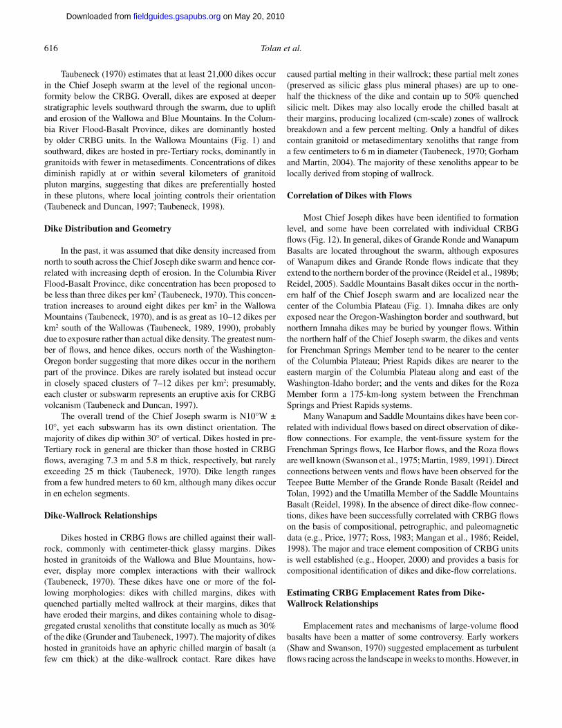
Flow Top
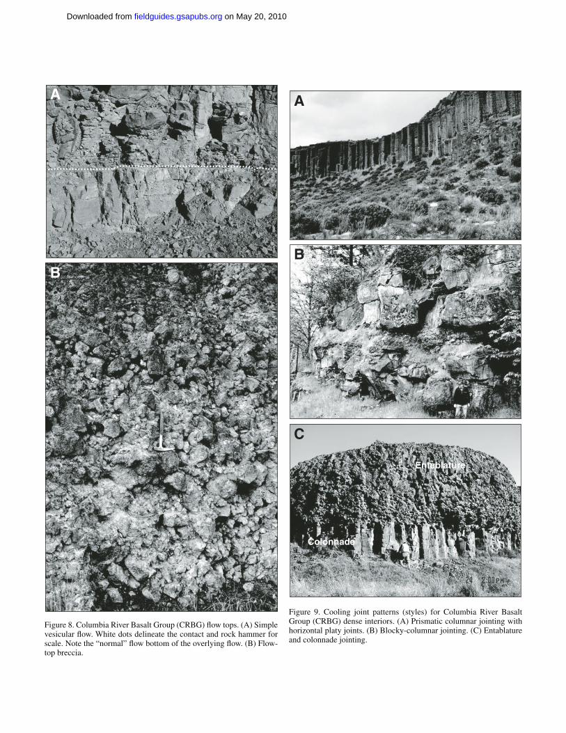
The fl ow top is the chilled, glassy upper crust of the fl ow. It may consist of vesicular to scoriaceous basalt, displaying pahoehoe- or a’a-like textures, or it may be rubbly to brecciated (Waters, 1960; Diery, 1967; Swanson and Wright, 1981). Typi-cally a CRBG fl ow top occupies ~10%–20% of the thickness of a fl ow, but in extreme cases, it can range from <1% to >90% of the entire fl ow thickness. The physical character of fl ow tops falls between two basic end-members, a simple vesicular fl ow top and a fl ow-top breccia (Figs. 7 and 8).
A simple vesicular fl ow top (Fig. 8A) commonly consists of glassy to fi ne-grained basalt that displays a rapid increase in the density of vesicles as you near the top of the fl ow (USDOE, 1988; McMillan et al., 1989). Vesicles may be isolated or inter-connected (USDOE, 1988). CRBG simple vesicular fl ows com-monly display features and textures indicative of pahoehoe fl ows (i.e., has a glassy, smooth, and billowy or undulating surface).
A fl ow-top breccia (Fig. 8B) consists of angular, scoriaceous to vesicular fragments of basaltic rubble that lies above a zone of nonfragmented, vesicular to vuggy basalt. Flow-top brec-cias can be very thick (over half the fl ow thickness—more than 30 m thick) and laterally extensive (USDOE, 1988). There are two models for the origin of CRBG fl ow-top breccias: (1) the sco-ria (breccia) was originally produced along the linear fi ssure sys-tem and subsequently rafted away on top of the fl owing lava and (2) an autobrecciation process similar to that which creates a’a
fl ows in Hawaii. In either case, laterally extensive fl ow-top brec-cias are relatively common fl ow-top feature within the CRBG.
Dense Interior
CRBG fl ow interiors typically consist of dense, nonvesicu-lar, glassy to crystalline basalt that contains numerous contrac-tion joints (termed “cooling joints”). These cooling joints formed in response to tensional stress created by the contraction of solidifi ed portions of a fl ow as it cooled below the solidus (Spry, 1962). CRBG cooling joints most often form regular patterns or styles, with the two most common being entablature-colonnade and columnar-blocky jointing (Figs. 7 and 9). Columnar-blocky jointing typically consists of mostly vertically oriented, poorly to well-formed, polygonal columns (Figs. 9A and 9B) that can range from 0.5 m to greater than 3 m in diameter. The vertical columns are often cut by horizontal to subhorizontal cooling joints. Entablature-colonnade jointing (Fig. 9C) displays a more complex pattern that forms within a single fl ow. The entabla-ture portion displays patterns varying from numerous, irregular jointed small columns to randomly oriented cooling joints that abruptly overlie a thinner zone displaying well-developed colum-nar jointing. The transition zone between the entablature and the basal colonnade may be very narrow, generally less than several centimeters in width. Typically the entablature is thicker than the basal colonnade, often comprising at least two-thirds of the total fl ow thickness. Another characteristic of entablatures is that
Base of flow
Top of flow
Base of flow
Simple vesicular flow top
Simple vesicular flow top
Columnar-blocky jointing
Columnar-blocky jointing
Entablature
Flow top breccia
Columnar-blockyjointing
Typical lack ofextensive pillow lavas
and hyaloclastite
Basal colonnade
Basalcolonnade
Vesicularflow top
Massiveentablature
Baseof flowFluvialsediments
Pillow lava complex
Top of flow
K: 10-2 to 10-12 m/s (104 to 10-6 ft/d)effective porosity: 3 to 6%
K: 10-2 to 10-5 m/s (104 to 10-1 ft/d)effective porosity: 6 to >25%
K: 10-9 to 10-15 m/s (10-3 to 10-9 ft/d)effective porosity: 0 to <1%
K: 10-9 to 10-15 m/s (10-3 to 10-9 ft/d)effective porosity: 0 to <1%
Figure 7. Diagram depicting Columbia River Basalt Group (CRBG) intrafl ow structures associated with sheet fl ows and intracanyon fl ows.
on May 20, 2010fieldguides.gsapubs.orgDownloaded from
Introduction to the CRBG 611
A
B
Figure 8. Columbia River Basalt Group (CRBG) fl ow tops. (A) Simple vesicular fl ow. White dots delineate the contact and rock hammer for scale. Note the “normal” fl ow bottom of the overlying fl ow. (B) Flow-top breccia.
Colonnade
Entablature
A
B
C
Figure 9. Cooling joint patterns (styles) for Columbia River Basalt Group (CRBG) dense interiors. (A) Prismatic columnar jointing with horizontal platy joints. (B) Blocky-columnar jointing. (C) Entablature and colonnade jointing.
on May 20, 2010fieldguides.gsapubs.orgDownloaded from
612 Tolan et al.
the basalt comprising it contains a very high percentage of glass (50%–95%) in contrast to the colonnade (Long and Wood, 1986; USDOE, 1988). While entablature-colonnade jointing style is commonly observed in CRBG fl ows, it is actually a very uncom-mon jointing pattern for lava fl ows elsewhere in the world. The origin of entablature-colonnade jointing has been the subject of much speculation and conjecture (e.g., Long and Wood, 1986; Reidel et al., 1994b), but it has not been resolved.
Frequency and spacing of cooling joints measured in out-crops indicate that frequencies typically range from 1 to 37 joints per meter with entablatures showing a greater number of joints per meter than colonnades. The spacing of cooling joints (num-ber of meters per fracture) appears to follow a log normal distri-bution for groups of cooling joints with similar attitudes. Meints (1986) found that the spacing of cooling joints was highly vari-able both between fl ows and within fl ows and could not be used to differentiate fl ows and intrafl ow structures.
Cooling joints are distinct from secondary tectonic fractures such as faults, shear zones, and joint sets. These secondary fea-tures are distinguishable by their appearance and occurrence. Tectonic fractures typically occur in sets of parallel to subpar-allel, closely spaced fractures. The presence of associated shat-ter breccias and gouge (often altered to clay) distinguishes them from cooling joints.
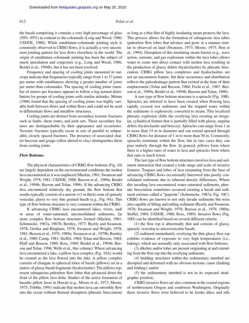
Flow Bottoms
The physical characteristics of CRBG fl ow bottoms (Fig. 10) are largely dependent on the environmental conditions the molten lava encountered as it was emplaced (Mackin, 1961; Swanson and Wright, 1978, 1981; USDOE, 1988; Beeson et al., 1989a; Reidel et al., 1994b; Beeson and Tolan, 1996). If the advancing CRBG lava encountered relatively dry ground, the fl ow bottom that results typically consists of a narrow (<1 m thick) zone of sparsely vesicular, glassy to very fi ne grained basalt (e.g., Fig. 9A). This type of fl ow bottom structure is very common within the CRBG.
If advancing CRBG lava encountered lakes, rivers, and/or areas of water-saturated, unconsolidated sediments, far more complex fl ow bottom structures formed (Mackin, 1961; Schmincke, 1967a, 1967b; Bentley, 1977; Byerly and Swanson, 1978; Grolier and Bingham, 1978; Swanson and Wright, 1978, 1981; Beeson et al., 1979, 1989a; Swanson et al., 1979b; Bentley et al., 1980; Camp, 1981; Stoffel, 1984; Tolan and Beeson, 1984; Pfaff and Beeson, 1989; Ross, 1989; Reidel et al., 1994b; Bee-son and Tolan, 1996; Wells et al., this volume). Where advancing lava encountered a lake, a pillow lava complex (Fig. 10A) would be created as the lava fl owed into the lake. A pillow complex consists of elongate to spherical lobes of basalt (pillows) set in a matrix of glassy basalt fragments (hyaloclastite). The pillows rep-resent subaqueous pahoehoe fl ow lobes that advanced down the front of the pillow lava delta. Studies of the active formation of basaltic pillow lavas in Hawaii (e.g., Moore et al., 1973; Moore, 1975; Tribble, 1991) indicate that molten lava can smoothly fl ow into the ocean without thermal disruption (phreatic brecciation)
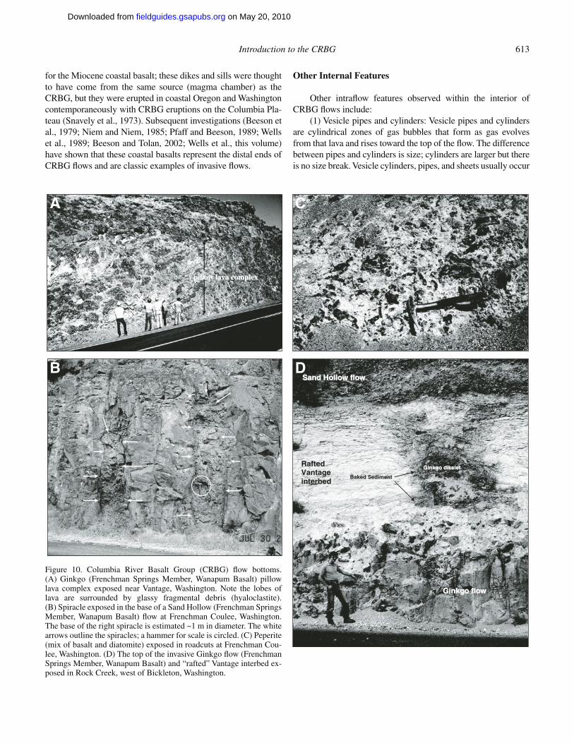
as long as a thin fi lm of highly insulating steam protects the lava. This process allows for the formation of subaqueous lava tubes (pahoehoe fl ow lobes that advance and grow in a manner simi-lar to observed on land (Swanson, 1973; Moore, 1975; Hon et al., 1994). Disruption of this insulating steam barrier (e.g., wave action, currents, and gas explosions within the lava lobe) allows water to come into direct contact with molten lava resulting in the production of glassy debris (hyaloclastite) by phreatic brec-ciation. CRBG pillow lava complexes and hyaloclastites are not an uncommon feature, but their occurrence and distribution refl ects the paleodrainage pattern that existed at the time of their emplacement (Tolan and Beeson, 1984; Fecht et al., 1987; Bee-son et al., 1989a; Reidel et al., 1994b; Beeson and Tolan, 1996).
A rare type of fl ow bottom structure is a spiracle (Fig. 10B). Spiracles are inferred to have been created when fl owing lava rapidly crossed wet sediments and the trapped water within the sediments is explosively converted to steam. This localized phreatic explosion chills the overlying lava creating an irregu-lar, cylindrical feature that is partially fi lled with glassy, angular debris (hyaloclastite and breccia). Spiracles can range from 1 m to more than 15 m in diameter and can extend upward through CRBG fl ows for distance of 1 m to more than 30 m. Commonly, spiracles terminate within the fl ow, but in rare cases they can pass entirely through the fl ow. In general, pillows form where there is a higher ratio of water to lava and spiracles form where that ratio is much lower.
The last type of fl ow bottom structures involves lava and sed-iment interaction that created a wide range and scale of invasive features. Tongues and lobes of lava emanating from the base of advancing CRBG fl ows occasionally burrowed into poorly con-solidated sediments due to inherent density differences. Where this invading lava encountered water-saturated sediments, phre-atic brecciation sometimes occurred creating a basalt and sedi-ment mixture called a “peperite” (Schmincke, 1967a; Fig. 10C). CRBG fl ows are known to not only invade sediments but were also capable of lifting and rafting sediment (Byerly and Swanson, 1978; Swanson and Wright, 1978; Beeson et al., 1979, 1989a; Stoffel, 1984; USDOE, 1988; Ross, 1989). Invasive fl ows (Fig. 10D) can be identifi ed based on several different criteria:
(1) the fl ow top is abnormally thin and consists of glassy, sparsely vesicular to microvesicular basalt;
(2) sediment immediately overlying the thin glassy fl ow top exhibits evidence of exposure to very high temperatures (i.e., baking), which are normally only associated with fl ow bottoms;
(3) dikelets and/or lobes are present originating at and extend-ing from the fl ow top into the overlying sediments;
(4) bedding structures within the sedimentary interbed are disrupted and deformed with no obvious tectonic cause (faulting and folding); and/or
(5) the sedimentary interbed is not in its expected strati-graphic position.
CRBG invasive fl ows are also common in the coastal regions of northwestern Oregon and southwest Washington. Originally these invasive fl ows were believed to be feeder dikes and sills
on May 20, 2010fieldguides.gsapubs.orgDownloaded from
Introduction to the CRBG 613
for the Miocene coastal basalt; these dikes and sills were thought to have come from the same source (magma chamber) as the CRBG, but they were erupted in coastal Oregon and Washington contemporaneously with CRBG eruptions on the Columbia Pla-teau (Snavely et al., 1973). Subsequent investigations (Beeson et al., 1979; Niem and Niem, 1985; Pfaff and Beeson, 1989; Wells et al., 1989; Beeson and Tolan, 2002; Wells et al., this volume) have shown that these coastal basalts represent the distal ends of CRBG fl ows and are classic examples of invasive fl ows.
Other Internal Features
Other intrafl ow features observed within the interior of CRBG fl ows include:
(1) Vesicle pipes and cylinders: Vesicle pipes and cylinders are cylindrical zones of gas bubbles that form as gas evolves from that lava and rises toward the top of the fl ow. The difference between pipes and cylinders is size; cylinders are larger but there is no size break. Vesicle cylinders, pipes, and sheets usually occur
ppiillllooww llaavvaa ccoommpplleexx
GGiinnkkggoo ffllooww
SSaanndd HHoollllooww ffllooww
RRaafftteedd VVaannttaaggee iinntteerrbbeedd
GGiinnkkggoo ddiikkeelleett
BBaakkeedd SSeeddiimmeenntt
A
B
C
D
Figure 10. Columbia River Basalt Group (CRBG) fl ow bottoms. (A) Ginkgo (Frenchman Springs Member, Wanapum Basalt) pillow lava complex exposed near Vantage, Washington. Note the lobes of lava are surrounded by glassy fragmental debris (hyaloclastite). (B) Spiracle exposed in the base of a Sand Hollow (Frenchman Springs Member, Wanapum Basalt) fl ow at Frenchman Coulee, Washington. The base of the right spiracle is estimated ~1 m in diameter. The white arrows outline the spiracles; a hammer for scale is circled. (C) Peperite (mix of basalt and diatomite) exposed in roadcuts at Frenchman Cou-lee, Washington. (D) The top of the invasive Ginkgo fl ow (Frenchman Springs Member, Wanapum Basalt) and “rafted” Vantage interbed ex-posed in Rock Creek, west of Bickleton, Washington.
on May 20, 2010fieldguides.gsapubs.orgDownloaded from
614 Tolan et al.
in relatively thin fl ows (5–30 m) that are composed of mainly colonnades and fl ow tops.
(2) Vesicle sheets: Vesicle sheets are horizontal to subhori-zontal layers of vesicles. They typically are fed by vesicle cylin-ders and form below the solidifi cation front. Vesicle zones within the interior of thicker fl ows can vary from centimeter to meters thick and can be laterally continuous, sometimes for kilometers.
(3) Vesicle zones: Vesicle zones are usually larger than vesicle sheets but probably form in much the same way. Vesicle zones can be up to several meters thick and are typically in the interior part of the lava fl ow.
(4) Laminae or dispersed diktytaxitic vesiculation: Diktytax-itic vesiculation or interstitial crystal-bounded vesicles can occur anywhere but is most prominent in thinner fl ows.
(5) Lava tubes: Lava tubes are rarely observed in CRBG fl ows except near their terminal margins. This is because CRBG fl ows were emplaced as sheet fl ows and were not tube fed as Hawaiian compound fl ows are.
(6) Sag fl owouts: Sag fl owouts are described as localized zones of complex tiering of colonnades and entablatures with some isolated fl ow-top material occurring below the top of the fl ow. A sag fl owout is thought to have formed as the result of lava draining from a partly solidifi ed fl ow leaving room for vesicula-tion to occur at the top of the remaining liquid.
Intrafl ow Structure Variation
Intrafl ow structures can be continuous for great distances, but the thickness and appearance of the intrafl ow structures are often highly variable. Lateral variations can occur gradually in some cases and very abruptly in other cases. The primary fac-tor that appears to control changes is the environment where the feature formed. Studies in the central Columbia Basin (USDOE, 1988) showed that lateral changes in the Umtanum Member (Grande Ronde Basalt; Fig. 2), which has a rubbly to brecciated fl ow top, extremely thick entablature and very thin colonnade, occur over relatively short distances. However, studies on the McCoy Canyon fl ow (Sentinel Bluffs Member, Grande Ronde Basalt), which has a normal fl ow top with a thick entablature and thick colonnade, documented gradual changes with distance.
The composition of the paleo–ground surface, and whether it is wet or dry, appears to be a signifi cant environmental con-sideration (Swanson and Wright, 1981). A dry basalt fl ow top has the least impact on the overlying fl ow, which probably is the situation for gradual changes in intrafl ow textures with distance. In contrast, wet sediment is the worst case and may be the cause of rapidly changing intrafl ow structure thickness. Wet sediments can rapidly reduce the temperature of the lava that increases its relative viscosity. The outward morphology of fl ows that advanced across wet sediments commonly resembles that of a compound fl ow, but the individual lobes are of much greater size (10 to >30 m thick); the larger lobes (>15 m thick) often display a complex internal jointing pattern, which is suggestive that lava was injected into the lobes (infl ated) even after it came to rest.
Flow Geometries
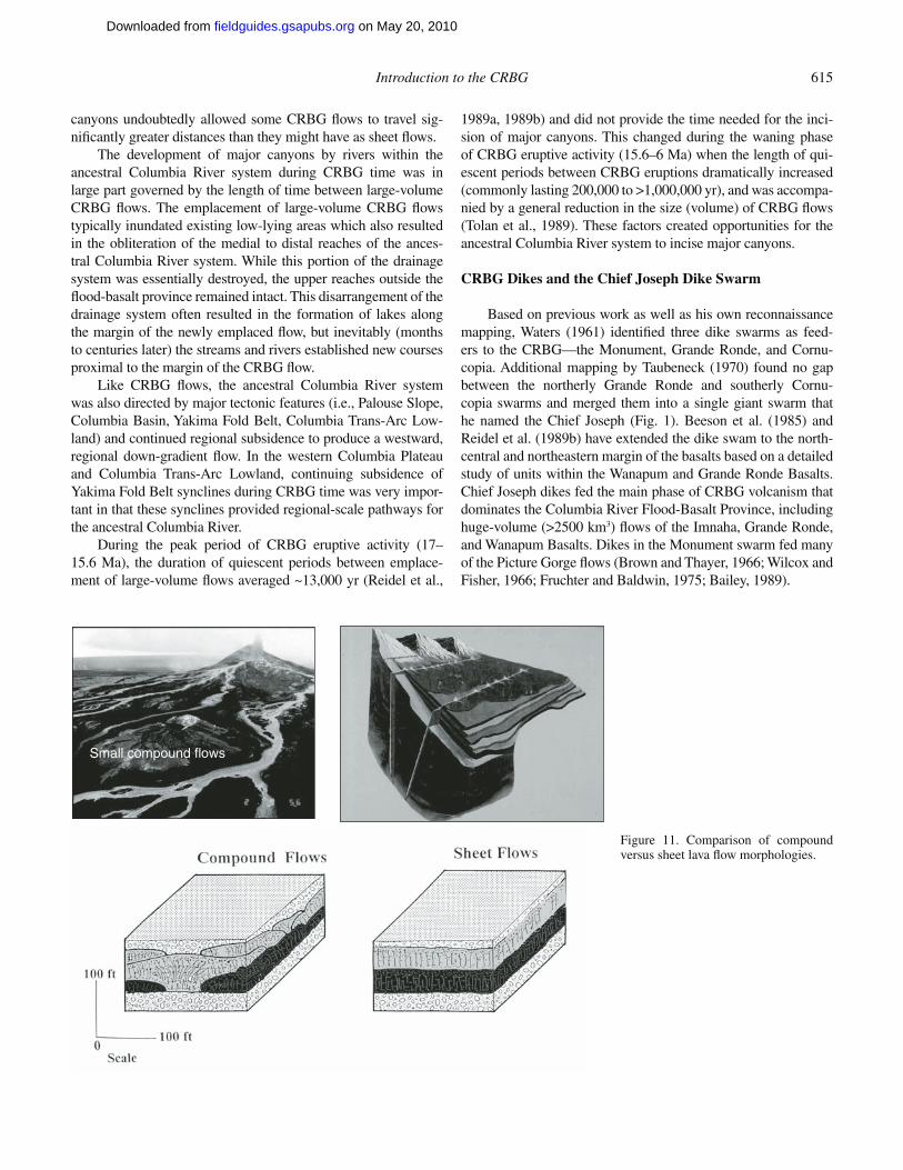
Sheet versus Compound FlowsRate and volume of lava erupted, lava composition and
temperature (rheology), vent geometry, topography, and envi-ronmental conditions all play signifi cant roles in fl ow rheology and emplacement dynamics, and overall geometry of individual basalt lava fl ows or fl ow fi elds (Shaw and Swanson, 1970; Bee-son et al., 1989a; Martin, 1989, 1991; Reidel and Tolan, 1992; Reidel et al., 1994b; Hon et al., 1994; Self et al., 1996, 1997; Keszthelyi and Self, 1998; Reidel, 1998). There are two basic types of fl ow geometries—compound and sheet (Fig. 11).
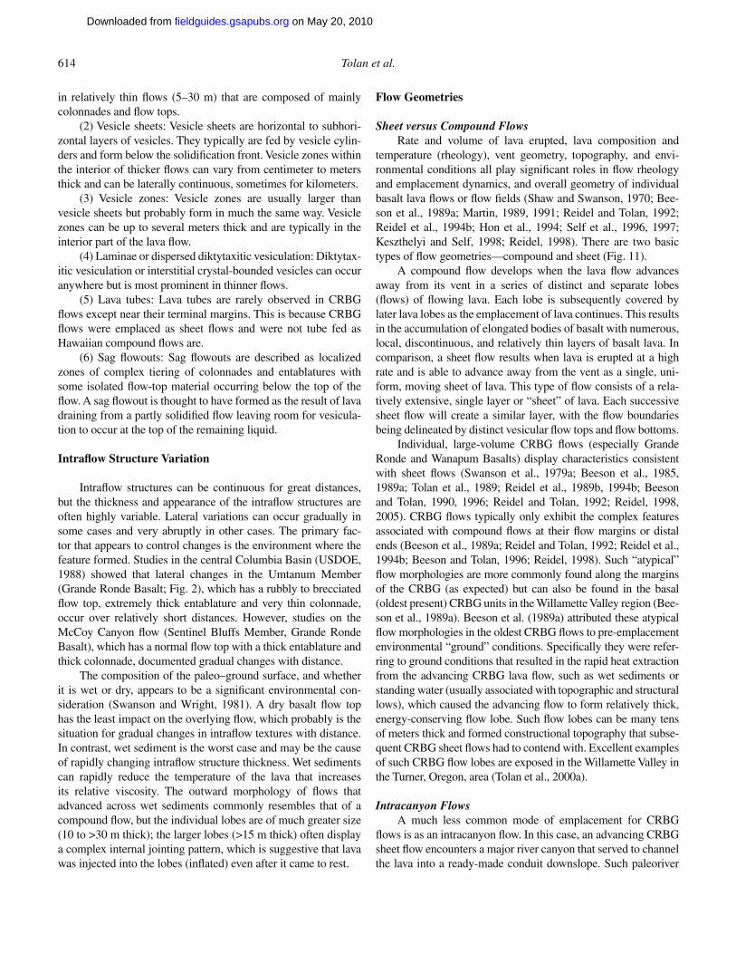
A compound fl ow develops when the lava fl ow advances away from its vent in a series of distinct and separate lobes (fl ows) of fl owing lava. Each lobe is subsequently covered by later lava lobes as the emplacement of lava continues. This results in the accumulation of elongated bodies of basalt with numerous, local, discontinuous, and relatively thin layers of basalt lava. In comparison, a sheet fl ow results when lava is erupted at a high rate and is able to advance away from the vent as a single, uni-form, moving sheet of lava. This type of fl ow consists of a rela-tively extensive, single layer or “sheet” of lava. Each successive sheet fl ow will create a similar layer, with the fl ow boundaries being delineated by distinct vesicular fl ow tops and fl ow bottoms.
Individual, large-volume CRBG fl ows (especially Grande Ronde and Wanapum Basalts) display characteristics consistent with sheet fl ows (Swanson et al., 1979a; Beeson et al., 1985, 1989a; Tolan et al., 1989; Reidel et al., 1989b, 1994b; Beeson and Tolan, 1990, 1996; Reidel and Tolan, 1992; Reidel, 1998, 2005). CRBG fl ows typically only exhibit the complex features associated with compound fl ows at their fl ow margins or distal ends (Beeson et al., 1989a; Reidel and Tolan, 1992; Reidel et al., 1994b; Beeson and Tolan, 1996; Reidel, 1998). Such “atypical” fl ow morphologies are more commonly found along the margins of the CRBG (as expected) but can also be found in the basal (oldest present) CRBG units in the Willamette Valley region (Bee-son et al., 1989a). Beeson et al. (1989a) attributed these atypical fl ow morphologies in the oldest CRBG fl ows to pre-emplacement environmental “ground” conditions. Specifi cally they were refer-ring to ground conditions that resulted in the rapid heat extraction from the advancing CRBG lava fl ow, such as wet sediments or standing water (usually associated with topographic and structural lows), which caused the advancing fl ow to form relatively thick, energy-conserving fl ow lobe. Such fl ow lobes can be many tens of meters thick and formed constructional topography that subse-quent CRBG sheet fl ows had to contend with. Excellent examples of such CRBG fl ow lobes are exposed in the Willamette Valley in the Turner, Oregon, area (Tolan et al., 2000a).
Intracanyon FlowsA much less common mode of emplacement for CRBG
fl ows is as an intracanyon fl ow. In this case, an advancing CRBG sheet fl ow encounters a major river canyon that served to channel the lava into a ready-made conduit downslope. Such paleoriver
on May 20, 2010fieldguides.gsapubs.orgDownloaded from
Introduction to the CRBG 615
canyons undoubtedly allowed some CRBG fl ows to travel sig-nifi cantly greater distances than they might have as sheet fl ows.
The development of major canyons by rivers within the ancestral Columbia River system during CRBG time was in large part governed by the length of time between large-volume CRBG fl ows. The emplacement of large-volume CRBG fl ows typically inundated existing low-lying areas which also resulted in the obliteration of the medial to distal reaches of the ances-tral Columbia River system. While this portion of the drainage system was essentially destroyed, the upper reaches outside the fl ood-basalt province remained intact. This disarrangement of the drainage system often resulted in the formation of lakes along the margin of the newly emplaced fl ow, but inevitably (months to centuries later) the streams and rivers established new courses proximal to the margin of the CRBG fl ow.
Like CRBG fl ows, the ancestral Columbia River system was also directed by major tectonic features (i.e., Palouse Slope, Columbia Basin, Yakima Fold Belt, Columbia Trans-Arc Low-land) and continued regional subsidence to produce a westward, regional down-gradient fl ow. In the western Columbia Plateau and Columbia Trans-Arc Lowland, continuing subsidence of Yakima Fold Belt synclines during CRBG time was very impor-tant in that these synclines provided regional-scale pathways for the ancestral Columbia River.
During the peak period of CRBG eruptive activity (17–15.6 Ma), the duration of quiescent periods between emplace-ment of large-volume fl ows averaged ~13,000 yr (Reidel et al.,
1989a, 1989b) and did not provide the time needed for the inci-sion of major canyons. This changed during the waning phase of CRBG eruptive activity (15.6–6 Ma) when the length of qui-escent periods between CRBG eruptions dramatically increased (commonly lasting 200,000 to >1,000,000 yr), and was accompa-nied by a general reduction in the size (volume) of CRBG fl ows (Tolan et al., 1989). These factors created opportunities for the ancestral Columbia River system to incise major canyons.
CRBG Dikes and the Chief Joseph Dike Swarm
Based on previous work as well as his own reconnaissance mapping, Waters (1961) identifi ed three dike swarms as feed-ers to the CRBG—the Monument, Grande Ronde, and Cornu-copia. Additional mapping by Taubeneck (1970) found no gap between the northerly Grande Ronde and southerly Cornu-copia swarms and merged them into a single giant swarm that he named the Chief Joseph (Fig. 1). Beeson et al. (1985) and Reidel et al. (1989b) have extended the dike swam to the north-central and northeastern margin of the basalts based on a detailed study of units within the Wanapum and Grande Ronde Basalts. Chief Joseph dikes fed the main phase of CRBG volcanism that dominates the Columbia River Flood-Basalt Province, including huge-volume (>2500 km3) fl ows of the Imnaha, Grande Ronde, and Wanapum Basalts. Dikes in the Monument swarm fed many of the Picture Gorge fl ows (Brown and Thayer, 1966; Wilcox and Fisher, 1966; Fruchter and Baldwin, 1975; Bailey, 1989).
Small compound flows
Figure 11. Comparison of compound versus sheet lava fl ow morphologies.
on May 20, 2010fieldguides.gsapubs.orgDownloaded from
616 Tolan et al.
Taubeneck (1970) estimates that at least 21,000 dikes occur in the Chief Joseph swarm at the level of the regional uncon-formity below the CRBG. Overall, dikes are exposed at deeper stratigraphic levels southward through the swarm, due to uplift and erosion of the Wallowa and Blue Mountains. In the Colum-bia River Flood-Basalt Province, dikes are dominantly hosted by older CRBG units. In the Wallowa Mountains (Fig. 1) and southward, dikes are hosted in pre-Tertiary rocks, dominantly in granitoids with fewer in metasediments. Concentrations of dikes diminish rapidly at or within several kilometers of granitoid pluton margins, suggesting that dikes are preferentially hosted in these plutons, where local jointing controls their orientation (Taubeneck and Duncan, 1997; Taubeneck, 1998).
Dike Distribution and Geometry
In the past, it was assumed that dike density increased from north to south across the Chief Joseph dike swarm and hence cor-related with increasing depth of erosion. In the Columbia River Flood-Basalt Province, dike concentration has been proposed to be less than three dikes per km2 (Taubeneck, 1970). This concen-tration increases to around eight dikes per km2 in the Wallowa Mountains (Taubeneck, 1970), and is as great as 10–12 dikes per km2 south of the Wallowas (Taubeneck, 1989, 1990), probably due to exposure rather than actual dike density. The greatest num-ber of fl ows, and hence dikes, occurs north of the Washington-Oregon border suggesting that more dikes occur in the northern part of the province. Dikes are rarely isolated but instead occur in closely spaced clusters of 7–12 dikes per km2; presumably, each cluster or subswarm represents an eruptive axis for CRBG volcanism (Taubeneck and Duncan, 1997).
The overall trend of the Chief Joseph swarm is N10°W ± 10°, yet each subswarm has its own distinct orientation. The majority of dikes dip within 30° of vertical. Dikes hosted in pre-Tertiary rock in general are thicker than those hosted in CRBG fl ows, averaging 7.3 m and 5.8 m thick, respectively, but rarely exceeding 25 m thick (Taubeneck, 1970). Dike length ranges from a few hundred meters to 60 km, although many dikes occur in en echelon segments.
Dike-Wallrock Relationships
Dikes hosted in CRBG fl ows are chilled against their wall-rock, commonly with centimeter-thick glassy margins. Dikes hosted in granitoids of the Wallowa and Blue Mountains, how-ever, display more complex interactions with their wallrock (Taubeneck, 1970). These dikes have one or more of the fol-lowing morphologies: dikes with chilled margins, dikes with quenched partially melted wallrock at their margins, dikes that have eroded their margins, and dikes containing whole to disag-gregated crustal xenoliths that constitute locally as much as 30% of the dike (Grunder and Taubeneck, 1997). The majority of dikes hosted in granitoids have an aphyric chilled margin of basalt (a few cm thick) at the dike-wallrock contact. Rare dikes have
caused partial melting in their wallrock; these partial melt zones (preserved as silicic glass plus mineral phases) are up to one-half the thickness of the dike and contain up to 50% quenched silicic melt. Dikes may also locally erode the chilled basalt at their margins, producing localized (cm-scale) zones of wallrock breakdown and a few percent melting. Only a handful of dikes contain granitoid or metasedimentary xenoliths that range from a few centimeters to 6 m in diameter (Taubeneck, 1970; Gorham and Martin, 2004). The majority of these xenoliths appear to be locally derived from stoping of wallrock.
Correlation of Dikes with Flows
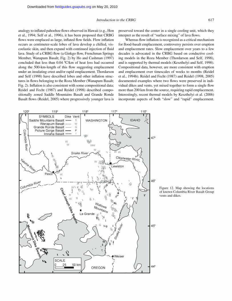
Most Chief Joseph dikes have been identifi ed to formation level, and some have been correlated with individual CRBG fl ows (Fig. 12). In general, dikes of Grande Ronde and Wanapum Basalts are located throughout the swarm, although exposures of Wanapum dikes and Grande Ronde fl ows indicate that they extend to the northern border of the province (Reidel et al., 1989b; Reidel, 2005). Saddle Mountains Basalt dikes occur in the north-ern half of the Chief Joseph swarm and are localized near the center of the Columbia Plateau (Fig. 1). Imnaha dikes are only exposed near the Oregon-Washington border and southward, but northern Imnaha dikes may be buried by younger fl ows. Within the northern half of the Chief Joseph swarm, the dikes and vents for Frenchman Springs Member tend to be nearer to the center of the Columbia Plateau; Priest Rapids dikes are nearer to the eastern margin of the Columbia Plateau along and east of the Washington-Idaho border; and the vents and dikes for the Roza Member form a 175-km-long system between the Frenchman Springs and Priest Rapids systems.
Many Wanapum and Saddle Mountains dikes have been cor-related with individual fl ows based on direct observation of dike-fl ow connections. For example, the vent-fi ssure system for the Frenchman Springs fl ows, Ice Harbor fl ows, and the Roza fl ows are well known (Swanson et al., 1975; Martin, 1989, 1991). Direct connections between vents and fl ows have been observed for the Teepee Butte Member of the Grande Ronde Basalt (Reidel and Tolan, 1992) and the Umatilla Member of the Saddle Mountains Basalt (Reidel, 1998). In the absence of direct dike-fl ow connec-tions, dikes have been successfully correlated with CRBG fl ows on the basis of compositional, petrographic, and paleomagnetic data (e.g., Price, 1977; Ross, 1983; Mangan et al., 1986; Reidel, 1998). The major and trace element composition of CRBG units is well established (e.g., Hooper, 2000) and provides a basis for compositional identifi cation of dikes and dike-fl ow correlations.
Estimating CRBG Emplacement Rates from Dike-Wallrock Relationships
Emplacement rates and mechanisms of large-volume fl ood basalts have been a matter of some controversy. Early workers (Shaw and Swanson, 1970) suggested emplacement as turbulent fl ows racing across the landscape in weeks to months. However, in
on May 20, 2010fieldguides.gsapubs.orgDownloaded from
Introduction to the CRBG 617
analogy to infl ated pahoehoe fl ows observed in Hawaii (e.g., Hon et al., 1994; Self et al., 1996), it has been proposed that CRBG fl ows were emplaced as large, infl ated fl ow fi elds. Flow infl ation occurs as centimeter-scale lobes of lava develop a chilled, vis-coelastic skin, and then expand with continued injection of fl uid lava. Study of a CRBG fl ow (a Ginkgo fl ow, Frenchman Springs Member, Wanapum Basalt; Fig. 2) by Ho and Cashman (1997) concluded that less than 0.04 ºC/km of heat loss had occurred along the 500-km-length of this fl ow suggesting emplacement under an insulating crust and/or rapid emplacement. Thordarson and Self (1998) have described lobes and other infl ation struc-tures in fl ows belonging to the Roza Member (Wanapum Basalt; Fig. 2). Infl ation is also consistent with some compositional data; Reidel and Fecht (1987) and Reidel (1998) described compo-sitionally zoned Saddle Mountains Basalt and Grande Ronde Basalt fl ows (Reidel, 2005) where progressively younger lava is
preserved toward the center in a single cooling unit, which they interpret as the result of “surface mixing” of lava fl ows.
Whereas fl ow infl ation is recognized as a critical mechanism for fl ood-basalt emplacement, controversy persists over eruption and emplacement rates. Slow emplacement over years to a few decades is advocated in the CRBG based on conductive cool-ing models in the Roza Member (Thordarson and Self, 1998), and is supported by thermal models (Keszthelyi and Self, 1998). Compositional data, however, are more consistent with eruption and emplacement over timescales of weeks to months (Reidel et al., 1994b). Reidel and Fecht (1987) and Reidel (1998, 2005) documented examples where two fl ows were preserved in indi-vidual dikes and vents, yet mixed together to form a single fl ow more than 200 km from the source, requiring rapid emplacement. Interestingly, recent thermal models by Keszthelyi et al. (2006) incorporate aspects of both “slow” and “rapid” emplacement.
Figure 12. Map showing the locations of known Columbia River Basalt Group vents and dikes.
on May 20, 2010fieldguides.gsapubs.orgDownloaded from
618 Tolan et al.
They envision a “typical” 1000 km3 fl ood-basalt lava fl ow being emplaced as infl ated sheet fl ows in under six years; however, they also propose that individual batches of lava traveling some 100–300 km beneath an insulating crust from the vent to the fl ow front in no more than ten days.
Petcovic and Grunder (2003) analyzed wallrock melting reactions in tonalite adjacent to the Maxwell Lake dike, a likely feeder to Wapshilla Ridge fl ows, the largest of all Grande Ronde Basalt members (Fig. 2), having an emplaced volume estimated at ~50,000 km3 (Reidel et al., 1989b). Field work by the authors has shown that only one main dike is known for the Wapshilla Ridge Member.
Petcovic and Dufek (2005) used two types of models constrained by the fi eld example of the Maxwell Lake dike in order to assess the rate of basalt eruption from development of wallrock melting due to basalt intrusion. Static conduction results suggested that sustained basalt fl ow for three to four years caused development of the melt zones observed in the dike. Advective transport simulations suggested that the initial basalt velocity in the dike center was ~10 m/s, but that basalt at the dike margin solidifi ed, causing constriction and slowing of fl ow. After ~60 days, magma in the dike reached a sustained velocity of ~2 m/s for the duration of fl ow. Wallrock melting was initiated after approximately one year of fl ow, and the wall-rock had dropped below its solidus temperature within approxi-mately two years after fl ow ceased. The thickness, distribution, and fractions of wallrock melt zones produced by advective transport modeling closely approximate fi eld observations of the Maxwell Lake dike (Petcovic and Dufek, 2005). Model results suggest that the dike was active for three to four years and likely represents a long-lived point source in fl ood-basalt eruptions. Furthermore, this suggests that >1000 km3 of lava were erupted per month, consistent with estimates of eruptions rates made by Reidel et al. (1994a), Reidel and Tolan (1992), and Reidel (1998, 2005).
Implications for CRBG Flow Emplacement
Results of the simulations allow limits to be estimated for eruption rates of the Wapshilla Ridge fl ow. Assuming that the Maxwell Lake dike fed the entire Wapshilla Ridge Member of 50,000 km3 over a period of three to four years yields an aver-age eruption rate of 30–50 km3/day. The eruption rate would have been lower, if fl ow in the dike were intermittent rather than continuous. Intermittent fl ow has been documented in historical basalt eruptions and during eruption of the Teepee Butte Mem-ber of the Grande Ronde Basalt (Reidel and Tolan, 1992). Some pauses during eruption cannot be ruled out, yet the lack of inter-nal contacts as well as the regular textural progression across the dike and wallrock melt zones is more consistent with nearly con-tinuous fl ow and a single cooling history.
The advective transport simulation provides a minimum esti-mate of basalt fl ux in the dike. Flow was assumed to be localized along the portions of the Maxwell Lake dike with partially melted
wallrock margins, which yields an initial basalt fl ux of ~0.8 km3/day waning rapidly to a sustained fl ux of ~0.1 km3/day (Table 3). Waning discharge is commonly documented in basaltic eruptions (e.g., Wadge, 1981). However, cumulative magma discharge under this scenario produced a total fl ow volume of only 150 km3 over four years. Clearly other fi ssure segments must have fed the same fl ow in order to produce a 2500–5000 km3 cumulative vol-ume typical of Grande Ronde fl ows. Based on the distribution of the Wapshilla Ridge unit, we estimate that the dike-fi ssure sys-tem was at least 100 km long. In historical basalt eruptions (e.g., Laki 1783 and Mauna Loa 1984), as well as has been proposed for the Roza Member fi ssure system (Martin, 1989, 1991; Self et al., 1997), eruptive activity migrated along the length of the dike-fi ssure system, with each fi ssure segment active for short periods (Table 3). The existence of additional dike segments feeding the Wapshilla Ridge unit has not been determined.
Volumetric eruption rates calculated on the basis of the thermal models for a typical Wapshilla Ridge fl ow are within the range reported for other CRBG eruptions (Table 1; see footnote 1). Minimum eruption rates are comparable to rates estimated from slow emplacement models for the Roza fl ow (Self et al., 1997; Thordarson and Self, 1998). Maximum eruption rates are an order of magnitude lower than rates calculated using rapid emplacement models (Swanson et al., 1975; Reidel and Tolan, 1992), yet they are an order of magnitude higher than slow emplacement estimates. Wapshilla Ridge eruption rates are similar to the maximum eruption rate of 0.2 km3/day reported for the 1783 Laki (Skaftár Fires) eruption, the largest histori-cal fi ssure eruption (Thordarson and Self, 1993). Although the maximum calculated volumetric eruption rate is consistent with models of rapid fl ow emplacement, the calculated minimum eruption rates and longevity of the Maxwell Lake dike (three to four years) support slower emplacement models (Petcovic and Dufek, 2005).
Model results suggest that the Maxwell Lake dike sustained high magma fl ux for at least several years. The transition from fi ssure eruption to localized vents during basaltic volcanism is often explained as a function of cooling in narrow portions of dikes coupled with enhanced fl ow in thicker portions, resulting in isolated, long-lived vents (e.g., Delaney and Pollard, 1982; Bruce and Huppert, 1990). This process may also explain the presence of wallrock melt zones only along two portions of the Maxwell Lake dike, which experienced higher mass and heat fl ux as surrounding portions of the dike solidifi ed. Wallrock melt zones adjacent to the Maxwell Lake dike provide evidence for the existence of long-lived point sources playing an important role in fl ood-basalt eruptions.
General Conclusions for Emplacement of CRBG Flows
Data from studies of fl ows and dikes indicate a wide range of emplacement rates. The estimates range from rates as low as one to two months for emplacement of larger volume fl ows to as high as three to four years. This should not be surprising, and attempts
on May 20, 2010fieldguides.gsapubs.orgDownloaded from

Introduction to the CRBG 619
TA
BLE
3. E
ST
IMA
TE
S O
F E
RU
PT
ION
RA
TE
S F
OR
SE
LEC
TE
D C
RB
G F
LOW
UN
ITS
Flo
w fi
eld
Gen
eric
CR
BG
di
ke
Roz
a M
embe
r Ic
e H
arbo
r M
embe
r T
eepe
e B
utte
S
entin
el B
luffs
M
embe
r U
mat
illa
Mem
ber
Roz
a M
embe
r W
apsh
illa
Rid
ge
Mem
ber
Flo
w fi
eld
volu
me
(km
3 ) N
ot g
iven
15
00
~7–
8 50
00
10,0
00
720
1300
~
50,0
00
Flo
w fi
eld
area
l ex
tent
(km
2 ) N
ot g
iven
40
,000
~70
052
,000
82, 4
61
15,1
1040
,300
~10
0,00
0
Indi
vidu
al fl
ow
volu
me
(km
3 ) “T
ypic
al”
= 1
00
“Lar
ge”
= 1
000
700
per
cool
ing
unit
0.1
per
cool
ing
unit
Lim
ekiln
Rap
ids
= 84
0 Jo
seph
Cre
ek =
18
50
Pru
itt D
raw
= 2
350
Mus
eum
= 2
349
Spo
kane
Fal
ls =
777
S
tem
ber
Cre
ek =
119
2 C
alifo
rnia
Cre
ek–
Airw
ay H
eigh
ts =
15
43
McC
oy C
anyo
n =
42
78
~31
0S
ingl
e er
uptio
n~
5000
–10,
000
Em
plac
emen
t tim
e D
ays
to w
eeks
7
days
10 d
ays
Day
s-w
eeks
, may
be
mon
ths
Mon
ths
Mon
ths
0.4 –
4.2
year
s fo
r in
divi
dual
flow
s.
6–14
yea
rs fo
r flo
w
field
3 –4
year
s al
l flo
ws
Vol
umet
ric
erup
tion
rate
(k
m3 /d
ay)
Typ
ical
= 1
4 –50
La
rge
= 14
0–50
0 31.0
s001 ot s01s001 ot s01
s001 ot s0110.0
1–0
.34
30–5
0P
etco
vic
and
Duf
ek
(200
5) a
ssum
ed th
e m
embe
r w
as o
nly
5000
km
3
F
issu
re s
yste
m
leng
th (
km)
Not
giv
en
~15
wid
e by
~12
0 lo
ng~
15 w
ide
by ~
90 lo
ng70
100
>50
~5
wid
e by
~15
0 lo
ng
At l
east
100
long
Eru
ptio
n ra
te
(km
3 /day
/km
of
fissu
re)
14 (
for
fissu
res
>3
m w
ide)
1
0.00
02>
1>
1 >
10.
08 (
assu
min
g 4
km a
ctiv
e at
on
ce)
Unk
now
n
Met
hod
of
erup
tion
rate
es
timat
e
Num
eric
al m
odel
ba
sed
on
rheo
logy
ar
gum
ents
. R
equi
res
turb
ulen
t flo
w.
Bas
ed o
n fie
ld
obse
rvat
ions
su
gges
ting
rapi
d em
plac
emen
t and
S
haw
and
Sw
anso
n’s
(197
0) m
odel
.
Bas
ed o
n fie
ld
obse
rvat
ions
su
gges
ting
rapi
d em
plac
emen
t and
S
haw
and
Sw
anso
n’s
(197
0) m
odel
.
Bas
ed o
n as
sum
ptio
n of
rap
id
empl
acem
ent
cons
iste
nt w
ith fi
eld
data
.
Eva
luat
ion
of fi
eld
data
, che
mic
al
com
posi
tion
impl
icat
ions
with
re
spec
t to
cool
ing
calc
ulat
ions
.
Eva
luat
ion
of fi
eld
data
, che
mic
al
com
posi
tion
impl
icat
ions
with
re
spec
t to
cool
ing
calc
ulat
ions
.
Bas
ed o
n m
odel
ca
lcul
atin
g co
olin
g tim
es to
fo
rm u
pper
cru
st
on fl
ows.
Min
imum
flux
(a
dvec
tive
tran
spor
t m
odel
). A
ssum
es
Max
wel
l Lak
e di
ke
fed
mem
ber
for
3–4
year
s.
Ref
eren
ce(s
) S
haw
and
S
wan
son
(197
0)
Sw
anso
n et
al.
(197
5)S
wan
son
et a
l. (1
975)
Rei
del a
nd T
olan
(1
992)
R
eide
l (20
05)
Rei
del (
1998
)S
elf e
t al.
(199
7);
Tho
rdar
son
and
Sel
f (19
98)
Pet
covi
c an
d D
ufek
(2
005)
; Pet
covi
c an
d G
rund
er (
2003
)
Not
e : C
RB
G—
Col
umbi
a R
iver
Bas
alt G
roup
.
on May 20, 2010fieldguides.gsapubs.orgDownloaded from
620 Tolan et al.
to fi t all fl ows into one model are probably unrealistic. We sug-gest that the interpretations are correct and that some fl ows are emplaced over long periods of time, such as the Maxwell Lake dike, while others are emplaced during very short intervals, such as that estimated for the Sentinel Bluffs Member of the Grande Ronde Basalt. In fact, it is probably more realistic to think in terms of a continuous spectrum of emplacement times rather than just the two extremes. The most important question that still remains unanswered is: what mechanism drives the rate at which these fl ood-basalt fl ows are erupted?
MIDDLE MIOCENE–PLIOCENE (LATE NEOGENE) AND QUATERNARY SEDIMENT GEOLOGY
No discussion of CRBG geology and stratigraphy is com-plete without at least a brief introduction to the late Neogene sedimentary units found interbedded with, and overlying, the CRBG and major Quaternary sedimentary units. While not the primary focus of any of the fi eld trips, these sediments have provided important insights to the geologic evolution of this fl ood-basalt province, and they do play a role in the hydroge-ology of the CRBG. A brief summary of these units is pre-sented here.
Late Neogene sediments in the Columbia River Flood-Basalt Province have been studied and mapped for almost a century (e.g., Bretz, 1917; Buwalda and Moore, 1927; Piper, 1932; Hodge, 1938, 1942; Thayer, 1939; Warren, 1941; Lowry and Baldwin, 1952; Waters, 1955; Laval, 1956; Mackin, 1961; Trimble, 1963; Hogenson, 1964; Schmincke, 1964, 1967b; New-comb, 1965, 1966, 1971; Hampton, 1972; Bentley, 1977; Kent, 1978; Rigby et al., 1979; Swanson et al., 1979a, 1979b, 1981; Bentley et al., 1980; Farooqui et al., 1981a, 1981b; Tolan and Beeson, 1984; Hagood, 1986; Dames and Moore, Inc., 1987; Fecht et al., 1987; Smith, 1988; Smith et al., 1989; Walker and MacLeod, 1991; Yeats et al., 1991; Swanson et al., 1993; Lind-sey, 1996; Gannett and Caldwell, 1998). These studies found that these sediments are interfi ngered with, and overlie the CRBG. This stratigraphic relationship with the CRBG provided a natu-ral, mappable subdivision between those sediments intercalated with the CRBG (interbeds) and those that overlie the CRBG (suprabasalt sediments). The composition and mode of deposi-tion of these sediments allowed them to be further separated and locally differentiated (e.g., Buwalda and Moore, 1927; Piper, 1932; Hodge, 1938, 1942; Waters, 1955; Schmincke, 1964; Tolan and Beeson, 1984).
The major late Neogene sedimentary units associated with the CRBG include:
(1) Ellensburg Formation: interbeds within the CRBG throughout much of the Columbia Plateau, Cascade Range, and Willamette Valley regions and suprabasalt sediments in the west-ern Columbia Plateau in Washington;
(2) Latah Formation: interbeds within the CRBG and local suprabasalt sediments along the northeastern and eastern fringe of the Columbia Plateau;
(3) Ringold Formation and Snipes Mountain Conglomerate: suprabasalt sediments in the Pasco Basin and lower Yakima Val-ley, respectively, of south-central Washington;
(4) Dalles Group (Chenoweth, McKay Creek, and Alkali Canyon Formations): suprabasalt sediments in the Umatilla-Dalles-Mosier basins of northern Oregon;
(5) Rhododendron Formation: volcaniclastic suprabasalt sediments (and related lava fl ows) within the Cascade arc;
(6) Troutdale Formation: suprabasalt sediments in the west-ern Cascade Range, northern Willamette Valley, and southwest-ern Washington; and
(7) Scappoose Formation: fl uvial and marine sediments interbedded with the CRBG in the Coast Range (Van Atta and Kelty (1982).
Subsidence within the Columbia Plateau (Columbia Basin) and Columbia Trans-Arc Lowland and local structural basins (e.g., Portland Basin, Walla Walla Basin, La Grande Basin, etc.) allowed for the accumulation of both CRBG fl ows and epiclas-tic and volcaniclastic sediments. The thickest accumulations of these Neogene sediments (100 to >300 m thick) usually occur within these structural basins and lowlands developed within the fl ood-basalt province.
Smith et al. (1989) provides a good comprehensive review of the Neogene suprabasalt sediments. Based on that report, and several other regional studies, including Piper (1932), Hodge (1938), Trimble (1963), Newcomb (1965, 1966, 1971), Farooqui et al. (1981a, 1981b), Tolan and Beeson (1984), Fecht et al. (1987), Lindsey et al. (1993), Lindsey (1996), and Lindsey and Tolan (1996), the types of facies comprising the epiclastic sedi-ments overlying the CRBG include:
(a) mixed lithology conglomerate and felsic sand deposited within the ancestral Columbia River and major tributaries (e.g., ancestral Salmon-Clearwater, Snake, and/or Willamette Rivers);
(b) mixed lithology conglomerate with a basaltic sand matrix;(c) muddy, basaltic conglomerate;(d) weakly indurated, massively bedded, siltstone and clay-
stone displaying characteristics indicative of paleosols;(e) well-stratifi ed, weakly indurated, siltstone and diatomite
deposited in lake environments; and(f) volcaniclastic sediments derived from Cascade Arc vol-
canism (mainly western Columbia Plateau, Cascade Range, and Willamette Valley regions).
The CRBG unit upon which these Miocene–Pliocene sedi-ments were deposited is not always the same CRBG unit. Thus the age of the base of the suprabasalt sediments can vary from 6.5 Ma, where it overlies the youngest Saddle Mountain Basalt unit, to 15.6 Ma, where it overlies the Sentinel Bluffs Member of the Grande Ronde Basalt (Fig. 13).
The major Quaternary sediment units consist primarily of Pleistocene to Holocene loess of the Palouse Formation and Pleistocene cataclysmic fl ood (Missoula fl oods) deposits that consist of gravels and sands along the fl ood tracts and slackwater sediments where the fl ood waters ponded. The cataclysmic fl oods were also responsible for eroding deep channels and valleys
on May 20, 2010fieldguides.gsapubs.orgDownloaded from
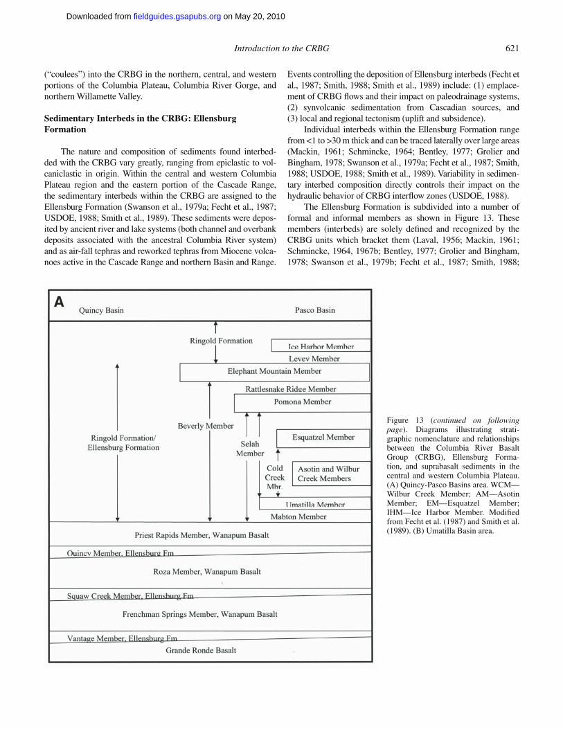
Introduction to the CRBG 621
(“coulees”) into the CRBG in the northern, central, and western portions of the Columbia Plateau, Columbia River Gorge, and northern Willamette Valley.
Sedimentary Interbeds in the CRBG: Ellensburg Formation
The nature and composition of sediments found interbed-ded with the CRBG vary greatly, ranging from epiclastic to vol-caniclastic in origin. Within the central and western Columbia Plateau region and the eastern portion of the Cascade Range, the sedimentary interbeds within the CRBG are assigned to the Ellensburg Formation (Swanson et al., 1979a; Fecht et al., 1987; USDOE, 1988; Smith et al., 1989). These sediments were depos-ited by ancient river and lake systems (both channel and overbank deposits associated with the ancestral Columbia River system) and as air-fall tephras and reworked tephras from Miocene volca-noes active in the Cascade Range and northern Basin and Range.
Events controlling the deposition of Ellensburg interbeds (Fecht et al., 1987; Smith, 1988; Smith et al., 1989) include: (1) emplace-ment of CRBG fl ows and their impact on paleodrainage systems, (2) synvolcanic sedimentation from Cascadian sources, and (3) local and regional tectonism (uplift and subsidence).
Individual interbeds within the Ellensburg Formation range from <1 to >30 m thick and can be traced laterally over large areas (Mackin, 1961; Schmincke, 1964; Bentley, 1977; Grolier and Bingham, 1978; Swanson et al., 1979a; Fecht et al., 1987; Smith, 1988; USDOE, 1988; Smith et al., 1989). Variability in sedimen-tary interbed composition directly controls their impact on the hydraulic behavior of CRBG interfl ow zones (USDOE, 1988).
The Ellensburg Formation is subdivided into a number of formal and informal members as shown in Figure 13. These members (interbeds) are solely defi ned and recognized by the CRBG units which bracket them (Laval, 1956; Mackin, 1961; Schmincke, 1964, 1967b; Bentley, 1977; Grolier and Bingham, 1978; Swanson et al., 1979b; Fecht et al., 1987; Smith, 1988;
A
Figure 13 (continued on following page). Diagrams illustrating strati-graphic nomenclature and relationships between the Columbia River Basalt Group (CRBG), Ellensburg Forma-tion, and suprabasalt sediments in the central and western Columbia Plateau. (A) Quincy-Pasco Basins area. WCM—Wilbur Creek Member; AM—Asotin Member; EM—Esquatzel Member; IHM—Ice Harbor Member. Modifi ed from Fecht et al. (1987) and Smith et al. (1989). (B) Umatilla Basin area.
on May 20, 2010fieldguides.gsapubs.orgDownloaded from
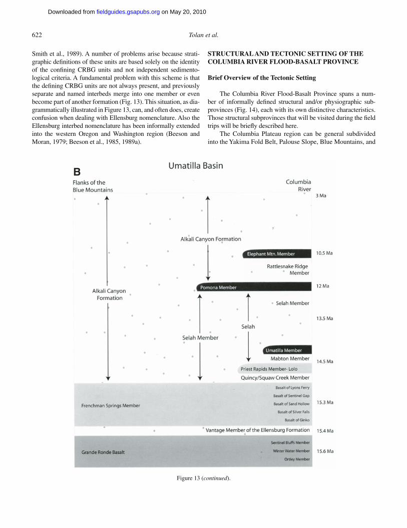
622 Tolan et al.
Smith et al., 1989). A number of problems arise because strati-graphic defi nitions of these units are based solely on the identity of the confi ning CRBG units and not independent sedimento-logical criteria. A fundamental problem with this scheme is that the defi ning CRBG units are not always present, and previously separate and named interbeds merge into one member or even become part of another formation (Fig. 13). This situation, as dia-grammatically illustrated in Figure 13, can, and often does, create confusion when dealing with Ellensburg nomenclature. Also the Ellensburg interbed nomenclature has been informally extended into the western Oregon and Washington region (Beeson and Moran, 1979; Beeson et al., 1985, 1989a).
STRUCTURAL AND TECTONIC SETTING OF THE COLUMBIA RIVER FLOOD-BASALT PROVINCE
Brief Overview of the Tectonic Setting
The Columbia River Flood-Basalt Province spans a num-ber of informally defi ned structural and/or physiographic sub-provinces (Fig. 14), each with its own distinctive characteristics. Those structural subprovinces that will be visited during the fi eld trips will be briefl y described here.
The Columbia Plateau region can be general subdivided into the Yakima Fold Belt, Palouse Slope, Blue Mountains, and
B
Figure 13 (continued).
on May 20, 2010fieldguides.gsapubs.orgDownloaded from
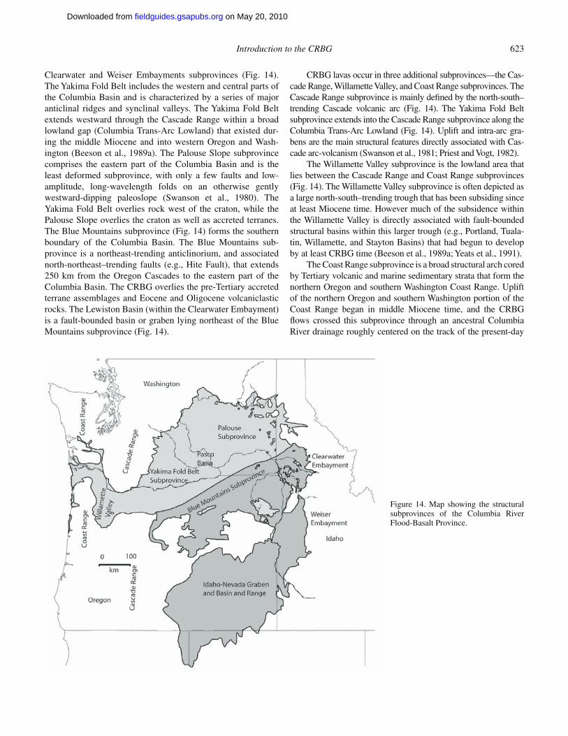
Introduction to the CRBG 623
Clearwater and Weiser Embayments subprovinces (Fig. 14). The Yakima Fold Belt includes the western and central parts of the Columbia Basin and is characterized by a series of major anticlinal ridges and synclinal valleys. The Yakima Fold Belt extends westward through the Cascade Range within a broad lowland gap (Columbia Trans-Arc Lowland) that existed dur-ing the middle Miocene and into western Oregon and Wash-ington (Beeson et al., 1989a). The Palouse Slope subprovince comprises the eastern part of the Columbia Basin and is the least deformed subprovince, with only a few faults and low- amplitude, long-wavelength folds on an otherwise gently westward-dipping paleoslope (Swanson et al., 1980). The Yakima Fold Belt overlies rock west of the craton, while the Palouse Slope overlies the craton as well as accreted terranes. The Blue Mountains subprovince (Fig. 14) forms the southern boundary of the Columbia Basin. The Blue Mountains sub-province is a northeast-trending anticlinorium, and associated north-northeast–trending faults (e.g., Hite Fault), that extends 250 km from the Oregon Cascades to the eastern part of the Columbia Basin. The CRBG overlies the pre-Tertiary accreted terrane assemblages and Eocene and Oligocene volcaniclastic rocks. The Lewiston Basin (within the Clearwater Embayment) is a fault-bounded basin or graben lying northeast of the Blue Mountains subprovince (Fig. 14).
CRBG lavas occur in three additional subprovinces—the Cas-cade Range, Willamette Valley, and Coast Range subprovinces. The Cascade Range subprovince is mainly defi ned by the north-south–trending Cascade volcanic arc (Fig. 14). The Yakima Fold Belt subprovince extends into the Cascade Range subprovince along the Columbia Trans-Arc Lowland (Fig. 14). Uplift and intra-arc gra-bens are the main structural features directly associated with Cas-cade arc-volcanism (Swanson et al., 1981; Priest and Vogt, 1982).
The Willamette Valley subprovince is the lowland area that lies between the Cascade Range and Coast Range subprovinces (Fig. 14). The Willamette Valley subprovince is often depicted as a large north-south–trending trough that has been subsiding since at least Miocene time. However much of the subsidence within the Willamette Valley is directly associated with fault-bounded structural basins within this larger trough (e.g., Portland, Tuala-tin, Willamette, and Stayton Basins) that had begun to develop by at least CRBG time (Beeson et al., 1989a; Yeats et al., 1991).
The Coast Range subprovince is a broad structural arch cored by Tertiary volcanic and marine sedimentary strata that form the northern Oregon and southern Washington Coast Range. Uplift of the northern Oregon and southern Washington portion of the Coast Range began in middle Miocene time, and the CRBG fl ows crossed this subprovince through an ancestral Columbia River drainage roughly centered on the track of the present-day
Figure 14. Map showing the structural subprovinces of the Columbia River Flood-Basalt Province.
on May 20, 2010fieldguides.gsapubs.orgDownloaded from
624 Tolan et al.
Columbia River (Snavely et al., 1973; Choiniere and Swanson, 1979; Niem and Niem, 1985; Beeson et al., 1985; Wells et al., 1989, 1995, this volume).
Important Structures and Structural Trends
Olympic-Wallowa LineamentThe Olympic-Wallowa lineament (OWL) is a major
northwest-trending topographic feature in Washington and Ore-gon (Fig. 14) that crosscuts the Columbia Basin (Raisz, 1945). This feature parallels pre-CRBG structural trends along the north-west margin of the Columbia Basin, but it has not been linked to any individual structure (Campbell, 1989; Reidel and Campbell, 1989). Within the Yakima Fold Belt, the OWL includes a zone of Miocene and post-Miocene deformation along Manastash Ridge and apparent bending of Umtanum Ridge, Yakima Ridge, Rattlesnake Ridge, and Horse Heaven Hills.
The portion of the OWL that crosses the central Washington is called the Cle Elum–Wallula deformed zone (CLEW; Kienle et al., 1977). It is a 10-km-wide, moderately diffuse zone of anticlines that have a N50°W orientation. As defi ned by Davis (1981), the CLEW consists of three structural parts: (1) a broad zone of defl ected or anomalous fold and fault trends extending south from Cle Elum to Rattlesnake Mountain; (2) a narrow belt of topographically aligned domes and doubly plunging anticlines extending from Rattlesnake Mountain to Wallula Gap (RAW); and (3) the Wallula fault zone (Horse Heaven Hills), extending from Wallula Gap into the Blue Mountains.
Northwest of the CRBG margin, numerous northwest- and north-trending faults and shear zones lie subparallel to the OWL (Tabor et al., 1984). The 17–19.7 Ma Snoqualmie batholith intrudes these faults but is not cut by them, indicating that any possible movement along the OWL at the western margin of the Columbia Basin must pre-date the batholith, 17–19.7 Ma (Friz-zell et al., 1984). The structural signifi cance of the OWL has been called into question by two recent geophysical studies. Neither a seismic profi ling survey by Jarchow (1991) nor a gravity survey by Saltus (1991) could fi nd any obvious geophysical signature for the OWL below the CRBG.
On the other hand, recent global positioning system (GPS) results suggest that the OWL (in its broadest sense) is the locus of active, north-south crustal shortening driven by the clockwise rotation of Oregon about a pole in the backarc (McCaffrey et al., 2007). New, high-resolution aeromagnetic surveys of the OWL in the Cascades may also suggest a structural link between active folding and faulting in Puget Sound and in the western Yakima Fold Belt (Blakely et al., 2009).
Hog Ranch–Naneum Ridge AnticlineThe Hog Ranch–Naneum Ridge (HR-NR) anticline is a
broad north-south–trending anticline in the CRBG that crosses the Yakima Fold Belt at a high angle (Fig. 14). This anticlinal feature begins at the northern margin of the CRBG on Naneum Ridge, southwest of Wenatchee, Washington, and trends south-
east for ~12 km, and then turns south toward Prosser, Washing-ton, where it separates the Toppenish Basin from the Pasco Basin. This south-plunging structure passes through fi ve Yakima Fold Belt anticlines and the OWL. A gravity gradient and a series of gravity highs delineate the HR-NR in the subsurface. The south-ern extension of the anticline appears to be a Bouguer gravity high near the Washington-Oregon border southeast of Prosser, Washington.
The HR-NR anticline was active in late to middle Miocene as demonstrated by thinning of CRBG fl ows across it (Reidel et al., 1989a), but the east-trending Yakima folds show no apparent off-set produced by the HR-NR cross-structures (Kienle et al., 1977; Tabor et al., 1982; Campbell, 1989; Reidel et al., 1989a) nor is the HR-NR anticline offset where the OWL-CLEW crosses it. Growth of the HR-NR anticline continued from the Miocene to Recent and is now marked by the highest structural points along the Yakima Fold Belt anticlinal ridges that cross it.
White River–Naches River Fault ZoneThe White River–Naches River Fault Zone (WR-NRFZ), a
major fault zone (Fig. 14) that extends 90 km from Naches to Enumclaw, Washington, separates two domains of dissimilar structure, stratigraphy, and topography (Campbell, 1988, 1989). To the northeast of the zone, structures strike N60°W; to the southwest, structures in pre-Tertiary rocks trend N5°E to N20°W. The WR-NRFZ probably extends under the basalt at least as far as Konnowac Pass and either parallels or crosscuts the HR-NR anticline. The WR-NRFZ is the major structure trending into the Columbia Basin that can be demonstrated to be a fundamental structural boundary in rock below the CRBG.
Yakima Fold BeltAs mentioned above, the Yakima Fold Belt subprovince
covers ~14,000 km2 of the western and west-central Columbia Plateau (Fig. 14) and formed as CRBG fl ows and intercalated sediments were folded and faulted under north-south–directed compression. Most of the present structural relief in the western and central Columbia Plateau has developed since ca. 10.5 Ma when the last massive outpouring of lava, the Elephant Moun-tain Member (Saddle Mountains Basalt; Fig. 2), buried much of this area. The main deformation is concentrated in the Yakima Fold Belt; there is only minor deformation on the Palouse Slope. Almost all the present structural relief is post-CRBG.
The Yakima Fold Belt consists of narrow anticlinal ridges separated by broad synclinal valleys fl oored by relatively unde-formed sediment. The anticlines and synclines are typically seg-mented and most have north vergence. However, south vergence occurs on some anticlines such as the Columbia Hills, Cleman Mountain, and a few segments of some other ridges. Fold length ranges from one kilometer to >200 km; fold wavelengths range from several kilometers to as much as 20 km. The folds are seg-mented by crosscutting faults and folds (Reidel, 1984, 1988; Anderson, 1987; Reidel et al., 1989a, 1994a). Structural relief is typically less than 600 m but varies along the length of the
on May 20, 2010fieldguides.gsapubs.orgDownloaded from
Introduction to the CRBG 625
fold. The greatest structural relief along the Frenchman Hills, the Saddle Mountains, Umtanum Ridge, and Yakima Ridge occurs where they intersect the north-trending HR-NR anticline.
Anticlines in the southwest part of the Yakima Fold Belt, southwest of the CLEW, generally have N50°E trends (Swan-son et al., 1979a; Reidel et al., 1989a, 1994a; Tolan and Reidel, 1989; Watters, 1989). Anticlines in the central part have east trends except along the CLEW where a N50°W trend predomi-nates (Swanson et al., 1979a; Reidel et al., 1989a, 1994a; Tolan and Reidel, 1989; Watters, 1989). The Rattlesnake Hills, Sad-dle Mountains, and Frenchman Hills have overall east trends, but Yakima Ridge and Umtanum Ridge change eastward from east to N50°W in the CLEW (Swanson et al., 1979a; Reidel et al., 1989a, 1994a; Tolan and Reidel, 1989; Watters, 1989). The Horse Heaven Hills, the N50°W-trending Rattlesnake Hills, and the Columbia Hills abruptly terminate against the CLEW.
Although rarely exposed, nearly all the steep forelimbs of the asymmetrical anticlines are faulted. These frontal fault zones typically consist of imbricated thrusts (Bentley, 1977; Bent-ley in Swanson et al., 1979a; Goff, 1981; Reidel, 1984, 1988; Hagood, 1986; Anderson, 1987) that are emergent at ground surface. Near the ground surface the thrust faults merge into shallow-dipping surface of the basalt (Reidel, 1984). Where ero-sion provides deeper exposures, these frontal faults are shown to be steep reverse faults (e.g., 45° south in the Frenchman Hills at the Columbia River water gap (Grolier and Bingham, 1971) and 50°–70° north in the Columbia Hills at Rock Creek, Washington (Swanson et al., 1979a; Anderson, 1987).
Hydrocarbon exploration boreholes provide direct evidence for the dips of these Yakima Fold Belt frontal faults. Reidel et al. (1989a) have argued that the Saddle Mountains fault must dip more than 60° where the Shell-ARCO BN 1-9 borehole was drilled. Drilling of the Umtanum fault near Priest Rapids Dam (Puget Sound Power and Light Company [PSPL], 1982) suggests that this fault dips southward under the ridge with a dip of at least 30° to 40° (PSPL, 1982) but perhaps as high as 60° (Price, 1982; Price and Watkinson, 1989).
Although it is diffi cult to assess, total shortening increases from east to west across the Yakima Fold Belt. At ~120° lon-gitude, it is estimated to be greater than 15 km but less than 25 km (Reidel et al., 1989a) or ~5%. Typically, shortening on an individual anticline due to folding is ~1–1.5 km. The amount of shortening on faults expressed at the surface is generally unknown. Estimates range from several hundreds of meters to as much as 3 km (Reidel et al., 1994a).
Synclines typically are structurally low areas formed between the gently dipping limb of one anticline and the steeply dipping limb of another where that limb was thrust up onto the gently dipping limb of the neighboring anticline. Few synclines were formed by synclinal folding of the CRBG.
Northwest-Trending Wrench FaultsGeologic mapping of the Columbia River Flood-Basalt
Province (e.g., Newcomb, 1970; Anderson, 1979, 1987; Ham-
mond, 1979; Swanson et al., 1979a, 1980, 1981; Barrash et al., 1980; Bentley et al., 1980; Kienle, 1980; Hammond et al. 1982; Niem and Niem, 1985; Dames and Moore, Inc., 1987; Walsh et al., 1987; Beeson et al., 1989b; Bentley, 1989; Walker and MacLeod, 1991; Blakely et al., 1995; Wells et al., 1995; Schus-ter et al., 1997; Tolan et al., 1999, 2000a) has found numer-ous northwest-trending, dextral (right-lateral), strike-slip faults in the western-half of the province. These northwest-trending faults range from relatively minor faults to features that can be traced for more than 50–100 km (e.g., Gales Creek–Mount Angel Structural Zone, Portland Hills–Clackamas River Struc-tural Zone, Lacamas Lake–Sandy River Structural Zone, Maupin Trend, Luna Butte Trend, Arlington Trend; Fig. 14). The larger scale northwest-trending faults have been classifi ed as wrench faults by most investigators (e.g., Bentley et al., 1980; Beeson et al., 1985, 1989a; Anderson and Tolan, 1986; Anderson, 1987; Dames and Moore, Inc., 1987; USDOE, 1988; Reidel et al., 1989a; Beeson and Tolan, 1990). This classifi cation is based on distinctive characteristics that they typically display, including (1) conjugate en echelon faults, (2) genetically related en ech-elon folds, (3) reversal of apparent dip-slip displacement along strike, (4) lengths of tens to >80 km, and (5) seismicity with focal mechanism solutions indicating dextral strike-slip and/or oblique-slip movement.
Studies have found evidence that many of these northwest-trending faults developed contemporaneously with the Yakima Fold Belt structures and that deformation has apparently contin-ued on these structures into the Holocene (Anderson and Tolan, 1986; Anderson, 1987; Dames and Moore, Inc., 1987). These northwest-trending wrench faults are also responsible for creat-ing large-scale pull-apart basins (e.g., La Grande Basin, Portland Basin, Tualatin Basin, Willamette Basin, and Stayton Basin) within the fl ood-basalt province (Fig. 14).
In the western Columbia Plateau and Willamette Valley, minor earthquake activity (mainly small magnitude [<3.0] events) is associated with several of the northwest-trending wrench faults (USDOE, 1988; Yelin and Patton, 1991). However the 25 March 1993, M5.6, Scotts Mills earthquake (Willamette Valley) prob-ably occurred on the Gales Creek–Mount Angel Structural Zone. This activity is direct evidence that some of these northwest-trending faults are still active today.
QUATERNARY DEFORMATION IN THE COLUMBIA RIVER FLOOD-BASALT PROVINCE
Columbia Plateau
Within the Columbia Plateau, probably all geologic struc-tures developed much of their present relief prior to the Pleis-tocene. Although not common, evidence of Pleistocene faulting has been found at many locations across the Columbia Plateau. While age relations are generally poorly constrained, they sug-gest that faulting has continued since the last cataclysmic fl ood (ca. 13,000 yr B.P.).
on May 20, 2010fieldguides.gsapubs.orgDownloaded from
626 Tolan et al.
Yakima Fold Belt
The following Yakima Fold Belt structures listed below have been identifi ed as displaying evidence of Quaternary deformation.
(1) Toppenish Ridge. Campbell and Bentley (1980, 1981) describe a 0.5- to 2.2-km-wide zone of nearly 100 surface rup-tures along a 32-km-long segment of the north fl ank of Toppenish Ridge. The scarps are subparallel to the ridge trend and range from 0.1 to 3 km in length. The lowest scarp (Mill Creek) is a thrust fault, but all other scarps are high-angle normal faults. Individual ruptures have displacements as great as 4 m; organic material in the ruptures yields C14 ages of 505 ± 160 yr and 620 ± 135 yr (Campbell and Bentley, 1981).
(2) Ahtanum Ridge. A Quaternary fault was exposed during highway construction near Union Gap, Washington, on Ahtanum Ridge. At this location, a high-angle reverse fault offsets Yakima River terrace gravels by at least 7 m, juxtaposing the basalt of Ginkgo, Frenchman Springs Member (Campbell, in Washington Public Power Supply System [WPPSS], 1981). A questionable U/Th caliche age of 30,000 yr was obtained for the terrace gravel (Campbell, 1983). The fault gouge appears to be capped by unde-formed 13,000-yr-old slackwater sediments, but exposures of the fault 1 km to the east show faulted slackwater sediments (N.P. Campbell, 1992, personal commun.).
(3) Umtanum Ridge–Gable Mountain. Deposits 13,000 yr old are offset as much as 6.5 cm by the central Gable Moun-tain fault (PSPL, 1982) at the east end of Umtanum Ridge. The central Gable Mountain fault is a tear fault with a component of reverse movement and shows increasing offset in progressively older units suggesting a history of multiple rupture events.
(4) Other Localities. Undocumented and/or unpublished data for other suspected Quaternary faults within the Yakima Fold Belt include: Manastash Ridge (Geomatrix, 1988); Boylston Mountains (R.D. Bentley, 1983, oral commun.); Cleman Moun-tain (Geomatrix, 1988; N.P. Campbell, 1992, personal com-mun.); Yakima Ridge (R.D. Bentley, 1990, oral commun.); Medicine Valley (Geomatrix, 1988); Hog Ranch–Naneum Ridge anticline (Bentley, 1986, personal commun.); Tamarack Springs (Campbell, 1983); Frenchman Hills and Smyrna Bench, Saddle Mountains (Geomatrix, 1988; West and Shaffer, 1989; Shaffer and West, 1989); Wenas Valley (West, 1987); Kittitas Valley (Geomatrix, 1988); and Ahtanum Ridge (N.P. Campbell, 1992, personal commun.; Geomatrix, 1988).
There is no pattern of faulting in the Yakima Fold Belt that would suggest Quaternary faulting is more concentrated in one part than another. Rather, the broad distribution of contempora-neous deformation suggests that the entire fold belt has contin-ued to develop through the Quaternary in a pattern similar to the Pliocene and Miocene.
Walla Walla Basin and Hite Fault
Quaternary deformation has been reported at 15 localities along the portion of the CLEW that defi nes the southern and
western boundary of the Walla Walla Basin (WPPSS, 1981; Mann and Lewis, 1991). Suspected Quaternary faults, associated with the Hite Fault system along the eastern side of the Walla Walla Basin, have also been reported by Shannon and Wilson (1979, p. 28).
Northwest-Trending Wrench Faults
In the western Columbia Plateau, Anderson and Tolan (1986) report a potential Quaternary fault (cutting cataclysmic fl ood sediments) that is associated with the northwest-trending Luna Butte Trend.
Gehrels et al. (1979) report suspected Quaternary deformation associated with northwest-trending faults in the La Grande Basin.
In the Willamette Valley, Liberty et al. (1999) and Blakely et al. (2000) report suspected Quaternary offset along the northwest-trending Gales Creek–Mount Angel Structural Zone. Blakely et al. (2004) report Quaternary faulting related to the northwest-trending Portland Hills–Clackamas River Structural Zone.
CONTEMPORARY STRESS AND STRAIN
Regional Data
Contemporary horizontal strain for the central Columbia Plateau has been determined from geodetic surveys. Although local geodetic surveys (Prescott and Savage, 1984) across the Pasco Basin suggest north-south shortening at a rate of −0.27+0.22 microstrain/yr, analysis of robust continuous and campaign GPS data by McCaffrey et al. (2007) indicate 3.3 mm/yr north-south shortening across the Yakima Fold Belt. In their block model, the slip is partitioned onto the CLEW and the Entiat–Saddle Mountains fault systems, although it is likely to be more broadly distributed.
Earthquake focal mechanism solutions indicate that the maximum principal stress is generally north-south and the mini-mum principal stress is near-vertical (USDOE, 1988). Seismicity occurs in three stratigraphic zones—the CRBG, the sub-CRBG sediments, and the crystalline basement. Most of the seismicity is concentrated in the CRBG and the crystalline basement. Seis-micity in the CRBG tends to be concentrated within the Yakima Fold Belt synclinal areas where surface deformation is minimal (USDOE, 1988). These data are consistent with geologic evi-dence (Reidel et al., 1989a) suggesting that the central Columbia Plateau has been under north-south compression since at least the Miocene and that the same stress pattern continues today.
Contemporary Stress in the Central Columbia Plateau
CRBG core disking and spalling are common in boreholes drilled in the Cold Creek syncline (Yakima Fold Belt–Pasco Basin, central Columbia Plateau) indicate relatively high in situ stress (USDOE, 1988). Core disking—when basalt drill core fractures into thin disks during drilling—is an indicator of high in situ stress, as well as remanent and residual stresses. Borehole
on May 20, 2010fieldguides.gsapubs.orgDownloaded from
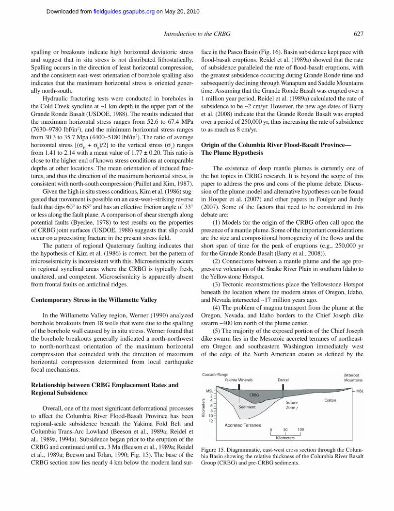
Introduction to the CRBG 627
spalling or breakouts indicate high horizontal deviatoric stress and suggest that in situ stress is not distributed lithostatically. Spalling occurs in the direction of least horizontal compression, and the consistent east-west orientation of borehole spalling also indicates that the maximum horizontal stress is oriented gener-ally north-south.
Hydraulic fracturing tests were conducted in boreholes in the Cold Creek syncline at ~1 km depth in the upper part of the Grande Ronde Basalt (USDOE, 1988). The results indicated that the maximum horizontal stress ranges from 52.6 to 67.4 MPa (7630–9780 lbf/in2), and the minimum horizontal stress ranges from 30.3 to 35.7 Mpa (4400–5180 lbf/in2). The ratio of average horizontal stress [(σ
H + σ
h)/2] to the vertical stress (σ
v) ranges
from 1.41 to 2.14 with a mean value of 1.77 ± 0.20. This ratio is close to the higher end of known stress conditions at comparable depths at other locations. The mean orientation of induced frac-tures, and thus the direction of the maximum horizontal stress, is consistent with north-south compression (Paillet and Kim, 1987).
Given the high in situ stress conditions, Kim et al. (1986) sug-gested that movement is possible on an east-west–striking reverse fault that dips 60° to 65° and has an effective friction angle of 33° or less along the fault plane. A comparison of shear strength along potential faults (Byerlee, 1978) to test results on the properties of CRBG joint surfaces (USDOE, 1988) suggests that slip could occur on a preexisting fracture in the present stress fi eld.
The pattern of regional Quaternary faulting indicates that the hypothesis of Kim et al. (1986) is correct, but the pattern of microseismicity is inconsistent with this. Microseismicity occurs in regional synclinal areas where the CRBG is typically fresh, unaltered, and competent. Microseismicity is apparently absent from frontal faults on anticlinal ridges.
Contemporary Stress in the Willamette Valley
In the Willamette Valley region, Werner (1990) analyzed borehole breakouts from 18 wells that were due to the spalling of the borehole wall caused by in situ stress. Werner found that the borehole breakouts generally indicated a north- northwest to north-northeast orientation of the maximum horizontal compression that coincided with the direction of maximum horizontal compression determined from local earthquake focal mechanisms.
Relationship between CRBG Emplacement Rates and Regional Subsidence
Overall, one of the most signifi cant deformational processes to affect the Columbia River Flood-Basalt Province has been regional-scale subsidence beneath the Yakima Fold Belt and Columbia Trans-Arc Lowland (Beeson et al., 1989a; Reidel et al., 1989a, 1994a). Subsidence began prior to the eruption of the CRBG and continued until ca. 3 Ma (Beeson et al., 1989a; Reidel et al., 1989a; Beeson and Tolan, 1990; Fig. 15). The base of the CRBG section now lies nearly 4 km below the modern land sur-
face in the Pasco Basin (Fig. 16). Basin subsidence kept pace with fl ood-basalt eruptions. Reidel et al. (1989a) showed that the rate of subsidence paralleled the rate of fl ood-basalt eruptions, with the greatest subsidence occurring during Grande Ronde time and subsequently declining through Wanapum and Saddle Mountains time. Assuming that the Grande Ronde Basalt was erupted over a 1 million year period, Reidel et al. (1989a) calculated the rate of subsidence to be ~2 cm/yr. However, the new age dates of Barry et al. (2008) indicate that the Grande Ronde Basalt was erupted over a period of 250,000 yr, thus increasing the rate of subsidence to as much as 8 cm/yr.
Origin of the Columbia River Flood-Basalt Province—The Plume Hypothesis
The existence of deep mantle plumes is currently one of the hot topics in CRBG research. It is beyond the scope of this paper to address the pros and cons of the plume debate. Discus-sion of the plume model and alternative hypotheses can be found in Hooper et al. (2007) and other papers in Foulger and Jurdy (2007). Some of the factors that need to be considered in this debate are:
(1) Models for the origin of the CRBG often call upon the presence of a mantle plume. Some of the important considerations are the size and compositional homogeneity of the fl ows and the short span of time for the peak of eruptions (e.g., 250,000 yr for the Grande Ronde Basalt (Barry et al., 2008)).
(2) Connections between a mantle plume and the age pro-gressive volcanism of the Snake River Plain in southern Idaho to the Yellowstone Hotspot.
(3) Tectonic reconstructions place the Yellowstone Hotspot beneath the location where the modern states of Oregon, Idaho, and Nevada intersected ~17 million years ago.
(4) The problem of magma transport from the plume at the Oregon, Nevada, and Idaho borders to the Chief Joseph dike swarm ~400 km north of the plume center.
(5) The majority of the exposed portion of the Chief Joseph dike swarm lies in the Mesozoic accreted terranes of northeast-ern Oregon and southeastern Washington immediately west of the edge of the North American craton as defi ned by the
Accreted Terranes
Figure 15. Diagrammatic, east-west cross section through the Colum-bia Basin showing the relative thickness of the Columbia River Basalt Group (CRBG) and pre-CRBG sediments.
on May 20, 2010fieldguides.gsapubs.orgDownloaded from
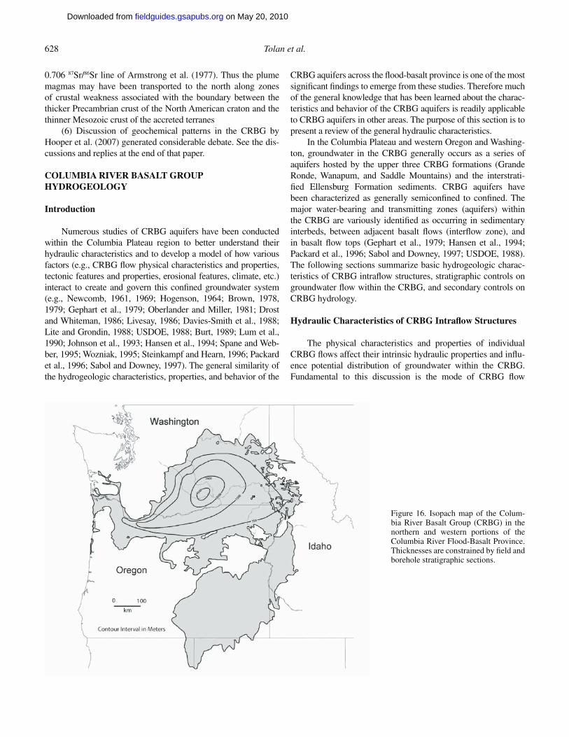
628 Tolan et al.
0.706 87Sr/86Sr line of Armstrong et al. (1977). Thus the plume magmas may have been transported to the north along zones of crustal weakness associated with the boundary between the thicker Precambrian crust of the North American craton and the thinner Mesozoic crust of the accreted terranes
(6) Discussion of geochemical patterns in the CRBG by Hooper et al. (2007) generated considerable debate. See the dis-cussions and replies at the end of that paper.
COLUMBIA RIVER BASALT GROUP HYDROGEOLOGY
Introduction
Numerous studies of CRBG aquifers have been conducted within the Columbia Plateau region to better understand their hydraulic characteristics and to develop a model of how various factors (e.g., CRBG fl ow physical characteristics and properties, tectonic features and properties, erosional features, climate, etc.) interact to create and govern this confi ned groundwater system (e.g., Newcomb, 1961, 1969; Hogenson, 1964; Brown, 1978, 1979; Gephart et al., 1979; Oberlander and Miller, 1981; Drost and Whiteman, 1986; Livesay, 1986; Davies-Smith et al., 1988; Lite and Grondin, 1988; USDOE, 1988; Burt, 1989; Lum et al., 1990; Johnson et al., 1993; Hansen et al., 1994; Spane and Web-ber, 1995; Wozniak, 1995; Steinkampf and Hearn, 1996; Packard et al., 1996; Sabol and Downey, 1997). The general similarity of the hydrogeologic characteristics, properties, and behavior of the
CRBG aquifers across the fl ood-basalt province is one of the most signifi cant fi ndings to emerge from these studies. Therefore much of the general knowledge that has been learned about the charac-teristics and behavior of the CRBG aquifers is readily applicable to CRBG aquifers in other areas. The purpose of this section is to present a review of the general hydraulic characteristics.
In the Columbia Plateau and western Oregon and Washing-ton, groundwater in the CRBG generally occurs as a series of aquifers hosted by the upper three CRBG formations (Grande Ronde, Wanapum, and Saddle Mountains) and the interstrati-fi ed Ellensburg Formation sediments. CRBG aquifers have been characterized as generally semiconfi ned to confi ned. The major water-bearing and transmitting zones (aquifers) within the CRBG are variously identifi ed as occurring in sedimentary interbeds, between adjacent basalt fl ows (interfl ow zone), and in basalt fl ow tops (Gephart et al., 1979; Hansen et al., 1994; Packard et al., 1996; Sabol and Downey, 1997; USDOE, 1988). The following sections summarize basic hydrogeologic charac-teristics of CRBG intrafl ow structures, stratigraphic controls on groundwater fl ow within the CRBG, and secondary controls on CRBG hydrology.
Hydraulic Characteristics of CRBG Intrafl ow Structures
The physical characteristics and properties of individual CRBG fl ows affect their intrinsic hydraulic properties and infl u-ence potential distribution of groundwater within the CRBG. Fundamental to this discussion is the mode of CRBG fl ow
Figure 16. Isopach map of the Colum-bia River Basalt Group (CRBG) in the northern and western portions of the Columbia River Flood-Basalt Province. Thicknesses are constrained by fi eld and borehole stratigraphic sections.
on May 20, 2010fieldguides.gsapubs.orgDownloaded from
Introduction to the CRBG 629
emplacement and types and extent of the intrafl ow structures associated with each fl ow. As reviewed earlier, there are three basic modes for lava fl ow emplacement—compound fl ow, sheet fl ow, and intracanyon fl ow. The internal arrangement of physi-cal (intrafl ow) structures is far more irregular in compound fl ows than sheet fl ows. The presence of these structures in compound fl ows provides numerous potential pathways for both horizon-tal and vertical groundwater movement through the fl ow. Based on both surface and subsurface data and mapping, CRBG fl ows are most commonly classifi ed as sheet fl ows (e.g., Beeson et al., 1985, 1989a; Beeson and Tolan, 1990, 1996; Reidel and Tolan, 1992; Reidel et al., 1994b; Reidel, 1998).
As described earlier, CRBG sheet fl ows exhibit a basic three-part internal arrangement of internal intrafl ow structures that originate during the emplacement and cooling of the lava fl ows. These features are referred to as the fl ow top, fl ow interior, and fl ow bottom (Fig. 7). The combination of a fl ow top of one fl ow and the fl ow bottom of the overlying fl ow is commonly referred to as the “interfl ow zone.” The interfl ow zones, in comparison to the fl ow’s dense interior, form the predominant water- transmitting zones (aquifers) within the CRBG (USDOE, 1988). In their origi-nal undisturbed state, individual interfl ow zones are as laterally extensive as the sheet fl ows between which they occur. Given the extent and thickness (geometry) of individual interfl ow zones, this creates a series of relatively tabular, stratiform layers that could potentially play host to aquifers within the CRBG.
It is widely agreed that within CRBG aquifers, given the typical distribution and physical characteristics of CRBG intra-fl ow structures, groundwater primarily resides within the inter-fl ow zones (Newcomb, 1969; Oberlander and Miller, 1981; Lite and Grondin, 1988; Davies-Smith et al., 1988; USDOE, 1988; Wozniak, 1995; Tolan et al., 2000b; Tolan and Lite, 2008). The presence of interbedded sediments can either enhance (e.g., sand-stone and conglomerate) or inhibit (e.g., mudstone and paleosols) groundwater storage and movement within this zone. Another crit-ical aspect with respect to interfl ow zones, that is not commonly recognized, is their potential lateral variability. For example, thick fl ow-top breccias are known to abruptly end with a much thin-ner normal fl ow top taking its place. The same is true for fl ow-bottom features (e.g., pillow complexes) that can abruptly end or transition to a more simple fl ow bottom. These intrafl ow structure “facies changes” can result in radical changes of the hydraulic properties and behavior of an individual CRBG aquifer.
The physical properties of undisturbed, laterally extensive, dense interiors of CRBG fl ows make this portion of the fl ow essentially impermeable for all practical purposes (Newcomb, 1969; Oberlander and Miller, 1981; Davies-Smith et al., 1988; Lite and Grondin, 1988; USDOE, 1988; Lindberg, 1989; Woz-niak, 1995). While the dense interior portion of a CRBG fl ow is replete with cooling joints, in their undisturbed state these joints have been found to be typically 77% to >99% fi lled with second-ary minerals (clay, silica, and zeolite), and void spaces that do occur are typically not interconnected (USDOE, 1988; Lindberg, 1989). The fact that CRBG dense fl ow interiors typically act as
aquitards accounts for the confi ned behavior exhibited by most CRBG aquifers. Artesian (fl owing) conditions have been encoun-tered within many areas around the fl ood-basalt province.
Field data and inferences based on modeling studies sug-gest that the hydraulic properties of CRBG aquifers are are-ally and vertically complex (e.g., Drost and Whiteman, 1986; USDOE, 1988; Hansen et al., 1994; Whiteman et al., 1994). For example, vertical profi les of hydraulic head from Hanford Site test wells indicate that there is the potential for upward move-ment of groundwater from Grande Ronde and Wanapum aqui-fers and downward movement of groundwater from the overly-ing Saddle Mountains aquifer (USDOE, 1988; Johnson et al., 1993). On the other hand, the regional water-level contours for the Grande Ronde and Wanapum aquifers presented in Hansen et al. (1994) suggest that the direction of vertical fl ow between these two aquifers is variable over the region. However, the results of hydrologic tests in wells at the Hanford Site show that lateral groundwater fl ow in the CRBG interfl ow zones appears to greatly exceed vertical movement through dense fl ow interi-ors (USDOE, 1988).
A range of hydraulic conductivity values is reported for CRBG aquifers in USDOE (1988), Whiteman et al. (1994), and Sabol and Downey (1997), and these values are summarized in Table 4. The values of hydraulic conductivity reported in White-man et al. (1994) rely heavily on data reported on driller’s well reports from many wells that are open to multiple CRBG aqui-fers. These lateral conductivities integrate values over the entire depth of penetrated CRBG and, therefore, refl ect the contribution from interlayer vertical movement of groundwater past CRBG fl ow pinchouts, faulting, and other discontinuities in individual CRBG fl ow layers. The hydraulic conductivities of an individual interfl ow zone within the tested intervals may be substantially higher (or lower) than the reported value.
Values of storativity in the CRBG are commonly between 10−4 and 10−5, refl ecting the high degree of confi nement of the interfl ows and incompressible aquifer matrix (McFarland and Morgan, 1996; Conlon et al., 2005). Higher values of storativity calculated from some aquifer tests may indicate less confi nement in some parts of the CRBG system. Some may represent tests in the uppermost basalt interval that are hydraulically connected through surface fractures to the overlying sediments or land sur-face. Lateral facies changes in the interfl ow zones, wells open to multiple and often different interfl ow zones, and the presence of structural boundaries complicate estimation of aquifer param-eters based on Theisien analysis of pumping test data, and may result in misleading parameter values.
The available data on hydraulic properties of the various CRBG aquifers, including permeability, porosity, and storativ-ity, indicate that a large variability in local fl ow characteristics is expected. However, hydraulic data are generally sparse and cannot be extrapolated easily to other locations within the area. Finally, pumping and recharge can locally alter hydraulic gradi-ents and fl ow directions during the year, especially in the vicinity of aquifer boundaries.
on May 20, 2010fieldguides.gsapubs.orgDownloaded from
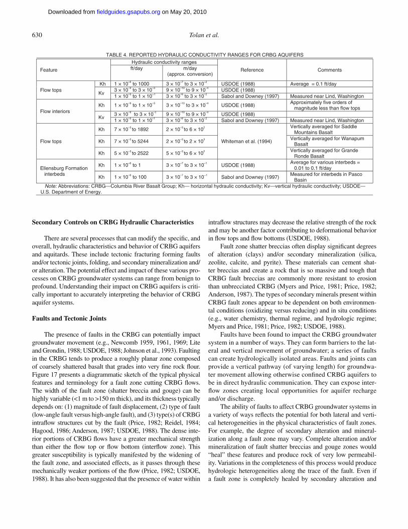
630 Tolan et al.
Secondary Controls on CRBG Hydraulic Characteristics
There are several processes that can modify the specifi c, and overall, hydraulic characteristics and behavior of CRBG aquifers and aquitards. These include tectonic fracturing forming faults and/or tectonic joints, folding, and secondary mineralization and/or alteration. The potential effect and impact of these various pro-cesses on CRBG groundwater systems can range from benign to profound. Understanding their impact on CRBG aquifers is criti-cally important to accurately interpreting the behavior of CRBG aquifer systems.
Faults and Tectonic Joints
The presence of faults in the CRBG can potentially impact groundwater movement (e.g., Newcomb 1959, 1961, 1969; Lite and Grondin, 1988; USDOE, 1988; Johnson et al., 1993). Faulting in the CRBG tends to produce a roughly planar zone composed of coarsely shattered basalt that grades into very fi ne rock fl our. Figure 17 presents a diagrammatic sketch of the typical physical features and terminology for a fault zone cutting CRBG fl ows. The width of the fault zone (shatter breccia and gouge) can be highly variable (<1 m to >150 m thick), and its thickness typically depends on: (1) magnitude of fault displacement, (2) type of fault (low-angle fault versus high-angle fault), and (3) type(s) of CRBG intrafl ow structures cut by the fault (Price, 1982; Reidel, 1984; Hagood, 1986; Anderson, 1987; USDOE, 1988). The dense inte-rior portions of CRBG fl ows have a greater mechanical strength than either the fl ow top or fl ow bottom (interfl ow zone). This greater susceptibility is typically manifested by the widening of the fault zone, and associated effects, as it passes through these mechanically weaker portions of the fl ow (Price, 1982; USDOE, 1988). It has also been suggested that the presence of water within
intrafl ow structures may decrease the relative strength of the rock and may be another factor contributing to deformational behavior in fl ow tops and fl ow bottoms (USDOE, 1988).
Fault zone shatter breccias often display signifi cant degrees of alteration (clays) and/or secondary mineralization (silica, zeolite, calcite, and pyrite). These materials can cement shat-ter breccias and create a rock that is so massive and tough that CRBG fault breccias are commonly more resistant to erosion than unbrecciated CRBG (Myers and Price, 1981; Price, 1982; Anderson, 1987). The types of secondary minerals present within CRBG fault zones appear to be dependent on both environmen-tal conditions (oxidizing versus reducing) and in situ conditions (e.g., water chemistry, thermal regime, and hydrologic regime; Myers and Price, 1981; Price, 1982; USDOE, 1988).
Faults have been found to impact the CRBG groundwater system in a number of ways. They can form barriers to the lat-eral and vertical movement of groundwater; a series of faults can create hydrologically isolated areas. Faults and joints can provide a vertical pathway (of varying length) for groundwa-ter movement allowing otherwise confi ned CRBG aquifers to be in direct hydraulic communication. They can expose inter-fl ow zones creating local opportunities for aquifer recharge and/or discharge.
The ability of faults to affect CRBG groundwater systems in a variety of ways refl ects the potential for both lateral and verti-cal heterogeneities in the physical characteristics of fault zones. For example, the degree of secondary alteration and mineral-ization along a fault zone may vary. Complete alteration and/or mineralization of fault shatter breccias and gouge zones would “heal” these features and produce rock of very low permeabil-ity. Variations in the completeness of this process would produce hydrologic heterogeneities along the trace of the fault. Even if a fault zone is completely healed by secondary alteration and
TABLE 4. REPORTED HYDRAULIC CONDUCTIVITY RANGES FOR CRBG AQUIFERS
Feature
Hydraulic conductivity ranges
stnemmoC ecnerefeRft/day m/day(approx. conversion)
Flow tops Kh 1 × 10⁻⁶ to 1000 3 × 10⁻⁷ to 3 × 10⁻² USDOE (1988) Average = 0.1 ft/day
Kv 3 × 10⁻⁹ to 3 × 10⁻³ 9 × 10⁻¹⁰ to 9 × 10⁻⁴ USDOE (1988) 1 × 10⁻⁵ to 1 × 10⁻¹ 3 × 10⁻⁶ to 3 × 10⁻² Sabol and Downey (1997) Measured near Lind, Washington
Flow interiors Kh 1 × 10⁻⁹ to 1 × 10⁻³ 3 × 10⁻¹⁰ to 3 × 10⁻⁴ USDOE (1988) Approximately five orders of
magnitude less than flow tops
Kv 3 × 10⁻⁹ to 3 × 10⁻³ 9 × 10⁻¹⁰ to 9 × 10⁻⁴ USDOE (1988)1 × 10⁻⁵ to 1 × 10⁻¹ 3 × 10⁻⁶ to 3 × 10⁻² Sabol and Downey (1997) Measured near Lind, Washington
Flow tops
Kh 7 × 10⁻³ to 1892 2 × 10⁻³ to 6 × 10²
Whiteman et al. (1994)
Vertically averaged for Saddle Mountains Basalt
Kh 7 × 10⁻³ to 5244 2 × 10⁻³ to 2 × 10³ Vertically averaged for Wanapum Basalt
Kh 5 × 10⁻³ to 2522 5 × 10⁻³ to 6 × 10² Vertically averaged for Grande Ronde Basalt
Ellensburg Formation interbeds
Kh 1 × 10⁻⁶ to 1 3 × 10⁻⁷ to 3 × 10⁻¹ USDOE (1988) Average for various interbeds =
0.01 to 0.1 ft/day
Kh 1 × 10⁻⁶ to 100 3 × 10⁻⁷ to 3 × 10⁻¹ Sabol and Downey (1997) Measured for interbeds in Pasco Basin
Note: Abbreviations: CRBG—Columbia River Basalt Group; Kh— horizontal hydraulic conductivity; Kv—vertical hydraulic conductivity; USDOE—U.S. Department of Energy.
on May 20, 2010fieldguides.gsapubs.orgDownloaded from
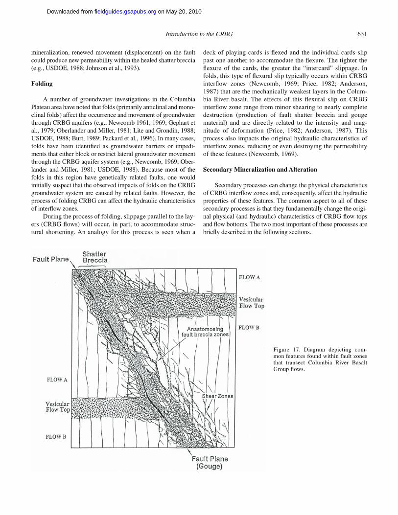
Introduction to the CRBG 631
mineralization, renewed movement (displacement) on the fault could produce new permeability within the healed shatter breccia (e.g., USDOE, 1988; Johnson et al., 1993).
Folding
A number of groundwater investigations in the Columbia Plateau area have noted that folds (primarily anticlinal and mono-clinal folds) affect the occurrence and movement of groundwater through CRBG aquifers (e.g., Newcomb 1961, 1969; Gephart et al., 1979; Oberlander and Miller, 1981; Lite and Grondin, 1988; USDOE, 1988; Burt, 1989; Packard et al., 1996). In many cases, folds have been identifi ed as groundwater barriers or impedi-ments that either block or restrict lateral groundwater movement through the CRBG aquifer system (e.g., Newcomb, 1969; Ober-lander and Miller, 1981; USDOE, 1988). Because most of the folds in this region have genetically related faults, one would initially suspect that the observed impacts of folds on the CRBG groundwater system are caused by related faults. However, the process of folding CRBG can affect the hydraulic characteristics of interfl ow zones.
During the process of folding, slippage parallel to the lay-ers (CRBG fl ows) will occur, in part, to accommodate struc-tural shortening. An analogy for this process is seen when a
deck of playing cards is fl exed and the individual cards slip past one another to accommodate the fl exure. The tighter the fl exure of the cards, the greater the “intercard” slippage. In folds, this type of fl exural slip typically occurs within CRBG interfl ow zones (Newcomb, 1969; Price, 1982; Anderson, 1987) that are the mechanically weakest layers in the Colum-bia River basalt. The effects of this fl exural slip on CRBG interfl ow zone range from minor shearing to nearly complete destruction (production of fault shatter breccia and gouge material) and are directly related to the intensity and mag-nitude of deformation (Price, 1982; Anderson, 1987). This process also impacts the original hydraulic characteristics of interfl ow zones, reducing or even destroying the permeability of these features (Newcomb, 1969).
Secondary Mineralization and Alteration
Secondary processes can change the physical characteristics of CRBG interfl ow zones and, consequently, affect the hydraulic properties of these features. The common aspect to all of these secondary processes is that they fundamentally change the origi-nal physical (and hydraulic) characteristics of CRBG fl ow tops and fl ow bottoms. The two most important of these processes are briefl y described in the following sections.
Figure 17. Diagram depicting com-mon features found within fault zones that transect Columbia River Basalt Group fl ows.
on May 20, 2010fieldguides.gsapubs.orgDownloaded from
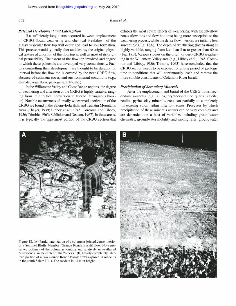
632 Tolan et al.
Paleosol Development and LaterizationIf a suffi ciently long hiatus occurred between emplacement
of CRBG fl ows, weathering and chemical breakdown of the glassy vesicular fl ow top will occur and lead to soil formation. This process would typically alter and destroy the original physi-cal texture of a portion of the fl ow top as well as most of its origi-nal permeability. The extent of the fl ow top involved and degree to which these paleosols are developed vary tremendously. Fac-tors controlling their development are thought to be duration of interval before the fl ow top is covered by the next CRBG fl ow, absence of sediment cover, and environmental conditions (e.g., climate, vegetation, paleogeography, etc.).
In the Willamette Valley and Coast Range regions, the degree of weathering and alteration of the CRBG is highly variable, rang-ing from little to total conversion to laterite (ferruginous baux-ite). Notable occurrences of areally widespread laterization of the CRBG are found in the Salem–Eola Hills and Tualatin Mountains areas (Thayer, 1939; Libbey et al., 1945; Corcoran and Libbey, 1956; Trimble, 1963; Schlicker and Deacon, 1967). In these areas, it is typically the uppermost portion of the CRBG section that
exhibits the most severe effects of weathering, with the interfl ow zones (fl ow tops and fl ow bottoms) being more susceptible to the weathering process, while the dense fl ow interiors are initially less susceptible (Fig. 18A). The depth of weathering (laterization) is highly variable, ranging from less than 5 m to greater than 60 m (Fig. 18B). Various studies on the origin of deep CRBG weather-ing in the Willamette Valley area (e.g., Libbey et al., 1945; Corco-ran and Libbey, 1956; Trimble, 1963) have concluded that the CRBG section needs to be exposed for a long period of geologic time to conditions that will continuously leach and remove the more soluble constituents of Columbia River basalt.
Precipitation of Secondary MineralsAfter the emplacement and burial of the CRBG fl ows, sec-
ondary minerals (e.g., silica, cryptocrystalline quartz, calcite, zeolite, pyrite, clay minerals, etc.) can partially to completely fi ll existing voids within interfl ow zones. Processes by which precipitation of these minerals occurs can be very complex and are dependent on a host of variables including groundwater chemistry, groundwater mobility and mixing rates, groundwater
A B
Figure 18. (A) Partial laterization of a columnar jointed dense interior of a Sentinel Bluffs Member (Grande Ronde Basalt) fl ow. Note pre-served outlines of the columnar jointing and relatively unweathered “corestones” in the center of the “blocks.” (B) Nearly completely later-ized portion of a two Grande Ronde Basalt fl ows exposed in roadcuts in the south Salem Hills. The roadcut is ~3 m in height.
on May 20, 2010fieldguides.gsapubs.orgDownloaded from
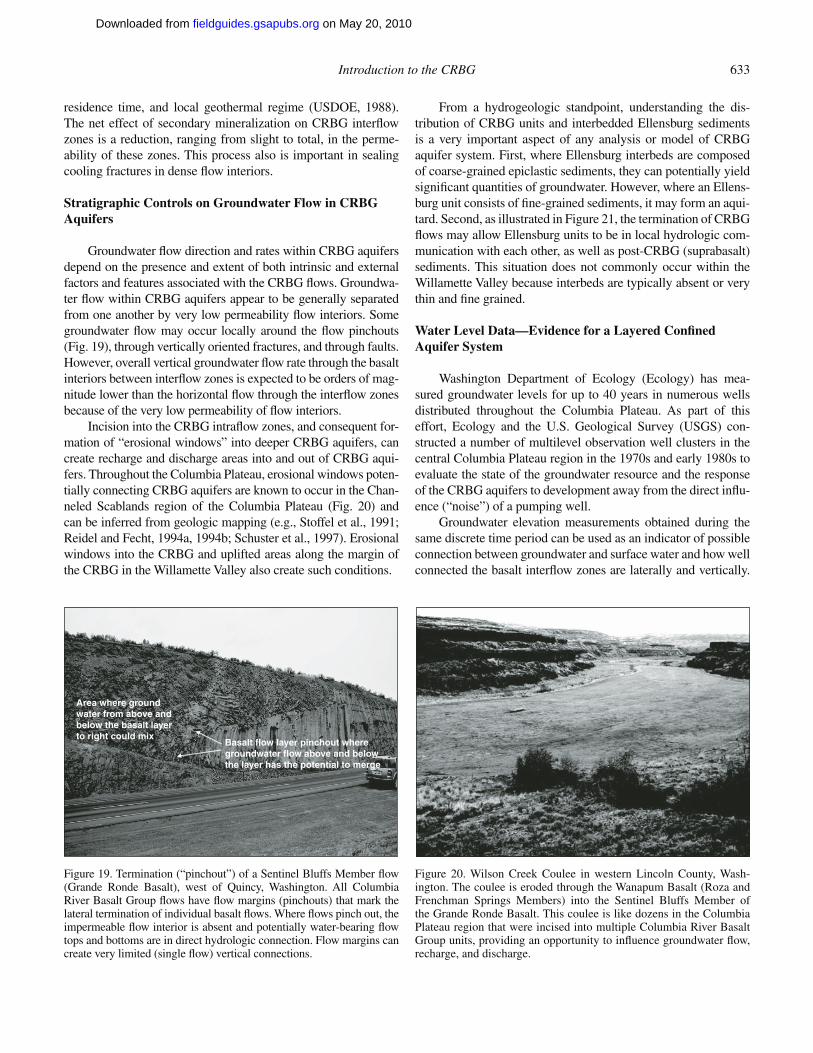
Introduction to the CRBG 633
residence time, and local geothermal regime (USDOE, 1988). The net effect of secondary mineralization on CRBG interfl ow zones is a reduction, ranging from slight to total, in the perme-ability of these zones. This process also is important in sealing cooling fractures in dense fl ow interiors.
Stratigraphic Controls on Groundwater Flow in CRBG Aquifers
Groundwater fl ow direction and rates within CRBG aquifers depend on the presence and extent of both intrinsic and external factors and features associated with the CRBG fl ows. Groundwa-ter fl ow within CRBG aquifers appear to be generally separated from one another by very low permeability fl ow interiors. Some groundwater fl ow may occur locally around the fl ow pinchouts (Fig. 19), through vertically oriented fractures, and through faults. However, overall vertical groundwater fl ow rate through the basalt interiors between interfl ow zones is expected to be orders of mag-nitude lower than the horizontal fl ow through the interfl ow zones because of the very low permeability of fl ow interiors.
Incision into the CRBG intrafl ow zones, and consequent for-mation of “erosional windows” into deeper CRBG aquifers, can create recharge and discharge areas into and out of CRBG aqui-fers. Throughout the Columbia Plateau, erosional windows poten-tially connecting CRBG aquifers are known to occur in the Chan-neled Scablands region of the Columbia Plateau (Fig. 20) and can be inferred from geologic mapping (e.g., Stoffel et al., 1991; Reidel and Fecht, 1994a, 1994b; Schuster et al., 1997). Erosional windows into the CRBG and uplifted areas along the margin of the CRBG in the Willamette Valley also create such conditions.
From a hydrogeologic standpoint, understanding the dis-tribution of CRBG units and interbedded Ellensburg sediments is a very important aspect of any analysis or model of CRBG aquifer system. First, where Ellensburg interbeds are composed of coarse-grained epiclastic sediments, they can potentially yield signifi cant quantities of groundwater. However, where an Ellens-burg unit consists of fi ne-grained sediments, it may form an aqui-tard. Second, as illustrated in Figure 21, the termination of CRBG fl ows may allow Ellensburg units to be in local hydrologic com-munication with each other, as well as post-CRBG (suprabasalt) sediments. This situation does not commonly occur within the Willamette Valley because interbeds are typically absent or very thin and fi ne grained.
Water Level Data—Evidence for a Layered Confi ned Aquifer System
Washington Department of Ecology (Ecology) has mea-sured groundwater levels for up to 40 years in numerous wells distributed throughout the Columbia Plateau. As part of this effort, Ecology and the U.S. Geological Survey (USGS) con-structed a number of multilevel observation well clusters in the central Columbia Plateau region in the 1970s and early 1980s to evaluate the state of the groundwater resource and the response of the CRBG aquifers to development away from the direct infl u-ence (“noise”) of a pumping well.
Groundwater elevation measurements obtained during the same discrete time period can be used as an indicator of possible connection between groundwater and surface water and how well connected the basalt interfl ow zones are laterally and vertically.
Area where groundwater from above andbelow the basalt layerto right could mix
Basalt flow layer pinchout wheregroundwater flow above and below the layer has the potential to merge
Figure 19. Termination (“pinchout”) of a Sentinel Bluffs Member fl ow (Grande Ronde Basalt), west of Quincy, Washington. All Columbia River Basalt Group fl ows have fl ow margins (pinchouts) that mark the lateral termination of individual basalt fl ows. Where fl ows pinch out, the impermeable fl ow interior is absent and potentially water-bearing fl ow tops and bottoms are in direct hydrologic connection. Flow margins can create very limited (single fl ow) vertical connections.
Figure 20. Wilson Creek Coulee in western Lincoln County, Wash-ington. The coulee is eroded through the Wanapum Basalt (Roza and Frenchman Springs Members) into the Sentinel Bluffs Member of the Grande Ronde Basalt. This coulee is like dozens in the Columbia Plateau region that were incised into multiple Columbia River Basalt Group units, providing an opportunity to infl uence groundwater fl ow, recharge, and discharge.
on May 20, 2010fieldguides.gsapubs.orgDownloaded from
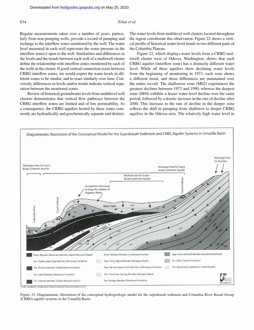
634 Tolan et al.
Regular measurements taken over a number of years, particu-larly from non-pumping wells, provide a record of pumping and recharge to the interfl ow zones monitored by the well. The water level measured in each well represents the water pressure in the interfl ow zone(s) open to the well. Similarities and differences in the levels and the trends between each well of a multiwell cluster defi ne the relationship with interfl ow zones monitored by each of the wells in the cluster. If good vertical connection exists between CRBG interfl ow zones, we would expect the water levels in dif-ferent zones to be similar, and to react similarly over time. Con-versely, differences in levels and/or trends indicate vertical sepa-ration between the monitored zones.
Review of historical groundwater levels from multilevel well clusters demonstrates that vertical fl ow pathways between the CRBG interfl ow zones are limited and of low permeability. As a consequence, the CRBG aquifers hosted by these zones com-monly are hydraulically and geochemically separate and distinct.
The water levels from multilevel well clusters located throughout the region corroborate this observation. Figure 22 shows a verti-cal profi le of historical water-level trends in two different parts of the Columbia Plateau.
Figure 22, which displays water levels from a CRBG mul-tiwell cluster west of Odessa, Washington, shows that each CRBG aquifer (interfl ow zone) has a distinctly different water level. While all three aquifers show declining water levels from the beginning of monitoring in 1973, each zone shows a different trend, and those differences are maintained over the entire record. The shallowest zone (M02) experiences the greatest declines between 1973 and 1990, whereas the deepest zone (M04) exhibits a lesser water-level decline over the same period, followed by a drastic increase in the rate of decline after 2000. This increase in the rate of decline in the deeper zone refl ects the shift in pumping from shallower to deeper CRBG aquifers in the Odessa area. The relatively high water level in
Figure 21. Diagrammatic illustration of the conceptual hydrogeologic model for the suprabasalt sediment and Columbia River Basalt Group (CRBG) aquifer systems in the Umatilla Basin.
on May 20, 2010fieldguides.gsapubs.orgDownloaded from
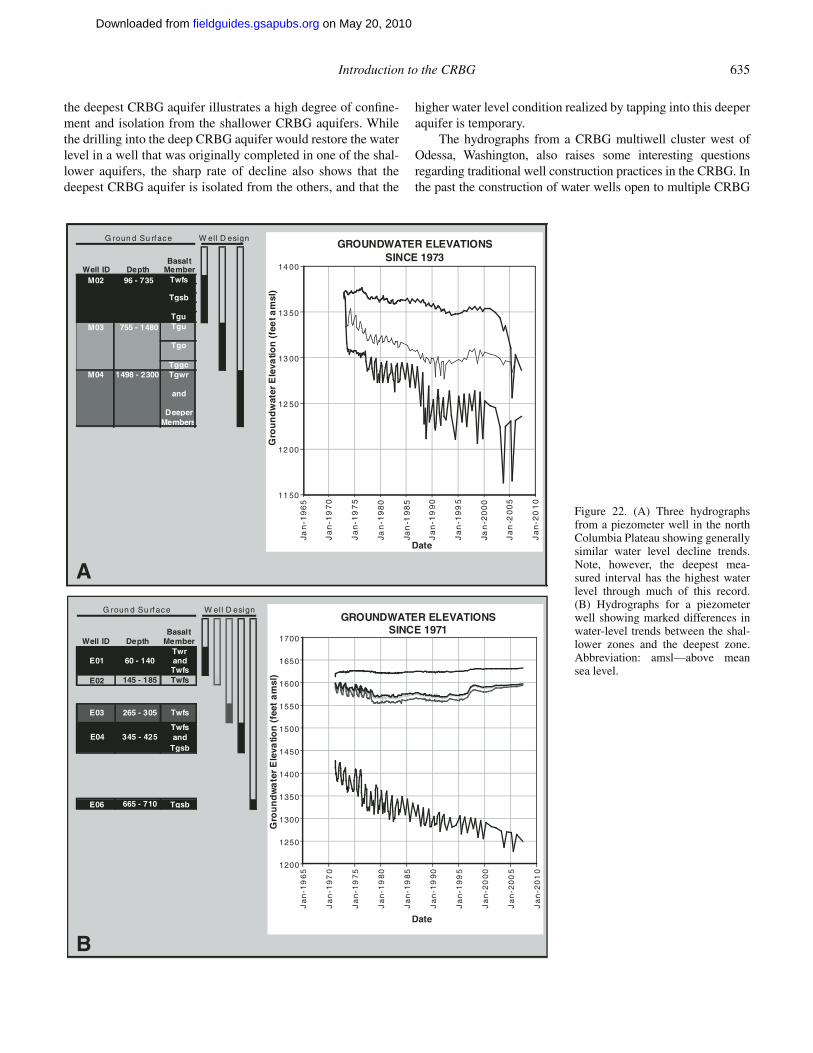
Introduction to the CRBG 635
the deepest CRBG aquifer illustrates a high degree of confi ne-ment and isolation from the shallower CRBG aquifers. While the drilling into the deep CRBG aquifer would restore the water level in a well that was originally completed in one of the shal-lower aquifers, the sharp rate of decline also shows that the deepest CRBG aquifer is isolated from the others, and that the
higher water level condition realized by tapping into this deeper aquifer is temporary.
The hydrographs from a CRBG multiwell cluster west of Odessa, Washington, also raises some interesting questions regarding traditional well construction practices in the CRBG. In the past the construction of water wells open to multiple CRBG
G roun d Su rface
BasaltWell ID Depth Member
Twfs
Tgsb
TguM03 755 - 1480 Tgu
Tgo
TggcM04 1498 - 2300 Tgwr
and
DeeperMembers
M02 96 - 735
GROUNDWATER ELEVATIONS SINCE 1973
11 50
12 00
12 50
13 00
13 50
14 00
Jan
-19
65
Ja
n-1
97
0
Ja
n-1
97
5
Jan
-19
80
Jan
-19
85
Ja
n-1
99
0
Ja
n-1
99
5
Jan
-20
00
Ja
n-2
00
5
Ja
n-2
01
0Date
Gro
un
dw
ater
Ele
vatio
n (
fee
t am
sl)
G roun d Su rface
BasaltWell ID Depth Member
TwrandTwfs
E02 145 - 185 Twfs
Twfsand
Tgsb
E06 665 - 710 Tgsb
W ell D esign
E04 345 - 425
60 - 140E01
Twfs265 - 305E03
GROUNDWATER ELEVATIONS SINCE 1971
1200
1250
1300
1350
1400
1450
1500
1550
1600
1650
1700
Ja
n-1
96
5
Ja
n-1
97
0
Ja
n-1
97
5
Ja
n-1
98
0
Ja
n-1
98
5
Ja
n-1
99
0
Ja
n-1
99
5
Ja
n-2
00
0
Ja
n-2
00
5
Ja
n-2
01
0
W el l D esign
Gro
un
dw
ate
r E
leva
tion
(fe
et a
msl
)
A
BDate
Figure 22. (A) Three hydrographs from a piezometer well in the north Columbia Plateau showing generally similar water level decline trends. Note, however, the deepest mea-sured interval has the highest water level through much of this record. (B) Hydrographs for a piezometer well showing marked differences in water-level trends between the shal-lower zones and the deepest zone. Abbreviation: amsl—above mean sea level.
on May 20, 2010fieldguides.gsapubs.orgDownloaded from

636 Tolan et al.
interfl ow zones (aquifers) has been the norm, rather than the exception. This is due to the fact that the CRBG has been gener-ally treated as a single aquifer instead of a multiple confi ned aqui-fer system. Therefore construction of water wells that are open to more than one CRBG aquifer (interfl ow zone) creates manmade, vertical pathways which allow groundwater to migrate between CRBG aquifers having different hydraulic heads (USDOE, 1988; Lite and Grondin, 1988; Wozniak, 1995). Therefore in regions where groundwater within the CRBG is the primary source of water, the CRBG groundwater system can have a signifi cant degree of vertical connectivity due to the large number of water wells open to multiple aquifers.
Potential Recharge and Discharge—CRBG Aquifers
Early researchers recognized that the unique nature of the CRBG aquifers provides limited opportunity for signifi cant recharge (Newcomb, 1959, 1969; USDOE, 1988; Hansen et al., 1994). Recharge can occur by diffuse percolation through the CRBG fl ow interiors over large areas. The very low verti-cal permeability limits the rate of recharge by this process, but the large areal extent of the CRBG could potentially result in signifi cant recharge on geologic timescales. Interfl ow zones for CRBG units that are not exposed to overlying sediments nor are present near the surface where they can receive direct recharge can only receive recharge through these processes. However, the development of secondary mineralization along vertical fractures (USDOE, 1988; Lindberg, 1989) reduces the vertical permeabil-ity and thus the rate of recharge via this pathway over time.
Infi ltration vertically downward along faults, past the ends of CRBG fl ow pinchouts, where CRBG fl ows are breached by erosional windows, and on highlands within, and bordering the fl ood-basalt province also are postulated mechanisms for recharge of CRBG interfl ow zones. However the predominant mechanism for enhanced recharge, particularly at rates and on a timescale relevant to stresses imposed by withdrawals in most areas, is direct infi ltration to CRBG interfl ow zones where they are present at, or near, the surface, and in direct hydrologic con-nection with surface water or exposed to percolating precipitation (Hart and Newcomb, 1956; Newcomb, 1959). Interfl ow zones of a given CRBG unit typically crop out, or are in connection with overlying sediment, over a limited area and thus may only have limited recharge potential by this mechanism. Climatic and other hydrologic changes over time may reduce (or increase) the water available for recharge at the locations where a given CRBG inter-fl ow zone is present to accept recharge, and thus the unit may receive signifi cantly less (or more) recharge under present condi-tions than past.
On the Columbia Plateau, recharge of the deeper Wanapum and Grande Ronde aquifers is inferred to result from interba-sin groundwater movement originating around the edge of the Columbia Plateau in areas where the Wanapum and Grande Ronde Basalts are exposed (Gephart et al., 1979; USDOE, 1988; Hansen et al., 1994) and from downward through overlying
CRBG fl ows (Hansen et al., 1994), although the physical charac-teristics of CRBG fl ow interiors would limit the effectiveness of this recharge mechanism.
Geochemical tracers and age dating in the central Colum-bia Plateau region (Columbia Basin Groundwater Management Area) indicates that deep CRBG units cropping out in coulees in northern Lincoln County, Washington, received the bulk of recharge in the Pleistocene. Interfl ow zones of these units are not in connection with existing surface water sources, and precipitation amounts are very low relative to evapotranspira-tion. However, these areas were inundated in the past during the Pleistocene. Whichever mechanism recharges the aquifer system, the amount of recharge often is small relative to the amount of current withdrawals, rendering the CRBG aquifers vulnerable to overdraft.
Groundwater discharge from the shallow CRBG aquifer (Saddle Mountains Basalt) on the Columbia Plateau, is inferred to be to surface water bodies (e.g., Columbia, Snake, and Yakima Rivers) or to suprabasalt sediment aquifers (Newcomb, 1969; USDOE, 1988; Hansen et al., 1994). Where the stratigraphically older CRBG aquifers (i.e., Wanapum and Grande Ronde aqui-fers) are shallow, such as within Yakima Fold anticlines, water gaps, and/or scabland coulees, it is inferred that these aquifers discharge to the overlying suprabasalt sediment aquifer, surface waters (e.g., Crab Creek, Columbia, and Snake Rivers), and the shallower CRBG (Saddle Mountains Basalt) aquifer, if present (Hansen et al., 1994). Erosional windows through CRBG dense fl ow interiors at the top of the CRBG aquifers allow direct inter-connection between the suprabasalt sediment and CRBG aqui-fers (Graham et al., 1984) and between CRBG aquifers.
Potential discharge areas for the deeper CRBG aquifers (i.e., Wanapum and Grande Ronde aquifers) in the Columbia Plateau region are inferred where folds and faults bring Wanapum and Grande Ronde fl ows closer to the surface. In contrast, Hansen et al. (1994) also suggested that discharge from deep CRBG aqui-fers may be directly upward through dense basalt fl ow interiors into the major rivers (e.g., Columbia and Snake Rivers). How-ever, it is diffi cult to envision this potential discharge scenario given the physical properties of CRBG basalt fl ows in this strati-form aquifer system.
Groundwater Resource Limitations
CRBG aquifers present challenges to sustainable groundwa-ter development throughout their extent (e.g., Newcomb, 1965; Sceva, 1966; Luzier et al., 1968; Bartholomew, 1975; Luzier and Skrivan, 1975; Oberlander and Miller, 1981; Norton and Bar-tholomew, 1984; Lite and Grondin, 1988; Zwart, 1990; Cline and Collins, 1992; Miller et al., 1994; Grondin et al., 1995; Conlon et al., 2005). The hydraulic properties inherent to CRBG aquifers have led to overdraft conditions in many areas. Low storativity values and relatively high horizontal conductivity of interfl ow zones combined with very low vertical conductivity of dense fl ow interiors result in a productive aquifer. With time, pumping
on May 20, 2010fieldguides.gsapubs.orgDownloaded from
Introduction to the CRBG 637
produces rapidly moving and coalescing cones of depression with low annual recharge rates. High horizontal conductivity in inter-fl ow zones allows high well yields, but low vertical permeabil-ity and limited recharge pathways result in low annual recharge rates. Combined with low storativity and low bulk porosity, these factors commonly lead to overdraft of CRBG aquifers. The pres-ence of low permeability boundaries such as faults or interfl ow “facies changes” can exacerbate seasonal drawdowns and limit opportunity for annual recovery of the hydraulic head. For exam-ple, all but two of the ~22 areas declared groundwater-limited or critical groundwater areas in Oregon are associated with over-draft conditions in CRBG aquifer systems, and 17 of these areas are located within the Willamette Valley.
Another ongoing challenge is well construction. Construc-tion of water wells that are open to more than one CRBG inter-fl ow zone creates several challenges: (1) water level measure-ments, water fl ow rates, and water quality represent the properties of multiple interfl ow zones and make comparison between wells diffi cult; and (2) the open boreholes create manmade, vertical pathways that allow groundwater (and contaminants) to migrate between CRBG aquifers having different hydraulic heads (Lite and Grondin, 1988; USDOE, 1988; Grondin et al., 1995). In the past, construction of water wells open to multiple CRBG interfl ow zones (aquifers) was common because drillers sought to insure a productive well, and the CRBG has been generally treated as a single aquifer instead of a multiple aquifer system. The consequences of this “open-hole” type of well construction results in depressurizing, and ultimately dewatering, the aquifers. Rapid depressurizing of small, compartmentalized CRBG aqui-fers leads to water-level decline, increased pumping costs, and when declines fall below pumps, results in deepening of wells. The percentage of water-level declines that can be attributed to this mechanism is generally not known, but recent work in the Mosier, Oregon area (Erick Burns, 2009, written commun.) indi-cates that it can be a signifi cant cause of decline.
Impacts on surface water resources from CRBG groundwa-ter development is another challenge that, to date, has received very little attention. The connection between CRBG interfl ow zones and surface water drainages is often inferred (e.g., Miller et al., 1994), but the hydrologic relationship is seldom quanti-fi ed aside from regional modeling studies. However, one of the best examples of where the impact has been directly measured is near Mosier, Oregon (Newcomb, 1969; Lite and Grondin, 1988). Mosier Creek changes from a gaining stream (Newcomb, 1969) to a losing stream where the stream fl ows across a contact between CRBG units (Lite and Grondin, 1988), and the change has been correlated with declining groundwater levels.
ACKNOWLEDGMENTS
We would like to thank Jim O’Connor for his comments and suggestions on an earlier version of this manuscript. We would also like to acknowledge the valuable contributions Russ Evarts, Ray Wells, and Terrence Conlon (U.S. Geological Survey) have
made to our general understanding of the various aspects of the CRBG discussed in this manuscript. We consider them all as “coauthors,” and their names would appear on this manuscript except for time-constraint problems pertaining to the internal U.S. Geological Survey review process. We would also like to acknowledge Heather Petcovic for her contribution to our understanding of the Maxwell Creek dike.
REFERENCES CITED
Anderson, J.L., 1979, The stratigraphy and structure of the Columbia River basalt in the Clackamas River drainage [M.S. thesis]: Portland, Oregon, Portland State University, 136 p.
Anderson, J.L., 1987, Structural geology and ages of deformation of a portion of the southwest Columbia Plateau [Ph.D. thesis]: Los Angeles, Univer-sity of Southern California, 283 p.
Anderson, J.L., and Tolan, T.L., 1986, Ages of wrench faulting in interridge basins, southwest Columbia Plateau, Washington and Oregon: Geologi-cal Society of America Abstracts with Programs, v. 18, p. 82.
Armentrout, J.M., Hull, D.A., Beaulieu, J.D., and Rau, W.W., 1983, Correla-tion of Cenozoic stratigraphic units of western Oregon and Washington: Oregon Department of Geology and Mineral Industries Oil and Gas Investigations 7, 90 p.
Armstrong, R.L., Taubeneck, W.H., and Hales, P.O., 1977, Rb-Sr and K-Ar geochronometry of Mesozoic granitic rocks and their Sr isotopic com-position, Oregon, Washington, and Idaho: Geological Society of Amer-ica Bulletin, v. 88, p. 397–411, doi: 10.1130/0016-7606(1977)88<397:RAKGOM>2.0.CO;2.
Bailey, M.M., 1989, Revisions to stratigraphic nomenclature of the Picture Gorge Basalt Subgroup, Columbia River Basalt Group, in Reidel, S.P., and Hooper, P.R., eds., Volcanism and tectonism in the Columbia River fl ood-basalt province: Geological Society of America Special Paper 239, p. 67–84.
Barrash, W., Bond, J.G., Kaufmann, J.C., and Venkatakrishnan, R., 1980, Geol-ogy of the La Grande area, Oregon: Oregon Department of Geology and Mineral Industries Special Paper 6, scale 1:62,500, 5 plates, 47 p. text.
Barry, T.L., Self, S., Kelley, S.P., Hooper, P.R., and Widdowson, M., 2008, New age dates from Grande Ronde lavas, Columbia River basalts: Implica-tions for periodicity of fl ood basalt eruptions and duration of major pulses: Eos (Transactions, American Geophysical Union), v. 89, no. 53, Fall Meeting Supplement, Abstract V53A-2127.
Bartholomew, W.S., 1975, Groundwater conditions and declining water lev-els in the Butter Creek area, Morrow and Umatilla Counties, Oregon: Oregon Water Resources Department Ground Water Report 24, 102 p.
Beeson, M.H., and Moran, M.R., 1979, Columbia River Basalt Group stratigra-phy in western Oregon: Oregon Geology, v. 41, p. 11–14.
Beeson, M.H., and Tolan, T.L., 1990, The Columbia River Basalt Group in the Cascade Range—A middle Miocene reference datum for structural analysis: Journal of Geophysical Research, v. 95, p. 19,547–19,559, doi: 10.1029/JB095iB12p19547.
Beeson, M.H., and Tolan, T.L., 1996, Field trip guide to Columbia River Basalt intracanyon fl ows in western Oregon and Washington—Ginkgo, Rosa-lia, and Pomona fl ows: Portland, Oregon, Cordilleran Section meeting, Geological Society of America, 35 p.
Beeson, M.H., and Tolan, T.L., 2002, Basalt of Huntzinger, Asotin Member of the Saddle Mountains Basalt, Columbia River Basalt Group (CRBG) identifi ed in western Washington: Geological Society of America Abstracts with Programs, v. 34, no. 5, p. 33.
Beeson, M.H., Perttu, R., and Perttu, J., 1979, The origin of the Miocene basalt of coastal Oregon and Washington: Oregon Geology, v. 41, p. 159–166.
Beeson, M.H., Fecht, K.R., Reidel, S.P., and Tolan, T.L., 1985, Correlations within the Frenchman Springs Member of the Columbia River Basalt Group: New insights into the middle Miocene tectonics of northwest Oregon: Oregon Geology, v. 47, p. 87–96.
Beeson, M.H., Tolan, T.L., and Anderson, J.L., 1989a, The Columbia River Basalt Group in western Oregon: Geologic structures and other factors that controlled fl ow emplacement patterns, in Reidel, S.P., and Hooper, P.R., eds., Volcanism and tectonism in the Columbia River Flood-
on May 20, 2010fieldguides.gsapubs.orgDownloaded from
638 Tolan et al.
Basalt Province: Geological Society of America Special Paper 239, p. 223–246.
Beeson, M.H., Tolan, T.L., and Madin, I., 1989b, Geologic map of the Lake Oswego quadrangle, Oregon: Oregon Department of Geology and Min-eral Industries Map GMS-59, scale 1:24,000, 1 sheet.
Bentley, R.D., 1977, Stratigraphy of the Yakima basalts and structural evolution of the Yakima ridges in the western Columbia Plateau, in Brown, E.H., and Ellis, R.C., eds., Geological Excursions in the Pacifi c Northwest: Bellingham, Western Washington University, p. 339–390.
Bentley, R.D., 1989, Geology and stratigraphy of the Columbia Hills area (Wood Gulch Report), in Pacifi c Groundwater Group, Hydrogeologic Characterization: Rabanco Regional Landfi ll, Klickitat County, Wash-ington: Consultant Report prepared for the Rabanco Regional Landfi ll Company, Appendix F, 16 p.
Bentley, R.D., Anderson, J.L., Campbell, N.P., and Swanson, D.A., 1980, Stra-tigraphy and structure of the Yakima Indian Reservation, with emphasis on the Columbia River Basalt Group: U.S. Geological Survey Open-File Report 80-200, 86 p.
Blakely, R.J., Wells, R.E., Yelin, T.S., Madin, I.P., and Beeson, M.H., 1995, Tectonic setting of the Portland-Vancouver area, Oregon and Wash-ington: Constraints from low-altitude aeromagnetic data: Geo-logical Society of America Bulletin, v. 107, p. 1051–1062, doi: 10.1130/0016-7606(1995)107<1051:TSOTPV>2.3.CO;2.
Blakely, R.J., Wells, R.E., Tolan, T.L., Beeson, M.H., Trehu, A.M., and Liberty, L.M., 2000, New aeromagnetic data reveal large strike-slip (?) faults in the northern Willamette Valley. Oregon: Geo-logical Society of America Bulletin, v. 112, p. 1225–1233, doi: 10.1130/0016-7606(2000)112<1225:NADRLS>2.3.CO;2.
Blakely, R.J., Wells, R.E., Cruikshank, K., Johnson, A., and Beeson, M., 2004, Gravity study through the Tualatin Mountains, Oregon: Understanding crustal structure and earthquake hazards in the Portland urban area: Bul-letin of the Seismological Society of America, v. 94, p. 1402–1409, doi: 10.1785/012003045.
Blakely, R J, Sherrod, B.L., Weaver, C.S., and Wells, R.E., 2009, Connecting crustal faults and tectonics from Puget Sound across the Cascade Range to the Yakima Fold and Thrust Belt, Washington—Evidence from new high-resolution aeromagnetic data: Eos (Transactions, American Geo-physical Union), v. 90, no. 22, Joint Assembly Supplement, Abstract GP23A-02.
Bretz, J.H., 1917, Satsop formation of Washington and Oregon: The Journal of Geology, v. 25, p. 446–458.
Brown, C.E., and Thayer, T.P., 1966, Geologic map of the Canyon City Quad-rangle, northeastern Oregon: U.S. Geological Survey Miscellaneous Geo-logical Investigations Map I-447, scale 1:250 000, 1 sheet.
Brown, J.C., 1978, Discussion of geology and groundwater hydrology of the Columbia Plateau with specifi c analysis of the Horse Heaven Hills, Sagebrush Flat, and Odessa-Lind areas, Washington: Washington State University, Pullman, Washington, College of Engineering Research Report 78/15-23, 51 p.
Brown, J.C., 1979, Investigation of stratigraphy and groundwater hydrology, Columbia River Basalt Group, Washington: Washington State Univer-sity, College of Engineering Research Division Research Report 79/15-37, 60 p.
Bruce, P., and Huppert, H., 1990, Solidifi cation and melting along dykes by laminar fl ow of basaltic magma, in Ryan, M., ed., Magma transport and storage: New York, John Wiley and Sons, p. 87–102.
Burt, W.C., 1989, The hydrogeology of structurally complex basalts in Black Rock and Dry Creek Valleys, Washington [M.S. thesis]: Moscow, Idaho, University of Idaho, 78 p.
Burt, W.C., Conlon, T., Tolan, T., Wells, R., and Melady, J., 2009, this vol-ume, Hydrogeology of the Columbia River Basalt Group in the northern Willamette Valley, Oregon, in O’Connor, J.E., Dorsey, R.J., and Madin, I.P., eds., Volcanoes to Vineyards: Geologic Field Trips through the Dynamic Landscape of the Pacifi c Northwest: Geological Society of America Field Guide 15, doi: 10.1130/2009.fl d015(31).
Buwalda, J.P., and Moore, B.N., 1927, Age of the “Satsop” and Dalles forma-tions of Oregon and Washington: Science, v. 66, p. 236, doi: 10.1126/science.66.1706.236.
Byerlee, J., 1978, Friction of rocks: Pure and Applied Geophysics, v. 116, p. 615–626, doi: 10.1007/BF00876528.
Byerly, G.R., and Swanson, D.A., 1978, Invasive Columbia River Basalt Group fl ows along the northwest margin of the Columbia Plateau, north-central
Washington: Geological Society of America Abstracts with Programs, v. 10, p. A98.
Camp, V.E., 1981, Geologic studies of the Columbia Plateau: Part II, Upper Miocene basalt distribution, refl ecting source locations, tecto-nism, and drainage history in the Clearwater embayment, Idaho: Geological Society of America Bulletin, v. 92, p. 669–678, doi: 10.1130/0016-7606(1981)92<669:GSOTCP>2.0.CO;2.
Camp, V.E. and Ross, M.E., 2004, Mantle dynamics and genesis of mafi c mag-matism in intermontane Pacifi c Northwest: Journal of Geophysical Research, v. 109, B08204, doi: 10.1029/2003JB002838.
Camp, V.E., Ross, M.E., and Hanson, W.E., 2003, Genesis of fl ood basalts and Basin and Range volcanic rocks from Steens Mountain to the Malheur River Gorge, Oregon: Geological Society of America Bulletin, v. 115, p. 105–128, doi: 10.1130/0016-7606(2003)115<0105:GOFBAB>2.0.CO;2.
Campbell, N.P., 1983, Correlation of late Cenozoic gravel deposits along the Yakima River drainage from Ellensburg to Richland, Washington: Northwest Science, v. 57, p. 179–193.
Campbell, N.P., 1988, Structural geology along the northwestern Columbia River basalt margin, Washington: Washington Division of Geology and Earth Resources Open-File Report 88-5, 108 p., 8 plates.
Campbell, N.P., 1989, Structural and stratigraphic interpretation of the rocks under the Yakima Fold Belt based on recent surface mapping and well data, in Reidel, S.P., and Hooper, P.R., eds., Volcanism and tectonism in the Columbia River Flood-Basalt Province: Geological Society of America Special Paper 239, p. 209–222.
Campbell, N.P., and Bentley, R.D., 1980, Late Quaternary faulting, Toppen-ish Ridge, south-central Washington: Geological Society of America Abstracts with Programs, v. 12, no. 3, p. 101.
Campbell, N.P., and Bentley, R.D., 1981, Late Quaternary deformation of the Toppenish Ridge uplift in south-central Washington: Geology, v. 9, p. 519–524, doi: 10.1130/0091-7613(1981)9<519:LQDOTT>2.0.CO;2.
Choiniere, S.A., and Swanson, D.A., 1979, Magnetostratigraphy and correla-tion of Miocene basalts of the northern Oregon coast and Columbia Plateau, southeast Washington: American Journal of Science, v. 279, p. 755–777.
Cline, D.R., and Collins, C.A., 1992, Groundwater-water pumpage from the Columbia Plateau regional aquifer system, Washington and Oregon, for selected years during the period 1945–1984: U.S. Geological Survey Water-Resources Investigations Report 90-4085, 31 p.
Coe, R.S., Bogue, S., and Myers, C.W., 1978, Paleomagnetism of the Grande Ronde (Lower Yakima) Basalt exposed at Sentinel Gap—Potential use for stratigraphic correlations: Richland, Washington, Rockwell Hanford Operations, RHO-BWI-ST-2, 24 p.
Conlon, T.D., Wozniak, K.C., Woodcock, D., Herrera, N.B., Fisher, B.J., Mor-gan, D.S., Lee, K.K., and Hinkle, S.R., 2005, Ground-water hydrol-ogy of the Willamette basin, Oregon: U.S. Geological Survey Scien-tifi c Investigations Report 2005-5168, 83 p. (http://pubs.usgs.gov/sir/2005/5168/).
Corcoran, R.E., and Libbey, F.W., 1956, Ferruginous bauxite deposits in the Salem Hills, Marion County, Oregon: Oregon Department of Geology and Mineral Industries Bulletin 46, 53 p.
Dames and Moore, Inc., 1987, Geologic and hydrogeologic site characteriza-tion report, Chem-Security Systems, Inc., Arlington facility, Arlington, Oregon: Bellevue, Washington, Consultant report to Chem-Security Systems, Inc.
Davies-Smith, A., Bolke, E.L., and Collins, C.A., 1988, Geohydrology and dig-ital simulation of the ground-water fl ow system in the Umatilla Plateau and Horse Heaven Hills area, Oregon and Washington: U.S. Geological Survey Water-Resources Investigations Report 87-4268, 72 p.
Davis, G.A., 1981, Late Cenozoic tectonics of the Pacifi c Northwest with spe-cial reference to the Columbia Plateau: Richland, Washington, Wash-ington Public Power Supply System Final Safety Analysis Report for WNP-2, Appendix 2.5 N, 44 p.
Delaney, P.T., and Pollard, D.D., 1982, Solidifi cation of basaltic magma during fl ow in a dike: American Journal of Science, v. 282, p. 856–885.
Diery, H.D., 1967, Stratigraphy and structure of the Yakima Canyon between Roza Gap and Kittitas Valley, Central Washington [Ph.D. thesis]: Seat-tle, University of Washington, 117 p.
Drost, B.W., and Whiteman, K.J., 1986, Surfi cial geology, structure, and thickness of selected geohydrologic units in the Columbia Plateau, Washington: U.S. Geological Survey Water-Resources Investigations Report 86-4326.
on May 20, 2010fieldguides.gsapubs.orgDownloaded from
Introduction to the CRBG 639
Farooqui, S.M., Beaulieu, J.D., Bunker, R.C., Stensland, D.E., and Thoms, R.E., 1981a, Dalles Group: Neogene formations overlying the Columbia River Basalt Group in north-central Oregon: Oregon Geology, v. 43, p. 131–140.
Farooqui, S.M., Bunker, R.C., Thoms, R.E., and Clayton, D.C., 1981b, Post-Colum-bia River Basalt Group stratigraphy and map compilation of the Columbia Plateau, Oregon: Oregon Department of Geology and Mineral Industries Open-File Report 81-10, scale 1:250,000, 6 plates, 79 p. text.
Fecht, K.R., Reidel, S.P., and Tallman, A.M., 1987, Paleodrainage of the Columbia River system on the Columbia Plateau of Washington State—A Summary, in Schuster, J.E., ed., Selected Papers on the Geology of Washington: Washington Division of Geology and Earth Resources Bulletin 77, p. 219–248.
Foulger, G.R., and Jurdy, D.M., eds., 2007, Plates, plumes, and planetary pro-cesses: Geological Society of America Special Paper 430, 974 p.
Frizzell, V.A., Jr., Tabor, R.W., Booth, D.B., Ort, K.M., and Waitt, R.B., Jr., 1984. Preliminary geologic map of the Snoqualime Pass 1:100,000 quadrangle, Washington: U.S. Geological Survey Open-File Report 84-693, scale 1:100,000, 1 sheet, 43 p. text.
Fruchter, J.S., and Baldwin, S.F., 1975, Correlations between dikes of the Monument swarm, central Oregon, and Picture Gorge Basalt fl ows: Geo-logical Society of America Bulletin, v. 86, p. 514–516, doi:10.1130/0016-7606(1975)86<514:CBDOTM>2.0.CO;2.
Gannett, M.W., and Caldwell, R.R., 1998, Geologic framework of the Willa-mette Lowland Aquifer System, Oregon and Washington: U.S. Geologi-cal Survey Professional Paper 1424-A, 32 p.
Gehrels, G.E., White, R.R., and Davis, G.A., 1979, The La Grande pull-apart basin, northeast Oregon: Richland, Washington, Letter report for Wash-ington Public Power Supply System.
Geomatrix, 1988, Seismotectonic evaluation, North Cascade geomorphic prov-ince: Geomatrix Consultants, Inc., Final Report to Bureau of Reclama-tion, Denver, Colorado, 154 p.
Gephart, R.E., Arnett, R.C., Baca, R.G., Leonhart, L.S., and Spane, F.A., Jr., 1979, Hydrologic studies within the Columbia Plateau, Washington—An integration of current knowledge: Richland, Washington, Rockwell Hanford Operations, RHO-BWI-ST-5.
Goff, F.E., 1981, Preliminary geology of eastern Umtanum Ridge, south- central Washington: Richland, Washington, Rockwell Hanford Operations, RHO-BWI-C-21, 100 p.
Gorham, S.J., and Martin, B.S., 2004, Xenolith-bearing dikes of the Grande Ronde Basalt, Columbia River Basalt Group, southeast Washington State: Geological Society of America Abstracts with Programs, v. 36, no. 5, p. 223.
Graham, M.J., Last, G.V., and Fecht, K.R., 1984, An assessment of aqui-fer intercommunication in the B Pond-Gable Mountain Area of the Hanford Site: Richland, Washington, Rockwell Hanford Operations, RHO-RE-ST-12P.
Grolier, M.J., and Bingham, J.W., 1971, Geologic map and sections of parts of Grant, Adams, and Franklin Counties, Washington: U.S. Geological Survey Miscellaneous Geologic Investigations Series Map I-589, scale 1:62,500, 6 sheets.
Grolier, M.J., and Bingham, J.W., 1978, Geology of parts of Grant, Adams, and Franklin Counties, east-central Washington: Washington Division of Geology and Earth Resources Bulletin 71, 91 p.
Grondin, G.H., Wozniak, K.C., Nelson, D.O., and Camacho, I., 1995, Hydroge-ology, groundwater chemistry and land uses in the lower Umatilla basin groundwater management area: Northern Morrow and Umatilla coun-ties Oregon (fi nal review draft): Oregon Department of Environmental Quality, 966 p.
Grunder, A.L., and Taubeneck, W.H., 1997, Partial melting of tonalite at the margins of Columbia River Basalt Group dikes, Wallowa Mountains, Oregon: Geo-logical Society of America Abstracts with Programs, v. 29, p. 18.
GWMA (Ground Water Management Area), 2007a, Geologic framework of selected suprabasalt sediment and Columbia River Basalt units in the Columbia Basin Ground Water Management Area of Adams, Franklin, Grant, and Lincoln Counties, Washington, Edition 2: Consultants report prepared for Columbia Basin GWMA by GSI Water Solutions, Inc. and Franklin Conservation District, August 2007.
GWMA, 2007b, Geologic framework of the suprabasalt sediment aquifer system, Columbia Basin Ground Water Management Area of Adams, Franklin, Grant, and Lincoln Counties, Washington: Consultants report prepared for Columbia Basin GWMA by GSI Water Solutions, Inc., and Franklin Conservation District, August 2007.
Hagood, M.C., 1986, Structure and evolution of the Horse Heaven Hills in south-central Washington: Richland, Washington, Rockwell Hanford Operations, RHO-BW-SA-344 P, 1 plate, 190 p. text.
Hammond, P.E., 1979, A tectonic model for the evolution of the Cascade Range, in Armentrout, J.M., Cole, M.R., and TerBest, H., Jr., eds., Cenozoic Paleogeography of the Western United States: Anaheim, California, Pacifi c Coast Paleogeography Symposium 3, Society of Economic Pale-ontologist and Mineralogists, Pacifi c Section, p. 219–237.
Hammond, P.E., Geyer, K.M., and Anderson, J.L., 1982, Preliminary geologic map and cross sections of the upper Clackamas and North Santiam Riv-ers area, northern Oregon Cascade Range: Portland, Oregon, Publica-tion of the Department of Earth Sciences, Portland State University, scale 1:62,500.
Hampton, E.R., 1972, Geology and ground water of the Molalla-Salem Slope area, northern Willamette Valley, Oregon: U.S. Geological Survey Water-Supply Paper 1997, 83 p.
Hansen, A.J., Jr., Vaccaro, J.J., and Bauer, H.H., 1994, Ground-water fl ow sim-ulation of the Columbia Plateau regional aquifer system, Washington, Oregon, and Idaho: U.S. Geological Survey, Water-Resources Investiga-tions Report 91-4187, 81 p.
Hart, D.H., and Newcomb, R.C., 1956, Preliminary report on the ground-water resources of the Tualatin Valley, Oregon: U.S. Geological Survey Water Supply Paper 1697, 172 p.
Ho, A.M., and Cashman, K.V., 1997, Temperature constraints on the Ginkgo Flow of the Columbia River Basalt Group: Geology, v. 25, p. 403–406, doi: 10.1130/0091-7613(1997)025<0403:TCOTGF>2.3.CO;2.
Hodge, E.T., 1938, Geology of the lower Columbia River: Geological Society of America Bulletin, v. 49, p. 831–930.
Hodge, E.T., 1942, Geology of north central Oregon: Corvallis, Oregon, Ore-gon State University Monographs, Studies in Geology, no. 3, 76 p.
Hogenson, G., 1964, Geology and ground water of the Umatilla River basin, Oregon: U.S. Geological Survey Water-Supply Paper 1620, 162 p.
Hon, K., Kauahikaua, J., Denlinger, R., and MacKay, K., 1994, Emplace-ment and infl ation of pahoehoe sheet fl ows: Observations and measurements of active lava fl ows on Kilauea Volcano, Hawaii: Geological Society of America Bulletin, v. 106, p. 351–370, doi: 10.1130/0016-7606(1994)106<0351:EAIOPS>2.3.CO;2.
Hooper, P.R., 2000, Chemical discrimination of Columbia River basalt fl ows: Geochemistry Geophysics Geosystems, v. 1, paper no. 2000GC000040.
Hooper, P.R., Camp, V.E., Reidel, S.P., and Ross, M.E., 2007, The origin of the Columbia River Flood-Basalt province: Plume versus nonplume models, in Foulger, G.R., and Jurdy, D.M., eds., Plates, Plumes, and Planetary Processes: Geological Society of America Special Paper 430, p. 635–668.
Jarchow, C.M., 1991, Investigations of magmatic underplating beneath the northwestern Basin and Range Province, and seismic data acquisition and tectonic problems of the Columbia Plateau, Washington, and the nature of the Mohorovičić discontinuity worldwide [Ph.D. thesis]: Stan-ford, California, Stanford University, 271 p.
Jerram, D.A., and Widdowson, M., 2005, The anatomy of continental fl ood basalt provinces: Geological constraints on the processes and prod-ucts of fl ood volcanism: Lithos, v. 79, p. 385–405, doi: 10.1016/j.lithos.2004.09.009.
Johnson, V.G., Graham, D.L., and Reidel, S.P., 1993, Methane in Columbia River basalt aquifers—Isotopic and geohydrologic evidence for a deep coal-bed gas source in the Columbia Basin, Washington: American Association of Petroleum Geologists Bulletin, v. 77, p. 1192–1207.
Kent, M.H., 1978, Stratigraphy and petrography of the Selah Member of the Ellensburg Formation in south-central Washington and north-central Oregon [M.S. Thesis]: Portland, Oregon, Portland State University, 118 p.
Keszthelyi, L., and Self, S., 1998, Some physical requirements for the emplace-ment of long basaltic lava fl ows: Journal of Geophysical Research, v. 103, p. 27,447–27,464, doi: 10.1029/98JB00606.
Keszthelyi, L., Self, S., and Thordarson, T., 2006, Flood lavas on Earth, Io, and Mars: Journal of the Geological Society [London], v. 163, p. 253–264, doi: 10.1144/0016-764904-503.
Kienle, C.F., 1971, The Yakima Basalt in western Oregon and Washington [Ph.D. thesis]: Santa Barbara, University of California, 171 p.
Kienle, C.F., 1980, Geologic reconnaissance of parts of the Walla Walla and Pullman, Washington and Pendleton, Oregon 1° × 2° AMS quadrangles: Seattle, Washington, U.S. Army Corps of Engineers, Seattle District, scale 1:250,000, 76 p. text.
on May 20, 2010fieldguides.gsapubs.orgDownloaded from
640 Tolan et al.
Kienle, C.F., Bentley, R.D., and Anderson, J.L., 1977, Geologic reconnaissance of the Cle Elum–Wallula Lineament and related structures: Washing-ton Public Power Supply System Preliminary Safety Analysis Report, Amendment 23, v. 2A, Subappendix 2R-D, 33 p.
Kim, K., Dischler, S.A., Aggson, J.R., and Hardy, M.P., 1986, The state of in situ stresses determined by hydraulic fracturing at the Hanford Site: Richland, Washington, Rockwell Hanford Operations, RHO-BW-ST-73 P, 86 p.
Laval, W.N., 1956, Stratigraphy and structural geology of portions of south-central Washington [Ph.D. thesis]: Seattle, University of Washington, 208 p.
Libbey, F.W., Lowry, W.D., and Mason, R.S., 1945, Ferruginous bauxite depos-its in northwestern Oregon: Oregon Department of Geology and Min-eral Industries Bulletin 29, 97 p.
Liberty, L.M., Trehu, A.M., Blakely, R.J., and Dougherty, M.E., 1999, Integra-tion of high resolution seismic and aeromagnetic data for earthquake hazards evaluations—An example from the Willamette Valley, Oregon: Seismological Society of America Bulletin, v. 89, p. 1473–1483.
Lindberg, J.W., 1989, A numerical study of cooling joint width and second-ary mineral infi lling in four Grande Ronde Basalt fl ows of the central Columbia Plateau, Washington, in Reidel, S.P., and Hooper, P.R., eds., Volcanism and Tectonism in the Columbia River Flood-Basalt Province: Geological Society of America Special Paper 239, p. 169–185.
Lindsey, K.A., 1996, The Miocene to Pliocene Ringold Formation and asso-ciated deposits of the of the ancestral Columbia River system, south-central Washington and north-central Oregon: Washington Division of Geology and Earth Resources Open-File Report 96-8.
Lindsey, K.A., and Tolan, T.L., 1996, Rediscovery of Late Neogene lacustrine deposits in the western Umatilla Basin—Implications for basin evolu-tion and paleodrainage history, north-central Oregon and south-central Washington: Geological Society of America Abstracts with Programs, v. 28, no. 5, p. 85.
Lindsey, K.A., Tolan, T.L., and Nielson, M., 1993, Hydrogeology of the Colum-bia Basin Groundwater Management Area, Adams, Grant, and Franklin Counties, Washington: Field trip guide for the 4th Symposium on the Hydrogeology of Washington State, April, 1993.
Lindsey, K., Morgan, D., Vlassopoulos, D., and Tolan, T., and Burns, E., 2009, this volume, Hydrogeology of the Columbia River Basalt Group in the Columbia Plateau: Road log and fi eld trip stop descriptions, in O’Connor, J.E., Dorsey, R.J., and Madin, I.P., eds., Volcanoes to Vine-yards: Geologic Field Trips through the Dynamic Landscape of the Pacifi c Northwest: Geological Society of America Field Guide 15, doi: 10.1130/2009.fl d015(30).
Lite, K.E., Jr., and Grondin, G.H., 1988, Hydrogeology of the basalt aquifers near Mosier, Oregon—A ground water resources assessment: Oregon Department of Water Resources Ground Water Report, no. 33, 119 p.
Livesay, D.M., 1986, The hydrogeology of the upper Wanapum Basalt, upper Cold Creek Valley, Washington [M.S. thesis]: Pullman, Washington State University, 159 p.
Long, P.E., and Wood, B.J., 1986, Structures, textures, and cooling histories of Columbia River basalt fl ows: Geological Society of America Bulletin, v. 97, p. 1144–1155, doi: 10.1130/0016-7606(1986)97<1144:STACHO>2.0.CO;2.
Lowry, W.D., and Baldwin, E.M., 1952, Late Cenozoic geology of the lower Columbia River Valley, Oregon and Washington: Geological Society of America Bulletin, v. 63, p. 1–24, doi: 10.1130/0016-7606(1952)63[1:LCGOTL]2.0.CO;2.
Lum, W.E., Smoot, J.L., and Ralston, D.R., 1990, Geohydrology and numerical analysis of ground-water fl ow in the Pullman-Moscow area, Washing-ton and Idaho: U.S. Geological Survey Water-Resources Investigations Report 89-4103, 73 p.
Luzier, J.E., and Skrivan, J.A., 1975, Digital-simulation and projection of water-level declines in basalt aquifers of the Odessa-Lind area, east-central Washington: U.S. Geological Survey Water-Supply Paper 2036, 56 p.
Luzier, J.E., Bingham, J.W., Burt, R.J., and Barker, R.A., 1968, Ground-water survey, Odessa-Lind area, Washington: Washington Division of Water Resources Water-Supply Bulletin 36, 31 p.
Mackin, J.H., 1955, Geology and construction materials—Priest Rapids hydro-electric development, Columbia River, Washington: Grant County Pub-lic Utility District (No. 2), v. 3, appendix 3-A, 43 p.
Mackin, J.H., 1961, A stratigraphic section in the Yakima Basalt and Ellensburg Formation in south-central Washington: Washington Division of Mines and Geology Reports of Investigations 19, 45 p.
Magill, J.R., Wells, R.E., Simpson, R.W., and Cox, A.V., 1982, Post 12 m.y. rotation of southwest Washington: Journal of Geophysical Research, v. 87, p. 3761–3776, doi: 10.1029/JB087iB05p03761.
Mangan, M.T., Wright, T.L., Swanson, D.A., and Byerly, G.R., 1986, Regional correlation of Grande Ronde Basalt fl ows, Columbia River Basalt Group, Washington, Oregon, and Idaho: Geological Society of America Bulletin, v. 97, p. 1300–1318, doi: 10.1130/0016-7606(1986)97<1300:RCOGRB>2.0.CO;2.
Mann, G.M., and Lewis, S.D., 1991, Structure and correlations to seismicity along the Olympic-Wallowa lineament: Eos (Transactions, American Geophysical Union), v. 72, p. 315–316, doi: 10.1029/90EO10246.
Martin, B.S., 1989, The Roza Member, Columbia River Basalt Group; Chemi-cal stratigraphy and fl ow distribution, in Reidel, S.P., and Hooper, P.R., eds., Volcanism and tectonism in the Columbia River Flood-Basalt Province: Geological Society of America Special Paper 239, p. 85–104.
Martin, B.S., 1991, Geochemical variations within the Roza Member, Wanapum Basalt, Columbia River Basalt Group: Implications for the magmatic processes affecting continental fl ood basalts [Ph.D. thesis]: Amherst, University of Massachusetts, 513 p.
McCaffrey, R., Qamar, A.I., King, R.W., Wells, R.E., Ning, Z., Williams, C.A., Stevens, C.W., Vollick, J.J., and Zwick, P.C., 2007, Fault locking, block rotation and crustal deformation in the Pacifi c Northwest: Geophysical Journal International, v. 169, no. 3, p. 1315–1340, doi: 10.1111/j.1365-246X.2007.03371.x.
McFarland, W.D. and Morgan, D.S., 1996, Description of the Ground-Water Flow System in the Portland Basin, Oregon and Washington: U.S. Geo-logical Survey Water-Supply Paper 2470-A, 58 p.
McMillan, K.C., Long, P.E., and Cross, R.W., 1989, Vesiculation in Colum-bia River basalts, in Reidel, S.P., and Hooper, P.R., eds., Volcanism and Tectonism in the Columbia River Flood-Basalt Province: Geological Society of America Special Paper 239, p. 157–167.
Meints, J.P., 1986, Statistical characterization of fractures in the Museum and Rocky Coulee fl ows of the Grande Ronde Formation, Columbia River Basalts [M.S. thesis]: Pullman, Washington State University, 238 p.
Miller, D.W., Gates, S.M., Broderson, B.T., and Zwart, M.A., 1994, Groundwater conditions of basalt Aquifers, Parrett Mountain, Northern Willamette Valley, Oregon Water Resources Department Ground Water Report, no. 40, 144 p.
Moore, J.G., 1975, Mechanism of formation of pillow lava: American Scientist, v. 63, p. 269–277.
Moore, J.G., Phillips, R.L., Grigg, R.W., Peterson, D.W., and Swanson, D.A., 1973, Flow of lava into the sea, 1969–1971, Kilauea volcano, Hawaii: Geological Society of America Bulletin, v. 84, p. 537–546, doi: 10.1130/0016-7606(1973)84<537:FOLITS>2.0.CO;2.
Myers, C.W., and Price, S.M., eds., 1981, Subsurface geology of the Cold Creek syncline: Richland, Washington, Rockwell Hanford Operations, RHO-BWI-ST-14.
Newcomb, R.C., 1959, Some preliminary notes on ground water in the Colum-bia River basalt: Northwest Science, v. 33, no. 1, p. 1–18.
Newcomb, R.C., 1961, Storage of ground water behind subsurface dams in the Columbia River basalt, Washington, Oregon, and Idaho: U.S. Geologi-cal Survey Professional Paper 238A, 15 p.
Newcomb, R.C., 1965, Geology and ground-water resources of the Walla Walla River Basin, Washington-Oregon: Washington Division of Water-Resources, Water-Supply Bulletin 21, 151 p.
Newcomb, R.C., 1966, Lithology and eastward extension of the Dalles For-mation, Oregon and Washington: U.S. Geological Survey Professional Paper 550-D, p. 59–63.
Newcomb, R.C., 1969, Effect of tectonic structure on the occurrence of ground water in the basalt of the Columbia River Group of The Dalles area, Oregon and Washington: U.S. Geological Survey Professional Paper 383-C, 33 p.
Newcomb, R.C., 1970, Tectonic map of the main part of the Columbia River Group, Washington, Oregon, and Idaho: U.S. Geological Survey Miscellaneous Geological Investigations Map I-587, scale 1:500 000, 1 sheet.
Newcomb, R.C., 1971, Relationship of the Ellensburg Formation to the exten-sion of the Dalles Formation in the area of Arlington and Shutler Flat, north-central Oregon: The Ore Bin, v. 33, p. 133–142.
Niem, A.R., and Niem, W.A., 1985, Oil and gas investigation of the Astoria Basin, Clatsop and northernmost Tillamook Counties, northwest Ore-gon: Oregon Department of Geology and Mineral Industries OGI-14, scale 1:100 000, 2 plates, 8 p. text.
on May 20, 2010fieldguides.gsapubs.orgDownloaded from
Introduction to the CRBG 641
Norton, M.A., and Bartholomew, W.S., 1984, Update of ground-water con-ditions and declining water levels in the Butter Creek area, Morrow and Umatilla Counties, Oregon: Oregon Water Resources Department Ground Water Report 30, 201 p.
Oberlander, P.L., and Miller, D.W., 1981, Hydrologic studies in the Umatilla structural basin—An integration of current knowledge: Oregon Depart-ment of Water Resources, unpublished preliminary report, 41 p.
Packard, F.A., Hansen, A.J., Jr., and Bauer, H.H., 1996, Hydrogeology and simu-lation of fl ow and the effects of development alternatives on the basalt aquifers of the Horse Heaven Hills, south-central Washington: U.S. Geo-logical Survey Water-Resources Investigations Report 94-4068, 92 p.
Paillet, F.L., and Kim, K., 1987, Character and distribution of borehole break-outs and their relationships to in situ stresses in deep Columbia River basalts: Journal of Geophysical Research, v. 92, p. 6223–6234, doi: 10.1029/JB092iB07p06223.
Petcovic, H.L., and Dufek, J.D., 2005, Modeling magma fl ow and cooling in dikes: Implications for the emplacement of Columbia River fl ood basalts: Journal of Geophysical Research, v. 110, p. B10201, doi: 10.1029/2004JB003432.
Petcovic, H.L., and Grunder, A.L., 2003, Textural and thermal history of partial melting in tonalitic wallrock at the margin of a basalt dike, Wallowa Mountains, Oregon: Journal of Petrology, v. 44, p. 2287–2312, doi: 10.1093/petrology/egg078.
Pfaff, V.J., and Beeson, M.H., 1989, Miocene basalt near Astoria, Oregon; Geophysical evidence for Columbia Plateau origin, in Reidel, S.P., and Hooper, P.R., eds., Volcanism and tectonism in the Columbia River Flood-Basalt Province: Geological Society of America Special Paper 239, p. 143–156.
Piper, A.M., 1932, Geology and ground-water resources of the Dalles Region, Oregon: U.S. Geological Survey Water-Supply Paper 659-B, 189 p.
Prescott, W.H., and Savage, J.C., 1984, Crustal deformation near Hanford, Washington: U.S. Geological Survey Open-File Report 84-797, 247 p.
Price, E.H., 1982, Structural geology, strain distribution, and tectonic evolution of Umtanum Ridge at Priest Rapids Dam, and a comparison with other selected localities within the Yakima fold belt structures, south-central Washington: Richland, Washington, Rockwell Hanford Operations, RHO-BWI-SA-138, 197 p.
Price, E.H., and Watkinson, A.J., 1989, Structural geometry and strain distri-bution within east Umtanum Ridge, south-central Columbia Plateau, in Reidel, S.P., and Hooper, P.R., eds., Volcanism and tectonism in the Columbia River Flood-Basalt Province: Geological Society of America Special Paper 239, p. 265–282.
Price, S.A.M., 1977, An evaluation of dike-fl ow correlations indicated by geo-chemistry, Chief Joseph swarm, Columbia River Basalt [Ph.D. thesis]: Moscow, University of Idaho, 343 p.
Priest, G.R., and Vogt, B.F., eds., 1982, Geology and geothermal resources of the Mount Hood area, Oregon: Oregon Department of Geology and Mineral Industries Special Paper 14, 100 p.
Puget Sound Power and Light Company (PSPL), 1982, Skagit/Hanford Nuclear Project; Preliminary safety analysis report: Bellevue, Washington, Puget Sound Power and Light Co., v. 4, Appendix 20, Amendment 23, 71 p.
Raisz, E., 1945, The Olympic-Wallowa-Lineament: American Journal of Sci-ence, v. 243-A, p. 479–485.
Reidel, S.P., 1984, The Saddle Mountains: The evolution of an anticline in the Yakima fold belt: American Journal of Science, v. 284, p. 942–978.
Reidel, S.P., 1988, Geological map of the Saddle Mountains, south-central Washington: Washington Division of Geology and Earth Resources Geologic Map GM-38, scale 1:48,000, 5 sheets, 28 p. text.
Reidel, S.P., 1998, Emplacement of Columbia River fl ood basalt: Journal of Geo-physical Research, v. 103, p. 27,393–27,410, doi: 10.1029/97JB03671.
Reidel, S.P., 2005, A lava fl ow without a source: The Cohasset Flow and its compositional components, Sentinel Bluffs Member, Columbia River Basalt Group: The Journal of Geology, v. 113, p. 1–21, doi: 10.1086/425966.
Reidel, S.P., and Campbell, N.P., 1989, Structure of the Yakima Fold Belt, Cen-tral Washington, in Joseph, N.L., et al., eds., Geologic guidebook for Washington and adjacent areas: Washington Division of Geology and Earth Resources Information Circular 86, p 275–303.
Reidel, S.P., and Fecht, K.R., 1987, The Huntzinger fl ow: Evidence of surface mixing of the Columbia River Basalt and its petrogenetic implica-tion: Geological Society of America Bulletin, v. 98, p. 664–677, doi: 10.1130/0016-7606(1987)98<664:THFEOS>2.0.CO;2.
Reidel, S.P., and Fecht, K.R., 1994a, Geologic Map of the Richland 1:100,000 Quadrangle, Washington: Washington State Department of Natural Resources, Division of Geology and Earth Resources Open-File Report 94-8, scale 1:100,000, 1 sheet, 21 p. text.
Reidel, S.P., and Fecht, K.R., 1994b, Geologic Map of the Priest Rapids 1:100,000 Quadrangle, Washington: Washington State Department of Natural Resources, Division of Geology and Earth Resources Open-File Report 94-13, scale 1:100,000, 1 sheet, 22 p. text.
Reidel, S.P., and Hooper, P.R., eds., 1989, Volcanism and tectonism in the Columbia River Flood-Basalt Province: Geological Society of America Special Paper 239, 386 p.
Reidel, S.P., and Tolan, T.L., 1992, Eruption and emplacement of fl ood basalt: An example from the large-volume Teepee Butte Member, Columbia River Basalt Group: Geological Society of America Bulletin, v. 104, p. 1650–1671, doi: 10.1130/0016-7606(1992)104<1650:EAEOFB>2.3.CO;2.
Reidel, S.P., Scott, G.R., Bazard, D.R., Cross, R.W., and Dick, B., 1984, Post-12 million year clockwise rotation in the central Columbia Pla-teau, Washington: Tectonics, v. 3, no. 2, p. 251–273, doi: 10.1029/TC003i002p00251.
Reidel, S.P., Fecht, K.R., Hagood, M.C., and Tolan, T.L., 1989a, The geologic evolu-tion of the Central Columbia Plateau, in Reidel, S.P., and Hooper, P.R., eds., Volcanism and Tectonism in the Columbia River Flood-Basalt Province: Geological Society of America Special Paper 239, p. 247–264.
Reidel, S.P., Tolan, T.L., Hooper, P.R., Beeson, M.H., Fecht, K.R., Bentley, R.D., and Anderson, J.L., 1989b, The Grande Ronde Basalt, Colum-bia River Basalt Group: Stratigraphic descriptions and correlations in Washington, Oregon, and Idaho, in Reidel, S.P., and Hooper, P.R., eds., Volcanism and Tectonism in the Columbia River Flood-Basalt Province: Geological Society of America Special Paper 239, p. 21–53.
Reidel, S.P., Fecht, K.R., Lindsey, K.A., and Campbell, N.P., 1994a, Late Ceno-zoic structure and stratigraphy of south-central Washington, in Lasma-nis, R., and Cheney, E.S., eds.: Washington Division of Geology and Earth Resources Bulletin 80, p. 159–180.
Reidel, S.P., Tolan, T.L., and Beeson, M.H., 1994b, Factors that infl uenced the eruptive and emplacement histories of fl ood-basalt fl ows: A fi eld guide to selected vents and fl ows of the Columbia River Basalt Group, in Swanson, D.A., and Haugerud, R.A., eds., Geologic Field Trips in the Pacifi c Northwest: Geological Society of America Annual Meeting Field Guide, p. 1B-1–1B-18.
Reidel, S.P., Johnson, V.G., and Spane, F.A., 2002, Natural Gas Storage in Basalt Aquifers of the Columbia Basin, Pacifi c Northwest USA: A Guide to Site Characterization: Richland, Washington, Pacifi c North-west Laboratory PNNL-13962.
Rietman, J.D., 1966, Remanent magnetization of the late Yakima Basalt, Washington State [Ph.D. thesis]: Stanford, California, Stanford University, 87 p.
Rigby, J.G., Othberg, K., Campbell, N.P., Hanson, L., Kiver, E., Stradling, D., and Webster, G., 1979, Reconnaissance surfi cial geologic mapping of the late Cenozoic sediments of the Columbia Basin, Washington: Wash-ington Division of Geology and Earth Resources Open-File Report 79-3, 7 plates, 94 p. text.
Ross, M.E., 1983, Chemical and mineralogical variations within four dikes of the Columbia River Basalt Group, southeastern Columbia Plateau: Geological Society of America Bulletin, v. 94, p. 1117–1126, doi: 10.1130/0016-7606(1983)94<1117:CAMVWF>2.0.CO;2.
Ross, M.E., 1989, Stratigraphic relationships of subaerial, invasive, and intra-canyon fl ows of Saddle Mountains Basalt in the Troy Basin, Oregon and Washington, in Reidel, S.P., and Hooper, P.R., eds., Volcanism and Tectonism in the Columbia River Flood-Basalt Province: Geological Society of America Special Paper 239, p. 131–142.
Sabol, M.A., and Downey, S.E., 1997, Support document for consideration of the eastern Columbia Plateau aquifer system as a sole-source aquifer: Seattle, Washington, U.S. Environmental Protection Agency, Document 910/R-97-002, 35 p.
Saltus, R.W., 1991, Gravity and heat fl ow constraints on Cenozoic tectonics of the western United States Cordillera [Ph.D. thesis]: Stanford, Califor-nia, Stanford University, 244 p.
Sceva, J.E., 1966, A brief description of the ground-water conditions in the Ordinance area, Morrow and Umatilla Counties, Oregon: Oregon Water Resources Department Ground-Water Report 11, 43p.
Schlicker, H.G., and Deacon, R.J., 1967, Engineering geology of the Tualatin Valley region, Oregon: Oregon Department of Geology and Mineral Industries Bulletin 60, no. 103, p. 423.
on May 20, 2010fieldguides.gsapubs.orgDownloaded from
642 Tolan et al.
Schmincke, H.-U., 1964, Petrology, paleocurrents, and stratigraphy of the Ellensburg Formation and interbedded Yakima Basalt fl ows, south-central Washington [Ph.D. thesis]: Baltimore, Maryland, Johns Hopkins University, 407 p.
Schmincke, H.-U., 1967a, Fused tuff and pépérites in south-central Washing-ton: Geological Society of America Bulletin, v. 78, p. 319–330, doi: 10.1130/0016-7606(1967)78[319:FTAPIS]2.0.CO;2.
Schmincke, H.-U., 1967b, Flow directions in Columbia River Basalt fl ows and paleocurrents of interbedded sedimentary rocks, south-central Wash-ington: Geologische Rundschau, v. 56, p. 992–1020, doi: 10.1007/BF01848776.
Schuster, J.E., Gulick, C.W., Reidel, S.P., Fecht, K.R., and Zurenko, S., 1997, Geologic map of Washington-Southeast quadrant: Washington Divi-sion of Geology and Earth Resources Geologic Map GM-45, scale 1:250,000, 2 sheets, 20 p. text.
Self, S., Thordarson, T., Keszthelyi, L., Walker, G.P.L., Hon, K., Murphy, M.T., Long, P., and Finnemore, S., 1996, A new model for the emplace-ment of Columbia River basalts as large, infl ated pahoehoe lava fl ow fi elds: Geophysical Research Letters, v. 23, p. 2689–2692, doi: 10.1029/96GL02450.
Self, S., Thordarson, T., and Keszthelyi, L., 1997, Emplacement of continental fl ood basalt lava fl ows, in Mahoney, J.J., and Coffi n, M.J., eds., Large igneous provinces: Continental, oceanic, and planetary fl ood volcanism: Washington, D.C., American Geophysical Union Geophysical Mono-graph 100, p. 381–410.
Shaffer, M.E., and West, D.O., 1989, Quaternary faulting in the Frenchman Hills anticline, Yakima fold belt, central Columbia Basin, Washington: Geological Society of America Abstracts with Programs, v. 21, no. 5, p. 142.
Shannon and Wilson, 1979, Geologic reconnaissance of Wallula Gap, Washington–Blue Mountains–La Grande, Oregon region: Richland, Washington, Shannon and Wilson, Inc., Consultant report for Washing-ton Public Power Supply System, Richland, Washington.
Shaw, H.R., and Swanson, D.A., 1970, Eruption and fl ow rates of fl ood basalts, in Gilmour, E.H., and Stradling, D., eds., Proceedings of the second Columbia River basalt symposium: Cheney, Eastern Washington State College Press, p. 271–299.
Smith, G.A., 1988, Neogene synvolcanic and syntectonic sedimentation in central Washington: Geological Society of America Bulletin, v. 100, p. 1479–1492, doi: 10.1130/0016-7606(1988)100<1479:NSASSI>2.3.CO;2.
Smith, G.A., Bjornstad, B.N., and Fecht, K.R., 1989, Neogene terrestrial sedi-mentation on and adjacent to the Columbia Plateau: Washington, Ore-gon and Idaho, in Reidel, S.P., and Hooper, P.R., eds., Volcanism and Tectonism in the Columbia River Flood-Basalt Province: Geological Society of America Special Paper 239, p. 187–198.
Snavely, P.D., Macleod, N.S., and Wagner, H.C., 1973, Miocene tholeiitic basalt of coastal Oregon and Washington and its relation to coeval basalt of the Columbia Plateau: Geological Society of America Bul-letin, v. 84, p. 387–424, doi: 10.1130/0016-7606(1973)84<387:MTBOCO>2.0.CO;2.
Spane, F.A., and Webber, W.D., 1995, Hydrochemistry and hydrogeologic con-ditions within the Hanford Site upper basalt confi ned aquifer system: Richland, Washington, Battelle Pacifi c Northwest Laboratory, Report PNL-10817, 40 p.
Spry, A., 1962, The origin of columnar jointing particularly in basalt fl ows: Geological Society of Australia Journal, v. 8, p. 191–216.
Steinkampf, W.C., and Hearn, P.P., Jr., 1996, Ground-water geochemistry of the Columbia Plateau aquifer system, Washington, Oregon, and Idaho: U.S. Geological Survey Open-File Report 95-467, 67 p.
Stoffel, K.L., 1984, Geology of the Grande Ronde lignite fi eld, Asotin County, Washington: Washington Division of Geology and Earth Resources Report of Investigations 27, 79 p.
Stoffel, K.L., Joseph, N.L., Waggoner, S.Z., Gulick, C.W., Korosec, M.A., and Bun-ning, B.B., 1991, Geologic map of Washington-Northeast quadrant: Wash-ington Division of Geology and Earth Resources Geologic Map GM-39.
Swanson, D.A., 1973, Pahoehoe fl ows from the 1969–1971 Mauna Ulu erup-tion, Kilauea volcano, Hawaii: Geological Society of America Bulletin, v. 84, p. 615–626, doi: 10.1130/0016-7606(1973)84<615:PFFTMU>2.0.CO;2.
Swanson, D.A., and Wright, T.L., 1978, Bedrock geology of the northern Columbia Plateau and adjacent areas, in Baker, V.R., and Nummedal, D., eds., The Channeled Scabland: A Guide to the geomorphology of the Columbia Basin, Washington: Washington, D.C., Planetary Geol-
ogy Program, Offi ce of Space Science, National Aeronautics and Space Administration, p. 37–57.
Swanson, D.A., and Wright, T.L., 1981, Guide to geologic fi eld trip between Lewiston, Idaho and Kimberly, Oregon, emphasizing the Columbia River Basalt Group, in Johnston D.A., and Donnelly-Nolan, J., eds., Guides to Some Volcanic Terranes in Washington, Idaho, Oregon, and Northern California: U.S. Geological Survey Circular 838, p. 1–28.
Swanson, D.A., Wright, T.L., and Helz, R.T., 1975, Linear vent systems and esti-mated rates of magma production and eruption of the Yakima Basalt on the Columbia Plateau: American Journal of Science, v. 275, p. 877–905.
Swanson, D.A., Anderson, J.L., Bentley, R.D., Byerly, G.R., Camp, V.E., Gard-ner, J.N., and Wright, T.L., 1979a, Reconnaissance geologic map of the Columbia River Basalt Group in parts of eastern Washington and north-ern Idaho: U.S. Geological Survey Open-File Report 79-1363, scale 1:250,000, 12 sheets.
Swanson, D.A., Wright, T.L., Hooper, P.R., and Bentley, R.D., 1979b, Revi-sions in stratigraphic nomenclature of the Columbia River Basalt Group: U.S., Geological Survey Bulletin 1457-G, 59 p.
Swanson, D.A., Wright, T.L., Camp, V.E., Gardner, J.N., Helz, R.T., Price, S.M., Reidel, S.P., and Ross, M.E., 1980, Reconnaissance geologic map of the Columbia River Basalt Group, Pullman and Walla Walla Quad-rangles, southeast Washington and adjacent Idaho: U.S. Geological Sur-vey Miscellaneous Investigations Series Map I-1139, scale 1:250,000, 2 sheets.
Swanson, D.A., and Anderson, J.L., Camp. V.E., Hooper, P.R., Taubeneck, W.H., and Wright, T.L., 1981, Reconnaissance geologic map of the Columbia River Basalt Group, northern Oregon and western Idaho: U.S. Geological Survey Open-File Report 81-797, scale 1:250,000, 6 sheets.
Swanson, R.D., McFarland, W.D., Gonthier, J.B., and Wilkinson, J.M., 1993, A description of hydrogeologic units in the Portland Basin, Oregon and Washington: U.S. Geological Survey Water-Resources Investigations Report 90-4196, 56 p. 10 sheets, scale 1:100 000.
Tabor, R.W., Waitt, R.B., Jr., Frizzell, V.A., Jr., Swanson, D.A., Byerly, G.A., and Bentley, R.D., 1982, Geologic map of the Wenatchee 1:100,000 quadrangle, central Washington: U.S. Geological Survey Miscellaneous Investigations Series Map I-1311, scale 1:100,000, 1 sheet, 26 p. text.
Tabor, R.W., Frizzell, V.A., Jr., Vance, J.A., and Naeser, C.W., 1984, Ages and stra-tigraphy of Lower and Middle Tertiary sedimentary and volcanic rocks of the central Cascades, Washington—Application to the tectonic history of the Straight Creek Fault: Geological Society of America Bulletin, v. 95, p. 26–44, doi: 10.1130/0016-7606(1984)95<26:AASOLA>2.0.CO;2.
Taubeneck, W.H., 1970, Dikes of Columbia River basalt in northeastern Ore-gon, western Idaho, and southeastern Washington, in Gilmour, E.H., and Stradling, D., eds., Proceedings of the Second Columbia River Basalt symposium: Cheney, Eastern Washington State College, p. 73–96.
Taubeneck, W.H., 1989, Recently defi ned axes of eruption in northeast Oregon in the southernmost part of the Chief Joseph dike swarm of Columbia River Basalt (CRB) Oregon, Idaho, and Washington: Geological Soci-ety of America Abstracts with Programs, v. 21, p. 151.
Taubeneck, W.H., 1990, Signifi cant discoveries during 1989 involving dikes of Columbia River Basalt in pre-Tertiary rocks in eastern Oregon (OR) and western Idaho (ID): Geological Society of America Abstracts with Programs, v. 22, p. 88.
Taubeneck, W.H., 1998, Control of strike and dip of dikes of Columbia River Basalt Group (CRBG) by major joint sets in granitic rocks or Wallowa Batholith (WB), Northeast Oregon: Geological Society of America Abstracts with Programs, v. 30, p. 68.
Taubeneck, W.H., and Duncan, R.A., 1997, Preferential occurrence of eruptive axes of dikes of the Columbia River Basalt Group in unmetamorphosed Meso-zoic granitic intrusives, with 40Ar/39Ar dates for four dikes and two of the earliest fl ows of basalt: Northeast Oregon and Western Idaho: Geological Society of America Abstracts with Programs, v. 29, no. 2, p. 48.
Thayer, T.P., 1939, Geology of the Salem Hills and the North Santiam River Basin, Oregon: Oregon Department of Geology and Mineral Industries Bulletin no. 15, 40 p., 2 plates.
Thordarson, T., and Self, S., 1993, The Laki (Skaftár Fires) and Grímsvötn eruptions in 1783–1785: Bulletin of Volcanology, v. 55, p. 233–263, doi: 10.1007/BF00624353.
Thordarson, T., and Self, S., 1998, The Roza Member, Columbia River Basalt Group: A gigantic pahoehoe lava fl ow fi eld formed by endogenous pro-cesses?: Journal of Geophysical Research, v. 103, p. 27,411–27,445, doi: 10.1029/98JB01355.
on May 20, 2010fieldguides.gsapubs.orgDownloaded from
Introduction to the CRBG 643
Tolan, T.L., and Beeson, M.H., 1984, Intracanyon fl ows of the Columbia River Basalt Group in the lower Columbia River Gorge and their relationship to the Troutdale Formation: Geological Society of America Bulletin, v. 95, p. 463–477, doi: 10.1130/0016-7606(1984)95<463:IFOTCR>2.0.CO;2.
Tolan, T.L., and Lite, K., 2008, Geology and Hydrogeology of the Columbia River Basalt Group: A Field Trip Guide to Selected Localities in the Columbia River Gorge, Oregon: Prepared for the National Ground Water Association International Conference on Nonrenewable Ground Water Resources Field Trip, October 15, 2008.
Tolan, T.L., and Reidel, S.P., compilers, 1989, Structure map of a portion of the Columbia River Flood-Basalt Province, in Reidel, S.P., and Hooper, P.R., eds., Volcanism and Tectonism in the Columbia River Flood-Basalt Province: Geological Society of America Special Paper 239, scale 1:576 000, 1 plate.
Tolan, T.L., Reidel, S.P., Beeson, M.H., Anderson, J.L., Fecht, K.R., and Swan-son, D.A., 1989, Revisions to the estimates of the areal extent and vol-ume of the Columbia River Basalt Group, in Reidel, S.P., and Hooper, P.R., eds., Volcanism and Tectonism in the Columbia River Flood-Basalt Province: Geological Society of America Special Paper 239, p. 1–20.
Tolan, T.L., Beeson, M.H., and Wheeler, K.L., 1999, Geologic map of the Scotts Mills, Silverton, and Stayton Northeast 7.5-minute quadrangles, northwest Oregon: A digital database: U.S. Geological Survey Open-File Report 99-141, scale 1:24,000.
Tolan, T.L., Beeson, M.H., and DuRoss, C.B., 2000a, Geologic map and data-base of the Salem East and Turner 7.5-minute quadrangles, Marion County, Oregon: A digital database: U.S. Geological Survey Open-File Report 00-351, scale 1:24,000.
Tolan, T.L., Campbell, N.P., and Lindsey, K.A., 2000b, Exploring the hydrogeology of the Columbia River Basalt Group—A fi eld guide to selected localities in the Columbia Plateau, Washington: Tacoma, Washington, Third Washington State Hydrogeology Symposium, October 14–15, 2000, 66 p.
Tolan, T.L., Martin, B.S., Reidel, S.P., Kauffman, J.D., Garwood, D.L., and Ander-son, J.L., 2009, this volume, Stratigraphy and tectonics of the central and eastern portions of the Columbia River Flood-Basalt Province: An over-view of our current state of knowledge, in O’Connor, J.E., Dorsey, R.J., and Madin, I.P., eds., Volcanoes to Vineyards: Geologic Field Trips through the Dynamic Landscape of the Pacifi c Northwest: Geological Society of Amer-ica Field Guide 15, doi: 10.1130/2009.fl d015(29).
Tribble, G.W., 1991, Underwater observations of active lava fl ows from Kilauea volcano, Hawaii: Geology, v. 19, p. 633–636, doi: 10.1130/0091-7613(1991)019<0633:UOOALF>2.3.CO;2.
Trimble, D.E., 1963, Geology of Portland, Oregon, and adjacent areas: U.S. Geological Survey Bulletin 1119, 119 p.
U.S. Department of Energy, 1988, Site characterization plan reference reposi-tory location, Hanford Site, Washington: Washington, D.C., U.S. Department of Energy, DOE/RW-0164, v. 1–2.
Van Alstine, D.R., and Gillette, S.L., 1981, Magnetostratigraphy of the Colum-bia River basalt, Pasco Basin and vicinity, Washington: Richland, Wash-ington, Rockwell Hanford Operations, RHO-BWI-C-110, 57 p.
Van Atta, R.O., and Kelty, K.B., 1982, Nonmarine lithofacies included in Scap-poose Formation, Northwest Oregon: American Association of Petro-leum Geologists Bulletin, v. 60, no. 10, p. 1702.
Wadge, G., 1981, The variation of magma discharge during basaltic eruptions: Journal of Volcanology and Geothermal Research, v. 11, p. 139–168, doi: 10.1016/0377-0273(81)90020-2.
Walker, G.W., 1979, Reconnaissance geologic map of the Oregon part of the Grangeville quadrangle, Baker, Union, Umatilla, and Wallowa Coun-ties, Oregon: U.S. Geological Survey Miscellaneous Investigations Map I-1116, scale 1:250 000, 1 sheet.
Walker, G.W., and MacLeod, N.S., 1991, Geologic map of Oregon: U.S. Geo-logical Survey, scale 1:500,000, 2 sheets.
Walsh, T.J., Korosec, M.A., Phillips, W.M., Logan, R.L., and Schasse, H.W., 1987, Geologic map of Washington—Southwest quadrant: Washington Division of Geology and Earth Resources Geologic Map GM-34, scale 1:250,000, 2 sheets, 28 p. text.
Warren, C.R., 1941, Course of the Columbia River in south-central Washing-ton: American Journal of Science, v. 239, p. 106–127.
Waters, A.C., 1955, Geomorphology of south-central Washington as illus-trated by the Yakima East quadrangle: Geological Society of America Bulletin, v. 66, p. 663–684, doi: 10.1130/0016-7606(1955)66[663:GOSWIB]2.0.CO;2.
Waters, A.C., 1960, Determining direction of fl ow in basalts: American Journal of Science, v. 258-A, p. 350–366.
Waters, A.C., 1961, Stratigraphic and lithologic variations in the Columbia River Basalt: American Journal of Science, v. 259, p. 583–611.
Watters, T.R., 1989, Periodically spaced anticlines of the Columbia Plateau, in Reidel, S.P., and Hooper, P.R., eds., Volcanism and Tectonism in the Columbia River Flood-Basalt Province: Geological Society of America Special Paper 239, p. 283–292.
Wells, R.E., 2006, Oregon geology—Parent of the soil, foundation for the vine: U.S. Geological Survey Open-File Report 2006-1069.
Wells, R.E., Simpson, R.W., Bentley, R.D., Beeson, M.H., Mangan, M.T., and Wright, T.L., 1989, Correlation of Miocene fl ows of the Columbia River Basalt Group from the central Columbia River Plateau to the coast of Oregon and Washington, in Reidel, S.P., and Hooper, P.R., eds., Vol-canism and Tectonism in the Columbia River Flood-Basalt Province: Geological Society of America Special Paper 239, p. 113–130.
Wells, R.E., Snavely, P.D., Jr., MacLeod, N.S., Kelly, M.M., Parker, M.J., Fen-ton, J.S., and Felger, T.J., 1995, Geologic map of the Tillamook High-lands, northwest Oregon Coast Range: A digital database: U.S. Geologi-cal Survey Open-File Report 95-670.
Wells, R.E., Niem, A.R., Evarts, R.C., and Hagstrum, J.T., 2009, this vol-ume, The Columbia River Basalt Group—From the gorge to the sea, in O’Connor, J.E., Dorsey, R.J., and Madin, I.P., eds., Volcanoes to Vineyards: Geologic Field Trips through the Dynamic Landscape of the Pacifi c Northwest: Geological Society of America Field Guide 15, doi: 10.1130/2009.fl d015(32)
Werner, K.S., 1990, I. Direction of maximum horizontal compression in west-ern Oregon determined from borehole breakouts; II. Structure and tec-tonics of the northern Willamette Valley, Oregon [M.S. thesis]: Corval-lis, Oregon, Oregon State University, 159 p.
West, D.O., 1987, The Wenas Valley fault—Holocene normal faulting or gravi-tational sliding in the Yakima fold belt, Columbia Plateau?: Geological Society of America Abstracts with Programs, v. 19, no. 6, p. 463.
West, D.O., and Shaffer, M.E., 1989, Late Quaternary tectonic deformation in the Smyrna Bench and Saddle Gap segments, Saddle Mountains anticline, Yakima fold belt, central Columbia Basin, Washington: Geological Soci-ety of America Abstracts with Programs, v. 21, no. 5, p. 157–158.
Whiteman, K.J., Vaccaro, J.J., Gonthier, J.B., and Bauer, H.H., 1994, Hydro-logical framework and geochemistry of the Columbia Plateau aquifer system in parts of Washington, Oregon, and Idaho: U.S. Geological Sur-vey Professional Paper 1413-B, 73 p.
Wilcox, R.E., and Fisher, R.V., 1966, Geologic map of the Monument Quadran-gle, Grant County, Oregon: U.S. Geological Survey Map GQ-541, scale 1:62 500, 1 sheet.
Wozniak, K.C., 1995, Chapter 2—Hydrogeology, in Hydrogeology, Groundwa-ter Chemistry, and Land Uses in the Lower Umatilla Basin Groundwater Management Area, Northern Morrow and Umatilla Counties, Oregon—Final Review Draft: Salem, Oregon, Oregon Department of Environ-mental Quality Report, p. 2.1–2.80.
WPPSS (Washington Public Power Supply System), 1981, Nuclear proj-ect No. 2—Final safety analysis report: Richland, Washington, v. 2, Amendment 18.
Wright, T.L., Grolier, M.J., and Swanson, D.A., 1973, Chemical varia-tion related to stratigraphy of the Columbia River Basalt: Geo-logical Society of America Bulletin, v. 84, p. 371–386, doi: 10.1130/0016-7606(1973)84<371:CVRTTS>2.0.CO;2.
Wright, T.L., Mangan, M.T., and Swanson, D.A., 1989, Chemical data for fl ows and feeder dikes of the Yakima Basalt Subgroup, Columbia River Basalt Group, Washington, Oregon, and Idaho, and their bearing on a petroge-netic model: U.S. Geological Survey Bulletin 1821, 71 p.
Yeats, R.S., Graven, E.P., Werner, K.S., Goldfi nger, C., and Popowski, T.A., 1991, Tectonics of the Willamette Valley, Oregon: U.S. Geological Sur-vey Open-File Report 91-441-P, 47 p.
Yelin, T.S., and Patton, H.J., 1991, Seismotectonics of the Portland, Oregon, region: Seismological Society of America Bulletin, v. 81, p. 109–130.
Zwart, M.J., 1990, Groundwater conditions in the Stage Gulch area, Umatilla County, Oregon: Oregon Water Resources Department Ground Water Report 35, 94 p.
MANUSCRIPT ACCEPTED BY THE SOCIETY12 JULY 2009
Printed in the USA
on May 20, 2010fieldguides.gsapubs.orgDownloaded from