Coyle Sorts Timber Sale - WA - DNR
16
\. Engineering Geologic Risk Assessment Coyle Sorts Timber Sale February 10, 2020 Prepared For: Mark Benner, Unit Forester Department of Natural Resources Olympic Region Straits District John Jenkins, LEG #1818, QE Department of Natural Resources Acting Earth Sciences Program Manager Forest Resources Division
Transcript of Coyle Sorts Timber Sale - WA - DNR
\.
Engineering Geologic Risk Assessment
Coyle Sorts Timber Sale
February 10, 2020
Prepared For:
Mark Benner, Unit Forester Department of Natural Resources
Olympic Region Straits District
John Jenkins, LEG #1818, QE Department of Natural Resources
Acting Earth Sciences Program Manager Forest Resources Division
Engineering Geologic Risk Assessment Coyle Sorts Timber Sale
Table of Contents 1.0 Introduction 2.0 Scope of Services 3.0
4.0
5.0 5.1
5.2
5.3 5.4
5.5 5.5. l 5.5.2
5.5.3
5.6
Site and Project Description Geologic Setting
Unstable Slopes Review
Forest Practices Landslide Inventory Review Units 1 and 6
Unit 5 Units 2 and 7 Unit 3
Published Geologic Map Deep Seated Landslides Inner Gorge
Unit 4
February I 0, 2020
3 3
4
4
5 5
5 5 5 6
6 6 8
8
9 6.0
7.0
8.0
Forest Practice Rule Statements Assessment Limitations References
10
10
Tables Table I .... ............... ... . ....... ....... .... ............... . . . .......... . Historic aerial photos reviewed Table 2 ..... ................. ..... Groundwater recharge areas for deep seated landslides around unit 3
Figures Figure l ...... ... ............................... .... ........................................................................... Vicinity Map
Figure 2 ......... .................... ................ .......................................... .......... ...... ................ Geologic Map Figure 3 ......................... ... ... .. ...... .......... ... ................. ........... ............ ..... ..... Site Map - Units 2 and 7 Figure 4 ......................... ...... ......... ....... .... .................. ........... .... ... ..... ..................... Site Map - Unit 3
Figure 5 ............. .... ........... .............. ... ................................................................. Site Map - Unit 4
Appendix Appendix A ... ................ ... ............................................... ........................... Geologist Qualifications
2
Engineering Geologic Risk Assessment Coyle Sorts Timber Sale
February 10, 2020
1.0 Introduction
This report documents our review of potentially unstable slopes in and around the proposed
Coyle Sorts timber sale to supplement the Forest Practices Application (FPA) to the
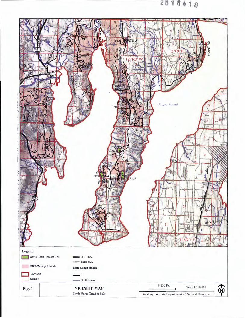
Washington State Department of Natural Resources (DNR) (Figure I - Vicinity Map). We
provide this information to describe the engineering geo logic risk assessment conducted for this
proposed harvest.
Around the sale , we remotely identified inner gorge and bedrock hollow topography. A trained
forester or li censed geologist confirmed the presence of these features during field visits. The
inner gorge features are bound out of the sale and excluded from the proposed harvest area. A
bedrock hollow landform is present w ithin the proposed harvest in unit 4. As presented in this
report there is no delivery potential from this feature.
Steep bluffs are located west of unit 4 where active erosion is dominated by toppling. Published
geologic mapping shows the bluffs in this area are comprised of non-glacial Whidbey Formation
sediments that is capped by glacial deposits of the Possession drift. The harvest boundary is set
back approximately I 00 feet from the slope break.
We also identified relict, dormant and active deep-seated landslides (DSL ' s) around unit 3.
Published geologic mapping indicates the landslides formed in non-glacial sediments but may
include a section of glacial drift. The upslope groundwater recharge areas extend into the harvest
area. As presented herein our opinion that there is a low likelihood that the proposed harvest will
decrease slope stability in these landslides .
2.0 Scope of Services
The scope of our services included:
• Review of the Polenz and others (2013), Contreras, and others (2014) 1 :24,000-scale geo logic maps.
• Review of Forest Practices landslide inventory and landslide hazard zonation maps. • Review of DNR Lidar digital elevation model and derivatives. • Field reconnaissance by State Lands Geo logist John Jenkins on December 17 and 19,
2019 and January 18, 2019. The weather during our site visits was rainy. • Review of DNR digital orthophotographs from 1990, 2005 , 2006, 2009, 20 I I , 2013 ,
2015 and 2017 and DNR aerial photos spanning 1965 through 2003 (Tab le 1 ). • Preparation of this report .
John Jenkins, a licensed engineering geo logist (LEG # 1818) prepared this report. He is a
"qualified expert" for timberland slope stabi lity evaluation (see Qualifications summary
in Append ix A).
3
Engineering Geologic Risk Assessment Coyle Sorts Timber Sale
Table 1: Historic Aerial Photos Reviewed
Year Flown Project Symbol Scale
1965 OLY-65 I :12,000
1972 JK-72 I :12,000
1973 MLM-73 I :24,000
1976 NW-C-76 * I :24,000
1977 OL-77 1:12,000
1981 OL-81 I :12,000
1985 OL-85 I: 12,000
1990 OL90 I : 12,000
1997 OL-97 I :12,000
2003 OL-C-03 I :12,000
3.0 Site and Project Description
2 February 10, 2020
Photograph Numbers
9
44, 45 , 29, 30, 31
7, 8
57, 58
8, 9, 10, 11
10, 11 , 62
9, II , 139, 140, 116, 117
103
289, 213
169, 147, 148, 168
The proposed sale is located in Township 26N, Range 0 I W, Sections I 0, 15, 16 and 33, and in
Township 27N , Range 0 I W, Section I 0, (Willamette Meridian) . It is approximately 6 miles southeast of Quilcene, Washington in Jefferson County along the Coyle county road (Figure I -
Vicinity Map. Five variable-retention harvest units and two variable density-thinning units
comprise the sale. Units 1-5 have approximate areas of 5, 25 , 54, 37, and 8 acres, respectively.
Units 6 and 7 are approximately 12 acres and 1 acre, respectively. Ground-based logging
methods are proposed for approximately 55 percent of the sale. Cable-based logging with hand
falling methods are proposed for approximately 25 percent, while cable or tethered logging
methods are proposed on 20 percent of the area. Restrictions are in place for ground logging
equipment in units exhibiting shallower soils, and in areas with steeper slopes.
Approximately 16, I 00 lineal feet of pre-haul road maintenance, 4,820 feet of new construction,
and 280 feet of reconstruction is planned as part of the harvest. Proposed road construction and
improvements are presented in Figure 2. Refer to the Road Plan document and the Forest
Practices application for detailed road information.
4.0 Geologic Setting
The site is located on the Toandos Peninsula within the Hood Canal portion of the Puget
Sound. Recent 7.5-minute quadrangle published geologic maps by the Washington Division of
Geology and Earth Resources (Polenz and others, 2013; Contreras and others, 2014) cover the
4
Engineering Geologic Risk Assessment February I 0, 2020 Coyle Sorts Timber Sale
Coyle Sorts timber sale . Hundreds of feet of glacial and non-glacial sediments underlie the
peninsula and bedrock is not exposed or mapped in the project region. The sediments include
both northern-sourced continental glaciation and Olympic mountain sourced alpine glaciation
events. Summaries of the mapped geology by unit are presented in Section 5.0 of this report.
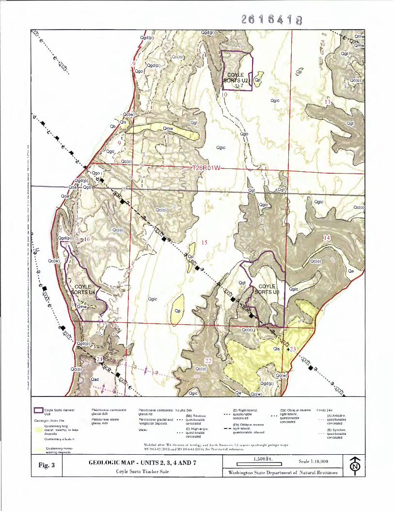
Figure 2: Geologic Map - Units 2, 3, 4 and 7 is modified from Polenz and others, 2013.
5.0 Unstable Slopes Review
The Slope Stability Maps included with the FPA for Coyle Sorts show the potentially unstable
slopes referenced in this section of the report.
5.1 Forest Practices Landslide Inventory Review We consulted the Forest Practices Landslide Inventory (LSI) and Landslide Hazard Zonation
(LHZ) databases during our office review. No LHZ mapping is available for the sale area. LSI
polygons are not located in the site region . Geologic mapping by Polenz and others (2013)
shows Quaternary landslides around unit 3 and a Quaternary mass wasting unit in unit 4 (Figure
2). Those features are discussed in section 5.5 and 5.6, respectively.
5.2 Units 1 and 6
Units I and 6 overlie a gently sloping plateau that is underlain by Fraser-age ice-contact
glacial deposits (Contreras and others, 2014) . West of the unit are drainages cut into the
plateau and the coastal bluffs where older Pleistocene glacial and non-glacial deposits are
exposed. The referenced geologic map shows Quaternary landslides and mass wasting deposits
along these steeper drainages about ½ mile to the west. The unit is not within the upslope
groundwater recharge area being separated topographically by north-south oriented ridges and
valleys identified as glacial flute landforms. Thus, potentially unstable slopes and rule
identified landforms are not present in and around units I and 6.
5.3 Unit 5
Unit 5 is located on a gentle southwest sloping plateau underlain by glacial ice-contact
deposits and till (Polenz and others, 2013). Drainages cut into the plateau and coastal bluffs
expose older Pleistocene glacial and non-glacial deposits. The referenced geologic map shows
Quaternary mass wasting deposits along the bluffs and landslides along these steeper
drainages. However, topographically the site is not within the upslope groundwater recharge
area of the bluffs or drainages. Thus, potentially unstable slopes and rule identified landforms
are not present in and around unit 5.
5.4 Units 2 and 7
An inner gorge is present along a type 3 stream west of units 2 and 7 (Figure 3: Site Map -
Units 2 and 7). This feature is included within the riparian management zone (RMZ). Leave
5
Engineering Geologic Risk Assessment Coyle Sorts Timber Sale
ii February 10, 2020
trees are also planned along swales directed towards this stream. Tail holds are proposed on
the west side of the inner gorge. The inner gorge is protected within the RMZ and tail holds
spanning the feature are unlikely to reduce slope stability.
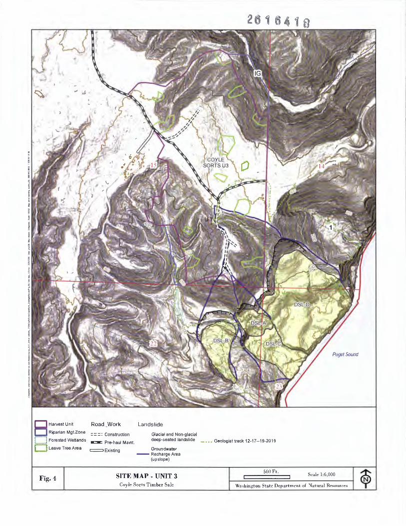
5.5 Unit 3
Unit 3 is located along the eastern side of the peninsula and is bordered by private timberlands
on the east and south. The central part of the unit is a gently sloping plateau at an elevation of
approximately 440 feet. Steeper slopes occur on the northern, western and southern portions of
the unit. As described below, an inner gorge is present around the sale to northeast and deep
seated landslides occur to the south and southeast (Figure 4: Site Map - Unit 3).
5.5.1 Published Geologic Map
Geologic mapping by Polenz and others (2013) show the plateau is underlain by a relatively
thin layer of Vashon Drift identified as glacial till and ice contact deposits (map units Qgt and
Qgic; Figure 2- Geologic Map) . The surrounding slopes down to sea level are mapped as Pre
Vashon alluvium of the Olympia nonglacial interval (map unit Qc(o)) and Quaternary
landslide deposits (Qls) . A northwest-southeast trending oblique slip fault is mapped through
these sediments but is shown as concealed beneath the Vashon age deposits and mapped
landslide deposits .
Southwest of the landslide deposits a section of Pre-Vashon Possession Drift, undivided (map
unit Qgd(p)) that is underlain by Pre-Vashon nonglacial sediments of the Whidbey Formation
(Qc(w)). These deposits occur on the upthrown side of the mapped fault based on review of
cross section B-B ' in Polenz and others (2013) .
The referenced geologic map shows Quaternary landslides deposits Qls around the southern
part of unit 3 that formed within the Pre-Vashon nonglacial and possibly Possession drift
glacial deposits . (Figure 2). The limits of four deep-seated landslides mapped for this project
(DSL-A through DSL-D; Figure 4) overly the landslide deposits map unit on the published
geologic map.
Landslide deposits are also mapped (Polenz and others, 2013) in the valley to the northeast
(point I on Figure 4). Reconnaissance indicates debris flow deposits occur along the axis of
this valley that have been derived from shallow failures on the surrounding steep slopes.
Recent failures were observed and expose medium dense sand with some rounded gravel and
cobbles. Where observed along the channel at lower elevations the thickness of the debris was
less than 5 feet and overly moderately cemented primarily coarse-grained sediments.
5.5.2 Deep Seated Landslides
The bodies and head scarps of four deep-seated landslides were mapped for this project based
on interpretation of geomorphology from Lidar derivatives and field observations (landslides
DSL-A through DSL-D; Figure 4). Sediments exposed in DSL-D included a thick section of
very stiff, gray, thick bedded silt, clay and fine sand (up to a minimum thickness of
6
Engineering Geologic Risk Assessment Coyle Sorts Timber Sale
~ ii f February I 0, 2020
approximately 20 feet) that is overlain by an approximately 4-feet thick exposed section of
diamicton generally composed of boulders, gravel and sand with a matrix of silt, clay and
sand. This may be correlated to Possession Drift. Although located within the landslide the
materials appeared undeformed and not broken or sheared by landslide movement. Downslope
where channel incision is present sediments exposed include relatively undeformed
interbedded stiff to hard, fine-grained and dense to very dense, coarse-grained sediments
overlain by less dense landslide debris with mixed lithology. lnterbedded stiff fine grained
sediments and dense to very dense coarse-grained sediments were observed during
reconnaissance in and around the other mapped landslides.
Evidence of recent or historic movement was observed in the field for DSL-A and DSL-B
whereas DSL-C and DSL-D appeared dormant with the upper portion of DSL-D being relic.
Review of historic aerial photographs indicate harvest occurred on lands I ides DSL-A, -8, and
C in the late I 990 ' s. Tree cover on DSL-A and DSL-B was dominantly even age alder with
larger diameter trees on DSL-B. Evidence of bare ground and scarps is apparent in post
harvest aerial photographs locally on DSL-A. DSL-A is hummocky and may correlate to
reactivation of the head scarp. DSL-B appears to be a rotational slide that transitions to a
translational type slide downslope. This portion included several recent appearing scarps up to
about 3 feet in height that were oriented normal to the southeastern movement direction .
Evidence of recent or historic movement was lacking on DSL-C and DSL-D. However, recent
erosion and debris slides and debris flows along channels is present in the southeastern part of
DSL-D. Debris slides along the channels were also observed in historic aerial photographs.
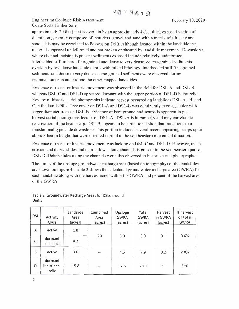
The limits of the upslope groundwater recharge area (based on topography) of the landslides
are shown on Figure 4. Table 2 shows the calculated groundwater recharge area (GWRA) for
each landslide along with the harvest acres within the GWRA and percent of the harvest area
of the GWRA.
Table 2: Groundwater Recharge Areas for DSLs around Unit 3
Landslide Combined Upslope DSL Activity Area Area GWRA
Class (acres) (acres) (acres)
A active 1.8
dormant 6.0 3.0
C indistinct
4.2
B active 3.6 -- 4.3
dormant D indistinct - 15.8 -- 12.5
relic
7
Total Harvest % harvest GWRA in GWRA of Total (acres) (acres) GWRA
9.0 0.1 0.6%
7.9 0.2 2.8%
28.3 7.1 25%
Engineering Geologic Risk Assessment Coyle Sorts Timber Sale
February I 0, 2020
Because landslides DSL-A and - Care contiguous, the total GWRA to these slides is
combined. A type 4 stream occurs along the western margin of DSL-B . This is interpreted to
be a gaining stream thus is not contributing groundwater to the landslide from the drainage
basin west of unit 3.
The GWRAs extend into the proposed harvest area on unit 3. A tailhold may be placed on the
relic portion of DSL-D. The percentage of harvest of the GWRA is estimated at approximately
one percent for active DSL-A and dormant indistinct DSL-C; and three percent for active
DSL-B. The percent of harvest is approximately 25 percent for DSL-D where the activity class
includes dormant indistinct and relic portions .
Based primarily on the relatively low percentages of harvest within the groundwater recharge
area we conclude there is a low likelihood that the proposed harvest and tailhold within DSL
D will trigger or contribute to further movement of these landslides.
5.5.3 Inner Gorge
An inner gorge is present along a type 3 stream around the northeast portion of unit 3 (IG on
Figure 4) . This feature is protected within the RMZ for the stream . Additional protection is
from leave tree areas along swales that descend to the stream. Convergent areas above the type
3 stream are not classified as bedrock hollows as the slopes are between 60 and 65 percent.
Tail hold cables may extend across the inner gorge .
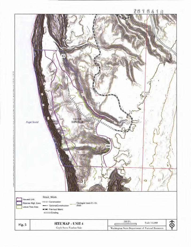
5.6 Unit 4
Geologic mapping (Polenz and others, 20 I 3; Figure 2) indicates the steep slopes along the
coastal bluff west of unit 4 are comprised of Whidbey Formation (local relief of approximately
200 feet). The Whidbey Formation is capped by Possession Drift that extend into the western
part of the unit up to approximately 240 feet elevation. This is overlain by pre-Vashon alluvium
of the Olympia non-glacial interval that underlies most of the unit. Further east on the plateau is
Vashon ice-contact deposits (Figure 2) .
Based on field observations and review of Lidar derivatives active erosion processes are
dominated by topples with the failed mass locally forming colluvial aprons (Figure 5: Site Map
- Unit 4) . The harvest unit boundary is set back approximately I 00 feet or greater from the edge
of the bluff. Leave tree areas are located along most of the swales directed towards the bluff for
additional protection.
Inner gorge segments are present along the north-northwest trending stream around the northeast
corner of unit 4 (IG on Figure 5). The harvest boundary along the RMZ or leave tree area is
located at or beyond the slope break; thus this feature is excluded from the harvest.
A relatively large swale is present in the southern part of unit 4. No incision or a stream is
present along the length of this swale to the bluff. A bedrock hollow landform is present along
the head of the swale on the east side. Locally shallow slumps have occurred on this land form.
Debris have accumulated along swale bottom that is mapped as a Quaternary mass wasting unit
8
« 41 a
Engineering Geologic Risk Assessment Coyle Sorts Timber Sale
February I 0, 2020
(Polenz and others, 2013). Evidence of historic movement along the axis was not observed as
conifer trees appeared straight and not deformed by slope movement. The slope along the swale
beneath the steeper area is approximately 13 percent. The base of the convergent area is
approximately 800 feet from the bluff edge. Because of the distance from the bluff, lack of a
channel, and the relatively low gradient, there is no delivery potential from potential failures
within the bedrock hollow landform. We conclude harvest of this area will therefore not result in
delivery.
6.0 Forest Practice Rule Statements
The following are the required Forest Practice Rule statements addressing WAC 222-10-030 (I)
(a, b, c). These responses are based on the data and discussion presented above.
(a) The likelihood that the proposed forest practices will cause movement on the potentially unstable slopes or landforms, or contribute to further movement of a potentially unstable slope or landform is low.
We identified rule-identified potentially unstable slopes and landforms in and around the
sale, including inner gorges, and glacial-nonglacial deep-seated landslides and associated
upslope groundwater recharge areas. The inner gorges are protected within no-harvest
riparian management zones with additional leave trees in some areas. Tailholds may
extend over some of the inner gorge landforms. We conclude that the proposed forest
practices are unlikely to contribute to or cause movement on the inner gorge landforms
because they are excluded from harvest.
Harvest is proposed on approximately 25 percent or less of the groundwater recharge area
to glacial-nonglacial deep-seated landslides around unit 3. Specifically the proposed
harvest around the active deep-seated landslides is less than 3 percent and approximately
25% of a dormant or relic landslide. A tailhold is proposed to extend on to a relic
landslide. We conclude that the proposed forest practices are unlikely to contribute to or
cause movement on the deep-seated lands I ides as the percent of harvest of the recharge
area is low.
(b) The likelihood of delivery of sediment or debris to a public resource, or in a manner that would threaten public safety is low.
9
This conclusion is based on our opinion that there is low likelihood the proposed forest
practices will cause movement on the potentially unstable slopes or landforms. However, if
there is any shallow failures along the inner gorge landforms, there may be a high likelihood
that sediment and debris will be delivered to a public resource. Again, it is our opinion that
there is an overall low risk of such an outcome, but the location of some potentially unstable
slopes could have delivery.
There is low likelihood for public safety to be threatened.
Engineering Geologic Risk Assessment Coyle Sorts Timber Sale
(c) Any possible mitigation for the identified hazards and risks:
February I 0, 2020
The primary mitigation measure for the identified hazards and risks is avoidance. Features
that were recognized during the geologic evaluation as having a moderate or high potential to
be unstable, and with the potential to deliver to a public resource, have been bound out of the
proposed harvest.
7.0 Assessment Limitations
This report is intended to be submitted with the forest practices application (FPA) for the Coyle
Sorts timber sale to meet the requirements of a IV-special classification . The conclusions
presented in this report are based on observed site conditions as they existed at the time of the
field visits. It is not possible to fully define the geologic conditions of the site based on this
limited investigation; however, the work was performed using practices consistent with
geologic and geotechnical industry standards in the region for forest slope stability. It is not
possible to predict slope movement with certainty with the available scientific knowledge.
If any changes in the proposed FPA are formulated or carried out differently in the field than
currently proposed, our conclusions and recommendations shall not be considered valid unless
those changes are reviewed in writing by the author.
8.0 References
Contreras, T.A., Patton, A.I. ; Paulin, G .L. , Hubert, I.J. , Cakir, R. , and Carson , R.J ., 2014 ,
Geologic map of the Quilcene 7.5-minute quadrangle, Jefferson County, Washington:
Washington Division of Geology and Earth Resources Map Series 2014-03 , I sheet, scale
I :24,000, with 27 p. text
Polenz, M ., Petro, G.T. , Contreras, T.A. , Stone, K.A. , Paulin, G.L. , and Cakir, R. , 2013 ,
Geo logic Map of the Seabeck and Poulsbo 7.5-minute quadrangles, Kitsap and Jefferson
Counties, Washington, Washington Division of Geo logy and Earth Resources Map Series
2013-02, October 20 13, I sheet, scale I :24,000, with 43 p. text.
Washington Administrative Code 222-16-050 ( I )(d)( i)
10
Coyle Sorts Harvest Unit
0NR-Managed Lands
• Township
O section
Fig. I
= U.S. Hwy.
-- State Hwy
State Lands Roads
--1:
-- 9: Unknown
VICINITY MAP Coyle Sorts Timber Sa le
Puget So1111d
8,250 Ft. Scale 1:100,000
0 a:: ..... z 6 a.
Washington Sta te Department of Natura l Resources
c<. ·~.
<.". ·-~
f fi-----1 :
• l. :
•. C. ~
D Coyle Sorts Harvest Unit
Geologic Units 24k
Quaternary bog , marsh , swamp, or lake deposits
Quaternary alluviu m
Quaternary masswastin de osits
Fig. 3
Pleistocene continental glacial drift
Pleistocene alpine glacial drift
Pleistocene continental Faults 24k glacial till
Pleistocene glacial and nong lacial deposits
Water
(Bb) Reverse , questionable concealed
(C) H igh-angle, questionable concealed
(0) Right-lateral , questionable concea led
41
(Eb) Oblique reverse - - right-lateral ,
questionable inferred
(Eb) Oblique reverse right-lateral , questionable concealed
Folds 24k
(A) Anticline . questionable concealed
(B) Syncline, questionable concea led
\l otlifi,,d afln: " '·\ Oi,i,•1011 uf G,·olug~ an d E :1rll1 B,•~0 11r,•,•~ 7.:, 111inu1,, ' l' rn d rangl,· g.-ulugir "'"P·• \I S 20 13-02 (20 13) ;uHI \IS 20 1 1-03 (20 1 I): S,,,. T,• x l for full r..f,•m,,·,• ,-.
GEOLOGIC MAP - UNITS 2, 3, 4 AND 7
Coyle Sor ts Timber Sale
1,500 Ft. Scale 1: 18,000
\Vas hington State Depar tment of Na tura l Resources
/ I

D Harvest Unit
D Riparian Mgt.Zone
D Leave Tree Area
f: :: Type b wetland U7
D Forested Wetlands
Fig. 3
,--·, L , Wetland Mgmt. Zone
••-"
Road Work
: = =: Construction
=Existing
SITE MAP - UNITS 2 AND 7 Coyle Sorts Timber Sa le
I"'.., '. t ' :,.._, . ;· -' ,
'
) • . • I • -
,, ..f '• .. ,.. J
✓
;;
'"
600 Ft. Sca le 1:7,200
Washington State Department of Natura l Resources
I l
. '
D Harvest Unit
D Riparian Mgt.Zone
D Forested Weijands
D Leave Tree Area
Fig. 4
Road_Work
: = =: Construction
-=-= Pre-haul Maint.
= Existing
Landslide
Glacial and Non-glacial deep-seated landslide
Groundwater - Recharge Area
(upslope)
SITE MAP - UNIT 3 Coy le So r ts Timber Sa le
Puget Sound
-··· Geolog ist track 12-1 7--1 9-201 9
500 Ft. Scale 1:6,000
Washington State Depar tment of Na tural Resources
l
Puget Sound
D Harvest Unit
D Riparian Mgt. Zone
D Leave Tree Area
Fig. 5
Road Work
= = =: Construction Geo log isl track O 1-10-- - OptionalConstruction - • • • 2020
-=-= Pre-haul Main!.
=Existing
SITE MAP - UNIT 4 Coyle Sorts Timber Sa le
500 Ft . Sca le 1 :6,000
Washin gton State Dep artment of Nat ural Resources
,'• 0 a, ..
Engineering Geologic Risk Assessment Coyle Sorts Timber Sale
11
Appendix A
Geologist Qualifications
February 10, 2020
John Jenkins has a Bachelor of Arts degree (1980) and a Master of Science degree ( 1985), both in geology, from University of Illinois, Champaign-Urbana, and the New Mexico Institute of Mining and Technology, Socorro, NM. The Washington Department of Natural Resources (DNR) has employed him since April 2012. His duties include providing technical and scientific support to the agency's Forest Resources Division. A majority of his work with DNR has focused on landslide risk assessment related to forest practices activities. Mr. Jenkins has over 30 years of experience in slope stability risk assessment ranging from site-scale to regional-scale projects for public agencies and private parties. Additional professional experience was gained during employment with the Oregon Department of Transportation, the U.S. Bureau of Reclamation and geologic mapping for the U.S. Geological Survey. He has been recognized as a "qualified expert" as outlined in WAC 222-10-030(5).
11