COVER PAGE - Amazon Simple Storage Service · 1 COVER PAGE Project name: MJUMITA Community Forest...
173
1 COVER PAGE Project name: MJUMITA Community Forest Project (Lindi) Project location: Lindi Rural District and Lindi Municipality, Lindi Region, Tanzania Project Proponent: Multiple project proponents (villages) represented by MJUMITA Contact Person: Rahima Njaidi, Executive Director, MJUMITA e-mail and phone: [email protected] +255 22 2669007 Auditor: SCS Global Services Auditor Contact Person: Scott Eaton, Coordinator, Greenhouse Gas Verification, Natural Resources Division, SCS Global Services Auditor e-mail and phone: [email protected] +1 510 452 8027 Project start date: 1 st April 2010 GHG Accounting period: 21st April 2012 - April 20 th 2042 Project lifetime: 1st April 2010 and will continue until April 20 th 2042 Full Validation using CCB Standards Version 3 History of CCB Status: First Validation Date of completion of this version of the PDD: 18th April 2014 Expected schedule for verification: 1st Verification to be conducted at the same time as the First Validation. Future verification will be timed with VCS verifications every 1-2 years.
Transcript of COVER PAGE - Amazon Simple Storage Service · 1 COVER PAGE Project name: MJUMITA Community Forest...

1
COVER PAGE
Project name: MJUMITA Community Forest Project (Lindi)
Project location: Lindi Rural District and Lindi Municipality, Lindi Region, Tanzania
Project Proponent: Multiple project proponents (villages) represented by MJUMITA
Contact Person: Rahima Njaidi, Executive Director, MJUMITA
e-mail and phone: [email protected] +255 22 2669007
Auditor: SCS Global Services
Auditor Contact Person: Scott Eaton, Coordinator, Greenhouse Gas Verification, Natural
Resources Division, SCS Global Services
Auditor e-mail and phone: [email protected] +1 510 452 8027
Project start date: 1st April 2010
GHG Accounting period: 21st April 2012 - April 20th 2042
Project lifetime: 1st April 2010 and will continue until April 20th 2042
Full Validation using CCB Standards Version 3
History of CCB Status: First Validation
Date of completion of this
version of the PDD:
18th April 2014
Expected schedule for
verification:
1st Verification to be conducted at the same time as the First
Validation. Future verification will be timed with VCS verifications
every 1-2 years.

i
SUMMARY OF THE PROJECT’S EXPECTED CLIMATE, COMMUNITY AND
BIODIVERSITY BENEFITS
Operating within the Coastal Forests of Eastern Africa biodiversity hotspot, the community-led
project will fulfil the following objectives:
Climate
To reduce emissions of greenhouse gases from unplanned deforestation on village land
through sustainable forest management.
To enhance the carbon stock within village forest reserves by allowing natural
regeneration
Community
To maintain forest ecosystem services and a sustainable supply of forest products
through an equitable and effective system of participatory forest management.
To generate individual cash incomes from REDD for investing in improved agricultural
practices and other enterprises and for livelihood diversification with a particular focus on
poorer households and women.
To improve the quality and availability of public services and infrastructure.
Biodiversity
To conserve threatened and endemic species.
To conserve an extensive area of Eastern African Coastal Forest.
The project will work with ten communities initially with the possibility of including other
communities within the project zone in future following a programmatic approach.
Gold Level criteria
The project aims to meet the following gold level criteria:
GL 1: Climate change adaptation benefits: The project will increase small-scale farmers
resilience to climate change as well as channeling funds for community development projects
including health facilities and water storage and supply infrastructure that will reduce community
vulnerability to the increased prevalance of disease and the water shortages that are predicted
for the area as a result of climate change. By establishing community based forest management
and improving agricultural practices, the project will safeguard biodiversity values against the
predicted increased pressure from shifting cultivation due to climate-change related stresses.
GL2. Exceptional Community Benefits: Community benefits lie at the heart of this project.
Project design has been led by communities and communities are the legal managers of the
entire project zone. From its inception, the project has aimed to demonstrate a pro-poor model for
REDD.
GL 3: Exceptional Biodiversity Benefits: The project area includes populations of the Critically
Endangered primate, the Rondo galago as well as three plant species categorized as
Endangered by IUCN; and four plant species categorized as Vulnerable by IUCN. By protecting
the habitat of these species the project aims to prevent population declines within the project
area.

ii
MJUMITA Community Forest Project
(Lindi)
Project Design Document (PDD)
For Full Validation Using the Climate, Community and Biodiversity (CCB)
Project Design Standards Third Edition – December 2013
Version Date: 16/04/2014

iii
Table of Contents
COVER PAGE ........................................................................................................................................ 1
TABLE OF CONTENTS ......................................................................................................................... III
LIST OF MAPS ...................................................................................................................................... III
LIST OF TABLES ...................................................................................................................................IV
ACKNOWLEDGEMENTS ......................................................................................................................VI
G1. PROJECT GOALS, DESIGN AND LONG-TERM VIABILITY .......................................................... 1
G2. WITHOUT-PROJECT LAND USE SCENARIO AND ADDITIONALITY ....................................... 34
G3. STAKEHOLDER ENGAGEMENT ................................................................................................. 38
G4. MANAGEMENT CAPACITY.......................................................................................................... 51
G5. LEGAL STATUS AND PROPERTY RIGHTS ............................................................................... 55
GL1. CLIMATE CHANGE ADAPTATION BENEFITS ......................................................................... 65
CM1. WITHOUT-PROJECT COMMUNITY SCENARIO ...................................................................... 74
CM2. NET POSITIVE COMMUNITY IMPACTS ................................................................................... 85
CM3. OTHER STAKEHOLDER IMPACTS ........................................................................................... 94
CM4. COMMUNITY IMPACT MONITORING ....................................................................................... 94
GL2. EXCEPTIONAL COMMUNITY BENEFITS .................................................................................. 95
B1. BIODIVERSITY WITHOUT–PROJECT SCENARIO .................................................................... 104
B2. NET POSITIVE BIODIVERSITY IMPACTS.................................................................................. 112
B3. OFFSITE BIODIVERSITY IMPACTS ........................................................................................... 116
B4. BIODIVERSITY IMPACT MONITORING ..................................................................................... 116
GL3. EXCEPTIONAL BIODIVERSITY BENEFITS ............................................................................. 117
ANNEX 1 REFERENCES .................................................................................................................. 121
ANNEX 2. MOU TEMPLATE BETWEEN MJUMITA AND THE COMMUNITIES ............................... 124
ANNEX 3 PUBLIC SERVICES AND INFRASTRUCTURE ORIGINAL ............................................. 131
ANNEX 4. THEORIES OF CHANGE FOR PROJECT INTERVENTIONS. ....................................... 134
ANNEX 5 PROJECT CASHFLOW AND PROJECTED REVENUES AND COSTS .......................... 161
List of Maps
Map 1: Project area location ................................................................................................................... 4
Map 2: Boundaries of the Project Zone villages responsible for managing the Project Area. ................ 5
Map 3: Project area streams, rivers, and topography. ............................................................................ 6
Map 4: Project area geology. .................................................................................................................. 7
Map 5: Lindi annual mean rainfall. .......................................................................................................... 8
Map 6: Lindi Mean Annual Temperature. ................................................................................................ 9
Map 7: Project area forest types. .......................................................................................................... 10
Map 8: Map of initial project area and participating villages. ................................................................ 14

iv
Map 9: The potential project zone (reference region) and current project zone (project villages). ...... 14
Map 10: Potential Rondo galago habitat. ........................................................................................... 114
List of Tables
Table 1: Above ground water sources within the project villages. .......................................................... 5
Table 2: List of Wards, Villages and Sub-villages deriving benefits from the Project Area. ................. 12
Table 3. Project activities ..................................................................................................................... 15
Table 4: Key dates and milestones in the project’s development. ........................................................ 27
Table 5: Risks to the expected project benefits and mitigation measures. ........................................... 28
Table 6: Potential project expansion villages to be included under the programmatic approach. ........ 33
Table 7: Stakeholder consultation process. .......................................................................................... 40
Table 8: Causal model to explain how project activities will achieve the project’s predicted adaptation
benefits. ................................................................................................................................................. 70
Table 9: List of participating villages and sub-villages. ......................................................................... 75
Table 10: Village populations ................................................................................................................ 76
Table 11: Potential risks to community benefits from project activities. ............................................... 87
Table 12: Number of threatened taxa recorded from village land in Lindi. ......................................... 107
Table 13: List of threatened taxa recorded from village land in Lindi. ................................................ 108
Table 14: Summary of the number of restricted range taxa. .............................................................. 109
Table 15: List of restricted range taxa recorded from Village land in Lindi ......................................... 109
Table 16: List of globally threatened species recorded at the site. ..................................................... 118
Table 17: Deforestation rates in forests with threatened plant and animal species. .......................... 119
Table 18: Impact assessment of strategy to improve village governance. ......................................... 135
Table 19: Impact assessment of activity to implement sustainable land management. ..................... 141
Table 20: Impact assessment of Strategy to establish sustainable forest management through PFM.
............................................................................................................................................................ 142
Table 21: Impact assessment of Strategy to establish a community carbon trading enterprise (CCTE)
............................................................................................................................................................ 148
Table 22: Impact assessment of Strategy to improve agricultural practices and productivity ............ 151
Table 23: Impact assessment of strategy to develop income generating activities (IGA) .................. 155
Table 24: Impacts of strategy to improve social services and infrastructure. ..................................... 158
v
List of Figures
Figure 1: Generic model of entry points for eight community development strategies proposed by
communities and stakeholders of the Lindi REDD project (NB: Strategy 6 in this diagram includes
Activities 6 and 7) .................................................................................................................................. 26
Figure 2: Maximum and minimum temperatures (º c) for the baseline year (2000) and changes by
2030 and 2050 relative to the baseline year. From Tumbo et al. 2010. ............................................... 65
Figure 3: Baseline year rainfall and rainfall changes to 2030 and 2050 under the two emission
scenarios (A1B and A2). From Tumbo et al. 2010. .............................................................................. 67
Figure 4. Conceptual model for depicting factors contributing to poor village governance (and
ultimately the absence of community participation in natural resource management. ....................... 138
Figure 5. Results chain for Activity 2 to implement sustainable land management........................... 140
Figure 6. Results chain for Activity 3 on community based forest management. .............................. 147
Figure 7: Results chain for strategy to establish community carbon trading enterprise and PFM
networks .............................................................................................................................................. 150
Figure 8: Results chain for Strategy to Improve Agricultural Practices and Productivity .................... 154
Figure 9: Results chain for Strategy to establish income generating activities ................................... 157
Figure 10: Results chain for Strategy to improve social services and infrastructure .......................... 160

vi
Acknowledgements
The project has been designed by the citizens of the ten participating villages: Kinyope, Kiwawa,
Likwaya, Makumba, Milola Magharibi, Mkanga 1, Mkombamosi, Muungano, Nandambi and Ruhoma.
The Village Councils, Village Natural Resources Committees, Village Land Use management
committees, REDD special committees, MJUMITA local networks, elders and ordinary citizens have
invested their time, hard work and knowledge in designing this project.
The design of this project has been made possible through the generous support of the people of
Norway through the grant from the Royal Norwegian Embassy to the Tanzania Forest Conservation
Group for the project ‘Making REDD work for communities and forest conservation in Tanzania’. We
are grateful to the staff of the Royal Norwegian Embassy including Ivar Jorgensen, Inger Naess,
Simon Milledge, Mille Lund, Berit Kristin Tvete and Yassin Mkwizu for their advice and support
throughout the five year project design process.
The design has been made possible through a partnership between the Tanzania Forest
Conservation Group and the Mtandao wa Jamii wa Usimamizi wa Misitu wa Tanzania in collaboration
with the Institute of Resource Assessment, the Regional Community Forestry Training Centre for
South-East Asia, CARE International in Tanzania, the Clinton Climate Initiative, the Valuing the Arc
project of WWF and Sokoine University of Agriculture.
The design of the ‘MJUMITA Community Forest Project (Lindi)’ was facilitated by the Making REDD
work project team:
Executive Director – TFCG: Charles Meshack
Executive Director – MJUMITA: Rahima Njaidi
Project Manager: Bettie Luwuge
Forest Enterprise Coordinator: Someni Mteleka
Technical Advisors: Nike Doggart and Theron Morgan-Brown
Lindi Site Coordinator: Nuru Nguya
Project Officers (Lindi): Raymond Nlelwa, Baraka Samwel and Hamza Omari
GIS Officer Sylvia Kalemera
Agriculture Officer (Lindi): Mohamand Nyamangaro
Monitoring Officers: Emmanuel Lyimo (2009–13), Habibu Said (2013) and Mwilla
Mbegu (2014)
Drivers: Joel Mbasha and Hezron Swago
With the support of Lindi District Council and Lindi Municipal Council:
Name Department Title
Charles Mwaipopo
Department of Land and Natural
Resources
DNRO ( District Natural Resources
Officer)
Selemani Ngaweje
Livestock and Fisheries
Development DFsO ( District Fisharies Oficer)
Stanford Mahimbo
Dept of Land and Natural
Resources DFO ( District Forest Officer)
Manace Nkuli
Department of Land and Natural
Resources DLO ( District Land Officer)

vii
Name Department Title
Ally Namila
Department of Agriculture,
Irrigation and Cooperatives
PAFO (Principle Agricultural Field
Officer)
Abdallah Musa
Department of Land and Natural
Resources DLS ( District Land Surveyor)
Joyce Kazana
Livestock and Fisheries
Development Fisheries Officer
Ally Nnunduma
Department of Planning and
Statistics Planning officer
Gasper Msese
Department of Land and Natural
Resources Game Officer
Patric Senga
Department of Land and Natural
Resources District Game Officer
Grace Mbaruku Administration Department DED ( District Executive Director)
Dr. Ally Himid Nssoro District Commissioner
Vicent Fikiri
Department of Primary
Education Cultural Officer
F. Matunda
Department of Agriculture,
Irrigation and Cooperatives DALDO
Abubakri Sinani
Tandangongoro Ward Agricultural
Officer (WAEO)
Ismail Cosmas WAEO Rutamba
Mponjori Mwakosya WAEO Milola
Juma Ponera Ag WAEO Nangaru
Saidi Mkingie
WLEO (Ward Livestock Extension
Officer)
The Late Yustin Mdachi Former WAEO - MATIMBA
Oliver Ng'utto
Department of Community
Development Community Development Officer
Lucy Lyakurwa
Department of Community
Development Community Development Officer
Ezra Apiyo
Natural Resources (Lindi
Municipality) Municipal Natural Resource Officer
Mohamed Chimbuli
Natural Resources (Lindi
Municipality) Municipal Forest Officer
The Project Design Document was written by Nike Doggart, TFCG Technical Advisor.
The project design has been guided by members of the Project Advisory Committee including:
Evarist Nashanda, Mohammed Borry, Anna Lawuo and Gerald Kamwenda, Tanzania Forest Service
Othmar Haule, Kilosa District Council
Charles Mwaipopo, Lindi District Council
Freddy Manyika and George Kafumu, Vice President’s Office
Thabit Masoud, Amour Bakar and Ally Thani, CARE Tanzania
viii
Lameck Noah, Beda Karani and Edward Kimweri, Regional Secretariat - Morogoro
Zawadi Jilala, Regional Secretariat – Lindi
Julitha Masanja, National REDD Task Force (NRTF)
Sanford Kway, Prime Minister’s Office – Regional Administration and Local Government
Shukuru Nyagawa, Edmund Mabhuye and Dr Emma Liwenda, Institute of Resource Assessment
Esther Yamat, Cassian Sianga and Carol Sorensen, Tanzania Natural Resources Forum (TNRF)
Erneus Kaijage, Clinton Climate Initiative
Professor Salim Maliondo, Climate Change Impact, Adaptation and Mitigation (CCIAM) programme,
SUA
Professor Kessy, Dr Suzan Augustino, Dr Katani and Professor Maliondo, Sokoine University of
Agriculture
Gloria John Massao, Mpingo Conservation and Development Initiative
Mary Swai, Tanzania Traditional Energy Development Organisation (TaTEDO)
Ronnakon Triraganon, Regional Community Forestry Training Centre
Dr Sara Namirembe, Forest Trends (Katoomba Incubator)
Additional technical input has been provided by:
Kate Forrester-Kibuga on the stakeholder analysis;
Tuyeni Mwampamba and Forest Trends on the Social Impact Assessment and theory of change
development;
Forest Trends and CARE International on the carbon enterprise design;
Roy Gereau and Moses Mwangoka on the botanical values of the project area;
The following VNRC members for their assistance with the botanical surveys:
Mohamed Makunda Ruhoma Village Natural Resource Committee member
Said Liochocho Kiwawa Village Natural Resource Committee member
Ismail Mmonyomonyo Kiwawa Village Natural Resource Committee member
Fadhili J Mtambule Kiwawa Village Natural Resource Committee member
Said Issa Mawala Mkanga Village Natural Resource Committee member
Bakari A.Lyiumu Mkanga Village Natural Resource Committee member
Said Likwena Mkomba Village Natural Resource Committee member
Mohamed Mandutta Mkombamosi Village Natural Resource Committee member
Rajabu Mohamed Mtopella Muungano Village Natural Resource Committee member
Said Mussa Ngapaliji Muungano Village Natural Resource Committee member
Bakari Mfaume Nangonji Ruhoma Village Natural Resource Committee member
Andrew Perkin and Katarzyna Nowak on the vertebrate fauna of the project area; and
Elia Mulungu on the birds of the project area.
The National REDD Task Force have provided valuable oversight to the project development process.

1
GENERAL SECTION
G1. Project Goals, Design and Long-term Viability
Project Overview
G1.1. Identify the primary Project Proponent which is responsible for the project’s
design and implementation and provide contact details.
As all of the project area is on communally owned village land, the project proponents are the
participating project village councils who have overall control over the project area and responsibility
for implementing the project's core activities. However, MJUMITA has signed a communications
agreement (Annex 2) with all project proponents and will serve as the authorized representative in all
interactions with CCB and VCS on behalf of the project proponents. MJUMITA is responsible for
submitting the VCS and CCB project description to a VCS validator/verification body, monitoring
activity data, compiling and submitting monitoring reports for verification, and marketing any VCU
issued to the project on behalf of the project proponents. Therefore, MJUMITA is listed as the primary
contact.
Contact details: Rahima Njaidi, Executive Director
Mtandao wa Jamii wa Usimamizi wa Misitu Tanzania (MJUMITA),
Plot 323, Msasani Village, Old Bagamoyo Road, PO Box 21527,
Dar es Salaam – Tanzania
Tel / Fax: +255 22 2669007
Email: [email protected]
www.mjumita.org
The full list of current project proponents and their contact details is as follows:
No. Name of
Village
Name of
Chairperson
Name of
Village
Executive
Officer
Village Postal
Address
Phone Numbers*
Chairperson Village
Executive
Officer
1 Muungano Juma M.
Njangari
Rashid S.
Rashid
P. O. Box 328
Lindi, Tanzania
0682 400547 0682593698
2 Mkombamosi Rashid
Mwishaweji
Chande A.
Khalifa
P. O. Box 328
Lindi, Tanzania
- 0787370207
3 Makumba Yusuph S.
Pangani
Rashid B.
Mpwili
P. O. Box 328
Lindi, Tanzania
- 0685296221
4 Likwaya Mwalim K.
Tanga
Hereswida
Mathew
P. O. Box 328
Lindi, Tanzania
0783 270129 0782592267
5 Mkanga 1 Athumani
Kimete
Anzigar Lilai P. O. Box 328
Lindi, Tanzania
0689 618090 0787311753
6 Nandambi Rashid S.
Kibaba
Selemani
Kitenge
P. O. Box 328
Lindi, Tanzania
0789 872884 0786048736
7 Kinyope Musa
Athumani
Hamis A.
Mwinyimmad
P. O. Box 328
Lindi, Tanzania
0689 306008 0782591072

2
No. Name of
Village
Name of
Chairperson
Name of
Village
Executive
Officer
Village Postal
Address
Phone Numbers*
Chairperson Village
Executive
Officer
Pilanga
8 Ruhoma Said H.
Katambi
Curben A.
Chitanda
P. O. Box 328
Lindi, Tanzania
- 0686167333
9 Milola
Margharibi
Issa Abdallah
Pilipili
Hamis J.
Mzee
P. O. Box 328
Lindi, Tanzania
0788 951190 0688347913
10 Kiwawa Said M
Manyanya
Ally M.
Akalola
P. O. Box 328
Lindi, Tanzania
0684 977834
neighbor
0787753990
* Dialling instructions: Outside of Tanzania - replace the zero at the beginning of the number with +255.
Inside Tanzania – dial as written.
G1.2. Define the project’s climate, community and biodiversity objectives
The project adopted the Conservation Measures Partnership Open Standards approach to project
planning and the project design process was guided by the Manual for Social Impact Assessment of
Land-Based Carbon Projects (Richards & Panfil 2010).
Through the social impact assessment and participatory development of a theory of change as
implemented at village and landscape level by the project (see Mwampamba et al. 2011), the
following objectives were identified by the stakeholders.
Climate
To reduce emissions of greenhouse gases from unplanned deforestation on village land
through sustainable forest management.
To enhance the carbon stock within the village forest reserves by allowing natural
regeneration.
Community
To maintain forest ecosystem services and a sustainable supply of forest products through an
equitable and effective system of participatory forest management.
To generate individual cash incomes from REDD for investing in improved agricultural
practices and other enterprises and for livelihood diversification with a particular focus on
poorer households and women.
To improve the quality and availability of public services and infrastructure.
Biodiversity
To conserve threatened and endemic species.
To conserve an extensive area of Eastern African Coastal Forest.
When asked to prioritise objectives, communities prioritised sustainable forest management first
followed by improving agricultural practices and then improving public services. Conservation of
threatened and endemic species was not cited as a priority by community members but does reflect
national policy objectives and the objectives of the Civil Society Organisations involved in the project
design. The high biodiversity values of the site were also a key consideration in the selection of the
Noto / Chitoa plateau as a piloting site for REDD.

3
Based on these objectives the project aims to bring about the following net-positive climate,
community and biodiversity impacts.
Positive Climate Impacts
The positive climate impacts are defined in the VCS Project Design Document.
Gold Level 1: Communities are less vulnerable and more resilient to climate change; and biodiversity
values are better conserved even during times of climate-change related increases in deforestation.
Positive community impacts
Community-owned forests will be managed in a participatory, effective and equitable way.
Forest products will continue to be available and accessible to all community members
including the poorest households according to access rules agreed in a participatory way.
Villages will be better governed.
Communities will have more secure land tenure
Water sources will be better protected
Soil erosion will be reduced
Individual incomes will be boosted and diversified by receiving REDD payments.
Women and men farmers, including those from poorer households, will adopt more profitable,
sustainable and climate change resilient agricultural practices and will invest in other
enterprises and / or value addition initiatives.
REDD revenues will contribute to improving public services and infrastructure.
Villages will have village offices.
GL2. Exceptional Community Benefits: Community benefits lie at the heart of this project. Project
design has been led by communities and communities are the legal managers of the entire project
zone. From its inception, the project has aimed to demonstrate a pro-poor model for REDD.
Positive biodiversity impacts
Populations of threatened and endemic species persist within the project area.
Extensive areas of Eastern African Coastal Forests continue to exist within the project area.
There is less pressure on the Eastern African Coastal Forest from deforestation and
degradation drivers.
Communities and other stakeholders are actively engaged in the management of Eastern
African Coastal Forest within the project area.
GL 3: Exceptional Biodiversity Benefits: The project area includes populations of the Critically
Endangered primate, the Rondo galago as well as three plant species categorized as Endangered by
IUCN; and four plant species categorized as Vulnerable by IUCN. By protecting the habitat of these
species the project aims to prevent population declines within the project area.
G1.3. Provide the location (country, sub-national jurisdictions(s)) and a brief overview
of the basic physical and social parameters of the project.
Location of the project area

4
The project is located in Lindi District, Lindi Region, Tanzania approximately 30 km inland from the
Indian Ocean in south-eastern Tanzania (see Map 1). The project area includes forest within 10
villages: Kinyope, Kiwawa, Likwaya, Makumba, Milola Magharibi, Mkanga 1, Mkombamosi,
Muungano, Nandambi and Ruhoma.
Map 1: Project area location

5
Biophysical description of the project area
Topography
The project zone extends for 40 km from North to South and 54 km from East to West. At the centre
of the landscape, the Mnangaru River has cut down into the Pliocene surface leaving a 3 km wide
valley, now the site of Muungano, Mkombamosi, Makumba and Kikomolela Villages. To the north, the
Likonde plateau rises up the steep escarpment from the valley floor at around 215 m asl to the
plateau top at 300 – 380 m asl. The Likonde plateau undulates gently descending in the east towards
the coastal plain. To the west the Likonde plateau meets with the Jurassic surface at Kiwawa and
along the watershed between the Mnangaru and Milola basins.
Table 1: Above ground water sources within the project villages.
Village Above ground water sources within the project villages according to the Village
Land Use Plans
Kinyope Kinyope River, Milola River, Nanjaja Lake. Various small springs.
Kiwawa Mianga River, Kiwawa River, Matapata River, Mchinjidi River, Mtenga River and the
Mkonga spring.
Likwaya No above ground water sources. Water is a serious problem in Likwaya.
Makumba Michindu River, Mnangaru River and Likandilo River.
Milola
Magharibi
The Chiwerere River is the most important. Also important is the River Nihinu and the
Kikumbi and Kipunga streams.
Mkanga 1 Mkomole River.
Mkombamosi Mnangaru River, Likandilo River and the Lihengepula River and the streams (mainly
ephemeral) that flow into them.
Map 2: Boundaries of the Project Zone villages responsible for managing the Project Area.
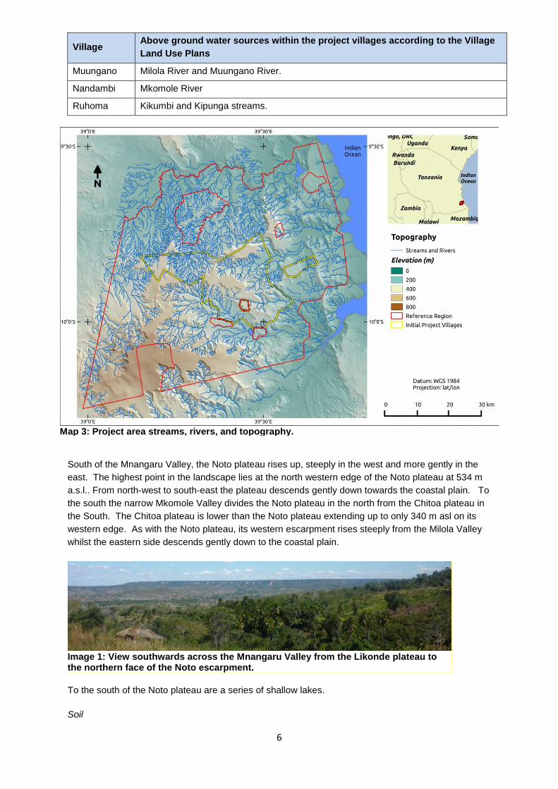
6
Village Above ground water sources within the project villages according to the Village
Land Use Plans
Muungano Milola River and Muungano River.
Nandambi Mkomole River
Ruhoma Kikumbi and Kipunga streams.
South of the Mnangaru Valley, the Noto plateau rises up, steeply in the west and more gently in the
east. The highest point in the landscape lies at the north western edge of the Noto plateau at 534 m
a.s.l.. From north-west to south-east the plateau descends gently down towards the coastal plain. To
the south the narrow Mkomole Valley divides the Noto plateau in the north from the Chitoa plateau in
the South. The Chitoa plateau is lower than the Noto plateau extending up to only 340 m asl on its
western edge. As with the Noto plateau, its western escarpment rises steeply from the Milola Valley
whilst the eastern side descends gently down to the coastal plain.
To the south of the Noto plateau are a series of shallow lakes.
Soil
Image 1: View southwards across the Mnangaru Valley from the Likonde plateau to the northern face of the Noto escarpment.
Map 3: Project area streams, rivers, and topography.

7
The landscape is characterised by a gradation or ‘catenary succession’ of soils from the well-drained,
sandy loams and loamy sands of the plateau tops down to the dark cracking clays and sandy clays
formed from lacustrine and riverine alluvium in the valleys and floodplains (Burgess et al. 2000a).
Typical of many parts of coastal Tanzania, there is high local variability in the soils reflecting different
substrates, slope angles, vegetation and drainage. Broad-scale maps (e.g. ILRI 2005) are therefore
misleading.
Clarke 1995 describes the soils of Chitoa Forest Reserve, on the south-western edge of the Chitoa
plateau as ‘Red brown sandy soils prone to retreating scarp erosion at the plateau edge’ whilst he
describes soil samples from Litipo Forest Reserve, at the southern edge of the landscape as having ‘a
pH that ranges from slightly acidic to neutral. The texture of the soil is sandy and the moisture content
low. The leaf litter is fairly shallow and there is no fermentation layer due to the quick turnover of
minerals and ions. Soil profiles from the riverine forest show more of a mineral horizon.
Geology
The Lindi plateaux are remnants of a lower-Cretaceous sandstone layer, warped and uplifted during
the Miocene. Rivers have subsequently gouged out valleys from the original Miocene ‘swell’
combined with gravity-driven retreating scarp erosion. Three of the six fragments of this Miocene
swell lie within the project landscape. This includes the Chitoa plateau in the south, divided by the
narrow Mkomole river valley from the Noto plateau (Clarke and Burgess, 2000). More recent
neogene sandstone is also present.
The valley floors are characterised by quaternary deposits and alluvium. Older, Jurassic formations
are exposed around Kiwawa Village and at the head of the Mnangaru River in Muungano Village.
Climate
Map 4: Project area geology.

8
Clarke (2000) describes the climate of the Eastern African Coastal Forests as being ‘characterised by
high temperatures and incident sunlight with little seasonal or annual variation, combined with very
variable rainfall patterns.’
The position of the Inter-Tropical Convergence Zone (ITCZ) determines the direction of the prevailing
winds and rainfall patterns in the project area. Between October / November to February / March
when the ITCZ lies to the south of the project area, the north-easterly trade winds prevail whilst
between May and September when the ITCZ lies to the north, south-easterly winds prevail (Clarke
2000).
Meteorological data from the project area
are scarce, particularly from the plateau
tops. The closest meteorological station is in
Lindi at 37 576624E 88940221S at 41 m asl
(Clarke 2000). A rainfall station was
operational at Rondo Ntene (10°08’S,
39°15’E, 758 m altitude) on the nearby
Rondo plateau from 1954 – 1973; at the
Ngurumahamba Estate (12 km east of Litipo)
between 1932 – 1962; at the Rutamba
Tanganyika Refugee Service (10°02’S,
39°30’E, 300 m) from 1969 – 1973; and at
the Naitivi Plantation (10°02’S, 39°33’E, 90
m altitude) from 1934 – 1957 (Clarke 1995)
Across the District, annual mean rainfall
varies from 800 mm in the lowlands to an
estimated 1200 mm on the plateaux. Over
the time that they were operational, the
various rainfall stations described the above
recorded annual mean rainfalls that ranged
from 1074 mm at Rutamba; 1096 mm at
Naitivi Plantation; and 1215 mm at Rondo
Ntene. There is considerable variation in the
total annual rainfall. For example the
Ngurumahamba Estate rainfall station, recorded a peak annual rainfall of 1418 mm and a minimum of
667 mm over the 30 years that it operated between 1932 and 1962 (Clarke 1995).
The rainfall pattern in Lindi is bimodal with rains between November and January (vuli) and between
March and May (masika). Clarke (1995) reports that the rainfall stations at the Rutamba Tanganyika
Refugee Service; at the Naitivi Plantation and at Rondo Ntene all recorded an average monthly
rainfall of less than 50 mm between June and October. The seasonal pattern of precipitation varies
annually.
Loveridge (1944) describes a significant occult precipitation effect from both the morning and evening
mists that gather over the Rondo plateau and a similar phenomenon may also affect the Noto, Chitoa
and Likonde plateaux.
Map 5: Lindi annual mean rainfall.

9
The mean annual temperature across the
District ranges from 24°C - 28°C.
Tropical storms are rare in the Coastal forest
belt although high winds periodically cause
tree falls.
Vegetation
The project area and project zone (hereafter
referred to as the project landscape) are part
of the Zanzibar-Inhambane regional mosaic
(sensu White 1983a and b). As its name
suggests, this is a mosaic of different
vegetation types. Within the Zanzibar-
Inhambane regional mosaic, Clarke (2000)
defines the East African Coastal Forests as
an ‘archipelago-like regional sub-centre of
endemism’. They are forests dominated by
Swahilian near endemic tree species. Clarke
(2000) identified the typical formation as
East African Coastal Dry Forest with four
variants, of which three have been recorded
within the project landscape: Coastal Scrub
Forest, Coastal Brachystegia Forest and
Coastal Riverine/Groundwater/Swamp
forest. The fourth variant, the Coastal
Afromontane Forest was not recorded in the project area.
Like many parts of the Eastern African coastal forest ecoregion, the project landscape includes a
mosaic of different vegetation types. The project area is centred on the mixed dry forest of the Chitoa
and Noto plateaux and the Likonde escarpment (labelled as Coastal Forest in Map 7). These are
characteristic of the East African Coastal Dry forests; are botanically diverse; and are home to
several endemic and threatened plant species. The dry forests are bordered by Coastal Brachystegia
forest and miombo woodland to the west and south-west; and mixed Coastal scrub forest along the
eastern side of the project zone. To the north, on the Likonde plateau, there is mosaic of Coastal dry
forest and thicket transitioning to the Brachystegia-dominated woodlands to the west. These
vegetation types are interspersed with agricultural land, agroforestry fallows and thicket / regenerating
areas. There are occasional patches of acacia woodland to the north-west of the project area
(included in the Open Woodland class in Map 7).
Coastal dry forest: between 200 m and 534 m asl, this is a variable forest type on the tops of the
Chitoa and Noto plateaux; along the Likonde escarpment; and in the north-west corner of the project
zone. Canopy height ranges from 10 – 25 m with emergents up to 35 m.
To the north of the Mnangaru river, the Likonde escarpment is botanically diverse. Based on
botanical surveys carried out by TFCG in 2010 and 2011, the dominant tree species in the centre and
east of the escarpment are Pteleopsis apetala (Ngwindi), Hymenaea verrucosa (Nkumbi), Grewia
conocarpa (Ng’ungulu), Hymenocardia ulmoides (Mmalala) and Scorodophleus fischeri. The canopy
height ranges from 10-12m, canopy cover is more than 70% while ground cover is less than 40%. The
height of emergent trees is about 20-25m tall including Bombax rhodagnophalon, Milicia excelsa,
Ricinodendron heudelotii, Terminalia sambesiaca (Nkulyungu) and Dialium holtzii. Understorey
shrubs include Chassalia umbraticola, Erythrococa pentagyna, Pentas bussei and Acalypha
neptunica. Lianas include: Vitex ferruginea, Rhoicissus tridentata, Dalechampia scandens,
Map 6: Lindi Mean Annual Temperature.

10
Dictophleba acida, Tylosema fagrescens and Dichapetalum sp. The ground cover includes herbs
such as Begonia oxyloba, Cincinnobotrys pulchella, Habenaria sp. and Scleria sp. Whilst this forest,
and the forest on the top of the Likonde plateau, has been severely reduced due to clearance for
agricultural land, some patches remain, particularly on the steeper slopes.
Further west along the plateau, there are some relatively undisturbed forest patches remaining.
These remaining patches are dominated by Afzelia quanzensis (Mbambakofi), Milicia excelsa (Mvule),
Hymenocardia ulmoides (Mmalala), Zanthoxylum chalybeaum (Namavele), Pouteria leucantha and
Bamboos in some areas. In this Western patch of forest, lianas include Abrus precatorius,
Combretum pentagonum, Entada pathuetha, Pterolobium stellatum and Grewia forbesii. Shrubs
include Carvalhoa campanulata, Fluggea virosa, Acalypha racemosa, Hoslundia opposita and
Whitfieldia elongata.
To the south of the Mnangaru River, on the Noto Plateau there is Coastal dry forest, with a well-
developed canopy at 12 m and emergent trees extending to 20 m. Dominant canopy species include
Pteleopsis myrtifolia, Afzelia quanzensis, Zanthoxylum deremense and Grewia conocarpa, In the
understorey the dominant species include Annona senegalensis, Tabernaemontana elegans,
Strychnos sp., Xylotheca tettensis, Carvalhoa campanulata, Erythrococca fischeri and Cyathula sp.
The forest differs from the Chitoa plateau to the south, in having few Scorodophloeus fischeri and few
Milicia excelsa. Lianas include Bonamia mossambiscensis, Uvaria acuminata, Grewia forbesii,
Dichapetalum braunii Dictyophleba lucida and Monanthotaxis tricantha. Whilst the ground cover
includes herbs such as Gladiolus decoratus, Chlorophytum sp and Elytralia minor.
Coastal Brachystegia forest: To the West of the Noto Plateau there are extensive areas of Coastal
Brachystegia forest. This formation is dominated by Brachystegia spiciformis, Millettia stuhlmannii,
Diplorrhynchus candylocarpon, Albizia veriscolor (Ntanga), Terminalia sericeae (Nchejea)
Pseudolachnostylis maproneifolia, Pterocarpus angolensis, Julbernardia globiflora, Acacia nilotica,
Polyshpaeria parviflora and Commiphora sp.
Map 7: Project area forest types.

11
There are patches of bamboo scattered throughout the woodland. Canopy height ranges from 10m –
15m, canopy cover is more than 60%, while ground cover is more than 80%. This area has been
regularly burnt and could be considered as transitional to Brachystegia woodland given the
dominance of grasses as ground cover in some areas. Emergent trees are Brachystegia spiciformis,
Millettia stuhlmannii and Pteleopsis myrtifolia. These species can reach 20-25m tall. The largest
patch of Coastal Brachystegia forest lies in the Makangala Forest Reserve and is thus outside of the
project area.
Coastal scrub forest: To the East of the Chitoa and Noto plateaux there are extensive areas of
coastal scrub forest. This is intermediate in structure between forest (canopy height > 10 m) and
thicket (canopy height < 10 m). Dominant species recorded in this area include Monodora minor,
Markhamia zanzibarica and Pteleopsis myrtifolia with the canopy ranging from 10 – 15 m in height
and 65 % canopy cover.
Agroforestry – dotted across the landscape are areas planted with cashew nut, mango, citrus and
coconut trees.
Current land use
Within each of the ten village land use plans, current and planned land use is described and mapped.
The land use categories include areas for permanent agriculture; settlement; public services;
grazing; village forest reserves for sustainable use; forest for unrestricted use; and areas for shifting
agriculture interspersed with housing. In general there is a pattern of allocating the areas in the
lowlands for agriculture and settlement with forest areas remaining on the plateau tops.
Project Design and Boundaries
G1.4. Define the boundaries of the Project Area where project activities aim to
generate net climate benefits and the Project Zone where project activities are
implemented.
The current project area (41,924 ha), includes all woody vegetation meeting the definition of forest in
April 2012 within the village boundaries of the 10 intial participating villages with the exception of
areas classified as non-forest in May 2001 or deforested between May 2001 and April 2012 (see Map
8). For more details on the definition of forest and procedures used to map forest and deforestation,
see the VCS project document.
The current project zone (66,110 ha) ecompasses all of the land under the control of the current
project proponents including non-forest areas not included in the project area. However, the project
may expand to include new villages within the project's reference region.
The total potential project area (336,629 ha) includes all woody vegetation meeting the definition of
forest in April 2012 on village land within the project’s reference region (Map 9) with the exception of
areas classified as non-forest in May 2001 or deforested between May 2001 and April 2012. The total
potential project zone including all land under control of the intial and potential project proponents
would is (402,739 ha).
G1.5. Explain the process of stakeholder identification and analysis used to identify
Communities, Community Groups and Other Stakeholders.
Stakeholder identification has been carried out and reviewed at various stages of the REDD
readiness process in order to ensure that all key stakeholders have been identified and consulted.
The stakeholder consultation process broadly followed the steps recommended by Forest Trends in

12
relation to social impact assessment of land based carbon projects (Richards and Panfil 2010 a and
b). At the project outset, a stakeholder analysis was conducted with the aim of identifying and
understanding the stakeholders within and external to the communities (Forrester-Kibuga and
Samweli 2010). This is available at www.tfcg.org/MakingREDDwork.html. During the social impact
assessment workshops at village and landscape level, this list of stakeholders was reviewed and
validated by the participants (Mwampamba et al. 2011). Participants in the SIA process included
representatives of the communities, community groups and other stakeholders identified by the initial
consultancy. In addition the REDD readiness process was well publicised at local level through
newsletters and local media thereby ensuring that all local stakeholders had the opportunity to
engage with the project during the design phase.
G1.6. List all Communities, Community Groups and Other Stakeholders identified
using the process explained in G 1.5.
Communities
The following communities derive income, livelihood or cultural values and other contributions to well-
being from the Project Area at the start of the project and/or under the with-project scenario.
Table 2: List of Wards, Villages and Sub-villages deriving benefits from the Project Area.
Ward Villages Sub-villages
Villages responsible for the management of the project area
Milola Milola
Magharibi
Total: 6
Names : Dodoma B, Kikumbi, Noto, Kipunga, Magela
Litandamkumbi
Rutamba
Kinyope Total: 4
Names: Namkopo, Sokoni, Gulioni, Shuleni
Ruhoma Total: 3
Names : Mchati, Shuleni, Mkundi
Nangaru
Mkombamosi
Total: 7
Names: Lumo, Msikitini, Sokoni, Mwenge, Cheleweni, Likonde
chini, Likandilo
Muungano
Total: 7
Names : Mnazi Mmoja, Likonde, Kipunga, Uleka, Umoja, Naruwi,
Ujamaa
Tandangongor
o Mkanga 1
Total: 4
Names: Mandanje, Mkanga Chini, Kilangalamatu, Mkanga Juu
Nga’pa /
Tandangongor
o
Nandambi
Total: 3
Names : Nandambi shuleni, Kilolombwani, Umoja
Matimba
Likwaya Total: 2
Names : Lumumba, Mapinduzi
Makumba
Total: 2
Mapinduzi na Mkwajuni
Kiwawa Kiwawa
Total: 8
Names: Kiwawa B, Kiwawa A, Mchinjidi A, Mchinjidi B, Mmumbu
A, Mmumbu B, Nawamba, Kitulo
Community groups

13
Based on the stakeholder analysis conducted at the start of the project; and the social impact
assessment work, the following groups of residents from the communities listed above, who derive
income, livelihood or cultural values and other contributions to well-being from the Project Area, were
identified:
- Small-scale farmers
- Users of forest products including medicinal plants, fuel wood, building poles, timber, food
plants including ming’oko and mushrooms.
- Charcoal producers
- Hunters
- Existing income generating groups
- Village governments and Village Natural Resources Committees (VNRCs)
These groups are differentiated on the basis of the way in which they use the forest and / or their
primary economic activity. As such, some individuals might fall into more than one category for
example hunters, charcoal producers, IGA group members, VNRC members and users of forest
products are also likely to be small-scale farmers as this is the most common livelihood activity within
the communities. These categories were identified by the stakeholders. Differentiating groups on the
basis of religion or tribe was not suggested during the social impact assessment and might run
counter to cultural norms in Tanzania.
Other stakeholders
Based on the stakeholder analysis conducted at the start of the project; and the social impact
assessment work, the following groups are populations that do not qualify as communities but that
can potentially affect or be affected by the project activities.
Small-scale farmers within the leakage belt
Charcoal transporters
Commercial users of forest products who are not residents in the current project zone
ILULU Cooperative Society
Lindi Municipal Council
Lindi Rural District Council
Local Member of Parliament
Airtel (Zain) mobile phone company
Non-governmental Organisations e.g. the Aga Khan Foundation
Non-resident traders (offsite stakeholders)

14
G1.7. Provide a map identifying the location of Communities and the boundaries of
the Project Area(s), of the Project Zone, including any High Conservation Value areas
(identified in CM1 and B1), and of additional areas that are predicted to be impacted
by project activities identified in CL3, CM3 and B3.
Map 8 shows the current project area forests and the boundaries of the participating villages. Some
national forest reserves border the project area, but are not included in the project area or the project
zone. The current project zone includes all lands within the current participating project villages. Map
9 shows the wider reference region. Forest areas in Map 9 outside of the project area are the areas
where the project may expand to include new villages (proponents) under the programmatic
approach. The entire area within the reference region excluding national forest reserves is the
potential project zone.
G1.8. Briefly describe each project activity and the expected outputs, outcomes and
impacts of the activities identifying the causal relationships that explain how the
activities will achieve the project’s predicted climate, community and biodiversity
benefits.
The project’s activities were developed through a consultative process involving meetings in all project
villages and at landscape level with a wide range of stakeholders, including representatives from all
communities, community groups and other stakeholders, as part of the Social Impact Assessment.
The activities reflect the priorities outlined by the stakeholders. The activities were developed using a
theory of change approach (Richards and Panfil 2010 a and b). Details of this process are provided in
Mwampamba et al. 2011 at www.tfcg.org/MakingREDDwork.html. The theory of change analysis
detailing the outputs, outcomes and impacts for each activity is provided in Annex 4. The activity
description, expected impacts and relevance to the project’s objectives are summarised in Table 3.
Map 8: Map of initial project area and participating villages. Map 9: The potential project zone (reference region) and current project zone (project villages).

15
Table 3. Project activities
Activity description Expected climate, community
and biodiversity impacts and
outcomes
Relevance to project’s
objectives
Activity 1. Improve
governance at village level.
Training and awareness raising
on good governance was / will
be provided by TFCG and
MJUMITA between 2010 – 2014
to the villages managing the
project area. With support from
the project, Village Natural
Resources, Land Use
Management and REDD
Committees were elected where
they were absent or incomplete
and trained on their roles and
responsibilities.
Reinforcement training on good
governance principles and
practices will be provided to
Village Council, Village Natural
Resources Committee and
REDD Committee members by
MJUMITA and Lindi District
Council prior to each round of
REDD payments. Training has
been provided to local
government staff on conflict
resolution.
Based on training and
awareness raising supported by
the project, MJUMITA members
will also raise awareness
amongst the communities
regarding good governance; and
will help communities to hold
village leaders accountable.
Local MJUMITA networks have
been established as a forum for
resolving governance issues
between and within
communities.
TFCG and MJUMITA have also
constructed village offices for
the ten villages in order to
provide a more conducive
CM Impact 3. Villages will be
better governed.
Expected outcomes:
More effective and equitable
implementation of forest
management and sustainable
land management by-laws and
plans thereby resulting in
emission reductions; a more
permanent basis for maintaining
forest cover; and carbon
sequestration through natural
regeneration.
Village council provide a more
effective and equitable service
to the communities as a result
of improved knowledge on their
roles and responsibilities and
greater accountability.
Public services and community-
owned infrastructure are
managed in a more equitable,
effective and efficient way.
Improved governance at village
level will underpin strategies to
adapt to climate change
including through improved land
and natural resources
management and improved
conflict resolution.
This will help to ensure that
water and forest products are
accessible in an equitable way
during times of climate change-
related stress; and will help to
minimise habitat loss associated
with increased shifting
cultivation during times of
climate change-related stress,
thereby conserving biodiversity
values (GL 1. Climate Change
adaptation benefit).
Ensures that local councils and
civil society participate fully in
providing the local conditions
necessary to achieve REDD
objectives.
Provides necessary supporting
conditions for equitable benefit
sharing including in relation to
more equitable gender-relations
and for sustaining free, prior and
informed consent.
Provides a stronger foundation
for the implementation of
community based forest
management; sustainable land
management; and for REDD
payments to incentivise
practices that reduce emissions.
Improved governance brings
cross sectoral benefits at village
level that will also contribute to
more secure tenure; improved
public services including in
relation to health, education,
land tenure and the local
economy; more resilience to
climate change; and better
management of infrastructure
intended for community benefit.

16
Activity description Expected climate, community
and biodiversity impacts and
outcomes
Relevance to project’s
objectives
environment for the
implementation of governance
functions.
MJUMITA and the Lindi District
Council will continue to provide
backstopping to the MJUMITA
networks and village leaders on
governance issues.
Timing: Training provided by
TFCG and MJUMITA 2010 –
2013; improved governance to
be practiced throughout project
lifespan.
Women will be represented on
the village council and village
committees (GL 2. Exceptional
community benefits).
Activity 2. Implement
sustainable land management
Each village will prepare a
village land use management
plan in a participatory way and
modelling the integrated
approach to land use planning
and community based forest
management planning that has
been practiced by the project.
See Luwuge et al. 2011a for
guidelines on the project’s
approach.
The planning process will be
facilitated by the District
Participatory Land Use
Management team. The plans
specify the geographical
distribution of land uses for the
community and the mechanisms
to ensure implementation. The
plans are reviewed and
approved by the District Council.
Through awareness raising
amongst the community;
training to village leaders; and
installation of sign boards in key
locations, the plans are widely
communicated within the
community. The village land
use management committee will
oversee the implementation of
CM Impact 1. Community-
owned forests will be managed
in a participatory, effective and
equitable way; and
CM Impact 4. Communities will
have more secure land tenure;
and
CM Impact 6. Soil erosion will
be reduced.
Expected outcomes:
All villages have developed and
are implementing village land
use plans which guide the
community on the agreed
location for different land uses
including forests and agricultural
land.
Communities will benefit
because water and other
ecological services are
maintained as a basis for more
sustainable livelihood activities.
Land tenure is strengthened and
conflicts over land are reduced.
More effective, equitable and
sustainable management of
forest resources will reduce
emissions of greenhouse gases
The boundary mapping process
that is integrated into the village
land use planning provides an
accurate basis for defining the
village boundaries.
Provides the precondition for
delineating areas for
participatory forest management
and for improving the security of
land tenure at community and
individual levels.
Zonation of village land into
different land uses makes clear
the agreed locations for
agriculture, public services,
residential areas, sensitive
ecological zones including water
sources and forests.
On the basis of the village land
use plans, villages can begin to
issue customary rights of
occupancy.

17
Activity description Expected climate, community
and biodiversity impacts and
outcomes
Relevance to project’s
objectives
the plans with oversight from the
Village Council and accountable
to the Village Assembly. Lindi
District Council will provide
backstopping where resources
allow.
Additional training will be
provided to the village natural
resources committees on fire
prevention activities combined
with widespread awareness
raising on the causes of fire; the
risks of fire; and ways of
preventing and tackling fire.
For the ten project area villages,
each village has prepared a
village land use plan and by-
laws in a participatory way and
in accordance with national
guidelines.
Timing: VLUP training and
development between 2010 and
2012; implementation
throughout project lifespan.
and protect high conservation
values.
Through training and awareness
raising on wildfire prevention,
there will be less fire damage to
forests.
Village land use plans will help
to ensure that water and forest
products are accessible in an
equitable way during times of
climate change-related stress;
and will help to minimise habitat
loss associated with increased
shifting cultivation during times
of climate change-related stress,
thereby conserving biodiversity
values (GL 1. Climate Change
adaptation benefit).
Activity 3. Community based
forest management.
Following widespread
awareness raising to all
community groups, each village
will establish village forest
reserves. This involves
agreeing the location of the
village forest reserve; and
preparation of a management
plan and by-laws following a
participatory approach facilitated
by the District. The plans and
by-laws are presented to the
village assembly for approval;
and from there they are
presented to the District Council
for review and approval.
Once approved at District level
CM Impact 1. Community-
owned forests will be managed
in a participatory, effective and
equitable way; and
CM Impact 2. Forest products
will continue to be available and
accessible to all community
members including the poorest
households according to access
rules agreed in a participatory
way; and
CM Impact 5. Water sources
will be better protected; and
CM Impact 6. Soil erosion will
be reduced; and
Biodiversity Impact 1.
Community based forest
management is relevant to all of
the climate, community and
biodiversity objectives of the
project. CBFM will help
communities to conserve the
ecosystem services that they
depend on; and ensure a
sustainable supply of forest
products.

18
Activity description Expected climate, community
and biodiversity impacts and
outcomes
Relevance to project’s
objectives
the communities will implement
their Village Forest Reserve
management plans and by-laws
according to the rules that they
have agreed amongst
themselves and as stipulated in
their plans and by-laws. These
include some sustainable use.
As part of REDD readiness,
each village has established a
forest reserve and has prepared
and approved management
plans and by-laws for the Village
Forest Reserves. REDD
revenues will be used to
contribute to, or cover in their
entirety, management costs.
The Village Natural Resources
Committees are responsible for
overseeing the implementation
of the plans with oversight from
the Village Council and
accountable to the Village
Assembly.
Lindi District Council will provide
backstopping where resources
allow.
Awareness raising activities will
be conducted on wild fires; and
training will be provided on
preventing wildfires.
For the ten project area villages,
each village has established a
village forest reserves and is
implementing its management
plan.
Timing: CBFM training and
development between 2010 and
2012; implementation
throughout project lifespan.
Populations of threatened and
endemic species persist within
the project area; and
Biodiversity Impact 2.
Extensive areas of Eastern
African Coastal Forests continue
to exist within the project area;
and
Biodiversity Impact 3. There is
less pressure on the Eastern
African Coastal Forest from
deforestation and degradation
drivers; and
Biodiversity Impact 4.
Communities and other
stakeholders are actively
engaged in the management of
Eastern African Coastal Forest
within the project area.
Expected outcomes:
The effective management of
the village forest reserves will
significantly reduce
deforestation in the reserves
and therefore will also reduce
emissions of greenhouse gases.
The management objectives for
the reserves include maintaining
natural forest cover. By
conserving the natural habitat,
so the biodiversity and other
high conservation values will
also be protected. Communities
will benefit by having access to
sustainably managed forest
products; by avoiding
degradation of water sources
and soil erosion that would
otherwise result from
deforestation; and by earning
revenues from REDD.
CBFM will also ensure access to
forest foods including fruits,
mushrooms and tubers during
periods of drought; and will help

19
Activity description Expected climate, community
and biodiversity impacts and
outcomes
Relevance to project’s
objectives
to minimise habitat loss and
fragmentation associated with
increased shifting cultivation
during times of climate change-
related stress, thereby
conserving biodiversity values
(GL 1. Climate Change
adaptation benefit).
CBFM will also conserve the
globally threatened species and
habitat found in the project zone
(GL. 3 Exceptional biodiversity
benefits).
Activity 4. Channel REDD
payments to communities.
As part of the REDD readiness
activities, MJUMITA and TFCG
have modelled a payment
mechanism based around
making individual payments to
all women, men and children
registered as residents of a
village. Residents are treated as
shareholders in the REDD
enterprise and are entitled to
dividends in the form of REDD
payments. Each village has
developed by-laws to govern the
REDD payments; have
established REDD committees
who have been trained on how
to implement the payments; and
have been through two rounds
of payments. The REDD
committees will take on
responsibility for distributing
payments from the sale of the
voluntary emission reductions.
This will involve maintaining a
register of residents; liaising with
MJUMITA regarding the
emission reductions and
earnings; and ensuring that the
budget allocation process is in
line with the village’s by-laws.
The model allows for
communities to decide whether
CM Impact 7. Individual
incomes will be boosted and
diversified by receiving REDD
payments; and
CM Impact 9. REDD revenues
will contribute to improving
public services and
infrastructure.
Expected outcomes:
The REDD payments will
provide an incentive to
communities to maintain forest
cover; and will cover the direct
costs of managing the village
forest reserves. As such the
payments are critical for
ensuring the longer term
climate, community and
biodiversity benefits. The
payments will be paid equally to
women, men and children; and
to all households regardless of
wealth (GL 2. Exceptional
community benefits).
REDD payments will provide
funds for community
development projects including
improved infrastructure and
social services.
REDD payments will provide a
The payments contribute to the
project’s climate and biodiversity
objectives by providing an
incentive for communities to
manage their forests sustainably
and by covering the costs of
forest management. They
contribute to the community
objectives by providing an
income to individuals and / or,
depending on the decision of the
communities, to pay for
community development
activities including public
services. The payment system
is designed to avoid elite
capture by making every
woman, man and child
(collected by their mothers)
eligible thereby ensuring that
poorer households and women
benefit.

20
Activity description Expected climate, community
and biodiversity impacts and
outcomes
Relevance to project’s
objectives
/ how much to allocate to
individual payments and / or to
allocate to community
development projects. Village
Councils must present detailed
plans and budgets to the Village
Assembly for any community
development projects and the
Village Assembly can then vote
whether they agree to support
the project. The MJUMITA
Community Liaison officer will
assist with the process and Lindi
District Council will provide
backstopping where resources
allow.
Timing: throughout project
lifespan.
direct income to individuals.
Activity 5. Improve
profitability, ecological
sustainability and climate
change resilience of
agriculture.
As part of the REDD readiness
activities, the project developed
an agricultural strategy (TFCG
2012). On the basis of this
strategy, and working closely
with the District, TFCG has been
training women and men small-
scale farmers on conservation
agriculture and reducing crop
losses from crop-raiding
animals.
The agricultural strategy
promotes conservation
agriculture techniques that avoid
shifting cultivation; and generate
more value from less land. The
techniques now being practised
also enhance soil moisture
management, soil nutrient
conservation and improved seed
selection thereby also
contributing to climate change
adaptation. The project’s
CM Impact 8. Women and men
farmers, including those from
poorer households, will adopt
more profitable, sustainable and
climate change resilient
agricultural practices and will
invest in other enterprises and /
or value addition initiatives.
Expected Outcomes
It is expected that by adopting
conservation agriculture,
farmers can improve the
profitability of their agricultural
practices.
It is expected that by improving
practices, farmers can move
away from shifting cultivation
and deforestation. .
It is expected that REDD
payments will enable farmers to
invest in improved agriculture
and thereby generate more
profit; be more ecologically
sustainable; and avoid
deforestation outside of the
village forest reserves.
In terms of relevance to climate
and biodiversity objectives, as
agriculture is the main
deforestation driver in this area,
it is critical that communities
adopt improved agricultural
practices that will allow farmers
to improve their livelihoods
without bringing forest areas into
agriculture. In terms of the
relevance to the community
objectives, improved agricultural
practices aim to increase the
profitability of farming practices.
By adopting agricultural
practices that are more resilient
to climate change, farmers will
be less vulnerable to climate
change.

21
Activity description Expected climate, community
and biodiversity impacts and
outcomes
Relevance to project’s
objectives
agricultural strategy is available
at
www.tfcg.org/MakingREDDwork.
html
More in-depth training is
provided to community-based
trainers. The community-based
trainers are expected to
provided technical backstopping
for other farmers in their village.
Farmer field schools also serve
as demonstration plots for other
farmers to observe the benefits
of conservation agriculture.
Open days where everyone is
invited to visit the demonstration
plots and meet with the Farmer
Field School members have
been used to promote the
approach. Radio is used to
raise awareness about
conservation agriculture and
training materials are provided in
each village.
It is expected that farmers
trained in conservation
agriculture will work with local
government staff, ward
extension officers and
community based trainers to
implement improved agricultural
practices and to support other
farmers in their respective
villages to adopt improved
agricultural practices. Lindi
District Council will provide
backstopping where resources
allow. REDD payments will
provide a source of cash for
farmers to invest in agricultural
inputs including improved seed
varieties.
Timing: Most training provided
between 2010 – 2014 in project
villages; and in leakage belt
villages in 2014 with District and
Community Based Trainers
By introducing improved
agricultural activities that are
designed to increase farmers’
resilience to climate change, it is
anticipated that farmers will be
able to withstand the shift in
growing season; increase in
crop pests and diseases;
increase in weeds; and
decrease in crop productivity
that are anticipated as a result of
climate change (GL 1. Climate
Change adaptation benefit).
22
Activity description Expected climate, community
and biodiversity impacts and
outcomes
Relevance to project’s
objectives
providing ongoing support post-
2014. Additional funds are
being raised in order for TFCG
to continue to support farmers
on conservation agriculture in
the project area villages.
Activity 6. Improve access to
microfinance services for
community members.
Training is provided to women
and men on establishing and
operating village savings and
loans associations. The VSLAs
provide a mechanisms for
community members to access
loans d to save. The VSLAs are
linked with the training on
improved agriculture and with
the training on enterprise
development.
The VSL Associations are
intended to link with the REDD
payments by providing a
mechanism by which community
members can save their REDD
incomes until it can be invested.
Lindi District Council will provide
backstopping where resources
allow.
Timing: Most training provided
between 2010 – 2014 with
District and Community Based
Trainers providing ongoing
support post-2014.
CM Impact 8. Women and men
farmers, including those from
poorer households, will adopt
more profitable, sustainable and
climate change resilient
agricultural practices and will
invest in other enterprises and /
or value addition initiatives.
Expected outcomes
This activity is closely linked with
Activities 4 and 5. The village
savings and loans associations
are intended to help farmers and
those with small enterprises to
have access to capital to help
with enterprise development and
purchasing inputs relevant to
adopting improved agricultural
practices.
Farmers will have access to
microfinance facilities that will
help them to invest in more
climate-resilient agricultural
practices; and to survive and
recover from climate change-
related stress (GL 1. Climate
Change adaptation benefit).
Loans can also be used to help
farmers switch to other
enterprises.
This activity aims to provide a
mechanism whereby the REDD
payments can be linked with
improved livelihood activities.
Activity 7. Generate incomes
from the sale of bee products.
Beekeepers within the
communities will produce honey
CM Impact 8. Women and men
farmers, including those from
poorer households, will adopt
more profitable, sustainable and
This is relevant to the
community objectives by
contributing to improved
incomes and by providing an

23
Activity description Expected climate, community
and biodiversity impacts and
outcomes
Relevance to project’s
objectives
and other bee products with
some of their hives being placed
within the village forest reserves.
As part of the REDD readiness
activities, over 200 beekeepers
were trained in beekeeping and
were provided with equipment.
Beekeepers are expected to
work with closely with the Village
Natural Resources Committees
providing support in reserve
management. Lindi District
Council will provide
backstopping where resources
allow.
Timing: Most training provided
between 2010 – 2014 with
District providing support post-
2014.
climate change resilient
agricultural practices and will
invest in other enterprises and /
or value addition initiatives; and
Biodiversity Impact 3. There is
less pressure on the Eastern
African Coastal Forest from
deforestation and degradation
drivers; and
Biodiversity Impact 4.
Communities and other
stakeholders are actively
engaged in the management of
Eastern African Coastal Forest
within the project area.
Expected Outcomes
Revenues to the beekeepers
from the sale of honey and other
bee products is expected to
improve the livelihoods of the
bee keepers.
Benefits from beekeeping are
expected to include additional
support to the Village Natural
Resources Committees from the
beekeepers in relation to
effective management of the
village forest reserves. This will
help to reduce deforestation and
emissions of greenhouse gases.
alternative income to agriculture
thereby improving climate
change resilience and
adaptation by providing
households with a broader
spread of economic activities to
rely on.
This is relevant to the climate
and biodiversity objectives by
incentivising effective reserve
management.
Activity 8. Growing and
harvesting trees on woodlots
and through agroforestry.
Farmers in the project villages
will grow and harvest trees in
woodlots and through
agroforestry. This is based on
the training provided to farmers
during the REDD readiness
phase. The local MJUMITA
networks will promote tree
planting and providing training
where resources allow. Lindi
District Council will provide
CM Impact 8. Women and men
farmers, including those from
poorer households, will adopt
more profitable, sustainable and
climate change resilient
agricultural practices and will
invest in other enterprises and /
or value addition initiatives; and
Biodiversity Impact 3. There is
less pressure on the Eastern
African Coastal Forest from
deforestation and degradation
drivers; and
This will contribute to the climate
and biodiversity impacts by
reducing pressure on the forest
from tree cutting for fuel wood
and construction.
It will contribute to the
community objectives by
providing fruits and wood
products for domestic
consumption; by providing an
income from the sale of timber;
and by diversifying household
incomes thereby contributing to

24
Activity description Expected climate, community
and biodiversity impacts and
outcomes
Relevance to project’s
objectives
backstopping where resources
allow.
Timing: Most training provided
between 2010 – 2014 with
District providing ongoing
support post-2014.
Expected Outcomes
Farmers will have easy access
to trees for fuelwood and
building materials from their
woodlots.
There will be less pressure on
the natural forests to supply fuel
wood and building materials.
Farmers can generate an
income from the sale of their
trees.
climate change adaptation.
Activity 9. Improve social
services and infrastructure
Communities will have the
option of allocating some or all
of their REDD revenues to pay
for better social services and
infrastructure. This is closely
related to Activities 1 and 4.
Timing: throughout project
lifespan.
CM Impact 9. REDD revenues
will contribute to improving
public services and
infrastructure.
CM Impact 10. Villages will
have village offices.
Biodiversity Impact 3. There is
less pressure on the Eastern
African Coastal Forest from
deforestation and degradation
drivers; and
Biodiversity Impact 4.
Communities and other
stakeholders are actively
engaged in the management of
Eastern African Coastal Forest
within the project area.
Expected impacts include better
health care, education and
infrastructure for community
members. Other expected
impacts include more positive
attitudes and practices in
relation to sustainable forest
management by the majority of
community members.
The impact of climate change-
related increase in diseases
such as malaria and dysentery,
will be reduced through access
to improved health facilities; and
This will contribute to climate
and biodiversity impacts by
increasing the incentive to
maintain forest cover as
communities see the benefit of
the REDD revenues in terms of
better schools, clinics and roads.
It will contribute to the
community objectives by
providing better public services
including education, health care
and governance.

25
Activity description Expected climate, community
and biodiversity impacts and
outcomes
Relevance to project’s
objectives
communities will have more
secure access to water supplies,
even during periods of drought,
as a result of improved water
infrastructure and management.
(GL 1. Climate Change
adaptation benefit).

26
Figure 1: Generic model of entry points for eight community development strategies proposed by communities and stakeholders of the Lindi REDD
project (NB: Strategy 6 in this diagram includes Activities 6 and 7)
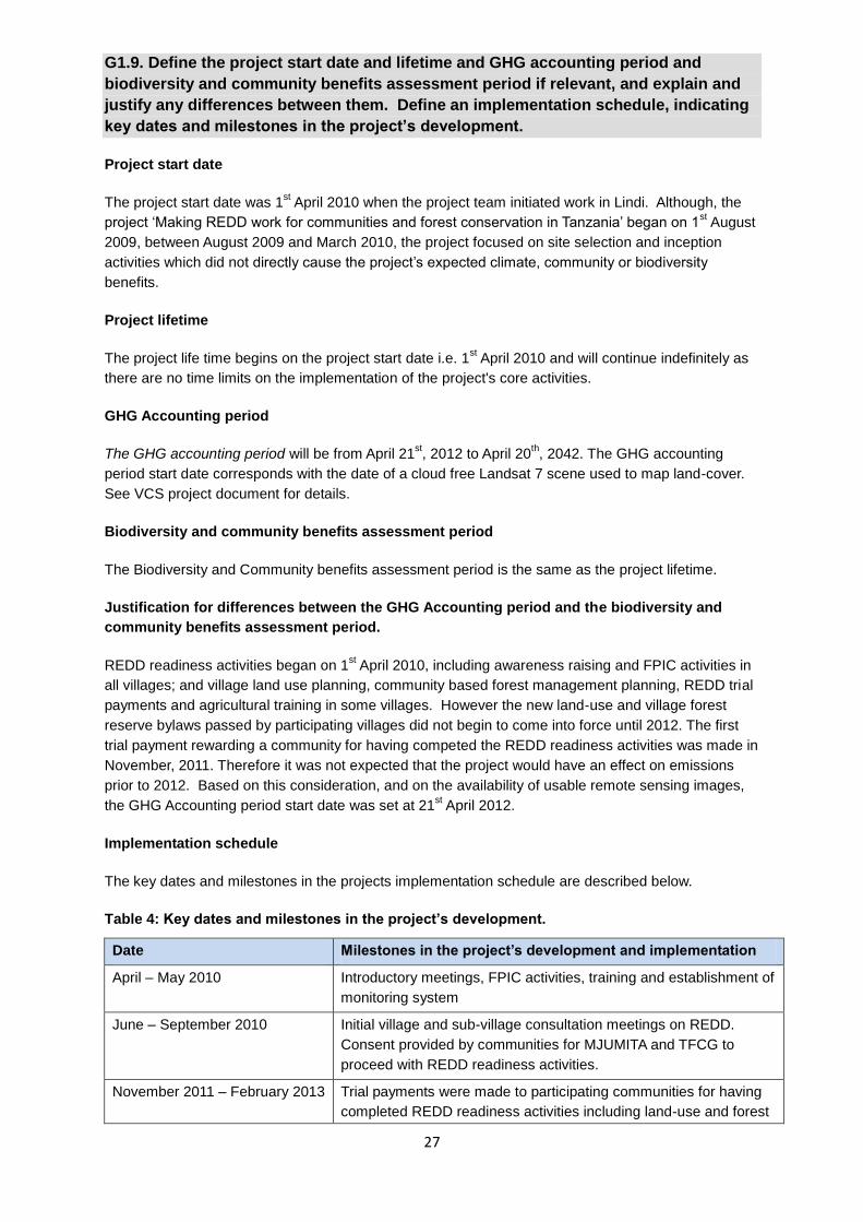
27
G1.9. Define the project start date and lifetime and GHG accounting period and
biodiversity and community benefits assessment period if relevant, and explain and
justify any differences between them. Define an implementation schedule, indicating
key dates and milestones in the project’s development.
Project start date
The project start date was 1st April 2010 when the project team initiated work in Lindi. Although, the
project ‘Making REDD work for communities and forest conservation in Tanzania’ began on 1st August
2009, between August 2009 and March 2010, the project focused on site selection and inception
activities which did not directly cause the project’s expected climate, community or biodiversity
benefits.
Project lifetime
The project life time begins on the project start date i.e. 1st April 2010 and will continue indefinitely as
there are no time limits on the implementation of the project's core activities.
GHG Accounting period
The GHG accounting period will be from April 21st, 2012 to April 20
th, 2042. The GHG accounting
period start date corresponds with the date of a cloud free Landsat 7 scene used to map land-cover.
See VCS project document for details.
Biodiversity and community benefits assessment period
The Biodiversity and Community benefits assessment period is the same as the project lifetime.
Justification for differences between the GHG Accounting period and the biodiversity and
community benefits assessment period.
REDD readiness activities began on 1st April 2010, including awareness raising and FPIC activities in
all villages; and village land use planning, community based forest management planning, REDD trial
payments and agricultural training in some villages. However the new land-use and village forest
reserve bylaws passed by participating villages did not begin to come into force until 2012. The first
trial payment rewarding a community for having competed the REDD readiness activities was made in
November, 2011. Therefore it was not expected that the project would have an effect on emissions
prior to 2012. Based on this consideration, and on the availability of usable remote sensing images,
the GHG Accounting period start date was set at 21st April 2012.
Implementation schedule
The key dates and milestones in the projects implementation schedule are described below.
Table 4: Key dates and milestones in the project’s development.
Date Milestones in the project’s development and implementation
April – May 2010 Introductory meetings, FPIC activities, training and establishment of
monitoring system
June – September 2010 Initial village and sub-village consultation meetings on REDD.
Consent provided by communities for MJUMITA and TFCG to
proceed with REDD readiness activities.
November 2011 – February 2013 Trial payments were made to participating communities for having
completed REDD readiness activities including land-use and forest

28
Date Milestones in the project’s development and implementation
management planning.
21st April 2012 Start of the project crediting period
April 2013 End of 1st Project Implementation period
July 2013 Management plans and by-laws for village forest reserves; Village
Land use plans and by-laws; REDD by-laws approved and signed
by Lindi District Council. The approval and signing process took
place over two years from July 2011 to July 2013 with most plans
being approved by the village assemblies in July – December 2011
and signed at District level in July 2013. Given that the District
Council exceeded the recommended 60 days for the approval
process, the communities began the implementation of the plans
and by-laws in 2012. Details on this are provided in Section CM
2.1 of the project’s first implementation report.
May – June 2013 MoUs between communities and MJUMITA signed giving consent
to MJUMITA to proceed with the validation and verification process
with VCS and CCB.
March 2014 2nd
Round of payments made to participating communities
August 2014 Validation and verification to be completed
December 2014 2nd
Round of payments made to participating communities
August 2015 2nd
verification completed
December 2015 3rd
Round of payments made to participating communities
August 2017 3rd
verification completed
December 2017 4th Round of payments made to participating communities
August 2019 4th verification completed
December 2019 5th Round of payments made to participating communities
August 2021 5th verification completed
December 2019 6th Round of payments made to participating communities
Risk Management and Long-term Viability
G1.10. Identify likely natural and human-induced risks to the expected climate,
community and biodiversity benefits during the project lifetime and outline measures
needed and taken to mitigate these risks.
The likely natural and human-induced risks to the expected climate community and biodiversity
benefits during the project lifespan are described below with an outline of the measures adopted by
the project to mitigate these risks. Risks 1, 2, 4, 5, 6, 9 and 10 were identified during the social impact
assessment (Mwampamba et al. 2011). Risks 3, 7 and 8 were identified by MJUMITA and TFCG staff
during the project design process. The non-permanence risk report prepared as part of the VCS
project design document describes risks to the project’s climate benefits.
Table 5: Risks to the expected project benefits and mitigation measures.
Risk description Probability and
potential impact of
risk
Mitigation measures
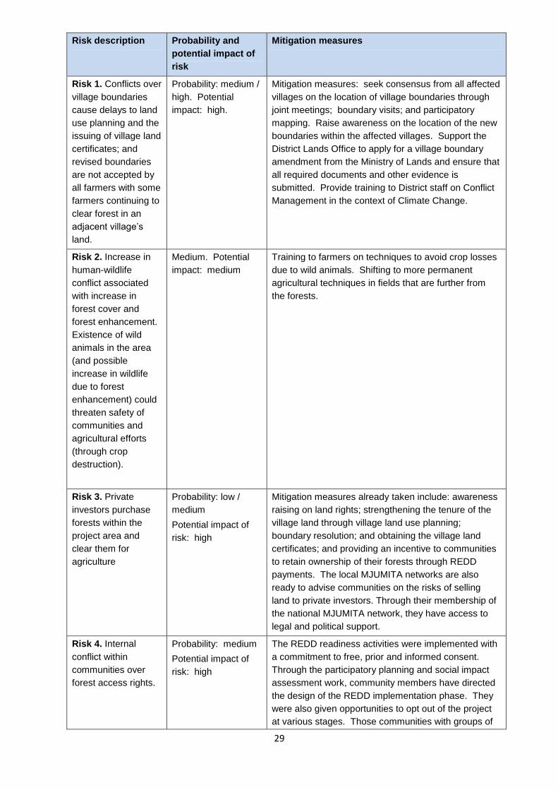
29
Risk description Probability and
potential impact of
risk
Mitigation measures
Risk 1. Conflicts over
village boundaries
cause delays to land
use planning and the
issuing of village land
certificates; and
revised boundaries
are not accepted by
all farmers with some
farmers continuing to
clear forest in an
adjacent village’s
land.
Probability: medium /
high. Potential
impact: high.
Mitigation measures: seek consensus from all affected
villages on the location of village boundaries through
joint meetings; boundary visits; and participatory
mapping. Raise awareness on the location of the new
boundaries within the affected villages. Support the
District Lands Office to apply for a village boundary
amendment from the Ministry of Lands and ensure that
all required documents and other evidence is
submitted. Provide training to District staff on Conflict
Management in the context of Climate Change.
Risk 2. Increase in
human-wildlife
conflict associated
with increase in
forest cover and
forest enhancement.
Existence of wild
animals in the area
(and possible
increase in wildlife
due to forest
enhancement) could
threaten safety of
communities and
agricultural efforts
(through crop
destruction).
Medium. Potential
impact: medium
Training to farmers on techniques to avoid crop losses
due to wild animals. Shifting to more permanent
agricultural techniques in fields that are further from
the forests.
Risk 3. Private
investors purchase
forests within the
project area and
clear them for
agriculture
Probability: low /
medium
Potential impact of
risk: high
Mitigation measures already taken include: awareness
raising on land rights; strengthening the tenure of the
village land through village land use planning;
boundary resolution; and obtaining the village land
certificates; and providing an incentive to communities
to retain ownership of their forests through REDD
payments. The local MJUMITA networks are also
ready to advise communities on the risks of selling
land to private investors. Through their membership of
the national MJUMITA network, they have access to
legal and political support.
Risk 4. Internal
conflict within
communities over
forest access rights.
Probability: medium
Potential impact of
risk: high
The REDD readiness activities were implemented with
a commitment to free, prior and informed consent.
Through the participatory planning and social impact
assessment work, community members have directed
the design of the REDD implementation phase. They
were also given opportunities to opt out of the project
at various stages. Those communities with groups of

30
Risk description Probability and
potential impact of
risk
Mitigation measures
individuals who were not happy to continue with REDD
implementation are not included. All of the villages
that are included in this PDD have chosen to continue
with the project through their village assembly
meetings. The Village Assembly meetings have
passed by-laws on REDD and have signed a
Memorandum of Understanding with MJUMITA
outlining their commitment to the REDD process. In
addition, a conflict resolution mechanism is in place, to
ensure that conflicts that do arise can be addressed in
a fair way. By engaging with a wide range of
stakeholders during the project design phase, there is
also a broad network of support for the initiative at
local and national level including from local MPs, the
District Council and the Ward Development
Committees. The project also provided training to
District staff on Conflict Management in the context of
Climate Change.
Risk 5. Forest fires
cause forest
degradation within
the project area.
Probability: medium
Potential impact of
risk: medium
Awareness raising on fire prevention and fire fighting.
By-laws that prohibit the use of fire to clear forests; or
the starting of fires within village forest reserves for any
other reason. Training farmers on alternative
agricultural methods to reduce dependence on ‘slash
and burn’ agriculture.
Risk 6. Reluctance
to adopt alternative
landuse practices to
shifting agriculture,
due to deeply
ingrained and long
landuse
management
traditions, as well as
capacity and financial
barriers to adoption
of alternative
techniques.
Probability: medium
Potential impact of
risk: medium
Farmer field schools will be used to demonstrate the
direct benefits of conservation agriculture and other
improved techniques. Farmers days will be organised
in order to attract people to come and see the new
approaches. By providing training to community based
trainers it is intended that there will technical
backstopping available within the communities for
farmers. Access to microfinance for agricultural
investment will be increased as a result of the project
supporting the establishment of village savings and
loans associations. The agricultural strategy has been
carefully designed to focus on locally-appropriate
strategies. REDD finance will provide an incentive to
adopt practices that do not result in deforestation.
TFCG will seek additional funds to provide continued
agricultural support following the close of the
Norwegian-funded project.
Risk 7. Corruption in
relation to the REDD
payments
undermines the
effectiveness and
equitability of REDD
Probability: medium
Potential impact of
risk: low / medium
The individual payment mechanism modelled by this
REDD project is designed to maximise accountability
around REDD payments. It is based on the premise
that individuals are more likely to demand
accountability where they have a direct stake in the
outcome of transactions. As part of the REDD
readiness activities, there has been widespread
awareness raising in relation to the model and two

31
Risk description Probability and
potential impact of
risk
Mitigation measures
rounds of payments have been made in all villages so
that a majority of people are familiar with the process
and the roles and responsibilities of different
stakeholders. The MJUMITA networks have also been
trained to provide support to communities to prevent
and where necessary address any governance
shortfalls in relation to the REDD payments. The
presence of civil society organisations is known to
moderate the risk of elite capture in participatory forest
management (Persha and Andersson 2014). The
highest risks relate to the use of any funds allocated
for community development projects. Where
communities do not trust their leaders, they have the
option of not entrusting any money to them.
Risk 8. Corruption in
relation to forest
reserve management
results in forest
clearance
Probability: medium
Potential impact of
risk: medium
Over the last decade there has been growing
awareness on the scale of corruption within the forest
sector in Tanzania and its impact on national
development. As such various efforts are now
underway at local and national levels to mitigate these
risks. Many of these initiatives such as the Mama
Misitu (Mother Forest) Campaign and the Forest
Justice Project have invested in building the capacity
of communities to address governance shortfalls. As
part of the REDD readiness activities, TFCG and
MJUMITA have provided training to village leaders on
good governance. They have also provided training
and support to community based advocacy groups so
that they can address governance shortfalls directly at
village level. These local MJUMITA networks are now
in place and will monitor and expose any corruption in
relation to reserve management.
Risk 9. Political
support for REDD in
Tanzania is
withdrawn or
legislation is changed
to prevent
communities
accessing REDD
revenues directly
Probability: low
Impact of risk: high
With support from the Norwegian government, the UN
REDD programme and the Forest Carbon Partnership
Facility, there is widespread awareness about REDD
and support for it within Tanzania. The National REDD
strategy was published in 2013 documenting the
government’s commitment to continue with REDD. By
raising awareness amongst communities and MPs
about the potential benefits that REDD could offer rural
communities, the issue also has political support.
Risk 10. REDD
revenues are
insufficient to
incentivise
sustainable forest
management
Probability: medium
Impact of risk: high
By seeking CCB and VCS validation, the project aims
to secure a price for REDD credits that will provide
sufficient incentives to communities to reduce
deforestation. In addition, during the REDD readiness
activities, TFCG and MJUMITA emphasised the other
benefits to communities of maintaining forest cover
and will continue to look at ways to secure other
revenues for communities that support and are
compatible with REDD.

32
G1.11. Describe the measures needed and taken to maintain and enhance the climate,
community and biodiversity benefits beyond the project lifetime.
Sustainability is affected by stakeholders having the incentive, the capacity and the external network
of support to continue with an initiative. All of these have been enhanced as part of the project
development process and will be further enhanced during the Project Lifetime.
In terms of incentive, the implementation of the activities aimed at achieving the climate, community
and biodiversity benefits will be led by the local communities. The project design reflects the priorities
identified by the communities and has been carried out with a commitment to free, prior and informed
consent. The communities are the primary beneficiaries of the water and other ecosystem services
provided by the current and potential project areas. This provides a long-term incentive for
maintaining the forests and their concomitant climate, community and biodiversity benefits.
In terms of capacity, TFCG and MJUMITA, with finance from the Norwegian Government, have spent
four years (2010 – 2013) preparing the communities to take on these responsibilities through training
and by facilitating processes such as village land use planning, securing village land certificates,
village boundary resolution and establishment of community based forest management. Their
technical and legal capacity to maintain forest cover has increased and by embedding these
processes into existing government procedures and structures, a framework is in place to encourage
these skills to be handed down to the next generation.
Similarly by aligning the REDD-related activities such as land use planning and CBFM with existing
processes, they are also embedded into existing government support structures. The processes
provide a legal basis for conserving the forest and corresponding climate, community and biodiversity
benefits beyond the project lifetime. The communities will also be receiving back-stopping from
MJUMITA throughout the project lifetime. As the project lifetime comes to an end, MJUMITA will
conduct an assessment of what is needed to sustain the project’s multiple benefits and will assist the
communities to seek the support that they need in order to sustain these. Finally, given national and
international interest in the East African Coastal Forests, and given the high biodiversity values of the
forest, we consider it likely that national and international conservation organisations will prioritise this
area for support even after the Project Lifetime.
G1.12. Demonstrate that financial mechanisms adopted, including actual and
projected revenues from GHG emissions reductions or removals and other sources,
provide an adequate actual and projected flow of funds for project implementation
and to achieve the project’s climate, community and biodiversity benefits.
The project's business plan shows that the project must obtain a minimum carbon price of $5.20 in
order to achieve its objectives and be financially self-sufficient (maintain a positive cashflow) from
February, 2015 onwards (see Annex 5 for projected cashflow for the first fixed baseline period). The
project's annual costs will be dramatically scaled back after the end of the startup phase in August
2014 as most of the project activities going forward will be implemented by participating communities
with limited support from MJUMITA. From August 2014, only the community forest enterprise officer
and a driver will continue to be employed fultime by MJUMITA for REDD activities. Their time and
costs will be divided between the MJUMITA Community Forest Project Lindi and Kilosa sites (this
PDD applies only to the Lindi site). At a price of $5.20, the project will generate enough revenue to
cover all of the ongoing costs associated with the project, including monitoring and verification and
saving enough revenue during the fixed-baseline period to cover the cost of the baseline renewal and
validation in 2022 should the project need to continue in the voluntary market at that time.
The minimum price is also sufficient for the project to pass on $3.25 per ton of avoided emissions to
communities, which is just enough to offset the opportunity cost of a typical farm in the project area.
This is based on the following calculations. Based on the social impact assessment, the typical upland
33
farm (where the majority of avoided deforestation will occur) produces about $183.50 worth of crops
(primarily maize) per hectare per year. Cultivating 1 hectare of land requires about 38 man power
days, the opportunity cost of which is $53.20 (Mkamilo, 2004). Thus profit from 1 hectare of cultivation
on a typical farm is $130.30 per year of cultivation. Farmers in Lindi typically farm a plot for 1 to 2
years before abandoning it for an average of 10 years. Assuming a farmer cultivates for 2 years in a
row and then fallows for 10 years before cultivating again, the 30 year (project life span) net present
value using an annual discount rate of 10% of 1 hectare of land converted to farming is $303.48. At
$3.25 per ton, after accounting for VCUs deposited into the risk buffer, the value of the average
hectare of avoided deforestation is $367.53, thus just slightly more than that of a typical farm.
However, it should be noted that a much higher carbon price is required to offset the opportunity cost
of sesame cultivation, which is the most profitable land-use in the area. The net present value of
REDD in the project area during the fixed baseline period is compared to agriculture at the end of
Annex 5.
The average price for VCUs transacted in the voluntary carbon market in 2012 was $5.90, while the
average price for REDD VCUs transacted in 2012 was $7.80. Thus, the project should be able to
obtain the required minimum price, especially considering the considerable additional benefits that
should appeal to corporate social responsibility buyers. Additionally, the project anticipates that by the
end of the first fixed-baseline, other sources of funding will have become available through the
creation of an international REDD program and that the project will be incorporated into a nested
accounting system within Tanzania, which is currently under development. This could greatly
decrease the project's costs associated with monitoring and could mean that the project could also
forgo verification under VCS, if it can receive funding apart from the voluntary carbon market.
The project paid communities in Lindi for emissions reductions they accomplished between 2012 and
2013 using a portion of funds from the Royal Norwegian Embassy. This money will be refunded to
MJUMITA to be used as working capital for the project after the sale of the emissions reductions from
this period. Thus, MJUMITA will always have working capital to cover basic ongoing project costs in
advance of sales. This is reflected in the cashflow analysis in the first column showing a starting cash
position of $89,477.
The project is exploring several market options related to corporate social responsibility, including
selling to a domestic offset reseller marketing to tourism related businesses, selling to companies
involved in the newly formed Tanzanian gas and oil industry, or selling to an international corporation
located in the US or Europe. The project has already secured an offer for $4 a ton from a domestic
reseller, but will continue to explore options to achieve a higher price.
Programmatic approach
G1.13. Specify the Project Area(s) and Communities that may be included under the
programmatic approach, and identify any new Project Area(s) and Communities that
have been included in the project since the last validation or verification against the
CCB Standards.
Table 6: Potential project expansion villages to be included under the programmatic approach.
Chilala Mnimbila
Chiponda Moka
Kikomolela Mputwa
Kilangala Mtakuja
Kitomanga Mtumbikile
Legezamwendo Nahanga

34
Lihimilo Namkongo
Luchemi Namtamba
Makangara Nanyanje
Matapwa Narunyu
Matimba Ng'apa
Mchichili Ntene
Michee Rutamba ya sasa
Milola A Rutamba ya Zamani
Milola B Tandangongoro
Mkangaulani Komolo
G1.14. Specify the eligibility criteria and process for project expansion under the
programmatic approach and demonstrate that these have been met for any new
Project Areas and Communities that have been included in the project since the last
validation or verification against the CCB Standards.
Eligibility criteria for inclusion of new project areas are:
1. Free, prior and informed consent including outreach at sub-village level and a participatory
social impact assessment must be implemented prior to new project areas being included.
2. Adoption and implementation of project activities as described in G1.8 of this project design
document whereby respect for rights to lands, territories and resources is integrated;
3. Adoption of a similar community, biodiversity and climate monitoring plan (Doggart, 2014 b).
4. Areas must be subject to the same climate, community and biodiversity without-project
scenarios as determined for the project area; and have similar characteristics with respect to
additionality.
5. Village must fall within the project reference region specified in the VCS project description
Methodolgical Annex.
G1.15. Establish scalability limits, if applicable, and describe measures needed and
taken to address any risks to climate, community and biodiversity benefits if the
project expands beyond those limits.
REDD readiness activities including the FPIC process, the social impact assessment, the village land
use planning and establishment of the village forest reserves required additional finance that was
provided by the Norwegian Ministry of Foreign Affairs. At present, MJUMITA has limited funds
available to finance expansion into new villages. However both TFCG and MJUMITA are actively
seeking funds to support these preparatory activities. As such scalability will depend on securing
additional funds.
In terms of the scalability limits, the eligibility criteria limit the area for scaling up given the differences
in the without-project scenarios for land beyond the current reference region.
G2. Without-project Land Use Scenario and Additionality
G2.1 Describe the most likely land-use scenario within the Project Zone in the
absence of the project, describing the range of potential land-use scenarios and the
associated drivers of land use changes and justifying why the land-use scenario

35
selected is most likely. It is allowable for different locations within the Project Zone to
have different without-project land use scenarios.
Two methods are used to assess the most likely land-use scenario within the project Zone in the
absence of the project i. A participatory scenario-building process with representatives from all project
villages (see Mwampamba 2011 for details) based on the without-project scenario building method
outlined in Richards and Panfil 2011; and ii. as part of the VCS PDD, the additionality of the project is
assessed using the most recent version (3.0) of VT0001 Tool for the Demonstration and Assessment
of Additionality in VCS AFOLU Project Activities.
Through the participatory without-project scenario-building process with community representatives,
all but one village stated that the forest area was going to decline over the next 5, 10 and 30 years
driven by conversion of forest land to agricultural land through shifting agriculture by small-scale
farmers, particularly for maize cultivation. Removal of the few remaining timber trees would also
continue with new species being targeted as the most desirable species go commercially extinct from
the area. Without the REDD project, communities predicted that natural resources management
strategies would not change in the short nor long-term future (see Mwampamba et al. 2011).
Underlying these without-project scenarios, are the factors affecting the deforestation drivers. Small-
scale agriculture is the primary deforestation driver. Deforestation as a result of small-scale
agriculture is linked to:
a growing population;
the absence of any plan or legal basis for conserving the forests;
unclear village boundaries and weak village governance;
the lack of other livelihood options for communities particularly given low levels of literacy;
the lack of extension services and other support to small-scale farmers to help them switch
away from shifting agriculture;
poverty and lack of capital preventing adoption of other livelihood activities;
the price of maize which is likely to increase with the lifting of the export ban.
During the social impact assessment, we did not record any initiative that was likely to change these
factors; and as such we found no evidence that the current trend of converting forest to agricultural
land would alter until all forest was cleared.
Based on the results of the VT0001 Tool for the Demonstration and Assessment of Additionality in
VCS AFOLU Project Activities the VCS PDD for this project concludes that ‘the continuation of the
land-use trends of the 10 years crops prior to the project (i.e. continued conversion of communally
owned village forest land to small holder agriculture, primarily for annual cash or subsistence) is the
most plausible alternative land use scenario in the absence of this REDD project.
G2.2. Document that project benefits including climate, community and biodiversity
benefits would not have occurred in the absence of the project, explaining how
existing laws, regulations and governance arrangements, or lack of laws and
regulations and their enforcement, would likely affect land use and justifying that the
benefits being claimed by the project are truly ‘additional’ and would not have
occurred without the project. Identify any distinct climate, community and biodiversity
benefits intended for use as offsets and specify how additionality is established for
each of these benefits.
Information to assess whether project activities would or would not have been implemented under the
without-project scenario, is derived from: participatory scenario building with stakeholders; local

36
government and CSO plans; relevant laws and sector plans; and a barrier analysis using VT0001
Tool for the Demonstration and Assessment of Additionality in VCS AFOLU Project Activities.
As part of the social impact assessment, communities were asked to speculate on the social (and
natural resources-related) changes they expect to experience, in the short (5 years), medium (10
years) and long-term (30 years) in the absence of the REDD project. In order to also capture plans by
national, regional and district programs, and NGO and private sector activities, one of the objectives
of the landscape level SIA workshop, was to validate the community-generated without project
scenarios in light of more information about other stakeholders’ planned interventions in the project
area. These plans were used to adjust the trajectories for social, economic, and environmental
conditions developed at community level. During the landscape SIA workshop, the tables were
verified and revised for each village by representative participants and some explanations were
provided to justify projections made.
In the absence of the project communities would not be implementing community-based forest
management and forest area would decline significantly
During the participatory scenario-building process with community representatives, only one of the
village (Likwaya) thought it likely that participatory forest management would be introduced in the
absence of the project. The majority of communities predicted that they will not be engaged in
participatory forest management, and forest land will not be set aside as village or government
reserves. In the case of Likwaya, the District Council had promised support to the village to undertake
land use planning including the establishment of a village land forest reserve.
In the case of Likwaya, the District Council had promised to support land use planning on the basis of
a project supported by the international NGO, Concern who were particularly interested in issues
around livestock management. Although the community had understood that PFM would be
integrated in this process, this was incorrect. The Concern project supported the initial stages of the
village land use planning process and initiated the construction of the village office. Unfortunately the
project was phased out before completion. As such, by the time the MJUMITA project began to work
with Likwaya, by-laws had not been approved by the village; the construction of the village office had
not been completed; and there was no VNRC in place. The District had no budget to complete the
VLUP process and the village office initiated with funds from Concern was converted into a teacher’s
house. As such, in the absence of the project, even in Likwaya, the without-project scenario would
have been ‘no CBFM’.
Prior to the project, none of the villages in the current project zone had established village forest
reserves or conducted land-use planning. Thus, conversion of forest to small holder agriculture was
legal, except in the case of conversion of forest land to agriculture within 30 meters of a stream and
farming on extremely steep slopes (hazard lands), which are illegal land-uses under the 2002 Forest
Act and 1999 Land Act respectively. However, there is not a single documented case of these acts
being enforced in the participating project villages prior to the start of the project and numerous
examples of farmers clearing in stream valleys and on hazard lands. In fact, the historical
deforestation analysis (see Step 2 of Part 2 of the VCS PD Methodological Annex) suggests that
stream valleys are the preferred location for small holder farmers deforesting in the vicinity of the
project area.
The barrier analysis presented in the VCS PDD shows that there are numerous barriers to
implementing the proposed project activities in the particular project site. Chief among these barriers
are the limited value of the forests in the project area other than in terms of REDD and the high
pressure for expanding agricultural land. While these barriers would make it extremely difficult to
convince the participating communities to engage in the proposed activities in the absence of REDD,
they also mean that there would not have been a business case to make to donors for the funding
necessary to even start the project. The donor money used to establish this project was specifically

37
provided to launch a REDD project that would generate revenue for local communities through the
sale of REDD credits.
In the absence of the project, forest area would decline significantly with a concomitant
decline in forest products
Forest cover is expected to decrease in all communities in the next 5 years, and expected to continue
decreasing into the future in most communities. Timber and non-timber forest resources (including
medicinal plants, wild fruits and ming’oko) are also expected to decrease due to decreasing forest
cover. Without the REDD project, natural resources management strategies are not expected to
change in the short nor long-term future. Among these, control of timber harvesting will not become
more effective, use of fire and subsequent uncontrolled forest fires will continue (or increase).
Applying the baseline deforestation rates, over a 30 year period, 18,478 ha of forest and woodland
would be cleared within the project area, equivalent to 44 % of the starting forest area.
In the absence of the project most aspects of village governance will remain the same.
The projections regarding improved governance varied between villages with over half expecting that
things will remain the same or will deteriorate in terms of Village Councils meeting and reporting to
their citizens with the remainder optimistic that there will be an improvement in these areas.
Participants expected that District extension services will train village executive officers on reporting
and record keeping particularly in generating, recording and reporting village income and
expenditures. Without the REDD project, communities do not expect improvements in other aspects
of village governance, certainly not in terms of developing landuse management plans or resolving
boundary conflicts.
In the absence of the project villages will not develop village land use plans and will not
receive their village land certificates.
All but one of the project villages (Likwaya) anticipated that they would not develop a village land use
plan nor receive their village land certificate within a 20 year period (for Likwaya see comments above
in the CBFM without-project scenario). As these are key steps in securing community and individual
land tenure, the community perception was that there would be little progress towards achieving more
secure land tenure in the absence of the project.
In the absence of the project communities would not receive REDD payments.
With no national-level mechanism in place to channel REDD payments to the communities and no
other AFOLU projects in place within the project area or project zone, the communities would not
have benefited from any direct payment for reducing emissions of greenhouse gases from
deforestation and forest degradation from the village land forests. As such, most household incomes
would rely exclusively on agriculture, particularly amongst the poorer households.
In the absence of the project, there will be little change in agricultural practices
According to SIA participants, shifting cultivation will continue to be the dominant landuse system
employed in the area, and production of surplus is unlikely to occur. Communities reason that
changes in the agricultural sector will not happen because production challenges will remain
unchanged, mostly due to inadequate farming implements, limited access to agricultural inputs,
frequent and devastating rat and ant seed damage, among other challenges. The SIA participants
also predicted that access and rights to agricultural land would decline or stay the same. Research
looking into the effectiveness of District Agricultural Development Plans, the main government support
mechanism to small-scale farmers, finds that this support strategy is largely dysfunctional benefitting
only a few communities and having no impact on poorer and more remote farmers (Baruani and
Senzia 2013).

38
There would be little investment in improving public services and infrastructure in the
communities in the absence of the project
With the exception of villages that are already undertaking improvement projects (mostly construction
of additional primary school classes and dispensaries), most communities do not expect improvement
in education, health and infrastructure services in the next five years. Improvements are anticipated
for the medium term (10 years); these improvements are not expected to persist into the long-term (30
years), however.
G3. Stakeholder Engagement
Access to information
G3.1. Describe how full project documentation has been made accessible to
Communities and Other Stakeholders, how summary project documentation
(including how to access full documentation) has been actively disseminated to
Communities in relevant local or regional languages, and how widely publicized
information meetings have been held with Communities and Other Stakeholders.
TFCG and MJUMITA have and will continue to use a series of different communication channels to
share full and summary project documentation. These are described below:
Internet –website the project design document has been submitted to the Climate, Community and
Biodiversity Project Standards for posting on their website for public comment. It is also posted on the
TFCG website. TFCG and MJUMITA will circulate an e-mail through the REDD pilot projects and the
Tanzania Forest Working Group list serves to publicise the public comment period. Several of the
supplementary documents are already available on the project’s website including the project’s policy
on GMOs; the biodiversity survey report for the area; the social impact assessment; and the project’s
agricultural strategy.
Meetings with local stakeholders – the project model as outlined in this document has been presented
to communities through various forums including the landscape level social impact assessment
workshop; the landscape level participatory evaluation workshop held in November 2012; and the
village assembly and village council meetings to present the REDD model in each village. During
each of these events, there has been opportunity to discuss the proposed model for REDD. In
addition a stakeholder meeting was held on 4th February 2014 in Lindi with representatives from all of
the participating villages as well as local government staff and leaders at which the PDD was
presented and there was an opportunity for questions and comments. All meetings were conducted
in Swahili.
Printed materials – the project has distributed posters in all participating villages that document the
project’s REDD model. A summary in Swahili of the CCB PDD was presented to communities during
the stakeholder meeting on 4th February 2014. Representatives from all villages as well as Ward
Councillors and District Officials including the District Commissioner and District Executive Director
were presented with a hard copy summary. The hard copy summary included a translation of
Sections G1.1-9 plus summaries of sections G 2, 3, 5 and 8; CM 1 – 3; B 1 – 2; GL 1- 3. Similarly a
summary of the 1st project implementation report was presented in hard copy and as a presentation
followed by discussions on 04/02/2014. Please refer to the PDD Stakeholder Consultation Workshop
report (Mbegu, 2014). Hard copies of the full PDD were presented to the District Executive Directors
for Lindi and Lindi Municipal; and were available for stakeholders to access at the TFCG Project
Office in Kinyope Village as well as at the TFCG Head Office in Dar. Registers for recording
comments will be made available and comments will be provided to the Validators.

39
G3.2. Explain how relevant and adequate information about potential costs, risks and
benefits to Communities has been provided to them in a form they understand and in
a timely manner prior to any decision they may be asked to make with respect to
participation in the project.
Guided by Richards and Panfil 2011, the project conducted a social impact assessment for the project
(see Mwampamba et al. 2011). As part of this assessment potential costs, risks and benefits were
identified during the stakeholder workshop held in Lindi in February 2011. Additional risks were
identified by the project team. See section G 1.10. During the stakeholder workshop in Lindi on 4th
February 2014, the table from G 1.10 was presented in Swahili in hard copy to all participants
including to the village and government representatives. The risks were also outlined in a
presentation at that meeting.
G3.3. Describe the measures taken, and communications methods used, to explain to
Communities and Other Stakeholders the process for validation and/or verification
against the CCB Standards by an independent Auditor, providing them with timely
information about the Auditor’s site visit before the site visit occurs and facilitating
direct and independent communication between them or their representatives and the
Auditor.
The role of CCB and VCS has been outlined to stakeholders at various stages in the project
development including during the Social Impact Assessment workshop; and most recently, during the
stakeholder meeting on 4th February 2014 the two standards were described; and the validation and
verification processes were explained. The role of the Auditor was also described. Once the date of
the auditor visit is known, it will be communicated to all communities. SCS has been selected as the
Auditor.
G3.4. Describe how Communities including all the Community Groups and Other
Stakeholders have influenced project design and implementation through Effective
Consultation, particularly with a view to optimizing Community and Other Stakeholder
benefits, respecting local customs, values and institutions and maintaining high
conservation values. Project proponents must document consultations and indicate if
and how the project design and implementation has been revised based on such
input. A plan must be developed and implemented to continue communication and
consultation between the project proponents and Communities, including all the
Community Groups, and Other Stakeholders about the project and its impacts to
facilitate adaptive management throughout the life of the project.
From the outset of the REDD readiness activities, MJUMITA and TFCG have tried to model best
practice in relation to free, prior and informed consent.
The initial consultation with the communities at sub-village and village level is described in Forrester-
Kibuga et al. 2011; records of the village level consultation on project design are recorded in
Mwampamba et al. 2011 and Nguya 2011; and the stakeholder workshop to present the PDD is
described in Mbegu 2014. MoUs have been signed between MJUMITA and the communities further
documenting their consent to participate. Copies of the MoUs signed by each community have been
provided to the Validators.
In terms of stakeholder involvement in project design through effective consultation, a multi-step
process was implemented reflecting the project’s commitment to free, prior and informed consent.
These steps are outlined below with more information available in Luwuge et al. 2011, Luwuge et al.
2011a and in Mwampamba et al. 2011. The process aimed to ensure that as many people as
possible were informed about REDD and the REDD readiness initiatives; that they had more than one

40
opportunity to confirm their consent for REDD as the process continued, or withdraw from the
process; and that marginalised groups including poorer households, women and those living in more
remote sub-villages were included. Local government staff participated at each stage and elected
officials including the MP and ward councillors were involved at key points.
Changes to the project design included the withdrawal of six villages from the process: Kikomolela,
Moka, Chikonji, Rutamba ya Sasa, Lihimilo and Namkongo Villages. In each of these villages there
were groups who did not consent to the REDD readiness or REDD implementation activities
proceeding. In keeping with our commitment to free, prior and informed consent as a pre-requisite for
participating in REDD, these villages are not included in the project area for this PDD. The project’s
desired impacts and the strategies to achieve those impacts are a culmination of stakeholder
comments.
Communication between the project was helped by identifying community communicators who were
given responsibility for liaising between the project and their respective community. Each
communicator was provided with a mobile phone and airtime each month during the REDD readiness
phase.
Table 7: Stakeholder consultation process.
Activity
Introductory meetings with Village Councils
Introductory meeting to all Village Councils were held to introduce TFCG and MJUMITA, and explain
about REDD, climate change and participatory forest management. Village councils were asked
whether they would like to continue with REDD readiness activities.
Community level awareness raising and consultation at sub-village level
Consultation and awareness raising meetings were held at sub-village level. All sub-villages were
visited and people had the opportunity to learn about REDD, climate change and participatory forest
management; discuss any concerns; and express their support or objection to REDD readiness
activities proceeding. The outreach at sub-village level aimed to ensure that even those living in
more remote parts of the village including poorer households and women, who often do not attend
village assembly meetings, could be contacted. See Forrester-Kibuga et al. 2011.
Community level awareness raising, consultation and request for consent to proceed at
village level
Village assembly meetings were held in each village including drama and discussions to raise
awareness on REDD and to document the consent of the village to proceed with the project. All adult
residents of a village are members of the village assembly. Many children also participated.
Members of the village natural resources committee were confirmed, ensuring that at least 1/3 of
members were women. The village assemblies were requested to decide whether they wanted to
proceed with the REDD readiness. All villages included in this PDD chose to accept the REDD
readiness project and to proceed towards REDD implementation. See Forrester-Kibuga et al. 2011.
Community level, participatory project design and social impact assessment workshops with
community representatives
Three–day social impact assessment workshops were held in all villages involving an average of 29 people per village including representatives from all sub-villages, village elders, village leaders, at least one village natural resources committee member and different forest users including herbalists. On average 9 out of the 30 participants were women. The workshops initiated a theory of change approach to social impact assessment. Steps taken during these meetings included:
participatory mapping of high conservation values;

41
development of with and without REDD scenarios;
identification of REDD project objectives and activities;
validation of lists of internal and external stakeholders;
community recommendations on a conflict resolution mechanism.
The results of the workshops are synthesised in Mwampamba et al. 2011.
Participatory social impact assessment workshop at landscape level involving community
representatives and other stakeholders
The village level workshops were followed by a workshop at District level involving representatives
from all villages plus other stakeholders. The objective of the workshop was to a) verify the
information gathered at the village workshops and validate the post-workshop synthesis and
analyses, b) identify key project activities needed to fulfil the long-term social objectives i.e., Phase 2
of the REDD project, c) agree on the conflict resolution mechanism and communication strategy; d)
document plans by stakeholders external to the communities on relevant initiatives, including local
government plans, to feed into the with and without project scenarios; and e) with workshop
participants, identify the intended and unintended social consequences of project activities. The
principal approach for conducting Stage 4 of the SIA was the Open Standards for the Practice of
Conservation’s theory of change (or causal model) approach. Open Standards (OS) are a set of
standards that “provide the steps and guidance necessary for successful implementation of
conservation projects” (CMP, 2007). The objectives and activities agreed upon by stakeholders
during these planning workshops form the basis for the design of the REDD implementation process
as outlined in Sections G 3.1 and G 3.2. The workshop report is available as supplementary material
(Luwuge et al., 2011) and the results are synthesised in Mwampamba et al. 2011.
Consultation meetings with community leaders on village land use planning, participatory
forest management and REDD
A process of integrated village land use planning, establishment of community based forest
management and REDD readiness was initiated in all villages. This involved introductory meetings
with the Village Land Use Management (VLUM) committees, the Village Natural Resources
Committees (VNRC), the Village Councils and elders on potential REDD revenues, principles of
REDD and climate change, natural resources policies, land use planning principles and procedures,
community based forest management principles and procedures and REDD benefit sharing by-laws.
Community consultation meetings on proposed REDD readiness activities
Meetings were then held in each village with the Village Assembly on linkages between REDD,
village land use planning and community based forest management; and signing of an MoU between
the community and the project to document roles and responsibilities in relation to REDD readiness.
This was another key step in ensuring free, prior and informed consent. All villages included in this
PDD agreed to proceed and signed an MoU with the project consenting to proceed with REDD
readiness activities. These are available as supplementary material.
Community level, participatory project design and social impact assessment workshops with community representatives Three–day social impact assessment workshops were held in all villages involving an average of 29
people per village including representatives from all sub-villages, village elders, village leaders, at
least one village natural resources committee member and different forest users including herbalists.
On average 9 out of the 30 participants were women.
The results of the workshops are synthesised in Mwampamba et al. 2011.
Community-led land use planning, village forest reserve establishment and REDD by-law
development

42
The village land use planning and CBFM establishment processes then proceeded. The approach
taken aimed to ensure that all of the required steps were followed as per government guidelines. An
integrated approach was adopted whereby the two processes, which are often implemented
separately, were well integrated. In each village the process was led by the community
representatives with technical support from local government staff and facilitated by TFCG and
MJUMITA field teams (see Luwuge et al 2011a for a detailed description of this process).
Steps that were taken included:
village boundary review,
participatory rural appraisal,
forest utilization assessment
development of community action plan.
Verification of village boundary beacons
Reach consensus with neighbouring villages on location of village boundaries.
Data collection to map the current land uses
Forest walks and forest sample plot assessment
Meeting to prepare drafts of the village land use plan and by-laws, village forest reserve plan and
by-laws and the REDD benefit sharing by-laws.
Draft REDD, VLUP, VFR plans and by-laws presented at sub-village level for consultation.
VNRC, VLUM and Village Council REDD meeting to address issues raised at sub-village level
and revise by-laws and plans accordingly.
Village Council meeting to present draft village land use plan and by-laws; draft VFR
management plan and by-laws; draft REDD benefit sharing mechanism by-laws; and service
provider agreement between community and MJUMITA.
Mapping of village forest reserve boundary, forest management units and land use classes for
incorporation in final land use plan and VFR maps involving selected members of the VLUM and
the VNRC.
Village assembly meeting to present REDD benefit sharing by-laws; select REDD benefit sharing
committee; present the draft VFR management plan, by-laws and map; present the draft Village
Land Use plan and by-laws; and present and sign the MJUMITA - Village service provision
agreement; describe the payment procedures for initial payment; and identify community
development projects from initial payment.
Based on comments at the village assembly meetings, corrections were then made to the maps. In
some cases this was quite a lengthy process. Similarly, in some cases the project facilitated a more
extensive consultation and conflict resolution process regarding the village boundaries.
Once approved at the village level and once the maps were finalised, The documents were
presented to the Ward Development Committee; the District Lawyer and the District CMT. Additional
comments were then incorporated. These mainly related to the maps. From there they were
submitted to the District Council for approval. Once approved they were submitted for signing by the
District Commissioner and once signed were returned to the respective villages.
Community consultation and planning on REDD payment mechanism and piloting of the
REDD payment mechanism
Once the plans and by-laws had been approved at village level, training was provided to the REDD
special committee on the REDD payment procedures. This included calculating the dividend to be
paid to each resident. The total sum to be paid to each village was based on the calculations of
potential emission reductions, proportional to the area of forest to be conserved and the historical
deforestation rate and based on a conservative per ton price. This was then divided by the number of
residents. The REDD committees were then responsible for ensuring that a complete list of the
residents of the village was in place; and that proposals on community development projetcs were
prepared. On the payment day, further information on REDD was provided and communities again

43
had an opportunity to provide or withdraw their consent to proceed towards REDD implementation.
At the time of the first payment Kiwawa Village withdrew their consent at this stage. However
following further consultation over a four month period and a conflict resolution process related to the
village forest reserve boundary, the village consented to proceed and a REDD payment was made.
In each village, people were required to make a contribution from their REDD payment to forest
management costs and, in some cases, community development projects based on a vote by the
Village Assembly. In each village, the REDD payment was followed by a participatory evaluation of
the process involving village representatives and the results of that consultation were integrated in a
revised REDD model. Changes made were to ensure that some funds be set aside to pay for forest
management activities by the Village Natural Resources Committee and to pay for the work of the
REDD committees in preparing for the payments. A more detailed description of the REDD payment
model is available in GL 2.6.
Stakeholder consultation and evaluation involving community representatives and other
stakeholders
Following the trial REDD payments, a stakeholder workshop was held to generate feedback on the
REDD readiness activities and on the proposed REDD implementation model. This was attended by
community representatives, local government officials, Ward Councillors and the Member of
Parliament. Key issues raised during the meeting included the need for the local government to
accelerate the process of approving the by-laws and plans developed by the communities; and the
need for greater cooperation in resolving village boundary conflicts. Comments were also provided
regarding the REDD model including the need to clarify the role of the District. The project also
faciliated the Lindi District Council Economic and Environment Committee members to visit six of the
project villages in November 2012 in order to ensure that local government leaders were informed
and had the opportunity to provide input into the process.
Strengthening community land tenure by securing village land certificates
Requests for village land certificates were submitted to the Ministry of Lands and requests for
boundary revisions were also submitted where resolutions had been made to change village
boundaries following extensive consultation with the affected villages. The project has been making
close follow-up on this.
Community level awareness raising on implementation of village land use and forest
management plans.
Awareness raising events to remind people about the land use plan and the village forest reserve.
Community consultation and participatory development of MoU between MJUMITA and the
communities
Meet with the Village Council and REDD special committee to develop an MoU between the village
and MJUMITA outlining the roles and responsibilities of the two parties in relation to the REDD
implementation phase including allowing MJUMITA to represent the communities in the CCB and
VCS validation and verification processes; and in negotiations with potential buyers of the verified
emission reductions.
Community training on roles and responsibilities
Training to VLUM and VNRC (plus V Chair and VEO) on implementation of CBFM and VLUP (3
days) including training on roles and responsibilities of different stakeholders; training on relevant
policies and laws; familiarisation with VLUP and VFR plan; preparation of monitoring plan, budget
and work plan for CBFM; preparation of monitoring plan, budget and work plan for village land use
management; and field visit to selected land use boundaries. And distribute relevant training
materials.

44
Community consultation and request for written consent to proceed with REDD
implementation
The memoranda of understanding were presented to the Village Assembly and where approved, the
MoUs were signed in May 2013. These are available as supplementary material.
Stakeholder meeting in Lindi to present PDDs
On 4th February 2014 a stakeholder meeting was held in Lindi involving 91 participants including
Village leaders from 10 villages, ward and divisional leaders, Ward Councillors, district and Municipal
officials, Executive Directors from the District and Municipal councils, the District Commissioner and
Member of Parliament, journalists and project officers. During the meeting presentations were made
on the CCB and VCS PDDs; hard copies of summary documents were circulated; and there was an
opportunity for comments and discussion (see Mbegu, 2014).
The processes described above focuses on the consultation at community and project area level.
TFCG and MJUMITA have also been consulting with national level stakeholders including the
National REDD task force, representatives of the National Carbon Monitoring Centre, the Land Use
Planning Commission and the Tanzania Forest Service. A project advisory committee with
representatives from the Vice-President’s office, Ministry of Natural Resources and Tourism, Sokoine
University of Agriculture, Prime-Minister’s Office for Regional and Local Government, Lindi District
Council, Lindi Regional Natural Resources Office and other civil society organisation including CARE,
WWF and the Mpingo Conservation and Development Initiative have met on a biannual basis to
review progress on REDD readiness activities. Their comments and advice have also been included
in the project design.
A communication plan has been developed and is presented together with the project’s community
and biodiversity monitoring plan (Doggart 2013b). This was presented to community representatives
from all project villages and local government during a workshop on 4th February 2014 (Mbegu, 2014)
for comment.
Photo 1: Social impact assessment workshop in Lindi Town, February 2011.
Photo 2: Stakeholder consultation workshop to present PDDs in February 2014.

45
G3.5. Demonstrate that all consultations and participatory processes have been
undertaken directly with Communities and Other Stakeholders or through their
legitimate representatives, ensuring adequate levels of information sharing with the
members of the groups.
Consultations and participatory process have involved village assembly meetings open to all adult
residents of a village; meetings with elected village councils and village natural resources
committees; meetings at sub-village level; and meetings with specific groups including women and
charcoal producers. The Village Assembly and the Village Council are considered to be the legitimate
forums for community consultations based on Tanzanian tradition and the Local Government (District
Authorities) Act, 1982 which states that:
‘141. A village assembly is the supreme authority on all matters of general policy-making in relation to
the affairs of the village as such, and shall be responsible for the election of the village council and the
removal from the council of any or all of the members of the council, and for the performance of any
other functions conferred upon it by or under this Act or any other written law.
142.-(l) A village council is the organ in which is vested all executive power in respect of all the affairs
and business of a village.
(2) In addition to any functions conferred upon it by or under this Act or any other written law, a village
council shall
(a) do all such acts and things as are necessary or expedient for the economic and social
development of the village;
(b) initiate and undertake any task, venture or enterprise designed to ensure the welfare and well
being of the residents of the village;
(c) plan and co-ordinate the activities of and render assistance and advice to the residents of the
village engaged in agricultural, horticultural, forestry or other activity or industry of any kind;
(d) encourage the residents of the village in undertaking and participating in communal enterprises;
(e) to participate, by way of partnership or any other way, in economic enterprises with other village
councils.’
Where consultation has been through community representatives, the project has involved the Village
Chair and / or the Village Executive officer with a preference for the Village Chairperson as the
elected representative. The project has also involved the Ward Councillors as the elected community
representatives on the District Council; and the Member of Parliament. During the village land use
planning and village forest reserve planning, the project worked with the elected village natural
resources committees and village land use management committees. For the REDD payments and
by-law development and implementation, the project has worked with the elected, village REDD
committees.
The project has also used a suite of communication tools including radio, video shows, project
newsletters, posters, meetings and leaflets in Swahili to ensure adequate levels of information sharing
with different stakeholders. These have included posters describing the MJUMITA Carbon Enterprise
model which have been distributed in all villages; a documentary in Swahili explaining about the
principles of REDD and presenting different community perspectives on REDD; regular radio
programmes on conservation agriculture; summaries of the CCB PDD, monitoring plan and 1st
Project Implementation Report.
Participation in decision-making and implementation
G3.6. Describe the measures needed and taken to enable effective participation, as
appropriate, of all Communities, including all the Community Groups, that want and

46
need to be involved in project design, implementation, monitoring and evaluation
throughout the project lifetime, and describe how they have been implemented in a
culturally appropriate and gender sensitive manner.
It is important that measures are in place to enable effective participation of all communities, including
all the Community groups beyond the project design phase. Annual village assembly meetings will be
held in each village involving all adult residents to review progress towards achieving the projects
climate, community and biodiversity benefits; and to decide on the distribution of REDD revenues. As
village assembly meetings are open to all residents of a village, these meetings will be open to all
community groups within the respective villages including women.
In interactions with MJUMITA, communities will be represented by their village chairperson and two
other representatives chosen in village assembly meetings, of whom one will be a woman. These
three representatives from each village will form the core of the project executive committee in charge
of overseeing the implementation of the MOU between MJUMITA and the participating villages. The
village members of the committee will review, change, and approve budgets proposed by MJUMITA
to cover costs associated with MRV and marketing. The committee will also review the monitoring
reports compiled by MJUMITA and the village level performance reports and portions of REDD
revenue awarded to each village. In the event that a significant amount of leakage is detected outside
of the project area, as per the MOU, the committee will identify the responsible village so that the
leakage can be included in estimates of their performance. The village representatives on the
executive committee will also be responsible for presenting this information to their village assemblies.
The executive committee will also include members with an advisory role, including representatives
from the districts chosen by the district execuive director, the executive director from TFCG, a
representative from the Forestry and Nature Conservation department of Sokoine University of
Agriculture, and a representative from the Vice President's Office dealing with national level REDD
issues. To enable the committee to be able to make informed decisions, all of the executive
committee members will receive training on REDD MRV, including basics of remote sensing and GIS
that will be used by MJUMITA to monitor preformance and report to VCS and CCB.
Anti-Discrimination
G3.7. Describe the measures needed and taken to ensure that the project proponent
and all other entities involved in project design and implementation are not involved
in or complicit in any form of discrimination or sexual harassment with respect to the
project.
The project identified discrimination based on gender as a potential risk and strategies were put in
place to ensure the active involvement of women in project design and implementation. This included
ensuring that at least 1/3 of Village Natural Resources Committee members were women; and that
women were encouraged to participate in trainings on agriculture, microfinance and beekeeping.
Women were involved in stakeholder consultation meetings including the village and landscape level
social impact assessment and project design meetings. Management plans and by-laws were
reviewed to ensure that women’s interests were appropriately protected.
Feedback and Grievance Redress Procedure
G3.8. Demonstrate that a clear grievance redress procedure has been formalized to
address disputes with Communities and Other Stakeholders that may arise during
project planning, implementation and evaluation with respect but not limited to, Free,
Prior and Informed Consent, rights to lands, territories and resources, benefit sharing,
and participation.

47
The project shall include a process for receiving, hearing, responding to and
attempting to resolve Grievances within a reasonable time period. The Feedback and
Grievance Redress Procedure shall take into account traditional methods that
Communities and Other Stakeholders use to resolve conflicts.
The Feedback and Grievance Redress Procedure shall have three stages with
reasonable time limits for each of the following stages.
First, the Project Proponent shall attempt to amicably resolve all Grievances, and
provide a written response to the Grievances in a manner that is culturally
appropriate.
Second, any Grievances that are not resolved by amicable negotiations shall be
referred to mediation by a neutral third party.
Third, any Grievances that are not resolved through mediation shall be referred either
to a) arbitration, to the extent allowed by the laws of the relevant jurisdiction or b)
competent courts in the relevant jurisdiction, without prejudice to a party’s ability to
submit the Grievance to a competent supranational adjudicatory body, if any.
Conflict resolution and Grievance redress procedure
Through consultation with stakeholders at village and landscape level (see Nguya 2011 and
Mwampamba et al. 2011) conflict resolution mechanisms and grievance redress procedures were
identified. MJUMITA aimed to find mechanisms that are fast; easy to understand; transparent;
accessible; and without risk of retribution. Given that REDD will be community-led, it was
recommended that the conflict resolution procedures for REDD should follow the same procedures as
are in place for other conflicts within the District. It was agreed that the normal procedures should be
applied in case of any conflicts within communities or between communities. This will ensure that
community members are familiar with the processes.
Within communities conflicts are addressed either by the Village Council or one if its committees. In
the case of land disputes within communities, the Village Lands Tribunal is responsible; whilst issues
related to natural resources management are the responsibility of the village natural resources
committees. If the committees are unable to resolve the issue, or for other issues, then the conflict
can be presented to the Village Council, Village Elders and / or the Village Assembly. If the Village
Council is unable to resolve it, then issues can be taken to the Ward Development Committee.
For conflicts between communities, the District Council is responsible for intervening. Again the office
responsible will vary depending on the nature of the conflict. Where government staff are unable to
resolve a conflict, it may either be taken to the District Executive Director or to the District
Commissioner to resolve.
Whilst these mechanisms apply to conflict resolution within and between stakeholders, it was
recognized that clear feedback and grievance procedures are also needed to address grievances
between the communities and MJUMITA.
The first stage of the grievance procedure is for communities or other stakeholders to raise an issue
of concern with MJUMITA either by writing to the Site Leader; or the MJUMITA Executive Director; or
by communicating with them verbally. At this stage an amicable resolution is sought and a response
is provided in writing by the project. The process should not extend beyond two months.
For stage two of the grievance procedure, communities were asked to identify a neutral third party
who is well-respected, trusted and freely available, to act as a mediator and to facilitate a resolution

48
process in situations where the first stage has failed to reach a solution. Proposals included the Ward
Development Committee, the District Commissioner, the Court and the District Executive Director.
The participants in the landscape level SIA workshop in 2011 agreed that the District Executive
Director should be the independent third party with the final say in the resolution of any conflicts
between a community and the project. However it was acknowledged that, where possible, conflicts
could also be mediated by the Ward Development Committee, or the Court. The procedures are
detailed in the MoU between MJUMITA and the communities (see Annex 2). This procedure was
presented at the workshop on 04/02/2014.
If the second stage of the grievance procedure fails then the issue would be referred to the District
Court.
Worker Relations
G3.9. Describe measures needed and taken to provide orientation and training for the
project’s workers and relevant people from the Communities with an objective of
building locally useful skills and knowledge to increase local participation in project
implementation. These capacity building efforts should target a wide range of people
in the Communities, with special attention to women and vulnerable and/or
marginalized people. Identify how training is passed on to new workers when there is
staff turnover, so that local capacity will not be lost.
Given the community-led nature of the project, training to community members on project
implementation has been central to the project over the last four years. Training and orientation to
MJUMITA staff is described separately in Section G4.2.
Orientation and training for the participating communities
Before the project began none of the villages had, had any training on REDD, climate change, village
land use planning (with the exception of Likwaya), community based forest management or carbon
monitoring. There was a basic understanding of roles and responsibilities in terms of general village
governance and village councils and village chairpersons were in place in all villages. However in
relation to general governance issues there was also a need for more training on roles and
responsibilities particularly on accountability, land and natural resources laws and policies, and record
keeping. Other training needs identified in relation to the project’s activities were on conservation
agriculture, village savings and loans associations, beekeeping, preventing crop losses due to
animals, and enterprise skills.
Having identified the training needs, the project team including staff from MJUMITA, TFCG and the
District embarked on a programme of orientation, training and mentoring. These capacity building
activites aimed to ensure that the communities had the knowledge, skills and capacity to implement
the project activities.
The project has provided training to the Village Councils, Village Natural Resources Committees,
Village Land Use Management Committees and REDD Special Committees on their roles and
responsibilities in relation to the implementation of the village forest reserve management plans and
by-laws, village land use plans and by-laws and the REDD by-laws and the ongoing monitoring of the
carbon assessment plots (see Luwuge et al. 2011a for a description of the training provided at
different stages of implementing the project’s activities).
Training has involved at least 50 people per village including the VNRCs (12 people per village); Land
Use Management committees (12 people); Village Councils (20 – 27 people); the REDD committees
(10 people), the community based agricultural trainers (2 per village) and the community based

49
microfinance trainers (2 per village). Training has also been provided to at least two MJUMITA
members per village.
With input from the Regional Community Forestry Training Centre, the project developed a Swahili
training manual for use in village-level training events on Climate Change, REDD and participatory
forest management (TFCG, 2011 and available at www.tfcg.org/MakingREDDwork.html) which
provided a basis for these trainings and are available as the project expands into other villages within
the project zone. Training has also been provided on governance both through specific training
events on governance for village leaders and MJUMITA members; and by integrating governance
issues in other training events including those on community based forest management, village land
use planning, REDD benefit distribution and conservation agriculture.
When visited in 2013, all VNRCs in the Project Area villages had a work plan and budget and 70% of
VNRCs mentioned that they presented reports to their Village Assembly every three months. This
shows the progress that the project has made since 2010 when no VNRCs were in place and there
was no awareness on the role of the VNRCs.
The team have continued to provide mentoring to the committees during the implementation of the
plans, including specific training on implementation-related issues related to participatory forest
management, sustainable land use management and the equitable distribution of REDD revenues.
In order to generate emission reductions, farmers from the participating communities will need to
move away from shifting cultivation. The project provided training to women and men farmers on
more climate-smart agriculture; identified and trained community-based, conservation agriculture
trainers to provide technical backstopping to farmers in their villages; and has initiated support
mechanisms through village saving and loans schemes and linkages with private sector initiatives.
The training events have targeted a wide range of people within the community. Membership of the
various committees must involve representatives from all sub-villages and include at least 1/3 women.
The project has also encouraged communities to include people from poorer households to be
included in these committees (see GL2.4 and GL2.5 for details).
Through widespread awareness raising amongst the broader community, the project has
endeavoured to generate awareness on the roles and responsibilities of different committees amongst
the broader population. This is intended to contribute to the sustainability of the system as
membership of the committees changes. The involvement of the District staff at each stage of the
REDD readiness activities also ensures that the District staff are aware of the roles and
responsibilities of different committees in the context of REDD and so will be able to provide
backstopping and refresher training in future. A training manual was also developed for District-level
training events on climate change, REDD and participatory forest management (available at
www.tfcg.org/MakingREDDwork.html). In addition, MJUMITA will continue to play a role in
backstopping the communities during REDD implementation.
G3.10. Demonstrate that people from the Communities are given an equal opportunity
to fill all work positions (including management) if the job requirements are met.
Explain how workers are selected for positions and where relevant, describe the
measures needed and taken to ensure Community members, including women and
vulnerable and/or marginalized people, are given a fair chance to fill positions for
which they can be trained.
According to MJUMITA HR procedures all employment opportunities are advertised and anyone can
apply. For jobs requiring someone with a university degree, jobs are advertised in the national
newspapers and via e-mail list serves. For local positions, jobs are advertised through notices in the
relevant village. Employees are selected on the basis of their qualifications, skills and experience.

50
MJUMITA does not discriminate on the basis of gender, religion, tribe or political affiliation. Many of
the activities in this project are implemented by community members who are elected either to
represent their sub-village or are elected at village level. Women are required to constitute at least
one third of the committees.
G3.11. Submit a list of all relevant laws and regulations covering worker’s rights in the
host country. Describe measures needed and taken to inform workers about their
rights. Provide assurance that the project meets or exceeds all applicable laws and/or
regulations covering worker rights and, where relevant, demonstrate how compliance
is achieved.
Relevant laws and regulations covering worker’s rights in Tanzania include:
The Employment and Labour Relations Act, 2004
The Labour Institutions Act, 2004
The Employment and Labour Relations (Code of Good Practice) Rules, G.N. No. 42 of 2007.
MJUMITA meets all applicable laws and regulations for its employees. This is reflected in the
MJUMITA Human Resources Manual.
In order to ensure that all MJUMITA employees are informed about their rights, all new employees are
provided with a contract, job description and copy of the MJUMITA Human Resources manual upon
joining the organisation.
G3.12. Comprehensively assess situations and occupations that might arise through
the implementation of the project and pose a substantial risk to worker safety.
Describe measures needed and taken to inform workers of risks and to explain how to
minimize such risks. Where worker safety cannot be guaranteed, project proponents
must show how the risks are minimized using best work practices in line with the
culture and customary practices of the communities
Vehicle accidents are the most common cause of accidental death and injury amongst NGO workers
in Tanzania. Safety measures that MJUMITA follows to reduce risks include a policy of not driving at
night; of requiring that the driver and all passengers wear seatbelts; that those driving a motorbike,
including driver and passenger, must wear helmets; and avoiding overloading of vehicles. To
minimise risks, First Aid training was provided to all project staff in January 2014. The three day
training programme was organised by the Red Cross and included risk assessment; basic first aid;
basic life support; basic trauma life support; and dealing with other medical emergencies.
HIV / AIDs. Tanzania has been hard hit by HIV / AIDs and this poses a significant health risk. The
2011 / 12 statistics for Tanzania show an HIV+ prevalence rate amongst 15 – 49 year olds of 5.1 %.
Prevalence is lower in rural than in urban areas. Lindi Region has a prevalence rate of 2.9 %.
MJUMITA has an active awareness raising campaign amongst its staff and in the communities where
it works, on the importance of prevention and testing. In the villages included in this PDD, HIV
awareness messages are included on sign boards and on printed materials distributed by the project.
As this is a community-led project, most of the activities will be led by community members on behalf
of their communities and not as employees of MJUMITA. There are risks associated with forest
patrols which the project seeks to mitigate by ensuring that patrol teams and village natural resources
committee members are properly equipped. Costs of equipment and protective clothing for patrol
teams and village natural resources committee members will be covered from REDD revenues. Gum
boots, rain coats , overalls and first aid kits have been provided by the project to all VNRCs.

51
G4. Management Capacity
G4.1. Describe the project’s governance structures, and roles and responsibilities of
all the entities involved in project design and implementation. For projects using a
programmatic approach, identify any new entities included in the project since the
last validation or verification against the CCB Standards.
At community level, the project is aligned with the Local Government (District Authorities) Act (1982).
The governance structures and roles and responsibilities of the Village, Ward and District authorities
are defined by this Act and are summarised below in terms of how they relate to the project.
The Village Assembly is the supreme authority on all matters of general policy-making in relation to
the affairs of the village. A village assembly comprises all women and men ordinarily resident in the
village and who has attained the apparent age of eighteen years. Meetings of the village assembly
are supposed to be held at least every three months. In the context of the project, the village
assembly have the power to accept or refuse the REDD project. The Village Assembly is also
responsible for reviewing village by-laws including those pertaining to the village forest reserve, village
land use plan and REDD revenue distribution. Although not required by law, the project has required
the approval of the village assembly for the Village Forest Reserve, Village land use management and
REDD by-laws. The village assembly elect and hold accountable the village council.
The Village Council is the organ in which is vested all executive power in respect of all the affairs
and business of a village. This specifically includes power to ‘plan and co-ordinate the activities of and
render assistance and advice to the residents of the village engaged in .... forestry or other activity or
industry of any kind’. Village councils are elected by the village assembly. Elections are held every
three years. It is customary, although not stated in law, that the committee include at least one
representative from each sub-village. Where a village council proposes to make by-laws they are
required to convene a meeting of the village assembly to review the by-laws. The Village Council is
then responsible for making amendments based on comments from the Village assembly; and to
submit to the District Council. The Village Council are then responsible for enforcing the by-laws. In
the context of the project, the Village Councils therefore play a key role in enforcing the village land
use plan and by-laws; the village forest reserve management plan and by-laws; and the REDD by-
laws. According to the MoUs with MJUMITA, the Village Councils are responsible for the
implementation of the strategies intended to reduce emissions. The Village Councils also have the
power to establish village committees and to delegate some of their power and responsibilities to
those committees. In each of the project villages, the Village Councils have established three
committees:
Village Natural Resources Committees: responsible for the management of all forests on village land
including those inside the village forest reserves, implementing carbon and deforestation monitoring
activities; and reporting to the village assembly on land use issues;
Village Land Use Management Committees: responsible for the implementation of the village land
use plans and by-laws, and reporting to the village assembly on land use issues;
Village REDD Committees: responsible for maintaining a register of eligible recipients of REDD
payments subject to public review; overseeing the REDD payment mechanism including facilitating a
participatory decision making process on the use of the REDD payments; and reporting to the village
assembly on issues related to the REDD payments;
Village Councils report to the Ward Development committees and to the District Council.

52
The Ward Development Committee is responsible for ensuring the implementation of the decisions
and policies of the district council, and of development schemes. The Ward Development Committee
reports to the District Council.
The District Council is responsible for the implementation and monitoring of development projects
throughout the District; and therefore plays a key role in supporting the villages in the implementation
of the project’s activities.
Through the Memorandum of Understanding with MJUMITA, each Village Council has agreed for
MJUMITA to market and sell Voluntary Carbon Units on their behalf. Copies of each of these signed
MoUs are available for review by the Validators. An example of the MoU, translated into English, is
provided in Annex 2.
Through these MoUs, MJUMITA is responsible for:
Developing and submitting the project design and implementation reports for VCS and CCB;
identifying and contracting VCS and CCB validators and verifiers;
marketing and selling the Voluntary Carbon Units;
transferring the net REDD revenues to the communities.
MJUMITA is accountable to the Village Councils. In order to strengthen this accountability, there is a
Project Executive Committee. The Project Executive Committee comprises the Village Chair and one
special representative elected from each of the project villages, plus representatives from the District
councils chosen by the District Executive Director; the Executive Director from TFCG; a
representative from the Forestry and Nature Conservation Department of Sokoine University of
Agriculture; and a representative from the Vice President’s office dealing with national level REDD
issues.
The Project Executive Committee holds MJUMITA accountable for delivery of the services as outlined
in the project MoU. See section G3.6 for more details.
G4.2. Document key technical skills required to implement the project successfully,
including community engagement, biodiversity assessment and carbon measurement
and monitoring skills. Document the management team’s expertise and prior
experience implementing land management and carbon projects at the scale of this
project. If relevant experience is lacking, the proponents must either demonstrate how
other organizations are partnered with to support the project or have a recruitment
strategy to fill the gaps.
Required technical skills and a description of the management team’s expertise and prior experience
The technical skills that are required to achieve the project’s climate, community and biodiversity
benefits are described below. Whilst these are arranged by benefit type, they are necessarily inter-
related. Unless otherwise specified, the management experience described here relates to expertise
and experience within MJUMITA.
Skills required to achieve and monitor the project’s climate benefits
- Oversight of the CCB and VCS verification process
The Forest Enterprise Coordinator will be responsible for overseeing the verification of the project
implementation reports for CCB and VCS. He has been closely involved in the validation and first
verification process and has thus got the first-hand experience of achieving this step. The MJUMITA
Technical Advisor, who has led this Validation and 1st Verification process, will provide technical

53
backstopping. Both the Technical Advisor and the Forest Enterprise coordinator participated in a
‘Project Clinic’ led by the Katoomba Group and Forest Trends held in Dar es Salaam in June 2010.
The workshop addressed various technical issues in relation to the development of REDD projects
including: markets, policy, standards etc; building project level activities into national REDD
processes; project design (e.g. how to address the drivers of deforestation); methodological (e.g.
baselines and leakage) and technical issues (e.g. assessing and monitoring carbon); and social
impact.
- Implementation of VCS methodologies to verify climate benefits
The MJUMITA forest enterprise officer will be responsible for implementing VCS approved
methodologies to verify the project’s climate benefits. Through a partnership with TFCG, the TFCG
GIS Officer will be contracted on a short-term basis each year to conduct the remote sensing analysis
to determine changes in forest area. She has been closely involved in the project design process
under the tutelage of the MJUMITA Technical Advisor and has thus had first hand experience of
calculating the forest area change. Once the National Climate Monitoring Centre has been
established, the project will determine whether some aspects of the methodology can be provided
through the national monitoring scheme.
- Collation and analysis of carbon monitoring data
The Carbon Monitoring officer will be responsible for collating carbon plot data from the Village
Natural Resources Committees. He has had three years experience in doing this; and the procedures
are documented in the VCS Project Design Document. He has received training on carbon
assessment from the National Forest Resources Monitoring and Assessment programme
(NAFORMA); and four years of mentoring from the MJUMITA Technical Advisor.
- Marketing of voluntary carbon units
The Forest Enterprise Coordinator will be responsible for marketing the voluntary carbon units; for
liaising with potential buyers and for organising the sale of the credits with technical backstopping
from the MJUMITA Technical Advisor. The Forest Enterprise Coordinator has followed international
negotiations on REDD and has participated in two UNFCCC Conference of Parties
Skills required to achieve and monitor the project’s community benefits
- Community engagement and communication
The Forest Enterprise Coordinator has the skills necessary for the implementation of the
communication plan for the REDD project. He has played a significant role in developing the
communication plan and has had experience in communicating key issues in relation to REDD
throughout the REDD readiness phase. As well as experience, the Forest Enterprise Coordinator has
participated in various training programmes including: a four-day training course led by Forest Trends
on social impact assessments held in Zanzibar in 2010; a one week study tour to Namibia to learn
about the revenue sharing mechanism in a successful community-owned wildlife conservancy also in
2010; and a six weeks training programme led by RECOFTC on facilitating participatory forest
management and REDD with communities with a particular focus on developing facilitation skills;
using participatory approaches; and adult learning. He also participated in a 2 week training course in
2014 led by RECOFTC and covering: Landscape functions and people; and Conflict management
and resolution.
- Calculations of REDD payments
The Forest Enterprise Coordinator, working close with the TFCG GIS Officer will calculate the
amounts to be paid to each village with technical backstoppping from the MJUMITA Technical

54
Adviser; will work with the communities to ensure that the register of eligible recipients of REDD
revenues is kept up to date and is accurate; and will assist the village councils to develop cost-
effective budgets in relation to community development projects.
- Payment of the REDD revenues to communities
The Forest Enterprise Coordinator has overseen the payment of REDD revenues in all ten villages in
Lindi and is thus very familiar with the procedures to be followed.
Skills required to achieve and monitor the project’s biodiversity benefits
- Biodiversity monitoring
MJUMITA will work closely with the Tanzania Forest Conservation Group in relation to the biodiversity
monitoring. The TFCG Technical Advisor has 15 years of experience in biodiversity monitoring and
assessment in Tanzanian forests. For the botanical work, the TFCG Botanist, trained by botanists
from Missouri Botanical Gardens and Kew Gardens through the Tanzania Botanical Collectors
Training Programme will monitor the endemic and threatened plant species.
Given the 30 year project lifetime, there will inevitably be staff turn over within MJUMITA. MJUMITA
has a clear policy on recruitment aimed at ensuring that staff have the appropriate experience and
expertise to achieve the work that is required. MJUMITA also have a standardised orientation
programme and will provided training necessary.
In keeping with MJUMITA’s Human Resources manual, upon confirmation of appointment a new
MJUMITA employee is provided with a thorough orientation to enable her/him to become familiar with
the structure, mission and values of MJUMITA, its programs, and the policies and procedures that
govern MJUMITA.
Within the first week of commencing work, a new employee will be provided with:
Training on MJUMITA financial rules and procedures;
An official identity card signed by the Appointing Authority (employees shall be liable to pay
the replacement costs of lost identity cards);
Desk, chair phone, computer and other equipment needed for performance of work;
A set of major organizational documents and publications, including the HR policy, Financial
regulations, Program Strategy and Annual Work Plan/Budget;
Internal email address, access to computer network;
Basic stationery materials;
The necessary forms to join the MJUMITA’s pension scheme (NSSF or PPF);
Information regarding health and other employee benefits.
Following this stage of the orientation staff are provided with training and orientation specific to their
job including introductions to team members and project partners.

55
G4.3. Document the financial health of the implementing organization(s). Provide
assurance that the Project Proponent and any of the other entities involved in project
design and implementation are not involved in or are not complicit in any form of
corruption such as bribery, embezzlement, fraud, favoritism, cronyism, nepotism,
extortion, and collusion, and describe any measures needed and taken to be able to
provide this assurance.
Financial health of the implementing organisation
MJUMITA was registered as an independent NGO in 2007.
MJUMITA’s income has grown steadily since 2007 reflecting its growing reputation as a professional
and forward-looking NGO. By 2013, MJUMITA’s income was US$ 1,570,869.
MJUMITA is primarily financed by donors through grants to implement specific projects. These funds
also contribute to the core costs of the organisation. MJUMITA is currently implementing a portfolio of
9 grants and has a projected annual income for 2014 of approximately US$ 1,200,000. MJUMITA
employs 30 staff members.
MJUMITA’s financial statements are audited by an Independent External Auditor. MJUMITA’s
externally audited financial statements and management letter were made available to the Auditors
for this PDD.
The costs of operating the Carbon Enterprise will be deducted from community payments at rates
agreed in advance with the communities through the project executive committee. Through funding
from the Royal Norwegian Embassy, anticipated direct costs for the first two years of operation (2015
– 2016) are already covered.
MJUMITA’s financial management and internal financial controls are guided by the organisation’s
financial regulations. The regulations state the organisations zero-tolerance policy on corruption.
Clear guidelines are in place for procurement.
G5. Legal Status and Property Rights
Respect for rights to lands, territories and resources, and Free, Prior and Informed
Consent
G5.1. Describe and map statutory and customary tenure/use/access/management
rights to lands, territories and resources in the Project Zone including individual and
collective rights and including overlapping or conflicting rights. If applicable, describe
measures needed and taken by the project to help to secure statutory rights.
Demonstrate that all Property Rights are recognized, respected, and supported.
All land within the project zone is categorised as Village Land. According to the project’s eligibility
criteria, only land categorised as Village Land may be included in the project zone.
The Village Land Act 1999 describes the management and administration of village land; rights of
occupancy; and dispute settlement requirements. As such, this is the most important Act in relation to
statutory rights to lands, territories and resources in the Project zone.
The Village Land Act provides several ways for communities to demonstrate the boundaries of their
village land. These include agreeing on the boundaries with adjacent villages (see G5.8 for details on
this); or by having a village land certificate. As part of REDD readiness activities, MJUMITA and
TFCG have been facilitating communities to prepare village land use plans and by-laws describing the

56
location of the village boundaries and of different land uses within the village boundaries, including the
village forest reserves. The project has also been facilitating the communities to apply for their village
land certificates. Village Land Certificates provide additional evidence of a village’s boundaries; and
are an additional way to demonstrate village land tenure. This process is ongoing.
Within village land, access to land for individuals’ is by Customary Right of Occupancy or Deemed
right of occupancy. This includes land under permanent agriculture. Land with a customary or
deemed right of occupancy can be traded. In addition, farmers in Lindi have traditionally practiced
shifting cultivation. Land under shifting cultivation is only considered to be under a deemed right of
occupancy whilst it is being farmed. When not in use it reverts to communal village land.
Under the Village Land Act 1999, (7) Any land which has been set aside by a village council or village
assembly for community or public occupation and use or any land which is and has been, since the
formation of the village, habitually used whether as a matter of practice or under customary law or
regarded by village residents as available for use as community or public land before the enactment
of this Act, shall be deemed by this Act to be communal village land approved as such by the village
assembly and shall be registered by the village council under subsection (6).
The project has supported communities to have stronger land tenure by taking steps towards securing
the village land certificates; by constructing village offices to house the village land registry; and by
providing secure filing cabinets to all villages in order to store the village land registry and copies of
the customary permits. Once the village land certificates are issued by the Lands Commissioner and
returned to the villages by the District, the project will also provide village land registry books.
With regard to that portion of the project zone that is included in Village Forest Reserves, the Forest
Act 2002 states clearly that ‘A village council, may by resolution-
declare an area of village land to be a village land forest reserve;
(d) establish a committee to manage a village land forest reserve or allocate the duties of
managing a village land forest reserve to an existing committee of the village council.’
In most villages with village forest reserves in Tanzania, Village Councils have allocated the duties of
managing the village forest reserve to the Village Natural Resources Committee, hence in the
management plans and by-laws it is the village natural resources committees who are primarily
responsible for enforcing village by-laws pertaining to forest management.

57
G5.2. Demonstrate with documented consultations and agreements that
a. the project will not encroach uninvited on private property, community property, or
government property,
b. the Free, Prior, and Informed Consent has been obtained of those whose property
rights are affected by the project through a transparent, agreed process.
Free, Prior and Informed Consent is defined as: - ‘Free’ means no coercion,
intimidation, manipulation, threat and bribery; - ‘Prior’ means sufficiently in advance
of any authorization or commencement of activities and respecting the time
requirements of their decision-making processes; - ‘Informed’ means that
information is provided that covers (at least) the following aspects
a. the nature, size, pace, reversibility and scope of any proposed project or activity;
b. the reason/s or purpose of the project and/or activity;
c. the duration of the above;
d. the locality of areas that will be affected;
e. a preliminary assessment of the likely economic, social, cultural and environmental
impact, including potential risks and fair and equitable benefit sharing in a context
that respects the precautionary principle;
f. personnel likely to be involved in the execution of the proposed project (including
Indigenous Peoples, private sector staff, research institutions, government
employees, and others); and
g. procedures that the project may entail; and - ‘Consent’ means that there is the
option of withholding consent and that the parties have reasonably understood it. -
Collective rights holders must be able to participate through their own freely chosen
representatives and customary or other institutions following a transparent process
for obtaining their Free, Prior and Informed Consent that they have defined.
c. appropriate restitution or compensation has been allocated to any parties whose
lands have been or will be affected by the project.
a. Agreement that the project will not encroach uninvited on private property, community
property, or government property,
The project has approval from each of the Village Councils for the participating communities. Their
consent to proceed with REDD is documented in Memoranda of Understanding between the
community and MJUMITA. Copies of the signed Memoranda of Understanding for each village have
been provided to the Auditors. A sample Memorandum of Understanding between MJUMITA and the
communities is provided in Annex 2. The MoUs demonstrate that the project will not encroach
uninvited on private property, community property, or government property.
b. Free, Prior, and Informed Consent59 from those whose property rights are affected by
the project through a transparent, agreed process.
From the outset of the REDD readiness activities, MJUMITA and TFCG have tried to model best
practice in relation to free, prior and informed consent. Please refer to Sections G3.1-5 of this

58
document for a description of the communication and stakeholder engagement processes followed by
the project.
The initial consultation with the communities at sub-village and village level is described in Forrester-
Kibuga et al. 2011; MoUs were signed with the project stating consent to proceed with REDD
readiness activities in 2010 and 2011; village level consultation on project design proceeded
involving village leaders and other stakeholder groups, these are recorded in Mwampamba et al. 2011
and Nguya 2011; each village has signed an MoU with MJUMITA documenting their consent to
proceed with REDD. Copies of the MoUs signed by each community have been provided to the
Validators.
Provision of information on the nature, size, pace, reversibility and scope of any proposed
project or activity
Since 2010, MJUMITA and TFCG have been raising awareness amongst the participating
communities on climate change and REDD in order to ensure that participating communities are
informed about what REDD is and about the MJUMITA REDD model. The activities included in this
project were identified through a participatory planning process involving women and men from the
project villages as well as other stakeholders such as District Officials and other civil society
organisations. The proposed activities were validated during the Social Impact Assessment
Stakeholder Workshop (Luwuge et al. 2011) and communicated once more during the February 2014
Stakeholder Workshop at which the CCB and VCS PDDs were presented (Mbegu 2014). See G3.1-5
for additional details.
Provision of information on the reason/s or purpose of the project and/or activity;
The purpose of REDD has been communicated through village meetings, radio programmes, printed
materials and video shows. The activities aimed at reducing emission from deforestation and forest
degradation were identified in a participatory way. These activities include village land use planning,
establishing community based forest management and introducing conservation agriculture.
The duration of the above;
The project lifespan has been communicated through meetings, training events, media coverage and
in the Swahili PDD summaries distributed to all communities.
The locality of areas that will be affected:
Detailed maps of forest cover and village forest reserve boundaries have been provided to each of the
ten participating villages. As part of the REDD payment process, MJUMITA provides maps to each
village that show the village’s forest area i.e. its portion of the project area, and highlight any
deforestation within that village’s portion of the project area.
A preliminary assessment of the likely economic, social, cultural and environmental impact,
including potential risks and fair and equitable benefit sharing in a context that respects the
precautionary principle;
The social impact assessment looked in detail at the likely economic, social and cultural impacts of
the project; including potential risks. Information on the impacts and risks was provided during the
Stakeholder Workshop on the Social Impact Assessment (Luwuge et al. 2011); and at the
Stakeholder workshop to present the VCS and CCB PDDs (Mbegu 2014); including hard copy
summaries of the sections of the PDDs that pertain to the expected benefits and risks. More detailed
information was provided on the benefits and risks of different activities as part of the activity
implementation. For example at the outset of the village land use planning and village forest reserve
establishment, the economic, social, cultural and environmental impacts are discussed with both the

59
Village Council and the Village Assembly. Furthermore during the FPIC process at the outset of the
project, discussions were held at village and sub-village level at which the impacts and risks were
discussed.
Personnel likely to be involved in the execution of the proposed project (including Indigenous
Peoples, private sector staff, research institutions, government employees, and others);
The roles and responsibilities of MJUMITA, the Village Assembly, Village Council, Ward Development
Council and District Council have been discussed. The roles of MJUMITA and the Village Councils
are specified in the Memorandum of Understanding. Others such as the role of the Ward
Development Committee and the District Council do not vary from their existing responsibilities as
outlined in the Local Government (District Authorities) Act 1982.
Procedures that the project may entail; and - ‘Consent’
The procedures for the implementation of the project are outlined in the village land use plans and by-
laws; the REDD by-laws; and the Village Forest reserve plans and by-laws. All of these documents
were prepared by and approved by the communities.
Regarding consent, each village has been offered specific opportunities to accept or reject the project
at different stages. That the communities had this opportunity; and understood this, is demonstrated
by the choices made by some of the villages who were initially invited to join the project e.g. Lihimilo,
Namkongo and Kikomolela who chose not to proceed with the project at various stages.
c. appropriate restitution or compensation has been allocated to any parties whose lands
have been or will be affected by the project.
In terms of appropriate compensation, the project will channel net revenues from the sale of Verified
Emission Reductions to the communities to recompense at least their opportunity and transaction
costs of foregoing the benefits that they might have gained by converting their forest to other land
cover types. The amount that will be paid will depend on the the amount of verified emission
reductions that are generated and the price.
G5.3 Demonstrate that project activities do not lead to involuntary removal or
relocation of Property Rights Holders from their lands or territories, and does not
force them to relocate activities important to their culture or livelihood. If any
relocation of habitation or activities is undertaken within the terms of an agreement,
the project proponents must demonstrate that the agreement was made with the Free,
Prior, and Informed Consent of those concerned and includes provisions for just and
fair compensation.
The project has not required the involuntary relocation of people as a mechanism to generate
emission reductions. In the process of developing the village land use plans, the Village Land Use
planning teams identified a farm in Kiwawa village that was damaging the community’s main water
source and was illegally located directly on the water source thereby contravening the Environmental
Management Act. The farmer was requested to shift his farm away from the water source. As this
land was already cleared, it has no impact on the emission reductions generated by the project and is
therefore not specific to REDD but instead reflects greater awareness on the management of high
conservation values.
60
G5.4 Identify any illegal activities that could affect the project’s climate, community
or biodiversity impacts (e.g. illegal logging) taking place in the Project Zone and
describe measures needed and taken to reduce these activities so that project
benefits are not derived from illegal activities.
Activities that would contravene the village by-laws for the village forest reserves and would affect the
project’s climate, community or biodiversity impacts include logging without a permit, charcoal
production without a permit, starting fires within the reserves and forest clearance for agriculture
within the village forest reserves. Both illegal logging and illegal clearance of forest for agriculture
within the village forest reserve have been detected within the project area.
The project is designed to address these activities through the management plans and by-laws that
have been prepared by the communities for their village forest reserves. The District are also
expected to support the communities in addressing illegal activities with the local MJUMITA networks
providing a watchdog function to raise alarm when such incidents occur.
G5.5 Identify any ongoing or unresolved conflicts or disputes over rights to lands,
territories and resources and also any disputes that were resolved during the last
twenty years where such records exist, or at least during the last ten years. If
applicable, describe measures needed and taken to resolve conflicts or disputes.
Demonstrate that no activity is undertaken by the project that could prejudice the
outcome of an unresolved dispute relevant to the project over lands, territories and
resources in the Project Zone.
During the social impact assessment, stakeholders were asked to identify any ongoing or unresolved
conflicts over rights to lands, territories and resources. Stakeholder identified a number of village
boundary conflicts within the project area. Other boundary conflicts were identified during the village
land use planning exercises. Village boundary disputes are common in Tanzania and are part and
parcel of the national process of formalising village boundaries which were historically unclear in
some areas, particularly in unsettled areas such as forests. Between 2007 – 09 the Ministry of Lands
undertook a mapping exercise to determine village boundaries across the country. With more than
10,000 villages in Tanzania many of which were unclear on their boundary location, and with a limited
budget, many boundaries were decided hurriedly and beacons were often placed in a different
location than was recorded on the map. This has caused boundary disputes between many villages.
Procedures are in place to resolve such boundaries. These involve consultation between
representatives from the concerned villages facilitated by the District Government. Once agreement
is reached between the community representatives, the resolution is presented to the respective
village assemblies for review and approval. From there the District is responsible for requesting a
change to the national cadastral map of village boundaries from the Ministry of Lands. The project
supported various boundary resolution processes following these procedures.
The following disputes were identified and resolved:
Kiwawa village had a border dispute with neighbouring Mputwa village with the latter claiming that a
large area of Kiwawa village belonged to Mputwa. This conflict started in 2006. This conflict was
resolved in January 2011 in the process of developing the LUP for Kiwawa Village.
Muungano Village had boundary conflicts with two neighbours, Ruhoma and Milola Magharibi villages
(both project villages). Following the normal conflict resolution process mediated by District staff, the
issue was resolved in December 2010.
Likwaya, Moka, Matimba and Kikomolela had a boundary conflict regarding the location of Beacon
Number 854. In order to resolve this conflict, a meeting was held on 8th April 2013 involving 8

61
members from each village including Village leaders (Chairperson and Village Executive Officer), four
elders and two members from Village Land use Management Committee (VLUM) making it 32
(including 1 woman) community members. Three District staff also participated including the District
surveyor. After reviewing the steps that had been taken during participatory land use planning
process in the respective villages and after each village had the opportunity to present their
perspective, the participants looked at the satellite image for the areas and it was agreed that the
beacon was in the correct place and each of the four villages agreed that its location should be
respected.
Milola Magharibi and Ruhoma, Muungano, Kiwawa and Milola ‘B’ had a boundary conflict regarding
two sub-villages. The conflicts arose because some families who consider themselves to be residents
of Milola Magharibi are living within the borders of Muungano (Kipunga sub-village) and Ruhoma.. A
related conflict was between Milola B and Milola Magharibi. Milola B was formerly part of Milola
Magharibi and there was still some uncertainty regarding the boundary between the two villages
following the Ministry survey of Village lands when the two villages were formed. These two conflicts
were resolved in March 2013 following a re-survey. The resurvey involved members from the five
villages i.e. Milola Magharibi, Milola B, Kiwawa, Muungano and Ruhoma. Meetings were held
between Milola Magharibi and Milola B; and Milola magharibi and Kiwawa, Muungano and Ruhoma. A
follow up meeting was also held between Milola Magharibi, Milola B and Kiwawa to agree on one of
the proposed boundary amendments. The Divisional Secretary from both Milola and Nangaru and the
WEO from Nangaru also participated. New boundary points were agreed between Milola Magharibi
and each of the other four villages and beacons were installed.
The project facilitated village assembly meetings in 19 project zone villages: Kiwawa, Mputwa, Milola
Magharibi, Milola B, Ruhoma, Kinyope, Rutamba, Mkanga 1, Nandambi, Chikonji kaskazini, Likwaya,
Nanyanje, Moka, Komolo, Makumba, Muungano, Mkombamosi and Lihimilo. These VA meetings
were meant: to explain the village boundary amendments made subsequent to the land use planning
in all project villages and non project villages that share the disputed boundary beacons; and to obtain
a copy of the meeting minutes of the VA indicating that all villages accepted the changes. The
meetings were held between 27th August - 5th September 2013. Two village assembly meetings
were done per day using a music system to attract the villagers to attend the meeting. The proposed
boundary amendments have been submitted to the Ministry of Lands and Human Settlements for
approval. A new issue raised during these meetings related to the location of Mtele sub-village in
Nandambi Village. The project shall proceed with the normal boundary resolution process for this
case and will report on progress in the 2nd
Project Implementation Report.
Legal status
G5.6 Submit a list of all national and local laws and regulations in the host country
that are relevant to the project activities. Provide assurance that the project is
complying with these and, where relevant, demonstrate how compliance is achieved.
Relevant national laws and regulations include:
Environmental Management Act, 2004: provides for the Minister for Environment to be responsible
for taking action on climate change. This provides the legal basis for the Vice President’s Office to
lead on the development of the National REDD strategy.
Land Act 1999: The Land Act specifies that the management of village land is covered in the Village
Land Act.
Local Government (District Authorities) Act (1982): this provides for the structure of local
government in Tanzania and outlines the roles and responsibilities for the District, Ward and Village
Government. The project has worked in close cooperation with all levels of local government

62
including the Village Assemblies, Village Councils, Ward Development Councils and the District
Council. The Village land use plans and by-laws; REDD by-laws and Village Forest Reserve plans
and by-laws developed through the project, have all passed through these layers of government.
NGO Act 2002: This Act provides the basis for MJUMITA to exist as a legally recognised entity.
Village Land Act 1999: The village land act provides the definition of village land whereby village
land includes registered village land; land demarcated and agreed to as village land by relevant
village councils; and land (other than reserved land) that villages have been occupying and using as
village land for 12 or more years (including pastoral uses) under customary law. The Village Land Act
also bestows the responsibility for managing village land to the Village Council.
Forest Act 2002: The Forest Act provides for the establishment of Village Forest Reserves and
empowers villages to retain revenues from Village Forest Reserves.
Village Land Use Planning Act, 2007: Provides the legal basis for the village land use planning
process.
In terms of local laws, each village has developed management plans and by-laws to guide: the
implementation of the village land use plans; the management of the village forest reserves; and the
management and distribution of REDD revenues. These by-laws were developed by the communities
with the support of the project and as such constitute a key component of the project’s implementation
plan. As such the project is in full compliance with these local laws.
G5.7. Document that the project has approval from the appropriate authorities,
including the established formal and/or traditional authorities customarily required by
the Communities.
As described in G5.2 MoUs have been signed between MJUMITA and the communities further
documenting their consent to participate. Copies of the MoUs signed by each community have been
provided to the Validators. These MoUs are witnessed by the District Government following a review
by the District Lawyer and are signed by the District Executive Director.
G5.8. Demonstrate that the Project Proponent(s) has the unconditional, undisputed
and unencumbered ability to claim that the project will or did generate or cause the
project’s climate, community and biodiversity benefits
The project proponents are the ten villages responsible for the project area. This reflects the CCB
definition of project proponent as ‘the individual or organization that has overall control and
responsibility for the project, or an individual or organization that together with others, each of which is
also a project proponent, has overall control or responsibility for the project.’ (CCBA, 2013).
The ten participating villages have the right of use of the forests within the project area arising by
virtue of their statutory right in the land, vegetation and management process that generates GHG
emission reductions and/or removals.
Their statutory right in the land, vegetation and management is provided for by the Village Land Act
1999 which states that:
‘7. (I) Village land shall consist of...(d) land the boundaries of which have been agreed upon between
the village council claiming jurisdiction over that land and (i) where the land surrounding contiguous to
that village is village land, the village councils of the contiguous village.’

63
Through the land use planning process supported by the project in all ten villages, the village
boundaries for all villages have been agreed with all adjacent villages thereby verifying that all land
within these village boundaries is indeed Village Land.
This right of use is vested in the communities through the Village Land Act 1999 and is further
supported through the Local Government (District Authorities) of Act 1982 and the Forest Act of 2002.
The Village Land Act 1999 states:
‘8. (I) The village council shall, subject to the provisions of this Act, be responsible for the
management of all Village Land.
(2) The Village council shall exercise the functions of management in accordance with the principles
applicable to a trustee managing property on behalf of a beneficiary as if the council were a trustee of,
and the villagers and other persons resident in the village were beneficiaries under a trust of the
village land.’
Additional details on the role of the Village Council and Village Assembly are provided in Section G
3.5.
Furthermore, on the issue of permits and licences, the Forest Act 2002 gives considerable autonomy
to villages to decide on the management of their village forest reserve. The Act, Part VI, 49. 6) states
that: ‘A village council shall, by resolution, which shall require confirmation by the village assembly,
adopt the provisions of this Part with such adaptations and modifications as may be prescribed, in
respect of the granting of permission to any person to undertake, for other than domestic purposes,
any of the activities to which this Part refers in a village land forest reserve or a village forest but no
such resolution shall operate to replace any arrangements providing for domestic use permits for
villagers.’ In this context Part refers to a number of activities including felling and extracting timber;
and exporting such other forest produce as may be prescribed. We understand this to include
emission reductions from reduced deforestation and forest degradation.
The ten participating villages have signed MoUs with MJUMITA, witnessed by the District
Government, which empower MJUMITA to provide the village and other proponent villages with the
following services to facilitate access to the voluntary carbon market:
a) Remote monitoring of forest cover and carbon stocks
b) Coordinating ground monitoring of carbon stocks by participating villages
c) Identifying and contracting a VCS and CCBA approved project validator
d) Identifying and contracting VCS and CCBA approved project verifiers as needed
e) Preparing and submitting the project design document for validation
f) Preparing and submitting project monitoring reports for verification
g) Marketing and selling verified emissions reductions to buyers in the voluntary carbon
market
h) Receiving payment from buyers in the voluntary carbon market on behalf of the village and
other proponent villages
i) Retiring sold emissions reductions according to the VCS and CCBA requirements
j) Forwarding revenue from the sale of verified emissions reductions to the village subject to
the stipulations specified in this agreement.
k) To avail information about carbon credit emissions and fulfil any other requirements by
VCS and CCBA registries.

64
l) Provide capacity building to communities on any matter emerging related to REDD+, good
governance, and carbon trading for improvement of their performance.
m) Facilitate village government to have operational plans in the format required by the project
and any other need that may arise.
n) To facilitate participatory social and ecological assessment and monitoring and submit the
results to any different stakeholders as the need may be.
o) To facilitate the Community Carbon Enterprise on any other technical requirement needed
to meet conditions for REDD+.
Signed copies of each villages MoU have been provided to the Auditors.
G5.9. Identify the tradable climate, community and biodiversity benefits of the project
and specify how double counting is avoided, particularly for offsets sold on the
voluntary market and generated in a country participating in a compliance
mechanism.
The tradable benefits are the Verified Emission Reductions as issued by the Verified Carbon
Standard. These VERs are being reviewed for validation by CCBA against each of the CCB
Standards criteria.
Tanzania is not participating in a compliance mechanism as such there is no risk of double counting
the emission reductions generated from the project area with emission reductions being sold in a
compliance market.

65
CLIMATE SECTION
For CL 1 – 4, please refer to the project’s VCS PDD.
GL1. Climate Change Adaptation Benefits
GL1.1 Identify likely regional or sub-national climate change and climate variability
scenarios and impacts, using available studies, and identify potential changes in the
local land use scenario due to these climate change scenarios in the absence of the
project.
Likely climate change and climate variability scenarios and impacts
Temperature
The National Climate Change Strategy (URT, 2012) states that ‘Time series analysis of both mean
annual Tmax and Tmin has revealed significantly increasing temperature trends in all meteorological
stations across the country.’
Although climate change models vary, Tumbo et al. (2011) found that, at sub-national level, there is
overall consensus of increasing temperatures across Eastern Tanzania, particularly during the cooler
months from July – August. Using the ECHam5 General Circulation Model, Tumbo et al. found that
under both of the emission scenarios that were analysed, minimum temperatures in Eastern Tanzania
increased between 0.5º – 1.0º c whilst maximum temperatures increased by 3.0º c.
Of the climate models presented in www.climatewizard.org the lowest temperature increase by 2050
predicted for Eastern Tanzania is 0.69 degrees as predicted by the ncar_pcm1.1 model under the B2
low emission scenario where as the cnrm_cm3.1 predicts an increase of 2.49 degrees by 2050 under
the A1B scenario. Under the medium emission scenario most models predict a temperature increase
of around 1.6 degrees for the project zone.
Rainfall
Figure 2: Maximum and minimum temperatures (º c) for the baseline year (2000) and
changes by 2030 and 2050 relative to the baseline year. From Tumbo et al. 2010.

66
At a national level, the National Climate Change strategy (URT, 2012) describes ‘A slightly weak
decreasing trend can be discerned from the mean annual rainfall time-series over most of the
meteorological stations (Figure 7). The observed rainfall trends are not statistically significant,
underlining the nature of uncertainty associated with rainfall patterns. However, intra-seasonal and
inter-annual variability manifested through late onset and early cessation, increase in dry spells and
shift in rainfall patterns are becoming more common.’
In contrast, for the project zone, almost all models presented in www.climatewizard.org under low,
medium and high emission scenarios predict an increase in the average annual rainfall for south-
eastern Tanzania with a mid-value for all models under all scenarios at 10.5 %. Predictions range
from a 25 % increase under a high emission scenario by the cnrm_cm3.1 model to -0.4 % as
predicted by the ipsl_cm4.1 model under a medium emission scenario.
Whilst there is general consensus of an increase in annual rainfall for the project zone, the models
vary in their predictions on the monthly distribution of rainfall. Tumbo et al. describe a predicted
increase in rainfall during December – January – February. For this time period the predictions in the
models in www.climatewizard.org vary from a 41 % increase (inmcm3_0.1 under an A1B scenario) to
a 14 % decrease (ipsl_cm4.1 under A1B scenario) with a mid-value predicted change of 12%. For the
period March – April – May Tumbo et al. 2011 predict less rainfall whilst the mid-value prediction of
the models in www.climatewizard.org show an increase of 9.5 % . The models are not consistent in
their predictions for October – November – December. In Tumbo et al 2011, one model shows a
decline and the other showing an increase. Similarly the models in www.climatewizard.org show
considerable variability with mid-values showing a decline in rainfall during July – October with an
increase in November – December.
Climate variability
Both Tumbo et al. 2010, Watkiss et al. 2011 and the National Climate Change Strategy emphasise
that in general Tanzania’s climate is likely to become less predictable with more extreme events
including high winds, drought and flooding.
The National Climate Change Strategy (URT, 2012) states that ‘Climate change projection indicates
that the frequency and severity of extreme climatic events will increase. In the last 40 years Tanzania
has experienced severe and recurring droughts with devastating effects to agricultural, water and
energy sectors.’

67
Climate change impact
Watkiss et al. 2011 indicate that climate change could result in costs equivalent to 2 – 3 % of GDP in
Tanzania by 2030. Tanzania is considered to be particularly vulnerable to climate change because of
the high proportion of people dependent on agriculture. This finding is relevant to the project given the
overall dependence on agriculture of the local economy in Lindi.
Potential changes in the local land use scenario due to these climate change scenarios
In terms of the local land use scenarios, the shifts in precipitation patterns will require a shift in
agricultural practices. The decline of the March-April-May rains will shorten the growing period;
require a change in the planting times; and will affect crop and crop variety selection. The extended
dry season is also likely to make forests more vulnerable to forest fires.
Tumbo et al. 2010 state that the crop that is likely to be hardest hit by climate change is maize due to
sensitivities in the with predicted declines in maize yields in Lindi of -11% to -36 % by 2030; and -23
% to -43 % by 2050 compared to the baseline year 2000. They note that ‘Temperature strongly
influences the rates of metabolic processes in living organisms, and therefore affects almost all
aspects of growth and development of an organism. The projected increase in temperatures due to
climate change is likely to affect crop production in Tanzania.’ For Eastern Tanzania they predict a
shortening in the growing season, primarily due to the increase in maximum temperatures relative to
the increase in minimum temperatures. Thus whilst farmers are likely to continue to cultivate maize
Figure 3: Baseline year rainfall and rainfall changes to 2030 and 2050 under the two emission
scenarios (A1B and A2). From Tumbo et al. 2010.

68
as their primary crop in Lindi, according to Tumbo et al.’s predictions, they risk facing declining yields.
Mbilinyi et al. 2013 found that famers tend to diversify the crops they grow as well as their economic
activities in response to climate change and other global factors. In terms of the impact of climate
change on land use change in the absence of the project, a number of CC-related factors risk
increasing deforestation and forest degradation. Diversification of livelihood activities as a CC coping
strategy could include more widespread timber harvesting and in some areas, charcoal production
thereby increasing deforestation and forest degradation. Given limited knowledge of soil fertility
management and weed control amongst small-scale farmers, and in the face of declining yields as a
result of CC, shifting cultivation is one coping strategy practiced by small-scale farmers according to
Mbilinyi et al. 2013. Increased adoption of shifting cultivation would also contribute to increased
deforestation. Other factors that might compound this trend include the predicted increases in the
price of maize as a result of the 2013 lifting of the maize export ban, thereby incentivizing increased
maize cultivation, the crop most directly correlated with deforestation. Thus whilst facing declining
yields, farmers are likely to rely as heavily on maize due to a combination of limited technical
knowledge acting as a barrier to switching to other crops and a price increase which could
‘compensate’ for the reduced yield. Thus the without-project scenario in the project zone predicts
continued, widespread maize cultivation with its associated deforestation.
Other land use changes as a result of CC may have limited impact on deforestation and forest
degradation. For example diversification into horticulture is likely to be carried out in areas already
cleared for agriculture; and adoption of non-agricultural livelihood activities such as petty trade and
motorbike taxis might also contribute to reduced pressure on forests.
GL1.2. Demonstrate that current or anticipated climate changes are having or are
likely to have an impact on the well-being of Communities and/or the conservation
status of biodiversity in the Project Zone and surrounding regions.
The impact of current and anticipated climate change on the well-being of Communities in the
project zone and surrounding regions
Mbilinyi et al. 2013 note that, in Tanzania, ‘the impact of variations in temperature and rainfall is food
shortages, disruption of agriculture yields and productivity and reduced income for farmers.’ They
found that 56% of farmers in Mtwara Region (the region adjacent to Lindi Region) had already
observed changes in harvesting time and outputs for maize in response to climate change with one
farmer noting that “before from 1 acre you could get 25 bags of rice, 10 bags of maize, 15 bags of
groundnuts but now you only get 10 bags of rice, 3 bags of maize and 4 bags of groundnuts”.
During the development of the project’s agricultural strategy, 63.1% of the farmers interviewed
reported a recent decrease in their total harvests; with 13.5% stating that the decrease in harvests is
attributable to less reliable rainfall / more rainfall variability (TFCG 2012a). Whilst limited in its scope,
these observations by local farmers are aligned with the findings summarised in the National Climate
Change Strategy of increased temperatures and increased variability in rainfall which in turn, link with
Tumbo et al.’s analysis of the impacts of such changes on maize yields.
The degree to which such decreases in yields will be balanced by an increase in the price of maize is
uncertain. As such current and anticipated climate change brings a significant risk of an increase in
poverty amongst the agriculture-dependent communities in the project zone and surrounding regions.
In the absence of the project and given the weak agricultural extension services it is anticipated that
farmers will not be able to adapt their agricultural practices fast enough to respond to the changes in
climate thereby resulting in the reduced incomes and food shortages described by Mbilinyi et al. 2013.

69
The National Climate Change strategy notes that, at a national level ‘There is a general perception by
the majority of farmers that incidents of crop pests have increased over the past few decades.’
Similarly they report that farmers have observed an increase in crop diseases.’ These problems were
also mentioned by farmers within the project zone during the development of the project’s agricultural
strategy (TFCG, 2012). Whilst the nature and cause of such trends are complex and subject to
considerable uncertainty; and, their links with climate change unclear; there is a risk that farmers may
face increasing temperatures whilst also facing increased stress from crop pests.
In terms of the impact of climate change on human health Downing et al. 2010 found that climate
change is likely to amplify existing health problems. They concluded that in Tanzania, climate change
will have a particularly negative impact on efforts to combat diarrhoeal diseases, malnutrition and
malaria. Given that diarrhoeal diseases and malaria are prevalent in the Lindi area and given the
poor health services available to most communities within the project zone and surrounding region, it
is anticipated that climate change will have a detrimental impact on health with a particular risk of
increased child mortality.
In terms of the impact of climate change on water supplies in Tanzania, Noel (2011) found that
possible impacts include increased evaporation from dams and reservoirs thereby affecting
hydropower production; increased siltation due to flooding; earlier drying of ephemeral streams; and
reduced stream flows under certain scenarios. Given the reliance on ephemeral and permanent
streams for water, it is anticipated that communities in the project zone and surrounding regions will
face severe water shortages particularly during the longer and drier ‘dry season’ between June –
October.
These negative impacts are likely to inter-act with each other in such a way as to magnify each other.
For example lower incomes and food shortage will limit farmers labour and ability to invest in
agricultural inputs thereby risking a downward spiral. With increased poverty there is increased
vulnerability to disease, again risking a downward spiral
With increased poverty and seasonal water shortages, conflicts may increase thereby undermining
improvements in governance.
The impact of current and anticipated climate change on the conservation status of
biodiversity in the project zone and surrounding areas
Devisscher (2010) notes that in Tanzania ‘Climate change is expected to put ecosystems at severe
risk affecting biodiversity, ecological functions, and the services and resources ecosystems provide.
As temperature rises, stress on ecosystems is expected to escalate quickly, compounded by other
pressures such as infestation of invasive species, over harvesting, land-use change, and water
scarcity, among others. These pressures will be driven directly or indirectly by forces such as
widespread poverty, and human population and consumption growth, which will increase the demand
for food, water, energy and land within the next decades. Future changes in rainfall and temperature
are likely to contribute to changes in plant and animal species composition, range and diversity, as
well as to shifts of carrying capacity and productivity of the agro- ecological zones in the country.’
As Devisscher (2010) notes, climate change is likely to increase human pressure on Coastal forests
leading to over harvesting and land use change. As such, within the project zone the without-project
scenario of continued deforestation is likely to be exacerbated by climate change as people respond
by increasing their reliance on shifting cultivation (as noted by Mbilinyi et al. 2013) and engage in
logging to substitute reduced agricultural incomes. As such increased habitat loss due to increased
human pressure is likely to be the primary impact of climate change on the unique biodiversity found
in the project zone.

70
GL1.3. Describe measures needed and taken to assist Communities and/or
biodiversity to adapt to the probable impacts of climate change based on the causal
model that explains how the project activities will achieve the project’s predicted
adaptation benefits.
On the basis of the climate change models referred to in GL1.1, it is anticipated that changes in local
climate within the project zone will include a longer and hotter dry season from July - October; and
increased rainfall from November – February. Other changes will include increased variability in
rainfall; and an overall increase in annual mean temperatures. As such project activities need to assist
communities and biodiversity to adapt to these probable changes.
The measures needed to assist communities and biodiversity to adapt to the probable impacts of
climate change are integral to the project design. Table 8 describes how the project activities will
assist communities to adapt to the probable impacts of climate as outlined in GL1.2; and will mitigate
the negative impacts of climate change on biodiversity values. Table 8 also demonstrates the causal
link between the positive impacts that will be generated by the project and climate change adaptation
benefits.
Box 1. Forests and climate change adaptation
In an international study, that included Tanzania, looking at issues related to forests and climate change, Robledo et al. 2008 found that ‘Forests play a key role during extreme events because they provide food during droughts, they reduce the effects of cyclones in coastal areas, and they reduce the risk of landslides during storms in mountain regions furthermore, forests provide food and shelter when climate-related risks have reduced agricultural and livestock yields and overall production or when extreme events have destroyed houses and infrastructure’ (Robledo, 2008).
Table 8: Causal model to explain how project activities will achieve the project’s predicted
adaptation benefits.
Project
activity
Predicted adaptation outcomes Impact
Activity 1.
Improving
governance at
village level.
Improved governance at village level will underpin
strategies to manage village forest reserves; to improve
land and forest management; and to avoid and resolve
conflicts. This will help to ensure that water and forest
products are accessible in an equitable way during times
of climate change-related stress; and will help to
minimise habitat loss associated with increased shifting
cultivation during times of climate change-related stress,
thereby conserving biodiversity values.
CM Impact 3. Villages
are better governed.
Biodiversity Impact 2.
Extensive areas of
Eastern African Coastal
Forests continue to exist
within the project area.
Activity 2.
Implement
sustainable
land
management.
Village land use plans will provide the basis for the
improved land and natural resources governance
mentioned under Activity 1 thereby contributing to
improved management of forest products; and to
protection of water sources.
CM Impact 2. Forest
products will continue to be available and accessible to all community members including the poorest households according to rules agreed in a participatory way.
CM Impact 5. Water sources will bre better protected.
Activity 3.
Community
based forest
By strengthening forest management and through the
project’s strong focus on improving community-level
governance it is anticipated that communities, with the
CM Impact 1. Community
owned forests will be
managed in a

71
Project
activity
Predicted adaptation outcomes Impact
management. support of the District, will have the capacity to prevent
increased deforestation and forest degradation through
community based forest management in the combination
with other strategies at the heart of the project. This will
ensure continued access to forest foods including fruits,
mushrooms and tubers even during periods of drought
(see Box 1 on the importance of forest foods during
times of food scarcity); and will help to minimise habitat
loss and fragmentation associated with increased
shifting cultivation during times of climate change-related
stress, thereby conserving biodiversity values.
participatory, effective and
equitable way.
CM Impact 2. Forest
products will continue to
be available and
accessible to all
community members
including the poorest
households according to
rules agreed in a
participatory way.
Biodiversity Impact 1.
Populations of threatened
and endemic species
persist within the project
area; and
Biodiversity Impact 2.
Extensive areas of
Eastern African Coastal
Forests continue to exist
within the project area;
Biodiversity Impact 2.
Extensive areas of
Eastern African Coastal
Forests continue to exist
within the project area.
Biodiversity Impact 3.
There is less pressure on
the Eastern African
Coastal Forest from
deforestation and
degradation drivers.
Activity 5.
Improve
profitability and
ecological
sustainability of
agriculture.
Training provided to the communities on improved
agricultural activities specifically targets agricultural
practices that will make farmers more resilient to climate
change. The aim of the project’s agriculture strategy is
‘To support women and men farmers especially those
from the poorest households to adopt agricultural
practices that improve their livelihoods; do not cause
deforestation or forest degradation; and make them
more resilient to climate change.’ (TFCG 2012). The
project is promoting soil moisture management
techniques and crop variety selection with a view to
enabling farmers to maintain and improve yields even in
the face of a prolonged dry season as is predicted for
the region by climate change models.
CM Impact 8. Women
and men farmers,
including those from
poorer households, will
adopt more profitable,
sustainable and climate
change resilient
agricultural practices and
will invest in other
enterprises and / or value
addition initiatives.

72
Project
activity
Predicted adaptation outcomes Impact
By introducing improved agricultural activities that are
designed to increase farmers’ resilience to climate
change, it is anticipated that farmers will be able to
withstand the shift in growing season; and decrease in
yields that are anticipated as a result of climate change.
For example, through a participatory process backed-up
by expert advice, the introduction of more drought
resistant crop varieties was identified as an appropriate
intervention; and one which has been implemented by
the project.
Activity 6.
Improve
access to
microfinance
services for
community
members.
Farmers will have access to microfinance facilities that
will help them to invest in more climate-resilient
agricultural practices; and to survive and recover from
climate change-related stress.
CM Impact 8. Women
and men farmers,
including those from
poorer households, will
adopt more profitable,
sustainable and climate
change resilient
agricultural practices and
will invest in other
enterprises and / or value
addition initiatives.
CM Impact 7. Individual
incomes will be boosted
and diversified by
receiving REDD
payments.
Activity 9.
Improve social
services and
infrastructure
Community development funds from REDD payments
can be used to invest in improved social services
including health facilities; and water delivery
infrastructure.
The impact of climate change-related increase in
diseases such as malaria and dysentery, is reduced
through access to improved health facilities.
Communities have more secure access to water
supplies, even during periods of drought, as a result of
improved water infrastructure and management.
CM Impact 9. REDD
revenues will contribute to
improving public services
and infrastructure.
GL1.4. Include indicators for adaptation benefits for Communities and/or biodiversity
in the monitoring plan. Demonstrate that the project activities assist Communities
and/or biodiversity to adapt to the probable impacts of climate change. Assessment
of impacts of project activities on Communities must include an evaluation of the
impacts by the affected Communities.
As outlined in the causal model in GL1.3, climate change adaptation benefits are integral to the
project design. Given that the project’s activities are intended to assist communities and biodiversity

73
to adapt to the probable impacts of climate change; and given that the anticipated climate change
adaptation benefits are part and parcel of the project’s overall impacts, as outlined in Error!
Reference source not found. and Table 8, indicators for adaptation benefits for communities and
biodiversity are aligned with those for the community and biodiversity impacts of the project as a
whole. These are described in the project’s community and biodiversity monitoring plan (Doggart,
2014) together with plans for community evaluation of the project’s impacts by the affected
communities.

74
COMMUNITY SECTION
CM1. Without-Project Community Scenario
CM1.1 Describe the Communities at the start of the project and significant community
changes in the past, including well-being information, and any community
characteristics. Describe the social, economic and cultural diversity within the
Communities and the differences and interactions between the Community Groups.
Community description
Data sources for Community Description
The information provided here comes from several sources including i. A stakeholder analysis
developed by the project (Forrester-Kibuga and Samweli 2010). This involved focus group
discussions, participatory mapping and transect walks with groups of village leaders; village elders
and women involving 180 people from five villages; ii. Household surveys conducted in 15
households per village in four villages; iii. Social impact assessment involving meetings with a
representative cross-section of society from each of the project villages for three days in each village.
These involved 375 people (118 women, 257 men) followed by a landscape-level workshop involving
participants from each village as well as other stakeholders. External reports are also cited. The
detailed information on the communities presents data for the ten project villages. As new project
villages from within the project zone are included in the project, more specific data on the additional
villages will be presented at the time of verification.
Socio-economic profile
National profile
The Project Zone is located in the south-east of the United Republic of Tanzania. Tanzania is an
ethnically diverse East African country with 122 tribes and languages. Historically there has been a
long history of trade between Africa, India and the Middle East along the Swahili Coast, including
what is now Tanzania. From the 11th Century AD, several important trading centres developed along
the Tanzanian coast including Mtwara, Lindi, Kilwa, Bagamoyo and Zanzibar. During colonial times,
Tanzania was initially under the jurisdiction of the German East African Company. After the first World
War, the area was designated as a British mandate by the League of Nations. Independence from
Britain came in 1961 followed by a political union with the islands of Zanzibar in 1964. Under
Tanzania’s first Present, Julius Nyerere, Tanzania followed a Pan-African socialist pathway that
included ‘Ujamaa’. Ujamaa involve people living in rural areas being brought together into
recognisable villages where services could be provided. This has had a profound impact on rural
development. Following economic restructuring in the 1980s the country’s GDP has grown steadily
although rates of poverty have remained high.
According to the World Bank1 economic growth in Tanzania accelerated from 3.5% on average in the
1990s to seven per cent on average in the 2000s. Growth in gross domestic product (GDP) has been
1
http://www.worldbank.org/en/country/tanzania/overview

75
between five and seven per cent in recent years. Economic growth has largely been driven by the
mining sector, telecommunications, tourism and construction. Inflation has been relatively high at
12.7 % in 2011. Recent discoveries of off-shore oil and gas have further boosted growth.
The total population of Tanzania is 44,928,923 according to the 2012 census with an average annual
population growth rate of 2.7%. The land area of Tanzania is 885,800 km2 and the average
population density is 51 people / km2.
75 % of the population are dependent on agriculture which accounts for 27.7 % of the GDP (World
Bank 2013, Tanzania at a Glance Fact Sheet) however, relative to other sectors, growth in the
agriculture sector has been sluggish at 3.4 % per annum.
Administrative set up: The levels of local government within Tanzania are as follows Region >
District > Division > Ward > Village > Sub-village > Cell > Household. The project is located in Lindi
Rural District and Lindi Municipality within Lindi Region. The project is working across seven wards in
ten villages with 46 sub-villages as follows.
Table 9: List of participating villages and sub-villages.
Ward Villages Sub-villages
Milola Milola
Magharibi
Total: 6
Names : Dodoma B, Kikumbi, Noto, Kipunga, Magela
Litandamkumbi
Rutamba
Kinyope Total: 4
Names: Namkopo, Sokoni, Gulioni, Shuleni
Ruhoma Total: 3
Names : Mchati, Shuleni, Mkundi
Nangaru
Mkombamosi
Total: 7
Names: Lumo, Msikitini, Sokoni, Mwenge, Cheleweni, Likonde
chini, Likandilo
Muungano
Total: 7
Names : Mnazi Mmoja, Likonde, Kipunga, Uleka, Umoja, Naruwi,
Ujamaa
Tandangongoro Mkanga 1 Total: 4
Names: Mandanje, Mkanga Chini, Kilangalamatu, Mkanga Juu
Nga’pa /
Tandangongoro Nandambi
Total: 3
Names : Nandambi shuleni, Kilolombwani, Umoja
Matimba
Likwaya Total: 2
Names : Lumumba, Mapinduzi
Makumba
Total: 2
Mapinduzi na Mkwajuni
Kiwawa Kiwawa
Total: 8
Names: Kiwawa B, Kiwawa A, Mchinjidi A, Mchinjidi B, Mmumbu
A, Mmumbu B, Nawamba, Kitulo
Population:
The total population of the participating villages is 16,051. This is provided per village below. These
figures are based on the number of people registered for the REDD payments in each village. Most
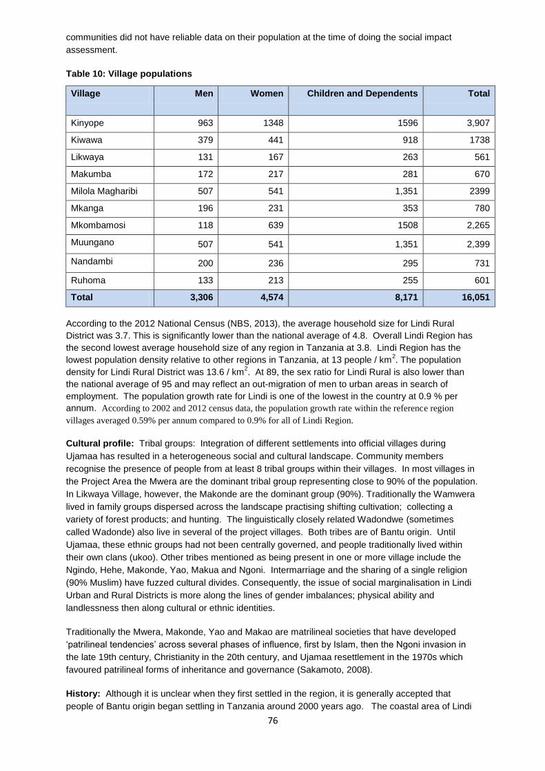
76
communities did not have reliable data on their population at the time of doing the social impact
assessment.
Table 10: Village populations
Village Men Women Children and Dependents Total
Kinyope 963 1348 1596 3,907
Kiwawa 379 441 918 1738
Likwaya 131 167 263 561
Makumba 172 217 281 670
Milola Magharibi 507 541 1,351 2399
Mkanga 196 231 353 780
Mkombamosi 118 639 1508 2,265
Muungano 507 541 1,351 2,399
Nandambi 200 236 295 731
Ruhoma 133 213 255 601
Total 3,306 4,574 8,171 16,051
According to the 2012 National Census (NBS, 2013), the average household size for Lindi Rural
District was 3.7. This is significantly lower than the national average of 4.8. Overall Lindi Region has
the second lowest average household size of any region in Tanzania at 3.8. Lindi Region has the
lowest population density relative to other regions in Tanzania, at 13 people / km2. The population
density for Lindi Rural District was 13.6 / km2. At 89, the sex ratio for Lindi Rural is also lower than
the national average of 95 and may reflect an out-migration of men to urban areas in search of
employment. The population growth rate for Lindi is one of the lowest in the country at 0.9 % per
annum. According to 2002 and 2012 census data, the population growth rate within the reference region
villages averaged 0.59% per annum compared to 0.9% for all of Lindi Region.
Cultural profile: Tribal groups: Integration of different settlements into official villages during
Ujamaa has resulted in a heterogeneous social and cultural landscape. Community members
recognise the presence of people from at least 8 tribal groups within their villages. In most villages in
the Project Area the Mwera are the dominant tribal group representing close to 90% of the population.
In Likwaya Village, however, the Makonde are the dominant group (90%). Traditionally the Wamwera
lived in family groups dispersed across the landscape practising shifting cultivation; collecting a
variety of forest products; and hunting. The linguistically closely related Wadondwe (sometimes
called Wadonde) also live in several of the project villages. Both tribes are of Bantu origin. Until
Ujamaa, these ethnic groups had not been centrally governed, and people traditionally lived within
their own clans (ukoo). Other tribes mentioned as being present in one or more village include the
Ngindo, Hehe, Makonde, Yao, Makua and Ngoni. Intermarriage and the sharing of a single religion
(90% Muslim) have fuzzed cultural divides. Consequently, the issue of social marginalisation in Lindi
Urban and Rural Districts is more along the lines of gender imbalances; physical ability and
landlessness then along cultural or ethnic identities.
Traditionally the Mwera, Makonde, Yao and Makao are matrilineal societies that have developed
‘patrilineal tendencies’ across several phases of influence, first by Islam, then the Ngoni invasion in
the late 19th century, Christianity in the 20th century, and Ujamaa resettlement in the 1970s which
favoured patrilineal forms of inheritance and governance (Sakamoto, 2008).
History: Although it is unclear when they first settled in the region, it is generally accepted that
people of Bantu origin began settling in Tanzania around 2000 years ago. The coastal area of Lindi

77
Region, has historical roots that extend back to the 11th century when Lindi Town was an important
trading area for Arab merchants trading along the East African coast. Under British Administrative
rule of Tanzania, Lindi Town was the headquarters for the Southern States, and a relatively large
population of Indian businessmen arrived with their families and settled in Lindi Town. The economic
importance of Lindi Town began to diminish in 1952 when the Southern States HQ were moved to
Mtwara.
Villages were formally established between 1951 (Milola) and 1973 (Nandambi). Lindi Region was
officially formed as one of Tanzania’s 21 regions in 1971, one decade after Independence.
Communities in the project area described the origin of their villages according to three historical
milestones: 1) Traditional settlements that existed prior to colonial rule; 2) settlements that were
formed during German and British occupancy (1884 – 1961), and; 3) settlements that were
consolidated to form official villages as a national policy to centralise services in rural areas (i.e. the
Villagisation Act or Ujamaa in 1971 - 1975 with the exception of Nangaru Village which was split into
Mkombamosi and Muungano Villages. Anecdotes describing how villages were formed indicate that
until the mid-1970s communities were extremely transient and moved fluidly within the area in search
of agricultural land and water. Pre-1974, most households were scattered, many of them within the
forest. In the 1960s the Ilulu cooperative society was established to promote cashew nuts, sesame
and pigeon peas. Village visioning reports (supplementary material) describe briefly how each project
village was founded. None of the villages qualify as truly indigenous/traditional/long-term villages. Two
of the project villages, Nandambi and Ruhoma were formed during Ujamaa.
Language: Although the Mwera are the dominant tribe, in most villages more than four (and
sometimes up to eight) languages are spoken, including Swahili. Swahili is the most widely spoken
and understood language. In all villages, it was stated that everyone understands Swahili. As such
this has been the language used by the project for communication work.
Religion: Islam is the dominant religion in the project area, having roots extending to 11th century
Arab traders who travelled to the East African coast. Villages have at least one (and sometimes two)
mosques.. The dominant ethnic group (waMwera) tend to be Muslims; the Makonde tend to be
Christians. In all villages it was stated that the majority of the population are Muslims. Followers of
both Sunni and Shia Islam are found within the project villages. It was also stated that there are a
minority of Christians present in all villages. Some animistic beliefs are also held.
Public services: In general, public services in the Project Area were absent or in poor condition at
the start of the project. Annex 3 provides a description of the baseline conditions in relation to the
public services available in the project area in 2011. These are summarised below:
School facilities
This section describes the absence/presence of education facilities and less so the quality of those
facilities or the quality of the educational services provided within them. The education sector in Lindi
District suffers a large shortage of teachers. In 2007 the district was short of 237 teachers.
Consequently, student to teacher ratios are high, with some schools having two (2) teachers
responsible for meeting the educational needs of 197 students. Walking distance to schools, on
average, is 1.5 km.
Nursery schools: Tanzania’s education system requires 5 – 6 year old children to attend nursery
school in preparation for primary school. According to Lindi Rural District statistics, 90% of the total
need for nursery schools in the District is met. However eight out of the 10 villages, do not have a
nursery school (Kiwawa, Makumba, Likwaya, Milola Magharibi, Nandambi, Mkanga 1, Kinyope and
Ruhoma). In four of the eight villages without nursery schools parents send their children to nursery

78
schools in nearby villages (Milola). In the remaining four villages children in this age group do not
attend nursery school at all (Kiwawa, Likwaya, Nandambi and Ruhoma).
Primary schools: Two of 10 villages to not have a village-specific primary school (Milola, Muungano)
and thus send their children to schools of nearby villages. In both cases the school facilities are
within 0.5 km of the village centre. School conditions (e.g. the facilities, teacher to student ratios, and
availability of teaching materials) are poor across all schools. Nandambi Village primary school, for
example, has four teachers to teach 152 students across seven levels.
Secondary schools: There is no secondary school within the current project zone. Secondary school
services (government) are available in nearby villages, distances range from 0.5 km (for students from
Likwaya, Muungano and Mkombamosi villages attending Nangaru secondary school in Komolo
Village within Matimba ward).
Health facilities
All health services in Lindi District are provided by the government rather than the private sector.
Three types of health services are available in the District. One regional hospital is based in Lindi
Urban District which provides in- and out-patient services, addresses most treatments including minor
and major surgery to all residents in Lindi Region.
Health centres provide in- and out-patient basic services (minor surgery) at ward level. There are a
total of five health centres in Lindi Rural District none of which are located within the project area. The
closest health centre to the project area is located in Rutamba ya Zamani Village.
Dispensaries are located at village level with the objective of providing first aid treatment, some
mother and child care (labour rooms and clinics) and HIV-AIDS testing and counselling. For the most
part, dispensaries do not have in-patient services and do not conduct surgery. Only two of the 10
villages in the project area have a dispensary (Kiwawa, Mkombamosi): and another two are under
construction in Kinyope and Mkanga 1. Residents from other villages use the closest available
dispensary. For example, Milola Magharibi residents go to Milola Mashariki dispensary. In some
villages such as Mkanga 1, people must walk for 11 km to reach their nearest dispensary. According
to the District Health Officer (DHO) of Lindi Rural District, the external structure of village dispensaries
and the services provided by these facilities are generally of good quality. However in the case of
Kiwawa, the building is in poor condition with large cracks in the walls.
Some of the main challenges facing health facilities in the study area include understaffing, lack of
transport (there are no ambulances), inadequate medicine supply (which limits services to issuance of
prescriptions), inadequate sanitation (toilets for patients), and unavailability of clean and safe water.
The hospital to population size ratio recommended by the Tanzania Government is 1 hospital per
100,000 people and one doctor per 25,000 patients. The reality in Lindi Rural District is that the one
hospital serves more than double the population size recommended, and one doctor serves up to
107,400 patients, more than four times the recommended ratio.
Transport and Communication
Roads: Communities in the project area are located 52 to 83 km from Lindi Town and the Regional
headquarters. The project area is accessible along unpaved roads feeding off the paved road from
Kilwa to Mtwara. The road to Kinyope and Milola in the south of the project area is in good condition
throughout the year. Smaller unpaved roads to Kiwawa and Ruhoma are accessible during the dry
season but can become impassable during heavy rains. In the north of the project area, villages are
also accessed along unpaved roads which can become impassable to some vehicles during heavy
rains. Between Lindi and Dar es Salaam, there is a paved highway for all but one 50 km stretch which
has been under construction for several years. Although a deadline for completion was set for 2013,
even by March 2014, there remains at least 20 km which has not been completed.

79
Public transport to the project area from Lindi Town is available in the form of mini-buses (max. 20
passengers) available daily. The fare ranges from TSH 3000 to 3500. These go to most villages with
the exception of Ruhoma, Kiwawa, Nandambi and Mkanga 1. Buses are available daily from Lindi
Town to Dar es Salaam. Bus fares to Dar es Salaam range from TSH 16,000 to 25,000. Buses to
Mtwara are also available daily; the fare is TSH 3000 from Lindi Town. As with many parts of
Tanzania, there has been growing availability of motorbike taxis that fill gaps in the transportation
services. Motorbike taxis (bodabodas) are used mostly from drop-off points along the main road to
village centres. Motorbike taxi fares vary from TSH 5000 (Kinyope Village) to TSH 7000 (Kiwawa
Village) and TZS 10,000 (Nangaru Village). These fares are high relative to fares elsewhere in the
country. Villagers generally walk or cycle between villages. Most people walk, however, because few
people can afford to own a bicycle. Other vehicles that are in the Project Area belong to government,
NGOs and traders.
Telephone communication in the project area is available through 2G cellular network communication.
The most widely available mobile phone service is that of Airtel (formerly Zain and Celtel). Tigo and
Vodacom mobile phone companies are only available in Nangaru Village. Ownership of cellular
phones is relatively common especially among young people (16 – 25 years old). Phone charging
services are provided by privately operated generators and solar power systems. The current price for
charging a phone is TSH 300.
National radio stations are the most reliable means of staying connected with local, national and
international news. Tanzania Broadcasting Company is the most popular radio station communities
tune into in Lindi.
Water services
Since the formation of Ujamaa villages in the early and mid-1970s, several water projects have been
implemented in the project area. Consequently some boreholes and/or improved water points do
exist. Improved water points are traditional wells that have been made safer by placing covers over
the well top to avoid contamination. In Mkombamosi Village, Finnish Government Aid developed two
boreholes (in 1988). More recently (in 2009), the Assemblies of God Church funded the construction
of an additional borehole.
Villages without an improved water point rely 100% on stream water, open traditional wells or
improved water points in nearby villages. Traditional open wells and stream water are the two main
sources of water for household use in the project area. Walking distances to the nearest source of
reliable water in the Project area range from 30 minutes to 4 hours, i.e., are up to 12 km. Acquiring
water for the household is generally the responsibility of women and girls.
Keeping improved water points in working order has been a challenge for communities: broken water
services have stayed in disrepair. Acquiring the funds to pay for borehole spare parts is the biggest
impediment to keeping boreholes working long after they have been developed. In Muungano Village,
for example, boreholes (constructed with funding from Finish Government Aid in 1988 have remained
in disrepair since January 2010; communities have subsequently resorted back to using stream water.
Stream water is not suitable for drinking, however; and waterborne diseases are one of the most
frequent diseases reported in Lindi Rural District.
Failure to maintain functional water facilities and services is largely because fees are not usually
charged for water acquired from improved water points. When fees are charged (TZS20 for 20L of
water) such as in Milola and Kinyope villages, water user associations are able to maintain functioning
facilities and services. In Ruhoma a borehole was donated to the village in April 2011 and no water
fees apply. When the water pump recently broke down no institutional mechanism or funds existed to
address repairs.

80
Public spaces
Village government offices: All villages in Tanzania are required to have a local council that governs
and administers national policies and programmes at village level. A village government office is an
essential facility for the Village government to provide daily services to the community, for hosting
council meetings and for storing documents. At the start of the project, only Ruhoma and Milola
Magharibi villages had village government offices. These consist of two small rooms, with mud walls
and a leaking roof, that are inadequate for hosting full council meetings. An office is presently under
construction in Muungano Village. All other villages lack office spaces; instead, they use political party
offices, court buildings, food storage buildings, ward offices, and dispensary corridors.
Community buildings: None of the villages own a public or community building. Assembly meetings
held by the village council (four are required annually) are conducted under large shade trees within
each village.
Market places: Most villages have one area in the central sub-village that is recognised as the
‘marketplace’, although it is not always an official area formally designated as a marketplace by the
village government. Marketplaces in the project zone consist of an open area absent of roofing and
oftentimes having no public sanitation services. Milola Magharibi Village does not have its own
marketplace but uses that of Milola Mashariki Village.
Food storage facilities: Storage of dry foods in communal storage facilities is a common practice in
many parts of Tanzania that provides some level of food security by avoiding post-harvest damage of
grains. Most facilities in the study area were built 30 – 40 years ago (during Ujamaa) and have not
been adequately maintained. Thus, although several of the villages own a storage facility, the
buildings are dilapidated, in dire need of repair or reconstruction, and generally unsuitable for safely
storing food.
Electricity & energy
Electricity from the grid is limited to Lindi Town and its immediate surroundings. None of the
communities in the project area have access to electricity. Lighting is provided by kerosene lamps and
candles. Privately operated diesel generators are available in some villages, usually to charge mobile
phone batteries or to operate local “cinemas” (i.e. viewing television programmes, news and/or
movies). Radios generally run on with battery power locally available from kiosks and shops.
Economic activities: The main economic activities in Lindi Rural District are agriculture, some
beekeeping, fishing, charcoal production and small scale entrepreneurship. In Lindi Municipality
economic activities include agriculture, livestock keeping, fishing, charcoal production,
entrepreneurship and some industry (although most industrial activities occurred in the past and
factories have been closed down).
Agriculture
Shifting cultivation (also known as slash-and-burn or swidden-fallow cultivation) is the main type of
agricultural system practiced in the project area. On average, each household clears 1 – 5 acres (0.81
– 2.02 ha) of primary or secondary forest annually to prepare new fields for cultivation. The process
involves removing all biomass in the designated area with the exception of one or two shade trees,
and subsequently burning the biomass. Tree biomass of larger trees is sometimes converted to
charcoal which is sold to Lindi businessmen although only a few people in most villages have
charcoal making skills. An agricultural field in the shifting cultivation system is used for one to two
seasons (equivalent to 1 to 2 years) before it is abandoned and a new area is cleared. Fields are
abandoned because weeds become increasingly difficult to control, soil fertility decreases (this is
gauged by decreased crop yields), and rat and insect infestations become intolerable. The length of
the fallow period ranges from 3 – 15 years, with most communities saying that they return after 10 –

81
15 years to re-cultivate an area. Wealthier farmers employ labourers and so can farm 7 – 15 acres
per year.
Permanent agricultural fields do exist. These are confined to areas closer to village centres, and in
fertile valleys or on non-sloping land. Most permanent fields are reserved for cultivation of permanent
or long-term crops such as cashew, coconut, orange trees, or for cultivating rice. In Mkombamosi in
the wetlands areas, sugar cane, coconuts, tomatoes, spinach, onions and cabbage are grown.
According to the Lindi District Agriculture Officer approximately 19,000 ha of land in Lindi District is is
under permanent agriculture. The majority of that land (16,000 ha) is occupied by cashew nut
plantations; the rest (3,000 ha) is occupied by coconut plantations.
A wide diversity of crops are cultivated in the project zone. Generally, maize, millet, rice, sorghum,
cowpeas, pigeon peas, bananas and cassava are the principal food crops cultivated. The main cash
crops are cashew, sesame, oranges and coconut. Across the project zone, there is substantial
variation between villages in terms of crops cultivated. Within villages, sub-villages can also cultivate
very different crop types. Many families farm shambas both in the uplands and in the lowlands,
typically with permanent crops, perhaps mixed with cowpeas in the lowland shamba, and food crops
and sesame in the upland shamba. Most people plant several crops on the same shamba, e.g. a line
of sesame, a line of sorghum and cowpeas in between. Or a shamba will be split into sections with
different crops in each section. The food produced lasts all year and seasonal food shortages are
rarely experienced. More detailed information on the agricultural practices of the area is provided in
Kibuga and Samweli (2010) and in the project’s agricultural strategy (TFCG 2012).
Rat and insect infestations are common and widespread. Other animals affecting agriculture
productivity include bush pigs, baboons, elephants, and blue monkeys who destroy crops at different
maturation stages. Furthermore, lions and leopards threaten the safety of farmers in their fields or on
their way to and from the fields.
Farming is conducted with low-tech and manual farming implements and is limited to the hand hoe.
Lack of access to agricultural inputs to control rat and insect infestations or to fertilise depleted soils
are additional challenges.
Kilimo Kwanza, a nationwide programme to improve agriculture has not yet had much impact in the
project area. For example, the farms are not ready for mechanised agriculture. Whilst tractors and
power tillers are available at District offices, they have not been put to use by communities because
their farms are not sufficiently prepared to enable mechanised tilling (roots have to be removed to
allow power tillers and tractors to function properly); and their fields are not accessible to tractors due
to a lack of roads and steep slopes.
Beekeeping
Beekeeping is uncommon and conducted by only few people in the project zone and is generally
perceived as unprofitable. Beekeeping is undertaken most prominently in Milola Magharibi village
(although it occurs at smaller scales in other villages as well). In Milola Magharibi, some community
members maintain traditional hives in the nearby Miombo woodlands. There are about 15 traditional
hives belonging to three people in Milola Magharibi. Beekeepers maintain about 5 hives per person.
The hives produce 40 to 50 litres of honey annually. Interviews with beekeepers revealed that one
hive produces about 10L of honey that can be harvested 4 to 5 times per year. Other villages have a
total of 2 – 3 hives. Honey is sold locally for medicinal purposes and for direct consumption. It is not
transported to sell to Lindi Town residents. Beekeepers tend to be WaMwera and occupy the middle
class; they are not particularly marginalised or vulnerable.
Small-scale business activities

82
Small business in the project area includes kiosks for non-perishable goods that are not produced
locally (oil, salt, sugar, wheat flour, batteries, etc); vegetable stands for tomatoes, greens, onions and
cabbage; tailors, carpenters, bicycle repair stands, hair dressers, phone charging services, local
cinemas, motorbike taxis, bicycle taxis, maize milling, guest houses, traditional breweries and local
pubs, and coffee/tea stands. Some women are food vendors, putting up small stalls on the street
sides in the evenings to sell economic food (e.g. rice and beans). Some people are employed as
labourers to work on the farmers of wealthier villagers.
Timber
Timber harvesting for sale outside the project zone occurs in Mkombamosi, Muungano and Nandambi
villages and is undertaken by businessmen from Lindi and Kilwa towns and residents of neighbouring
villages. The clandestine nature of the timber business means that it is unlikely that communities will
state openly that they participate in timber harvesting. Preferred timber species are the hardwood
species mninga (Pterocarpus angolensis), mvule (Milicia excelsa) and mchenga (Julbernardia
globiflora).
Charcoal production
Charcoal production is conducted by a few people in most villages. It is predominantly a male activity.
Women are also involved either individually or in partnership with a man. For example in a survey
conducted by the project of 188 charcoal mounds in Likwaya, it was found that 71% of the mounds
were made by men, 13% by women and 16% of those mounds were made in collaboration between a
man and a woman. In most villages there are a few individuals who are year-round charcoal
producers. Others produce charcoal only to address a particular financial emergency. The charcoal is
sold mostly within the community, but also exported outside the area by small-scale middlemen.
Charcoal is often produced either as a by-product of forest clearing for agriculture, or as the primary
activity. The chief charcoal producing village is Likwaya where it is the primary economic opportunity
for many households
No AFOLU projects were established in the project zone prior to this project.
CM1.2. Evaluate whether the Project Zone includes any of the following High
Conservation Values (HCVs) related to community well-being and describe the
qualifying attributes for any identified HCVs:
a. Areas that provide critical ecosystem services;
b. Areas that are fundamental for the livelihoods of Communities; and
c. Areas that are critical for the traditional cultural identity of Communities.
Identify the areas that need to be managed to maintain or enhance the identified
HCVs.
CM 1.2 a High Conservation Values - Ecosystem services
Hydrological Services
The plateaux trigger orographic rainfall. This percolates through the sandstone emerging as springs at
the base of the plateaux. This water than flows into the permanent and ephemeral streams and rivers
within the landscape including the Mnangaru and Likandilo Rivers to the North of the plateau; the
Mkomole River valley that divides the Chitoa from the Noto plateaux; and the Milola valley to the west
of the project area. These rivers supply water for agricultural use. The Lutamba and Tandangongoro

83
lakes that form at the base of the Chitoa plateau are used for fishing and as a water source for
domestic use. For domestic use, most people collect water from open springs and streams.
The plateaux are an important catchment area for the streams that flow eastwards providing water for
people living in the valleys.
Erosion control
The forests growing up the sides of the escarpments play an important role in preventing soil erosion
including landslides on these extremely steep slopes. In this way the forests help to protect the
settlements at the base of the escarpments from damage due to landslides.
Sequestration of CO2
As is described in more detail in G 1.4, the project area represents an important carbon stock. The
forests also play an important role in sequestering CO2.
CM 1.2 b High Conservation Values - Community forest products
Based on interviews with women and men living within the project area, as part of the REDD
Readiness activities, the TFCG and MJUMITA teams recorded several community forest products
including wild tubers, fruits, mushrooms, medicinal plants and bush meat. A summary is provided
below with more information available in Forrester-Kibuga and Samweli (2010) and Mwampamba et
al. (2011) which can be found at www.tfcg.org/MakingREDDwork.html.
Within the project area, wild food and fruits are an important source of complementary vitamins and
minerals otherwise difficult to obtain from everyday staples. Wild food and fruits are often collected by
women and children. The most common wild food collected from forests are the Ming’oko and
Mipama tubers. Ming’oko are an important source of income for women; they are sold locally or taken
to Lindi Town. They are consumed like cassava. The Ming’oko season is between June – November
i.e during the dry season. According to some participants, ming’oko is gathered in thickets and
degraded primary or secondary forests (not dense primary forests).
The diversity of edible mushrooms varies substantially between villages. Likwaya villagers claim that
there are no edible mushrooms in their village areas. All other villages identified 5 to 8 different types
of edible mushrooms.
Wild fruits are collected across a wide array of forest types by men, women and children.
Approximately nine different fruits are most commonly collected; collection occurs in all villages.
According to some interviewees, in the last 20 years wild fruit availability has been steadily
decreasing. Given that most wild fruits are gathered in dense primary forests, participants foresee
continued decrease in wild fruit.
Medicinal plants are collected and used in all villages in the project area. Two villages (Ruhoma, and
Milola Magharibi) reported scarcity while the other villages reported abundance. Availability of
medicinal plants over the last 20 years echoes this disparity across villages: about half of the villages
perceive unchanged availability while others report decreasing availability.
Wild honey is available in all villages with forests, with the exception of Ruhoma Village. Overall,
supply is low, and limited to household use or sold very locally. The honey is used as food and
medicine. About half the of the villages practice beekeeping in local forests. Prior to the project,
production was low with only one or two people practice beekeeping with less than 10 hives being
kept in any one forest. As part of the REDD readiness activities, TFCG and MJUMITA have been
providing training and equipment for beekeeping. As such the number of hives now kept in the forest
is higher and the number of people benefiting from beekeeping has increased.

84
Though illegal without a permit, hunting for bush meat is conducted in all villages. The main animals
hunted are duiker, bushbuck, warthog, blue monkey, buffalo, and elephant. Religious beliefs affect
the animals targeted by different people for example Muslims are prohibited from eating bush pig or
primates.
CM 1.2 c High Conservation Values - Cultural values
The collection of forest products is often associated with cultural values. For several of the women
whom the team interviewed, they highlighted that it was traditional for women to retain the income
from the sale of ming’oko to buy things for themselves such as a new khanga.
Areas that need to be managed to maintain or enhance the identified HCVs.
Forests on the escarpments and in close proximity to rivers need to be conserved in order to maintain
the hydrological functions of the forest.
In order to conserve access to forest foods including fruits, mushrooms and tubers, it is important to
conserve both woodland and coastal forests.
CM1.3. Describe the expected changes in the well-being conditions and other
characteristics of Communities under the without-project land use scenario, including
the impact of likely changes on all ecosystem services in the Project Zone identified
as important to Communities.
The ‘without project’ scenario in which there is widespread deforestation and forest degradation would
negatively affect all ecosystem services currently provided by the forests. The following scenarios
were developed in a participatory way as part of the social impact assessment (Mwampamba et al.
2011).
Forest foods and medicinal plants: with declining forest area and a commensurate decline in plant
populations, communities would find it increasingly difficult to find the mushrooms, fruits, medicinal
plants, fodder and other forest foods that they currently use. Already, according to some
interviewees, in the last 20 years wild fruit availability has been steadily decreasing. Given that most
wild fruits are gathered in dense primary forests, participants foresee continued decrease in wild fruit.
This decline in forest foods is likely to hit the poorest households hardest as they tend to be the most
dependent on forest products. During the participatory ‘without project’ scenario building all but one
community indicated that they expected a decline in forest fruits, mushrooms and medicinal plants in
the absence of the project (see Mwampamba et al. 2011). As noted in Section GL1, such forest foods
are particularly important during times of drought, therefore their decline is particularly significant in
the context of increased vulnerability to climate change.
Medicinal plants are collected and used in all villages in the project area. Two villages (Ruhoma, and
Milola Magharibi) reported scarcity while the other villages reported abundance. Availability of
medicinal plants over the last 20 years echoes this disparity across villages: about half of the villages
perceive unchanged availability while others report decreasing availability. This disparity will reflect
the medicinal plants under consideration with those medicinal plants that favour forest habitats
declining whilst those that flourish in more disturbed conditions increasing.
Timber and fuelwood supplies reduced: communities also highlighted that in the absence of the
project fuelwood and timber supplies would be reduced resulting in (mainly) women having to invest
more time and effort in collecting fuel wood for domestic consumption.
Increased soil erosion: with the loss of the protective forest cover on the steep slopes on the plateau
sides, it is likely that there would be an increase in soil erosion including land slides and gulley
erosion resulting in loss of agricultural land.
85
Reduced water supplies: it is unclear what the impact would be on water supplies and more research
is needed to understand the micro-climates of the plateaux and the hydrology. There is a risk that
higher ground temperatures would result in more evaporation and therefore less water being available
to percolate through the plateaux to feed the springs and lakes at the plateau bases. There is also a
risk that a longer, hotter dry season will lead to greater water stress during August and September.
More research is needed to understand the hydrology of this area.
CM2. Net Positive Community Impacts
CM 2.1 Use appropriate methodologies to assess the impacts, including predicted and
actual, direct and indirect benefits, costs and risks, on each of the identified
Community Groups (identified in G1.5) resulting from project activities under the with-
project scenario. The assessment of impacts must include changes in well-being due
to project activities and an evaluation of the impacts by the affected Community
Groups. This assessment must be based on clearly defined and defendable
assumptions about changes in well-being of the Community Groups under the with-
project scenario, including potential impacts of changes in all ecosystem services
identified as important for the Communities (including water and soil resources), over
the project lifetime.
As outlined in Section G 3.1 the project has three objectives pertaining to the project’s community
impact.
Positive community impacts
The predicted and actual, direct and indirect positive impact on the communities of the project is
detailed below according to these three objectives:
CM Objective 1. To maintain forest ecosystem services and a sustainable supply of forest
products through an equitable and effective system of participatory forest management.
CM Impact 1. Community-owned forests will be managed in a participatory, effective and
equitable way.
Compared with the ‘without project scenario’ in which communities did not anticipate the
establishment of community based forest management in the villages, the village forests will be
managed according to management plans and by-laws developed in a participatory way as a result of
project interventions. The plans will reflect the needs of different groups within the communities
including women and poorer households. The Village Natural Resources Committees shall be
responsible for the management of the reserves and will be accountable to the Village Council and
Village Assembly.
CM Impact 2. Forest products will continue to be available and accessible to all community
members including the poorest households according to access rules agreed in a
participatory way.
Compared with the ‘without project scenarios’ in which communities anticipated an overall decline in
the availability of forest products and the projected deforestation based on the historical baseline
indicated a 44 % loss of forest over a 30 year period, it is anticipated that sustainable management of
the village forest reserves will safeguard the availability of non-timber forest products including wild
foods and medicinal plants. The forests will also continue to provide a suitable place to locate bee
hives and will provide forage for bees so that bee keepers can produce honey.
CM Impact 3. Villages will be better governed.

86
Compared to the without project scenario, in which communities anticipated that most aspects of
village governance will remain the same, it is anticipated that REDD will motivate elected village
leaders to uphold village by-laws; and will motivate citizens of a particular village to hold their leaders
more accountable, particularly in relation to the management of community development projects. By
requiring that village leaders must present the plans and budgets for community development projects
and that the community as a whole can chose whether or not to invest in the community development
project, it is expected that the leaders will be more accountable for the delivery of the projects.
Through the trial payments already made in the villages, there is already evidence of this. It is
expected that as a result, the village council and the village natural resources committee will meet
more regularly. Integrated into measures to improve governance will be the principle of improved
representation for women and poorer households. Underlying improved governance in the
participating villages is widespread awareness raising that will reach adults through meetings and the
distribution of awareness raising materials and youth through improved environmental education in
primary schools.
CM Impact 4. Communities will have more secure land tenure
The without project scenario developed by the communities indicated that they did not anticipate
developing a village land use plan. As part of REDD, each of the villages has developed a village
land use plan and by-laws; will receive its village land certificate; and will have a village land registry.
CM Impact 5. Water sources will be better protected
Many communities rely on springs for their water supply. By protecting forests around the springs, it
is anticipated that communities will have a more reliable and plentiful supply of water than would
occur according under a ‘without project’ scenario where deforestation close to springs might threaten
the water suppliers.
CM Impact 6. Soil erosion will be reduced
Forests play an important role in preventing soil erosion. With the loss of the protective forest cover on
the steep slopes on the plateau side, as predicted in the without project scenario, it is likely that there
would be an increase in soil erosion including land slides and gulley erosion resulting in loss of
agricultural land. By maintaining forest cover on steep slopes, particularly along the sides of the
plateau, it is anticipated that soil erosion will be reduced compared to a without project scenario in
which forests are removed from the plateau edges. In addition, the adoption of conservation
agriculture practices which integrate improved soil management techniques, it is anticipated that soil
erosion will also be reduced in agricultural areas.
CM Objective 2. To generate individual cash incomes from REDD for investing in improved
agricultural practices and other enterprises and for livelihood diversification with a particular
focus on poorer households and women.
CM Impact 7. Individual incomes will be boosted and diversified by receiving REDD payments
The project model aims to channel the net REDD payments (after verification, monitoring, marketing
and revenue distribution costs are deducted) to communities. Each woman, man and child who fulfills
the eligibility criteria agreed by the communities, is treated as a share-holder and is paid a dividend
from the revenue generated from the sale of the voluntary carbon units. In this way all individuals can
tailor the way that the revenues are invested to meet their particular needs. The payments will benefit
all constituent socio-economic and cultural groups within the communities as every individual will be
paid. Such cash payments were not in place before the project. The amount that communities will
earn will be proportional to their emission reductions. Based on conservative estimates, this is likely
to range from TZS 8 million to TZS 50 million per village. Each community will decided as to what

87
proportion of their individual payments they retain for personal use and what proportion they
contribute to community development activities. The payment mechanism has been trialed
successfully in all villages. Individual payments were used by community members for a wide range
of expenses including investing in businesses; paying school fees; purchasing agricultural inputs;
paying for improved houses; and covering immediate needs such as food and medicines. MJUMITA
and TFCG have provided training on the establishment and operations of village savings and loans
associations thereby setting up a system by which community members can save and plan how to
invest their REDD incomes.
CM Impact 8. Women and men farmers, including those from poorer households, will adopt
more profitable, sustainable and climate change resilient agricultural practices and will invest
in other enterprises and / or value addition measures.
The project aims to provide farmers with the technical skills to adopt improved agricultural activities
that are more profitable, more ecologically sustainable and more resilient to climate change. This will
include training on on-farm activities as well as post-harvesting value addition. In addition, the project
will support access to micro-finance through the establishment of village savings and loans
associations in order to provide farmers with a more stable financial basis. The project will also
provide training on other economic enterprises including silviculture and bee keeping.
CM Objective 3. To improve the quality and availability of public services and infrastructure.
CM Impact 9. REDD revenues will contribute to improving public services and infrastructure
It is anticipated that the communities will chose to invest some of their REDD revenues in improving
community services and infrastructure. This might include payments for the construction of buildings
intended for public service delivery e.g. a dispensary, class room, water delivery point or market
place; or to contribute to the costs of running public services better (e.g. contributing to the running
costs of a dispensary). By generating funds from REDD to pay for these services, the communities
will be better off than they expected to be as described in the ‘without project’ scenarios.
CM Impact 10. Villages will have village offices
In many villages, the without project scenarios indicated that they did not expect to construct a
modern village office. As a result of the project all of the participating villages will have village offices
with space to store their records; hold meetings; store equipment securely; and fulfill other functions of
village governance.
As described in CM 1.1 the project anticipates that the project will have a positive impact on the high
conservation values identified in G 1.8.4 – 6.
Potential and actual costs and risks to community benefits resulting from project activities
under the with-project scenario.
As noted in Section G 1.10, during the social impact assessment for the project, stakeholders
identified a number of potential risks; assessed their probability and potential impact; and identified
some mitigation measures. The risks that could negatively affect community benefits and that may be
linked directly or indirectly with project activities (rather than resulting from external factors) are listed
in Table 11.
Table 11: Potential risks to community benefits from project activities.
Risk description Probability and
potential impact of
risk
Mitigation measures

88
Risk description Probability and
potential impact of
risk
Mitigation measures
Risk 1. Conflicts over
village boundaries
cause delays to land
use planning and the
issuing of village land
certificates; and
revised boundaries
are not accepted by
all farmers with some
farmers continuing to
clear forest in an
adjacent village’s
land.
Probability: medium /
high. Potential
impact: high.
Mitigation measures: seek consensus from all affected
villages on the location of village boundaries through
joint meetings; boundary visits; and participatory
mapping. Raise awareness on the location of the new
boundaries within the affected villages. Support the
District Lands Office to apply for a village boundary
amendment from the Ministry of Lands and ensure that
all required documents and other evidence is
submitted.
Risk 2. Increase in
human-wildlife
conflict associated
with increase in
forest cover and
forest enhancement.
Existence of wild
animals in the area
(and possible
increase in wildlife
due to forest
enhancement) could
threaten safety of
communities and
agricultural efforts
(through crop
destruction).
Medium. Potential
impact: medium
Training to farmers on techniques to avoid crop losses
due to wild animals. Shifting to more permanent
agricultural techniques in fields that are further from
the forests.
Risk 4. Internal
conflict within
communities over
forest access rights.
Probability: medium
Potential impact of
risk: high
The REDD readiness activities were implemented with
a commitment to free, prior and informed consent.
Through the participatory planning and social impact
assessment work, community members have directed
the design of the REDD implementation phase. They
were also given opportunities to opt out of the project
at various stages. Those communities with groups of
individuals who were not happy to continue with REDD
implementation are not included. All of the villages
that are included in this PDD have chosen to continue
with the project through their village assembly
meetings. The Village Assembly meetings have
passed by-laws on REDD and have agreed to sign a
Memorandum of Understanding with MJUMITA
outlining their commitment to the REDD process. In
addition, a conflict resolution mechanism is in place, to
ensure that conflicts that do arise can be addressed in
a fair way. By engaging with a wide range of

89
Risk description Probability and
potential impact of
risk
Mitigation measures
stakeholders during the project design phase, there is
also a broad network of support for the initiative at
local and national level including from local MPs, the
District Council and the Ward Development
Committees.
Risk 7. Corruption in
relation to the REDD
payments
undermines the
effectiveness and
equitability of REDD
Probability: medium
Potential impact of
risk: low / medium
The individual payment mechanism modelled by this
REDD project is designed to maximise accountability
around REDD payments. It is based on the premise
that individuals are more likely to demand
accountability where they have a direct stake in the
outcome of transactions. As part of the REDD
readiness activities, there has been widespread
awareness raising in relation to the model and two
rounds of payments have been made in all villages so
that a majority of people are familiar with the process
and the roles and responsibilities of different
stakeholders. The MJUMITA networks have also been
trained to provide support to communities to prevent
and where necessary address any governance
shortfalls in relation to the REDD payments. The
presence of civil society organisations is known to
moderate the risk of elite capture in participatory forest
management (Persha and Andersson 2014). The
highest risks relate to the use of any funds allocated
for community development projects. Where
communities do not trust their leaders, they have the
option of not entrusting any money to them.
Risk 8. Corruption in
relation to forest
reserve management
results in forest
clearance
Probability: medium
Potential impact of
risk: medium
Over the last decade there has been growing
awareness on the scale of corruption within the forest
sector in Tanzania and its impact on national
development. As such various efforts are now
underway at local and national levels to mitigate these
risks. Many of these initiatives such as the Mama
Misitu (Mother Forest) Campaign and the Forest
Justice Project have invested in building the capacity
of communities to address governance shortfalls. As
part of the REDD readiness activities, TFCG and
MJUMITA have provided training to village leaders on
good governance. They have also provided training
and support to community based advocacy groups so
that they can address governance shortfalls directly at
village level. These local MJUMITA networks are now
in place and are expected to play an important role in
preventing and resolving corruption in relation to
reserve management.
Risk 10. REDD
revenues are
insufficient to
incentivise
Probability: medium
Impact of risk: high
By seeking CCB and VCS validation, the project aims
to secure a price for REDD credits that will provide
sufficient incentives to communities to reduce
deforestation. In addition, during the REDD readiness

90
Risk description Probability and
potential impact of
risk
Mitigation measures
sustainable forest
management
activities, TFCG and MJUMITA emphasised the other
benefits to communities of maintaining forest cover
and will continue to look at ways to secure other
revenues for communities that support and are
compatible with REDD.
In terms of costs to communities, the main cost is the opportunity cost of allocating village land for
forest management rather than agriculture. The project aims to mitigate this cost by providing training
to communities on improved agricultural practices; and by channelling REDD finance to the
communities. Other direct costs include the costs of implementing the village land use plans and
community based forest management. Communities are strongly encouraged to set aside REDD
funds to cover these costs.
Whilst the introduction of participatory forest management and REDD bring governance-related risks
and potential conflict, they have also brought governance-related benefits including increased
knowledge amongst ordinary residents and village leaders on roles and responsibilities in relation to
forest management; increased accountability of village leaders; stronger land tenure; and village
offices to provide a more conducive environment for village governance. Overall, the project is
expected to have significant net positive impact on the communities with the costs and risks being
mitigated through the strategies outlined above.
CM 2.2 Describe measures needed and taken to mitigate any negative well-being
impacts on Community Groups and for maintenance or enhancement of the high
conservation value attributes (identified in CM1.2) consistent with the precautionary
principle.
The mitigation measures for each risk and cost are presented in Section CM 2.1 with further analysis
of the positive and potential negative impact of the project on each community group presented in CM
2.3.
No negative impact on the high conservation values is anticipated as a result of the project activities.
Positive impacts relative to the without-project scenario are highlighted in Section CM 2.1 in relation to
CM Impacts 5 and 6 and in Section B2.1 – 4 in relation to the impact on biodiversity values.
CM 2.3 Demonstrate that the net well-being impacts of the project are positive for all
identified Groups compared with their anticipated well-being conditions under the
without- project land use scenario (described in CM1).
The net well-being of the project is anticipated to be positive for all community groups.
Some of the project’s community benefits will have a positive impact on all community groups. These
include:
Community Impact 3: Villages will be better governed. Community Impact 4: Communities will have more secure land tenure. Community Impact 5: Water sources will be better protected. Community Impact 7: Individual incomes will be boosted and diversified by receiving REDD payments. Community Impact 9: REDD revenues will contribute to improving public services and infrastructure. Community Impact 10: Villages will have village offices.
Similarly some of the risks could have a negative impact on all community groups. These include:

91
Risk 7. Corruption in relation to the REDD payments undermines the effectiveness and equitability of REDD. Risk 8. Corruption in relation to forest reserve management results in forest clearance. Risk 10. REDD revenues are insufficient to incentivise sustainable forest management.
These risks could reduce the benefits anticipated to be achieved through community impacts 7 and 9
however the communities would still be better off as a result of project compared with the without
project scenario i.e. these risks are primarily to the project’s model rather than posing a direct threat to
the well-being of any of the community groups.
Some of the project’s community benefits and risks are primarily relevant to specific community
groups. These are considered below with a particular focus on assessing the degree to which the
scale of the risks has been changed by the project relative to the without-project land use scenario i.e.
how much of the risk can be attributed to the project:
Small-scale farmers
In addition to the positive impacts intended to benefit all community members, the community impacts
that are intended specifically to benefit small-scale farmers include:
Community Impact 6: Soil erosion will be reduced.
Community Impact 8: Women and men farmers, including those from poorer households, will adopt
more profitable, sustainable and climate change resilient agricultural practices and will invest in other
enterprises and / or value addition initiatives.
The risks that might affect small-scale farmers include:
Risk 1. Conflicts over village boundaries cause delays to land use planning and the issuing of village
land certificates; and revised boundaries are not accepted by all farmers with some farmers
continuing to clear forest in an adjacent village’s land.
Risk 2. Increase in human-wildlife conflict associated with increase in forest cover and forest
enhancement. Existence of wild animals in the area (and possible increase in wildlife due to forest
enhancement) could threaten safety of communities and agricultural efforts (through crop destruction).
Some small-scale farmers, particularly those living close to the forest edge are also likely to bear a
disproportionate amount of the opportunity cost of foregoing forest clearance for new agricultural land.
The project is designed to enable farmers to adopt improved agricultural techniques that help to
increase yields by adopting improved seeds; conserve soil fertility; maintain soil moisture; prevent soil
erosion and reduce crop losses to wild animals. By establishing village saving and loans associations
and providing training on enterprise skills, the project is also trying to empower farmers to add value
and become more profitable. For some farmers, there is also the added benefit of diversifying into
beekeeping.
Regarding the first risk, whilst this is a risk to the project, it is a risk that farmers would have faced
even in the absence of the project and stems from the problematic way in which the village
boundaries were mapped by the Ministry of Lands prior to the project. As such the project has helped
the majority of small-scale farmers to be better off with respect to having agreed-upon village
boundaries by supporting the boundary resolution process for several contested boundaries.
Regarding the human-wildlife conflict, even in advance of the project this was cited as one of the
major problems that farmers were facing. Whilst some of the animal species considered problematic
by farmers are associated with forests and woodlands including the vervet monkeys, blue monkeys,

92
baboons and bush pigs, others such as cane rats are non-forest species and as such will be
unaffected by the project. Even regarding the crop-raiding species that do live in woodland or forest,
most are coming from the forest immediately adjacent to the agricultural land which, in most villages,
lies outside of the village forest reserve. For the forest and woodland outside of the village forest
reserve, there is no increase on hunting restrictions. As such, the impact of the project on populations
of crop-raiding animals is likely to be minimal when compared with the ‘without-project’ scenario for
any farmer with a field adjacent to a forest area. Nonetheless, recognising that addressing this issue
is critical to freeing up farmers’ labour for more productive use, the project has provided training on
simple measures that can be taken to reduce such crop losses; and is also encouraging farmers to
adopt more permanent agriculture away from the forest frontier. Overall the project has not
exacerbated this risk relative to the without-project land use scenario; has taken steps to help farmers
to mitigate this risk; and provides a suite of other benefits to enhance farmers’ well-being. As such the
impact of the project on small-scale farmers is anticipated to be positive relative to the without-project
land use scenario.
One of the costs associated with establishment of village forest reserves, that will be borne by some
small-scale farmers is the opportunity cost of clearing the forest. As noted in Section 1.12, assuming
a farmer cultivates for 2 years in a row and then fallows for 10 years before cultivating again, the 30
year (project life span) net present value using an annual discount rate of 10% of 1 hectare of land
converted to farming is $303.48. Whilst this should be covered by the revenue from the sale of REDD
VCU, the REDD revenues will be distributed amongst all community members, whereas the
opportunity cost is borne by those who would have cleared the forest. For this reason, the project has
focused training on conservation agriculture on those living closest to the forest so that the
opportunity cost of clearing forest for a new field is balanced by her / his ability to produce more from
their existing fields plus the REDD payments and other positive impacts associated with the project
thereby leaving them at least as well off as they would have been in the without-project scenario.
Users of forest products including medicinal plants, fuel wood, building poles, timber, food plants
including ming’oko and mushrooms and hunters.
In addition to the positive impacts intended to benefit all community members, the community impacts
that are are intended to benefit forest-product users include:
Community Impact 1: Community-owned forests will be managed in a participatory, effective and
equitable way.
Community Impact 2: Forest products will continue to be available and accessible to all community
members including the poorest households according to access rules agreed in a participatory way.
The risks that might affect forest-product users include:
Risk 4. Internal conflict within communities over forest access rights.
The project is designed to clarify user rights and access rules; and to ensure a sustainable supply of
forest products. Whilst there is a risk that some users may not understand or accept the new rules
which could lead to conflict, the project has sought to mitigate this risk through the participatory way in
which the Village Forest Reserve management plans were developed; the awareness raising on the
CBFM process; and encouraging communities to allow sustainable use within the village forest
reserves. This risk should also be considered in the context of declining supplies of forest products in
the without-project land use scenario. For example, charcoal producers in Likwaya have contributed
to an annual deforestation rate of 4.7 % for the village. With such a high deforestation rate and with
many households largely dependent on charcoal, it is clear that the basis for their livelihoods is rapidly
being eroded with the risk that in the absence of the project providing support to adopt alternative
economic opportunities, conflict over resources will occur in 10 – 15 years. More generally, the
restrictions apply only to the forest within the village forest reserve. As such whilst the risk may occur
initially, after the first two years when people understand the new village forest reserve rules, it is
unlikely to have a significant negative impact on users; and the negative impact will be balanced by

93
the positive impact of having a more sustainable supply of forest products as a result of the improved
forest management. In the context of the other benefits provided by the project, the net impact is
anticipated to be positive relative to the without-project land use scenario.
Charcoal producers
In addition to the positive impacts intended to benefit all community members, the community impacts
that are intended to benefit charcoal producers:
Community Impact 8: Women and men farmers, including those from poorer households, will adopt
more profitable, sustainable and climate change resilient agricultural practices and will invest in other
enterprises and / or value addition initiatives.
With the exception of Likwaya, the few charcoal producers who were identified within the project area
can be described as opportunistic and are producing charcoal as a by-product of farm clearance. As
such, their primary economic activity is as small-scale farmers and so fit more naturally into the small-
scale farmer category analysed above. In Likwaya, the project has sought to involve charcoal
producers in conservation agriculture training.
Existing income generating groups
In addition to the positive impacts intended to benefit all community members, the community impacts
that are intended to benefit existing income-generating groups:
Community Impact 8: Women and men farmers, including those from poorer households, will adopt
more profitable, sustainable and climate change resilient agricultural practices and will invest in other
enterprises and / or value addition initiatives.
No risks specific to this group were identified. Members of these groups will benefit from the
availability of additional technical support from the community based trainers whom the project has
trained within the villages. The project will have a net-positive impact on this community group.
Village Councils and Village Natural Resources Committees (VNRCs)
The community impacts that are intended to benefit the Village Council and VNRC members include:
Community Impact 1: Community-owned forests will be managed in a participatory, effective and
equitable way.
The risks that may affect the Village Council and VNRC members include:
Risk 1. Conflicts over village boundaries cause delays to land use planning and the issuing of village
land certificates; and revised boundaries are not accepted by all farmers with some farmers
continuing to clear forest in an adjacent village’s land.
Risk 7. Corruption in relation to the REDD payments undermines the effectiveness and equitability of
REDD
Risk 8. Corruption in relation to forest reserve management results in forest clearance
Risk 10. REDD revenues are insufficient to incentivise sustainable forest management
Increaased transaction costs.
As village leaders, the project is designed to support the Village Council and its committees to fulfil
their roles and responsibilities in a more efficient, effective and equitable way. This risks increasing
their work load; requires them to be more vigilant in fighting corruption; increases the transaction
costs of implementing new by-laws; and will require them to demonstrate their performance more
clearly during elections. The project has mitigated these risks through training to the Village Council,
Village Natural Resources Committees and Village Land Use Management Committees in their roles
and responsibilities; governance practices; and record keeping. In addition the project has raised
awareness amongst other community members on what can be expected from their leaders. This is
anticipated to provide more widespread support for the village leaders to implement their jobs
properly. As part of the REDD payments, communities are encouraged to set aside funds for the
functioning of the village committees. The project has also supported the construction of village

94
offices so that village leaders can fulfil their jobs more effectively. In the context of the other benefits
provided by the project, the net impact is anticipated to be positive relative to the without-project land
use scenario.
CM2.4. Demonstrate that no High Conservation Values (identified in CM1.4) are
negatively affected by the project.
It is not anticipated that the project will have a negative impact on any of the project area’s High
Conservation Values.
CM3. Other Stakeholder Impacts
CM3.1. Identify any potential positive and negative impacts that the project activities
are likely to cause on the well-being of Other Stakeholders.
Potential and actual positive impacts that the project activities are likely to cause on the well-being of
other stakeholders include:
- increased capacity of local government in relation to conflict resolution, participatory forest
management, village land use planning, conservation agriculture and environmental
education as a result of training and capacity building to local government staff provided by
the project;
- increased awareness on issues ranging from conservation agriculture, land tenure and
improving village governance as a result of awareness raising activities including media
coverage, that the project has supported;
As part of the Social Impact assessment, communities were asked to identify external stakeholders
who might be affected by the project. Some communities stated that there were no external
stakeholders who would be affected by the project whilst others stated that sometimes, farmers and
forest product collectors from adjacent villages use their forests and so might be affected by more
stringent regulations on access to forest products. In most cases the adjacent villages are within the
project area, thus whilst the farmers are external to a particular village they should not be considered
as offsite stakeholders since they are resident within the project area. As such, the REDD revenues
are expected to compensate for the reduced access to forest products and forest land. However
potential negative impacts were identified for a few farmers from some villages that are external to the
project area. The project will offer training on conservation agriculture in these villages in 2014.
CM3.2. Describe the measures needed and taken to mitigate the negative well-being
impacts on Other Stakeholders.
By providing training to offsite farmers who might be affected by restrictions on forest access, the
project aims to mitigate the potential negative impacts.
CM3.3. Demonstrate that the project activities do not result in net negative impacts on
the well-being of Other Stakeholders.
By providing training on conservation agriculture, it is anticipated that the net impact of the project is
positive.
CM4. Community Impact Monitoring
CM4.1 Develop and implement a monitoring plan that identifies community variables
to be monitored, Communities, Community Groups and Other Stakeholders to be
monitored, the types of measurements, the sampling methods, and the frequency of

95
monitoring and reporting. Monitoring variables must be directly linked to the
project’s objectives for Communities and Community Groups and to predicted
outputs, outcomes and impacts identified in the project’s causal model related to the
well-being of Communities (described in G1.8). Monitoring must assess differentiated
impacts, including and actual benefits, costs and risks, for each of the Community
Groups and must include an evaluation by the affected Community Groups.
The project’s monitoring plan is provided as supplementary material (Doggart 2014b).
CM 4.2. Develop and implement a monitoring plan to assess the effectiveness of
measures taken to maintain or enhance all identified High Conservation Values
related to community well-being.
The project’s monitoring plan is provided as supplementary material (Doggart 2014b). The project’s
Biodiversity and Community Impact Monitoring plan details the indicators, methods, means of
verification and frequency for monitoring the effectiveness of measures to maintain or enhance High
Conservation Values (Doggart 2014b).
CM 4.3. Disseminate the monitoring plan, and any results of monitoring undertaken in
accordance with the monitoring plan, ensuring that they are made publicly available
on the internet and summaries are communicated to the Communities and Other
Stakeholders through appropriate means.
The monitoring plan and the project’s first implementation reports are available on the TFCG website
and on the CCB Project website.
Swahili summaries of the monitoring and communication plan and the 1st Project Implementation
Report were distributed to community representatives during the stakeholder workshop held in Lindi in
February 2014 (Mbegu 2014); and presentations were made by project staff to community leaders
and other stakeholders during that meeting. Journalists were also present.
GL2. Exceptional Community Benefits
GL 2.1. a. Demonstrate that Smallholders/Community Members or Communities either
own or have management rights, statutory or customary, individually or collectively,
to land in the Project Area. The Smallholders/Community Members or Communities
have rights to claim that their activities will or did generate or cause the project’s
climate, community and biodiversity benefits.
OR
b. Demonstrate that the Project Zone is in a low human development country OR in an
administrative area of a medium or high human development country in which at least
50% of the households within the Communities are below the national poverty line
Communities have statutory management rights to all land in the Project Area. All of the forest land in
the project area and reference region is classified as Village Land and is under communal tenure.
The boundaries for each village have been approved and are documented in the Village land use
plans and by-laws that have been approved by the District.
The climate, community and biodiversity benefits are directly attributable to the actions of the
communities and the communities therefore have the right to claim that their activities are generating
the project’s multiple benefits. The project’s activities are all community-led as outlined in G1.8.

96
The communications agent for all project proponents is MJUMITA, a national network of community-
based organisations involved in participatory forest management, that is governed by community
members. The project is designed with a view to maximising benefits to local communities; and
demonstrating a pro-poor model of REDD.
According to the 2013 UNDP Human Development Report, Tanzania is considered to be a Low
Human Development Country and is ranked 152nd
out of 185 countries in terms of its Human
Development Index which is 0.476. See http://hdr.undp.org/en/reports/global/hdr2013/download/
GL 2.2. Demonstrate that the project generates short-term and long-term net positive
well-being benefits for Smallholders/ Community Members. Include indicators of well-
being impacts on Smallholder/Community Members in the monitoring plan. The
assessment of impacts must include changes in well-being due to project activities
and an evaluation of the impacts by the affected Smallholders/Community Members.
In terms of short-term benefits, all community members within the participating villages including
those within the lowest wealth-ranking category will receive REDD payments based on the model of
REDD payments proposed for the project. Payments will be made annually. This short term benefit is
aligned with CM Impact 7: Individual incomes will be boosted and diversified by receiving REDD
payments; and is monitored and reported on as part of monitoring CM Impact 7.
In addition, some community members will be directly involved in the training and capacity building
events on improved agriculture, micro-finance, beekeeping and agroforestry. This short and long term
benefit is aligned with CM Impact 8: Women and men farmers, including those from poorer
households, will adopt more profitable, sustainable and climate change resilient agricultural practices
and will invest in other enterprises and / or value addition measures; and is monitored and reported
on as part of monitoring CM Impact 8.
In terms of long-term benefits, all community members within the participating villages will then have
access to the improved infrastructure and services provided as a result of the community
development initiatives paid for with a portion of the REDD revenues. These include improved health
services through the construction of clinics and health centres; improved schools through the
construction of class-rooms; and improved community governance linked with the construction of
village offices and governance training to village leaders. This long term benefit is aligned with CM
Impact 9: REDD revenues will contribute to improving public services and infrastructure; and is
monitored and reported on as part of monitoring CM Impact 9.
Taking the conceptual framework for categorising REDD+ outcomes proposed by Lawlor et al. 2013,
the project addresses each of the three pathways to enhanced well-being: creating material
opportunities for wealth creation and well-being; enhancing populations’ security, including tenure
security; and facilitating (or preventing) the empowerment of individuals and communities to
participate in decisions affecting local land-use and development. In addition the project aims to
ensure that the ecosystem services that underpin community livelihoods are sustainably managed.
The ways in which the project is addressing each of these is outlined below:
Training to community members on micro-finance, enterprise skills and improved agriculture aims to
enhance community members opportunities to create wealth from a wide range of sources. By
training community based trainers it is intended that there will be technical support available within the
communities beyond the project establishment phase. This links with CM Impact 8. The REDD
payment model (CM Impact 7) is also intended open entrepreneurial options (see GL2.6 for details).
By improving land tenure for communities through the village land use planning; by securing the
village land certificates; and by initiating the village land registries, the project aims to improve security
for communities (CM Impact 4). Security will also be enhanced through the project’s focus on
97
improving local governance whereby local leaders will have a better understanding of their roles and
responsibilities (CM Impact 3). The project also intends to enhance security through its support for
activities aimed at enhancing resilience to climate change as outlined in GL1.
The project is empowering communities to decide on local land-use and development through the
village land use planning process and the community based forest management (CM Impact 4).
Furthermore the project’s REDD revenues benefit sharing mechanisms empowers communities to
decide on how their REDD revenues are used and distributed (CM Impact 7 and 9).
By conserving the high conservation values of the project area, the project is also generating long
term net positive well-being benefits by ensuring improved availability of ecosystem services and
forest products relative to the ‘without-project scenario’.
Both the short-term and long-term positive impact of the project’s interventions exceeds the potential
negative impacts as described in GL 2.3 and CM 2.1.
The project’s community and biodiversity monitoring plan (Doggart, 2014) includes indicators of well-
being impacts on Smallholder/Community Members as part of the community impact monitoring. In
addition, household surveys conducted in 2011 and 2013 also provide a basis for assessing
community impact.
The impacts of the project’s strategies were identified through a participatory process that included
the community members (see Mwampamba et al. 2011).
GL2.3 Identify, through a participatory process, risks for the Smallholders/Community
Members to participate in the project, including those related to tradeoffs with food
security, land loss, loss of yields and short-term and long-term climate change
adaptation. Explain how the project is designed to avoid such tradeoffs and the
measures taken to manage the identified risks. Include indicators of risks for
Smallholders/Community Members in the monitoring plan.
Risks to small-scale farmers and other community members
As noted in Section CM 2.1, potential risks were identified by community members and other
stakeholders during the social impact assessment (Mwampamba et al. 2011). These can be broadly
classified into governance-related risks; and risks to livelihoods. Governance-related risks that might
affect small-scale farmers and other community members include conflicts over boundaries and
natural resources access; leadership struggles; and corruption.
Risks to livelihoods include risks of increased human-wildlife conflict; and risks associated with
switching from shifting cultivation to more permanent conservation agriculture.
The project is designed to mitigate these risks, as outlined in Section GL2.2; and to monitor their
impact in order to demonstrate a net-positive impact on all community groups including poorer and
more vulnerable households.
GL 2.4. Identify Community Groups that are marginalized and/or vulnerable.
Demonstrate that the project generates net positive impacts on the well-being of all
identified marginalized and/or vulnerable Community Groups. Demonstrate that any
barriers or risks that might prevent benefits going to marginalized and/or vulnerable
Smallholder/Community Members have been identified and addressed. Demonstrate
that measures are taken to identify any marginalized and/or vulnerable
Smallholders/Community Members, whose well-being may be negatively affected by

98
the project, and that measures are taken to avoid, or when unavoidable to mitigate,
any such impacts.
The risk that REDD revenues and other project benefits are captured by community-level elites was
identified at the project outset. This is a common risk associated with the decentralisation of natural
resources management (Persha and Andersson 2014). As a result the REDD model was built with
the intention that all adults and children who are residents of the village, would receive an equal
portion of the REDD revenues thereby removing the potential barrier of elite capture (see GL2.6 for
details). Furthermore MJUMITA networks have been eistablished locally with a view to playing the
role of ‘watchdog’. The presence of such organisations is demonstrated to reduce the risk of elite
capture in participatory forest management (Persha and Andersson, 2014).
The project was also designed to engage women and men living in more remote sub-villages in the
decision-making process by holding meetings at sub-village level, particularly during the FPIC
process; and by having representatives from every sub-village in the village REDD committee and the
Village Natural Resources Committee. This aims to ensure that even those living outside the village
centre, and particularly those living adjacent to the project area are involved in decision making.
Given the project’s commitment to demonstrating a pro-poor approach, the team have been
monitoring whether women and men from the lowest wealth ranking category participate in different
forums (see Luwuge, 2013). On average in the villages, by 2013:
78 % of Village Council members were in the lowest wealth ranking category
68 % of the Village Natural Resources Committee members were in the lowest wealth ranking
category
100 % of the Village Land Use Management Committee are in either the middle or the lowest
wealth ranking category
91% of the beekeeping group members are in the lowest wealth ranking category.
Women were identified as being marginalised and more vulnerable than men within the project zone.
See Section GL2.5 for details.
GL 2.5. Demonstrate that the project generates net positive impacts on the well-being
of women and that women participate in or influence decision-making and include
indicators of impacts on women in the monitoring plan
Women have been involved at all stages of the project design process including during the village-
level social impact assessments; and at the landscape level (Mwampamba et al. 2011).
The project is designed with a view to empowering women by:
1. Ensuring that the membership of all VNRCs includes at least 1/3 women thereby allowing
women to participate in decision-making over forest and natural resources management.
2. Encouraging and monitoring women’s participation in village councils;
3. The direct payment model whereby women receive their individual payments plus those of
their dependents.
4. Ensuring that women participate in livelihood training activities including on agriculture and
micro-finance.
Indicators under CM Impact 7 and CM Impact 8 in the project’s Biodiversity and Community Impact
Monitoring plan are designed to monitor the impact of the project on women.
By 2013, on average in the 10 project villages in Lindi:
99
25% of the VC members are women;
37% of the VNRC members are women;
41% of the VLUP committee members are women;
62% members of the bee keeping groups are women;
70% of the members in the VSL groups are women;
37% of the farmers involved in farming follow up activities are women.
The mid-term evaluation report for the project stated that, ‘Overall, TFCG and MJUMITA have been
effectively targeting women, and have been tracking impact on women throughout the project. The
revenue distribution mechanism is designed so that women receive the majority of community
payments as mothers collect payments on the behalf of their children.’ (Deloitte 2012).
GL 2.6. Describe the design and implementation of a benefit sharing mechanism,
demonstrating that Smallholders/Community Members have fully and effectively
participated in defining the decision-making process and the distribution mechanism
for benefit sharing; and demonstrating transparency, including on project funding
and costs as well as on benefit distribution.
The project’s benefit sharing model is based on the principle that when the benefits from community-
based natural resource management include revenue, treating community-based natural resource
management as a community business and community members as shareholders in the business
offers many advantages over systems that only allow revenue to be spent on communal benefits.
Treating village revenue from natural resources as dividends allows communities the greatest
flexibility and decision-making power over the use of their earnings; contributes to rural economic
development; can be used to create incentives for individual behaviour change; improves the delivery
of communal benefits; encourages wider participation in decision making; and lowers transaction .
Revenue from REDD could be substantial. Trial REDD payments to villages based on conservative
estimated potential annual earnings from expected reductions in deforestation within the project area
have ranged from $2000 to $30,000 depending on the village.
These potential revenues far exceed the revenues that villages are accustomed to managing.
Therefore, the MJUMITA secretariat has worked with participating REDD communities to develop new
systems for managing revenue from REDD and sustainable forest management according to good
governance principles. Decisions about the final form of the benefit sharing arrangements are up to
each village assembly. MJUMITA have provided guidelines for villages to consider. Most importantly,
the benefit sharing guidelines recommend that the final decision regarding the use of village earnings
from REDD+ or sustainable forest use fees should be made by the village assembly annually and that
options for the use of revenue should include paying dividends to community members.
The basic steps of the process are as follows:
The village assembly (meeting of all villagers over the age of 18) passes bylaws specifying who is
eligible to receive dividends from village forest revenue. All villages agreed that all adults residing in
the village for more than 3 years and their dependent children under the age of 18 (who may not
reside in the village) are eligible for dividends. The bylaws also establish a revenue sharing committee
consisting of village council members from every sub-village and members of the VNRC.
Sub-village leaders compile lists of eligible residents and post them for comments in a public place
within each sub-village. Lists are adjusted as discrepancies are found.

100
The revenue sharing committee secretary compiles the completed lists into one registry book. The
registry is read aloud in the next village assembly meeting, adjusted if needed, and approved by the
village assembly.
The revenue sharing committee meets to develop budgets for village development and conservation
activities based on previous village assembly meeting discussions. The committee also calculates the
dividends by dividing all forest revenue from that year by the number of eligible residents. Finally, the
committee calculates the cost of each development and conservation activity in terms of its cost per
dividend.
The village assembly meets and the revenue sharing committee presents the village forest revenue
for the year, its sources, and the basis for any REDD revenue. The committee presents the dividends
and proposed cuts for dividends for each development and conservation activity. The village
assembly votes on each proposed activity and unpopular activities are adjusted or removed. The
revenue sharing committee presents the final dividends and the dividend payment day is announced.
On the dividend payment day, payments are organized by sub-village. Individuals come up one by
one to collect their dividend in front of their fellow community members. The revenue sharing
committee observes the process and ensures that each person signs the registry book opposite from
their name and the amount of the dividend.
This model aims to increase the sense of community wide ownership over the forest, the revenue
generated from the forest, and any development projects that are funded by the revenue. Since any
revenue directed to development projects represents a decrease in the funds available for dividends,
we expect that community members will take more interest in deciding on which projects to fund and
will be more likely to hold village leaders responsible for implementing the selected projects.
Furthermore, since the village assembly has the power to change its mind annually, village leaders
should have an increased desire to deliver on development projects since the village assembly could
decide to spend all its earnings on dividends the following year if unhappy with the village
government's performance. The model also aims to ensure that everyone within the village has the
right to benefit from the project thereby reducing the risk that poorer and more vulnerable groups
within the village are excluded.
During trial REDD payments, we found that many communities were unwilling to contribute to village
development projects such as building classrooms or health clinics unless the MJUMITA Secretariat
would oversee the use of the funds, suggesting that community members were already seeking to
withhold funding from the village governments in order to avoid the risk that funds would be mis-
managed or even stolen. Thus, MJUMITA has also worked with villages to develop bylaws concerning
the use of funds that have been approved for village development projects requiring village
governments to stick to approved budgets and account properly for their expenditures. With the
successful implementation of some village projects, villagers are showing more confidence in the
system and were ready to trust their Village Governments to implement community development
projects at the time of the 2nd
REDD payments in 2014.
Dividend payments also provide a rare opportunity for government and civil society to reach nearly all
village members at one time. Tanzanian villages range in size from a little over 200 to 1000 adults.
TFCG and MJUMITA's experience suggests that participation rates in village assembly meetings are
generally low, with often less than 20% of adults attending. Furthermore, those most likely to attend
will be from the areas nearest to the village centre, which is often far from the forest. Thus, people
living near or in the forest may be the least likely to attend village assembly meetings. Realizing this,
the project started REDD awareness raising activities at the sub-village level. However, this process is
time consuming, expensive and still fails to reach a significant number of community members. In
contrast, on dividend payment days, more than 90% of adults show up to collect their dividends on
that day. The project has taken advantage of these days to conduct additional REDD awareness

101
raising activities, provide agricultural training and bring agricultural supply store representatives from
town to offer their goods at competitive prices.
If substantial enough, the benefits of dividends from natural resource rents do not end with increased
accountability and participation. The dividends themselves could also make a substantial contribution
to rural development by allowing individuals to decide how to spend their income. All villages have
adopted individual dividends rather than household dividends, which is probably more democratic
given the power dimensions of gender in many households. The project also promoted the idea that
children should be eligible for dividends and that these dividends should go to mothers or the primary
care giver for the children. Though seemingly controversial, especially in conservative rural
communities, this suggestion was adopted by almost all the participating communities because they
clearly recognized that mothers were the primary care givers of children.
To our knowledge, previous CBNRM schemes involving dividends for community members, most
notably CAMPFIRE in Zimbabwe, only involved adults. The inspiration for dividends for children
channelled to mothers came from the Basic Income Guarantee pilot project in Namibia, that involved
an unconditional guaranteed income scheme for a rural community. Women tend to be more likely
than men to spend their income on goods and services for their children. In Namibia, the Basic
Income Guarantee project found dramatically reduced rates of child malnutrition, increased school
attendance and increased use of health services after introducing payments to mothers (Frankman
2010). Cash payment systems to poor mothers in Brazil and Mexico have also found similar benefits
(Handa and Davis 2006). Another advantage of targeting more money to women is that they are less
likely to suffer from alcoholism, which is a major public health problem in rural Tanzania, and are
therefore more likely than men to put their earnings to productive uses.
Aside from benefits to children, small cash payments can contribute to economic development by:
Removing barriers to entrepreneurship – Often, poor households cannot afford to risk their labour on
activities that do not result in immediate income. For a poor household even very small cash
dividends represent several days of casual labour which they have saved. Cash payments can enable
people to purchase supplies and equipment required for new enterprises; help households meet
some of their daily consumption needs before the new enterprise starts to generate income; or give
them income to fall back on if the new enterprise fails to generate the expected return.
Not being a one size fits all approach to rural development – Rural communities are heterogeneous
with regards to capital, land, natural resources, education, and entrepreneurial skill. Therefore, it can
be difficult to design a livelihood program that will be appropriate for all community members. Each
individual is in the best position to know the kinds of opportunities she or he can capitalize on and
individual payments give people the greatest number of choices for how to adapt their livelihoods to a
world with REDD+.
Based on a survey of community members after REDD trial payments, we have already found
considerable evidence to support the idea that even very small cash dividends can contribute to
improving livelihoods. Forty-four percent of respondents reported that someone in their household
used their dividends for entrepreneurial activities related to increasing their agricultural productivity,
livestock keeping, or starting small businesses. Additionally, though not counted as an entrepreneurial
activity, it is likely that for some households, purchasing food could have been considered an
entrepreneurial activity if it freed up their labour to work on their own farm rather than as a casual
labour on other peoples farms.
The project has recommended a couple of key controls on the dividend system. Eligibility based on
residency length helps communities avoid being swamped by people moving to their village to collect
payments. Also, most, but not all villages agreed to put a cap on the number of children that a mother
can claim as dependents, thereby avoiding incentivizing larger families.

102
One concern frequently voiced by outside observers of the project's dividend system is that if carbon
prices are low, the per capita dividend might be too low to make any kind of significant impact on rural
life and community members will see the dividends as irrelevant. We would argue that if this is the
case, then carbon prices are simply too low and REDD will not work regardless of the benefit sharing
mechanism. However, under the dividend system, villagers can always decide to spend their
dividends on social services that might make more of a difference. Furthermore, the project has found
that even dividends as low as $10 per person ($50 per average household) generated a great deal of
interest and unprecedented turnout at village meetings to discuss how to use them. During the first
round of trial payments, almost all communities voted to spend some money on social services and
forest management. However, in all villages except one, a majority of funds were spent on dividends,
even when the remaining per capita dividends were $5 per person. Thus, the dividend option is very
popular even when the dividend itself would appear to be insignificant from an outsiders point of view.
Another common concern is that paying everyone dividends must be associated with high transaction
costs. However, our experience suggests the opposite to be the case. For the reasons detailed
earlier, the dividend system should improve accountability and thus reduce the need for external
monitoring of village development funds. At the same time, the dividends payments themselves cost
very little to implement. Resident lists are compiled and checked at the sub-village level where
everyone knows each other and there is little risk of missing people. Furthermore, dividend payments
are made in public in front of the entire village assembly, making it difficult to manipulate who gets
paid. For the work of compiling the resident lists and overseeing the payments, village assemblies
have generally agreed to pay REDD benefit sharing committee members the equivalent of $1.3 each,
bringing the total cost of the system at the village level to about $30. A police escort for the money
and providing for district officials to participate in the process might cost $200 per village, but these
additional costs would be incurred even without a dividend system. Thus, the system has low
transactions costs, is self-governing, and should reduce external monitoring costs compared with
alternatives. The system is also designed to minimise barriers to the many community members who
are illiterate.
With the rapid emergence of electronic money transfer options in Tanzania, such as M-PESA, the
project will continue to assess other options for the safe delivery of the individual payments however
our analysis at present indicates that the advantages of the current system outweigh electronic money
transfer systems given high rates of illiteracy; limited mobile phone network coverage; limited mobile
phone ownership; and inaccessibility of cash disbursement facilities linked to M-PESA for many
people.
GL 2.7. Explain how relevant and adequate information about predicted and actual
benefits, costs and risks has been communicated to Smallholders/Community
Members and provide evidence that the information is understood.
Throughout the design, establishment and implementation of the project community members have
been at the heart of the process. As outlined in G3 the project has implemented a continuous,
community-oriented communication plan that has included information about predicted and actual
benefits, costs and risks. A survey of knowledge, attitudes and practices of community members in
the project zone, showed that 67% of community respondents could provide a general description of
REDD by 2013 whilst 86 % of respondents stated that they had been involved in REDD project
activities.

103
GL 2.8. Describe the project’s governance and implementation structures, and any
relevant self- governance or other structures used for aggregation of
Smallholders/Community members, and demonstrate that they enable full and
effective participation of Smallholders/Community Members in project decision-
making and implementation.
All adult community members are members of the Village Assembly for their respective village. Key
decisions relating to the project are made through the village assembly. This includes decisions on
the approval of the village land use and village forest reserve management and by-laws; the REDD
by-laws; and the REDD revenue distribution plan. The Village Assembly elect the Village Council, the
Village Land Use Management committee, the REDD committee and the Village Natural Resources
Committee according to clearly defined criteria. The Village Council and the committees are
responsible for reporting back to the Village Assembly on the implementation of their duties. This
structure is in line with the Local Government (District Authorities) Act, 1982, with the exception of the
REDD committee which has specific roles relating to the REDD revenues. In addition, MJUMITA
have established local MJUMITA networks as aggregations of community members from more than
one community. These networks aim to fulfil a watchdog and support function. The MJUMITA carbon
enterprise has an MoU with each and every community within the current project zone obliging
MJUMITA to provide services to those communities in relation to accessing REDD. MJUMITA's
service provision will be overseen by the executive committee described in G3.6. The executive
committee will have accees to all relelvant project monitoring and financial data, including the
MJUMITA annual audit.
GL 2.9. Demonstrate how the project is developing the capacity of
Smallholders/Community Members, and relevant local organizations or institutions, to
participate effectively and actively in project design, implementation and
management.
Capacity building to smallholders / community members on project design.
Representatives from all communities and from local government were involved in the project design
process as outlined in Mwampamba et al. 2011. In addition, two Tanzania Forest Service staff
participated in a four-day training course led by Forest Trends on social impact assessments held in
Zanzibar in 2010; and one staff member from Lindi District Council participated fully in all of the social
impact assessment and project design steps.
Capacity building to smallholders / community members on project implementation.
Training has been provided to smallholders / community members in relation to the implementation of
all project activities. This includes training on improved governance; village land use planning and
management; community based forest management; improved agriculture; beekeeping; tree planting;
micro-finance; carbon monitoring; and in overseeing the equitable distribution of REDD benefits.
Capacity building to smallholders / community members on management.
Village Councils, VNRCs and REDD committees are responsible for managing the implementation of
project activities in their respective village in accordance with their specific roles and responsibilities.
To achieve this training has been provided in relation to their specific roles and responsibilities as well
as on general good governance; record keeping and monitoring.
Details on the various training events organised by the project are provided in the project’s annual
and biannual implementation reports which were provided to the Auditors.

104
BIODIVERSITY SECTION
B1. Biodiversity Without–project Scenario
B1.1. Describe biodiversity within the Project Zone at the start of the project and
threats to that biodiversity, using appropriate methodologies.
B 1.1.1 Description of the current biodiversity
The coastal forests of Lindi are consistently identified as being a biodiversity conservation priority in
global analyses of biologically important areas. They are part of the Coastal Forests of Eastern Africa
biodiversity hotspot according to Conservation International’s hotspot analysis (Mittermeier et al.
2004); they are within the Southern Zanzibar-Inhambane Coastal Forest Mosaic ecoregion according
to the WWF Conservation Assessment of Terrestrial Ecoregions of Africa and Madagascar (Burgess
et al. 2004). The contiguous forest reserves of Chitoa and Litipo form part of the Lindi Forests
Important Bird Area Tz 051 (Baker and Baker, 2001; Baker and Baker, 2002).
The East African coastal forests are characterised as ‘a chain of relict forest and thicket patches set
within savannah woodlands, wetlands and increasing areas of farmland’ (Mittermeier et al. 2004).
Most coastal forests are small and fragmented. Most of the Tanzanian coastal forests are in the 15 –
50 km2 size class. The high levels of botanical and mammalian endemism are the main reason for
the area to have been given such a high priority in global analyses. Mittermeier et al. recognise 1750
endemic plant species from the area; and 11 endemic mammal species.
Both Burgess et al. (2004) and Mittermeier et al. (2004) recognise that within the larger ecoregion /
hotspot, the Lindi forests are of particular importance as centres of endemism. Much of the attention
has focused in on Rondo Forest, a reserve 26 km to the south-west of the project area as this has the
most single-site endemics of any of the coastal forests. This area has also received considerably
more attention from scientists and fewer surveys have been made on the Noto and Chitoa plateaux
with various authors highlighting the importance of conducting surveys in Noto, Chitoa and Likonde in
order to document their importance (Prins and Clarke 2007; Burgess et al. 2004; Baker and Baker
2002).
As part of REDD readiness activities, biodiversity surveys were carried out within the project area
between 2008 and 2013 by the Tanzania Forest Conservation Group. The surveys focused on
plants, mammals and birds. The survey report (Doggart et al. 2013) detailing the species recorded
from the project area is available at www.tfcg.org/MakingREDDwork.html and is provided to the
validators for review. The report includes the results of the TFCG surveys and a literature review.
Diversity of species
The TFCG survey team recorded 279 plant, 26 mammal and 36 bird species from the project area. An
additional nine plant species
records from the project area are
documented in other publications.
These records do not include any
amphibian, reptile, bat or fish
species as no surveys were
conducted for these taxa. As
such the total number of
vertebrate species in these forests
is greater than the 62 species that
have been documented so far.
Ecosystems

105
The project area consists of a mosaic of vegetation types typical of the Eastern African Coastal
Forests. These are described in detail in G1.2.
B 1.1.2 Description of current threats to the biodiversity
Habitat clearance
Most of the East African coastal forests have already been cleared for agriculture. Mittermeier et al
estimate that 10 % is remaining whilst Prins and Clarke (2007) estimate that only 5 % of the forest
remains relative to the Holocene extent. Almost all of this deforestation has occurred over the last
300 years. The pattern of deforestation has not only reduced the total area of forest but has left the
remaining forest highly fragmented and prone to edge-effects including greater vulnerability to fire and
the replacement of forest-adapted species with more generalist species. Given the tiny fragments
and the difficulties of dispersal between fragments, the viability of many populations is questionable.
The Noto – Chitoa - Likonde plateaux are exceptional in representing a relatively large and previously
unprotected area of coastal forest. As is described in more detail in the project’s VCS PDD,
deforestation for agricultural land continues to be the single most important threat to the forests.
Habitat degradation due to logging
Decades of logging have removed many of the large trees from the area according to the results of
interviews with community representatives and the project’s vegetation plots. Species that have been
targeted include Milicia excelsa and Pterocarpus angolensis. Pressure to harvest timber continues to
be a threat to the forest and is likely to increase as sources of timber closer to Dar es Salaam are
exhausted (Burgess et al. 2013).
Charcoal production
With Dar es Salaam consuming 500,000 tons of charcoal annually (Peter and Sander 2009) and with
almost none of this being produced in a sustainable way, producers are sourcing charcoal from
further and further away. Although for the Lindi forests, this is only a low level threat at the moment,
over a REDD project timescale, this threat is likely increase as the forests and woodlands closer to
Dar es Salaam are exhausted. Evidence of the wave of charcoal production extending further and
further south has already been documented (Burgess et al. 2013).
Fire
Fires set by hunters and for clearance of fields can spread into the forests changing the ecological
dynamics of the area affected. Fires regularly burn through the woodlands around the plateaux. It is
not known to what extent the plateau-top vegetation is fire-adapted however increases in fire
frequency and intensity are likely to have a negative impact on the plant and animal biodiversity of the
area.
Hunting
Some households hunt wild animals including duikers, bushbuck and buffalo. Elephant and lion
populations are also affected by hunting in the area.

106
Honey badger. Camera Trap 9. Noto Site 2.
Giant pouched rat. Camera Trap 9. Noto Site 2.
Male suni. Camera Trap 9. Noto Site 2.
Central African large spotted genet. Camera trap 17. Noto Site 2.
Bush pig. Camera trap 17. Noto Site 2
Bushy tailed mongoose. Camera trap 17. Noto Site 2
Chequered sengi. Camera trap 17. Noto Site 2
Harvey’s duiker. Camera Trap 13. Noto Site 1.
Image 2. Mammals recorded from the project area using camera traps.

107
B1.2. Evaluate whether the Project Zone includes any of the following High
Conservation Values (HCVs) related to biodiversity and describe the qualifying
attributes for any identified HCVs:
a. Globally, regionally or nationally significant concentrations of biodiversity values;
protected areas
ii. threatened species
iii. endemic species
iv. areas that support significant concentrations of a species during any time in their
lifecycle.
b. Globally, regionally or nationally significant large landscape-level areas where
viable populations of most if not all naturally occurring species exist in natural
patterns of distribution and abundance;
c. Threatened or rare ecosystems.
Identify the areas that need to be managed to maintain or enhance the identified
HCVs.
B 1.2 a. Globally, regionally or nationally significant concentrations of biodiversity values
B 1.2.i Protected areas
As part of the REDD-related activities, the participating communities have proposed to establish ten
village forest reserves. As additional villages within the project zone join the project, so this number
will increase. The reserves provide a management framework for the forest. For each reserve, the
respective community has prepared a management plan and by-laws. These documents have been
prepared in a participatory way involving consultation with the community as a whole at various steps.
The plans and by-laws describe the location of the reserve and its attributes; the activities that are
allowed within the reserve with or without permits; and the activities that are prohibited within the
reserves. The consequences of breaking the by-laws are also described. The plans and by-laws for
each of the participating villages have been provided to the Project Validators with details on the area
of each village forest reserve reported in the project’s 1st Implementation Report.
B 1.2.ii Threatened taxa
In terms of globally threatened taxa, there are 19 taxa listed on the IUCN red list as threatened that
have been recorded in the project area and six listed as Near-Threatened. These are summarised in
Table 12 and the taxa are listed in Table 13. Of these records nine of the plant species are published
records for species that were not recorded during the baseline survey (see Table 13). For the red-
listing of the plant species, this includes six assessments that have been made by the East African
Plant Red-Listing Authority but that have not yet been included on the IUCN Red List online database.
It is unclear why IUCN have delayed to include these as some of the assessments, which involved
over 20 of the leading East African botanists, were done in 2010.
Table 12: Number of threatened taxa recorded from village land in Lindi.
Taxon Critically Endangered Endangered Vulnerable Near threatened

108
Taxon Critically Endangered Endangered Vulnerable Near threatened
Plants 2 5 9 1
Mammals 1 2 2
Birds 3
Total 3 5 11 6
Table 13: List of threatened taxa recorded from village land in Lindi.
Common name Scientific name Status (IUCN 2011)
Plants
*Homalium elegantulum Sleumer Critically Endangered
*Artabotrys modestus Diels subsp. modestus: Critically Endangered
Leptactina papyrophloea Verdc. Endangered
*Xylia schliebenii Harms: Endangered
*Gomphia lutambensis (Sleumer) Verdc Endangered
Dichapetalum braunii Engl. & K. Krause Endangered
Pteleopsis apetala Vollesen. Endangered
Monanthotaxis trichantha (Diels) Verdc. Vulnerable
Mimusops acutifolia Mildbr. Vulnerable
*Mkilua fragrans Verdc. Vulnerable
Peponium leucanthum (Gilg) Cogn. Vulnerable
*Millettia eriocarpa Dunn: Vulnerable
*Millettia impressa Harms subsp. goetzeana
(Harms) J.B. Gillett:
Vulnerable
*Premna hans-joachimii Verdc. Vulnerable
*Bullockia impressinerva (Bridson) Razafim.,
Lantz & B. Bremer:
Vulnerable
Bauhinia loeseneriana Harms. Vulnerable
Lettowianthus stellatus Near threatened
Birds
Southern banded snake
eagle
Circaetus fasciolatus Near threatened
East coast akalat Sheppardia gunningi Near threatened
Plain backed sunbird Anthrepetes reichenowii Near threatened
Mammals
Rondo galago Galagoides rondoensis Critically endangered
Lion Panthera leo Vulnerable
African elephant Loxodonta africana Vulnerable
Leopard Panthera pardus Near threatened
Chequered sengi Ryhnchocyon cirnei Near threatened
* The presence of these species is based on published records however these species were not
recorded during the baseline survey.

109
B 1.2.iii Endemism
In terms of endemic taxa, there are a total of 25 restricted range taxa that are found within the REDD
project area of which 16 were recorded during the baseline survey and nine records are based on the
literature (Table 14 and Table 15).
Table 14: Summary of the number of restricted range taxa.
Taxon Lindi (E) Coastal Forest Endemic Coastal forest near-endemic
Plants 8 10 1
Mammals 0 2* 1
Birds 0 1 2
Total 8 13 4
*includes one sub-species. All other records in this table refer to species.
Table 15: List of restricted range taxa recorded from Village land in Lindi
Common Name Scientific name Range notes
Endemic to the Lindi Region Coastal Forests
Plants
**Cincinnobotrys
pulchella (Brenan) Jac.-
Fel.
Known from Rondo and Likonde Plateaux only.
*Artabotrys modestus
Diels subsp. modestus:
Clarke (1995) reports that this shrub / liana was
collected from Noto in the 1930s by Schlieben. It
is also known from Rondo Forest Reserve.
**Mimusops acutifolia
Mildbr.:
Clarke (1995) states that this shrub or small tree is
only known from the Noto and Rondo forests.
*Premna hans-joachimii
Verdc.
Clarke (1995) states that this shrub or tree is only
known from the Noto and Rondo forests.
*Homalium elegantulum
Sleumer
Only known from Noto.
*Xylia schliebenii Harms: Known from Noto, Simara-Kitunda and Ngarama
North forests
*Gomphia lutambensis
(Sleumer) Verdc
Verdcourt (2005) reported this shrub from the Noto
Plateau and Rondo Forest Reserve. Only known
from these two sites.
*Bullockia impressinerva
(Bridson) Razafim.,
Lantz & B. Bremer:
‘A coastal forest species. Known from three sites
in south-east Tanzania. It has been collected from
an unprotected tract of forest on the Noto Plateau
and from the nearby Rondo Plateau
Endemic to the East African Coastal Forests
Plants
**Streptosiphon hirsutus
Mildr.
Recorded during current surveys. T8 endemic.
Rare 2 locs only according to Burgess and Clarke
(2000).
**Pteleopsis apetala
Vollesen
Recorded during current surveys. T6, 8. Rare 3
locs. only according to Burgess and Clarke (2000).

110
Common Name Scientific name Range notes
**Peponium leucanthum
(Gilg.) Cogn.
Recorded during current surveys.
T8 endemic. Rare, 2 locs. only according to
Burgess and Clarke (2000).
**Dichapetalum braunii
Engl. & K. Krause
Recorded during current surveys. T8 endemic.
Rare less than 5 locs. according to Burgess and
Clarke (2000)
**Heinsia bussei Verdc. Recorded during current surveys. T8 endemic.
Rare less than 5 locs. according to Burgess and
Clarke (2000)
**Leptactina
papyrophloea Verdc.
Rondo, Likonde and Northern Mozambique.
*Mkilua fragrans Verdc. A Kenyan and Tanzanian coastal species, also
found on all the Tanzanian islands.
**Bauhinia loeseneriana
Harms:
Endemic to coastal forest in Tanzania, this species
is known only from four sites.
*Millettia eriocarpa Dunn: Endemic to south-east Tanzania, a species of dry
coastal forest.
*Millettia impressa
Harms subsp. goetzeana
(Harms) J.B. Gillett:
Noto and Litipo Forests.
Mammals
Rondo galago Galagoides rondoensis Recorded from nine forests in the Tanzanian
coastal forests.
Chequered sengi Rhynchocyon petersi The subspecies R. c. macrurus is endemic to the
coastal forests of SE Tanzania in the coastal
forests from the Ruvuma river north to the
Mbemkuru R. near Kilwa.
Birds
Little Yellow
flycatcher
Erythrocercus
holochlorus
Widespread north of the Rufiji (Mlingwa et al 2000)
Near endemic to the East African Coastal Forests being found in adjacent mountains
Plants
Monanthotaxis trichantha
(Diels) Verdc.
Coastal forests and lowland Nguru and Usambara
Mountains.
Mammals
Small-eared greater
galago
Otolemur garnettii Found in the coastal forests from S. Somalia south
to the Ruvuma river and the Eastern Arc
Mountains, Mt. Kilimanjaro, Mt. Meru and the
Kukuyu highlands of Kenya.
Birds
Southern banded
snake eagle
Circaetus fasciolatus

111
Common Name Scientific name Range notes
Plain backed sunbird Anthrepetes reichenowii
East Coast akalat Sheppardia gunningi
Along the East African coast from Kenya to
Mozambique with an outlying population in
northern Malawi. The sub-species S. g.
sokokensis that is found in southern Tanzania is
restricted to a few coastal forest in Tanzania and
Kenya.
Forest batis Batis mixta ssp.
reichenowi
Eastern Arc Mountains and coastal forest. The
sub-species Reichenow’s batis is endemic to the
southern Tanzanian coastal forests.
* Plant records based on the literature only.
** Plant species recorded during the baseline survey.
B 1.2.iv Migratory species
In terms of migratory species, two migratory bird species are known from forests adjacent to the
project area: the Spotted ground thrush and the African pitta. The Spotted ground thrush Zoothera
guttata (Endangered) has been recorded from the contiguous Litipo Forest Reserve during its
migration. It is known to breed in the nearby Rondo Forest Reserve but surveys have not been
conducted at the right time of year in order to determine whether it also breeding on the Chitoa or
Noto plateaux. Similarly, although no records are available of the African pitta within the village land
forests, its presence in adjacent forests suggests that it is likely to use these forests also.
Elephants migrate through the forest, probably on migrations between Selous Game Reserve and the
coast.
B 1.2 b High Conservation Values - Landscape values
The forests of the Noto-Chitoa-Likonde plateaux are an exceptional example of the Coastal Forests of
Eastern Africa. Most remaining coastal forests in Tanzania are less than 50 km2. These plateau
forests extend over 350 km2. The forests within the area are also part of a larger landscape that
extends south west across the woodlands of the Mkangala Forest Reserve, woodlands on village land
and towards the Rondo Plateau. In a study financed by UNDP the importance of maintaining
ecological connectivity between these areas was highlighted (Perkin et al. 2008). Habitat corridors
between these areas are still in place as evidenced by the substantial elephant migration across the
landscape however the connectivity is threatened by habitat clearance, particularly on village land.
By conserving these plateau forests, an important part of that corridor will be protected.
B 1.2 c High Conservation Values - Threatened or rare ecosystems
The Coastal Forests of Eastern Africa, a threatened ecosystem
The study area is part of the Coastal Forests of Eastern Africa. In a recent analysis by Godoy et al.
(2011), they highlighted that rates of deforestation are high (between 0.6 – 1.4 % yr-1) with the
highest rates occurring outside of forest reserves. Prins and Clarke (2006) estimate that only 5 % of
the original extent of East African Coastal Forests is still remaining whilst Mittermeier et al. (2004)
estimate that 10 % is remaining. IUCN have recently launched criteria for Ecosystem Red Listing
(Keith et al. 2013). Whilst the East African Coastal Forests have not yet been assessed, the historical
loss of 90 - 95 % of the original area combined with current rates of deforestation would place the
area within the Endangered (> 70 % loss of geographic area since 1750 and / or > 50 % loss over the
last 50 years) or Critically Endangered (> 90 % loss of geographic area since 1750) category on the
basis of geographic distribution.

112
B 1.3. Describe how the without-project land use scenario would affect biodiversity
conditions in the Project Zone.
As noted by Richards and Panfil 2011, ‘projections of changes to biodiversity are likely to be strongly
correlated to expected changes in natural vegetation cover. For a REDD project, species that are
forest-dependent can be expected to decline, if deforestation continues.’
The ‘without project’ scenario whereby forest land is converted to agriculture (see Section G2.1)
would lead to reductions in the populations of forest dependent species including the threatened and
restricted range species that make the Lindi coastal forests so globally important. These forest
dependent species would gradually go locally extinct and in the case of the two plant species endemic
to the Noto Plateau, they would be at significant risk of going extinct in the wild. The population of the
Critically Endangered Rondo galago on the Noto Plateau would collapse, particularly with the loss of
suitable nesting sites as larger trees were removed. More widespread, woodland and fire-tolerant
species would dominate.
The ecological processes that would result in this loss of the unique biodiversity values of the Lindi
coastal forests are as follows.
Deforestation and forest degradation would reduce the area of habitat / potential habitat for forest
dependent species. By transforming the forest into agricultural land and / or regenerating scrub,
plant and animal species requiring forest habitat would be excluded. Based on a species / area
correlation, the reduction in forest area would result in a loss of diversity. The impact would vary from
species to species depending on species’ tolerance to forest edge conditions.
Forest fragmentation would result in forest patches becoming too small to support viable populations
of some plant and animal species. This isolation would be particularly damaging for those species
unable to cross non-forest barriers such as the Rondo galago and would lead to a rapid or gradual
population decline and eventually to local extinction.
Edge effects as a result of fragmentation would result in an increase as the proportion of forest edge
to forest interior increased. Edge effects including greater vulnerability to fire, wind damage and
invasive and pioneer species (alien and indigenous) would further reduce the area of habitat suitable
for the threatened and restricted range species dependent on forests.
As forest area declined, and in the absence of any restrictions on hunting, pressure on remaining
populations of larger mammals would increase. Populations of elephant, lion, leopard and antelope
would be hardest hit. With less forest to migrate through, human wildlife conflicts involving elephants
would probably increase temporarily before declining as a result of the collapse of the elephant
migration.
B2. Net Positive Biodiversity Impacts
B 2.1 Use appropriate methodologies to estimate changes in biodiversity, including
assessment of predicted and actual, positive and negative, direct and indirect
impacts, resulting from project activities under the with-project scenario in the Project
Zone and over the project lifetime. This estimate must be based on clearly defined
and defendable assumptions.
The with project scenario was developed using a theory of change approach (Richards and Panfil
2010 a and b). Details of this process are provided in Mwampamba et al. 2011 at
www.tfcg.org/MakingREDDwork.html. As outlined in Section G3.1 the project has two objectives
pertaining to the project’s biodiversity impact.

113
The estimated impact of the project on biodiversity is detailed below according to these two
objectives:
B Objective 1. To conserve threatened and endemic species.
B Objective 2. To conserve an extensive area of Eastern African Coastal Forest.
B Objective 1. To conserve threatened and endemic species.
B Impact 1. Populations of threatened and endemic species persist within the project area.
As outlined in Section B 1.2.ii one Critically Endangered, three Endangered and 6 Vulnerable species
were recorded during the baseline surveys. In addition 25 Coastal Forest Endemic animal and plant
species have been recorded within the project area of which 16 were recorded during the baseline
survey. With the deforestation and forest degradation described for the without project scenario, it is
anticipated that populations of all species would have significantly declined with some species,
including the Rondo galago, being at high risk of local extinction, either through habitat loss or as a
result of direct removal (in the case of the tree species).
By directly maintaining forest cover through participatory forest management and improved land use
management, the project anticipates that populations of the ten threatened and 16 restricted range
species recorded at the project baseline will persist within the project area throughout the project
lifetime. All project activities contribute positively towards this impact. Activities including community
based forest management, village land use planning and REDD payments have an actual and direct
effect on this impact. The outcome of improving governance and improving agricultural practices
have an actual but indirect influence on achieving this impact. The theories of change linking these
strategies with reduced deforestation and forest degradation are presented in Annex 4.
Given our still-incomplete knowledge of the range of the Rondo Galago within the project area, the
project attempted to map the potential range for comparison with the location of the village forest
reserves. Based on the known habitat preferences of the Rondo galago, the project developed a map
of the potential habitat for the Rondo galago within the project area (Map 10). This was developed
by selecting the areas where the Rondo galago has been found within the project area and from the
Rondo Forest Reserve, and then sampling everything else, using a Landsat image from August 2011,
in order to train a randomforest model of the habitat. This selects for areas of vegetation that retain
leaf-cover throughout the dry season. This shows that 100 % of the potential habitat within the
current project area is included in the village forest reserves.

114
Map 10: Potential Rondo galago habitat.
B Objective 2. To conserve an extensive area of Eastern African Coastal Forest.
B Impact 2. Extensive areas of Eastern African Coastal Forests continue to exist within the
project area.
Compared with the without project scenario which anticipated an accelerating rate of deforestation
within the project area, the project will reduce the rate of deforestation and will provide long term
protection for extensive areas of Eastern African Coastal Forests within village forest reserves. All
project activities contribute positively towards this impact. Activities including community based forest
management, REDD payments and village land use planning have an actual and direct effect on this
impact. The outcome of improving governance, improving agricultural practices, have an actual but
indirect influence on achieving this impact.
B Impact 3. There is less pressure on the Eastern African Coastal Forest from deforestation
and degradation drivers.
The drivers of deforestation and forest degradation will be addressed through project interventions
and compared with the ‘without project’ scenario. All project activities contribute positively towards
this impact. The impact of improved agricultural practices will have an actual and direct influence on
achieving this impact.
B Impact 4. Communities and other stakeholders are actively engaged in the management of
Eastern African Coastal Forest within the project area.
The without project scenario did not anticipate the establishment of community based forest
management. As a result of the project, the communities will be managing their forests according to
forest management plans designed in a participatory way. Management activities will include regular
patrols and enforcement of village forest reserve by-laws; village forest reserve boundary

115
demarcation; and issuance of permits for the collection of forest products according to sustainable
harvesting principles. The Village Natural Resources Committees will keep records in accordance
with their management plans and by-laws; will meet regularly and will report to the Village Council and
Village Assemblies. All project activities contribute positively towards this impact. Activities including
establishing community based forest management and improving village governance have an actual
and direct effect on this impact. The outcome of improving village land use planning; making REDD
payments and improving agricultural practices have an actual but indirect influence on achieving this
impact. The theories of change linking these strategies with reduced deforestation and forest
degradation are presented in Annex 4.
B 2.2. Demonstrate that the project’s net impacts on biodiversity in the Project Zone
are positive, compared with the biodiversity conditions under the without-project land
use scenario (described in B1).
In section B 1.3 we have established that the ‘without project’ scenario would lead to reductions in the
populations of forest dependent species including the threatened and restricted range species; as well
as reduction in the area remaining of the threatened ecosystem ‘the Coastal Forests of Eastern
Africa’. In contrast the anticipated positive impacts of the project are elaborated in B 2.1. No negative
impacts on biodiversity are anticipated as a result of the project’s interventions. As such, the net
impacts on biodiversity in the project zone are positive, compared with the biodiversity conditions
under the without-project land use scenario.
B 2.3. Describe measures needed and taken to mitigate negative impacts on
biodiversity and any measures needed and taken for maintenance or enhancement of
the High Conservation Value attributes (identified in B1.2) consistent with the
precautionary principle.
No potential negative impacts on biodiversity were identified; and as such no mitigation measures
have been identified.
B 2.4. Demonstrate that no High Conservation Values (identified in B1.2) are
negatively affected by the project.
As described in B 2.1 the project anticipates that the project will have a positive impact on the high
conservation values identified in B 1.2. It is not anticipated that the project will have a negative impact
on any of the project area’s High Conservation Values.
B 2.5. Identify all species used by the project and show that no known invasive
species are introduced into any area affected by the project and that the population of
any invasive species does not increase as a result of the project.
Species promoted by the project include: maize, beans, rice, cassava, sorghum, pigeon peas, cow
peas and citrus trees. None of these species are invasive. As such it is not anticipated that the
population of any invasive species will increase as a result of the project.
B 2.6. Describe possible adverse effects of non-native species used by the project on
the region’s environment, including impacts on native species and disease
introduction or facilitation. Justify any use of non-native species over native species.
The only non-native species promoted by the project are crops already present within the project
zone. These species are selected based on the agricultural and cultural practices and norms within
the project area. For example maize, beans, rice, cassava, sorghum, pigeon peas, cow peas are all
crops promoted by the project on the basis of community preferences. As such the project does not
foresee any adverse effects from non-native species introduced by the project beyond those already

116
described in the without-project scenario; and linked to the conversion of forest land into agricultural
land.
B 2.7. Guarantee that no GMOs are used to generate GHG emissions reductions or
removals.
The project guarantees that no GMOs will be used to generate GHG emissions reductions or
removals. The projects GMO policy is available at www.tfcg.org/MakingREDDwork.html
B 2.8. Describe the possible adverse effects of, and justify the use of, fertilizers,
chemical pesticides, biological control agents and other inputs used for the project.
Training to farmers on the safe use of agricultural inputs including fertilisers and chemical pesticides
and fungicides has been provided in the context of the conservation agriculture training. Possible
adverse effects of pesticides and fungicides include toxicity to humans and non-target fauna if
improperly handled and applied; as well disturbance to ecosystem functioning. Possible adverse
effects of fertilisers include contamination of water sources. Conservation agriculture aims to
minimise the need for chemical inputs.
B 2.9. Describe the process for identifying, classifying and managing all waste
products resulting from project activities.
The project does not anticipate generating significant waste materials.
B3. Offsite Biodiversity Impacts
B 3.1. Identify potential negative impacts on biodiversity that the project activities are
likely to cause outside the Project Zone.
No potential negative impacts on biodiversity outside the project zone are anticipated.
B 3.2. Describe the measures needed and taken to mitigate these negative impacts on
biodiversity outside the Project Zone.
As noted under B 2.1, no negative offsite biodiversity impacts are anticipated and thus no specific
mitigation measures have been developed. The project is committed to monitor for any potential
negative impacts on biodiversity outside the project zone that may emerge over the project lifespan
and to apply adaptive management should these emerge.
B 3.3. Evaluate unmitigated negative impacts on biodiversity outside the Project Zone
and compare them with the project’s biodiversity benefits within the Project Zone.
Justify and demonstrate that the net effect of the project on biodiversity is positive.
No unmitigated negative offsite biodiversity impacts have been identified as such the net impact of the
project on offsite biodiversity is expected to be positive. Awareness raising on the biological
importance of the East African Coastal Forests has been integrated into the project’s communication
work, will have a positive impact on biodiversity outside the project zone. Similarly capacity building
for local government staff on participatory forest management and conflict resolution is anticipated to
have a positive outcome for biodiversity outside of the project zone.
B4. Biodiversity Impact Monitoring
B 4.1. Develop and implement a monitoring plan that identifies biodiversity
variables119 to be monitored, the areas to be monitored, the sampling methods, and
the frequency of monitoring and reporting.120 Monitoring variables must be directly

117
linked to the project’s biodiversity objectives and to predicted activities, outcomes
and impacts identified in the project’s causal model related to biodiversity (described
in G1.8).
The projects monitoring plan is described in detail in Doggart (2014) and is provided as
supplementary material.
B 4.2. Develop and implement a monitoring plan to assess the effectiveness of
measures taken to maintain or enhance all identified High Conservation Values
related to globally, regionally or nationally significant Biodiversity (identified in B1.2)
present in the Project Zone.
The projects monitoring plan is described in detail in Doggart (2014) and is provided as
supplementary material.
B 4.3. Disseminate the monitoring plan and the results of monitoring, ensuring that
they are made publicly available on the internet and summaries are communicated to
the Communities and Other Stakeholders through appropriate means.
The monitoring plan is available on the CCBA website and on at www.tfcg.or/MakingREDDwork.html
Monitoring results are documented in the 1st Project Implementation Report and are publicly available
on the CCBA website and on at www.tfcg.or/MakingREDDwork.html
Summaries of the PDD translated into Swahili were communicated to communities and other
stakeholders during the PDD-sharing workshop held in Lindi in February 2014 through presentations
to representatives of all villages and through hard copy summaries (Mbegu, 2014).
GL3. Exceptional Biodiversity Benefits
GL 3.1. Demonstrate that the Project Zone includes a site of high biodiversity
conservation priority by meeting either the vulnerability or irreplaceability criteria
defined below, identifying the ‘Trigger’ species that cause(s) the site to meet any of
the following qualifying conditions and providing evidence that the qualifying
conditions are met:
1.1 Vulnerability
Regular occurrence of a globally threatened species (according to the IUCN Red List)
at the site: a. Critically Endangered (CR) and Endangered (EN) species - presence of
at least a single individual; or b. Vulnerable species (VU) - presence of at least 30
individuals or 10 pairs.
OR 1.2 Irreplaceability
A minimum proportion of a species’ global population present at the site at any stage
of the species’ lifecycle according to the following thresholds: a. Restricted-range
species - species with a global range less than 50,000 km2 and 5% of global
population at the site; or b. Species with large but clumped distributions - 5% of the
global population at the site; or c. Globally significant congregations - 1% of the
global population seasonally at the site; or d. Globally significant source populations
- 1% of the global population at the site.
1.1 Vulnerability

118
As noted in Section B 1.2 of this Document, there are two Critically Endangered plant, one Critically
Endangered mammal and 5 Endangered plant species within the project area based on IUCN Red
List criteria. Some of these records are historical records, whilst others were recorded as part of the
biodiversity baseline survey. For the one Critically Endangered, three Endangered and four
Vulnerable species recorded during the baseline survey, the project aims to maintain populations
within the project area. As the other species were not recorded during the baseline survey we do not
know whether these species are still present within the area and therefore can not commit to ensuring
the continued existence.
Table 16: List of globally threatened species recorded at the site.
Scientific name Status (IUCN
2011)
Comments Village Forest
Reserves
Mammals
Galagoides
rondoensis
Critically
Endangered
One of the Top 25 most endangered
primates. Known only from 8 forest patches
in Tanzania. Recorded during the baseline
survey.
Ruhoma and
Muungano
Plants
Leptactina
papyrophloea Verdc.
Endangered Recorded in Likonde during the baseline
survey. The IUCN Red List describes its
range as ‘Now thought to be confined to
undisturbed areas of the Rondo Forest
Reserve (140 km²).’ A more recent collection
records L. papyrophloea from northern
Mozambique.
Kiwawa
Dichapetalum
braunii Engl. & K.
Krause
Endangered Recorded during the baseline survey. Ruhoma and
Muungano
Pteleopsis apetala
Vollesen.
Endangered Recorded during the baseline survey. Ruhoma and
Mkangamoja
Monanthotaxis
trichantha (Diels)
Verdc.
Vulnerable Recorded during the baseline survey and in
Clarke 2001. Range extends to lowland
Nguru and Usambara Mountains.
Ruhoma and
Mkangamoja
Mimosops acutifolia
Mildbr.
Vulnerable Recorded during the baseline survey. Clarke
(1995) states that this shrub or small tree is
only known from the Noto and Rondo forests.
It was first collected by Schlieben in 1935
from Noto. The IUCN Red List refers to its
having been collected around Lake Lutamba
and cites its presence in Litipo Forest
Reserve. Another collection was made by
Bridson et al. in 1991 in Rondo. The Red List
also refers to its possible occurrence in the
East Usambaras (see Hemsley, 1968). The
EAPRLA has not yet assessed this species;
it appears on the IUCN Red List as
Vulnerable: VU B1+2b (ver. 2.3).
Mkombamosi
Likonde
Peponium
leucanthum (Gilg)
Vulnerable Recorded during the baseline survey. Mkanga 1

119
Scientific name Status (IUCN
2011)
Comments Village Forest
Reserves
Cogn.
Bauhinia
loeseneriana Harms.
Vulnerable Recorded during the baseline survey. The
IUCN red list describes its range as ‘Endemic
to coastal forest in Tanzania, this species is
known only from four sites.’
Mkanga 1
GL 3.2 Describe recent population trends of each of the Trigger species in the Project
Zone at the start of the project and describe the most likely changes under the
without-project land use scenario.
Of the eight threatened species recorded from the project area during the baseline survey, the project
will focus on four trigger species: G. rondoensis (CR), Leptactina papyrophloea (E), Pteleopsis
apetala (E) and Mimusops acutifolia for population trend assessment (GL3.2), conservation measures
(GL3.3) and monitoring (GL3.4) in keeping with CCB rules. By monitoring these four species, we will
be monitoring all of the village forest reserves with documented populations of threatened species
thereby including habitat monitoring that encompasses all of the threatened species.
Populations of all trigger species are assumed to be in decline due to habitat loss based on
documented deforestation rates for the villages where the threatened species were recorded.
Table 17: Deforestation rates in forests with threatened plant and animal species.
Village
Average annual
deforestation rate per
village between 2001
and 2012
Trigger species present
Kiwawa -1.27% Leptactina papyrophloea Verdc.
Mkanga 1 -2.77%
Pteleopsis apetala, (plus Monanthotaxis trichantha,
Peponium leucanthum, Bauhinia loeseneriana)
Mkombamosi -2.2% Mimosops acutifolia
Muungano -2.15% G. rondoensis, (plus Dichapetalum braunii)
Ruhoma -1.03%
G. rondoensis. Pteleopsis apetala, (plus Dichapetalum
braunii, Monanthotaxis trichantha)
As outlined in Section G. 2, the without-project scenario predicts continued deforestation and forest
degradation within the project area based on the causal model identified. The resulting habitat loss is
assumed to be associated with population decline for all of the trigger species.
GL 3.3. Describe measures needed and taken to maintain or enhance the population
status of each Trigger species in the Project Zone, and to reduce the threats to them
based on the causal model that identifies threats to Trigger species and activities to
address them.
As habitat loss represents the key threat to all trigger species, the causal model for the population
status of these species identifies conversion of forest land to agricultural land as the main direct
threat.
Based on the theories of change outlined in Annex 4, the project activities that will bring the most
immediate impact on reducing habitat loss include: participatory forest management, village land use
planning, REDD payments and improved agricultural practices.

120
GL 3.4. Include indicators of the population trend of each Trigger species and/or the
threats to them in the monitoring plan and demonstrate the effectiveness of measures
needed and taken to maintain or enhance the population status of Trigger species.
Indicators of the population trend and of the threats to them are included in the monitoring plan and
are designed to demonstrate the effectiveness of measures intended to maintain the population status
of the threatened species.

121
Annexes
Annex 1 References
Baruani, I. B. and Senzia, D. A. 2013. Study to generate recommendations on how District agricultural
Development Plans [DADPs] can address climate change adaptation and mitigation in
relation to small-scale farmers: the case of Kilosa and Chamwino districts. CCAP. Pp 1 – 42.
http://www.tfcg.org/CCAP.html
Burgess, N. D., J. d’Amico Hales, E. Underwood, E. Dinerstein, D. Olson, I. Itoua, J. Schipper, T.
Ricketts, K. Newman 2004. Terrestrial ecoregions of Africa and Madagascar. Island Press.
Burgess, N. D., J. Abdallah, K. Lukumbuzya, J. Urock, I. Malugu, P. Sumbi, A. Kijazi, S. Milledge, M.
Schaafsma and J. Makala 2013. Trends in the production of charcoal and timber from
Tanzania’s Coastal Forests. Arc Journal 28: 25 – 30.
CCBA. 2013. Rules for the Use of the Climate, Community & Biodiversity Standards (December
2013). CCBA, Arlington, VA, USA. December, 2013. At: www.climate-standards.org
Deloitte 2012. Mid-term Review Report of Nine NGO REDD+ Pilot Projects in Tanzania - Tanzania
Forest Conservation Group (TFCG) – “Making REDD work for Communities and Forest
Conservation in Tanzania”. http://www.tfcg.org/makingReddWork.html
Devisscher, T. 2010 Ecosystem-based Adaptation in Tanzania: The Role of Ecosystem Services for
Human Well-Being and Climate Adaptation. Ecosystems Report for The Economics of
Climate Change in Tanzania Project.
Doggart, N., M. Mwangoka, R. Gereau, E. Lyimo and A. Perkin (2013a). The Biodiversity and forest
condition of forests on village land in Lindi Rural District. TFCG Technical Report 40. DSM,
Tz. 1 – 93.
Doggart, N. 2014. Biodiversity and Community Impact Monitoring Plan and Stakeholder
Communication Plan. DSM.
Downing, T. E. and N. Brunner 2010. Economics of climate change in Tanzania: health sector
assessment. Global Climate Change Adaptation Partnership.
Forest Trends, 2010a. Manual for social impact assessment for land-based carbon projects. Part I.
Core guidance for project proponents.
Forest Trends, 2010b. Manual for social impact assessment for land-based carbon projects. Part II.
Toolbox of methods and support materials.
Forrester-Kibuga, K. and B. Samweli 2010. Analysis of the drivers of deforestation and stakeholders
in the Lindi project site. TFCG Technical Report 26. Pp 1 – 59. Dar es Salaam.
Forrester-Kibuga, K., N. Nguya, H. Chikira, B. Luwuge and N. Doggart 2011. Integrating the principles
of free, prior and informed consent in the establishment of REDD: a case study from
Tanzania. TFCG Technical Report 27. Pp 1 - 92. Dar es Salaam.
Frankman, M. J. (2010). Making the Difference! The BIG in Namibia; Basic Income Grant Pilot Project
Assessment Report, April 2009. Canadian Journal of Development Studies/Revue
canadienne d'études du développement, 29(3-4), 526-529.
122
Handa, S., & Davis, B. 2006. The experience of conditional cash transfers in Latin America and the
Caribbean. Development policy review, 24(5), 513-536.
Lawlor K., E. M. Madeira, J. Blockhus, D.J. Ganz 2013. Community Participation and Benefits in
REDD+: A Review of Initial Outcomes and Lessons. Forests. 4(2):296-318.
Luwuge, B., N. Nguya, S. Mteleka and N. Doggart 2011. Proceedings of the Social Impact
Assessment Workshop for the Lindi Community-led REDD project conducted at the Novelty
Hall, Lindi Town. TFCG. Pp 1 -
Luwuge, B., S. Mteleka, N. Doggart, T. Morgan-Brown, N. Nguya, J. Timanywa, H. Chikira, R. Nlelwa,
W. Pima, H. Omari, E. Kitumbika 2011a. Guidelines on the implementation of REDD at
community level in Tanzania. TFCG Technical Report 34. Pp. 1 - 53
Luwuge, B. 2013. Making REDD work for communities and forest conservation in Tanzania: Year 4
Technical Report. Submitted to the Royal Norwegian Embassy on 20/11/2013.
Lyimo, E. 2011. Monitoring report on the socio economic impact of REDD in Lindi district in 2011.
TFCG Technical Report.
Lyimo, E. 2013. Monitoring report on the socio economic impact of REDD in Lindi district in 2013.
TFCG Technical Report.
Mbegu, M. 2014. MJUMITA Community Forest Project (Lindi): Workshop proceedings on sharing the
CCB and VCS Pproject Design Documents to Lindi stakeholders.
Mbilinyi, A., G Ole Saibul and V. Kazi 2013. Impact of climate change to small scale farmers: voices
of farmers in village communities in Tanzania. The Economic and Social Research
Foundation (ESRF) Discussion Paper 47.
Mwampamba, T. 2010. Report to TFCG on the process and outcomes of a training workshop on
social impact assessment for land-based carbon projects.
Mwampamba, T., B. Luwuge, N. Nguya and N. Doggart 2011. Social Impact Assessment of the Lindi
REDD project. TFCG Technical Report 28. Pp 1 – 109. Dar es Salaam.
NAFRI et al., 2005 Village Land-Use Planning and Land Allocation: An Alternative Approach.
National Bureau of Statistics, 2013. 2012 Population and housing census: Population Distribution by
Administrative Areas. National Bureau of Statistics, Tanzania. P 1 - 264
Nguya, N. 2011. An assessment of the potential social impact of REDD in fifteen villages in Lindi
Rural Region and participatory identification of measures to address the drivers of
deforestation and forest degradation.
Noel, S. 2011, The Economics of climate change in Tanzania: water resources. Stockholm
Environment Institute.
Perkin, A., C. Leonard and N. Doggart 2008. Landscape Profile: Rondo / Noto .Document prepared
as an input to the GEF PPG process to develop a full sized proposal for the Tanzanian
Coastal Forests. TFCG.
Perkin A. and P. Honess 2012. Rondo Galago. Mammals of Africa. Volume 11: Primates. 450 – 451.
Bloomsbury.

123
Perkin, A., B. Samwel, and J. Gwegime, 2011. Going for gold in the Noto Plateau. Arc Journal 26: 14-
15.
Persha, L. and K. Andersson 2014. Elite capture risk and mitigation in decentralized forest
governance regimes Global Environmental Change 24: 265–276.
Peter, C. and K. Sander 2009. Environmental crisis or sustainable development opportunity?
Transforming the charcoal sector in Tanzania. A Policy Note. World Bank.
Richards, M. and S. Panfil 2010 a. Manual for social impact assessment of land-based carbon
project. Part 1. Core guidance for project proponents. Forest Trends.
Richards, M. and S. Panfil 2010 b. Manual for social impact assessment of land-based carbon
project. Part 2. Toolbox of methods and support materials. Forest Trends.
Richards, M. and S. N. Panfil 2011. Social and Biodiversity Impact Assessment (SBIA) Manual for
REDD+ Projects: Part 1 – Core Guidance for Project Proponents. Climate, Community &
Biodiversity Alliance, Forest Trends, Fauna & Flora International, and Rainforest Alliance.
Washington, DC.
Robledo, C., Blaser, J., Byrne, S., and Schmidt, K. 2008. Climate Change and Governance in the
Forest Sector: An overview of the issues on forests and climate change with specific
consideration of sector governance, tenure, and access for local stakeholders. Rights and
Resources Initiative, Washington DC. www.rightsandresources.org/documents
Sakamoto, K. 2008. The Matrilineal and Patrilineal Clan Lineages of the Mwera in Southeast
Tanzania. Journal of Faculty of International Studies Utsunomiya University,26: 1 – 20.
TFCG 2011. Usimamizi Shirikishi wa Misitu (USM) na Mpango wa Upunguzaji wa Hewa ya ukaa
inayotokana na ukataji wa miti hovyo na Uharibifu wa Misitu (MKUHUMI): Matukio ya
Mafunzo katika ngazi ya kijiji Tanzania. TFCG Technical Paper 30. pp 1 – 64.
TFCG. 2012. Improving agricultural practices in the context of REDD readiness in Lindi Rural District,
Tanzania: a review of current agricultural practices and recommendations for project
interventions.
Tumbo, S. D., B. P. Mbilinyi, F. B. Rwehumbiza and K. D. Mutabazi. 2010. Economics of Climate
Change for Agriculture Sector in Tanzania: adaptation options and their costs. Sokoine
University of Agriculture.
United Republic of Tanzania, Vice President’s Office. 2012. National Climate Change Strategy.
http://climatechange.go.tz/downloads/TANZANIA_CLIMATE_CHANGE_STRATEGY.pdf
Watkiss, P., T. Downing, J. Dyszynski, S. Pye et al (2011). The economics of climate change in the
United Republic of Tanzania. Report to Development Partners Group and the UK Department
for International Development. Published 2011. Available at: http://economics-of-cc-in-
tanzania.org/
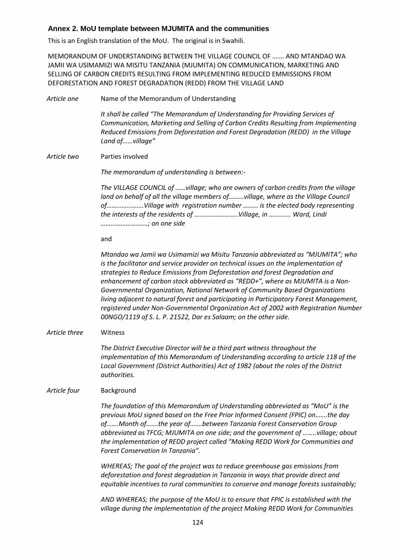
124
Annex 2. MoU template between MJUMITA and the communities
This is an English translation of the MoU. The original is in Swahili.
MEMORANDUM OF UNDERSTANDING BETWEEN THE VILLAGE COUNCIL OF ……. AND MTANDAO WA JAMII WA USIMAMIZI WA MISITU TANZANIA (MJUMITA) ON COMMUNICATION, MARKETING AND SELLING OF CARBON CREDITS RESULTING FROM IMPLEMENTING REDUCED EMMISSIONS FROM DEFORESTATION AND FOREST DEGRADATION (REDD) FROM THE VILLAGE LAND
Article one Name of the Memorandum of Understanding
It shall be called “The Memorandum of Understanding for Providing Services of Communication, Marketing and Selling of Carbon Credits Resulting from Implementing Reduced Emissions from Deforestation and Forest Degradation (REDD) in the Village Land of……village”
Article two Parties involved
The memorandum of understanding is between:-
The VILLAGE COUNCIL of ……village; who are owners of carbon credits from the village land on behalf of all the village members of………village, where as the Village Council of………………….Village with registration number ……… is the elected body representing the interests of the residents of ……………………..Village, in …………. Ward, Lindi ……………………….; on one side
and
Mtandao wa Jamii wa Usimamizi wa Misitu Tanzania abbreviated as “MJUMITA”; who is the facilitator and service provider on technical issues on the implementation of strategies to Reduce Emissions from Deforestation and forest Degradation and enhancement of carbon stock abbreviated as “REDD+”, where as MJUMITA is a Non-Governmental Organization, National Network of Community Based Organizations living adjacent to natural forest and participating in Participatory Forest Management, registered under Non-Governmental Organization Act of 2002 with Registration Number 00NGO/1119 of S. L. P. 21522, Dar es Salaam; on the other side.
Article three Witness
The District Executive Director will be a third part witness throughout the implementation of this Memorandum of Understanding according to article 118 of the Local Government (District Authorities) Act of 1982 (about the roles of the District authorities.
Article four Background
The foundation of this Memorandum of Understanding abbreviated as “MoU” is the previous MoU signed based on the Free Prior Informed Consent (FPIC) on…….the day of…….Month of…….the year of…….between Tanzania Forest Conservation Group abbreviated as TFCG; MJUMITA on one side; and the government of ……..village; about the implementation of REDD project called “Making REDD Work for Communities and Forest Conservation In Tanzania”.
WHEREAS; The goal of the project was to reduce greenhouse gas emissions from deforestation and forest degradation in Tanzania in ways that provide direct and equitable incentives to rural communities to conserve and manage forests sustainably;
AND WHEREAS; the purpose of the MoU is to ensure that FPIC is established with the village during the implementation of the project Making REDD Work for Communities

125
and Forest Conservation In Tanzania;
AND WHEREAS; the project supported communities to manage and benefit from their forests sustainably; to reduce rate of deforestation and forest degradation and corresponding emissions of greenhouse gases; and adopt better land use and agricultural practices and hence improve their livelihoods;
AND WHEREAS; the project has been successfully implemented after both parties fulfilling their obligations;
AND WHEREAS; The village is willing to carry on implementing the strategies to reduce deforestation and forest degradation and engage in the selling of carbon credits in a voluntary market;
AND WHEREAS; the carbon credits resulting from reduced deforestation and forest degradation are owned by the village as other non-timber forest products from the village land forest according to the laws of Tanzania;
AND WHEREAS; The village council of …….village is the owner and managers of all properties and resources of the village including carbon credits on behalf of all the citizens of ….village as stipulated in the Local Government Act (District Authorities) of 1982, Village Land Act of 1999 and the Forest Act of 2002;
AND WHERE AS; The District Council coordinates all development and government activities in the District according to the Local Government Act of 1982.
Article five Objectives of the MoU
UNDERSTANDING THAT; Reduced Emissions from Deforestation and Forest Degradation and enhancement of forest carbon stock abbreviated as REDD+ is being implemented in pilot bases in Tanzania during REDD+ readiness phase; also, the implementation of national REDD+ strategies and action plans are underway; no reliable source of funding to motivate the communities that fulfills the conditions of emission reductions from REDD;
RECALLING THAT; ……..village is implementing REDD and fulfilled the conditions for trading emission reductions under the voluntary carbon market;
RECOGNIZING THAT; The current sole option available for payment for emissions reduced from REDD+ is through the voluntary carbon market;
AND RECOGNIZING THAT; MJUMITA is a Non-Governmental Organization, an umbrella of Community Based Organizations living adjacent to natural forest, and participating in Participatory Forest Management (PFM) in Tanzania Mainland; have facilitated communities to implement REDD+ and has been providing technical services including acting as a communication agent for the communities to the Voluntary Carbon Standards (VCS) and Climate Community Biodiversity Alliance (CCBA) during the pilot implementation of REDD+;
AND RECOGNIZING THAT; The cost for validation, certification and registration of REDD+ project are high for a single project proponent and the same is less if shared among the project proponent in the same project site;
AND RECOGNIZING THAT; The terms and conditions for participating in the international voluntary carbon markets requires the written consent of the project proponent and the organization serving as a communication agent between them and the VCS and CCBA;
THEREFORE; the agreement is made hereafter serving as written consent between the

126
Village Council of………who are holding the rights of the project proponent and MJUMITA who are serving as communication agent and technical service provider for the project proponent to fulfill the obligations stipulated in article six below;
Article six The agreement
WE AGREE THAT; The ownership of verified carbon emissions reductions from the village land shall belong to the …….village and the village council shall hold the rights on behalf of all the citizens of the village as stipulated in section 32 of the Forest Act No. 14 of 2002 on Community Based Forest Management (CBFM); and ……village commits to continue implementing the strategies to address drivers of deforestation in the village land for the purpose of reducing carbon emissions and selling the emission reductions from the village land to any funding mechanism available;
WE AGREE THAT; MJUMITA will serve as a communication agent between the ……village and (VCS CCBA, REDD project validators and verifiers, marketing agents, and or carbon credit buyers) the marketing agent or any other source of funding. Furthermore, MJUMITA will also provide technical advice upon request and need realized by any part of this agreement. The communication between the two parties shall be shared in a period not exceeding thirty days after the date of the correspondence. The copies of any written correspondence shall be sent to the Executive Director of the local government;
WE AGREE THAT; Subject to being able to cover its costs from an annual agreed budget approved by the village and other proponent villages in the same reference region, MJUMITA will provide the village and other proponent villages with the following services to facilitate access to the voluntary carbon market:
Remote monitoring of forest cover and carbon stocks
Coordinating ground monitoring of carbon stocks by participating villages
Identifying and contracting a VCS and CCBA approved project validator
Identifying and contracting VCS and CCBA approved project verifiers as needed
Preparing and submitting the project design document for validation
Preparing and submitting project monitoring reports for verification
Marketing and selling verified emissions reductions to buyers in the voluntary carbon market
Receiving payment from buyers in the voluntary carbon market on behalf of the village and other proponent villages
Retiring sold emissions reductions according to the VCS and CCBA requirements
Forwarding revenue from the sale of verified emissions reductions to the village subject to the stipulations specified in this agreement.
To avail information about carbon credit emissions and fulfill any other requirements by VCS and CCBA registries.
Provide capacity building to communities on any matter emerging related to REDD+, good governance, and carbon trading for improvement of their performance.
Facilitate village government to have operational plans in the format required by the project and any other need that may arise.

127
To facilitate participatory social and ecological assessment and monitoring and submit the results to any different stakeholders as the need may be.
To facilitate the Community Carbon Enterprise on any other technical requirement needed to meet conditions for REDD+.
WE AGREE THAT; The revenue distribution mechanism used during the pilot phase of implementing REDD+ in the village shall continue to be used as a tool of ensuring fairness, participative, and transparency during the decision making event on the use of REDD revenues.
WE AGREE THAT: The service provider shall provide a proposal of apportioning performance based REDD revenue across participating villages of which the criteria shall be as follows among others:-
Share of carbon credits generated from a village land
Relative performance of reducing deforestation in the village land
Size of the village forest area
Leakage within and outside the village boundary
WE AGREE THAT: The proposal on revenue sharing among participating villages shall be discussed and agreed by the village councils of the participating villages on the amount to be paid for each village after considering the following:-
Deducting all the cost incurred and agreed before in the course of aggregating, determining and marketing the carbon credits from the project
Carbon credits subtracted from a participating village caused leakage in the particular year based on the GIS evidence and credits awarded to village whose carbon credits were reduced by that particular leakage.
WE AGREE THAT; The Village Council shall be in charge of ensuring village compliance on REDD+ terms and conditions as stipulated in this agreement, national and international frameworks. Subject to the condition that sufficient REDD funding shall be available through national or international funding mechanism, the village commits to implement REDD for the period of twenty years (20) as from September, 2014;
WE AGREE THAT; The cost for project certification and registration shall be shared with other villages implementing REDD in the landscape. The cost shall be paid based on the real cost spent and the cost elements for the service provider shall be agreed upon in a participatory and transparent manner between the participating villages and the service provider. The payment shall be done during the village REDD annual meeting after selling the carbon credits. The amount of cost sharing among participating villages shall be proportional to the amount of carbon credits earned by each participating village.
WE AGREE THAT; Revenue from the sale of verified emissions reductions shall be paid to the village once per year. The amount paid shall be equivalent to the value of the amount of emissions reductions verified by a third party verifier, that the village accomplished compared to its baseline, which is specified in appendix 1, less any credits required by VCS to be deposited into a risk buffer, less any leakage for which the village has been assigned responsibility by other project proponents, and less any costs approved to be paid to MJUMITA in the same year by the village for services provided under this agreement.
Article seven Dispute resolution

128
Disputes arising from the implementation of this memorandum of understanding between MJUMITA and the Village Council will involve a third party who shall serve as a mediator. The mediator shall be the Ward Development Committee (WDC), the District Executive Director or the court as the situation may be. The procedure shall involve the following steps:-
First Step:
Complaints are received by a mediator either by phone, text messages, and meeting or by letter from a person in charge of any part. The third part shall formally acknowledge the receipt of the complaint and within reasonable time inform the respondent and set timescale for resolving the complaint.
Step two
The complaints shall be sent to the respondent in writing and within reasonable time scale (not exceeding twenty eight days) the defendant shall provide response of the complaints to the mediator.
Step three
The mediator after being satisfied with the response provided from the respondent shall send the same to the complainant. In case the response provided is not sufficient to the satisfaction of the mediator or complainant, the mediator shall call a meeting of the two parties for mediation.
Step four
In case the resolution of the complaint not sought, the mediator shall forward the complaints to the office of the District Executive Director within a period not exceeding thirty days (30) since the date of mediation. The proceedings of the matter shall be attached in the report to be forwarded to the District Executive Director. The District Executive Director shall conduct a thorough review of the matter and call the meeting for mediation of the two parties.
Step five
In case the mediation is not sought by the District Executive Director, the matter shall be taken to the court.
Article eight Limitations of the MoU
The implementation of this MoU is subject to the following assumptions:-
Availability of REDD financing from the market or national fund
Availability of policy and legal framework supporting REDD implementation at national and international level
Participating villages successfully generates carbon credits through avoiding deforestation and forest degradation in the village land.
Ability has technical and financial capacity to provide the services specified in this MoU
Article nine Termination
In case of termination by either part of this agreement three-month notice in writing shall be needed. In case the village council terminates the agreement, the notice for the termination shall be attached with the minutes of the village assembly deliberated for

129
the matter.
Article ten Amendment of the Memorandum of Understanding
The amendment of this Memorandum of understanding shall be made any time after consultation of the two parties.
Article eleven Commencement of the agreement
The implementation of this memorandum of understanding shall commence after being signed by the two parties. After signing the implementation shall commence from …………………...
Article twelve Signing the Memorandum of Understanding
MJUMITA
Signed the day of……………..Dated………….Month of ………….Year……
Signed by……………………………..Title………………………………………
………………………………………………………………………………….
Signature and Official Seal
For: Mtandao wa Jamii wa Usimamizi wa Misitu Tanzania (MJUMITA)
……………………VILLAGE COUNCIL
Signed the day of……………..Dated………….Month of ………….Year……
Signed by……………………………..Title………………………………………
………………………………………………………………………………….
Signature and Official Seal
Signs of other Village Council Members and Village Government seal
Na. Jina Wadhifa Sahihi

130
…………………..DISTRICT COUNCIL
Signed the day of……………..Dated………….Month of ………….Year……
Signed by……………………………..Title………………………………………
………………………………………………………………………………….
Signature and Official Seal

131
Annex 3 Public services and infrastructure original
Public Service Kinyope Kiwawa Likwaya Makumba Milola Mkanga 1 Mkombamosi Muungano Nandambi Ruhoma
Nursery school No school. No school.
Children do not
attend nursery
school.
No school;
attend the
Chikonji Kusini
School
No school. No school;
attend the one
in Milola A
village 0.5 km
away.
No school. Nursery school services
obtained under tree
within primary school
grounds;
No school; Mambo Elimu
government program
(established in 2007)
available in Uleka Sub-
village (operates like
MEMKWA); Program
receives support from
Govt of United States. 40
students (M-16, F-24)
No school; No school;
Primary school One primary
school with 8
classrooms; 6
teachers; 388
pupils brick
walls and metal
roof.
One primary
school in
(subvillage); 330
students. 6
class rooms; 4
teachers; brick
walls and metal
roof.
Primary school
under
construction;
students attend
Moka Primary
School in
Matimba village
3 km away.
Under
construction. 2
classes
completed so
far.
No school;
students go to
Milola B 0.5 km
away.
One school. 4
class rooms; 3
teachers and
172 pupils
One school; located
between Mwenge and
Sokoni sub-villages. 7
class rooms 7 teachers.
560 pupils. Brick walls.
Metal roof
No school; students attend
Mkombamosi Primary
School which is 0.5 km
away.
One school; five
class rooms;
four teachers
and 170 pupils.
One school in Mchati sub-
village. 5 class rooms, 3
teachers. 197 pupils. Brick
walls, metal roof.
Secondary
school
No school.
Attend 2ndary
school 11 km
away.
No school;
attend Milola
School in Milola
B Village 18 km
away.
No school;
attend Nangaru
School in
Komolo Village.
6 km away.
Under
construction.
No school;
attend Milola B
School (0.5 km
away)
No school.
Attend school
11 km away.
No school; attend
Nangaru School in
Komolo Village (5 km
away)
No school; attend Nangaru
School in Komolo Village
(Matimba ward) 6 km
away.
No school;
attend Chikonji
and Nga’pa
secondary
schools (6 & 12
kms away,
respectively)
No school; attend Milola and
Rutamba Schools in
respective villages 20 km
away.
Dispensary One dispensary
under
construction.
One dispensary
with two
qualified staff.
Building in poor
condition.
No dispensary.
Services
available in
Moka 3 km
away.
No dispensary.
Services
available
No dispensary;
go to Milola A
0.5 km away.
No dispensary.
Services
available.
Nearest
dispensary 11
km away.
One dispensary in Lumo
sub-village
with 3 qualified staff.
Building in good
condition.
No dispensary; health
services available in
Mkombamosi Dispensary
0.5 km away.
No dispensary;
closest
healthcare
service 14 km
away.
No dispensary; go to Milola
or Rutamba Villages 12 km
away.
Health clinic One clinic under
corruption.
No health clinic; No health clinic; No health clinic; No health clinic; No health clinic; No health clinic. No health clinic; No health clinic; No health clinic;
Roads Non-paved
roads.
Non-paved
roads;
impassable
during heavy
rainfalls
Non-paved
roads;
impassable
during heavy
rainfalls
Non-paved
roads;
impassable
during heavy
rainfalls
Non-paved
roads;
Non-paved
roads;
impassable
during heavy
rainfalls
Non-paved roads;
impassable during heavy
rainfalls
Non-paved roads;
impassable during heavy
rainfalls
Non-paved
roads;
impassable
during heavy
rainfalls
Non-paved roads;
impassable during heavy
rainfalls

132
Public Service Kinyope Kiwawa Likwaya Makumba Milola Mkanga 1 Mkombamosi Muungano Nandambi Ruhoma
Water services No improved
water points,
Water sourced
from stream in
Kitulo sub-
village
No improved
water points;
Other water
supplies
available in
Mapinduzi and
Lumumba sub-
villages
No improved
water point in;
water obtained
from Milola A
Village
(distance, type
of water?);
3 stream
sources in
Village in
Kipunga, Noto
and Kikumbi
sub-villages
3 improved water points
(2 boreholes in Msikitini
and Cheleweni sub
villages - both SWN80
type boreholes).
Boreholes were funded
by Embassy of Finland in
1988; 1 borehole also
funded by Assemblies of
God in 2009. All 3 water
points are in use; 20
open wells in Lumo sub
village, Cheleweni
Mwenge and Msikitini
subvillages . Water also
sourced from Mtonya
and Mloweka rivers
2 improved water points
(in Mnazi Mmoja and
Ujamaa sub-villages (SWN
80 type of bore holes);
Boreholes are not
functioning, due to lack of
spares (village cannot
afford);
15 water sources from
stream
No improved
water points;
Use open wells
(3 in Ruaha,
Mtandi and
Kiwayawaya).
Some
households
collect water
from the
streams.
1 improved water points in
Shuleni sub-village
[condition?];
Stream water available in
Mkundi sub- village
Meeting
space/communit
y space
No community
building or
meeting space
available for
community
meetings;
No community
building or
meeting space
available.
Village
assembly
meetings done
at the market;
Internal
meetings done
at Ward office
No community
building or
meeting space
available.
Meetings
conducted
under mango
tree in
Mapinduzi sub-
village
No community
building or
meeting space
available for
community
meetings;
No community
building or
meeting space
available.
Meeting are
conducted in
Milola B sub-
village under
Mkungu tree
No community
building or
meeting space
available for
community
meetings;
No community building
or meeting space
available. Conducted
under mango tree in
Lumo sub-village
No community building or
meeting space available.
Meetings occur under a
tree (Kongo/Msonobali) in
Ujamaa sub-village
No community
building or
meeting space
available.
Usually
conducted
under mango
tree at village
centre.
No community building or
meeting space available for
community meetings;
Usually conducted under a
mango tree
Market
place/building
1 market place;
[condition]
1 market in
Mapinduzi sub-
village
[condition]
No market in
village; New
market
constructed in
Milola Mashariki
but it is not yet
in use
1 market place in Sokoni
sub-village
No formally designated
market place; community
tends to use Mkombamosi
village market in
neighbouring village
No market place 1 local market in
SUBVILLAGE; [condition]
Village office No village office Current they are
using Ward
office
No village office,
use the food
storage facility
room within
village
No village office 1 small village
office in
Dodoma B sub
village; has 2
small rooms
No village office No village office; Use
the village court building
at Mkombamosi Village
Under construction in
Mnazi Mmoja sub-village
(use the Litogoro House*)
* what is this?
No village office;
Use the CCM
office
Village office building exists
(subvillage); has 2 small
rooms; too small to host
larger meetings

133
Public Service Kinyope Kiwawa Likwaya Makumba Milola Mkanga 1 Mkombamosi Muungano Nandambi Ruhoma
Crop/Food
Storage facility
1 facility in
Kiwawa A;
1 facility that is
not in good
order
No facility; Use
the one in
Milola ward
1 facility located in Lumo
sub village
1 facility; dilapidated (was
built bellow standard); risk
of building falling;
No facility; 1 facility in Mkundi sub
village; highly dilapidated
Communication Mobile phone
coverage
available in all
sub-villages.
Mobile phone
coverage
available in one
sub-village only.
Mobile phone
coverage
available in all
sub-villages.
Mobile phone
coverage
available in
more than one
sub-village but
not in all sub-
villages.
Mobile phone
coverage
available in
more than one
sub-village but
not in all sub-
villages.
Mobile phone
coverage
available in
more than one
sub-village but
not in all sub-
villages.
Mobile phone coverage
available in more than
one sub-village but not in
all sub-villages.
Mobile phone coverage
available in more than one
sub-village but not in all
sub-villages.
Mobile phone
coverage
available in
more than one
sub-village but
not in all sub-
villages.
Mobile phone coverage
available in one sub-village
only.
Transport At least one bus
service daily;
motorbike and
bicycle taxis
available.
At least one bus
service daily;
motorbike and
bicycle taxis
available.
At least one bus
service daily;
bicycle taxis
available.
At least one bus
service daily;
motorbike and
bicycle taxis
available.
At least one bus
service daily;
motorbike and
bicycle taxis
available.
No bus service;
motorbike and
bicycle taxis
available.
At least one bus service
daily; motorbike and
bicycle taxis available.
At least one bus service
daily; motorbike and
bicycle taxis available.
No bus service;
motorbike and
bicycle taxis
available.
No bus service; bicycle taxis
available.

134
Annex 4. Theories of change for project interventions.
These theories of change were developed during the social impact assessment. In some cases, based on the experience of the project subsequent to the SIA, they have been improved to reflect the lessons learned by they project in the intervening period.
Activity 1: Improve governance at village level
Success of REDD in the Project Area is highly dependent on the ability of communities to govern
themselves and their natural resources. Improving village governance is an explicit strategy that the
REDD project is committed to undertake early in the Project cycle because it is the foundation on
which two key strategies rest: development of village land use plans and establishment of
participatory forest management. In the village and landscape level workshops, however, improved
governance was not discussed as an explicit strategy. Rather, activities constituting improved
governance (e.g., training in record keeping) were key components of other strategies.
Prior to the start of the project, governance at village level was rudimentary at best in most villages in
the Project Area. Village councils are required to have between 15 and 25 members. These consist of
a chairperson elected by the village assembly, all chairpersons of the sub-villages within its area and
other members elected by the village assembly. Women must account for 25 % of the council
members. Most village councils (VCs) in the Project Area were incomplete; none fulfilled the 25%
women quota. Councils were required to meet monthly; most VCs rarely met, and when they did,
meeting minutes were not kept and reporting to the village assembly was not done. None of the
villages have a village government office. Consequently, there was no official space to store VC
related material (including records). Council meetings (if conducted) were held in borrowed space,
either from CCM party offices, a school, or a storage facility (Annex 3).
After taking on positions of leadership council members do not receive training on their function and
responsibilities; thus, they are unaware of the mandates they are required to fulfill during their term,
nor the protocols for fulfilling them. Interviews conducted during the independent stakeholder analysis
revealed that council members were uncertain of processes and decisions they had inherited from
previous leaders, including decisions about natural resource use within their jurisdiction (TFCG 2011).
For example, most councilors could not confidently say whether their village had undergone a land
use planning process, and if so, what the process had entailed, or how far along in the process they
were. Councils are also not included in District planning, even when plans affect the Councils’ areas
of influence. For example, no-one could clearly explain why District authorities had prohibited timber
harvesting in forests around the Project Area.
A large part of this strategy is - on the one hand – to train existing and future council members on
their duties and responsibilities, and to provide them with the skills necessary to fulfill their functions.
On the other hand, it is to empower local communities on the importance of good governance, on
their civil rights and duties, how they can participate in local decision making, and the platforms that
exist for airing their concerns and initiating change. Awareness raising campaigns on governance
issues will be the main approach for this. The village level natural resources committee (VNRC) will
receive extra training as part of the PFM and extractive use of forest biomass strategies. A results
chain was not developed for this strategy. Instead, Table 18 summarises the justification for a strategy
on improvement of village governance and how the strategy links to other planned intervention points.

135
Table 18: Impact assessment of strategy to improve village governance.
Activity / Sub-
activity
Intended
positive
outputs,
outcomes or
impacts
Potential
negative
impacts
Magnitude of
negative
impact
Stakeholders
affected
Mitigation
action Needed
Activity 1. Improving governance at village level.
Awareness
raising on the
meaning and
importance of
good
governance to
communities
and their
leaders (Phase
1)
Awareness is
conducted in all
project villages.
Communities
and leaders
aware of rights
and
responsibilities
and willing to
exercise those
to improve
community and
individual
welfare (i.e.
democratization,
empowerment)
Increased
awareness
among
communities
may lead to bout
of scrutiny of
existing VCs;
Some members
may resign;
replacement
may be difficult if
people are
unwilling to take
on leadership
positions
because of
increased
scrutiny
Low to high;
depends on
effectiveness of
campaign and
how
communities
react to
increased
awareness of
their rights
VC members
and
communities in
general
Gauge and
record
community
reaction; paying
particular
attention to
expressions of
annoyance
and/or
resentment with
the campaign or
Project. Adjust
style or
approach of
campaign so
that it is
sensitive to local
nuances.
Incomplete
councils
completed
through
democratic
elections
(Phase 1)
Every village
has a village
council that
fulfills basic
requirements
(25 members,
gender
representation,
etc)
Resentment
towards women
if it is unusual
for women to
occupy
leadership
positions
(Muslim society)
Low: women in
existing councils
do not seem to
be negatively
affected;
VC members
and
communities in
general
Gender
awareness
raising; gauge
women leader’s
experience;
ensure moral
support is
provided for
women to
handle new
roles well
Training on
governance,
record keeping,
reporting,
policies, laws
and gender to
existing and
future leaders
(Phase 1)
VCs know their
responsibilities
and mandates,
and can execute
basic functions
well;
Community has
the sense that
they have good
leaders who
have the
community’s
wellbeing in
mind.
VC members
perceive the
responsibilities
as burdensome
and decide to
resign; Illiterate
VC members
are marginalised
because they
cannot
participate fully
in training;
Leadership
positions limited
to those who
can read and
write (i.e. elite
capture)
Potential for
high positive
impact.
Directly: VC
members;
Illiterate leaders
Indirectly: All
community
members
Training is
conducted in a
way that
accommodates
illiteracy; VCs
strategically
ensure that they
fulfill a minimum
quota of literate
members;
Strategically
train future
leaders too so
that the learning
curve is less
steep when they
take on
leadership

136
Activity / Sub-
activity
Intended
positive
outputs,
outcomes or
impacts
Potential
negative
impacts
Magnitude of
negative
impact
Stakeholders
affected
Mitigation
action Needed
positions
Council
members
implement
training:
(gradual –
Phase 1 & 2)
Meetings more
regularly held,
transparency
improved,
meetings better
attended by
village
assembly,
leaders start
soliciting
services and
support from
District;
communities
begin
developing
community
projects
Increased
bureaucracy for
all community
members as
procedures
become
implemented
according to
fixed rules;
VC members
are viewed as
barriers to
pursuing
activities that
were not
previously
controlled;
Potential to
corrupt VC in
their new
positions of
power;
Community
projects require
households to
contribute time
&/or labour;
Medium to high:
potential to
increase
opportunities for
corruption if cost
of following rules
(time, money,
efficiency) is
perceived as
high.
Directly:
community
members;
outsiders
dealing with VC
(e.g.
businessperson
s, District
officers, etc), VC
members
Strong
emphasis on
transparency
and minimal
bureaucracy
needed;
Emphasis on
community
participation in
all decision
making so that
communities
help establish
rules and
regulations that
guide theirs and
other’s
behaviour. A
reward-
punishment
system needed
to keep VC’s
uninterested in
corruption
offers; Ensure
that community
participates in
choosing
development
projects to
maximise
willingness to
contribute
Trained leaders
evaluated
regularly to
ensure duties
are well
executed
(Phase 2)
Performance
and standards
are kept high;
transparency is
increases;
communities are
ensured that
only the best
leaders are in
Council
Risk that
unqualified
leaders are not
fired due to fear
of addressing
unpleasant
situations;
Low: Because
by this point,
most leaders
unresponsive to
training have
resigned
Directly: VC and
upcoming
leaders
Indirectly:
community
members
Leadership
training should
specifically
ensure that skills
in how to handle
unpleasant
situations such
as firing,
penalizing, and
making public
unpopular
decisions are
provided
Additional
training
conducted
based on
Capacity of VC
to undertake
council
responsibilities
Directly: VC and
upcoming
leaders

137
Activity / Sub-
activity
Intended
positive
outputs,
outcomes or
impacts
Potential
negative
impacts
Magnitude of
negative
impact
Stakeholders
affected
Mitigation
action Needed
identified
needs (Phase
2)
strengthened Indirectly:
community
members
The ToC statement for this strategy was developed from a conceptual model developed by project
staff during SIA training (Figure 4). It includes all the activities that were mentioned in workshops. A
results chain for this Strategy was not developed.
Theory of change for Strategy to improve village governance
IF awareness raising on the meaning and importance of good governance is conducted for
communities and their leaders; and
IF Incomplete councils completed through democratic elections; and
IF VC and upcoming leaders are trained in governance (e.g. record keeping, reporting, policies, laws,
etc.); and
IF Council members implement training; and
IF Trained leaders are evaluated regularly to ensure duties are well executed; and
IF Additional training is conducted based on identified needs; and
IF communities are aware of their rights and responsibilities;
IF communities agree to adhere to rules and regulations they participated in developing; and
IF rules and regulations are not perceived as barriers by those requiring to adhere to them; and
IF corruption does not become rampant (because mitigation measures implemented); and
IF VC is perceived as transparent and fair; and
IF communities participate in governance decision making, including natural resource management;
IF VC enforce the village by-laws;
THEN village governance will be improved and high rates deforestation and degradation in Lindi
District village forests will be significantly reduced.

138
Figure 4. Conceptual model for depicting factors contributing to poor village governance (and ultimately the absence of community participation in natural
resource management.

139
Activity 2. Implement sustainable land management
A village land use plan (VLUP) should provide the basis for communities to manage village land
sustainably. A village land use plan directs communities on how to manage their land optimally for
the long-term given variability in land use activities and land use interests within the village.
Developing a LUP involves setting aside land for forests, agriculture, grazing, residential areas and
public services, and requires delineation of the village area into distinct zones for specific land use
categories. When LUPs are developed using participatory approaches (as is required by Tanzania’s
National Land Use Planning Commission) they can improve village livelihood systems while retaining
forest cover levels (NAFRI et al, 2005). Village land use planning can also help to improve land
tenure by ensuring that village boundaries are clear; and by contributing to village’s securing Village
Land Certificates. Once a village land use plan has been prepared, the next step is to establish a
village land registry. This is something that the project will support. From there villages can begin to
issue customary rights of occupancy to individuals.
Developing a VLUP is an important precondition for introducing CBFM (Strategy 3) that the project will
undertake. By delineating activities to specific areas within the village landscape communities expect
to have better control on shifting cultivation, particularly of the ‘pioneer’ type (when primary forests or
undisturbed forests are felled to clear land for cultivation).
A LUP alone is not sufficient to decrease shifting cultivation practices. A large part of post Phase 1
activities will focus on ensuring that the LUP is implemented according to landuse by-laws. This will
require that some REDD carbon payments is reinvested into implementation activities (e.g. patrolling,
administration, monitoring).
Theory of change statement for strategy to develop LUP in each village
IF awareness is raised on the importance of having LUPs, and
IF awareness is raised on the importance of permanent agriculture, and
IF Communities decide that they want to have a LUP and practice permanent agriculture, and
IF the District supports (i.e. provide LUP experts) for communities in developing their LUPs, and
IF parallel to development of LUPs District provides training in improved ag. practices, and other
environmental management methods (e.g. fire control), and
IF Communities implement all improved training received, and
IF Communities respect the LUP and implement it according to agreements, and
IF the Sustainable Forest Management Strategy is successfully implemented,
THEN communities will have more secure land tenure and forest governance and governance as a
whole will dramatically improve in the project area.

140
Figure 5. Results chain for Activity 2 to implement sustainable land management.

141
Table 19: Impact assessment of activity to implement sustainable land management.
Activity Intended positive
Impact
Negative impact
and/or risks
Stakeholders
affected
Mitigation action
Needed
Activity 2: Implement sustainable land management.
Conduct
awareness raising
on importance of
LUP
Communities
convinced that
establishing a LUP
for their villages is a
worthwhile
undertaking;
Communities willing
to participate in the
LUP process; LUP
reflects communities
input and is owned
by the communities
None obvious Communities; VC
members
None
Resolving
boundary conflicts
Long-term conflicts
settled
Risk that conflicts
aren’t resolved and
slow down other
processes (Strategy
3);
Risk of exacerbating
existing conflicts;
risk of identifying
new conflicts;
Time consuming
and stressful for
those involved in the
resolution process;
Council members
directly involved in
conflict resolution;
community
members whose
land is directly
involved;
Establish Grievance
protocol so that
boundary conflicts
are adequately
addressed (Phase
1);
Participatory LU
planning process
undertaken*
Plans exist to guide
communities on
appropriate land
use; VC has
authority to govern
landuse; Having a
LUP is the impetus
for other land and
natural resource
management
initiatives, e.g.,
development of a
natural resource
committee...
Process is time
consuming for
community
members who are
directly involved;
boundary conflicts
surface and slow
down process;
within-community
conflicts emerge on
how LU should be
allocated;
Marginalised
groups’ interests not
reflected in the LUP;
Risk that the
process exhausts
community funds
Directly: Community
members involved in
the planning;
Indirectly: All
community
members
Compensation for
members actively
involved in process;
Participatory aspect
of the LU planning
emphasised;
Process for
addressing and
resolving between
and within
community conflicts
pre-determined;
Villages acquire
village land
certificates
Mores secure land
tenure
None identified N/A N/A

142
Allocation of areas
for permanent
agriculture
Shifting cultivation
reduced
Risk that in some
villages, there will
not be enough land
for everyone. Risk
that land-less
farmers will acquire
land in other villages
(leakage potential);
Annoyance,
especially from non-
Project communities
Farmers; nearby
communities that
would absorb any
spill-over
Meetings should be
held with
neighbouring
villages to discuss
impacts and viable
solutions;
* In itself, the LU planning process has numerous sub-activities that must be successfully undertaken. Refer to
Guidelines for Participatory VLUP, Tanzania and project guidelines for integrated CBFM and village land use
planning for full process.
Activity 3: Community based forest management
The Project firmly considers that CBFM is the best approach that the REDD project should take to
guarantee long-term sustainable management of forests. A basic premise for the Project is that the
additional incentives (income) for communities from sales of carbon credits could cover the costs of
management and provide additional income for community development projects. Establishing and
implementing CBFM in the project area is thus an important outcome of the project.
The primary purpose of CBFM is to enable local communities to determine how forests in the LUPs
will be governed and managed for long-term sustainability. CBFM also gives communities greater
legal control over their forests and entitles them to retain all royalties from forest products and
services from a village forest reserve. Phase 1 activities consist of building local capacity to undertake
PFM and subsequently manage the numerous activities associated with implementing CBFM and
REDD+ forest-related activities. Most activities will be conducted by VNRCs. Forest users, however,
are the indirect targets of the project because it is their influence on forests that PFM is concerned
with.
Table 20: Impact assessment of Strategy to establish sustainable forest management through
PFM.
Activity / sub-
activity
Positive / desired
Impact
Negative impact Stakeholders
affected
Mitigation action
Needed
Activity 3: Community based forest management
Implement the LUP
Strategy
The legal framework
exists for
communities to start
the PFM process;
areas for
establishing PFM
have been identified
See Table 11 VC members, local
communities;
communities outside
project boundary
See Table 11
District is informed
of the desire for
communities to
establish CBFM in
the Project area
Protocol is
established between
District &
communities;
District is aware of
communities’
intentions and can
provide appropriate
support; Type of
None identified District office staff;

143
Activity / sub-
activity
Positive / desired
Impact
Negative impact Stakeholders
affected
Mitigation action
Needed
support needed
from District is
established early;
District involved in
earliest stages of
the process to
ensure that the
process follows
required rules.
Conduct
awareness raising
linking illegal and
unsustainable
extractive use of
forest resources to
poverty and high
carbon emissions
in Project area
Communities are
aware of how their
own behaviour
contributes to the
key objectives of the
Project and
consciously decide
to be willing
participants in the
PFM process; early
local policing
begins;
Illegal activities
become more
clandestine;
potential conflicts
arise as it becomes
easier for
communities to
identify the ‘bad
guys’; short-term
acceleration in
deforestation &
degradation
activities in
anticipation of
increased difficulty
in accessing forest
resources in the
near future
- communities - Monitor forest use;
- Encourage system
of anonymous
reporting of on
infractions to forest
management
(whistle-blowing);
- Solicit District
assistance to
develop a system
for handling early
land-grabbing
Establish natural
resource
committees in all
village councils
(VNRCs)
A core group is
established in every
village that has the
authority to see the
CBFM process
through and can
commit fully to
implementing the
management plans.
none VC, VNRC
members, forest
users
Districts experts
assist
communities
undertake the
CBFM process
CBFM process is
done according to
protocol;
communities are
more closely linked
with information and
resources that are
available at District
for the CBFM
process;
- Communities
experience directly
the extension
services available
from the District;
- emergence of
boundary conflicts
(new or pre-
existing);
- conflicts slow down
procedure for
establishing CBFM;
- See Table 11
District staff, VNRC
members;
communities
(through assembly
meetings to discuss
CBFM)
- See Table 11
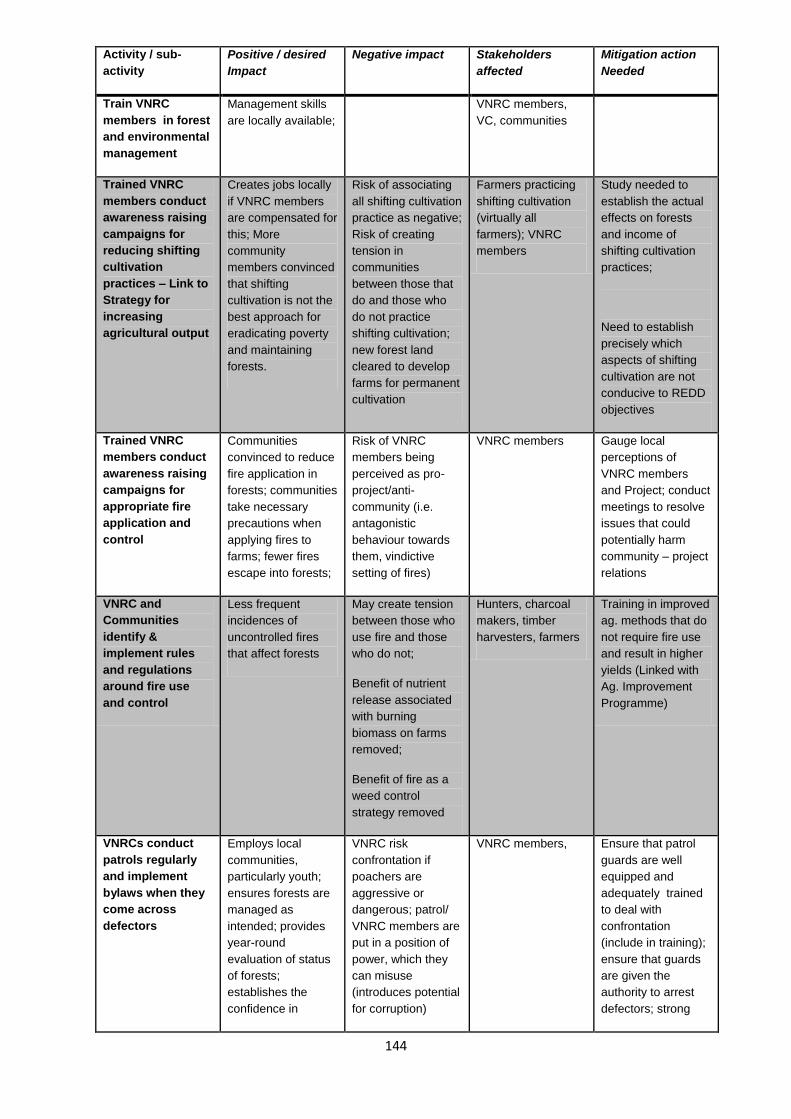
144
Activity / sub-
activity
Positive / desired
Impact
Negative impact Stakeholders
affected
Mitigation action
Needed
Train VNRC
members in forest
and environmental
management
Management skills
are locally available;
VNRC members,
VC, communities
Trained VNRC
members conduct
awareness raising
campaigns for
reducing shifting
cultivation
practices – Link to
Strategy for
increasing
agricultural output
Creates jobs locally
if VNRC members
are compensated for
this; More
community
members convinced
that shifting
cultivation is not the
best approach for
eradicating poverty
and maintaining
forests.
Risk of associating
all shifting cultivation
practice as negative;
Risk of creating
tension in
communities
between those that
do and those who
do not practice
shifting cultivation;
new forest land
cleared to develop
farms for permanent
cultivation
Farmers practicing
shifting cultivation
(virtually all
farmers); VNRC
members
Study needed to
establish the actual
effects on forests
and income of
shifting cultivation
practices;
Need to establish
precisely which
aspects of shifting
cultivation are not
conducive to REDD
objectives
Trained VNRC
members conduct
awareness raising
campaigns for
appropriate fire
application and
control
Communities
convinced to reduce
fire application in
forests; communities
take necessary
precautions when
applying fires to
farms; fewer fires
escape into forests;
Risk of VNRC
members being
perceived as pro-
project/anti-
community (i.e.
antagonistic
behaviour towards
them, vindictive
setting of fires)
VNRC members Gauge local
perceptions of
VNRC members
and Project; conduct
meetings to resolve
issues that could
potentially harm
community – project
relations
VNRC and
Communities
identify &
implement rules
and regulations
around fire use
and control
Less frequent
incidences of
uncontrolled fires
that affect forests
May create tension
between those who
use fire and those
who do not;
Benefit of nutrient
release associated
with burning
biomass on farms
removed;
Benefit of fire as a
weed control
strategy removed
Hunters, charcoal
makers, timber
harvesters, farmers
Training in improved
ag. methods that do
not require fire use
and result in higher
yields (Linked with
Ag. Improvement
Programme)
VNRCs conduct
patrols regularly
and implement
bylaws when they
come across
defectors
Employs local
communities,
particularly youth;
ensures forests are
managed as
intended; provides
year-round
evaluation of status
of forests;
establishes the
confidence in
VNRC risk
confrontation if
poachers are
aggressive or
dangerous; patrol/
VNRC members are
put in a position of
power, which they
can misuse
(introduces potential
for corruption)
VNRC members, Ensure that patrol
guards are well
equipped and
adequately trained
to deal with
confrontation
(include in training);
ensure that guards
are given the
authority to arrest
defectors; strong
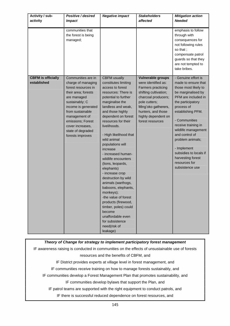
145
Activity / sub-
activity
Positive / desired
Impact
Negative impact Stakeholders
affected
Mitigation action
Needed
communities that
the forest is being
managed;
emphasis to follow
through with
consequences for
not following rules
so that ;
compensate patrol
guards so that they
are not tempted to
take bribes.
CBFM is officially
established
Communities are in
charge of managing
forest resources in
their area; forests
are managed
sustainably; C
income is generated
from sustainable
management of
emissions; Forest
cover increases,
state of degraded
forests improves
CBFM usually
constitutes limiting
access to forest
resources: There is
potential to further
marginalise the
landless and weak,
and those highly
dependent on forest
resources for their
livelihoods.
- High likelihood that
wild animal
populations will
increase
- increased human-
wildlife encounters
(lions, leopards,
elephants)
- increase crop
destruction by wild
animals (warthogs,
baboons, elephants,
monkeys);
-the value of forest
products (firewood,
timber, poles) could
become
unaffordable even
for subsistence
need(risk of
leakage)
Vulnerable groups
were identified as:
Farmers practicing
shifting cultivation;
charcoal producers;
pole cutters;
Ming’oko gatherers,
hunters, and those
highly dependent on
forest resources
- Genuine effort is
made to ensure that
those most likely to
be marginalised by
PFM are included in
the participatory
process of
establishing PFM.
- Communities
receive training in
wildlife management
and control of
problem animals;
- Implement
subsidies to locals if
harvesting forest
resources for
subsistence use
Theory of Change for strategy to implement participatory forest management
IF awareness raising is conducted in communities on the effects of unsustainable use of forests
resources and the benefits of CBFM, and
IF District provides experts at village level in forest management, and
IF communities receive training on how to manage forests sustainably, and
IF communities develop a Forest Management Plan that promotes sustainability, and
IF communities develop bylaws that support the Plan, and
IF patrol teams are supported with the right equipment to conduct patrols, and
IF there is successful reduced dependence on forest resources, and

146
IF communities generate saleable VERs, and
IF communities sell the VERs,
THEN Community-owned forests will be managed in a participatory, effective and equitable way.
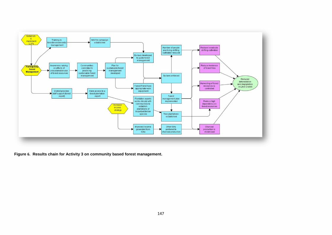
147
Figure 6. Results chain for Activity 3 on community based forest management.

148
Strategy 4: Channel REDD payments to communities.
A principle objective of Phase 1 of the REDD project was to establish a self-financing community-
based carbon trading association or enterprise that functions within MJUMITA and channels REDD
payments to communities. Communities in the project area undertaking PFM would become members
of the enterprise. The enterprise will aggregate voluntary emission reductions from its members and
market them according to internationally recognised standards. Revenue from the sale of the
emissions will be paid to the communities. Every eligible resident will be entitled to their dividend.
Through their village assemblies communities will decide in advance of the payment on how the
dividends should be divided between individual payments and contributions to the costs of the VNRC
and REDD special committee and community development projects.
Table 21: Impact assessment of Strategy to establish a community carbon trading enterprise
(CCTE)
Activity / sub-
activity
Positive / desired
Impact
Negative impact Stakeholders
affected
Mitigation action
Needed
Activity 4. Channel REDD payments to communities.
Awareness raising
on the objectives
of CCTC, MJUMITA
and REDD as a
whole
Communities/VNRC
s / Community
REDD committees
are aware of the
opportunities
available to sell C
credits; eagerness
to establish CCTC
and join MJUMITA
none VNRC members,
local communities,
VC members
Training on
establishing and
managing
enterprises and
networks
VNRC and
Community REDD
committee members
have capacity to
effectively establish
& manage CCTC
and participate in
MJUMITA
Potential for elite
capture
VNRC and
Community REDD
committee
members, local
communities, the
poor/illiterate
Project will
specifically ensure
that vulnerable
groups are
represented in the
training
Communities
establish CCTC
and join MJUMITA
CCTC cooperative
established;
Communities put
themselves in a
position to be able
to aggregate VERs
with other members
of the Network, once
VERs are generated
none VNRCs, VCs and
Community REDD
committee
Communities
generate the VERs
through
sustainable forest
management
Income is re-
directed towards
sustainable forest
practices, and
community
development; water
and springs
increase due to
improve forests
Increase in human-
wildlife
confrontations due
to improved forest
habitat
Directly: VNRCs -
they spearhead
most PFM activities;
-ve impact felt most
by forest users and
farmers negatively
impacted by
problem animals
Farmers
(communities at
large) are trained to
control wild/problem
animals (see PFM
impacts)

149
Activity / sub-
activity
Positive / desired
Impact
Negative impact Stakeholders
affected
Mitigation action
Needed
that destroy crops
Theory of change statement for strategy to establish community carbon trading enterprise
IF communities are made aware of the objectives and advantage of participating in REDD as a whole;
and
IF communities are convinced of the advantages of participating in REDD; and
IF strategies to reduce emissions are successful; and
IF Voluntary Emission Reductions and validated and verified according to international standards; and
IF a buyer pays an adequate price for the emission reductions;
THEN communities will be able to sell their VERs

150
Figure 7: Results chain for strategy to establish community carbon trading enterprise and PFM networks

151
Strategy 5: Improve Agricultural Practices & Productivity
The strategy to improve agricultural practices and output is motivated by the fact that almost everyone
in the project area is a farmer, is heavily dependent on their agricultural outputs to produce food and
generate any form of income, and practices shifting cultivation as the main form of farming. This
strategy is designed to target four main issues related to agriculture: high dependency on shifting
cultivation as the prominent agricultural practice; absence of agricultural inputs; high prevalence of
pests and wild animals that destroy crops at all stages of the farming cycle: as seeds, mature plants,
or harvested crop); in adequate information about climate change resilient agriculture; and inadequate
markets for post-harvest products.
The improved agricultural practices and output strategy can be considered as a package of three sub-
strategies each targeting one of the main issues. Sub-strategy one constitutes gradually decreasing
the amount of land that is under shifting cultivation (i.e. a move towards intensified permanent
agricultural fields). Sub-strategy 2 consists of improving agricultural inputs (i.e. the on-farm methods
and tools applied). Sub-strategy 3 requires managing on- and off-farm pests and problem animals that
destroy seeds before they can germinate, or crops before they can be harvested, or destroy harvests
before they can be consumed.
The project has developed a separate agricultural strategy that provides a detailed analysis of the
current agricultural techniques; problems faced by farmers and potential solutions.
Table 22: Impact assessment of Strategy to improve agricultural practices and productivity
Activity / sub-
activity
Intended positive
Impact
Potential
negative impacts
Stakeholders
affected
Mitigation action
Needed
Activity 5. Improve profitability, ecological sustainability and climate change resilience of
agriculture.
Develop and
implement LUP
for every village
LUP will identify
where new
agricultural land is
zoned (for
permanent ag.)
and which areas
are restricted for
shifting cultivation
See Table 11 See Table 11 See Table 11
Link strategy to
activities related
to reducing
shifting
cultivation
activities under
PFM
- streamlines
information and
resources across
strategies
See Table 12 See Table 12 See Table 12
VC solicits
services from
the District
(including
availability of a
village or ward
level extension
- Communities
participate in
identifying
services that they
need (bottom-up
approach);
Farmers

152
Activity / sub-
activity
Intended positive
Impact
Potential
negative impacts
Stakeholders
affected
Mitigation action
Needed
ag. expert) - VC gains
interaction
experience with
District staff
(builds confidence
& networks)
Ag experts
provides training
in improved
agriculture
Communities are
equipped with the
skill needed to
practice viable
alternatives to
shifting cultivation
Farmers Link with Aga
Khan Foundation
efforts
Training
provided in how
to minimise and
control animal-
human conflicts
Farmers are able
to prevent crop
losses and reduce
time spent
defending their
crops.
Farmers, District
wildlife office;
Equipment and
tools needed to
mitigate problem
animals and
pests on farms
made available
Communities able
to address side
effects of
increased wildlife
in project area
Farmers Keep close track
& public records
of human-wildlife
incidences;
Encourage
reporting of
incidences
Permanent fields
made available
(through LUP
process)
Areas to
undertake
improved ag. are
available
Risk that there is
not enough land;
- puts land
permanently out
of forest cover
- Risk that non-
project farmers
establish farms in
project area
Farmers Ensure that
intensified ag.
(requiring less
land for equal or
more output) is
part of the plan.
Tree nurseries
are established
and trees are
planted
- Local job
opportunities;
- Opportunity to
establish CBOs
that own and run
nurseries;
- Reduces 100%
dependency on
natural forests for
Risk of oversupply
of seedlings if
they are perceived
as easy to
establish and
keep supplied
- non-farming
youth;
- women’s groups;
- schools
Provide estimate
of how many
seedlings are
needed annually
so communities
can assess
whether to
participate

153
Activity / sub-
activity
Intended positive
Impact
Potential
negative impacts
Stakeholders
affected
Mitigation action
Needed
all woody biomass
requirements;
(see strategy to
reduce high
dependency on
forest resources);
tree planting a
potential IGA
Theory of Change for Improvement in agricultural practices and productivity
IF communities receive training in viable and low cost alternatives to shifting cultivation, and
IF District and Project provide training on improved agricultural inputs, and
IF communities receive training in managing problem animals, and
IF an agriculture officer or community based trainer is available in each village, and
IF agriculture officer assists farmers in timely and effective manner, and
IF LUP are developed, and
IF communities implement agriculture improvement training received,
IF communities practice improved agriculture in permanent fields,
IF fewer farmers practice shifting cultivation,
IF no additional forests are converted to shifting cultivation fields,
IF harvests improve,
IF markets for agricultural products improve, and
IF income from agriculture increases
THEN, degradation and deforestation caused by shifting cultivation will decrease; poverty will in Lindi
Urban and Rural Districts will be alleviated and farmers will be more resilient to climate change.
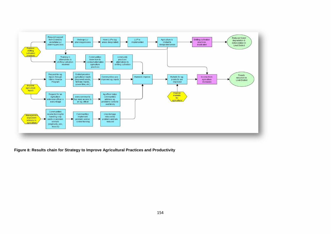
154
Figure 8: Results chain for Strategy to Improve Agricultural Practices and Productivity

155
Strategy 6: Develop Income Generating Activities
Lack of locally available income generating activities (IGAs) was often cited as a contributing factor for
local involvement in shifting cultivation, charcoal production, timber harvesting, and other extraction of
forest biomass. It was also cited as the main reason for high levels of poverty in the project area.
Interviews with charcoal producers and pole cutters/vendors conducted during stakeholder analysis
indicate that most biomass extraction activities (including shifting cultivation) are labour-intensive and
difficult, and that availability of less difficult IGAs that provide equal or more income would encourage
youth – in particular – to leave forest-related jobs.
Capital to start-up IGAs is difficult to obtain, however, and a major reason for low availability of IGAs.
Access to credit for start-up is virtually non-existent. Establishing village savings and loans
associations (VSLAs) was proposed as a viable means for making locally accessible loans. TFCG has
experience implementing VSLAs in other areas in Tanzania; in-house expertise exists. Given the
relative isolation of communities from more entrepreneurial parts of Tanzania, communities need help
exploring the IG potential in their areas. Some lessons can be learned from past IGAs that were
established by other initiatives but which have subsequently failed.
Awareness raising must be accompanied by training in how to start up IGAs, how to manage IGAs
profitably, and how to identify and avoid potential problems (such as oversaturation of the market, or
new opportunities to expand). Most IGAs will be conducted in groups so that start-up capital is more
readily generated. Training in how to form such groups, how to ensure there is equity in inputs and
outputs, and how to solve within-group conflicts is important.
Table 23: Impact assessment of strategy to develop income generating activities (IGA)
Activity Positive/desired
impact
Potential
negative impacts
Stakeholders
affected
Mitigation action
Needed
Activity 6. Improve access to microfinance services for community members.
Activity 7. Generate incomes from the sale of bee products.
Awareness
raising on IGAs
Communities are
aware of the
range of
possibilities to
locally generate
income
Link to Aga Khan
Foundation which
is implementing
entrepreneur skills
in the area
Participatory
assessment of
viable and
sustainable IGAs
in the area
Communities
involved in
identifying the
most viable IGAs
Training on basic
entrepreneurship
skills provided to
interested
parties
Community
members are
empowered to
investigate and
pursue potential
IGAs
Risk of elite
capture
Training must be
sensitive to
illiterate interested
parties, gender,
and age
disparities
Support
provided to
establish village
savings and
VSLAs that can
provide credit to
IG groups are

156
loans
associations
(VSLA)
available
Support
provided to
establish IG
groups including
beekeeping
That high start-up
IGAs (e.g.
establishing a
local milling
centre) are viable
Training in VSLA
management for
members
VSLAs operate
effectively and
transparently
VSLAs widely
established and
used for
acquiring credit
- VSLAs become
accessible source
of credits for
IGAs;
- Income at
household level
significantly
increased
Risk of over-
saturation of
VICOBAs;
- Potential for
within-household
conflicts (men
using new income
to drink & self-
entertainment,
increase violence)
Community
members
participating in
IGAs; trickle-down
effect of new
sources of income
to non-
participants.
Include in training,
skills to evaluate
business potential
of IGAs and
VICOBAs and to
avoid high risk –
low returns
ventures
Short & long-
term monitoring
of outcomes and
impacts of
Strategy
Determine the
effect of IGAs and
VSLAs on
improving
household income
and alleviating
poverty
Theory of Change for Strategy to establish income generating activities
IF communities receive training in how to establish and run IGAs including bee keeping and tree
crops, and
IF individuals/groups receive training in entrepreneurship, and
IF village savings and loans associations (VSLA) are established, and
IF enough individuals take loans to start off their IGAs, and
IF enough community members are engaged in diverse IGAs, and
IF individuals/groups receive additional support in the form of advise and training, and
IF IGAs are successful (i.e. generate adequate income),
THEN poverty in Lindi District at household level will be reduced; farmers can adopt more profitable
agricultural practices; women and men will be less vulnerable to climate change; and there will be less
pressure on the forests.

157
Figure 9: Results chain for Strategy to establish income generating activities

158
Strategy 8: Improve social services and infrastructure
The pre-conditions for this strategy are improved household incomes, improved village-level
governance, and existence of a functioning community carbon trading enterprise through which
communities can sell their VER and generate sufficient income to undertake their own development
projects. Implementing Strategy 8 is thus a Phase 2 objective.
Participants expressed interest in ensuring that the following services and associated infrastructure
were developed with REDD-generated funds:
a) Village government offices that are adequate for holding monthly Council meetings, and
which provide a safe storage place for village records;
b) Villages had improved storage facilities for their crops;
c) Roads connecting villages to Lindi Town are upgraded to gravel status;
d) Improved access to dispensaries and/or health clinics, preferably in the form of one clinic
or dispensary per village;
e) Schools have a complete set of classrooms and sufficient teachers;
f) A secondary school exists close by; and that
g) Water services are improved
Achieving all of these objectives requires community members to continue participating in decision
making in local governments, for village governments to work closely with District government for
technical and (in some cases) financial support, and for communities to provide voluntary labour for
construction activities.
Table 24: Impacts of strategy to improve social services and infrastructure.
Activity Positive/desired
impact
Potential
negative impact
Stakeholders
affected
Action needed
Activity 9. Improve social services and infrastructure.
Construct
adequate offices
for village
governments
Decrease
dependency on
good will of
political party
offices
None obvious VC
Improve storage
facilities
Increase post-
harvest crop
storage; increase
income from
agriculture;
None obvious Farmers
Upgrade roads to
gravel
Improve
connectivity
between villages
and Lindi Town;
improve markets
for local products;
decrease costs of
transportation;
Social change
with increased
accessibility to
markets; migration
Farmers,
communities as a
whole; business
people
Monitor types of
changes taking
place, identify
undesirable
changes and
discuss
appropriate
mitigation
measures
Building
dispensaries
Increase local
availability of
None obvious Communities;
women and
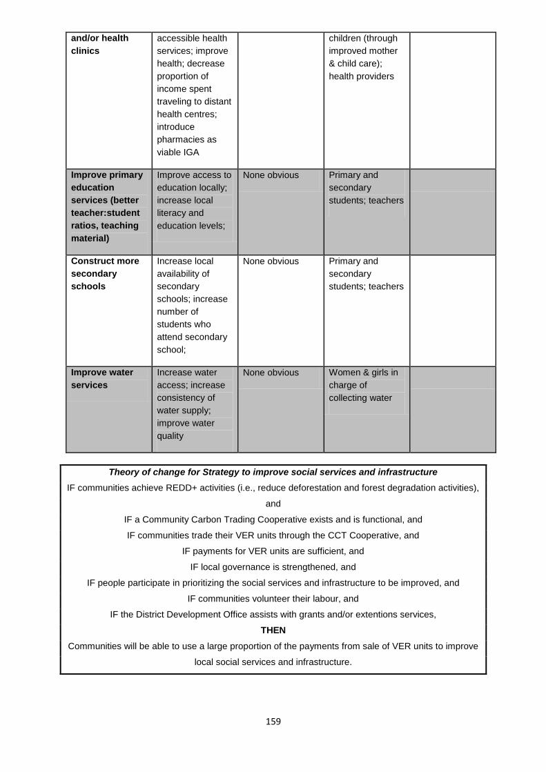
159
and/or health
clinics
accessible health
services; improve
health; decrease
proportion of
income spent
traveling to distant
health centres;
introduce
pharmacies as
viable IGA
children (through
improved mother
& child care);
health providers
Improve primary
education
services (better
teacher:student
ratios, teaching
material)
Improve access to
education locally;
increase local
literacy and
education levels;
None obvious Primary and
secondary
students; teachers
Construct more
secondary
schools
Increase local
availability of
secondary
schools; increase
number of
students who
attend secondary
school;
None obvious Primary and
secondary
students; teachers
Improve water
services
Increase water
access; increase
consistency of
water supply;
improve water
quality
None obvious Women & girls in
charge of
collecting water
Theory of change for Strategy to improve social services and infrastructure
IF communities achieve REDD+ activities (i.e., reduce deforestation and forest degradation activities),
and
IF a Community Carbon Trading Cooperative exists and is functional, and
IF communities trade their VER units through the CCT Cooperative, and
IF payments for VER units are sufficient, and
IF local governance is strengthened, and
IF people participate in prioritizing the social services and infrastructure to be improved, and
IF communities volunteer their labour, and
IF the District Development Office assists with grants and/or extentions services,
THEN
Communities will be able to use a large proportion of the payments from sale of VER units to improve
local social services and infrastructure.

160
Figure 10: Results chain for Strategy to improve social services and infrastructure

161
Annex 5 Project cashflow and projected revenues and costs
Cash Flow Assumptions
Description Value Explanation For more information:
Sale Price of credits ($/tCO2e) $5.20
Estimated price per credit at time of
sale
Average voluntary carbon market prices in 2012 were $5.90 per tCO2 eq and average for REDD projects in 2012 was $7.80 per tCO2 eq.
Brokerage fee (%) 7.50% Commercialization
fee
Left unchanged from original social carbon accountability tool. Not sure if it will apply.
Registration ($/tCO2e) $0.05 Fee charged by
registry
APX VCS Registry Fee (taken from original Social Carbon REDD feasibility tool since the fees are not listed on the APX website)
Issuance fee ($/tCO2e) $0.10 From VCS
Program Fee Schedule v3.4
VCS charges fee per VCU issued. CCBA does not charge any fees.
Methodology use fee ($/tCO2e)
$0.02 From VCS
Program Fee Schedule v3.4
Fee charged by VCS on behalf of methodology developers. Not sure if will apply to VM0015.
Sales Tax (if applicable) (%) 0.00% N/A assuming VCUs sold as export product
Price paid to communities $3.25 Will increase if project obtains more than $5.20
District Cess 5.00% Only charged from what is paid to communities
Tax on net income (if applicable) (%) 0.00%
N/A as MJUMITA is a not-for-profit organization

162
Expected Revenues 2013 2014 2015 2016 2017 2018 2019 2020 2021 2022 2023
year 0 year 1 year 2 year 3 year 4 year 5 year 6 year 7 year 8 year 9 year 10
Gross income
Credits generated 27,184 28,560 32,263 36,426 38,610 41,016 42,551 43,151 41,805 40,956 ?
Gross Revenue from sale of credits 145,433 325,398 194,877 206,565 219,434 227,645 230,860 223,656 219,117
Sales Tax - - - - - - - - - -
Revenue after Sales Tax - 145,433 - 325,398 194,877 206,565 219,434 227,645 230,860 223,656 219,117
Carbon Project Cycle Costs 2013 2014 2015 2016 2017 2018 2019 2020 2021 2022 2023
year 0 year 1 year 2 year 3 year 4 year 5 year 6 year 7 year 8 year 9 year 10
Investment REDD - Project Cycle
Validation (Audit PDD) - - - - - - - - -
(10,000) -
Carbon stock monitoring and Modeling Adjustment - - - - - - - - -
(50,000) -
Verification (Audit monitoring reports for CCB and VCS) - - -
(14,000)
(14,000)
(14,000) (14,000)
(14,000)
(14,000)
(14,000)
(14,000)
Registration fees - (1,359) - (3,041) (1,821) (1,931) (2,051) (2,128) (2,158) (2,090) (2,048)
Issuance fees - (2,718) - (6,082) (3,643) (3,861) (4,102) (4,255) (4,315) (4,180) (4,096)
Methodology use fees (544) (1,216) (729) (772) (820) (851) (863) (836) (819)
Brokerage fees -
(10,907) -
(24,405)
(14,616)
(15,492) (16,458)
(17,073)
(17,314)
(16,774)
(16,434)
Total Project Cycle Costs -
(15,529) -
(48,745)
(34,808)
(36,056) (37,430)
(38,307)
(38,650)
(97,881)
(37,396)
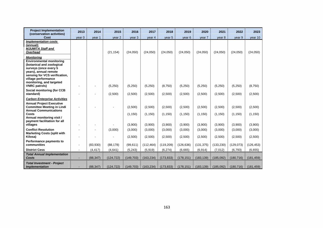
163
Project Implementation (conservation activities)
Cost
2013 2014 2015 2016 2017 2018 2019 2020 2021 2022 2023
year 0 year 1 year 2 year 3 year 4 year 5 year 6 year 7 year 8 year 9 year 10
Implementation costs (annual): MJUMITA Staff and Overhead (21,154) (24,050) (24,050) (24,050) (24,050) (24,050) (24,050) (24,050) (24,050)
Monitoring
Environmental monitoring (botanical and zoological surveys (once every 5 years), annual remote sensing for VCS verification, village performance monitoring, and targeted VNRC patrols) - - (5,250) (5,250) (5,250) (8,750) (5,250) (5,250) (5,250) (5,250) (8,750)
Social monitoring (for CCB standard) - - (2,500) (2,500) (2,500) (2,500) (2,500) (2,500) (2,500) (2,500) (2,500)
Carbon Enterprise Activities
Annual Project Executive Committee Meeting in Lindi - - - (2,500) (2,500) (2,500) (2,500) (2,500) (2,500) (2,500) (2,500) Annual Communications Costs (1,150) (1,150) (1,150) (1,150) (1,150) (1,150) (1,150) (1,150) Annual monitoring visit / payment facilitation for all villages - - - (3,900) (3,900) (3,900) (3,900) (3,900) (3,900) (3,900) (3,900)
Conflict Resolution - - (3,000) (3,000) (3,000) (3,000) (3,000) (3,000) (3,000) (3,000) (3,000) Marketing Costs (split with Kilosa) - - - (2,500) (2,500) (2,500) (2,500) (2,500) (2,500) (2,500) (2,500)
Performance payments to communities -
(83,930) (88,178) (99,611)
(112,464)
(119,209)
(126,636)
(131,375)
(133,230)
(129,073)
(126,453)
District Cess - (4,417) (4,641) (5,243) (5,919) (6,274) (6,665) (6,914) (7,012) (6,793) (6,655)
Total Annual Implementation Costs -
(88,347) (124,722)
(149,703)
(163,234)
(173,833)
(178,151)
(183,139)
(185,092)
(180,716)
(181,459)
Total Investment - Project Implementation -
(88,347) (124,722)
(149,703)
(163,234)
(173,833)
(178,151)
(183,139)
(185,092)
(180,716)
(181,459)

164
Financial Analysis
Revenue after Sales Tax - 145,433 - 325,398 194,877 206,565 219,434 227,645 230,860 223,656 219,117
Total Project Cycle Costs -
(15,529) - (48,745) (34,808) (36,056) (37,430) (38,307) (38,650) (97,881) (37,396)
Total implementation costs -
(88,347) (124,722)
(149,703)
(163,234)
(173,833)
(178,151)
(183,139)
(185,092)
(180,716)
(181,459)
Operational Result (EBITDA) including implementation costs - 41,557 (83,165) 43,785 40,621 37,296 41,149 47,348 54,466 (475) (213)
Net income before tax - 41,557 (124,722) 126,950 (3,164) (3,325) 3,853 6,199 7,118 (54,941) 262
Income tax - - - - - - - - - - -
Net income after tax - 41,557 (124,722) 126,950 (3,164) (3,325) 3,853 6,199 7,118 (54,941) 262
Cash Position 89,477 131,034 6,312 133,262 130,098 126,773 130,626 136,825 143,943 89,002 89,264
Estimated Annual Area of Avoided Deforestation 238 249 278 309 327 344 354 354 340 331 Community Earnings from REDD 83,930 88,178 99,611 112,464 119,209 126,636 131,375 133,230 129,073 126,453
NPV 10% discount rate 679,391 Community Earnings from AG 72,052 75,522 84,098 93,705 99,213 104,293 107,135 107,135 102,910 100,194
NPV 10% discount rate 562,806