County Real Estate PortfolioThe Leon County Real Estate Portfolio is comprised of 604 parcels of...
82
Attachment #1 Page 1 of 82 For Calendar Year 2019 Leon County Annual Status Report For Year ended December 31, 2019 Real Estate Portfolio The Leon County Real Estate Portfolio is comprised of 604 parcels of land containing 6,370.6 acres, 138 buildings with 2,434,502 square feet. This report is a review and highlights of the activity that took place in the real estate portfolio during calendar year ended December 31, 2019. Mike Battle Real Estate Specialist Office of Financial Stewardship Division of Real Estate Management Leon County, Florida July 14, 2020
Transcript of County Real Estate PortfolioThe Leon County Real Estate Portfolio is comprised of 604 parcels of...

Attachment #1 Page 1 of 82
For Calendar Year 2019 Leon County Annual Status ReportFor Year ended December 31, 2019 Real Estate
Portfolio The Leon County Real Estate Portfolio is comprised of 604 parcels of land containing 6,370.6 acres, 138 buildings with 2,434,502 square feet. This report is a review and highlights of the activity that took place in the real estate portfolio during calendar year ended December 31, 2019.
Mike Battle
Real Estate Specialist
Office of Financial Stewardship
Division of Real Estate Management
Leon County, Florida
July 14, 2020

Leon County Real Estate Portfolio Annual update, year ending December 31, 2019 Page 2 of 23
Attachment #1 Page 2 of 82
Annual Status ReportFor Year ended December 31, 2019
This purpose of this report is to provide the highlights and changes in the Leon County Land Portfolio, leasing activity and Tax Deed activities during the period ending December 31, 2019.
The Portfolio
The Leon County Land Portfolio is comprised of several different land types and uses, from vacant and under‐developed land, to a variety of developed properties that are improved with multi‐story office buildings, retail centers, along with industrial and warehouse buildings. The total portfolio contains over 6,370.6 acres, comprised of 604 parcels. There are 138 buildings within the portfolio containing over 2,434,502 square feet. The buildings the County utilizes, have various capabilities, eighty‐seven (87) buildings, containing 2,132,536 square feet are used to directly support the staff, the daily business of the County government and the citizens of Leon County. Twenty‐eight (28) buildings containing 279,764 square feet, these buildings are owned by Leon County but leased to others through long and short‐term leases. There are also twenty‐three (23) various structures containing 23,542 square feet (primarily residential and mobile homes) acquired through escheatment, a result of the delinquent property tax process.
At the close of 2019, the Leon County Land Portfolio has grown by seventeen (17) parcels from the previous year‐end and the total acreage of the portfolio has increased by 64.5 acres. The activity in the portfolio brings the total parcels owned and controlled by Leon County to 604 parcels from the 587 parcels at the end of 2018.
The Leon County Land Portfolio has been categorized into different uses to help the user to quickly and easily identify the use of the property.
Figures 1 & 2 below illustrate the categorization of all Leon County owned properties. Figure 1 illustrates the net change in the number of parcels, acreage, buildings and their square footage that occurred during 2019. Figure 2 reflects the composition of the portfolio by the number of parcels and the corresponding number of acres encumbered in each category.

‐ ‐ ‐ ‐ ‐ ‐
‐
Leon County Real Estate Portfolio Annual update, year ending December 31, 2019 Page 3 of 23
(Figure 1)
Total Real Estate Portfolio as of December 31, 2019 Year‐to‐Year Portfolio Change
Attachment #1 Page 3 of 82
Parcels Acreage Buildings Square Footage
Parcels Acreage Buildings Square Footage
Parcels Acreage Buildings Square Footage
"Facilities" "Facilities ‐ Leased" 2 6.423 1 45,286 3 6.720 2 47,159 1 0.297 1 1,873 "Facilities ‐ Owned" 47 1,096.121 87 2,273,499 46 1,096.380 86 2,264,230 (1) 0.259 (1) (9,269) Total "Facilities" 49 1,102.799 88 2,318,785 49 1,103.100 88 2,311,389 ‐ 0.556 ‐ (7,396)
"Parks & Recreation" "Boat Landing" 21 61.259 5 4,362 19 61.260 5 4,362 (2) 0.001 ‐ ‐
"Community Center" 6 62.370 6 26,732 6 62.370 6 26,732 ‐ ‐ ‐ ‐
"Parks ‐ Leased" 6 1,409.100 ‐ ‐ 6 1,409.100 ‐ ‐ ‐ ‐ ‐ ‐
"Park" 46 2,062.284 15 66,863 47 2,089.470 16 69,477 1 27.186 1 2,614 Total "Parks & Recreation" 79 3,595.013 26 97,957 78 3,622.200 27 100,571 (1) 27.187 1 2,614
"Right of Way (ROW)" 14 157.043 15 159.650 1 2.608
"Surplus" "Affordable Housing" 1 0.750 ‐ ‐ ‐ ‐ ‐ ‐ (1) (0.750) ‐ ‐
"Developable" 15 9.440 2 2,834 25 16.980 4 4,162 10 7.540 2 1,328 "Undevelopable" 13 5.683 1 713 13 5.280 ‐ ‐ ‐ (0.403) (1) (713) Total "Surplus" 29 15.873 3 3,547 38 22.260 4 4,162 9 6.387 1 615
"Tax Deeds" "Affordable Housing" 42 22.106 11 11,364 60 22.880 13 12,927 18 0.774 2 1,563 "Pending Affordable Housing" 28 10.085 9 10,915 25 11.44 5 4389 (3) 1.356 (4) (6,526) "Developable" 49 30.540 10 13,004 27 20.790 1 1,064 (22) (9.750) (9) (11,940) Total "Tax Deeds" 119 62.731 30 35,283 112 55.110 19 18,380 (7) (7.621) (11) (16,903)
"Water Management" "Drainage" 30 22.711 ‐ ‐ 33 24.210 ‐ ‐ 3 1.499 ‐ ‐
"Drainage ‐ Federal" ‐ ‐ ‐ ‐ ‐ ‐ ‐ ‐ ‐ ‐ ‐ ‐
"Flood" 37 46.163 ‐ ‐ 44 48.670 ‐ ‐ 7 2.507 ‐ ‐
"Flood ‐ County" 54 35.824 ‐ ‐ 54 35.830 ‐ ‐ ‐ 0.006 ‐ ‐
"Flood ‐ Federal" 44 113.519 ‐ ‐ 44 113.510 ‐ ‐ ‐ (0.009) ‐ ‐
"SWMF" 100 314.160 ‐ ‐ 101 327.960 ‐ ‐ 1 13.800 ‐ ‐
"SWMF ‐ Federal" 5 27.670 ‐ ‐ 5 27.670 ‐ ‐ ‐ ‐ ‐ ‐
"Wetlands" 26 752.853 ‐ ‐ 30 770.450 ‐ ‐ 4 17.597 ‐ ‐
"Wetlands ‐ Federal" 1 60.000 ‐ ‐ 1 60.000 ‐ ‐ ‐ ‐ ‐ ‐
Total Water Management 297 1,372.900 ‐ ‐ 312 1,408.300 ‐ ‐ 15 35.400 ‐ ‐
587 6,306.358 147 2,455,572 604 6,370.620 138 2,434,502 17 64.517 (9) (21,070)
Use Category
Total County Controlled Properties
Real Estate Portfolio ‐ December 31, 2018 Real Estate Portfolio December 31, 2019 Net Portfolio Change

"Facilities-Leased"
"Surplus"
■ "Facilities-Leased"
II "Surplus"
PARCELS
3
■ "Facilities-Owned" "Parks & Recreation" ■ "Right of Way (ROW)"
"Tax Deeds" ■ "Water Management"
ACRES
■ "Facilities-Owned" "Parks & Recreation" ■ "Right of Way (ROW)"
"Tax Deeds" ■ "Water Management"
Leon County Real Estate Portfolio Annual Status Report for year ended December 31, 2018 Page 4 of 23
Attachment #1 Page 4 of 82

Leon County Real Estate Portfolio Annual update, year ending December 31, 2019 Page 5 of 23
Attachment #1 Page 5 of 82
Changes to the Portfolio during Calendar Year 2019
During 2019 the Leon County Land Portfolio had a net increase of seventeen (17) parcels containing an increase of sixty‐four (64) acres, fifty‐five (55) parcels were added and thirty‐eight (38) parcels were removed. At the end of 2018 the portfolio contained 587 parcels comprised of 6,306.1 acres, while at the end of 2019 the portfolio has grown to 604 parcels comprised of 6,370.6 acres.
1) Facilities Leased & Owned – Any parcel of land or assemblage of land and buildings that is leased or owned and operated by Leon County to provide a clean, safe and fully functional governmental system that serves the citizens and users of Leon County Services.
During the year the following activity took place.
1. 1 parcel added to Facilities‐Leased – after the sale of the building (106 E. Jefferson St) Tourist Development was relocated to the Leon County Government Annex. However, Tourist Development felt they need to maintain a public presence, therefor, the County leased back the first floor of the 106 E Jefferson building to maintain the retail store for Tourist Development there.
2. 1 parcel removed during 2019 a. Tourist Development Center ‐ 2136251691465, 106 E Jefferson St, Parcel
ID 2136251691465, Totaling 0.0517 acres, containing 1 building containing 8,780 base SF & 195 aux SF office building; Use; 8600 Zoned; CC ‐ Central Core; Sold 1/2019 for 2,250,000
3. During 2019 the County Property Appraiser made corrections to 12 parcels and increased the Estimated Acreage by adding .314 acres and adjusted the square footage of buildings by decreasing the SF of the Facilities portfolio 294 SF.
Appendix 2 and 3 contains a detailed list of all parcels in the Facilities Category.
2) Parks & Recreation – Any parcel of land, or an assemblage of parcels of land, that has been acquired and will be utilized for the recreation, well‐being and entertainment of the citizens of Leon County.
The Parks & Recreation category is subdivided into four subcategories, Boat Landing, Community Centers, Parks‐Leased and Parks. Overall, there are 78 parcels classified in this category, during 2019 one (1) parcel added and two (2) parcel were consolidated into an existing third parcel
a) Boat Landing – any parcel of land located in Leon County that is owned or leased by the County that serves as a facility for the launching and recovery of boats or any other amphibious vehicles into a body of water.
At the end of 2019 the Boat Landing subcategory consisted of 19 parcels, totaling 61.3 acres, with five buildings containing 4,362 square feet of space.

Leon County Real Estate Portfolio Annual update, year ending December 31, 2019 Page 6 of 23
Attachment #1 Page 6 of 82
1. No parcels added during 2019
2. 2 parcels removed during 2019
a. COE LANDING RD ‐ 2325150000020, COE LANDING RD, Parcel ID 2325150000020, Totaling 0.884 acres, Parcel consolidated into Paracel # 2325150000010 to create a 3.49 acres parcel. Residential structure totaling 768 SF is now a part of the surviving parcel.
b. Coe Landing ‐ 2325150000030, COE LANDING RD, Parcel ID 2325150000030, Totaling 1.382 acres, Parcel consolidated into Paracel # 2325150000010 to create a 3.49 acres parcel.
3. During 2019 the County Property Appraiser made corrections to 4 parcels that increased the Estimated Acreage by adding 2.265 acres and increased the number of Building by 1 containing 768 SF.
b) Community Centers – any parcel of land, or assemblage of parcels where members of the community can gather for group activities, social support, public information, and other purposes.
At the end of 2019 the Community Center subcategory consisted of six (6) parcels (5 owned and 1 Leased), totaling 62.4 acres, with six (6) buildings containing 26,732 square feet of space.
1. No parcels added during 2019
2. No parcels removed during 2019
c) Parks Leased – any parcel of land, or an assemblage of parcels of land that is leased from a third‐party, that has developed facilities on the site that are actively being used and maintained as a recreation area for the citizens of Leon County.
At the end of 2019, the Park‐leased subcategory consisted of six (6) parcels, totaling 1,409.1 acres, with no buildings.
d) Parks – A parcel of land, or an assemblage of parcels of land specifically purchased to be used and maintained as a recreation area for the citizens of Leon County.
At the end of 2019, the Parks subcategory consisted of 47 parcels, totaling 2,089.5 acres, with sixteen (16) buildings containing 69,477 square feet of space.
During 2019, one parcel was added, this parcel was conveyed to the County by BP 2000 to create Broadmoor Pond Park, consisting of 27.4 acres.
Appendix 4 contains a detailed list of all parcels in the Parks & Recreation Category.

Leon County Real Estate Portfolio Annual update, year ending December 31, 2019 Page 7 of 23
Attachment #1 Page 7 of 82
3) Right of Ways (ROW) – any parcel taken or dedicated for use as a public way or such use as is set forth in the instrument establishing the right‐of‐way. Any parcel of land area acquired for its use by Leon County to provide temporary and/or permanent access to any other county owned property or county owned projects constructed on public lands.
At the end of 2018, Right of Ways (ROW) category consisted of 14 parcels, totaling 157.1 acres, with no buildings. During 2019, there was 1 parcel totaling 2.59 acres added, this addition resulted from an escheatment of the parcel to the County from the List of Lands available for Taxes (LOLA). Due to Property Appraiser’s reassessment of acreage during 2019, this subcategory has increased by .02 acres.
At the end of 2019, the Right of Ways (ROW) category consisted of fifteen (15) parcels, totaling 159.7 acres
Appendix 5 contains a detailed list of all parcels in the ROW Category.
4) Surplus ‐ Any parcel of land or building owned by Leon County for which the Real Estate Division with input from appropriate County staff, has determined that there is no intended or proposed County use. Upon designating a parcel as Surplus, the Division of Real Estate Management may proceed with its disposition in accordance with the Leon County Real Estate Policy.
The Surplus category is subdivided in three subcategories "Affordable Housing", "Developable", and "Undevelopable". At the end of 2019 the Surplus category consisted of 38 parcels, totaling 22.3 acres.
Activity during 2019 consisted of:
a) 11 Parcels, added, totaling 11.9 acres and containing 2 structure totaling 1,328 SF, they are located throughout Leon County. All of these parcels are a result of escheatment to the County due to the non‐payment of associated property taxes, fees and interest.
b) Two parcels were removed during 2019, one was sold back to the original owner for $3,000.00, the other was conveyed to Deer Tree Hills, Inc., along with 2 other parcels from Affordable Housing to satisfy a claim that there were back HOA fees associated with these escheated parcels.
Appendix 6 contains a detailed list of all parcels categorized in the Surplus Category.
5) Tax Deeds ‐ Any parcel of land or building conveyed to Leon County through the delinquent property tax process as defined in Florida Statue 197. The parcels are assumed to be immediately disposable with limited action by the County to clear title issues.
Beginning in 2019, in an attempt to reduce the length of time that these parcels are in the Portfolio and to try and get them back on the Tax Roll, New procedures were instituted to actively market these parcels to return them back to the County Tax Rolls. When the parcel is conveyed to the County by an Escheatment Tax Deed the Real Estate Division notifies County Divisions that the parcel is now a County parcel and ask them to review and evaluate to determine if it may be useable by the County and if it should remain in the Leon County Land Portfolio. If the parcel is not suitable for future County

Leon County Real Estate Portfolio Annual update, year ending December 31, 2019 Page 8 of 23
Attachment #1 Page 8 of 82
use, the Real Estate Division will evaluate the parcel for marketability, Code Violations, Encroachments or possible flooding. If no hindrance is noted, Real Estate Division will notify adjacent property owners that if they have interest in purchasing the parcel, they will need to submit a bid and the parcel will be sold to the highest bidder. If no bids are received the parcel is offered the Housing Division for affordable housing. Net proceeds from the sale of affordable housing provided to the Housing Finance Authority.
At the end of 2018 the Tax Deed category consisted of a total of 119 parcels consisting of 62.7 acres with 30 structures containing 35,283 square feet. During 2019 there were 26 parcels added with 33 parcels removed from the category. The Tax Deed category is sub‐divided into three (3) subcategories; "Affordable Housing ", “Pending Affordable Housing” and "Developable".
During the year the following activity took place.
a. Parcels added or transferred with the Tax Deeds Category; 27 parcels added during 2019 – 27 parcels transferred from Tax Deeds Developable after being approved for Affordable housing by the Board on July 9, 2019.
1. Affordable Housing– 2018 Pending Affordable Housing Parcels approved by BCC as suitable for Affordable Housing July 9, 2019 a) 317 Ridge Rd, Parcel ID #411352 B0010, .34 acres, 1 single family structure
totaling 1,467 SF b) Clay St, Parcel # 243025 F0190, .15 acres, no structures c) Idaho St, Parcel # 212620212000, .11 acres, no structures
d) 1494 Nashville Dr, parcel ID # 213061 B0250, .170 acres and 1 Mobile Home
totaling 1,296 SF
e) 1383 MCCULLOUGH DR, parcel ID # 4126130000170, 1.21 acres and 1 Mobile
Home totaling 2,039 SF
f) 6992 CRYSTAL BROOK CT, parcel ID # 243025 H0110, .68 acres and 1 Single Family totaling 800 SF
g) 714 STAFFORD ST parcel ID # 411137 D0180, 0.22 acres and 1 Single family structure totaling 1,780 SF
h) CLAY ST, parcel ID # 2126200530000, .15 acres with no structures i) 5012 SARAY WAY, parcel # 412680 K0150, .30 acres with no structures j) 4036 BUSTER RD, parcel # 4123060000430, .28 acres and 1 Mobile Home
totaling 1,644 SF
k) IDAHO ST, parcel # 2126202130000, .15 acres with no structures l) 818 FLORAL ST, parcel # 4101750220011, .13 acres with no structures m) 7433 BOOKOUT CV, parcel # 2235202100000, .57 acres and I single family
structure totaling 1,330 SF n) 9523 LANCE RD, parcel # 331740 E0120, .464 acres with no structures o) 3515 SUNKISSED RD, parcel # 411480 B0030, .208 acres with 1 mobile home
totaling 528 SF p) Sundown Rd, parcel # 411480 D0030, .132 acres with no structures q) 11832 T AND T RD, parcel # 3317200370000, .220 acres with no structures
r) 8812 DIVINE WAY, parcel # 1608202040000, .510 acres with no structures s) 1418 SEVILLE ST, parcel # 4123140000140, .280 acres with 1 Mobile Home
structure totaling 1,064 SF

Leon County Real Estate Portfolio Annual update, year ending December 31, 2019 Page 9 of 23
Attachment #1 Page 9 of 82
t) 1418 SEVILLE ST, parcel # 4123140000140, .280 acres with 1 Mobile Home
structure totaling 1,064 SF
u) 3584 SUNDOWN RD, parcel # 411480 B0570, .151 acres with no structures v) 2142 NATURAL WELLS DR, parcel # 332103 B0020, .701 acres with no
structures
w) 3085 ADKINS FOREST LN, parcel # 310328 A0020, .244 acres with no
structures
x) HOLLYBROOK TRL, parcel # 1407202430000, .170 acres with no structures
y) 4029 MORGAN RD, parcel # 412406 A0070, .285 acres with no structures
z) 4025 MORGAN RD, parcel # 412406 A0060, .285 acres with no structures
aa) 2399 EDDIE RD, parcel # 111680 E0080, .137 acres with 1 single family
structure totaling 624 SF
bb) 6992 CRYSTAL BROOK CT, parcel ID # 243025 H0110, .68 acres and 1 Single
Family totaling 800 SF
2. Pending Affordable Housing – 25 Parcels added along with 5 structures totaling
4,389 SF
a) 10586 CAPITOLA RD, parcel # 1235204240000, 3.060 acres with no structures
b) 8807 SPRING HOLLOW LN, parcel # 1608206040000, 1.65 acres with a mobile
home totaling 672 SF
c) BRIGHT MEADOW LN, parcel # 1617206200000, 1.070 acres with no structures
d) 462 LONG PINE DR, parcel # 411315 A0400, .440 acres with no structures
e) CAPITOLA RD, parcel # 1234204550000, .430 acres with no structures
f) 4136 COWAN DR, parcel # 4123120000520, .420 acres with no structures
g) 7567 MAIGE LN, parcel # 223519 A0090, .400 acres with 1 mobile home
totaling 732 SF
h) MEXICO LN, parcel # 3107202120000, .360 acres with no structures
i) OFFICE PLAZA DR, parcel # 113168 A0190, .280 acres with no structures
j) 4025 BISHOP RD, parcel # 412305 A0140, .280 acres with 1 mobile home
totaling 1,356 SF
k) 8402 BLACKJACK RD, parcel # 461030 B0150, .250 acres with no structures
l) MOCCASIN GAP RD, parcel # 1605510070020, .230 acres with no structures
m) COUNTRY CLUB Dr, parcel # 3107202280000, .220 acres with no structure
n) EDENHALL CIR, parcel # 1605510080080, .210 acres with no structure
o) McCaskill Ave, parcel # 41023507B0000, .210 acres with no structure
p) MEXICO LN, parcel # 3107202110000, .180 acres with no structure
q) 1331 CLAY ST, parcel # 2126200870000, .160 acres with no structure
r) 1117 VOLUSIA ST, parcel # 212645 B0180, .140 acres with no structure
s) HERNANDO DR, parcel # 410255 A0180, .140 acres with no structure
t) Kitt St, parcel # 2126206320000, .130 acres with no structure
u) 4321 CONIFER ST, parcel # 213215 C0030, .130 acres with I mobile home
totaling 652 SF

Leon County Real Estate Portfolio Annual update, year ending December 31, 2019 Page 10 of 23
Attachment #1 Page 10 of 82
v) 2721 LAKE HENRIETTA ST, parcel # 411155 C0220, .120 acres with no structure
w) 3528 SUNDOWN RD, parcel # 411480 B0260, .120 acres with no structure
x) Bennett St, parcel # 2126150000080, .110 acres with no structure
y) 210 OAK CREST BLVD, .110 acres with no structure
3. Developable Tax Deeds – 1 parcel added
a) ROBINSON OAK DR, parcel # 2117206060000, .500 acres with no structures
b. 33 parcels removed ‐ 28 Parcels containing 17.22 acres along with 10 structures totaling 12,984 SF were sold during 2019 generating sales revenues of $236,110, I parcel donated and 4 parcels conveyed to settle legal actions.
1. Parcels Sold 28 a) MONDAY RD, 5 Acres with no Structures, Sold for $15,000.00 b) 10715 TEBO TRL, 2 Acres with 1 residential Structure totaling 1,056 SF, Sold for
$20,000.00P c) Moore Woods Rd, 1.5931 Acres with no Structures, Sold for $7,100.00 d) 12513 FOREST ACRES TRL, 1.145 Acres with no Structures, Sold for $9,500.00 e) 8716 WIDE RD, 0.95 Acres with 1 mobile home totaling 1,272 SF, Sold for
$10,710.00 f) 2572 TINY LEAF RD, 0.628 Acres with no Structures, Sold for $4,000.00 g) 7344 POPLAR POINT DR, 0.624 Acres with no Structures, Sold for $9,000.00 h) 5071 MEADOWLARK LN, 0.57 Acres with 1 mobile home totaling 1,612 SF, Sold
for $11,200.00 i) CRAFT ST, 0.4829 Acres with no Structures, Sold for $6,000.00 j) 1579 BALKIN RD, 0.459 Acres with one residential structure totaling 1,273 SF,
Sold for $4,600.00 k) 4037 BISHOP RD, 0.287 Acres with no Structures, Sold for $8,000.00 l) 4033 BISHOP RD, 0.2842 Acres with no Structures, Sold for $8,000.00 m) 4043 BUSTER RD, 0.2817 Acres with no Structures, Sold for $8,000.00 n) 4065 MORGAN RD, 0.2793 Acres with no Structures, Sold for $7,100.00 o) 5017 DUST BOWL LN, 0.267 Acres with 1 mobile home totaling 960 SF, Sold for
$3,500.00 p) LILLY RD, 0.2657 Acres with no Structures, Sold for $7,100.00 q) 2993 LILLY RD, 0.2622 Acres with 1 mobile home totaling 732 SF, Sold for
$8,100.00 r) 4060 MORGAN RD, 0.2502 Acres with no Structures, Sold for $7,100.00 s) 1506 CROWN RIDGE RD, 0.2309 Acres with 1 mobile home totaling 1,288 SF,
Sold for $8,100.00 t) 714 STAFFORD ST, 0.2155 Acres with 1 residential structure totaling 1,780 SF,
Sold for $35,000.00 u) ABRAHAM ST, 0.184 Acres with no Structures, Sold for $8,800.00 v) DELAWARE ST, 0.1826 Acres with no Structures, Sold for $6,000.00 w) 1118 CLAY ST, 0.1599 Acres with 1 residential structure totaling 1,715 SF, Sold
for $6,800.00 x) Calloway St, 0.1498 Acres with no Structures, Sold for $6,800.00 y) 3529 SUNBURST LOOP, 0.1339 Acres with no Structures, Sold for $4,000.00 z) 2277 SAXON ST, 0.1203 Acres with no Structures, Sold for $2,500.00

Leon County Real Estate Portfolio Annual update, year ending December 31, 2019 Page 11 of 23
Attachment #1 Page 11 of 82
aa) 1494 NASHVILLE DR, 0.1109 Acres with 1 mobile home totaling 1,296 SF, Sold for $100.00
bb) Flipper St & Palm Beach St, 0.1031 Acres with no Structures, Sold for $4,000.00
2. Donated Parcels 1 a) 1340 CONNECTICUT ST, 0.1473 Acres with no Structures, donated to Habitat for
Humanity
3. 4 Parcels removed due to Errors and Omissions and Legal Action a) MCCULLOUGH DR, 1.2067 Acres with 1 mobile home totaling 2,039SF, sold for
$0.00, Returned to previous owner after error by Clerk of the Court b) 1820 DEER TREE DR, 0.1398 Acres with no Structures, sold for $0.00, in order to
avoid a lawsuit from the DEERTREE HILLS HOA for back HOA fees, ownership of Parcel was trans to DEERTREE HILLS INC, Inc
c) 1830 1383 DEER TREE DR, 0.1219 Acres with no Structures, sold for $0.00, in order to avoid a lawsuit from the DEERTREE HILLS HOA for back HOA fees, ownership of Parcel was trans to DEERTREE HILLS INC, Inc
d) 5667 CARIBOU LN, 0.0833 Acres with no Structures, sold for $0.00, in order to avoid a lawsuit from the DEERTREE HILLS HOA for back HOA fees, ownership of Parcel was trans to DEERTREE HILLS INC, Inc
c. During 2019 County Property Appraiser made adjustments to the Estimated Acreage on 68 Parcels reducing the total acres by .0127
d. During 2019 the Real Estate Management contracted to have 4 structures totaling 4,845 SF removed. These structures were uninhabitable and structurally unsound.
During 2019 the County engaged Ketcham Realty Group to market and sell a select group pf approved Affordable Housing parcels. This engagement accounts for the increased volume of parcels sold to the public during 2019, returning them to the Tax Roll.
Appendix 7 contains a detailed list of all parcels categorized in the Tax Deed Category.
6) Water Management ‐ Any parcel of land, or an assemblage of parcels of land acquired to manage and direct storm water away urban and residential areas to reduce flooding, protect rivers, lakes and vital landscape and spur economic revitalization. The water Management Category is subdivided into nine subcategories "Drainage", "Drainage ‐ Federal", "Flood", "Flood ‐ County", "Flood ‐ Federal", "Storm Water Management Facilities ‐ SWMF", "Storm Water Management Facilities ‐ SWMF ‐ Federal", "Wetlands" and "Wetlands ‐ Federal".
At the end of 2019 there were a total 312 parcels in this category, consisting of 1,408.3 acres, with no habitable structures.
a. Drainage ‐ A parcel or an assemblage of parcels with a natural or artificial means for the removal of surface and sub‐surface water from an area. Usually acquired for storm water control and prevent flooding to adjacent parcels or contribute to the overall storm water plan for Leon County.

Leon County Real Estate Portfolio Annual update, year ending December 31, 2019 Page 12 of 23
Attachment #1 Page 12 of 82
At the end of the 2019 there were a total 33 parcels in this subcategory, consisting of 24.2 acres, with no habitable structures.
During the year the following activity took place.
1. 3 parcels added totaling 1.5 Acres with no structures a) LESTER HACKLEY RD, Parcel ID 1116200910000, 0.5 Acres with no Structures,
FEMA Flood Zone ‐ AE
b) Lester Hackley Rd, Parcel ID 1116200920000, 0.5 Acres with no Structures,
FEMA Flood Zone – AE
c) PRESTON JOHNSON RD, Parcel ID 4415030000190, 0.5 Acres with no
Structures, FEMA Flood Zone – A
2. No parcels removed
3. During 2019 the County Property Appraiser made correctios to 4 parcels by
decreasing the Estimated Acreage .0001 acres
b. Drainage ‐ Federal ‐ A parcel or an assemblage of parcels of land that meets the drainage criteria through a Federal Grant Program. Usually if acquired with federal grant funds there are severe restrictions placed within the deed that limits any future conveyance or development of the parcel.
During the year the following activity took place.
1. No parcels added during 2019
2. Property Appraiser made no adjustments during 2019
c. Flood ‐ A parcel or an assemblage of parcels of land acquired for the following reasons: (i) its nature of being susceptible to flooding from storm water. (ii) any property designated for future acquisition by the County (in accordance with any of the Board’s current or future policies, programs, or ordinances) intended to provide relief to owners of homesteaded residential properties prone to flooding, or (iii) any property acquired by the County by tax deed, foreclosure, exchange, or other such means and which thereafter is determined to be unsuitable for resale or other disposition because of its tendency to flood.
At the end of 2019 there were a total 44 parcels in this subcategory, consisting of 48.7 acres with no habitable structures.
During the year the following activity took place.
1. Parcels added during 2019 totaling 2.51 acres a) 8734 OLD SHELL POINT RD, Parcel ID 4611206220000, 1 Acres with no
Structures, FEMA Flood Zone – AE

Leon County Real Estate Portfolio Annual update, year ending December 31, 2019 Page 13 of 23
Attachment #1 Page 13 of 82
b) 10853 SUNFLOWER LN, Parcel ID 3318206120000, 0.68 Acres with no Structures, FEMA Flood Zone ‐ None
c) MUNSON BLVD, Parcel ID 412650 G0140, 0.24 Acres with no Structures, FEMA Flood Zone ‐ AE
d) COMPASS LN, Parcel ID 3107203020000, 0.23 Acres with no Structures, FEMA Flood Zone ‐ AE
e) 2756 KENNEDY DR, Parcel ID 411080 B0060, 0.13 Acres with no Structures, FEMA Flood Zone ‐ AE
f) Red Arrow Dr, Parcel ID 3107203170000, 0.12 Acres with no Structures, FEMA Flood Zone ‐ AE
g) RED ARROW RD, Parcel ID 3107203100000, 0.11 Acres with no Structures, FEMA Flood Zone – AE
2. No parcels removed
3. During 2019 the County Property Appraiser made correctios to 2 parcels by decreasing the Estimated Acreage .0003 acres
d. Flood ‐ County ‐ A parcel or an assemblage of parcels of land that meets the Flood criteria that are acquired via County funded programs. When these parcels are conveyed to the County, restrictive covenants may be placed on the property similar to the land acquired by Federal Funds, However, if a higher and better use is found the restriction may be removed by the county.
At the end of 2019 there were a total 54 parcels in this subcategory, consisting of 35.8 acres, with no habitable structures.
4. No parcels added during 2019
5. No parcels removed during 2019
6. During 2019 the County Property Appraiser made correctios to 1 parcel and increased the Estimated Acreage by adding .001 acres
7. During 2019 the Real Estate Management contracted to have 1 structure totaling
1,274 SF removed.
e. Flood ‐ Federal ‐ A parcel or an assemblage of parcels of land that meets the Flood criteria acquired through a Federal Grant Program. If conveyed to the County under one of these programs there are restrictions on any future conveyance or development except for their limited use as pocket parks or community gardens. If not used for one of the above, the parcel must be returned to its natural state.
At the end of the current calendar year there were a total 44 parcels in this subcategory, consisting of 113.5 acres.
1. No parcels added during 2019

Leon County Real Estate Portfolio Annual update, year ending December 31, 2019 Page 14 of 23
Attachment #1 Page 14 of 82
2. No parcels removed during 2019
3. During 2019 the County Property Appraiser made correctios to 2 parcels and decreased the Estimated Acreage by adding .001 acres
f. Storm Water Management Facilities (SWMF) ‐ A parcel or an assemblage of parcels of land, acquired for the management of storm water runoff or watershed through natural and engineered structures. These can be any structure that collects, conveys, channels, diverts, stores, absorbs, inhibits, treats, uses, or reuses storm water to control erosion, ponding or flooding.
At the end of the 2019 there is a total 101 parcels in this subcategory, consisting of 328.0 acres, with no habitable structures.
During the year the following activity took place.
1. 1 parcel totaling 13.8 acres added during 2019 a) GUM RD, Parcel ID 2131208010000, 13.8 Acres with no Structures, FEMA Flood
Zone ‐ X5; transfer to the County by BP 2000
2. No parcels removed during 2019.
3. During 2019 the County Property Appraiser made corrections to 1 parcel and increased the Estimated Acreage by adding .005 acres
g. SWMF ‐ Federal ‐ A parcel or an assemblage of parcels of land that meets the SWMF criteria above acquired through a Federal Grant Program. If conveyed to the County under one of these programs there are restrictions on any future conveyance or development except for their use as Storm Water Management Facilities.
At the end of 2019 there were a total five parcels in this subcategory, consisting of 27.7 acres, with no habitable structures.
During the year the following activity took place.
1. No parcels added during 2019
2. No parcels removed during 2019
3. During 2019 the County Property Appraiser made no corrections
h. Wetlands ‐ Any area that is inundated or saturated by surface water or groundwater that does not have any natural method of drainage and would not be financially feasible to develop. Wetlands generally include swamps, marshes, bogs, and similar areas such as sloughs, wet meadows, river overflows, mud flat, sand flats, beaches, seepage slopes, and temporary natural ponds.

Leon County Real Estate Portfolio Annual update, year ending December 31, 2019 Page 15 of 23
Attachment #1 Page 15 of 82
At the end of 2019 there were a total 26 parcels in this subcategory, consisting of 752.7 acres, with no buildings.
During the year the following activity took place.
1. 5 parcels added during 2019 i. 5285 TRAILS END LN parcel ID # 2131200060000, consisting of 10 acres, No
Buildings of 0 SF. Obtained through the Grace Program ii. CAPITOLA RD parcel ID # 1319206040000, consisting of 1.84 acres, No
Buildings of 0 SF. Obtained by Escheatment iii. BLOUNTSTOWN HWY parcel ID # 2131204150000, consisting of 1.24 acres, No
Buildings of 0 SF. Obtained by Escheatment iv. LAKE IAMONIA DR parcel ID # 173308 A0160, consisting of 0.62 acres, No
Buildings of 0 SF. Obtained through the Grace Program v. 3651 ERIN DR parcel ID # 321410 C0170, consisting of 0.46 acres, No Buildings
of 0 SF. Obtained by Escheatment
2. Property Appraiser made 1 adjustment during 2019 the decreases the acreage by 1.987
i. Wetlands ‐ Federal ‐ a parcel or an assemblage of parcels of land that meets the Wetland criteria above acquired through a Federal Grant Program. If conveyed to the County under one of these programs there are restrictions on any future conveyance or development except for their use as Wetlands Preservation.
At the end of the year there were a total one parcel in this subcategory, consisting of 60 acres, with no buildings.
During the year the following activity took place. 1. No parcels added during 2019
2. Property Appraiser made no adjustments during 2019
Appendix 8contains a detailed list of all parcels categorized in the Water Management Category.
Buildings in the Portfolio
There are a total 138 buildings within the Real Estate Portfolio, containing 2,434,502 square feet. 87 of the buildings are used for the direct support of the daily business of Leon County these buildings are comprised of governmental. Commercial offices, retail, industrial and warehousing space, in addition to specialized uses such as libraries, health services, public safety, detention facility and fleet management. Additionally, there are 28 buildings containing 279,764 square feet on County owned parcels that are encumbered by long term leases or agreements to others for their use.

Leon County Real Estate Portfolio Annual update, year ending December 31, 2019 Page 16 of 23
Attachment #1 Page 16 of 82
Finally, there are 23 buildings (primarily residential) containing 23,547 square feet that the County received when the parent parcel was escheated to the County due to delinquent taxes.
A detailed review of the building within the Real Estate Portfolio can be found in Appendix 9 and 10.
Leased Parcels from Others
The County is currently leasing ten (10) locations throughout the county containing 1,409.8 acres, three (3) of the locations contain buildings in which we are leasing 57,231 square feet for retail, offices and community space.
Two locations and one building for the direct support of the daily business of Leon County.
(Figure 6)
Parcel Name Location Acres Premise Square Footage Leased
Notes
Current Total Real Estate Portfolio/"Facilities ‐ Leased" Portfolio as of December 31, 2019
1 Supervisor of Elections Ops Center 2990 APALACHEE PKWY 5.410 1 45,286
Trinity United Methodist Church 2 120 Park Ave W 1.260 0 0
(Parking)
Leon County Tourist Dev Retail 3 106 E JEFFERSON ST 0.050 1 1,873
Store
Four locations leased from the State of Florida for Parks & Recreation [Figure 7]
Lease 45,286 SF of s 60,000 SF retail bldg for Voter Operations Center & Warehouse
Leased from Trinity United Methodist Church, 30 parking spaces ‐ original lease dated August 1, 1989, contains automatic 1‐yr renewals with $500.00 per year inc; current rent $20,500.00 per yr
1,678 SF leased from CAPITOL ASSETS LLC for the use of a retail store for Leon County Tourist Development the 2nd of two 6‐month renewals, current term expiration is July 31, 2020

Leon County Real Estate Portfolio Annual update, year ending December 31, 2019 Page 17 of 23
(Figure 7)
Attachment #1 Page 17 of 82
Parcels Name Location Acres Premise Square Footage Leased
Notes
Parcels Leased from the State of Florida
1 Miccosukee Road Greenway Park 4996 Crump Road 501.970 No Buildings
J. R. Alford Greenway ‐2 2500 Pedrick Road 395.510 No Buildings
1231209010000
J. R. Alford Greenway ‐3 Rutledge Road 293.540 No Buildings
1232209020000
J. R. Alford Greenway ‐4 Rutledge Road 198.080 No Buildings
1230209010000
(Rest of the page intentionally left blank)
Leased from Board of Trustees of the International Improvement Trust Fund ‐ State of Florida (TIITF) Sublessor; Florida Department of Environmental Protection; 50‐yr term; expiration Jan 2049; rent $300.00 Per yr
1 of 3 parcels leased from Board of Trustees of the International Improvement Trust Fund ‐ State of Florida (TIITF) Sublessor; Florida Department of Environmental Protection; 50‐yr term; expiration Nov 2050; rent $300.00 Per yr
1 of 3 parcels leased from Board of Trustees of the International Improvement Trust Fund ‐ State of Florida (TIITF) Sublessor; Florida Department of Environmental Protection; 50‐yr term; expiration Nov 2050; rent $300.00 Per yr
1 of 3 parcels leased from Board of Trustees of the International Improvement Trust Fund ‐ State of Florida (TIITF) Sublessor; Florida Department of Environmental Protection; 50‐yr term; expiration Nov 2050; rent $300.00 Per yr

1
Leon County Real Estate Portfolio Annual update, year ending December 31, 2019 Page 18 of 23
Three (3) locations leased from Leon County School Board, also for “Parks & Recreation”
(Figure 8)
Attachment #1 Page 18 of 82
Parcels Name Location Acres Premise Square Footage
Notes
Parcels Leased from the Leon Counry Schools
Leased from School Board of Leon County, 20‐yr term; expiration May 2027; contains 2 5‐yr renewals; rent
Canopy Oaks Community Park 3250 Point View Dr 10.700 No Buildings $1.00 per yr; the 7,184 SF bldg on the property is not included in the Lease.
Leased from School Board of Leon
2 Ft Braden Elementary School (Ft Braden Community Park)
15100 Blountstown Hwy 9.300 No Buildings County, 20‐yr term; expiration May 2027; contains 2 5‐yr renewals; rent $1.00 per yr Building count from Prop App Site is 0; contains 1 building containing as est
3 Ft Braden Community Center 16387 Blountstown Hwy 4.250 1 10,072 SF ‐ Leased from School Board of
10,072 Leon County, 20‐yr term; expiration May 2027; contains 2 5‐yr renewals; rent $1.00 per yr
Leasing Activity
The Real Estate Division continues its efforts to find the highest and best use for any identified underutilized space in the County’s real estate portfolio, in an effort to produce more revenue from its assets. County Administration has directed Real Estate to market these locations and to find qualified tenants for the vacant and leasable space existing in County owned buildings at current market rates for similar properties.
There are usually two types of leases; Gross Lease, is a lease in which all expenses associated with owning and operating the property are paid by the landlord and are passed on to the tenant through the periodic rent the Landlord charges. The other is a Net Lease, a lease in which the tenant pays, in addition to base rent, a proportional share of operating expenses such as real estate taxes, insurance premiums, and maintenance costs associated with property. The majority of the leases that Leon County has entered into are Gross Leases, some of our leases are a modification of the Gross Lease, and this is being done with the leases at the Lake Jackson Town Center at Huntington. Certain direct expenses related to the operation of the center, such as parking lot maintenance & lighting, landscaping and common area utilities are passed through to the Tenants by virtue of a Common Area Maintenance Charge (CAM) that can be adjusted on a periodical bases based actual expenses incurred.
There are currently two locations in the portfolio that are being leased to third‐party tenants:
1) Leon County Government Annex Plaza (f/n/a Bank of America Building) is a 240,111 square foot office complex located on South Calhoun Street just east of the Leon County Courthouse. The complex is comprised of two office buildings, a 3‐story 20,171 square foot building and an 8‐story 136,810 square foot Class “A” office building with an accompanying 83,130 square foot parking garage.

Leon County Real Estate Portfolio Annual update, year ending December 31, 2019 Page 19 of 23
Attachment #1 Page 19 of 82
a) Plaza Building (Annex) – Current rent roll for the Annex is in Figure 9 below. The Annex has 17,154 of its total 15,873 lease‐able square feet occupied or 92.5% occupied and 1,280 square feet vacant or 7.5%. All the occupied square footage is by County Staff or Constitutional Office functions. Please see the detail Rent Roll for the Plaza Building as of December 2019 in Figure 9 below
(Figure 9)
Leon County Government Annex ‐ Plaza Building ‐ Gross Revenue Statement & Rent Roll as of December 31, 2019
County Third Party County Third Party Vacant Total
Occupied Occupied Occupancy Occupancy
Square Footage 15,873 ‐ 1,280 17,154 92.54% 0.00%
Lease Expiration Date Current Term County Third Party
Unit Name if all Renewals are Unit Size Vacant Per Sq Ft Monthly Annual Expiration Offices Tenants
Excerised
33.5% 0.0% 0.0%
17,154 15,873 ‐ 1,280 $ ‐ $ ‐ $ ‐
92.5% 0.0% 7.5%
Occupancy 92.5%
Occupied by Annual Rent
Occupancy Summary ‐ Leon County Government Annex ‐ Plaxa Building
Plaza Building ‐ Basement Level OOB Clerk of the Court Records NA NA 1,738 1,738 ‐ ‐ $ ‐ $ ‐ $ ‐
OOL Facilities NA NA 2,766 2,766 ‐ ‐ ‐ ‐ ‐
OOM Vacant NA NA 1,280 ‐ ‐ 1,280 ‐ ‐ ‐
Occupancy ‐ Plaza Building ‐ Basement Level 5,785 4,505 ‐ 1,280 $ ‐ $ ‐ $ ‐
26.3% 0.0% 7.5% Plaza Building ‐ Plaza 101 Plaza 100 Sherriff Warrant Division NA NA 2,201 2,201 ‐ ‐ $ ‐ $ ‐ $ ‐
Plaza 101 Sherriff Warrant Division NA NA 3,424 3,424 ‐ ‐ ‐ ‐ ‐
Occupancy ‐ Plaza Building ‐ Plaza 101 5,625 5,625 ‐ ‐ $ ‐ $ ‐ $ ‐
32.8% 0.0% 0.0% Second Floor 2nd Flr ‐ 201 Public Defender NA NA 3,648 3,648 ‐ ‐ $ ‐ $ ‐ $ ‐
2nd Flr ‐ 202 Property Appraiser Field Office NA NA 2,096 2,096 ‐ ‐ ‐ ‐ ‐
Occupancy ‐ Second Floor 5,744 5,744 ‐ ‐ $ ‐ $ ‐ $ ‐
b) Tower Building ‐ Current rent roll for the Tower portion of the complex is in Figure 10, on the following page. The building is 92.0% occupied with both County offices, 35.1%of the lease‐able square feet and third‐party tenants 56.8% of the Lease‐able square feet. The rental income for 2019 was $1,775,453.
Marketing of the remaining 6,653 lease‐able square feet of vacant space in the Tower continues. In 2016, the County hired NAI/TALCOR to market and lease the vacancies. Interest in the tower remains strong due to its close proximity to the Leon County Courthouse, the downtown core and the State Capital and its support buildings.

Leon County Real Estate Portfolio Annual update, year ending December 31, 2019 Page 20 of 23
Attachment #1 Page 20 of 82
(Figure 10)
Leon County Government Annex ‐ Tower Building ‐ Gross Revenue Statement & Rent Roll as of December 31, 2019
County Third Party County Third Party Vacant Total
Occupied Occupied Occupancy Occupancy
Square Footage 42,466 68,656 9,725 120,847 35.14% 56.81%
Occupied by Annual Rent
Unit Name Current Term Expiration
Lease Expiration Date if all Renewals are
Excerised Unit Size
County Offices
Third Party Tenants
Vacant Per Sq Ft Monthly Annual
Tower Building ‐ Parking Levels P‐1 100 County ‐ Vacant 2,232 2,232 ‐ ‐ $ ‐ $ ‐ $ ‐
P‐2 100 Bank of America March 31, 2022 March 31, 2037 1,732 ‐ 1,732 ‐ 21.91 3,161.29 37,935.43 P‐2 110 County ‐ Vacant 3,785 3,785 ‐ ‐ ‐ ‐ ‐
P‐2 120 Leon County MIS 541 541 ‐ ‐ ‐ ‐ ‐
Occupancy ‐ Tower Building ‐ Parking Levels 8,289 6,557 1,732 ‐ $ 21.91 $ 3,161.29 $ 37,935.43 5.4% 1.4% 0.0%
Tower Building ‐ First Floor 1‐Suite 100 Bank of America March 31, 2020 March 31, 2037 8,655 ‐ 8,655 ‐ $ 25.53 $18,414.07 $ 220,968.89 1‐Suite 110 OEV ‐ BP2000 December 31, 2025 December 31, 2035 4,362 ‐ 4,362 ‐ ‐ ‐ ‐
1‐Suite 120 OEV ‐ BP2000 ‐ License Area December 31, 2025 December 31, 2035 771 ‐ 771 ‐ ‐ ‐ ‐
Occupancy ‐ Tower Building ‐ First Floor 13,788 ‐ 13,788 ‐ $ 16.03 $18,414.07 $ 220,968.89 0.0% 11.4% 0.0%
Tower Building ‐ Second Floor 2‐Suite 210 Leon County Human Resources 5,742 5,742 ‐ ‐ $ ‐ $ ‐ $ ‐
2‐Suite 220 SAO‐Victim Advocate area 2,465 2,465 ‐ ‐ ‐ ‐ ‐
Bank of America‐Portion of Lease 2‐Suite 230
Terminated 03/31/2020 March 31, 2020 5,794 ‐ ‐ 5,794 24.21 11,689.25 140,271.00
Occupancy ‐ Tower Building ‐ Second Floor 14,000 8,206 ‐ 5,794 $ 24.21 $11,689.25 $ 140,271.00 6.8% 0.0% 4.8%
Tower Building ‐ Third Floor 3‐Suite 300 Leon County Property Appraiser 14,032 14,032 ‐ ‐ $ ‐ $ ‐ $ ‐
Occupancy ‐ Tower Building ‐ Third Floor 14,032 14,032 ‐ ‐ $ ‐ $ ‐ $ ‐
11.6% 0.0% 0.0% Tower Building ‐ Fourth Floor 4‐Suite 400 ATF ‐ GSA ‐ Vacant after 03‐2022 March 31, 2022 March 31, 2022 6,475 ‐ 6,475 ‐ $ 26.23 $14,153.75 $ 169,845.00 4‐Suite 450 BluePrint 2000 December 31, 2025 December 31, 2035 7,569 ‐ 7,569 ‐ 25.24 15,922.40 191,068.85
Occupancy ‐ 4‐Suite 400 14,044 ‐ 14,044 ‐ $ 25.70 $30,076.15 $ 360,913.85 0.0% 11.6% 0.0%
Tower Building ‐Fifth Floor 5‐Suite 500 CenturyLink ‐ Vacant after 01‐2020
Visit Tallahassee (Tourist 5‐Suite 510
Development) 5‐Suite 520 County ‐ Vacant
January 31, 2020 January 31, 2020 4,531
2,703
893
‐
2,703
893
4,531
‐
‐
‐
‐
‐
$ 21.36
‐
‐
$ 8,065.08
‐
‐
$ 96,780.96
‐
‐
5‐Suite 525 Leon County MIS 97 97 ‐ ‐ ‐ ‐ ‐
5‐Suite 530 Vacant Visit Tallahassee (Tourist
5‐Suite 540 Development)
3,931
2,277
‐
2,277
‐
‐
3,931
‐
‐
‐
‐
‐
‐
‐
Occupancy ‐ Tower Building ‐Fifth Floor 14,432 5,970 4,531 3,931 $ 6.71 $ 8,065.08 $ 96,780.96 4.9% 3.7% 3.3%
Tower Building ‐Sixth Floor 6‐Suite 600 Holland & Knight‐Vacant after 06‐21 December 31, 2020 June 30, 2021 14,039 ‐ 14,039 ‐ $ 25.41 $29,726.24 $ 356,714.92
Occupancy ‐ Tower Building ‐Sixth Floor 14,039 ‐ 14,039 ‐ $ 25.41 $29,726.24 $ 356,714.92 0.0% 11.6% 0.0%
Tower Building ‐Seventh Floor 7‐Suite 700 Clerk of the Court 7,479 7,479 ‐ ‐ $ ‐ $ ‐ $ ‐
7‐Suite 740 Holland & Knight‐Vacant after 06‐21 December 31, 2020 June 30, 2021 6,559 ‐ 6,559 ‐ 22.18 12,122.52 145,470.27 Occupancy ‐ 7‐Suite 700 14,038 7,479 6,559 ‐ $ 10.36 $12,122.52 $ 145,470.27
6.2% 5.4% 0.0% Tower Building ‐ Eight Floor 8‐Suite 800 HDR Engineering, Inc September 30, 2020 September 30, 2026 1,617 ‐ 1,617 ‐ $ 27.10 $ 3,652.23 $ 43,826.73
Cisco Systems Tenant has notified us the they will exceised their early
8‐Suite 810 Termination Clause, effective July
July 31, 2020 July 31, 2020 1,130 ‐ 1,130 ‐ 32.10 3,021.90 36,262.77
31, 2020 8‐Suite 830 Lewis, Longman & Walker July 31, 2022 July 31, 2032 8,057 ‐ 8,057 ‐ 27.47 18,442.54 221,310.45 8‐Suite 840 Leon County MIS 221 221 ‐ ‐ ‐ ‐ ‐
Temp ‐ HDR Engineering, Inc ‐ Vacant 8‐Suite 848 September 30, 2020 September 30, 2020
after Sept 2020 1,301 ‐ 1,301 ‐ ‐ ‐ ‐
8‐Suite 850 Kurkin Forehand Brandes June 30, 2020 June 30, 2027 1,609 ‐ 1,609 ‐ 29.39 3,940.72 47,288.60 Occupancy ‐ Tower Building ‐ Eight Floor 13,935 221 13,714 ‐ $ 25.02 $29,057.38 $ 348,688.55
0.2% 11.3% 0.0% Tower Building ‐Roof top Penthouse Cingular Wireless May 31, 2020 May 31, 2025 250 ‐ 250 ‐ 270.84 5,642.45 67,709.44
Occupancy ‐ Tower Building ‐Roof top 250 ‐ 250 ‐ $ 270.84 $ 5,642.45 $ 67,709.44 0.0% 0.2% 0.0%
120,847 42,466 68,656 9,725 $ 14.69 $ 147,954 $1,775,453.30
35.1% 56.8% 8.0%
Occupancy 92.0%
Occupancy Summary ‐ Leon County Government Annex ‐ Tower Building

,, ,,
Leon County Real Estate Portfolio Annual update, year ending December 31, 2019 Page 21 of 23
Attachment #1 Page 21 of 82
2) Lake Jackson Town Center at Huntington (f/n/a Huntington Oaks Plaza) is a 69,215 square foot retail shopping center located at 3840 North Monroe Street. The shopping center houses the Lake Jackson Branch Library and Community Center as well as a local Leon County Tax Collector’s office and several third‐party tenants.
The center is 86.8% occupied with both County offices (49.5% of the lease‐able square feet) and third‐party tenants (37.3 % of the lease‐able square feet). The 2019 annual revenue is $135,647, due to new Leases already executed the projected earnings for 2020 is $258,154.
In Figure 11 below, is the current rent roll for the center. The Real Estate Division continues to receive interest from local business owners wanting to lease space in the center.
(Figure 11)
Lake Jackson Town Center at Huntington Oaks as of December 31, 2019
County Third Party County Third Party Vacant Total
Occupied Occupied Occupancy Occupancy
Square Footage 34,248 25,818 9,149 69,215 49.48% 37.30%
Lease Expiration
Current Term County Third Party Unit Name Date if all Unit Size Vacant Per Sq Ft Monthly Annual
Expiration Offices Tenants Renewals are Excerised
69,215 34,248 25,818 9,149 $ 1.96 $ 11,304 $ 135,647.46 49.5% 37.3% 13.2%
Occupancy 86.8%
Occupied by Annual Rent
Occupancy Summary ‐ Leon County Government Annex ‐ Plaxa
Lake Jackson Town Center at Huntington
100 Ace Massage, LLC 101, 102, 103
Leon County Tax Collertor & 104 105 Country Kitchen Café
200, 201 & Fuel Fitness Training & Bootcamp
202 203 Fashion Nails 204 China King 205 Vacant 206 Vacant 207 Vacant 300 Lake Jackson Branch Library 301 Lake Jackson Community Center 302 Vacant
303, 304 & Simply Grace Community Church
305 Great Beginnings Preschool & Cool
400 Kids Club Before/After School Care
500 County Storage
Aug‐19 Jul‐24
Aug‐18 Jul‐28
Jan‐18 Dec‐24
Apr‐20 Mar‐23 May‐18 Apr‐21
Nov‐19 Oct‐22
Jun‐20 May‐25
900
5,636
4,314
6,804
900 1,200 960
2,362 2,387
10,539 3,495 3,440
3,600
8,100
14,578
‐
5,636
‐
‐
‐
‐
‐
‐
‐
10,539 3,495
‐
‐
‐
14,578
900
‐
4,314
6,804
900 1,200
‐
‐
‐
‐
‐
‐
3,600
8,100
‐
‐ $ 2.33 $ 175.00 $ 2,100.00
‐ ‐ ‐ ‐
‐
‐
‐
‐
960
2,362
2,387
‐
9.75
7.94
20.11 16.14 ‐
‐
‐
‐
3,505.13
4,502.19
1,507.89 1,613.75
‐
‐
‐
‐
42,061.52
54,026.31
18,094.63 19,365.00
‐
‐
‐
‐
‐
3,440
‐
‐
‐
‐
‐
‐
‐ ‐ ‐ ‐
‐ ‐ ‐ ‐
‐ ‐ ‐ ‐
In summation, the Leasing activity that is taking place within the portfolio is generated annual gross rental revenues of
over $1,911,100 during 2019. Leon County continues to profit from the utilization of underutilized buildings and
properties in the portfolio.

Leon County Real Estate Portfolio Annual update, year ending December 31, 2019 Page 22 of 23
Attachment #1 Page 22 of 82
OTHER REAL ESTATE ISSUES
Parcels without formal conveyance
Leon County continues to have several parcels within the land portfolio that have questionable documentation on the true ownership of the parcels. At the end of the 2019 there are 28 parcels with this status. The Real Estate Management Division is continuing to review and research these parcels to determine proper ownership. 17 of the 28 parcels seem to have placed under County Ownership by the Leon County Property Appraiser because they were dedicated for public use by the plat plan filed with the subdivision site plans; these areas are commonly storm water ponds, drainage and easements, sidewalks and roads, etc. within the subdivision required by growth management. The ownership is usually changed when the U. S. Postmaster returns mailings to the registered owner and are undeliverable. A dedication by plat does not constitute ownership and is not a formal conveyance of title. The ownership rights, to a parcel, remains with the dedicating entity or surviving Homeowners Association that controls the subdivision.
Parcels with Reversion Clauses in their Deed
The portfolio also contains 7 parcels that have reversion clauses within their agreements which will revert the ownership of
the parcel back to original owner or their heirs if the County stops using the parcel for the intended purpose that the donor
intended it to be used.
Delinquent Taxes, Tax Certificates and Tax Deeds
The greatest contributor to the growth of the Real Estate Portfolio has been the Tax Deed Process through the escheatment of parcels to Leon County via the non‐redemption of delinquent Property Taxes related to the parcels.
Because of its importance, the Real Estate Division has become more involved in the delinquent tax process procedure. Potential problems that have been discovered from parcels that are escheat to the county;
i. They are still occupied ii. Code violations have to be addressed and corrected iii. Environmental issues iv. Federal Liens v. Issues to obtaining marketable title (properties are conveyed by County Deed and not warranted beyond the date
of the County’s possession
Real Estate Division is working with the County Attorney to develop a policy and procedures to handle these conditions to reduce the County’s liability exposure.
As part of this Annual review a detail explanation of the delinquent property tax process is discussed in Appendix 8.
Portfolio Summary
Total parcels in the Real Estate Portfolio as of December 31, 2019 reached 604 parcels, containing 6,370.6 acres. The total number of structures within the RE Portfolio is 138 containing 2,434,502 square feet, these structures range from the largest single structure, the Leon County Courthouse, that contains 541,810 square feet to the smallest at 528 square feet.
The Real Estate Division and Leon County GIS have re‐organized the TLCGIS Mapping Program, this reorganization has created a more productive and informative source of information regarding the Leon County Land Portfolio and buildings. This enhancement of GIS has given users the ability to locate any piece of land owned or leased by the County, by parcel ID,

Leon County Real Estate Portfolio Annual update, year ending December 31, 2019 Page 23 of 23
Attachment #1 Page 23 of 82
address or use. Once the property is located the user can determine its primary use, Tax ID, location, ownership, status, developmental potential, flood status, purchase date, location of the deed in the Official Records, size, the number of buildings included on each parcel, the total building square footage and the type of building on the parcel without having to go to several different sites.
In Conclusion
The Division of Real Estate Management will continue to update and evaluate the portfolio to search for opportunities to
maximize the value of the properties under County ownership. However, there continues to be very few opportunities
within the Portfolio that could generate substantial amounts of revenue.
Additional information pertaining to activity within the County land portfolio can be obtained in the attached appendixes.

Attachment #1 Page 24 of 82
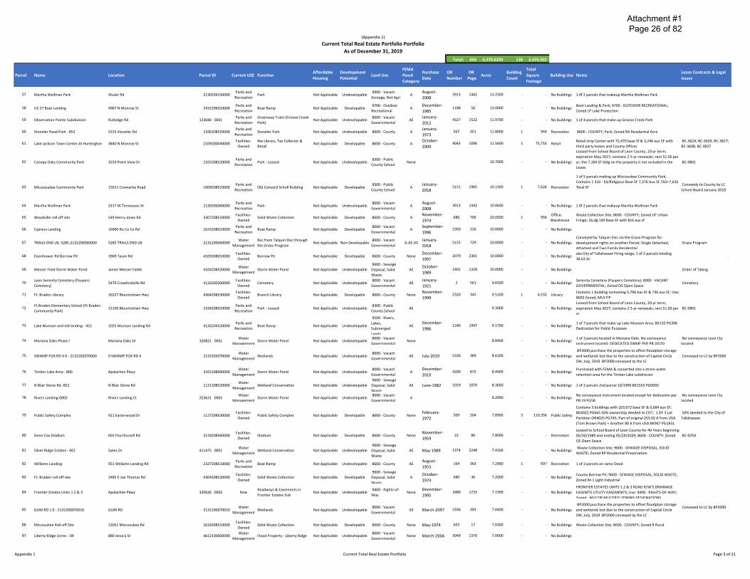
(Appendix 1)
Current Total Real Estate Portfolio Portfolio
As of December 31, 2019
Total: 604 6,370.6200 138 2,434,502
Parcel Name Location
FEMA Total Affordable Development Purchase OR OR Building Lease Contracts & Legal
Parcel ID Current USE Function Land Use Flood Acres Square Building Use Notes Housing Potential Date Number Page Count Issues
Category Footage
Total Real Estate Portfolio
1 US 27 Landfill
2 St Marks Headwaters Greenway
3 Miccosukee Road Greenway Park
4 J. R. Alford Greenway - 1231209010000
5 J. R. Alford Greenway - 1232209020000
6 Tom Brown Park
7550 Apalachee Pkwy
10995 Buck Lake Rd
4996 Crump Road
2500 Pedrick Road
Rutledge Road
501 Easterwood Dr
9600 - Sewage 8 bldgs 12,845 SF & 650 aux SF-Seminole Radio Control Club Facilities- January-
3204208510000 Solid Waste Collection Not Applicable Developable Disposal, Solid AE 875 420 600.6200 8 13,495 Warehouse leases +/- 3.01 acres 5-yr term with an auto 5-yr renewal BC-0426 Owned 1977
Waste expires 2/2019-Apalachee Regional Park 160 Ac
1 of 10 parcels that makeup St Marks Headwaters Parks and St Marks Headwaters October-
1226200100000 Not Applicable Undevelopable 8600 - County A 2745 2336 586.4500 - - No Buildings Greenway/Capitola Area Park; Parcel consoldition reduced # Recreation Greenway/Capitola Area Park 2002
of Parcels to 2 2015-2016
Leased from Board of Trustees of the International
Parks and 8000 - Vacant Improvement Trust Fund - State of Florida (TIITF) Sublessor; 1114209010000 Park - Leased Not Applicable Undevelopable AE 501.9700 - - No Buildings BC-1695
Recreation Governmental Florida Department of Environmental Protection; 50-yr term;
expiration Jan 2049; rent $300.00 Per yr
1 of 3 parcels leased from Board of Trustees of the
International Improvement Trust Fund - State of Florida Parks and 9900 - Vacant
1231209010000 Park - Leased Not Applicable Undevelopable AE 395.5100 - - No Buildings (TIITF) Sublessor; Florida Department of Environmental BC-1968 Recreation Acreage, Not Agri
Protection; 50-yr term; expiration Nov 2050; rent $300.00 Per
yr 1 of 3 parcels leased from Board of Trustees of the
International Improvement Trust Fund - State of Florida Parks and 9900 - Vacant
1232209020000 Park - Leased Not Applicable Undevelopable AE 293.5400 - - No Buildings (TIITF) Sublessor; Florida Department of Environmental BC-1968 Recreation Acreage, Not Agri
Protection; 50-yr term; expiration Nov 2050; rent $300.00 Per
yr
Contains 6 Buildings containing 25,838 base SF & 6,886 aux
SF; Original 255.02 A from USA (Tom Brom Park). BK624 Parks and February-
1127208510000 Tom Brown Park Not Applicable Undevelopable 8600 - County AE 509 204 256.2700 6 32,259 Recreation PG542 COT disclaimed all rights and claims. Corrective Deed Recreation 1972
BK 627 PG543. Another 80 A from USA BK947 PG1831.
7 Upper Lake Lafayette
8 J. R. Alford Greenway - 1230209010000
Barnstaple Rd
Rutledge Road
9500 - Rivers,
Water Lakes, 1126208010000 Wetland Conservation Not Applicable Undevelopable AE March-2006 3474 968 200.0000 - - No Buildings Corrective Deed BK3517 PG511
Management Submerged
Lands 1 of 3 parcels leased from Board of Trustees of the
International Improvement Trust Fund - State of Florida Parks and 9900 - Vacant
1230209010000 Park - Leased Not Applicable Undevelopable AE 198.0800 - - No Buildings (TIITF) Sublessor; Florida Department of Environmental BC-1968 Recreation Acreage, Not Agri
Protection; 50-yr term; expiration Nov 2050; rent $300.00 Per
yr
9 Nusbickel Parcel (Future Park)
10 St Marks Headwaters Greenway
11 Fred George Greenway
CHEVY WAY
655 Baum Rd
3043 Capital Cir Nw
Parks and 9900 - Vacant 1 of 2 parcels Quit Claimed from BP 2000 for future Park & 1229204600000 Future Park & Greenway Not Applicable Undevelopable AE May-2015 4801 1640 173.8600 - - No Buildings Quick Claim from BP 2000
Recreation Acreage, Not Agri Greenway
1 of 10 parcels that makeup St Marks Headwaters Parks and St Marks Headwaters 8000 - Vacant September-
1225200050000 Not Applicable Undevelopable A 3770 1285 168.1300 - - No Buildings Greenway/Capitola Area Park; Parcel consoldition reduced # Recreation Greenway/Capitola Area Park Governmental 2007
of Parcels to 2 2015-2016
Parks and December-2108206020000 Park - Fred George Not Applicable Undevelopable 8600 - County A 4069 1673 156.6200 2 5,669 Recreation 1 of 6 parcels that make up Fred George Park
Recreation 2009
12 Gum Swamp-216
13 Eight Mile Pond Park
F.A. Ash Borrow Pit 14
Borrow Pit
15 North Florida Fairgrounds-853
16 Orchard Pond Pkwy - 2403200180001
17 Lake Munson
18 Celebration Parcel - Future Park
19 Lower Lake Lafayette
Daniel B. Chaires Community Park & 20
Community Center
21 Lake Munson Preserve Park - 852
22 Lake Munson & Flood Plain - 248
23 McCracken Rd-801
Daniel B. Chaires Community Park & 24
Community Center
W Tennessee St
Tomberlin Rd
10600 F A ASH WAY
411 E Paul Russell Rd
760 ORCHARD POND PKY
Jackson Moody Pl
Thomasville Rd & Proctor Rd
Raymond Tucker Rd
Road To The Lake
1306 Jackson Moody Pl
Tom Still Rd
Miccosukee Rd & Mccracken Rd
4768 Chaires Cross Rd
Water 9900 - Vacant February-2129202160000 Wetland Conservation Not Applicable Undevelopable AE 1879 2397 154.6300 - - No Buildings 1 of 11 parcels that make up the Gum Swamp Area
Management Acreage, Not Agri 1996
9500 - Rivers, 1 of 5 parcels totaling 132.08 acres making up Eight Mile Pond
Parks and Lakes, 4611202400000 Park - Eight Mile Pond Not Applicable Undevelopable AE June-2010 4128 2325 116.0600 - - No Buildings Park, renamed Eight Mile Pond Park vs Seven Mile Pond Park
Recreation Submerged at request of Parks & Rec
Lands
Facilities- 9200 - Mining, December- County Barrow Pit; HAMLIN SAND MINE; 9200 - MINING, 3223200060000 Borrow Pit Not Applicable Developable A 1352 95 110.0000 - - No Buildings
Owned Petrolium/Gas 1988 PETROLIUM/GAS; Zoned R Rural
Contains 14 Buildings containing 130,648 base SF & 1,694 aux BC-0251 Leased to North Facilities- Leased to the North Florida Fair
3118208530000 Not Applicable Developable 8600 - County None May-1954 176 65 107.0900 14 132,342 Recreation SF; Use; 8600 Zoned; MULTIP; Under long-term lease to the Florida Fair Assoc Owned Association
North Florida Fair Assoc 9400 - Rights-of- ROW for Orchard Pond Toll Road;Use: 9400 - RIGHTS-OF-
2403200180001 Row ROW for Orchard Pond Pkwy Not Applicable Developable AE April-2016 4917 1115 105.1600 - - No Buildings Way WAY; Zoned R Rural 9500 - Rivers,
Water Lakes, December-4126208510000 Drainage - Lake Munson Not Applicable Undevelopable AE 197 586 105.0000 - - No Buildings 1 of 7 parcels that make up Lake Munson Area
Management Submerged 1964 Lands
Parks and Future Park - Thomasville Rd & 7000 - Vacant October-1412200020000 Not Applicable Undevelopable A 4586 1349 100.0000 - - No Buildings Future Park east side of Thomasville Rd at Proctor Rd
Recreation Proctor Rd Institutional 2013 9500 - Rivers,
Water Lakes, 3206200020000 Wetland Conservation Not Applicable Undevelopable AE March-2003 2850 2113 76.2200 - - No Buildings
Management Submerged
Lands
Parks and 9700 - Outdoor February-1233208510000 Community Center & Park Not Applicable Developable A 838 229 73.9900 - - No Buildings As of 08/2013 includes former Chaires Borrow Pit
Recreation Recreational 1977 8200 - Forest,
Parks and November- 1 of 7 parcels that make up Lake Munson Area; Add'L BK2155 4126208520000 Drainage - Lake Munson Not Applicable Undevelopable Parks, Recreation AE 2323 282 61.8300 - - No Buildings
Recreation 1999 PG267 & Corrective Deed BK4453 PG 608 Area 9500 - Rivers,
1 of 7 parcels that make up Lake Munson Area BK3892 PG645 Water Lakes,
4126202480000 Drainage - Lake Munson Not Applicable Undevelopable AE May-1999 2255 733 60.0000 - - No Buildings Flood Covenant & restrictions; Parcel obtained via Federal Management Submerged
Grant Lands
Water 8000 - Vacant 1535208010000 Wetland Conservation Not Applicable Undevelopable A April-2004 3071 1952 54.6900 - - No Buildings
Management Governmental 1 of 2 parcels that includes the former Chaires Borrow Pit;
Parks and August- Contains 2 Buildings containing 3,074 base SF & 522 aux SF; 1233204280000 Community Center & Park Not Applicable Undevelopable 8600 - County A 2042 1379 50.0000 2 3,596 Recreation
Recreation 1997 Use; 8600 Zoned; MULTIP
25 Hopkins Crossing -01
26 Lake Munson & Flood Plain - 613
Commonwealt Blvd
Dawson Rd
Parks and 8000 - Vacant October-211935 0001 Undeveloped Park Not Applicable Undevelopable A 2428 890 49.3100 - - No Buildings Fee Simple dedication by Hopkins Crossing, Ltd
Recreation Governmental 2000 Water 8000 - Vacant
4123206130000 Drainage - Lake Munson Not Applicable Undevelopable AE May-1999 2255 733 45.8000 - - No Buildings 1 of 7 parcels that make up Lake Munson Area Management Governmental
Appendix 1 Current Total Real Estate Portfolio Page 1 of 21

Attachment #1 Page 25 of 82
(Appendix 1)
Current Total Real Estate Portfolio Portfolio
As of December 31, 2019
Total: 604 6,370.6200 138 2,434,502
Parcel Name Location Parcel ID Current USE Function Affordable
Housing
Development
Potential Land Use
FEMA Purchase
Flood Date
Category
OR
Number
OR Acres
Page
Total Building
Square Count
Footage
Building Use Notes Lease Contracts & Legal
Issues
27 Goose Creek/Alford Alrm Park 6101 Buck Lake Rd 123025 0001 Parks and
Recreation Park - Goose Creek Not Applicable Undevelopable
8000 - Vacant
Governmental AE
August-
2001 2556 1374 45.3100 - - No Buildings 1 of 4 parcels that make up Groose Creek Park
28 Jackson View Park 2585 Clara Kee Blvd 2105200110000 Parks and
Recreation Jackson View Park Not Applicable Undevelopable
8000 - Vacant
Governmental A
January-
2002 2610 451 44.5300 - - No Buildings Use Restrictions BK3839 PG 559 Use Restriction
29 Lake Henrietta / Munson Slough Area -347 Blue Bird Rd Water Lk Henrietta-Munson Slough
4114203470000 Management Drainage
Not Applicable Undevelopable
9600 - Sewage
Disposal, Solid
Waste
AE February-
1999 2220 1482 41.8000 - - No Buildings
Order of Taking - 1 of 20 Parcels that make up Lake Henrietta-Order of Taking
Munson Slough Drainage Area
30 Farms Rd -852 Capitola Rd Water
1319208520000 Wetland Conservation Management
Not Applicable Undevelopable 9900 - Vacant
Acreage, Not Agri A
January-
1999 1467 1602 40.4400 - - No Buildings
31 Gum Swamp-017 Capital Cir Sw Water
2132200170000 Wetland Conservation Management
Not Applicable Undevelopable
9600 - Sewage
Disposal, Solid
Waste
AE October-
1992 1601 765 37.7100 - - No Buildings
1 of 11 parcels that make up the Gum Swamp Area;
Conservation Easement BK1984 PG2268
32 Public Works Center 1800 N Blair Stone Rd 1120208510000 Facilities-
Owned Public Works Center Not Applicable Developable 8600 - County AE June-1968 321 70 32.6900 7
Office-87,845
Warehouse
Parcel contains 7 buildings totaling 50,696 Base SF & 37,149
Aux SF; 8600 - COUNTY; Zoned MULTIP MULTIPLE ZONING
DESIGNATIONS
33 Jail - Health Dept - Sheriff HQ -851 501 Appleyard Dr 2133208510000 Facilities-
Owned
Jail/Health Dept./Mosquito
Control Not Applicable Developable 8600 - County None
January-
1991 1473 491 32.0300 17 500,673
County Jail & Support buildings containing 500,232 base SF &
Public Safety 441 aux SF; 8600 - COUNTY; Zoned MULTIP MULTIPLE
ZONING DESIGNATIONS
34 Public Safety Complex - Retention Pond Easterwood Dr Water
1127208540000 Storm Water Pond Management
Not Applicable Undevelopable 8600 - County AE February-
1972 509 204 29.8900 - - No Buildings
Part of original 255.02 A from USA (Tom Brown Park) +
Another 80 A from USA BK947 PG1831; 1 OF 3 Lot Partition
OR4025 PG745
35 Eisenhower Rd borrow pit Tyson Rd 4109208520000 Facilities-
Owned Borrow Pit Not Applicable Developable
9600 - Sewage
Disposal, Solid
Waste
None December-
1997 2078 2301 28.6300 - - No Buildings
County Barrow Pit; 9600 - SEWAGE DISPOSAL, SOLID WASTE;
Zoned M-1 Light Industrial
36 Broadmoor Pond Park - 4105202440000 4723 JACKSON BLUFF RD 4105202440000 Parks and
Recreation Broadmoor Pond Park Not Applicable Undevelopable
8000 - Vacant
Governmental None June-2019 5329 574 27.1800 - - No Buildings Acquired from BP2000 From BP2000
37 J. Lee Vause park 6024 Old Bainbridge Rd 2429208510000 Parks and
Recreation J. Lee Vause Park Not Applicable Undevelopable 8600 - County A May-1969 364 78 26.7600 2 3,574 Recreation
Parcel 2 BK1072 PG1134 Parcel 3 BK1099 PG1852 Parcel 4
BK1239 PG 2002
38 J. Lewis Hall, Sr. Park 1492 J Lewis Hall Sr Ln 3305208510000 Parks and
Recreation J. Lewis Hall, Sr Park Not Applicable Undevelopable 8600 - County AE March-1992 2302 165 26.6400 1 1,334 Recreation 1 of 2 parcels that make up J Lewis Hall (Woodville) Park
39 Okeeheepkee Prairie Park 1294 Fuller Rd 2111208010000 Parks and
Recreation Okeeheepkee Prairie Park Not Applicable Undevelopable 8600 - County A April-1999 2248 1199 26.1700 - - No Buildings Parcel 2 BK2248 PG1201
40 Lake Henrietta Area -203 N Ridge Rd Water Lk Henrietta-Munson Slough
4114202030000 Management Drainage
Not Applicable Undevelopable
9600 - Sewage
Disposal, Solid
Waste
AE November-
1996 1966 1151 23.7800 - - No Buildings
1 of 21 Parcels that make up Lake Henrietta-Munson Slough
Drainage Area
41 Sunflower Rd - 4613208010000 Sunflower Rd 4613208010000 Row ROW Not Applicable Undevelopable 9400 - Rights-of-
Way A June-1981 1003 1714 22.6300 - - No Buildings
Reversion Clause if not used for road, drainage or utility; Use:
9400 - RIGHTS-OF-WAY; Zoned: UF Urban Fringe Reversion Clause in Deed
42 Gum Swamp-852 Capital Cir Sw Water
2132208520000 Wetland Conservation Management
Not Applicable Undevelopable 8000 - Vacant
Governmental AE April-1990 1453 360 21.3300 - - No Buildings 1 of 11 parcels that make up the Gum Swamp Area
43 Council Estates Orange Ave E 411203 A0020 Water
Storm Water Pond Management
Not Applicable Undevelopable
9600 - Sewage
Disposal, Solid
Waste
AE August-
2001 2543 2033 20.2700 - - No Buildings
Contains 1 Building containing 13,419 base SF & 1,460 aux SF
44 Pedrick Pond-008 1583 Pedrick Rd 1124200080000 Parks and
Recreation Pedrick Pond Park Not Applicable Undevelopable 8600 - County A April-2000 2522 1714 19.3300 1 14,879 Library
used as a library; 1 of 3 Parcels that make up Pedrick Pond
Park & Eastside Library; Use: 8600 Zoned: RP
Contains 1 building with 38,820 base SF; Part of original BK552 PG369 99-yr Lease to
45 National Guard Armory 1225 Easterwood Dr 1127209020000 Facilities-
Owned
Land Lease-Armory Board Of
The State Of Florida Not Applicable Developable 8100 - Military None
February-
1972 509 204 19.1800 1 38,820 Warehouse
255.02 A from USA (Tom Brown Park) + Another 80 A from
USA BK947 PG1831; 8100 - MILITARY; Zoned M-1 Light
Armory Board of the State of
Florida commencing on
Industrial 06/13/1972
46 Lake Henrietta -802 3305 Springhill Rd Water Lk Henrietta-Munson Slough
4114208020000 Management Drainage
Not Applicable Undevelopable
9600 - Sewage
Disposal, Solid
Waste
AE July-1998 2152 853 18.1500 - - No Buildings 1 of 21 Parcels that make up Lake Henrietta-Munson Slough
Drainage Area
47 Orchard Pond Greenway Orchard Pond Rd 2403200180002 Parks and
Recreation Greenway Park Not Applicable Undevelopable
9400 - Rights-of-
Way X5 April-2016 4917 1154 17.7400 - - No Buildings
Original Orchard Pond Rd ROW deeded to County after the
Orchard Pond Parkway was complete & open
Former Orchard Pond Rd
ROW donated for Greenway
48 Lake Henrietta/Young Unrec Sprinil Rd Water Lk Henrietta-Munson Slough
4114050000080 Management Drainage
Not Applicable Undevelopable
9600 - Sewage
Disposal, Solid
Waste
AE July-1998 2136 72 17.3600 - - No Buildings 1 of 21 Parcels that make up Lake Henrietta-Munson Slough
Drainage Area
49 John Hancock Dr & Timberlane Rd -
2122000050000 JOHN HANCOCK DR
Water 2112200050000 Wetland Preservation
Management Not Applicable Undevelopable
9600 - Sewage
Disposal, Solid
Waste
A July-2015 4829 234 17.2900 - - No Buildings Quit Claim Dee
50 Lake Henrietta / Munson Slough Area -401 Capital Cir Sw Water Lk Henrietta-Munson Slough
4115204010000 Management Drainage
Not Applicable Undevelopable
9600 - Sewage
Disposal, Solid
Waste
AE July-1998 2146 2185 15.3200 - - No Buildings 1 of 21 Parcels that make up Lake Henrietta-Munson Slough
Drainage Area
51 Gum Road Transfer Station -611 4900 Gum Rd 2129206110000 Facilities-
Owned Solid Waste Collection Not Applicable Developable 8600 - County AE March-2000 2360 2002 15.0500 4 30,849 Warehouse
1 of 2 parcels that make up Gunm Rd Transfer Station
containing 4 buildings containing 29,856 base SF & 993 aux
SF; 8600 - COUNTY; Zoned M-1 Light Industrial
52 GUM RD 2 - 2131208010000 GUM RD Water
2131208010000 Wetlands Management
Not Applicable Undevelopable
9600 - Sewage
Disposal, Solid
Waste
X5 July-2019 5336 386 13.8000 - - No Buildings
BP2000 purchase the properties to offset floodplain storage
and wetlands lost due to the construction of Capital Circle
SW; July, 2019 BP2000 conveyed tp the LC
Conveyed to LC by BP2000
53 Bannerman Corner Lauder Dr Water
1422220000080 Storm Water Pond Management
Not Applicable Undevelopable
9600 - Sewage
Disposal, Solid
Waste
None February-
1998 2098 1081 13.6900 - - No Buildings
54 Linene Woods Subdivision ROW Dartmoor Dr 211207 0001 Row Roadways & Easements in
Linene Woods Subdivision Not Applicable Undevelopable
8000 - Vacant
Governmental A July-2009 4013 20 13.5000 - - No Buildings
ROADWAYS & RIGHT OF WAYS OF SUBDIVISION; Use: 8000 -
VACANT GOVERNMENTAL; Zoned: LP Lake Protection
55 Thomasville Rd - 1414208530000 Thomasville Rd Water
1414208530000 Storm Water Pond Management
Not Applicable Undevelopable
9600 - Sewage
Disposal, Solid
Waste
A June-2008 3905 1407 13.3300 - - No Buildings
56 Bannerman Rd, 3434 - 142229 A0050 3434 Bannerman Rd 142229 A0050 Water
Storm Water Pond Management
Not Applicable Undevelopable
9600 - Sewage
Disposal, Solid
Waste
A September-
2015 4847 1605 13.2600 - - No Buildings
Part of 3 parcels resulting from a land exchange between
County and Summit Holdings for the old Bradfordvile
Community Center location
Land exchange between
County & Summit Holdings;
Appendix 1 Current Total Real Estate Portfolio Page 2 of 21
Attachment #1 Page 26 of 82
(Appendix 1)
Current Total Real Estate Portfolio Portfolio
As of December 31, 2019
Total: 604 6,370.6200 138 2,434,502
Parcel Name Location Parcel ID Current USE Function Affordable
Housing
Development
Potential Land Use
FEMA Purchase
Flood Date
Category
OR
Number
OR Acres
Page
Total Building
Square Count
Footage
Building Use Notes Lease Contracts & Legal
Issues
57 Martha Wellman Park Shuler Rd 2130204150000 Parks and
Recreation Park Not Applicable Undevelopable
9900 - Vacant
Acreage, Not Agri A
August-
2008 3913 1442 13.2500 - - No Buildings 1 0f 2 parcels that makeup Martha Wellman Park
58 US 27 Boat Landing 4967 N Monroe St 2432206010000 Parks and
Recreation Boat Ramp Not Applicable Developable
9700 - Outdoor
Recreational A
December-
1985 1188 56 13.0000 - - No Buildings
Boat Landing & Park; 9700 - OUTDOOR RECREATIONAL;
Zoned LP Lake Protection
59 Observation Pointe Subdivision Rutledge Rd 123040 0001 Parks and
Recreation
Greenway Trails (Groose Creek
Park) Not Applicable Undevelopable
8000 - Vacant
Governmental AE
January-
2012 4327 1522 11.9700 - - No Buildings 1 of 4 parcels that make up Groose Creek Park
60 Stoneler Road Park - 852 5225 Stoneler Rd 2106208520000 Parks and
Recreation Stoneler Park Not Applicable Undevelopable 8600 - County A
January-
1973 567 351 11.8000 1 944 Recreation 8600 - COUNTY; Park; Zoned RA Residential Acre
61 Lake Jackson Town Center At Huntington 3840 N Monroe St 2109200040000 Facilities-
Owned
Nw Library, Tax Collector &
Retail Not Applicable Developable 8600 - County A
October-
2009 4043 1096 11.5600 1 75,716 Retail
Retail strip Center with 72,470 base Sf & 3,246 aux SF with
third party leases and County Offices
BC-3624; BC-3629; BC-3817;
BC-3608; BC-3837 Leased from School Board of Leon County, 20-yr term;
62 Canopy Oaks Community Park 3250 Point View Dr 2105208520000 Parks and
Recreation Park - Leased Not Applicable Undevelopable
8300 - Public
County School None 10.7000 - - No Buildings
expiration May 2027; contains 2 5-yr renewals; rent $1.00 per
yr; the 7,184 SF bldg on the property is not included in the BC-0801
Lease.
1 of 5 parcels making up Miccosukee Community Park;
63 Miccossukee Community Park 15011 Cromartie Road 1609208510000 Parks and
Recreation Old Concord Scholl Building Not Applicable Developable
8300 - Public
County School A
January-
2018 5151 1905 10.1300 1 7,626 Recreation
Contains 1 310 - Ed/Religious Base SF 7,376 Aux SF 250=7,626 Conveedy to County by LC
Total SF School Board January 2018
64 Martha Wellman Park 5317 W Tennessee St 2130200060000 Parks and
Recreation Park Not Applicable Undevelopable
8000 - Vacant
Governmental A
August-
2008 3913 1442 10.0600 - - No Buildings 1 0f 2 parcels that makeup Martha Wellman Park
65 Woodville roll-off site 549 Henry Jones Rd 3307208510000 Facilities-
Owned Solid Waste Collection Not Applicable Developable 8600 - County A
November-
1974 686 706 10.0500 1
Office-956
Warehouse
Waste Collection Site; 8600 - COUNTY; Zoned UF Urban
Fringe; 1b;dg 140 Base SF with 816 aux sf
66 Cypress Landing 16900 Ro Co Co Rd 1623208010000 Parks and
Recreation Boat Ramp Not Applicable Developable
8000 - Vacant
Governmental A
September-
1996 1950 226 10.0000 - - No Buildings
67 TRAILS END LN, 5285-2131200060000 5285 TRAILS END LN Water Rec from Talquin Elec through
2131200060000 Management the Grace Program
8000 - Vacant Not Applicable Non-Developable
Governmental A-AE-X5
January-
2018 5155 729 10.0000 - - No Buildings
Conveyed by Talquin Elec via the Grace Program for
development rights on another Parcel; Single Detached,
Attached and Two Family Residential
Grace Program
68 Eisenhower Rd Borrow Pit 3969 Tyson Rd 4109208010000 Facilities-
Owned Borrow Pit Not Applicable Developable 8600 - County None
December-
1997 2079 2301 10.0000 - - No Buildings
aka City of Tallahassee Firing range; 1 of 2 parcels totaling
38.63 Ac -
69 Messer Field Storm Water Pond James Messer Fields Water
4104208520000 Storm Water Pond Management
Not Applicable Undevelopable
9600 - Sewage
Disposal, Solid
Waste
AE October-
1989 1401 1328 10.0000 - - No Buildings Order of Taking
70 Leon Serenity Cemetery (Paupers
Cemetery) 5479 Crawfordville Rd 4126200200000
Facilities-
Owned Cemetery Not Applicable Undevelopable
8000 - Vacant
Governmental AE
January-
1921 2 561 9.6500 - - No Buildings
Serenity Cemetery (Paupers Cemetery); 8000 - VACANT
GOVERNMENTAL; Zoned OS Open Space Cemetery
71 Ft. Braden Library 16327 Blountstown Hwy 4304208530000 Facilities-
Owned Branch Library Not Applicable Developable 8600 - County None
November-
1999 2320 345 9.5100 1 6,532 Library
Contains 1 building containing 5,796 bas SF & 736 aux SF; Use;
8600 Zoned; MULTIP
72 Ft Braden Elementary School (Ft Braden
Community Park) 15100 Blountstown Hwy 2334208010000
Parks and
Recreation Park - Leased Not Applicable Undevelopable
8300 - Public
County School AE 9.3000 - - No Buildings
Leased from School Board of Leon County, 20-yr term;
expiration May 2027; contains 2 5-yr renewals; rent $1.00 per BC-0801
yr 9500 - Rivers,
73 Lake Munson and old landing - 452 1025 Munson Landing Rd 4126204520000 Parks and
Recreation Boat Ramp Not Applicable Undevelopable
Lakes,
Submerged AE
December-
1986 1240 1997 9.1700 - - No Buildings
1 of 7 parcels that make up Lake Munson Area; BK120 PG396
Dedication for Public Purposes
Lands
74 Mariana Oaks Phase I Mariana Oaks Dr 320821 0001 Water
Storm Water Pond Management
Not Applicable Undevelopable 8000 - Vacant
Governmental None 8.8400 - - No Buildings
1 of 3 parcels located in Mariana Oaks. No conveyance
instrument located; DEDICATED SWMF PER PB 20/20
No conveyance Leon Cty
located
75 SWAMP FOX RD 4 0 - 2132202070000 0 SWAMP FOX RD 4 Water
2132202070000 Wetlands Management
Not Applicable Undevelopable 8000 - Vacant
Governmental AE July-2019 5336 389 8.6100 - - No Buildings
BP2000 purchase the properties to offset floodplain storage
and wetlands lost due to the construction of Capital Circle
SW; July, 2019 BP2000 conveyed tp the LC
Conveyed to LC by BP2000
76 Timber Lake Area - 800 Apalachee Pkwy Water
3101208000000 Storm Water Pond Management
Not Applicable Undevelopable 8000 - Vacant
Governmental A
December-
2010 4200 875 8.4000 - - No Buildings
Purchased with FEMA & converted into a strom water
retention area for the Timber Lake subdivision
77 N Blair Stone Rd -852 N Blair Stone Rd Water
1121208520000 Wetland Conservation Management
Not Applicable Undevelopable
9600 - Sewage
Disposal, Solid
Waste
AE June-1982 1029 1070 8.3600 - - No Buildings 1 of 2 parcels 2nd parcel 10/1990 BK1555 PG0093
78 Rivers Landing-0002 Rivers Landing Ct 253621 0002 Water
Storm Water Pond Management
Not Applicable Undevelopable 8000 - Vacant
Governmental A 8.2900 - - No Buildings
No conveyance instrument located except for dedication per
PB 19 PG58
No conveyance Leon Cty
located
Contains 3 buildings with 103,672 base SF & 6,684 aux SF;
79 Public Safety Complex 911 Easterwood Dr 1127208530000 Facilities-
Owned Public Safety Complex Not Applicable Developable 8600 - County None
February-
1972 509 204 7.8900 3 110,356
BK4022 PG665 50% ownership deeded to COT; 1 OF 3 Lot Public Safety
Partition OR4025 PG745; Part of original 255.02 A from USA
50% deeded to the City of
Tallahassee
(Tom Brown Park) + Another 80 A from USA BK947 PG1831.
80 Gene Cox Stadium 601 Paul Russell Rd 3118208560000 Facilities-
Owned Stadium Not Applicable Developable 8600 - County None
November-
1959 22 86 7.8000 - - Recreation
Leased to School Board of Leon County for 40-Years beginning
05/30/1989 and ending 05/29/2029; 8600 - COUNTY: Zoned BC-0254
OS Open Space
81 Silver Ridge Estates - 001 Sykes Dr 411475 0001 Water
Wetland Conservation Management
Not Applicable Undevelopable
9600 - Sewage
Disposal, Solid
Waste
AE May-1989 1374 2248 7.4100 - - No Buildings Waste Collection Site; 9600 - SEWAGE DISPOSAL, SOLID
WASTE; Zoned RP Residential Preservation
82 Williams Landing 951 Williams Landing Rd 2327208510000 Parks and
Recreation Boat Ramp Not Applicable Undevelopable 8600 - County AE
August-
1953 164 363 7.2900 1 697 Recreation 1 of 3 parcels on same Deed
83 Ft. Braden roll-off site 2485 E Joe Thomas Rd 4304208520000 Facilities-
Owned Solid Waste Collection Not Applicable Developable
9600 - Sewage
Disposal, Solid
Waste
A October-
1974 680 36 7.2000 - - No Buildings
County Barrow Pit; 9600 - SEWAGE DISPOSAL, SOLID WASTE;
Zoned M-1 Light Industrial
84 Frontier Estates Units 1 2 & 3 Apalachee Pkwy 320626 0002 Row Roadways & Easements in
Frontier Estates Sub Not Applicable Undevelopable
9400 - Rights-of-
Way None
December-
1995 1880 1732 7.1300 - - No Buildings
FRONTIER ESTATES UNITS 1 2 & 3 ROAD R/W'S DRAINAGE
EASEMTS UTILITY EASEMENTS; Use: 9400 - RIGHTS-OF-WAY;
Zoned: MULTIP MULTIPLE ZONING DESIGNATIONS
85 GUM RD 1 0 - 2131200070010 GUM RD Water
2131200070010 Wetlands Management
Not Applicable Undevelopable 8000 - Vacant
Governmental X5 March-2097 5336 393 7.0400 - - No Buildings
BP2000 purchase the properties to offset floodplain storage
and wetlands lost due to the construction of Capital Circle
SW; July, 2019 BP2000 conveyed tp the LC
Conveyed to LC by BP2000
86 Miccosukee Roll-off Site 13051 Miccosukee Rd 1618208510000 Facilities-
Owned Solid Waste Collection Not Applicable Developable 8600 - County None May-1974 655 17 7.0300 - - No Buildings Waste Collection Site; 8600 - COUNTY; Zoned R Rural
87 Liberty Ridge Unrec - 09 880 Jessica St Water
4612100000090 Flood Property - Liberty Ridge Management
Not Applicable Undevelopable 8000 - Vacant
Governmental None March-2004 3049 1370 7.0000 - - No Buildings
Appendix 1 Current Total Real Estate Portfolio Page 3 of 21

Attachment #1 Page 27 of 82
(Appendix 1)
Current Total Real Estate Portfolio Portfolio
As of December 31, 2019
Total: 604 6,370.6200 138 2,434,502
Parcel Name Location Parcel ID Current USE Function Affordable
Housing
Development
Potential Land Use
FEMA Purchase
Flood Date
Category
OR
Number
OR Acres
Page
Total Building
Square Count
Footage
Building Use Notes Lease Contracts & Legal
Issues
88 Lk Henrietta-Munson Slough Drainage Springhill Rd Water
4114208520000 Munson Slough Drainage Area Management
Not Applicable Undevelopable
9600 - Sewage
Disposal, Solid
Waste
AE May-1976 792 404 6.9800 - - No Buildings 1 of 21 Parcels that make up Lake Henrietta-Munson Slough
Drainage Area
89 Yorktown Pond Lakeshore Dr Water
2112208530000 Storm Water Pond Management
Not Applicable Undevelopable
9600 - Sewage
Disposal, Solid
Waste
A November-
1993 1702 1203 6.4200 - - No Buildings
90 Jordans Pass Jordans Pass Dr 223622 0001 Water
Storm Water Management Management
Not Applicable Undevelopable 8000 - Vacant
Governmental A 6.2100 - - No Buildings
No conveyance instrument located except for dedication per
PB 19 PG69
No conveyance Leon Cty
located
91 Lake Lafayette & Flood Plain -202 Road To The Lake Water
3204202020000 Flood Property - Lake Lafayette Management
Not Applicable Undevelopable 8000 - Vacant
Governmental AE March-2004 3066 920 6.0600 - - No Buildings
92 Liberty Ridge Unrec - 60 663 Nocatee Rd Water
4612100000600 Flood Property - Liberty Ridge Management
Not Applicable Undevelopable 8000 - Vacant
Governmental A
November-
1997 2068 760 6.0000 - - No Buildings
93 Kate Ireland Park 12271 Iamonia Landing Rd 1723208010000 Parks and
Recreation Kate Ireland Park Not Applicable Undevelopable 8600 - County A April-1997 2006 1047 5.9800 - - No Buildings 8000 - VACANT GOVERNMENTAL; Park; Zoned R Rural
94 Cascade Lake Capital Cir Sw Water
4105208020000 Wetland Conservation Management
Not Applicable Undevelopable 8000 - Vacant
Governmental AE
January-
2004 1347 782 5.9600 - - No Buildings
95 Old Magnolia Old Magnolia Rd Water
1634208020000 Wetland Conservation Management
Not Applicable Undevelopable
9600 - Sewage
Disposal, Solid
Waste
A April-1998 2141 1665 5.8900 - - No Buildings
96 Sierra Woods Sierra Woods Dr 321631 0002 Water
Storm Water Management Management
Not Applicable Undevelopable 8000 - Vacant
Governmental A 5.6300 - - No Buildings
No conveyance instrument located except for Drainage
Easement dated 11/2005 OR3413 PG1060 for different
portion of Sierra Woods
No conveyance Leon Cty
located
97 Woodville Community Center 8000 Old Woodville Rd 3308208020000 Parks and
Recreation Community Center & Library Not Applicable Developable 8600 - County None
August-
2005 3354 1659 5.5400 1 8,820 Library
1 of 2 Parcels containing 1 building with 8,143 base SF & 677
aux SF combining the Woodvile Branch Library & Community
Center; 8600 - COUNTY; Zoned R Rural
98 Blount Roll-off -851 4363 Holder Ln 4415208510000 Facilities-
Owned Solid Waste Collection Not Applicable Developable
9600 - Sewage
Disposal, Solid
Waste
None November-
1961 21 430 5.5000 - - No Buildings
99 Supervisor of Elections Ops Center 2990 APALACHEE PKWY 3104200040000 Facilities-
Leased
Offices & Warehouse-
Supervisor of Elections Not Applicable Undevelopable
1100 - Stores,
One Story None 5.4100 1
Office-45,286
Warehouse
Lease 45,286 SF of s 60,000 SF retail bldg for Voter Operations
Center & Warehouse -
100 Tower Road Park 5971 Tower Rd 2431208510000 Parks and
Recreation Tower Road Park Not Applicable Undevelopable 8600 - County A
August-
1986 1224 1718 5.3500 1 1,222 Recreation
8600 - COUNTY; Park; Zoned R-3 Single Detached, Attached
and Two Family Residential
101 Eight Mile Pond Park Avalon Dr 4611030000200 Parks and
Recreation Park - Eight Mile Pond Not Applicable Undevelopable
8000 - Vacant
Governmental AE June-2010 4128 2325 5.1300 - - No Buildings
1 of 5 parcels totaling 132.08 acres making up Eight Mile Pond
Park, renamed Eight Mile Pond Park vs Seven Mile Pond Park
at request of Parks & Rec
102 Juvenile Detention Center 2303 Ronellis Dr 4109208530000 Facilities-
Owned Juvenile Corrections Not Applicable Developable 8600 - County None
February-
1991 1484 905 5.0000 1 24,065
Land Lease to Florida Department of Health & Rehabilitative
Public Safety Services; 50-yr term; expiration date June 9, 2043; 8600 -
COUNTY; Zoned M-1 Light Industrial
BC-0059 Florida Department
of Health & Rehabilitative
Services
103 Tallahassee Developmental Center 455 Appleyard Dr 212851 D0002 Facilities-
Owned
Leased to Pensacola Care under Not Applicable
25-yr Capital Lease Developable 8600 - County A
February-
1989 1360 1201 5.0000 5 30,933 Medical
Contains 5 buildings containing 28,413 base SF & 2,520 aux BC-3939 & BC-3651
SF; Leased for 25-yrs as a Capital Lease to Pensacola Care, Inc Pensacola Care, Inc
term June 30, 2036
104 Coe Landing - 2325208510000 1208 Coe Landing Rd 2325208510000 Parks and
Recreation Coe Landing Park Not Applicable Undevelopable 8600 - County AE
August-
1953 164 363 4.9500 1 866 Recreation
1 0f 5 parcels totaling 9.979 acres that makeup Coe Landing
Park Deed Book
105 Eight Mile Pond Park Avalon Ct 4611030000220 Parks and
Recreation Park - Eight Mile Pond Not Applicable Undevelopable
8000 - Vacant
Governmental AE June-2010 4128 2325 4.8100 - - No Buildings
1 of 5 parcels totaling 132.08 acres making up Eight Mile Pond
Park, renamed Eight Mile Pond Park vs Seven Mile Pond Park
at request of Parks & Rec
106 Bradfordville Rd-801 Bradfordville Rd Water
1422208010000 Storm Water Pond Management
Not Applicable Undevelopable
9600 - Sewage
Disposal, Solid
Waste
A September-
2003 2961 2024 4.6800 - - No Buildings Quit Claim from State of Florida
107 MALLARD HILL LN - 151615 A0070 MALLARD HILL LN 151615 A0070 Water
Wetlands preservation Management
Not Applicable Undevelopable 8000 - Vacant
Governmental A
January-
2016 4890 568 4.6700 - - No Buildings Acquired by development wxchange on another Parcel
Acquired through the
Flooded Prop acq & Mgmt
Program
108 LAKE HALL RD, - 143310 0001 LAKE HALL RD, 143310 0001 Row .05 mile Row for Lake Hall RD Not Applicable Undevelopable 9400 - Rights-of-
Way None
November-
1983 1097 2356 4.6700 - - No Buildings
Poertion of the ROW for Lake Hall Rd in NE Leon County .28
Miles west of Thomasville Rd & .81 Miles south of Kerry
ForestPkwy
Property Exchange
109 Oak Grove Plantation-0001 Oak Grove Plantation Rd 140725 0001 Water
Storm Water Pond Management
Not Applicable Undevelopable
9500 - Rivers,
Lakes,
Submerged
Lands
None 4.6300 - - No Buildings
No conveyance instrument located appears to be part of
Conservation Easement dated 09/2002 recorded in OR2757
PG264
No conveyance Leon Cty
located
110 NE Branch Library 5513 Thomasville Rd 1427202080000 Facilities-
Owned Branch Library Not Applicable Developable 8600 - County None
October-
1997 2056 762 4.5400 1 19,802 Library
Contains 1 building containing 18,300 base SF & 1,502 aux SF;
Use: 8600 Zoned: MULTIP
111 Facilities Managerment 1907 S Monroe St 4101208510000 Facilities-
Owned Offices & Warehouse Not Applicable Developable 8600 - County None April-1968 316 324 4.5400 2
Office-20,188
Warehouse
Building count from Prop App site is 0-parcel actually Contains
2 building containing 20,391 SF
112 Eight Mile Pond Park Avalon Dr 4611030000210 Parks and
Recreation Park - Eight Mile Pond Not Applicable Undevelopable
8000 - Vacant
Governmental AE June-2010 4128 2325 4.3900 - - No Buildings
1 of 5 parcels totaling 132.08 acres making up Eight Mile Pond
Park, renamed Eight Mile Pond Park vs Seven Mile Pond Park
at request of Parks & Rec
113 AH - Rhodes Cemetery Rd 1905-
3308200030000-3058 of 2007 1905 Rhodes Cemetery Road 3308200030000 Tax Deeds
AH - 06/2016 - Escheated TD for
unpaid Taxes
Affordable
Housing Developable
8000 - Vacant
Governmental A
December-
2014 4741 2388 4.3400 - - No Buildings Escheated to County due too delinquent taxes - Zoned: Rural Escheated Tax Deed
Building count from Prop App Site is 0; contains 1 building
114 Ft Braden Community Center 16387 Blountstown Hwy 4304208510000 Parks and
Recreation Community Center - Leased Not Applicable Undevelopable
8000 - Vacant
Governmental A 4.2500 1 10,072 Recreation
containing as est 10,072 SF - Leased from School Board of BC-0801
Leon County, 20-yr term; expiration May 2027; contains 2 5-yr
renewals; rent $1.00 per yr
115 Agricultural Center 615 Paul Russell Rd 3118208570000 Facilities-
Owned Offices Not Applicable Developable 8600 - County None June-1962 51 235 4.1300 1 13,289 Office
Contains 1 building containing 13,289 SF; Use; 8600 Zoned;
OR-2
116 Dresonia Dr Parcel - 217 Tower Rd Water
2431202170000 Flood Property Management
Not Applicable Undevelopable 8000 - Vacant
Governmental A
August-
1998 2164 507 3.9500 - - No Buildings
117 Lakeshore Dr at Meginnis Arm Rd 3000 Lakeshore Dr Water
2114200100000 Storm Water Pond Management
Not Applicable Undevelopable
9600 - Sewage
Disposal, Solid
Waste
A November-
1995 1856 1393 3.8300 - - No Buildings
118 B.L. Perry Library 2817 S Adams St 4112208050000 Facilities-
Owned Branch Library Not Applicable Developable 8600 - County X5
October-
1996 1978 1244 3.7900 1 13,684 Library
11/06/2014 OR 4732 PG 720 B. L. Perry Library site, 1 building containing 12,350 base SF &
.90 Ac parcel donated to 1,334 aux SF; Use: 8600 Zoned; MULTIP
County
119 Fred George Park/Wildwood-A08 Knollwood Dr 210515 A0080 Parks and
Recreation Park - Fred George Not Applicable Undevelopable
8000 - Vacant
Governmental A July-2009 4012 1030 3.7800 - - No Buildings 1 of 6 parcels that make up Fred George Park
120 Liberty Ridge Unrec - D00 694 Spiral Garden Way 461210 D0000 Water
Flood Property - Killearn Lakes Management
Not Applicable Undevelopable 8000 - Vacant
Governmental A
August-
1998 2158 506 3.7800 - - No Buildings
Appendix 1 Current Total Real Estate Portfolio Page 4 of 21

Attachment #1 Page 28 of 82
(Appendix 1)
Current Total Real Estate Portfolio Portfolio
As of December 31, 2019
Total: 604 6,370.6200 138 2,434,502
Parcel Name Location Parcel ID Current USE Function Affordable
Housing
Development
Potential Land Use
FEMA Purchase
Flood Date
Category
OR
Number
OR Acres
Page
Total Building
Square Count
Footage
Building Use Notes Lease Contracts & Legal
Issues
121 Gum Road Transfer Station -205 4858 Gum Rd 2132202050000 Facilities-
Owned Solid Waste Collection Not Applicable Developable
8000 - Vacant
Governmental AE March-2000 2360 2002 3.7000 - - No Buildings 1 of 2 parcels that make up Gunm Rd Transfer Station
122 American Red Cross 1115 Easterwood Dr 1127208520000 Facilities-
Owned
Land Lease to American Red
Cross Not Applicable Developable 8600 - County None
February-
1972 509 204 3.6500 1 21,345 Office
Contains 1 building containing 20,378 base SF & 1,261 aux SF;
Land Lease to The American National Red Cross; 90-yr term;
expiration date September 30, 2098;
BC-3320 American Red Cross
123 Highgrove-801 Forsythe Way Water
1433208010000 Storm Water Pond Management
Not Applicable Undevelopable
9600 - Sewage
Disposal, Solid
Waste
A September-
2003 2961 2002 3.5600 - - No Buildings
124 Liberty Ridge Unrec - 08 904 Jessica St Water
4612100000080 Flood Property - Liberty Ridge Management
Not Applicable Undevelopable 8000 - Vacant
Governmental A
February-
1999 2215 2034 3.5000 - - No Buildings
125 COE LANDING RD - 2325150000010 COE LANDING RD 2325150000010 Parks and
Recreation Coe Landing Park Not Applicable Undevelopable
0100 - Single
Family
Residential
AE November-
2018 5255 889 3.4900 1 768 Recreation
1 0f 5 parcels totaling 9.979 acres that makeup Coe Landing
Park 3 parcels on same deed
126 Lakeshore Estates -003 Timberlane Rd 211250 0003 Water
Storm Water Pond Management
Not Applicable Undevelopable
9600 - Sewage
Disposal, Solid
Waste
A 3.4000 - - No Buildings No conveyance instrument located No conveyance Leon Cty
located
127 Liberty Ridge Phase II Unrec -76 Flicker Rd Water
4611100000760 Flood Property - Liberty Ridge Management
Not Applicable Undevelopable 8000 - Vacant
Governmental A
December-
2003 3022 935 3.3400 - - No Buildings
128 RO CO CO RD, -1626202110000-2356 of
2010 RO CO CO RD 1626202110000 Tax Deeds
Escheated for unpaid Property
Taxes Not Applicable Developable
0000 - Vacant
Residential A
January-
2018 5154 2316 3.3300 - - No Buildings
01/28/2018 Parcel escheated to the County, Tax Deed BK
5154 PG 2316; No apparent access to County Rd
Escheated Tax Deed related
to Tax Cert 2356 of 2010
129 Miccosukee Community-208 Veterans Memorial Dr 1609202080000 Parks and
Recreation Miccosukee Community Not Applicable Undevelopable
8000 - Vacant
Governmental None
October-
2006 3597 1139 3.3000 - - No Buildings
1 of 5 parcels making up Miccosukee Community Center &
Park
130 Public Health Unit 1515 Old Bainbridge Rd 2126200140000 Facilities-
Owned Public Health Not Applicable Developable 8600 - County A June-1991 1499 720 3.2100 1 19,406 Medical
Contains 1 building containing 18,201 & 1,206 aux SF Sq Ft ;
Use: 8600 - COUNTY: Zoned RP-2 Residential Preservation-2
131 Edinbourgh Estates-01 4470 Sherborne Rd 210540 A0010 Water
Flood Property - Robinson Rd Management
Not Applicable Undevelopable 8000 - Vacant
Governmental A
October-
1997 2061 49 3.1800 - - No Buildings
132 Wakulla Springs Road Unrec-17 8617 Moore Woods Rd Water Flood Property - Wakulla
4610180000170 Management Springs Rd
Not Applicable Undevelopable 8000 - Vacant
Governmental None
November-
1997 2068 515 3.1600 - - No Buildings
133 RUSSELLS POND LN, - 2431200320000 -
4563 of 2009 RUSSELLS POND LN
Water 2431200320000 Storm Water Pond
Management Not Applicable Developable
0000 - Vacant
Residential A
October-
2017 5122 1552 3.1600 - - No Buildings
Surrounding land of retentions ponds of Russels Ponds Sub;
Escheated to County due too delinquect Taxes; 0000 -
VACANT Residential; Zoned: RP - Residential Preservation;
Escheated Tax Deed related
to Tax Cert 4363 of 2009
134 Woodville Community Center (South) Old Woodville Rd 3308200250000 Parks and
Recreation Park Not Applicable Developable
8000 - Vacant
Governmental A March-2009 3967 133 3.0800 - - No Buildings 1 of 2 parcels making up Woodville Community Center
135 CAPITOLA RD, 10586-1235204240000-1080
10586 CAPITOLA RD of 2009
1235204240000 Tax Deeds Escheated for unpaid Property
Taxes
Pending
Affordable
Housing
Developable 0000 - Vacant
Residential A
August-
2019 5358 36 3.0600 - - No Buildings
Escheated to County due too delinquent Taxes; 0000 -
VACANT RESIDENTIAL; R - Rural; 0 Structures; Base SF: 0,
Auxiliary SF: 0, Total SF: 0
Escheated Tax Deed related
to Tax Cert 1080 of 2009
136 FOOTMAN LN, 851-1225204150000-628 of
851 FOOTMAN LN 2007
1225204150000 Tax Deeds AH - 06/2018 - Escheated for
unpaid Property Taxes
Affordable
Housing Developable
0200 - Mobile
Homes None
September-
2017 5113 1051 3.0100 1
Escheated to County due too delinquect Taxes; 0200 -854 Mobile Home MOBILE HOMES; Zoned R - Rural: contains 1 Mobile Home
containing 854 base SF & 0 aux SF
Escheated Tax Deed related
to Tax Cert 628 of 2007
137 Renaissance Center 435 N Macomb St 2136500135300 Facilities-
Owned Office Building Not Applicable Developable 8900 - Municipal None March-2006 3481 506 3.0000 2 148,032 Office
Building count Prop App site is 2 - 107,488 base SF & 1,664
aux SF building & parking deck, Undivided 1/3rd interest
(33.4%) deeded to Leon County by COT 03/2006
Undivided 1/3rd interest
(33.4%) deeded to Leon
County by COT 03/2006
138 Avalon Dr -09 8350 Avalon Dr Water
4611030000090 Flood Property Management
Not Applicable Undevelopable 8000 - Vacant
Governmental AE
September-
2005 3368 106 3.0000 - - No Buildings
139 Liberty Ridge Unrec - 01 8866 Freedom Rd Water
4612100000010 Flood Property - Liberty Ridge Management
Not Applicable Undevelopable 8000 - Vacant
Governmental None
October-
1997 2056 1031 3.0000 - - No Buildings
140 Liberty Ridge Unrec - 11 868 Jessica St Water
4612100000110 Flood Property - Liberty Ridge Management
Not Applicable Undevelopable 8000 - Vacant
Governmental None April-1998 2121 99 3.0000 - - No Buildings
141 Liberty Ridge Unrec - 02 867 Jessica St Water
4612100000020 Flood Property - Liberty Ridge Management
Not Applicable Undevelopable 8000 - Vacant
Governmental None June-1998 2141 449 3.0000 - - No Buildings
142 Avalon Dr -11 8342 Avalon Dr Water
4611030000110 Flood Property Management
Not Applicable Undevelopable 8000 - Vacant
Governmental AE
November-
1997 2068 755 3.0000 - - No Buildings
0900 -
143 Kinhega Landings-0001 Winters Run 173328 0001 Water
Storm Water Pond Management
Not Applicable Undevelopable Residential
Common A 2.9900 - - No Buildings
No conveyance instrument located except for dedication per
Plat
No conveyance Leon Cty
located
Elements/Areas
144 Stoutamire Landing park 2552 Ben Stoutamire Rd 4411050000010 Parks and
Recreation Boat Ramp Not Applicable Undevelopable 8600 - County AE April-1958 1227 403 2.9900 - - No Buildings Online Image not available on Clerk of Courts site
145 Buck Lake Rd Between Highland BUCK LAKE RD Water
1124208520000 Storm Water Pond Management
Not Applicable Undevelopable
9600 - Sewage
Disposal, Solid
Waste
None October-
1992 1595 1812 2.9800 - - No Buildings
Conveyed to County by Final
Judgment on 10-1992, Case
#87-4491, HM & HF Andrews
vs Leon County
146 Fuller at Ty Cobb -409 3302 Ty Cobb Rd Water
2110204090000 Storm Water Pond Management
Not Applicable Undevelopable
9600 - Sewage
Disposal, Solid
Waste
A June-2001 2517 1048 2.8900 - - No Buildings
147 CRUMP RD, -1533204510000-2125 of 2011 CRUMP RD 1533204510000 Tax Deeds Escheated for unpaid Property
Taxes Not Applicable Developable
0000 - Vacant
Residential None March-2018 5175 315 2.8000 - - No Buildings
Escheated to County due to delinquect Taxes; 0000 - VACANT Escheated Tax Deed related
RESIDENTIAL; Zoned R - Rural No Deeded Access to Tax Cert 2125 of 2011
148 Pedrick Pond-004 Mahan Dr 1124200040000 Parks and
Recreation Pedrick Pond Park Not Applicable Undevelopable
9700 - Outdoor
Recreational A
August-
1998 2156 880 2.7600 - - No Buildings 1 of 3 Parcels that make up Pedrick Pond Park
149 Fred George Park/Wildwood-A14 Knollwood Dr 210515 A0140 Parks and
Recreation Park - Fred George Not Applicable Undevelopable
8000 - Vacant
Governmental A March-2007 3677 219 2.7300 - - No Buildings 1 of 4 Parcels that makes up Fred George Park
150 Orange Ave Health Center 872 Orange Ave W 4111250000260 Facilities-
Owned Public Health Not Applicable Developable 8600 - County None
December-
1997 2082 217 2.6100 1 16,179 Medical
Contains 1 building containing 15,423 base SF & 756 aux SF;
Use: 8600 Zoned: MULTIP
151 Ridge Rd, - 4113206020000-6624 of 2012 Ridge Road 4113206020000 Row Escheated for unpaid Property
Taxes Not Applicable Undevelopable
9900 - Vacant
Acreage, Not Agri None
January-
2019 5276 1106 2.5900 - - No Buildings
Escheated to County due too delinquent Taxes; Subject to a Escheated Tax Deed related
100-foot City of Tallahassee Utility easement dated March 24, to Tax Cert 6624 of 2012
1950 and recorded in Deed Book 121, Page 303
152 Sagebrook Mill-3 Fred George Rd & Sagebrook Dr. 211721 0003 Water
Storm Water Pond Management
Not Applicable Undevelopable 8000 - Vacant
Governmental A 2.5800 - - No Buildings No conveyance instrument located
No conveyance Leon Cty
located
153 Rhodes Cemetery Rd Woodville Hwy Water
3308200100000 Storm Water Pond Management
Not Applicable Undevelopable 8000 - Vacant
Governmental A June-2011 4256 1637 2.5600 - - No Buildings Proposed Storm Water Pond
Appendix 1 Current Total Real Estate Portfolio Page 5 of 21

Attachment #1 Page 29 of 82
(Appendix 1)
Current Total Real Estate Portfolio Portfolio
As of December 31, 2019
Total: 604 6,370.6200 138 2,434,502
Parcel Name Location Parcel ID Current USE Function Affordable
Housing
Development
Potential Land Use
FEMA Purchase
Flood Date
Category
OR
Number
OR Acres
Page
Total Building
Square Count
Footage
Building Use Notes Lease Contracts & Legal
Issues
154 Pedrick Pond-002 5707 Mahan Dr 1124200020000 Parks and
Recreation Pedrick Pond Park Not Applicable Undevelopable
9700 - Outdoor
Recreational A
August-
1998 2156 882 2.5500 - - No Buildings 1 of 3 Parcels that make up Pedrick Pond Park
155 Mariana Oaks Phase Ii Mariana Oaks Dr 320822 0001 Water
Storm Water Pond Management
Not Applicable Undevelopable 8000 - Vacant
Governmental A 2.5500 - - No Buildings
1 of 3 parcels located in Mariana Oaks. No conveyance
instrument located; DEDICATED SWMF PER PB 20/20
No conveyance Leon Cty
located
156 Rhoden Cove Landing 1053 Rhoden Cove Rd 2102208520000 Parks and
Recreation Boat Ramp Not Applicable Undevelopable
8000 - Vacant
Governmental A July-1950 124 35 2.5400 - - No Buildings Deed Book
157 Liberty Ridge Phase II Unrec -47 9121 Warbler St Water
4611100000470 Flood Property - Liberty Ridge Management
Not Applicable Undevelopable 8000 - Vacant
Governmental A
December-
2003 3022 935 2.5000 - - No Buildings
158 COLLINS LANDING RD, - 4308202280000-
7318 of 2012 COLLINS LANDING RD 4308202280000 Tax Deeds
Escheated for unpaid Property
Taxes Not Applicable Undevelopable
0000 - Vacant
Residential A March-2018 5179 436 2.5000 - - No Buildings
Escheated to County due too delinquect Taxes;0000 - VACANT Escheated Tax Deed: TC
RESIDENTIAL; Zoned LT-Lake Talquin 7318 of 2012
159 Liberty Ridge Phase II Unrec -48 9113 Warbler St Water
4611100000480 Flood Property - Liberty Ridge Management
Not Applicable Undevelopable 8000 - Vacant
Governmental A March-2006 3475 1077 2.5000 - - No Buildings
160 Wakulla Springs Rd -016 Wakulla Springs Rd Water Flood Property - Wakulla
4615200160000 Management Springs Rd
Not Applicable Undevelopable 8000 - Vacant
Governmental A
February-
1998 2092 2129 2.5000 - - No Buildings
161 Liberty Ridge Phase II Unrec -46 9133 Warbler St Water
4611100000460 Flood Property - Liberty Ridge Management
Not Applicable Undevelopable 8000 - Vacant
Governmental A May-2004 3088 269 2.5000 - - No Buildings
162 Leon County Courthouse 301 S Monroe St 2136250901415 Facilities-
Owned Office Building Not Applicable Developable 8600 - County None
December-
1989 1412 989 2.4800 2 541,810 Office
Building count from Prop App site is 2 - Contains 1 building
276,910 SF & a parking garage 264,900 SF; totaling 541,810
SF, Currently 3 active leases
BC-0834; BC0920A; BC-3187
F A ASH WAY, 10146-3214206220000-5273 163 of 2012 10146 F A ASH WAY 3214206220000 Surplus
Escheated for unpaid Property
Taxes Not Applicable Developable
0000 - Vacant
Residential None July-2018 5219 2345 2.4700 - - No Buildings
Escheated TaxEscheated to County due to del Taxes - Use;
0000 - VACANT RESIDENTIAL Zoned; RA Residential Acre Escheated Tax Deed related
Contains a Mobile Home containiCng 1,786 base SF & 448 aux to Tax Cert 5273 of 2012
SF
164 Flicker Rd - 8782 8782 FLICKER RD Water
4611100000860 Flood Property Management
Not Applicable Undevelopable 0000 - Vacant
Residential A
December-
2013 4619 836 2.4700 - - No Buildings Parcel Donated to County Donation
165 Celia CT - 9028 9028 Celia Ct 331845 M0040 Water
Flood Property Management
Not Applicable Undevelopable 0000 - Vacant
Residential None April-2013 4516 664 2.4500 - - No Buildings Warranty Deed - Lot 4, Block M, Slaw Plantation, Unit 3
166 Lainey Ln -M06 9044 Celia Ct 331845 M0060 Water
Flood Property Management
Not Applicable Undevelopable 8000 - Vacant
Governmental None
December-
2005 3420 241 2.4500 - - No Buildings
167 Branded Oaks-0001 Branded Oaks Ct 322125 0001 Water
Storm Water Pond Management
Not Applicable Undevelopable
9600 - Sewage
Disposal, Solid
Waste
A 2.4200 - - No Buildings No conveyance instrument located No conveyance Leon Cty
located
168 Liberty Ridge Phase II Unrec -37 9156 Warbler St Water
4611100000370 Flood Property - Liberty Ridge Management
Not Applicable Undevelopable 8000 - Vacant
Governmental A
January-
1998 2089 451 2.4000 - - No Buildings
169 Liberty Ridge Unrec- 131 Freedom Rd Water
4612100000131 Flood Property - Liberty Ridge Management
Not Applicable Undevelopable 8000 - Vacant
Governmental None
December-
1997 2080 1099 2.4000 - - No Buildings
170 Liberty Ridge Unrec - 13 Freedom Rd Water
4612100000130 Flood Property - Liberty Ridge Management
Not Applicable Undevelopable 8000 - Vacant
Governmental None
January-
1998 2105 1368 2.3900 - - No Buildings
171 Fred George Park/Wildwood-A13 Knollwood Dr 210515 A0130 Parks and
Recreation Park - Fred George Not Applicable Undevelopable
8000 - Vacant
Governmental A March-2007 3677 219 2.3300 - - No Buildings
1 of 4 Parcels that makes up Fred George Park - Acquired as
Floof prperty reclassed & consolidated into Fred George Park
FY 13-14
172 Beech Ridge Trl - 142229 B0050 BEECH RIDGE TRL 142229 B0050 Water
Storm Water Pond Management
Not Applicable Undevelopable
9600 - Sewage
Disposal, Solid
Waste
None September-
2015 4847 1605 2.3200 - - No Buildings
Part of 3 parcels resulting from a land exchange between
County and Summit Holdings for the old Bradfordvile
Community Center location
Land exchange between
County & Summit Holdings;
173 Liberty Ridge Phase II Unrec -44 9157 Warbler St Water
4611100000440 Flood Property - Liberty Ridge Management
Not Applicable Undevelopable 8000 - Vacant
Governmental A
January-
1998 2091 27 2.3100 - - No Buildings
174 Wakulla Springs Rd -030 9550 Wakulla Springs Rd Water Flood Property - Wakulla
4615200030000 Management Springs Rd
Not Applicable Undevelopable 8000 - Vacant
Governmental A July-2007 3730 15 2.3100 - - No Buildings
Contains 3 buildings totaling 23,358 base SF & 2,908 aux SF;
Parcel is encumbered by 1 lease to National Railroad
175 Amtrak Station 918 Railroad Ave 4101202050000 Facilities-
Owned
Train Station, Offices &
Warehouse Not Applicable Developable 8600 - County None
September-
2009 4042 232 2.2900 3
Office-26,266
Warehouse
Passenger Corporation & 1 License Agreement to Tallahassee BC-2993; BC-1478
Film Society, and a 1992 JPA with the FDOT for improvements
to the depot.
176 Bosque De Augustine-0002 Camino Real 320925 0002 Water
Storm Water Pond Management
Not Applicable Undevelopable
9600 - Sewage
Disposal, Solid
Waste
A December-
1990 1481 71 2.2400 - - No Buildings
177 Leroy Collins Library 200 Park Ave W 2136402114015 Facilities-
Owned Library - Downtown Not Applicable Developable 8600 - County None
December-
1979 948 1234 2.2300 1 88,230 Library
Contains 1 building totaling 88,230 SF (650 SF leased to
Friends of the Library) BC-2964B
178 BABY FARM CT, 8052 - 223410 C0030 8052 BABY FARM CT 223410 C0030 Water
Wetland Preservation Management
0000 - Vacant Not Applicable Non-Developable
Residential A
August-
2017 5100 582 2.1300 - - No Buildings
Conveyed to County via Grace Program to allow development Parcel conveyed to County
on another parcel via Grace Program
179 SANDY CREEK CT, 7115-161817 E0010-
1802 of 2009 7115 SANDY CREEK CT 161817 E0010 Tax Deeds
Escheated for unpaid Property
Taxes - Vac Land Not Applicable Undevelopable
0000 - Vacant
Residential A July-2017 5092 24 2.0200 - - No Buildings
Escheated to County due too delinquect Taxes; 0000 -
VACANT RESIDENTIAL; Zoned R, Rural; 2/3 of parcel in Flood
Zone A
Escheated Tax Deed related
to Tax Cert 1802 of 2009
Escheated to County due too delinquent Taxes; 0000 -
180 DRIFTWOOD CT, - 1308206300000-1159 of
DRIFTWOOD CT 2013
1308206300000 Surplus Escheated for unpaid Property
Taxes Not Applicable Undevelopable
0000 - Vacant
Residential None
August-
2018 5233 745 2.0000 - - No Buildings
VACANT RESIDENTIAL; Zoned R - Rural: contains no Escheated Tax Deed related
Structures; The parcel does not appear to have deeded access to Tax Cert 1159 of 2013
or located on a County maintained road
181 Miccosukee Community-224 15009 Cromartie Rd 1609202240000 Parks and
Recreation Miccosukee Community Not Applicable Undevelopable
0100 - Single
Family
Residential
None September-
2006 3585 1811 2.0000 1 1,970 Recreation
1 of 5 parcels making up Miccosukee Community Center &
Park
182 Chevy Way Parcel -092 6702 Chevy Way Water
1229200920000 Flood Property Management
Not Applicable Undevelopable 8000 - Vacant
Governmental None
August-
2004 3140 731 2.0000 - - No Buildings
183 Wild Olive Way -330 5278 Wild Olive Way Water
4129200330000 Flood Property - Wild Olive Way Not Applicable Management
Undevelopable 8000 - Vacant
Governmental A
December-
1997 2074 881 2.0000 - - No Buildings 1 of 2 Parcels on same deed
Contains 1 building containing 840 base SF; Use; 8600 -
184 Williams Rd Fire Station 6370 Williams Rd 3221208010000 Facilities-
Owned Public Safety Not Applicable Developable 8600 - County None
December-
2001 2613 122 1.9000 1
COUNTY; Zoned; UF-Urban Fringe; Used by to Chaires-800 Public Safety
Capitola Volunteer Fire Departmentby agreement between BC-2394
VFD & County
185 Woodville Hwy at Robinson Rd -424 1853 Robinson Rd Water
3317204240000 Flood Property - Robinson Rd Management
Not Applicable Undevelopable 8000 - Vacant
Governmental None
January-
1998 2068 749 1.9000 - - No Buildings
Assemblage of 5 parcels on Robinson Rd between Woodville
Hwy and Old Woodville Rd for flood mediation
186 Eight Mile Pond Park Oak Ridge Rd W 4611030000240 Parks and
Recreation Park - Eight Mile Pond Not Applicable Undevelopable
8000 - Vacant
Governmental AE June-2010 4128 2325 1.8500 - - No Buildings
1 of 5 parcels totaling 132.08 acres making up Eight Mile Pond
Park, renamed Eight Mile Pond Park vs Seven Mile Pond Park
at request of Parks & Rec
Appendix 1 Current Total Real Estate Portfolio Page 6 of 21

Attachment #1 Page 30 of 82
(Appendix 1)
Current Total Real Estate Portfolio Portfolio
As of December 31, 2019
Total: 604 6,370.6200 138 2,434,502
Parcel Name Location Parcel ID Current USE Function Affordable
Housing
Development
Potential Land Use
FEMA Purchase
Flood Date
Category
OR
Number
OR Acres
Page
Total Building
Square Count
Footage
Building Use Notes Lease Contracts & Legal
Issues
187 CAPITOLA RD, -1319206040000-1242 of
2012 CAPITOLA RD
Water 1319206040000 Wetland Conservation
Management Not Applicable Undevelopable
0000 - Vacant
Residential A April-2017 5188 1281 1.8400 - - No Buildings
Escheated to County due too delinquect Taxes; 0000 - Escheated Tax Deed related
VACANT RESIDENTIAL; Zoned R - Rural: contains no structures to Tax Cert 1242 of 2012
188 ELLIS RD, -1233202270000-972 of 2014 ELLIS RD 1233202270000 Surplus Escheated for unpaid Property
Taxes Not Applicable Developable
0000 - Vacant
Residential None
November-
2019 5398 1654 1.7800 - - No Buildings
Escheated to County due too del Taxes; 0000 - VACANT
RESIDENTIAL; UF - Urban Fringe: contains no Structures; No
deeded acces from a County road
Escheated Tax Deed related
to Tax Cert 972 of 2014
189 Liberty Ridge Phase II Unrec -431 9167 Warbler St Water
4611100000431 Flood Property - Liberty Ridge Management
Not Applicable Undevelopable 8000 - Vacant
Governmental A
September-
1997 2056 1629 1.7500 - - No Buildings
190 SPRING HOLLOW LN, 8807-1608206040000-
8807 SPRING HOLLOW LN 1644 of 2014
1608206040000 Tax Deeds Escheated for unpaid Property
Taxes
Pending
Affordable
Housing
Developable 0200 - Mobile
Homes None
October-
2019 5372 1732 1.6500 1
Escheated to County due too delinquent Taxes; 0000 -
VACANT RESIDENTIAL; R - Rural; 0 Structures; Base SF: 0, 672 Mobile Home
Auxiliary SF: 0, Total SF: 0; Property doesn’t appear to
have access to an improved Rd..
Escheated Tax Deed related
to Tax Cert 1644 of 2014
191 Jacksons Gap Sub Jasckson Gap Rd 112440 0001 Water
Storm Water Pond Management
Not Applicable Undevelopable
9600 - Sewage
Disposal, Solid
Waste
None 1.6300 - - No Buildings No conveyance instrument located except for dedication per
Plat
No conveyance Leon Cty
located
Escheated to County due too delinquent Taxes; 0000 -
192 FOREST RUN RD, 12776-1308202030000-
1150 of 2013 12776 FOREST RUN DR 1308202030000 Surplus
Escheated for unpaid Property
Taxes Not Applicable Undevelopable
0000 - Vacant
Residential None
August-
2018 5233 739 1.6000 - - No Buildings
VACANT RESIDENTIAL; Zoned R - Rural: contains no Escheated Tax Deed related
Structures; The parcel does not appear to have deeded access to Tax Cert 1150 of 2013
or located on a County maintained road
193 Tharpe St Warehouse 3401 W Tharpe St 2120208520000 Facilities-
Owned Offices & Warehouse Not Applicable Developable 8600 - County None April-1974 650 450 1.5900 1 25,728 Warehouse
Contains 1 building containing 24,960 & 768 aux SF, that
shares a common wall with the building next door. Party wall
agreement in File
194 Lakewood Business Center - 216510000660
5135 WOODLANE CIR -1933 of 2008
2106510000660 Tax Deeds Escheated for unpaid Property
Taxes Not Applicable Developable
0000 - Vacant
Residential None
October-
2015 4849 1724 1.5800 - - No Buildings
Escheated to the County due too delinquent taxes; 0000 -
VACANT RESIDENTIAL; Zoned MULTIP
Escheated Tax Deed - 1933
of 2008
195 Wakulla Springs Road Unrec -18 8611 Moore Woods Rd Water Flood Property - Wakulla
4610180000180 Management Springs Rd
Not Applicable Undevelopable 8000 - Vacant
Governmental None
February-
1998 2094 966 1.5800 - - No Buildings
196 Montejo Sub-001 Sistrunk Cir & Blair Rd 311924 0001 Water
Storm Water Pond Management
Not Applicable Undevelopable 8000 - Vacant
Governmental None 1.5600 - - No Buildings No conveyance instrument located
No conveyance Leon Cty
located
197 Coe Landing - 2230120000320 1208 Coe Landing Rd 2230120000320 Parks and
Recreation Boat Ramp & Park Not Applicable Undevelopable
0100 - Single
Family
Residential
AE June-1992 1571 912 1.5400 1 1,071 Residential 1 0f 5 parcels totaling 9.979 acres that makeup Coe Landing
Park
198 VFW / Moody Cemetery Fox Rd 4126150000150 Facilities-
Owned Cemetery Not Applicable Undevelopable 8600 - County None March-1969 356 424 1.5000 - - No Buildings
Veterans/Moody Cemetery; 8600 - COUNTY; Zoned RP
Residential Preservation Cemetery
Escheated to County due too delinquent Taxes; 0000 -
199 LUTTERLOH RD, - 3308206060000-5345 of
2013 LUTTERLOH RD 3308206060000 Surplus
Escheated for unpaid Property
Taxes Not Applicable Developable
8000 - Vacant
Governmental None March-2019 5297 1944 1.5000 - - No Buildings
VACANT RESIDENTIAL; Zoned RA - Residential Acre; contains
no Structures; appears there is no designated ingress/egress
Escheated Tax Deed related
to Tax Cert 5345 of 2013
to a County road however there is a utility easement
200 Traffic Court 1920 Thomasville Rd 1119206180000 Facilities-
Owned Office Building Not Applicable Developable 8600 - County None
January-
1999 2209 2110 1.4900 1 15,978 Office
Building count from Prop App site is 2-Contains 1 building
totaling 15,819 base SF & 159 aux SF; Use: 8600 Zoned: UP-1
201 CHRISTY CARY LN, -2225030000070-3821
of 2008 Christy Cary Ln Water
2225030000070 Flood Property Management
Not Applicable Undevelopable 8000 - Vacant
Governmental A
Dec-17 5142 839 1.4900 - - No Buildings
Escheated to County due to delinquent Taxes - Use; 0000 -
VACANT Residential Zoned; MULTIP - MULTIPLE ZONING
DESIGNATIONS;50 to 60% of parcel in a basin
Escheated Tax Deed related
to Tax Cert 3821 of 2009
0900 -
202 Indian Town Ln-1408210000002-Drainage INDIAN TOWN LN Water Drainage - Donation from Sable
1408210000002 Not Applicable Management Chase, Inc
Undevelopable Residential
Common None June-2015 4835 774 1.4800 - - No Buildings Part of Sable Chase storm water drainage system. Donation by Sable Chase, Inc
Elements/Areas
203 Leroy Collins Library Parking N Bronough St 2136402794410 Facilities-
Owned Parking Not Applicable Developable
8000 - Vacant
Governmental None April-1988 1316 1714 1.4500 - - No Buildings
Auxcillary Parking Main Library; 8000 - VACANT
GOVERNMENTAL; Zoned CC Central Core
204 Cedar Hill Park 467 Cedar Hill Rd 2412208520000 Parks and
Recreation Park - Cedar Hill Not Applicable Undevelopable
9700 - Outdoor
Recreational A May-1972 527 245 1.4400 - - No Buildings
9700 - OUTDOOR RECREATIONAL; Park & Landing; Zoned R
Rual
205 Ochlocknee Landing Park 6991 Tower Rd 2536208520000 Parks and
Recreation Boat Ramp & Park Not Applicable Undevelopable
9700 - Outdoor
Recreational AE
August-
1953 164 363 1.4400 - - No Buildings
fka Tower Boat Landing 1 of 3 parcels on same Deed; 9700 -
OUTDOOR RECREATIONAL; Zoned R Rural Deed Book
206 Raymond Diehl Rd (2900 range) RAYMOND RD Water
1109208030000 Storm Water Drainage Management
Not Applicable Undevelopable 8000 - Vacant
Governmental A 1.4100 - - No Buildings
No conveyance instrument located. PA site indicates County
owned by Order of Taking Order of Taking
207 Tram Rd Roll Off Site - 852 Tram Rd 3227208520000 Facilities-
Owned Solid Waste Collection Not Applicable Developable
8000 - Vacant
Governmental None May-1973 587 78 1.3800 - - No Buildings
Closed Waste Collection Site; 9600 - SEWAGE DISPOSAL,
SOLID WASTE; Zoned R Rural
208 Ranchero Rd, 8481 - 4611170000140 8481 RANCHERO RD Water
4611170000140 Flood Property Management
Not Applicable Undevelopable 8000 - Vacant
Governmental AE
January-
2004 3017 763 1.3800 - - No Buildings
209 Lake Iamonia Flood Plain / Buck Point Rd 10095 Buck Point Rd Water
1733110000070 Flood Property Management
Not Applicable Undevelopable 8000 - Vacant
Governmental A
September-
1997 2049 956 1.3700 - - No Buildings
210 Lawton Chiles Ln Beech Ridge Trl 140350 A0010 Water
Storm Water Pond Management
Not Applicable Undevelopable
9600 - Sewage
Disposal, Solid
Waste
None November-
1997 2079 100 1.3700 - - No Buildings
211 Leon County Goverment Annex Complex 311 S Calhoun St 2136250661205 Facilities-
Owned Office Building Not Applicable Developable 8600 - County None May-2003 2883 466 1.3600 3 240,111 Office
Building count Prop App site is 3 - Contains 2 buildings & a
parking garage totaling 215,062 base SFt & 25,049 aux SF;
with 9 current active leases
BC-3813A; BC-2825A; BC-
2825; BC-3665; BC-3572; BC-
3326; BC-3490; BC-3599A
212 OLD SHELL POINT RD, 8760-
4611206250000-7441 of 2009 8760 OLD SHELL POINT RD 4611206250000 Tax Deeds
Escheated for unpaid Property
Taxes Not Applicable Developable
0000 - Vacant
Residential None July-2017 5092 30 1.3500 - - No Buildings
Escheated to County due too delinquect Taxes; 0000 -
VACANT RESIDENTIAL; Zoned RP-2, Single Family Detached
Residential
Escheated Tax Deed related
to Tax Cert 5375 of 2009
213 Rocky Hill SWMF Deshazier Ln 210626 0002 Water
Storm Water Pond Management
Not Applicable Undevelopable 8000 - Vacant
Governmental A 1.3200 - - No Buildings No conveyance instrument located
No conveyance Leon Cty
located
214 Lakewood Business Center - 67 Capital Cir Nw 2106510000670 Row Future ROW Not Applicable Developable 9400 - Rights-of-
Way None July-1992 1608 1927 1.3000 - - No Buildings
MEDIAN STRIP ADJ CAP CIR; Use: 9400 - RIGHTS-OF-WAY;
Zoned: I Industrial Leased from Trinity United Methodist Church, 30 parking
215 Trinity United Methodist Church (Parking) 120 Park Ave W 2136402154020 Facilities-
Leased Downtown Library Parking Not Applicable Undevelopable
7000 - Vacant
Institutional None 1.2600 - - No Buildings
spaces - original lease dated August 1, 1989, contains
automatic 1-yr renewals with $500.00 per year inc; current -
rent $20,500.00 per yr
216 Sunset Landing 4800 Jackson Cove Rd 2432208510000 Parks and
Recreation Boat Ramp Not Applicable Undevelopable 8600 - County A June-1963 93 320 1.2500 1 960 Recreation
fka Old Bainbridge Landing; 8600 - COUNTY; Zoned LP Lake
Protection
217 Pine Lakes Unrec -A17 365 Slash Pine Ct 411315 A0170 Water
Storm Water Drainage Management
Not Applicable Undevelopable 8000 - Vacant
Governmental None June-1994 1740 1651 1.2500 - - No Buildings Order of Taking
Appendix 1 Current Total Real Estate Portfolio Page 7 of 21

Attachment #1 Page 31 of 82
(Appendix 1)
Current Total Real Estate Portfolio Portfolio
As of December 31, 2019
Total: 604 6,370.6200 138 2,434,502
FEMA Total Affordable Development Purchase OR OR Building Lease Contracts & Legal
Parcel Name Location Parcel ID Current USE Function Land Use Flood Acres Square Building Use Notes Housing Potential Date Number Page Count Issues
Category Footage
Escheated due too delinquect Taxes; 0000 - VACANT RESL;
BLOUNTSTOWN HWY, - 2131204150000- Water Escheated for unpaid Property 0000 - Vacant August- Zoned R-5 - Manufactured Home and Single Family Detached; Escheated Tax Deed related 218 BLOUNTSTOWN HWY 2131204150000 Not Applicable Undevelopable A-AE-X5 5233 760 1.2400 - - No Buildings
3423 of 2013 Management Taxes Residential 2018 Parcel is located in the Gum Creek water shed and is classified to Tax Cert 3423 of 2013
in FEMA Flood Zone AE-X500
N NATURAL WELLS DR, -3321030000110- Escheated to County due to delinquect Taxes; 0000 - VACANT Water Escheated for unpaid Property 8000 - Vacant Escheated Tax Deed related
219 5577 of 2012 N NATURAL WELLS DR 3321030000110 Not Applicable Undevelopable None March-2018 5175 321 1.1700 - - No Buildings RESIDENTIAL; Zoned RP - Residential Preservation; appears to Management Taxes Governmental to Tax Cert 5577 of 2012
be natural depression subject flooding
Escheated to County due too delinquect Taxes; 0000 -KENNEDY DR, - 4110204120000-6380 of Water Escheated for unpaid Property 8000 - Vacant November- Escheated Tax Deed related
220 2712 KENNEDY DR 4110204120000 Not Applicable Non-Developable X5 5134 2114 1.1400 - - No Buildings VACANT Residential; Zoned R-5 - Manufactured Home and 2009 Management Taxes Governmental 2017 to Tax Cert 6380 of 2009
Single Family Residential: Vacant 9600 - Sewage
Water Lk Henrietta-Munson Slough September- 1 of 21 Parcels that make up Lake Henrietta-Munson Slough 221 Lake Henrietta / Munson Slough Area -402 Blue Bird Rd 4115204020000 Not Applicable Undevelopable Disposal, Solid AE 2169 644 1.1400 - - No Buildings Order of Taking
Management Drainage 1998 Drainage Area Waste
Water 8000 - Vacant No conveyance Leon Cty 222 Buck Lake Rd and Davis Dr Buck Lake & Davis Dr 1126202070000 Storm Water Pond Not Applicable Undevelopable None 1.1000 - - No Buildings No conveyance instrument located
Management Governmental located
Escheated due too delinquect Taxes; 0200 - MOBILE HOMES; W W KELLEY RD, 3641-321410 D0010-6456 Escheated for unpaid Property 0000 - Vacant Escheated Tax Deed related
223 3641 W W KELLEY RD 321410 D0010 Tax Deeds Not Applicable Developable A June-2018 5208 1896 1.0900 - - Mobile Home Zoned R - Rural; 1 Residential Structure (MH - Mobile Home) / of 2011 Taxes Residential to Tax Cert 6456 of 2011
1,296 Base SF 130 Aux SF = 1,426 Total SF
Pending Escheated to County due too delinquent Taxes; 0000 -BRIGHT MEADOW LN, -1617206200000- Escheated for unpaid Property 0000 - Vacant October- Escheated Tax Deed related
224 BRIGHT MEADOW LN 1617206200000 Tax Deeds Affordable Developable None 5372 1747 1.0700 - - No Buildings VACANT RESIDENTIAL; R - Rural; 0 Structures; Base SF: 0, 1654 of 2014 Taxes Residential 2019 to Tax Cert 1654 of 2014
Housing Auxiliary SF: 0, Total SF: 0 Water 8000 - Vacant No conveyance Leon Cty
225 Sagebrook Mill-2 Sage Brook Dr 211721 0002 Storm Water Pond Not Applicable Undevelopable None 1.0600 - - No Buildings No conveyance instrument located Management Governmental located
Water Lk Henrietta-Munson Slough September- 1 of 21 Parcels that make up Lake Henrietta-Munson Slough 226 Lake Henrietta / Munson Slough Area -403 Capital Cir Sw 4115204030000 Not Applicable Undevelopable 8600 - County AE 2174 1479 1.0500 - - No Buildings
Management Drainage 1998 Drainage Area
Escheated to County due to del Taxes - Use; 0200 - MOBILE
MCCULLOUGH DR, 1088-4126130000230- Escheated for unpaid Property Affordable 0200 - Mobile November- HOMES Zoned; RP - Residential Preservation 1 Structure, Escheated Tax Deed related 227 1088 MCCULLOUGH DR 4126130000230 Tax Deeds Developable None 5260 133 1.0400 1 1,248 Mobile Home
6982 of 2013 Taxes Housing Homes 2018 residential Mobile Home, Base SF: 1,248, Auxiliary SF: 0, Total to Tax Cert 6982 of 2012
SF: 1,248 Storm Water Drainage from Pasenda Dr; Escheated to County
Water 0000 - Vacant September- Escheated Tax Deed related 228 EUREKA CT, -1219140000350-814 of 2008 EUREKA CT 1219140000350 Storm Water Drainage Not Applicable Non-Developable A 5113 1060 1.0200 - - No Buildings due too delinquect Taxes; RP - Residential Preservation;
Management Residential 2017 to Tax Cert 814 of 2008 Zoned R - Rural:
9600 - Sewage Water August-
229 Frontier Estates Units 1 to 3 -01 Apalachee Pkwy 320626 0001 Storm Water Pond Not Applicable Undevelopable Disposal, Solid None 1880 1736 1.0200 - - No Buildings Management 1995
Waste
Facilities- February- General parking for Court House & Goverment Annex; 8600 -230 Gadsden Parking Lot - LCGC & Courthouse 745 S Gadsden St 2136250091145 Parking Not Applicable Developable 8600 - County None 2810 193 1.0100 - - No Buildings
Owned 2003 COUNTY; Zoned CC Central Core
1 of 2 parcels containing the Miccosukee Community Center
Parks and contains 1 building containing 2,944 base SF & 160 aux SF; 231 Miccosukee Community Center-852 13887 Moccasin Gap Rd 1608208520000 Miccosukee Community Center Not Applicable Developable 8600 - County None July-1957 228 397 1.0000 1 3,104 Recreation Deed Book
Recreation Use; 8600 Zoned; RC
Water 8000 - Vacant February-232 Liberty Ridge Phase II Unrec -751 971 Towhee Rd 4611100000751 Flood Property - Liberty Ridge Not Applicable Undevelopable A 2216 699 1.0000 - - No Buildings
Management Governmental 1999
Parks and 8000 - Vacant October- 1 of 5 parcels making up Miccosukee Community Center & 233 Miccosukee Community Center-005 Moccasin Gap Rd 1608200050000 Miccosukee Community Center Not Applicable Undevelopable A 1852 1123 1.0000 - - No Buildings
Recreation Governmental 1995 Park
0900 -
Parks and Residential No conveyance to Leon Cty 234 Meridian Rd at Lakeshore Dr N Meridian Rd 2112208510000 Lakeshore Estates Entranc Not Applicable Undevelopable None 1.0000 - - No Buildings No conveyance instrument located
Recreation Common located
Elements/Areas 0700 -
Escheated for unpaid Property November- Escheated Tax Deed: TC 235 Oleben Cir - 3316200230000 OLEBEN CIR 3316200230000 Tax Deeds Not Applicable Developable Miscellaneous None 4732 647 1.0000 - - No Buildings Escheated to County due too delinquent taxes
Taxes 2014 3098 of 2008 Residential
Contains 1 building containing 840 base SF Use; 8000 -
Facilities- February- VACANT GOVERNMENTAL; Zoned; R-Rural; ; Used by 236 Mahan/Miccosukee Fire Station 4245 Heatherwood Dr 1635100000013 Public Safety Not Applicable Developable 8600 - County None 2630 1007 1.0000 1 800 Public Safety BC-2392
Owned 2019 Miccosukee Volunteer Fire-Rescue, Inc; by agreement
between VFD & County Escheated to County due too del Taxes; USE: 0000 - VACANT
AVERY CIR, 4861-3214206230000-5274 of Escheated for unpaid Property 0000 - Vacant RESIDENTIAL; Zoned: UF - Urban Fringe: LCPA contains no Escheated Tax Deed related
237 2012 4861 AVERY CIR 3214206230000 Surplus Not Applicable Developable None July-2018 5219 2342 1.0000 - - Mobile Home Taxes Residential Structures; Research indicates several Structures (Mobile to Tax Cert 5274 of 2012
Homes, storage sheds and vehicles, Escheated due too delinquect Taxes; 0000 - VACANT
AVERY CIR, 4826-3214206240000-5275 of Escheated for unpaid Property 0000 - Vacant RESIDENTIAL; Zoned UF - Urban Fringe; LCPA reports No Escheated Tax Deed relateCd 238 4826 AVERY CIR 3214206240000 Surplus Not Applicable Developable None March-2097 5219 2339 1.0000 - - Mobile Home
2012 Taxes Residential Structures; research indicates several Structures (Mobile to Tax Cert 5273 of 2012
Homes, storage sheds and vehicles, Escheated due too delinquect Taxes; 0000 - VACANT
M AND T RD, 1502-3308204030000-5391 of Escheated for unpaid Property 0000 - Vacant Escheated Tax Deed relateCd 239 1502 M AND T RD 3308204030000 Surplus Not Applicable Developable A July-2018 5219 2336 1.0000 - - No Buildings RESIDENTIAL; Zoned RA - Residential Acre; LCPA reports No
2012 Taxes Residential to Tax Cert 5391 of 2012 Structures; Escheated to County due too delinquent Taxes; 0000 -
INDIGO LN, 15821-1627200010000-1876 of Escheated for unpaid Property 0000 - Vacant VACANT RESIDENTIAL; Zoned RP - Residential Preservation; Escheated Tax Deed related 240 15821 INDIGO LN 1627200010000 Surplus Not Applicable Developable None March-2019 5297 1934 1.0000 - - No Buildings
2013 Taxes Residential contains no Structures; appears there is no designated to Tax Cert 1876 of 2013
ingress/egress to a County road
Escheated to County due too delinquent Taxes; 0000 -
OLD BUMPY RD, - 1225204420000-1053 of Escheated for unpaid Property 0000 - Vacant VACANT RESIDENTIAL; Zoned R - Rural; contains no Escheated Tax Deed related 241 OLD BUMPY RD 1225204420000 Surplus Not Applicable Developable A March-2019 5297 1931 1.0000 - - No Buildings
2013 Taxes Residential Structures; parcel is landlocked, however there are recorded to Tax Cert 1053 of 2013
Escheated to County due too delinquent Taxes; 0200 -AVERY CIR, 4838-3214206250000-6468 of Escheated for unpaid Property 0200 - Mobile Escheated Tax Deed related
242 4838 AVERY CIR 3214206250000 Surplus Not Applicable Developable None April-2018 5188 1303 1.0000 1 600 Mobile Home MOBILE HOMES; Zoned UF – Urban Fringe 1 Mobile home, 2011 Taxes Homes to Tax Cert 6468 of 2011
600 base SF + 0 aux SF = 600 Total SF Water Lk Henrietta-Munson Slough 8000 - Vacant 1 of 21 Parcels that make up Lake Henrietta-Munson Slough
243 Lake Henrietta Area -286 Sprinil Rd 4114202860000 Not Applicable Undevelopable AE July-1998 2145 312 1.0000 - - No Buildings Management Drainage Governmental Drainage Area
Affordable Housing parcel 2 - Purchased off of LOLA -
Questionable Ingress & Egress from a public ROW; Escheated Tax Deed - AH - Lester Hackley RD-1116200930000- AH - 06/2016 - Escheated TD for Affordable 0000 - Vacant October-
244 Lester Hackley Rd 1116200930000 Tax Deeds Undevelopable AE 4585 262 1.0000 - - No Buildings Designated AH by LCBoCC 07/2013; Use: 0000 - VACANT Questionable Ingress & 230 of 2008 unpaid Taxes Housing Residential 2013
RESIDENTIAL; Zoned: R-3 Single Detached, Attached and Two Egress from a public ROW
Family Residential
�.in FEMA flood Zone “Aâ€Parcel is easements. access
Appendix 1 Current Total Real Estate Portfolio Page 8 of 21

Attachment #1 Page 32 of 82
(Appendix 1)
Current Total Real Estate Portfolio Portfolio
As of December 31, 2019
Total: 604 6,370.6200 138 2,434,502
Parcel Name Location Parcel ID Current USE Function Affordable
Housing
Development
Potential Land Use
FEMA Purchase
Flood Date
Category
OR
Number
OR Acres
Page
Total Building
Square Count
Footage
Building Use Notes Lease Contracts & Legal
Issues
245 Wild Olive Way -019 5284 Wild Olive Way Water
4129200190000 Flood Property - Wild Olive Way Not Applicable Management
Undevelopable 0000 - Vacant
Residential A
December-
1997 2074 881 1.0000 - - No Buildings 1 of 2 Parcels on same deed
246 OLD SHELL POINT RD, 8734-
4611206220000-7598 of 2012 8734 OLD SHELL POINT RD
Water Escheated for unpaid Property 4611206220000
Management Taxes Not Applicable Undevelopable
0000 - Vacant
Residential AE April-2019 5307 923 1.0000 - - No Buildings
Escheated to County due too delinquect Taxes; 0700 -
MISCELLANEOUS RESIDENTIAL; Zoned UF - Urban Fringe; 0
Structure, Base SF: 0, Auxiliary SF: 0, Total SF: 0
Escheated Tax Deed related
to Tax Cert 7598 of 2012
247 GOODWIN DR, -321410 C0030-5204 of
2013 GOODWIN DR 321410 C0030
Water Escheated for unpaid Property
Management Taxes Not Applicable Undevelopable
0000 - Vacant
Residential A
January-
2019 5276 1089 1.0000 - - No Buildings
Escheated to County due too delinquent Taxes; 0000 -
VACANT RESIDENTIAL; Zoned R - Rural: contains no
Structures; FEMA Flood Zone A
Escheated Tax Deed related
to Tax Cert 5204 of 2013
Purchased as a flooded Property; 0100 - SINGLE FAMILY
248 3491 Lakeshore Dr - 2112206150000 3491 LAKESHORE DR Water
2112206150000 Flood Property Management
Not Applicable Undevelopable 0000 - Vacant
Residential None
December-
2015 4785 103 1.0000 - - Residential
RESIDENTIAL; Zoned LP Lake Protection; Currently has a
resudential dwelling containing 2,818 base SF & 956 aux SF
Purchased as a flooded
Property
will be demo'd;
249 Woodville Hwy at Robinson Rd -401 9551 Woodville Hwy Water
3317204010000 Flood Property - Robinson Rd Management
Not Applicable Undevelopable 8000 - Vacant
Governmental None
November-
1997 2065 141 1.0000 - - No Buildings
Assemblage of 5 parcels on Robinson Rd between Woodville
Hwy and Old Woodville Rd for flood mediation
250 Liberty Ridge Phase II Unrec -381 922 Jessica St Water
4611100000381 Flood Property - Liberty Ridge Management
Not Applicable Undevelopable 8000 - Vacant
Governmental A
January-
2004 3027 1864 1.0000 - - No Buildings
251 CAPITOLA RD, 13588-1317206400000-1229
13588 CAPITOLA RD of 2012
1317206400000 Tax Deeds Escheated for unpaid Property
Taxes Not Applicable Developable
0000 - Vacant
Residential A June-2018 5208 1902 1.0000 - -
Escheated due too delinquect Taxes; 0200 - MOBILE HOMES; Escheated Tax Deed related
Mobile Home Zoned R - Rural; 1 Residential Structure (MH - Mobile Home) / to Tax Cert 1229 of 2012
1,151 Base SF 0 Aux SF = 1,152 Total SF
252 RESHARD CT, - 1528204920000-1807 of
2012 RESHARD CT 1528204920000 Tax Deeds
Escheated for unpaid Property
Taxes
Pending
Affordable
Housing
Developable 0000 - Vacant
Residential None April-2018 5188 1284 1.0000 - - No Buildings
Escheated to County due too delinquent Taxes; 0000 -
VACANT RESIDENTIAL; Zoned R - Rural: contains no
Structures; Parcel has deeded access to Proctor Road
Escheated Tax Deed related
to Tax Cert 1807 of 2012
253 Lake Henrietta / Munson Slough Area -404 Capital Cir Sw Water Lk Henrietta-Munson Slough
4115204040000 Management Drainage
Not Applicable Undevelopable
9600 - Sewage
Disposal, Solid
Waste
AE August-
1998 2169 644 1.0000 - - No Buildings
1 of 21 Parcels that make up Lake Henrietta-Munson Slough
Drainage Area Order of Taking
254 Lake Henrietta -241 Sprinil Rd Water Lk Henrietta-Munson Slough
4114202410000 Management Drainage
Not Applicable Undevelopable 9700 - Outdoor
Recreational AE June-1998 2141 67 1.0000 - - No Buildings
1 of 21 Parcels that make up Lake Henrietta-Munson Slough
Drainage Area 9500 - Rivers,
255 Buck Lake Rd at Meadow Hills 4903 Buck Lake Rd 112650 D0180 Water
Storm Water Pond Management
Not Applicable Undevelopable Lakes,
Submerged None June-2011 4256 1005 0.9900 - - No Buildings 1 of 3 parcels Order of Taking
Lands
256 Lafayette Oaks-13 2204 Monaco Dr 111360 D0130 Water
Flood Property - Lafayette Oaks Not Applicable Management
Undevelopable 8000 - Vacant
Governmental None
September-
1997 2052 807 0.9800 - - No Buildings
257 Lafayette Oaks-02 2203 Monaco Dr 111360 H0020 Water
Flood Property - Lafayette Oaks Not Applicable Management
Undevelopable 8000 - Vacant
Governmental A June-2006 3535 588 0.9600 - - No Buildings
258 BOX WOOD LN, 5032-243025 D0190-4268
5032 BOX WOOD LN of 2013
243025 D0190 Water Escheated for unpaid Property
Management Taxes Not Applicable Undevelopable
0000 - Vacant
Residential A April-2019 5307 930 0.9500 - - No Buildings
Escheated to County due too delinquect Taxes; 0000 -Escheated Tax Deed related
VACANT RESIDENTIAL; Zoned RP - Residential Preservation;.0 to Tax Cert 4268 of 2013
Structure, Base SF: 0, Auxiliary SF: 0, Total SF: 0
259 Orange Ave at Jim Lee Rd-403 Orange Ave At Jim Lee Rd-Sw Corner Water
3107204030000 Storm Water Drainage Management
Not Applicable Undevelopable 8000 - Vacant
Governmental AE June-2001 2522 1698 0.9500 - - No Buildings
260 Lafayette Oaks-03 2205 Monaco Dr 111360 H0030 Water
Flood Property - Lafayette Oaks Not Applicable Management
Undevelopable 8000 - Vacant
Governmental A
January-
1999 2209 2199 0.9300 - - No Buildings
261 Wild Cherry Dr - 1903 1903 Wild Cherry Dr 461108 C0110 Water
Flood Property - Wild Olive Way Not Applicable Management
Undevelopable 0000 - Vacant
Residential A
December-
2013 4614 418 0.9200 - - No Buildings
262 Moorewoods Rd -403 8622 Moore Woods Rd Water
4610204030000 Flood Property Management
Not Applicable Undevelopable 8000 - Vacant
Governmental None
September-
1997 2049 334 0.9100 - - No Buildings
263 Lake Munson & Flood Plain - 244 Ruthenia Rd Water
4126202440000 Flood Property - Lake Munson Management
Not Applicable Undevelopable
9600 - Sewage
Disposal, Solid
Waste
AE August-
1998 2166 570 0.8700 - - No Buildings 1 of 7 parcels that make up Lake Munson Area
264 Lakewood Estates Cypress Cir 210648 0001 Water
Storm Water Pond Management
Not Applicable Undevelopable
9600 - Sewage
Disposal, Solid
Waste
None 0.8700 - - No Buildings No conveyance instrument located No conveyance to Leon Cty
located
265 Old Woodville rd - 3305206090000 Old Woodville Rd 3305206090000 Parks and
Recreation J. Lewis Hall, Sr Park Not Applicable Undevelopable
8000 - Vacant
Governmental None
September-
2009 3944 801 0.8500 - - No Buildings 1 of 2 parcels that make up J Lewis Hall (Woodville) Park
266 Longwood Estates-10 Poplar Dr 222550 E0100 Water
Flood Property Management
Not Applicable Undevelopable 8000 - Vacant
Governmental None
November-
1989 1416 783 0.8400 - - No Buildings
267 Gathering Oaks Dr-1123260000003-
05/2016 Gathering Oaks Dr
Water 1123260000003 Storm Water Facility
Management Not Applicable Undevelopable
9600 - Sewage
Disposal, Solid
Waste
None May-2016 4924 202 0.8300 - - No Buildings Retention Pond - Villas at Mahan -
268 Macau Manor Unrec -B1 Wakulla Springs Rd 461115 B0010 Water
Flood Property - Macau Manor Management
Not Applicable Undevelopable 8000 - Vacant
Governmental AE
December-
2003 3007 358 0.8200 - - No Buildings
269 1900 Tomberlin Rd 1900 Tomberlin Rd 461115 A0100 Water
Flood Property - Tomberllin Rd Management
Not Applicable Undevelopable 0000 - Vacant
Residential AE
October-
2013 4596 704 0.8200 - - No Buildings
Zoned UF - Urban Fringe
270 Macau Manor Unre -B10 1901 Tomberlin Rd 461115 B0100 Water
Flood Property - Macau Manor Management
Not Applicable Undevelopable 8000 - Vacant
Governmental AE
October-
2005 3386 1737 0.8100 - - No Buildings
271 Pine Lakes Unrec -A9 370 Bark Dr E 411315 A0090 Water
Storm Water Drainage Management
Not Applicable Undevelopable 8000 - Vacant
Governmental None June-1994 0.8100 - - No Buildings Reported on PA site Order of taking 93-3183 Order of Taking
272 Lake Henrietta -288 Sprinil Rd Water
4114202880000 Flood Property - Lake Henrietta Management
Not Applicable Undevelopable 9700 - Outdoor
Recreational AE April-1998 2121 1689 0.8100 - - No Buildings
1 of 21 Parcels that make up Lake Henrietta-Munson Slough
Drainage Area
273 Lake Henrietta -248 Sprinil Rd Water Lk Henrietta-Munson Slough
4114202480000 Management Drainage
Not Applicable Undevelopable 8600 - County AE May-1998 2138 785 0.8100 - - No Buildings 1 of 21 Parcels that make up Lake Henrietta-Munson Slough
Drainage Area
274 Lake Henrietta -244 Sprinil Rd Water Lk Henrietta-Munson Slough
4114202440000 Management Drainage
Not Applicable Undevelopable 9700 - Outdoor
Recreational AE April-1998 2121 1625 0.8100 - - No Buildings
1 of 21 Parcels that make up Lake Henrietta-Munson Slough
Drainage Area Escheated to County due too del Taxes; 0000 - VACANT
275 GRADY RD, -2113202720000-2022 of 2014 GRADY RD 2113202720000 Surplus Escheated for unpaid Property
Taxes Not Applicable Developable
0000 - Vacant
Residential None
November-
2019 5398 1657 0.8000 - - No Buildings
RESIDENTIAL; Zoned MR-1 - Medium Density Residential:
contains no structures; development is unlikely, due to not
Escheated Tax Deed related
to Tax Cer 2022 of 2014
having direct access to a County maintained road.
276 Pine Lakes Unrec / COT Electirc Easement -
368 Cone Dr A026
411315 A0260 Water
Storm Water Drainage Management
Not Applicable Undevelopable 8000 - Vacant
Governmental None 0.7900 - - No Buildings No conveyance instrument located
No conveyance to Leon Cty
located
277 Omaha Trl 6500-142560 X0040 6500 OMAHA TRL 142560 X0040 Water
Storm Water Drainage Management
Not Applicable Undevelopable 0000 - Vacant
Residential None March-2016 4902 1131 0.7800 - - Residential
Purchased to enhance Storm Water drainage at intersection
of Omaha & Whirlaway Trl - As of 03/2016 has 2,215 SF
residential Structure, to be demo'd in next 6-months
Prop subject to storm water
flooding
278 Wainwright Landing 4135 Wainwright Rd 4414208510000 Parks and
Recreation Boat Ramp Not Applicable Undevelopable
9700 - Outdoor
Recreational AE 0.7700 - - No Buildings No conveyance instrument located
No conveyance to Leon Cty
located
Appendix 1 Current Total Real Estate Portfolio Page 9 of 21

Attachment #1 Page 33 of 82
(Appendix 1)
Current Total Real Estate Portfolio Portfolio
As of December 31, 2019
Total: 604 6,370.6200 138 2,434,502
Parcel Name Location Parcel ID Current USE Function Affordable
Housing
Development
Potential Land Use
FEMA Purchase
Flood Date
Category
OR
Number
OR Acres
Page
Total Building
Square Count
Footage
Building Use Notes Lease Contracts & Legal
Issues
279 Pine Lakes Unrec / COT Electirc Easement -
Big Limb Ct A031
411315 A0310 Water
Storm Water Drainage Management
Not Applicable Undevelopable 8000 - Vacant
Governmental None June-1992 1562 1666 0.7500 - - No Buildings
280 Centerville Trace-A43 Craigs House Ct 111004 A0430 Water
Storm Water Drainage Management
Not Applicable Undevelopable 8000 - Vacant
Governmental None
November-
2006 3609 1007 0.7500 - - No Buildings
281 Centerville Trace-C13 Harpers Ferry Dr 111004 C0130 Water
Storm Water Drainage Management
Not Applicable Undevelopable 8000 - Vacant
Governmental A
November-
2006 3609 979 0.7400 - - No Buildings
282 NATURAL WELLS DR, 2142-332103 B0020-
2142 NATURAL WELLS DR 5478 of 2013
332103 B0020 Tax Deeds Escheated for unpaid Property
Taxes
Affordable
Housing Developable
8000 - Vacant
Governmental None
August-
2018 5233 769 0.7000 - - No Buildings
Escheated due too delinquect Taxes; 0000 - VACANT
RESIDENTIAL; Zoned RP - Residential Preservation; No
Structure;
Escheated Tax Deed related
to Tax Cert 5478 of 2013
Appears to be a designated drainage area for Goose Creek
283 Goose Creek Phase Ii - 123026 0002 Waynard Way 123026 0002 Parks and
Recreation Park - Goose Creek Not Applicable Undevelopable
9700 - Outdoor
Recreational AE 0.6900 - - No Buildings
Sub Phrase II. The area is dedicated to be used as a Leon
County park, does not appear to have been conveyed to the
Cty. Governing doc OR 2556 Pg 1380 “Declaration of
Covenants and Restrictions�
284 Lake Jackson Heights-D43-1 Longview Dr 210365 D0431 Water
Storm Water Pond Management
Not Applicable Undevelopable 8000 - Vacant
Governmental None
August-
2002 2716 530 0.6800 - - No Buildings
1 of 17 parcels making up Longview Dr Storm Water Pond in
Lake Jackson Heights
285 CRYSTAL BROOK CT 6992-243025 H0110-
5205 of 2010 6992 CRYSTAL BROOK CT 243025 H0110 Tax Deeds
Escheated for unpaid Property
Taxes
Afforable
Housing Undevelopable
0100 - Single
Family
Residential
None February-
2020 5164 993 0.6800 1 870 Residential
Escheated for unpaid Property Taxes; Use: SINGLE FAMILY
RESIDENTIAL; Zoned: RP-Residential Preservation; 1-
Structures; 800 Base SF, 70 Aux SF = 870 Total SF;
Escheated Tax Deed related
to Tax Cert 5205 of 2010
286 SUNFLOWER LN, 10853-3318206120000-
5522 of 2012 10853 SUNFLOWER LN
Water Escheated for unpaid Property 3318206120000
Management Taxes Not Applicable Developable
0000 - Vacant
Residential None
November-
2018 5260 145 0.6800 - - No Buildings
Escheated to County due to del Taxes - Use; 0000 - VACANT Escheated Tax Deed related
RESIDENTIAL Zoned; UR - Urban Fringe 0 Structures, Base SF: to Tax Cert 5522 of 2012
0, Auxiliary SF: 0, Total SF: 0
287 Stallion Ave at Wakulla Springs Rd 8012 Wakulla Springs Rd Water
4610200450000 Flood Property Management
Not Applicable Undevelopable 8000 - Vacant
Governmental AE June-2004 3118 706 0.6800 - - No Buildings
288 Killearn Acres Unit1-NN1 5280 Pimlico Dr 142560 NN0010 Water
Storm Water Pond Management
Not Applicable Undevelopable 8000 - Vacant
Governmental AE
November-
2002 2779 1165 0.6700 - - No Buildings
289 Ben Boulevard Drainage Improvements 4049 Mcleod Dr 210430 B0050 Water
Storm Water Drainage Management
Not Applicable Undevelopable 8600 - County None May-2010 4130 566 0.6600 - - No Buildings
290 Centerville Trace-A0180 MOLLY PITCHER CT 111004 A0180 Water
Storm Water Pond Management
Not Applicable Undevelopable 0000 - Vacant
Residential None
December-
2012 4658 1147 0.6600 - - No Buildings Centerville Trace storm water pond -
291 Hickory Ct -14 Hickory Ct Water
3316520000140 Flood Property Management
Not Applicable Undevelopable 8000 - Vacant
Governmental None
November-
1997 2071 1602 0.6400 - - No Buildings
292 Wakulla Springs Rd -035 Wakulla Springs Rd Water Flood Property - Wakulla
4615200350000 Management Springs Rd
Not Applicable Undevelopable 8000 - Vacant
Governmental A
February-
1998 2096 1883 0.6400 - - No Buildings
293 Melody Hills - 0002 Owenby Dr 112150 0002 Water
Storm Water Pond Management
Not Applicable Undevelopable
9600 - Sewage
Disposal, Solid
Waste
AE 0.6300 - - No Buildings No conveyance instrument located No conveyance to Leon Cty
located
294 LAKE IAMONIA DR-173308 A0160 LAKE IAMONIA DR 173308 A0160 Water
Wetlands Preservation Management
0000 - Vacant Not Applicable Non-Developable
Residential A July-2018 5223 93 0.6200 - - No Buildings
Conveyed to County via Grace Program to allow development Parcel conveyed to County
on another parcel via Grace Program
295 Chris Ln at Wade Trl Chris Ln 461017 0001 Water
Storm Water Pond Management
Not Applicable Undevelopable 8000 - Vacant
Governmental None 0.6200 - - No Buildings
No conveyance instrument located except for dedication per
Plat Book 10 PG65
No conveyance to Leon Cty
located
296 Timber Lake Area-60000 5001 Apalachee Pkwy Water
3101202060000 Storm Water Pond Management
Not Applicable Undevelopable 9100 - Utilities A April-2012 4449 184 0.6200 - - No Buildings 1 of 2 parcels that makeup the Timber Lake retention area Quit Claim
297 Country Oak Acres Comanche Ln 222505 B0030 Water
Storm Water Pond Management
Not Applicable Undevelopable 8000 - Vacant
Governmental None March-1988 1363 1187 0.6100 - - No Buildings
298 Damon Cir-2236200260000-3988 of 2008 DAMON CIR 2236200260000 Tax Deeds Escheated for unpaid Property
Taxes Not Applicable Developable
0000 - Vacant
Residential None
December-
2016 5005 905 0.6100 - - No Buildings
Vacant residential (R-5) escheated to County 12/2016 with
questable ingress & egress
Escheated Tax Deed: TC
3988 of 2008
299 AH - Springhawk Loop - 470214 A0020 -
6872 of 2008 SPRINGHAWK LOOP 470214 A0020 Tax Deeds
AH - 06/2016 - Escheated TD for
unpaid Taxes
Affordable
Housing Developable
0000 - Vacant
Residential None
November-
2015 4865 865 0.6100 - - No Buildings
Escheated to County due too delinquect Taxes; 0000 -
VACANT RESIDENTIAL; Zoned MULTIP MULTIPLE ZONING
DESIGNATIONS
TC 6872 of 2008; Escheated
Tax Deed; Vacant Lot
300 Apaloosa Trl Appaloosa Trl 222505 D0010 Row Road Not Applicable Undevelopable 9400 - Rights-of-
Way None
November-
1988 1363 1184 0.6000 - - No Buildings
ROW for Apaloosa Trl; Use: 9400 - RIGHTS-OF-WAY; Zoned:
RP Residential Preservation
301 Bull Headley Landing 10156 Bull Headley Rd 1732208520000 Parks and
Recreation Boat Ramp Not Applicable Undevelopable
9700 - Outdoor
Recreational A
December-
1952 150 412 0.5900 - - No Buildings Deed Book
1 of 3 parcels from a land exchange between County and
Summit Holdings; Bradfordvile Community Center containing
302 Bradfordville Community Center BEECH RIDGE TRL 142229 A0040 Parks and
Recreation Community Center Not Applicable Undevelopable 8600 - County None
September-
2015 4847 1603 0.5800 1 1,140 Recreation
1,140 base SF was moved to this location; Use; 1700 - OFFICE Land exchange between
BUILDINGS/NONPROF/ONE Zoned; BC-1 Bradfordville County & Summit Holdings;
Commercial 1
Declared Surplus at LCBoCC meeting on 01/29/2013; Use:
303 Lake Jackson Heights-D54 2001 Longview Dr 210365 D0540 Surplus Vacant Land Not Applicable Developable 8000 - Vacant
Governmental None
February-
2005 3244 725 0.5800 - - No Buildings
8000 - VACANT GOVERNMENTAL; Zoned: LP Lake Protection
304 Crowder Landing 1053 Crowder Rd 2103208510000 Parks and
Recreation Boat Ramp Not Applicable Undevelopable
9700 - Outdoor
Recreational A March-1972 514 293 0.5800 - - No Buildings ; Designated AH by LCBoCC 07/2013"
Escheated to County due too delinquect Taxes; 0200 -
305 HERON ST, 9740-4615140000140-7472 of
2009 9740 HERON ST 4615140000140 Tax Deeds
AH - 06/2018 - Escheated for
unpaid Property Taxes
Affordable
Housing Developable
0200 - Mobile
Homes None
August-
2017 5103 289 0.5800 1
MOBILE HOMES; Zoned UF, Urban Fringe; T Heiker, access 784 Mobile Home
roads to the parcel have a history of flooding (intersection of
Escheated Tax Deed related
to Tax Cert 7472 of 2009
Snail and Limpkin).
306 BOOKOUT CV, 7433-2235202100000-3976
of 2008 7433 BOOKOUT CV 2235202100000 Tax Deeds
Escheated for unpaid Property
Taxes
Affordable
Housing Developable
0100 - Single
Family
Residential
None April-2018 5188 1300 0.5700 1 1,336 Residential
Escheated to County due too delinquent Taxes; 0100 - SINGLE
FAMILY RESIDENTIAL; Zoned UF – Urban Fringe: contains 1 Escheated Tax Deed related
Single Family Residence, 1,110 base SF + 220 aux SF = 1,330 to Tax Cert 3976 of 2008
Total SF
307 BALKIN RD, 1765-4123206290000-8253 of
2010 1765 BALKIN RD 4123206290000 Tax Deeds
Escheated for unpaid Property
Taxes Not Applicable Developable
0000 - Vacant
Residential None April-2018 5188 1318 0.5700 - - No Buildings
Escheated to County due too delinquent Taxes; 0000 -
VACANT RESIDENTIALL; Zoned -3 – Single Detached,
Attached and Two Family Residential: contains no Structures
Escheated Tax Deed related
to Tax Cert 8253 of 2010
308 Ben Boulevard Drainage Improvements 4053 Mcleod Dr 210430 B0040 Water
Storm Water Drainage Management
Not Applicable Undevelopable 8600 - County None June-2010 4130 565 0.5600 - - No Buildings
Appendix 1 Current Total Real Estate Portfolio Page 10 of 21

Attachment #1 Page 34 of 82
(Appendix 1)
Current Total Real Estate Portfolio Portfolio
As of December 31, 2019
Total: 604 6,370.6200 138 2,434,502
Parcel Name Location Parcel ID Current USE Function Affordable
Housing
Development
Potential Land Use
FEMA Purchase
Flood Date
Category
OR
Number
OR Acres
Page
Total Building
Square Count
Footage
Building Use Notes Lease Contracts & Legal
Issues
Escheated to County due too delinquent Taxes; 0000 -
309 VOLUSIA ST, - 2126200990000-2941 of
2013 VOLUSIA ST 2126200990000 Surplus
Escheated for unpaid Property
Taxes Not Applicable Undevelopable
0000 - Vacant
Residential None
August-
2018 5233 757 0.5600 - - No Buildings
VACANT RESIDENTIAL; Zoned MP-1 - Medium Density Escheated Tax Deed related
Residential: contains no Structures; Parcel appears to have no to Tax Cert 2941 of 2013
deeded access to a County/City maintained ROW
310 Groose Creek Park - 1230204100001 -
Greenway Trail Groose Creek Park 1230204100001
Parks and
Recreation
Greenway Trails (Groose Creek
Park) Not Applicable Undevelopable
8000 - Vacant
Governmental AE
January-
2012 4327 1522 0.5500 - - No Buildings 1 of 4 parcels that make up Groose Creek Park
311 Wadesboro Rd ROW Mahan Dr 1210160000110 Row ROW Not Applicable Undevelopable 9400 - Rights-of-
Way None
February-
1992 1549 348 0.5500 - - No Buildings
ROW for Wadesboro Rd; Use: 9400 - RIGHTS-OF-WAY; Zoned:
UF Urban Fringe
312 Mt. Zion Cemetery Bradfordville Rd 1422250000050 Facilities-
Owned Cemetery Not Applicable Undevelopable 8600 - County None June-1993 1651 192 0.5500 - - No Buildings
Mt Zion Cemetery; 8600 - COUNTY; Zoned BC-2 Bradfordville
Commercial 2 Cemetery
313 GOSHAWK WAY, 767-4124206050000-7071
767 Goshawk Way of 2009
4124206050000 Tax Deeds AH - 06/2018 - Escheated for
unpaid Property Taxes
Affordable
Housing Developable
0200 - Mobile
Homes None
Dec-17 5142 848 0.5500 1
Escheated to County due too delinquect Taxes; 0200 -
MOBILE HOMES; Zoned M-1 - Light Industria: contains 1836 Mobile Home
mobile home, 720 base SF + 116 aux SF
Escheated Tax Deed related
to Tax Cert 7071 of 2009
314 Idlewild- G06 1313 Munson Blvd 412650 G0060 Water
Flood Property - Lake Munson Management
Not Applicable Undevelopable 8600 - County AE May-2004 3082 361 0.5400 - - No Buildings 1 of 7 Parcels that makeup the Lake Munson area
315 Orange Ave at Jim Lee Rd-G2 Orange Ave At Jim Lee Rd-Ne Corner 310772 G0020 Water
Storm Water Drainage Management
Not Applicable Undevelopable 8000 - Vacant
Governmental AE June-2001 2533 2226 0.5400 - - No Buildings
316 Bright Dr - Parcel 2 Bright Dr Water
2106204050002 Drainage - Bright Dr Management
Not Applicable Undevelopable 9900 - Vacant
Acreage, Not Agri A
January-
2014 4624 359 0.5400 - - No Buildings 1 of 4 parcels making up Bright Dr storm water drainage
Taken under threat of
condemnation
317 Rainbow Acres Unrec -029 4006 Penelope Rd Water
4123120000280 Storm Water Pond Management
Not Applicable Undevelopable 8000 - Vacant
Governmental None
November-
2003 3025 399 0.5300 - - No Buildings I of 4 Parcels
318 Forest Estates-A10 Gray Forest Dr 330950 A0100 Water
Storm Water Pond Management
Not Applicable Undevelopable
9600 - Sewage
Disposal, Solid
Waste
None March-1975 709 212 0.5200 - - No Buildings
319 COMPASS LN, -3107203010000-4993 of
2009 COMPASS LN
Water Escheated for unpaid Property 3107203010000
Management Taxes Not Applicable Developable
8000 - Vacant
Governmental AE
February-
2018 5164 986 0.5200 - - No Buildings
02/24/2018 Parcel escheated to the County, Tax Deed BK
5164 PG 986; 0000 - VACANT RESIDENTIAL; Located in flood
prone area
Escheated Tax Deed related
to Tax Cert 4993 of 2009
320 DIVINE WAY, 8812-1608202040000-1901 of
8812 DIVINE WAY 2012
1608202040000 Tax Deeds Escheated for unpaid Property
Taxes
Affordable
Housing Developable
0000 - Vacant
Residential None July-2018 5219 2352 0.5100 - - No Buildings
Escheated due too delinquect Taxes; 0000 - VACANT
RESIDENTIAL; Zoned R - Rural; No Structure; Parcels has
deeded access to Moccasin Gap Rd
Escheated Tax Deed related
to Tax Cert 1901 of 2012
Escheated to County due too delinquent Taxes; 0000 -
321 Lester Hackley Rd, -1116200910000-265 of
LESTER HACKLEY RD 2013
Water Escheated for unpaid Property 1116200910000
Management Taxes Not Applicable Undevelopable
0000 - Vacant
Residential AE March-2019 5297 1940 0.5000 - - No Buildings
VACANT RESIDENTIAL; Zoned R-3 - Single Detached, Attached Escheated Tax Deed related
and Two Family Residential; contains no Structures; parcel to Tax Cert 265 of 2013
appears to be on an unimproved road and located in FEMA
flood Zone AE
Escheated to County due to del Taxes - Use; 0000 - VACANT Escheated Tax Deed related
322 PRESTON JOHNSON RD, -4415030000190-
7275 of 2009 PRESTON JOHNSON RD
Water Escheated for unpaid Property 4415030000190
Management Taxes Not Applicable Undevelopable
0000 - Vacant
Residential A
November-
2018 5260 154 0.5000 - - No Buildings
RESIDENTIAL Zoned; MULTIP - MULTIPLE ZONING
DESIGNATIONS 0 Structures, Base SF: 0, Auxiliary SF: 0, Total
to Tax Cert 7275 of 2009;
Drainage area through the
SF: 0 - A drainage area through the parcel parcel
323 Lake Henrietta Area -252 Springhill Rd Water Lk Henrietta-Munson Slough
4114202520000 Management Drainage
Not Applicable Undevelopable 8600 - County AE July-1998 2149 2220 0.5000 - - No Buildings 1 of 21 Parcels that make up Lake Henrietta-Munson Slough
Drainage Area
324 Saray Way, 5017 - 412680 I00 5017 SARAY WAY 412680 I0050 Surplus Foreclosure for Code
Enfordement Fees Not Applicable Developable
8000 - Vacant
Governmental None
September-
2017 5112 934 0.5000 - - No Buildings
Conveyed to County via foreclosure by Code Enforcement;
0000 - VACANT RESIDENTIAL; Zoned - RP - Residential
Preservation
Acquired 09/13/2017 by
Certificate of Title caused by
Foreclose Action due to Code
Enforcement Fees
325 Woodville Hwy at Robinson Rd -423 1829 Robinson Rd Water
3317204230000 Flood Property - Robinson Rd Management
Not Applicable Undevelopable 8000 - Vacant
Governmental None
September-
1997 2049 337 0.5000 - - No Buildings
Assemblage of 5 parcels on Robinson Rd between Woodville
Hwy and Old Woodville Rd for flood mediation
Escheated to County due too delinquect Taxes; 0000 -
326 Lester Hackley Rd, -1116200920000-266 of
Lester Hackley Rd 2013
Water Escheated for unpaid Property 1116200920000
Management Taxes Not Applicable Undevelopable
0000 - Vacant
Residential AE April-2019 5307 933 0.5000 - - No Buildings
VACANT RESIDENTIAL; Zoned R-3 - Single Detached, Attached Escheated Tax Deed related
and Two Family Residential; The parcel appears to be on an to Tax Cert 266 of 2013
unimproved road and located in an AE-X500 FEMA flood
Zone. Escheated to County due too delinquent Taxes; 0000 -
327 ROBINSON OAK DR, -2117206060000-2390
ROBINSON OAK DR of 2013
2117206060000 Tax Deeds Escheated for unpaid Property
Taxes Not Applicable Developable
0000 - Vacant
Residential None
January-
2019 5276 1064 0.5000 - - No Buildings
VACANT RESIDENTIAL; Zoned UF - Urban Fringe: contains no
Structures; The parcel has a deeded access or located on a
Escheated Tax Deed related
to Tax Cert 2390 of 2013
County maintained road
328 Orange Ave - 411230 D0091 Orange Ave & Meridian St 411230 D0091 Facilities-
Owned Vacant Land Not Applicable Developable
8000 - Vacant
Governmental AE March-2002 2641 2251 0.4800 - - No Buildings
8000 - VACANT GOVERNMENTAL; Zoned CU-45 Central
Urban - 45
329 Woodside Heights Playground-E6 812 Brent Dr 311980 E0060 Parks and
Recreation Brent Dr Park Not Applicable Undevelopable
8000 - Vacant
Governmental None
February-
1956 211 146 0.4800 - - No Buildings
1 0f 3 parcels, reversion clause in deed that will revert
ownership to Grantors if not used for ROW. public road, park, Deed Book
and drainage
330 Woodville Hwy at Robinson Rd - 065 1819 ROBINSON RD Water
3317200650000 Flood Property - Robinson Rd Management
Not Applicable Undevelopable 8000 - Vacant
Governmental None June-2015 4823 382 0.4800 - - No Buildings
Assemblage of several parcels on Robinson Rd between
Woodville Hwy and Old Woodville Rd for flood mediation
Escheated Tax Deed Tax
Certificate 6702 of 2011
331 Woodside Heights Playground-E22 813 Greenleaf Dr 311980 E0220 Parks and
Recreation Brent Dr Park Not Applicable Undevelopable
8000 - Vacant
Governmental None
February-
1956 211 146 0.4800 - - No Buildings
1 0f 3 parcels, reversion clause in deed that will revert
ownership to Grantors if not used for ROW. public road, park, Deed Book
and drainage
332 Wakulla Springs Rd -034 Wakulla Springs Rd Water Flood Property - Wakulla
4615200340000 Management Springs Rd
Not Applicable Undevelopable 8000 - Vacant
Governmental A
February-
1998 2096 1883 0.4800 - - No Buildings
333 Huntington Estates-Drainage Easement Dorset Way Water
2109516531050 Drainage Management
Not Applicable Undevelopable 9400 - Rights-of-
Way None 0.4700 - - No Buildings
No conveyance instrument located except for dedication per
Plat Book 1 PG4
No conveyance Leon Cty
located
334 Orange Ave - 411230 D0090 Orange Ave & Meridian St 411230 D0090 Facilities-
Owned Vacant Land Not Applicable Developable
8000 - Vacant
Governmental AE May-2001 2502 536 0.4700 - - No Buildings
8000 - VACANT GOVERNMENTAL; Zoned CU-45 Central Urban
- 45
335 Killearn Lakes3-AW11 1625 Norwood Ln 140350 AW0110 Water
Flood Property - Killearn Lakes Management
Not Applicable Undevelopable 8000 - Vacant
Governmental None
October-
2002 2762 869 0.4700 - - No Buildings
336 CHATEAU LN, - 320883 A0351-5176 of
2013 CHATEAU LN 320883 A0351 Surplus
Escheated for unpaid Property
Taxes Not Applicable Developable
8000 - Vacant
Governmental A
January-
2019 5276 1086 0.4700 - - No Buildings
Escheated to County due too delinquent Taxes; 0000 -
VACANT RESIDENTIAL; Zoned RP - Residential Preservation:
contains no Structures; FEMA Flood Zone A
Escheated Tax Deed related
to Tax Cert 5176 of 2013
337 PUTNAM DR, -3107202910000-4992 of
2009 Putnam Dr Water
3107202910000 Flood Property Management
Not Applicable Undevelopable 8000 - Vacant
Governmental AE
Dec-17 5142 842 0.4700 - - No Buildings
Escheated to County due to delinquent Taxes - Use; 0000 -
VACANT Residential Zoned; CU-26 - Central Urban - 26;
Escheated Tax Deed related
to Tax Cert 4992 of 2009
Appendix 1 Current Total Real Estate Portfolio Page 11 of 21

Attachment #1 Page 35 of 82
(Appendix 1)
Current Total Real Estate Portfolio Portfolio
As of December 31, 2019
Total: 604 6,370.6200 138 2,434,502
Parcel Name Location Parcel ID Current USE Function Affordable
Housing
Development
Potential Land Use
FEMA Purchase
Flood Date
Category
OR
Number
OR Acres
Page
Total Building
Square Count
Footage
Building Use Notes Lease Contracts & Legal
Issues
338 T AND T RD, -331781 A0004-5760 of 2009 T AND T RD 331781 A0004 Tax Deeds AH - 06/2018 - Escheated for
unpaid Property Taxes
Affordable
Housing Developable
8000 - Vacant
Governmental None July-2017 5092 36 0.4700 - - No Buildings
Escheated to County due too delinquect Taxes; 0000 -
VACANT RESIDENTIAL; Zoned RP-1, Single Family Detached
Residential
Escheated Tax Deed related
to Tax Cert 5760 of 2009
339 BLOUNTSTOWN HWY-4308206850000-
6650 of 2008 BLOUNTSTOWN HWY 4308206850000 Tax Deeds
AH - 06/2018 - Escheated for
unpaid Property Taxes
Affordable
Housing Developable
0000 - Vacant
Residential None March-2016 4902 487 0.4700 - - No Buildings
Escheated to County due too delinquect Taxes - Zoned LT -
Lake Talquin Recreational Urban Fringe Protection
Escheated Tax Deed; Tax
Deed File 6650 of 2008
340 Orange Ave at Jim Lee Rd-14 Orange Ave At Jim Lee Rd-Nw Corner Water
3107700000140 Storm Water Drainage Management
Not Applicable Undevelopable 8000 - Vacant
Governmental AE
February-
2001 2468 544 0.4700 - - No Buildings
Escheated to County due too delinquent Taxes; 0000 -
341 ERIN DR, 3651-321410 C0170-9205 of 2011 3651 ERIN DR 321410 C0170 Water Escheated for unpaid Property
Management Taxes Not Applicable Undevelopable
8000 - Vacant
Governmental A April-2018 5188 1327 0.4600 - - No Buildings
VACANT RESIDENTIAL; Zoned R - Rural: no Structures; Future Escheated Tax Deed related
development of this parcel is questionable due to its to Tax Cert 9205 of 2011
classification "A" in the FEMA Flood Zone list
342 Kinhega Landings-23 10542 Winters Run Water
1733280000230 Storm Water Pond Management
Not Applicable Undevelopable 8000 - Vacant
Governmental None
December-
1999 2327 1724 0.4600 - - No Buildings
343 Pine Lakes Unrec -A10 Bark Dr E 411315 A0100 Water
Storm Water Drainage Management
Not Applicable Undevelopable 8000 - Vacant
Governmental None April-1996 1896 1964 0.4600 - - No Buildings Stipulated Final Judgement
344 Killearn Lakes - Southbrook Ln - BI0240 1616 Southbrook Ln 140350 BI0240 Water
Storm Water Drainage Management
Not Applicable Undevelopable 8000 - Vacant
Governmental None
October-
2009 4048 443 0.4600 - - No Buildings
345 Lake Jackson Heights-F39 Harriet Dr 210365 F0390 Water
Storm Water Pond Management
Not Applicable Undevelopable 8000 - Vacant
Governmental None
November-
2002 2773 1162 0.4600 - - No Buildings
1 of 8 parcels making up Harriet Dr Storm Water Pond in Lake
Jackson Heights
346 Buck Lake Rd at Meadow Hills 4905 Buck Lake Rd 112650 D0190 Water
Storm Water Pond Management
Not Applicable Undevelopable 8000 - Vacant
Governmental None
February-
1999 2215 1039 0.4600 - - No Buildings 1 of 3 parcels
347 Buck Lake Rd at Meadow Hills 4907 Buck Lake Rd 112650 D0200 Water
Storm Water Pond Management
Not Applicable Undevelopable 8000 - Vacant
Governmental None March-1999 2237 1616 0.4600 - - No Buildings 1 of 3 parcels; Parcel obtained via Federal Grant
348 LANCE RD, 9523-331740 E0120-3131 of
2007 9523 LANCE RD 331740 E0120 Tax Deeds
Escheated for unpaid Property
Taxes
Affordable
Housing Developable
0700 -
Miscellaneous
Residential
None April-2018 5188 1297 0.4600 - - No Buildings
Escheated to County due too delinquent Taxes; 0700 -
MISCELLANEOUS RESIDENTIAL; Zoned RP – Residential Preservation: contains no Structures
Escheated Tax Deed related
to Tax Cert 3131 of 2007
349 Stoutamire Landing Ben Stoutamire Rd 4411208510000 Parks and
Recreation Boat Ramp Not Applicable Undevelopable
9700 - Outdoor
Recreational AE
September-
1954 176 69 0.4500 - - No Buildings
Reversion clause in deed that will revert ownership to
Grantors if not used for a park. Deed Book; Reversion Clause
350 Plantation Estates-E012 2114 Foshalee Dr 121750 E0120 Water
Flood Property Management
Not Applicable Undevelopable 8000 - Vacant
Governmental None March-2007 3680 2292 0.4500 - - No Buildings
351 Killearn Lakes - Southbrook Ln - BI0230 1613 Southbrook Ln 140350 BI0230 Water
Storm Water Drainage Management
Not Applicable Undevelopable 8000 - Vacant
Governmental None
December-
2011 4313 278 0.4500 - - No Buildings
352 Rainbow Acres Unrec -1 1397 Rainbow Rd Water
4123120000010 Storm Water Pond Management
Not Applicable Undevelopable 8000 - Vacant
Governmental None
February-
2004 3038 1766 0.4500 - - No Buildings I of 4 Parcels
353 LONG PINE DR, 462-411315 A0400-6443 of
462 LONG PINE DR 2013
411315 A0400 Tax Deeds Escheated for unpaid Property
Taxes
Pending
Affordable
Housing
Developable 0000 - Vacant
Residential None March-2019 5297 1947 0.4400 - - No Buildings
Escheated to County due too delinquent Taxes; 0700 -
MISCELLANEOUS RESIDENTIAL; Zoned RP - Residential
Preservation; contains no Structures;
Escheated Tax Deed related
to Tax Cert 6443 of 2013
354 Killearn Lakes3-BM1 1580 Chadwick Way 140350 BM0010 Water
Flood Property - Killearn Lakes Management
Not Applicable Undevelopable 8000 - Vacant
Governmental A
August-
1998 2163 2266 0.4400 - - No Buildings
355 Lake Jackson Heights-F42 Harriet Dr 210365 F0420 Water
Storm Water Pond Management
Not Applicable Undevelopable 8000 - Vacant
Governmental None July-2005 3336 2229 0.4300 - - No Buildings
1 of 8 parcels making up Harriet Dr Storm Water Pond in Lake
Jackson Heights
356 Lake Jackson Heights-D073 1917 Longview Dr 210365 D0730 Water Flood Property - Lake Jackson
Management Heights Not Applicable Undevelopable
8000 - Vacant
Governmental None
February-
2005 3249 638 0.4300 - - No Buildings
357 Macau Manor Unrec -A8 1920 Tomberlin Rd 461115 A0080 Water
Flood Property - Macau Manor Management
Not Applicable Undevelopable 8600 - County AE March-2007 3686 317 0.4300 - - No Buildings
358 CAPITOLA RD, - 1234204550000 - 980 of
2014 CAPITOLA RD 1234204550000 Tax Deeds
Escheated for unpaid Property
Taxes
Pending
Affordable
Housing
Developable 0000 - Vacant
Residential A
October-
2019 5372 1744 0.4300 - - No Buildings
Escheated to County due too delinquent Taxes; 0000 -
VACANT RESIDENTIAL; RC - Rural Community; 0 Structures;
Base SF: 0, Auxiliary SF: 0, Total SF: 0
Escheated Tax Deed related
to Tax Cert 980 of 2014
359 Lake Jackson Heights-D074 1913 Longview Dr 210365 D0740 Water Flood Property - Lake Jackson
Management Heights Not Applicable Undevelopable
8000 - Vacant
Governmental A
December-
2004 3215 756 0.4300 - - No Buildings
360 Killearn Lakes1-R7 8061 Briarcreek Rd E 140350 R0070 Water
Flood Property - Killearn Lakes Management
Not Applicable Undevelopable
9600 - Sewage
Disposal, Solid
Waste
A September-
1993 1669 1587 0.4200 - - No Buildings
Deeded to County by Killearn Properties as Lying within 100-
Yr flood plain with no residential construction
361 Killearn Lakes1-X85 8068 Briarcreek Rd E 140350 X0850 Water
Flood Property - Killearn Lakes Management
Not Applicable Undevelopable
9600 - Sewage
Disposal, Solid
Waste
A September-
1993 1669 1587 0.4200 - - No Buildings
Deeded to County by Killearn Properties as Lying within 100-
Yr flood plain with no residential construction
362 Killearn Lakes3-AW14 1616 Norwood Ln 140350 AW0140 Water
Flood Property - Killearn Lakes Management
Not Applicable Undevelopable 8000 - Vacant
Governmental None July-2008 3882 395 0.4200 - - No Buildings
363 COWAN DR, 4136-4123120000520-8336 of
4136 COWAN DR 2011
4123120000520 Tax Deeds Escheated for unpaid Property
Taxes
Pending
Affordable
Housing
Developable 0000 - Vacant
Residential None
December-
2019 5318 493 0.4200 - - No Buildings
Escheated to County due too delinquent Taxes; 0000 -
VACANT RESIDENTIAL; Zoned R-5 - Rural - 5: contains no
Structures;
Escheated Tax Deed related
to Tax Cert 8336 of 2011
364 Macau Manor Unrec -B8 Tomberlin Rd 461115 B0080 Water
Flood Property - Tomberllin Rd Management
Not Applicable Undevelopable 8000 - Vacant
Governmental AE
January-
2004 3025 401 0.4100 - - No Buildings
365 Macau Manor Unrec -A6 1940 Tomberlin Rd 461115 A0060 Water
Flood Property - Tomberllin Rd Management
Not Applicable Undevelopable 8000 - Vacant
Governmental AE
September-
2003 2962 1240 0.4100 - - No Buildings
366 Rainbow Acres Unrec -028 4008 Penelope Rd Water
4123120000290 Storm Water Pond Management
Not Applicable Undevelopable 8000 - Vacant
Governmental None
February-
2007 3656 2076 0.4100 - - No Buildings I of 4 Parcels
367 Macau Manor Unrec -B7 Tomberlin Rd 461115 B0070 Water
Flood Property - Tomberllin Rd Management
Not Applicable Undevelopable 8000 - Vacant
Governmental AE March-2004 3047 1 0.4100 - - No Buildings
368 Rainbow Acres Unrec -030 Penelope Rd Water
4123120000300 Storm Water Pond Management
Not Applicable Undevelopable 8000 - Vacant
Governmental None
February-
2007 3656 2076 0.4100 - - No Buildings I of 4 Parcels
369 Macau Manor Unrec -B6 Tomberlin Rd 461115 B0060 Water
Flood Property - Tomberllin Rd Management
Not Applicable Undevelopable 8000 - Vacant
Governmental AE
November-
2003 2994 2246 0.4100 - - No Buildings
370 Macau Manor Unrec -B90 Tomberlin Rd 461115 B0090 Water
Flood Property - Tomberllin Rd Management
Not Applicable Undevelopable 0200 - Mobile
Homes AE
January-
2013 4466 1859 0.4100 - - No Buildings
0900 -
371 Centville Trace Dam OXHILL CT 111004 0002 Water
Drainage & Dam Management
Not Applicable Undevelopable Residential
Common A
December-
2012 4658 1147 0.4100 - - No Buildings Pond Dam -
Elements/Areas
Water 8000 - Vacant December-372 Macau Manor Unrec -B5 Tomberlin Rd 461115 B0050 Flood Property - Tomberllin Rd Not Applicable Undevelopable AE 3003 1997 0.4100 - - No Buildings
Management Governmental 2003
Appendix 1 Current Total Real Estate Portfolio Page 12 of 21

Attachment #1 Page 36 of 82
(Appendix 1)
Current Total Real Estate Portfolio Portfolio
As of December 31, 2019
Total: 604 6,370.6200 138 2,434,502
Parcel Name Location Parcel ID Current USE Function Affordable
Housing
Development
Potential Land Use
FEMA Purchase
Flood Date
Category
OR
Number
OR Acres
Page
Total Building
Square Count
Footage
Building Use Notes Lease Contracts & Legal
Issues
373 Sullivan Rd -853 Sullivan Rd Water
4106208530000 Storm Water Pond Management
Not Applicable Undevelopable
9600 - Sewage
Disposal, Solid
Waste
None April-1989 1371 1031 0.4100 - - No Buildings
374 Macau Manor Unrec -B2 Tomberlin Rd 461115 B0030 Water
Flood Property - Tomberllin Rd Management
Not Applicable Undevelopable 8000 - Vacant
Governmental AE
December-
2003 3007 359 0.4100 - - No Buildings
375 Macau Manor Unrec -A9 1910 Tomberlin Rd 461115 A0090 Water
Flood Property - Tomberllin Rd Management
Not Applicable Undevelopable 8000 - Vacant
Governmental AE March-2007 3686 314 0.4100 - - No Buildings
376 Killearn Lakes1-AA17 7755 Briarcreek Rd N 140350 AA0170 Water
Flood Property - Killearn Lakes Management
Not Applicable Undevelopable
9600 - Sewage
Disposal, Solid
Waste
A September-
1993 1669 1587 0.4000 - - No Buildings
Deeded to County by Killearn Properties as Lying within 100-
Yr flood plain with no residential construction
377 Harbinwood Estates 3-C019 2142 Faulk Dr 210350 C0190 Water
Storm Water Drainage Management
Not Applicable Undevelopable 8000 - Vacant
Governmental A
September-
2004 3168 1948 0.4000 - - No Buildings
378 Killearn Lakes3-AW10 1621 Norwood Ln 140350 AW0100 Water
Flood Property - Killearn Lakes Management
Not Applicable Undevelopable 8000 - Vacant
Governmental None
August-
2002 2712 554 0.4000 - - No Buildings
379 Lake Henrietta Area -746 Eagle Rd Water Lk Henrietta-Munson Slough
4114207460000 Management Drainage
Not Applicable Undevelopable
9600 - Sewage
Disposal, Solid
Waste
AE September-
1998 2172 1310 0.4000 - - No Buildings
1 of 21 Parcels that make up Lake Henrietta-Munson Slough
Drainage Area
380 MAIGE LN, 7567-223519 A0090-3967 of
2008 7567 MAIGE LN 223519 A0090 Tax Deeds
Escheated for unpaid Property
Taxes
Pending
Affordable
Housing
Developable 0200 - Mobile
Homes None
February-
2016 5286 1715 0.4000 1
Escheated to County due too delinquent Taxes; 0200 -
MOBILE HOMES; Zoned UF - Urban Fringe; contains 1924 Mobile Home
Structure, MH - Mobile Home Residential, Base SF: 732,
Auxiliary SF: 192, Total SF: 924
Escheated Tax Deed related
to Tax Cert 3967 of 2008
0900 -
381 Forest Park Sub -002 Sandalwood Dr N 461035 0002 Water
Storm Water Pond Management
Not Applicable Undevelopable Residential
Common None 0.3900 - - No Buildings No conveyance instrument located
No conveyance Leon Cty
located
Elements/Areas
382 LL Wallace Rd - 4609202330000 L L Wallace Rd 4609202330000 Row ROW - Wallace Rd Not Applicable Undevelopable 9400 - Rights-of-
Way None
August-
2002 3166 2184 0.3900 - - No Buildings
PART OF L L WALLACE ROADWAY; Use: 9400 - RIGHTS-OF-
WAY; Zoned: UF Urban Fringe
383 Killearn Lakes3-AW9 1617 Norwood Ln 140350 AW0090 Water
Flood Property - Killearn Lakes Management
Not Applicable Undevelopable 8000 - Vacant
Governmental None
October-
2002 2753 2177 0.3800 - - No Buildings
384 Killearn Lakes1-AA18 7751 Briarcreek Rd N 140350 AA0180 Water
Flood Property - Killearn Lakes Management
Not Applicable Undevelopable
9600 - Sewage
Disposal, Solid
Waste
A December-
2001 2625 795 0.3800 - - No Buildings
385 Forest Park Sub -0001 Sandalwood Dr N 461035 0001 Water
Storm Water Pond Management
Not Applicable Undevelopable
9600 - Sewage
Disposal, Solid
Waste
None 0.3700 - - No Buildings No conveyance instrument located No conveyance Leon Cty
located
386 Crown Ridge Estates Unit 3 Unrec -B09 Baron Ln 411403 B0090 Water
Storm Water Pond Management
Not Applicable Undevelopable
9600 - Sewage
Disposal, Solid
Waste
None November-
1998 2187 2305 0.3700 - - No Buildings
387 Shadywood Unrec - Lot 12 - Bright Dr
Parcel 4 4400 Bright Dr
Water 2106130000120 Drainage - Bright Dr
Management Not Applicable Undevelopable
8000 - Vacant
Governmental A
December-
2011 4322 439 0.3700 - - No Buildings 1 of 4 Parcels makeing up Bright Dr storm water drainage
388 Longwood Estates-6 Elm Rd 222550 C0060 Water
Flood Property Management
Not Applicable Undevelopable
9600 - Sewage
Disposal, Solid
Waste
None October-
1991 1524 260 0.3600 - - No Buildings
389 Creek Run Town Houses-3 Brookside Blvd Water
3108450030010 Wetland Preservation Management
Not Applicable Undevelopable 8000 - Vacant
Governmental AE May-1995 3596 1654 0.3600 - - No Buildings
1 0f 5 Parcels - Acquired by Tax Deed Escheated Tax Deed
390 MEXICO LN, - 3107202120000-4357 of
2014 MEXICO LN 3107202120000 Tax Deeds
Escheated for unpaid Property
Taxes
Pending
Affordable
Housing
Developable 0000 - Vacant
Residential None
October-
2019 5372 1738 0.3600 - - No Buildings
Escheated to County due too delinquent Taxes; 0000 -
VACANT RESIDENTIAL; CU-26 - Central Urban - 26; 0
Structures; Base SF: 0, Auxiliary SF: 0, Total SF: 0; Property
doesn't appear to have deeded access to an improved Rd.
Escheated Tax Deed related
to Tax Cert 4357 of 2014
391 Coffee Ln Parcel-1300 2007 Coffee Ln Water
2109517241300 Flood Property Management
Not Applicable Undevelopable 8600 - County None August-
2011 4282 413 0.3500 - - No Buildings
392 Coffee Ln Parcel-1290 2009 Coffee Ln Water
2109517241290 Flood Property Management
Not Applicable Undevelopable 8000 - Vacant
Governmental None March-2006 3475 1067 0.3500 - - No Buildings
393 Lake Jackson Heights-E43 Harriet Dr 210365 E0430 Water
Storm Water Pond Management
Not Applicable Undevelopable 8000 - Vacant
Governmental None
November-
2003 3001 755 0.3500 - - No Buildings
1 of 17 parcels making up Longview Dr Storm Water Pond in
Lake Jackson Heights
394 Paremore Estates -010 China Doll Dr Water
2424600000010 Storm Water Pond Management
Not Applicable Undevelopable 8000 - Vacant
Governmental None May-1988 2937 1550 0.3500 - - No Buildings Escheated Tax Deed
Escheated to County; 0000 - VACANT RESIDENTIAL; Zoned RP-
395 OLD WOODVILLE RD, -331781 A0003-5759
OLD WOODVILLE RD of 2009
331781 A0003 Tax Deeds AH - 06/2018 - Escheated for
unpaid Property Taxes
Affordable
Housing Developable
8000 - Vacant
Governmental None July-2017 5092 33 0.3500 - - No Buildings
1, Single Family Detached Residential; T Heiker, parcels off
Old Woodville Road and T and T Road next to Ace Hardware
pond and at low elevation for the area, septic tanks may be a
Escheated Tax Deed related
to Tax Cert 5759 of 2009
problem.
396 Reeves Landing 16254 Reeves Landing Rd 1602208510000 Parks and
Recreation Boat Ramp Not Applicable Undevelopable
9400 - Rights-of-
Way A May-1960 257 117 0.3400 - - No Buildings Deed Book
397 Wakefield-0001 Diehl Dr 110990 0001 Water
Storm Water Pond Management
Not Applicable Undevelopable
9600 - Sewage
Disposal, Solid
Waste
None 0.3400 - - No Buildings No conveyance instrument located No conveyance Leon Cty
located
398 Flagg, 723 - 311980 J0020 723 FLAGG ST 311980 J0020 Facilities-
Owned
Future site for a Sewer Lift
Station Not Applicable Undevelopable
0900 -
Residential
Common
Elements/Areas
None March-2018 5173 912 0.3400 - - No Buildings
Future Site fo a sewer lift station; 0900 - RESIDENTIAL
COMMON ELEMENTS/AREAS; Zoned RP - Residential
Preservation
Obtained by Suit
399 Bright Dr-2106130000230-2157 of 2012 BRIGHT DR Water Storm Water drainage along
2106130000230 Management Bright Dr
Not Applicable Undevelopable 0000 - Vacant
Residential A April-2016 4920 183 0.3400 - - No Buildings Storm water drainage along Bruight Dr
Tax Deed - Puchased from
LOLA
400 Fulton Rd, -2113206470000-2037 of 2014 Fulton Rd 2113206470000 Surplus Escheated for unpaid Property
Taxes Not Applicable Developable
0000 - Vacant
Residential None
November-
2019 5398 1654 0.3400 - - No Buildings
Escheated to County due too del Taxes; 0000 - VACANT
RESIDENTIAL; MR-1 - Medium Density Residential: contains
no Structures; No deeded acces from a County road
Escheated Tax Deed related
to Tax Cert 2037 of 2014
No Ingress or egress to parcel; parcel purchased through Tax
Deed by Koval Properties and then Quit Claim to county;
401 Grady Rd -613 Grady Rd 2113206130000 Surplus Vacant Land Not Applicable Undevelopable 8000 - Vacant
Governmental None
September-
1996 1946 1113 0.3400 - - No Buildings
Declared Surplus at LCBoCC meeting on 01/29/2013; Use:
8000 - VACANT GOVERNMENTAL; Zoned: RP-2 Residential Escheated Tax Deed
Preservation-2
Water 8000 - Vacant November-402 Pineridge Estates - B0100 Westview Ln 410660 B0100 Storm Water Drainage Not Applicable Undevelopable None 4358 875 0.3400 - - No Buildings Excludes Talquin well site; 71.9 FT by 52.2 FT
Management Governmental 2011
Appendix 1 Current Total Real Estate Portfolio Page 13 of 21

Attachment #1 Page 37 of 82
(Appendix 1)
Current Total Real Estate Portfolio Portfolio
As of December 31, 2019
Total: 604 6,370.6200 138 2,434,502
Parcel Name Location Parcel ID Current USE Function Affordable
Housing
Development
Potential Land Use
FEMA Purchase
Flood Date
Category
OR
Number
OR Acres
Page
Total Building
Square Count
Footage
Building Use Notes Lease Contracts & Legal
Issues
403 RIDGE RD, 317-411352 B0010-6217 of
2008 317 RIDGE RD 411352 B0010 Tax Deeds
Escheated for unpaid Property
Taxes
Affordable
Housing Developable
0700 -
Miscellaneous
Residential
None January-
2018 5154 2331 0.3400 - - Residential
01/28/2018 Parcel escheated to the County, Tax Deed BK
5154 PG 2331; 0100 - SINGLE FAMILY RESIDENTIA; 1 SINGLE
FAMILY RESIDENCE containing 1,319 base SF + 148 Aux SF =
1,467 total SF
Escheated Tax Deed related
to Tax Cert 6217 of 2008
404 GRIFFIN ST, 919-212635 A0270-3773 of
2010 919 GRIFFIN ST 212635 A0270 Tax Deeds
Escheated for unpaid Property
Taxes
Affordable
Housing Developable
0000 - Vacant
Residential None May-2018 5198 1382 0.3400 - - No Buildings
Escheated to County due too delinquect Taxes; 0000 -Escheated Tax Deed related
VACANT RESIDENTIAL; Zoned R-2 - Residential Preservation 2; to Tax Cert 3773 of 2010
Parcel set aside for TLC Escheated to County; 0100-SINGLE FAMILY RESIDENTIAL;
405 ORCHID DR, 4704-412330 F0110-6423 of
2008 4704 ORCHID DR 412330 F0110 Tax Deeds
AH - 06/2018 - Escheated for
unpaid Property Taxes
Affordable
Housing Developable
0100 - Single
Family
Residential
None September-
2017 5113 1054 0.3300 1 1,069 Residential
Zoned RP; contains 1 RESIDENCE, 803 base SF + 266 Aux SF;T
Heiker, has a closed contour on rear of the lot which may hold Escheated Tax Deed; TC
water, should be disclosed to avoid future complaints about 6423 of 2008
standing water.
406 Killearn Lakes1-R5 8069 Briarcreek Rd E 140350 R0050 Water
Flood Property - Killearn Lakes Management
Not Applicable Undevelopable 8900 - Municipal A September-
1993 1669 1587 0.3200 - - No Buildings
Deeded to County by Killearn Properties as Lying within 100-
Yr flood plain with no residential construction
407 Killearn Lakes3-AW16 1608 Norwood Ln 140350 AW0160 Water
Flood Property - Killearn Lakes Management
Not Applicable Undevelopable 8000 - Vacant
Governmental None
September-
2002 2727 1889 0.3200 - - No Buildings
408 Strip - Springhill Rd to Seasons Ln Springhill Rd 411560 0001 Row Vacant - Dedicated ROW Not Applicable Undevelopable 9400 - Rights-of-
Way None 0.3200 - - No Buildings
No conveyance instrument located except for dedication per
Plat Book 7 PG30; 10 FT BUFFER R/W; Use: Use: 9400 -
RIGHTS-OF-WAY; Zoned: RP Residential Preservation
No conveyance Leon Cty
located
Escheated to County due to del Taxes - Use; 0200 - MOBILE
409 ELGIN LN, 10497-3317202340000-5487 of
2012 10497 ELGIN LN 3317202340000 Surplus
Escheated for unpaid Property
Taxes Not Applicable Developable
0200 - Mobile
Homes None July-2018 5219 2333 0.3200 1 2,234
HOMES Zoned; UF - Urban Fringe Property Appraiser Mobile Home
indicates no Structures, however Google Earth indicates
Escheated Tax Deed related
to Tax Cert 5487 of 2012
several Structures (Mobile Homes, storage sheds and vehicles
410 Killearn Lakes1-R6 8065 Briarcreek Rd E 140350 R0060 Water
Flood Property - Killearn Lakes Management
Not Applicable Undevelopable
9600 - Sewage
Disposal, Solid
Waste
A September-
1993 1669 1587 0.3200 - - No Buildings
Deeded to County by Killearn Properties as Lying within 100-
Yr flood plain with no residential construction
411 Lake Iamonia landing Iamonia Landing Rd 1723208510000 Parks and
Recreation Boat Ramp Not Applicable Undevelopable
8000 - Vacant
Governmental A
February-
1949 107 81 0.3100 - - No Buildings
Reversion clause in deed that will revert ownership to
Grantors if not used for Public Recreation Deed Book; Reversion Clause
412 HUNTINGTON Woods Blvd, -
2116080000460-2312 of 2009 HUNTINGTON Woods Blvd Water
2116080000460 Flood Property Management
Not Applicable Undevelopable 8000 - Vacant
Governmental A
Dec-17 5142 830 0.3100 - - No Buildings
Escheated to County due to delinquent Taxes - Use; 0000 -Escheated Tax Deed related
VACANT Residential Zoned; RP-1 - Residential Preservation-1; to Tax Cert 2312 of 2009
Drainage sres related to Huntington Garden Homes
413 Blount Landing 24371 Lanier St 4415640000250 Parks and
Recreation Boat Ramp Not Applicable Undevelopable
9700 - Outdoor
Recreational None
January-
1900 0.3100 - - No Buildings No conveyance instrument located
No conveyance Leon Cty
located
414 Southern St, 1307 - 412680 I0010 1307 SOUTHERN ST 412680 I0010 Surplus Certificate of Title from Code
Enforcement Liens Not Applicable Developable
0100 - Single
Family
Residential
None April-2019 5299 995 0.3100 1 712 Residential
Certificate of Title from Code Enforcement Liens; 0100 -
SINGLE FAMILY RESIDENTIAL; Zoned: RP - Residential
Preservation; 1 Residential Structure SF - Single Family, Base
SF: 652, Auxiliary SF: 60, Total SF: 712
Certificate of Title resulting
from Code Enforcement
Liens
415 Orange Ave at Dozier Dr Dozier Dr 310786 B0150 Water
Flood Property Management
Not Applicable Undevelopable 8000 - Vacant
Governmental AE
September-
2001 2557 884 0.3000 - - No Buildings
Escheated to County due too delinquect Taxes; 0100 - SINGLE
416 SARAY WAY, 5012-412680 K0150-7160 of
2009 5012 SARAY WAY 412680 K0150 Tax Deeds
Escheated for unpaid Property
Taxes
Affordable
Housing Developable
0000 - Vacant
Residential None March-2018 5175 336 0.3000 - - Residential
FAMILY RESIDENTIAL; Zoned RP- Residential Preservation:
contains 1 single family residence containing 800 base SF & 0
Escheated Tax Deed related
to Tax Cert 7160 of 2012
aux SF
417 Village West-14 Burgess Dr Water
2129180000140 Flood Property - Village West Management
Not Applicable Undevelopable 8000 - Vacant
Governmental AE
January-
1998 2088 1769 0.3000 - - No Buildings 1 of 11 parcels that make up the Gum Swamp Area -
418 Swatts Rd at Casa Linda Ct 2014 Casa Linda Ct Water
2109400000010 Flood Property Management
Not Applicable Undevelopable 8000 - Vacant
Governmental None
December-
2004 3206 353 0.2900 - - No Buildings
419 Lake Jackson Heights-D049 2013 Longview Dr 210365 D0490 Water
Storm Water Pond Management
Not Applicable Undevelopable 8000 - Vacant
Governmental None May-2004 3100 1507 0.2900 - - No Buildings
1 of 17 parcels making up Longview Dr Storm Water Pond in
Lake Jackson Heights
420 BRIGHT DR, 4414-2106130000080-1970 of
2009 4414 Bright Dr
Water 2106130000080 Flood Property
Management Not Applicable Undevelopable
8000 - Vacant
Governmental A
Dec-17 5142 827 0.2900 - - No Buildings
Escheated to County due to delinquent Taxes - Use; 0000 -
VACANT Residential Zoned; RP - Residential Preservation
Escheated Tax Deed related
to Tax Cert 1970 of 2009
421 Lake Jackson Heights-D46 Longview Dr 210365 D0460 Water
Storm Water Pond Management
Not Applicable Undevelopable 8000 - Vacant
Governmental None July-2005 3330 1861 0.2900 - - No Buildings
1 of 17 parcels making up Longview Dr Storm Water Pond in
Lake Jackson Heights
422 Lake Jackson Heights-D47 2017 Longview Dr 210365 D0470 Water
Storm Water Pond Management
Not Applicable Undevelopable 8000 - Vacant
Governmental None
August-
2002 2720 212 0.2900 - - No Buildings
1 of 17 parcels making up Longview Dr Storm Water Pond in
Lake Jackson Heights
423 Lake Jackson Heights-D48 2015 Longview Dr 210365 D0480 Water
Storm Water Pond Management
Not Applicable Undevelopable 8000 - Vacant
Governmental None July-2003 2905 1221 0.2900 - - No Buildings
1 of 17 parcels making up Longview Dr Storm Water Pond in
Lake Jackson Heights
Escheated to County due to del Taxes - Use; 0000 - VACANT
424 CROSSWAY CT, 4704-4124050000080-6886
4704 CROSSWAY CT of 2013
4124050000080 Tax Deeds Escheated for unpaid Property
Taxes Not Applicable Developable
0000 - Vacant
Residential None
November-
2018 5260 136 0.2900 - - No Buildings
RESIDENTIAL Zoned; M-1 - Light Industrial 0 Structures, Base Escheated Tax Deed related
SF: 0, Auxiliary SF: 0, Total SF: 0 - Google Earth indicates there to Tax Cert 6886 of 2013
may be a structure on the site
Escheated to County due too del Taxes; 0000 - VACANT
425 MORGAN RD, 4025-412406 A0060-7064 of
4025 MORGAN RD 2012
412406 A0060 Tax Deeds Escheated for unpaid Property
Taxes
Affordable
Housing Developable
8000 - Vacant
Governmental None
September-
2018 5244 2037 0.2900 - - No Buildings
RESIDENTIAL; Zoned RP - Residential Preservation: LCPA
indicates no structures; View from Google Earth indicates
Escheated Tax Deed related
to Tax Cert 7064 of 2012
there may be a structure on the site
426 Orange Ave at Pontiac Dr 2424 Pontiac Dr 310786 E0150 Water
Flood Property Management
Not Applicable Undevelopable 8000 - Vacant
Governmental AE
September-
2001 2557 884 0.2900 - - No Buildings
Purchased for a Drainage projecty; 0100 - SINGLE FAMILY
427 2891 Hawkbill Ct-211250 N05608 289 HAWKBILL CT 211250 N0560 Water
Storm Water Drainage Management
Not Applicable Undevelopable 0000 - Vacant
Residential A
November-
2015 4864 1912 0.2800 - - Residential
RESIDENTIAL; Zoned LP Lake Protection; Currently has a
resudential dwelling containing 1,780 base SF & 461 aux SF
will be demo'd;
428 Crown Ridge Estates Unit 3 Unre -06 4019 Buster Rd Water
4123060000060 Storm Water Pond Management
Not Applicable Undevelopable 8600 - County None October-
1998 2180 2249 0.2800 - - No Buildings
429 Shadywood Unrec - Lot 22 - Bright Dr
Parcel 3 Bright Dr
Water 2106130000220 Drainage - Bright Dr
Management Not Applicable Undevelopable
0000 - Vacant
Residential A
December-
2012 4471 2378 0.2800 - - No Buildings 1 of 4 parcels making up Bright Dr storm water drainage
430 Lake Jackson Heights-D42 2027 Longview Dr 210365 D0420 Water
Storm Water Pond Management
Not Applicable Undevelopable 8000 - Vacant
Governmental None
January-
2006 3434 1550 0.2800 - - No Buildings
1 of 17 parcels making up Longview Dr Storm Water Pond in
Lake Jackson Heights
Appendix 1 Current Total Real Estate Portfolio Page 14 of 21

Attachment #1 Page 38 of 82
(Appendix 1)
Current Total Real Estate Portfolio Portfolio
As of December 31, 2019
Total: 604 6,370.6200 138 2,434,502
Parcel Name Location Parcel ID Current USE Function Affordable
Housing
Development
Potential Land Use
FEMA Purchase
Flood Date
Category
OR
Number
OR Acres
Page
Total Building
Square Count
Footage
Building Use Notes Lease Contracts & Legal
Issues
431 Lake Jackson Heights-B32 2014 Longview Dr 210365 B0320 Water Flood Property - Lake Jackson
Management Heights Not Applicable Undevelopable
8000 - Vacant
Governmental None June-2004 3112 186 0.2800 - - No Buildings
432 Lake Jackson Heights-B15 2023 Faulk Dr 210365 B0150 Water
Storm Water Drainage Management
Not Applicable Undevelopable 8000 - Vacant
Governmental None
August-
1970 429 117 0.2800 - - No Buildings
433 Hopkins Unrec- C02 1867 Hopkins Dr 211015 C0020 Water
Flood Property - Hopkins Management
Not Applicable Undevelopable 8000 - Vacant
Governmental None
August-
2004 3156 764 0.2800 - - No Buildings
Escheated to County due to del Taxes - Use; 0200 - MOBILE
434 BISHOP RD 4025 - 412305 A0140 - 8293 of
4025 BISHOP RD 2011
412305 A0140 Tax Deeds
Escheated for unpaid Property
Taxes
Pending
Affordable
Housing
Developable 0200 - Mobile
Homes None July-2019 5342 2196 0.2800 1 1,356
HOMES Zoned; RP– Residential Preservation; 1 Residential Escheated Tax Deed related
Mobile Home Mobile Home, Base SF: 1,064, Auxiliary SF: 216, Total SF: to Tax Cert 8293 of 2011
1,356
Declared Surplus at LCBoCC meeting on 01/29/2013; Public
Works has requested that this parcel not be marketed until a
435 Lake Jackson Heights-B28 2006 Longview Dr 210365 B0280 Surplus Vacant Land Not Applicable Developable 8000 - Vacant
Governmental None March-2006 3475 1101 0.2800 - - No Buildings
special tax isssue is resolved regarding sewers in the area;
Use: 8000 - VACANT GOVERNMENTAL; Zoned: LP Lake
Protection
Declared Surplus at LCBoCC meeting on 01/29/2013; Public
Works has requested that this parcel not be marketed until a
436 Lake Jackson Heights-B27 2004 Longview Dr 210365 B0270 Surplus Vacant Land Not Applicable Developable 8000 - Vacant
Governmental None
September-
2005 3372 725 0.2800 - - No Buildings
special tax isssue is resolved regarding sewers in the area;
Use: 8000 - VACANT GOVERNMENTAL; Zoned: LP Lake
Protection
Declared Surplus at LCBoCC meeting on 01/29/2013; Public
Works has requested that this parcel not be marketed until a
437 Lake Jackson Heights-B26 2002 Longview Dr 210365 B0260 Surplus Vacant Land Not Applicable Developable 8000 - Vacant
Governmental None June-2004 3106 32 0.2800 - - No Buildings
special tax isssue is resolved regarding sewers in the area;
Use: 8000 - VACANT GOVERNMENTAL; Zoned: LP Lake
Protection
438 MORGAN RD, 4006 - 412406 A0370 - 8335
4006 MORGAN RD of 2010
412406 A0370 Tax Deeds AH - 06/2018 - Escheated for
unpaid Property Taxes
Affordable
Housing Developable
0200 - Mobile
Homes None
October-
2017 5122 1555 0.2800 1
Escheated to County due too delinquect Taxes; 0200 -960 Mobile Home MOBILE HOMES; Zoned RP - Residential Preservation;
contains 1 mobile home, 960 base SF
Escheated Tax Deed; TC
8335 of 2010
439 OFFICE PLAZA DR, 460-113168 A0190-699
OFFICE PLAZA DR of 2012
113168 A0190 Tax Deeds Escheated for unpaid Property
Taxes
Pending
Affordable
Housing
Developable 0000 - Vacant
Residential None April-2019 5307 937 0.2800 - - No Buildings
Escheated to County due too delinquect Taxes; 0000 -Escheated Tax Deed related
VACANT RESIDENTIAL; Zoned RP-2 - Residential Preservation-to Tax Cert 699 of 2012
2; 0 Structure, Base SF: 0, Auxiliary SF: 0, Total SF: 0.
440 Park Ave at Victory Garden Dr Victory Garden Dr & Park Ave 113375 0001 Water
Storm Water Pond Management
Not Applicable Undevelopable
9600 - Sewage
Disposal, Solid
Waste
None 0.2800 - - No Buildings No conveyance instrument located No conveyance Leon Cty
located
441 Killearn Lakes3-BD36 9917 Turtle Dove Way 140350 BD0360 Water
Flood Property - Killearn Lakes Management
Not Applicable Undevelopable 8000 - Vacant
Governmental None
August-
2002 2709 1826 0.2800 - - No Buildings
Escheated to County due too del Taxes; 0000 - VACANT
442 MORGAN RD, 4029-412406 A0070-7065 of
4029 MORGAN RD 2012
412406 A0070 Tax Deeds Escheated for unpaid Property
Taxes
Affordable
Housing Developable
8000 - Vacant
Governmental None
September-
2018 5244 2034 0.2800 - - No Buildings
RESIDENTIAL; Zoned RP - Residential Preservation: LCPA
indicates no structures; View from Google Earth indicates
Escheated Tax Deed related
to Tax Cert 7065 of 2012
there may be a structure on the site Escheated to County due too delinquect Taxes; 0200 -
443 BUSTER RD, 4036-4123060000430-6928 of
4036 BUSTER RD 2012
4123060000430 Tax Deeds Escheated for unpaid Property
Taxes
Affordable
Housing Developable
0200 - Mobile
Homes None March-2018 5175 333 0.2800 1 1,644
MOBILE HOMES; Zoned RP- Residential Preservation: Mobile Home
contains 1 mobile home containing 1,404 base SF & 240 aux
Escheated Tax Deed related
to Tax Cert 6928 of 2012
SF
EscheaCted due too delinquect Taxes; 0200 - MOBILE
444 SEVILLE ST, 1418-4123140000140-6975 of
2012 1418 SEVILLE ST 4123140000140 Tax Deeds
Escheated for unpaid Property
Taxes
Affordable
Housing Developable
0200 - Mobile
Homes None July-2018 5219 2364 0.2800 1 1,064
HOMES; Zoned RP - Residential Preservation; 1 MH - Mobile Mobile Home
Home with a residential use, containing base square footage
Escheated Tax Deed related
to Tax Cert 6975 of 2012
of 1,064 plus 0 auxiliary square feet totaling 1,064 square feet
445 Village West-13 Burgess Dr Water
2129180000130 Flood Property - Village West Management
Not Applicable Undevelopable 8000 - Vacant
Governmental AE July-1998 2144 1381 0.2700 - - No Buildings 1 of 11 parcels that make up the Gum Swamp Area
446 Lake Jackson Heights-E55 Harriet Dr 210365 E0550 Water Flood Property - Lake Jackson
Management Heights Not Applicable Undevelopable 8600 - County None
February-
2005 3244 725 0.2700 - - No Buildings
447 Old Woodville Rd 9539-3317200660000-
Flood 9539 OLD WOODVILLE RD
Water 3317200660000 Storm Water Mgmt
Management Not Applicable Undevelopable
8000 - Vacant
Governmental None June-2015 4807 136 0.2700 - - No Buildings
Assemblage of 5 parcels on Robinson Rd between Woodville
Hwy and Old Woodville Rd for flood mediationof 4 parcels
between Woodville Hwy & Old Woodville Rd at Robinson Rd
448 SHORELINE DR, 407-311880 H0120-5375
of 2009 407 SHORELINE DR 311880 H0120 Tax Deeds
AH - 06/2018 - Escheated for
unpaid Property Taxes
Affordable
Housing Developable
8000 - Vacant
Governmental None July-2017 5092 30 0.2700 - - No Buildings
Escheated to County due too delinquect Taxes; 0000 -
VACANT RESIDENTIAL; Zoned RP-2, Single Family Detached
Residential; TLC has placed a hold on this parcel
Escheated Tax Deed related
to Tax Cert 5375 of 2009
449 Capital Park East Sub -001 Capital Park Dr 113367 0001 Water
Storm Water Pond Management
Not Applicable Undevelopable
9600 - Sewage
Disposal, Solid
Waste
None 0.2700 - - No Buildings No conveyance instrument located No conveyance Leon Cty
located
450 Lake Jackson Heights-E46 2020 Harriet Dr 210365 E0460 Water
Storm Water Pond Management
Not Applicable Undevelopable 8000 - Vacant
Governmental None July-2003 2908 885 0.2700 - - No Buildings
1 of 17 parcels making up Longview Dr Storm Water Pond in
Lake Jackson Heights
451 Nusbickel Parcel access CHEVY WAY 1229201040000 Parks and
Recreation Future Park & Greenway Not Applicable Undevelopable
8000 - Vacant
Governmental None May-2015 4801 1603 0.2700 - - No Buildings
1 of 2 parcels Quit Claimed from BP 2000 for future Park &
Greenway Quick Claim from BP 2000
452 Lake Jackson Heights-E49 Harriet Dr 210365 E0490 Water
Storm Water Pond Management
Not Applicable Undevelopable 8000 - Vacant
Governmental None
February-
2006 3461 136 0.2700 - - No Buildings
1 of 17 parcels making up Longview Dr Storm Water Pond in
Lake Jackson Heights
453 T AND T RD, 1836-3317200360000-5727 of
1836 T AND T RD 2009
3317200360000 Tax Deeds Escheated for unpaid Property
Taxes Not Applicable Developable
8000 - Vacant
Governmental None
November-
2017 5134 2108 0.2700 - - No Buildings
Escheated to County due to del Taxes - Use; 0000 - VACANT
Residential Zoned; R-1 - Residential Vacant
Escheated Tax Deed related
to Tax Cert 5727 of 2009
454 Scenic Heights-E025 2002 Sheridan Rd 212270 B0250 Row Vacant Land Not Applicable Developable 8000 - Vacant
Governmental None March-2005 3261 1621 0.2600 - - No Buildings
Purchase for future improvement of Tharpe St & Devra Dr
intersection; Use: 8000 - VACANT GOVERNMENTAL; Zoned:
RP Residential Preservation
455 John Hancock, 3359 - 211250 U0130 3359 JOHN HANCOCK DR 211250 U0130 Water
Storm Water Drainage Management
Not Applicable Undevelopable 0000 - Vacant
Residential A July-2017 5090 184 0.2600 - - No Buildings
Storm water control from Hawkbill Ct and John Hancock Rd in
to area off of John Hancock Rd; former residence demo'd -
456 Lake Jackson Heights-F43 Harriet Dr 210365 F0430 Water
Storm Water Pond Management
Not Applicable Undevelopable 8000 - Vacant
Governmental None March-2004 3066 1038 0.2600 - - No Buildings
1 of 8 parcels making up Harriet Dr Storm Water Pond in Lake
Jackson Heights
457 Lake Jackson Heights-F38 Harriet Dr 210365 F0380 Water
Storm Water Pond Management
Not Applicable Undevelopable 8000 - Vacant
Governmental None March-2008 3055 1160 0.2600 - - No Buildings
1 of 8 parcels making up Harriet Dr Storm Water Pond in Lake
Jackson Heights
Appendix 1 Current Total Real Estate Portfolio Page 15 of 21

Attachment #1 Page 39 of 82
(Appendix 1)
Current Total Real Estate Portfolio Portfolio
As of December 31, 2019
Total: 604 6,370.6200 138 2,434,502
Parcel Name Location Parcel ID Current USE Function Affordable
Housing
Development
Potential Land Use
FEMA Purchase
Flood Date
Category
OR
Number
OR Acres
Page
Total Building
Square Count
Footage
Building Use Notes Lease Contracts & Legal
Issues
458 Lake Jackson Heights-E49 8 Harriet Dr 210365 E0480 Water
Storm Water Pond Management
Not Applicable Undevelopable 8000 - Vacant
Governmental None June-2003 2892 1165 0.2600 - - No Buildings
1 of 17 parcels making up Longview Dr Storm Water Pond in
Lake Jackson Heights
459 Lake Jackson Heights-E47 Harriet Dr 210365 E0470 Water
Storm Water Pond Management
Not Applicable Undevelopable 8000 - Vacant
Governmental None
September-
2005 3396 1926 0.2600 - - No Buildings
1 of 17 parcels making up Longview Dr Storm Water Pond in
Lake Jackson Heights
460 Lake Jackson Heights-E45 Harriet Dr 210365 E0450 Water
Storm Water Pond Management
Not Applicable Undevelopable 8000 - Vacant
Governmental None
September-
2005 3378 993 0.2600 - - No Buildings
1 of 17 parcels making up Longview Dr Storm Water Pond in
Lake Jackson Heights
461 Lake Jackson Heights-E44 Harriet Dr 210365 E0440 Water
Storm Water Pond Management
Not Applicable Undevelopable 8000 - Vacant
Governmental None
August-
2002 2716 104 0.2600 - - No Buildings
1 of 17 parcels making up Longview Dr Storm Water Pond in
Lake Jackson Heights
462 Lake Jackson Heights-F44 Harriet Dr 210365 F0440 Water
Storm Water Pond Management
Not Applicable Undevelopable 8000 - Vacant
Governmental None June-2004 3106 83 0.2600 - - No Buildings
1 of 8 parcels making up Harriet Dr Storm Water Pond in Lake
Jackson Heights
463 Lake Jackson Heights-E41 Harriet Dr 210365 E0410 Water
Storm Water Pond Management
Not Applicable Undevelopable 8000 - Vacant
Governmental None March-2005 3254 1372 0.2600 - - No Buildings
1 of 17 parcels making up Longview Dr Storm Water Pond in
Lake Jackson Heights
464 Lake Jackson Heights-F45 Harriet Dr 210365 F0450 Water
Storm Water Pond Management
Not Applicable Undevelopable 8000 - Vacant
Governmental None May-2004 3101 725 0.2600 - - No Buildings
1 of 8 parcels making up Harriet Dr Storm Water Pond in Lake
Jackson Heights
465 Parkhill Sub -C10 2936 Nepal Dr 210370 C0100 Water
Flood Property Management
Not Applicable Undevelopable 8000 - Vacant
Governmental None
January-
2007 3647 1612 0.2500 - - No Buildings
Purchased as flooded property; 8600 - COUNTY; Zoned LP
Lake Protection
466 Hopkins Unrec - A02 1870 Hopkins Dr 211015 A0020 Water
Flood Property - Hopkins Management
Not Applicable Undevelopable 8000 - Vacant
Governmental None
February-
2006 3461 171 0.2500 - - No Buildings
Purchased as flooded property; 8000 - VACANT
GOVERNMENTAL; Zoned LP Lake Protection
467 Annawood Sub -C002 Peggy Dr 311925 C0020 Water
Storm Water Pond Management
Not Applicable Undevelopable 8000 - Vacant
Governmental None April-1993 1637 1409 0.2500 - - No Buildings
8000 - VACANT GOVERNMENTAL; Storm Water Pond; Zoned
RP Residential Preservation
468 Lake Jackson Heights-F37 Harriet Dr 210365 F0370 Water
Storm Water Pond Management
Not Applicable Undevelopable 8000 - Vacant
Governmental None March-2005 3259 945 0.2500 - - No Buildings
1 of 8 parcels making up Harriet Dr Storm Water Pond in Lake
Jackson Heights
469 Killearn Lakes1-Y3 7780 Briarcreek Rd N 140350 Y0030 Water
Flood Property - Killearn Lakes Management
Not Applicable Undevelopable 8000 - Vacant
Governmental None
September-
1993 1669 1587 0.2500 - - No Buildings
Deeded to County by Killearn Properties as Lying within 100-
Yr flood plain with no residential construction
470 Killearn Lakes1-Y1 3410 Hawks Hill Trl 140350 Y0010 Water
Flood Property - Killearn Lakes Management
Not Applicable Undevelopable 8000 - Vacant
Governmental None
September-
1993 1669 1587 0.2500 - - No Buildings
Deeded to County by Killearn Properties as Lying within 100-
Yr flood plain with no residential construction
471 Elk Horn Landing 3997 Elk Horn Rd 4412208520000 Parks and
Recreation Boat Ramp Not Applicable Undevelopable
9700 - Outdoor
Recreational AE 0.2500 - - No Buildings No conveyance instrument located
No conveyance Leon Cty
located
472 BLACKJACK RD, 8402-461030 B0150-7303
of 2013 8402 BLACKJACK RD 461030 B0150 Tax Deeds
Escheated for unpaid Property
Taxes
Pending
Affordable
Housing
Developable 0000 - Vacant
Residential None
January-
2019 5276 1113 0.2500 - - No Buildings
Escheated to County due too delinquent Taxes; 0000 -
VACANT RESIDENTIAL; Zoned RP - Residential Preservation:
contains no Structures; The parcel has a deeded access or
located on a County maintained road
Escheated Tax Deed related
to Tax Cert 7303 of 2013
473 MUNSON BLVD, - 412650 G0140-7012 of
2013 MUNSON BLVD 412650 G0140
Water Escheated for unpaid Property
Management Taxes Not Applicable Undevelopable
8000 - Vacant
Governmental AE March-2019 5297 1957 0.2400 - -
Escheated to County due too delinquent Taxes; 0000 -
- VACANT RESIDENTIAL; Zoned RP - Residential Preservation;
contains no Structures;
Escheated Tax Deed related
to Tax Cert 7012 of 2013
474 Crown Rdige Estates Unit 5 Unrec - A028 Harden Rd 411404 A0280 Water
Storm Water Pond Management
Not Applicable Undevelopable
9600 - Sewage
Disposal, Solid
Waste
None November-
1998 2187 1764 0.2400 - - No Buildings
9600 - SEWAGE DISPOSAL, SOLID WASTE; Storm Water Pond;
Zoned RP Residential Preservation
475 KENNEDY DR, - 4110204120020-6381 of
2009 KENNEDY DR
Water Escheated for unpaid Property 4110204120020
Management Taxes
8000 - Vacant Not Applicable Non-Developable
Governmental X5
November-
2017 5134 2117 0.2400 - - No Buildings
Escheated to County due too delinquect Taxes; 0000 -
VACANT Residential; Zoned R-5 - Manufactured Home and
Single Family Residential: Vacant
Escheated Tax Deed related
to Tax Cert 6381 of 2009
476 RITZCRAFT AVE, 101-411316 I0030-6602 of
101 RITZCRAFT AVE 2012
411316 I0030 Tax Deeds Escheated for unpaid Property
Taxes Not Applicable Developable
0200 - Mobile
Homes None
November-
2018 5260 139 0.2400 1 1,064
Escheated to County due to del Taxes - Use; 0200 - MOBILE
Mobile Home HOMES Zoned; MH – Mobile Home 1 Residential Mobile
Home, Base SF: 1,064, Auxiliary SF: 0, Total SF: 1,064
Escheated Tax Deed related
to Tax Cert 6602 of 2012
Declared Surplus at LCBoCC meeting on 01/29/2013; Public
Works has requested that this parcel not be marketed until a
477 Killearn Lakes3-BB17 1879 Log Ridge Trl 140350 BB0170 Surplus Vacant Land Not Applicable Developable 8000 - Vacant
Governmental None June-2007 3722 1534 0.2400 - - No Buildings
special tax isssue is resolved regarding sewers in the area;
Use: 8000 - VACANT GOVERNMENTAL; Zoned: RP Residential
Preservation
Escheated to County due too delinquent Taxes; 0000 -
478 PUTNAM DR, -3107203450000-4675 of
2012 PUTNAM DR 3107203450000 Surplus
Escheated for unpaid Property
Taxes Not Applicable Developable
0000 - Vacant
Residential None April-2019 5307 926 0.2400 - - No Buildings
VACANT RESIDENTIAL; Zoned CU-26 – Central Urban-26; contains 0 Structure, Base SF: 0, Auxiliary SF: 0, Total SF: 0;
appears there is no designated ingress/egress to a municipal
Escheated Tax Deed related
to Tax Cert 4675 of 2012
road
479 Capital City Estates Sub - B023 Oleander Dr 412330 B0230 Row Vacant Land Not Applicable Developable 8000 - Vacant
Governmental None 0.2400 - - No Buildings
No Conveyance: designated for expansion of Capital Cir SW;
Use: 8000 - VACANT GOVERNMENTAL; Zoned: R1 Single
Family Detached
No conveyance Leon Cty
located
480 ADKINS FOREST LN, 3085-310328 A0020-
4411 of 2013 3085 ADKINS FOREST LN 310328 A0020 Tax Deeds
Escheated for unpaid Property
Taxes
Affordable
Housing Developable
0000 - Vacant
Residential None
August-
2018 5233 766 0.2400 - - No Buildings
Escheated due too delinquect Taxes; 0000 - VACANT
RESIDENTIAL; Zoned R-5 - Manufactured Home and Single
Family Residential; No Structure;
Escheated Tax Deed related
to Tax Cert 4411 of 2013
481 THOMPSON CIR, -2424050000190-4054 of
2008 THOMPSON CIR
Water Flood Property - Escheated for 2424050000190
Management unpaid Prop Taxes Not Applicable Undevelopable
0000 - Vacant
Residential None
August-
2017 5103 283 0.2300 - - No Buildings
Flood Property Escheated to County due too delinquect
Taxes; 0000 - VACANT RESIDENTIAL; Zoned R, Rueal
Escheated Tax Deed related
to Tax Cert 4054 of 2008
482 Creek Run Town Houses-6 Brookside Blvd Water
3108450060010 Wetland Preservation Management
Not Applicable Undevelopable 8000 - Vacant
Governmental AE May-1995 3596 1648 0.2300 - - No Buildings 1 0f 5 Parcels - Acquired by Tax Deed Escheated Tax Deed
483 Lehigh-G19 1425 Nancy Dr 310772 G0190 Water
Storm Water Pond Management
Not Applicable Undevelopable 8000 - Vacant
Governmental AE March-2002 2645 1965 0.2300 - - No Buildings 1 0f 5 Parcels
484 THOMPSON CIR, -2424050000200-4055 of
2008 THOMPSON CIR
Water Flood Property - Escheated for 2424050000200
Management unpaid Prop Taxes Not Applicable Undevelopable
0000 - Vacant
Residential None
August-
2017 5103 286 0.2300 - - No Buildings
Flood Property Escheated to County due too delinquect
Taxes; 0000 - VACANT RESIDENTIAL; Zoned R, Rueal
Escheated Tax Deed related
to Tax Cert 4055 of 2008
Escheated to County due too delinquent Taxes; 0000 -
485 COMPASS LN, -3107203020000-4657 of
2013 COMPASS LN
Water Escheated for unpaid Property 3107203020000
Management Taxes Not Applicable Undevelopable
8000 - Vacant
Governmental AE
February-
2016 5286 1718 0.2300 - - No Buildings
VACANT RESIDENTIAL; Zoned CU-26 - Central Urban-26;
contains no Structures; Parcel appears to have no deeded
Escheated Tax Deed related
to Tax Cert 4657 of 2012
access to a County/City maintained ROW
486 Apalachee Pkwy at Chaires Cross Rd -633 Chaires Cross Rd Water
3203206330000 Wetland Preservation Management
Not Applicable Undevelopable 8000 - Vacant
Governmental AE May-1993 3019 517 0.2300 - - No Buildings Acquired by Tax Deed Escheated Tax Deed
487 MOCCASIN GAP RD, -1605510070020-1609
MOCCASIN GAP RD of 2014
1605510070020 Tax Deeds Escheated for unpaid Property
Taxes
Pending
Affordable
Housing
Developable 0000 - Vacant
Residential None
October-
2019 5372 1726 0.2300 - - No Buildings
Escheated to County due too delinquent Taxes; 0000 -
VACANT RESIDENTIAL; RP - Residential Preservation; 0
Structures; Base SF: 0, Auxiliary SF: 0, Total SF: 0; Access to
property is questionable.
Escheated Tax Deed related
to Tax Cert 1609 of 2014
488 SEAGULL LN, -172305 C0030-2060 of 2012 SEAGULL LN 172305 C0030 Surplus Escheated for unpaid Property
Taxes Not Applicable Developable
0000 - Vacant
Residential None July-2018 5219 2348 0.2300 - - No Buildings
Escheated due too delinquect Taxes; 0000 - VACANT
RESIDENTIAL; Zoned R - Rural; No Structure; Located on
unimproved Rd
Escheated Tax Deed related
to Tax Cert 2060 of 2012
Appendix 1 Current Total Real Estate Portfolio Page 16 of 21

Attachment #1 Page 40 of 82
(Appendix 1)
Current Total Real Estate Portfolio Portfolio
As of December 31, 2019
Total: 604 6,370.6200 138 2,434,502
Parcel Name Location Parcel ID Current USE Function Affordable
Housing
Development
Potential Land Use
FEMA Purchase
Flood Date
Category
OR
Number
OR Acres
Page
Total Building
Square Count
Footage
Building Use Notes Lease Contracts & Legal
Issues
489 COUNTRY CLUB DR, - 3107202280000-4360
COUNTRY CLUB DR of 2014
3107202280000 Tax Deeds Escheated for unpaid Property
Taxes
Pending
Affordable
Housing
Developable 0000 - Vacant
Residential None
October-
2019 5372 1741 0.2200 - - No Buildings
Escheated to County due too delinquent Taxes; 0000 -
VACANT RESIDENTIAL; CU-26 - Central Urban - 26; 0 Escheated Tax Deed related
Structures; Base SF: 0, Auxiliary SF: 0, Total SF: 0; Property to Tax Cert 4360 of 2014
doesn’t appear to have deeded access to an improved Rd.
490 T AND T RD, 1832-3317200370000-5480 of
1832 T AND T RD 2012
3317200370000 Tax Deeds Escheated for unpaid Property
Taxes
Affordable
Housing Developable
8000 - Vacant
Governmental None June-2018 5208 2012 0.2200 - - No Buildings
Escheated due too delinquect Taxes; 0000 - VACANT
RESIDENTIAL; Zoned R - Rural; No Structure; Zoned R - Rural;
No Structure
Escheated Tax Deed related
to Tax Cert 5480 of 2012
491 Bright Dr Parcel 1 Bright Dr Water
2106204050001 Drainage - Bright Dr Management
Not Applicable Undevelopable 9900 - Vacant
Acreage, Not Agri A
January-
2014 4624 359 0.2200 - - No Buildings Conveyed under threat of condemnation
Taken under threat of
condemnation
492 Creek Run Town Houses-7 Brookside Blvd Water
3108450080010 Wetland Preservation Management
Not Applicable Undevelopable 8000 - Vacant
Governmental AE May-1993 3019 515 0.2200 - - No Buildings 1 0f 5 Parcels - Acquired by Tax Deed Escheated Tax Deed
493 MICCOSUKEE RD, -1605510110060-1892 of
MICCOSUKEE RD 2012
1605510110060 Tax Deeds Escheated for unpaid Property
Taxes
Pending
Affordable
Housing
Developable 8000 - Vacant
Governmental A
November-
2018 5260 151 0.2200 - - No Buildings
Escheated to County due to del Taxes - Use; 7000 - VACANT
Institutional Zoned; MULTIP - Multiple Land Use Designations Escheated Tax Deed related
0 Structures, Base SF: 0, Auxiliary SF: 0, Total SF: 0; 1/3 of to Tax Cert 1892 of 2012
parcel in Flood Zone A
494 Privateer Way Cemetery Privateer Way 3317208530000 Facilities-
Owned Cemetery Not Applicable Undevelopable
8000 - Vacant
Governmental None June-1976 802 17 0.2100 - - No Buildings
8000 - VACANT GOVERNMENTAL; Cemetery; Zoned RA
Residential Acre Cemetery
495 Lehigh-G20 1435 Nancy Dr 310772 G0200 Water
Storm Water Pond Management
Not Applicable Undevelopable 8000 - Vacant
Governmental AE March-2002 2659 595 0.2100 - - No Buildings 1 0f 5 Parcels
496 Creek Run Town Houses-4 Brookside Blvd Water
3108450040010 Wetland Preservation Management
Not Applicable Undevelopable 8000 - Vacant
Governmental AE May-1995 3596 1651 0.2100 - - No Buildings 1 0f 5 Parcels - Acquired by Tax Deed Escheated Tax Deed
497 SUNKISSED RD, 3515-411480 B0030-8204
of 2011 3515 SUNKISSED RD 411480 B0030 Tax Deeds
Escheated for unpaid Property
Taxes
Affordable
Housing Developable
0200 - Mobile
Homes None April-2018 5188 1312 0.2100 1
Escheated to County due too del Taxes; 0200 - MOBILE Escheated Tax Deed; TC
528 Mobile Home HOMES; Zoned MH – Mobile Home Park: contains 1 Mobile 8204 of 2011
Home, 528 base sf + 0 Aux SF = 528 Total SF;
498 EDENHALL CIR, -1605510080080-1611 of
2014 EDENHALL CIR 1605510080080 Tax Deeds
Escheated for unpaid Property
Taxes
Pending
Affordable
Housing
Developable 0000 - Vacant
Residential None
October-
2019 5372 1729 0.2100 - - No Buildings
Escheated to County due too delinquent Taxes; 0000 -
VACANT RESIDENTIAL; RP - Residential Preservation; 0
Structures; Base SF: 0, Auxiliary SF: 0, Total SF: 0;
Escheated Tax Deed related
to Tax Cert 1611 of 2014
499 Village West-10 1291 Burgess Dr Water
2129180000100 Flood Property - Village West Management
Not Applicable Undevelopable 8000 - Vacant
Governmental AE
January-
1998 2088 1765 0.2100 - - No Buildings 1 of 11 parcels that make up the Gum Swamp Area
500 Creek Run Town Houses-5 Brookside Blvd Water
3108450050010 Wetland Preservation Management
Not Applicable Undevelopable 8000 - Vacant
Governmental AE May-1995 3596 1651 0.2100 - - No Buildings 1 0f 5 Parcels - Acquired by Tax Deed Escheated Tax Deed
501 Village West-11 1286 Burgess Dr Water
2129180000110 Flood Property - Village West Management
Not Applicable Undevelopable 8000 - Vacant
Governmental AE
January-
1998 2088 1765 0.2100 - - No Buildings 1 of 11 parcels that make up the Gum Swamp Area
502 McCaskill Ave, -41023507B0000-5903 of
2013 McCaskill Ave 41023507B0000 Tax Deeds
Escheated for unpaid Property
Taxes
Pending
Affordable
Housing
Developable 8000 - Vacant
Governmental None
January-
2019 5276 1098 0.2100 - - No Buildings
Escheated to County due too delinquent Taxes; 0000 -
VACANT RESIDENTIAL; Zoned CU-18 – Central Urban - 18: contains no Structures; The parcel has a deeded access or
located on a County maintained road
Escheated Tax Deed related
to Tax Cert 5903 of 2013
503 Lake Henrietta Area -726 Eagle Rd Water Lk Henrietta-Munson Slough
4114207260000 Management Drainage
Not Applicable Undevelopable
9600 - Sewage
Disposal, Solid
Waste
AE June-1998 2167 2330 0.2000 - - No Buildings 1 of 21 Parcels that make up Lake Henrietta-Munson Slough
Drainage Area Escheated Tax Deed
504 Lehigh-G19-1 1425 Nancy Dr 310772 G0191 Water
Storm Water Pond Management
Not Applicable Undevelopable 8000 - Vacant
Governmental AE March-2002 2645 1965 0.2000 - - No Buildings 1 0f 5 Parcels
505 Lake Henrietta Area -744 Eagle Rd Water Lk Henrietta-Munson Slough
4114207440000 Management Drainage
Not Applicable Undevelopable
9600 - Sewage
Disposal, Solid
Waste
AE September-
1998 2172 1310 0.2000 - - No Buildings
1 of 21 Parcels that make up Lake Henrietta-Munson Slough
Drainage Area
506 Lake Henrietta Area -728 1652 Eagle Rd Water Lk Henrietta-Munson Slough
4114207280000 Management Drainage
Not Applicable Undevelopable
9600 - Sewage
Disposal, Solid
Waste
AE June-1998 2135 2258 0.2000 - - No Buildings 1 of 21 Parcels that make up Lake Henrietta-Munson Slough
Drainage Area
March 2013 - Escheated to the County due too delinquent
507 Wade Rd WADE RD 2234204080000 Tax Deeds Escheated for unpaid Property
Taxes Not Applicable Undevelopable
9400 - Rights-of-
Way None March-2013 4495 2258 0.2000 - - No Buildings
taxes; Undevelopable due too size & location. Small Escheated Tax Deed; TC
triangular parcel lying alongside Wade Road, appears to be in 2775 of 2002
the ROW to Wade Rd.
508 Capital Cir SE - 311980 0001 Capital Cir Se 311980 0001 Water
Storm Water Drainage Management
Not Applicable Undevelopable 8000 - Vacant
Governmental None
December-
1957 224 302 0.1900 - - No Buildings
8000 - VACANT GOVERNMENTAL; Drainage; Zoned RP
Residential Preservation Deed Book
509 Cedar Island Sub / Spinnaker Ct - 0001 Spinnaker Ct 211033 0001 Water
Storm Water Pond Management
Not Applicable Undevelopable
9600 - Sewage
Disposal, Solid
Waste
None 0.1900 - - No Buildings No conveyance instrument located No conveyance Leon Cty
located
510 Lake Jackson Heights-D43 Longview Dr 210365 D0430 Water
Storm Water Pond Management
Not Applicable Undevelopable 8000 - Vacant
Governmental None
September-
1979 941 35 0.1900 - - No Buildings
1 of 17 parcels making up Longview Dr Storm Water Pond in
Lake Jackson Heights
511 HOLMES ST-410270 A0100-6256 of 2009 HOLMES ST 410270 A0100 Tax Deeds AH - 06/2018 - Escheated for
unpaid Property Taxes
Affordable
Housing Developable
8000 - Vacant
Governmental None
November-
2017 5134 2111 0.1900 - - No Buildings
Escheated to County due too delinquect Taxes; 0000 -
VACANT Residential; Zoned RP-1 - Residential Preservation:
Vacant
Escheated Tax Deed related
to Tax Cert 6256 of 2009
512 MEXICO LN, - 3107202110000-4356 of
2014 MEXICO LN 3107202110000 Tax Deeds
Escheated for unpaid Property
Taxes
Pending
Affordable
Housing
Developable 0000 - Vacant
Residential None
October-
2019 5372 1735 0.1800 - - No Buildings
Escheated to County due too delinquent Taxes; 0000 -
VACANT RESIDENTIAL; CU-26 - Central Urban - 26; 0
Structures; Base SF: 0, Auxiliary SF: 0, Total SF: 0; Property
doesn't appear to have deeded access to an improved Rd.
Escheated Tax Deed related
to Tax Cert 4356 of 2014
Escheated to County due too delinquent Taxes; 0000 -
513 VETERANS MEMORIAL DR, 8228-
1608205070000-2192 of 2011 8228 VETERANS MEMORIAL DR 1608205070000 Surplus
Escheated for unpaid Property
Taxes Not Applicable Undevelopable
0000 - Vacant
Residential None
February-
2019 5286 1706 0.1800 - - No Buildings
VACANT RESIDENTIAL; Zoned R - Rural contains no Escheated Tax Deed related
Structures; located just north of the Floodway that runs north to Tax Cert 2192 of 2011
of Orange Ave
514 Edinbourgh Estates/Fred George Park Sherborne Rd Water
2108208010000 Wetland Preservation Management
Not Applicable Undevelopable 8000 - Vacant
Governmental AE May-2009 3984 1202 0.1700 - - No Buildings
8000 - VACANT GOVERNMENTAL; Wetlands Presevation;
Zoned OS Open Space -
515 Capital City Estates Sub - A008 Hibiscus Ave 412330 A0080 Row Vacant Land Not Applicable Developable 8000 - Vacant
Governmental None March-2006 3475 1993 0.1700 - - No Buildings
Deeded to County by Habitat for Humanity; designated for
expansion of Capital Cir SW; Use: 8000 - VACANT
GOVERNMENTAL; Zoned: RP Residential Preservation
516 HOLLYBROOK TRL, - 1407202430000-1369
of 2012 HOLLYBROOK TRL 1407202430000 Tax Deeds
Escheated for unpaid Property
Taxes
Affordable
Housing Developable
0000 - Vacant
Residential None
August-
2018 5233 748 0.1700 - - No Buildings
Escheated due too delinquect Taxes; 0000 - VACANT
RESIDENTIAL; Zoned UF - Urban Fringe; No Structure; Parcel
has a deeded utility easement to Bannerman Rd
Escheated Tax Deed related
to Tax Cert 1369 of 2012
517 WILDRIDGE DR, -210340 D0131-1929 of
2009 WILDRIDGE DR 210340 D0131 Tax Deeds
Escheated for unpaid Property
Taxes Not Applicable Developable
0000 - Vacant
Residential None
January-
2018 5154 2313 0.1700 - - No Buildings
01/28/2018 Parcel escheated to the County, Tax Deed BK
5154 PG 2313
Escheated Tax Deed related
to Tax Cert 1929 of 2008
518 Morgan Rd 4046-412406 A0710-4131 of
2007 4046 MORGAN RD 412406 A0270 Tax Deeds
AH - 06/2016 - Escheated TD for
unpaid Taxes
Affordable
Housing Developable
8000 - Vacant
Governmental None
September-
2015 4841 1279 0.1700 - - No Buildings
Escheated to County due too delinquect Taxes - Zoned RP -
Residential Preservation
Escheated Tax Deed; Tax
Deed File - 4131 of 2007
519 Lehigh-G20-1 1435 Nancy Dr 310772 G0201 Water
Storm Water Pond Management
Not Applicable Undevelopable 8000 - Vacant
Governmental AE March-2002 2650 595 0.1600 - - No Buildings 1 0f 5 Parcels
Appendix 1 Current Total Real Estate Portfolio Page 17 of 21

Attachment #1 Page 41 of 82
(Appendix 1)
Current Total Real Estate Portfolio Portfolio
As of December 31, 2019
Total: 604 6,370.6200 138 2,434,502
Parcel Name Location Parcel ID Current USE Function Affordable
Housing
Development
Potential Land Use
FEMA Purchase
Flood Date
Category
OR
Number
OR Acres
Page
Total Building
Square Count
Footage
Building Use Notes Lease Contracts & Legal
Issues
520 CLAY ST, 1331-2126200870000-2932 of
2013 1331 CLAY ST 2126200870000 Tax Deeds
Escheated for unpaid Property
Taxes
Pending
Affordable
Housing
Developable 0000 - Vacant
Residential None
January-
2019 5276 1070 0.1600 - - No Buildings
Escheated to County due too delinquent Taxes; 0000 -
VACANT RESIDENTIAL; Zoned RP-2 - Residential Preservation- Escheated Tax Deed related
2: contains no Structures; The parcel has a deeded access or to Tax Cert 2932 of 2013
located on a County maintained road; Parcel set aside for TLC
521 SUNDOWN Rd 3548 - 411480 E0130-6312
of 2008 3548 SUNDOWN RD 411480 E0130 Tax Deeds
AH - 06/2016 - Escheated TD for
unpaid Taxes
Affordable
Housing Developable
8000 - Vacant
Governmental None March-2016 4902 478 0.1600 - - No Buildings
Escheated to County due too delinquect Taxes - Zoned MH -
Mobile Home Park
Escheated Tax Deed; Tax
Deed File 6312 of 2008
"Declared Surplus at LCBoCC meeting on 01/29/2013; Parcel
522 Elgin Rd - 3317910000010 9253 Elgin Rd 3317910000010 Surplus Vacant Land Not Applicable Undevelopable 8000 - Vacant
Governmental None
September-
2008 3908 473 0.1600 - - No Buildings
Configuration henders develop ability; Use: 8000 - VACANT
GOVERNMENTAL; Zoned: RP Residential Preservation Certificate of Title
523 PUTNAM DR, -3107203480000-5006 of
2009 PUTNAM DR 3107203480000 Tax Deeds
Escheated for unpaid Property
Taxes Not Applicable Developable
8000 - Vacant
Governmental AE
February-
2018 5164 990 0.1600 - - No Buildings
02/24/2018 Parcel escheated to the County, Tax Deed BK
5164 PG 990; 0000 - VACANT RESIDENTIAL;
Escheated Tax Deed related
to Tax Cert 5006 of 2009
524 Groose Creek Park - 1230204310001 -
Greenway Trail Groose Creek Park 1230204310001
Parks and
Recreation
Greenway Trails (Groose Creek
Park) Not Applicable Undevelopable
8000 - Vacant
Governmental AE
January-
2012 4327 1522 0.1500 - - No Buildings 1 of 4 parcels that make up Groose Creek Park
525 SUNDOWN RD, 3584-411480 B0570-6834
of 2012 3584 SUNDOWN RD 411480 B0570 Tax Deeds
Escheated for unpaid Property
Taxes
Affordable
Housing Developable
8000 - Vacant
Governmental None July-2018 5219 2361 0.1500 - - No Buildings
Escheated to County due too delinquect Taxes; 0000 -
VACANT RESIDENTIAL; Zoned: MH - Mobile Home Park:
contains no Structures
Escheated Tax Deed related
to Tax Cert 6384 of 2012
526 CLAY ST, -2126200590000-2962 of 2009 CLAY ST 2126200590000 Tax Deeds Escheated for unpaid Property
Taxes
Pending
Affordable
Housing
Developable 0000 - Vacant
Residential None
January-
2018 5154 2319 0.1500 - - No Buildings
01/28/2018 Parcel escheated to the County, Tax Deed BK
5154 PG 2319
Escheated Tax Deed related
to Tax Cert 2925 of 2008
527 CLAY ST, -2126200530000-2957 of 2009 CLAY ST 2126200530000 Tax Deeds Escheated for unpaid Property
Taxes
Affordable
Housing Developable
0000 - Vacant
Residential None
February-
2018 5164 980 0.1500 - - No Buildings
02/24/2018 Parcel escheated to the County, Tax Deed BK
5164 PG 980; Parcel set aside for TLC
Escheated Tax Deed related
to Tax Cert 2957 of 2009
528 CLAY ST, -2126200570000-2914 of 2008 CLAY ST 2126200570000 Tax Deeds AH - 06/2018 - Escheated for
unpaid Property Taxes
Affordable
Housing Developable
0000 - Vacant
Residential None
October-
2017 5122 1540 0.1500 - - No Buildings
Escheated to County due too delinquect Taxes; 0000 -Escheated Tax Deed related
VACANT RESIDENTIAL; Zoned RP-2 - Residential Preservation-to Tax Cert 2914 of 2008
2: TLC has placed a hold on this parcel
529 IDAHO ST, -2126202130000-2978 of 2009 IDAHO ST 2126202130000 Tax Deeds Escheated for unpaid Property
Taxes
Affordable
Housing Developable
0000 - Vacant
Residential None March-2018 5175 318 0.1500 - - No Buildings
Escheated to County due to delinquect Taxes; 0000 - VACANT Escheated Tax Deed related
RESIDENTIAL; Zoned RP-2 - Residential Preservation-2; Parcel to Tax Cert 2978 of 2009
set aside for TLC
530 CALLOWAY ST, -212664 L0080-3112 of
2009 Calloway St 212664 L0080 Tax Deeds
AH - 06/2018 - Escheated for
unpaid Property Taxes
Affordable
Housing Developable
8000 - Vacant
Governmental None
Dec-17 5142 833 0.1500 - - No Buildings
Escheated to County due to delinquent Taxes - Use; 0000 -Escheated Tax Deed related
VACANT Residential Zoned; RP-2 - Residential Preservation-2; to Tax Cert 3112 of 2009
TLC has placed a hold on this parcel
531 VOLUSIA ST, 1117-212645 B0180-3077 of
2013 1117 VOLUSIA ST 212645 B0180 Tax Deeds
Escheated for unpaid Property
Taxes
Pending
Afordable
Housing
Developable
0100 - Single
Family
Residential
None February-
2016 5286 1709 0.1400 1 785 Residential
Escheated to County due too delinquent Taxes; 0100 - SINGLE
FAMILY RESIDENTIAL; Zoned RP-2 - Residential Preservation- Escheated Tax Deed related
2; contains 1 Structure, SF - Single Family Residential, Base SF: to Tax Cert 3077 of 2013
605, Auxiliary SF: 180, Total SF: 785
532 IDAHO ST, - 2126202140000-2926 of 2008 IDAHO ST 2126202140000 Tax Deeds AH - 06/2018 - Escheated for
unpaid Property Taxes
Affordable
Housing Developable
0000 - Vacant
Residential None
October-
2017 5122 1543 0.1400 - - No Buildings
Escheated to County due too delinquect Taxes; 0000 -Escheated Tax Deed related
VACANT RESIDENTIAL; Zoned RP-2 - Residential Preservation-to Tax Cert 2926 of 2008
2: TLC has placed a hold on this parcel
533 IDAHO ST, -2126202120000-2925 of 2008 IDAHO ST 2126202120000 Tax Deeds Escheated for unpaid Property
Taxes
Affordable
Housing Developable
0000 - Vacant
Residential None
January-
2018 5154 2322 0.1400 - - No Buildings
01/28/2018 Parcel escheated to the County, Tax Deed BK
5154 PG 2322; Parcel set aside for TLC
Escheated Tax Deed related
to Tax Cert 2962 of 2008
534 EDDIE RD, 2399-111680 E0080-304 of 2013 2399 EDDIE RD 111680 E0080 Tax Deeds Escheated for unpaid Property
Taxes
Affordable
Housing Developable
0100 - Single
Family
Residential
None August-
2018 5233 742 0.1400 1 624 Residential
Escheated to County due too delinquent Taxes; 0100 - SINGLE
FAMILY RESIDENTIALL; RP-1 - Residential Preservation-1; 1 Escheated Tax Deed related
Residential Structures; SF - Single Family dwelling, Base SF: to Tax Cert 304 of 2013
540, Auxiliary SF: 84, Total SF: 624
535 S Calhoun St - 411250 G0070 S Calhoun St 411250 G0070 Row ROW Not Applicable Undevelopable 8000 - Vacant
Governmental None April-1956 202 37 0.1400 - - No Buildings
Extension of Calhoun St north to Willis St by Plat; Use:
Extension of Calhoun St north to Willis St by Plat; Zoned: CU-
45 Central Urban - 45
Deed Book
Escheated to County due too delinquent Taxes; 0000 -
536 HERNANDO DR, -410255 A0180-5663 of
2008 HERNANDO DR 410255 A0180 Tax Deeds
Escheated for unpaid Property
Taxes
Pending
Affordable
Housing
Developable 8000 - Vacant
Governmental A-AE-X5
January-
2019 5276 1092 0.1400 - - No Buildings
VACANT RESIDENTIAL; Zoned R-3 - Single Detached, Attached Escheated Tax Deed related
and Two Family Residential: contains no Structures; The to Tax Cert 5663 of 2008
parcel has a deeded access or located on a County maintained
road Escheated to County due too delinquent Taxes; 0100 - SINGLE
537 MICCOSUKEE RD, - 1605510100060-1891
of 2012 MICCOSUKEE RD 1605510100060 Surplus
Escheated for unpaid Property
Taxes Not Applicable Developable
0100 - Single
Family
Residential
None March-2019 5297 1937 0.1400 1 616 Residential
FAMILY RESIDENTIAL; Zoned R - Rural contains 1 Single Family Escheated Tax Deed related
Residential Structure, Base SF: 504, Auxiliary SF: 112, Total to Tax Cert 1891 of 2012
SF: 616; part of the Canopy Road Protection Zone parcel may
not be dev
Escheated to County due too del Taxes; 0000 - VACANT
538 LUTHER HALL RD, - 4307030020040-7216
of 2009 LUTHER HALL RD 4307030020040 Surplus
Escheated for unpaid Property
Taxes Not Applicable Undevelopable
0000 - Vacant
Residential None
January-
2015 5188 1309 0.1400 - - No Buildings
RESIDENTIAL; Zoned LT – Lake Talquin Recreational/Urban
Fringe: contains no structures; development is unlikely, due
Escheated Tax Deed; TC
7216 of 2009
to not having direct access to a County maintained road.
539 MEXICO LN, - 3107203370000-4673 of
2012 Mexico LN 3107203370000 Surplus Surplus due to acces Iss Not Applicable Developable
8000 - Vacant
Governmental None
November-
2018 5260 148 0.1400 - - No Buildings
Escheated to County due to del Taxes - Use; 0000 - VACANT Escheated Tax Deed related
RESIDENTIAL Zoned; CU-26 - Central Urban - 26 0 Structures, to Tax Cert 4673 of 2012
Base SF: 0, Auxiliary SF: 0, Total SF: 0
540 Hazelwood Rd Lot 168-4124550001680-
6538 of 2008 HAZELWOOD RD 4124550001680 Tax Deeds
AH - 06/2016 - Escheated TD for
unpaid Taxes
Affordable
Housing Developable
0000 - Vacant
Residential None
November-
2015 4865 868 0.1400 - - No Buildings
Escheated to County due too delinquect Taxes; 0000 -
VACANT RESIDENTIAL; Zoned R-5, Manufactured Home and
Single Family Residential
TC 6538 of 2008; Escheated
Tax Deed; Vacant Lot
Affordable Housing parcel 7 - Purchased from LOLA;
541 AH - Joe Louis St-212664 P0030-3058 of
2008 JOE LOUIS ST 212664 P0030 Tax Deeds
AH - 06/2016 - Purchased 10/13
from LOLA
Affordable
Housing Developable
0000 - Vacant
Residential None
October-
2013 4585 280 0.1400 - - No Buildings
Designated AH by LCBoCC 07/2013; Use: 0000 - VACANT
RESIDENTIAL; Zoned: RP-2 Residential Preservation-2; Parcel Escheated Tax Deed
set aside for TLC Escheated to County due too delinquent Taxes; 0000 -
542 KENNEDY DR, 2756-411080 B0060-5840 of
2756 KENNEDY DR 2008
411080 B0060 Water Escheated for unpaid Property
Management Taxes Not Applicable Undevelopable
8000 - Vacant
Governmental AE
January-
2019 5276 1095 0.1300 - - No Buildings
VACANT RESIDENTIAL; Zoned R-5 - Manufactured Home and Escheated Tax Deed related
Single Family Residential: contains no Structures; FEMA Flood to Tax Cert 5840 of 2008
Zone A
543 Miccosukee Community-210 8999 Veterans Memorial Dr 1609202100000 Parks and
Recreation Miccosukee Community Not Applicable Undevelopable
8000 - Vacant
Governmental None
September-
2006 3575 2305 0.1300 - - No Buildings
1 of 5 parcels making up Miccosukee Community Center &
Park
544 SUNDOWN LN 823-411480 D0100-6310 of
823 SUNDOWN LN 2008
411480 D0100 Tax Deeds AH - 06/2016 - Escheated TD for
unpaid Taxes
Affordable
Housing Developable
8000 - Vacant
Governmental None March-2016 4902 475 0.1300 - - No Buildings
Escheated to County due too delinquect Taxes - Zoned MH -
Mobile Home Park
Escheated Tax Deed; Tax
Deed File 6312 of 2008
Appendix 1 Current Total Real Estate Portfolio Page 18 of 21

Attachment #1 Page 42 of 82
(Appendix 1)
Current Total Real Estate Portfolio Portfolio
As of December 31, 2019
Total: 604 6,370.6200 138 2,434,502
Parcel Name Location Parcel ID Current USE Function Affordable
Housing
Development
Potential Land Use
FEMA Purchase
Flood Date
Category
OR
Number
OR Acres
Page
Total Building
Square Count
Footage
Building Use Notes Lease Contracts & Legal
Issues
545 AH - Volusia St-212664 O0030-3057 of
2008 VOLUSIA ST 212664 O0030 Tax Deeds
AH - 06/2016 - Purchased 10/13
from LOLA
Affordable
Housing Developable
0000 - Vacant
Residential None
October-
2013 4585 277 0.1300 - - No Buildings Affordable Housing parcel 6 - Purchased from LOLA
Escheated Tax Deed
10/2013; Final Judgment
Quietingt Title 08/2016
546 AH - SUNDOWN RD 3548-411480 E0130-
6312 of 2008 3543 Sundown Rd 411480 C0190 Tax Deeds
AH - 06/2018 - Escheated for
unpaid Property Taxes
Affordable
Housing Developable
0200 - Mobile
Homes None
Dec-17 5142 845 0.1300 1 1,110
Escheated to County due too delinquect Taxes; 0200 -
MOBILE HOMES; Zoned MH - Mobile Home Park: contains 1 Mobile Home
mobile home, 924 base SF + 186 aux SF
Escheated Tax Deed related
to Tax Cert 6879 of 2009
547 SUNDOWN RD, - 411480 D0030-8095 of
2010 Sundown Rd 411480 D0030 Tax Deeds
Escheated for unpaid Property
Taxes
Affordable
Housing Developable
8000 - Vacant
Governmental None May-2018 5198 1379 0.1300 - - No Buildings
Escheated to County due too delinquect Taxes; 0000 -
VACANT RESIDENTIAL; Zoned MH - Mobile Home Park
Escheated Tax Deed related
to Tax Cert 8095 of 2010
548 CONIFER ST, 4321-213215 C0030-3440 of
2013 4321 CONIFER ST 213215 C0030 Tax Deeds
Escheated for unpaid Property
Taxes
Pending
Afordable
Housing
Developable 0200 - Mobile
Homes None
January-
2019 5276 1080 0.1300 1
Escheated to County due too delinquent Taxes; 0200 -
MOBILE HOMES; ZonedR-5 - Manufactured Home and Single 652 Mobile Home
Family Residential: 1 Residential Structure, MH - Mobile
Home Base SF: 540, Auxiliary SF: 112, Total SF: 652
Escheated Tax Deed related
to Tax Cert 2440 of 2013
549 FLORAL ST, 818-4101750220011-5852 of
2012 818 FLORAL ST 4101750220011 Tax Deeds
Escheated for unpaid Property
Taxes
Affordable
Housing Developable
8000 - Vacant
Governmental None March-2018 5175 324 0.1300 - - No Buildings
Escheated to County due to delinquect Taxes; 0000 - VACANT Escheated Tax Deed related
RESIDENTIAL; Zoned RP-2 - Residential Preservation-2; Parcel to Tax Cert 5852 of 2012
set aside for TLC
550 KITT ST, -2126206320000-2973 of 2013 Kitt St 2126206320000 Tax Deeds Escheated for unpaid Property
Taxes
Pending
Affordable
Housing
Developable 0000 - Vacant
Residential None
January-
2019 5276 1074 0.1300 - - No Buildings
Escheated to County due too delinquent Taxes; 0000 -
VACANT RESIDENTIAL; Zoned RP-2 - Residential Preservation- Escheated Tax Deed related
2: contains no Structures; The parcel has a deeded access or to Tax Cert 2973 of 2013
located on a County maintained road
551 RED ARROW DR, -3107203170000-4663 of
2013 Red Arrow Dr
Water Escheated for unpaid Property 3107203170000
Management Taxes Not Applicable Undevelopable
8000 - Vacant
Governmental AE
January-
2019 5276 1083 0.1200 - - No Buildings
Escheated to County due too delinquent Taxes; 0000 -
VACANT RESIDENTIAL; Zoned CU-26 - Central Urban - 26:
contains no Structures; FEMA Flood Zone AE
Escheated Tax Deed related
to Tax Cert 4663 of 2013
Escheated to County due too delinquect Taxes; 0000 -
552 LUTHER HALL RD, - 4307030010010 - 4347
of 2004 LUTHER HALL RD 4307030010010 Tax Deeds
AH - 06/2018 - Escheated for
unpaid Property Taxes
Affordable
Housing Developable
0000 - Vacant
Residential None
October-
2017 5122 1549 0.1200 - - No Buildings
VACANT RESIDENTIAL; Zoned LT;Comments T Heiker, is too
small and too near a stream to place a septic tank. This site
Escheated Tax Deed; TC
4347 of 2004
should not be developed.
553 LAKE HENRIETTA ST, 2721-411155 C0220-
6188 of 2013 2721 LAKE HENRIETTA ST 411155 C0220 Tax Deeds
Escheated for unpaid Property
Taxes
Pending
Affordable
Housing
Developable 0000 - Vacant
Residential None
January-
2019 5276 1102 0.1200 - - No Buildings
Escheated to County due too delinquent Taxes; 0000 -
VACANT RESIDENTIAL; Zoned RP-2 – Residential Preservation-2: contains no Structures; The parcel has a
deeded access or located on a County maintained road
Escheated Tax Deed related
to Tax Cert 6188 of 2013
554 SUNDOWN RD, 3528-411480 B0260-6656
of 2013 3528 SUNDOWN RD 411480 B0260 Tax Deeds
Escheated for unpaid Property
Taxes
Pending
Affordable
Housing
Developable 8000 - Vacant
Governmental None March-2019 5297 1954 0.1200 - - No Buildings
Escheated to County due too delinquent Taxes; 0000 -Escheated Tax Deed related
VACANT RESIDENTIAL; Zoned MH – Mobile Home; contains to Tax Cert 6656 of 2013
no Structures;
555 Red Arrow Rd- 3107203070000 Red Arrow Rd 3107203070000 Tax Deeds AH - 06/2016 - Escheated TD for
unpaid Taxes
Affordable
Housing Developable
8000 - Vacant
Governmental AE
October-
2014 4722 241 0.1100 - - No Buildings
Escheated to County due too delinquect Taxes - Zoned RP -
Residential Preservation Escheated Tax Deed
556 RED ARROW RD, -3107203100000-5728 of
2011 RED ARROW RD
Water 3107203100000 Flood Property
Management Not Applicable Undevelopable
8000 - Vacant
Governmental AE
November-
2018 5260 142 0.1100 - - Residential
Escheated to County due to del Taxes - Use; 0000 - VACANT Escheated Tax Deed related
RESIDENTIAL Zoned; CU-26 - Central Urban - 26 0 Structures, to Tax Cert 5728 of 2011
Base SF: 0, Auxiliary SF: 0, Total SF: 0
557 Village West-12-1 1300 Burgess Dr Water
2129180000121 Flood Property - Village West Management
Not Applicable Undevelopable 8000 - Vacant
Governmental AE
January-
1998 2088 1765 0.1100 - - No Buildings 1 of 11 parcels that make up the Gum Swamp Area
558 BENNETT ST, 1125-2126150000080-2918 of
Bennett St 2013
2126150000080 Tax Deeds Escheated for unpaid Property
Taxes
Pending
Affordable
Housing
Developable 0000 - Vacant
Residential None
January-
2019 5276 1067 0.1100 - - No Buildings
Escheated to County due too delinquent Taxes; 0000 -
VACANT RESIDENTIAL; Zoned RP-2 - Residential Preservation- Escheated Tax Deed related
2: contains no Structures; The parcel has a deeded access or to Tax Cert 2918 of 2013
located on a County maintained road
559 ORANGE AVE W, -411155 E0020-3771 of
2004 Orange Ave W 411155 E0020 Tax Deeds
AH - 06/2018 - Escheated for
unpaid Property Taxes
Affordable
Housing Developable
8000 - Vacant
Governmental None
September-
2017 5113 1048 0.1100 - - No Buildings
Escheated to County due too delinquect Taxes; 0000 -Escheated Tax Deed; TC
VACANT RESIDENTIAL; Zoned RP-2 - Residential Preservation-3771 of 2004
2: TLC has placed a hold on this parcel
560 Blairstone Forest Unit 3 Sub -002 Orange Ave E 310832 0002 Water
Storm Water Drainage Management
Not Applicable Undevelopable 8000 - Vacant
Governmental AE
January-
2005 3220 936 0.1000 - - No Buildings 1 0f 5 Parcels
561 Mission Manor-D15 Greenon Ln 212865 D0150 Water
Flood Property - Mission Manor Not Applicable Management
Undevelopable 8000 - Vacant
Governmental AE
August-
2003 2936 1074 0.1000 - - No Buildings 1 of 8 parcels Escheated Tax Deed
562 Mission Manor-D14 Greenon Ln 212865 D0140 Water
Flood Property - Mission Manor Not Applicable Management
Undevelopable 8000 - Vacant
Governmental AE
August-
2003 2936 1073 0.1000 - - No Buildings 1 of 8 parcels Escheated Tax Deed
563 WAKULLA ST, 2113-410127 U0090-5740 of
2113 WAKULLA ST 2012
410127 U0090 Tax Deeds Escheated for unpaid Property
Taxes Not Applicable Developable
8000 - Vacant
Governmental None July-2018 5219 2358 0.1000 - - No Buildings
EscheaCted due too delinquect Taxes; 0000 - VACANT
RESIDENTIAL; Zoned RP-2 - Residential Preservation-2; LCPA
reports No Structures;
Escheated Tax Deed related
to Tax Cert 5740 of 2012
564 OSCEOLA ST, 836-410127 J0071-3435 of
2004 836 OSCEOLA ST 410127 J0071 Tax Deeds
AH - 06/2018 - Escheated for
unpaid Property Taxes
Affordable
Housing Developable
8000 - Vacant
Governmental None
September-
2017 5113 1042 0.1000 - - No Buildings
Escheated to County due too delinquect Taxes; 0000 -Escheated Tax Deed; TC
VACANT RESIDENTIAL; Zoned RP-2 - Residential Preservation-3435 of 2004
2: Parcel set aside for TLC
565 Mission Manor-D16 Greenon Ln 212865 D0160 Water
Flood Property - Mission Manor Not Applicable Management
Undevelopable 8000 - Vacant
Governmental AE
August-
2003 2936 1075 0.1000 - - No Buildings 1 of 8 parcels Escheated Tax Deed
566 GREAT LAKES ST, 413-411316 F0060-6719
413 GREAT LAKES ST of 2009
411316 F0060 Tax Deeds AH - 06/2018 - Escheated for
unpaid Property Taxes
Affordable
Housing Developable
8000 - Vacant
Governmental None
November-
2017 5134 2120 0.1000 - - No Buildings
Escheated to County due too delinquect Taxes; 0000 -
VACANT Residential; Zoned MULTIP – MULTIPLE ZONING DESIGNATIONS: Vacant; Parcel set aside for TLC
Escheated Tax Deed related
to Tax Cert 6719 of 2009
March 2013 - Escheated to the County due too delinquent
567 BLOUNTSTOWN HWY - 4308200700000 BLOUNTSTOWN HWY 4308200700000 Tax Deeds Escheated for unpaid Property
Taxes Not Applicable Undevelopable
0000 - Vacant
Residential None March-2013 4495 2261 0.1000 - - No Buildings
taxes; Undevelopable due too size & location. Small
triangular remnant, appears to have no ingress & egress w/o
passing over adjoining parcels.
Escheated Tax Deed
568 Village West-11-1 1288 Burgess Dr Water
2129180000111 Flood Property - Village West Management
Not Applicable Undevelopable 8000 - Vacant
Governmental AE
January-
1998 2088 1765 0.1000 - - No Buildings 1 of 11 parcels that make up the Gum Swamp Area
569 WAKULLA ST, -410127 U0070-6038 of
2009 WAKULLA ST 410127 U0070 Tax Deeds
Escheated for unpaid Property
Taxes
Affordable
Housing Developable
8000 - Vacant
Governmental None March-2018 5175 327 0.1000 - - No Buildings
Escheated to County due to delinquect Taxes; 0000 - VACANT Escheated Tax Deed related
RESIDENTIAL; Zoned RP-2 - Residential Preservation-2; Parcel to Tax Cert 6038 of 2009
set aside for TLC
570 MOSS COVE LN-4124550000200-6518 of
2008 MOSS COVE LN 4124550000200 Tax Deeds
AH - 06/2016 - Escheated TD for
unpaid Taxes
Affordable
Housing Developable
0000 - Vacant
Residential None March-2016 4902 484 0.1000 - - No Buildings
Escheated to County due too delinquect Taxes - Zoned R-5 -
Manufactured Home and Single Family Residential
Escheated Tax Deed; Tax
Deed File 6518 of 2008
571 Village West-12 1298 Burgess Dr Water
2129180000120 Flood Property - Village West Management
Not Applicable Undevelopable 8000 - Vacant
Governmental AE
January-
1998 2088 1765 0.0900 - - No Buildings 1 of 11 parcels that make up the Gum Swamp Area
572 Lake Jackson Heights-E42-1 Harriet Dr 210365 E0421 Water
Storm Water Pond Management
Not Applicable Undevelopable 8000 - Vacant
Governmental None June-2006 3523 2329 0.0900 - - No Buildings
1 of 17 parcels making up Longview Dr Storm Water Pond in
Lake Jackson Heights
Appendix 1 Current Total Real Estate Portfolio Page 19 of 21

Attachment #1 Page 43 of 82
(Appendix 1)
Current Total Real Estate Portfolio Portfolio
As of December 31, 2019
Total: 604 6,370.6200 138 2,434,502
Parcel Name Location Parcel ID Current USE Function Affordable
Housing
Development
Potential Land Use
FEMA Purchase
Flood Date
Category
OR
Number
OR Acres
Page
Total Building
Square Count
Footage
Building Use Notes Lease Contracts & Legal
Issues
573 Lake Jackson Heights-A531 Longview Dr 210365 A0531 Water
Storm Water Drainage Management
Not Applicable Undevelopable 8000 - Vacant
Governmental None
February-
2005 3237 1941 0.0900 - - No Buildings
8000 - VACANT GOVERNMENTAL; Drainage; Zoned LP Lake
Protection
574 Mission Manor-D13 Greenon Ln 212865 D0130 Water
Flood Property - Mission Manor Not Applicable Management
Undevelopable 8000 - Vacant
Governmental AE
August-
2003 2936 1072 0.0900 - - No Buildings 1 of 8 parcels Escheated Tax Deed
575 Mission Manor-D12 Greenon Ln 212865 D0120 Water
Flood Property - Mission Manor Not Applicable Management
Undevelopable 8000 - Vacant
Governmental AE
August-
2003 2936 1071 0.0900 - - No Buildings 1 of 8 parcels Escheated Tax Deed
576 Mission Manor-D17 Greenon Ln 212865 D0170 Water
Flood Property - Mission Manor Not Applicable Management
Undevelopable 8000 - Vacant
Governmental AE
August-
2003 2936 1076 0.0900 - - No Buildings 1 of 8 parcels Escheated Tax Deed
577 Mission Manor-D11 Greenon Ln 212865 D0110 Water
Flood Property - Mission Manor Not Applicable Management
Undevelopable 8000 - Vacant
Governmental AE
August-
2003 2936 1070 0.0900 - - No Buildings 1 of 8 parcels Escheated Tax Deed
578 Mission Manor-D18 Greenon Ln 212865 D0180 Water
Flood Property - Mission Manor Not Applicable Management
Undevelopable 8000 - Vacant
Governmental AE
August-
2003 2936 1077 0.0900 - - No Buildings 1 of 8 parcels Escheated Tax Deed
579 Village West-10-1 1293 Burgess Dr Water
2129180000101 Flood Property - Village West Management
Not Applicable Undevelopable 8000 - Vacant
Governmental AE
January-
1998 2088 1765 0.0900 - - No Buildings 1 of 11 parcels that make up the Gum Swamp Area
580 Hazelwood Rd Lot 131-4124550001310-
6536 of 2008 HAZELWOOD RD 4124550001310 Tax Deeds
AH - 06/2016 - Escheated TD for
unpaid Taxes
Affordable
Housing Developable
0000 - Vacant
Residential None
November-
2015 4865 871 0.0900 - - No Buildings
Escheated to County due too delinquect Taxes; 0000 -
VACANT RESIDENTIAL; Zoned R-5, Manufactured Home and
Single Family Residential
TC 6536 of 2008; Escheated
Tax Deed; Vacant Lot
Escheated to County due too delinquect Taxes; 0000 -
581 Oak Crest Blvd Lot 54-
41245500000540–6522 of 2008 OAK CREST BLVD 4124550000540 Tax Deeds
AH - 06/2016 - Escheated TD for
unpaid Taxes
Affordable
Housing Developable
0000 - Vacant
Residential None
November-
2015 4865 877 0.0900 - - No Buildings
VACANT RESIDENTIAL; Zoned R-5, Manufactured Home and
Single Family Residential
TC 6522 of 2008; Escheated
Tax Deed; Vacant Lot
582 OAK CREST BLVD, 210-4124550000950-
7120 of 2009 210 OAK CREST BLVD 4124550000950 Tax Deeds
Escheated for unpaid Property
Taxes
Pending
Affordable
Housing
Developable
0700 -
Miscellaneous
Residential
None January-
2018 5276 1109 0.0900 - - No Buildings
Escheated to County due too delinquent Taxes; 0000 -
VACANT RESIDENTIAL; Zoned R-5 – Manufactured Home
and Single Family Residential: contains no Structures; Roads
within the subdivision are not maintained by the county
Escheated Tax Deed related
to Tax Cert 7210 of 2009
583 Lake Jackson Heights-E42 Harriet Dr 210365 E0420 Water
Storm Water Pond Management
Not Applicable Undevelopable 8000 - Vacant
Governmental None
February-
1969 352 178 0.0800 - - No Buildings
1 of 17 parcels making up Longview Dr Storm Water Pond in
Lake Jackson Heights
584 Lake Jackson Heights-F41 Harriet Dr 210365 F0410 Water
Storm Water Pond Management
Not Applicable Undevelopable 8000 - Vacant
Governmental None
August-
1970 429 120 0.0800 - - No Buildings
1 of 8 parcels making up Harriet Dr Storm Water Pond in Lake
Jackson Heights; 8000 - VACANT GOVERNMENTAL; Zoned LP
Lake Protection
585 Indian Head Acres-B012 Apakin Nene 310550 B0120 Water Storm Water Drainage R/W -
Management City Not Applicable Undevelopable
9400 - Rights-of-
Way None 0.0800 - - No Buildings No conveyance instrument located
No conveyance Leon Cty
located
586 KEITH ST, -410125 D0071-5682 of 2012
KEITH ST 410125 D0071 Surplus Escheated for unpaid Property
Taxes Not Applicable Developable
8000 - Vacant
Governmental None July-2018 5219 2355 0.0800 - - No Buildings
Escheated to County due to del Taxes - Use; 0000 - VACANT
RESIDENTIAL Zoned; RP-2 - Residential Preservation-2
VACANT; Lot size restricts development
Escheated Tax Deed related
to Tax Cert 5682 of 2012
587 Huntington Woods Blvd -42 Huntington Woods Blvd Water
2116080000420 Flood Property Management
Not Applicable Undevelopable 8000 - Vacant
Governmental AE June-2004 3114 674 0.0700 - - No Buildings
8000 - VACANT GOVERNMENTAL; Drainage; Zoned RP-2
Residential Preservation-2 Escheated Tax Deed
Escheated to County due too delinquent Taxes; 0000 -
588 OLD WOODVILLE RD, -3308205040000-
6620 of 2011 OLD WOODVILLE RD 3308205040000 Surplus
Escheated for unpaid Property
Taxes Not Applicable Undevelopable
8000 - Vacant
Governmental None April-2018 5188 1306 0.0700 - - No Buildings
VACANT RESIDENTIAL; Zoned R5 – Manufactured Home
and SF Resid: no Structures; Due to the width of the parcel,
Escheated Tax Deed related
to Tax Cert 6620 of 2011
develop unlikely, probably only an interest to adjac prop own
03/2013-Escheated due too delinquent taxes; Undevelopable
589 Oak Crest Sub Lot 75 OAK CREST BLVD 4124550000750 Tax Deeds AH - 06/2016 - Escheated TD for
unpaid Taxes
Affordable
Housing Undevelopable
0000 - Vacant
Residential None March-2013 4495 2269 0.0500 - - No Buildings
due to size and being located in a subdiv w/o County or City Escheated Tax Deed; TC
maintained rds; Designated AH by LCBoCC 07/2013; Use: 0000 4857 of 2001
- VACANT RESID; Zoned: R-5 Manufactured Home & Single
Family Resid Escheated due too delinquect Taxes; 0000 - VACANT RESL;
590 HAZELWOOD RD, - 4124550001430-8562 of
HAZELWOOD RD - Lot 143 2011
4124550001430 Surplus Escheated for unpaid Property
Taxes Not Applicable Undevelopable
0000 - Vacant
Residential None May-2018 5198 1388 0.0500 - - No Buildings
Zoned R-5 - Manufactured Home and Single Family Detached; Escheated Tax Deed related
Development of this parcel is questionable due to it being to Tax Cert 8562 of 2011
only 20 ft wide and located in a subdivision without County
maintained roads. Escheated to County due too del Taxes; 0000 - VACANT
591 MOSS COVE LN, -4124550001410-8560 of
2011 MOSS COVE LN 4124550001410 Surplus
Escheated for unpaid Property
Taxes Not Applicable Undevelopable
0000 - Vacant
Residential None April-2018 5188 1324 0.0500 - - No Buildings
RESIDENTIAL; Zoned R-5 – Manufactured Home and Single
Family Residential: contains no Structures; development
questionable due to only 20 ft wide and located in a sub
Escheated Tax Deed; TC
8560 of 2011
without Cty maintained roads.
Escheated to County due too delinquent Taxes; 0000 -
592 EASY ST, - 210575 C0082-2056 of 2013 EASY ST 210575 C0082 Surplus Escheated for unpaid Property
Taxes Not Applicable Undevelopable
0000 - Vacant
Residential None
August-
2018 5233 751 0.0500 - - No Buildings
VACANT RESIDENTIAL; Zoned RP - Residential Preservation:
contains no Structures; Due to size and configuration parcel
Escheated Tax Deed related
to Tax Cert 2056 of 2013
would only be marketable to adjacent property owners
593 Leon County Tourist Dev Retail Store 106 E JEFFERSON ST 2136251691465 Facilities-
Leased Retail Space Not Applicable Undevelopable
1800 - Office
Buildings/Nonpro
f/Multi
None January-
1900 0 0 0.0500 1
Office 1,873
building
1,678 SF leased from CAPITOL ASSETS LLC for the use of a
retail store for Leon County Tourist Development the 2nd of
two 6-month renewals, current term expiration is July 31,
2020
1,678 SF leased from
CAPITOL ASSETS LLC
03/2013-Escheated due too delinquent taxes; Undevelopable
due to size and being located in a subdiv w/o County or City
594 Oak Crest Sub Lot 76 OAK CREST BLVD 4124550000760 Tax Deeds AH - 06/2016 - Escheated TD for
unpaid Taxes
Affordable
Housing Undevelopable
0000 - Vacant
Residential None March-2013 4495 2275 0.0400 - - No Buildings
maintained rds; Designated AH by LCBoCC 07/2013; Use: 0000 Escheated Tax Deed: TC
- VACANT RESID; Zoned: R-5 Manufactured Home & Single 4858 pf 2001
Family Resid
03/2013-Escheated due too delinquent taxes; Undevelopable
due to size and being located in a subdiv w/o County or City
595 Oak Crest Sub Lot 144 HAZELWOOD RD 4124550001440 Tax Deeds AH - 06/2016 - Escheated TD for
unpaid Taxes
Affordable
Housing Undevelopable
0000 - Vacant
Residential None March-2013 4495 2272 0.0400 - - No Buildings
maintained rds; Designated AH by LCBoCC 07/2013; Use: 0000 Escheated Tax Deed
- VACANT RESID; Zoned: R-5 Manufactured Home & Single
Family Resid
596 Oak Crest Blvd 209-4124550000640-6524
of 2008 209 OAK CREST BLVD 4124550000640 Tax Deeds
AH - 06/2016 - Escheated TD for
unpaid Taxes
Affordable
Housing Developable
0000 - Vacant
Residential None
November-
2015 4865 874 0.0400 - - No Buildings
Escheated to County due too delinquect Taxes; 0000 -
VACANT RESIDENTIAL; Zoned R-5, Manufactured Home and
Single Family Residential
TC 6524 of 2008; Escheated
Tax Deed; Vacant Lot
597 Oak Crest Sub - 72 Oak Crest Blvd 4124550000720 Tax Deeds Escheated for unpaid Property
Taxes Not Applicable Undevelopable
8000 - Vacant
Governmental None
January-
1975 697 349 0.0400 - - No Buildings
Declared Surplus at LCBoCC meeting on 01/29/2013; 8000 -
VACANT GOVERNMENTAL; Manufactured Home and Single
Family Residential
Escheated Tax Deed; TC 404
of 1968
598 BLACKTHORN TRL - 4124550000030-6517
of 2008 BLACKTHORN TRL 4124550000030 Tax Deeds
Escheated for unpaid Property
Taxes Not Applicable Developable
0000 - Vacant
Residential None
September-
2016 4970 684 0.0400 - - No Buildings
Rec NB at PS held 09/04/2013; escheated to County 09/2016; TC 6517 of 2008; Escheated
0000 - VACANT RESIDENTIAL; Manufactured Home and Single Tax Deed; Vacant Lot
Family Residential
Appendix 1 Current Total Real Estate Portfolio Page 20 of 21

Attachment #1 Page 44 of 82
(Appendix 1)
Current Total Real Estate Portfolio Portfolio
As of December 31, 2019
Total: 604 6,370.6200 138 2,434,502
Parcel Name Location Parcel ID Current USE Function Affordable
Housing
Development
Potential Land Use
FEMA Purchase
Flood Date
Category
OR
Number
OR Acres
Page
Total Building
Square Count
Footage
Building Use Notes Lease Contracts & Legal
Issues
599 Oak Crest Sub - 52 Oak Crest Blvd 4124550000520 Tax Deeds Escheated for unpaid Property
Taxes Not Applicable Undevelopable
8000 - Vacant
Governmental None
January-
1975 697 347 0.0400 - - No Buildings Declared Surplus at LCBoCC meeting on 01/29/2013;
Escheated Tax Deed; TC 402
of 1968 Escheated due too delinquect Taxes; 0000 - VACANT RESL;
600 HAZELWOOD RD, - 4124550001420-8561 of
HAZELWOOD RD - Lot 142 2011
4124550001420 Surplus Escheated for unpaid Property
Taxes Not Applicable Undevelopable
0000 - Vacant
Residential None May-2018 5198 1385 0.0400 - - No Buildings
Zoned R-5 - Manufactured Home and Single Family Detached; Escheated Tax Deed related
Development of this parcel is questionable due to it being to Tax Cert 8561 of 2011
only 20 ft wide and located in a subdivision without County
maintained roads. Escheated to County due too delinquent Taxes; 0000 -
601 California St, - 212685 E0031-3075 of 2008 CALIFORMIA ST 212685 E0031 Surplus Escheated for unpaid Property
Taxes Not Applicable Undevelopable
0000 - Vacant
Residential None April-2018 5188 1294 0.0400 - - No Buildings
VACANT RESIDENTIAL; Zoned R - Rural: contains no
Structures; The parcel is unbuildable due to size. It is only
Escheated Tax Deed related
to Tax Cert 3075 of 2008
useable to adjacent property owners.
602 Durward Sub / Thomasville at North Ride -
Thomasville Rd 151
Water 1119500000151 Storm Water Drainage
Management Not Applicable Undevelopable
8000 - Vacant
Governmental None
September-
1955 192 73 0.0300 - - No Buildings
Reversion clause in deed that will revert ownership to
Grantors if not used for a ditch or drainage Reversion Clause
603 Idalou & Idaho St Idalou & Idaho St 212666 B0100 Tax Deeds Escheated for unpaid Property
Taxes Not Applicable Undevelopable
0000 - Vacant
Residential None
October-
2013 4596 1041 0.0300 - - No Buildings
Escheated Tax Deed OR 4596 Escheated to County due too delinquect Taxes - Zoned RP -
PG 1041 Residential Preservation: Undevelopable due too size, maybe
Escheated Tax Deed OR 4596 marketable to adjacent property owners
PG 1041
604 Woodside Heights-F6-1 Greenleaf Dr 311980 F0061 Water
Storm Water Drainage Management
Not Applicable Undevelopable 8000 - Vacant
Governmental None
November-
1953 211 146 0.0300 - - No Buildings Reversion clausel if not used as ROW Road Park or drainage Deed Book; Reversion Clause
Total 604 parcels as of December 31, 2019 604 6,370.6200 138 2,434,502
Appendix 1 Current Total Real Estate Portfolio Page 21 of 21

Attachment #1 Page 45 of 82
(Appendix 2)
Current Total Real Estate Portfolio/"Facilities - Leased" Portfolio as of December 31, 2019
Total: 3 6.720 2 47,159
Affordable Development Building Total Square Parcel Name Location Parcel ID Current USE Land Use Purchase Date OR Number OR Page Acres Building Use Notes Lease Contracts & Legal Issues
Housing Potential Count Footage
Current Total Real Estate Portfolio/"Facilities - Leased" Portfolio as of December 31, 2019
1100 - Stores, One Office- Lease 45,286 SF of s 60,000 SF retail bldg for Voter 1 Supervisor of Elections Ops Center 2990 APALACHEE PKWY 3104200040000 Facilities-Leased Not Applicable Undevelopable Leased Leased Leased 5.410 1 45,286
Story Warehouse Operations Center & Warehouse Leased from Trinity United Methodist Church, 30 parking
7000 - Vacant spaces - original lease dated August 1, 1989, contains 2 Trinity United Methodist Church (Parking) 120 Park Ave W 2136402154020 Facilities-Leased Not Applicable Undevelopable Leased Leased Leased 1.260 - - No Buildings
Institutional automatic 1-yr renewals with $500.00 per year inc; current
rent $20,500.00 per yr 1,678 SF 1,678 SF leased from CAPITOL ASSETS LLC for the use of a
1800 - Office leased from retail store for Leon County Tourist Development the 2nd of
3 Leon County Tourist Dev Retail Store 106 E JEFFERSON ST 2136251691465 Facilities-Leased Not Applicable Undevelopable Buildings/Nonprof/ January-1900 0 0.050 1 1,873 Office building CAPITOL two 6-month renewals, current term expiration is July 31,
Multi ASSETS LLC 2020
Total Parcel parcels as of December 31, 2019 3 6.720 2 47,159
Appendix 2 Current Real Estate Portfolio/"Facilities - Leassed" Portfolio Page 1 of 1

Attachment #1 Page 46 of 82
(Appendix 3)
Current Total Real Estate Portfolio/"Facilities - Owned" Portfolio as of December 31, 2019
Total: 46 1,096.380 86 2,264,230
Total Affordable Development Purchase OR OR Building
Parcel Name Location Parcel ID Current USE Land Use Acres Square Building Use Notes Lease Contracts & Legal Issues Housing Potential Date Number Page Count
Footage Current Total Real Estate Portfolio/"Facilities - Owned" Portfolio as of December 31, 2019
9600 - Sewage 8 bldgs 12,845 SF & 650 aux SF-Seminole Radio Control Club Not January-1 US 27 Landfill 7550 Apalachee Pkwy 3204208510000 Facilities-Owned Developable Disposal, Solid 875 420 600.620 8 13,495 Warehouse leases +/- 3.01 acres 5-yr term with an auto 5-yr renewal BC-0426
Applicable 1977 Waste expires 2/2019-Apalachee Regional Park 160 Ac
F.A. Ash Borrow Pit Not 9200 - Mining, December- County Barrow Pit; HAMLIN SAND MINE; 9200 - MINING, 2 10600 F A ASH WAY 3223200060000 Facilities-Owned Developable 1352 95 110.000 - - No Buildings Borrow Pit Applicable Petrolium/Gas 1988 PETROLIUM/GAS; Zoned R Rural
Contains 14 Buildings containing 130,648 base SF & 1,694 BC-0251 Leased to North Florida Not 3 North Florida Fairgrounds-853 411 E Paul Russell Rd 3118208530000 Facilities-Owned Developable 8600 - County May-1954 176 65 107.090 14 132,342 Recreation aux SF; Use; 8600 Zoned; MULTIP; Under long-term lease to Fair Assoc
Applicable the North Florida Fair Assoc
Parcel contains 7 buildings totaling 50,696 Base SF & 37,149 Not Office-4 Public Works Center 1800 N Blair Stone Rd 1120208510000 Facilities-Owned Developable 8600 - County June-1968 321 70 32.690 7 87,845 Aux SF; 8600 - COUNTY; Zoned MULTIP MULTIPLE ZONING
Applicable Warehouse DESIGNATIONS County Jail & Support buildings containing 500,232 base SF &
Not January-5 Jail - Health Dept - Sheriff HQ -851 501 Appleyard Dr 2133208510000 Facilities-Owned Developable 8600 - County 1473 491 32.030 17 500,673 Public Safety 441 aux SF; 8600 - COUNTY; Zoned MULTIP MULTIPLE Applicable 1991
ZONING DESIGNATIONS 9600 - Sewage
Not December- County Barrow Pit; 9600 - SEWAGE DISPOSAL, SOLID WASTE; 6 Eisenhower Rd borrow pit Tyson Rd 4109208520000 Facilities-Owned Developable Disposal, Solid 2078 2301 28.630 - - No Buildings Applicable 1997 Zoned M-1 Light Industrial
Waste Contains 1 building with 38,820 base SF; Part of original BK552 PG369 99-yr Lease to
Not February- 255.02 A from USA (Tom Brown Park) + Another 80 A from Armory Board of the State of 7 National Guard Armory 1225 Easterwood Dr 1127209020000 Facilities-Owned Developable 8100 - Military 509 204 19.180 1 38,820 Warehouse Applicable 1972 USA BK947 PG1831; 8100 - MILITARY; Zoned M-1 Light Florida commencing on
Industrial 06/13/1972 1 of 2 parcels that make up Gunm Rd Transfer Station
Not March-8 Gum Road Transfer Station -611 4900 Gum Rd 2129206110000 Facilities-Owned Developable 8600 - County 2360 2002 15.050 4 30,849 Warehouse containing 4 buildings containing 29,856 base SF & 993 aux Applicable 2000
SF; 8600 - COUNTY; Zoned M-1 Light Industrial Not October- Retail strip Center with 72,470 base Sf & 3,246 aux SF with BC-3624; BC-3629; BC-3817; BC-9 Lake Jackson Town Center At Huntington 3840 N Monroe St 2109200040000 Facilities-Owned Developable 8600 - County 4043 1096 11.560 1 75,716 Retail
Applicable 2009 third party leases and County Offices 3608; BC-3837 Not November- Office- Waste Collection Site; 8600 - COUNTY; Zoned UF Urban 10 Woodville roll-off site 549 Henry Jones Rd 3307208510000 Facilities-Owned Developable 8600 - County 686 706 10.050 1 956
Applicable 1974 Warehouse Fringe; 1b;dg 140 Base SF with 816 aux sf Not December- aka City of Tallahassee Firing range; 1 of 2 parcels totaling 11 Eisenhower Rd Borrow Pit 3969 Tyson Rd 4109208010000 Facilities-Owned Developable 8600 - County 2079 2301 10.000 - - No Buildings NA
Applicable 1997 38.63 Ac Not 8000 - Vacant January- Serenity Cemetery (Paupers Cemetery); 8000 - VACANT 12 Leon Serenity Cemetery (Paupers Cemetery) 5479 Crawfordville Rd 4126200200000 Facilities-Owned Undevelopable 2 561 9.650 - - No Buildings Cemetery
Applicable Governmental 1921 GOVERNMENTAL; Zoned OS Open Space Not November- Contains 1 building containing 5,796 bas SF & 736 aux SF; 13 Ft. Braden Library 16327 Blountstown Hwy 4304208530000 Facilities-Owned Developable 8600 - County 2320 345 9.510 1 6,532 Library
Applicable 1999 Use; 8600 Zoned; MULTIP
Contains 3 buildings with 103,672 base SF & 6,684 aux SF; Not February- BK4022 PG665 50% ownership deeded to COT; 1 OF 3 Lot 50% deeded to the City of
14 Public Safety Complex 911 Easterwood Dr 1127208530000 Facilities-Owned Developable 8600 - County 509 204 7.890 3 110,356 Public Safety Applicable 1972 Partition OR4025 PG745; Part of original 255.02 A from USA Tallahassee
(Tom Brown Park) + Another 80 A from USA BK947 PG1831.
Leased to School Board of Leon County for 40-Years Not November-15 Gene Cox Stadium 601 Paul Russell Rd 3118208560000 Facilities-Owned Developable 8600 - County 22 86 7.800 - - Recreation beginning 05/30/1989 and ending 05/29/2029; 8600 - BC-0254
Applicable 1959 COUNTY: Zoned OS Open Space
9600 - Sewage Not October- County Barrow Pit; 9600 - SEWAGE DISPOSAL, SOLID WASTE; 16 Ft. Braden roll-off site 2485 E Joe Thomas Rd 4304208520000 Facilities-Owned Developable Disposal, Solid 680 36 7.200 - - No Buildings
Applicable 1974 Zoned M-1 Light Industrial Waste
Not 17 Miccosukee Roll-off Site 13051 Miccosukee Rd 1618208510000 Facilities-Owned Developable 8600 - County May-1974 655 17 7.030 - - No Buildings Waste Collection Site; 8600 - COUNTY; Zoned R Rural Applicable
9600 - Sewage Not November-18 Blount Roll-off -851 4363 Holder Ln 4415208510000 Facilities-Owned Developable Disposal, Solid 21 430 5.500 - - No Buildings -
Applicable 1961 Waste
Land Lease to Florida Department of Health & Rehabilitative Not February- BC-0059 Florida Department of 19 Juvenile Detention Center 2303 Ronellis Dr 4109208530000 Facilities-Owned Developable 8600 - County 1484 905 5.000 1 24,065 Public Safety Services; 50-yr term; expiration date June 9, 2043; 8600 -
Applicable 1991 Health & Rehabilitative Services COUNTY; Zoned M-1 Light Industrial Contains 5 buildings containing 28,413 base SF & 2,520 aux
Not February- BC-3939 & BC-3651 Pensacola 20 Tallahassee Developmental Center 455 Appleyard Dr 212851 D0002 Facilities-Owned Developable 8600 - County 1360 1201 5.000 5 30,933 Medical SF; Leased for 25-yrs as a Capital Lease to Pensacola Care, Inc Applicable 1989 Care, Inc
term June 30, 2036 Not Office- Building count from Prop App site is 0-parcel actually 21 Facilities Managerment 1907 S Monroe St 4101208510000 Facilities-Owned Developable 8600 - County April-1968 316 324 4.540 2 20,188
Applicable Warehouse Contains 2 building containing 20,391 SF Not October- Contains 1 building containing 18,300 base SF & 1,502 aux 22 NE Branch Library 5513 Thomasville Rd 1427202080000 Facilities-Owned Developable 8600 - County 2056 762 4.540 1 19,802 Library
Applicable 1997 SF; Use: 8600 Zoned: MULTIP Not Contains 1 building containing 13,289 SF; Use; 8600 Zoned; 23 Agricultural Center 615 Paul Russell Rd 3118208570000 Facilities-Owned Developable 8600 - County June-1962 51 235 4.130 1 13,289 Office
Applicable OR-2
Not October- B. L. Perry Library site, 1 building containing 12,350 base SF 11/06/2014 OR 4732 PG 720 .90 24 B.L. Perry Library 2817 S Adams St 4112208050000 Facilities-Owned Developable 8600 - County 1978 1244 3.790 1 13,684 Library Applicable 1996 & 1,334 aux SF; Use: 8600 Zoned; MULTIP Ac parcel donated to County
Not 8000 - Vacant March-25 Gum Road Transfer Station -205 4858 Gum Rd 2132202050000 Facilities-Owned Developable 2360 2002 3.700 - - No Buildings 1 of 2 parcels that make up Gunm Rd Transfer Station Applicable Governmental 2000
Contains 1 building containing 20,378 base SF & 1,261 aux Not February-26 American Red Cross 1115 Easterwood Dr 1127208520000 Facilities-Owned Developable 8600 - County 509 204 3.650 1 21,345 Office SF; Land Lease to The American National Red Cross; 90-yr BC-3320 American Red Cross
Applicable 1972 term; expiration date September 30, 2098;
Not Contains 1 building containing 18,201 & 1,206 aux SF Sq Ft ; 27 Public Health Unit 1515 Old Bainbridge Rd 2126200140000 Facilities-Owned Developable 8600 - County June-1991 1499 720 3.210 1 19,406 Medical Applicable Use: 8600 - COUNTY: Zoned RP-2 Residential Preservation-2
Building count Prop App site is 2 - 107,488 base SF & 1,664 Undivided 1/3rd interest (33.4%) Not March-28 Renaissance Center 435 N Macomb St 2136500135300 Facilities-Owned Developable 8900 - Municipal 3481 506 3.000 2 148,032 Office aux SF building & parking deck, Undivided 1/3rd interest deeded to Leon County by COT
Applicable 2006 (33.4%) deeded to Leon County by COT 03/2006 03/2006
Appendix 3 Current Real Estate Portfolio/"Facilities - Owned" Portfolio Page 1 of 2

Attachment #1 Page 47 of 82
(Appendix 3)
Current Total Real Estate Portfolio/"Facilities - Owned" Portfolio as of December 31, 2019
Total: 46 1,096.380 86 2,264,230
Parcel Name Location Parcel ID Current USE Affordable Housing
Development Potential
Land Use Purchase Date
OR Number
OR Page
Acres Building Count
Total Square Footage
Building Use Notes Lease Contracts & Legal Issues
29 Orange Ave Health Center 872 Orange Ave W 4111250000260 Facilities-Owned Not
Applicable Developable 8600 - County
December-1997
2082 217 2.610 1 16,179 Medical Contains 1 building containing 15,423 base SF & 756 aux SF;
Use: 8600 Zoned: MULTIP
30 Leon County Courthouse 301 S Monroe St 2136250901415 Facilities-Owned Not
Applicable Developable 8600 - County
December-1989
1412 989 2.480 2 541,810 Office Building count from Prop App site is 2 - Contains 1 building
276,910 SF & a parking garage 264,900 SF; totaling 541,810 SF, Currently 3 active leases
BC-0834; BC0920A; BC-3187
Contains 3 buildings totaling 23,358 base SF & 2,908 aux SF; Parcel is encumbered by 1 lease to National Railroad
31 Amtrak Station 918 Railroad Ave 4101202050000 Facilities-Owned Not
Applicable Developable 8600 - County
September-2009
4042 232 2.290 3 Office-
26,266 Warehouse
Passenger Corporation & 1 License Agreement to Tallahassee BC-2993; BC-1478
Film Society, and a 1992 JPA with the FDOT for improvements to the depot.
32 Leroy Collins Library 200 Park Ave W 2136402114015 Facilities-Owned Not
Applicable Developable 8600 - County
December-1979
948 1234 2.230 1 88,230 Library Contains 1 building totaling 88,230 SF (650 SF leased to
Friends of the Library) BC-2964B
Contains 1 building containing 840 base SF; Use; 8600 -
33 Williams Rd Fire Station 6370 Williams Rd 3221208010000 Facilities-Owned Not
Applicable Developable 8600 - County
December-2001
2613 122 1.900 1 800 Public Safety COUNTY; Zoned; UF-Urban Fringe; Used by to Chaires-Capitola Volunteer Fire Departmentby agreement between
BC-2394
VFD & County
34 Tharpe St Warehouse 3401 W Tharpe St 2120208520000 Facilities-Owned Not
Applicable Developable 8600 - County April-1974 650 450 1.590 1 25,728 Warehouse
Contains 1 building containing 24,960 & 768 aux SF, that shares a common wall with the building next door. Party wall agreement in File
35 VFW / Moody Cemetery Fox Rd 4126150000150 Facilities-Owned Not
Applicable Undevelopable 8600 - County
March-1969
356 424 1.500 - - No Buildings Veterans/Moody Cemetery; 8600 - COUNTY; Zoned RP
Residential Preservation Cemetery
36 Traffic Court 1920 Thomasville Rd 1119206180000 Facilities-Owned Not
Applicable Developable 8600 - County
January-1999
2209 2110 1.490 1 15,978 Office Building count from Prop App site is 2-Contains 1 building
totaling 15,819 base SF & 159 aux SF; Use: 8600 Zoned: UP-1
37 Leroy Collins Library Parking N Bronough St 2136402794410 Facilities-Owned Not
Applicable Developable
8000 - Vacant Governmental
April-1988 1316 1714 1.450 - - No Buildings Auxcillary Parking Main Library; 8000 - VACANT
GOVERNMENTAL; Zoned CC Central Core
38 Tram Rd Roll Off Site - 852 Tram Rd 3227208520000 Facilities-Owned Not
Applicable Developable
8000 - Vacant Governmental
May-1973 587 78 1.380 - - No Buildings Closed Waste Collection Site; 9600 - SEWAGE DISPOSAL,
SOLID WASTE; Zoned R Rural
39 Leon County Goverment Annex Complex 311 S Calhoun St 2136250661205 Facilities-Owned Not
Applicable Developable 8600 - County May-2003 2883 466 1.360 3 240,111 Office
Building count Prop App site is 3 - Contains 2 buildings & a parking garage totaling 215,062 base SFt & 25,049 aux SF; with 9 current active leases
BC-3813A; BC-2825A; BC-2825; BC-3665; BC-3572; BC-3326; BC-3490; BC-3599A
40 Gadsden Parking Lot - LCGC & Courthouse 745 S Gadsden St 2136250091145 Facilities-Owned Not
Applicable Developable 8600 - County
February-2003
2810 193 1.010 - - No Buildings General parking for Court House & Goverment Annex; 8600 -
COUNTY; Zoned CC Central Core Contains 1 building containing 840 base SF Use; 8000 -
41 Mahan/Miccosukee Fire Station 4245 Heatherwood Dr 1635100000013 Facilities-Owned Not
Applicable Developable 8600 - County
February-2019
2630 1007 1.000 1 800 Public Safety VACANT GOVERNMENTAL; Zoned; R-Rural; ; Used by Miccosukee Volunteer Fire-Rescue, Inc; by agreement
BC-2392
between VFD & County
42 Mt. Zion Cemetery Bradfordville Rd 1422250000050 Facilities-Owned Not
Applicable Undevelopable 8600 - County June-1993 1651 192 0.550 - - No Buildings
Mt Zion Cemetery; 8600 - COUNTY; Zoned BC-2 Bradfordville Cemetery
Commercial 2
43 Orange Ave - 411230 D0091 Orange Ave & Meridian St
411230 D0091 Facilities-Owned Not
Applicable Developable
8000 - Vacant Governmental
March-2002
2641 2251 0.480 - - No Buildings 8000 - VACANT GOVERNMENTAL; Zoned CU-45 Central
Urban - 45
44 Orange Ave - 411230 D0090 Orange Ave & Meridian St
411230 D0090 Facilities-Owned Not
Applicable Developable
8000 - Vacant Governmental
May-2001 2502 536 0.470 - - No Buildings 8000 - VACANT GOVERNMENTAL; Zoned CU-45 Central
Urban - 45
45 Flagg, 723 - 311980 J0020 723 FLAGG ST 311980 J0020 Facilities-Owned Not
Applicable Undevelopable
0900 - Residential Common
Elements/Areas
March-2018
5173 912 0.340 - - No Buildings Future Site fo a sewer lift station; 0900 - RESIDENTIAL
COMMON ELEMENTS/AREAS; Zoned RP - Residential Preservation
Obtained by Suit
46 Privateer Way Cemetery Privateer Way 3317208530000 Facilities-Owned Not
Applicable Undevelopable
8000 - Vacant Governmental
June-1976 802 17 0.210 - - No Buildings 8000 - VACANT GOVERNMENTAL; Cemetery; Zoned RA
Residential Acre Cemetery
Total Parcel parcels as of December 31, 2019 46 1,096.380 86 2,264,230
Appendix 3 Current Real Estate Portfolio/"Facilities - Owned" Portfolio Page 2 of 2

Attachment #1 Page 48 of 82
(Appendix 4)
Current Total Real Estate Portfolio/"Parks & Recreation" Portfolio as of December 31, 2019
Parcel Name Location Parcel ID Current USE
Current Total Real Estate Portfolio/"Parks & Recreation" Portfolio as of December 31, 2019
Parks and 1 St Marks Headwaters Greenway 10995 Buck Lake Rd 1226200100000 Recreation
Parks and 2 Miccosukee Road Greenway Park 4996 Crump Road 1114209010000
Recreation
Parks and 3 J. R. Alford Greenway - 1231209010000 2500 Pedrick Road 1231209010000
Recreation
Parks and 4 J. R. Alford Greenway - 1232209020000 Rutledge Road 1232209020000
Recreation
Parks and 5 Tom Brown Park 501 Easterwood Dr 1127208510000
Recreation
Total: 78 3,622.200 27 100,571
Total Affordable Development Purchase OR OR Building
Land Use Acres Square Building Use Notes Lease Contracts & Legal Issues Housing Potential Date Number Page Count
Footage
1 of 10 parcels that makeup St Marks Headwaters Not October-
Undevelopable 8600 - County 2745 2336 586.450 - - No Buildings Greenway/Capitola Area Park; Parcel consoldition reduced # Applicable 2002
of Parcels to 2 2015-2016
Leased from Board of Trustees of the International Not 8000 - Vacant Improvement Trust Fund - State of Florida (TIITF) Sublessor;
Undevelopable Leased Leased Leased 501.970 - - No Buildings BC-1695 Applicable Governmental Florida Department of Environmental Protection; 50-yr term;
expiration Jan 2049; rent $300.00 Per yr
1 of 3 parcels leased from Board of Trustees of the International Improvement Trust Fund - State of Florida
Not 9900 - Vacant Undevelopable Leased Leased Leased 395.510 - - No Buildings (TIITF) Sublessor; Florida Department of Environmental BC-1968
Applicable Acreage, Not Agri Protection; 50-yr term; expiration Nov 2050; rent $300.00 Per yr 1 of 3 parcels leased from Board of Trustees of the International Improvement Trust Fund - State of Florida
Not 9900 - Vacant Undevelopable Leased Leased Leased 293.540 - - No Buildings (TIITF) Sublessor; Florida Department of Environmental BC-1968
Applicable Acreage, Not Agri Protection; 50-yr term; expiration Nov 2050; rent $300.00 Per yr Contains 6 Buildings containing 25,838 base SF & 6,886 aux SF; Original 255.02 A from USA (Tom Brom Park). BK624
Not February-Undevelopable 8600 - County 509 204 256.270 6 32,259 Recreation PG542 COT disclaimed all rights and claims. Corrective Deed
Applicable 1972 BK 627 PG543. Another 80 A from USA BK947 PG1831.
Parks and 6 J. R. Alford Greenway - 1230209010000 Rutledge Road 1230209010000
Recreation
Parks and 7 Nusbickel Parcel (Future Park) CHEVY WAY 1229204600000 Recreation
Parks and 8 St Marks Headwaters Greenway 655 Baum Rd 1225200050000 Recreation
Parks and 9 Fred George Greenway 3043 Capital Cir Nw 2108206020000 Recreation
Parks and 10 Eight Mile Pond Park Tomberlin Rd 4611202400000 Recreation
Thomasville Rd & Proctor Parks and 11 Celebration Parcel - Future Park 1412200020000 Rd Recreation
Daniel B. Chaires Community Park & Community Parks and 12 Road To The Lake 1233208510000 Center Recreation
Parks and 13 Lake Munson Preserve Park - 852 1306 Jackson Moody Pl 4126208520000 Recreation
Daniel B. Chaires Community Park & Community Parks and 14 4768 Chaires Cross Rd 1233204280000 Center Recreation
1 of 3 parcels leased from Board of Trustees of the International Improvement Trust Fund - State of Florida
Not 9900 - Vacant Undevelopable Leased Leased Leased 198.080 - - No Buildings (TIITF) Sublessor; Florida Department of Environmental BC-1968
Applicable Acreage, Not Agri Protection; 50-yr term; expiration Nov 2050; rent $300.00 Per yr
Not 9900 - Vacant 1 of 2 parcels Quit Claimed from BP 2000 for future Park & Undevelopable May-2015 4801 1640 173.860 - - No Buildings Quick Claim from BP 2000
Applicable Acreage, Not Agri Greenway 1 of 10 parcels that makeup St Marks Headwaters
Not 8000 - Vacant September-Undevelopable 3770 1285 168.130 - - No Buildings Greenway/Capitola Area Park; Parcel consoldition reduced #
Applicable Governmental 2007 of Parcels to 2 2015-2016
Not December-Undevelopable 8600 - County 4069 1673 156.620 2 5,669 Recreation 1 of 6 parcels that make up Fred George Park
Applicable 2009 9500 - Rivers, 1 of 5 parcels totaling 132.08 acres making up Eight Mile
Not Undevelopable Lakes, Submerged June-2010 4128 2325 116.060 - - No Buildings Pond Park, renamed Eight Mile Pond Park vs Seven Mile
Applicable Lands Pond Park at request of Parks & Rec
Not 7000 - Vacant October-Undevelopable 4586 1349 100.000 - - No Buildings Future Park east side of Thomasville Rd at Proctor Rd
Applicable Institutional 2013 Not 9700 - Outdoor February-
Developable 838 229 73.990 - - No Buildings As of 08/2013 includes former Chaires Borrow Pit Applicable Recreational 1977
8200 - Forest, Not November- 1 of 7 parcels that make up Lake Munson Area; Add'L BK2155
Undevelopable Parks, Recreation 2323 282 61.830 - - No Buildings Applicable 1999 PG267 & Corrective Deed BK4453 PG 608
Area 1 of 2 parcels that includes the former Chaires Borrow Pit;
Not August- Contains 2 Buildings containing 3,074 base SF & 522 aux SF; Undevelopable 8600 - County 2042 1379 50.000 2 3,596 Recreation
Applicable 1997 Use; 8600 Zoned; MULTIP
Parks and 15 Hopkins Crossing -01 Commonwealt Blvd 211935 0001 Recreation Parks and 16 Goose Creek/Alford Alrm Park 6101 Buck Lake Rd 123025 0001 Recreation Parks and 17 Jackson View Park 2585 Clara Kee Blvd 2105200110000 Recreation Parks and 18 Broadmoor Pond Park - 4105202440000 4723 JACKSON BLUFF RD 4105202440000 Recreation Parks and 19 J. Lee Vause park 6024 Old Bainbridge Rd 2429208510000 Recreation Parks and 20 J. Lewis Hall, Sr. Park 1492 J Lewis Hall Sr Ln 3305208510000 Recreation Parks and 21 Okeeheepkee Prairie Park 1294 Fuller Rd 2111208010000 Recreation
Parks and 22 Pedrick Pond-008 1583 Pedrick Rd 1124200080000
Recreation
Not 8000 - Vacant October-Undevelopable 2428 890 49.310 - - No Buildings Fee Simple dedication by Hopkins Crossing, Ltd
Applicable Governmental 2000 Not 8000 - Vacant August-
Undevelopable 2556 1374 45.310 - - No Buildings 1 of 4 parcels that make up Groose Creek Park Applicable Governmental 2001
Not 8000 - Vacant January-Undevelopable 2610 451 44.530 - - No Buildings Use Restrictions BK3839 PG 559 Use Restriction
Applicable Governmental 2002 Not 8000 - Vacant
Undevelopable June-2019 5329 574 27.180 - - No Buildings Acquired from BP2000 From BP2000 Applicable Governmental
Not Parcel 2 BK1072 PG1134 Parcel 3 BK1099 PG1852 Parcel 4 Undevelopable 8600 - County May-1969 364 78 26.760 2 3,574 Recreation
Applicable BK1239 PG 2002 Not March-
Undevelopable 8600 - County 2302 165 26.640 1 1,334 Recreation 1 of 2 parcels that make up J Lewis Hall (Woodville) Park Applicable 1992
Not Undevelopable 8600 - County April-1999 2248 1199 26.170 - - No Buildings Parcel 2 BK2248 PG1201
Applicable
Contains 1 Building containing 13,419 base SF & 1,460 aux SF Not used as a library; 1 of 3 Parcels that make up Pedrick Pond
Undevelopable 8600 - County April-2000 2522 1714 19.330 1 14,879 Library Applicable Park & Eastside Library; Use: 8600 Zoned: RP
Parks and 23 Orchard Pond Greenway Orchard Pond Rd 2403200180002 Recreation Parks and 24 Martha Wellman Park Shuler Rd 2130204150000 Recreation Parks and 25 US 27 Boat Landing 4967 N Monroe St 2432206010000 Recreation Parks and 26 Observation Pointe Subdivision Rutledge Rd 123040 0001 Recreation
Not 9400 - Rights-of- Original Orchard Pond Rd ROW deeded to County after the Former Orchard Pond Rd ROW Undevelopable April-2016 4917 1154 17.740 - - No Buildings
Applicable Way Orchard Pond Parkway was complete & open donated for Greenway Not 9900 - Vacant August-
Undevelopable 3913 1442 13.250 - - No Buildings 1 0f 2 parcels that makeup Martha Wellman Park Applicable Acreage, Not Agri 2008
Not 9700 - Outdoor December- Boat Landing & Park; 9700 - OUTDOOR RECREATIONAL; Developable 1188 56 13.000 - - No Buildings
Applicable Recreational 1985 Zoned LP Lake Protection Not 8000 - Vacant January-
Undevelopable 4327 1522 11.970 - - No Buildings 1 of 4 parcels that make up Groose Creek Park Applicable Governmental 2012
Appendix 4 Current Real Estate Portfolio/"Parls Recreation" Portfolio Page 1 of 3

Attachment #1 Page 49 of 82
(Appendix 4)
Current Total Real Estate Portfolio/"Parks & Recreation" Portfolio as of December 31, 2019
Total: 78 3,622.200 27 100,571
Parcel Name Location Parcel ID Current USE Affordable Housing
Development Potential
Land Use Purchase OR Date Number
OR Page
Acres Building Count
Total Square Footage
Building Use Notes Lease Contracts & Legal Issues
27 Stoneler Road Park - 852 5225 Stoneler Rd Parks and
2106208520000 Recreation
Not Applicable
Undevelopable 8600 - County January-
1973 567 351 11.800 1 944 Recreation 8600 - COUNTY; Park; Zoned RA Residential Acre
Leased from School Board of Leon County, 20-yr term;
28 Canopy Oaks Community Park 3250 Point View Dr Parks and
2105208520000 Recreation
Not Applicable
Undevelopable 8300 - Public
County School Leased Leased Leased 10.700 - - No Buildings
expiration May 2027; contains 2 5-yr renewals; rent $1.00 per yr; the 7,184 SF bldg on the property is not included in the Lease.
BC-0801
1 of 5 parcels making up Miccosukee Community Park;
29 Miccossukee Community Park 15011 Cromartie Road Parks and
1609208510000 Recreation
Not Applicable
Developable 8300 - Public
County School January-
2018 5151 1905 10.130 1 7,626 Recreation
Contains 1 310 - Ed/Religious Base SF 7,376 Aux SF 250=7,626 Conveedy to County by LC School
Total SF Board January 2018
30 Martha Wellman Park 5317 W Tennessee St Parks and
2130200060000 Recreation
Not Applicable
Undevelopable 8000 - Vacant Governmental
August-2008
3913 1442 10.060 - - No Buildings 1 0f 2 parcels that makeup Martha Wellman Park
31 Cypress Landing 16900 Ro Co Co Rd Parks and
1623208010000 Recreation
Not Applicable
Developable 8000 - Vacant Governmental
September-1996
1950 226 10.000 - - No Buildings NA
32 Ft Braden Elementary School (Ft Braden Community Park)
15100 Blountstown Hwy Parks and
2334208010000 Recreation
Not Applicable
Undevelopable 8300 - Public
County School Leased Leased Leased 9.300 - - No Buildings
Leased from School Board of Leon County, 20-yr term; expiration May 2027; contains 2 5-yr renewals; rent $1.00 BC-0801 per yr
33 Lake Munson and old landing - 452 1025 Munson Landing Rd Parks and
4126204520000 Recreation
Not Applicable
Undevelopable 9500 - Rivers,
December-Lakes, Submerged
1986 Lands
1240 1997 9.170 - - No Buildings 1 of 7 parcels that make up Lake Munson Area; BK120 PG396 Dedication for Public Purposes
34 Williams Landing 951 Williams Landing Rd Parks and
2327208510000 Recreation
Not Applicable
Undevelopable 8600 - County August-
1953 164 363 7.290 1 697 Recreation 1 of 3 parcels on same Deed
35 Kate Ireland Park 12271 Iamonia Landing Rd
Parks and 1723208010000
Recreation Not
Applicable Undevelopable 8600 - County April-1997 2006 1047 5.980 - - No Buildings 8000 - VACANT GOVERNMENTAL; Park; Zoned R Rural
36 Woodville Community Center 8000 Old Woodville Rd Parks and
3308208020000 Recreation
Not Applicable
Developable 8600 - County August-
2005 3354 1659 5.540 1 8,820 Library
1 of 2 Parcels containing 1 building with 8,143 base SF & 677 aux SF combining the Woodvile Branch Library & Community Center ; 8600 - COUNTY; Zoned R Rural
37 Tower Road Park 5971 Tower Rd Parks and
2431208510000 Recreation
Not Applicable
Undevelopable 8600 - County August-
1986 1224 1718 5.350 1 1,222 Recreation
8600 - COUNTY; Park; Zoned R-3 Single Detached, Attached and Two Family Residential
38 Eight Mile Pond Park Avalon Dr Parks and
4611030000200 Recreation
Not Applicable
Undevelopable 8000 - Vacant Governmental
June-2010 4128 2325 5.130 - - No Buildings 1 of 5 parcels totaling 132.08 acres making up Eight Mile Pond Park, renamed Eight Mile Pond Park vs Seven Mile Pond Park at request of Parks & Rec
39 Coe Landing - 2325208510000 1208 Coe Landing Rd Parks and
2325208510000 Recreation
Not Applicable
Undevelopable 8600 - County August-
1953 164 363 4.950 1 866 Recreation
1 0f 5 parcels totaling 9.979 acres that makeup Coe Landing Park
Deed Book
40 Eight Mile Pond Park Avalon Ct Parks and
4611030000220 Recreation
Not Applicable
Undevelopable 8000 - Vacant Governmental
June-2010 4128 2325 4.810 - - No Buildings 1 of 5 parcels totaling 132.08 acres making up Eight Mile Pond Park, renamed Eight Mile Pond Park vs Seven Mile Pond Park at request of Parks & Rec
41 Eight Mile Pond Park Avalon Dr Parks and
4611030000210 Recreation
Not Applicable
Undevelopable 8000 - Vacant Governmental
June-2010 4128 2325 4.390 - - No Buildings 1 of 5 parcels totaling 132.08 acres making up Eight Mile Pond Park, renamed Eight Mile Pond Park vs Seven Mile Pond Park at request of Parks & Rec Building count from Prop App Site is 0; contains 1 building
42 Ft Braden Community Center 16387 Blountstown Hwy Parks and
4304208510000 Recreation
Not Applicable
Undevelopable 8000 - Vacant Governmental
Leased Leased Leased 4.250 1 10,072 Recreation containing as est 10,072 SF - Leased from School Board of Leon County, 20-yr term; expiration May 2027; contains 2 5-
BC-0801
yr renewals; rent $1.00 per yr
43 Fred George Park/Wildwood-A08 Knollwood Dr 210515 A0080 Parks and Recreation
Not Applicable
Undevelopable 8000 - Vacant Governmental
July-2009 4012 1030 3.780 - - No Buildings 1 of 6 parcels that make up Fred George Park
44 COE LANDING RD - 2325150000010 COE LANDING RD Parks and
2325150000010 Recreation
Not Applicable
Undevelopable 0100 - Single November-
Family Residential 2018 5255 889 3.490 1 768 Recreation
1 0f 5 parcels totaling 9.979 acres that makeup Coe Landing Park
3 parcels on same deed
45 Miccosukee Community-208 Veterans Memorial Dr Parks and
1609202080000 Recreation
Not Applicable
Undevelopable 8000 - Vacant Governmental
October-2006
3597 1139 3.300 - - No Buildings 1 of 5 parcels making up Miccosukee Community Center & Park
46 Woodville Community Center (South) Old Woodville Rd Parks and
3308200250000 Recreation
Not Applicable
Developable 8000 - Vacant Governmental
March-2009
3967 133 3.080 - - No Buildings 1 of 2 parcels making up Woodville Community Center
47 Stoutamire Landing park 2552 Ben Stoutamire Rd Parks and
4411050000010 Recreation
Not Applicable
Undevelopable 8600 - County April-1958 1227 403 2.990 - - No Buildings Online Image not available on Clerk of Courts site
48 Pedrick Pond-004 Mahan Dr Parks and
1124200040000 Recreation
Not Applicable
Undevelopable 9700 - Outdoor
Recreational August-
1998 2156 880 2.760 - - No Buildings 1 of 3 Parcels that make up Pedrick Pond Park
49 Fred George Park/Wildwood-A14 Knollwood Dr 210515 A0140 Parks and Recreation
Not Applicable
Undevelopable 8000 - Vacant Governmental
March-2007
3677 219 2.730 - - No Buildings 1 of 4 Parcels that makes up Fred George Park
50 Pedrick Pond-002 5707 Mahan Dr Parks and
1124200020000 Recreation
Not Applicable
Undevelopable 9700 - Outdoor
Recreational August-
1998 2156 882 2.550 - - No Buildings 1 of 3 Parcels that make up Pedrick Pond Park
51 Rhoden Cove Landing 1053 Rhoden Cove Rd Parks and
2102208520000 Recreation
Not Applicable
Undevelopable 8000 - Vacant Governmental
July-1950 124 35 2.540 - - No Buildings NA Deed Book
52 Fred George Park/Wildwood-A13 Knollwood Dr 210515 A0130 Parks and Recreation
Not Applicable
Undevelopable 8000 - Vacant Governmental
March-2007
3677 219 2.330 - - No Buildings 1 of 4 Parcels that makes up Fred George Park - Acquired as
Floof prperty reclassed & consolidated into Fred George Park FY 13-14
53 Miccosukee Community-224 15009 Cromartie Rd Parks and
1609202240000 Recreation
Not Applicable
Undevelopable 0100 - Single
Family Residential September-
2006 3585 1811 2.000 1 1,970 Recreation
1 of 5 parcels making up Miccosukee Community Center & Park
54 Eight Mile Pond Park Oak Ridge Rd W Parks and
4611030000240 Recreation
Not Applicable
Undevelopable 8000 - Vacant Governmental
June-2010 4128 2325 1.850 - - No Buildings 1 of 5 parcels totaling 132.08 acres making up Eight Mile Pond Park, renamed Eight Mile Pond Park vs Seven Mile Pond Park at request of Parks & Rec
55 Coe Landing - 2230120000320 1208 Coe Landing Rd Parks and
2230120000320 Recreation
Not Applicable
Undevelopable 0100 - Single
Family Residential June-1992 1571 912 1.540 1 1,071 Residential
1 0f 5 parcels totaling 9.979 acres that makeup Coe Landing Park
56 Cedar Hill Park 467 Cedar Hill Rd Parks and
2412208520000 Recreation
Not Applicable
Undevelopable 9700 - Outdoor
Recreational May-1972 527 245 1.440 - - No Buildings
9700 - OUTDOOR RECREATIONAL; Park & Landing; Zoned R Rual
Appendix 4 Current Real Estate Portfolio/"Parls Recreation" Portfolio Page 2 of 3

Attachment #1 Page 50 of 82
(Appendix 4)
Current Total Real Estate Portfolio/"Parks & Recreation" Portfolio as of December 31, 2019
Total: 78 3,622.200 27 100,571
Parcel Name Location Parcel ID Current USE Affordable Housing
Development Potential
Land Use Purchase OR Date Number
OR Page
Acres Building Count
Total Square Footage
Building Use Notes Lease Contracts & Legal Issues
57 Ochlocknee Landing Park 6991 Tower Rd Parks and
2536208520000 Recreation
Not Applicable
Undevelopable 9700 - Outdoor
Recreational August-
1953 164 363 1.440 - - No Buildings
fka Tower Boat Landing 1 of 3 parcels on same Deed; 9700 -OUTDOOR RECREATIONAL; Zoned R Rural
Deed Book
58 Sunset Landing 4800 Jackson Cove Rd Parks and
2432208510000 Recreation
Not Applicable
Undevelopable 8600 - County June-1963 93 320 1.250 1 960 Recreation fka Old Bainbridge Landing; 8600 - COUNTY; Zoned LP Lake Protection
59 Meridian Rd at Lakeshore Dr N Meridian Rd Parks and
2112208510000 Recreation
Not Applicable
Undevelopable 0900 - Residential
Common Elements/Areas
Leased Leased Leased 1.000 - - No Buildings No conveyance instrument located No conveyance to Leon Cty located
60 Miccosukee Community Center-005 Moccasin Gap Rd Parks and
1608200050000 Recreation
Not Applicable
Undevelopable 8000 - Vacant Governmental
October-1995
1852 1123 1.000 - - No Buildings 1 of 5 parcels making up Miccosukee Community Center & Park 1 of 2 parcels containing the Miccosukee Community Center
61 Miccosukee Community Center-852 13887 Moccasin Gap Rd Parks and
1608208520000 Recreation
Not Applicable
Developable 8600 - County July-1957 228 397 1.000 1 3,104 Recreation contains 1 building containing 2,944 base SF & 160 aux SF; Use; 8600 Zoned; RC
Deed Book
62 Old Woodville rd - 3305206090000 Old Woodville Rd Parks and
3305206090000 Recreation
Not Applicable
Undevelopable 8000 - Vacant Governmental
September-2009
3944 801 0.850 - - No Buildings 1 of 2 parcels that make up J Lewis Hall (Woodville) Park
63 Wainwright Landing 4135 Wainwright Rd Parks and
4414208510000 Recreation
Not Applicable
Undevelopable 9700 - Outdoor
Recreational Leased Leased Leased 0.770 - - No Buildings No conveyance instrument located
No conveyance to Leon Cty located
Appears to be a designated drainage area for Goose Creek
64 Goose Creek Phase Ii - 123026 0002 Waynard Way 123026 0002 Parks and Recreation
Not Applicable
Undevelopable 9700 - Outdoor
Recreational Leased Leased Leased 0.690 - - No Buildings
Sub Phrase II. The area is dedicated to be used as a Leon County park, does not appear to have been conveyed to the Cty. Governing doc OR 2556 Pg 1380 “Declaration of Covenants and Restrictionsâ€
65 Bull Headley Landing 10156 Bull Headley Rd Parks and
1732208520000 Recreation
Not Applicable
Undevelopable 9700 - Outdoor
Recreational December-
1952 150 412 0.590 - - No Buildings NA Deed Book
1 of 3 parcels from a land exchange between County and Summit Holdings; Bradfordvile Community Center containing
66 Bradfordville Community Center BEECH RIDGE TRL 142229 A0040 Parks and Recreation
Not Applicable
Undevelopable 8600 - County September-
2015 4847 1603 0.580 1 1,140 Recreation
1,140 base SF was moved to this location; Use; 1700 - OFFICE Land exchange between County & BUILDINGS/NONPROF/ONE Zoned; BC-1 Bradfordville Summit Holdings; Commercial 1
67 Crowder Landing 1053 Crowder Rd Parks and
2103208510000 Recreation
Not Applicable
Undevelopable 9700 - Outdoor
Recreational March-
1972 514 293 0.580 - - No Buildings ; Designated AH by LCBoCC 07/2013"
68 Groose Creek Park - 1230204100001 - Greenway Trail
Groose Creek Park Parks and
1230204100001 Recreation
Not Applicable
Undevelopable 8000 - Vacant Governmental
January-2012
4327 1522 0.550 - - No Buildings 1 of 4 parcels that make up Groose Creek Park
69 Woodside Heights Playground-E22 813 Greenleaf Dr 311980 E0220 Parks and Recreation
Not Applicable
Undevelopable 8000 - Vacant Governmental
February-1956
211 146 0.480 - - No Buildings 1 0f 3 parcels, reversion clause in deed that will revert ownership to Grantors if not used for ROW. public road, park, Deed Book and drainage
70 Woodside Heights Playground-E6 812 Brent Dr 311980 E0060 Parks and Recreation
Not Applicable
Undevelopable 8000 - Vacant Governmental
February-1956
211 146 0.480 - - No Buildings 1 0f 3 parcels, reversion clause in deed that will revert ownership to Grantors if not used for ROW. public road, park, Deed Book and drainage
71 Stoutamire Landing Ben Stoutamire Rd Parks and
4411208510000 Recreation
Not Applicable
Undevelopable 9700 - Outdoor
Recreational September-
1954 176 69 0.450 - - No Buildings
Reversion clause in deed that will revert ownership to Grantors if not used for a park.
Deed Book; Reversion Clause
72 Reeves Landing 16254 Reeves Landing Rd Parks and
1602208510000 Recreation
Not Applicable
Undevelopable 9400 - Rights-of-
Way May-1960 257 117 0.340 - - No Buildings NA Deed Book
73 Blount Landing 24371 Lanier St Parks and
4415640000250 Recreation
Not Applicable
Undevelopable 9700 - Outdoor
Recreational January-
1900 Leased Leased 0.310 - - No Buildings No conveyance instrument located No conveyance Leon Cty located
74 Lake Iamonia landing Iamonia Landing Rd Parks and
1723208510000 Recreation
Not Applicable
Undevelopable 8000 - Vacant Governmental
February-1949
107 81 0.310 - - No Buildings Reversion clause in deed that will revert ownership to Grantors if not used for Public Recreation
Deed Book; Reversion Clause
75 Nusbickel Parcel access CHEVY WAY Parks and
1229201040000 Recreation
Not Applicable
Undevelopable 8000 - Vacant Governmental
May-2015 4801 1603 0.270 - - No Buildings 1 of 2 parcels Quit Claimed from BP 2000 for future Park &
Greenway Quick Claim from BP 2000
76 Elk Horn Landing 3997 Elk Horn Rd Parks and
4412208520000 Recreation
Not Applicable
Undevelopable 9700 - Outdoor
Recreational Leased Leased Leased 0.250 - - No Buildings No conveyance instrument located No conveyance Leon Cty located
77 Groose Creek Park - 1230204310001 - Greenway Trail
Groose Creek Park Parks and
1230204310001 Recreation
Not Applicable
Undevelopable 8000 - Vacant Governmental
January-2012
4327 1522 0.150 - - No Buildings 1 of 4 parcels that make up Groose Creek Park
78 Miccosukee Community-210 8999 Veterans Memorial Dr
Parks and 1609202100000
Recreation Not
Applicable Undevelopable
8000 - Vacant Governmental
September-2006
3575 2305 0.130 - - No Buildings 1 of 5 parcels making up Miccosukee Community Center & Park
Total Parcel parcels as of December 31, 2019 78 3,622.200 27 100,571
Appendix 4 Current Real Estate Portfolio/"Parls Recreation" Portfolio Page 3 of 3

- -
Attachment #1 Page 51 of 82
(Appendix 5)
Current Total Real Estate Portfolio/"Right of Way (ROW)" Portfolio as of December 31, 2019
Total: 15 159.650
Parcel Name Location
Current Total Real Estate Portfolio/"Right of Way (ROW)" Portfolio as of December 31, 2019
Parcel ID Current USE Affordable Housing
Development Potential
Land Use Purchase Date
OR Number
OR Page
Acres Building Count
Total Square Footage
Building Use Notes Lease Contracts & Legal Issues
1 Orchard Pond Pkwy - 2403200180001 760 ORCHARD POND PKY 2403200180001 Row Not
Applicable Developable
9400 - Rights-of-Way
April-2016 4917 1115 105.160 - - No Buildings ROW for Orchard Pond Toll Road;Use: 9400 - RIGHTS-OF-
WAY; Zoned R Rural
2 Sunflower Rd - 4613208010000 Sunflower Rd 4613208010000 Row Not
Applicable Undevelopable
9400 - Rights-of-Way
June-1981 1003 1714 22.630 - - No Buildings Reversion Clause if not used for road, drainage or utility;
Use: 9400 - RIGHTS-OF-WAY; Zoned: UF Urban Fringe Reversion Clause in Deed
3 Linene Woods Subdivision ROW Dartmoor Dr 211207 0001 Row Not
Applicable Undevelopable
8000 - Vacant Governmental
July-2009 4013 20 13.500 - - No Buildings ROADWAYS & RIGHT OF WAYS OF SUBDIVISION; Use: 8000 -
VACANT GOVERNMENTAL; Zoned: LP Lake Protection
4 Frontier Estates Units 1 2 & 3 Apalachee Pkwy 320626 0002 Row Not
Applicable Undevelopable
9400 - Rights-of-Way
December-1995
1880 1732 7.130 - - No Buildings FRONTIER ESTATES UNITS 1 2 & 3 ROAD R/W'S DRAINAGE
EASEMTS UTILITY EASEMENTS; Use: 9400 - RIGHTS-OF-WAY; Zoned: MULTIP MULTIPLE ZONING DESIGNATIONS
5 LAKE HALL RD, - 143310 0001 LAKE HALL RD, 143310 0001 Row Not
Applicable Undevelopable
9400 - Rights-of-Way
November-1983
1097 2356 4.670 - - No Buildings Poertion of the ROW for Lake Hall Rd in NE Leon County .28
Miles west of Thomasville Rd & .81 Miles south of Kerry ForestPkwy
Property Exchange
6 Ridge Rd, - 4113206020000-6624 of 2012 Ridge Road 4113206020000 Row Not
Applicable Undevelopable
9900 - Vacant Acreage, Not Agri
January-2019
5276 1106 2.590 - - No Buildings Escheated to County due too delinquent Taxes; Subject to a
100-foot City of Tallahassee Utility easement dated March 24, 1950 and recorded in Deed Book 121, Page 303
Escheated Tax Deed related to Tax Cert 6624 of 2012
7 Lakewood Business Center - 67 Capital Cir Nw 2106510000670 Row Not
Applicable Developable
9400 - Rights-of-Way
July-1992 1608 1927 1.300 - - No Buildings MEDIAN STRIP ADJ CAP CIR; Use: 9400 - RIGHTS-OF-WAY;
Zoned: I Industrial
8 Apaloosa Trl Appaloosa Trl 222505 D0010 Row Not
Applicable Undevelopable
9400 - Rights-of-Way
November-1988
1363 1184 0.600 - - No Buildings ROW for Apaloosa Trl; Use: 9400 - RIGHTS-OF-WAY; Zoned:
RP Residential Preservation
9 Wadesboro Rd ROW Mahan Dr 1210160000110 Row Not
Applicable Undevelopable
9400 - Rights-of-Way
February-1992
1549 348 0.550 - - No Buildings ROW for Wadesboro Rd; Use: 9400 - RIGHTS-OF-WAY;
Zoned: UF Urban Fringe
10 LL Wallace Rd - 4609202330000 L L Wallace Rd 4609202330000 Row Not
Applicable Undevelopable
9400 - Rights-of-Way
August-2002
3166 2184 0.390 - - No Buildings PART OF L L WALLACE ROADWAY; Use: 9400 - RIGHTS-OF-
WAY; Zoned: UF Urban Fringe
11 Strip - Springhill Rd to Seasons Ln Springhill Rd 411560 0001 Row Not
Applicable Undevelopable
9400 - Rights-of-Way
Leased Leased Leased 0.320 - - No Buildings No conveyance instrument located except for dedication per
Plat Book 7 PG30; 10 FT BUFFER R/W; Use: Use: 9400 -RIGHTS-OF-WAY; Zoned: RP Residential Preservation
No conveyance Leon Cty located
12 Scenic Heights-E025 2002 Sheridan Rd 212270 B0250 Row Not
Applicable Developable
8000 - Vacant Governmental
March-2005
3261 1621 0.260 - - No Buildings Purchase for future improvement of Tharpe St & Devra Dr
intersection; Use: 8000 - VACANT GOVERNMENTAL; Zoned: RP Residential Preservation
13 Capital City Estates Sub - B023 Oleander Dr 412330 B0230 Row Not
Applicable Developable
8000 - Vacant Governmental
Leased Leased Leased 0.240 - - No Buildings No Conveyance: designated for expansion of Capital Cir SW;
Use: 8000 - VACANT GOVERNMENTAL; Zoned: R1 Single Family Detached
No conveyance Leon Cty located
14 Capital City Estates Sub - A008 Hibiscus Ave 412330 A0080 Row Not
Applicable Developable
8000 - Vacant Governmental
March-2006
3475 1993 0.170 - - No Buildings Deeded to County by Habitat for Humanity; designated for
expansion of Capital Cir SW; Use: 8000 - VACANT GOVERNMENTAL; Zoned: RP Residential Preservation
15 S Calhoun St - 411250 G0070 S Calhoun St 411250 G0070 Row Not
Applicable Undevelopable
8000 - Vacant Governmental
April-1956 202 37 0.140 - - No Buildings Extension of Calhoun St north to Willis St by Plat; Use:
Extension of Calhoun St north to Willis St by Plat; Zoned: CU-45 Central Urban - 45
Deed Book
Total Parcel parcels as of December 31, 2019 15 159.650 - -
Appendix 5 Current Real Estate Portfolio/"Right of Way (ROW)" Portfolio Page 1 of 1

Attachment #1 Page 52 of 82
(Appendix 6)
Current Total Real Estate Portfolio/"Surplus" Portfolio as of December 31, 2019
Parcel Name Location
Current Total Real Estate Portfolio/"Surplus" Portfolio as of December 31, 2019
1 OLD BUMPY RD, - 1225204420000-1053 of 2013 OLD BUMPY RD
2 Killearn Lakes3-BB17 1879 Log Ridge Trl
Parcel ID Current USE
1225204420000 Surplus
140350 BB0170 Surplus
Total: 38 22.260 4 4,162
Total Affordable Development Purchase OR OR Building
Land Use Acres Square Building Use Notes Lease Contracts & Legal Issues Housing Potential Date Number Page Count
Footage
Escheated to County due too delinquent Taxes; 0000 -Not 0000 - Vacant March- VACANT RESIDENTIAL; Zoned R - Rural; contains no Escheated Tax Deed related to
Developable 5297 1931 1.000 - - No Buildings Applicable Residential 2019 Structures; parcel is landlocked, however there are recorded Tax Cert 1053 of 2013
access easements. Parcel is in FEMA flood Zone “Aâ€. Declared Surplus at LCBoCC meeting on 01/29/2013; Public
Works has requested that this parcel not be marketed until a Not 8000 - Vacant special tax isssue is resolved regarding sewers in the area;
Developable June-2007 3722 1534 0.240 - - No Buildings Applicable Governmental Use: 8000 - VACANT GOVERNMENTAL; Zoned: RP Residential
Preserva on
FOREST RUN RD, 12776-1308202030000-1150 of 3 12776 FOREST RUN DR 2013
4 DRIFTWOOD CT, - 1308206300000-1159 of 2013 DRIFTWOOD CT
5 SEAGULL LN, -172305 C0030-2060 of 2012 SEAGULL LN
VETERANS MEMORIAL DR, 8228-1608205070000- 8228 VETERANS 6 2192 of 2011 MEMORIAL DR
7 INDIGO LN, 15821-1627200010000-1876 of 2013 15821 INDIGO LN
8 MICCOSUKEE RD, - 1605510100060-1891 of 2012 MICCOSUKEE RD
9 Lake Jackson Heights-D54 2001 Longview Dr
1308202030000 Surplus
1308206300000 Surplus
172305 C0030 Surplus
1608205070000 Surplus
1627200010000 Surplus
1605510100060 Surplus
210365 D0540 Surplus
Escheated to County due too delinquent Taxes; 0000 -Not 0000 - Vacant August- VACANT RESIDENTIAL; Zoned R - Rural: contains no Escheated Tax Deed related to
Undevelopable 5233 739 1.600 - - No Buildings Applicable Residential 2018 Structures; The parcel does not appear to have deeded Tax Cert 1150 of 2013
access or located on a County maintained road Escheated to County due too delinquent Taxes; 0000 -
Not 0000 - Vacant August- VACANT RESIDENTIAL; Zoned R - Rural: contains no Escheated Tax Deed related to Undevelopable 5233 745 2.000 - - No Buildings
Applicable Residential 2018 Structures; The parcel does not appear to have deeded Tax Cert 1159 of 2013 access or located on a County maintained road Escheated due too delinquect Taxes; 0000 - VACANT
Not 0000 - Vacant Escheated Tax Deed related to Developable July-2018 5219 2348 0.230 - - No Buildings RESIDENTIAL; Zoned R - Rural; No Structure; Located on
Applicable Residential Tax Cert 2060 of 2012 unimproved Rd Escheated to County due too delinquent Taxes; 0000 -
Not 0000 - Vacant February- VACANT RESIDENTIAL; Zoned R - Rural contains no Escheated Tax Deed related to Undevelopable 5286 1706 0.180 - - No Buildings
Applicable Residential 2019 Structures; located just north of the Floodway that runs north Tax Cert 2192 of 2011 of Orange Ave Escheated to County due too delinquent Taxes; 0000 -
Not 0000 - Vacant March- VACANT RESIDENTIAL; Zoned RP - Residential Preservation; Escheated Tax Deed related to Developable 5297 1934 1.000 - - No Buildings
Applicable Residential 2019 contains no Structures; appears there is no designated Tax Cert 1876 of 2013 ingress/egress to a County road Escheated to County due too delinquent Taxes; 0100 - SINGLE FAMILY RESIDENTIAL; Zoned R - Rural contains 1 Single
Not 0100 - Single March- Escheated Tax Deed related to Developable 5297 1937 0.140 1 616 Residential Family Residential Structure, Base SF: 504, Auxiliary SF: 112,
Applicable Family Residential 2019 Tax Cert 1891 of 2012 Total SF: 616; part of the Canopy Road Protection Zone parcel may not be dev
Declared Surplus at LCBoCC meeting on 01/29/2013; Use: Not 8000 - Vacant February- 8000 - VACANT GOVERNMENTAL; Zoned: LP Lake Protec on
Developable 3244 725 0.580 - - No Buildings Applicable Governmental 2005
10 Lake Jackson Heights-B26 2002 Longview Dr 210365 B0260 Surplus
Declared Surplus at LCBoCC meeting on 01/29/2013; Public Works has requested that this parcel not be marketed until a
Not 8000 - Vacant special tax isssue is resolved regarding sewers in the area; Developable June-2004 3106 32 0.280 - - No Buildings
Applicable Governmental Use: 8000 - VACANT GOVERNMENTAL; Zoned: LP Lake Protec on
11 Lake Jackson Heights-B27 2004 Longview Dr 210365 B0270 Surplus
Declared Surplus at LCBoCC meeting on 01/29/2013; Public Works has requested that this parcel not be marketed until a
Not 8000 - Vacant September- special tax isssue is resolved regarding sewers in the area; Developable 3372 725 0.280 - - No Buildings
Applicable Governmental 2005 Use: 8000 - VACANT GOVERNMENTAL; Zoned: LP Lake Protec on
12 Lake Jackson Heights-B28 2006 Longview Dr 210365 B0280 Surplus
Declared Surplus at LCBoCC meeting on 01/29/2013; Public Works has requested that this parcel not be marketed until a
Not 8000 - Vacant March- special tax isssue is resolved regarding sewers in the area; Developable 3475 1101 0.280 - - No Buildings
Applicable Governmental 2006 Use: 8000 - VACANT GOVERNMENTAL; Zoned: LP Lake Protec on
13 EASY ST, - 210575 C0082-2056 of 2013 EASY ST
14 Grady Rd -613 Grady Rd
210575 C0082 Surplus
2113206130000 Surplus
Escheated to County due too delinquent Taxes; 0000 -Not 0000 - Vacant August- VACANT RESIDENTIAL; Zoned RP - Residential Preservation: Escheated Tax Deed related to
Undevelopable 5233 751 0.050 - - No Buildings Applicable Residential 2018 contains no Structures; Due to size and configuration parcel Tax Cert 2056 of 2013
would only be marketable to adjacent property owners
No Ingress or egress to parcel; parcel purchased through Tax Deed by Koval Properties and then Quit Claim to county;
Not 8000 - Vacant September- Declared Surplus at LCBoCC meeting on 01/29/2013; Use: Undevelopable 1946 1113 0.340 - - No Buildings Escheated Tax Deed
Applicable Governmental 1996 8000 - VACANT GOVERNMENTAL; Zoned: RP-2 Residential Preserva on-2
15 VOLUSIA ST, - 2126200990000-2941 of 2013 VOLUSIA ST
16 California St, - 212685 E0031-3075 of 2008 CALIFORMIA ST
2126200990000 Surplus
212685 E0031 Surplus
Escheated to County due too delinquent Taxes; 0000 -Not 0000 - Vacant August- VACANT RESIDENTIAL; Zoned MP-1 - Medium Density Escheated Tax Deed related to
Undevelopable 5233 757 0.560 - - No Buildings Applicable Residential 2018 Residential: contains no Structures; Parcel appears to have Tax Cert 2941 of 2013
no deeded access to a County/City maintained ROW
Escheated to County due too delinquent Taxes; 0000 -Not 0000 - Vacant VACANT RESIDENTIAL; Zoned R - Rural: contains no Escheated Tax Deed related to
Undevelopable April-2018 5188 1294 0.040 - - No Buildings Applicable Residential Structures; The parcel is unbuildable due to size. It is only Tax Cert 3075 of 2008
useable to adjacent property owners.
Appendix 6 Current Real Estate/"Surplus" Portfolio Pare 1 of 3

Attachment #1 Page 53 of 82
(Appendix 6)
Current Total Real Estate Portfolio/"Surplus" Portfolio as of December 31, 2019
Total: 38 22.260 4 4,162
Parcel Name Location Parcel ID Current USE Affordable Housing
Development Potential
Land Use Purchase Date
OR Number
OR Page
Acres Building Count
Total Square Footage
Building Use Notes Lease Contracts & Legal Issues
17 MEXICO LN, - 3107203370000-4673 of 2012 Mexico LN 3107203370000 Surplus Not
Applicable Developable
8000 - Vacant Governmental
November-2018
5260 148 0.140 - - No Buildings Escheated to County due to del Taxes - Use; 0000 - VACANT
RESIDENTIAL Zoned; CU-26 - Central Urban - 26 0 Structures, Base SF: 0, Auxiliary SF: 0, Total SF: 0
Escheated Tax Deed related to Tax Cert 4673 of 2012
Escheated to County due too delinquent Taxes; 0000 -
18 PUTNAM DR, -3107203450000-4675 of 2012 PUTNAM DR 3107203450000 Surplus Not
Applicable Developable
0000 - Vacant Residential
April-2019 5307 926 0.240 - - No Buildings VACANT RESIDENTIAL; Zoned CU-26 – Central Urban-26; contains 0 Structure, Base SF: 0, Auxiliary SF: 0, Total SF: 0; appears there is no designated ingress/egress to a municipal
Escheated Tax Deed related to Tax Cert 4675 of 2012
road
19 CHATEAU LN, - 320883 A0351-5176 of 2013 CHATEAU LN 320883 A0351 Surplus Not
Applicable Developable
8000 - Vacant Governmental
January-2019
5276 1086 0.470 - - No Buildings Escheated to County due too delinquent Taxes; 0000 -
VACANT RESIDENTIAL; Zoned RP - Residential Preservation: contains no Structures; FEMA Flood Zone A
Escheated Tax Deed related to Tax Cert 5176 of 2013
20 F A ASH WAY, 10146-3214206220000-5273 of 2012 10146 F A ASH WAY 3214206220000 Surplus
Not Applicable
Developable 0000 - Vacant
Residential July-2018 5219 2345 2.470 - - No Buildings
Escheated TaxEscheated to County due to del Taxes - Use; 0000 - VACANT RESIDENTIAL Zoned; RA Residential Acre Escheated Tax Deed related to Contains a Mobile Home containiCng 1,786 base SF & 448 aux Tax Cert 5273 of 2012 SF Escheated to County due too del Taxes; USE: 0000 - VACANT
21 AVERY CIR, 4861-3214206230000-5274 of 2012
4861 AVERY CIR 3214206230000 Surplus Not
Applicable Developable
0000 - Vacant Residential
July-2018 5219 2342 1.000 - - Mobile Home RESIDENTIAL; Zoned: UF - Urban Fringe: LCPA contains no Structures; Research indicates several Structures (Mobile
Escheated Tax Deed related to Tax Cert 5274 of 2012
Homes, storage sheds and vehicles, Escheated due too delinquect Taxes; 0000 - VACANT
22 AVERY CIR, 4826-3214206240000-5275 of 2012 4826 AVERY CIR 3214206240000 Surplus Not
Applicable Developable
0000 - Vacant Residential
March-2097
5219 2339 1.000 - - Mobile Home RESIDENTIAL; Zoned UF - Urban Fringe; LCPA reports No Structures; research indicates several Structures (Mobile
Escheated Tax Deed relateCd to Tax Cert 5273 of 2012
Homes, storage sheds and vehicles,
23 AVERY CIR, 4838-3214206250000-6468 of 2011 4838 AVERY CIR 3214206250000 Surplus Not
Applicable Developable
0200 - Mobile Homes
April-2018 5188 1303 1.000 1 600 Mobile Home Escheated to County due too delinquent Taxes; 0200 -
Escheated Tax Deed related to MOBILE HOMES; Zoned UF – Urban Fringe 1 Mobile home,
Tax Cert 6468 of 2011 600 base SF + 0 aux SF = 600 Total SF
24 KEITH ST, -410125 D0071-5682 of 2012
KEITH ST 410125 D0071 Surplus Not
Applicable Developable
8000 - Vacant Governmental
July-2018 5219 2355 0.080 - - No Buildings Escheated to County due to del Taxes - Use; 0000 - VACANT
RESIDENTIAL Zoned; RP-2 - Residential Preservation-2 VACANT; Lot size restricts development
Escheated Tax Deed related to Tax Cert 5682 of 2012
Escheated to County due to del Taxes - Use; 0200 - MOBILE
25 ELGIN LN, 10497-3317202340000-5487 of 2012 10497 ELGIN LN 3317202340000 Surplus Not
Applicable Developable
0200 - Mobile Homes
July-2018 5219 2333 0.320 1 2,234 Mobile Home HOMES Zoned; UF - Urban Fringe Property Appraiser indicates no Structures, however Google Earth indicates
Escheated Tax Deed related to Tax Cert 5487 of 2012
several Structures (Mobile Homes, storage sheds and vehicles
Escheated to County due too delinquent Taxes; 0000 -
26 OLD WOODVILLE RD, -3308205040000-6620 of 2011
OLD WOODVILLE RD 3308205040000 Surplus Not
Applicable Undevelopable
8000 - Vacant Governmental
April-2018 5188 1306 0.070 - - No Buildings VACANT RESIDENTIAL; Zoned R5 – Manufactured Home and SF Resid: no Structures; Due to the width of the parcel,
Escheated Tax Deed related to Tax Cert 6620 of 2011
develop unlikely, probably only an interest to adjac prop own
Escheated to County due too delinquent Taxes; 0000 -
27 LUTTERLOH RD, - 3308206060000-5345 of 2013 LUTTERLOH RD 3308206060000 Surplus Not
Applicable Developable
8000 - Vacant Governmental
March-2019
5297 1944 1.500 - - No Buildings VACANT RESIDENTIAL; Zoned RA - Residential Acre; contains no Structures; appears there is no designated ingress/egress
Escheated Tax Deed related to Tax Cert 5345 of 2013
to a County road however there is a utility easement
28 M AND T RD, 1502-3308204030000-5391 of 2012 1502 M AND T RD 3308204030000 Surplus Not
Applicable Developable
0000 - Vacant Residential
July-2018 5219 2336 1.000 - - No Buildings Escheated due too delinquect Taxes; 0000 - VACANT
RESIDENTIAL; Zoned RA - Residential Acre; LCPA reports No Structures;
Escheated Tax Deed relateCd to Tax Cert 5391 of 2012
"Declared Surplus at LCBoCC meeting on 01/29/2013; Parcel
29 Elgin Rd - 3317910000010 9253 Elgin Rd 3317910000010 Surplus Not
Applicable Undevelopable
8000 - Vacant Governmental
September-2008
3908 473 0.160 - - No Buildings Configura on henders develop ability ; Use: 8000 - VACANT GOVERNMENTAL; Zoned: RP Residential Preservation
Certificate of Title
Escheated to County due too del Taxes; 0000 - VACANT
30 LUTHER HALL RD, - 4307030020040-7216 of 2009 LUTHER HALL RD 4307030020040 Surplus Not
Applicable Undevelopable
0000 - Vacant Residential
January-2015
5188 1309 0.140 - - No Buildings RESIDENTIAL; Zoned LT – Lake Talquin Recreational/Urban Fringe: contains no structures; development is unlikely, due
Escheated Tax Deed; TC 7216 of 2009
to not having direct access to a County maintained road.
Escheated to County due too del Taxes; 0000 - VACANT
31 MOSS COVE LN, -4124550001410-8560 of 2011 MOSS COVE LN 4124550001410 Surplus Not
Applicable Undevelopable
0000 - Vacant Residential
April-2018 5188 1324 0.050 - - No Buildings RESIDENTIAL; Zoned R-5 – Manufactured Home and Single Family Residential: contains no Structures; development questionable due to only 20 ft wide and located in a sub
Escheated Tax Deed; TC 8560 of 2011
without Cty maintained roads. Escheated due too delinquect Taxes; 0000 - VACANT RESL;
32 HAZELWOOD RD, - 4124550001420-8561 of 2011 HAZELWOOD RD - Lot 142
4124550001420 Surplus Not
Applicable Undevelopable
0000 - Vacant Residential
May-2018 5198 1385 0.040 - - No Buildings Zoned R-5 - Manufactured Home and Single Family Detached; Development of this parcel is questionable due to it being only 20 ft wide and located in a subdivision without
Escheated Tax Deed related to Tax Cert 8561 of 2011
County maintained roads. Escheated due too delinquect Taxes; 0000 - VACANT RESL;
33 HAZELWOOD RD, - 4124550001430-8562 of 2011 HAZELWOOD RD - Lot 143
4124550001430 Surplus Not
Applicable Undevelopable
0000 - Vacant Residential
May-2018 5198 1388 0.050 - - No Buildings Zoned R-5 - Manufactured Home and Single Family Detached; Development of this parcel is questionable due to it being only 20 ft wide and located in a subdivision without
Escheated Tax Deed related to Tax Cert 8562 of 2011
County maintained roads. Certificate of Title from Code Enforcement Liens; 0100 -
34 Southern St, 1307 - 412680 I0010 1307 SOUTHERN ST 412680 I0010 Surplus Not
Applicable Developable
0100 - Single Family Residential
April-2019 5299 995 0.310 1 712 Residential SINGLE FAMILY RESIDENTIAL; Zoned: RP - Residential Preservation; 1 Residential Structure SF - Single Family, Base
Certificate of Title resulting from Code Enforcement Liens
SF: 652, Auxiliary SF: 60, Total SF: 712
Appendix 6 Current Real Estate/"Surplus" Portfolio Pare 2 of 3

Attachment #1 Page 54 of 82
(Appendix 6)
Current Total Real Estate Portfolio/"Surplus" Portfolio as of December 31, 2019
Total: 38 22.260 4 4,162
Parcel Name Location Parcel ID Current USE Affordable Housing
Development Potential
Land Use Purchase Date
OR Number
OR Page
Acres Building Count
Total Square Footage
Building Use Notes Lease Contracts & Legal Issues
35 Saray Way, 5017 - 412680 I00 5017 SARAY WAY 412680 I0050 Surplus Not
Applicable Developable
8000 - Vacant Governmental
September-2017
5112 934 0.500 - - No Buildings Conveyed to County via foreclosure by Code Enforcement;
0000 - VACANT RESIDENTIAL; Zoned - RP - Residential Preservation
Acquired 09/13/2017 by Certificate of Title caused by Foreclose Action due to Code Enforcement Fees
Escheated to County due too del Taxes; 0000 - VACANT
36 GRADY RD, -2113202720000-2022 of 2014 GRADY RD 2113202720000 Surplus Not
Applicable Developable
0000 - Vacant Residential
November-2019
5398 1657 0.800 - - No Buildings RESIDENTIAL; Zoned MR-1 - Medium Density Residential: contains no structures; development is unlikely, due to not
Escheated Tax Deed related to Tax Cer 2022 of 2014
having direct access to a County maintained road.
37 Fulton Rd, -2113206470000-2037 of 2014 Fulton Rd 2113206470000 Surplus Not
Applicable Developable
0000 - Vacant Residential
November-2019
5398 1654 0.340 - - No Buildings Escheated to County due too del Taxes; 0000 - VACANT
RESIDENTIAL; MR-1 - Medium Density Residential: contains no Structures; No deeded acces from a County road
Escheated Tax Deed related to Tax Cert 2037 of 2014
38 ELLIS RD, -1233202270000-972 of 2014 ELLIS RD 1233202270000 Surplus Not
Applicable Developable
0000 - Vacant Residential
November-2019
5398 1654 1.780 - - No Buildings Escheated to County due too del Taxes; 0000 - VACANT
RESIDENTIAL; UF - Urban Fringe: contains no Structures; No deeded acces from a County road
Escheated Tax Deed related to Tax Cert 972 of 2014
Total Parcel parcels as of December 31, 2019 38 22.260 4 4,162
Appendix 6 Current Real Estate/"Surplus" Portfolio Pare 3 of 3

Attachment #1 Page 55 of 82
(Appendix 7)
Current Total Real Estate Portfolio/"Tax Deeds" Portfolio as of December 31, 2019
Parcel Name Location Parcel ID Current USE
Current Total Real Estate Portfolio/"Tax Deeds" Portfolio as of December 31, 2019
Affordable Development Housing Potential
Total: 112 55.110 19 18,380
Total Purchase OR OR Building
Land Use Acres Square Building Use Notes Lease Contracts & Legal Issues Date Number Page Count
Footage
AH - Rhodes Cemetery Rd 1905-3308200030000- 1905 Rhodes Cemetery 1 3308200030000 Tax Deeds
3058 of 2007 Road Affordable
Developable Housing
8000 - Vacant December-4741 2388 4.340 - - No Buildings Escheated to County due too delinquent taxes - Zoned: Rural Escheated Tax Deed
Governmental 2014
2 RO CO CO RD, -1626202110000-2356 of 2010 RO CO CO RD 1626202110000 Tax Deeds Not
Developable Applicable
0000 - Vacant January- 01/28/2018 Parcel escheated to the County, Tax Deed BK Escheated Tax Deed related to 5154 2316 3.330 - - No Buildings
Residential 2018 5154 PG 2316; No apparent access to County Rd Tax Cert 2356 of 2010
CAPITOLA RD, 10586-1235204240000-1080 of 3 10586 CAPITOLA RD 1235204240000 Tax Deeds 2009
4 FOOTMAN LN, 851-1225204150000-628 of 2007 851 FOOTMAN LN 1225204150000 Tax Deeds
5 CRUMP RD, -1533204510000-2125 of 2011 CRUMP RD 1533204510000 Tax Deeds
Pending Affordable Developable
Housing
Affordable Developable
Housing
Not Developable
Applicable
Escheated to County due too delinquent Taxes; 0000 -0000 - Vacant August- Escheated Tax Deed related to
5358 36 3.060 - - No Buildings VACANT RESIDENTIAL; R - Rural; 0 Structures; Base SF: 0, Residential 2019 Tax Cert 1080 of 2009
Auxiliary SF: 0, Total SF: 0
Escheated to County due too delinquect Taxes; 0200 -0200 - Mobile September- Escheated Tax Deed related to
5113 1051 3.010 1 854 Mobile Home MOBILE HOMES; Zoned R - Rural: contains 1 Mobile Home Homes 2017 Tax Cert 628 of 2007
containing 854 base SF & 0 aux SF
0000 - Vacant March- Escheated to County due to delinquect Taxes; 0000 - Escheated Tax Deed related to 5175 315 2.800 - - No Buildings
Residential 2018 VACANT RESIDENTIAL; Zoned R - Rural No Deeded Access Tax Cert 2125 of 2011
COLLINS LANDING RD, - 4308202280000-7318 of 6 COLLINS LANDING RD 4308202280000 Tax Deeds 2012
SANDY CREEK CT, 7115-161817 E0010-1802 of 7 7115 SANDY CREEK CT 161817 E0010 Tax Deeds 2009
SPRING HOLLOW LN, 8807-1608206040000-1644 8807 SPRING HOLLOW 8 1608206040000 Tax Deeds of 2014 LN
Lakewood Business Center - 216510000660 -1933 9 5135 WOODLANE CIR 2106510000660 Tax Deeds of 2008
OLD SHELL POINT RD, 8760-4611206250000-7441 8760 OLD SHELL POINT 10 4611206250000 Tax Deeds of 2009 RD
W W KELLEY RD, 3641-321410 D0010-6456 of 11 3641 W W KELLEY RD 321410 D0010 Tax Deeds 2011
BRIGHT MEADOW LN, -1617206200000-1654 of 12 BRIGHT MEADOW LN 1617206200000 Tax Deeds 2014
MCCULLOUGH DR, 1088-4126130000230-6982 of 13 1088 MCCULLOUGH DR 4126130000230 Tax Deeds 2013
AH - Lester Hackley RD-1116200930000-230 of 14 Lester Hackley Rd 1116200930000 Tax Deeds
2008
CAPITOLA RD, 13588-1317206400000-1229 of 15 13588 CAPITOLA RD 1317206400000 Tax Deeds 2012
16 RESHARD CT, - 1528204920000-1807 of 2012 RESHARD CT 1528204920000 Tax Deeds
17 Oleben Cir - 3316200230000 OLEBEN CIR 3316200230000 Tax Deeds
NATURAL WELLS DR, 2142-332103 B0020-5478 of 18 2142 NATURAL WELLS DR 332103 B0020 Tax Deeds 2013
CRYSTAL BROOK CT 6992-243025 H0110-5205 of 19 6992 CRYSTAL BROOK CT 243025 H0110 Tax Deeds 2010
20 Damon Cir-2236200260000-3988 of 2008 DAMON CIR 2236200260000 Tax Deeds
AH - Springhawk Loop - 470214 A0020 - 6872 of 21 SPRINGHAWK LOOP 470214 A0020 Tax Deeds 2008
22 HERON ST, 9740-4615140000140-7472 of 2009 9740 HERON ST 4615140000140 Tax Deeds
Not Developable
Applicable
Not Developable
Applicable
Pending Affordable Developable
Housing
Not Developable
Applicable
Not Developable
Applicable
Not Developable
Applicable
Pending Affordable Developable
Housing
Affordable Developable
Housing
Affordable Developable
Housing
Not Developable
Applicable
Pending Affordable Developable
Housing
Not Developable
Applicable
Affordable Developable
Housing
Afforable Developable
Housing
Not Developable
Applicable
Affordable Developable
Housing
Affordable Developable
Housing
0000 - Vacant March- Escheated to County due too delinquect Taxes;0000 - Escheated Tax Deed: TC 7318 of 5179 436 2.500 - - No Buildings
Residential 2018 VACANT RESIDENTIAL; Zoned LT-Lake Talquin 2012
Escheated to County due too delinquect Taxes; 0000 -0000 - Vacant Escheated Tax Deed related to
July-2017 5092 24 2.020 - - No Buildings VACANT RESIDENTIAL; Zoned R, Rural; 2/3 of parcel in Flood Residential Tax Cert 1802 of 2009
Zone A Escheated to County due too delinquent Taxes; 0000 -
0200 - Mobile October- VACANT RESIDENTIAL; R - Rural; 0 Structures; Base SF: 0, Escheated Tax Deed related to 5372 1732 1.650 1 672 Mobile Home
Homes 2019 Auxiliary SF: 0, Total SF: 0; Property doesn’t appear to Tax Cert 1644 of 2014 have access to an improved Rd..
0000 - Vacant October- Escheated to the County due too delinquent taxes; 0000 - Escheated Tax Deed - 1933 of 4849 1724 1.580 - - No Buildings
Residential 2015 VACANT RESIDENTIAL; Zoned MULTIP 2008 Escheated to County due too delinquect Taxes; 0000 -
0000 - Vacant Escheated Tax Deed related to July-2017 5092 30 1.350 - - No Buildings VACANT RESIDENTIAL; Zoned RP-2, Single Family Detached
Residential Tax Cert 5375 of 2009 Residential
Escheated due too delinquect Taxes; 0200 - MOBILE HOMES; 0000 - Vacant Escheated Tax Deed related to
June-2018 5208 1896 1.090 - - Mobile Home Zoned R - Rural; 1 Residential Structure (MH - Mobile Home) Residential Tax Cert 6456 of 2011
/ 1,296 Base SF 130 Aux SF = 1,426 Total SF
Escheated to County due too delinquent Taxes; 0000 -0000 - Vacant October- Escheated Tax Deed related to
5372 1747 1.070 - - No Buildings VACANT RESIDENTIAL; R - Rural; 0 Structures; Base SF: 0, Residential 2019 Tax Cert 1654 of 2014
Auxiliary SF: 0, Total SF: 0 Escheated to County due to del Taxes - Use; 0200 - MOBILE
0200 - Mobile November- HOMES Zoned; RP - Residential Preservation 1 Structure, Escheated Tax Deed related to 5260 133 1.040 1 1,248 Mobile Home
Homes 2018 residential Mobile Home, Base SF: 1,248, Auxiliary SF: 0, Total Tax Cert 6982 of 2012 SF: 1,248 Affordable Housing parcel 2 - Purchased off of LOLA -
Questionable Ingress & Egress from a public ROW; Escheated Tax Deed -0000 - Vacant October-
4585 262 1.000 - - No Buildings Designated AH by LCBoCC 07/2013; Use: 0000 - VACANT Questionable Ingress & Egress Residential 2013
RESIDENTIAL; Zoned: R-3 Single Detached, Attached and Two from a public ROW Family Residential Escheated due too delinquect Taxes; 0200 - MOBILE HOMES;
0000 - Vacant Escheated Tax Deed related to June-2018 5208 1902 1.000 - - Mobile Home Zoned R - Rural; 1 Residential Structure (MH - Mobile Home)
Residential Tax Cert 1229 of 2012 / 1,151 Base SF 0 Aux SF = 1,152 Total SF Escheated to County due too delinquent Taxes; 0000 -
0000 - Vacant Escheated Tax Deed related to April-2018 5188 1284 1.000 - - No Buildings VACANT RESIDENTIAL; Zoned R - Rural: contains no
Residential Tax Cert 1807 of 2012 Structures; Parcel has deeded access to Proctor Road
0700 -November- Escheated Tax Deed: TC 3098 of
Miscellaneous 4732 647 1.000 - - No Buildings Escheated to County due too delinquent taxes 2014 2008
Residential Escheated due too delinquect Taxes; 0000 - VACANT
8000 - Vacant August- Escheated Tax Deed related to 5233 769 0.700 - - No Buildings RESIDENTIAL; Zoned RP - Residential Preservation; No
Governmental 2018 Tax Cert 5478 of 2013 Structure;
Escheated for unpaid Property Taxes; Use: SINGLE FAMILY 0100 - Single February- Escheated Tax Deed related to
5164 993 0.680 1 870 Residential RESIDENTIAL; Zoned: RP-Residential Preservation; 1-Family Residential 2020 Tax Cert 5205 of 2010
Structures; 800 Base SF, 70 Aux SF = 870 Total SF;
0000 - Vacant December- Vacant residential (R-5) escheated to County 12/2016 with Escheated Tax Deed: TC 3988 of 5005 905 0.610 - - No Buildings
Residential 2016 questable ingress & egress 2008 Escheated to County due too delinquect Taxes; 0000 -
0000 - Vacant November- TC 6872 of 2008; Escheated Tax 4865 865 0.610 - - No Buildings VACANT RESIDENTIAL; Zoned MULTIP MULTIPLE ZONING
Residential 2015 Deed; Vacant Lot DESIGNATIONS Escheated to County due too delinquect Taxes; 0200 -
0200 - Mobile August- MOBILE HOMES; Zoned UF, Urban Fringe; T Heiker, access Escheated Tax Deed related to 5103 289 0.580 1 784 Mobile Home
Homes 2017 roads to the parcel have a history of flooding (intersection of Tax Cert 7472 of 2009 Snail and Limpkin).
Apprndix 7 - Tax Deeds Total Real Estate Portfolio as December 31, 2019 Page 1 of 7

Attachment #1 Page 56 of 82
(Appendix 7)
Current Total Real Estate Portfolio/"Tax Deeds" Portfolio as of December 31, 2019
Total: 112 55.110 19 18,380
Parcel Name Location Parcel ID Current USE Affordable Housing
Development Potential
Land Use Purchase Date
OR Number
OR Page
Acres Building Count
Total Square Footage
Building Use Notes Lease Contracts & Legal Issues
Escheated to County due too delinquent Taxes; 0100 -
23 BOOKOUT CV, 7433-2235202100000-3976 of 2008 7433 BOOKOUT CV 2235202100000 Tax Deeds Affordable
Housing Developable
0100 - Single Family Residential
April-2018 5188 1300 0.570 1 1,336 Residential SINGLE FAMILY RESIDENTIAL; Zoned UF – Urban Fringe: contains 1 Single Family Residence, 1,110 base SF + 220 aux
Escheated Tax Deed related to Tax Cert 3976 of 2008
SF = 1,330 Total SF
24 BALKIN RD, 1765-4123206290000-8253 of 2010 1765 BALKIN RD 4123206290000 Tax Deeds Not
Applicable Developable
0000 - Vacant Residential
April-2018 5188 1318 0.570 - - No Buildings Escheated to County due too delinquent Taxes; 0000 -
VACANT RESIDENTIALL; Zoned -3 – Single Detached, Attached and Two Family Residential: contains no Structures
Escheated Tax Deed related to Tax Cert 8253 of 2010
25 GOSHAWK WAY, 767-4124206050000-7071 of 2009
767 Goshawk Way 4124206050000 Tax Deeds Affordable
Housing Developable
0200 - Mobile Homes
Dec-17 5142 848 0.550 1 836 Mobile Home
Escheated to County due too delinquect Taxes; 0200 -MOBILE HOMES; Zoned M-1 - Light Industria: contains 1 mobile home, 720 base SF + 116 aux SF
Escheated Tax Deed related to Tax Cert 7071 of 2009
26 DIVINE WAY, 8812-1608202040000-1901 of 2012 8812 DIVINE WAY 1608202040000 Tax Deeds Affordable
Housing Developable
0000 - Vacant Residential
July-2018 5219 2352 0.510 - - No Buildings Escheated due too delinquect Taxes; 0000 - VACANT
RESIDENTIAL; Zoned R - Rural; No Structure; Parcels has deeded access to Moccasin Gap Rd
Escheated Tax Deed related to Tax Cert 1901 of 2012
Escheated to County due too delinquent Taxes; 0000 -
27 ROBINSON OAK DR, -2117206060000-2390 of 2013
ROBINSON OAK DR 2117206060000 Tax Deeds Not
Applicable Developable
0000 - Vacant Residential
January-2019
5276 1064 0.500 - - No Buildings VACANT RESIDENTIAL; Zoned UF - Urban Fringe: contains no Structures; The parcel has a deeded access or located on a
Escheated Tax Deed related to Tax Cert 2390 of 2013
County maintained road
28 T AND T RD, -331781 A0004-5760 of 2009 T AND T RD 331781 A0004 Tax Deeds Affordable
Housing Developable
8000 - Vacant Governmental
July-2017 5092 36 0.470 - - No Buildings Escheated to County due too delinquect Taxes; 0000 -
VACANT RESIDENTIAL; Zoned RP-1, Single Family Detached Residential
Escheated Tax Deed related to Tax Cert 5760 of 2009
29 BLOUNTSTOWN HWY-4308206850000-6650 of 2008
BLOUNTSTOWN HWY 4308206850000 Tax Deeds Affordable
Housing Developable
0000 - Vacant Residential
March-2016
4902 487 0.470 - - No Buildings Escheated to County due too delinquect Taxes - Zoned LT -
Lake Talquin Recreational Urban Fringe Protection Escheated Tax Deed; Tax Deed File 6650 of 2008
30 LANCE RD, 9523-331740 E0120-3131 of 2007 9523 LANCE RD 331740 E0120 Tax Deeds Affordable
Housing Developable
0700 -Miscellaneous
Residential April-2018 5188 1297 0.460 - - No Buildings
Escheated to County due too delinquent Taxes; 0700 -MISCELLANEOUS RESIDENTIAL; Zoned RP – Residential Preservation: contains no Structures
Escheated Tax Deed related to Tax Cert 3131 of 2007
31 LONG PINE DR, 462-411315 A0400-6443 of 2013 462 LONG PINE DR 411315 A0400 Tax Deeds Pending
Affordable Housing
Developable 0000 - Vacant
Residential March-
2019 5297 1947 0.440 - - No Buildings
Escheated to County due too delinquent Taxes; 0700 -MISCELLANEOUS RESIDENTIAL; Zoned RP - Residential Preservation; contains no Structures;
Escheated Tax Deed related to Tax Cert 6443 of 2013
32 CAPITOLA RD, - 1234204550000 - 980 of 2014 CAPITOLA RD 1234204550000 Tax Deeds Pending
Affordable Housing
Developable 0000 - Vacant
Residential October-
2019 5372 1744 0.430 - - No Buildings
Escheated to County due too delinquent Taxes; 0000 -VACANT RESIDENTIAL; RC - Rural Community; 0 Structures; Base SF: 0, Auxiliary SF: 0, Total SF: 0
Escheated Tax Deed related to Tax Cert 980 of 2014
33 COWAN DR, 4136-4123120000520-8336 of 2011 4136 COWAN DR 4123120000520 Tax Deeds Pending
Affordable Housing
Developable 0000 - Vacant
Residential December-
2019 5318 493 0.420 - - No Buildings
Escheated to County due too delinquent Taxes; 0000 -VACANT RESIDENTIAL; Zoned R-5 - Rural - 5: contains no Structures;
Escheated Tax Deed related to Tax Cert 8336 of 2011
34 MAIGE LN, 7567-223519 A0090-3967 of 2008 7567 MAIGE LN 223519 A0090 Tax Deeds Pending
Affordable Housing
Developable 0200 - Mobile
Homes February-
2016 5286 1715 0.400 1 924 Mobile Home
Escheated to County due too delinquent Taxes; 0200 -MOBILE HOMES; Zoned UF - Urban Fringe; contains 1 Structure, MH - Mobile Home Residential, Base SF: 732, Auxiliary SF: 192, Total SF: 924
Escheated Tax Deed related to Tax Cert 3967 of 2008
35 MEXICO LN, - 3107202120000-4357 of 2014 MEXICO LN 3107202120000 Tax Deeds Pending
Affordable Housing
Developable 0000 - Vacant
Residential October-
2019 5372 1738 0.360 - - No Buildings
Escheated to County due too delinquent Taxes; 0000 -VACANT RESIDENTIAL; CU-26 - Central Urban - 26; 0 Structures; Base SF: 0, Auxiliary SF: 0, Total SF: 0; Property doesn't appear to have deeded access to an improved Rd.
Escheated Tax Deed related to Tax Cert 4357 of 2014
Escheated to County; 0000 - VACANT RESIDENTIAL; Zoned RP-
36 OLD WOODVILLE RD, -331781 A0003-5759 of 2009
OLD WOODVILLE RD 331781 A0003 Tax Deeds Affordable
Housing Developable
8000 - Vacant Governmental
July-2017 5092 33 0.350 - - No Buildings 1, Single Family Detached Residential; T Heiker, parcels off
Escheated Tax Deed related to Old Woodville Road and T and T Road next to Ace Hardware
Tax Cert 5759 of 2009 pond and at low elevation for the area, septic tanks may be a problem.
37 GRIFFIN ST, 919-212635 A0270-3773 of 2010 919 GRIFFIN ST 212635 A0270 Tax Deeds Affordable
Housing Developable
0000 - Vacant Residential
May-2018 5198 1382 0.340 - - No Buildings Escheated to County due too delinquect Taxes; 0000 -
VACANT RESIDENTIAL; Zoned R-2 - Residential Preservation 2; Parcel set aside for TLC
Escheated Tax Deed related to Tax Cert 3773 of 2010
38 RIDGE RD, 317-411352 B0010-6217 of 2008 317 RIDGE RD 411352 B0010 Tax Deeds Affordable
Housing Developable
0700 -Miscellaneous
Residential
January-2018
5154 2331 0.340 - - Residential
01/28/2018 Parcel escheated to the County, Tax Deed BK 5154 PG 2331; 0100 - SINGLE FAMILY RESIDENTIA; 1 SINGLE FAMILY RESIDENCE containing 1,319 base SF + 148 Aux SF = 1,467 total SF
Escheated Tax Deed related to Tax Cert 6217 of 2008
Escheated to County; 0100-SINGLE FAMILY RESIDENTIAL; Zoned RP; contains 1 RESIDENCE, 803 base SF + 266 Aux SF;T
39 ORCHID DR, 4704-412330 F0110-6423 of 2008 4704 ORCHID DR 412330 F0110 Tax Deeds Affordable
Housing Developable
0100 - Single Family Residential
September-2017
5113 1054 0.330 1 1,069 Residential Heiker, has a closed contour on rear of the lot which may hold water, should be disclosed to avoid future complaints
Escheated Tax Deed; TC 6423 of 2008
about standing water.
Escheated to County due too delinquect Taxes; 0100 -
40 SARAY WAY, 5012-412680 K0150-7160 of 2009 5012 SARAY WAY 412680 K0150 Tax Deeds Affordable
Housing Developable
0000 - Vacant Residential
March-2018
5175 336 0.300 - - Residential SINGLE FAMILY RESIDENTIAL; Zoned RP- Residential Preservation: contains 1 single family residence containing
Escheated Tax Deed related to Tax Cert 7160 of 2012
800 base SF & 0 aux SF
Escheated to County due to del Taxes - Use; 0000 - VACANT
41 CROSSWAY CT, 4704-4124050000080-6886 of 2013
4704 CROSSWAY CT 4124050000080 Tax Deeds Not
Applicable Developable
0000 - Vacant Residential
November-2018
5260 136 0.290 - - No Buildings RESIDENTIAL Zoned; M-1 - Light Industrial 0 Structures, Base Escheated Tax Deed related to SF: 0, Auxiliary SF: 0, Total SF: 0 - Google Earth indicates there Tax Cert 6886 of 2013 may be a structure on the site
Escheated to County due too del Taxes; 0000 - VACANT
42 MORGAN RD, 4025-412406 A0060-7064 of 2012 4025 MORGAN RD 412406 A0060 Tax Deeds Affordable
Housing Developable
8000 - Vacant Governmental
September-2018
5244 2037 0.290 - - No Buildings RESIDENTIAL; Zoned RP - Residential Preservation: LCPA indicates no structures; View from Google Earth indicates
Escheated Tax Deed related to Tax Cert 7064 of 2012
there may be a structure on the site
Apprndix 7 - Tax Deeds Total Real Estate Portfolio as December 31, 2019 Page 2 of 7

Attachment #1 Page 57 of 82
(Appendix 7)
Current Total Real Estate Portfolio/"Tax Deeds" Portfolio as of December 31, 2019
Total: 112 55.110 19 18,380
Parcel Name Location Parcel ID Current USE Affordable Housing
Development Potential
Land Use Purchase Date
OR Number
OR Page
Acres Building Count
Total Square Footage
Building Use Notes Lease Contracts & Legal Issues
43 OFFICE PLAZA DR, 460-113168 A0190-699 of 2012
OFFICE PLAZA DR 113168 A0190 Tax Deeds Pending
Affordable Housing
Developable 0000 - Vacant
Residential April-2019 5307 937 0.280 - - No Buildings
Escheated to County due too delinquect Taxes; 0000 -Escheated Tax Deed related to
VACANT RESIDENTIAL; Zoned RP-2 - Residential Preservation-Tax Cert 699 of 2012
2; 0 Structure, Base SF: 0, Auxiliary SF: 0, Total SF: 0.
Escheated to County due too delinquect Taxes; 0200 -
44 BUSTER RD, 4036-4123060000430-6928 of 2012 4036 BUSTER RD 4123060000430 Tax Deeds Affordable
Housing Developable
0200 - Mobile Homes
March-2018
5175 333 0.280 1 1,644 Mobile Home MOBILE HOMES; Zoned RP- Residential Preservation: contains 1 mobile home containing 1,404 base SF & 240 aux
Escheated Tax Deed related to Tax Cert 6928 of 2012
SF EscheaCted due too delinquect Taxes; 0200 - MOBILE
45 SEVILLE ST, 1418-4123140000140-6975 of 2012 1418 SEVILLE ST 4123140000140 Tax Deeds Affordable
Housing Developable
0200 - Mobile Homes
July-2018 5219 2364 0.280 1 1,064 Mobile Home HOMES; Zoned RP - Residential Preservation; 1 MH - Mobile Home with a residential use, containing base square footage of 1,064 plus 0 auxiliary square feet totaling 1,064 square
Escheated Tax Deed related to Tax Cert 6975 of 2012
feet Escheated to County due too del Taxes; 0000 - VACANT
46 MORGAN RD, 4029-412406 A0070-7065 of 2012 4029 MORGAN RD 412406 A0070 Tax Deeds Affordable
Housing Developable
8000 - Vacant Governmental
September-2018
5244 2034 0.280 - - No Buildings RESIDENTIAL; Zoned RP - Residential Preservation: LCPA indicates no structures; View from Google Earth indicates
Escheated Tax Deed related to Tax Cert 7065 of 2012
there may be a structure on the site Escheated to County due to del Taxes - Use; 0200 - MOBILE
47 BISHOP RD 4025 - 412305 A0140 - 8293 of 2011 4025 BISHOP RD 412305 A0140 Tax Deeds Pending
Affordable Housing
Developable 0200 - Mobile
Homes July-2019 5342 2196 0.280 1 1,356 Mobile Home
HOMES Zoned; RP– Residential Preservation; 1 Residential Escheated Tax Deed related to Mobile Home, Base SF: 1,064, Auxiliary SF: 216, Total SF: Tax Cert 8293 of 2011 1,356
48 MORGAN RD, 4006 - 412406 A0370 - 8335 of 2010
4006 MORGAN RD 412406 A0370 Tax Deeds Affordable
Housing Developable
0200 - Mobile Homes
October-2017
5122 1555 0.280 1 960 Mobile Home Escheated to County due too delinquect Taxes; 0200 -
MOBILE HOMES; Zoned RP - Residential Preservation; contains 1 mobile home, 960 base SF
Escheated Tax Deed; TC 8335 of 2010
49 SHORELINE DR, 407-311880 H0120-5375 of 2009 407 SHORELINE DR 311880 H0120 Tax Deeds Affordable
Housing Developable
8000 - Vacant Governmental
July-2017 5092 30 0.270 - - No Buildings Escheated to County due too delinquect Taxes; 0000 -
VACANT RESIDENTIAL; Zoned RP-2, Single Family Detached Residential; TLC has placed a hold on this parcel
Escheated Tax Deed related to Tax Cert 5375 of 2009
50 T AND T RD, 1836-3317200360000-5727 of 2009 1836 T AND T RD 3317200360000 Tax Deeds Not
Applicable Developable
8000 - Vacant Governmental
November-2017
5134 2108 0.270 - - No Buildings Escheated to County due to del Taxes - Use; 0000 - VACANT
Residential Zoned; R-1 - Residential Vacant Escheated Tax Deed related to Tax Cert 5727 of 2009
51 BLACKJACK RD, 8402-461030 B0150-7303 of 2013 8402 BLACKJACK RD 461030 B0150 Tax Deeds Pending
Affordable Housing
Developable 0000 - Vacant
Residential January-
2019 5276 1113 0.250 - - No Buildings
Escheated to County due too delinquent Taxes; 0000 -VACANT RESIDENTIAL; Zoned RP - Residential Preservation: contains no Structures; The parcel has a deeded access or located on a County maintained road
Escheated Tax Deed related to Tax Cert 7303 of 2013
52 ADKINS FOREST LN, 3085-310328 A0020-4411 of
3085 ADKINS FOREST LN 2013
310328 A0020 Tax Deeds Affordable
Housing Developable
0000 - Vacant Residential
August-2018
5233 766 0.240 - - No Buildings Escheated due too delinquect Taxes; 0000 - VACANT
RESIDENTIAL; Zoned R-5 - Manufactured Home and Single Family Residential; No Structure;
Escheated Tax Deed related to Tax Cert 4411 of 2013
53 RITZCRAFT AVE, 101-411316 I0030-6602 of 2012 101 RITZCRAFT AVE 411316 I0030 Tax Deeds Not
Applicable Developable
0200 - Mobile Homes
November-2018
5260 139 0.240 1 1,064 Mobile Home Escheated to County due to del Taxes - Use; 0200 - MOBILE
HOMES Zoned; MH – Mobile Home 1 Residential Mobile Home, Base SF: 1,064, Auxiliary SF: 0, Total SF: 1,064
Escheated Tax Deed related to Tax Cert 6602 of 2012
54 MOCCASIN GAP RD, -1605510070020-1609 of 2014
MOCCASIN GAP RD 1605510070020 Tax Deeds Pending
Affordable Housing
Developable 0000 - Vacant
Residential October-
2019 5372 1726 0.230 - - No Buildings
Escheated to County due too delinquent Taxes; 0000 -VACANT RESIDENTIAL; RP - Residential Preservation; 0 Structures; Base SF: 0, Auxiliary SF: 0, Total SF: 0; Access to property is questionable.
Escheated Tax Deed related to Tax Cert 1609 of 2014
55 MICCOSUKEE RD, -1605510110060-1892 of 2012 MICCOSUKEE RD 1605510110060 Tax Deeds Pending
Affordable Housing
Developable 8000 - Vacant Governmental
November-2018
5260 151 0.220 - - No Buildings
Escheated to County due to del Taxes - Use; 7000 - VACANT Institutional Zoned; MULTIP - Multiple Land Use Designations 0 Structures, Base SF: 0, Auxiliary SF: 0, Total SF: 0; 1/3 of parcel in Flood Zone A
Escheated Tax Deed related to Tax Cert 1892 of 2012
56 COUNTRY CLUB DR, - 3107202280000-4360 of 2014
COUNTRY CLUB DR 3107202280000 Tax Deeds Pending
Affordable Housing
Developable 0000 - Vacant
Residential October-
2019 5372 1741 0.220 - - No Buildings
Escheated to County due too delinquent Taxes; 0000 -VACANT RESIDENTIAL; CU-26 - Central Urban - 26; 0 Escheated Tax Deed related to Structures; Base SF: 0, Auxiliary SF: 0, Total SF: 0; Property Tax Cert 4360 of 2014 doesn’t appear to have deeded access to an improved Rd.
57 T AND T RD, 1832-3317200370000-5480 of 2012 1832 T AND T RD 3317200370000 Tax Deeds Affordable
Housing Developable
8000 - Vacant Governmental
June-2018 5208 2012 0.220 - - No Buildings Escheated due too delinquect Taxes; 0000 - VACANT
Escheated Tax Deed related to RESIDENTIAL; Zoned R - Rural; No Structure; Zoned R - Rural;
Tax Cert 5480 of 2012 No Structure
58 EDENHALL CIR, -1605510080080-1611 of 2014 EDENHALL CIR 1605510080080 Tax Deeds Pending
Affordable Housing
Developable 0000 - Vacant
Residential October-
2019 5372 1729 0.210 - - No Buildings
Escheated to County due too delinquent Taxes; 0000 -VACANT RESIDENTIAL; RP - Residential Preservation; 0 Structures; Base SF: 0, Auxiliary SF: 0, Total SF: 0;
Escheated Tax Deed related to Tax Cert 1611 of 2014
59 McCaskill Ave, -41023507B0000-5903 of 2013 McCaskill Ave 41023507B0000 Tax Deeds Pending
Affordable Housing
Developable 8000 - Vacant Governmental
January-2019
5276 1098 0.210 - - No Buildings
Escheated to County due too delinquent Taxes; 0000 -VACANT RESIDENTIAL; Zoned CU-18 – Central Urban - 18: contains no Structures; The parcel has a deeded access or located on a County maintained road
Escheated Tax Deed related to Tax Cert 5903 of 2013
60 SUNKISSED RD, 3515-411480 B0030-8204 of 2011 3515 SUNKISSED RD 411480 B0030 Tax Deeds Affordable
Housing Developable
0200 - Mobile Homes
April-2018 5188 1312 0.210 1 528 Mobile Home Escheated to County due too del Taxes; 0200 - MOBILE
Escheated Tax Deed; TC 8204 of HOMES; Zoned MH – Mobile Home Park: contains 1 Mobile
2011 Home, 528 base sf + 0 Aux SF = 528 Total SF;
March 2013 - Escheated to the County due too delinquent
61 Wade Rd WADE RD 2234204080000 Tax Deeds Not
Applicable Developable
9400 - Rights-of-Way
March-2013
4495 2258 0.200 - - No Buildings taxes; Undevelopable due too size & location. Small Escheated Tax Deed; TC 2775 of triangular parcel lying alongside Wade Road, appears to be in 2002 the ROW to Wade Rd.
62 HOLMES ST-410270 A0100-6256 of 2009 HOLMES ST 410270 A0100 Tax Deeds Affordable
Housing Developable
8000 - Vacant Governmental
November-2017
5134 2111 0.190 - - No Buildings Escheated to County due too delinquect Taxes; 0000 -
VACANT Residential; Zoned RP-1 - Residential Preservation: Vacant
Escheated Tax Deed related to Tax Cert 6256 of 2009
Apprndix 7 - Tax Deeds Total Real Estate Portfolio as December 31, 2019 Page 3 of 7
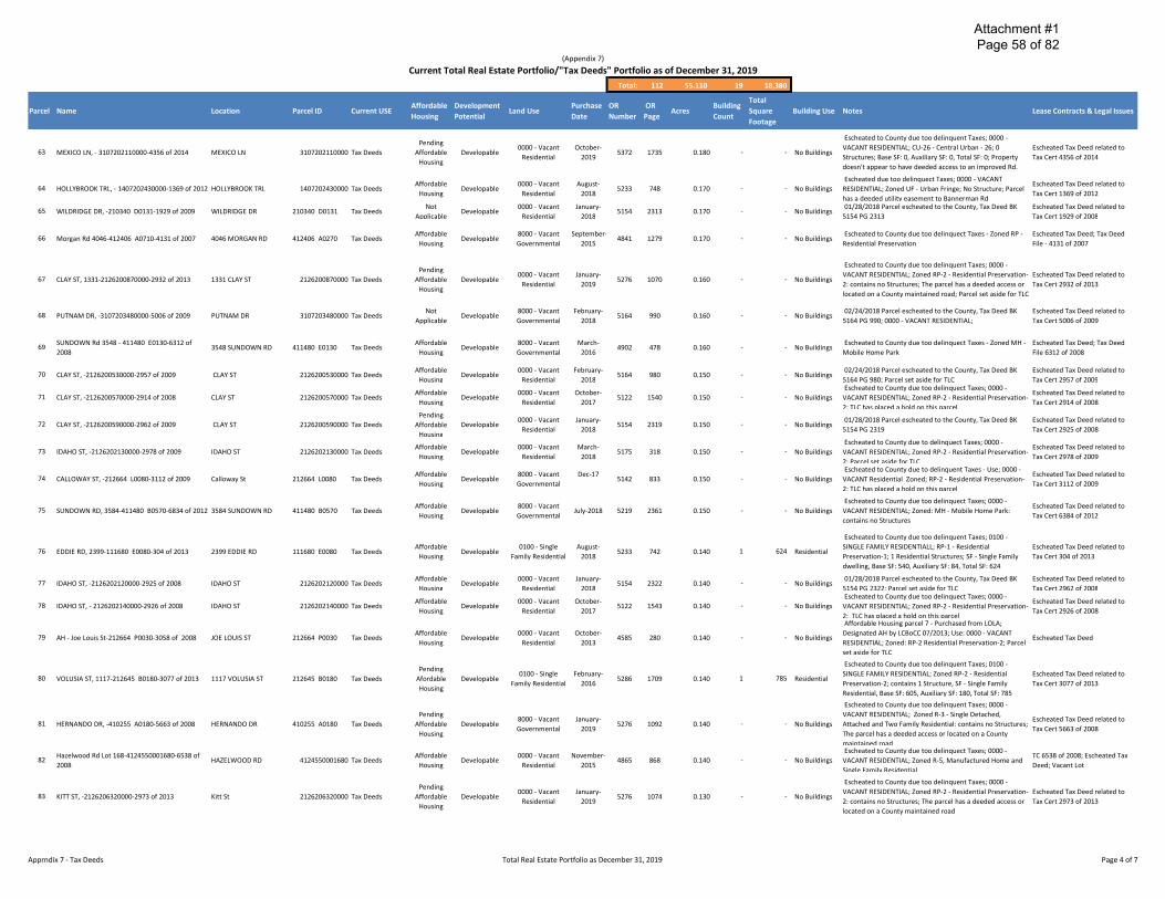
Attachment #1 Page 58 of 82
(Appendix 7)
Current Total Real Estate Portfolio/"Tax Deeds" Portfolio as of December 31, 2019
Total: 112 55.110 19 18,380
Parcel Name Location Parcel ID Current USE Affordable Housing
Development Potential
Land Use Purchase Date
OR Number
OR Page
Acres Building Count
Total Square Footage
Building Use Notes Lease Contracts & Legal Issues
63 MEXICO LN, - 3107202110000-4356 of 2014 MEXICO LN 3107202110000 Tax Deeds Pending
Affordable Housing
Developable 0000 - Vacant
Residential October-
2019 5372 1735 0.180 - - No Buildings
Escheated to County due too delinquent Taxes; 0000 -VACANT RESIDENTIAL; CU-26 - Central Urban - 26; 0 Structures; Base SF: 0, Auxiliary SF: 0, Total SF: 0; Property doesn't appear to have deeded access to an improved Rd.
Escheated Tax Deed related to Tax Cert 4356 of 2014
64
65
HOLLYBROOK TRL, - 1407202430000-1369 of 2012 HOLLYBROOK TRL
WILDRIDGE DR, -210340 D0131-1929 of 2009 WILDRIDGE DR
1407202430000 Tax Deeds
210340 D0131 Tax Deeds
Affordable Housing
Not Applicable
Developable
Developable
0000 - Vacant Residential
0000 - Vacant Residential
August-2018
January-2018
5233
5154
748
2313
0.170
0.170
-
-
-
-
No Buildings
No Buildings
Escheated due too delinquect Taxes; 0000 - VACANT RESIDENTIAL; Zoned UF - Urban Fringe; No Structure; Parcel has a deeded utility easement to Bannerman Rd 01/28/2018 Parcel escheated to the County, Tax Deed BK
5154 PG 2313
Escheated Tax Deed related to Tax Cert 1369 of 2012
Escheated Tax Deed related to Tax Cert 1929 of 2008
66 Morgan Rd 4046-412406 A0710-4131 of 2007 4046 MORGAN RD 412406 A0270 Tax Deeds Affordable
Housing Developable
8000 - Vacant Governmental
September-2015
4841 1279 0.170 - - No Buildings Escheated to County due too delinquect Taxes - Zoned RP -
Residential Preservation Escheated Tax Deed; Tax Deed File - 4131 of 2007
67 CLAY ST, 1331-2126200870000-2932 of 2013 1331 CLAY ST 2126200870000 Tax Deeds Pending
Affordable Housing
Developable 0000 - Vacant
Residential January-
2019 5276 1070 0.160 - - No Buildings
Escheated to County due too delinquent Taxes; 0000 -VACANT RESIDENTIAL; Zoned RP-2 - Residential Preservation- Escheated Tax Deed related to 2: contains no Structures; The parcel has a deeded access or Tax Cert 2932 of 2013 located on a County maintained road; Parcel set aside for TLC
68 PUTNAM DR, -3107203480000-5006 of 2009 PUTNAM DR 3107203480000 Tax Deeds Not
Applicable Developable
8000 - Vacant Governmental
February-2018
5164 990 0.160 - - No Buildings 02/24/2018 Parcel escheated to the County, Tax Deed BK
5164 PG 990; 0000 - VACANT RESIDENTIAL; Escheated Tax Deed related to Tax Cert 5006 of 2009
69 SUNDOWN Rd 3548 - 411480 E0130-6312 of 2008
3548 SUNDOWN RD 411480 E0130 Tax Deeds Affordable
Housing Developable
8000 - Vacant Governmental
March-2016
4902 478 0.160 - - No Buildings Escheated to County due too delinquect Taxes - Zoned MH -
Mobile Home Park Escheated Tax Deed; Tax Deed File 6312 of 2008
70
71
72
73
74
CLAY ST, -2126200530000-2957 of 2009
CLAY ST, -2126200570000-2914 of 2008
CLAY ST, -2126200590000-2962 of 2009
IDAHO ST, -2126202130000-2978 of 2009
CALLOWAY ST, -212664 L0080-3112 of 2009
CLAY ST
CLAY ST
CLAY ST
IDAHO ST
Calloway St
2126200530000 Tax Deeds
2126200570000 Tax Deeds
2126200590000 Tax Deeds
2126202130000 Tax Deeds
212664 L0080 Tax Deeds
Affordable Housing
Affordable Housing
Pending Affordable
Housing
Affordable Housing
Affordable Housing
Developable
Developable
Developable
Developable
Developable
0000 - Vacant Residential
0000 - Vacant Residential
0000 - Vacant Residential
0000 - Vacant Residential
8000 - Vacant Governmental
February-2018
October-2017
January-2018
March-2018
Dec-17
5164
5122
5154
5175
5142
980
1540
2319
318
833
0.150
0.150
0.150
0.150
0.150
-
-
-
-
-
-
-
-
-
-
No Buildings
No Buildings
No Buildings
No Buildings
No Buildings
02/24/2018 Parcel escheated to the County, Tax Deed BK Escheated Tax Deed related to 5164 PG 980; Parcel set aside for TLC Tax Cert 2957 of 2009 Escheated to County due too delinquect Taxes; 0000 -
Escheated Tax Deed related to VACANT RESIDENTIAL; Zoned RP-2 - Residential Preservation-
Tax Cert 2914 of 2008 2: TLC has placed a hold on this parcel
01/28/2018 Parcel escheated to the County, Tax Deed BK Escheated Tax Deed related to 5154 PG 2319 Tax Cert 2925 of 2008
Escheated to County due to delinquect Taxes; 0000 -Escheated Tax Deed related to
VACANT RESIDENTIAL; Zoned RP-2 - Residential Preservation-Tax Cert 2978 of 2009
2; Parcel set aside for TLC Escheated to County due to delinquent Taxes - Use; 0000 -
Escheated Tax Deed related to VACANT Residential Zoned; RP-2 - Residential Preservation-
Tax Cert 3112 of 2009 2; TLC has placed a hold on this parcel
75 SUNDOWN RD, 3584-411480 B0570-6834 of 2012 3584 SUNDOWN RD 411480 B0570 Tax Deeds Affordable
Housing Developable
8000 - Vacant Governmental
July-2018 5219 2361 0.150 - - No Buildings Escheated to County due too delinquect Taxes; 0000 -
VACANT RESIDENTIAL; Zoned: MH - Mobile Home Park: contains no Structures
Escheated Tax Deed related to Tax Cert 6384 of 2012
76 EDDIE RD, 2399-111680 E0080-304 of 2013 2399 EDDIE RD 111680 E0080 Tax Deeds Affordable
Housing Developable
0100 - Single Family Residential
August-2018
5233 742 0.140 1 624 Residential
Escheated to County due too delinquent Taxes; 0100 -SINGLE FAMILY RESIDENTIALL; RP-1 - Residential Preservation-1; 1 Residential Structures; SF - Single Family dwelling, Base SF: 540, Auxiliary SF: 84, Total SF: 624
Escheated Tax Deed related to Tax Cert 304 of 2013
77
78
79
80
IDAHO ST, -2126202120000-2925 of 2008
IDAHO ST, - 2126202140000-2926 of 2008
AH - Joe Louis St-212664 P0030-3058 of 2008
VOLUSIA ST, 1117-212645 B0180-3077 of 2013
IDAHO ST
IDAHO ST
JOE LOUIS ST
1117 VOLUSIA ST
2126202120000 Tax Deeds
2126202140000 Tax Deeds
212664 P0030 Tax Deeds
212645 B0180 Tax Deeds
Affordable Housing
Affordable Housing
Affordable Housing
Pending Afordable Housing
Developable
Developable
Developable
Developable
0000 - Vacant Residential
0000 - Vacant Residential
0000 - Vacant Residential
0100 - Single Family Residential
January-2018
October-2017
October-2013
February-2016
5154
5122
4585
5286
2322
1543
280
1709
0.140
0.140
0.140
0.140
-
-
-
1
-
-
-
785
No Buildings
No Buildings
No Buildings
Residential
01/28/2018 Parcel escheated to the County, Tax Deed BK Escheated Tax Deed related to 5154 PG 2322; Parcel set aside for TLC Tax Cert 2962 of 2008 Escheated to County due too delinquect Taxes; 0000 -
Escheated Tax Deed related to VACANT RESIDENTIAL; Zoned RP-2 - Residential Preservation-
Tax Cert 2926 of 2008 2: TLC has placed a hold on this parcel Affordable Housing parcel 7 - Purchased from LOLA;
Designated AH by LCBoCC 07/2013; Use: 0000 - VACANT Escheated Tax Deed
RESIDENTIAL; Zoned: RP-2 Residential Preservation-2; Parcel set aside for TLC
Escheated to County due too delinquent Taxes; 0100 -SINGLE FAMILY RESIDENTIAL; Zoned RP-2 - Residential Escheated Tax Deed related to Preservation-2; contains 1 Structure, SF - Single Family Tax Cert 3077 of 2013 Residential, Base SF: 605, Auxiliary SF: 180, Total SF: 785
81
82
HERNANDO DR, -410255 A0180-5663 of 2008
Hazelwood Rd Lot 168-4124550001680-6538 of 2008
HERNANDO DR
HAZELWOOD RD
410255 A0180 Tax Deeds
4124550001680 Tax Deeds
Pending Affordable
Housing
Affordable Housing
Developable
Developable
8000 - Vacant Governmental
0000 - Vacant Residential
January-2019
November-2015
5276
4865
1092
868
0.140
0.140
-
-
-
-
No Buildings
No Buildings
Escheated to County due too delinquent Taxes; 0000 -VACANT RESIDENTIAL; Zoned R-3 - Single Detached,
Escheated Tax Deed related to Attached and Two Family Residential: contains no Structures;
Tax Cert 5663 of 2008 The parcel has a deeded access or located on a County maintained road Escheated to County due too delinquect Taxes; 0000 -
TC 6538 of 2008; Escheated Tax VACANT RESIDENTIAL; Zoned R-5, Manufactured Home and
Deed; Vacant Lot Single Family Residential
83 KITT ST, -2126206320000-2973 of 2013 Kitt St 2126206320000 Tax Deeds Pending
Affordable Housing
Developable 0000 - Vacant
Residential January-
2019 5276 1074 0.130 - - No Buildings
Escheated to County due too delinquent Taxes; 0000 -VACANT RESIDENTIAL; Zoned RP-2 - Residential Preservation- Escheated Tax Deed related to 2: contains no Structures; The parcel has a deeded access or Tax Cert 2973 of 2013 located on a County maintained road
Apprndix 7 - Tax Deeds Total Real Estate Portfolio as December 31, 2019 Page 4 of 7

Attachment #1 Page 59 of 82
(Appendix 7)
Current Total Real Estate Portfolio/"Tax Deeds" Portfolio as of December 31, 2019
Total: 112 55.110 19 18,380
Parcel
84
85
86
87
Name
AH - Volusia St-212664 O0030-3057 of 2008
CONIFER ST, 4321-213215 C0030-3440 of 2013
FLORAL ST, 818-4101750220011-5852 of 2012
AH - SUNDOWN RD 3548-411480 E0130-6312 of 2008
Location
VOLUSIA ST
4321 CONIFER ST
818 FLORAL ST
3543 Sundown Rd
Parcel ID Current USE
212664 O0030 Tax Deeds
213215 C0030 Tax Deeds
4101750220011 Tax Deeds
411480 C0190 Tax Deeds
Affordable Housing
Affordable Housing
Pending Afordable Housing
Affordable Housing
Affordable Housing
Development Potential
Developable
Developable
Developable
Developable
Land Use
0000 - Vacant Residential
0200 - Mobile Homes
8000 - Vacant Governmental
0200 - Mobile Homes
Purchase Date
October-2013
January-2019
March-2018
Dec-17
OR Number
4585
5276
5175
5142
OR Page
277
1080
324
845
Building Acres
Count
0.130 -
0.130 1
0.130 -
0.130 1
Total Square Footage
-
652
-
1,110
Building Use
No Buildings
Mobile Home
No Buildings
Mobile Home
Notes Lease Contracts & Legal Issues
Escheated Tax Deed 10/2013; Affordable Housing parcel 6 - Purchased from LOLA Final Judgment Quietingt Title
08/2016
Escheated to County due too delinquent Taxes; 0200 -MOBILE HOMES; ZonedR-5 - Manufactured Home and Single Escheated Tax Deed related to Family Residential: 1 Residential Structure, MH - Mobile Tax Cert 2440 of 2013 Home Base SF: 540, Auxiliary SF: 112, Total SF: 652
Escheated to County due to delinquect Taxes; 0000 -Escheated Tax Deed related to
VACANT RESIDENTIAL; Zoned RP-2 - Residential Preservation-Tax Cert 5852 of 2012
2; Parcel set aside for TLC Escheated to County due too delinquect Taxes; 0200 -
Escheated Tax Deed related to MOBILE HOMES; Zoned MH - Mobile Home Park: contains 1
Tax Cert 6879 of 2009 mobile home, 924 base SF + 186 aux SF
88 SUNDOWN RD, - 411480 D0030-8095 of 2010 Sundown Rd 411480 D0030 Tax Deeds Affordable
Housing Developable
8000 - Vacant Governmental
May-2018 5198 1379 0.130 - - No Buildings Escheated to County due too delinquect Taxes; 0000 -
VACANT RESIDENTIAL; Zoned MH - Mobile Home Park Escheated Tax Deed related to Tax Cert 8095 of 2010
89 SUNDOWN LN 823-411480 D0100-6310 of 2008 823 SUNDOWN LN 411480 D0100 Tax Deeds Affordable
Housing Developable
8000 - Vacant Governmental
March-2016
4902 475 0.130 - - No Buildings Escheated to County due too delinquect Taxes - Zoned MH -
Mobile Home Park Escheated Tax Deed; Tax Deed File 6312 of 2008
90
91
92
LAKE HENRIETTA ST, 2721-411155 C0220-6188 of 2721 LAKE HENRIETTA ST 411155 C0220 Tax Deeds
2013
LUTHER HALL RD, - 4307030010010 - 4347 of LUTHER HALL RD 4307030010010 Tax Deeds
2004
SUNDOWN RD, 3528-411480 B0260-6656 of 2013 3528 SUNDOWN RD 411480 B0260 Tax Deeds
Pending Affordable
Housing
Affordable Housing
Pending Affordable
Housing
Developable
Developable
Developable
0000 - Vacant Residential
0000 - Vacant Residential
8000 - Vacant Governmental
January-2019
October-2017
March-2019
5276
5122
5297
1102
1549
1954
0.120
0.120
0.120
-
-
-
-
-
-
No Buildings
No Buildings
No Buildings
Escheated to County due too delinquent Taxes; 0000 -VACANT RESIDENTIAL; Zoned RP-2 – Residential Escheated Tax Deed related to Preservation-2: contains no Structures; The parcel has a Tax Cert 6188 of 2013 deeded access or located on a County maintained road
Escheated to County due too delinquect Taxes; 0000 -VACANT RESIDENTIAL; Zoned LT;Comments T Heiker, is too Escheated Tax Deed; TC 4347 of small and too near a stream to place a septic tank. This site 2004 should not be developed.
Escheated to County due too delinquent Taxes; 0000 -Escheated Tax Deed related to
VACANT RESIDENTIAL; Zoned MH – Mobile Home; contains Tax Cert 6656 of 2013
no Structures;
93 BENNETT ST, 1125-2126150000080-2918 of 2013
94 Red Arrow Rd- 3107203070000
95 ORANGE AVE W, -411155 E0020-3771 of 2004
96 OSCEOLA ST, 836-410127 J0071-3435 of 2004
97 WAKULLA ST, -410127 U0070-6038 of 2009
98 WAKULLA ST, 2113-410127 U0090-5740 of 2012
GREAT LAKES ST, 413-411316 F0060-6719 of 99 2009
100 BLOUNTSTOWN HWY - 4308200700000
Bennett St
Red Arrow Rd
Orange Ave W
836 OSCEOLA ST
WAKULLA ST
2113 WAKULLA ST
413 GREAT LAKES ST
BLOUNTSTOWN HWY
2126150000080 Tax Deeds
3107203070000 Tax Deeds
411155 E0020 Tax Deeds
410127 J0071 Tax Deeds
410127 U0070 Tax Deeds
410127 U0090 Tax Deeds
411316 F0060 Tax Deeds
4308200700000 Tax Deeds
Pending Affordable
Housing
Affordable Housing
Affordable Housing
Affordable Housing
Affordable Housing
Not Applicable
Affordable Housing
Not Applicable
Developable
Developable
Developable
Developable
Developable
Developable
Developable
Developable
0000 - Vacant Residential
8000 - Vacant Governmental
8000 - Vacant Governmental
8000 - Vacant Governmental
8000 - Vacant Governmental
8000 - Vacant Governmental
8000 - Vacant Governmental
0000 - Vacant Residential
January-2019
October-2014
September-2017
September-2017
March-2018
July-2018
November-2017
March-2013
5276
4722
5113
5113
5175
5219
5134
4495
1067
241
1048
1042
327
2358
2120
2261
0.110
0.110
0.110
0.100
0.100
0.100
0.100
0.100
-
-
-
-
-
-
-
-
-
-
-
-
-
-
-
-
No Buildings
No Buildings
No Buildings
No Buildings
No Buildings
No Buildings
No Buildings
No Buildings
Escheated to County due too delinquent Taxes; 0000 -VACANT RESIDENTIAL; Zoned RP-2 - Residential Preservation- Escheated Tax Deed related to 2: contains no Structures; The parcel has a deeded access or Tax Cert 2918 of 2013 located on a County maintained road
Escheated to County due too delinquect Taxes - Zoned RP -Escheated Tax Deed
Residential Preservation Escheated to County due too delinquect Taxes; 0000 -
Escheated Tax Deed; TC 3771 of VACANT RESIDENTIAL; Zoned RP-2 - Residential Preservation-
2004 2: TLC has placed a hold on this parcel Escheated to County due too delinquect Taxes; 0000 -
Escheated Tax Deed; TC 3435 of VACANT RESIDENTIAL; Zoned RP-2 - Residential Preservation-
2004 2: Parcel set aside for TLC Escheated to County due to delinquect Taxes; 0000 -
Escheated Tax Deed related to VACANT RESIDENTIAL; Zoned RP-2 - Residential Preservation-
Tax Cert 6038 of 2009 2; Parcel set aside for TLC EscheaCted due too delinquect Taxes; 0000 - VACANT
Escheated Tax Deed related to RESIDENTIAL; Zoned RP-2 - Residential Preservation-2; LCPA
Tax Cert 5740 of 2012 reports No Structures; Escheated to County due too delinquect Taxes; 0000 -
Escheated Tax Deed related to VACANT Residential; Zoned MULTIP – MULTIPLE ZONING
Tax Cert 6719 of 2009 DESIGNATIONS: Vacant; Parcel set aside for TLC March 2013 - Escheated to the County due too delinquent
taxes; Undevelopable due too size & location. Small triangular remnant, appears to have no ingress & egress w/o Escheated Tax Deed passing over adjoining parcels.
101 MOSS COVE LN-4124550000200-6518 of 2008
Oak Crest Blvd Lot 54-41245500000540–6522 102 of 2008
MOSS COVE LN
OAK CREST BLVD
4124550000200 Tax Deeds
4124550000540 Tax Deeds
Affordable Housing
Affordable Housing
Developable
Developable
0000 - Vacant Residential
0000 - Vacant Residential
March-2016
November-2015
4902
4865
484
877
0.100
0.090
-
-
-
-
No Buildings
No Buildings
Escheated to County due too delinquect Taxes - Zoned R-5 -Manufactured Home and Single Family Residential Escheated to County due too delinquect Taxes; 0000 -
VACANT RESIDENTIAL; Zoned R-5, Manufactured Home and Single Family Residen al
Escheated Tax Deed; Tax Deed File 6518 of 2008
TC 6522 of 2008; Escheated Tax Deed; Vacant Lot
103
104
OAK CREST BLVD, 210-4124550000950-7120 of 2009
Hazelwood Rd Lot 131-4124550001310-6536 of 2008
210 OAK CREST BLVD
HAZELWOOD RD
4124550000950 Tax Deeds
4124550001310 Tax Deeds
Pending Affordable
Housing
Affordable Housing
Developable
Developable
0700 -Miscellaneous
Residential
0000 - Vacant Residential
January-2018
November-2015
5276
4865
1109
871
0.090
0.090
-
-
-
-
No Buildings
No Buildings
Escheated to County due too delinquent Taxes; 0000 -VACANT RESIDENTIAL; Zoned R-5 – Manufactured Home and Single Family Residential: contains no Structures; Roads within the subdivision are not maintained by the county
Escheated to County due too delinquect Taxes; 0000 -VACANT RESIDENTIAL; Zoned R-5, Manufactured Home and Single Family Residential
Escheated Tax Deed related to Tax Cert 7210 of 2009
TC 6536 of 2008; Escheated Tax Deed; Vacant Lot
Apprndix 7 - Tax Deeds Total Real Estate Portfolio as December 31, 2019 Page 5 of 7

Attachment #1 Page 60 of 82
(Appendix 7)
Current Total Real Estate Portfolio/"Tax Deeds" Portfolio as of December 31, 2019
Total: 112 55.110 19 18,380
Parcel Name Location Parcel ID Current USE Affordable Housing
Development Potential
Land Use Purchase Date
OR Number
OR Page
Acres Building Count
Total Square Footage
Building Use Notes Lease Contracts & Legal Issues
105
106
107
108
109
110
Oak Crest Sub Lot 75 OAK CREST BLVD
BLACKTHORN TRL - 4124550000030-6517 of 2008 BLACKTHORN TRL
Oak Crest Sub - 52 Oak Crest Blvd
Oak Crest Blvd 209-4124550000640-6524 of 2008 209 OAK CREST BLVD
Oak Crest Sub - 72 Oak Crest Blvd
Oak Crest Sub Lot 76 OAK CREST BLVD
4124550000750 Tax Deeds
4124550000030 Tax Deeds
4124550000520 Tax Deeds
4124550000640 Tax Deeds
4124550000720 Tax Deeds
4124550000760 Tax Deeds
Affordable Housing
Not Applicable
Not Applicable
Affordable Housing
Not Applicable
Affordable Housing
Developable
Developable
Developable
Developable
Developable
Developable
0000 - Vacant Residential
0000 - Vacant Residential
8000 - Vacant Governmental
0000 - Vacant Residential
8000 - Vacant Governmental
0000 - Vacant Residential
March-2013
September-2016
January-1975
November-2015
January-1975
March-2013
4495
4970
697
4865
697
4495
2269
684
347
874
349
2275
0.050
0.040
0.040
0.040
0.040
0.040
-
-
-
-
-
-
-
-
-
-
-
-
No Buildings
No Buildings
No Buildings
No Buildings
No Buildings
No Buildings
03/2013-Escheated due too delinquent taxes; Undevelopable due to size and being located in a subdiv w/o County or City maintained rds; Designated AH by LCBoCC 07/2013; Use: 0000 - VACANT RESID; Zoned: R-5 Manufactured Home & Single Family Resid Rec NB at PS held 09/04/2013; escheated to County
09/2016; 0000 - VACANT RESIDENTIAL; Manufactured Home and Single Family Residential
Declared Surplus at LCBoCC meeting on 01/29/2013;
Escheated to County due too delinquect Taxes; 0000 -VACANT RESIDENTIAL; Zoned R-5, Manufactured Home and Single Family Residential Declared Surplus at LCBoCC meeting on 01/29/2013; 8000 -
VACANT GOVERNMENTAL; Manufactured Home and Single Family Residential 03/2013-Escheated due too delinquent taxes;
Undevelopable due to size and being located in a subdiv w/o County or City maintained rds; Designated AH by LCBoCC 07/2013; Use: 0000 - VACANT RESID; Zoned: R-5 Manufactured Home & Single Family Resid
Escheated Tax Deed; TC 4857 of 2001
TC 6517 of 2008; Escheated Tax Deed; Vacant Lot
Escheated Tax Deed; TC 402 of 1968
TC 6524 of 2008; Escheated Tax Deed; Vacant Lot
Escheated Tax Deed; TC 404 of 1968
Escheated Tax Deed: TC 4858 pf 2001
111 Oak Crest Sub Lot 144 HAZELWOOD RD 4124550001440 Tax Deeds Affordable
Housing Developable
0000 - Vacant Residential
March-2013
4495 2272 0.040 - - No Buildings
03/2013-Escheated due too delinquent taxes; Undevelopable due to size and being located in a subdiv w/o County or City maintained rds; Designated AH by LCBoCC 07/2013; Use: 0000 - VACANT RESID; Zoned: R-5 Manufactured Home & Single Family Resid
Escheated Tax Deed
112 Idalou & Idaho St Idalou & Idaho St 212666 B0100 Tax Deeds Not
Applicable Developable
0000 - Vacant Residential
October-2013
4596 1041 0.030 - - No Buildings Escheated to County due too delinquect Taxes - Zoned RP -
Escheated Tax Deed OR 4596 PG Residential Preservation: Undevelopable due too size, maybe
1041 marketable to adjacent property owners
Total Parcel parcels as of December 31, 2019 112 55.110 19 18,380
Apprndix 7 - Tax Deeds Total Real Estate Portfolio as December 31, 2019 Page 6 of 7

- -
Attachment #1 Page 61 of 82
(Appendix 8)
Current Total Real Estate Portfolio/"Water Management" Portfolio as of December 31, 2019
Parcel Name Location Parcel ID Current USE
Current Total Real Estate Portfolio/"Water Management" Portfolio as of December 31, 2019
Water 1 Upper Lake Lafayette Barnstaple Rd 1126208010000 Management
Water 2 Gum Swamp-216 W Tennessee St 2129202160000 Management
Water 3 Lake Munson Jackson Moody Pl 4126208510000 Management
Water 4 Lower Lake Lafayette Raymond Tucker Rd 3206200020000 Management
Water 5 Lake Munson & Flood Plain - 248 Tom Still Rd 4126202480000 Management
Miccosukee Rd & Water 6 McCracken Rd-801 1535208010000 Mccracken Rd Management
Water 7 Lake Munson & Flood Plain - 613 Dawson Rd 4123206130000 Management
Water 8 Lake Henrietta / Munson Slough Area -347 Blue Bird Rd 4114203470000 Management
Water 9 Farms Rd -852 Capitola Rd 1319208520000 Management
Water 10 Gum Swamp-017 Capital Cir Sw 2132200170000 Management
Water 11 Public Safety Complex - Retention Pond Easterwood Dr 1127208540000 Management
Water 12 Lake Henrietta Area -203 N Ridge Rd 4114202030000 Management
Water 13 Gum Swamp-852 Capital Cir Sw 2132208520000 Management
Water 14 Council Estates Orange Ave E 411203 A0020 Management
Water 15 Lake Henrietta -802 3305 Springhill Rd 4114208020000 Management
Water 16 Lake Henrietta/Young Unrec Sprinil Rd 4114050000080 Management
John Hancock Dr & Timberlane Rd - Water 17 JOHN HANCOCK DR 2112200050000 2122000050000 Management
Water 18 Lake Henrietta / Munson Slough Area -401 Capital Cir Sw 4115204010000 Management
Water 19 GUM RD 2 - 2131208010000 GUM RD 2131208010000 Management
Water 20 Bannerman Corner Lauder Dr 1422220000080 Management
Water 21 Thomasville Rd - 1414208530000 Thomasville Rd 1414208530000 Management
Water 22 Bannerman Rd, 3434 - 142229 A0050 3434 Bannerman Rd 142229 A0050 Management
Water 23 TRAILS END LN, 5285-2131200060000 5285 TRAILS END LN 2131200060000 Management
Water 24 Messer Field Storm Water Pond James Messer Fields 4104208520000 Management
Water 25 Mariana Oaks Phase I Mariana Oaks Dr 320821 0001 Management
Total: 312 1,408.300
Total Affordable Development Purchase OR OR Building
Land Use Acres Square Housing Potential Date Number Page Count
Footage
9500 - Rivers, Not March-
Undevelopable Lakes, Submerged 3474 968 200.000 -Applicable 2006
Lands Not 9900 - Vacant February-
Undevelopable 1879 2397 154.630 -Applicable Acreage, Not Agri 1996
9500 - Rivers, Not December-
Undevelopable Lakes, Submerged 197 586 105.000 -Applicable 1964
Lands 9500 - Rivers,
Not March-Undevelopable Lakes, Submerged 2850 2113 76.220 -
Applicable 2003 Lands
9500 - Rivers, Not
Undevelopable Lakes, Submerged May-1999 2255 733 60.000 -Applicable
Lands Not 8000 - Vacant
Undevelopable April-2004 3071 1952 54.690 -Applicable Governmental
Not 8000 - Vacant Undevelopable May-1999 2255 733 45.800 -
Applicable Governmental 9600 - Sewage
Not February-Undevelopable Disposal, Solid 2220 1482 41.800 -
Applicable 1999 Waste
Not 9900 - Vacant January-Undevelopable 1467 1602 40.440 -
Applicable Acreage, Not Agri 1999 9600 - Sewage
Not October-Undevelopable Disposal, Solid 1601 765 37.710 -
Applicable 1992 Waste
Not February-Undevelopable 8600 - County 509 204 29.890 -
Applicable 1972
9600 - Sewage Not November-
Undevelopable Disposal, Solid 1966 1151 23.780 -Applicable 1996
Waste Not 8000 - Vacant
Undevelopable April-1990 1453 360 21.330 -Applicable Governmental
9600 - Sewage Not August-
Undevelopable Disposal, Solid 2543 2033 20.270 -Applicable 2001
Waste 9600 - Sewage
Not Undevelopable Disposal, Solid July-1998 2152 853 18.150 -
Applicable Waste
9600 - Sewage Not
Undevelopable Disposal, Solid July-1998 2136 72 17.360 -Applicable
Waste 9600 - Sewage
Not Undevelopable Disposal, Solid July-2015 4829 234 17.290 -
Applicable Waste
9600 - Sewage Not
Undevelopable Disposal, Solid July-1998 2146 2185 15.320 -Applicable
Waste
9600 - Sewage Not
Undevelopable Disposal, Solid July-2019 5336 386 13.800 -Applicable
Waste
9600 - Sewage Not February-
Undevelopable Disposal, Solid 2098 1081 13.690 -Applicable 1998
Waste 9600 - Sewage
Not Undevelopable Disposal, Solid June-2008 3905 1407 13.330 -
Applicable Waste
9600 - Sewage Not September-
Undevelopable Disposal, Solid 4847 1605 13.260 -Applicable 2015
Waste
Not Non- 8000 - Vacant January-5155 729 10.000 -
Applicable Developable Governmental 2018
9600 - Sewage Not October-
Undevelopable Disposal, Solid 1401 1328 10.000 -Applicable 1989
Waste
Not 8000 - Vacant Undevelopable Leased Leased Leased 8.840 -
Applicable Governmental
Building Use Notes Lease Contracts & Legal Issues
- No Buildings Corrective Deed BK3517 PG511
- No Buildings 1 of 11 parcels that make up the Gum Swamp Area
- No Buildings 1 of 7 parcels that make up Lake Munson Area
- No Buildings NA
1 of 7 parcels that make up Lake Munson Area BK3892 - No Buildings PG645 Flood Covenant & restrictions; Parcel obtained via
Federal Grant
- No Buildings NA
- No Buildings 1 of 7 parcels that make up Lake Munson Area
Order of Taking - 1 of 20 Parcels that make up Lake - No Buildings Order of Taking Henrietta-Munson Slough Drainage Area
- No Buildings NA
1 of 11 parcels that make up the Gum Swamp Area; - No Buildings Conservation Easement BK1984 PG2268
Part of original 255.02 A from USA (Tom Brown Park) + - No Buildings Another 80 A from USA BK947 PG1831; 1 OF 3 Lot Partition
OR4025 PG745
1 of 21 Parcels that make up Lake Henrietta-Munson Slough - No Buildings Drainage Area
- No Buildings 1 of 11 parcels that make up the Gum Swamp Area
- No Buildings NA
1 of 21 Parcels that make up Lake Henrietta-Munson Slough - No Buildings Drainage Area
1 of 21 Parcels that make up Lake Henrietta-Munson Slough - No Buildings Drainage Area
- No Buildings NA Quit Claim Dee
1 of 21 Parcels that make up Lake Henrietta-Munson Slough - No Buildings Drainage Area
BP2000 purchase the properties to offset floodplain storage - No Buildings and wetlands lost due to the construction of Capital Circle Conveyed to LC by BP2000
SW; July, 2019 BP2000 conveyed tp the LC
- No Buildings NA
- No Buildings NA
Part of 3 parcels resulting from a land exchange between Land exchange between County & - No Buildings County and Summit Holdings for the old Bradfordvile Summit Holdings;
Community Center location Conveyed by Talquin Elec via the Grace Program for
- No Buildings development rights on another Parcel; Single Detached, Grace Program Attached and Two Family Residential
- No Buildings NA Order of Taking
1 of 3 parcels located in Mariana Oaks. No conveyance - No Buildings No conveyance Leon Cty located instrument located; DEDICATED SWMF PER PB 20/20
Water 26 SWAMP FOX RD 4 0 - 2132202070000 0 SWAMP FOX RD 4 2132202070000 Management
Water 27 Timber Lake Area - 800 Apalachee Pkwy 3101208000000 Management
Not 8000 - Vacant Undevelopable July-2019 5336 389 8.610 -
Applicable Governmental
Not 8000 - Vacant December-Undevelopable 4200 875 8.400 -
Applicable Governmental 2010
BP2000 purchase the properties to offset floodplain storage - No Buildings and wetlands lost due to the construction of Capital Circle Conveyed to LC by BP2000
SW; July, 2019 BP2000 conveyed tp the LC
Purchased with FEMA & converted into a strom water - No Buildings retention area for the Timber Lake subdivision
Appendix 8 Current Real Estate Portfolio/"Water Management" Portfolio Page 1 of 10

- -
Attachment #1 Page 62 of 82
(Appendix 8)
Current Total Real Estate Portfolio/"Water Management" Portfolio as of December 31, 2019
Total: 312 1,408.300
Parcel Name Location Parcel ID Current USE Affordable Housing
Development Potential
Land Use Purchase Date
OR Number
OR Page
Acres Building Count
Total Square Footage
Building Use Notes Lease Contracts & Legal Issues
28 N Blair Stone Rd -852 N Blair Stone Rd Water
1121208520000 Management
Not Applicable
Undevelopable 9600 - Sewage Disposal, Solid
Waste June-1982 1029 1070 8.360 - - No Buildings 1 of 2 parcels 2nd parcel 10/1990 BK1555 PG0093
29 Rivers Landing-0002 Rivers Landing Ct 253621 0002 Water Management
Not Applicable
Undevelopable 8000 - Vacant Governmental
Leased Leased Leased 8.290 - - No Buildings No conveyance instrument located except for dedication per
No conveyance Leon Cty located PB 19 PG58
30 Silver Ridge Estates - 001 Sykes Dr 411475 0001 Water Management
Not Applicable
Undevelopable 9600 - Sewage Disposal, Solid
Waste May-1989 1374 2248 7.410 - - No Buildings
Waste Collection Site; 9600 - SEWAGE DISPOSAL, SOLID WASTE; Zoned RP Residential Preservation
BP2000 purchase the properties to offset floodplain storage
31 GUM RD 1 0 - 2131200070010 GUM RD Water
2131200070010 Management
Not Applicable
Undevelopable 8000 - Vacant Governmental
March-2097
5336 393 7.040 - - No Buildings and wetlands lost due to the construction of Capital Circle SW; July, 2019 BP2000 conveyed tp the LC
Conveyed to LC by BP2000
32 Liberty Ridge Unrec - 09 880 Jessica St Water
4612100000090 Management
Not Applicable
Undevelopable 8000 - Vacant Governmental
March-2004
3049 1370 7.000 - - No Buildings NA
33 Lk Henrietta-Munson Slough Drainage Springhill Rd Water
4114208520000 Management
Not Applicable
Undevelopable 9600 - Sewage Disposal, Solid
Waste May-1976 792 404 6.980 - - No Buildings
1 of 21 Parcels that make up Lake Henrietta-Munson Slough Drainage Area
34 Yorktown Pond Lakeshore Dr Water
2112208530000 Management
Not Applicable
Undevelopable 9600 - Sewage Disposal, Solid
Waste
November-1993
1702 1203 6.420 - - No Buildings NA
35 Jordans Pass Jordans Pass Dr 223622 0001 Water Management
Not Applicable
Undevelopable 8000 - Vacant Governmental
Leased Leased Leased 6.210 - - No Buildings No conveyance instrument located except for dedication per
No conveyance Leon Cty located PB 19 PG69
36 Lake Lafayette & Flood Plain -202 Road To The Lake Water
3204202020000 Management
Not Applicable
Undevelopable 8000 - Vacant Governmental
March-2004
3066 920 6.060 - - No Buildings NA
37 Liberty Ridge Unrec - 60 663 Nocatee Rd Water
4612100000600 Management
Not Applicable
Undevelopable 8000 - Vacant Governmental
November-1997
2068 760 6.000 - - No Buildings NA
38 Cascade Lake Capital Cir Sw Water
4105208020000 Management
Not Applicable
Undevelopable 8000 - Vacant Governmental
January-2004
1347 782 5.960 - - No Buildings NA
39 Old Magnolia Old Magnolia Rd Water
1634208020000 Management
Not Applicable
Undevelopable 9600 - Sewage Disposal, Solid
Waste April-1998 2141 1665 5.890 - - No Buildings NA
40 Sierra Woods Sierra Woods Dr 321631 0002 Water Management
Not Applicable
Undevelopable 8000 - Vacant Governmental
Leased Leased Leased 5.630 - - No Buildings No conveyance instrument located except for Drainage
Easement dated 11/2005 OR3413 PG1060 for different portion of Sierra Woods
No conveyance Leon Cty located
41 Bradfordville Rd-801 Bradfordville Rd Water
1422208010000 Management
Not Applicable
Undevelopable 9600 - Sewage Disposal, Solid
Waste
September-2003
2961 2024 4.680 - - No Buildings Quit Claim from State of Florida
42 MALLARD HILL LN - 151615 A0070 MALLARD HILL LN 151615 A0070 Water Management
Not Applicable
Undevelopable 8000 - Vacant Governmental
January-2016
4890 568 4.670 - - No Buildings Acquired by development wxchange on another Parcel Acquired through the Flooded Prop acq & Mgmt Program
43 Oak Grove Plantation-0001 Oak Grove Plantation Rd 140725 0001 Water Management
Not Applicable
Undevelopable 9500 - Rivers,
Lakes, Submerged Lands
Leased Leased Leased 4.630 - - No Buildings No conveyance instrument located appears to be part of
Conservation Easement dated 09/2002 recorded in OR2757 PG264
No conveyance Leon Cty located
44 Dresonia Dr Parcel - 217 Tower Rd Water
2431202170000 Management
Not Applicable
Undevelopable 8000 - Vacant Governmental
August-1998
2164 507 3.950 - - No Buildings NA
45 Lakeshore Dr at Meginnis Arm Rd 3000 Lakeshore Dr Water
2114200100000 Management
Not Applicable
Undevelopable 9600 - Sewage Disposal, Solid
Waste
November-1995
1856 1393 3.830 - - No Buildings NA
46 Liberty Ridge Unrec - D00 694 Spiral Garden Way 461210 D0000 Water Management
Not Applicable
Undevelopable 8000 - Vacant Governmental
August-1998
2158 506 3.780 - - No Buildings NA
47 Highgrove-801 Forsythe Way Water
1433208010000 Management
Not Applicable
Undevelopable 9600 - Sewage Disposal, Solid
Waste
September-2003
2961 2002 3.560 - - No Buildings NA
48 Liberty Ridge Unrec - 08 904 Jessica St Water
4612100000080 Management
Not Applicable
Undevelopable 8000 - Vacant Governmental
February-1999
2215 2034 3.500 - - No Buildings NA
49 Lakeshore Estates -003 Timberlane Rd 211250 0003 Water Management
Not Applicable
Undevelopable 9600 - Sewage Disposal, Solid
Waste Leased Leased Leased 3.400 - - No Buildings No conveyance instrument located No conveyance Leon Cty located
50 Liberty Ridge Phase II Unrec -76 Flicker Rd Water
4611100000760 Management
Not Applicable
Undevelopable 8000 - Vacant Governmental
December-2003
3022 935 3.340 - - No Buildings NA
51 Edinbourgh Estates-01 4470 Sherborne Rd 210540 A0010 Water Management
Not Applicable
Undevelopable 8000 - Vacant Governmental
October-1997
2061 49 3.180 - - No Buildings NA
52 RUSSELLS POND LN, - 2431200320000 - 4563 of 2009
RUSSELLS POND LN Water
2431200320000 Management
Not Applicable
Developable 0000 - Vacant
Residential October-
2017 5122 1552 3.160 - - No Buildings
Surrounding land of retentions ponds of Russels Ponds Sub; Escheated to County due too delinquect Taxes; 0000 -VACANT Residential; Zoned: RP - Residential Preservation;
Escheated Tax Deed related to Tax Cert 4363 of 2009
53 Wakulla Springs Road Unrec-17 8617 Moore Woods Rd Water
4610180000170 Management
Not Applicable
Undevelopable 8000 - Vacant Governmental
November-1997
2068 515 3.160 - - No Buildings NA
54 Avalon Dr -09 8350 Avalon Dr Water
4611030000090 Management
Not Applicable
Undevelopable 8000 - Vacant Governmental
September-2005
3368 106 3.000 - - No Buildings NA
55 Liberty Ridge Unrec - 01 8866 Freedom Rd Water
4612100000010 Management
Not Applicable
Undevelopable 8000 - Vacant Governmental
October-1997
2056 1031 3.000 - - No Buildings NA
56 Liberty Ridge Unrec - 02 867 Jessica St Water
4612100000020 Management
Not Applicable
Undevelopable 8000 - Vacant Governmental
June-1998 2141 449 3.000 - - No Buildings NA
57 Avalon Dr -11 8342 Avalon Dr Water
4611030000110 Management
Not Applicable
Undevelopable 8000 - Vacant Governmental
November-1997
2068 755 3.000 - - No Buildings NA
58 Liberty Ridge Unrec - 11 868 Jessica St Water
4612100000110 Management
Not Applicable
Undevelopable 8000 - Vacant Governmental
April-1998 2121 99 3.000 - - No Buildings NA
Appendix 8 Current Real Estate Portfolio/"Water Management" Portfolio Page 2 of 10

- -
Attachment #1 Page 63 of 82
(Appendix 8)
Current Total Real Estate Portfolio/"Water Management" Portfolio as of December 31, 2019
Total: 312 1,408.300
Parcel Name Location Parcel ID Current USE Affordable Housing
Development Potential
Land Use Purchase Date
OR Number
OR Page
Acres Building Count
Total Square Footage
Building Use Notes Lease Contracts & Legal Issues
59 Kinhega Landings-0001 Winters Run 173328 0001 Water Management
Not Applicable
Undevelopable 0900 - Residential
Common Elements/Areas
Leased Leased Leased 2.990 - - No Buildings No conveyance instrument located except for dedication per
No conveyance Leon Cty located Plat
60 Buck Lake Rd Between Highland BUCK LAKE RD Water
1124208520000 Management
Not Applicable
Undevelopable 9600 - Sewage Disposal, Solid
Waste
October-1992
1595 1812 2.980 - - No Buildings NA
Conveyed to County by Final Judgment on 10-1992, Case #87-4491, HM & HF Andrews vs Leon County
61 Fuller at Ty Cobb -409 3302 Ty Cobb Rd Water
2110204090000 Management
Not Applicable
Undevelopable 9600 - Sewage Disposal, Solid
Waste June-2001 2517 1048 2.890 - - No Buildings NA
62 Sagebrook Mill-3 Fred George Rd & Sagebrook Dr.
211721 0003 Water Management
Not Applicable
Undevelopable 8000 - Vacant Governmental
Leased Leased Leased 2.580 - - No Buildings No conveyance instrument located No conveyance Leon Cty located
63 Rhodes Cemetery Rd Woodville Hwy Water
3308200100000 Management
Not Applicable
Undevelopable 8000 - Vacant Governmental
June-2011 4256 1637 2.560 - - No Buildings Proposed Storm Water Pond
64 Mariana Oaks Phase Ii Mariana Oaks Dr 320822 0001 Water Management
Not Applicable
Undevelopable 8000 - Vacant Governmental
Leased Leased Leased 2.550 - - No Buildings 1 of 3 parcels located in Mariana Oaks. No conveyance
instrument located; DEDICATED SWMF PER PB 20/20 No conveyance Leon Cty located
65 Liberty Ridge Phase II Unrec -46 9133 Warbler St Water
4611100000460 Management
Not Applicable
Undevelopable 8000 - Vacant Governmental
May-2004 3088 269 2.500 - - No Buildings NA
66 Liberty Ridge Phase II Unrec -47 9121 Warbler St Water
4611100000470 Management
Not Applicable
Undevelopable 8000 - Vacant Governmental
December-2003
3022 935 2.500 - - No Buildings NA
67 Liberty Ridge Phase II Unrec -48 9113 Warbler St Water
4611100000480 Management
Not Applicable
Undevelopable 8000 - Vacant Governmental
March-2006
3475 1077 2.500 - - No Buildings NA
68 Wakulla Springs Rd -016 Wakulla Springs Rd Water
4615200160000 Management
Not Applicable
Undevelopable 8000 - Vacant Governmental
February-1998
2092 2129 2.500 - - No Buildings NA
69 Flicker Rd - 8782 8782 FLICKER RD Water
4611100000860 Management
Not Applicable
Undevelopable 0000 - Vacant
Residential December-
2013 4619 836 2.470 - - No Buildings Parcel Donated to County Donation
70 Celia CT - 9028 9028 Celia Ct 331845 M0040 Water Management
Not Applicable
Undevelopable 0000 - Vacant
Residential April-2013 4516 664 2.450 - - No Buildings Warranty Deed - Lot 4, Block M, Slaw Plantation, Unit 3
71 Lainey Ln -M06 9044 Celia Ct 331845 M0060 Water Management
Not Applicable
Undevelopable 8000 - Vacant Governmental
December-2005
3420 241 2.450 - - No Buildings NA
72 Branded Oaks-0001 Branded Oaks Ct 322125 0001 Water Management
Not Applicable
Undevelopable 9600 - Sewage Disposal, Solid
Waste Leased Leased Leased 2.420 - - No Buildings No conveyance instrument located No conveyance Leon Cty located
73 Liberty Ridge Phase II Unrec -37 9156 Warbler St Water
4611100000370 Management
Not Applicable
Undevelopable 8000 - Vacant Governmental
January-1998
2089 451 2.400 - - No Buildings NA
74 Liberty Ridge Unrec- 131 Freedom Rd Water
4612100000131 Management
Not Applicable
Undevelopable 8000 - Vacant Governmental
December-1997
2080 1099 2.400 - - No Buildings NA
75 Liberty Ridge Unrec - 13 Freedom Rd Water
4612100000130 Management
Not Applicable
Undevelopable 8000 - Vacant Governmental
January-1998
2105 1368 2.390 - - No Buildings NA
76 Beech Ridge Trl - 142229 B0050 BEECH RIDGE TRL 142229 B0050 Water Management
Not Applicable
Undevelopable 9600 - Sewage Disposal, Solid
Waste
September-2015
4847 1605 2.320 - - No Buildings Part of 3 parcels resulting from a land exchange between
County and Summit Holdings for the old Bradfordvile Community Center location
Land exchange between County & Summit Holdings;
77 Liberty Ridge Phase II Unrec -44 9157 Warbler St Water
4611100000440 Management
Not Applicable
Undevelopable 8000 - Vacant Governmental
January-1998
2091 27 2.310 - - No Buildings NA
78 Wakulla Springs Rd -030 9550 Wakulla Springs Rd Water
4615200030000 Management
Not Applicable
Undevelopable 8000 - Vacant Governmental
July-2007 3730 15 2.310 - - No Buildings NA
79 Bosque De Augustine-0002 Camino Real 320925 0002 Water Management
Not Applicable
Undevelopable 9600 - Sewage Disposal, Solid
Waste
December-1990
1481 71 2.240 - - No Buildings NA
80 BABY FARM CT, 8052 - 223410 C0030 8052 BABY FARM CT 223410 C0030 Water Management
Not Applicable
Non-Developable
0000 - Vacant Residential
August-2017
5100 582 2.130 - - No Buildings Conveyed to County via Grace Program to allow
development on another parcel Parcel conveyed to County via Grace Program
81 Chevy Way Parcel -092 6702 Chevy Way Water
1229200920000 Management
Not Applicable
Undevelopable 8000 - Vacant Governmental
August-2004
3140 731 2.000 - - No Buildings NA
82 Wild Olive Way -330 5278 Wild Olive Way Water
4129200330000 Management
Not Applicable
Undevelopable 8000 - Vacant Governmental
December-1997
2074 881 2.000 - - No Buildings 1 of 2 Parcels on same deed
83 Woodville Hwy at Robinson Rd -424 1853 Robinson Rd Water
3317204240000 Management
Not Applicable
Undevelopable 8000 - Vacant Governmental
January-1998
2068 749 1.900 - - No Buildings Assemblage of 5 parcels on Robinson Rd between Woodville
Hwy and Old Woodville Rd for flood mediation
84 CAPITOLA RD, -1319206040000-1242 of 2012 CAPITOLA RD Water
1319206040000 Management
Not Applicable
Undevelopable 0000 - Vacant
Residential April-2017 5188 1281 1.840 - - No Buildings
Escheated to County due too delinquect Taxes; 0000 -VACANT RESIDENTIAL; Zoned R - Rural: contains no structures
Escheated Tax Deed related to Tax Cert 1242 of 2012
85 Liberty Ridge Phase II Unrec -431 9167 Warbler St Water
4611100000431 Management
Not Applicable
Undevelopable 8000 - Vacant Governmental
September-1997
2056 1629 1.750 - - No Buildings NA
86 Jacksons Gap Sub Jasckson Gap Rd 112440 0001 Water Management
Not Applicable
Undevelopable 9600 - Sewage Disposal, Solid
Waste Leased Leased Leased 1.630 - - No Buildings
No conveyance instrument located except for dedication per No conveyance Leon Cty located
Plat
87 Wakulla Springs Road Unrec -18 8611 Moore Woods Rd Water
4610180000180 Management
Not Applicable
Undevelopable 8000 - Vacant Governmental
February-1998
2094 966 1.580 - - No Buildings NA
88 Montejo Sub-001 Sistrunk Cir & Blair Rd 311924 0001 Water Management
Not Applicable
Undevelopable 8000 - Vacant Governmental
Leased Leased Leased 1.560 - - No Buildings No conveyance instrument located No conveyance Leon Cty located
89 CHRISTY CARY LN, -2225030000070-3821 of 2008
Christy Cary Ln Water
2225030000070 Management
Not Applicable
Undevelopable 8000 - Vacant Governmental
Dec-17 5142 839 1.490 - - No Buildings
Escheated to County due to delinquent Taxes - Use; 0000 -VACANT Residential Zoned; MULTIP - MULTIPLE ZONING DESIGNATIONS;50 to 60% of parcel in a basin
Escheated Tax Deed related to Tax Cert 3821 of 2009
90 Indian Town Ln-1408210000002-Drainage INDIAN TOWN LN Water
1408210000002 Management
Not Applicable
Undevelopable 0900 - Residential
Common Elements/Areas
June-2015 4835 774 1.480 - - No Buildings Part of Sable Chase storm water drainage system. Donation by Sable Chase, Inc
Appendix 8 Current Real Estate Portfolio/"Water Management" Portfolio Page 3 of 10

- -
Attachment #1 Page 64 of 82
(Appendix 8)
Current Total Real Estate Portfolio/"Water Management" Portfolio as of December 31, 2019
Total: 312 1,408.300
Parcel Name Location Parcel ID Current USE Affordable Housing
Development Potential
Land Use Purchase Date
OR Number
OR Page
Acres Building Count
Total Square Footage
Building Use Notes Lease Contracts & Legal Issues
91 Raymond Diehl Rd (2900 range) RAYMOND RD Water
1109208030000 Management
Not Applicable
Undevelopable 8000 - Vacant Governmental
Leased Leased Leased 1.410 - - No Buildings No conveyance instrument located. PA site indicates County
owned by Order of Taking Order of Taking
92 Ranchero Rd, 8481 - 4611170000140 8481 RANCHERO RD Water
4611170000140 Management
Not Applicable
Undevelopable 8000 - Vacant Governmental
January-2004
3017 763 1.380 - - No Buildings NA
93 Lawton Chiles Ln Beech Ridge Trl 140350 A0010 Water Management
Not Applicable
Undevelopable 9600 - Sewage Disposal, Solid
Waste
November-1997
2079 100 1.370 - - No Buildings NA
94 Lake Iamonia Flood Plain / Buck Point Rd 10095 Buck Point Rd Water
1733110000070 Management
Not Applicable
Undevelopable 8000 - Vacant Governmental
September-1997
2049 956 1.370 - - No Buildings NA
95 Rocky Hill SWMF Deshazier Ln 210626 0002 Water Management
Not Applicable
Undevelopable 8000 - Vacant Governmental
Leased Leased Leased 1.320 - - No Buildings No conveyance instrument located No conveyance Leon Cty located
96 Pine Lakes Unrec -A17 365 Slash Pine Ct 411315 A0170 Water Management
Not Applicable
Undevelopable 8000 - Vacant Governmental
June-1994 1740 1651 1.250 - - No Buildings NA Order of Taking
Escheated due too delinquect Taxes; 0000 - VACANT RESL;
97 BLOUNTSTOWN HWY, - 2131204150000-3423 of 2013
BLOUNTSTOWN HWY Water
2131204150000 Management
Not Applicable
Undevelopable 0000 - Vacant
Residential August-
2018 5233 760 1.240 - - No Buildings
Zoned R-5 - Manufactured Home and Single Family Escheated Tax Deed related to Detached; Parcel is located in the Gum Creek water shed and Tax Cert 3423 of 2013 is classified in FEMA Flood Zone AE-X500
98 N NATURAL WELLS DR, -3321030000110-5577 of 2012 N NATURAL WELLS DR
Water 3321030000110
Management Not
Applicable Undevelopable
8000 - Vacant Governmental
March-2018
5175 321 1.170 - - No Buildings Escheated to County due to delinquect Taxes; 0000 -
VACANT RESIDENTIAL; Zoned RP - Residential Preservation; appears to be natural depression subject flooding
Escheated Tax Deed related to Tax Cert 5577 of 2012
99 KENNEDY DR, - 4110204120000-6380 of 2009 2712 KENNEDY DR Water
4110204120000 Management
Not Applicable
Non-Developable
8000 - Vacant Governmental
November-2017
5134 2114 1.140 - - No Buildings Escheated to County due too delinquect Taxes; 0000 -
VACANT Residential; Zoned R-5 - Manufactured Home and Single Family Residential: Vacant
Escheated Tax Deed related to Tax Cert 6380 of 2009
100 Lake Henrietta / Munson Slough Area -402 Blue Bird Rd Water
4115204020000 Management
Not Applicable
Undevelopable 9600 - Sewage Disposal, Solid
Waste
September-1998
2169 644 1.140 - - No Buildings 1 of 21 Parcels that make up Lake Henrietta-Munson Slough
Order of Taking Drainage Area
101 Buck Lake Rd and Davis Dr Buck Lake & Davis Dr Water
1126202070000 Management
Not Applicable
Undevelopable 8000 - Vacant Governmental
Leased Leased Leased 1.100 - - No Buildings No conveyance instrument located No conveyance Leon Cty located
102 Sagebrook Mill-2 Sage Brook Dr 211721 0002 Water Management
Not Applicable
Undevelopable 8000 - Vacant Governmental
Leased Leased Leased 1.060 - - No Buildings No conveyance instrument located No conveyance Leon Cty located
103 Lake Henrietta / Munson Slough Area -403 Capital Cir Sw Water
4115204030000 Management
Not Applicable
Undevelopable 8600 - County September-
1998 2174 1479 1.050 - - No Buildings
1 of 21 Parcels that make up Lake Henrietta-Munson Slough Drainage Area
104 EUREKA CT, -1219140000350-814 of 2008 EUREKA CT Water
1219140000350 Management
Not Applicable
Non-Developable
0000 - Vacant Residential
September-2017
5113 1060 1.020 - - No Buildings Storm Water Drainage from Pasenda Dr; Escheated to
County due too delinquect Taxes; RP - Residential Preservation; Zoned R - Rural:
Escheated Tax Deed related to Tax Cert 814 of 2008
105 Frontier Estates Units 1 to 3 -01 Apalachee Pkwy 320626 0001 Water Management
Not Applicable
Undevelopable 9600 - Sewage Disposal, Solid
Waste
August-1995
1880 1736 1.020 - - No Buildings NA
Purchased as a flooded Property; 0100 - SINGLE FAMILY
106 3491 Lakeshore Dr - 2112206150000 3491 LAKESHORE DR Water
2112206150000 Management
Not Applicable
Undevelopable 0000 - Vacant
Residential December-
2015 4785 103 1.000 - - Residential
RESIDENTIAL; Zoned LP Lake Protection; Currently has a resudential dwelling containing 2,818 base SF & 956 aux SF
Purchased as a flooded Property
will be demo'd;
107 GOODWIN DR, -321410 C0030-5204 of 2013 GOODWIN DR 321410 C0030 Water Management
Not Applicable
Undevelopable 0000 - Vacant
Residential January-
2019 5276 1089 1.000 - - No Buildings
Escheated to County due too delinquent Taxes; 0000 -VACANT RESIDENTIAL; Zoned R - Rural: contains no Structures; FEMA Flood Zone A
Escheated Tax Deed related to Tax Cert 5204 of 2013
108 Woodville Hwy at Robinson Rd -401 9551 Woodville Hwy Water
3317204010000 Management
Not Applicable
Undevelopable 8000 - Vacant Governmental
November-1997
2065 141 1.000 - - No Buildings Assemblage of 5 parcels on Robinson Rd between Woodville
Hwy and Old Woodville Rd for flood mediation
109 Lake Henrietta -241 Sprinil Rd Water
4114202410000 Management
Not Applicable
Undevelopable 9700 - Outdoor
Recreational June-1998 2141 67 1.000 - - No Buildings
1 of 21 Parcels that make up Lake Henrietta-Munson Slough Drainage Area
110 Lake Henrietta Area -286 Sprinil Rd Water
4114202860000 Management
Not Applicable
Undevelopable 8000 - Vacant Governmental
July-1998 2145 312 1.000 - - No Buildings 1 of 21 Parcels that make up Lake Henrietta-Munson Slough
Drainage Area
111 Liberty Ridge Phase II Unrec -381 922 Jessica St Water
4611100000381 Management
Not Applicable
Undevelopable 8000 - Vacant Governmental
January-2004
3027 1864 1.000 - - No Buildings NA
112 Liberty Ridge Phase II Unrec -751 971 Towhee Rd Water
4611100000751 Management
Not Applicable
Undevelopable 8000 - Vacant Governmental
February-1999
2216 699 1.000 - - No Buildings NA
113 OLD SHELL POINT RD, 8734-4611206220000-7598 8734 OLD SHELL POINT of 2012 RD
Water 4611206220000
Management Not
Applicable Undevelopable
0000 - Vacant Residential
April-2019 5307 923 1.000 - - No Buildings Escheated to County due too delinquect Taxes; 0700 -
MISCELLANEOUS RESIDENTIAL; Zoned UF - Urban Fringe; 0 Structure, Base SF: 0, Auxiliary SF: 0, Total SF: 0
Escheated Tax Deed related to Tax Cert 7598 of 2012
114 Lake Henrietta / Munson Slough Area -404 Capital Cir Sw Water
4115204040000 Management
Not Applicable
Undevelopable 9600 - Sewage Disposal, Solid
Waste
August-1998
2169 644 1.000 - - No Buildings 1 of 21 Parcels that make up Lake Henrietta-Munson Slough
Order of Taking Drainage Area
115 Wild Olive Way -019 5284 Wild Olive Way Water
4129200190000 Management
Not Applicable
Undevelopable 0000 - Vacant
Residential December-
1997 2074 881 1.000 - - No Buildings 1 of 2 Parcels on same deed
116 Buck Lake Rd at Meadow Hills 4903 Buck Lake Rd 112650 D0180 Water Management
Not Applicable
Undevelopable 9500 - Rivers,
Lakes, Submerged Lands
June-2011 4256 1005 0.990 - - No Buildings 1 of 3 parcels Order of Taking
117 Lafayette Oaks-13 2204 Monaco Dr 111360 D0130 Water Management
Not Applicable
Undevelopable 8000 - Vacant Governmental
September-1997
2052 807 0.980 - - No Buildings NA
118 Lafayette Oaks-02 2203 Monaco Dr 111360 H0020 Water Management
Not Applicable
Undevelopable 8000 - Vacant Governmental
June-2006 3535 588 0.960 - - No Buildings NA
119 BOX WOOD LN, 5032-243025 D0190-4268 of 2013
5032 BOX WOOD LN 243025 D0190 Water Management
Not Applicable
Undevelopable 0000 - Vacant
Residential April-2019 5307 930 0.950 - - No Buildings
Escheated to County due too delinquect Taxes; 0000 -Escheated Tax Deed related to
VACANT RESIDENTIAL; Zoned RP - Residential Preservation;.0 Tax Cert 4268 of 2013
Structure, Base SF: 0, Auxiliary SF: 0, Total SF: 0
120 Orange Ave at Jim Lee Rd-403 Orange Ave At Jim Lee Rd-Sw Corner
Water 3107204030000
Management Not
Applicable Undevelopable
8000 - Vacant Governmental
June-2001 2522 1698 0.950 - - No Buildings NA
Appendix 8 Current Real Estate Portfolio/"Water Management" Portfolio Page 4 of 10

- -
Attachment #1 Page 65 of 82
(Appendix 8)
Current Total Real Estate Portfolio/"Water Management" Portfolio as of December 31, 2019
Total: 312 1,408.300
Parcel Name Location Parcel ID Current USE Affordable Housing
Development Potential
Land Use Purchase Date
OR Number
OR Page
Acres Building Count
Total Square Footage
Building Use Notes Lease Contracts & Legal Issues
121 Lafayette Oaks-03 2205 Monaco Dr 111360 H0030 Water Management
Not Applicable
Undevelopable 8000 - Vacant Governmental
January-1999
2209 2199 0.930 - - No Buildings NA
122 Wild Cherry Dr - 1903 1903 Wild Cherry Dr 461108 C0110 Water Management
Not Applicable
Undevelopable 0000 - Vacant
Residential December-
2013 4614 418 0.920 - - No Buildings NA
123 Moorewoods Rd -403 8622 Moore Woods Rd Water
4610204030000 Management
Not Applicable
Undevelopable 8000 - Vacant Governmental
September-1997
2049 334 0.910 - - No Buildings NA
124 Lakewood Estates Cypress Cir 210648 0001 Water Management
Not Applicable
Undevelopable 9600 - Sewage Disposal, Solid
Waste Leased Leased Leased 0.870 - - No Buildings No conveyance instrument located
No conveyance to Leon Cty located
125 Lake Munson & Flood Plain - 244 Ruthenia Rd Water
4126202440000 Management
Not Applicable
Undevelopable 9600 - Sewage Disposal, Solid
Waste
August-1998
2166 570 0.870 - - No Buildings 1 of 7 parcels that make up Lake Munson Area
126 Longwood Estates-10 Poplar Dr 222550 E0100 Water Management
Not Applicable
Undevelopable 8000 - Vacant Governmental
November-1989
1416 783 0.840 - - No Buildings NA
127 Gathering Oaks Dr-1123260000003-05/2016 Gathering Oaks Dr Water
1123260000003 Management
Not Applicable
Undevelopable 9600 - Sewage Disposal, Solid
Waste May-2016 4924 202 0.830 - - No Buildings Retention Pond - Villas at Mahan NA
128 1900 Tomberlin Rd 1900 Tomberlin Rd 461115 A0100 Water Management
Not Applicable
Undevelopable 0000 - Vacant
Residential October-
2013 4596 704 0.820 - - No Buildings
Zoned UF - Urban Fringe
129 Macau Manor Unrec -B1 Wakulla Springs Rd 461115 B0010 Water Management
Not Applicable
Undevelopable 8000 - Vacant Governmental
December-2003
3007 358 0.820 - - No Buildings NA
130 Lake Henrietta -244 Sprinil Rd Water
4114202440000 Management
Not Applicable
Undevelopable 9700 - Outdoor
Recreational April-1998 2121 1625 0.810 - - No Buildings
1 of 21 Parcels that make up Lake Henrietta-Munson Slough Drainage Area
131 Lake Henrietta -248 Sprinil Rd Water
4114202480000 Management
Not Applicable
Undevelopable 8600 - County May-1998 2138 785 0.810 - - No Buildings 1 of 21 Parcels that make up Lake Henrietta-Munson Slough
Drainage Area
132 Lake Henrietta -288 Sprinil Rd Water
4114202880000 Management
Not Applicable
Undevelopable 9700 - Outdoor
Recreational April-1998 2121 1689 0.810 - - No Buildings
1 of 21 Parcels that make up Lake Henrietta-Munson Slough Drainage Area
133 Pine Lakes Unrec -A9 370 Bark Dr E 411315 A0090 Water Management
Not Applicable
Undevelopable 8000 - Vacant Governmental
June-1994 Leased Leased 0.810 - - No Buildings Reported on PA site Order of taking 93-3183 Order of Taking
134 Macau Manor Unre -B10 1901 Tomberlin Rd 461115 B0100 Water Management
Not Applicable
Undevelopable 8000 - Vacant Governmental
October-2005
3386 1737 0.810 - - No Buildings NA
135 Pine Lakes Unrec / COT Electirc Easement - A026 368 Cone Dr 411315 A0260 Water Management
Not Applicable
Undevelopable 8000 - Vacant Governmental
Leased Leased Leased 0.790 - - No Buildings No conveyance instrument located No conveyance to Leon Cty located
136 Omaha Trl 6500-142560 X0040 6500 OMAHA TRL 142560 X0040 Water Management
Not Applicable
Undevelopable 0000 - Vacant
Residential March-
2016 4902 1131 0.780 - - Residential
Purchased to enhance Storm Water drainage at intersection of Omaha & Whirlaway Trl - As of 03/2016 has 2,215 SF residential Structure, to be demo'd in next 6-months
Prop subject to storm water flooding
137 Centerville Trace-A43 Craigs House Ct 111004 A0430 Water Management
Not Applicable
Undevelopable 8000 - Vacant Governmental
November-2006
3609 1007 0.750 - - No Buildings NA
138 Pine Lakes Unrec / COT Electirc Easement - A031 Big Limb Ct 411315 A0310 Water Management
Not Applicable
Undevelopable 8000 - Vacant Governmental
June-1992 1562 1666 0.750 - - No Buildings NA
139 Centerville Trace-C13 Harpers Ferry Dr 111004 C0130 Water Management
Not Applicable
Undevelopable 8000 - Vacant Governmental
November-2006
3609 979 0.740 - - No Buildings NA
140 Lake Jackson Heights-D43-1 Longview Dr 210365 D0431 Water Management
Not Applicable
Undevelopable 8000 - Vacant Governmental
August-2002
2716 530 0.680 - - No Buildings 1 of 17 parcels making up Longview Dr Storm Water Pond in
Lake Jackson Heights
141 SUNFLOWER LN, 10853-3318206120000-5522 of 2012
10853 SUNFLOWER LN Water
3318206120000 Management
Not Applicable
Developable 0000 - Vacant
Residential November-
2018 5260 145 0.680 - - No Buildings
Escheated to County due to del Taxes - Use; 0000 - VACANT Escheated Tax Deed related to
RESIDENTIAL Zoned; UR - Urban Fringe 0 Structures, Base SF: Tax Cert 5522 of 2012
0, Auxiliary SF: 0, Total SF: 0
142 Stallion Ave at Wakulla Springs Rd 8012 Wakulla Springs Rd Water
4610200450000 Management
Not Applicable
Undevelopable 8000 - Vacant Governmental
June-2004 3118 706 0.680 - - No Buildings NA
143 Killearn Acres Unit1-NN1 5280 Pimlico Dr 142560 NN0010 Water Management
Not Applicable
Undevelopable 8000 - Vacant Governmental
November-2002
2779 1165 0.670 - - No Buildings NA
144 Centerville Trace-A0180 MOLLY PITCHER CT 111004 A0180 Water Management
Not Applicable
Undevelopable 0000 - Vacant
Residential December-
2012 4658 1147 0.660 - - No Buildings Centerville Trace storm water pond NA
145 Ben Boulevard Drainage Improvements 4049 Mcleod Dr 210430 B0050 Water Management
Not Applicable
Undevelopable 8600 - County May-2010 4130 566 0.660 - - No Buildings NA
146 Hickory Ct -14 Hickory Ct Water
3316520000140 Management
Not Applicable
Undevelopable 8000 - Vacant Governmental
November-1997
2071 1602 0.640 - - No Buildings NA
147 Wakulla Springs Rd -035 Wakulla Springs Rd Water
4615200350000 Management
Not Applicable
Undevelopable 8000 - Vacant Governmental
February-1998
2096 1883 0.640 - - No Buildings NA
148 Melody Hills - 0002 Owenby Dr 112150 0002 Water Management
Not Applicable
Undevelopable 9600 - Sewage Disposal, Solid
Waste Leased Leased Leased 0.630 - - No Buildings No conveyance instrument located
No conveyance to Leon Cty located
149 LAKE IAMONIA DR-173308 A0160 LAKE IAMONIA DR 173308 A0160 Water Management
Not Applicable
Non-Developable
0000 - Vacant Residential
July-2018 5223 93 0.620 - - No Buildings Conveyed to County via Grace Program to allow
development on another parcel Parcel conveyed to County via Grace Program
150 Timber Lake Area-60000 5001 Apalachee Pkwy Water
3101202060000 Management
Not Applicable
Undevelopable 9100 - Utilities April-2012 4449 184 0.620 - - No Buildings 1 of 2 parcels that makeup the Timber Lake retention area Quit Claim
151 Chris Ln at Wade Trl Chris Ln 461017 0001 Water Management
Not Applicable
Undevelopable 8000 - Vacant Governmental
Leased Leased Leased 0.620 - - No Buildings No conveyance instrument located except for dedication per No conveyance to Leon Cty
Plat Book 10 PG65 located
152 Country Oak Acres Comanche Ln 222505 B0030 Water Management
Not Applicable
Undevelopable 8000 - Vacant Governmental
March-1988
1363 1187 0.610 - - No Buildings NA
153 Ben Boulevard Drainage Improvements 4053 Mcleod Dr 210430 B0040 Water Management
Not Applicable
Undevelopable 8600 - County June-2010 4130 565 0.560 - - No Buildings NA
154 Bright Dr - Parcel 2 Bright Dr Water
2106204050002 Management
Not Applicable
Undevelopable 9900 - Vacant
Acreage, Not Agri January-
2014 4624 359 0.540 - - No Buildings 1 of 4 parcels making up Bright Dr storm water drainage
Taken under threat of condemnation
155 Orange Ave at Jim Lee Rd-G2 Orange Ave At Jim Lee Rd-
310772 G0020 Ne Corner
Water Management
Not Applicable
Undevelopable 8000 - Vacant Governmental
June-2001 2533 2226 0.540 - - No Buildings NA
156 Idlewild- G06 1313 Munson Blvd 412650 G0060 Water Management
Not Applicable
Undevelopable 8600 - County May-2004 3082 361 0.540 - - No Buildings 1 of 7 Parcels that makeup the Lake Munson area
Appendix 8 Current Real Estate Portfolio/"Water Management" Portfolio Page 5 of 10

- -
Attachment #1 Page 66 of 82
(Appendix 8)
Current Total Real Estate Portfolio/"Water Management" Portfolio as of December 31, 2019
Total: 312 1,408.300
Parcel Name Location Parcel ID Current USE Affordable Housing
Development Potential
Land Use Purchase Date
OR Number
OR Page
Acres Building Count
Total Square Footage
Building Use Notes Lease Contracts & Legal Issues
157 Rainbow Acres Unrec -029 4006 Penelope Rd Water
4123120000280 Management
Not Applicable
Undevelopable 8000 - Vacant Governmental
November-2003
3025 399 0.530 - - No Buildings I of 4 Parcels
158 COMPASS LN, -3107203010000-4993 of 2009 COMPASS LN Water
3107203010000 Management
Not Applicable
Developable 8000 - Vacant Governmental
February-2018
5164 986 0.520 - - No Buildings 02/24/2018 Parcel escheated to the County, Tax Deed BK
5164 PG 986; 0000 - VACANT RESIDENTIAL; Located in flood Escheated Tax Deed related to Tax Cert 4993 of 2009
prone area
159 Forest Estates-A10 Gray Forest Dr 330950 A0100 Water Management
Not Applicable
Undevelopable 9600 - Sewage Disposal, Solid
Waste
March-1975
709 212 0.520 - - No Buildings NA
Escheated to County due too delinquent Taxes; 0000 -
160 Lester Hackley Rd, -1116200910000-265 of 2013 LESTER HACKLEY RD Water
1116200910000 Management
Not Applicable
Undevelopable 0000 - Vacant
Residential March-
2019 5297 1940 0.500 - - No Buildings
VACANT RESIDENTIAL; Zoned R-3 - Single Detached, Attached Escheated Tax Deed related to
and Two Family Residential; contains no Structures; parcel Tax Cert 265 of 2013
appears to be on an unimproved road and located in FEMA flood Zone AE Escheated to County due too delinquect Taxes; 0000 -
161 Lester Hackley Rd, -1116200920000-266 of 2013 Lester Hackley Rd Water
1116200920000 Management
Not Applicable
Undevelopable 0000 - Vacant
Residential April-2019 5307 933 0.500 - - No Buildings
VACANT RESIDENTIAL; Zoned R-3 - Single Detached, Attached Escheated Tax Deed related to
and Two Family Residential; The parcel appears to be on an Tax Cert 266 of 2013
unimproved road and located in an AE-X500 FEMA flood Zone.
162 Woodville Hwy at Robinson Rd -423 1829 Robinson Rd Water
3317204230000 Management
Not Applicable
Undevelopable 8000 - Vacant Governmental
September-1997
2049 337 0.500 - - No Buildings Assemblage of 5 parcels on Robinson Rd between Woodville
Hwy and Old Woodville Rd for flood mediation
163 Lake Henrietta Area -252 Springhill Rd Water
4114202520000 Management
Not Applicable
Undevelopable 8600 - County July-1998 2149 2220 0.500 - - No Buildings 1 of 21 Parcels that make up Lake Henrietta-Munson Slough
Drainage Area
164 PRESTON JOHNSON RD, -4415030000190-7275 of
PRESTON JOHNSON RD 2009
Water 4415030000190
Management Not
Applicable Undevelopable
0000 - Vacant Residential
November-2018
5260 154 0.500 - - No Buildings
Escheated to County due to del Taxes - Use; 0000 - VACANT RESIDENTIAL Zoned; MULTIP - MULTIPLE ZONING DESIGNATIONS 0 Structures, Base SF: 0, Auxiliary SF: 0, Total SF: 0 - A drainage area through the parcel
Escheated Tax Deed related to Tax Cert 7275 of 2009; Drainage area through the parcel
165 Woodville Hwy at Robinson Rd - 065 1819 ROBINSON RD Water
3317200650000 Management
Not Applicable
Undevelopable 8000 - Vacant Governmental
June-2015 4823 382 0.480 - - No Buildings Assemblage of several parcels on Robinson Rd between
Woodville Hwy and Old Woodville Rd for flood mediation Escheated Tax Deed Tax Certificate 6702 of 2011
166 Wakulla Springs Rd -034 Wakulla Springs Rd Water
4615200340000 Management
Not Applicable
Undevelopable 8000 - Vacant Governmental
February-1998
2096 1883 0.480 - - No Buildings NA
167 Killearn Lakes3-AW11 1625 Norwood Ln 140350 AW0110 Water Management
Not Applicable
Undevelopable 8000 - Vacant Governmental
October-2002
2762 869 0.470 - - No Buildings NA
168 Huntington Estates-Drainage Easement Dorset Way Water
2109516531050 Management
Not Applicable
Undevelopable 9400 - Rights-of-
Way Leased Leased Leased 0.470 - - No Buildings
No conveyance instrument located except for dedication per No conveyance Leon Cty located
Plat Book 1 PG4
169 Orange Ave at Jim Lee Rd-14 Orange Ave At Jim Lee Rd-Nw Corner
Water 3107700000140
Management Not
Applicable Undevelopable
8000 - Vacant Governmental
February-2001
2468 544 0.470 - - No Buildings NA
170 PUTNAM DR, -3107202910000-4992 of 2009
Putnam Dr Water
3107202910000 Management
Not Applicable
Undevelopable 8000 - Vacant Governmental
Dec-17 5142 842 0.470 - - No Buildings
Escheated to County due to delinquent Taxes - Use; 0000 -VACANT Residential Zoned; CU-26 - Central Urban - 26;
Escheated Tax Deed related to Tax Cert 4992 of 2009
171 Buck Lake Rd at Meadow Hills 4905 Buck Lake Rd 112650 D0190 Water Management
Not Applicable
Undevelopable 8000 - Vacant Governmental
February-1999
2215 1039 0.460 - - No Buildings 1 of 3 parcels
172 Buck Lake Rd at Meadow Hills 4907 Buck Lake Rd 112650 D0200 Water Management
Not Applicable
Undevelopable 8000 - Vacant Governmental
March-1999
2237 1616 0.460 - - No Buildings 1 of 3 parcels; Parcel obtained via Federal Grant
173 Killearn Lakes - Southbrook Ln - BI0240 1616 Southbrook Ln 140350 BI0240 Water Management
Not Applicable
Undevelopable 8000 - Vacant Governmental
October-2009
4048 443 0.460 - - No Buildings NA
174 Kinhega Landings-23 10542 Winters Run Water
1733280000230 Management
Not Applicable
Undevelopable 8000 - Vacant Governmental
December-1999
2327 1724 0.460 - - No Buildings NA
175 Lake Jackson Heights-F39 Harriet Dr 210365 F0390 Water Management
Not Applicable
Undevelopable 8000 - Vacant Governmental
November-2002
2773 1162 0.460 - - No Buildings 1 of 8 parcels making up Harriet Dr Storm Water Pond in
Lake Jackson Heights Escheated to County due too delinquent Taxes; 0000 -
176 ERIN DR, 3651-321410 C0170-9205 of 2011 3651 ERIN DR 321410 C0170 Water Management
Not Applicable
Undevelopable 8000 - Vacant Governmental
April-2018 5188 1327 0.460 - - No Buildings VACANT RESIDENTIAL; Zoned R - Rural: no Structures; Future Escheated Tax Deed related to development of this parcel is questionable due to its Tax Cert 9205 of 2011 classification "A" in the FEMA Flood Zone list
177 Pine Lakes Unrec -A10 Bark Dr E 411315 A0100 Water Management
Not Applicable
Undevelopable 8000 - Vacant Governmental
April-1996 1896 1964 0.460 - - No Buildings NA Stipulated Final Judgement
178 Plantation Estates-E012 2114 Foshalee Dr 121750 E0120 Water Management
Not Applicable
Undevelopable 8000 - Vacant Governmental
March-2007
3680 2292 0.450 - - No Buildings NA
179 Killearn Lakes - Southbrook Ln - BI0230 1613 Southbrook Ln 140350 BI0230 Water Management
Not Applicable
Undevelopable 8000 - Vacant Governmental
December-2011
4313 278 0.450 - - No Buildings NA
180 Rainbow Acres Unrec -1 1397 Rainbow Rd Water
4123120000010 Management
Not Applicable
Undevelopable 8000 - Vacant Governmental
February-2004
3038 1766 0.450 - - No Buildings I of 4 Parcels
181 Killearn Lakes3-BM1 1580 Chadwick Way 140350 BM0010 Water Management
Not Applicable
Undevelopable 8000 - Vacant Governmental
August-1998
2163 2266 0.440 - - No Buildings NA
182 Lake Jackson Heights-D073 1917 Longview Dr 210365 D0730 Water Management
Not Applicable
Undevelopable 8000 - Vacant Governmental
February-2005
3249 638 0.430 - - No Buildings NA
183 Lake Jackson Heights-D074 1913 Longview Dr 210365 D0740 Water Management
Not Applicable
Undevelopable 8000 - Vacant Governmental
December-2004
3215 756 0.430 - - No Buildings NA
184 Lake Jackson Heights-F42 Harriet Dr 210365 F0420 Water Management
Not Applicable
Undevelopable 8000 - Vacant Governmental
July-2005 3336 2229 0.430 - - No Buildings 1 of 8 parcels making up Harriet Dr Storm Water Pond in
Lake Jackson Heights
185 Macau Manor Unrec -A8 1920 Tomberlin Rd 461115 A0080 Water Management
Not Applicable
Undevelopable 8600 - County March-
2007 3686 317 0.430 - - No Buildings NA
186 Killearn Lakes3-AW14 1616 Norwood Ln 140350 AW0140 Water Management
Not Applicable
Undevelopable 8000 - Vacant Governmental
July-2008 3882 395 0.420 - - No Buildings NA
187 Killearn Lakes1-R7 8061 Briarcreek Rd E 140350 R0070 Water Management
Not Applicable
Undevelopable 9600 - Sewage Disposal, Solid
Waste
September-1993
1669 1587 0.420 - - No Buildings Deeded to County by Killearn Properties as Lying within 100-
Yr flood plain with no residential construction
Appendix 8 Current Real Estate Portfolio/"Water Management" Portfolio Page 6 of 10

190
195
200
205
210
215
220
- -
Attachment #1 Page 67 of 82
(Appendix 8)
Current Total Real Estate Portfolio/"Water Management" Portfolio as of December 31, 2019
Total: 312 1,408.300
Parcel Name Location Parcel ID Current USE Affordable Housing
Development Potential
Land Use Purchase Date
OR Number
OR Page
Acres Building Count
Total Square Footage
Building Use Notes Lease Contracts & Legal Issues
188 Killearn Lakes1-X85 8068 Briarcreek Rd E 140350 X0850 Water Management
Not Applicable
Undevelopable 9600 - Sewage Disposal, Solid
Waste
September-1993
1669 1587 0.420 - - No Buildings Deeded to County by Killearn Properties as Lying within 100-
Yr flood plain with no residential construction
189 Centville Trace Dam OXHILL CT 111004 0002 Water Management
Not Applicable
Undevelopable 0900 - Residential
Common Elements/Areas
December-2012
4658 1147 0.410 - - No Buildings Pond Dam NA
Sullivan Rd -853 Sullivan Rd Water
4106208530000 Management
Not Applicable
Undevelopable 9600 - Sewage Disposal, Solid
Waste April-1989 1371 1031 0.410 - - No Buildings NA
191 Macau Manor Unrec -A6 1940 Tomberlin Rd 461115 A0060 Water Management
Not Applicable
Undevelopable 8000 - Vacant Governmental
September-2003
2962 1240 0.410 - - No Buildings NA
192 Macau Manor Unrec -A9 1910 Tomberlin Rd 461115 A0090 Water Management
Not Applicable
Undevelopable 8000 - Vacant Governmental
March-2007
3686 314 0.410 - - No Buildings NA
193 Macau Manor Unrec -B2 Tomberlin Rd 461115 B0030 Water Management
Not Applicable
Undevelopable 8000 - Vacant Governmental
December-2003
3007 359 0.410 - - No Buildings NA
194 Macau Manor Unrec -B5 Tomberlin Rd 461115 B0050 Water Management
Not Applicable
Undevelopable 8000 - Vacant Governmental
December-2003
3003 1997 0.410 - - No Buildings NA
Macau Manor Unrec -B6 Tomberlin Rd 461115 B0060 Water Management
Not Applicable
Undevelopable 8000 - Vacant Governmental
November-2003
2994 2246 0.410 - - No Buildings NA
196 Macau Manor Unrec -B7 Tomberlin Rd 461115 B0070 Water Management
Not Applicable
Undevelopable 8000 - Vacant Governmental
March-2004
3047 1 0.410 - - No Buildings NA
197 Macau Manor Unrec -B8 Tomberlin Rd 461115 B0080 Water Management
Not Applicable
Undevelopable 8000 - Vacant Governmental
January-2004
3025 401 0.410 - - No Buildings NA
198 Macau Manor Unrec -B90 Tomberlin Rd 461115 B0090 Water Management
Not Applicable
Undevelopable 0200 - Mobile
Homes January-
2013 4466 1859 0.410 - - No Buildings NA
199 Rainbow Acres Unrec -028 4008 Penelope Rd Water
4123120000290 Management
Not Applicable
Undevelopable 8000 - Vacant Governmental
February-2007
3656 2076 0.410 - - No Buildings I of 4 Parcels
Rainbow Acres Unrec -030 Penelope Rd Water
4123120000300 Management
Not Applicable
Undevelopable 8000 - Vacant Governmental
February-2007
3656 2076 0.410 - - No Buildings I of 4 Parcels
201 Killearn Lakes3-AW10 1621 Norwood Ln 140350 AW0100 Water Management
Not Applicable
Undevelopable 8000 - Vacant Governmental
August-2002
2712 554 0.400 - - No Buildings NA
202 Killearn Lakes1-AA17 7755 Briarcreek Rd N 140350 AA0170 Water Management
Not Applicable
Undevelopable 9600 - Sewage Disposal, Solid
Waste
September-1993
1669 1587 0.400 - - No Buildings Deeded to County by Killearn Properties as Lying within 100-
Yr flood plain with no residential construction
203 Harbinwood Estates 3-C019 2142 Faulk Dr 210350 C0190 Water Management
Not Applicable
Undevelopable 8000 - Vacant Governmental
September-2004
3168 1948 0.400 - - No Buildings NA
204 Lake Henrietta Area -746 Eagle Rd Water
4114207460000 Management
Not Applicable
Undevelopable 9600 - Sewage Disposal, Solid
Waste
September-1998
2172 1310 0.400 - - No Buildings 1 of 21 Parcels that make up Lake Henrietta-Munson Slough
Drainage Area
Forest Park Sub -002 Sandalwood Dr N 461035 0002 Water Management
Not Applicable
Undevelopable 0900 - Residential
Common Elements/Areas
Leased Leased Leased 0.390 - - No Buildings No conveyance instrument located No conveyance Leon Cty located
206 Killearn Lakes3-AW9 1617 Norwood Ln 140350 AW0090 Water Management
Not Applicable
Undevelopable 8000 - Vacant Governmental
October-2002
2753 2177 0.380 - - No Buildings NA
207 Killearn Lakes1-AA18 7751 Briarcreek Rd N 140350 AA0180 Water Management
Not Applicable
Undevelopable 9600 - Sewage Disposal, Solid
Waste
December-2001
2625 795 0.380 - - No Buildings NA
208 Shadywood Unrec - Lot 12 - Bright Dr Parcel 4 4400 Bright Dr Water
2106130000120 Management
Not Applicable
Undevelopable 8000 - Vacant Governmental
December-2011
4322 439 0.370 - - No Buildings 1 of 4 Parcels makeing up Bright Dr storm water drainage
209 Crown Ridge Estates Unit 3 Unrec -B09 Baron Ln 411403 B0090 Water Management
Not Applicable
Undevelopable 9600 - Sewage Disposal, Solid
Waste
November-1998
2187 2305 0.370 - - No Buildings NA
Forest Park Sub -0001 Sandalwood Dr N 461035 0001 Water Management
Not Applicable
Undevelopable 9600 - Sewage Disposal, Solid
Waste Leased Leased Leased 0.370 - - No Buildings No conveyance instrument located No conveyance Leon Cty located
211 Longwood Estates-6 Elm Rd 222550 C0060 Water Management
Not Applicable
Undevelopable 9600 - Sewage Disposal, Solid
Waste
October-1991
1524 260 0.360 - - No Buildings NA
212 Creek Run Town Houses-3 Brookside Blvd Water
3108450030010 Management
Not Applicable
Undevelopable 8000 - Vacant Governmental
May-1995 3596 1654 0.360 - - No Buildings 1 0f 5 Parcels - Acquired by Tax Deed
Escheated Tax Deed
213 Lake Jackson Heights-E43 Harriet Dr 210365 E0430 Water Management
Not Applicable
Undevelopable 8000 - Vacant Governmental
November-2003
3001 755 0.350 - - No Buildings 1 of 17 parcels making up Longview Dr Storm Water Pond in
Lake Jackson Heights
214 Coffee Ln Parcel-1290 2009 Coffee Ln Water
2109517241290 Management
Not Applicable
Undevelopable 8000 - Vacant Governmental
March-2006
3475 1067 0.350 - - No Buildings NA
Coffee Ln Parcel-1300 2007 Coffee Ln Water
2109517241300 Management
Not Applicable
Undevelopable 8600 - County August-
2011 4282 413 0.350 - - No Buildings NA
216 Paremore Estates -010 China Doll Dr Water
2424600000010 Management
Not Applicable
Undevelopable 8000 - Vacant Governmental
May-1988 2937 1550 0.350 - - No Buildings NA Escheated Tax Deed
217 Wakefield-0001 Diehl Dr 110990 0001 Water Management
Not Applicable
Undevelopable 9600 - Sewage Disposal, Solid
Waste Leased Leased Leased 0.340 - - No Buildings No conveyance instrument located No conveyance Leon Cty located
218 Bright Dr-2106130000230-2157 of 2012 BRIGHT DR Water
2106130000230 Management
Not Applicable
Undevelopable 0000 - Vacant
Residential April-2016 4920 183 0.340 - - No Buildings Storm water drainage along Bruight Dr Tax Deed - Puchased from LOLA
219 Pineridge Estates - B0100 Westview Ln 410660 B0100 Water Management
Not Applicable
Undevelopable 8000 - Vacant Governmental
November-2011
4358 875 0.340 - - No Buildings Excludes Talquin well site; 71.9 FT by 52.2 FT
Killearn Lakes3-AW16 1608 Norwood Ln 140350 AW0160 Water Management
Not Applicable
Undevelopable 8000 - Vacant Governmental
September-2002
2727 1889 0.320 - - No Buildings NA
Appendix 8 Current Real Estate Portfolio/"Water Management" Portfolio Page 7 of 10

- -
Attachment #1 Page 68 of 82
(Appendix 8)
Current Total Real Estate Portfolio/"Water Management" Portfolio as of December 31, 2019
Total: 312 1,408.300
Parcel Name Location Parcel ID Current USE Affordable Housing
Development Potential
Land Use Purchase Date
OR Number
OR Page
Acres Building Count
Total Square Footage
Building Use Notes Lease Contracts & Legal Issues
221 Killearn Lakes1-R5 8069 Briarcreek Rd E 140350 R0050 Water Management
Not Applicable
Undevelopable 8900 - Municipal September-
1993 1669 1587 0.320 - - No Buildings
Deeded to County by Killearn Properties as Lying within 100-Yr flood plain with no residential construction
222 Killearn Lakes1-R6 8065 Briarcreek Rd E 140350 R0060 Water Management
Not Applicable
Undevelopable 9600 - Sewage Disposal, Solid
Waste
September-1993
1669 1587 0.320 - - No Buildings Deeded to County by Killearn Properties as Lying within 100-
Yr flood plain with no residential construction
HUNTINGTON Woods Blvd, -2116080000460-2312 HUNTINGTON Woods 223 of 2009 Blvd
Water 2116080000460
Management Not
Applicable Undevelopable
8000 - Vacant Governmental
Dec-17 5142 830 0.310 - - No Buildings
Escheated to County due to delinquent Taxes - Use; 0000 -VACANT Residential Zoned; RP-1 - Residential Preservation-1; Drainage sres related to Huntington Garden Homes
Escheated Tax Deed related to Tax Cert 2312 of 2009
224 Village West-14 Burgess Dr Water
2129180000140 Management
Not Applicable
Undevelopable 8000 - Vacant Governmental
January-1998
2088 1769 0.300 - - No Buildings 1 of 11 parcels that make up the Gum Swamp Area NA
225 Orange Ave at Dozier Dr Dozier Dr 310786 B0150 Water Management
Not Applicable
Undevelopable 8000 - Vacant Governmental
September-2001
2557 884 0.300 - - No Buildings NA
226 Lake Jackson Heights-D46 Longview Dr 210365 D0460 Water Management
Not Applicable
Undevelopable 8000 - Vacant Governmental
July-2005 3330 1861 0.290 - - No Buildings 1 of 17 parcels making up Longview Dr Storm Water Pond in
Lake Jackson Heights
227 Lake Jackson Heights-D47 2017 Longview Dr 210365 D0470 Water Management
Not Applicable
Undevelopable 8000 - Vacant Governmental
August-2002
2720 212 0.290 - - No Buildings 1 of 17 parcels making up Longview Dr Storm Water Pond in
Lake Jackson Heights
228 Lake Jackson Heights-D48 2015 Longview Dr 210365 D0480 Water Management
Not Applicable
Undevelopable 8000 - Vacant Governmental
July-2003 2905 1221 0.290 - - No Buildings 1 of 17 parcels making up Longview Dr Storm Water Pond in
Lake Jackson Heights
229 Lake Jackson Heights-D049 2013 Longview Dr 210365 D0490 Water Management
Not Applicable
Undevelopable 8000 - Vacant Governmental
May-2004 3100 1507 0.290 - - No Buildings 1 of 17 parcels making up Longview Dr Storm Water Pond in
Lake Jackson Heights
230 BRIGHT DR, 4414-2106130000080-1970 of 2009 4414 Bright Dr Water
2106130000080 Management
Not Applicable
Undevelopable 8000 - Vacant Governmental
Dec-17 5142 827 0.290 - - No Buildings
Escheated to County due to delinquent Taxes - Use; 0000 -VACANT Residential Zoned; RP - Residential Preservation
Escheated Tax Deed related to Tax Cert 1970 of 2009
231 Swatts Rd at Casa Linda Ct 2014 Casa Linda Ct Water
2109400000010 Management
Not Applicable
Undevelopable 8000 - Vacant Governmental
December-2004
3206 353 0.290 - - No Buildings NA
232 Orange Ave at Pontiac Dr 2424 Pontiac Dr 310786 E0150 Water Management
Not Applicable
Undevelopable 8000 - Vacant Governmental
September-2001
2557 884 0.290 - - No Buildings NA
233 Park Ave at Victory Garden Dr Victory Garden Dr & Park
113375 0001 Ave
Water Management
Not Applicable
Undevelopable 9600 - Sewage Disposal, Solid
Waste Leased Leased Leased 0.280 - - No Buildings No conveyance instrument located No conveyance Leon Cty located
234 Killearn Lakes3-BD36 9917 Turtle Dove Way 140350 BD0360 Water Management
Not Applicable
Undevelopable 8000 - Vacant Governmental
August-2002
2709 1826 0.280 - - No Buildings NA
235 Lake Jackson Heights-B15 2023 Faulk Dr 210365 B0150 Water Management
Not Applicable
Undevelopable 8000 - Vacant Governmental
August-1970
429 117 0.280 - - No Buildings NA
236 Lake Jackson Heights-D42 2027 Longview Dr 210365 D0420 Water Management
Not Applicable
Undevelopable 8000 - Vacant Governmental
January-2006
3434 1550 0.280 - - No Buildings 1 of 17 parcels making up Longview Dr Storm Water Pond in
Lake Jackson Heights
237 Lake Jackson Heights-B32 2014 Longview Dr 210365 B0320 Water Management
Not Applicable
Undevelopable 8000 - Vacant Governmental
June-2004 3112 186 0.280 - - No Buildings NA
238 Shadywood Unrec - Lot 22 - Bright Dr Parcel 3 Bright Dr Water
2106130000220 Management
Not Applicable
Undevelopable 0000 - Vacant
Residential December-
2012 4471 2378 0.280 - - No Buildings 1 of 4 parcels making up Bright Dr storm water drainage
239 Hopkins Unrec- C02 1867 Hopkins Dr 211015 C0020 Water Management
Not Applicable
Undevelopable 8000 - Vacant Governmental
August-2004
3156 764 0.280 - - No Buildings NA
Purchased for a Drainage projecty; 0100 - SINGLE FAMILY
240 2891 Hawkbill Ct-211250 N05608 289 HAWKBILL CT 211250 N0560 Water Management
Not Applicable
Undevelopable 0000 - Vacant
Residential November-
2015 4864 1912 0.280 - - Residential
RESIDENTIAL; Zoned LP Lake Protection; Currently has a resudential dwelling containing 1,780 base SF & 461 aux SF will be demo'd;
241 Crown Ridge Estates Unit 3 Unre -06 4019 Buster Rd Water
4123060000060 Management
Not Applicable
Undevelopable 8600 - County October-
1998 2180 2249 0.280 - - No Buildings NA
242 Capital Park East Sub -001 Capital Park Dr 113367 0001 Water Management
Not Applicable
Undevelopable 9600 - Sewage Disposal, Solid
Waste Leased Leased Leased 0.270 - - No Buildings No conveyance instrument located No conveyance Leon Cty located
243 Lake Jackson Heights-E46 2020 Harriet Dr 210365 E0460 Water Management
Not Applicable
Undevelopable 8000 - Vacant Governmental
July-2003 2908 885 0.270 - - No Buildings 1 of 17 parcels making up Longview Dr Storm Water Pond in
Lake Jackson Heights
244 Lake Jackson Heights-E49 Harriet Dr 210365 E0490 Water Management
Not Applicable
Undevelopable 8000 - Vacant Governmental
February-2006
3461 136 0.270 - - No Buildings 1 of 17 parcels making up Longview Dr Storm Water Pond in
Lake Jackson Heights
245 Lake Jackson Heights-E55 Harriet Dr 210365 E0550 Water Management
Not Applicable
Undevelopable 8600 - County February-
2005 3244 725 0.270 - - No Buildings NA
246 Village West-13 Burgess Dr Water
2129180000130 Management
Not Applicable
Undevelopable 8000 - Vacant Governmental
July-1998 2144 1381 0.270 - - No Buildings 1 of 11 parcels that make up the Gum Swamp Area
247 Old Woodville Rd 9539-3317200660000-Flood 9539 OLD WOODVILLE RD
Water 3317200660000
Management Not
Applicable Undevelopable
8000 - Vacant Governmental
June-2015 4807 136 0.270 - - No Buildings Assemblage of 5 parcels on Robinson Rd between Woodville
Hwy and Old Woodville Rd for flood mediationof 4 parcels between Woodville Hwy & Old Woodville Rd at Robinson Rd
248 Lake Jackson Heights-E41 Harriet Dr 210365 E0410 Water Management
Not Applicable
Undevelopable 8000 - Vacant Governmental
March-2005
3254 1372 0.260 - - No Buildings 1 of 17 parcels making up Longview Dr Storm Water Pond in
Lake Jackson Heights
249 Lake Jackson Heights-E44 Harriet Dr 210365 E0440 Water Management
Not Applicable
Undevelopable 8000 - Vacant Governmental
August-2002
2716 104 0.260 - - No Buildings 1 of 17 parcels making up Longview Dr Storm Water Pond in
Lake Jackson Heights
250 Lake Jackson Heights-E45 Harriet Dr 210365 E0450 Water Management
Not Applicable
Undevelopable 8000 - Vacant Governmental
September-2005
3378 993 0.260 - - No Buildings 1 of 17 parcels making up Longview Dr Storm Water Pond in
Lake Jackson Heights
251 Lake Jackson Heights-E47 Harriet Dr 210365 E0470 Water Management
Not Applicable
Undevelopable 8000 - Vacant Governmental
September-2005
3396 1926 0.260 - - No Buildings 1 of 17 parcels making up Longview Dr Storm Water Pond in
Lake Jackson Heights
252 Lake Jackson Heights-E49 8 Harriet Dr 210365 E0480 Water Management
Not Applicable
Undevelopable 8000 - Vacant Governmental
June-2003 2892 1165 0.260 - - No Buildings 1 of 17 parcels making up Longview Dr Storm Water Pond in
Lake Jackson Heights
253 Lake Jackson Heights-F38 Harriet Dr 210365 F0380 Water Management
Not Applicable
Undevelopable 8000 - Vacant Governmental
March-2008
3055 1160 0.260 - - No Buildings 1 of 8 parcels making up Harriet Dr Storm Water Pond in
Lake Jackson Heights
Appendix 8 Current Real Estate Portfolio/"Water Management" Portfolio Page 8 of 10

- -
Attachment #1 Page 69 of 82
(Appendix 8)
Current Total Real Estate Portfolio/"Water Management" Portfolio as of December 31, 2019
Total: 312 1,408.300
Parcel Name Location Parcel ID Current USE Affordable Housing
Development Potential
Land Use Purchase Date
OR Number
OR Page
Acres Building Count
Total Square Footage
Building Use Notes Lease Contracts & Legal Issues
254 Lake Jackson Heights-F43 Harriet Dr 210365 F0430 Water Management
Not Applicable
Undevelopable 8000 - Vacant Governmental
March-2004
3066 1038 0.260 - - No Buildings 1 of 8 parcels making up Harriet Dr Storm Water Pond in
Lake Jackson Heights
255 Lake Jackson Heights-F44 Harriet Dr 210365 F0440 Water Management
Not Applicable
Undevelopable 8000 - Vacant Governmental
June-2004 3106 83 0.260 - - No Buildings 1 of 8 parcels making up Harriet Dr Storm Water Pond in
Lake Jackson Heights
256 Lake Jackson Heights-F45 Harriet Dr 210365 F0450 Water Management
Not Applicable
Undevelopable 8000 - Vacant Governmental
May-2004 3101 725 0.260 - - No Buildings 1 of 8 parcels making up Harriet Dr Storm Water Pond in
Lake Jackson Heights
257 John Hancock, 3359 - 211250 U0130 3359 JOHN HANCOCK DR 211250 U0130 Water Management
Not Applicable
Undevelopable 0000 - Vacant
Residential July-2017 5090 184 0.260 - - No Buildings
Storm water control from Hawkbill Ct and John Hancock Rd in to area off of John Hancock Rd; former residence demo'd
NA
258 Killearn Lakes1-Y1 3410 Hawks Hill Trl 140350 Y0010 Water Management
Not Applicable
Undevelopable 8000 - Vacant Governmental
September-1993
1669 1587 0.250 - - No Buildings Deeded to County by Killearn Properties as Lying within 100-
Yr flood plain with no residential construction
259 Killearn Lakes1-Y3 7780 Briarcreek Rd N 140350 Y0030 Water Management
Not Applicable
Undevelopable 8000 - Vacant Governmental
September-1993
1669 1587 0.250 - - No Buildings Deeded to County by Killearn Properties as Lying within 100-
Yr flood plain with no residential construction
260 Lake Jackson Heights-F37 Harriet Dr 210365 F0370 Water Management
Not Applicable
Undevelopable 8000 - Vacant Governmental
March-2005
3259 945 0.250 - - No Buildings 1 of 8 parcels making up Harriet Dr Storm Water Pond in
Lake Jackson Heights
261 Parkhill Sub -C10 2936 Nepal Dr 210370 C0100 Water Management
Not Applicable
Undevelopable 8000 - Vacant Governmental
January-2007
3647 1612 0.250 - - No Buildings Purchased as flooded property; 8600 - COUNTY; Zoned LP
Lake Protection
262 Hopkins Unrec - A02 1870 Hopkins Dr 211015 A0020 Water Management
Not Applicable
Undevelopable 8000 - Vacant Governmental
February-2006
3461 171 0.250 - - No Buildings Purchased as flooded property; 8000 - VACANT
GOVERNMENTAL; Zoned LP Lake Protection
263 Annawood Sub -C002 Peggy Dr 311925 C0020 Water Management
Not Applicable
Undevelopable 8000 - Vacant Governmental
April-1993 1637 1409 0.250 - - No Buildings 8000 - VACANT GOVERNMENTAL; Storm Water Pond; Zoned
RP Residential Preservation
264 KENNEDY DR, - 4110204120020-6381 of 2009 KENNEDY DR Water
4110204120020 Management
Not Applicable
Non-Developable
8000 - Vacant Governmental
November-2017
5134 2117 0.240 - - No Buildings Escheated to County due too delinquect Taxes; 0000 -
VACANT Residential; Zoned R-5 - Manufactured Home and Single Family Residential: Vacant
Escheated Tax Deed related to Tax Cert 6381 of 2009
265 Crown Rdige Estates Unit 5 Unrec - A028 Harden Rd 411404 A0280 Water Management
Not Applicable
Undevelopable 9600 - Sewage Disposal, Solid
Waste
November-1998
2187 1764 0.240 - - No Buildings 9600 - SEWAGE DISPOSAL, SOLID WASTE; Storm Water Pond;
Zoned RP Residential Preservation
266 MUNSON BLVD, - 412650 G0140-7012 of 2013 MUNSON BLVD 412650 G0140 Water Management
Not Applicable
Undevelopable 8000 - Vacant Governmental
March-2019
5297 1957 0.240 - -Escheated to County due too delinquent Taxes; 0000 -
- VACANT RESIDENTIAL; Zoned RP - Residential Preservation; contains no Structures;
Escheated Tax Deed related to Tax Cert 7012 of 2013
267 THOMPSON CIR, -2424050000190-4054 of 2008 THOMPSON CIR Water
2424050000190 Management
Not Applicable
Undevelopable 0000 - Vacant
Residential August-
2017 5103 283 0.230 - - No Buildings
Flood Property Escheated to County due too delinquect Taxes; 0000 - VACANT RESIDENTIAL; Zoned R, Rueal
Escheated Tax Deed related to Tax Cert 4054 of 2008
268 THOMPSON CIR, -2424050000200-4055 of 2008 THOMPSON CIR Water
2424050000200 Management
Not Applicable
Undevelopable 0000 - Vacant
Residential August-
2017 5103 286 0.230 - - No Buildings
Flood Property Escheated to County due too delinquect Taxes; 0000 - VACANT RESIDENTIAL; Zoned R, Rueal
Escheated Tax Deed related to Tax Cert 4055 of 2008
269 Lehigh-G19 1425 Nancy Dr 310772 G0190 Water Management
Not Applicable
Undevelopable 8000 - Vacant Governmental
March-2002
2645 1965 0.230 - - No Buildings 1 0f 5 Parcels
Escheated to County due too delinquent Taxes; 0000 -
270 COMPASS LN, -3107203020000-4657 of 2013 COMPASS LN Water
3107203020000 Management
Not Applicable
Undevelopable 8000 - Vacant Governmental
February-2016
5286 1718 0.230 - - No Buildings VACANT RESIDENTIAL; Zoned CU-26 - Central Urban-26; contains no Structures; Parcel appears to have no deeded
Escheated Tax Deed related to Tax Cert 4657 of 2012
access to a County/City maintained ROW
271 Creek Run Town Houses-6 Brookside Blvd Water
3108450060010 Management
Not Applicable
Undevelopable 8000 - Vacant Governmental
May-1995 3596 1648 0.230 - - No Buildings 1 0f 5 Parcels - Acquired by Tax Deed Escheated Tax Deed
272 Apalachee Pkwy at Chaires Cross Rd -633 Chaires Cross Rd Water
3203206330000 Management
Not Applicable
Undevelopable 8000 - Vacant Governmental
May-1993 3019 517 0.230 - - No Buildings Acquired by Tax Deed Escheated Tax Deed
273 Bright Dr Parcel 1 Bright Dr Water
2106204050001 Management
Not Applicable
Undevelopable 9900 - Vacant
Acreage, Not Agri January-
2014 4624 359 0.220 - - No Buildings Conveyed under threat of condemnation
Taken under threat of condemnation
274 Creek Run Town Houses-7 Brookside Blvd Water
3108450080010 Management
Not Applicable
Undevelopable 8000 - Vacant Governmental
May-1993 3019 515 0.220 - - No Buildings 1 0f 5 Parcels - Acquired by Tax Deed Escheated Tax Deed
275 Village West-10 1291 Burgess Dr Water
2129180000100 Management
Not Applicable
Undevelopable 8000 - Vacant Governmental
January-1998
2088 1765 0.210 - - No Buildings 1 of 11 parcels that make up the Gum Swamp Area
276 Village West-11 1286 Burgess Dr Water
2129180000110 Management
Not Applicable
Undevelopable 8000 - Vacant Governmental
January-1998
2088 1765 0.210 - - No Buildings 1 of 11 parcels that make up the Gum Swamp Area
277 Lehigh-G20 1435 Nancy Dr 310772 G0200 Water Management
Not Applicable
Undevelopable 8000 - Vacant Governmental
March-2002
2659 595 0.210 - - No Buildings 1 0f 5 Parcels
278 Creek Run Town Houses-4 Brookside Blvd Water
3108450040010 Management
Not Applicable
Undevelopable 8000 - Vacant Governmental
May-1995 3596 1651 0.210 - - No Buildings 1 0f 5 Parcels - Acquired by Tax Deed Escheated Tax Deed
279 Creek Run Town Houses-5 Brookside Blvd Water
3108450050010 Management
Not Applicable
Undevelopable 8000 - Vacant Governmental
May-1995 3596 1651 0.210 - - No Buildings 1 0f 5 Parcels - Acquired by Tax Deed Escheated Tax Deed
280 Lehigh-G19-1 1425 Nancy Dr 310772 G0191 Water Management
Not Applicable
Undevelopable 8000 - Vacant Governmental
March-2002
2645 1965 0.200 - - No Buildings 1 0f 5 Parcels
281 Lake Henrietta Area -726 Eagle Rd Water
4114207260000 Management
Not Applicable
Undevelopable 9600 - Sewage Disposal, Solid
Waste June-1998 2167 2330 0.200 - - No Buildings
1 of 21 Parcels that make up Lake Henrietta-Munson Slough Escheated Tax Deed
Drainage Area
282 Lake Henrietta Area -728 1652 Eagle Rd Water
4114207280000 Management
Not Applicable
Undevelopable 9600 - Sewage Disposal, Solid
Waste June-1998 2135 2258 0.200 - - No Buildings
1 of 21 Parcels that make up Lake Henrietta-Munson Slough Drainage Area
283 Lake Henrietta Area -744 Eagle Rd Water
4114207440000 Management
Not Applicable
Undevelopable 9600 - Sewage Disposal, Solid
Waste
September-1998
2172 1310 0.200 - - No Buildings 1 of 21 Parcels that make up Lake Henrietta-Munson Slough
Drainage Area
284 Lake Jackson Heights-D43 Longview Dr 210365 D0430 Water Management
Not Applicable
Undevelopable 8000 - Vacant Governmental
September-1979
941 35 0.190 - - No Buildings 1 of 17 parcels making up Longview Dr Storm Water Pond in
Lake Jackson Heights
285 Cedar Island Sub / Spinnaker Ct - 0001 Spinnaker Ct 211033 0001 Water Management
Not Applicable
Undevelopable 9600 - Sewage Disposal, Solid
Waste Leased Leased Leased 0.190 - - No Buildings No conveyance instrument located No conveyance Leon Cty located
286 Capital Cir SE - 311980 0001 Capital Cir Se 311980 0001 Water Management
Not Applicable
Undevelopable 8000 - Vacant Governmental
December-1957
224 302 0.190 - - No Buildings 8000 - VACANT GOVERNMENTAL; Drainage; Zoned RP
Residential Preservation Deed Book
Appendix 8 Current Real Estate Portfolio/"Water Management" Portfolio Page 9 of 10

Attachment #1 Page 70 of 82
(Appendix 8)
Current Total Real Estate Portfolio/"Water Management" Portfolio as of December 31, 2019
Total: 312 1,408.300
Parcel Name Location Parcel ID Current USE Affordable Housing
Development Potential
Land Use Purchase Date
OR Number
OR Page
Acres Building Count
Total Square Footage
Building Use Notes Lease Contracts & Legal Issues
287 Edinbourgh Estates/Fred George Park Sherborne Rd Water
2108208010000 Management
Not Applicable
Undevelopable 8000 - Vacant Governmental
May-2009 3984 1202 0.170 - - No Buildings 8000 - VACANT GOVERNMENTAL; Wetlands Presevation;
Zoned OS Open Space NA
288 Lehigh-G20-1 1435 Nancy Dr 310772 G0201 Water Management
Not Applicable
Undevelopable 8000 - Vacant Governmental
March-2002
2650 595 0.160 - - No Buildings 1 0f 5 Parcels
Escheated to County due too delinquent Taxes; 0000 -
289 KENNEDY DR, 2756-411080 B0060-5840 of 2008 2756 KENNEDY DR 411080 B0060 Water Management
Not Applicable
Undevelopable 8000 - Vacant Governmental
January-2019
5276 1095 0.130 - - No Buildings VACANT RESIDENTIAL; Zoned R-5 - Manufactured Home and Escheated Tax Deed related to Single Family Residential: contains no Structures; FEMA Flood Tax Cert 5840 of 2008 Zone A
290 RED ARROW DR, -3107203170000-4663 of 2013 Red Arrow Dr Water
3107203170000 Management
Not Applicable
Undevelopable 8000 - Vacant Governmental
January-2019
5276 1083 0.120 - - No Buildings Escheated to County due too delinquent Taxes; 0000 -
VACANT RESIDENTIAL; Zoned CU-26 - Central Urban - 26: contains no Structures; FEMA Flood Zone AE
Escheated Tax Deed related to Tax Cert 4663 of 2013
291 Village West-12-1 1300 Burgess Dr Water
2129180000121 Management
Not Applicable
Undevelopable 8000 - Vacant Governmental
January-1998
2088 1765 0.110 - - No Buildings 1 of 11 parcels that make up the Gum Swamp Area
292 RED ARROW RD, -3107203100000-5728 of 2011 RED ARROW RD Water
3107203100000 Management
Not Applicable
Undevelopable 8000 - Vacant Governmental
November-2018
5260 142 0.110 - - Residential Escheated to County due to del Taxes - Use; 0000 - VACANT
RESIDENTIAL Zoned; CU-26 - Central Urban - 26 0 Structures, Base SF: 0, Auxiliary SF: 0, Total SF: 0
Escheated Tax Deed related to Tax Cert 5728 of 2011
293 Mission Manor-D14 Greenon Ln 212865 D0140 Water Management
Not Applicable
Undevelopable 8000 - Vacant Governmental
August-2003
2936 1073 0.100 - - No Buildings 1 of 8 parcels Escheated Tax Deed
294 Mission Manor-D15 Greenon Ln 212865 D0150 Water Management
Not Applicable
Undevelopable 8000 - Vacant Governmental
August-2003
2936 1074 0.100 - - No Buildings 1 of 8 parcels Escheated Tax Deed
295 Mission Manor-D16 Greenon Ln 212865 D0160 Water Management
Not Applicable
Undevelopable 8000 - Vacant Governmental
August-2003
2936 1075 0.100 - - No Buildings 1 of 8 parcels Escheated Tax Deed
296 Village West-11-1 1288 Burgess Dr Water
2129180000111 Management
Not Applicable
Undevelopable 8000 - Vacant Governmental
January-1998
2088 1765 0.100 - - No Buildings 1 of 11 parcels that make up the Gum Swamp Area
297 Blairstone Forest Unit 3 Sub -002 Orange Ave E 310832 0002 Water Management
Not Applicable
Undevelopable 8000 - Vacant Governmental
January-2005
3220 936 0.100 - - No Buildings 1 0f 5 Parcels
298 Lake Jackson Heights-E42-1 Harriet Dr 210365 E0421 Water Management
Not Applicable
Undevelopable 8000 - Vacant Governmental
June-2006 3523 2329 0.090 - - No Buildings 1 of 17 parcels making up Longview Dr Storm Water Pond in
Lake Jackson Heights
299 Lake Jackson Heights-A531 Longview Dr 210365 A0531 Water Management
Not Applicable
Undevelopable 8000 - Vacant Governmental
February-2005
3237 1941 0.090 - - No Buildings 8000 - VACANT GOVERNMENTAL; Drainage; Zoned LP Lake
Protection
300 Mission Manor-D11 Greenon Ln 212865 D0110 Water Management
Not Applicable
Undevelopable 8000 - Vacant Governmental
August-2003
2936 1070 0.090 - - No Buildings 1 of 8 parcels Escheated Tax Deed
301 Mission Manor-D12 Greenon Ln 212865 D0120 Water Management
Not Applicable
Undevelopable 8000 - Vacant Governmental
August-2003
2936 1071 0.090 - - No Buildings 1 of 8 parcels Escheated Tax Deed
302 Mission Manor-D13 Greenon Ln 212865 D0130 Water Management
Not Applicable
Undevelopable 8000 - Vacant Governmental
August-2003
2936 1072 0.090 - - No Buildings 1 of 8 parcels Escheated Tax Deed
303 Mission Manor-D17 Greenon Ln 212865 D0170 Water Management
Not Applicable
Undevelopable 8000 - Vacant Governmental
August-2003
2936 1076 0.090 - - No Buildings 1 of 8 parcels Escheated Tax Deed
304 Mission Manor-D18 Greenon Ln 212865 D0180 Water Management
Not Applicable
Undevelopable 8000 - Vacant Governmental
August-2003
2936 1077 0.090 - - No Buildings 1 of 8 parcels Escheated Tax Deed
305 Village West-10-1 1293 Burgess Dr Water
2129180000101 Management
Not Applicable
Undevelopable 8000 - Vacant Governmental
January-1998
2088 1765 0.090 - - No Buildings 1 of 11 parcels that make up the Gum Swamp Area
306 Village West-12 1298 Burgess Dr Water
2129180000120 Management
Not Applicable
Undevelopable 8000 - Vacant Governmental
January-1998
2088 1765 0.090 - - No Buildings 1 of 11 parcels that make up the Gum Swamp Area
307 Lake Jackson Heights-E42 Harriet Dr 210365 E0420 Water Management
Not Applicable
Undevelopable 8000 - Vacant Governmental
February-1969
352 178 0.080 - - No Buildings 1 of 17 parcels making up Longview Dr Storm Water Pond in
Lake Jackson Heights
308 Lake Jackson Heights-F41 Harriet Dr 210365 F0410 Water Management
Not Applicable
Undevelopable 8000 - Vacant Governmental
August-1970
429 120 0.080 - - No Buildings 1 of 8 parcels making up Harriet Dr Storm Water Pond in
Lake Jackson Heights; 8000 - VACANT GOVERNMENTAL; Zoned LP Lake Protection
309 Indian Head Acres-B012 Apakin Nene 310550 B0120 Water Management
Not Applicable
Undevelopable 9400 - Rights-of-
Way Leased Leased Leased 0.080 - - No Buildings No conveyance instrument located No conveyance Leon Cty located
310 Huntington Woods Blvd -42 Huntington Woods Blvd Water
2116080000420 Management
Not Applicable
Undevelopable 8000 - Vacant Governmental
June-2004 3114 674 0.070 - - No Buildings 8000 - VACANT GOVERNMENTAL; Drainage; Zoned RP-2
Residential Preservation-2 Escheated Tax Deed
311 Durward Sub / Thomasville at North Ride - 151 Thomasville Rd Water
1119500000151 Management
Not Applicable
Undevelopable 8000 - Vacant Governmental
September-1955
192 73 0.030 - - No Buildings Reversion clause in deed that will revert ownership to
Grantors if not used for a ditch or drainage Reversion Clause
312 Woodside Heights-F6-1 Greenleaf Dr 311980 F0061 Water Management
Not Applicable
Undevelopable 8000 - Vacant Governmental
November-1953
211 146 0.030 - - No Buildings Reversion clausel if not used as ROW Road Park or drainage Deed Book; Reversion Clause
Total Parcel parcels as of December 31, 2019 312 1,408.300 - -
- -
Appendix 8 Current Real Estate Portfolio/"Water Management" Portfolio Page 10 of 10

Attachment #1 Page 71 of 82
(Appendix 9) Buildings within Total Real Estate Portfolio Portfolio
as of December 31, 2019
Name Location Primary Building
Type Number
Square Footage
Real Estate Portfolio Sub-Category
Buildings Leon County Courthouse 301 S Monroe St Office 2 541,810 Facilities-Owned Jail - Health Dept - Sheriff HQ -851 501 Appleyard Dr Public Safety 17 500,673 Facilities-Owned
Leon County Goverment Annex Complex 311 S Calhoun St Office 3 240,111 Facilities-Owned
Renaissance Center 435 N Macomb St Office 2 148,032 Facilities-Owned North Florida Fairgrounds-853 411 E Paul Russell Rd Recreation 14 132,342 Facilities-Owned Public Safety Complex 911 Easterwood Dr Public Safety 3 110,356 Facilities-Owned Leroy Collins Library 200 Park Ave W Library 1 88,230 Facilities-Owned Public Works Center 1800 N Blair Stone Rd Office-Warehouse 7 87,845 Facilities-Owned
Lake Jackson Town Center At Huntington 3840 N Monroe St Retail 1 75,716 Facilities-Owned
Supervisor of Elections Ops Center 2990 APALACHEE PKWY Office-Warehouse 1 45,286 Facilities-Leased National Guard Armory 1225 Easterwood Dr Warehouse 1 38,820 Facilities-Owned Tom Brown Park 501 Easterwood Dr Recreation 6 32,259 Parks and Recreation Tallahassee Developmental Center 455 Appleyard Dr Medical 5 30,933 Facilities-Owned Gum Road Transfer Station -611 4900 Gum Rd Warehouse 4 30,849 Facilities-Owned Amtrak Station 918 Railroad Ave Office-Warehouse 3 26,266 Facilities-Owned Tharpe St Warehouse 3401 W Tharpe St Warehouse 1 25,728 Facilities-Owned Juvenile Detention Center 2303 Ronellis Dr Public Safety 1 24,065 Facilities-Owned American Red Cross 1115 Easterwood Dr Office 1 21,345 Facilities-Owned Facilities Managerment 1907 S Monroe St Office-Warehouse 2 20,188 Facilities-Owned NE Branch Library 5513 Thomasville Rd Library 1 19,802 Facilities-Owned Public Health Unit 1515 Old Bainbridge Rd Medical 1 19,406 Facilities-Owned Orange Ave Health Center 872 Orange Ave W Medical 1 16,179 Facilities-Owned Traffic Court 1920 Thomasville Rd Office 1 15,978 Facilities-Owned Pedrick Pond-008 1583 Pedrick Rd Library 1 14,879 Parks and Recreation B.L. Perry Library 2817 S Adams St Library 1 13,684 Facilities-Owned US 27 Landfill 7550 Apalachee Pkwy Warehouse 8 13,495 Facilities-Owned Agricultural Center 615 Paul Russell Rd Office 1 13,289 Facilities-Owned Ft Braden Community Center 16387 Blountstown Hwy Recreation 1 10,072 Parks and Recreation Woodville Community Center 8000 Old Woodville Rd Library 1 8,820 Parks and Recreation Miccossukee Community Park 15011 Cromartie Road Recreation 1 7,626 Parks and Recreation Ft. Braden Library 16327 Blountstown Hwy Library 1 6,532 Facilities-Owned Fred George Greenway 3043 Capital Cir Nw Recreation 2 5,669 Parks and Recreation Daniel B. Chaires Community Park & Community Center
4768 Chaires Cross Rd Recreation 2 3,596 Parks and Recreation
J. Lee Vause park 6024 Old Bainbridge Rd Recreation 2 3,574 Parks and Recreation Miccosukee Community Center-852 13887 Moccasin Gap Rd Recreation 1 3,104 Parks and Recreation ELGIN LN, 10497-3317202340000-5487 of 2012
10497 ELGIN LN Mobile Home 1 2,234 Surplus
Miccosukee Community-224 15009 Cromartie Rd Recreation 1 1,970 Parks and Recreation Leon County Tourist Dev Retail Store 106 E JEFFERSON ST Office building 1 1,873 Facilities-Leased BUSTER RD, 4036-4123060000430-6928 of 2012
4036 BUSTER RD Mobile Home 1 1,644 Tax Deeds
BISHOP RD 4025 - 412305 A0140 - 8293 of 2011
4025 BISHOP RD Mobile Home 1 1,356 Tax Deeds
BOOKOUT CV, 7433-2235202100000-3976 of 2008
7433 BOOKOUT CV Residential 1 1,336 Tax Deeds
J. Lewis Hall, Sr. Park 1492 J Lewis Hall Sr Ln Recreation 1 1,334 Parks and Recreation MCCULLOUGH DR, 1088-4126130000230-6982 of 2013
1088 MCCULLOUGH DR Mobile Home 1 1,248 Tax Deeds
Tower Road Park 5971 Tower Rd Recreation 1 1,222 Parks and Recreation Bradfordville Community Center BEECH RIDGE TRL Recreation 1 1,140 Parks and Recreation
Appendix 9 Building within the Real Estate Portfolio Page 1 of 2

Attachment #1 Page 72 of 82
(Appendix 9) Buildings within Total Real Estate Portfolio Portfolio
as of December 31, 2019
Name Location Primary Building
Type Number
Square Footage
Real Estate Portfolio Sub-Category
AH - SUNDOWN RD 3548-411480 E0130-6312 of 2008
3543 Sundown Rd Mobile Home 1 1,110 Tax Deeds
Coe Landing - 2230120000320 1208 Coe Landing Rd Residential 1 1,071 Parks and Recreation ORCHID DR, 4704-412330 F0110-6423 of 2008
4704 ORCHID DR Residential 1 1,069 Tax Deeds
SEVILLE ST, 1418-4123140000140-6975 of 2012
1418 SEVILLE ST Mobile Home 1 1,064 Tax Deeds
RITZCRAFT AVE, 101-411316 I0030-6602 of 2012
101 RITZCRAFT AVE Mobile Home 1 1,064 Tax Deeds
Sunset Landing 4800 Jackson Cove Rd Recreation 1 960 Parks and Recreation MORGAN RD, 4006 - 412406 A0370 - 8335 of 2010
4006 MORGAN RD Mobile Home 1 960 Tax Deeds
Woodville roll-off site 549 Henry Jones Rd Office-Warehouse 1 956 Facilities-Owned Stoneler Road Park - 852 5225 Stoneler Rd Recreation 1 944 Parks and Recreation MAIGE LN, 7567-223519 A0090-3967 of 2008
7567 MAIGE LN Mobile Home 1 924 Tax Deeds
CRYSTAL BROOK CT 6992-243025 H0110-5205 of 2010
6992 CRYSTAL BROOK CT Residential 1 870 Tax Deeds
Coe Landing - 2325208510000 1208 Coe Landing Rd Recreation 1 866 Parks and Recreation FOOTMAN LN, 851-1225204150000-628 of 2007
851 FOOTMAN LN Mobile Home 1 854 Tax Deeds
GOSHAWK WAY, 767-4124206050000-7071 767 Goshawk Way
of 2009 Mobile Home 1 836 Tax Deeds
Williams Rd Fire Station 6370 Williams Rd Public Safety 1 800 Facilities-Owned Mahan/Miccosukee Fire Station 4245 Heatherwood Dr Public Safety 1 800 Facilities-Owned VOLUSIA ST, 1117-212645 B0180-3077 of 2013
1117 VOLUSIA ST Residential 1 785 Tax Deeds
HERON ST, 9740-4615140000140-7472 of 2009
9740 HERON ST Mobile Home 1 784 Tax Deeds
COE LANDING RD - 2325150000010 COE LANDING RD Recreation 1 768 Parks and Recreation Southern St, 1307 - 412680 I0010 1307 SOUTHERN ST Residential 1 712 Surplus Williams Landing 951 Williams Landing Rd Recreation 1 697 Parks and Recreation SPRING HOLLOW LN, 8807-1608206040000-
8807 SPRING HOLLOW LN 1644 of 2014
Mobile Home 1 672 Tax Deeds
CONIFER ST, 4321-213215 C0030-3440 of 2013
4321 CONIFER ST Mobile Home 1 652 Tax Deeds
EDDIE RD, 2399-111680 E0080-304 of 2013 2399 EDDIE RD Residential 1 624 Tax Deeds
MICCOSUKEE RD, - 1605510100060-1891 of MICCOSUKEE RD
2012 Residential 1 616 Surplus
AVERY CIR, 4838-3214206250000-6468 of 2011
4838 AVERY CIR Mobile Home 1 600 Surplus
SUNKISSED RD, 3515-411480 B0030-8204 of 2011
3515 SUNKISSED RD Mobile Home 1 528 Tax Deeds
Total Buildings in Total Real Estate Portfolio 138 2,434,502
Appendix 9 Building within the Real Estate Portfolio Page 2 of 2

Attachment #1 Page 73 of 82
Appendix 10 County Buildings Sorted by Square Footage
As of December 31, 2019
Parcel Name Location Sub Use Primary Building
Number Square Footage
-
Owned Buildings In the Real Estate Porfolio utilized for the support of County Business Leon County Courthouse 301 S Monroe St Facilities-Owned Office 2 541,810
Jail - Health Dept - Sheriff HQ -851 501 Appleyard Dr Facilities-Owned Public Safety
17 500,673
Leon County Goverment Annex Complex 311 S Calhoun St Facilities-Owned Office 3 240,111
Renaissance Center 435 N Macomb St Facilities-Owned Office 2 148,032
Public Safety Complex 911 Easterwood Dr Facilities-Owned Public Safety
3 110,356
Leroy Collins Library 200 Park Ave W Facilities-Owned Library 1 88,230 Office-
Public Works Center 1800 N Blair Stone Rd Facilities-Owned Warehous 7 87,845 e
Lake Jackson Town Center At Huntington 3840 N Monroe St Facilities-Owned Retail 1 75,716
Gum Road Transfer Station -611 4900 Gum Rd Facilities-Owned Warehous 4 30,849 e Office-
Amtrak Station 918 Railroad Ave Facilities-Owned Warehous 3 26,266 e
Tharpe St Warehouse 3401 W Tharpe St Facilities-Owned Warehous 1 25,728 e Office-
Facilities Managerment 1907 S Monroe St Facilities-Owned Warehous 2 20,188 e
NE Branch Library 5513 Thomasville Rd Facilities-Owned Library 1 19,802 Public Health Unit 1515 Old Bainbridge Rd Facilities-Owned Medical 1 19,406 Orange Ave Health Center 872 Orange Ave W Facilities-Owned Medical 1 16,179 Traffic Court 1920 Thomasville Rd Facilities-Owned Office 1 15,978
Pedrick Pond-008 1583 Pedrick Rd Parks and Recreation Library 1 14,879
B.L. Perry Library 2817 S Adams St Facilities-Owned Library 1 13,684
US 27 Landfill 7550 Apalachee Pkwy Facilities-Owned Warehous 8 13,495 e
Agricultural Center 615 Paul Russell Rd Facilities-Owned Office 1 13,289
Woodville Community Center 8000 Old Woodville Rd Parks and Recreation Library 1 8,820
Miccossukee Community Park 15011 Cromartie Road Parks and Recreation Recreation
1 7,626
Ft. Braden Library 16327 Blountstown Hwy Facilities-Owned Library 1 6,532
Fred George Greenway 3043 Capital Cir Nw Parks and Recreation Recreation
2 5,669
Daniel B. Chaires Community Park & Community Center
4768 Chaires Cross Rd Parks and Recreation Recreation
2 3,596
Appendix 10 County Buildings in the Real Estate Portfolio Sorted by Use Square Footage Page 1 of 4

Attachment #1 Page 74 of 82
Appendix 10 County Buildings Sorted by Square Footage
As of December 31, 2019
Parcel Name Location Sub Use Primary Building
Number Square Footage
-
J. Lee Vause park 6024 Old Bainbridge Rd Parks and Recreation Recreation
2 3,574
Miccosukee Community Center-852 13887 Moccasin Gap Rd Parks and Recreation Recreation
1 3,104
Miccosukee Community-224 15009 Cromartie Rd Parks and Recreation Recreation
1 1,970
BOOKOUT CV, 7433-2235202100000-3976 of 2008
7433 BOOKOUT CV Tax Deeds Residentia l
1 1,336
MCCULLOUGH DR, 1088-4126130000230-6982 of 2013
1088 MCCULLOUGH DR Tax Deeds Mobile Home
1 1,248
Tower Road Park 5971 Tower Rd Parks and Recreation Recreation
1 1,222
AH - SUNDOWN RD 3548-411480 E0130-6312 of 2008
3543 Sundown Rd Tax Deeds Mobile Home
1 1,110
RITZCRAFT AVE, 101-411316 I0030-6602 of 2012
101 RITZCRAFT AVE Tax Deeds Mobile Home
1 1,064
MORGAN RD, 4006 - 412406 A0370 - 8335 of 2010
4006 MORGAN RD Tax Deeds Mobile Home
1 960
Office-Woodville roll-off site 549 Henry Jones Rd Facilities-Owned Warehous 1 956
e
CRYSTAL BROOK CT 6992-243025 H0110-5205 of 2010
6992 CRYSTAL BROOK CT Tax Deeds Residentia l
1 870
GOSHAWK WAY, 767-4124206050000-7071 of 2009
767 Goshawk Way Tax Deeds Mobile Home
1 836
Williams Rd Fire Station 6370 Williams Rd Facilities-Owned Public Safety
1 800
HERON ST, 9740-4615140000140-7472 of 2009
9740 HERON ST Tax Deeds Mobile Home
1 784
Southern St, 1307 - 412680 I0010 1307 SOUTHERN ST Surplus Residentia 1 712 l
Total Owned Buildings In the Real Estate Porfolio utilized for the 84 2,075,305
Buildings Leased from others utilized for the support of County Business
Supervisor of Elections Ops Center 2990 APALACHEE PKWY Facilities-Leased Office-Warehous e
1 45,286
Ft Braden Community Center
Leon County Tourist Dev Retail Store
16387 Blountstown Hwy
106 E JEFFERSON ST
Parks and Recreation
Office building
Recreation
Office building
1
1
10,072
1,873
Appendix 10 County Buildings in the Real Estate Portfolio Sorted by Use Square Footage Page 2 of 4

Attachment #1 Page 75 of 82
Appendix 10 County Buildings Sorted by Square Footage
As of December 31, 2019
Parcel Name Location Sub Use Primary Building
Number Square Footage
-
Total Buildings Leased from others utilized for the support of 3 57,231
Total Buildings owned & Leased from others that RE utilized for 87 2,132,536 the support of County Business
Buildings & Land owned by Leon County leased to others through Long Term Leases
North Florida Fairgrounds-853
National Guard Armory
Tom Brown Park
Tallahassee Developmental Center
Juvenile Detention Center
American Red Cross
411 E Paul Russell Rd
1225 Easterwood Dr
501 Easterwood Dr
455 Appleyard Dr
2303 Ronellis Dr
1115 Easterwood Dr
Facilities-Owned Recreation
14 132,342
Facilities-Owned Warehous 1 38,820 e
Parks and Recreation Recreation
6 32,259
Facilities-Owned Medical 5 30,933
Facilities-Owned Public Safety
1 24,065
Facilities-Owned Office 1 21,345
28 279,764 Total Buildings & Land owned by Leon County leased to others
Buildings in the Portfolio as a results of Escheatment, Donation & awaiting Demolition ELGIN LN, 10497-3317202340000-5487 of 2012
10497 ELGIN LN Surplus Mobile Home
1 2,234
Leon County Tourist Dev Retail Store 106 E JEFFERSON ST Facilities-Leased Office building
1 1,873
BUSTER RD, 4036-4123060000430-6928 of 2012
4036 BUSTER RD Tax Deeds Mobile Home
1 1,644
BISHOP RD 4025 - 412305 A0140 - 8293 of 2011
4025 BISHOP RD Tax Deeds Mobile Home
1 1,356
J. Lewis Hall, Sr. Park 1492 J Lewis Hall Sr Ln Parks and Recreation Recreation
1 1,334
Bradfordville Community Center BEECH RIDGE TRL Parks and Recreation Recreation
1 1,140
Coe Landing - 2230120000320 1208 Coe Landing Rd Parks and Recreation Residentia
1 1,071
ORCHID DR, 4704-412330 F0110-6423 of 2008
4704 ORCHID DR Tax Deeds Residentia l
1 1,069
SEVILLE ST, 1418-4123140000140-6975 of 2012
1418 SEVILLE ST Tax Deeds Mobile Home
1 1,064
Sunset Landing 4800 Jackson Cove Rd Parks and Recreation Recreation
1 960
Stoneler Road Park - 852 5225 Stoneler Rd Parks and Recreation Recreation
1 944
MAIGE LN, 7567-223519 A0090-3967 of 2008
7567 MAIGE LN Tax Deeds Mobile Home
1 924
Appendix 10 County Buildings in the Real Estate Portfolio Sorted by Use Square Footage Page 3 of 4

Attachment #1 Page 76 of 82
Appendix 10 County Buildings Sorted by Square Footage
As of December 31, 2019
Parcel Name Location Sub Use Primary Building
Number Square Footage
-
Parks and Recreation
Tax Deeds
Facilities-Owned
Recreation
Mobile Home Public Safety
1
1
1
866
854
800
Tax Deeds Residentia l
1 785
Parks and Recreation Recreation
1 768
Parks and Recreation
Tax Deeds
Tax Deeds
Recreation
Mobile Home Mobile Home
1
1
1
697
672
652
Tax Deeds Residentia l
1 624
Surplus
Surplus
Residentia l Mobile Home
1
1
616
600
Coe Landing - 2325208510000
FOOTMAN LN, 851-1225204150000-628 of 2007
Mahan/Miccosukee Fire Station
VOLUSIA ST, 1117-212645 B0180-3077 of 2013
COE LANDING RD - 2325150000010
Williams Landing
SPRING HOLLOW LN, 8807-1608206040000-1644 of 2014 CONIFER ST, 4321-213215 C0030-3440 of 2013
EDDIE RD, 2399-111680 E0080-304 of 2013 2399 EDDIE RD
MICCOSUKEE RD, - 1605510100060-1891 of MICCOSUKEE RD
2012
AVERY CIR, 4838-3214206250000-6468 of 4838 AVERY CIR
2011
1208 Coe Landing Rd
851 FOOTMAN LN
4245 Heatherwood Dr
1117 VOLUSIA ST
COE LANDING RD
951 Williams Landing Rd
8807 SPRING HOLLOW LN
4321 CONIFER ST
Total Buildings in the Portfolio as a results of Escheatment, 23 23,547
Total County Buildings Sorted by Square Footage 138 2,435,847
Appendix 10 County Buildings in the Real Estate Portfolio Sorted by Use Square Footage Page 4 of 4

Appendix 11
Delinquent Property Taxes, Tax Certificates, Tax Deed Applications, List
of Lands Available for Taxes (LOLA)
The Real Estate Division, County Tax Collector and the Clerk of the Courts have been working together to make the delinquent tax process more efficient and productive. In the last four-years, the Real Estate Division has processed
more County Tax Deed Applications, to bring parcels with Tax Certificates into the portfolio in more timely manner.
The results of these actions generate the recovery of delinquent taxes more efficiently. Due to these actions more parcels are being presented at Public Sales that eventually lead to more parcels escheating to the County in the coming
years.
Delinquent Property Taxes, Tax Certificates
In the Florida Statutes, Chapter 197 (Tax Collections, Sales and Liens) declares that if a parcel owner is delinquent in the payment of the property taxes associated with a parcel of land, the Tax Collector of that County is required to sell Tax
Certificates at a public auction for the amount of the taxes due plus interest and fees. If a delinquent parcel’s certificate
goes to auction and there is no bid received, the Tax Collector is required to issue the Tax Certificate for the delinquent taxes owed on the parcel in the name of the county in which the parcel resides at an 18% interest rate.
Due to improved conditions the number of Tax Certificates issued to the County is down, as of the end of 2019 there were 289 Tax Certificates outstanding (down substantially from the 856 outstanding at the same period last year) that
have been issued to Leon County due to receiving no bids at Public Sales held by the County Tax Collector to try to
recover delinquent property taxes. A summary of the Tax Certificate activity related to Leon County is in Figure 1 below.
[Figure 1]
The activity for 2019 shows that there were 87 Tax Certificates issued to the County redeemed, County filed Tax Deed
Applications on 25 Tax Certificates and increased the number of outstanding Tax Certificates by 94 items.
Change in Tax Certificates from December 31, 2018
All Tax
Certifigates
as of:
December 31,
2018
All Tax
Certificates -
Leon County
(Investor 998) -
as of
December 31,
2019
Change from
December
31, 2018
Redeemed Tax Certificates 4,555 4,468 (87)
Canceled Tax Certificates 75 88 13
Tax Certificates with a Special Status 11 699 688
Tax Certificates with Tax Deed Applications Filed 522 31 (491)
6 31 25
Open Tax Certificates 315 409 94
5,484 5,726 242 Net Change in Tax Certificates Since December 31,
2018
Tax Certificates with Filed Bankruptcy
Attachment #1 Page 77 of 82
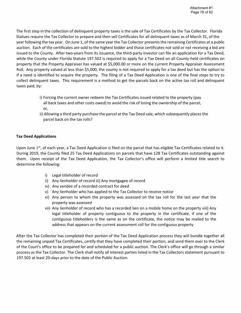
Attachment #1 Page 78 of 82
The first step in the collection of delinquent property taxes is the sale of Tax Certificates by the Tax Collector. Florida
Statues require the Tax Collector to prepare and then sell Certificates for all delinquent taxes as of March 31, of the year following the tax year. On June 1, of the same year the Tax Collector presents the remaining Certificates at a public
auction. Each of the certificates are sold to the highest bidder and those certificates not sold or not receiving a bid are
issued to the County. After two-years from its issuance, the third-party investor can file an application for a Tax Deed, while the County under Florida Statute 197.502 is required to apply for a Tax Deed on all County-held certificates on
property that the Property Appraiser has valued at $5,000.00 or more on the current Property Appraiser Assessment Roll. Any property valued at less than $5,000, the county is not required to apply for a tax deed but has the option to
if a need is identified to acquire the property. The filing of a Tax Deed Application is one of the final steps to try to
collect delinquent taxes. This requirement is a method to get the parcels back on the active tax roll and delinquent taxes paid, by:
i) Forcing the current owner redeem the Tax Certificates issued related to the property (pay
all back taxes and other costs owed) to avoid the risk of losing the ownership of the parcel,
or,
ii) Allowing a third party purchase the parcel at the Tax Deed sale, which subsequently places the parcel back on the tax rolls?
Tax Deed Applications
Upon June 1st, of each year, a Tax Deed Application is filed on the parcel that has eligible Tax Certificates related to it. During 2019, the County filed 25 Tax Deed Applications on parcels that have 128 Tax Certificates outstanding against
them. Upon receipt of the Tax Deed Application, the Tax Collector’s office will perform a limited title search to determine the following:
i) Legal titleholder of record
ii) Any lienholder of record iii) Any mortgagee of record
iv) Any vendee of a recorded contract for deed
v) Any lienholder who has applied to the Tax Collector to receive notice
vi) Any person to whom the property was assessed on the tax roll for the last year that the
property was assessed
vii) Any lienholder of record who has a recorded lien on a mobile home on the property viii) Any
legal titleholder of property contiguous to the property in the certificate, if one of the
contiguous titleholders is the same as on the certificate, the notice may be mailed to the
address that appears on the current assessment roll for the contiguous property
After the Tax Collector has completed their portion of the Tax Deed Application process they will bundle together all
the remaining unpaid Tax Certificates, certify that they have completed their portion, and send them over to the Clerk of the Court’s office to be prepared for and scheduled for a public auction. The Clerk’s office will go through a similar process as the Tax Collector. The Clerk shall notify all interest parties listed in the Tax Collectors statement pursuant to
197.502 at least 20-days prior to the date of the Public Auction.

Attachment #1 Page 79 of 82
Public Sale
Upon the completion of the notifications process, the Clerk’s Office will schedule a Public Sale, will advertise the Public Sale once a week for four consecutive weeks in a newspaper selected as provided in FS 197.402 and on the date of the sale as it appears in the advertisement the Clerk’s office will administer a Public Sale of all the parcels with applications for Tax Deed. The opening bid on non-homesteaded properties will be the value of all outstanding certificates against the property, omitted taxes that should have been assessed, all delinquent taxes, interest and all other fees and costs.
If the property is homesteaded on the latest tax roll, in addition to the amounts listed for non-homesteaded properties
an amount equal to 50% of the latest assessed value of the homestead will be required in the opening bid.
If the parcel is not redeemed by the owner prior to the publish sale date, the remaining properties will be
presented at the scheduled Public Sale. Properties schedule for the Public Sale will be sold to the highest bidder,
at the auction. The highest bidder must post a non-refundable deposit of 5% of the bid or $200, whichever is greater. Then, within 24-hours of the auction the highest bidder must make full payment, plus doc stamps and
recording fees to complete the transfer of the parcel from the current taxpayer to the highest bidder via Tax Deed
under the provisions of FS 197.512/522. If no bid is received at the auction, whether county-held or individually held certificates, or the winning bidder fails to pay the amounts due for issuance of a tax deed within 30 days after
the sale, the Clerk shall enter the land on a list entitled “lands available for taxes” (LOLA)
During 2019,
1. Real Estate Division filed 25 Tax Deed Applications with the Clerk of the Court’s Office. 2. The Clerk of the Court held eight (8) Public Sales
3. The Clerk’s office brought 213 Tax Deed Applications to Public Sale; 17 were filed by Leon County and 166 were
filed by other investors.
4. The resulting impact of the 213 Tax Deed Applications brought to Public Sale during the 2019 application
process
a. 122 redeemed prior to public sale, recovering $1,040,667.90 in back taxes, interest and fees b. 58 sold at public sale to third-party investors, recovering $ $1,054,481.60 in back taxes, interest and fees
c. 32 received no bid at the public sale and have been placed on the List of Lands Available for Taxes
(LOLA) d. 22 Tax Deed Applications were withdrawn for their Public Sale.
5. A total of 180 parcels went back onto the tax rolls and all delinquent taxes and fees related were collected from
these parcels
List of Lands Available for Taxes (LOLA)
On county-held or individually held certificates for which there are no bidders at the public sale and for which the
certificate holder fails to timely pay costs of resale or fails to pay the amounts due for issuance of a tax deed within 30 days after the sale, the Clerk shall enter the land on a list entitled “lands available for taxes” and shall immediately notify the County Commission that the property is available. During the first 90 days after the
property is placed on the list, the county may purchase the land for the opening bid or may waive its rights to purchase the property. Thereafter, any person, the county, or any other governmental unit may purchase the
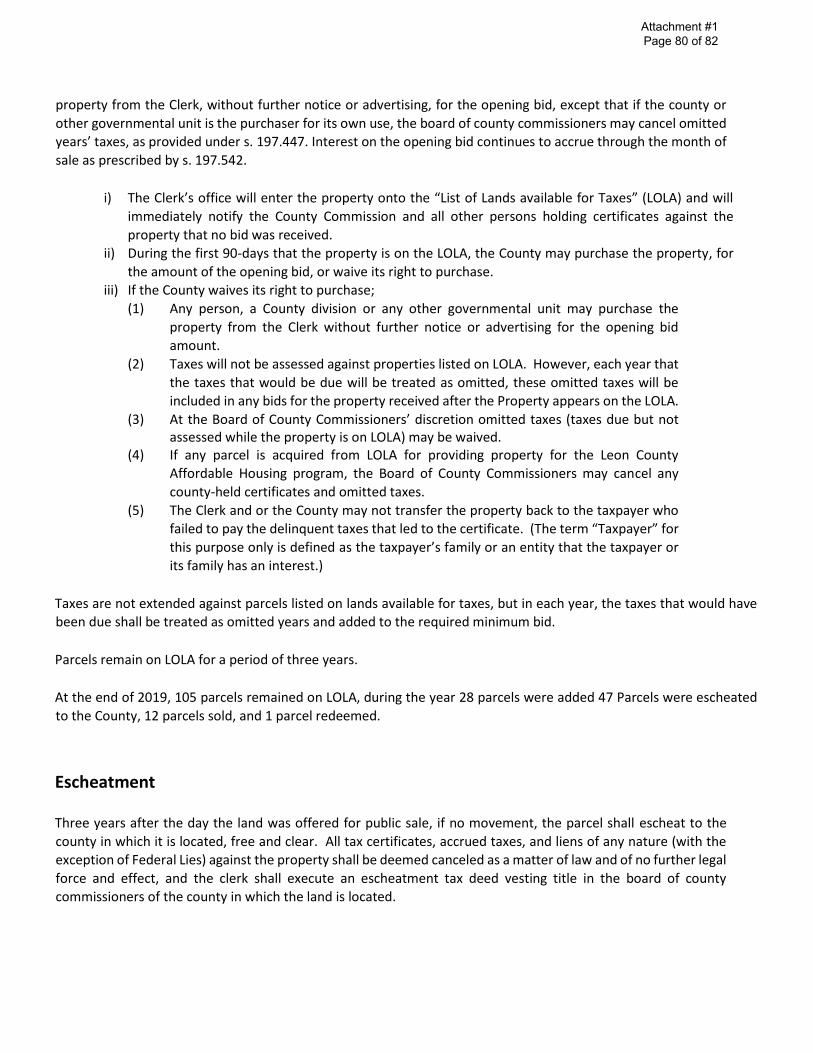
Attachment #1 Page 80 of 82
property from the Clerk, without further notice or advertising, for the opening bid, except that if the county or
other governmental unit is the purchaser for its own use, the board of county commissioners may cancel omitted years’ taxes, as provided under s. 197.447. Interest on the opening bid continues to accrue through the month of
sale as prescribed by s. 197.542.
i) The Clerk’s office will enter the property onto the “List of Lands available for Taxes” (LOLA) and will immediately notify the County Commission and all other persons holding certificates against the
property that no bid was received. ii) During the first 90-days that the property is on the LOLA, the County may purchase the property, for
the amount of the opening bid, or waive its right to purchase.
iii) If the County waives its right to purchase;
(1) Any person, a County division or any other governmental unit may purchase the
property from the Clerk without further notice or advertising for the opening bid
amount.
(2) Taxes will not be assessed against properties listed on LOLA. However, each year that
the taxes that would be due will be treated as omitted, these omitted taxes will be included in any bids for the property received after the Property appears on the LOLA.
(3) At the Board of County Commissioners’ discretion omitted taxes (taxes due but not assessed while the property is on LOLA) may be waived.
(4) If any parcel is acquired from LOLA for providing property for the Leon County
Affordable Housing program, the Board of County Commissioners may cancel any
county-held certificates and omitted taxes.
(5) The Clerk and or the County may not transfer the property back to the taxpayer who failed to pay the delinquent taxes that led to the certificate. (The term “Taxpayer” for this purpose only is defined as the taxpayer’s family or an entity that the taxpayer or its family has an interest.)
Taxes are not extended against parcels listed on lands available for taxes, but in each year, the taxes that would have been due shall be treated as omitted years and added to the required minimum bid.
Parcels remain on LOLA for a period of three years.
At the end of 2019, 105 parcels remained on LOLA, during the year 28 parcels were added 47 Parcels were escheated
to the County, 12 parcels sold, and 1 parcel redeemed.
Escheatment
Three years after the day the land was offered for public sale, if no movement, the parcel shall escheat to the
county in which it is located, free and clear. All tax certificates, accrued taxes, and liens of any nature (with the
exception of Federal Lies) against the property shall be deemed canceled as a matter of law and of no further legal
force and effect, and the clerk shall execute an escheatment tax deed vesting title in the board of county commissioners of the county in which the land is located.

I
Attachment #1 Page 81 of 82
When a property escheats to the county under this subsection, the county is not subject to any liability imposed
by chapter 376 or chapter 403 for preexisting soil or groundwater contamination due solely to its ownership. However, this subsection does not affect the rights or liabilities of any past or future owners of the escheated
property and does not affect the liability of any governmental entity for the results of its actions that create or
exacerbate a pollution source.
The current projections for Escheatment’s to the County are as follows;
Number
Of ParcelsAcres
Taxable
Value
Possible
Homestead
Parcels
Located in
City
Parcels Located
in County
Possible Escheatments to Leon County47 25.434 649,921 1 23 24
31 57.511 492,464 2 13 18
27 34.240 317,894 3 10 17
Total Possible Escheatments to Leon County 105 117.185 1,460,279 6 46 59
27 Parcels Scheduled to Escheat in 2022
31 Parcels Scheduled to Escheat in 2021
Escheatment Schedule for the List of Lands Available for Taxesas of December 31, 2019
Total Remaining Escheatments during 2020
Due to this increasing growth from Escheatment, the Real Estate Division has developed procedures to effectively
dispose of this inflow to the Land Portfolio including:
1. Starting Quiet Title action on a half dozen parcels
2. Monthly circulation among County Staff a Report on the Status of the Parcels on LOLA for review and
evaluation to determine if there is a need within the County to maintain a parcel or parcels in the portfolio
for public use
3. During 2018, the Real Estate Division increased its activity in notification of the previous property owners that
the county has taken ownership of their property and if they can pay the back taxes, fees and interest, the
county will sell the parcel back to them
4. Working with the Housing Division and HFA to identify parcels that would be suitable for affordable housing
5. Partnering with the HFA to determine parcels that are suitable for donation to organization like Habitat for Humanity and the newly create Community Land Trust for the construction of affordable housing.
6. On non-developable parcels, usually caused by their size, encroachments, ingress and egress and other zoning
& growth issues, contacting adjacent property owners to offer them for sale
7. Procuring the services of a residential real estate brokers for the purpose listing available parcels on multi-
listing, marketing to sell. Through the invitation to bid, Ketcham Realty was selected to handle the sale of
selected parcels. In February 2019, the first 15 parcels were listed with positive sale results.
During 2019, the following activity took place in the parcels identified as Affordable Housing. At the beginning of the
year we had 110 parcels that had been approved for Sale in the “Tax Deed” Category within the Leon County Real
Estate Portfolio. During the year we added 30 parcels, sold 34 parcels, generating net proceeds of $238,358.77 and

-------------------------
Attachment #1 Page 82 of 82
redeemed 4 parcels, by selling the parcels to previous Owner or their immediate family, generating $32,974.39.
Additional details regarding the Affordable Housing Parcels.
Status Listing Price Contract
Price
Cost of
Sale
Net
Proceeds
Listing
Reim from
HFA
Net
Proceeds to
HFA
Listed 8 $102,500.00 $ - $ 1,500.00 $ - $ - $ -
AH 33 - - - - - -
Bid - - - - - - -
Contract 1 15,000.00 8,000.00 - - - -
Sold 34 281,800.00 259,700.00 20,331.24 238,368.77 13,124.16 225,287.61
Settlement 4 - - - - - -
Eminent
Domain 1 16,000.00 16,000.00 - - - -
Redeemed 4 32,974.39 32,974.39 - 32,974.39 - -
Donated 1 - - - - - -
TLC 17 52,500.00 - 4,000.00 - - -
TBD 24 - - - - - -
Rejected 12 - - - - - -
Total 139 $500,774.39 0.00 $316,674.39 0.00 $25,831.24 $271,343.16 $13,124.16 $225,287.61
Affordable Housing Parcels Activity 2017, 2018 & 2019
as of December 31, 2019