COUNTY OF SAN MATEO PLANNING AND BUILDING … of san mateo planning and building department ......
35
COUNTY OF SAN MATEO PLANNING AND BUILDING DEPARTMENT DATE: February 25, 2015 TO: Planning Commission FROM: Planning Staff SUBJECT: EXECUTIVE SUMMARY: Consideration of a Coastal Development Permit for the removal of a portion of a legal fence within the public right-of-way and installation of a metal guard rail, at the west end of Seventh Street, in the unincorporated Montara area of San Mateo County. This project is appealable to the California Coastal Commission. County File Number: PLN 2014-00302 (SMCo. Dept. of Public Works) PROPOSAL The applicant, San Mateo County Department of Public Works (DPW) is requesting a Coastal Development Permit to install a metal beam guard rail at the west end of Seventh Street in Montara. The guard rail will be approximately 30 linear feet in length, in two connected segments, and approximately 29 inches in height. In conjunction with the construction of the guard rail, the applicant is proposing to remove approximately 30 feet of an existing, legal wooden fence that extends into the public right-of-way. Removal of the fence will open up public access (views) at the end of Seventh Street. The new guardrail will be placed on the footprint of the removed fence so that there is no reduction in access into the driveway at 101 Seventh Street. The guard rail will be installed along the southern edge of the pavement, adjacent to an existing myoporum shrub. Work will be scheduled to occur when the forecast shows a 3-day period of dry weather. A sandbag berm will be temporarily installed near an adjacent culvert inlet to prevent impacts to water quality during construction. All heavy equipment will be operated from the roadway and construction will remain within the County right-of-way. No significant vegetation will be removed in order to construct this project. RECOMMENDATION Approve the Coastal Development Permit, County File Number PLN 2014-00302, by adopting the required findings and conditions of approval.
Transcript of COUNTY OF SAN MATEO PLANNING AND BUILDING … of san mateo planning and building department ......

COUNTY OF SAN MATEOPLANNING AND BUILDING DEPARTMENT
DATE: February 25, 2015
TO: Planning Commission
FROM: Planning Staff
SUBJECT: EXECUTIVE SUMMARY: Consideration of a Coastal Development Permit for the removal of a portion of a legal fence within the public right-of-way and installation of a metal guard rail, at the west end of Seventh Street, in the unincorporated Montara area of San Mateo County. This project is appealable to the California Coastal Commission.
County File Number: PLN 2014-00302 (SMCo. Dept. of Public Works)
PROPOSAL
The applicant, San Mateo County Department of Public Works (DPW) is requesting a Coastal Development Permit to install a metal beam guard rail at the west end of Seventh Street in Montara. The guard rail will be approximately 30 linear feet in length, in two connected segments, and approximately 29 inches in height. In conjunction with the construction of the guard rail, the applicant is proposing to remove approximately 30 feet of an existing, legal wooden fence that extends into the public right-of-way. Removal of the fence will open up public access (views) at the end of Seventh Street. The new guardrail will be placed on the footprint of the removed fence so that there is no reduction in access into the driveway at 101 Seventh Street.
The guard rail will be installed along the southern edge of the pavement, adjacent to an existing myoporum shrub. Work will be scheduled to occur when the forecast shows a 3-day period of dry weather. A sandbag berm will be temporarily installed near an adjacent culvert inlet to prevent impacts to water quality during construction. All heavy equipment will be operated from the roadway and construction will remain within the County right-of-way. No significant vegetation will be removed in order to construct this project.
RECOMMENDATION
Approve the Coastal Development Permit, County File Number PLN 2014-00302, by adopting the required findings and conditions of approval.

2
SUMMARY
The fence across Seventh Street was constructed at some point in the 1960s under the auspices of an encroachment permit granted by the County’s Engineering and Road Department (as DPW was then known). As such, the fence predates the Coastal Act. The fence is considered a legal, non-conforming structure, in that it does not conform to the County’s fence regulations (it exceeds the maximum fence height of six feet), but was constructed with a permit. However, all encroachment permits are revocable. The applicant, DPW, has determined that it is in the public interest to modify the encroachment permit as proposed in this project.
As a County agency, the Department of Public Works is exempt from local building and zoning regulations (Government Code 53091); however, a Coastal Development Permitin compliance with Local Coastal Program, Policy 2.1 is required for this project. Staff has completed a review of the project and all the submitted documents and reports against the applicable Local Coastal Program policies. Potential impacts to waterquality were identified. Measures were proposed by the applicant to address these potential impacts and are included as Conditions of Approval 3 and 4 in Attachment A of this report.
For the purposes of compliance with California Environmental Quality Act (CEQA), the County is the lead agency and the Department of Public Works has assumed the role of lead department. As such, DPW has prepared a Categorical Exemption under Section 15301 (Repair of Existing Facilities) of the CEQA Guidelines.
The first part of the proposed project (removal of the legal fence) will more clearly define the public’s access rights within the Seventh Street public right-of-way and is consistent with the public access component of the County’s Local Coastal Program. The second part of the project (construction of the guard rail) is necessary to address potential safety issues created by the removal of the fence. At the present time, there are insufficient measures to prevent cars from inadvertently driving over the bluff edge. Staff believes that if the project is implemented as proposed and with the conditions of approval contained in Attachment A, then the project will be consistent with the Coastal Act and the County’s Local Coastal Program policies regarding public access and recreation.
MS:pac - MJSZ0165_WPU.DOCX

COUNTY OF SAN MATEOPLANNING AND BUILDING DEPARTMENT
DATE: February 25, 2015
TO: Planning Commission
FROM: Planning Staff
SUBJECT: Consideration of a Coastal Development Permit, pursuant to Section 6328.4 of the County Zoning Regulations, for the removal of a portion of a legal fence within the public right-of-way and installation of a metal guard rail, at the west end of Seventh Street, in the unincorporated Montara area of San Mateo County. This project is appealable to the California Coastal Commission.
County File Number: PLN 2014-00302 (SMCo. Dept. of Public Works)
PROPOSAL
The applicant, San Mateo County Department of Public Works (DPW) is requesting a Coastal Development Permit to install a metal beam guard rail at the west end of Seventh Street in Montara. The guard rail will be approximately 30 linear feet in length, in two connected segments, and approximately 29 inches in height. In conjunction with the construction of the guard rail, the applicant is proposing to remove approximately 30 feet of an existing, legal wooden fence that extends into the public right-of-way. Removal of the fence will open up public access (views) at the end of Seventh Street. The new guardrail will be placed on the footprint of the removed fence so that there is no reduction in access into the driveway at 101 Seventh Street.
The guard rail will be installed along the southern edge of the pavement, adjacent to an existing myoporum shrub. Work will be scheduled to occur when the forecast shows a 3-day period of dry weather. A sandbag berm will be temporarily installed near an adjacent culvert inlet to prevent impacts to water quality during construction. All heavy equipment will be operated from the roadway and construction will remain within the County right-of-way. No significant vegetation will be removed in order to construct this project.
RECOMMENDATION
Approve the Coastal Development Permit, County File Number PLN 2014-00302, by adopting the required findings and conditions of approval.

2
BACKGROUND
Report Prepared By: Michael Schaller, Senior Planner, Telephone 650/363-1849
Applicant: San Mateo County Department of Public Works
Owner: San Mateo County
Location: West end of Seventh Street, Montara, adjacent to 101 - Seventh Street.
APN: Public Right-of-Way (ROW) and adjacent to 036-057-240
Existing Zoning: R-1/S-17/DR (Single-Family Residential/5,000 sq. ft. minimum parcel size/Design Review)
General Plan Designation: Medium Density Residential
Existing Land Use: Public Road/Single-Family Residences
Flood Zone: The project site is located in an area of minimal flooding (Zone X), per FEMA Panel 06081C0117E, effective date October 16, 2012.
Environmental Evaluation: The County is the lead agency and DPW has assumed therole of lead department, per the County CEQA Guidelines. The Department of Public Works has filed a Notice of Exemption under Section 15301 (Repair of Existing Facilities) of the California Environmental Quality Act.
Setting: The project vicinity consists of residential development to the north, south, and east and the Pacific Ocean to the west. Based on geographic information system tools, the Pacific Ocean is approximately 150 feet west of the project site, and is not expected to be impacted by the project activities. At the project site, an existing concrete swale located along the southern edge of Seventh Street collects runoff from nearby streets and ditches and deposits the runoff into the Pacific Ocean. The understory beneath the landscaping shrubs at the cliff edge is comprised of non-native vegetation such as Bermuda buttercup, myoporum, cheeseweed, bull thistle, sow thistle, bur clover, ripgut brome, and wild oat. There is a large cypress bush on the ocean side of the existing fence that will remain after fence removal. The shrubs planted at the cliff edge are non-native myoporum which do not adequately obstruct vehicles from inadvertently driving over the cliff.

3
DISCUSSION
A. KEY ISSUES
1. Conformance with the County General Plan and Zoning Regulations
Pursuant to Section 53091 of the California Government Code, projects undertaken by the Department of Public Works are exempt from review under the County’s Zoning Regulations. However, the project is subject to the policies of the General Plan.
Vegetative, Water, Fish and Wildlife Resources Policies
Policy 1.27 (Regulate Development to Protect Sensitive Habitats). As discussed above, there is a storm drain intake adjacent to the proposed work area. This storm drain line empties into the Fitzgerald Marine Preserve Area of Special Biological Significance (ASBS) which is a designated sensitive habitat. A sandbag berm will be temporarily installed at the culvert inlet to prevent impacts to water quality during construction. The sandbag berm will be removed once the project has been completed and the concrete (for the guardrail posts) has fully cured.
In addition, the applicant is proposing to implement their Best Management Practices (BMPs) including:
a. Project will begin when the forecast shows 3-day period of dry weather. If rain is forecasted within 30 days following application of concrete, a commercial sealant will be applied to the concrete to prevent impacts to water quality.
b. Openings will be covered at the end of the work day so as to avoid inadvertently trapping wildlife.
c. Pre-construction briefing of all personnel involved in the project by a qualified biologist including sensitive species training and BMPsimplementation.
d. Project construction shall be preceded by a pre-construction survey by a qualified biologist to identify and prevent impacts to rare plants, special status species, nesting birds, and water quality.
(1) Rare plants will be identified using high visibility flagging and a 15-foot protective buffer will be established around the plant.

4
(2) Active passerine bird nests will receive a 50-foot protective buffer while raptorial/ardeid bird nests will receive a 250-foot protective buffer.
(3) If threatened or endangered species are encountered within the project area, work will cease until approval for project continua-tion is received from California Department of Fish and Wildlife (CDFW) and the United States Fish and Wildlife Service.
Implementation of these measures, as well as the other measures contained as conditions of approval in Attachment A should reduce the potential of impact to sensitive habitats to a negligible level.
Visual Quality Policies
Policy 4.21 (Scenic Corridors). This policy calls for the protection and enhancement of the visual quality of scenic corridors by managing the location and appearance of structural development. The project site is within the Cabrillo Highway County Scenic Corridor. The structures that DPW is proposing to place at the edge of the roadway (two connected guardrail segments) should not be visually significant or obtrusive when viewed from Cabrillo Highway, which is approximately 250 feet east of the project site. Moreover, these are the types of safety structures that are typically seen along cliff edges and would not be considered out of place by the average motorist. Additionally, DPW will be removing the non-permitted fence that is currently within the public right of way. This fence blocks public views of the ocean from a public viewing point (Seventh Street). Both actions are consistent with the intent of this General Plan policy.
2. Conformance with San Mateo County Local Coastal Program (LCP)
A Coastal Development Permit is required pursuant to San Mateo County Local Coastal Program Policy 2.1, which mandates compliance with the California Coastal Act for any government agency wishing to undertake development in the Coastal Zone. Development includes all public transportation facilities, including roads and highways and related facilities (Policy 2.2). Summarized below are the following sections of the LCP that are relevant to this project:
a. Sensitive Habitats Component
Policy 7.3 (Protection of Sensitive Habitats). This policy requires that development in areas adjacent to sensitive habitats be sited and designed to prevent impacts that could significantly degrade these resources. All uses shall be compatible with the maintenance of biologic productivity of the habitats. As discussed above, the project

5
site sits adjacent to the Fitzgerald Marine Preserve ASBS and drains into it. Soil disturbance to construct the project could result in sediment entering into the ASBS if no measures are taken address this possibility. As discussed above, the applicant is proposing to implement erosion control measures as part of their project to avoid this potential impact.
Policy 7.5 (Permit Conditions). This policy requires, as part of the development review process, that the applicant demonstrate that there will be no significant impact on sensitive habitats. This is achieved by having the applicant submit a biological report outlining what resources exist at the project location and how the project may impact those resources. As part of their application submittal, the applicant submitted a biological report for the project, which identified potential impacts to the ASBS and recommended mitigation measures to minimize those impacts, as was discussed above. The biotic report did not identify any special status plant species at the work site. No special status animal species were identified during the biologist’s site visit, nor was habitat for special status species identified at the site.
b. Visual Resources Component
Policy 8.4 (Cliffs and Bluffs). This policy requires that development be setback from the bluff edge sufficiently far to ensure it is not visually obtrusive when viewed from the shoreline except in highly developed areas where adjoining development is nearer the bluff edge, or in special cases where a public facility is required to serve the public safety, health, and welfare. The purpose of the project is to ensure the public’s safety by adequately obstructing vehicles from inadvertently driving over the cliff. The guard rails will be setback approximately 5-8 feet from the edge of the bluff. However, given their relatively short height (29 inches), it is not anticipated that the guardrails will be visible from the shoreline area below.
Policy 8.32 (Regulation of Scenic Corridors in Urban Areas). This policy is directed more toward building design within the scenic corridor rather than incidental public works structures such as the focus of this project. However, one aspect of the design standards that is applicable to this project is color. The applicant has not stated whether the guardrails will be painted or left in a bare metal condition. Painting the guardrails a brown earth tone color will allow them to blend in with the surrounding natural vegetation. A condition of approval has been included to ensure that the guardrails are painted (Condition No. 3).

6
c. Shoreline Access Component
Policy 10.1 (Permit Conditions for Shoreline Access). This policy requires the provision of some form of shoreline access as a condition of granting development permits for any public or private project between the sea and the nearest road. The purpose of the first phase of the project is to remove an impediment to the existing public access at this location. Public access to the physical end of the Seventh Street ROW currently exists. There is an open door through the existing fence that any member of the public can go through in order to access the viewing point on the bluff. However, the fence could give those who are unfamiliar with the location the impression that the area behind the fence is private property, thus discouraging members of the public from visiting the area. Removal of the proposed segment of the fence (in conjunction with the proposed fence in front of 101 Seventh Street) will clarify the public’s right to access this area.
Policy 10.3 (Definition of Shoreline Access). This policy defines shoreline access as the provision of access for the general public from a public road to and along the shoreline. In the case of this location, shoreline access falls into the vertical category:
Define vertical access as a reasonably direct connection between the nearest public roadway and the shoreline. Define shoreline as a beach, where contact with the water’s edge is possible, or a bluff, where only visual access is afforded.
Physical access to the water’s edge is not practicable at this location. The bluffs are steep and there is limited retreat area at the base of the bluffs. This particular stretch of coastline is dominated by rocky shelves and lacks a sandy beach area. To the north is Montara State Beach which does provide extensive, wide sandy beaches. The bluff top area provides a safe visual access point in compliance with this policy.
Policy 10.9 (Public Safety). This policy requires the provision of safe access to shoreline destinations which are large enough to accom-modate public safety improvements and public use, including bluffs which are large enough and of a physical character to accommodate safety improvements and which provide room for public use as a vista point. The vista point that will be opened up by removal of the fence islimited in size. Placement of the guard rails closer to the bluff edge would make physical access to the area easier, however, such placement would diminish their ability to prevent a car from driving

7
over the bluff, as well as potentially increase erosion (during construction) and necessitate the removal of existing vegetation that has significant scenic value.
Policy 10.23 (Access Trails). This policy outlines development standards for protecting public safety, specifically:
(1) Give preference to providing access trails in level, safe areas.
(2) Where no such safe areas exist, provide the following trail improvements, including but not limited to: (1) staircases down steep bluffs, (2) fences along the edges of narrow bluffs, and (3) handrails and steps on steep terrain.
(3) Design and site trail improvements to blend with the natural environment. Prohibit the disturbance or alteration of landforms which would cause or contribute to erosion or geologic hazards.
(4) Refer to the Site Specific Recommendations for Shoreline Destinations (Table 10.6) for a listing of required improvements to protect public safety at existing sites.
(5) Post caution signs on all difficult access trails
The applicant, DPW, is not a public recreation service provider. The applicant is simply partially revoking a legal encroachment permit issued in the 1960s. The proposed guardrails are a necessary public safety improvement. The area behind the guardrails meets the criteria of Policy 10.23(a) above and as such is the preferred public access. Construction of staircases down the bluff could trigger significant erosion which could undermine the stability of the bluff. As discussed previously, the base of the bluff is not a safe shoreline access point due to limited retreat area. The intention of this project is to improve visual access (coastal views), not lateral access along the Marine Walk right-of-way or vertical access to the water’s edge.
B. ENVIRONMENTAL REVIEW
The County is the lead agency and DPW has assumed the role of lead department, per the California Environmental Quality Act (CEQA) Guidelines. The Department of Public Works has filed a Categorical Exemption under Section 15301 (Existing Facilities) of the California Environmental Quality Act. This Section of CEQA exempts “the repair of existing public or private structures involving negligible or no expansion of use” and includes existing highways and roads as a category of existing structures.

8
C. REVIEWING AGENCIES
California Coastal CommissionMidcoast Community Council
On January 28, 2015, staff received comments from the Coastal Commission (Attachment H) regarding this project. A majority of the letter consists of project description and a request to include analysis of specific policies from the County’s LCP, which was performed above. The substantive comments are addressed below:
“Commission staff recommends that the entire wooden fence be removed from the right-of-way. Complete removal of the fence is warranted because as constructed it interferes with the public’sability to laterally access the bluff top public property, specifically Marine Walk that extends along the top of the bluff parallel and seaward to the Westerfield private property.”
Staff response: An insistence that the remaining portion of the fence will inhibit, either physically or visually, public access at the end of Seventh Street is factually incorrect. Removal of the remaining portion of the fence will neither increase nor decrease the public’s ability to access both the viewing spot within the Seventh Street corridor and the Marine Walk path. The southerly end point of the fence aligns with other encroachments into the Seventh Street right of way (including the retaining wall on the adjacent property at 123 Seventh Street). As such, it presents a consistent visual continuum and provides screening for the house at 101 Seventh Street. It should be noted that the public can access this area right now, by simply walking through the open doorway in the fence. No portion of DPW’s proposed guardrails will block the footpath into Marine Walk. Additionally, removal of more of the fence could encourage the public to park directly in front of the guardrails. Parking at that location would effectively block access into the driveways for both 101 and 123 Seventh Street.
In addition, Coastal Commission staff has recommended that the existing vegetation that is in front and behind the fence be removed in order to remove obstructions to public access. Staff disagrees with this recommendation on two grounds. First, removal of these bushes could contribute to erosion of the bluff and deposition of sediment into the Fitzgerald Marine Preserve’s waters. Second, staff believes removing vegetation to enhance a view sets the wrong precedent with regards to tree and brush removal. It undercuts staff’s attempts to protect trees on private land (or at other locations on public land) that owners may wish to remove in order to enhance their private views.
On February 12, 2015, staff also received comments from the Midcoast Community Council (Attachment I). The Council’s comments echo the Coastal Commission’s: removal of the fence in its entirety and the removal of the large

9
shrubs in the right-of-way. Staff has responded to both these items above, under the response to the Coastal Commission.
ATTACHMENTS
A. Recommended Findings and Conditions of ApprovalB. Location MapC. Site MapD. Plan ElevationsE. Standard Guardrail PlansF. Biotic ReportG. Department of Public Works’ Categorical ExemptionH. California Coastal Commission Comment Letter, dated January 28, 2015I. Midcoast Community Council Comment Letter, dated February 12, 2015
MS:pac - MJSZ0166_WPU.DOCX

10
Attachment A
County of San MateoPlanning and Building Department
RECOMMENDED FINDINGS AND CONDITIONS OF APPROVAL
Permit or Project File Number: PLN 2014-00302 Hearing Date: February 25, 2015
Prepared By: Michael Schaller For Adoption By: Planning CommissionSenior Planner
RECOMMENDED FINDINGS
Regarding the Environmental Review, Find:
1. That this project is categorically exempt pursuant to Section 15301 of the California Environmental Quality Act, consisting of the repair of existing public or private structures involving negligible or no expansion of use.
Regarding the Coastal Development Permit, Find:
2. That the project, as described in the application and accompanying materials required by Zoning Regulations Section 6328.7 and as conditioned in accordance with Section 6328.14, conforms with the plans, policies, requirements and standards of the San Mateo County Local Coastal Program as discussed in the staff report under Section A.2, including protection of biological resources.
3. Where the project is located between the nearest public road and the sea, that the project is in conformity with the public access and public recreation policies of Chapter 3 of the Coastal Act of 1976 (commencing with Section 30200 of the Public Resources Code). As discussed in the staff report, there is no physical constraint that prevents any member of the public from accessing the area behind the existing fence. However, the presence of the fence could lead a casual observer to conclude that this area is private property and off limits to the public. Removal of a portion of the fence will eliminate this perception and increase the public’s visual access to the coast.
RECOMMENDED CONDITIONS OF APPROVAL
Current Planning Section
1. This approval applies only to the proposal, documents and plans described in this report and submitted to and approved by the Planning Commission at the

11
February 25, 2015 meeting. Minor adjustments to the project may be approved by the Community Development Director if they are consistent with the intent of and in substantial conformance with this approval.
2. This permit shall be valid for one year. Any extension of this permit shall require submittal of an application for permit extension and payment of applicable permit extension fees 60 days prior to expiration.
3. The applicant shall paint the guardrails a dark brown color to blend with the surrounding natural vegetation.
Measures Proposed by Applicant
4. Project will begin when the forecast shows 3-day period of dry weather. If rain is forecasted within 30 days following application of concrete, a commercial sealant will be applied to the concrete to prevent impacts to water quality.
5. Erosion control Best Management Practices (BMPs) shall be implemented as needed. Specifically, a sandbag berm will be temporarily installed around the adjacent culvert inlet to prevent any sediment from entering into drainage system. The sandbag berm will be removed once the project has been completed and the concrete has fully cured.
6. Openings will be covered at the end of the work day so as to avoid inadvertently trapping wildlife.
7. Pre-construction briefing of all personnel involved in the project by a qualified biologist including sensitive species training and BMPs implementation.
8. Project construction shall be preceded by a pre-construction survey by a qualified biologist to identify and prevent impacts to rare plants, special status species, nesting birds, and water quality.
a. Rare plants will be identified using high visibility flagging and a 15-foot protective buffer will be established around the plant.
b. Active passerine bird nests will receive a 50-foot protective buffer while raptorial bird nests will receive a 250-foot protective buffer.
c. If threatened or endangered species are encountered within the projectarea, work will cease until approval for project continuation is received from California Department of Fish and Wildlife and the United States Fish and Wildlife Service.
MS:pac - MJSZ0166_WPU.DOCX

Owner/Applicant: Attachment:
File Numbers:
San Mateo County Planning Commission Meeting
MH
1
10 50 100 150 200
Feet
BSan Mateo Co. Dept. of Public Works
PLN2014-302

Owner/Applicant: Attachment:
File Numbers:
San Mateo County Planning Commission Meeting
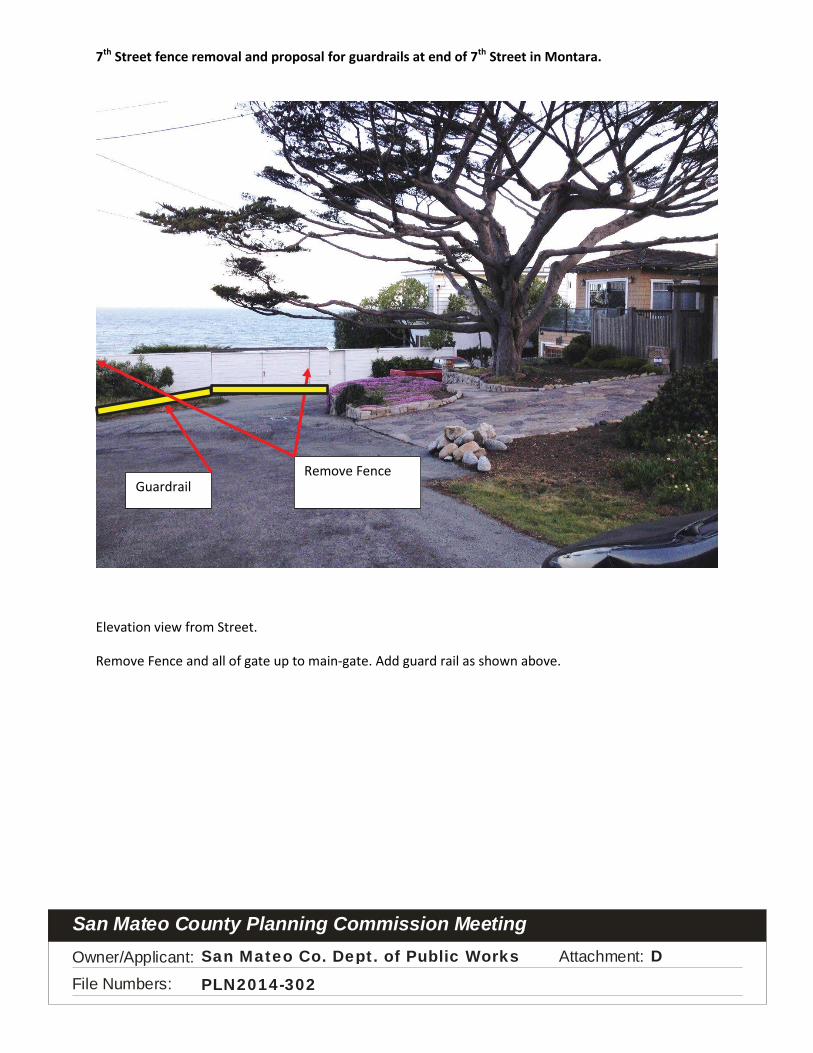
7th Street fence removal and proposal for guardrails at end of 7th Street in Montara.
Plan View of Proposed fence removal.
Addition of guard rails.
Remove a portion of the fence. Proposed location of guardrail to allow for view of ocean.
Proposed location of guardrail to allow for access to existing utility pole, drain line, etc.
Right of Way lines
CSan Mateo Co. Dept. of Public Works
PLN2014-302
Owner/Applicant: Attachment:
File Numbers:
San Mateo County Planning Commission Meeting
7th Street fence removal and proposal for guardrails at end of 7th Street in Montara.
Elevation view from Street.
Remove Fence and all of gate up to ma n-gate. Add guard rail as shown above.
Remove Fence Guardrail
DSan Mateo Co. Dept. of Public Works
PLN2014-302

Ow
ner/A
pplic
ant:
A
ttach
men
t:
File
Num
bers
:
San
Mat
eo C
ount
y Pl
anni
ng C
omm
issi
on M
eetin
gS
an M
ateo
Co.
Dep
t. o
f P
ublic
Wor
ksE
PLN
2014
-302

Co
un
ty o
f Sa
n M
ate
o -
Pla
nn
ing
an
d B
uil
din
g D
ep
art
me
nt

Seventh Street Bollards and Guard Rail Project Project Description
County of San Mateo Department of Public Works August 18, 2014
1
The Seventh Street Bollards and Guard Rail Project (Project) is located at the west end of Seventh Street in unincorporated Montara, San Mateo County (Appendix A, Figure 1 & 3). The County of San Mateo Department of Public Works (County) proposes to remove portions of a wooden fence and install 4 metal bollards and 1 metal beam guard rail at the end of Seventh Street approximately 200 feet west of State Route 1. The proposed Project serves to prevent vehicles from inadvertently driving beyond the cliff’s edge. The Project vicinity consists of residential development to the north, south, and east and the Pacific Ocean to the west (Photo 3). Based on geographic information system tools, the Pacific Ocean is approximately 150 feet west of the Project site.
A site visit was conducted by County biologist, Michael Huynh, on June 13, 2014, to characterize habitats and plant communities, document the presence of sensitive species, and determine appropriate best management practices (BMPs) for the proposed Project. California Department of Fish and Wildlife’s (CDFW) California Natural Diversity Database (CNDDB) was queried to determine if sensitive species occurrences have been documented near the Project site.
The results of the CNDDB query are shown in the Special Status Species Occurrences Map (Appendix A, Figure 2). One occurrence for rose leptosiphon (Leptosiphon rosaceus) and one occurrence for San Francisco gum plant (Grindelia hirsutula var. maritima) exist within a half mile of the Project site. Rose leptosiphon is an herbaceous annual which usually occurs on undisturbed coastal bluff habitat. The flowering period for rose leptosiphon is typically from April to July. San Francisco gum plant is an herbaceous perennial which is typically found in serpentine soils on coastal bluffs and coastal hillsides. The San Francisco gum plant’s flowering period is from June to September. As a perennial plant, San Francisco gum plant is expected to be present year-round and can be identified at least to the genus level based on physical characteristics of the stem and leaves.
The portion of the Pacific Ocean adjacent to the Project site is within the James V. Fitzgerald Area of Special Biological Significance (Fitzgerald ASBS). As stated above, the Pacific Ocean is approximately 150 feet west of the site and is not expected to be impacted by the Project activities. At the Project site, an existing concrete swale located along the southern edge of Seventh Street collects runoff from nearby streets and ditches and deposits the runoff into the Pacific Ocean.
Seventh Street is one of the major cross streets for the unincorporated Montara area. As mentioned, the Project site is bordered by residential development in all directions except the west, which is bordered by the Pacific Ocean. The understory beneath the landscaping shrubs at the cliff edge is comprised of non-native vegetation such as Bermuda buttercup (Oxalis pes-caprae), myoporum (Myoporum laetum), cheeseweed (Malva sp.), bull thistle (Cirsium vulgare),

Seventh Street Bollards and Guard Rail Project County of San Mateo Project Description Department of Public Works
sow thistle (Sonchus sp.), bur clover (Medicago polymorpha), ripgut brome (Bromus diandrus),and wild oat (Avena sp.). The shrubs planted at the cliff edge are non-native myoporum which do not adequately obstruct vehicles from inadvertently driving over the cliff.
The Project consists of removing portions of a wooden fence, installing 4 yellow metal bollards, and constructing a metal beam guard rail near the coastal bluff cliff adjacent to 101 Seventh Street. (Appendix A, Figure 4). Bollard dimensions will be approximately 6 inches in diameter and 3 feet in height and will be positioned at 4-foot intervals. Installation holes will be created by use of a small auger which will drill into the pavement to a depth of approximately 1 foot. Concrete will be slowly poured into the hole to fasten the base of the bollard. Bollards will be installed at 4 locations near the wooden fence and myoporum shrubs at 101 Seventh Street (APN 036057240) (Appendix A, Figure 4). A metal beam-style guard rail will be installed along the edge of pavement with the myoporum shrubs towards 100 Seventh Street (APN 036057110) (Appendix A, Figure 4). The auger will also drill into the pavement to create the guard rail installation holes. The guard rail posts will be inserted into the holes and set with concrete. The guard rail will be approximately 28 inches in height and approximately 30 feet long. Installation of the bollards and guard rail will require approximately 2 working days to complete. The concrete placed at the base of the bollard will require approximately 1 to 2 days to set and 30 days to fully cure. The existing white wooden fence located at 101 Seventh Street has been built within County right-of-way and the portion of the fence and gate adjacent to the shrubs will be removed during the course of this Project. Work will be scheduled to occur when the forecast shows a 3-day period of dry weather. If rain is forecasted within 30 days after bollard installation, a commercial sealant will be applied to the concrete to prevent water quality impacts. A sandbag berm will be temporarily installed near the culvert inlet to prevent impacts to water quality during construction. All heavy equipment will be operated from the roadway and construction will remain within County right-of-way.
Impacts to natural resources are not anticipated to occur as work will mostly be confined to the roadway and roadway shoulder. The proposed bollard installation sites are located within the roadway and disturbed ground near the edge of pavement. Additionally, Seventh Street is regularly disturbed by human activities (e.g., tree trimming, landscaping, dog walkers, vehicular traffic and parking). Additional noise temporarily generated by bollard installation activities are not expected to greatly exceed existing noise levels from nearby residential activities. Active bird nests were not detected within the proposed work area during the June 13, 2014 site visit. The Seventh Street concrete swale did not contain surface water at the time of the survey. No special status species were observed within the vicinity of the Project site.
Best Management Practices and Conservation Measures
All Project-related activities will involve the use of BMPs and conservation measures detailed in the County of San Mateo Watershed Protection Program’s Maintenance Standards (County of San Mateo Department of Public Works, 2004). Potential impacts to biological resources will be

Seventh Street Bollards and Guard Rail Project County of San Mateo Project Description Department of Public Works
minimized or avoided by implementation of the following BMPs and protection and minimization measures:
Project will begin when the forecast shows 3-day period of dry weather.
o If rain is forecasted within 30 days following application of concrete, a commercial sealant will be applied to the concrete to prevent impacts to water quality.
If rain is forecasted, a plastic-lined sandbag berm will be temporarily created at the ditch culvert inlet to prevent potential runoff issues associated with the Project.
Openings will be covered at the end of the work day so as to avoid inadvertently trapping wildlife.
Pre-construction briefing of all personnel involved in repair activities by a qualified biologist including sensitive species training and BMP implementation.
Project shall be preceded by a pre-construction survey by a qualified biologist to identify and prevent impacts to rare plants, special status species, nesting birds, and water quality.
o Rare plants will be identified using high visibility flagging and a 15-foot protective buffer will be established around the plant.
o Active passerine bird nests will receive a 50-foot protective buffer while raptorial/ardeid bird nests will receive a 250-foot protective buffer.
o If threatened or endangered species are encountered within the Project area, work will cease until approval for Project continuation is received from CDFW and the United States Fish and Wildlife Service.

Seventh Street Bollards and Guard Rail Project County of San Mateo Project Description Department of Public Works
Photo 1 – Photo of Project site showing Seventh Street cliff and concrete swale (identified by the dashed line). The shrubs planted at the cliff edge are non-native myoporum which do not adequately prevent vehicles from inadvertently driving over the cliff. The Project proposes to install 4 6-inch diameter bollards at the wooden fence and to construct a 28-inch tall metal guard rail along the ground by the landscaping shrubs towards the utility pole. Additionally, the wooden fence shown in this picture will be removed.

Seventh Street Bollards and Guard Rail Project County of San Mateo Project Description Department of Public Works
Photo 2 – Photo showing vegetation along coastal bluff cliff. Non-native myoporum shrubs have been planted along the 15-foot stretch of the cliff. The shrubs provide little resistance to full-sized vehicles and the danger of driving off or backing into the cliff from the narrow road is exacerbated at night when visibility is impaired. The understory is mostly bare containing non-native ruderal vegetation (e.g., rip-gut brome, wild oat, Bermuda buttercup, bull thistle, and bur clover). The arrow identifies the location of the swale outlet. A sandbag berm will be temporarily installed at the culvert inlet to prevent impacts to water quality during construction. The sandbag berm will be removed once the Project has been completed and the concrete has fully cured.

Seventh Street Bollards and Guard Rail Project County of San Mateo Project Description Department of Public Works
Photo 3 – Photo showing overview of Project site. Project activities involve removing the white wooden fence and installing 4 metal bollards along the coastal bluff edge near the fence. Additionally a metal guard rail will be installed along the edge of pavement adjacent to the fence and myoporum shrubs. See Appendix A Figure 4 for Project Sketch.

Seventh Street Bollards and Guard Rail Project County of San Mateo Project Description Department of Public Works
Appendix A – Figures


August 18, 2014County of San Mateo
Department of Public Works
\\PW-FS1\Data\Users\utility\watershed_protection\PERMITS\WPS2014-009 7th Street Bollards\Maps
Seventh Street Bollards and Guard Rail ProjectFigure 2. Special Status Species Occurrence Map
Source: San Mateo County GIS 2005, CNDDB 2014
MH
Project Site
Half Mile Buffer
Streets
Streams
Monarch butterfly
San Bruno elfin butterfly
Hickman''s cinquefoil
San Francisco gumplant
Rose leptosiphon
Montara
Kanoff
Dea
nCr
eek
Creek
Creek
Pacific Ocean
0.00 0.25 0.50
Miles
Source: County GIS 2005, CNDDB 2014

August 18, 2014County of San Mateo
Department of Public Works
\\PW-FS1\Data\Users\utility\watershed_protection\PERMITS\WPS2014-009 7th Street Bollards\Maps
Seventh Street Bollards and Guard Rail ProjectFigure 3. Project Site Location map
Source: San Mateo County GIS 2005, CNDDB 2014
MH
7th Street
7th Street
Seacliff Court
8th Street
Stat
e R
oute
16th Street
Mai
nSt
reet
1
5th Street
4th Street
1
Project Location
Streets
Streams
0 50 100 150 200
Feet

Co
un
ty o
f Sa
n M
ate
o -
Pla
nn
ing
an
d B
uil
din
g D
ep
art
me
nt


Co
un
ty o
f Sa
n M
ate
o -
Pla
nn
ing
an
d B
uil
din
g D
ep
art
me
nt


Co
un
ty o
f Sa
n M
ate
o -
Pla
nn
ing
an
d B
uil
din
g D
ep
art
me
nt

Midcoast Community Council An elected Advisory Council to the San Mateo County Board of Supervisors
representing Montara, Moss Beach, El Granada, Princeton, and Miramar P.O. Box 248, Moss Beach, CA 94038-0248 - www.MidcoastCommunityCouncil.org
Dave Olson Chris Johnson Lisa Ketcham Dan Haggerty Erin Deinzer Joel Janoe Laura Stein Chair Vice-Chair Secretary Treasurer Date: January 28, 2015
To: Mike Schaller, SMC Planning Dept.
From: Midcoast Community Council, Dave Olson, Chair
Cc: Supervisor Don Horsley CCC staff Nancy Cave, Renee Ananda State Parks, San Mateo Coast Superintendent
Subject: PLN2015-00020: CDP to construct a 4 ft tall wood frame & wire mesh fence within the public right-of-way at the west end of 7th Street in Montara. Fence will be approximately 5 ft into the ROW & will be parallel to the front property line of the parcel at 101 7th Street. Applicant: Westerfield
The Midcoast Community Council has the following comments/recommendations on this Project:
1. We appreciate the simplicity and open structure of the fence design.
2. Locate the new fence within the private parcel, not in the public right-of-way (ROW). No justification is given for the County to allow fencing off for private use 150 sq.ft. on the north side of 7th St. adjacent to the coastal bluff and State Parkland. The fence encroachment serves no legitimate ROW purpose. It would impede already limited driveway access. It plays no role in stormwater runoff management, a significant issue on this street. The accelerated bluff retreat on the south side of 7th St. has already narrowed the ROW and taken a section of the 10-ft-wide undeveloped bluff top Marine Walk with it. This pattern is predicted to continue.1 A fence in this location will effectively block access to the Marine Walk along the bluff with its unusual views of the Coast. LCP Table 10.6 recommends keeping open the ends of residential streets in Montara and developing them as viewpoints.
3. Remove invasive view-blocking Pittosporum shrubs planted on the cliff edge on State Parkland west of the applicant’s house. Cut at ground level and paint fresh cuts with glyphosate.
Thank you for the opportunity to comment. Please keep us informed of any comments received, redesigns, hearings, approvals, or appeals concerning this project. Digital format is preferred ([email protected]).
1 50-year erosion/drainage map, 6/13/2000, http://www.midcoastcommunitycouncil.org/storage/issues/montaracoast/2000-06-13-7thStErosion-map.pdf