COUNTY OF LOS ANGELESfile.lacounty.gov/SDSInter/bos/bc/045483_PDT728.pdf · COUNTY OF LOS ANGELES...
59
COUNTY OF LOS ANGELES DEPARTMENT OF PUBLIC WORKS “To Enrich Lives Through Effective and Caring Service” 900 SOUTH FREMONT AVENUE ALHAMBRA, CALIFORNIA 91803-1331 Telephone: (626) 458-5100 www.ladpw.org DONALD L. WOLFE, Director ADDRESS ALL CORRESPONDENCE TO: P.O. BOX 1460 ALHAMBRA, CALIFORNIA 91802-1460 IN REPLY PLEASE REFER TO FILE: MP-5 154.041 June 1, 2006 The Honorable Board of Supervisors County of Los Angeles 383 Kenneth Hahn Hall of Administration 500 West Temple Street Los Angeles, CA 90012 Dear Supervisors: PRIVATE DRAIN NO. T 728 GRANT OF EASEMENT CITY OF WESTLAKE VILLAGE SUPERVISORIAL DISTRICT 3 3 VOTES IT IS RECOMMENDED THAT YOUR BOARD ACTING AS THE GOVERNING BODY OF THE LOS ANGELES COUNTY FLOOD CONTROL DISTRICT: 1. Acting as a responsible agency pursuant to the California Environmental Quality Act (CEQA), consider the enclosed Negative Declaration/Finding of No Significant Impact, including comments received during the public review process, which was prepared by the California Department of Transportation (Caltrans). This report was approved by Caltrans and the Federal Highway Administration for the Lindero Canyon Road and U.S. 101 Street and Ramp Improvement project on August 23 and September 13, 2001, respectively; find that the granting of the recommended easement is within the scope of the proposed project; find that the proposed project will not have a significant effect on the environment; find that the Negative Declaration/Finding of No Significant Impact document reflects the independent judgment of the County; and approve the Negative Declaration/Finding of No Significant Impact document.
-
Upload
trinhquynh -
Category
Documents
-
view
216 -
download
1
Transcript of COUNTY OF LOS ANGELESfile.lacounty.gov/SDSInter/bos/bc/045483_PDT728.pdf · COUNTY OF LOS ANGELES...

COUNTY OF LOS ANGELES
DEPARTMENT OF PUBLIC WORKS “To Enrich Lives Through Effective and Caring Service”
900 SOUTH FREMONT AVENUE
ALHAMBRA, CALIFORNIA 91803-1331 Telephone: (626) 458-5100
www.ladpw.org
DONALD L. WOLFE, Director
ADDRESS ALL CORRESPONDENCE TO:P.O. BOX 1460
ALHAMBRA, CALIFORNIA 91802-1460
IN REPLY PLEASE
REFER TO FILE: MP-5 154.041
June 1, 2006 The Honorable Board of Supervisors County of Los Angeles 383 Kenneth Hahn Hall of Administration 500 West Temple Street Los Angeles, CA 90012 Dear Supervisors: PRIVATE DRAIN NO. T 728 GRANT OF EASEMENT CITY OF WESTLAKE VILLAGE SUPERVISORIAL DISTRICT 3 3 VOTES IT IS RECOMMENDED THAT YOUR BOARD ACTING AS THE GOVERNING BODY OF THE LOS ANGELES COUNTY FLOOD CONTROL DISTRICT:
1. Acting as a responsible agency pursuant to the California Environmental Quality Act (CEQA), consider the enclosed Negative Declaration/Finding of No Significant Impact, including comments received during the public review process, which was prepared by the California Department of Transportation (Caltrans). This report was approved by Caltrans and the Federal Highway Administration for the Lindero Canyon Road and U.S. 101 Street and Ramp Improvement project on August 23 and September 13, 2001, respectively; find that the granting of the recommended easement is within the scope of the proposed project; find that the proposed project will not have a significant effect on the environment; find that the Negative Declaration/Finding of No Significant Impact document reflects the independent judgment of the County; and approve the Negative Declaration/Finding of No Significant Impact document.

The Honorable Board of Supervisors June 1, 2006 Page 2
2. Acting as a responsible agency pursuant to CEQA, consider and adopt the Mitigation Monitoring Program (included in the Negative Declaration), which was prepared and adopted by Caltrans as a condition of the project to mitigate or avoid significant effects on the environment.
3. Find that the proposed grant of an easement for public road and highway
purposes in, over, and across Private Drain No. T 728 from the Los Angeles County Flood Control District to the City of Westlake Village and the City's subsequent use of said easement will not interfere with the use of Private Drain No. T 728 for any District purpose.
4. Approve the grant of an easement for public road and highway purposes
from the District to the City of Westlake Village within Private Drain No. T 728 (2,455± square feet) for $13,500. The subject parcel is located at the northeast corner of the intersection of Lindero Canyon and Agoura Roads in the City of Westlake Village.
5. Instruct the Chair to sign the enclosed Road Deed and authorize delivery
to the Grantee.
PURPOSE/JUSTIFICATION OF RECOMMENDED ACTION This action will allow the District to grant an easement within Private Drain No. T 728 to the City of Westlake Village. The City requested the easement for the road widening of Lindero Canyon and Agoura Roads in connection with Caltrans' Lindero Canyon Road and U.S. Highway 101 Street and Ramp Improvement project. The granting of this easement is not considered adverse to the District's purposes. Implementation of Strategic Plan Goals This action meets the County Strategic Plan Goal of Fiscal Responsibility. The revenue from this transaction will be used for flood control purposes. FISCAL IMPACT/FINANCING The $13,500 proposed selling price represents the market value of the easement. This amount has been paid and deposited into the Flood Control District Fund.

The Honorable Board of Supervisors June 1, 2006 Page 3 FACTS AND PROVISIONS/LEGAL REQUIREMENTS The granting of this easement will not hinder the use of the channel for possible transportation, utility, or recreational corridors. The enclosed Road Deed has been approved by County Counsel and will be recorded. ENVIRONMENTAL DOCUMENTATION On May 3, 2001, Caltrans, as the lead agency, circulated a Negative Declaration/Finding of No Significant Impact for the Lindero Canyon Road and U.S. 101 Street and Ramp Improvement project in accordance with CEQA requirements. The mitigation measures included in the CEQA document for the project specifically address air quality, archeologic-historic, flood plain/flooding, geologic/seismic, noise, public services, soil erosion/compaction/grading, traffic/circulation, vegetation, and water quality issues. The Negative Declaration/Finding of No Significant Impact concluded that the project, with the proposed mitigation measures, will not have a significant effect on the environment. The public comment period did not raise significant environmental issues with the project; therefore, Caltrans finalized and adopted the Negative Declaration/Finding of No Significant Impact on August 23, 2001. Under CEQA, the District is a responsible agency whose discretionary approval of the project is required in order to carry out the project. As a responsible agency, your Board must consider and adopt the Negative Declaration/Finding of No Significant Impact and the Mitigation Monitoring Plan prepared by Caltrans before the recommended easement is granted. IMPACT ON CURRENT SERVICES (OR PROJECTS) None. CONCLUSION Enclosed are an original and duplicate of the Road Deed. Please have the original and duplicate signed by the Chair and acknowledged by the Executive Officer of the Board. Please return the executed original to Public Works and retain the duplicate for your files.

The Honorable Board of Supervisors June 1, 2006 Page 4 One adopted copy of this letter is requested. Respectfully submitted, DONALD L. WOLFE Director of Public Works DKW:mr P6:\blPDT728.doc Enc. cc: Auditor-Controller (Accounting Division - Asset Management) Chief Administrative Office County Counsel

ORIGINAL
RECORDING REQUESTED BYAND MAIL TO:
City of Westlake ViI/age31200 Oak Crest DriveWestlake ViI/age, CA 91361
Space Above This Line Reserved for Recorder's Use
THIS DOCUMENT IS EXEMPT FROM DOCUMENTARY TRANSFER TAX PURSUANTTO SECTION 11922 OF THE REVENUE & TAXTION CODE. Assessor's Identification Number:
2057 -001-900 (Portion)THIS DOCUMENT IS EXEMPT FROM RECORDING FEES PURSUANT TO SECTION27383 OF THE GOVERNMENT CODE.
ROAD DEEDFor a valuable consideration, receipt of which is hereby acknowledged, the
LOS ANGELES COUNTY FLOOD CONTROL DISTRICT, a body corporate and politic, doeshereby grant to the CITY OF WESTLAKE VILLAGE, a municipal corporation, an easement forpublic road and highway purposes in, on, over, and across aI/ that real property in the City ofWestlake ViI/age, County of Los Angeles, State of California, described in Exhibit A attachedhereto and by this reference made a part hereof.
Dated
LOS ANGELES COUNTY FLOOD CONTROL DISTRICT,a body corporate and politic
(LACFCD-SEAL)By
Chair, Board of Supervisors of theLos Angeles County Flood Control District
ATTEST:
By
File with: TRANSFER DRAINSPRIVATE DRAIN NO. 728
Affects: Agoura Road, Parcel 6-3RE
(File with: Lindero Canyon Road (1))I.M. 159-037S.D. 3 M0523002
Sachi Hamai, Executive Officerof the Board of Supervisorsof the County of Los Angeles
Deputy
NOTE: Acknowledgment form on reverse side.
OG:bwP:\MPM\WORDPRO\TITlE\CONF\OG-RD PO 728.DOC

STATE OF CALIFORNIA )) ss.
COUNTY OF LOS ANGELES )
On January 6, 1987, the Board of Supervisors for the County of Los Angeles andex offcio the governing body of aI/ other special assessment and taxing districts, agencies,and authorities for which said Board so acts adopted a resolution pursuant to Section 25103of the Government Code that authorized the use of facsimile signatures of the Chair of theBoard on aI/ papers, documents, or instruments requiring the Chair's signature.
The undersigned hereby certifies that on this day of ,20_,the facsimile signature ofChair of the Board of Supervisors of the LOS ANGELES COUNTY FLOOD CONTROLDISTRICT was affxed hereto as the offcial execution of this document. The undersignedfurther certifies that on this date, a copy of the document was delivered to the Chair of theBoard of Supervisors of the LOS ANGELES COUNTY FLOOD CONTROL DISTRICT.
In witness whereof, I have also hereunto set my hand and affixed my official seal theday and year above written.
Sachi Hamai, Executive Officerof the Board of Supervisorsof the County of Los Angeles
By
(LACFCD-SEAL)
APPROVED AS TO FORM:
Deputy
RAYMOND G. FORTNER, JR.,
::7MÖ'~--Depu
CERTIFICATE OF ACCEPTANCE
,20DEPARTMENT OF PUBLIC WORKSMapping & Property Management Division
This is to certify that the interest in real property conveyed bythe deed or grant herein, dated , from the LosAngeles County Flood Control District, a body corporate andpolitic, to the City of Westlake Village, a municipal corporation,is hereby accepted pursuant to authority conferred byResolution No. adopted on ,and the grantee consents to the recordation thereof by its dulyauthorized officer.
APPROVED as to title and execution,
Supervising Title Examiner
ByDated
P:Conf:ACKS:floodfax2 w accpt wlk vilge.doc By

EXHIBIT A
File with: TRANSFER DRAINSPRIVATE DRAIN NO. 728
Affects: Agoura Road Parcel No. 6-3RE(File with: Lindero Canyon Road (1))A.P.N. 2057-001-900 (Portion)T.G. 557 (E6)
i. M. 159-037S.D. 3M0523002
LEGAL DESCRIPTION(Grant of easement for public road and highway purposes)
That portion of Lot 2, Tract No. 27425, as shown on map filed in Book 763,pages 45, 46 and 47, of Maps, in the office of the Recorder of the County of LosAngeles, within the fol/owing described boundaries:
Beginning at the most southerly corner of said Lot 2; thence northwesterly alongthe general/y southwesterly boundary of said lot and continuing in a general/y
northwesterly direction along its various courses and curves to the westerly terminus ofthat certain course having a bearing and distance of N 68°28'06" W 45.74 feet in saidgeneral/y southwesterly boundary; thence South 68°28'06" East along said certaincourse, a distance of 25.09 feet; thence leaving said general/y southwesterly boundary,South 34°08'59" West 29.01 feet; thence South 1JD34'20" West 20.20 feet; thenceSouth 53°07'44" East 90.22 feet to the general/y southeasterly boundary of said Lot 2;thence South 13°03'56" West along said general/y southeasterly boundary, a distanceof 12.76 feet to the point of beginning.
Containing: 2,455:t sJ.
To be known as AGOURA ROAD.. .'
LP\DMS fies\mpm0523002.rwe.fleg.doc3/28/2006

Lindero Canyon Road and U.S. Highway 101
Street and Ramp Improvements
Negative Declaration/Finding of No Significant Impact
tJ fHWA ..I1
..11 California Depa.rt~ent of Transportation
. Los Angeles, Distrrct 7
I1 Office of Environmental Planning

.)
¡
¡.,
Street and Ramp Improvements at lindero Canyon Road andU.S. Highway 101, Westlake Vilage, California
(07/LA101 KP59.55/61.15)
INITIAL STUDYIENVIRONMENTAL ASSESSMENT
State of CaliforniaDepartment of Transportation
andU.S. Department of TransportationFederal Highway Administration
Pursuant to: 42 U.S.C. 4332(2)(C)
~Acting Division ChiefCalifornia Department of Transportation
c?~?~ ..Michael G. RitchieDivisiòn AdministratorFederal Highway Administration
Øl6' 0 LdO/Date
~-ILj-OfDate
The following persons may be contacted for additional information concerning this document:
Cesar PerezSenior Transportation EngineerFederal Highway Administration980 Ninth Street, Suite 400Sacramento, CA 95814(916) 498-5860
Ron KosinskiActing Division ChiefCaltrans District 7120 W. Spring StreetLos Angeles. CA 90012(213) 897-0703
John Knipe
City EngineerCity of Westlake Vilage31824 W. Villa Ce RoaWestlake Village, CA 91361(818) 706-.1613

STATE OF CALIFORNIADEPARTMENT OF TRANSPORTATION
SCH No. 2001051009(07/LA101KP59.55/61.15)CU-EA 07186-120161
NEGATIVE DECLARATION
Pursuant to: Division 13, Public Resources Code
Description
,;
The project consists of widening Lindero Canyon Road from Agoura Road to Via Colinas in theCity of Westlake Vilage including median reconstruction and re-striping of Undero CanyonRoad, construction of a bike path and widening the southbound Lindero Canyon Road on-rampto northbound US 101 (Ramp G-6) within the Caltrans right-of-way. The reconstruction andwidening of portions of Lindero Canyon Road and Ramp G-6 was generated by the projectedYear 2020 traffc conditions. Land uses in the immediate vicinity of the project site consist ofOffce Commercial, Specific Plan (Commercial) and Commercial Recreation.
Summary of Review Process'
A Public Notice was published on May 3, 2001 in the Los Angeles Times inviting publiccomments on the Draft Initial Study/Environmental Assessment which was prepared for theproposed project. The public review penod closed on June 18, 2001. The Draft InitialStudylEnvironmental Assessment was also circulated to the State Clearinghouse on May 3,2001 for distrbution to affected agencies for their review and comment.
Summary of Comments Received on Draft Initial Studv/Environmental Assessment
-)
No comments were received on the Draft Initial Study/Environmental Assessment from thepublic. No comments were received from agencies receiving copies of the Draft Initial'StudylEnvironmental Assessment through the State Cleannghouse, with the exception of theCalifornia Department of Fish and "Game (CDFG). The CDFG expressed concerns regardingproject-related water quality impact to streams and watercourses in the project vicinity. TheCDFG also recommended that a pre-construction survey be conducted for bats, swallows, andnesting birds in the project area and that a buffer be maintained. between nesting areas andconstruction activities. Both concerns expressed by the CDFG have been addressed by new orrevised project mitigation measures.
Summary of Mitiqation Measures
1. If .groundwater is encountered during construction and dewatering is necessary, the effuent
generated shall be containerized and disposed of off-site or be treated and discharged on-site after regulatory approval of appropnate permits.
2. If excavation of the sewer line is conducted and soil affected by chlorinated vac is
encountered, the affected soil shall be containerized arid disposed of off-site or be treatedand discharged on-site after regulatory approval of appropriate permits.

-J. Soils alor.g on-ramp G-6 shall be tested for aerially deposited lead in accordance with latestpolicies during the design stage of Phases 1 and 2. If such soils are found, they shall beproperly disposed of in accordance with the special management requirements of a varianceissued to CAL TRANS by the DSTC.
. :~j
4. To reduce noise levels below the established noise standards of the City of WestlakeVillage, the project shall comply with the special provisions of the City's noise ordinanceaddressing construction noise, including provisions Jorlimiting hours of construction in orderto reduce adverse effects on sensitive receptors.
5. Native plant species shall be used to revegetate embankments and roadway edges.Planting and hydroseeding shall be utilized for erosion control purposes.
6. If project activities are to occur during the nesting season of birds (March 1 to September 1),a pre-construction survey for breeding bats and swallows and other nesting birds shall beconducted per California Department of Fish and Game guidelines. A buffer of at least 150feet for construction activities shall be maintained for any active bird bests (500 feet forraptor nests). .
¡
\J
7. The applicant shall consult with local police, fjre and other emergency service providers todevelop temporary alternatives to the use of Lindero Canyon Road as an emergencyresponse or evacuation route during project construction.
8. If buried historic or prehistoric resources are found during the excavation activities,excavation activities shall be halted and an archaeological monitor shall be retained toformally evaluate such resources for their significance and/or importance pursuant to CEQA.
Determination
An Initial Study/Environmental Assessment has been prepared by the California Department ofTransportation (Caltrans). On the basis of this study it is determined that the proposed actionwill not have a significant effect upo'n the environment for the following reasons:
1. There wil be no effect on: unique or natural features, plant or animal life, habitats,archaeological, historic, agricultural, scenic or timber resources, residences, businesses,schools or neighborhoods, flood plains, wetlands or water bodies.
2. There wil be no significant effect on: air or water quality, improvements or increases inenergy consumption.
3. in the project which will reduce potentially
--j
Aziz ElattarActing Deputy District DirectorDivision of Environmental PlanningCalifornia Department of Transportation
~ %- 2 3 _ ? OÐ IDate
~,

FEDERAL HIGHWAY ADMINISTRATIONFINDING OF NO SIGNIFICANT IMPACT
\
FORSTREET AND RAMP IMPROVEMENTS AT LlNDEROCANYON ROAD AND
U.S. HIGHWAY 101, WESTLAKE VILLAGE~ CALIFORNIA
. ~ 'f
The project consists of widening Lindero Canyon Road from Agoura Road to Via Colinas inthe City of Westlake Vilage including median reconstrction and re-sttping 01 Lindero
Canyon Road, construction of a bike path, and widening the southbound Undero CanyonRoad onrramp to northbound US 101 (Ramp G-6) within the Caltrans right-of-way. Thereconstrction and widening of portions ofUndero Canyon Road and Ramp G~6 was .generated by the projected Year 2020 tiaffc cûnditÎons.
The FHWA has determined that this project wil not have any significant impact on the humanenvironment. This finding of no signifcant impact is based on the attched environmentalassessment, which has been independently evaluated by the FHWA and determined toadequately and accrately discuss the environmental issues and impact of the proposed
. project. It provides suffcient evidence and analysis for detemmining that an environmentalimpact statement is not required. The FHWA takes fun responsibilit forthe accuracy. scope,and content of the enclosed EnvironmentalAssessment.
~Lt~César E. PérezSr. "rransporttion Engineer
ih'3/ó iDáte (
.

TABLE OF CONTENTS
A. PURPOSE OF AND NEED FOR PROJECT 1
B. PROJECT DESCRIPTION 4
C. AFFECTED ENVIRONMENT 17
D. ENVIRONMENTAL EVALUATION 21
E. DISCUSSION OF ENVIRONMENTAL EVALUATION 23
F. CONSUL T A TION AND COORDINATION 32
G. REFERENCES 32
H. LIST OF PREPARERS 36
i. TITLE VI POLICY STATEMENT 38
J. MITIGATION MONITORING PLAN 39
K. DISTRIBUTION/MAILING LIST 43
L. COMMENTS RECEIVED AND RESPONSES TO COMMENTS 44
APPENDIX A - PACIFIC SOUTHWEST BIOLOGICAL SERVICES LETTER
APPENDIX B - STATE CLEARINGHOUSE LETTER
Cíty of Westlake Vílage1..;,.;"" Cl..rl.,/C,.,.:--_____...._, JI________~.. Lindero Canyon Road at US 101. .

TABLES
Table No. Description
1
2
3
Level of Service Analyses 2
3
4
Level of Service Definitions for Signalized Intersections
T ASAS Accident Rates
FIGURES
ï Figure No. Description.,
1 Location Map 6
2a Phase 1 Layout 7
2b Phase 1 Layout 8
2c Phase 1 Layout 9
2d Phase 1 Cross Section 10
2e Phase 1 Cross Section 11
2f Phase 1 Cross Section 12
2g Phase 2 Layout 13
2h Phase 2 Layout 14
2i Phase 2 Cross Section 15
3 Public Notice 34
City of Westlake Vilage Lindero Canyon Road at US 101

INITIAL STUDY/ENVIRONMENTAL ASSESSMENT
A. PURPOSE OF AND NEED FOR PROJECT
The City of Westlake Vilage (City) proposes to widen Lindero Canyon Road and Ramp G-6 at U.S. Highway 101 (US 101) K.P.59.55/61.15. The proposal to reconstruct and widenportions of Lindero Canyon Road and ramp G-6 was generated by the projected Year 2020traffc deficiencies as summarized in the combined Project Study ReportProject Report,Section 6, Traffc and Accident Data and WPA Traffc Engineering, Inc, US 101- LinderoCanyon Road PSR Traffc Analysis, April, 1997.
.-i
The project is needed in order to accommodate future anticipated growth and to reducecongestion and related accidents. As can be seen in Table 1, below, four (4) keyintersections wil have deficient operations by the year 2020 without the proposedimprovements. The proposed improvements wil assist the City in achieving objectivesincluded in the City's General Plan Circulation Element. The Circulation Element
establishes LOS C as the minimum acceptable level of service at all intersections withinthe City, except that LOS D is acceptable at intersections along Lindero Canyon Roadbetween Agoura Road and Via Colinas. These minimum acceptable levels of service wilbe achieved (with the exception of the intersection of Lindero Canyon Road and ViaColinas) with implementation of the project.
Lindero Canyon Road is a major arterial highway in the City of Westlake Vilage. It iscurrently striped for two lanes in each direction. The City is currently widening LinderoCanyon Road east of Via Colinas to accommodate three lanes in each direction. Thewidening of Lindero Canyon Road is consistent with the City's General Plan.
The Lindero Canyon Road Interchange with U.S. 101 was constructed in 1974. US 101 isan interregional freeway. The existing roadway consists of eight mixed flow lanes andauxiliary lanes. The 2010 Route Concept Report indicates that US 101 should consist of
.i eight mixed flow and two HOV lanes. The HOV lanes would be accommodated in themedian of this segment of the freeway so that no outside widening would be necessary.This proposal would not interfere with existing usage of US 101 and would be consistentwith and would not affect its future operations. The Lindero Canyon Bridge wil not requirefurther modification in the future when additional (HOV) lanes are added in the future.
Background
The Lindero Canyon Road overcrossing of US 101 (built in 1974) is located in the southernportion of the City of Westlake Vilage. Westlake Village is located in the Conejo Valley, arapidly growing urban area, approximately 20 miles northwest of the City of Los Angeles atthewestern edge of Los Angeles County. US 101 runs in a generally north-south direction(but east-west through Westlake Vilage) and provides access to the Los Angeles region tothe southeast. Lindero Canyon Road carries traffc both within the Westlake Vilage areaand to and from US 101. The widening of Lindero Canyon Road and on-ramp G-6 would
City of Westlake Village Undero Canyon Road at US 101

.'-,
.,
involve excavation for grading and construction of a retaining wal/ along the south side ofthe adjoining Dole Foods Corporation (Dole) property at 5411 Lindero Canyon Road. TheCity of Westlake Village has a cooperative development agreement with Dole and the Stateof California Department of Transportation (CAL TRANS) for improvements along the Dolepropert and the northbound on-ramp to US 101. The City wil acquire a strip along theeastern and southern sides of the Dole property. The strip includes a maximum 8.5 meter(28 foot) width for additional Lindero Canyon Road right-of-way (ROW), and a temporaryconstruction easement of 7.0 meter (22.5 foot) width. Following construction ofimprovements, CAL TRANS will receive and take control of the ROW associated with thelimits of the state highway. The 2010 Route Concept Report states that US 101 at LinderoCanyon Road should consist of eight mixed flow lanes and two HOV lanes. The existingfreeway has eight mixed flow lanes and auxiliary lanes in each direction.
Deficiencies¡.!
A Traffc Analysis Report has been completed for Lindero Canyon Road for existingconditions and the year 2020 with and without traffc improvements.1 A total of fourintersections included in the report were:
. !
!
)
Lindero Canyon Road and Agoura RoadLindero Canyon Road and US 101 Southbound Off-rampLindero Canyon Road and US 101 Northbound Off-rampLindero Canyon Road and Via Colin as
,-or
The results of the existing and Year 2020 traffc condition analysis for these intersectionsare presented in Table 1. The analysis shows deficiencies in the Year 2020, if roadimprovements are not made, at Lindero Canyon Road and Via Colinas in both the a.m. aridp.m. peak hours; at Lindero Canyon Road and Northbound on-ramp in the a.m. peak hour;and, at Lindero Canyon Road and Agoura Road in the p.m. peak hour. An explanation oflevels of service is provided in Table 2.
Table 1
L i fS A
i.1
eve 0 ervice naiysesIntersection Capacitv Utilzation/Level of Service
Year 2020 Year 2020Location Existing Conditions Conditions without Conditions with
Improvements ImprovementsAM PM AM PM AM PM
Lindero Canyon Road and0.76/C O.74/C 1.05/F 1.40/F 0.92/E 0.93/EVia Colinas
Lindero Canyon Road and0.51/A 0.57A 0.82/0 O.77/C 0.79/C O.77/CSouthbound Off-ramp
Lindero Canyon Road and0.53/A 0.60/A 1.01/F 0.84/0 0.80/C 0.72/CNorthbound Off-ramp
Lindero Canyon Road and0.66/B O.76/C 0.83/0 O.96/E O.66/B O.65/BAQoura Road
.. -J
1 WPA Traffc Engineering, Inc, US 101- Undero Canyon Road PSR Traffc Analysis, April, 1997.
City of WesUake Vilage Lindero Canyon Road at US 101

i.-j
Table 2Level of Service Definitions for Signalized Intersections
rii;¡. LOS V/C DEFINITION
A 0.00-0.60 Excellent No vehicle waits longer than one red light andno approach phase is fully used.
8 ::0.60-0.70 Very Good An occasional approach phase if fully utmzed;many drivers begin to feel some what restrictedwithin groups of vehicles.
C ;:0.70-0.80 Good Occasionally drivers may have to wait throughmore than one red light; backups may developbehind turning vehicles.
D ::0.80-0.90 Fair Delays may be substantial during portions of therush hours, but enough lower volume periodsoccur to permit clearing of developing lines,preventing excessive backups.
E ::0.90-1.00 Poor Represents the most vehicle intersectionapproaches can accommodate; may be longlines of waiting vehicles through several signalcycles.
F ::1.00 Failure Backups from nearby locations or on cross-stre-els may i e~ll icl VI pi everrl movenneiil urtremendous delays with continuously increasingqueue lengths.
i.
i
j
. ,i
t'/
~ "
;¡
!y
Accident Data
:':ii-.
Table 3 is a summary of the Caltrans Traffc Accident Surveilance and Analysis System(TASAS) Table B printout for this project's locations at Lindero Canyon Road and SR101for five years. The T AS AS is for the period January 1, 1993 to December 31, 1997. Acomplete copy of the T ASAS, Table B printout for the Lindero Canyon Road Interchange isincluded in the PSR/PR.
....,
City of WesUake Viiage I inrlQm r."nvnn Rn"rl "t 11.0: 1 n1

":1'.,
- ~-;!
l
,j
..
""J
.!
Table 3
T ASAS Accident Rates.
Actual Rates* Average Rates*
Location. Total No.F F + 1 Total F F + 1 Totalof Accidents
5B on from NB Lindero1 0.000 0.00 0.12 0.004 0.23 0.60Canyon Rd
NB off to Lindero Canyon13 0.000. 0.13 0.55 0.005 0.59 1.50Rd
NB on from NB Lindero0 0.000 0.00 0.00 0.002 0.27 0.70Canyon Rd
5B on from 5B Lindero3 0.000 0.09 0.26 0.002 0.27 0.70Canyon Rd
NB on from 5B Lindero4 0.000 0.09 0.36 0.004 0.23 0.60Canyon Rd
5B Off to Lindero Canyon12 0.000 0.22 0.66 0.005 0.59 1.50Rd
*Accidents per Milion Vehicfe Miles
A review of Table 3 indicates that the actual total accident rates are less than the averagerates expected for the locations indicated along Undero Canyon Road. It is expected thatwidening Lindero Canyon Road at these locations wil not increase the actual accidentrates and would instead lower future accident rates by reducing future traffc congestion.
B. PROJECT DESCRIPTION
ALTERNATIVES ANALYSIS
This section describes the alternatives considered for the project: No-build (Alternative A),'. La Tienda Road extension alternative (Alternative "8), and the Preferred Alternative
. (Alternative C).
No Build Alternative - Alternative A
Alternative A, the No Build or "No Project" alternative, would result in no wideningimprovements to Undero Canyon Road or associated ramps at the US 101/UnderoCanyon Road Interchange. While this alternative would result in no construction-relatedimpacts, this alternative would not be consistent with local planning. This alternative doesnot address future traffc deficiencies resulting from continued growth and increasing traffclevels. As indicated in Table 1, three of the four intersections studied are projected tooperate at Levels of Service (LOS) E and F for the year 2020 "no build" alternative.
La Tienda Road Extension - Alternative B
This alternative consisted of the extension of La Tienda Road from Via Rocas to UnderoCanyon Road, intersecting Lindero across from the U.S. 101 Northbound Off-ramp. The
City of Westlake Village Lindero Canyon Road at US 101r_~":_J ("... _~_ _ no .__

niI\
-L
northbound direct on-ramp would be widened to two lanes and depressed under the LaTienda Road extension. Preliminary geometnc design identifed significant design issues,most notably prohibitively high retaining wall and structure costs. Reasons for these highcosts included the high retaining walls required to provide vertical clearance on the on-ramp and the long structure necessitated by sight distance requirements along the on-rampcurVe. In addition to its economic infeasibilty, this alternative would also require moreright-of-way than the preferred alternative, would present drainage diffculties due to thedepth of the depressed on-ramp (potential need for pumping stormwater, with associatedconcerns regarding maintenance and safety in the event of pump failure), and would resultin a less-aesthetically pleasing project (very high retaining wal/s and overhead structures).
~ ;
l
Preferred Alternative - Alternative C
'.
,¡
The City of Westlake Vilage (City) proposes to widen Lindero Canyon Road and Ramp G-6 at U.S. Highway 101(US 101) (K.P.59.55/61.15) (See Figure 1, Location Map). Theproposal to reconstruct and widen portions of Lindero Canyon Road and ramp G-6 wasgenerated by the projected Year 2020 traffc deficiencies as summarized in the combinedProject Study ReporUProject Report, Section 6, Traffc and Accident Data and WPA TraffcEngineering, Inc, US 101- Undero Canyon Road PSR Traffc Analysis, April, 1997. Thepreferred alternative comprises a significant portion of the project identified as ProjèctLA960142 in the Federal Transportation Improvement Program. In addition, the project isthe central element of the Congestion Management Program Deficiency Plan for the City ofWestlake Vilage, as approved by the Los Angeles County Metropolitan TransportationAuthority. The project has also been designated as a High Priority project (Project No.0065) under the Transportation Equity Act of the 21st Century (TEA-21), with Federal
funding in the amount of $236,000. The balance of the project funding wil be provided bylocal funds.
-,.~
i
)
.'
It is proposed to widen Lindero Canyon Road between Via Colinas to the north of US 101and Agoura Road to the south from two lanes to three lanes in each direction. The bridgeovercrossing would not require widening. Proposed improvements include the widening ofthe west side of Lindero Canyon Road and the northbound on-ramp (G-6) to US 101. Theconstruction project wil extend from Via Colinas to Agoura Road, a distance of 750 meters(2,450 feet). The City proposes to construct this alternative in two phases for fundingreasons. . Phase 1 would involve reconstruction and widening of Lindero Canyon Road toaccommodate three lanes in each direction and a bikepath. Phase 2 would involve thewidening of Ramp G-6 to two lanes (Please refer to Figures 2a through 2f, Phase 1Layouts and Cross Sections, and Figures 29 through 2i, Phase 2 Layouts and CrossSections).
Based on the descriptions of the relevant resources in Section C (Affected Environment),and the predicted effects of the preferred alternative in Section D (Environmental
Evaluation), the preferred alternative (Alternative C) represents the best choice to reduceexisting and projected future congestion levels. It is also the best choice to reducecongestion-related accidents in the project area by enhancing capacity and mobility alongLindero Canyon Road.
City of Westfake Vi/age Lindero Canyon Road at US 101

jl
j
~
-1¡
. NOT TO SC¡
1
J
City of Westlake Vilage
Figure 1
Location MapCity of Westlake VilageInitial Study/Environmental Assessment
6Lindero Canyon Road at US 101
Improvements

"'..
._-~
. -".
'':'
~":,.
.ø.;L
.:.,
'. 'I ~'-.-
.... -
'''~_J
'...
.:-...
_--.
--..
.."...
"....
.
NOTES: 1. VEFHlCAL ALIGNMENT FOR
LlN
D'E
RO
CA
NY
ON
RO
AD
,AL TERN
A T
IVE
B, P
HA
SE
1 W
ILL
NO
TB
E R
EV
ISE
D. R
EF
ER
EN
CE
IS M
AD
ETO CONTRACT NO. 07-100554
SHiE
ET
22 O
F 29
2.2. CURB RAMPS WILL BE CONSTRUCTED
TO ADA STANDARDS.
"-'-"
'''''-'
'-'''''
-'~. .
SC
1: 5
0
/(/
/1/
~ 4- oS c-c- ~ W
WY
)"; ~ () '4 ~
~;,,.
, .
Ph,a
s,e
1 L
ayou
tF
ig:fJ
re 2
aC
ity o
f Wes
tlake
Vill
age
Initi
al S
tudy
/Env
ironm
enta
l Ass
essm
ent
, ' '.
~; ~
fft.~
'i::~
;: .
;f'7
.'¡'
:\:::¡
.r;
Lind
erG
) C
anyo
n R
oad
at U
S 1
01
Impr
ovem
ents
¡ i ."

...".
.-...
,:.:..
....
"~ "
,,---
---
.,.._
---,
.. in
NOTES: 1. VERllCAL ALIGNMENT FOR
LlNOERO CANYON ROAD,
AL TERN
A ll
VE
8, P
HA
SE
1 W
ILL
NO
TB
E R
EV
ISE
D. R
EF
ER
EN
CE
IS M
AD
ETO CONTRACT NO. 07-100554
SHEET' 22 OF 292.
2. CUR,S RAMPS WILL BE CONSTRUCTED '
TO ADA STANDARDS.
s
LL
LL
CI
,. , -J
Pha
se 1
Lay
out
Figu
re 2
bC
ity o
f Wes
tlake
Viia
geIn
itial
Stu
dy/E
nviro
nmen
tal A
sses
smen
t
,;,...
,,,',,
,.
:i:"'
I:'~
J1ß
i.--~
:
Lin
dero
Can
yon
Roa
d at
US
101
Impr
ovem
ents

_...,
.__.
...
~ '" iiN
icrP
ES
: 1. V
ER
TIC
AL
ALI
GN
ME
NT
FO
RL
lM¡~
ER
O C
AN
YO
N R
OA
D.
AL TERN
A T
lVE
B, P
HA
SE
1 W
ILL
NO
TBË REVISED. REFERENCE IS MADE
TO CONTRACT NO. 07-100554
~/i,
IEE
T 2
2 O
F 2
92.
2. C
UR
'S R
AM
PS W
ILL
BE
CO
NST
RU
CW
JÐTO ADA STANDARDS.
+ 1£ f" '\ t- ~ .. ~
I I
#// ,
. ....
I I I I
'"
Pln
.se
1 La
iyfJ
ilJit
¡:ig
!ure
2c
City
of W
estla
ke V
ilage
Initi
al S
tudy
/Env
ironm
enta
l Ass
eS6m
ent
¡':¡';
:~;:k
\f¡
....¡l.1 ¡
..!,!
!,,~
J¡,
",' .
...""
.""'.
,"'..
"._,
......
....~
_.._
.._...
.._-"
,.....
.".."
.
Lind
el'o
Can
yon
Roa
ø a
t U!$
101
Impr
ovem
ents

. .''"
''~.''
. '
~I
!- EXIST RlW
i
28,0
4
J.6
TH
RU
LtN
DfR
O C
..NY
ON
RO
..DE
XlS
l1N
GST
A 2
J+00
CU
RB
i:~"""" ,'" =3-1J7,2mmAC
24J,8 mm AB -- - '. -~ '2
- r'" 0 mm AS
L__
-E
)(S
T R
/W
4.2
RIG
HT
TU
RN
LA
NE
28.0
4
J.6
TH
RU
V It LINOERO ~YDN ROAO i- EXIST R/W
15,2
4 i
6.0 I f J.6 J.6 J.6 2.4 i
OUAL i DI THRU THRU THRU S!
LEFT I II 12 i
TURNS - ' i
0,9 ' In-------~-
_1- - - - - - - - = = = ~J1 i.¡: = == = = = - - _1- _.J,1=:3: i-
- - -::::: -- - - -.. "" ~ - -- - - _::: - -- ..ri- -ü"" EXIST
:::__________.. ~ã:-2-------::: ~,6 mm RETAINING WALL
CU
RB
I -
'-A-2
I L
lNO
ER
O C
AN
YO
N R
OA
O C
UR
BPR
OPO
SED
ST A
23+
00
SE
CT
ION
ANO SC ,
3.3
TH
RU
J,6
TH
RU
i ~ 4-150 mm AC
150 mm AS '~,~ 1-J70 mm AS
SECTION 8
NO
SC
E
i
!-E
XIS
T R
/Wi
J6 ANO VARIES
EXIST R/~
6,0 ANO
3.6
2,4
,V
AR
IES
RA
MP
SID
E-
iG
-6W
All
iG
OR
EI
AR
EA
,
NOTES: 1, All CROSSF"AllS
i I
:z::
UN
LES
S O
TH
ER
WIS
ESH
OW
N,
2. ALL DIMENSIONS ARE
,-lI
ND
ER
O C
AN
YO
N R
OA
r)C
UR
BSH
OW
N I
N U
ET
ER
SE
XlS
l1N
G
UNLESS OTHERWISE
sTA
25+
09.8
7
SHO
WN
,E
XIS
T R
/W
"120
.06
36 AND VARIES
i-E
XIS
T R
/Wi
""12,80 ANO VARIES
i, ~
I~w
12.6
i~
iw
4.8
3.6
J.6
J.6
J,6
6.5 ANO
,6
I
idæ
0i
¡¡
TH
RU
TH
RU
TH
RU
TH
RU
RA
MP
VA
RIE
SR
AM
PI
3.0
1.2
G-5
GO
RE
G-6
,A
RE
Ai
i
LlNDERØ P-Yrr RØ..Ð
PR
$ I)
STA
11"
09,8
7A
-2C
UR
iI
Phi
Bse
1 C
ross
Sec
tion
Figu
re 2
dC
ity o
f Wes
tlake
Vila
geIn
ital S
tudy
/Env
ironm
enta
l Ass
essm
ent
X;.:
.:~~:
.'~.:;
~;~
:::~~
.
'.'~&
;i\
j..!~
JLi
rrde
'fro
Can
yørr
Roa
d at
US
101
Impr
ovem
ents

"'H
".H
'__~
'.""
....:~
..,...
..._
_._.
....~
......
..'H
....-
...;-
_.
lINDERD CANYON ROAD
EX
IST
ING
STA 27+00
12.8
0It
UN
DE
RO
CA
NY
ON
RO
AD
16.4
6
i:.~".~= ," =J-137.2 mm AC
243.8 mm AB ---- -j.32D mm AS
l__
-Q
:"" o .. :J o :: V
I
3,6,
TH
RU
3,6
TH
RU
i
Q: i
-1.1D " ¡ I MEDIAN
~ ~"
~0,6 i J ~iiU THRU
, iI I
SECTION A
NO
SC
AE
2,3
1.2
3.6
TH
RU
'" ""3.
6 ~9
RAMP õ
G-S
¡¡
O.J
OS
~ ::150 mm AC
150 mm ABi '" .~ )-370 mm AS
1.2
2,3)
SID
EW
AL
K
SECTION B
NO
SC
AL
LOS ANGELES COUN TV
OEPARThENT OF
PUBLIC WORKS
VA
RiE
S 8.
84 5
.40
12,8
735
:1 3
.6 V
AR
IES
1,.8
1.5
3,6
3.6
3.0
J.O
3.6
3',6
3,6
2.4
4VARIES r RAMP IDE THRU THRU I THRU THRU THRU ,
: _______~G-,------======= W: _~-==-===t~ìii. ===J=====___~____ ,rl~ EXIST R/W
1-==_______ ======-======:¡ ï ..1-- - ------- '- -----___ --- --__==:¡.. r~
É::=
==
==
==
= =
==
==
==
----
-- ¡
'-1L
- =
=--
---
LB
--2
--__
__=
==
: ---
-__-
¡..\.
. 100
6 m
mA 2J - - -__ -- .
i CURB I CURB I ---
A-2
LIN
DE
"RO
CA
NY
ON
RO
AD
CU
RB
EX
IST
ING
ST
A 2
6+50
r- It LINDERO CANYON ROAD
i
~"~'" - =:r106.7 mm AC
198.1 mm CTB -- -' _- L 76,2 mm AB
121.9 mm AS-t___ __"1
SE
CT
ION
çN
O S
CA
L
lINDERO CANYON ROAD
PRO
POSE
OS
TA
27+
00EXIST R /W I "-
14.4
NO
TE
S: 1
. All
CR
OSS
FAllS
2% UNLESS OTHERWISE
SHO
WN
.2. ALL DIMENSIONS ARE
SHO
WN
IN
ME
TE
RS
UNLESS OTHERwwse;
SHO
WN
.
VA
RIE
So
V It LINDERO CANYON ROAD
5,40 U60
3.6 3.6 3,6 3.6 3,6 3.6 3.6 1,5
THRU lHRU 1.2 I THRU THRU THRU : EXIST R/W
0,6
i I--
¡-=
==
=--
..ìíl.
.F=
==
==
==
=-t
-- ~
========?~~~======== ======== 100 mm
I CURB' 'I
' LmI! CAN¥ON ROAI! , " I A - 2
j!iROP'ØSEO. CURB
51..
28+
SQ
35:1
VA
RIE
S
VA
RIE
S
OV
Ig¡
vv",
¡!Q
::S~'
"a.
Um
Q.
.,','.
\'b,"
I,,','
:,~j '
í"~
" .
':::;;
~';.:
'~:)
!IK
!i
Pha
se 1
Cro
ss S
ectio
,nm,itt'u'..4 2' 'm
r¡ 'i
l ,,'
!, V
' V
City
of W
estla
ke V
illag
eIn
itial
Stu
dy/E
nviro
nmen
tal A
sses
smen
t"'
\jîa¡
'111
!:;1
:!.:.
..,...
-,..'
.'
.,.",
,,1,,.
.:1,,"
;.:
Lin
dero
Can
yon
Roa
d at
US
101
Impr
ovem
ents

-;".
....."
..,.-
'".e
".N
_. '.
.,,'
:..:,
~,'"
.....'
_...-
.\.",
NOTES: 1. ALL CROSSF ALLS
2% UNLESS OTHERWISE
SHÒ
WN
.2. ALL DIMENSIONS ARE
SHO
WN
IN
ME
TE
RS
UNLESS OTHERWISE
SHO
WN
.
i:~. .=3-137.2 !Tm AC
243.8 mm A8 -- - --
L== _r320mm AS
Exiin R./W
LOS ANGELES COUNTY
DEPARTIENT OF
PUBLIC WORKS
EXIST Rl' I ~ i I i I
LOS ANGELES COUNTY
DEPARTIENT, OF
PUBLIC WORKS
150
mm
AB
i ~td50 mm AC
370 mm AS
sEcnON A
NO
SC
AL
SE
CT
ION
EI
NO SCALE
.~ :.
'....
..::,,
:.='::
.....:
...
"" I-~ ! r It' lINOERO CANYON ROAD Ë! ~ EXIST R/W
i !!:¡ 5.2 12.80 iii i
~ 5." ~~ '.3 TH3'R6U 3.0 3,0 ~:U ~':U ~:U v~
¡ VARIES
I 1.
8 T
HR
U :
l----~~""~Q~-J~1 t -----.Ji~!.¡:-- J__ 1 i).-d
I "'~-V~' ì ..~= =::===::~:====::= ==========::..1-
v)- 1)-1- - i L - ---_______ -'
1 mm L_ ------' ------__ ____ --..~00.6 mm
8-2 ---___
A-2
i C
UR
B I
'A-2
~ ~~~~~ ~
EX
IST
ING
ST
A 3
0+00
5.9:
tE
XIS
T R
IWI-
~ ¡
,!!~
IIt lINDERO CANYON ROAD i::: ,
5.2
12.8
0 ii
i3.6 3.0 3,0 3.6 3.6 3.6 v~
THRU I THRU THRU RIGHT ,
ON
LY
Q6 'I
' r
-- i -----.Jì~!.F---l-_--_ ¡ ,).-:1
mm
T--
: ==
==
==
t,"rc
==
==
==
==
==
==
==
==
==
~"--
""..r
r~0.
6 m
m--
. L ~
8-2
----
--1
\"JI
-2~ I ~ I ~
lIND
ER
O C
AN
YO
N R
OA
DPR
OPO
SED
ST
A 3
0+00
HV
AR
IES
~1-
-'!!
~ x..
""0 ii
1.8
3.7
2.0:
1
Pha
se 1
Cro
ss S
ectio
n¡:
;giu
re 2
f
,~ tt
~
'"'1
2'1
t'"."
..,:~
City
of W
estla
ke V
ilage
Initi
al S
tudy
lEnv
ironm
enta
l Ass
essm
ent
LinC
!$r'I
CS
fI¥G
Jn R
èaii
at U
S 1
'91
Impr
CI1
item
ef'ts

......
...,..
~,.
~'._
_...,
.,.u.
._ '
...".
,n__
____
___h
.
NOTES: 1. VERTICAL ALIGNMENT FOR
RAMP G-6, AL TERNA nVE 8,
PHASE 2 WILL NOt BE REVISED.
REFERENCE IS MADE TO CONTRACT
NO
. 07
-100
554,
SH
EE
T 2
.3 O
F 2
92.
2. CURB RAMPS WILL BE CONSTRUCTED
TO ADA STANDARDS..
SC
1: S
O
/1/
/0/
..~+
~CLASS I BI~ PAlH
1,2 SIDEWALK
"'!
~~o úI -+ N
Ni. \
i, ..
~H .. ..
:: vv
U i- .. ~
~ssC
1ON
EA
T
Pha
se 2
Lay
out
Figu
re 2
gC
ity o
f Wes
tlake
Vila
geInital Study
/Env
ironm
enta
l Ass
essm
ent
. ,,;,
,~~
~;.:
;:~:
iE!
Lind
ero
Can
yon
Roa
d at
US
101
,
Impr
ovem
ents

-"".
_.",
.."...
...'
tj ,
". Ir -¡ /g ff '
~ E ~
- .."
. "-'.
."".
'~'.'
-'g'-'
~~-"
-'-""
--"'
-'..'-
'-"._
-"..
....,.
.,-."
.-,..
.
. """
'" ,.
"C, .
.,,_.
,. '.:
..".,¡
."".
.~",
.." _
;" "
......
:,:."
...'.'
.~""
':'.,.
_"..,
~"",
'~".
NO
TE
S: 1
. VE
RT
lC,A
L A
UG
NM
EN
T F
OR
RA
MP
G-6
, AL
TË
RN
A T
lVË
. B
,PHASE 2 WILL NOT BE REVISED.
RE
FER
EN
CE
IS
MA
DE
TO
CO
NT
RA
CT
NO. 07-100554, SHEET 2.3 OF 292.
2. CURB RAMPS WILL BE CONSTRUCTED'
TO ADA STANDARDS.
SC 1
: ii
~ 1
City
of W
estla
ke V
ilage
Initi
al S
tudy
/Env
ironm
enta
l Ass
essm
ent
." .
'h,'
.... .
:::::;
:::;::
:
t"""
~d':i
14
:'j,
I....
~..
¡ P
hase
2 L
ayou
tFi
gure
2h
LiP
l'ØeF
Ii C
a'f!f
Iif1
PP
øad
at u
s 1Ø
1
Impr
OV
Bm
Bnt
s

EXIST R/W '\ I. V It LlNIiERO CAN'YCJ RÐAÐ
'' 28,04 15.24
I ~ 4.2 3.6 3.3 3.6 6,0 I 3,6 3,6 3.6
ig RIGHT THRU THRU THRU DUAL i THRU THRU THRU
i a.:r
a. T
UR
N L
EfT
112
ii ~\:~ ii LANE TURNS . ,
I 0.6 a.~~a. \'2 0.9 i ,- I l liT------~---'
01 i - - ~--------==---..~ II ¡:-___-~------ I ::ii
\..i~/::-i--ì~F========== :::::::--=====i,,;"====- ::::::: rT-Ü
-.,~
~ i l
oa, m
m '7
..---
--:::
::::::
: ___
____
____
___
~e=
2---
---
-_..
"\ ~
.~ .. 2J L_____ CURB I \.
CURB I IINDFRO CANYON ROAD A-2
EXISTING CURB
ST" 23+0D
---_
."..~
.,...,
.,-_.
.._..
.
EXIST R/W I V It LlNDERO CANYON RO"O
28.04 15.24
I ~¡! 4,2 3.6 3.3 3.6 6.0 3.6 3.6 3,6
, l:~ i ~~i THRU THRU THRU ~~:t i I~RU THRU THRU
"'~-"77~~"-~cc== =:::~::: :::::::::::~ ~~~~~=l::::::
--'~
~ 1
100.
mm
'7""
---
____
____
____
__ ~
B-2
_ _
____
_.~ ..-2J L______ CURB I
CURB I LlNDERO C"'NYON ROAD
PRO
POSE
DST" 23+00
R""'P G-6 i
~R
A"'P
G-6
~
. --,
-"",
-,,,~
,,--,
._,
I-E
XIS
T R
/W
2.4
i- EXIST. R/W
PR
OP
R/W
i-,
3.5
....X
IV..RIES ¡.
I
15:1
;.' I
EX
IST
R/W
V i I
i-19 1.2 3.6 :
----
t..
_"F~
=¡~
;';;'~
= =
==
: ~ -
-- E =====-----'-
-----===:: ''"..c DIKE
I BA TYE "
EX
IST
ING
STA
6.4
+00
17:1
EX
IST
R/W
----
----
R""
'P G
-6 !i
VR
A"'P
G-6
!i
I- EXIST R/W
i ,
v15
:1
3.6 7.0
CHP ENFORCEMENT
AR
EA
EX
IST
R/W
l- , i I -- V..I
ES
4.0 MAX
City
of W
estla
ke V
ilage
Initi
al S
tudy
/Env
ironm
enta
l Ass
essm
ent
,'~":
~.:\
.
Jí1
'J,\.
,~...
_~.~
_,. ~
._._
__,,~
_J
NOTES: 1. All cROSSFAllS
2% UNLESS OTHERWISE
SHO
WN
.2. All DIMENSIONS ARE
SHO
WN
IN
ME
TE
RS
UNLESS OTHERWISE
SHO
WN
.
SLO
PEE
ASE
ME
NT
C~=:r137.2 mm "C
243,8 mm AB -T.-- =j-320 mm "S
L__
.SE
CT
ION
.AN
O S
C
~ 3=150 mm "C
200 mm "B-t:~ 350 mm "5
SECTION B
NO
SC
i:~=:r106.7 mm "C
198.
1 m
m C
TB
-F_
-L76
.2 m
m "
B121.9 mm "5-£"___ __J
SECTION C
NO
5C
-
Pha
se 2
Cro
ss S
ectio
nF
igur
e 2i
Lin
dem
Can
yon
Roa
d at
US
101
Impr
ovem
ents

.:ì
¡
Phase 1 - Lindero Canyon Road Widening
Curb returns and island curbs and gutters at the ramp termini for Ramps G-1, 2,3,4 and 5would undergo minor reconstruction, Lindero Canyon Road between Via Colin as andAgoura Road would be widened from two lanes to three lanes in each direction, Toaccomolish this. oortions of roadwav curb and outter and raised median would bei i l. - - - - - - - -- - - --.I - --- - ---. vreconstructed but the bridge overcrossing of U.S. 101 would not require widening. TheCity has acquired the necessary right of way for this work.
The schedule for Phase 1 is being dictated by development projects in the City of WestlakeVilage which are scheduled to be completed by 2004. It is the City's desire to have theroadway improvements in place prior to completion of the developments.
Phase 2 - Ramp G-6 Widening
Ramp G-6 would be widened to two lanes and include a California Highway Patrol (CHP)enforcement pocket. Provisions would also be made for future ramp metering equipmentshould the need arise beyond the year 2004. The City proposes to begin the widening atVia Colinas. The ramp widening project would provide for two free right turn lanes forsouthbound Via Colin as traffc at Lindero Canyon Road.
The schedule for Phase 2 is being dictated by development projects in the City of WestlakeVilage which are scheduled to be completed by 2004. It is the City's desire to have theroadway improvements in place prior to' completion of the developments.
Traffc Signals
Existing traffc signals at the Lindero Canyon Road intersections with Via Colinas, AgouraRoad and the freeway ramps would require construction modification.
. iNon-Standard Design Features
There is one non-standard advisory feature associated with this proposal. This proposalprovides for a varying median width with a minimum width of 1.1 meters (3.6 feet). Topic308 - Cross Sections for Roads Under Other Jurisdictions; 308. 1 City Streets and CountyRoads, Caltrans Highway Design Manual, requires that conventional highway designstandards be incorporated in a project. The conventional highway design standards formedian widths are identified in Topic 305 - Median Standards; 305.1 Width: (2)
Conventional Highways, Caltrans Highway Design Manual, which states that the minimummedian width for city street conditions should be 3.6 meters (11.8 feet). The projectprovides for a 1.1 meters (3.6 feet) minimum median width for Lindero Canyon Road whichis a non-standard design feature. A Fact Sheet, completed to justify the exception for anonstandard median width, has been approved by Caltrans.
City of Westlake VilageInitial StudyÆnvironmental Assessment 16
Lindero Canyon Road at US 101Improvements

i~ I
¡
Permits Required
A Control Checklist of Water Pollution has been completed for this project. Theconstruction contractor wil obtain the NPDES Permit required for this project prior to thestart of construction.
~ i
i
The City of Westlake Vilage will apply for an Encroachment Permit from Caltrans for thisproject, and a permit from Los Angeles County Department of Public Works forimprovements to Agoura Road over the flood control channeL.
C. AFFECTED ENVIRONMENT
Location
The Lindero Canyon Road overcrossing of US 101 (built in 1974) is located in the southernportion of the City of Westlake Vilage. Westlake Vilage is located in the ConejoValley, arapidly growing urban area, approximately 20 miles northwest of the City of Los Angeles atthe western edge of Los Angeles County.
Topography
The topography of the project area is nearly flat about 950 feet above sea leveL. Drainageis from north to south via groundwater flow. The east side of Lindero Canyon Road has noimprovements other than signs and traffc signals. Vegetation includes annual grasses andweeds, oak trees and oleanders. Improvements along the west side of Lindero CanyonRoad, adjacent to the Dole property, include a sidewalk, a section of retaining wall, signsand traffc signals. A short slope above the retaining wall extends to a chain link fence
surrounding the relatively level area of the Dole property which is currently undergoinggrading for construction of the Dole World Headquarters. The slope is vegetated withseveral types of trees and sparse annual grasses and weeds. The level area of the Doleproperty is at approximately the same grade as the top of on-ramp G-6. The retaining wallextends south along Lindero Canyon Road to approximately 600 feet south of
Via Colin asbeyond which there is no retaining wal/, and the south side of the Dole propert slopesmoderately steeply from the fence line to on-ramp G-6. This slope is well vegetated withannual grasses and weeds as well as various shrubs and trees, including oleanders, palmsand pines most of which are located along the fence line.
Land Use
The existing General Plan designation for the property on the northwest quadrant of theLinderQ Canyon Road/U.S. 101 interchange is Offce Commercial; in the northeastquadrant, Specific Plan (Commercial); in the southwest quadrant, CommercialRecreational; and in the southeast quadrant Offce CommerciaL. Land uses within thevicinity ofthe project include the Dole corporate headquarters (northwest quadrant); vacantland and a cemetery (northeast quadrant); a golf course and clubhouse (southwestquadraht); and offce/industrial buildings (southeast quadrant).
City of Westlake ViiageInitial StudyÆiivironmental Assessment 17
Lindero Canyon Road at US 101Improvements

.\1. i-J
r
-. I
Land uses within the City of Westlake Vilage are controlled by the City of Westlake VilageGeneral Plan. A comparison of the project with existing General Plan goals and policiesindicates that the project is consistent with the City of Westlake Vilage's General Plan andthe designation of Lindero Canyon Road as a major arterial highway. The proposedimprovements to the interchange wil also help achieve objectives included in the City'sGenera! Plan Circulation Element. The Circulation E!ement establishes LOS C as theminimum acceptable level of service at all intersections within the City, except that LOS Dis acceptable at intersections along Lindero Canyon Road between Agoura Road and ViaColinas .. ¡
!!
Biological Resources
'I
The areas adjacent to Lindero Canyon Road, south of Via Colinas, consist largely of bareearth and patches of weeds and grass. Some native vegetation exists along this portion ofLindero Canyon Road but there is no significant amount of native plant species on eitherside of the road. The east side of Lindero Canyon Road has no improvements other thansigns and traffc signals. Vegetation includes annual grasses and weeds, oak trees andoleanders. Improvements along the west side of Lindero Canyon Road, adjacent to theDole property, include a sidewalk, a section of retaining wall, signs and traffc signals. Ashort slope above the retaining wall is vegetated with several types of trees and sparseannual grasses and weeds. The south side of the Dole property slopes moderately steeplyfrom the fence line to the Lindero Canyon Road on-ramp to northbound US 101. Thisslope is well vegetated with annual grasses and weeds as well as various shrubs andtrees, including oleanders, palms and pines, most of which are located along the fenceline. Some native vegetation exists along roadway embankments and within the interior ofthe interchange loop ramps where Lindero Canyon Road crosses over U.S. 101. Areasadjacent to and within the loop ramps are also heavily landscaped with non-native plantspecies which are part of the freeway planting which occurred when the interchange wasfirst constructed.
iiI
!
'I
Pacifc Southwest Biological Services conducted a search of the California Department ofFish and Game's Natural Diversity Data Base (NDDB) in May, 1997 to determine if anyrare, threatened, or endangered plant or animal species are known to exist in theimmediate vicinity of the project site. The database indicated that the following resourcesare within the region: Santa Susanna Tarplant (Hemizonia minthomiij, Lyon's Pentachaeta(Pentachaeta Iyoniij, Bank Swallow (Riparia riparia) and the Western Pond Turtle (Clemysmarmorata pallda). The following sensitive habitats also occur in the region: SouthernCoast Live Oak Riparian Forest, Southern Sycamore Alder Riparian Woodland and ValleyOak Woodland.
Cultural Resources
A standard archaeological records check and literature review was completed for theproject by EIP Associates in May 1997. The records check and literature review showedthat fourteen cultural resource studies have been conducted in Los Angeles County andten within Ventura County within one mile of the project site. Of these, ten containidentified cultural resources but none of the ten are within the current Area of PotentialEffects (APE). The majority of the APE has been addressed by cultural resourceCity of Westlake ViiageInital StudyÆnvironmental Assessmßnt 18
Lindero Canyon Road at US 101ImDrovements

-j
-¡j
..j
;ii
-j
investigations between 1969 and 1996. The areas not surveyed or addressed are locatednorthwest of the Lindero Canyon Road overcrossing between US 101 and Via Colin as andbetween Lindero Canyon Road and Via Rocas.
i Hazardous Waste
An Initial Site Assessment (ISA) Report has been completed for this proposed project. Ofthe hazardous waste sites or otherwise environmentally impacted sites present in thevicinity of the study area, only the Dole property appears to have adverse environmentalimpacts with potential to affect the project area. A plume of groundwater contaminationconsisting of dissolved chlorinated volatie organic compounds (VOCs) in concentrationsexceeding the Maximum Contaminant Limit extends south from the Dole propertapproximately centered on the Lindero Canyon Road on-ramp to northbound US 101.
Waterways and Hydrologic Systems
The nearest natural, unchannelized watercourse to the project site is Lindero Creek, whichis located over a half-mile northeast of the project site. Lindero Creek acts as a naturalflood channel for the area and its 1 OO-year and 500-year floodplains are contained withinthe unimproved channeL. There are no sole source acquifers in the area
Drainage in the project area is currently conveyed to an open trapezoidal channel ownedand operated by the Los Angeles County Flood Control District (PO 728). This channel isaligned parallel to Lindero Canyon Road and extends from the U.S. 101 Freeway toWestlake Lake south of Foxfeld Drive.
Water Quality
Water quality is currently regulated by a General Construction Activity Storm Water permit,issued by the Regional Water Quality Control Board (RWQCB) pursuant to the Clean
'.. Water Act. Provisions of the National Pollutant Discharge Elimination System (NPDES)
establish procedures to protect against water quality impacts resulting from projectconstruction. Provisions underthe General Construction Storm Water Permit require that aStorm Water Pol/ution Prevention Plan (SWPPP) be implemènted to control construction 'site runoff that could potentially degrade water quality.
Air Quality
The Clean Air Act Amendments (CAAs) of 1990 require that transportation plans,programs, and projects which are funded by or approved under Title 23 U.S.C. or theFederal Transit Act (FT A) conform with state or federal air quality plans. The project isidentified in the 1998/99 through 2004/2005 Regional Transportation ImprovementProgram (RTIP), which is in conformance with all applicable State Implementation Plans(SIPs), and with the 1998 Regional Mobilty Element prepared by the Southern CaliforniaAssociation of Governments (SCAG). Assumptions used in the FY 1998/99 through 2004-2005 RTIP regarding population, employment, travel and congestion were the most recentdeveloped by SCAG for the 1998 RTP, and included the most recently approved planningassumptions by SCAG's Regional CounciL. SCAG conducted a regional emissions analysisCity of Westlake VilageInitial StudyÆnvironmental Assessment 19
Undero Canyon Road at US 101Imorovements

.¡
j
-.-ì
1
. i!
!
-,
of the FY 1998/99 - 2004/2005 RTIP and used the most recent California Air ResourcesBoard (CARB) emission factors.
Pedestrian and Bicvcle Facilties
I\~ u,ifh ..11 ,.fh,.". ...+....i..1 ..f......f~ i.. fh.. 0if" ,.of \/\I....+1.."e \/ill,.,.o. I in~o..... 0a.."I".. DI"",~"" yy IU I aii VUlvl ai Lviia. ¡:LI vvL¡: ILL Lilt: '-ILl Vi Y yt:¡:Llaß Y iiia~v, i-iiiuv' v '- i 'J VII I'VCCU
currently provides for bicycle traffc with designated facilities. There is currently a Class"bicycle traffc lane located between Via Colinas and Agoura Road. There are no pedestrianfacilties (sidewalks) in the project area.
D. ENVIRONMENTAL EVALUATION
The Environmental Significance Checklist was used to identify physical, biological, socialand economic factors which might be impacted by the proposed project. In many cases,the background studies performed in connection with this project clearly indicate the projectwil not affect a particular item. A "NO" answer in the first column documents thisdetermination. When there is a need for clarifying discussion, an asterisk is shown next tothe answer. The discussion is in the section following the checklist.
YES orIf YES, is it
PHYSICAL. Wil the Proposal (either directly or indirectly): NO significant? YES
or NO
1. Appreciably chanççe the topography or ççround surface relief features? Yes No*2. Destroy, cover, or modif any unique oeologic or physical features? No3. Result in the loss of availabilty of a known mineral resource or locally important
mineral resource recovery site that would be of value to the region and the Noresidents of the state?
4. Result in unstable earth surfaces or increase the exposure of people orNo*propert to oeoloççic or sèismic hazards?
5, Result in or be affected by soil erosion or situation (whether by water or wind)? Yes No*6. Result in the increased use of fuel or energy in large amounts or in a wasteful
Nomanner?7. Result in an increase in the rate of use of any natural resource? No*8. Result in the substantial depletion of any nonrenewable resource? No9. Violate any published Federal, State, or local standards pertaining to
No*hazardous waste, solid waste, or Jitter control?10. Modify the channel of a river or stream or the bed of the ocean or any bay,
No*inlet, or lake?11. Encroach upon a floodplain or result in or be affected by floodwaters or tidal
No*waves?12. Adversely affect the quantity or quality of surface water, groundwater, or public
No*water supply?
13. Result in the use of water in larççe amounts or in a wasteful manner? No14. Affect wetlands or riparian vegetation? No15. Violate or be inconsistent with Federal, State, or local water quality standards? No16. Result in changes in air movement, moisture, or temperature orany climatic
Noconditions?17. Result in an increase in air pollutant emissions, adverse effects on or
Yes No*deterioration of ambient air qualitv?
City of Westlake VifageInital StudyÆnvironmental Assessment 20
Lindero Canyon Road at US 101Imnrovp.mp.nt.~

;
i.1.;
I
.1
-.J
YES or If YES, is itPHYSICAL. Wil the Proposal (either directly or indirectly):
NOsignificant? YES
or NO
18. Results in the creation of objectionable odors? No19. Violate or be inconsistent with Federal, State, or local air standards or control
No*plans??O. Result in an increase in noise levels or vibration fer adicining areas? Vo", No*, ....21. Result in any Federal, State, or local noise criteria beinQ equal or exceeded? Yes No*22. Produce new IiQht, Qlare, or shadows? No
YES or If YES, is itBIOLOGICAL. Wil the proposal (either directly or indirectly):
NOsignificant? YES
or NO
23. Change in the diversity of species or number of any species of (including trees,No*shrubs, Qrass, microflora, and aquatic plants)?
24. Reduction of the numbers of or encroachment upon the critical habitat or anyNo*uniaue, threatened, or endanQered species of plants?
25. Introduction of new species of plants into an area, or result in a barrier to theYes No*normal replenishment of existinçç species?
26. Reduction in acreage of any agricultural crop or commercial timber stands, orNoaffects prime, unique, or other farmland of State or local importance?
27. Removal or deterioration of existinQ fish or wildlife habitat? Yes No*28. Change in the diversity of species, or numbers of any species of animals (birds,
land animals including repties, fish and shellfish, benthic organisms, insects, or Yes No*microfauna)?
29. Reduction of the numbers of or encroachment upon the critical habitat of anyNo*unique, threatened, or endanQered species of animals?
30. Conflct with any applicable habitat conservation plan, natural comml.mityNoconservation plan or other approved local, reoional or state habitat plan?
31. Introduction of new species of animals into an area, or result in a barrier to theNomioration of movement of animals?
YES orIf YES, is it
SOCIAL AND ECONOMIC. Wil the proposal (directly or indirectly):NO
significant? YESor NO
32. Cause disruption of orderly planned development? No*33. Be inconsistent with any elements of adopted community plans, policies, or
No*Qoals?34. Be inconsistent with a Coastal Zone ManaQement Plan? No35. Affect the location, distribution density, or grm"/th rate of the human population
No*of an area?36. Affect life-styles, or neiQhborhood character or stabilty? No37. Affect minority, elderly, handicapped, transit-dependent, or other specific
Nointerest Qroups?38. Divide or disrupt an established community? No* .39. Affect existing housing, require the acquisition of residential improvements, or
Nothe displacement of people or create a demand for additional housinçç?40. Affect employment, industry, or commerce, or require the displacement of
No*businesses or farms?41. Affect propert values or the local tax base? No*42. Affect any community facilties (including medical, educational, scientific,
Norecreational or religious institutions, ceremonial sites, or sacred shrines)?43, Affect public utilties, or police, fire emergency, or other public services? No*44. Have substantial impact on existing transportation systems, or alter present
No*patterns of circulation or movement of people and/or ç¡oods?45. Generate additional traffc? Yes No*46. Affect or be affected by existing parking facilties or result in demand of new
NoparkinQ?
Crt of WesUake Vilage
Initial StudyÆnvironmental Assessment 21Undero Canyon Road at US 101
ImnmVRmRnf.C:

I
.J
ii
J
.;
. .
-¡I
!i
47. Expose people or structures to a significant risk of loss, injury, or deathinvolving wildland fires, including where wildlands are adjacent to urbanized Noareas of where residences are intermixed with wildlands?
48. Involve a substantial risk of an explosion or the release. of hazardoussubstances in the event of an accident or otherwise adversely affect overall Yes No*public safety?
49. Result in alterations to vv/aterborne, rail, or air traffc? f\Jo50. Support lame commércial or residential development? No51. Affect a siççnificant archaeological or historic site, structure object, or buildinç¡? No*52. Affect wild or scenic rivers or natural landmarks? No53. Affect any scenic resources or result in the obstruction of any scenic vista or
view open to the public, or creation of an aesthetically offensive site open to Nopublic view?
54. Result in substantial impacts associate with construction activities (e.g., noise,Yes No*dust, temporary drainaç¡e, traffc detours, and temporary access, etc.)?
55. Result in the use of any publicly owned land from a park, recreation area, orNowildlife and waterfowl refuge?
YES or If YES, is itMANDATORY FINDINGS OF SIGNIFICANCE
NOsignificant? YES
or NO
56. Does the project have the potential to substantially degrade the quality of theenvironment, substantially reduce the habitat of a fish or wildlife species, causefish or wildlife population to drop below self-sustaining levels, threaten to
Noeliminate a plant or animal community, reduce the number of, restrict the rangeof a rare or endangered plant or animal, or eliminate important examples of themajor periods of California history or prehistory?
57. Does the project have the potential to achieve short-term, to the disadvantageof long-term, environmental goals? (A short-term impact on the environment is
Noone which occurs in a relatively brief, definitive period of time while long-termimpacts wil endure well into the future.)
58. Does the project have environmental effects which are individually limited, butcumulatively considerable? Cumulatively considerable means that theincremental effects of an individual project are considerable when viewed in
Noconnection with the effects of past projects, the effects of other current projects,and the effects probable future projects. It includes the effects of other projectswhich interact with this project and, tOQether, are considerable.
59. Does the project have environmental effects that wil cause substantial adverseNoeffects on human beinas, either directly or indirectlv?
'" An asterisk indicates that impacts can be mitigated to non-signifcance.
City of Westlake VílageInital Study/Environmental Assessment 22
Lindero Canyon Road at US 101ImnmVAmønli:

.',1
jjri
,
. ;
.¡5.
E. DISCUSSION OF ENVIRONMENTAL EVALUATION
1. Some minor modification of the existing topography will be required to implementthe proposed project. Landform modifications would consist of the minor grading ofcut and fill slopes (1:2 or flatter) to accommodate intersection improvements,including a wider bike lane. Interchange improvements at the U.S. 101overcrossing would consist of minor cut and fill to increase the width of existing on-
. and off-ramps. Because the land in these areas is vacant, is owned by the City,and was originally designed to accommodate future widening, very little landformmodification would be required to accommodate the proposed improvements.
Excavation for grading and construction of retaining walls along the east and southsides of the adjoining Dole Foods Corporation (Dole) property at 5411 LinderoCanyon Road would be required to accommodate the widening of Lindero CanyonRoad and on-ramp G-6.
4. As is typical of all of southern California, the project site is subject to ground shakinggenerated by periodic seismic activity. Fracturing and displacement of the groundsurface can occur during an earthquake along a causative fault and also as a resultof sympathetic movement on zones of weakness such as older trace faults.However, no such faults have been identified in the project area so no significantimpact is anticipated.
The potential for seismic ground-shaking in the project area is expected to besignificant but the intensity of the shaking is expected to be moderate.2 Seismichazards and the design implications for the project wil/ be addressed in the
'foundation report which wil be prepared for the project. All structures wil bedesigned in accordance with Caltrans current standard seismic load conditions andthe most recent Uniform Building Code, as amended by City Ordinance.Compliance with these standards wil be enforced through plan review and
inspections during construction. Compliance ofthe project with Code requirementswil reduce impacts from ground shaking to a less than significant leveL.
During project construction, ground disturbance wil temporarily increase thepotential for soil erosion. Soil erosion also could be caused by either water or wind.In addition, the project site is within a zone of soils with high shrink-swell potential.3Existing State and City requirements and standard engineering practices wouldreduce impacts to a less than significant leveL. Construction plans wil need tospecify measures for controllng erosion at the project site.
2 City of Westlake Vilage, General Plan, July 1993.
3 Ibid.
City of Westlake VilageInital StudyÆnvironmental Assessment
Lindero Canyon Road at US 101ImDrovements23

O!
.j
7. The project would use a variety of widely available non-renewable materials forconstruction of the widened road and bíidge including aggregate, asphalt, iron andrelated minerals used in steel, mineral oil and fuel to power construction vehiclesand equipment. Project construction and operation would not involve the wastefuluse of non-renewable resources. No impact would occur.
9. Project construction activities, including disposal of construction waste, wil need toconform to all applicable regulations regarding hazardous waste, solid waste, andlitter control. An Initial Site Assessment (ISA) Report has been completed for thisproposed project. Of the hazardous waste sites or otherwise environmentallyimpacted sites present in the vicinity of the study area, only the Dole propertyappears to have adverse environmental impacts with potential to affect the projectarea. A plume of groundwater contamination consisting of dissolved chlorinatedvolatile organic compounds (VOCs) in concentrations exceeding the MaximumContaminant Limit extends off the Dole propert approximately centered on on-rampG-6. Considering that groundwater is not anticipated to be encountered duringproject construction, the vac plume is not considered to be of concern. Ifgroundwater is encountered during construction and dewatering is necessary, theeffuent generated would require containerization and off-site disposal or treatmentand discharge on-site upon regulatory approval of appropriate permits. Potentialsoil impacts along the portion of the project area at the Dole property are probablyrestricted to very localized occurrences along the sanitary sewer line. If excavationof the sewer line is conducted, there is a low to medium potential of encounteringsoil affected by chlorinated VOC, which would require special management. Alongon-ramp G-6, there is a medium to high potential of encountering soils impacted byaerially deposited lead. Such soils require special management under a varianceissued to CAL TRANS by the DSTC. It is recommended to perform testing for leadin accordance with latest policies during the design phase. If surface leadcontamination is found it is believed that it can be properly disposed of within the fillareas of the project. The project is not expected to result in the generation of anyhazardous waste or other waste products requiring special handling and disposaL.However, if the hazardous materials discussed above are encountered, thefollowing mitigation measures would reduce environmental impacts to a less thansignificant level:
If groundwater is encountered during construction and dewatering isnecessary, the effluent generated shall be containerized and disposed of off-site or be treated and discharged on-site after regulatory approval ofappropriate permits.
If excavation of the sewer line is conducted and soil affected by chlorinatedVaG is encountered, the affected soil shall be containerized and disposed ofoff-site or be treated' and discharged on-site after regulatory approval ofappropriate permits.
City of Westlake VilageInitial Study/Environmental Assessment 24
Lindero Canyon Road at US 101Imnmvp.mp.nt,~

:-j
Soils along on-ramp G-6 shall be tested for aerially deposited lead inaccordance with latest policies during the design stage of Phases 1 and 2. Ifsuch soils are found, they shall be properly disposed of in accordance withthe special management requirements of a variance issued to CAL TRANSby the DSTC.
11.
The nearest natural watercourse to the project site is Lindero Creek, which islocated over a half-mile east of the project site. The proposed improvements wilnot have any effect on Lindero Creek. There is, however, an open trapezoidalchannel owned and operated by the Los Angeles County Flood Control District(PD728) in the project vicinity. This channel is aligned parallel to Lindero Canyon Roadand extends from the U.S. 1 D1 Freeway to Westlake Lake south of Foxfeld Drive.Drainage in the project area is currently conveyed to this channeL. Although theAgoura Road Bridge over the channel wil be widened to provide for an additionalturn lane, the proposed project wil not alter existing drainage facilities or historicdrainage patterns. Work on the bridge, however, may potential/y impact waterquality in the drainage channeL. See response to No. 12, below.
Lindero Creek, over a half-mile east of the project site, acts as a natural floodchannel for the area and its 1 DO-year and 500-year floodplains are contained withinthe unimproved channeL. The proposed ramp and roadway widening improvementswil not encroach upon this flood channel area.4 A Floodplain Evaluation Report
would, therefore, not be required for this project.
:1
---:;
i
12. The widening of Lindero Canyon Road and on-ramp G-6 would disturb more thanfive acres and would increase the amount of impervious surface in the project areathus slightly decreasing the absorption rate and slightly increasing the amount ofsurface runoff. The runoff however would fol/ow existing drainage patterns and thechanges in absorption rate and surface runoff are considered to be less thansignificant impacts.
During construction, there is the potential for discharge into the drainage system,and thence to Lindero Creek, of construction related materials. Also, duringoperation of the widened Lindero Canyon Road and on-ramp G-6, there is thepotential for an increased discharge of automotive related materials into the creek.A General Construction Activity Storm Water permit, issued by the Regional WaterQuality Control Board (RWQCB) pursuant to the Clean Water Act, wil be required toimplement the provisions of the National Pollutant Discharge Elimination System(NPDES). Provisions under the General Construction Storm Water Permit requirethat a Storm Water Pollution Prevention Plan (SWPPP) be implemented to controlconstruction site runoff. Required compliance with these provisions wil ensure thatconstruction impacts on water quality would be at a less than significant leveL.
The project would not cause changes in the quantity of ground waters, eitherthrough direct additions or withdrawals, or through interception of an aquifer by cuts
4 Ibid
City of Westlake VilageInital StudylEnvironmental Assessment 25
Lindero Canyon Road at US 101ImDrDVements

or excavations or through substantial loss of groundwater recharge capabiliy.
17. Air pollutants would be generated during project construction, primarily fromconstruction vehicle emissions and fugitive dust caused by earth disturbance.Construction emissions are expected to be typical of a project of this type and nounusually high levels of pollutants are expected to be generated by constructionactivities. The project area and amount of earth moved would be less
than theSouth Coast Air Quality Management District (SCAQMD) screening threshold ofsignificance so impacts would be less than significant and no mitigation would berequired. Following project completion, air quality is expected to improve due toimproved tràffc flow over the widened roadway.
19. See No. 17 above. Although temporary in nature, the generation of particulatematter in excess of State and local standards is a common concern withconstruction projects. However, due to the limited amount of grading required forthe proposed project, it is not anticipated that emission standards for particulateswil be exceeded.
20. Construction activities would cause temporary, localized increases in noise and
vibration levels. The noise and vibration associated with construction activity areunavoidable and it is possible that noise generated by project construction wouldequal or exceed established noise standards. However, the exceedance of noisestandards is not considered significant because no noise-sensitive uses such asresidential neighborhoods, schools, day-care facilties, hospitals or nursing homesare located in the project area. If the project exceeds noise standards, the followingmitigation measure shall be implemented:
To reduce noise levels below the established noise standards of the City of
Westlake Village, the project shall comply with the special provisions of theCity's noise ordinance addressing construction noise, including provisions forlimitng hours of construction in order to reduce adverse effects on sensitvereceptors.
21. It is possible that noise generated by project construction would equal or exceed
established noise standards. The City of Westlake Vilage's noise regulationscontain special provisions addressing construction noise, including provisions forlimiting hours of construction in order to reduce adverse effects on sensitive.receptors. See No. 19 above.
23. The areas adjacent to Lindero Canyon Road, south of Via Colinas, consist largely ofbare earth and patches of weeds and grass. Some native vegetation exists alongthis portion of Lindero Canyon Road but there is no significant amount of nativeplant species on either side of the road. The east side of Lindero Canyon Road hasno improvements other than signs and traffic signals. Vegetation includes annualgrasses and weeds, oak trees and oleanders. Improvements along the west side ofLindero Canyon Road, adjacent to the Dole property, include a sidewalk, a sectionof retaining wall, signs and traffc signals. A short slope above the retaining wal/ isvegetated with several types of trees and sparse annual grasses and weeds. The
City of Westlake Viiage .Initial Study/Environmental Assessment
Lindero Canyon Road at US 101?R 1","__1,,.......10'"

south side of the Dole property slopes moderately steeply from the fence line to on-ramp G-6. This slope is well vegetated with annual grasses and weeds as well asvarious shrubs and trees, including oleanders, palms and pines,most of which arelocated along the fence line. Some native vegetation exists along roadway
embankments and within the interior of the interchange loop ramps where Lindero. Canyon Road crosses over Ü.S. î ûî. Areasaåjacent to and within the ioop rampsare also heavily landscaped with non-native plant species which are part of thefreeway planting which occurred when the interchange was first constructed. Nosignificant amount of native or non-native plant species would be lost due toconstruction of the proposed roadway improvements.
Pacific Southwest Biological Services conducted a search of the CaliforniaDepartment of Fish and Game's Natural Diversity Data Base (NDDB) in May, 1997to determine if any rare, threatened, or endangered plant or animal species areknown to exist in the immediate vicinity of the project site. The database indicatedthat the following resources are within the region:
Santa Susanna Tarplant (Hemizonia minthornii)Lyon's Pentachaeta(Pentachaeta Iyonii)Bank Swallow (Riparia riparia)Western Pond Turtle (Clemys marmorata pallda)
The fol/owing sensitive habitats also occur in the region:
Southern Coast Live Oak Riparian ForestSouthern Sycamore Alder Riparian WoodlandValley Oak Woodland
.'
Because of the characteristics of the project site, the habitat requirements ofspecies, and the hydrological conditions of the site, PSBS concluded that there isno possibilty of any of these resources occurring at the project site. No significantamount of native plant species would be lost due to constmction of the proposedramp and roadway improvements.
24. See Response 23 above.
25. The existing landscaping on the roadway slope of Lindero Canyon Road in the
. - southeast quadrant of the interchange would be removed. The top of the slopewould be widened to provide space for the bikepath proposed for Phase 1. It isproposed to construct a new irrigation system and to replace the landscaping. Thefollowing mitigation measure shall be implemented:
Native plant species shall be used to revegetate embankments and roadwayedges. Planting and hydroseeding is rccommcnded shall be to be utilized forerosion control purposes.
City of Westlake Vilagelroil;..' C"h.,..,J'....:.._____.._. JI_____ Lindero Canyon Road at US 101

27. Some isolated patches of vegetation (primarily along roadway embankments) wouldbe destroyed by the proposed project. It is possible that these areas provide limitedhabitat for some species. However, because of the small, isolated, and degradedcondition of these areas, any loss of habitat wil be insignificant.
2ô. Aithough considered minimai, the vegetation aiong the rõadway edge may have
some limited habitat value (see No. 27 above). However, the project would affectsuch a small and isolated area of degraded habitat that any loss would beinsignificant. As a result, the limited loss of species that might occur would not havea significant effect on the diversity of animal species in the area.
29. There are two bridges within the project area. the Lindero Canyon Bridge and the
AQoura Road Bridge. which could potentially provide habitat for bats and/or cliffswallows. In addition. there are vegetated areas within the project footprint thatcould additionally provide nestin~ habitat for other native birds. Consequently. a pre-construction survey should be conducted for breeding bats and swallows ana asimilar survey should be conducted for nesting birds. Implementation of thefol/owing mitigation measure would result in a less than significant impact:
If project activities are to occur during the nesting season of birds (March 1 toSeptember 1), a pre-construction survey for breeding bats and swallows andother nesting birds shall be conducted per California Department of Fish andGame guidelines. A buffer of at leàst 150 feet for construction activities shallbe maintained for any active bird bests (500 feet for raptor nests).
32. Acquisition of right-of-way would not be required for the Phase 1 work. The project
would, however, require the acquisition of a portion of the Dole property alongLindero Canyon Road and on-ramp G-6 for the Phase 2 work. The City of WestlakeVilage has a cooperative development agreement with Dole and the State ofCalifornia Department of Transportation (CAL TRANS) for improvements along theDole propert and the northbound on-ramp to US 101. The City wil acquire a stripalong the eastern and southern sides of the Dole propert. The strip includes amaximum 8.5 meter (28 foot) width for additional Lindero Canyon Road right-of-way(ROW) and a temporary construction easement of 7.0 meter (22.5 foot) width.Following construction of improvements, CAL TRANS wil receive and take control ofthe ROW associated with the limits of the state highway. This acquisition would beconsistent with the General Plan designation of Lindero Canyon Road and wouldhave no impact on the designated uses. The property required for right-of-way iscurrently vacant and its land use designation is commerciaL. A Right-of-Way DataSheet has been prepared for this project.
33. The project is consistent with the City of Westlake Vilage's General Plan and thedesignation of Lindero Canyon Road as a major arterial highway.
35. The project does not involve the construction or demolition of housing and would,therefore, not affect regional or local population projections. The project wouldenhance access between areas along Lindero Canyon Road to US 101 and thenceto other parts of California. However, the enhanced access would be insufficient to
City of Westlake Vilage Undero Canyon Road at US 1011",;li..1 C'1.."J.,IC..,'o"',.........l-..I JI..........._....10 1___..____.&_

induce substantial growth in the project area and would have a less than significantimpact.
38. The project concerns the widening of an existing street and freeway access rampsin an area zoned for industrial and commercial uses. There would, therefore, be noåisruption or åivision or the physicai arrangement of an existing communiry
40. The proposed project would generate temporary construction employment and is
expected to have a positive effect on local industry and commerce by eliminating aprojected roadway deficiency which hampers circulation in the area.
41. The project is not expected to have a direct effect on propert values or the local taxbase; however, the elimination of circulation deficiencies would remove oneconstraint to growth in the area, thereby enhancing the potential for future growth inpropert values and the local tax base.
43. A review of utilty atlases indicates that this project would have no impact on utilities.The City of Westlake Vilage wil prepare the Certification of Utiliy Facilities. Duringconstruction, temporary road closures may cause emergency response fire andpolice protection vehicles to take alternative routes thus increasing response timesand interfere with emergency response and/or emergency evacuation plans.Implementation of the following mitigation measure would result in a less thansignificant impact:
The applicant shall consult with local police, fire and other emergencyservice providers to develop temporaryaltematives to the use of LinderoCanyon Road as an emergency response or evacuation route during projectconstruction.
Once completed, the project, by widening Lindero Canyon Road and improvingtraffc. operation, would improve emergency response times and enhance firepiOtection. The project would not result in the need for new or altered fire andpolice protection services.
The project would increase the impermeable surfaces of Lindero Canyon Road andcreate additional run-off to the local storm drainage system. Site run-off would notexceed the capacity of the storm drains serving the site. Therefore, the projectwould have a less than significant impact on storm water infrastructure.
The project would require solid waste disposal service only during construction.The construction contractor would remove all solid waste from the site. Duringproject operation, waste would be removed by the road-sweeping service thatcurrently clears Lindero Canyon Road. There would be no impact on solid wastedisposal services
The project would use a small amount of water during construction which can besupplied by existing water services and which would not have a substantial impacton local or regional water supplies. During operation, the project would not use any
City of Westlake Vilage Lindero Canyon Road at US 101. .

water. Therefore, there would be no impact on local or regional water supplies.
,. ,
44. The proposed project wil not significantly impact existing transportation systems oralter present patterns of circulation. Instead, the proposed improvements wilimprove traffc circulation along Lindero Canyon Road and improve traffc safety atthe ûn-ramp access for ÜS Î û1. During construction, detours may be necessarythereby having a temporary impact on interchange circulation. Provision of signsnotifying the public of pending construction and ramp closures would be adequatenotification for this project. Traffc that would normally use the interchange atLindero Canyon Road may instead utilze the next interchanges to the north andsouth. These conditions, however, would be temporary and would be alleviatedupon completion ofthe project. Overall, the project would improve traffc circulationin the project area and be beneficial for the community.
-I
i
., ,j
,
!
)
The proposed project wil improve pedestrian circulation and safety by providingconnecting sidewalk improvements where none currently exist. Although pedestrianvolumes have been and are expected to remain relatively low, the proposedsidewalk faciliies wil improve safety and should adequately serve future needs.
45. During project construction, vehicle trips would be temporarily increased byconstruction-related trips and traffc congestion would be temporarily increased byintermittent lane closures due to construction during active construction times. Thiswould be a less than significant impact.
The project is designed to accommodate traffc generated by planned growth.Project operation would not generate vehicle trips or promote traffc congestion.
, 48. The project is not anticipated to involve the risk of an accidental explosion but the
! accidental release of hazardous substances is possible during project construction.Compliance with federal, state and local regulations concerning hazardous solid andliquid waste would ensure that the impact would be less than significant.
51. A standard archaeological records check and literature review was completed for
the project by EIP Associates in May, 1997. The records check and literaturereview showed that fourteen cultural resource studies have been conducted in LosAngeles County and ten within Ventura County within one mile ofthe project site. Ofthese, ten contain identified cultural resources but none of the ten are within thecurrent Area of Potential Effects (APE). The majority of the APE has beenaddressed by cultural resource investigations between 1969 and 1996. The areasnot surveyed or addressed are located northwest of the Lindero Canyon Roadovercrossing between US 101 and Via Colinas and between Lindero Canyon Roadand Via Rocas. The lack of identified cultural remains for the rest of the APE andthe majority of the study area indicate that the project site is of low sensitivity forhistoric cultural resources and of low to moderate sensitivity for prehistoric culturalresources. As recommended by EIP Associates, the area northwest of the LinderoCanyon Road overcrossing (and within the APE) was subjected to anarchaeological reconnaissance survey and other areas of immediate impact
received a cursory survey for current conditions. The recently completed
City of W.estlake Viiage Lindero Canyon Road at US 101In;lj~' Cl..,..~/C"".li...._....¡,_1 A....______J. . .

archaeological records check need not be repeated and a Negative HPSRdocument, adequate for compliance, is included in the PSR/PR as Attachment A.
The following mitigation measure shall be implemented:
If buried historic or prehisroric resources are round during ine excavarionactivities, Excavation activites shall be halted and an archaeological monitorshall be retained to formally evaluate such resources for their signifcanceand/or imporlance pursuant to CEQA.
..
54. Construction activities wil generate temporary air pollutant emissions, dust, noise,and vibration. Project construction may also temporarily hamper access andnecessitate traffc detours. Access and traffc detour alternatives wil need to beincorporated into project construction plans. See nos. 16, 19, 20, and 42 above.
The references consulted and specialized studies conducted in conjunction with thepreparation of this Environmental Evaluation are included in Section G - References.Copies of these documents are available for public review at the Westlake Vilage City Hall,4373 Park Terrace Drive, Westlake Village, California during normal business hours.
City of Westlake Viiage Undero Canyon Road at US 101

F. CONSULTATION AND COORDINATION
Public Involvement and Comment Period
A Notice of Availabilty of Environmental Document For Public Review was published in theLos Anqeles Times on May 3,2001 inviting the public to comment on the proposed projectand environmentai evaluation and offerinq the opportunity for a pubUc hearing to beconducted if desired by the public (Figure 3). The public comment period was from May 3.2001 through June 18. 2001. No requests were received from the public asking for ahearing. The State Clearinghouse letter acknowledging Caltran's compliance with theState Clearinghouse review requirements for draft environmental documents, pursuant tothe California Environmental Quality Act, can be found in Appendix B.
Consultation
The following individuals were consulted in the preparation of this document:
1. Min Wun, Senior Transportation Coordinator, $tate of California, Department of
Transportation2. Cathy Wright, Senior Environmental Planner, State of California, Department of
Transportation3. Barbara Pilolla, Environmental Planner, State of California, Department of
Transportation4. Abbe Hoenscheid, Environmental Planner, State of California, Department of
Transportation5. Karl Price, Associate Environmental Planner, State of California, Department of
Transportation6. R. Mitchell Beauchamp, M. Sc., Pacific Southwest Biological Services
7. Jeanette A. McKenna, Principal Investigator, McKenna et al.8. Wes Pringle, WPA Traffc Engineering, Inc.
Additional agencies, organizations, and individuals contacted include the following:
1. Ron Kosinski, Chief, Environmental Planning Branch, Caltrans, District 72. Diane Kane, Caltrans District 7 Heritage Preservation Coordinator3. Cesar Perez, FHWA Area Engineer4. Gail McNulty, Native American Heritage Commission5. Anthony Morales, GabrielinolTongva Tribal Council6. Beverly Salazar Folkes, Chumash/Fernandeño Representative7. John Knipe, City of Westlake Vilage City Engineer
G. REFERENCES
State of California, Department of Transportation, Combined Project Study ReportProjectReport (PSR/PR) on Route 10fat Lindero Canyon Road ( 07-LA-101 KP 59.55/61/1507234-120160K),1998.
City of Westlake VillageInili,,1 C''',,''.~~_..:______.._, A__ Lindero Canyon Road at US 101

City of Westlake. Village, General Plan, July 1993.
Pacific Southwest Biological Service.s, Inc., Letter to Wi/dan Associates (PSBS #T266),May 13,1997.
WPA Traffc Engineering, Inc., U.S. 101- Lindero Canyon Road PSR TraffcAnalysis, April1997.
ElF' Associates, Results of a Standard Archaeological Records Check for the ProposedLindero Canyon Road Overcrossing Improvements Project in the City of Westlake Vilage,Los Angeles County, California, May 19,1997.
. .°1
Roy F. Weston, Inc., Initial Site Assessment Proposed Street and Ramp ImprovementsLindero Canyon Road at U.S. Highway 101, Westlake Village, California, July 1998.
South Coast Air Quality Management District, Environmental Handbook, November 1993.
California De.partment of Transportation, Historic Property Survey Report - NegativeFindings, Negative Archeological Survey Report, June 15, 1999.
City of Westlake Vílage Lindero Canyon Road at US 101

PUBLIC NP11CENotice of Availability of Env.."nmental DocumentFor Public Review for the street and rampimprovements project at Lindero Canyon Rd. andU.S. 101 in the City of Westlake Vilage.
.litr FIGURE 3
¡
..-~~~ G~~'i~-.~~~o.._-..~
c.o~~c'"_'Co o.-=..~
City of' WesUake Village
..;
What'sBeing
Planned?
WhyThisAd?
What'sAvailable?
WhereDo
YouComeIn?
The City of Westlake Vilage proposes to widen Lindero
Canyon Road between Via Colinas and Agoura Rd. fromtwo lanes to thee in each direction. The nortbound on-ramp to u.s. 101 would also be widened.
Caltrans has stdied the effects that this project may haveon the environment. Our studies show it wil notsignificantly afect the quality of the environment. Theresults of the study are contained in an environmental
document known as an Initial StudyÆnvironmentalAssessment (ISÆA) which should lead to a NegativeDec1aration/inding of No Significant Impact(N/FONSI). Ths notice is to tell you of its preparationand of its availability for you to read, and to offer theo orti for a ublic hearn .
The environmental document is available for review andcopying at the CALTRS Distct 7 Office (120 S.Spnng Street, Los Angeles), on weekdays from 8:00 a.m.to 5:00 p.m and at the Westlake Vilage City Hall, 4373
Park Terrace Drve, Westlake Village, CA durng nonna1business hours. The environmental document is also
available at the Westlake Vilage Public Librar, 4371Park Terrace Drve, Westlake Vila e, CA.
Do you have any comments about processing the projectwith an ND/FONSI and the ISÆA? Do you disagree withthe findings of our study as set fort in the Proposed
ND/FONSï? Would you care to make any other conuentson the project? Would you like a public hearng? Pleasesubmit your comments andlor request for a public hearigin wrtig no later than June 18, 200 1 to:
Ronald J. Kosinski, Deputy Distrct DirectorDivision of Environmental Planning
CAL TRS120 S. Spnng StreetLos Angeles, CA 90012
If there are no major comments or requests for a publichearing, CAL TRNS wil request approval from theFederal Highway Administration and proceed with thero'ects desi
For more information about this study or anyContact transportation matter, call Ronald J. Kosinski at (213) 897-
0703. Individuals who require documents in alternativeformats are requesíed to contact the District 7 PublicAffairs Offce at (213) 897-3800. TDD users may contactthe California Relay Service TDD line at 1-800-735-2929or Voice Line at 1-800-735-2922.
Thank ou or .our interest!

H. LIST OF PREPARERS
.fState of California, Department of Transportation
¡
I.,,
Min Wun, P.E., Senior Transportation EngineerOffce of Project Studies120 S. Spíing Stíeet
Los Angeles, CA 90012213-897-7413.. i
¡
;
Cathy Wright, Senior Environmental PlannerBarbara Pilolla, Environmental PlannerAbbe Hoenscheid, Environmental PlannerKarl Price, Associate Environmental PlannerOffce of Environmental Planning
120 S. Spring StreetLos Angeles, CA 90012213-897-0687
City of Westlake Vilage-¡
l John Knipe P.E.City EngineerCity of Westlake Village4373 Park Terrace DriveWestlake Vilage, CA 91361
Mark Wessel, P.E.
Deputy City Traffc EngineerCity of Westlake Vilage4373 Park Terrace DriveWestlake Vilage, CA 91361
Wildan Associates - Prime Consultant
Teresa Kelley, Supervising EngineerDean Sherer, AICP, Principal PlannerRoger Kent, Consulting Senior Planner12900 Crossroads Parkway South, Suite 200Industry, CA 91746-3499562-908-6259
City of Westlake Vilage Undero Canyon Road at US 101

i.',
~ I
~I
L-Y
)
Pacific Southwest Biological Services - Biological Resources Subconsultant
R. Mitchel Beauchamp, M. Sc., PresidentP.O. Box 985Nationar City, CA 91951-0985619-477-5333
WPA Traffc Engineering. Inc. - Traffc Subconsultant
Wes Pringle, Principal, Weston Pringle Associates23421 south Pointe Drive, Suite 190Laguna Hils, CA 92653
McKenna et. ar. . Cultural Resources Subconsultant
Jeanette A. McKenna, M.A., Principal Investigator6008 Friends AvenueWhittier, California 90601-3724562-696-3852
City of Westlake Viiage Undero Canyon Road at US 101'nili,., C""..."",./L_..:______.i_1 A _______~.L

i. TITLE Vi ~oLlCY STATEMENT
'-i!ï;
TITLE ViPOLICY STATEMENT
¡
..J The California State Department of Transportation under Title Vi of the Civil Rights Act of
1964 and related statutes, ensures that no person in the State of California shall, on thegrounds of race, color, sex and national origin be excluded from participation in, be deniedthe benefis of, or be otherwise subjected to discrimination under any program or activity itadministers.
i.i
i, JEFF MORALESí Director
J
.1
'i." j
. ..
City of Westlake Vilage'_:4.:_1 r-I......_L-__ _~___ Lindero Canyon Road at US 101

,
. ~
.----",
j
Li
J. Mitigation Monitoring Plan
¡
)
A Mitigation Monitoring Plan has been prepared to describe the responsibilties andprocedures for monitoring the implementation of mitigation measures. The table on thefollowing page indicates: 1) the required mitigation measure, 2) when the implementation ofeach mitigation measure is to be monitored, 3) performance objectives (actions required tobe compieted), and 4) verification of compliance.
Cit of Westlake Viiage Lindero Canyon Road at US 101

,-,,.
......
......
. .._
_..,
"-.,-
_'._
.._--
.._".
..:...
'-~~.
Str
eet &
Ram
p Im
prov
emen
ts a
t Lin
dero
Can
yon
Roa
d an
d U
.S. H
ighw
ay 1
01M
itiga
tion
Mon
itori
ng P
lan
Env
iron
men
tal
Miti
gatio
n M
easu
reT
imin
g of
Miti
gatio
nPe
norm
ance
Ver
ific
atio
n of
Miti
gatio
n C
:om
plet
edC
once
rnM
easu
reO
bjec
tives
Com
plia
nce
Haz
ardo
us M
ater
ials
If gr
ound
wat
er is
enc
ount
ered
dur
ing
Con
stru
ctio
nM
onito
r fo
rD
ate
Com
plet
ed:
cons
truc
tion
and
dew
ater
ing
isco
mpl
ianc
e du
ring
Section E
nece
ssar
y, th
e ef
fuen
t gen
erat
edco
nstr
uctio
nPage 26
shal
l be
cont
aine
rize
d an
d di
spos
edphase. A record
of o
ff-si
te o
r be
trea
ted
and
of c
ompl
ianc
edi
scha
rged
on-
site
afte
r re
gula
tory
shal
l be
logg
edap
prov
al o
f app
ropr
iate
per
mits
.da
ily a
ndsu
bmiU
ed to
the
Publ
ic W
orks
Env
iron
men
tal
Dat
eIn
spec
tor
on a
Ove
rsig
htw
eekl
y ba
sis.
Haz
ardo
us M
ater
ials
If ex
cava
tion
of th
e se
wer
line
isC
onst
ruct
ion
Mon
itor
for
Dat
e C
ompl
eted
:co
nduc
ted
and
soil
affe
cted
by
com
plia
nce
durin
gSection E
chlo
rinat
ed V
OC
is e
ncou
nter
ed, t
heco
nstr
uctio
nPage 26
affe
cted
soi
l sha
ll be
con
tain
eriz
edphase. A record
and
disp
osed
of o
ff-si
te o
r be
trea
ted
of c
ompl
ianc
ean
d di
scha
rged
on-
site
afte
rsh
all b
e lo
gged
regu
lato
ry a
ppro
val o
f ap
prop
riat
eda
ily a
ndE
nvir
onm
enta
lD
ate
perm
its.
subm
itted
to th
eO
vers
ight
Pub
lic W
orks
Inspector 011 a
wee
kly
basi
s...
:ity
of W
estla
ke V
ilage
¡ilal
Stu
dylE
nviro
nmen
tal A
sses
smen
t40
Lin
dero
Can
yon
Roa
d at
US
101
ImD
mve
men
l!'

--._
-"",
,.--_
.....
..,-'.
.....,
--.-
."_.
,,.~~
._-
.,..
..w
__.~
..~.
--. -
,,-~"
_.."
/
Env
iron
men
tal
Miti
gatio
n M
easu
reT
imin
g of
Miti
gatio
nPe
norm
ance
Ver
ific
atio
n of
Miti
gatio
n C
ompl
eted
Con
cern
Mea
sure
Obj
ectiv
esC
ompl
ianc
eH
azar
dous
Mat
eria
lsSo
ils a
long
on-
ram
p G
-6 s
hall
beC
onst
ruct
ion
Mon
itor
for
Dat
e C
ompl
eted
:te
sted
for
aeria
lly d
epos
ited
lead
inco
mpl
ianc
e du
ring
Section E
acco
rdan
ce w
ith la
test
pol
icie
sco
nstr
uctio
nPage 26
durin
g th
e de
sign
sta
ge o
f Pha
ses
1phase. A record
and
2. If
suc
h so
ils a
re fo
und,
they
of c
ompl
ianc
esh
all b
e pr
oper
ly d
ispo
sed
of in
shal
l be
logg
edac
cord
ance
with
the
spec
ial
daily
and
Env
imnm
enta
lD
ate
man
agem
ent r
equi
rem
ents
of a
subm
itted
to th
eO
vers
ight
varia
nce
issu
ed to
CA
L T
RA
NS
by
Publ
ic W
orks
the
DS
TC
.In
spec
tor
& D
ST
Con
a w
eekl
y ba
sis.
'Iois
eT
o re
duce
noi
se le
vels
bel
ow th
eC
onst
ruct
ion
Mon
itor
for
Dat
e C
ompl
eted
:es
tabl
ishe
d no
ise
stan
dard
s of
the
com
plia
nce
durin
gS
ectio
n E
City
of W
estla
ke V
ilage
, the
pro
ject
cons
truc
tion
::age
28
shal
l com
ply
with
the
spec
ial
phase. A record
prov
isio
ns o
f the
City
's n
oise
of c
ompl
ianc
eor
dina
nce
addr
essi
ng c
Qns
truc
tion
shal
l be
logg
edno
ise,
incl
udin
g pr
ovis
ions
for
daily
and
Env
imnm
enta
lD
ate
limiti
ng h
ours
of c
onst
ruct
ion
in o
rder
subm
itted
to th
eO
vers
ight
to r
educ
e ad
vers
e ef
fect
s on
Publ
ic W
orks
sens
itive
rec
epto
rs.
Insp
ecto
r on
aw
eeld
y ba
sis.
:;ultu
ral R
esou
rces
If bu
ried
hist
oric
or
preh
isto
ricC
onst
ruct
ion
Mon
itor
for
Dat
e C
ompl
eted
:re
sour
ces
are
foun
d du
ring
the
com
plia
nce
durin
g3e
ctio
n E
exca
vatio
n ac
tiviti
es, e
xcav
atio
nco
nstr
uctio
n:)
age
32ac
tiviti
es s
hall
be h
alte
d an
d an
phas
e by
Pub
licar
chae
olog
ical
mon
itor
shal
l be
Wor
ks I
nspe
ctor
.retained to formally evaluate SLlch
Ret
ain
reso
urce
s fo
r th
eir
sign
ifica
nce
arch
eolo
gica
lE
nvir
rnm
enta
lD
ate
and/
or Im
port
ance
pur
suan
t to
mon
itor
ifO
vers
ight
CE
QA
.resources are
foun
d. -
;ty o
f Wes
tlake
Vila
gem
al S
fudy
lEnv
ironm
enta
l Ass
essm
ent
41L
inde
ro C
anyo
n R
oad
at U
S 10
1Im
prov
emen
ts
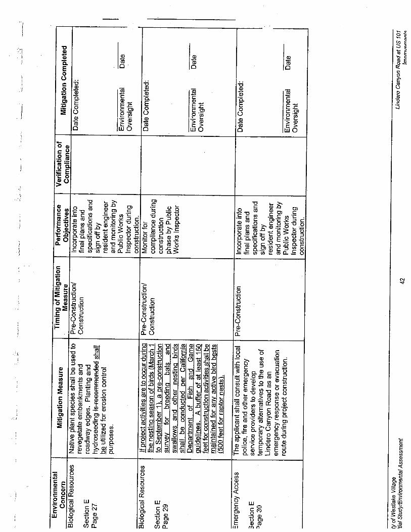
..._'
-._~
,,"'_
"__'
",,_
...~.
-
Env
iron
men
tal
Miti
gatio
n M
easu
reT
imin
g of
Miti
gatio
nPe
norm
ance
Ver
ific
atio
n of
Miti
gatio
n C
ompl
eted
Con
cern
Mea
sure
Obi
ectiv
esC
ompl
ianc
eB
iolo
gica
l Res
ourc
esN
ativ
e pl
ant s
peci
es s
hall
be u
sed
toPr
e-C
onst
ruct
ion!
Inco
rpor
ate
into
Dat
e C
ompl
eted
:re
vege
tate
em
bank
men
ts a
ndC
onst
ruct
ion
final
pla
ns a
ndSection E
road
way
edg
es. P
lant
ing
and
spec
ific
atio
ns a
ndPage 27
hydr
osee
ding
is r
ecom
men
ded
shal
lsi
gn o
ff by
be utilzed for erosion control
resi
dent
eng
inee
rpu
rpos
es.
and
mon
itorin
g by
Publ
ic W
orks
Env
iron
men
tal
Dat
eIn
spec
tor
durin
gO
vers
ight
cons
truc
tion.
Bio
logi
cal R
esol
/rce
sIf
proj
ect a
ctiv
ities
are
to o
ccur
dur
ing
Pre-
Con
stru
ctio
n!M
onito
r fo
rD
ate
Com
plet
ed:
the nestinq season of birds (March 1
Con
stru
ctio
nco
mpl
ianc
e du
ring
Section E
to S
eote
mbe
r11.
a p
re-c
onst
ruct
ion
cons
truc
tion
Pag
e 29
surv
eyfo
rbr
eedi
nqba
tsan
dph
ase
by P
ublic
swal
low
s an
d . o
ther
nes
ting
bird
sW
orks
Ins
pect
orsh
all b
e co
nduc
ted
oer
Cal
iforn
iaD
epar
tmen
tof
Fish
and
Gam
eE
nvir
onm
enta
lD
ate
Qui
delin
es.
A b
uffe
r of
at l
east
150
Ove
rsig
htfe
et f
or c
onst
ruct
ion
activ
ities
sha
ll be
mai
ntai
ned
for
any
activ
e bi
rd b
ests
(500
feet
for
ract
or n
ests
).
::mer
genc
y A
cces
sT
he a
pplic
ant s
hall
cons
ult w
ith lo
cal
Pre-
Con
stru
ctio
nIn
corp
orat
e in
toD
ate
Com
plet
ed:
polic
e, fi
re a
nd o
ther
em
erge
ncy
final
pla
ns a
nd3ection E
serv
ice
prov
ider
s to
dev
elop
spec
ific
atio
ns a
nd~
age
30te
mpo
rary
alte
rnat
ives
to th
e us
e of
sign
off
byLi
nder
o C
anyo
n R
oad
as a
nre
side
nt e
ngin
eer
emer
genc
y re
spon
se o
r ev
acua
tion
and
mon
itorin
g by
rout
e du
ring
proj
ect c
onst
ruct
ion.
Pub
lic W
orks
Env
iron
men
tal
Dat
eIn
spec
tor
durin
gO
vers
ight
cons
truc
tion.
ty o
f Wes
tlake
Vila
ge'fi
at S
tudy
lEnv
ironm
enta
t Ass
essm
ent
42L
inde
ro C
anyo
n R
oad
at U
S 10
1Im
nrnv
i:mi:n
l..

.. ,
~- J K. DISTRIBUTION/MAILING LIST
The following individuals and organizations were sent copies of the Draft IS/EA for their review andcomment:
Federal Offcials and Agencies
ij Hon. Barbara Boxer
U.S. Senator2250 E. Imperial Hwy.EI Segundo, CA 90245
DirectorOffce of Environmental AffairsDepartment of Health and Human Services200 Independence Ave. SW, Rm. 537 FWashington, DC 20201
Hon. Dianne FeinsteinU.S. Senator11111 Santa Monica Blvd. # 915Los Angeles, CA 90048
DirectorOffce of Environmental AffairsDept. of Health and human Services200 Independence Ave. SW, Rm. 537FWashington, DC 20201
;... -I
Hon. Brad ShermanCongressman, District 2421031 Ventura Blvd.Woodland Hils, CA 91364 Centers for Disease Control
Environmental Health and Injury ControlSpecial Programs Group, MS F-291600 Clifton RoadAtlanta, GA 30333
Environmental Protection Agency (EP A)
Offce of Federal Activities (A-I04)401 "M" Street, SWWashington, DC20460
EIS Coordinator, Region 9Environmental Protection Agency75 Hawthorne St.San Francisco, CA 94105
Federal Transit AdministrationRegion 9
201 Mission Street, Suite 2210San Francisco, CA 94105
DirectorOffce of Environmental Policy and ComplianceU. S. Department of InteriorMain Interior Building 1\S 23401849 C Street, NWWashington, DC 20240
District EngineerU. S. Army Corps of Engineers300 N. Los Angeles StreetLos Angeles, CA 90012
Director, Offce of Environmental ComplianceU. S. Department of Energy1000 Independence Ave., SW, Rm. 4G-064Washington, DC 20585
Emironmental Clearance OffcerDepartment of Housing and UrbanDeyelopment450 Goiden Gate AvenueP. O. Box 36003San Francisco, CA 94102
State Offcials and Agencies
Hon. Sheil:: KuehlState Senator. District 23
10951 W Pico Blvd. #202Los .-\ngl'i's. c..\ 9006''
Hon. Fr::n PavleyState Asseinblyinember, Dist. .. i6355 Topanga Cyn. Blvd. Ste. 205Woodl:ind Hills. CA 9l367
( ïn' o( We'xihike' I -¡/Jiig,.liiiiiiii Si"d,. /':I1'irO/lI1(,IIII/ .-1-'.,....'-11('11
4 \!.iide'/O ( '0111',,,, Rood ell I 'S 1111
I mprcJ\ '( 'IIJ( on t."

Mr. Doii DrachaiieCalifornia Air Resources BoardP.O. Box 8001
Ei Monte, CA 91734
Executive OffcerState Lands Commission1807 13"1 Street, RoomJ 01
CommanderCalifornia Highway PatrolWest VaHey Offce
5825 De So to Ave.Woodland Hils 91367-5297
SecretaryResources Agency13lh Floor, 1416 Ninth StreetSacramento, CA 95814
DirectorDepartment of Conservation1416 Ninth Street
Sacramento, CA 95814
Native American Heritage Commission915 Capitol Mall, Rm 288Sacramento, CA 95814
Mr. Dennis Dickerson
Executive Director
Water Quality Control BoardLos Angeles Region320 W. 41h St., Ste. 200Los Angeles, CA 90013
Paul EdelmanSanta Monica Mountains Conservancy5750 Ramirez Canyon Rd.Malibu, CA 90265
Charles RaysbrookRegional ManagerCalifornia Department of Fish and Game, Region 54949 View Ridge Ave.
San Diego, CA 92123Sacramento, CA 95814
Mr. Hans KreutzbergOffce of Historic PreservationDepartment of Parks and RecreationP.O. Box 94289Sacramento, CA 95296
:)
DirectorDepartment of Parks and Recreation1416 Ninth Street
Sacramento, CA 95814
Local Officials and Agencies
Hon. Zev YaroslavskySupervisor, Third DistrictCounty of Los Angeles500 W. Temple St., Room 821Los Angeles, CA 90012
Mr. James Lents
Executive Offcer. South Coast Air Quality Management District21865 E. Copley Dr.
Diamond Bar, CA 91765
Ron. Mark RutherfordMayorCity of Westlake Vilage4373 Park Terrace Drive
Westlake ViIage, CA 91361
Ray MaekawaTransportation Projects ManagerLos Angeles Metropolitan Transportation Authority
P.O. Box 194Los Angeles, CA 90053
(ïii. ol- ir,'sll,ik,' lïllogi'liiÙj,i/ ,\(11.1'- fll'l'Ù'O/illh'Il'iil .-f.'ì.'l'.\'SIIl("J( .i.
Liiide!"" ('IWI'OIl R""diul 'S 101blll'n)\'t'II('lJ(S

L. COMMENTS RECEIVED AND RESPONSES TO COMMENTS
The Draft Initial Study/Environmental Assessment was circulated for public and agencyreview from May 3. 2001 through June 18. 2001.
The foilowing letters were received from reviewing agencies:
1. Letter from C.F. Raysbrook. Regional Manaqer. California Department of Fish andGame. South Coast Region. June 19. 2001.
Letter No.1 - California Department of Fish and Game. South Coast Region
Comment #1: The California Department of Fish and Game (CDFG) indicates that the twobridges within the project area. the Lindero Canyon Bridge and the Agoura Road Bridge,could provide habitat for bats and/or cliff swallows and. that vegetated areas within theproject footprint could additionally provide nestinq habitat for other native birds. The CDFGrecommends that a pre-construction survey be conducted for breeding bats and swallowsand that a similar survey be conducted for nestinq birds. A buffer of at least 150 feet fromactive bird nests (500 feet for raptor nests) is recommended to be maintained.
Response: The following mitigation measure will be added to the project to respond tothese concerns:
Bioloqical Resources
If project activities are to occur during the nesting season of birds (March 1 toSeptember 1). a pre-construction survey for breeding bats and swallows and othernesting birds shall be conducted per California Department of Fish and Gamequidelines. A buffer of at least 150 feet for construction activities shall bemaintained for any active bird bests (500 feet for raptor nests).
,._Î
ï.,
J
Comment #2: The CDFG requests clarification of potential impacts to water quality in thedrainage channel adjacent to the construction site, including indirect impacts todownstream wildlife and wildlife habitat.
Response: There is minimal potential for construction activities to affect water quality inthe drainage channeL. Although the Agoura Road Bridge over the channel wil be widened,project conformance with applicable National Pollutant Discharge Elimination (NPDES)requirements and implementation of a Storm Water Pollution Prevention Plan (SWPPP) wiladequately mitigate potential impacts to water quality in the channeL.
Comment #3: The CDFG recommends including other feasible mitigation measures tomitigate pollutant run-off in addition to compliance with a Storm Water Pollution PreventionPlan (SWPPP).
..
--

-.-!ì
Response: As indicated in the Draft Initial Study/Environmental Assessment. the projectwil be required to obtain a General Construction Activity Storm Water permit. issued by theRegional Water Quality Control Board to implement the provisions of the National PollutantDischarqe Elimination System (NPDES) for the project. In addition. the project wil berequired to implement a Storm Water Pollution Prevention Plan (SWPP) to controlconstruction-related runoff. These measures should be adequate in addressinq potentialwater quality impacts:
A mitigation measure exists (Mitiqation Measure No.5) which requires native plant speciesbe used to revegetate embankments and roadway edges and recommends that plantingand hydroseeding be implemented for erosion control purposes. This mitigation measurewil be revised to address CDFG's concerns as follows:
Biological Resources
Native plant species shall be used to revegetate embankments and roadway edges.
Planting and hydroseeding is recommended shall be utilzed. for erosion controlpurposes.
Comment #4: The CDFG expresses concerns that the project may affect a streambed andthat a Streambed Alteration Agreement may be needed for the project.
Response: The project will not cross a streambed and there will be no alteration to anexistinq streambed. Therefore, a Streambed Alteration Agreement wil not be needed.
---j
-)
-,