Country report on history and status of soil survey in Iran by Bahman Eskandarie
25
1 The Islamic Republic of Iran Ministry of Jihad-e Agriculture Country report On History and status of soil survey in Iran GSP regional workshop Jordan Amman 1-5 April 2012 Prepared by Bahman Eskandarie Head of soil conservation and fertility Deputy for water and soil and industry Water and soil affairs office Report on Iran’s Soil and Agricultural status
Transcript of Country report on history and status of soil survey in Iran by Bahman Eskandarie

1
The Islamic Republic of Iran Ministry of Jihad-e Agriculture
Country report
On History and status of soil survey in Iran
GSP regional workshop Jordan
Amman 1-5 April 2012 Prepared by Bahman Eskandarie Head of soil conservation and fertility Deputy for water and soil and industry Water and soil affairs office Report on Iran’s Soil and Agricultural status

2
In the name of God, the compassionate the merciful
I would warmly like to express my cordial gratitude to all of the participants of this workshop my special thanks goes to his Excellency the minister of Jordan agriculture ministry and the honourable colleagues of FAO as well. It is my great privilege to address you, on behalf of the Ministry of Agricultural - Jihad and the deputy for water and soil and industry and the water and soil affairs office either and the head of soil fertility and soil conservation group to say how grateful we are to FAO to convene this Regional congregation On Soil scientific issues, here in Hashemite Kingdom of Jordan. It is appreciative to note that the agenda of the Seminar covers a wide range of very interesting items relating to the multiple features and circumstances of soils and especially those directly related to aspects of soil management. First and foremost I am going to present a general over view of the country’s circumstances such as geographical, climate, and soil resources environmental situation as well. Our thanks and gratitude to the Government of the Hashemite Kingdom of Jordan for hosting this assemblage and for all the facilities which will undoubtedly highly contribute to the success of this process.
I am going to have a comprehensive and holistic proceeding of the existing circumstances in the agriculture sectors specifically water and soil department from the viewpoint of our vision and mission for upcoming plans and program that we have to prosecute sedulously. I hope I could have found the majority and essential failing points and the paucities of laws and regulation in agricultural soil practices to manifest the backdrop of agricultural history. Since institution of former ministry of agriculture and current jihad -agriculture though many soil scientists had been working in a multidisciplinary specific range of soil thematic but due to the lack of a severe and distinct authorised custodian this

3
ministry as the inalienable warrantor for food supply securities and as the kingpin ministry Is confronting with the diversities of tangled affairs which we are going decisively to recover if it is not to late. Therefore I tried to compose a Skimming views to the trend and the significant activities have been undertaken in the last seven years.
INTRODUCTION General overview
Topography, CLIMATE, RAINFALL
Iran is located in the Northern Hemisphere, between 25° and 40° N and 44° to 63° E. and covers a total area of about 1.648000 sq. Km. and is bordered by Caspian see and Turkmenistan, Azerbaijan and Armenian on the North .Pakistan and Afghanistan on the east, Oman see and the Persian Golf on the south, Iraq and Turkey on the west. The Islamic Republic of Iran is situated in one of the most arid and semi arid regions of the world. The average annual precipitation is 252 mm (one-third of the world’s average precipitation), and this is under conditions in which 179 mm or 71 percent of rainfall is directly evaporated. The annual evaporation potential of the country is between 1500 and 2000 mm. unfortunately, in the past ten years, particularly in the year 2000, some parts of the country have suffered severely from drought.
4
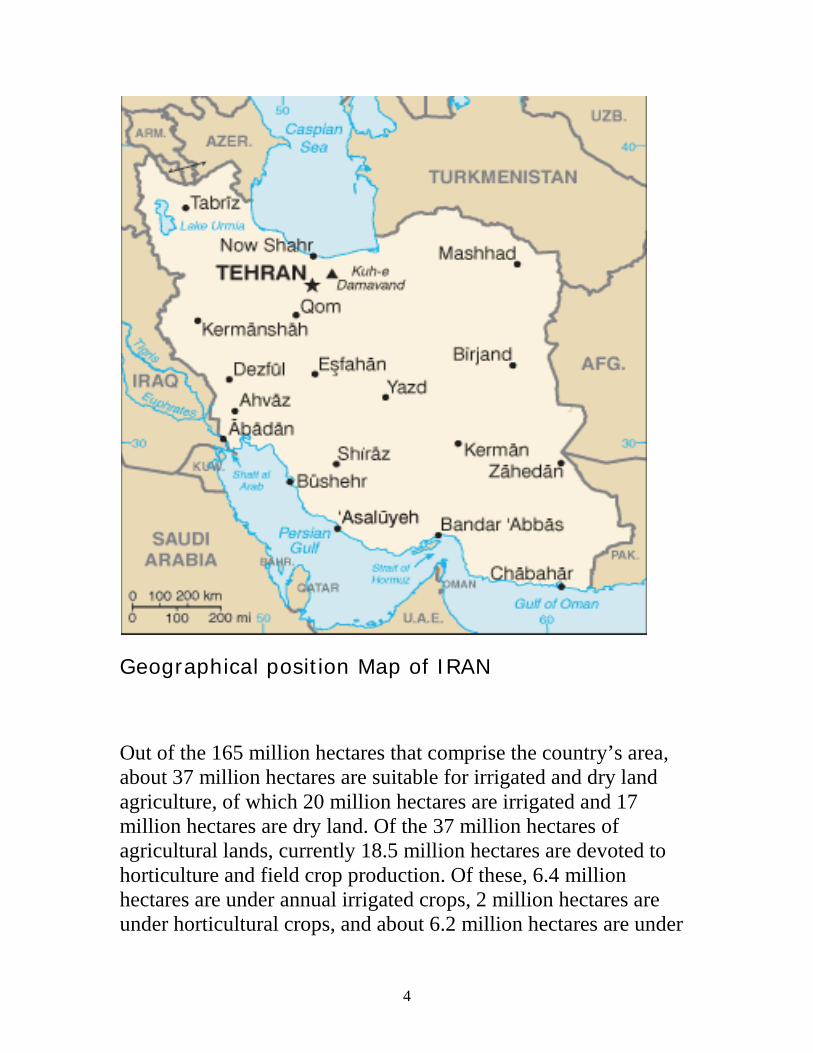
Geographical position Map of IRAN
Out of the 165 million hectares that comprise the country’s area, about 37 million hectares are suitable for irrigated and dry land agriculture, of which 20 million hectares are irrigated and 17 million hectares are dry land. Of the 37 million hectares of agricultural lands, currently 18.5 million hectares are devoted to horticulture and field crop production. Of these, 6.4 million hectares are under annual irrigated crops, 2 million hectares are under horticultural crops, and about 6.2 million hectares are under
5
annual dry land crops, while the remaining 3.9 million hectares are fallow.
Roughly one-third of Iran's total surface area is suited for farmland, but because of poor soil and lack of adequate water distribution in many areas, most of it is not under cultivation. Only 12% of the total land area is under cultivation (arable land, orchards and vineyards) but less than one-third of the cultivated area is irrigated; the rest is devoted to dry farming. Some 92 percent of agro products depend on water. The western and northwestern parts of the country have the most fertile soils. Iran's food security index stands at around 96 percent.
Topography affects climate and soils and plays an impotent role in the differentiation and distribution of climates and vegetation zones. For example, the Caspian zone is humid, due to the high Alborz mountain and Zagros region as well.
Altitudes vary from 40 m below sea level to 5,678 m above sea level and have a pronounced influence on the diversity and variation of the climate. Although most parts of the country can be classified as arid to semiarid, the country enjoys a wide range of climatic conditions. Both latitude and longitude have a major influence on climate in the various regions. This can be seen in the geographic variation of annual precipitation (from 50 mm in the central desert to 1600- up to 2000 mm in Gillan Province, situated at the southern coast of the Caspian Sea), and a wide range of temperatures that can vary up to 100°C (from –44°C in Borudjen/Chahar Mahal Bakhtiari Province, located in the central Zagrus Range mountains to 56°C in the south along the Persian Gulf coast). The total natural resources and rangeland areas are about 102.4 million hectares, composed of 90 million hectares as

6
pastures (in various level of forage productivity) and 12.4 million hectares as forests.
Altitudinal categories of the country. Altitude metres Area (Square Km) Percentage Over 2,000 260,000 15.7 1,000 - 2,000 879,000 53.3 500 - 1,000 154,000 9.3 0 – 500 332,000 20.0 Below sea level 11,000 0.9 Inland water bodies above sea level
14,000 0.7
Total 1,650,000 100 Type of land

7
Type of Land Area (ha) Mountains 46,036,179 Hills 22,027,499 Plateaux and Upper Terraces 23,004,259 Plain Mountain Slope 7,794,319 River Sedimentary Slope 4,022,892 Lower and Saline Lands 5,565,823 Torrential Plain 8,608,070 Alluvial Fan 10,568,120 Mixed Lands 4,978,319 Other Lands 5,211,466 Alluvium with Gravel (stone) 1,074,320 Sedimentary Slope 227,600 Total 138,130,573
Iran is mountainous with lots of features, Iran’s Topographic map at 1:250,000 consist of 134 sheets the mean slope on 54% of the area is between 1 - 5% which consists of coastal plains, watershed beds, inland plains etc. Some 21% of the country has slopes of 5 -

8
15%. Thus about 75% of the land area of the country has a mean slope of 0 - 15% (about 7º).
Slope classes of the country. Slope (Percentage)
Area (Square Km)
Percentage of total land area
1% 352,044.9 25% 1 - 3% 281,457.1 20% 3 - 5% 134,794.1 9% 5 - 10% 171,847.1 12% 10 - 15% 126,197.2 9% 15 - 30% 15,2619 11% 30 - 50% 89,239.5 6% > 50% 118,268.3 8% Total 1,426,467.2 100%
Soil Survey Background in Iran
The water and soil research centres in Iran are as follows:
1- The Soil and Water Research Institute (SWRI)
The preliminary soil activities have been done 60 years ago 1952 by the independent irrigation agency under auspicious and cooperation of FAO experts. Finally In 1960 emerged the existing water and soil research centre with distinct obligations.
The objectives and programs of the agency were as follows:
9
-Classification and identification of soils for optimum development and sustainable land-use. -Identification of soil resources of the Country and factors affecting soil degradation. -Research on improving irrigation quality, water harvesting, crop water management, and use of marginal water such as recycled effluent water, and saline water. -Studies on soil chemistry and microbiology, in relation to balanced crop nutrition, taking in to account the soil, water and plant relationship. The Soil and Water Research Institute (SWRI) comprises of the Following research departments:
Department of Soil Genesis, Classification and Cartography Department of Land Evaluation Department of Soil Chemistry, Fertility and Plant Nutrition Department of Irrigation and Soil Physics Department of Soil Conservation and Sustainable Land
Management Department of Soil Biology
Soil Conservation and Watershed Management Research Institute (SCWMRI)
"Soil Conservation and Watershed Management Research Institute" with the objectives of defining and executing research projects in the areas of soil conservation and watershed management has been stablished in 1993. Its different research divisions with respect to various areas and research requirements are divided into three main groups :
A. identification group: including research and analysis on weather and climate, water, vegetation and economic and social issues B. Soil conservation and soil and water resources group:
10
Including research and analysis on different water and soil conservation methods C. Watershed utilization management group : Including surveys required in various fields of the management of the management of water resource, soil resources, vegetable products, sustainable socio-economic development in watersheds. Considering the aforementioned requirements, the centre’s different research divisions are as follows: 1. Soil Conservation 2. Watershed Management 3. Flood Management and Exploitation 4. River Engineering and Training 5. Coastal Protection 6. Hydrology and Water Resources Development
Climate trend in IRAN
Iran is a mostly arid or semi-arid country, with a sub-tropical climate along the Caspian coast. Deforestation, , overgrazing, and pollution from vehicle emissions and industrial operations have harmed the land over the last few decades and hampered production. Other significant problems include poor cultivation methods, lack of water, and limited access to markets. Benefiting from land suitable for agriculture, the agricultural sector is one of the major contributors to Iran's economy. It accounts for almost 13% of Iran's GDP, 20% of the employed population, 23% of non-oil exports, 82% of domestically consumed foodstuffs and 90% of raw materials used in the food processing industry. Key data reflecting the potential of Iran's agricultural industry include access to 37 million hectares of productive land, 130 billion cubic meters of renewable water, wide spectrum of climatic conditions, 102.4 million hectares of forests and grasslands, 2700 kilometres of

11
water border, and diverse genetic reserves, which have led to the sector’s considerable growth. In addition, in recent years, the construction of several dams in different parts of Iran has facilitated the irrigation of agricultural lands. Therefore, it is estimated that the production volume of agricultural products in Iran will increase from currently 90 million tons to an estimated 200 million tons within the next decade. This will enable Iran to enter some lucrative markets in the world, especially in the European Union countries, with strategic products such as pistachio, saffron, cumin, citrus fruits, pomegranate, sugar cane, and oil seed. Both irrigated and rain-fed farming are used in Iran. In 2005, some 13.05 million hectares of land was under cultivation, of which 50.45% was allocated to irrigated farming and the remaining 49.55% to rain-fed system. Though the country provides about 90% of the total agri-food products, still Iran is a large importer of agricultural products, in addition to the technology and equipment required for this sector. The main products imported, related to this sector activity, include refined sugar, rice, soybean, sunflower oil, corn, palm oil, barley, processed food, fish, animal feed, additives, fertilizers and fertilizer raw materials and agricultural equipment. Pistachio, raisins, dates and saffron are the first four export products, from the viewpoint of value. In addition to the above-mentioned products, Iran also exports some other important agricultural products such as medical and industrial plants, decorative flowers and plants, as well as livestock products. At the end of the 20th century, agricultural activities accounted for about one-fifth of Iran's gross domestic product (GDP) and employed a comparable proportion of the workforce. Most farms are small, less than 25 acres (10 hectares), and thus are not economically viable, which has contributed to the wide-scale migration to cities. In addition to water scarcity and areas of poor soil, seed is of low quality and farming techniques are antiquated.

12
Agriculture plays an important role in the economy of Iran. It accounts for one fourth of the Gross Domestic Product (GDP), one fourth of employment, more than 80 percent of food requirements, one third of non-oil exports, and 90 percent of raw materials for industries. The agriculture of I.R. Iran enjoyed an average growth rate of 5.1 percent over the two National Development Plans (1989 to 2000).
Iran's agricultural sector is especially dependent on changes in rainfall, and although the government has attempted to reduce this dependence through the construction of dams, irrigation and drainage networks, agriculture remains highly sensitive to climate developments. Still, the agricultural sector accounts for about one-fifth of the GDP and employs one-third of the workforce. The country's most important crops are wheat, rice, other grains, sugar beets, fruits, nuts, cotton, and tobacco. Iran also produces dairy products, wool, and a large amount of timber. Irrigated areas are fed from modern water-storage systems or from the ancient system of qanat. Qanat are underground water channels stretching up to 47 kilometers (28 miles) and first used at least 2000 years ago. Unfortunately, many of them have fallen into disrepair in recent years.
Soil implementation process

13
Our deputy Initiated new soil policy as the top priority welcoming cooperative measures which led to establishment of cross-country Provincial special soil management committee engaged with the Comprehensive soil problems (difficulties) that are going to be supervised by the soil conservation and fertility group permanently.
The above mentioned committee observes and supervises all soil studies and practices connected to relevant soil thematic. Soil conservation and fertility group and divers directorates of auricular jihad-e organisation collaborated in holding the organic matter management workshop for the provincial soil experts.
Agriculture is considered as the mainstay of agrarian society in Iran, hence this is the most widespread economy activities of a greater part of the country. Through the fact of industrialization and urbanisation this sector is confronted with a blatant reduction of cultivated area whereof the population growth and cities sprawling contributed to these as encumbrances and farmers chief complaints as well .With the recognition of land degradation either natural or induced by humans this is a progressive process as an important problem which is a universal problem and not necessarily one for the developing countries. The intensive scramble and proceeding by the deputy for water and soil and industry in the last five years illuminated multiple dimensions in this sector as follow:
1- Drafting Legislation for Sustainable Soils and Good Agricultural Practice
This draft provides a reference source for the legal requirements for farmers and land managers with respect to, soil essentially and

14
water as ancillary. It also contains references to related legal requirements translated, overwritten and thoroughly revised.
Following the fifth economical, social and cultural national developing plan the first draft of Directive soil law prepared through an intensive collaboration and cooperation of many soil scientists and approved including 44 articles (Clause) and 19 provisos which has not been finalized yet.
The soil bill included multisciplinary aspects of soil in 5 chapters and considered as the holistic and versatile soils law and regulation (compared to European countries)
2- Land monitoring
Soil monitoring plan and procedures
The program of the soil monitoring system in IRAN has been developed at the water and Soil Research Institute in IRAN since 2010 soil basically and essential properties such as physical, chemical, agrochemical properties are monitored. The soil monitoring network in IRAN includes basically 3300 sites But during the performance of the project the quantities of these sites increased up to approximately 3500 monitoring sites that are distributed across the agricultural areas , which present the soil-landscape patterns . Soil samples are collected annually from each site. Samples are collected after harvest but before cultivation or fertilization and soil freeze-up. Important soil properties connected to soil erosion, soil contamination, soil acidification, and soil alteration indices are monitorized as well, as an important factor in inorganic and organic contamination. Trace elements such as Pb, Cd, Cr, Cu, Zn, Ni, As, Hg, Se, Co (total content) were analysed. The sites are not to be situated on water courses, field corners, pipeline right-of-ways, headlands or areas of weed infestations. The most important event was the Soil sampling which have been done at standard level and depths such as, -0,20 m, 0,20-0,30 m

15
and 0,30-0,50 m in dried land , but soil samples from horticulture and orchards range have been done up to nearly 100 centimetres in variables horizons and steps . The monitoring period is an ongoing procedure of five years which could last through the sixth upcoming five year developing plan.
Main objectives of the soil monitoring implementation
• provide a bases data of multiple soil species as the country data bank provide baseline soil information in dried and irrigated land ranges
• evaluate prospect effects on soil quality over time • provide a dataset to test and validate simulation models • monitor soil quality changes process over time on a field
basis
3- Maintaining Soil Fertility Under an Organic matter Management
Organic matter strategies and project
Soil fertility depletion and soil degradation present the most serious problems. Regarding to the Iran’s location in arid and semiarid climate and its adjoining and adjacent countries regions soils are generally poor. As the recent statistics shows more than 70 percent of Iran’s agricultural soil contain lesser than 0/5 percent organic matters and ingredient as well. Consequently Maintaining or increasing soil fertility is one of the most important things farmers have to do to increase output. Therefore, farmers have to know the characteristics and constraints of their soils and use sustainable agricultural practices and methods for conserving them and making them more fertile. These include fallowing, using compost, manure, crop residues, fertilizer trees, intercropping legumes with cereals and including the principles of conservation

16
agriculture (crop rotation, ensuring permanent cover for the soil and no disturbing of the top soil layer). Soils have to be nourished and cared for, and allowed to rest from time to time. The benefits of sound soils related to crops are many, and management is the key to ensure that a soil is functioning correctly.
The efficiencies of organic matter application are as follows:
1. Improves the soil by preventing it from compacting and crusting. 2. Increases the water’s holding ability so earthworms and other micro organisms can aerate the soil 3. slows down erosion and degradation process 4. in later stages of decay, organic matter is able to release nitrogen and other nutrients which help the crops grow.
To fulfil this project it has been considered a lump sum project implementation during the five year developing plan, which we wait optimistically looking forward, then through this comprehensive plan we can remediate and alleviate the agricultural soil from all above obstacles and encumbrances.
Soil survey in Iran The strategic plan of soil survey and land evaluation was compiled by a committee composed of representatives of both the executive and the research divisions of the Ministry of Agriculture. The plan should be seen as a part of the mission of Soil and Water Research Institute for boosting agricultural productivity through determination of capabilities and limitations of the soil resources of country. Two sub committees undertake the responsibility: one on soil survey and the other on land evaluation. The strategic plan of soil survey and land evaluation is a comprehensive program in

17
which the mission and strategies of Soil and Water Research Institute in the domain of soil mapping and land classification are clearly stated. The tactics, which are required to fulfil the goals of the strategic plan, is explained. The proposed plan makes a framework for operationalization of soil survey and land evaluation activities in Iran. The aim was to increase the quality of soil data as a basis for land use planning of national and regional levels. Generally the process of classifying soil types and other soil properties in an area is
Soil survey, or soil mapping the process of classifying soil types and other soil properties and combination of two components such as Field and laboratory activities intended to identify the basic physical and chemical properties of soils, establish the distribution of those soils at specific map scales, and interpret the information for a variety of uses .for the following soil description the two kinds of soil surveys, also general and specific purpose the main properties of the properties of the soil (such as texture, internal drainage, parent material, depth to groundwater, topography, degree of erosion, stoniness, pH, and salinity) and their spatial distribution over a landscape. Soils are grouped into similar types and their boundaries are delineated on a map.
The soil survey in Iran includes five stages as follows:
Reconnaissance Soil Survey 11.900 .000 hectares - 2- point per hectare
Sub detailed soil survey 6.550. 000 hectares 20 point per hectares
Detailed soil survey 550000 hectares
Total soil survey 19000 000 hectares

18
Due to its topographical, climatic and particularly its lithologic diversity, Iran displays a rich mosaic of soils. The following is a brief geo-botanical account of the soils classified by Dewan and Famouri (1964) and Zohary (1963). It is mainly a geobotanical review and as such, it considers as soil all kinds of substrates in their relation to vegetation.
Most of the soils of the area are lithosols due to heavy erosion which does not allow profile development. Other soils are alluvial-colluvial with steady rejuvenation of the profile and which occur in a variety of forms not always well differentiated by the pedologist, but readily distinguished from one another by vegetation.
Climatically, the soils of Iran can be classed into humid, semi-humid and arid ones. From the geobotanical point of view the soils can be subdivided into regional and interregional ones. The former comprises all soil series which are definitely confined to climatic and plant geographical regions, such as forest soils and steppe soils. Interregional soil units are such that may occur in various plant geographical regions, although slightly or markedly varying in their vegetation cover in the various regions. Such soils are not necessarily related to the climatic vegetation complexes of the region; examples are sandy soils, swamps and marshes; such soils as long as they preserve their primary pedological nature, will sharply differ in their vegetation from other soils of the region, while showing more vegetational affinity to similar soils in alien regions. Of the regional soil groups, the following should be mentioned:
0TForest Climax Soils
5Ta) 0T5TBrown Forest Soil.0T This is the soil of deciduous forest of the most mesic type both in the Caspian and reportedly also in the

19
Zagros mountains. It is sometimes mixed with podzolic soils from which it is not easily distinguished. It is confined to areas with high precipitation, part of which falls in summer. Generally, it has a well developed profile with a humiferous A- horizon, moderately acid to alkaline. Beech and Oak forests are the characteristic climax vegetation of the soil. At present, the typical brown forest soil is less extensive than its more ruined or skeletal derivative (lithosol facies), or its alluvial variety deposited in the intermountain valleys.
b) Chestnut soil. It develops under humid climatic conditions from various parent materials such as limestone and igneous rocks. It is characterized by the dark brown or dark greyish-brown surface horizon.
c) Rendzinas. True rendzinas developing from soft marly limestones are confined to humid or semi humid areas. They are generally characterized by their dark-coloured usually calcareous surface horizon which sharply contrasts with the marly or chalky white parent rock. In Iran, they are not uncommon in the forest areas of the mountains but are often intermixed with other types.
Alluvial Soils
These are the soils that fill the great plains and valleys. They are partly formed in situ, but largely transported from the mountains and redeposited, and thereby physically changed. There is no mature profile in these soils because of the steady rejuvenation of the upper horizons. Alluvial soils in this sense, do not include hydromorphic deposits, they are ecologically zonal soils, because they are apt to harbour plant communities of the same regional vegetation complex as the adjacent mountains that supply the soil material. Examples are alluvial soils of the intermountain valleys of the Zagros and Alborz mountains, which support the same forest type that grows in similar altitudes of adjacent mountains.

20
Steppe Soil Series
The bulk of Iran is occupied by steppe and desert, which are characterized by dwarf shrubs or herbaceous formations, the density of which is largely dependant upon the amount of rainfall. The soils classed under this heading include (Figure 3) sierozems, brown steppe, loess and loess-like soils, as well as hammadas.
Sierozems are typical steppe soils. They are mostly oropedic, shallow, with an A - C profile, almost devoid of a humiferous layer, and grey in colour. They are mostly highly calcareous, free or almost free from injurious salts. In Iran, most of the mountain slopes facing the Central Plateau and all the elevations of the plateau itself are typical sierozems.
Brown soils. Brown soils are formed under more favourable climatic conditions than sierozems, but are still marginal for arboreal vegetation. In Iran, brown soils are common in more humid parts of the Zagros mountains and in Khorasan (Dewan and Famouri, 1964).
Loess and loess-like Soils. A type of soil reminiscent of loess has been observed in several localities, south of Alborz mountains and in the adjacent valleys. This aeolic soil has a yellowish-brown colour and is deposited mainly as desert dust in valleys on the outer fringe of the desert. It is no doubt confused with brown soils and sierozems. Loess is a fine-grained soil with a medium clay / silt ratio and a high proportion of fine sand.
d-Hammadas. Most of the hammadas are confined to the intermountain valleys and drier parts of the Central Plateau. They are greyish-brown, calcareous soils with a fairly high content of silt and clay mixed with and covered by pebbles of various rock materials (desert pavement). Hammadas are generally poorly

21
vegetated because of the low rainfall. In extreme cases, such as in Dasht-e-Lut, there are immense stretches of altogether bare hammadas.
Main Climatic Zones: due to the following climatic regions we do have extreme changes in different zones.ant these are as follows:
Caspian Zone ,Desert Zones, Steppes zone , Substeppic zone and Irano-Turanian Zone
Soil Erosion in Agricultural Systems
Soil erosion in agricultural systems is a very important problem to manage. Soil can be eroded away by wind and water. High winds can blow away loose soils from flat or hilly terrain. Water erosion generally occurs only on slopes, and its severity increases with the severity of the slope. In the Midwest much of the wind erosion occurs in winter when the ground is frozen, but the upper most soil layer is dry and loose. Water erosion occurs during the spring with the thawing and melting action of the snow.
Different methods of reducing soil erosion.
Contour tillage reduces water erosion. On hilly areas plowing is done across the hill rather than straight up and down. One problem with this is that some fields' shape make this method impractical. Terraces can also be constructed so to reduce water erosion. Strong proponents of soil protection also advocate no-till agriculture. No-till is actually a misnomer. Traditional plowing cuts down and overturns up to 8" of soil. The coulter disks on traditional plows are straight disks. No-till only stirs up to 2" in creating crop rows. No-till coulter disks are waved which creates the stiring action. Traditional plowing is utilized to break up dirt clogs in heavy clay soils and to kill competing weeds. No-till reduces soil erosion by
22
keeping crop and plant residue on the surface longer. The major problem with no-till is that weed growth can only be stopped by heavier herbicide applications than with traditional tillage methods. In this case, farmers must make the hard choice between soil conservation and heavier applications of herbicides. No-till also does not work as well in all soil types. No-till works best in sandy soils, but in the heavier clay soils, fall traditional plowing is required to break the soil up enough for adequate crop yields. No-till also does not work in compacted soils. The only way to break down soil compaction is through traditional moldboard plowing or the use of a subsoiler.
One method designed to reduce to wind erosion is the establishment of windbreaks. Windbreaks work well in reducing wind velocities over fields, but they have one serious drawback to farmers. For every quater mile of windbreak approximately one acre is taken out of crop production. Windbreaks take out not only their physical width, but they shade out crops to the side of them as well. Farmers must pay taxes, rent, and maintenance for windbreaks that produce no benefit in return.
Land Degradation
Soil Degradation Processes in Iran
Erosion
The critical aspect of soil erosion for our purposes here is that the rate of the process is highly dependent on anthropogenic actions. Natural rates of soil erosion are lower for soil with a good cover of vegetation than for bare soil. In fact, any human actions that uncover soil (e.g., farming, logging, building, overgrazing, off-road vehicles, fires, etc.) greatly enhance soil erosion rates.

23
We have two types of Soil erosion in Iran and these are in field and in watershed regions as an example it varies from nearly 500 Kg irrigated cropland up to 70 tones I losse deposits in North and North east of the country.
Land-use Management
Land-use change is one of the main drivers of many environmental change processes. It influences the basic resources of land use, including the soil. Its impact on soil often occurs so creepingly that land managers hardly contemplate initiating ameliorative or counterbalance measures. Poor land management has degraded vast amounts of land, reduced our ability to produce enough food, and is a major threat to rural livelihoods in many developing countries. To date, there has been no single unifying volume that addresses the multifaceted impacts of land use on soils.
Policy measures to prevent irreversible degradation and rehabilitate degraded soils are :
New attitude toward Tillage farming
Tillage and No-till or Zero till farming
Since a decade we are following the worldwide attitude toward new methodology of reducing soil erosion is to leave crop residue on the field after harvesting. No-tillage can be defined as a system of planting (seeding) crops into untilled soil by opening a narrow slot or trench only of sufficient width and depth to obtain proper seed coverage. For example, after the corn is harvested, the stalks are left on the field all winter to reduce erosion and soil fertility decline. The major problem with this is that the the crop residue offers habitat for pests. If crop rotation is unfeasible then heavier amounts of pesticides are required to eliminate the pest.

24
The aim is to move as little soil as possible in order not to bring weed seeds to the surface and not stimulating them to germinate. The residues from the previous crops will remain largely undisturbed at the soil surface as mulch. If the soil is disturbed even only superficially then the system can not be termed no-tillage and is defined as mulch tillage. We followed this new technology generally in horticulture sector in some provinces with different climates under no tillage cultivation which resulted satisfactory crop yield. This is one of the foremost and prior plans in our agricultural strategy in the fifth developing plan.
Thank you For your Attention & Tolerance

25


![Bahman Bahmani bahman@stanford.edu. Fundamental Tradeoffs Drug Interaction Example [Adapted from Ullman’s slides, 2012] Technique I: Grouping](https://static.fdocuments.in/doc/165x107/56649ca75503460f94969a01/bahman-bahmani-bahmanstanfordedu-fundamental-tradeoffs-drug-interaction.jpg)