Cotati Bicycle and Pedestrian Master Plan
42
Cotati Bicycle and Pedestrian Master Plan Prepared by: Sonoma County Transportaon Authority In partnership with: City of Cota Adopted December 2008 Updated April 22, 2014
-
Upload
nguyenxuyen -
Category
Documents
-
view
221 -
download
2
Transcript of Cotati Bicycle and Pedestrian Master Plan

Cotati Bicycle and Pedestrian Master Plan
Prepared by:Sonoma County Transportation Authority
In partnership with:City of Cotati
Adopted December 2008Updated April 22, 2014
SCTA Countywide Bicycle and Pedestrian Master Plan, 2014 Update - City of Cotati
Glossary and List of Acronyms
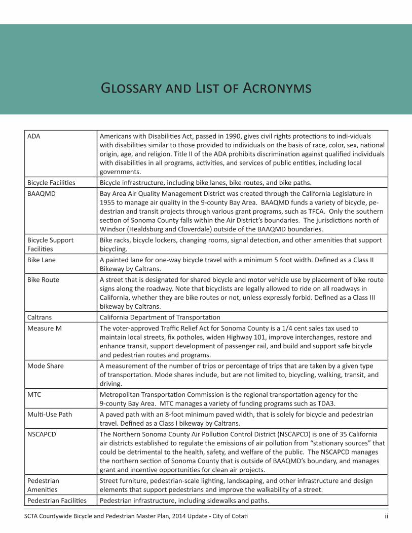
ADA Americans with Disabilities Act, passed in 1990, gives civil rights protections to indi-viduals with disabilities similar to those provided to individuals on the basis of race, color, sex, national origin, age, and religion. Title II of the ADA prohibits discrimination against qualified individuals with disabilities in all programs, activities, and services of public entities, including local governments.
Bicycle Facilities Bicycle infrastructure, including bike lanes, bike routes, and bike paths.BAAQMD Bay Area Air Quality Management District was created through the California Legislature in
1955 to manage air quality in the 9-county Bay Area. BAAQMD funds a variety of bicycle, pe-destrian and transit projects through various grant programs, such as TFCA. Only the southern section of Sonoma County falls within the Air District’s boundaries. The jurisdictions north of Windsor (Healdsburg and Cloverdale) outside of the BAAQMD boundaries.
Bicycle Support Facilities
Bike racks, bicycle lockers, changing rooms, signal detection, and other amenities that support bicycling.
Bike Lane A painted lane for one-way bicycle travel with a minimum 5 foot width. Defined as a Class II Bikeway by Caltrans.
Bike Route A street that is designated for shared bicycle and motor vehicle use by placement of bike route signs along the roadway. Note that bicyclists are legally allowed to ride on all roadways in California, whether they are bike routes or not, unless expressly forbid. Defined as a Class III bikeway by Caltrans.
Caltrans California Department of TransportationMeasure M The voter-approved Traffic Relief Act for Sonoma County is a 1/4 cent sales tax used to
maintain local streets, fix potholes, widen Highway 101, improve interchanges, restore and enhance transit, support development of passenger rail, and build and support safe bicycle and pedestrian routes and programs.
Mode Share A measurement of the number of trips or percentage of trips that are taken by a given type of transportation. Mode shares include, but are not limited to, bicycling, walking, transit, and driving.
MTC Metropolitan Transportation Commission is the regional transportation agency for the 9-county Bay Area. MTC manages a variety of funding programs such as TDA3.
Multi-Use Path A paved path with an 8-foot minimum paved width, that is solely for bicycle and pedestrian travel. Defined as a Class I bikeway by Caltrans.
NSCAPCD The Northern Sonoma County Air Pollution Control District (NSCAPCD) is one of 35 California air districts established to regulate the emissions of air pollution from “stationary sources” that could be detrimental to the health, safety, and welfare of the public. The NSCAPCD manages the northern section of Sonoma County that is outside of BAAQMD’s boundary, and manages grant and incentive opportunities for clean air projects.
Pedestrian Amenities
Street furniture, pedestrian-scale lighting, landscaping, and other infrastructure and design elements that support pedestrians and improve the walkability of a street.
Pedestrian Facilities Pedestrian infrastructure, including sidewalks and paths.
ii

City of Cotati
Sonoma County Transportation AuthorityCotati Bicycle and Pedestrian Master Plan, 2014 Update
ROW Right-of-WaySharrows Shared Roadway Bicycle Markings - A stencil of a bicycle and chevron placed in the middle of
the right-hand vehicle lane, typically adjacent to parallel parking. The shared lane marking indicates to bicyclists where they should ride to avoid opening car doors and reminds motorists that bicycles will be riding in the middle of the lane.
SCTA Sonoma County Transportation Authority manages countywide planning and programming of funds.
SRTS Safe Routes to Schools. There is a Countywide Safe Routes to Schools Program. There are also locally managed SRTS activities in some jurisdictions.
SWITRS A database of police-reported collisions maintained by the California Highway Patrol.TDA3 Transportation Development Act, Article 3 is a 2% set-aside from TDA funding, which is
exclusively reserved for bicycle and pedestrian projects. In Sonoma County, each jurisdiction accumulates TDA3 funds each year based upon their share of the population.
TFCA Transportation Fund for Clean Air is a funding program managed by the Bay Area Air Quality Management District. The TFCA program is funded by a $4 vehicle registration surcharge in the Bay Area.
iii
Glossary and List of Acronyms, continued
SCTA Countywide Bicycle and Pedestrian Master Plan, 2014 Update - City of Cotati
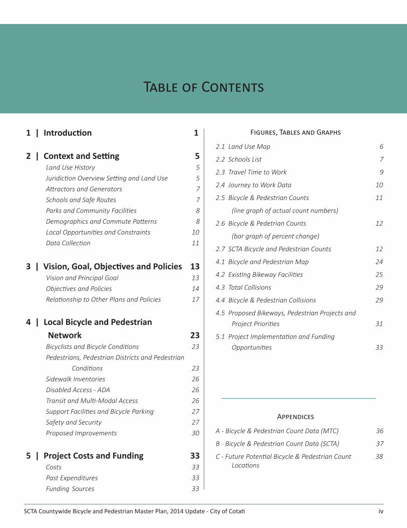
Table of Contents
iv
1 | Introduction 1
2 | Context and Setting 5Land Use History 5Juridiction Overview Setting and Land Use 5Attractors and Generators 7Schools and Safe Routes 7Parks and Community Facilities 8Demographics and Commute Patterns 8Local Opportunities and Constraints 10Data Collection 11
3 | Vision, Goal, Objectives and Policies 13Vision and Principal Goal 13Objectives and Policies 14 Relationship to Other Plans and Policies 17
4 | Local Bicycle and Pedestrian Network 23
Bicyclists and Bicycle Conditions 23Pedestrians, Pedestrian Districts and Pedestrian Conditions 23Sidewalk Inventories 26Disabled Access - ADA 26Transit and Multi-Modal Access 26Support Facilities and Bicycle Parking 27Safety and Security 27Proposed Improvements 30
5 | Project Costs and Funding 33Costs 33Past Expenditures 33Funding Sources 33
Figures, Tables and Graphs
2.1 Land Use Map 6
2.2 Schools List 7
2.3 Travel Time to Work 9
2.4 Journey to Work Data 10
2.5 Bicycle & Pedestrian Counts 11
(line graph of actual count numbers)
2.6 Bicycle & Pedetrian Counts 12
(bar graph of percent change)
2.7 SCTA Bicycle and Pedestrian Counts 12
4.1 Bicycle and Pedestrian Map 24
4.2 Existing Bikeway Facilities 25
4.3 Total Collisions 29
4.4 Bicycle & Pedestrian Collisions 29
4.5 Proposed Bikeways, Pedestrian Projects and Project Priorities 31
5.1 Project Implementation and Funding Opportunities 33
Appendices
A - Bicycle & Pedestrian Count Data (MTC) 36
B - Bicycle & Pedestrian Count Data (SCTA) 37
C - Future Potential Bicycle & Pedestrian Count 38 Locations
SCTA Bicycle and Pedestrian Master Plan, 2014 Update – City of Cotati 1
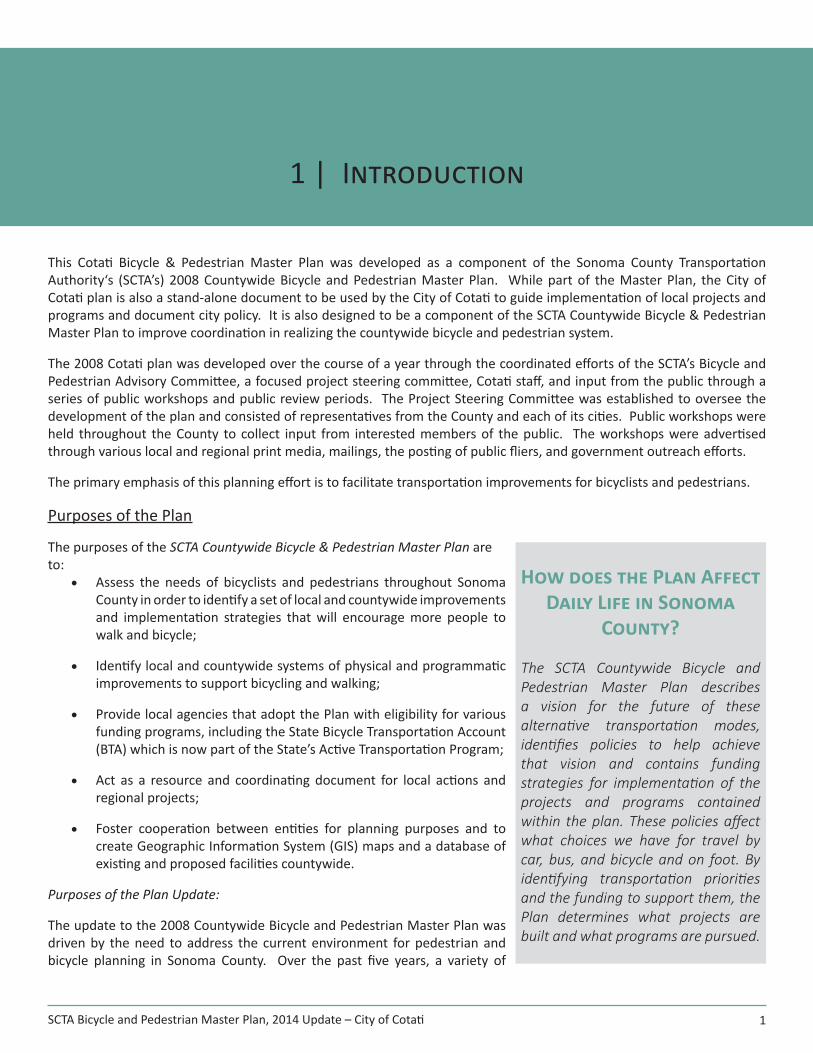
1 | Introduction
This Cotati Bicycle & Pedestrian Master Plan was developed as a component of the Sonoma County Transportation Authority‘s (SCTA’s) 2008 Countywide Bicycle and Pedestrian Master Plan. While part of the Master Plan, the City of Cotati plan is also a stand-alone document to be used by the City of Cotati to guide implementation of local projects and programs and document city policy. It is also designed to be a component of the SCTA Countywide Bicycle & Pedestrian Master Plan to improve coordination in realizing the countywide bicycle and pedestrian system.
The 2008 Cotati plan was developed over the course of a year through the coordinated efforts of the SCTA’s Bicycle and Pedestrian Advisory Committee, a focused project steering committee, Cotati staff, and input from the public through a series of public workshops and public review periods. The Project Steering Committee was established to oversee the development of the plan and consisted of representatives from the County and each of its cities. Public workshops were held throughout the County to collect input from interested members of the public. The workshops were advertised through various local and regional print media, mailings, the posting of public fliers, and government outreach efforts.
The primary emphasis of this planning effort is to facilitate transportation improvements for bicyclists and pedestrians.
Purposes of the Plan
The purposes of the SCTA Countywide Bicycle & Pedestrian Master Plan are to:
• Assess the needs of bicyclists and pedestrians throughout Sonoma County in order to identify a set of local and countywide improvements and implementation strategies that will encourage more people to walk and bicycle;
• Identify local and countywide systems of physical and programmatic improvements to support bicycling and walking;
• Provide local agencies that adopt the Plan with eligibility for various funding programs, including the State Bicycle Transportation Account (BTA) which is now part of the State’s Active Transportation Program;
• Act as a resource and coordinating document for local actions and regional projects;
• Foster cooperation between entities for planning purposes and to create Geographic Information System (GIS) maps and a database of existing and proposed facilities countywide.
Purposes of the Plan Update:
The update to the 2008 Countywide Bicycle and Pedestrian Master Plan was driven by the need to address the current environment for pedestrian and bicycle planning in Sonoma County. Over the past five years, a variety of
How does the Plan Affect Daily Life in Sonoma
County?
The SCTA Countywide Bicycle and Pedestrian Master Plan describes a vision for the future of these alternative transportation modes, identifies policies to help achieve that vision and contains funding strategies for implementation of the projects and programs contained within the plan. These policies affect what choices we have for travel by car, bus, and bicycle and on foot. By identifying transportation priorities and the funding to support them, the Plan determines what projects are built and what programs are pursued.

City of Cotati
Sonoma County Transportation Authority
2
Cotati Bicycle and Pedestrian Master Plan, 2014 Update
changes have taken place, therefore accompanying information needs to be updated. The key updates are:
• Map: countywide bicycle and pedestrian facilities map• Data: Census data, collision data, and commuting statistics• Project Lists: Countywide proposed bicycle and pedestrian projects
To achieve these, the Plan includes recommendations for physical improvements and programs that could be developed to enhance and expand existing facilities, connect gaps, address constraints, provide for greater local and regional connectivity, and increase the potential for walking and bicycling as transportation modes.
Vision Statement
Through a collaborative planning process, a vision, goal and objectives were approved by all ten jurisdictions of Sonoma County: Cloverdale, Healdsburg, Windsor, Santa Rosa, Cotati, Rohnert Park, Petaluma, Sonoma, Sebastopol, and the County of Sonoma. These are designed to guide the development and maintenance of bicycle and pedestrian facilities throughout Sonoma County and express the intent of SCTA and Sonoma County jurisdictions to enhance non-motorized mobility and to improve safety, access, traffic congestion, air quality, and the quality of life of Sonoma County residents, workers and visitors.
Vision
The vision for a comprehensive bicycle and pedestrian transportation system is:
In Sonoma County bicycling and walking are:
• Important to residents’ quality of life
• Integral parts of an interconnected transportation system
• Safe and convenient for all user groups
• Viable means of reaching desired destinations
• Routinely accommodated as part of a complete streets approach
• Encouraged by easy connections to transit
• Supported by education and enforcement
• Advanced by actions of government, schools and the private sector
• Promoted as tourism and recreation attractions
• Mode choices that contribute to personal health
• Options that reduce vehicle miles traveled and greenhouse gas emissions
Caltrans Compliance
Active Transportation Program
The Active Transportation Program was created in 2013 by Senate Bill 99 and Assembly Bill 101. There is no longer a checklist requirement as was the case per the Bicycle Transportation Account before the Active Transportation Program.
City of Cotati
Sonoma County Transportation Authority
3
Cotati Bicycle and Pedestrian Master Plan, 2014 Update
Depending on the amount awarded to a project, there may be a requirement for the project/program to be included in a plan.
As detailed on page 10, the “Public Participation and Planning” bullet point under “Scoring Criteria” in the guidelines:
Identification of the community-based public participation process that culminated in the project proposal, which may include noticed meetings and consultation with local stakeholders. Project applicants must clearly articulate how the local participation process resulted in the identification and prioritization of the proposed project.
For projects costing $1 million or more, an emphasis will be placed on projects that are prioritized in an adopted city or county bicycle transportation plan, pursuant to Section 891.2, pedestrian plan, safe routes to school plan, active transportation plan, trail plan, or circulation element of a general plan that incorporated elements of an active transportation plan. In future funding cycles, the Commission expects to make consistency with an approved active transportation plan a requirement for large projects.
For more information, please visit the Active Transportation Program website: http://www.catc.ca.gov/programs/ATP.htm or http://www.dot.ca.gov/hq/LocalPrograms/atp/.
City of Cotati
Sonoma County Transportation Authority
4
Cotati Bicycle and Pedestrian Master Plan, 2014 Update
[this page intentionally left blank]
SCTA Bicycle and Pedestrian Master Plan, 2014 Update – City of Cotati 5
2 | Context and Setting
Land Use History
The indigenous peoples known as the coastal Miwok Indians lived on the land now named Cotati. In 1826 an Irishman named John Thomas Reed made a claim on the land north of Mission San Rafael. His grant included land north of Vallejo’s Petaluma Adobe to just south of today’s Santa Rosa, including where Rohnert Park, Cotati and Penngrove are now situated. The Rancho was broken up in the 1800s into many ranches that were sold to settlers who came in after the Gold Rush. Eventually Reed sold his land and it changed hands several times until Doctor Thomas Stokes Page bought it in 1846. In the early 1870s the railroad was established. It made stops at Page’s Station, which later became Cotati.
The next major influence on transportation, and likewise land use, was the affordability of the automobile for many families and businesses. Trails evolved into paved roads to serve the new vehicular mode and land use and development quickly adapted with more dispersed patterns. As development became more sprawled and the number of car owners grew, non-motorized means of travel declined. Worth noting is that most of Sonoma County’s cities retain a central historic core that preceded the advent of the automobile. Cotati’s downtown hub retains much of its walkability from that earlier era.
Jurisdiction Overview Setting and Land Use
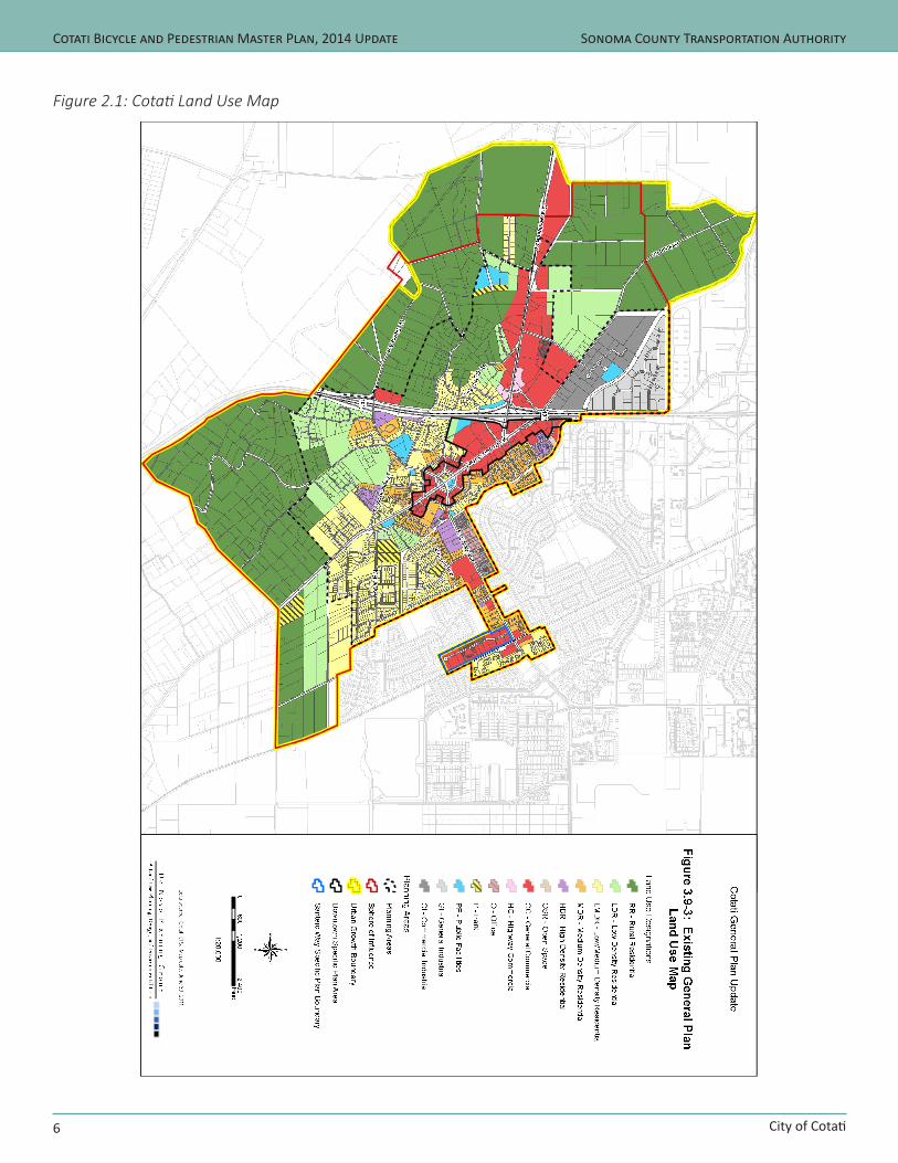
Land use development and settlement patterns are indicated in Figure 2.1, the Cotati Land Use Map.
Although Sonoma State University (SSU) is not actually located within Cotati, to a large extent, Cotati is a university town. Many students live in Cotati and the downtown’s restaurants and bars are popular with SSU students. The City of Cotati radiates out from “the Hub,” two concentric sets of eight streets, each of which form a hexagon, and within the center of which is La Plaza Park and the Cotati fire station. The Hub is bisected by Old Redwood Highway and East Cotati Avenue/West Sierra Avenue. Around the Hub is a thriving, historic downtown, which has recently been transformed by several projects that included streetscape and pedestrian improvements and mixed-use developments.
The Draft Downtown Cotati Specific Plan proclaims that preserving and reinforcing the historic and pedestrian nature of downtown is fundamental to the success of the revitalization effort. The Plan includes a number of policies aimed at improving the area’s walkability, including lively streetscapes, intimate pedestrian paseos, wide sidewalks, street trees, pedestrian-oriented street frontages, and shared “Park Once” automobile parking to encourage the transformation of motorists into pedestrians.
Cotati’s commercial areas are laid out in a linear fashion along the major collectors of East Cotati Avenue, Gravenstein Highway and Old Redwood Highway. Housing closest to downtown is the most compact, with development west of Highway 101 appreciably less dense. Various Cotati cul-de-sacs could be opened for bicycle and pedestrian access to
City of Cotati
Sonoma County Transportation Authority
6
Cotati Bicycle and Pedestrian Master Plan, 2014 Update
Figure 2.1: Cotati Land Use Map
City of Cotati
Sonoma County Transportation Authority
7
Cotati Bicycle and Pedestrian Master Plan, 2014 Update
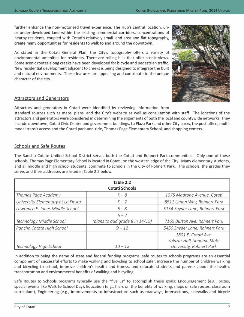
further enhance the non-motorized travel experience. The Hub’s central location, un- or under-developed land within the existing commercial corridors, concentrations of nearby residents, coupled with Cotati’s relatively small land area and flat topography, create many opportunities for residents to walk to and around the downtown.
As stated in the Cotati General Plan, the City’s topography offers a variety of environmental amenities for residents. There are rolling hills that offer scenic views. Some scenic routes along creeks have been developed for bicycle and pedestrian traffic. New residential development adjacent to creeks is being designed to integrate the built and natural environments. These features are appealing and contribute to the unique character of the city.
Attractors and Generators
Attractors and generators in Cotati were identified by reviewing information from standard sources such as maps, plans, and the City’s website as well as consultation with staff. The locations of the attractors and generators were considered in determining the alignments of both the local and countywide networks. They include downtown, Cotati Civic Center and government buildings, La Plaza Park and other City parks, the post office, multi-modal transit access and the Cotati park-and-ride, Thomas Page Elementary School, and shopping centers.
Schools and Safe Routes
The Rancho Cotate Unified School District serves both the Cotati and Rohnert Park communities. Only one of these schools, Thomas Page Elementary School is located in Cotati, on the western edge of the City. Many elementary students, and all middle and high school students, commute to schools in the City of Rohnert Park. The schools, the grades they serve, and their addresses are listed in Table 2.2 below.
Table 2.2Cotati Schools
Thomas Page Academy K – 8 1075 Madrone Avenue, CotatiUniversity Elementary at La Fiesta K – 2 8511 Liman Way, Rohnert ParkLawrence E. Jones Middle School 6 – 8 5154 Snyder Lane, Rohnert Park
Technology Middle School6 – 7
(plans to add grade 8 in 14/15) 7165 Burton Ave, Rohnert ParkRancho Cotate High School 9 – 12 5450 Snyder Lane, Rohnert Park
Technology High School 10 – 12
1801 E. Cotati Ave, Salazar Hall, Sonoma State
University, Rohnert Park
In addition to being the name of state and federal funding programs, safe routes to schools programs are an essential component of successful efforts to make walking and bicycling to school safer, increase the number of children walking and bicycling to school, improve children’s health and fitness, and educate students and parents about the health, transportation and environmental benefits of walking and bicycling.
Safe Routes to Schools programs typically use the “five Es” to accomplish these goals: Encouragement (e.g., prizes, special events like Walk to School Day), Education (e.g., fliers on the benefits of walking, maps of safe routes, classroom curriculum), Engineering (e.g., improvements to infrastructure such as roadways, intersections, sidewalks and bicycle

City of Cotati
Sonoma County Transportation Authority
8
Cotati Bicycle and Pedestrian Master Plan, 2014 Update
facilities), Enforcement (making sure motorists, pedestrians and bicyclists understand and obey the rules of the road), and Evaluation (such as before/after surveys to see the effect of programs and physical improvements on mode choice for student commuters).
In school year 2009/10, the District began work on a multi-year program funded by a Safe Routes to School Grant from Caltrans to implement outreach and education to students for safe walking and bicycling to and from campus. The program included bike safety fairs, educational materials and events targeted to elementary school students. Those programs are tailored to the individual school populations and have continued since initiation. Some programs are done in partnership with the Sonoma County Bike Coalition.
In addition, the District initiated home to school transportation for students attending Thomas Page Elementary and living north of Highway 116, as well as those students living in the L-sections of Cotati and Rohnert Park. These two transport programs are expected to continue serving these areas of Cotati.
Parks and Community Facilities
A variety of parks and community facilities exist in Cotati. They include City parks, neighborhood parks, pocket parks, civic buildings, schools, and other quasi-public facilities. These facilities are distributed throughout the community and are accessible by those on foot and/or bicycle. Following is a list of parks:
• Delano Park• Kotati Park• La Plaza Park• Helen Putnam Park• Veteran’s Park• Thomas Page Park• Falletti Park• Cotati Civic Center - meeting and event facilities, classrooms, picnic area and ball field• Draper Park
Cotati Demographics and Commute Patterns
Local Bicycle and Pedestrian Travel Characteristics
Travel information in Cotati was analyzed to identify mode split and to evaluate travel time to work. The term ‘mode split’ refers to the form of transportation a person chooses: walking, bicycling, taking a bus, driving, etc. The commute analysis establishes base data on the existing number of bicycle and pedestrian commuters, as well as an indication of the number of potential bicycle and pedestrian commuters in the plan area. This information can then be used by staff and local officials to develop improvement plans and set priorities, with the objective of increasing the percentage of people who choose to walk or bicycle rather than drive a car or be driven.
A review of available demographic and commute statistics was performed in order to better understand the level of walking and bicycling in Cotati and Sonoma County as a whole. Several data sources were reviewed, including California Department of Finance Population Estimates, the Bay Area Travel Survey, and Journey-to-Work (JTW) Data from the US Census Bureau.

City of Cotati
Sonoma County Transportation Authority
9
Cotati Bicycle and Pedestrian Master Plan, 2014 Update
Every ten years, the US Census Bureau attempts to count every person throughout the nation. In the 2000 Census, “journey to work” data set was included in the long-form of the census questionnaire; however, this data set is no longer included in the decennial census, but rather is included in the American Community Survey (ACS). Each year, the question “How did you usually get to work last week?” is asked of participants in the ACS. Respondents who typically use more than one method of transportation are instructed to mark the mode used for “most of the distance”. The collective responses to this question form a set of data known as Journey-to-Work (JTW). Even though the Journey-to-Work data from the ACS is available at the county level each year, only the 5-year data set has the ability to show this data for all jurisdictions. Therefore, all Journey-to-Work data in this Plan is from the most recent 5-year American Community Survey (2007-2011).
JTW data is considered the most reliable source of transportation mode choice information available. However, while the JTW provides a glimpse of how Cotati residents travel to and from work, the data source only provides a partial understanding of travel characteristics. This is particularly true in assessing walking and bicycling trips since it does not reflect multi-modal trips or non-work trips. Thus the JTW data misses school, shopping, and recreational trips, which may constitute much of the bicycle and pedestrian travel by Cotati’s student and senior populations and others. The instructions effectively eliminate any record of the pedestrian portion of walk-to-transit and walk-to-carpool trips; the wording leaves the response, for commuters who do not use the same mode every day, up to the respondent.
The 2010 US Census indicates a population of 7,310 in Cotati, which is a 9 percent increase since the 2000 Census. According to the American Community Survey (2007-2011), there are 3,732 workers in Cotati 16 years old or older. Of these, 3,445 work outside the home. The mean travel time to work for Cotati residents is 24 minutes, as demonstrated in Table 2.3 below. When comparing the ACS 2007-2011 data with the 2000 Census, there is a positive trend in Cotati; more Cotati residents are shifting toward spending fewer minutes traveling to work. Almost thirty-three percent, or 1,133 workers, have a travel time to work of 15 minutes or less. This represents a 52% increase in this travel time category, whereas those traveling 45 to 59 minutes and more than 60 minutes both decreased by more than 30 percent each. This shift demonstrates that more Cotati residents are working closer to home than previously. Lastly, it is interesting to note that Cotati residents who work from home increased more than 400 percent since the 2000 Census.
Table 2.3Cotati Travel Time to Work for Workers 16 Years and Older
# %Total Employed Persons (16+) 3,732 100%Worked at Home 287 7.7%Did Not Work at Home 3,445 92.3%
Travel Time # %Less than 15 minutes 1,133 32.9%15-29 minutes 1,257 36.5%30-44 minutes 551 16.0%45-59 minutes 224 6.5%60 minute or more 313 9.1%Mean travel time to work 24.2 minutes
Source: US Census, American Community Survey, 5-Year Estimates, 2007-2011
As shown in Table 2.4 below, JTW data indicates that 80 percent of workers in Cotati, or 3,151 persons, drive to work

City of Cotati
Sonoma County Transportation Authority
10
Cotati Bicycle and Pedestrian Master Plan, 2014 Update
alone (slightly up from the 2000 Census). Approximately 2.5 percent, or 98 workers, commute by bicycle, a rate that is much higher than the County bicycle mode share of 1.2 percent. Approximately 0.6 percent (24 persons) of Cotati employed persons walk to work; it remains the lowest walk-to-work rate in Sonoma County. While approximately 10.4 percent of workers in Cotati (409 persons) carpool, the majority of workers in Cotati drive to work alone. Given Cotati’s climate, topography, and percentage of commuters with a travel time to work of 15 minutes or less compared to the number of existing bicycle and pedestrian commuters, a significant opportunity exists to achieve a greater bicycle and pedestrian mode share. Every motor vehicle trip or vehicle mile driven eliminated results in less air pollution, reduced green house gas emissions, and lessened traffic congestion.
Table 2.4Demographic and Journey to Work Data
Cotati Countywide CaliforniaPopulation 7,154 478,551 36,969,200Employed Persons 16 years of age + 3,929 226,280 16,251,032Mode Share # % # % # %Drove Alone 3,151 80.2% 169,257 74.8% 13,764,624 84.7%Carpool 409 10.4% 24,438 10.8% 1,901,371 11.7%Public Transit 98 2.5% 4,299 1.9% 828,803 5.1%Walk 24 0.6% 7,015 3.1% 455,029 2.8%Bike 98 2.5% 2,715 1.2% 162,510 1.0%Motorcycle, cab, other 35 0.9% 2,263 1.0% 211,263 1.3%Worked at Home 114 2.9% 15,840 7.0% 828,803 5.1%Source: US Census - American Community Survey, 5-Year Estimates 2007-2011
Local Opportunities and Constraints
This section provides a discussion of opportunities and constraints for the City’s bicycle and pedestrian networks. A variety of conditions were considered including roadway geometries, traffic volumes, crossing locations, distance between destinations, topography, system users, and other issues.
Opportunities:
• Multi-modal access improvement opportunities at existing transit stops and park and ride lots
• Improved inter-county and inter-city connection opportunities
• System enhancements through a comprehensive way-finding, directional, and warning signing campaign for pedestrians and bicyclists
• Potential mode share growth and safety improvements through education and awareness efforts, especially on Old Redwood Highway
Constraints:

City of Cotati
Sonoma County Transportation Authority
11
Cotati Bicycle and Pedestrian Master Plan, 2014 Update
• Sidewalk needs and gap closures in Cotati’s western neighborhoods
• Limited crossing locations and the need for pedestrian improvements on Gravenstein Highway South
• US 101 is a barrier to east-west travel
• Right-of-way constraints on Old Redwood Highway in downtown
• Deteriorating pavement and maintenance needs on the City’s existing Class II bike lanes
• Bulbouts on Old Redwood Highway, which were designed to improve pedestrian crossings, inadvertently impede bicycle travel because they extend too far into the roadway
Data Collection
Bicycle and Pedestrian Counts
Since the 2008 Countywide Bicycle and Pedestrian Master Plan was adopted, significant work has been accomplished with regard to bicycle and pedestrian counts by the Sonoma County Transportation Authority (SCTA). SCTA began the bicycle and pedestrian count program in 2009. The completion of the 2008 Countywide Bicycle and Pedestrian Master Plan assisted in informing SCTA staff of key locations within each jurisdiction to be included in a countywide bicycle and pedestrian count program. Moreover, the Metropolitan Transportation Commission (MTC) has collected bicycle and pedestrian count data at eight locations in Sonoma County since 2002. The MTC count locations have remained consistent over the entire 10 year period. The graph below demonstrates the total bicycle and pedestrian counts for the Old Redwood Highway and Cotati Avenue location in the City of Cotati. According to the data in the MTC counts, there has been a steady increase in both bicycle and pedestrian activity in Sonoma County at the eight locations where MTC conducts their counts. However, this location in Cotati has experienced more variability as the graph below demonstrates.
Table 2.5: MTC Bicycle & Pedestrian Counts (actual count numbers)
The below graph demonstrates the percent change in both bicycle and pedestrian counts at the Old Redwood Highway and Cotati Avenue location. The top bars are comparing the percent change between the years 2002 and 2012, and the bottom bars are comparing the percent change between the years 2010 and 2012. Similar to the overall County, this location in Cotati also experienced a very large increase in bicycle activity between 2010 and 2012.

City of Cotati
Sonoma County Transportation Authority
12
Cotati Bicycle and Pedestrian Master Plan, 2014 Update
Table 2.6: MTC Bicycle & Pedestrian Counts (percent change)
SCTA began their bicycle and pedestrian count program in 2009 with 15 count locations throughout almost all jurisdictions in Sonoma County. By 2011, all jurisdictions were included in the SCTA bicycle and pedestrian count program. Similar to the MTC counts for Cotati, the SCTA counts also demonstrate a yearly variability, as the graph below demonstrates. Both bicycle and pedestrian have increased overall at this location in Cotati. Bicycle activity has increased 36 percent, and pedestrian activity has increased 63 percent.
Table 2.7: SCTA Bicycle & Pedestrian Counts
Even though significant work has been accomplished in recent years on collecting bicycle and pedestrian count data, SCTA can only count approximately 20 locations per year. Moreover, only four hours per location are collected in manual bicycle and pedestrian counts. Therefore, the lack of documentation on usage and demand for pedestrian and bicycle facilities remains a challenge facing staff and local decision makers in bicycle and pedestrian planning. Moreover, we have no data on non-peak travel hours, or on weekend non-motorized travel throughout Sonoma County. Without accurate and consistent data, it is difficult to measure the benefits of bicycle and pedestrian investments, especially when compared to the other types of transportation such as the automobile. In order to supplement JTW data, to attain a better understanding of existing usage and travel patterns, and to be able to project demand, specialized bicycle and pedestrian counts are recommended. Therefore, SCTA is exploring various options to purchase automated counters to assist in counting bicyclists and pedestrians for longer periods of time at locations throughout Sonoma County. This will be a collaborative effort, which will include participation from each jurisdiction.
SCTA Bicycle and Pedestrian Master Plan, 2014 Update – City of Cotati 13
3 | Vision, Goal, Objectives and Policies
Vision, Goal, Objectives, and Policies
This section defines the vision for bicycle and pedestrian transportation throughout Sonoma County, and outlines the vision, principal goal, and objectives that will serve as guidelines in the continuing development of the countywide bicycle and pedestrian transportation system. Through a collaborative planning process, the vision, goal and objectives were approved by all ten jurisdictions of Sonoma County: Cotati, Healdsburg, Windsor, Santa Rosa, Cotati, Rohnert Park, Petaluma, Sonoma, Sebastopol, and the County of Sonoma. These are designed to guide the development and maintenance of bicycle and pedestrian facilities throughout Sonoma County and express the intent of SCTA and its member agencies to enhance non-motorized mobility to improve safety, access, traffic congestion, air quality, and the quality of life of Sonoma County residents, workers and visitors.
The vision, goal and top-tier objectives are meant to function as the mutually agreed upon common framework applicable to both the primary countywide system and local bicycle and pedestrian networks. Policies, and possibly additional objectives, that address jurisdiction-specific issues are included in the individual County and city/town plans.
The role of the SCTA is in advocating, planning, coordinating, and funding, whereas local agencies, such as cities, towns, and the County, transit agencies, Caltrans, and the non-profit and private sectors, will be chiefly responsible for implementation of objectives and policies.
The vision for a comprehensive bicycle and pedestrian transportation system is:
In Sonoma County bicycling and walking are:
• Important to residents’ quality of life• Integral parts of an interconnected transportation system• Safe and convenient for all user groups• Viable means of reaching desired destinations• Routinely accommodated as part of a complete streets approach• Encouraged by easy connections to transit• Supported by education and enforcement• Advanced by actions of government, schools and the private sector• Promoted as tourism and recreation attractions• Mode choices that contribute to personal health• Options that reduce vehicle miles traveled and greenhouse gas emissions
Principal Goal:To develop and maintain a comprehensive countywide bicycle and pedestrian transportation system, which includes projects, programs, and policies that work together to provide safe and efficient transportation opportunities for bicyclists and pedestrians.
City of Cotati
Sonoma County Transportation Authority
14
Cotati Bicycle and Pedestrian Master Plan, 2014 Update
Objectives and Policies
Objective 1.0: The Countywide Bicycle and Pedestrian Network Establish a comprehensive countywide bicycle and pedestrian transportation system.
Policies
1.1 Develop a local and countywide bicycle and pedestrian transportation network that provides access to and among major activity centers, commercial districts, schools, transportation centers, public transportation recreation, and other destinations, according to the recommendations in this plan.1.2 Work cooperatively with responsible agencies including cities and the County of Sonoma, Regional Parks, SCTA, SMART, SCWA, and others, to close existing facility gaps and ensure the system is implemented, constructed, and maintained.1.3 Establish a bicycle and pedestrian advisory committee to advise staff on bicycle and pedestrian issues. A. The Bicycle and Pedestrian Advisory Committee (BPAC) shall be responsible for advising staff on the ongoing planning and coordination of the bicycle and pedestrian transportation system.1.4 Assign a bicycle and pedestrian coordinator to oversee implementation of the Bicycle and Pedestrian Plan and coordinate activities between City departments and other jurisdictions.1.5 Double the “Journey to Work” mode split percentages for walking and bicycling, by the year 2020, using 2006 data as the baseline.1.6 Accommodate the needs of bicyclists of all types (commuters, recreational riders, children, and families) in planning, developing, and maintaining a bikeway network that is safe and convenient.1.7 Make the development of a Class I multi-use pathway along the SMART right-of-way a high priority, independent of the re-establishment of rail and transit operations.1.8 Require new development to provide safe, continuous and convenient pedestrian access to jobs, shopping and other local services and destinations.1.9 Create spaces and activities that invite pedestrian use and optimize the experience of walking with amenities such as landscaping, public art, seating and drinking fountains.1.10 Improve the safety of pedestrian crossings on roadways and highways, especially in pedestrian districts.
Objective 2.0: DesignUtilize accepted design standards and complete streets principles for the development of bicycle and pedestrian facilities.
Policies2.1 Consider Chapter 1000 “Bikeways Planning and Design”, from the California Highway Design Manual, the California Manual of Uniform Traffic Control Devices, the American Association of State Highway Transportation Officials (AASHTO) Guide for the Development of Bicycle Facilities and Guide for the Planning, Design, and Operation of Pedestrian Facilities when designing bicycle and pedestrian facilities.2.2 Require that all signalized intersections include bicycle detection and are properly marked and operational for use by bicyclists.2.3 Where minimum bike lane standards are infeasible, use striped edge lines, signs, shared lane markings, or other route enhancements to improve conditions for bicyclists.2.4 Avoid the loss of existing bicycle and pedestrian facilities or jeopardize future facilities as shown on the Bikeways Map.2.5 Install directional and informational signage, markers, and stencils on off-street paths, on-street bikeways, local roads, and State Routes to improve “way-finding” for bicyclists, assist emergency personnel, and heighten motorist’s awareness. A. Develop a Citywide “way-finding” program.
City of Cotati
Sonoma County Transportation Authority
15
Cotati Bicycle and Pedestrian Master Plan, 2014 Update
Objective 3.0: Multimodal IntegrationDevelop and enhance opportunities for bicyclists and pedestrians to easily access other modes of transportation.
Policies
3.1 Implement a ‘safe routes to transit’ program that prioritizes pedestrian and bicycle access to transit stops and stations.3.2 Require transit providers to provide and maintain convenient and secure bike parking facilities, all- weather shelters, and other amenities at major transit stops and transportation centers at a minimum.3.3 Require local and regional transit agencies to accommodate bicycles on transit and plan for the need for additional bicycle storage capacity on transit to ensure capacity keeps up with demand.
Objective 4.0: Comprehensive Support FacilitiesEncourage the development of comprehensive support facilities for walking and bicycling.
Policies
4.1 Require adequate short-term bicycle parking for retail, office, commercial and industrial uses.4.2 Require adequate short-term bicycle parking and long-term bicycle storage for transportation centers.4.3 Require larger employers to provide secure indoor and/or covered bicycle parking for their employees.4.4 Require larger employers to provide adequate shower and locker facilities for workers.
Objective 5.0: Education and PromotionDevelop programs and public outreach materials to promote bicycle and pedestrian safety and the benefits of bicycling and walking.
Policies
5.1 Participate in the development and maintenance of a bicycle and pedestrian safety campaign as a countywide tool to deliver comprehensive safety awareness, driver, cyclist and pedestrian education information, and to increase the awareness of the benefits of walking and bicycling as transportation modes.5.2 Support “grassroots” efforts that help to resolve bicycle and pedestrian transportation issues.5.3 Distribute bicycle and pedestrian safety, educational, and promotional materials through law enforcement activities, at scholastic orientations, through drivers training and citation diversion programs, and to new political representatives.5.4 Encourage events that introduce residents to walking and bicycling, such as bike-to-work, walk/bike-to-school days, senior walks and historic walks.5.5 Require major employment centers and employers to encourage commuting by bicycle.5.6 Educate the general public and the officials of state, county, and local law enforcement agencies on common Vehicle Code infractions involving bicyclists and other users of roadways or off-road pathways.
Objective 6.0: Safety and SecurityCreate countywide pedestrian and bicycle networks that are safe and secure. Reduce automobile collisions with pedestrians and bicyclists by 50 percent by the year 2020, using 2006 collision data as the baseline for analysis.
Policies
6.1 Coordinate the delivery of bicycle Safety Education Programs to schools, utilizing assistance from law enforcement agencies, local bicycle shops, and other appropriate groups and organizations.6.2 Improve safety of intersection crossings using routine pedestrian signal cycles, pedestrian buttons, high-visibility crosswalk markings and education.

City of Cotati
Sonoma County Transportation Authority
16
Cotati Bicycle and Pedestrian Master Plan, 2014 Update
6.3 Prioritize safety improvements in the vicinity of schools, public transit and other high-priority pedestrian destinations.6.4 Improve collection and analysis of collision data. The Public Works Department shall review this data annually to identify problem areas which require immediate attention.6.5 Improve pedestrian safety and security and the ‘sense of isolation’ with pedestrian-level lighting, where appropriate, and development of activities and facilities that encourage walking.
Objective 7.0: Land UseEncourage smart growth land use strategies by planning, designing and constructing bicycle and pedestrian facilities in new development.
Policies
7.1 Encourage School districts to participate in providing safe and continuous bicycle and pedestrian connections from surrounding neighborhoods when constructing new or improving existing school facilities.7.2 Ensure that on-street parking does not conflict with Class II bikeways.7.3 Encourage compact, high density pedestrian oriented development in pedestrian districts.7.4 In pedestrian districts allow shared parking for commercial uses rather than requiring each business to provide separate parking areas.7.5 Require discretionary projects in pedestrian districts to provide pedestrian facilities such as sidewalks, steps, and trails that link pedestrian routes or provide access to destinations.
Objective 8.0: Planning Continue to support bicycle and pedestrian efforts with data measurement, analysis, and ongoing planning.
Policies
8.1 Update the Bicycle and Pedestrian Plan in accordance with the California Bicycle Transportation Act, and to coordinate with Regional Transportation Plan updates.8.2 Incorporate policies in this Bicycle and Pedestrian Plan into all specific, master and General Plan documents and redevelopment policies.8.3 The BPAC shall review the design of all new road widening projects in order to minimize hazards and barriers to bicycle travel on all local roads.8.4 Refer projects that meet any of the following conditions to the BPAC for review to determine consistency with this plan: A. Resurfacing, restoration, and rehabilitation (3R) projects, or other improvements of roads designated as Class II bikeways. B. Resurfacing, restoration, and rehabilitation (3R) projects or other improvements of roads designated as Class III bike routes. C. Resurfacing, restoration, and rehabilitation (3R) projects that include the installation of rumble strips, AC berms or similar barriers, and/or roadway dots in the shoulder area. D. Traffic calming improvements. E. Road capacity improvement projects. F. Discretionary projects adjacent to or traversed by existing or designated Class I, II or III bikeways. G. Discretionary projects conditioned with roadway improvements along a designated or existing Class I, II or III bikeway.8.5 Proactively seek opportunities for acquisition of abandoned rights-of-way, natural waterways, flood control rights- of-way, utility rights-of-way, and lands for the development of new Class I multi-use pathways.8.6 Ensure that Class I or II bikeways are constructed in a manner that does not reduce or eliminate other designated bikeways without consultation with the Bicycle and Pedestrian Advisory Committee.8.7 Plan for and acquire Class I bike paths, wherever feasible, that will connect to designated or existing Class I multi-
City of Cotati
Sonoma County Transportation Authority
17
Cotati Bicycle and Pedestrian Master Plan, 2014 Update
use pathways, trails, communities, existing or proposed schools, public parks and open space areas, and existing or proposed public transit nodes (e.g., transportation centers, park and ride lots, bus stops).
Objective 9.0: MaintenanceMaintain and/or improve the quality, operation, and condition of bicycle and pedestrian infrastructure.
Policies
9.1 Maintain geometry, pavement surface condition, debris removal, markings, and signage on Class II and Class III bikeways to the same standards and condition as the adjacent motor vehicle lanes.9.2 Develop a maintenance reporting system with a central point of contact that can be used to report, track, and respond to routine bicycle and pedestrian maintenance issues in a timely manner.9.3 Require that road construction projects minimize their impacts on bicyclists and pedestrians through the proper placement of construction signs and equipment, and by providing adequate detours.9.4 Require that routine maintenance of local roads consider bicycle and pedestrian safety and at a minimum includes the following activities: A. Trim vegetation to provide a minimum horizontal clearance of 4 feet from the edge of pavement and a minimum vertical clearance of 8 feet. B. Clear debris from road shoulder areas to provide space for walking.
Objective 10.0: Funding Maximize the amount of funding for bicycle and pedestrian projects and programs throughout Sonoma County, with an emphasis on implementation of this plan.
Policies
10.1 Work with federal, state, regional, and local agencies and any other available public or private funding sources to secure funding for the bicycle and pedestrian system.10.2 Encourage multi-jurisdictional funding applications to implement the regional bicycle and pedestrian system.10.3 Promote the availability of adequate regional, state and federal funding sources for bicycle and pedestrian transportation projects.
Relationship to Other Plans and Policies
Implementation of the Cotati Bicycle and Pedestrian Plan will require coordination, consistency, and cooperation among numerous jurisdictions and agencies with varied interests that share policy decisions within and immediately adjacent to Cotati and Sonoma County. There are myriad relevant federal, state, regional, county, and local agencies that have developed plans, programs, directives, policies, and regulations related to funding, planning, designing, operating, maintaining, and using bicycle and pedestrian facilities. These agencies and their plans, policies, etc., have been evaluated for coordination, consistency, and conformance with this Plan. Brief summaries of local plans and policies are provided below. Summaries of regional, state, and federal plans, policies, and other relevant resources are provided in the Overview section.
Cotati General Plan
The Cotati General Plan is a long-range comprehensive planning document required by state law and adopted by the City in 1998 to set policy and guide future growth, development and conservation of resources. The General Plan was designed to guide development through 2015. An update to the plan is currently underway and near completion. While the policies and goals contained in the 1998 General Plan still apply, given the anticipated adoption of the General Plan Update in the near term, the draft update was evaluated for the purpose of this review.
City of Cotati
Sonoma County Transportation Authority
18
Cotati Bicycle and Pedestrian Master Plan, 2014 Update
The following General Plan goals are relevant to bicycle and pedestrian improvements in Cotati.
Goal 2 – Develop a system of transportation facilities and services that provides safe and efficient access to all parts of the City, including Thomas Page School, Sonoma State University, and the region, and reinforces the desired land use pattern.
Policies and Implementation:
Objective 2.2Develop a safe and efficient system of bicycle and pedestrian routes that connect neighborhoods with commercial centers, transit facilities, parks, and Thomas Page School, the City of Rohnert Park, and the County of Sonoma.
Policies and Implementation
2.2.1 Establish and maintain continuous clearly identifiable bicycle routes and facilities on Old Redwood Highway, East Cotati Avenue, Gravenstein Highway, and West Sierra Avenue. A. Through a Capital Improvement Program the Public Works staff shall maintain and develop bike lanes along arterial streets with clearly marked lines and visible signs. (see Map 5) B. Planning staff shall work with Sonoma County Transit to create an effective Rider Awareness Program that will educate the public on the existing transit systems. C. The Planning Commission shall prepare a Bicycle and Pedestrian Master Plan which will include a regular maintenance schedule for bikepaths, sidewalks, and walkways. D. Provide safe and continuous pedestrian, vehicular, and bicycle access to park-and-ride facilities. E. Complete the Laguna Bikepath which connects Commerce Blvd. to Lancaster Avenue as shown on Map 5.
2.2.2 Maintain and develop a network of walkways and sidewalks along arterial and collector streets to provide for safe and efficient travel. A. Where appropriate, the City shall use the Street and Highways Code (for assessment purposes) to construct sidewalks. In addition, establish a schedule for installing sidewalks along arterial streets, using other funding sources should they be available (see Map 6). The City Engineer shall review all plans for sidewalk construction to ensure that existing trees are circumvented by the new sidewalk. Public Works shall ensure that existing trees are properly protected during construction. B. In areas where sidewalks and walkways are needed, special assessment of affected property owners may provide the funding for installation. C. For all new residential and commercial development, developers shall be required to install sidewalks and walkways on and off-site as dictated by the location of transit stops and common pedestrian destinations. The Planning Department and the Building Inspector shall monitor plans for compliance with these requirements. Exceptions may be made for the residential area immediately surrounding the Hub area when it can be shown that the sidewalk will be at odds with the neighborhood aesthetic and the historic nature of the area. D. Emphasis shall be placed on creating safe pedestrian and bicycle travel to and from Thomas Page School.
2.2.3 New development shall provide the rights-of-way for bicycle and pedestrian facilities. A. Developers shall be required to provide land dedication or provide fees in order to provide bikepaths, sidewalks, and walkways. The Planning Department and Building Inspector shall monitor plans for compliance with these requirements.
2.2.4 Priority shall be given to upgrading and maintaining existing bicycle and pedestrian routes before new routes are established. A. The Planning Department shall prepare a Bicycle and Pedestrian Master Plan which will include a regular maintenance schedule for bikepaths, sidewalks, and walkways.

City of Cotati
Sonoma County Transportation Authority
19
Cotati Bicycle and Pedestrian Master Plan, 2014 Update
2.2.5 Continue to provide secure bicycle racks in the Hub, future and existing commercial areas, park-and-ride transit facilities, schools, and multiple unit residential developments. A. Developers shall be required to provide secure bicycle racks in multiple unit and commercial developments. The design review process shall monitor this requirement.2.2.6 Provide curb cuts and ramps at the intersections along Old Redwood Highway and East Cotati Avenue and throughout the community, to serve the needs of the mobility-impaired. A. Through a Capital Improvement Program the Public Works Department shall install curb cuts at intersections and along Old Redwood Highway and East Cotati Avenue.
2.2.7 Identify streets on the west side of Highway 101 where reduced pedestrian facilities, such as an asphalt path, would more closely support the rural character. A. Planning staff shall indicate streets with reduced pedestrian facilities on the Pedestrian Facility Needs Map (See Map 6).
2.2.8 Establish pedestrian facilities under the Gravenstein Highway and West Sierra Avenue interchanges to facilitate safe and efficient pedestrian and bicycle travel throughout Cotati. A. Planning staff shall pursue with Caltrans the installation of sidewalks under Highway 101 at both interchanges.
2.2.9 Enhance the safety of pedestrian crossings in the Hub area while ensuring a delightful downtown experience. A. The City shall retain the viewpoint of the pedestrian as the primary perspective when identifying Hub- related traffic improvements.
Draft Citywide Traffic Improvement Plan, March 15, 2005
Alternative Transportation Modes
Based on a review of the 1998 General Plan, other studies, and field review, alternative transportation mode traffic improvements were developed.
Bicycle Facilities
Criteria provided by Caltrans in the Traffic Manual denote a Class I bicycle facility as a separate path, Class II facilities are bike lanes, and a Class III facility is one on which bicycle traffic is promoted but where there is no separate lane or path. Within the City of Cotati, there are existing Class II facilities on Old Redwood Highway, E. Cotati Avenue, and Gravenstein Highway.
• It is recommended that continuous bike lanes on Old Redwood Highway, E. CotatiAvenue, Gravenstein Highway and W. Sierra Avenue be created and maintained within the City of Cotati. Currently, there is a gap in the Class II lanes on Gravenstein Highway between Redwood Drive and Old Redwood Highway.
• The Laguna bike path that connects Commerce Boulevard to Lancaster Avenue should be completed.
Pedestrian Facilities
Pedestrian activity areas within the City of Cotati are primarily focused in the hub area of downtown. There is also moderate pedestrian activity along E. Cotati Avenue, Old Redwood Highway, and W. Sierra Avenue. These corridors are generally served by concrete sidewalks. However, there are intermittent sections without sidewalks due to adjacent undeveloped parcels. A number of the residential neighborhoods and industrial areas on the fringes of the community do not have any sidewalks, walkways or shoulder area for pedestrian traffic. In
City of Cotati
Sonoma County Transportation Authority
20
Cotati Bicycle and Pedestrian Master Plan, 2014 Update
addition, the City has recognized an unwritten policy that supports using a more rural type of pedestrian path rather than the typical curb, gutter and sidewalk in the West Cotati area.
• Gaps in the sidewalk system should be addressed, especially on Old Redwood Highway between Gravenstein Highway and the hub, on Old Redwood Highway between the hub and Valparaiso Avenue-Myrtle Avenue and on West Sierra Avenue between U.S. 101 and Valparaiso Avenue.
Enhanced pedestrian crossings, including warning lights, pedestrian signage and striping, and medians or bulbouts, should be provided at uncontrolled crossing locations including:
- East Cotati Avenue at the Laguna trail crossing, east of Charles Street- East Cotati Avenue at Charles Street - W. Sierra Avenue at La Plaza (west)- W. Sierra Avenue at Henry Street-Olaf Street- Old Redwood Highway at La Plaza (north) - Old Redwood Highway at Page Street
City of Cotati Downtown Specific Plan, Draft, February 20, 2006
Chapter I: Introduction
Local Context
1.2 - Relationship to Cotati General Plan
The Downtown Specific Plan implements several policies of the Cotati General Plan by providing for new mixed-use and commercial development on vacant and underutilized land north of La Plaza, and for the continuing economic development of the historic downtown area south of La Plaza. The Specific Plan also addresses General Plan circulation policies by effectively accommodating multiple transportation modes. Specific applicable General Plan policies include, but are not limited to the following:
Community Development
1.4.14 The area along both sides of Old Redwood Highway, north of La Plaza and south of the Highway 101 northbound on-ramp, shall be developed in an integrated manner assuring a vibrant, mixed-use and pedestrian-oriented extension of the downtown.
2.2.1 Establish and maintain continuous clearly identifiable bicycle routes and facilities on Old Redwood Highway, East Cotati Avenue, Gravenstein Highway, and West Sierra Avenue.
2.2.2 Maintain and develop a network of walkways and sidewalks along arterial and collector streets to provide for safe and efficient travel.
2.2.3 New development shall provide the rights-of-way for bicycle and pedestrian facilities.
2.2.4 New priority shall be given to upgrading and maintaining existing bicycle and pedestrian routes before new routes are established.
2.2.9 Enhance the safety of pedestrian crossings in the Hub area while ensuring a delightful downtown experience.

City of Cotati
Sonoma County Transportation Authority
21
Cotati Bicycle and Pedestrian Master Plan, 2014 Update
2.4.1 Seek alternatives to traditional traffic solutions; these measures could include traffic signals, street widening, and stop signs. Traffic calming measures, which decrease environmental impacts, slow vehicular speed and encourage pedestrian and bicycle modes of transportation, including pedestrian and cyclist amenities such as bike racks and street furniture/signage, shall be given the highest priority above the traffic improvements recommended below.
Economic Vitality
11.1.4 Provide safe walking areas for pedestrians, allow safe on-street parking and provide adequate street width for fire safety vehicles in the Hub.
City of Cotati
Sonoma County Transportation Authority
22
Cotati Bicycle and Pedestrian Master Plan, 2014 Update
[this page is intentionally blank]

SCTA Bicycle and Pedestrian Master Plan, 2014 Update – City of Cotati 23
4 | Local Bicycle and Pedestrian Network
The City of Cotati bicycle and pedestrian resources map is shown in Figure 4.1. The map includes both existing and proposed bicycle and pedestrian facilities.
Existing Conditions
Bicyclists and Bicycle Conditions
The existing bicycle network in Cotati consists of Class I pathways and Class II bike lanes. Nearly 1.5 miles of the Laguna de Santa Rosa trail have been improved over the past decade providing nearly continuous access through the community with connections to parks and neighborhoods, including several pedestrian bridges. Approximately 2.8 miles of Class II bike lanes are provided in Cotati. Class II bike lanes extend east-west through the City on East Cotati Avenue and West Sierra Avenue, however, the public noted that deteriorating pavement conditions on East Cotati Avenue are a deterrent to commuters and existing striping and stencils are in need of maintenance. Class II bike lanes are provided on Lancaster Drive and Redwood Drive, and shoulders are provided on Gravenstein Highway South. A segment by segment breakdown of existing bikeways is listed in Table 4.2.
Pedestrians, Pedestrian Districts, and Pedestrian Conditions
The Old Redwood Highway/Gravenstein Highway pedestrian corridor extends from Highway 101/Gravenstein Highway), through the downtown, to roughly Park Avenue south of the Hub, and contains the bulk of Cotati’s retail and commercial resources. Pedestrian enhancements are proposed for the intersections of Old Redwood Highway at La Plaza and at Page Street, south of the Hub. The Downtown Cotati Specific Plan envisions a mixed-use, pedestrian-oriented extension of downtown along this corridor, north of La Plaza. Long term plans include realigning Old Redwood Highway to allow through-traffic to avoid this pedestrian-oriented district.
The West Sierra Avenue pedestrian corridor extends west from the Hub to West School Street, and provides access to City Hall, Cotati Middle School, and residential areas including a mix of single and multi-family units. The Citywide Traffic Improvement Plan calls for enhanced pedestrian crossings—including warning lights, pedestrian signage and striping, and medians or bulbouts—on West Sierra Avenue at La Plaza and at Henry/Olaf Streets. The need for crossing improvements has also been identified on West Sierra Avenue at Cypress and Valparaiso avenues.
Cotati’s schools also attract large numbers of pedestrians, particularly at certain times of day. (See Safe Routes to Schools discussion, below.)

City of Cotati
Sonoma County Transportation Authority
24
Cotati Bicycle and Pedestrian Master Plan, 2014 Update
! P
! P
! P
! P(
! P
! P
! P(! P(
Æa)Æa)
Æa)
! !
! !
! !! !! !
! !! !
! !
! !! !
! !
! !
! !
! !
! !
! !
! !
! !
! !
! !
! !
! ! ! !
! !! !
! !! !
! !! !
! !
! !
! !
! !
! !
! !
! !
! !
! !
! !
! !! !
! !
! !
! !! !! !! !
! !
! !
! !
! !
! !
! !
! !
! !
! !
! !
! !! !
! !
! !
! !! !
! !
! !
! !
! !
! !
! !
! !
! !
! !
! !
! !
! !
! !
! !
! !
! !
! !
! !
! !
! !
! !
! !! !
! !
! !
! !
! !
! !
! !
! !
! !
! !
! !
! !
! !
! !
! !
! !! !
! !
! !
! !
! !
! !
! !
! !
! !
! !
! !
! !! !
! !
! !
! !
! !
! !
! !
! !! !
! !! !
! !
! !
! !! !
! !
! !
! !
! !
! !
! !
! !
! !! !
! !! !
! !
! !! !
! !! !
! !
! !
! !! !
! !! !
! !
! !! !
! !
! !
! !
! !
! !! !
! !
! !
! !
! !! !
! !! !
! !
! !
! !
! !
! !! !
! !
! !
! !! !
! !
! !
! !! !
! !
! !
! !
! !
! !
! !! !
! !
! !
! !
! !
! !! !
! !
! !! !
! !
! !
! !
! !
! !
! ! ! !
! !
! !
! !
! !
! !
! !! !
! ! ! ! ! ! ! ! ! !
! !
! !
! !
! !
! !
! !
! !
! !
! !
! !
! !
! !
! !
! !
! !! !
! !
! !
! !
! !
! !
! !
! !
! !
! !
! !
! !
! !
! !
! !
! !
! !
! !
! !
! !
! !
! !
! !
! !
! !! !
! !
! !! !
! !
! !
! !
! !
! !
! !
! !
! !
! !
! !! !! !
! !
! ! ! !
! !
! !
! !
! !
! !
! !! !
! !
! !
! !
! !
! !
! !! !
! !
! !
! !
! !
! !
! !
! !
! !
! ! ! !
! !
! !
! ! ! !
! !
! !
! !! !
! !
! !
! !
! !
! !
! ! ! !
! !
! !
! !
! !
! ! ! !
! !
! ! ! ! ! !
! !
! !
! !
! !
! !
! !
! !
! !
! !! !! !
! !
! !
! !! !
! !
! !! !
! !
! !! !! !
! !
! !
! !! !
! !
! !
! !
! !
! !
! !
! !
! !
! !
! !! !
! !
! !
! !
! !
! !
! !
! !
! !
! !! !
! !
! !! !
! !
! !
! !
! ! ! !
! !! !
! !
! !
! !
! !
! !! !
! !! !! !
! !
! !
! !
! !
! !
! !
! !
! !
! ! ! ! ! !
! !! !
! !! !
! ! ! !! !
! !! !
! !! !
! !
! !
! !
! !
! !
! !! !! !
! !! !
! !
! !
! !! !
! !
! !! !! !! !! !
! !
! !
! !
! !
! ! ! ! ! ! ! ! ! !
! !! !
! !
! !! !
! !
! !! !
! !
! !
! !! !
! !! !
! !! !
! !
! !
! !
! !
! !
! !
! !
! !
! !
! !
! !
! !! !
! !
! !
! !
! !! !! !! !
! !! !
! !
! !
! !
! !
! ! ! !
! !
! !
! !
! !! !
! !
! !
! !
! !
! !
! !
! !! !
! !
! !! !
! !
! !
! !
! !
! !
! !
! !
! !! !
! !
! !
! !
! !
! !
! !
! !
! !
! !
! !
! !
! !
! !
! !
! !
! !
! !
! !
! !
! !
! !
! !
! ! ! ! ! ! ! ! ! ! ! ! ! !
! !
! !! ! ! !
! !! !! !
! !
! !
! !
! !
! !
! ! ! !
! !
! !
! !
! !
! !
! !
! !
! !
! !
! !
! !
! !
! !
! !
! !
! !
! !
! !
! !
! !
! !
! !
! !
! !
! !
! !
! !
! !
! !
! !
! !
! !
! !
! !
! !
! !
! !
! !
! !
! !
! !
! !
! !
! !
! !
! !
! !
! !
! !! !
! !
! !
! !! !
! !
! !
! !
! !
! !
! !
! !! !
! !! !! !! !! !
! !
! !! !
! !
! !
! !
! !
! !
! !
! !
! !
! !
! !! ! ! ! ! !
! !
! !
! !
! !
! !
! !
! !
! !
! !
! !
! !
! !! !
! !
! !
! !
! !! !
! !! !
! !
! !
! !
! !
! !
! !
! !
! !
! !
! !
! !
! !! !
! !
! !
! !
! !
! !
! !
! !
! !! !
! !
! ! ! ! ! !
! !
! !
! !! !
! !
! !
! !
! !
! ! ! !! !! !
! !! !
! !
! !
! !
! !! !
! !! !
! !
! !! !
! !
! !
! !
! !
! !
! !
! !
! !! !
! !! !
! !
! !
! !
! !
! !
! !
! !
! !
! !
! !! !
! !
! !
! !
! !
! !
! !
! !
! !
! !
! !
! !
! !
! !
! !
! !
! !! !
! !! !! !
! !
! !
! !
! !
! !
! !! !
! !! !
! !
! !
! !! !
! !
! !
! !
! !
! !
! !
! !
! !
! !
! !
! !
! !
! !
! !
! !
! !
! !
! !
! !
! !! !
! !
! !
! !
! !
! !
! !
! !
! !
! !
! !
! !! !
! !
! !
! !
! !
! !
! !
! !
! !
! ! ! ! ! !! !
! !! !
! !
! !
! ! ! ! ! ! ! !
! !! !! !
! !
! !
! !
! !
! !
! !
! !
! !
! !! !
! !
! !
! !! !
! !
! !
! !
! !
! !
! !
! !
! !
! !
! !
! !
! !! !
! !
! !
! !
! !
! !
! !
! !
! !
! !
! !
! !
! !
! !
! !
! !
! !
! !
! !
! !
! !! !
! !
! !
! !
! !
! !
! !
! !
! !! !! !
! !
! !
! !
! !
! !
! !! !
! !! !
! !
! !
! !
! !
! !
! ! ! ! ! !
! !
! !
! !
! !
! !
! !
! !
! !
! !
! !
! !! !! !! !! !! !! !! !! !! !! !! !! !! !
! !! !
! !
! !! !
! !
! !
! !
! !
! !
! !
! !
! !
! !
! !
! !! !! !! !! !
! !
! !
! !
! !! !! !
! !
! !
! !
! !
! !
! !
! !
! !
! !
! !
! !
! !! !
! !! !
! !
! !
! !
! !
! !
! !
! !
! !
! !
! !
! !
! !
! !! !
! !
! !
! !
! !
! !
! !
! !
! !
! !
! !
! !
! !
! !
! !
! !
! !
! !
! !
! !
! !
! !
! !
! !
! !
! !! !
! !
! !
! !
! !
! !
! !
! !
! !
! !
! !
! !
! !
! !
! ! ! ! ! !! !! ! ! ! ! ! ! ! ! ! ! !! !
! !
! !
! !
! !
! !
! !
! !
! !
! !
! !! !
! !
! !! !
! !
! !
! !! !
! !
! !
! !! ! ! !
! ! ! ! ! ! ! !
! !
! !
! !
! !
! !
! !
! !
! !
! !
! !! !
! !
! !
! !
! !
! !
! !
! !
! !
! !
! !
! !
! !
! !
! !! !
! !
! !
! !
! !
! ! ! ! ! !! !
! !! ! ! !
! !
! !
! !
! !
! !
! !
! !
! !
! !
! !
! !! !
! !! !
! !
! !
! !
! !
! !
! ! ! !! !
! !! !
! !
! !! !
! !
! ! ! !
! !
! !
! !! ! ! !
! !
! !
! !
! !
! !
! ! ! !! ! ! !
! !! !! !
! !
! !
! !
! !! !
! !
! !
! !! !
! !
! !
! !
! !
! !! !
! !
! !! !! !
! !! !
! !! !
! !
! !
! !! !
! !
! !! !
! !! !
! !
! !
! !
! !
! !! !! !
! !! !! !! !! !
! !! !! !! !
! !
! ! ! !
! !
! !
! !
! !! !
! !
! !
! !
! ! ! !
! !
! !
! !
! !! !! !! !! !! !! !! !
! !
! !! !
! !
! !
! !
! !
! !
! !! !
! !! !
! !
! !! !
! !
! !! !! !
! !
! !
! !
! !
! !
! !
! !
! !
! !
! !
! !
! !
! !
! !
! !
! !
! !
! !
! !
! !
! !
! !
! !
! !
! !
! !
! !
! !
! !
! !
! !
! !
! !
! !
! !
! !
! !
! !
! !
! !
! !
! !
! !
! !
! !
! !
! !
! ! ! !
! !! !! !
! !
! !
! !
! !
! !
! !
! !
! !
! !
! !
! !
! !
! !
! !
! !
! ! ! !
! !
! !
! !
! !
! !
! !
! !
! !! !
! !! !
! !
! !
! !
! !
! !
! !
! !
! !
! !
! !
! !
! !
! !
! !! !
! !
! !
! ! ! !
! !
! !! !
! !
! !
! !! !
! !
! !
! !
! !
! !
! !! !
! !
! !
! !
! !
! !
! !
! !
! !
! !
! !
! !
! !
! !! !
! !
! !
! !
! !
! !! !
! !
! !
! !
! !
! !
! !
! !
! !
! !
! !
! !
! !
! !
! !
! !
! !
! !
! !
! !
! !
! !
! !
! !
! !
! !
! !
! !
! !
! !! !
! !
! !
! !
! !
! !
! !
! !
! !
! !
! !
! !
! !
! !
! !
! !! !
! !
! !
! !
! !
! !
! !! !
! !
! !
! !
! !! !
! !
! !
! !! !
! !
! !
! !
! !
! !
! !
! !
! !
! !
! !
! !
! !
! !
! !
! !
! !! !
! !
! !
! !
! !
! !
! ! ! ! ! !
! !
! !
! !
! !
! ! ! !
! !
! !
! !
! !
! !
! !
! !
! !
! !
! !
! !
! !! !
! !
! !
! !! !
! !
! ! ! !
! !
! !
! !
! !
! !
! !
! !
! !
! !
! !
! !
! !
! !
! !
! !
! !
! !
! !! !
! !! !
! !
! !! !
! !
! !! !
! !
! !
! !
! !! !
! !
! !
! !! !
! !
! !
! !
! !! !
! !
! !
! !
! !
! !
! !
! !
! !
! !
! !
! ! ! !
! !
! !
! !
! !! !
! !
! !
! !
! !! !
! !
! !
! !
! !! !! !! !! !! !! !! !! !! !
! !
! !
! !
! !! !
! !
! !
! !
! !
! !
! !
! !
! !
! !
! !
! !
! !
! !
! !
! !
! !
! !
! !
! !
! !
! !
! !
! !
Æý
Æý
Æý
Æý
Æý
Æý
ÆýÆý
Æý
ÆýÆý
Æý
Æý
Æý
Æý
Æý
Æý
Æý
Æý
Æý
Æý
Æý
¹º
¹º
¹º¹º
¹º
ñ
ñ
I2
I2
PRIMERO
TREBINO
HELMAN
W COTATI OAKS
BRAD
EN
E SIERRA
LUND
HI LL JAGLE
EL RANCHO
KINGSTON
NICHOLAS
MEADOWBROOK
GREENLEAF
CONDOR
AG
UIR
RE
ME
ND
ELS
SO
HN
MIW
OK
LARKSPUR
E CO
TATI AVE
CA
RLITA
CA
RLITA
STJOSEPH
ST JOSEPH
LOCUST
BELITA
REDWOOD
BETH
BETH
VARDA
MILTO
N
ANNE
CERVANTE
S
MA
DIS
ON
TOMPKINS
ALEXIS
CLIFFORD
KEPPELBRETT
REDWOODREDWOOD
LORRAINE
REBECCA
LAMONT
JUNIPER
RYAN
RYAN
TERRACE
LOMA LINDA
VALLEYHOUSE
PINE
TREE
STONYPOINT
STONY POINT
ME
RC
AN
TILE
MATT
ER
I
FLAMINGO
MONTERO
MO
NTE
RO
AGUIRRE
ROXANNE RO
XA
NN
E
LEBEC
BRUCE
LUNAR
ORETSKY
CH
ADWICK
HO
US
ER
LOMALINDA
HONOR
AA
RO
N
AARON
MERIDIAN
LYDIA
GRAVENSTEIN
MASO
N MASON
WILLIAM
SILVER
RIOVISTA
FALCON
AGUIRRE
SA
NTA
ALIC
IA
LARK
CIRCLE
CIRCLE
WREN
AHLSTROM
PARK
LASALLE
LAURELWOOD
VE
RO
ND
A
W SCHOOL
SCH
OO
L
MCGINNIS
MCGINNIS
ALM
A
HAHN
BLAIR
MA
N
DOLIN
ARLEN
LAN
DS
DO
WN
REGENTS
SEED FARM
ALTA
ALTA
REDWOOD
LIMAN
LIMAN
GILMORE
MAMMOTH
LORDSMANOR
FORNO
COMMERCE
COMMERCE
MELODY
FIESTA
LAKEWOOD
CIELO
CIELO
WILFOR
D
WILFO
RD
LOMAVERDE SONOMA
REDWOOD
MITCHELL MITCHELL ROMAN
RO
MA
N
VALLE
Y H
OU
SE
VALLE
YH
OU
SE
CRE
EK
LOR
ETTO
CAMINOCOLEGIO
COUNTRYCLUB
CA
MIN
OC
OR
ON
AD
O
BURTON
BURTON
WATER
WATER
BAY TREE
LACROSSE
JAS
MIN
E
SUNFLOWER
SANTERO
OAK
ALLA
N
PINE
OLDREDWOOD
BENSON
OLDREDW
OOD
MATTIC
E
FEHLER
SO
UTH
WE
ST
GE
OR
GE
ARTHUR
OLOF
CORNELL
MO
SS
OLDREDW
OOD
WATER
NELSO
N
SYC
AMO
RE
LOWELL
MA
RIA
MA
LLOR
Y
SO
UTH
WE
ST
OAK
SU
NFLO
WER
HELM
AN
MATEO
MARQ
UE
SCHINDLER
MIR
AM
ON
TE
LAR
CH
MA
RIG
OLD
CORSICA
EU
CA
LYP
TUS
RO
BIN
RASMUSSEN
SOU
THW
ES
T
WILLO
W
ADRIA N
CALCUTTA
ISA
BE
L
DYQUISTO
MONET
RUBY
LIANA
CARIOCA
CA
PR
I
ARBO
R
MU
IR
BARRY
CLOTH
IER
MA
RIN
ER
AMBER
MO
NTA
NA
AVENIDA CALA
ME
GA
N
CASTILLE
W C
OTATI
BE
NE
DE
TTI
MONIQUE
MAXIMILLIAN
DELANO
MACAWMAURICE
CORONADO
HW
Y116
LISBON
HEN
RY
LASKER
CORINTH
COHEN
MA
RY
OLD
REDWOOD
RYAN
AVR
AM
ISSEL
SKILLING
CARILLON
POPLAR
WILLOW
CR
YSTAL
MAR
LENE
LANC
EW
OO
D CRISTOBAL
ADRIAN
CA
MIN
OC
OR
TO
RE
GE
NTS
MERCEDES
LIBERTY
COTATI
LIBERTY
LILAC
LINDEN
MID
DLE
BR
OO
K
BONITA
MANOR
FLOR
AL
BRENDA
CIRC
LE
LIGH
TWO
OD
AD
ELE
BONNIE
BERNADETTE
LINDSAY
RO
SAN
A
CALA
BECKY
STA
HL
BARBI
BARON
LIVERY
MACKEY
ME
ADO
WP
INE
S
OLSEN
MAPLE
JASMI NE
BEVERLY
RO
SIE
GRAVENSTEIN
CLOISTERCARIDAD
MANCHESTER
BORIS
NINA
BIRC
H
REBAS
ADOBE
MICHE
LE
LINDEN
BURTON
PO
RTA
L
LAS
SE
N
LANYA
RD
RO
SS
WCOTATI
KEYT
CYPRESS
WOODLANDHILLS
CR
EST
DINO
DORFMAN
CO
LLEG
EV
IEW
BLODGETTCA
RLITA
MAUREEN
REG
EN
TS
WALNUT
ALIS
ON
CHARLES
MACKLIN
LANCASTER
ANSON
CAIRO
LOM
ALIN
DA
ALDER
MICHAE
L
POPLAR
MCNAIR
MARSH
ESC
HO
OL
MAPLE
BRIDGIT
BONNIE
WINDMILL
FARM
S
SOUTHWEST
ALD
EN
CORAL
LOMBARD
MY
RTLE
JORGENSEN
SOUTHWEST
JADE
VARDA
JOYCE
CAD
IZ
SIERR
A
PINEW
O OD
PAGE
EA
GLE
MA
DR
ON
E
ANSON
REGENTS
DER
BY
W C
OTATI
GILBERT
AVA
SNYDER
BERNICE
BOBBIE
LINCOLN
SO
UTH
WE
ST
BERGA
MEDALLION
LARODA
MORA
JOH
NR
OB
ER
TS
CYPRESS
RIC
HA
RD
SO
N
P INEWOOD
WA
LNU
TCO
PELAND
CREEK
WILFO
RD
MANCHESTER
MAIDE
N
ROMAN
MAINSAIL
MA
GN
OLIA
SNYDER
MA
GILL
ADRIAN
MADR
IGAL
BODWAYBODWAY
OLDREDWOOD
CO
TATI
CO
TATI
HILLVIEW
CAMINOCOLEGIO
CA
MIN
OC
OLE
GIO
SANTA
BARBARA
TRACKS
COTATI
CO
PELA
ND
CR
EE
K
GROVE
VALPARAISO
LOW
EL L
VALLEY
HO
US
E
RAINBOW PARK
LAD
YBUG
PAR
K
SON
OM
ASTATE
UN
IVER
SITY
BURTON AVENUE
TOTLOT
LA CROSSE
MINI-PARK
DELANOPARK
ALICIA
PAR
K
CIELOMINI-PARK
LILACWAY
TOT LOT
KOTATE
PARK
SUNFLOW
ER
PARK
CARLITACIRCLE TOT
LOT
THOMASPAGE PARK
VETERANS
PARK
LYDIA COURT
MINI-PARK
MAG
NO
LIAPA
RK
FALLETTI
PARK
CATERPILLAR
PARK
BENIC
IAPA
RK
CIVIC
CENTER
FALLETTI
PARK
CO
LEGIO
VISTAPA
RK
FOOT HILLS MINIPARK / JASMINE
TOT LOT
LA PLAZA
LA PLAZA
LA PLAZA
HELEN
PUTN
AM
PAR
K
DRAPER
PARK
PARKAVE
LORETTO
AVE
BENSON LN
LASALLEAV
LINCOLN
AVE
BURTONAVE
SANTA
BARBARAD
R
BEVERLYDR
DERBYLN
AD
RIA
N D
R
ALISO
N AV
NO NAMEST
GILM
AN
RA
NC
H R
D
ALMA AV
AR
LEN D
R
LAN
CA
STER D
R
SOUTHWEST BV
GR
AVENSTEIN
HW
Y S
W CO
TATIAVE
VALPARAISO AV
MYR
TLEAVE
CAMINO COLEGIO
CYPRESS AV
WSIERRA
AV
STONY POINT RD
E COTATI AVE
COMMERCEBV N
REDWOOD DR
COUNTRYCLUB DR
SEED
FARM DR
COMMERCE
OLD REDWOOD HWY
SNYDER LN
LAG
UN
AD
ESA
NTA
RO
SA
TRA
ILEXTEN
SION
NWP TRAIL
GOSSAGECREEKTRAIL
CO
PELAN
D C
RK
CAMINOCOLEGIOSB
COMMERCE BV S
LAGUNADESANTA
ROSATRAIL
Rancho
Cotate
High
Page (Thom
as) Elem
entary
Monte V
istaE
lementary
Reed (John)
Elem
entary
Rohnert
(Waldo)
Elem
entary
CO
TATIC
ITY HA
LL
RO
HN
ERT
PAR
KC
ITY HA
LL
Cotati
SMA
RT
(/ 101
(/ 101
F
CITY OF CO
TATI AND VICIN
ITY
Author: Sonom
a County Transportation A
uthorityD
ate: April 20, 2006
Revised: A
pril 10, 2014Projection &
Coordinate System
: CA S
tate Plane, Zone 11, N
AD
83, US Survey Feet,
Lambert C
onformal C
onic Projection.
Project Source:S:\SC
TA\SC
TA Modeling P
rogram\PR
OJE
CTS
\bikeplan\2014_Update\cotati_update_2014.m
xdSources: S
CTA C
ountywide B
icycle and Pedestrian A
dvisory Com
mittee, S onom
a County G
IS,
City of C
otati
This map is for illustrative purposes only, and though care has been taken to ensure that data is
accurate, maps and represented data are provided w
ithout warranty of any kind.
PROPO
SED AND EXISTIN
G BICYCLE AND PEDESTRIAN
FACILITIESSO
NO
MA CO
UN
TY, CALIFORN
IA
0910
1,8202,730
3,640455
Feet0
250500
7501,000
125M
eters
NO
TE: Proposed facilities outside of Cotati C
ity limits are
shown to illustrate connectivity w
ith the countywide system
. The C
ity of Cotati has no jurisdiction over projects
outside of City lim
its. Any proposed facilities show
n outside of C
otati City lim
its have been proposed by other jurisdictions.
POST
OFFIC
E
kVETER
AN
'SH
ALL
BB
BB
BBBB
BB
BB
LEGEN
DB
ike Routes
Transportation Features
Schools
Pedestrian Enhancements
Multim
odal Connections
Bicycle A
menities
Highlighted R
oute on the Regional N
etwork
Highlighted R
oute on the Regional N
etwork
Pedestrian Oriented A
reas
CLA
SS
I, EX
ISTIN
GC
LAS
S I, P
RO
PO
SE
D
CLA
SS
II, EX
ISTIN
GC
LAS
S II, P
RO
PO
SE
D
CLA
SS
III, EX
ISTIN
GC
LAS
S III, P
RO
PO
SE
D
Geographic Elem
ents
Highlighted R
oute on the Regional N
etwork
Street or R
oadH
ighway
Freeway
Waterw
ay
Railroad
Pedestrian D
istricts
Link - PR
OP
OS
ED
City S
phere of Influence
ñC
ity Halls
¹ºE
LEM
EN
TAR
Y
¹ºM
IDD
LE
¹ºH
IGH
SC
HO
OL
ÆýE
XIS
TING
CR
OS
SIN
G
ÆýP
RO
PO
SE
D C
RO
SS
ING
Æa)E
XIS
TING
Æa)P
RO
PO
SE
D
! PB
ike Parking - E
xisting
! P(B
ike Parking - P
roposed
JU)S
howers/Lockers - E
xisting
JU)S
howers/Lockers - P
roposed
Publicly O
wned Land
Cotati C
ity Limits
Other C
ity Limits
PR
OP
OS
ED
SID
EW
ALK
IMP
RO
VE
ME
NT
Link - EX
ISTIN
G
BBB
icycle Boulevard
! !B
us Stops - E
XIS
TING
4.1: Cotati Bicycle and Pedestrian Map

City of Cotati
Sonoma County Transportation Authority
25
Cotati Bicycle and Pedestrian Master Plan, 2014 Update
Table 4.2Existing Bikeway Facilities
Project Corridor/ Street
Begin Point End Point Class Length(miles)
Local (L)Regional
(R)
Primary Network
SF Bay Area
Regional Route
Use
Commerce Blvd South
Rohnert Park/Cotati City
Limits
Old Redwood Highway
I 0.10 R No No Trans
Laguna de Santa Rosa
Old Redwood Highway
Ladybug Park I 1.46 R Yes No Trans/Rec
Laguna de Santa Rosa Bridge & Connector Trail
Loretto Avenue Eagle Drive I 0.07 L No No Trans/Rec
West Sierra Avenue
Cotati City Limits
Old Redwood Highway
II 0.68 R Yes No Trans
Gravenstein Hwy South
Madrone Avenue
Old Redwood Highway
II 0.88 R Yes No Trans
Lancaster Drive East Cotati Avenue
Cotati/Rohnert Park City Limits
II 0.09 R No No Trans
Redwood Drive Copeland Creek Trail
Gravenstein Highway
II 0.20 R Yes No Trans
E Cotati Ave Old Redwood Highway
Cotati/Rohnert Park City Limits
II 1.00 Yes Trans
Redwood Drive Cotati City Limits
Gravenstein Hwy II 0.6 L No No Trans
Commerse Boulevard
Old Redwood Hwy
Rohnert Park/ Cotati City Limits
II 0.1 R Yes Yes Trans
Old Redwood Hwy
Gravenstein Hwy
Cotati Plaza II 0.8 R Yes Yes Trans
East Cotati Avenue at RR
Santero Drive Windmill Farms Drive
II 0.1 R Yes Yes Trans
Class I 1.63Class II 4.45Class III 0.0
The primary challenges to walking in Cotati include pedestrian crossings of Gravenstein Highway (particularly at Alder and Locust streets and Madrone Avenue, near Thomas Page Elementary School); Old Redwood Highway; East Cotati Avenue; and West Sierra Street. Filling in sidewalk gaps is also a priority (see following section), as is connecting the parts of town east and west of Highway 101. An existing under-crossing of US 101 connects the east and west sides of Cotati on East and West School streets and improvements are proposed for the Gravenstein Highway interchange. Caltrans will also be improving the SR 116/US 101 interchange, including sidewalks, curb ramps and bicycle lanes as part of the US 101 widening project. Pedestrian-level lighting is needed throughout Cotati, particularly at roadway crossings, as is a strategy
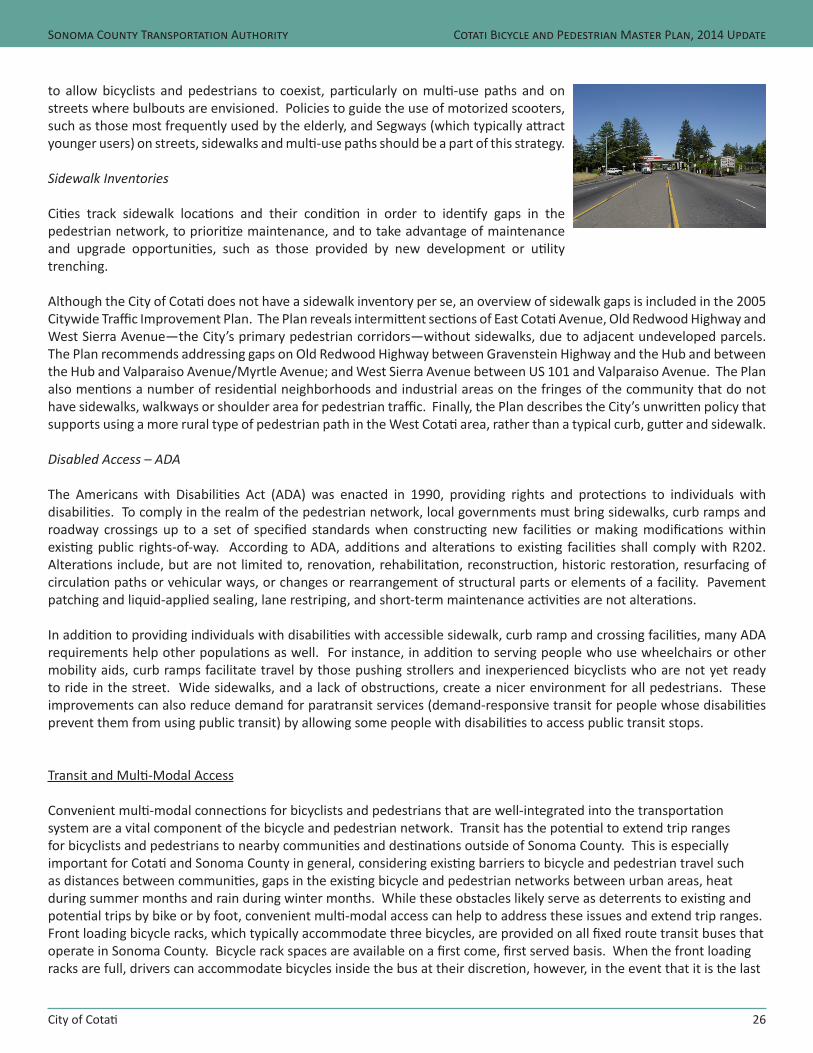
City of Cotati
Sonoma County Transportation Authority
26
Cotati Bicycle and Pedestrian Master Plan, 2014 Update
to allow bicyclists and pedestrians to coexist, particularly on multi-use paths and on streets where bulbouts are envisioned. Policies to guide the use of motorized scooters, such as those most frequently used by the elderly, and Segways (which typically attract younger users) on streets, sidewalks and multi-use paths should be a part of this strategy.
Sidewalk Inventories
Cities track sidewalk locations and their condition in order to identify gaps in the pedestrian network, to prioritize maintenance, and to take advantage of maintenance and upgrade opportunities, such as those provided by new development or utility trenching.
Although the City of Cotati does not have a sidewalk inventory per se, an overview of sidewalk gaps is included in the 2005 Citywide Traffic Improvement Plan. The Plan reveals intermittent sections of East Cotati Avenue, Old Redwood Highway and West Sierra Avenue—the City’s primary pedestrian corridors—without sidewalks, due to adjacent undeveloped parcels. The Plan recommends addressing gaps on Old Redwood Highway between Gravenstein Highway and the Hub and between the Hub and Valparaiso Avenue/Myrtle Avenue; and West Sierra Avenue between US 101 and Valparaiso Avenue. The Plan also mentions a number of residential neighborhoods and industrial areas on the fringes of the community that do not have sidewalks, walkways or shoulder area for pedestrian traffic. Finally, the Plan describes the City’s unwritten policy that supports using a more rural type of pedestrian path in the West Cotati area, rather than a typical curb, gutter and sidewalk.
Disabled Access – ADA
The Americans with Disabilities Act (ADA) was enacted in 1990, providing rights and protections to individuals with disabilities. To comply in the realm of the pedestrian network, local governments must bring sidewalks, curb ramps and roadway crossings up to a set of specified standards when constructing new facilities or making modifications within existing public rights-of-way. According to ADA, additions and alterations to existing facilities shall comply with R202. Alterations include, but are not limited to, renovation, rehabilitation, reconstruction, historic restoration, resurfacing of circulation paths or vehicular ways, or changes or rearrangement of structural parts or elements of a facility. Pavement patching and liquid-applied sealing, lane restriping, and short-term maintenance activities are not alterations.
In addition to providing individuals with disabilities with accessible sidewalk, curb ramp and crossing facilities, many ADA requirements help other populations as well. For instance, in addition to serving people who use wheelchairs or other mobility aids, curb ramps facilitate travel by those pushing strollers and inexperienced bicyclists who are not yet ready to ride in the street. Wide sidewalks, and a lack of obstructions, create a nicer environment for all pedestrians. These improvements can also reduce demand for paratransit services (demand-responsive transit for people whose disabilities prevent them from using public transit) by allowing some people with disabilities to access public transit stops.
Transit and Multi-Modal Access
Convenient multi-modal connections for bicyclists and pedestrians that are well-integrated into the transportation system are a vital component of the bicycle and pedestrian network. Transit has the potential to extend trip ranges for bicyclists and pedestrians to nearby communities and destinations outside of Sonoma County. This is especially important for Cotati and Sonoma County in general, considering existing barriers to bicycle and pedestrian travel such as distances between communities, gaps in the existing bicycle and pedestrian networks between urban areas, heat during summer months and rain during winter months. While these obstacles likely serve as deterrents to existing and potential trips by bike or by foot, convenient multi-modal access can help to address these issues and extend trip ranges. Front loading bicycle racks, which typically accommodate three bicycles, are provided on all fixed route transit buses that operate in Sonoma County. Bicycle rack spaces are available on a first come, first served basis. When the front loading racks are full, drivers can accommodate bicycles inside the bus at their discretion, however, in the event that it is the last
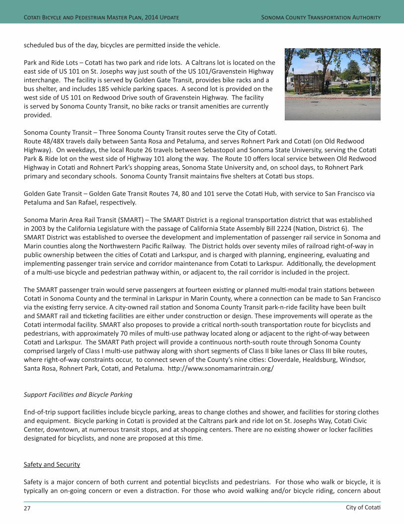
City of Cotati
Sonoma County Transportation Authority
27
Cotati Bicycle and Pedestrian Master Plan, 2014 Update
scheduled bus of the day, bicycles are permitted inside the vehicle.
Park and Ride Lots – Cotati has two park and ride lots. A Caltrans lot is located on the east side of US 101 on St. Josephs way just south of the US 101/Gravenstein Highway interchange. The facility is served by Golden Gate Transit, provides bike racks and a bus shelter, and includes 185 vehicle parking spaces. A second lot is provided on the west side of US 101 on Redwood Drive south of Gravenstein Highway. The facility is served by Sonoma County Transit, no bike racks or transit amenities are currently provided.
Sonoma County Transit – Three Sonoma County Transit routes serve the City of Cotati. Route 48/48X travels daily between Santa Rosa and Petaluma, and serves Rohnert Park and Cotati (on Old Redwood Highway). On weekdays, the local Route 26 travels between Sebastopol and Sonoma State University, serving the Cotati Park & Ride lot on the west side of Highway 101 along the way. The Route 10 offers local service between Old Redwood Highway in Cotati and Rohnert Park’s shopping areas, Sonoma State University and, on school days, to Rohnert Park primary and secondary schools. Sonoma County Transit maintains five shelters at Cotati bus stops.
Golden Gate Transit – Golden Gate Transit Routes 74, 80 and 101 serve the Cotati Hub, with service to San Francisco via Petaluma and San Rafael, respectively.
Sonoma Marin Area Rail Transit (SMART) – The SMART District is a regional transportation district that was established in 2003 by the California Legislature with the passage of California State Assembly Bill 2224 (Nation, District 6). The SMART District was established to oversee the development and implementation of passenger rail service in Sonoma and Marin counties along the Northwestern Pacific Railway. The District holds over seventy miles of railroad right-of-way in public ownership between the cities of Cotati and Larkspur, and is charged with planning, engineering, evaluating and implementing passenger train service and corridor maintenance from Cotati to Larkspur. Additionally, the development of a multi-use bicycle and pedestrian pathway within, or adjacent to, the rail corridor is included in the project. The SMART passenger train would serve passengers at fourteen existing or planned multi-modal train stations between Cotati in Sonoma County and the terminal in Larkspur in Marin County, where a connection can be made to San Francisco via the existing ferry service. A city-owned rail station and Sonoma County Transit park-n-ride facility have been built and SMART rail and ticketing facilities are either under construction or design. These improvements will operate as the Cotati intermodal facility. SMART also proposes to provide a critical north-south transportation route for bicyclists and pedestrians, with approximately 70 miles of multi-use pathway located along or adjacent to the right-of-way between Cotati and Larkspur. The SMART Path project will provide a continuous north-south route through Sonoma County comprised largely of Class I multi-use pathway along with short segments of Class II bike lanes or Class III bike routes, where right-of-way constraints occur, to connect seven of the County’s nine cities: Cloverdale, Healdsburg, Windsor, Santa Rosa, Rohnert Park, Cotati, and Petaluma. http://www.sonomamarintrain.org/
Support Facilities and Bicycle Parking
End-of-trip support facilities include bicycle parking, areas to change clothes and shower, and facilities for storing clothes and equipment. Bicycle parking in Cotati is provided at the Caltrans park and ride lot on St. Josephs Way, Cotati Civic Center, downtown, at numerous transit stops, and at shopping centers. There are no existing shower or locker facilities designated for bicyclists, and none are proposed at this time.
Safety and Security
Safety is a major concern of both current and potential bicyclists and pedestrians. For those who walk or bicycle, it is typically an on-going concern or even a distraction. For those who avoid walking and/or bicycle riding, concern about
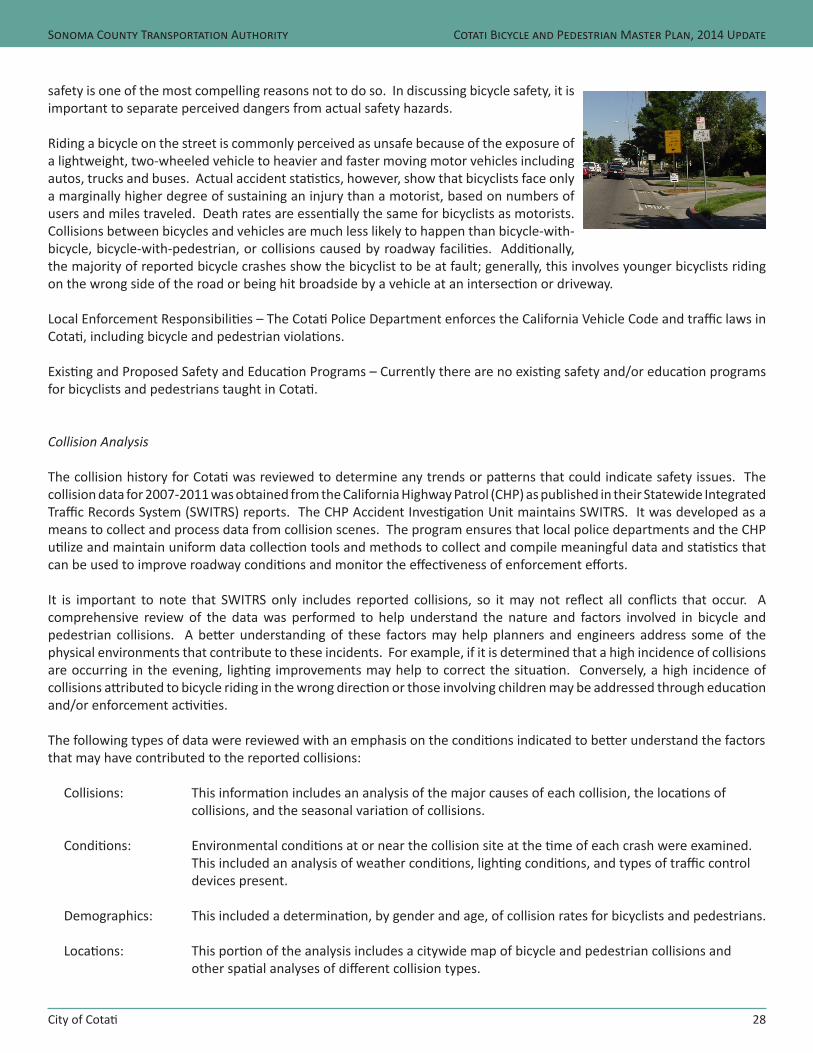
City of Cotati
Sonoma County Transportation Authority
28
Cotati Bicycle and Pedestrian Master Plan, 2014 Update
safety is one of the most compelling reasons not to do so. In discussing bicycle safety, it is important to separate perceived dangers from actual safety hazards.
Riding a bicycle on the street is commonly perceived as unsafe because of the exposure of a lightweight, two-wheeled vehicle to heavier and faster moving motor vehicles including autos, trucks and buses. Actual accident statistics, however, show that bicyclists face only a marginally higher degree of sustaining an injury than a motorist, based on numbers of users and miles traveled. Death rates are essentially the same for bicyclists as motorists. Collisions between bicycles and vehicles are much less likely to happen than bicycle-with-bicycle, bicycle-with-pedestrian, or collisions caused by roadway facilities. Additionally, the majority of reported bicycle crashes show the bicyclist to be at fault; generally, this involves younger bicyclists riding on the wrong side of the road or being hit broadside by a vehicle at an intersection or driveway.
Local Enforcement Responsibilities – The Cotati Police Department enforces the California Vehicle Code and traffic laws in Cotati, including bicycle and pedestrian violations.
Existing and Proposed Safety and Education Programs – Currently there are no existing safety and/or education programs for bicyclists and pedestrians taught in Cotati.
Collision Analysis
The collision history for Cotati was reviewed to determine any trends or patterns that could indicate safety issues. The collision data for 2007-2011 was obtained from the California Highway Patrol (CHP) as published in their Statewide Integrated Traffic Records System (SWITRS) reports. The CHP Accident Investigation Unit maintains SWITRS. It was developed as a means to collect and process data from collision scenes. The program ensures that local police departments and the CHP utilize and maintain uniform data collection tools and methods to collect and compile meaningful data and statistics that can be used to improve roadway conditions and monitor the effectiveness of enforcement efforts.
It is important to note that SWITRS only includes reported collisions, so it may not reflect all conflicts that occur. A comprehensive review of the data was performed to help understand the nature and factors involved in bicycle and pedestrian collisions. A better understanding of these factors may help planners and engineers address some of the physical environments that contribute to these incidents. For example, if it is determined that a high incidence of collisions are occurring in the evening, lighting improvements may help to correct the situation. Conversely, a high incidence of collisions attributed to bicycle riding in the wrong direction or those involving children may be addressed through education and/or enforcement activities.
The following types of data were reviewed with an emphasis on the conditions indicated to better understand the factors that may have contributed to the reported collisions:
Collisions: This information includes an analysis of the major causes of each collision, the locations of collisions, and the seasonal variation of collisions.
Conditions: Environmental conditions at or near the collision site at the time of each crash were examined. This included an analysis of weather conditions, lighting conditions, and types of traffic control devices present.
Demographics: This included a determination, by gender and age, of collision rates for bicyclists and pedestrians.
Locations: This portion of the analysis includes a citywide map of bicycle and pedestrian collisions and other spatial analyses of different collision types.
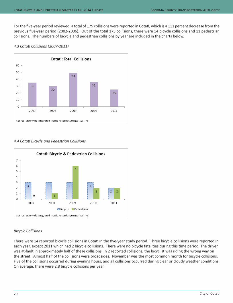
City of Cotati
Sonoma County Transportation Authority
29
Cotati Bicycle and Pedestrian Master Plan, 2014 Update
For the five-year period reviewed, a total of 175 collisions were reported in Cotati, which is a 111 percent decrease from the previous five-year period (2002-2006). Out of the total 175 collisions, there were 14 bicycle collisions and 11 pedestrian collisions. The numbers of bicycle and pedestrian collisions by year are included in the charts below.
4.3 Cotati Collisions (2007-2011)
4.4 Cotati Bicycle and Pedestrian Collisions
Bicycle Collisions
There were 14 reported bicycle collisions in Cotati in the five-year study period. Three bicycle collisions were reported in each year, except 2011 which had 2 bicycle collisions. There were no bicycle fatalities during this time period. The driver was at-fault in approximately half of these collisions. In 2 reported collisions, the bicyclist was riding the wrong way on the street. Almost half of the collisions were broadsides. November was the most common month for bicycle collisions. Five of the collisions occurred during evening hours, and all collisions occurred during clear or cloudy weather conditions. On average, there were 2.8 bicycle collisions per year.
City of Cotati
Sonoma County Transportation Authority
30
Cotati Bicycle and Pedestrian Master Plan, 2014 Update
Pedestrian Collisions
Over the five-year period 11 pedestrian collisions were recorded in Cotati. The year 2009 had a peak of 6 pedestrian collisions, but on average there were 2.2 pedestrian collisions per year. Two collisions occurred in the months of August and November, and the remaining collisions throughout the rest of the months. There was no significant pattern between pedestrian collisions and the month in which they occurred. Five out of the 11 collisions occurred in daylight, but most of the collisions took place during evening hours. All pedestrian collisions occurred during clear or cloudy weather, except one which occurred during rainy weather. No fatalities occurred during this time period.
Proposed Improvements
Bikeways
A segment by segment breakdown of the proposed bikeways including facility type, length, estimated cost of improvements, project priority, and other criteria are listed in Table 4.5. The proposed bikeways network has been developed to provide bicycle access to destinations throughout Cotati. The network consists of primary routes that connect through the City and provide access to neighboring jurisdictions, as well as local bikeways that provide access to neighborhoods and destinations throughout Cotati. While the projects in this Plan have received a preliminary feasibility evaluation, engineering and environmental studies will be required prior to project implementation to determine project specific issues such as right-of-way impacts, traffic operations, parking impacts, and environmental issues.
Approximately 4.5 miles of bikeways are proposed in Cotati, including a 0.6 miles extension of the Class I Laguna Pathway, 2.6 miles of Class II bike lanes on Myrtle Avenue, Old Redwood Highway, and Redwood Drive, and 1.3 miles of Class III bike routes which will provide local access on many of Cotati’s local streets including Benson Lane, Gilman Ranch Road, Lincoln Avenue, and others. Improved bicycle access is planned as a component of long-term solutions proposed on Gravenstein Highway under US 101, on West Sierra Avenue under US 101, and the US 101 undercrossing at East School Road. Additionally, a signing campaign of warning signs and destination based ‘wayfinding’ signs is proposed. Approximately 15-20 signs placed strategically at community gateways, route junctions, and regular intervals along the primary network would provide coverage for the entire community. The total cost of the bicycle facility improvements proposed in this plan is estimated at approximately $525,549.
Pedestrian Facilities
Proposed pedestrian improvements in this Plan are focused on crossing enhancements at various intersections on Gravenstein Highway, East and West Cotati Avenues, US 101 at the existing East School Street undercrossing and the Laguna De Santa Rosa Trail along with proposed sidewalk infill projects on West Cotati Avenue, West Sierra Avenue, and Madrone Avenue. The total cost of the pedestrian improvements proposed in this plan is estimated at approximately $2,834,038.
Pedestrian District – The Cotati 12 square block downtown area has been identified as a ‘pedestrian district.’ This district is one which experiences frequent pedestrian activity and street crossings. Therefore, the City should identify future pedestrian facilities and amenities in this district to serve this need.
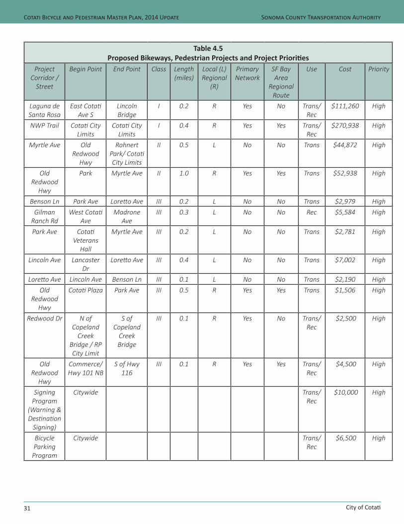
City of Cotati
Sonoma County Transportation Authority
31
Cotati Bicycle and Pedestrian Master Plan, 2014 Update
Table 4.5Proposed Bikeways, Pedestrian Projects and Project Priorities
Project Corridor /
Street
Begin Point End Point Class Length(miles)
Local (L)Regional
(R)
Primary Network
SF Bay Area
Regional Route
Use Cost Priority
Laguna de Santa Rosa
East Cotati Ave S
Lincoln Bridge
I 0.2 R Yes No Trans/Rec
$111,260 High
NWP Trail Cotati City Limits
Cotati City Limits
I 0.4 R Yes Yes Trans/Rec
$270,938 High
Myrtle Ave Old Redwood
Hwy
Rohnert Park/ Cotati City Limits
II 0.5 L No No Trans $44,872 High
Old Redwood
Hwy
Park Myrtle Ave II 1.0 R Yes Yes Trans $52,938 High
Benson Ln Park Ave Loretto Ave III 0.2 L No No Trans $2,979 HighGilman
Ranch RdWest Cotati
AveMadrone
AveIII 0.3 L No No Rec $5,584 High
Park Ave Cotati Veterans
Hall
Myrtle Ave III 0.2 L No No Trans $2,781 High
Lincoln Ave Lancaster Dr
Loretto Ave III 0.4 L No No Trans $7,002 High
Loretto Ave Lincoln Ave Benson Ln III 0.1 L No No Trans $2,190 HighOld
Redwood Hwy
Cotati Plaza Park Ave III 0.5 R Yes Yes Trans $1,506 High
Redwood Dr N of Copeland
Creek Bridge / RP City Limit
S of Copeland
Creek Bridge
III 0.1 R Yes No Trans/ Rec
$2,500 High
Old Redwood
Hwy
Commerce/ Hwy 101 NB
S of Hwy 116
III 0.1 R Yes Yes Trans/ Rec
$4,500 High
Signing Program
(Warning & Destination
Signing)
Citywide Trans/Rec
$10,000 High
Bicycle Parking
Program
Citywide Trans/Rec
$6,500 High
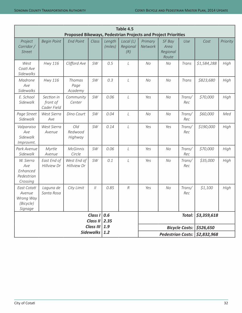
City of Cotati
Sonoma County Transportation Authority
32
Cotati Bicycle and Pedestrian Master Plan, 2014 Update
Table 4.5Proposed Bikeways, Pedestrian Projects and Project Priorities
Project Corridor /
Street
Begin Point End Point Class Length(miles)
Local (L)Regional
(R)
Primary Network
SF Bay Area
Regional Route
Use Cost Priority
West Coati Ave Sidewalks
Hwy 116 Clifford Ave SW 0.5 L No No Trans $1,584,288 High
Madrone Ave
Sidewalks
Hwy 116 Thomas Page
Academy
SW 0.3 L No No Trans $823,680 High
E. School Sidewalk
Section in front of
Cader Field
Community Center
SW 0.06 L Yes No Trans/ Rec
$70,000 High
Page Street Sidewalk
West Sierra Ave
Dino Court SW 0.04 L No No Trans/ Rec
$60,000 Med
Valparaiso Ave
Sidewalk Improvmt.
West Sierra Avenue
Old Redwood Highway
SW 0.14 L Yes Yes Trans/ Rec
$190,000 High
Park Avenue Sidewalk
Myrtle Avenue
McGinnis Circle
SW 0.06 L Yes No Trans/ Rec
$70,000 High
W. Sierra Ave
Enhanced Pedestrian Crossing
East End of Hillview Dr
West End of Hillview Dr
SW 0.1 L Yes No Trans/ Rec
$35,000 High
East Cotati Avenue
Wrong Way (Bicycle) Signage
Laguna de Santa Rosa
City Limit II 0.85 R Yes No Trans/Rec
$1,100 High
Class I Class II
Class III Sidewalks
0.62.351.91.2
Total: $3,359,618
Bicycle Costs: $526,650Pedestrian Costs: $2,832,968
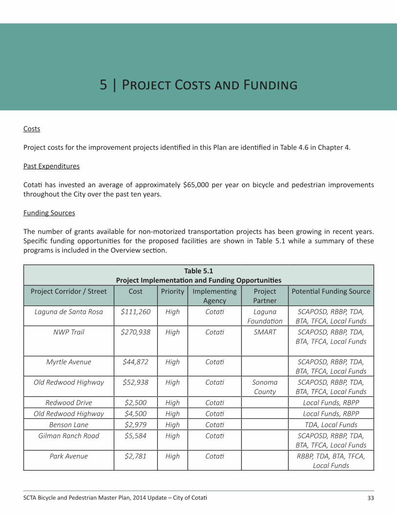
SCTA Bicycle and Pedestrian Master Plan, 2014 Update – City of Cotati 33
5 | Project Costs and Funding
Costs
Project costs for the improvement projects identified in this Plan are identified in Table 4.6 in Chapter 4.
Past Expenditures
Cotati has invested an average of approximately $65,000 per year on bicycle and pedestrian improvements throughout the City over the past ten years.
Funding Sources
The number of grants available for non-motorized transportation projects has been growing in recent years. Specific funding opportunities for the proposed facilities are shown in Table 5.1 while a summary of these programs is included in the Overview section.
Table 5.1Project Implementation and Funding Opportunities
Project Corridor / Street Cost Priority Implementing Agency
Project Partner
Potential Funding Source
Laguna de Santa Rosa $111,260 High Cotati Laguna Foundation
SCAPOSD, RBBP, TDA, BTA, TFCA, Local Funds
NWP Trail $270,938 High Cotati SMART SCAPOSD, RBBP, TDA, BTA, TFCA, Local Funds
Myrtle Avenue $44,872 High Cotati SCAPOSD, RBBP, TDA, BTA, TFCA, Local Funds
Old Redwood Highway $52,938 High Cotati Sonoma County
SCAPOSD, RBBP, TDA, BTA, TFCA, Local Funds
Redwood Drive $2,500 High Cotati Local Funds, RBPPOld Redwood Highway $4,500 High Cotati Local Funds, RBPP
Benson Lane $2,979 High Cotati TDA, Local FundsGilman Ranch Road $5,584 High Cotati SCAPOSD, RBBP, TDA,
BTA, TFCA, Local FundsPark Avenue $2,781 High Cotati RBBP, TDA, BTA, TFCA,
Local Funds
City of Cotati
Sonoma County Transportation Authority
34
Cotati Bicycle and Pedestrian Master Plan, 2014 Update
Table 5.1Project Implementation and Funding Opportunities
Project Corridor / Street Cost Priority Implementing Agency
Project Partner
Potential Funding Source
Lincoln Avenue $7,002 High Cotati RBBP, TDA, BTA, TFCA, Local Funds
Loretto Avenue $2,190 High Cotati RBBP, TDA, BTA, TFCA, Local Funds
Old Redwood Highway $1,506 High Cotati RBBP, TDA, BTA, TFCA, Local Funds
Signing Program(Warning & Destination
Signing)
$10,000 High Cotati SCTA, County TDA, RBPP
Bicycle Parking Program $6,500 High Cotati SCTA TDA, RBPP, Local FundsWest Cotati Avenue
Sidewalks$1,584,288 High Cotati RBBP, TDA, BTA, TFCA,
Local FundsWest Sierra Avenue
Enhanced Ped Crossing$35,000 High Cotati Local Funds, RBPP
Madrone Avenue Sidewalks $823,680 High Cotati Safe Routes to Schools, Local Funds, Developer
FeesE. School Sidewalk $70,000 High Cotati
Page Street Sidewalk $60,000 High CotatiValparaiso Ave Sidewalk
Improvmt.$190,000 High Cotati Local Funds, RBPP,
Developer FeesPark Avenue Sidewalk $70,000 High Cotati
East Cotati Avenue Wrong Way (Bicycle) Signage
$1,100 High Cotati Local Funds, RBPP
Class I $ 382,198 Class II $ 97,810
Class III $ 29,042Sidewalks $2,832,968
Bicycle Parking and Signage
$17,600
Total: $3,359,618
SCTA Bicycle and Pedestrian Master Plan, 2014 Update – City of Cotati 35
Appendices
Appendix A: Bicycle and Pedestrian Count Data by Metropolitan Transportation Commission (MTC)
Appendix B: Bicycle and Pedestrian Count Data by Sonoma County Transportation Authority (SCTA)
Appendix C: Future Potential Bicycle and Pedestrian Count Locations
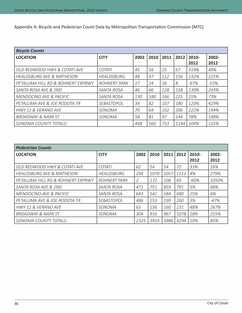
City of Cotati
Sonoma County Transportation Authority
36
Cotati Bicycle and Pedestrian Master Plan, 2014 Update
Appendix A: Bicycle and Pedestrian Count Data by Metropolitan Transportation Commission (MTC)
Bicycle CountsLOCATION CITY 2002 2010 2011 2012 2010-
20122002-2012
OLD REDWOOD HWY & COTATI AVE COTATI 45 16 25 67 319% 49%HEALDSBURG AVE & MATHESON HEALDSBURG 48 47 112 156 232% 225%PETALUMA HILL RD & ROHNERT EXPRWY ROHNERT PARK 17 24 16 8 -67% -53%SANTA ROSA AVE & 2ND SANTA ROSA 46 66 128 158 139% 243%MENDOCINO AVE & PACIFIC SANTA ROSA 130 180 166 225 25% 73%PETALUMA AVE & JOE RODOTA TR SEBASTOPOL 34 82 107 180 120% 429%HWY 12 & VERANO AVE SONOMA 70 64 102 206 222% 194%BROADWAY & NAPA ST SONOMA 58 81 97 144 78% 148%SONOMA COUNTY TOTALS: 448 560 753 1144 104% 155%
Pedestrian CountsLOCATION CITY 2002 2010 2011 2012 2010-
20122002-2012
OLD REDWOOD HWY & COTATI AVE COTATI 62 54 54 72 33% 16%HEALDSBURG AVE & MATHESON HEALDSBURG 294 1070 1057 1113 4% 279%PETALUMA HILL RD & ROHNERT EXPRWY ROHNERT PARK 2 172 106 69 -60% 3350%SANTA ROSA AVE & 2ND SANTA ROSA 471 751 859 791 5% 68%MENDOCINO AVE & PACIFIC SANTA ROSA 643 542 584 680 25% 6%PETALUMA AVE & JOE RODOTA TR SEBASTOPOL 486 253 199 260 3% -47%HWY 12 & VERANO AVE SONOMA 63 156 160 231 48% 267%BROADWAY & NAPA ST SONOMA 304 916 967 1078 18% 255%SONOMA COUNTY TOTALS: 2325 3914 3986 4294 10% 85%
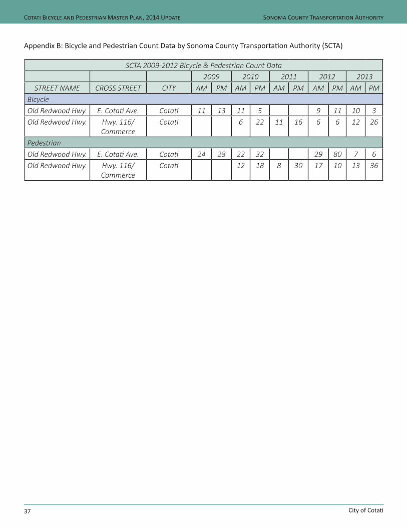
City of Cotati
Sonoma County Transportation Authority
37
Cotati Bicycle and Pedestrian Master Plan, 2014 Update
Appendix B: Bicycle and Pedestrian Count Data by Sonoma County Transportation Authority (SCTA)
SCTA 2009-2012 Bicycle & Pedestrian Count Data 2009 2010 2011 2012 2013
STREET NAME CROSS STREET CITY AM PM AM PM AM PM AM PM AM PMBicycleOld Redwood Hwy. E. Cotati Ave. Cotati 11 13 11 5 9 11 10 3Old Redwood Hwy. Hwy. 116/
CommerceCotati 6 22 11 16 6 6 12 26
PedestrianOld Redwood Hwy. E. Cotati Ave. Cotati 24 28 22 32 29 80 7 6Old Redwood Hwy. Hwy. 116/
CommerceCotati 12 18 8 30 17 10 13 36

City of Cotati
Sonoma County Transportation Authority
38
Cotati Bicycle and Pedestrian Master Plan, 2014 Update
Appendix C: Future Potential Bicycle and Pedestrian Count Locations
City of Cotati# Primary Street Cross Street Notes
1* Old Redwood Highway Gravenstein Highway (SR 116)
Primary Network / Community Gateway
2 Old Redwood Highway West Sierra Ave Downtown District / Primary Network3 East Cotati Ave Lancaster Primary Network / School Commute Route4 Laguna Path East Cotati Avenue Intersection of Primary Network and Regional
Pathway5 Laguna Path Commerce Boulevard Primary Network / Community Gateway6 Old Redwood Highway Myrtle Primary Network / Community Gateway7 Redwood Drive Gravenstein Highway (SR
116)Primary Network / Community Gateway
8 School Street West Sierra Local Bikeway*Location has already been counted as part of the SCTA Bicycle and Pedestrian Count Program