Cost-Benefit Analysis of the Alternatives Proposed for the ...
40
January 8, 2019 © Anderson Economic Group, LLC, 2018 Permission to reproduce in entirety granted with proper citation. All other rights reserved. Anderson Economic Group, LLC East Lansing | Chicago 1555 Watertower Place, Suite 100 East Lansing, Michigan 48823 Telephone: (517) 333-6984 www.AndersonEconomicGroup.com Cost-Benefit Analysis of the Alternatives Proposed for the Grand River Revitalization Prepared by: Anderson Economic Group, LLC Jason Horwitz, Senior Consultant Brandon Betz, Senior Analyst Commissioned by: Environmental Consulting & Technology, Inc.
Transcript of Cost-Benefit Analysis of the Alternatives Proposed for the ...

January 8, 2019
© Anderson Economic Group, LLC, 2018Permission to reproduce in entirety granted with proper citation. All other rights reserved.
Anderson Economic Group, LLCEast Lansing | Chicago
1555 Watertower Place, Suite 100East Lansing, Michigan 48823Telephone: (517) 333-6984
www.AndersonEconomicGroup.com
Cost-Benefit Analysis of the Alternatives Proposed for the Grand River Revitalization
Prepared by:
Anderson Economic Group, LLCJason Horwitz, Senior ConsultantBrandon Betz, Senior Analyst
Commissioned by:Environmental Consulting & Technology, Inc.

Table of Contents
Anderson Economic Group, LLC
I. Executive Summary................................................1
Purpose of Report ................................................................. 1Overview of Approach .......................................................... 1Overview of Findings ........................................................... 3About Anderson Economic Group ........................................ 8
II. The Grand Rapids Whitewater Project ................9
About Grand Rapids Whitewater .......................................... 9Grand River Revitalization Project ....................................... 9Description of Proposed Alternatives ................................. 10
III. Costs and Benefits of Proposed Alternatives ....13
Construction and Maintenance Spending ........................... 13Environmental Impacts ....................................................... 14Ecological Impacts .............................................................. 15Recreation Impacts .............................................................. 18Impacts on Business Activity .............................................. 21Net Present Value of Costs and Benefits ............................ 21
Appendix A. Overview of Project Area .................A-1
Appendix B. Sensitivity Analysis ...........................B-1
Discount Rates .................................................................. B-1Time Horizon .................................................................... B-1
Appendix C. Methodology.....................................C-1
Usership Estimates for Recreational Activities ................ C-1Monetizing Recreational Benefits ..................................... C-2Assumptions ...................................................................... C-4
Appendix D. About Anderson Economic Group... D-1
About the Authors ............................................................. D-1

Executive Summary
I.Executive Summary
A centerpiece to Grand Rapids and the city’s namesake, the Grand River runs right through the city. This 2.2-mile stretch of river once featured large boul-ders, rock islands, and natural reefs. These were cleared and five dams were built to facilitate the transfer of timbers, to facilitate water power, and to float sewage in the mid to late 1800s, which degraded the ecosystem and limited rec-reational activity that occurred in and around the river. The section of the river that flows through downtown Grand Rapids is mostly unusable due to the dams that span the downtown area, which create unsafe currents for boating, fishing, and other activities.
The remaining beautification dams serve no useful purpose and prevent safe travel along the river. A project proposed by Grand Rapids Whitewater would remove four beautification dams along the river and enhance the substrate of the riverbed. The removal of the dams and restoration of natural bottom features would bring back not only the rapids to Grand Rapids—it is designed to improve aquatic habitat diversity; create new, safer recreational opportunities; expand access to the river; spur economic development; and enhance the natural beauty of the river.
PURPOSE OF REPORT To inform portions of the watershed project plan (WPP) for the Grand River res-toration, Environmental Consulting & Technology, Inc. has commissioned Anderson Economic Group (AEG) to perform a cost-benefit analysis of alterna-
tives proposed under the Biological Assessment1, which aims to restore the rap-ids to Grand Rapids. The purpose of this report is to:
• Document the proposed alternatives in terms of their impact on the environ-ment, ecosystem, and recreation;
• Catalogue, measure, and categorize costs and benefits for each alternative from the national perspective;
• Monetize the estimated costs and benefits, where possible; and
• Calculate the net effect of each of the alternatives as compared to the No Action alternative.
OVERVIEW OF APPROACH
In 1936, Congress passed the Flood Control Act, which codified the importance of cost-benefit analysis in watershed projects and established use of the tool:
“... that the Federal Government should improve or participate in the improvement of navigable waters or their tributaries, including watersheds thereof, for flood-control
1. Heidi L. Dunn, “Biological Assessment: Impacts to Federal and State Threatened and Endan-gered Species from Rehabilitation of the Grand River Between I-196 and Fulton Street in Grand Rapids, Kent County, Michigan,” EcoAnalysts, Inc., December 2018.
Anderson Economic Group, LLC 1

Executive Summary
purposes if the benefits to whomsoever they may accrue are in excess of the estimated
costs, and if the lives and social security of people are otherwise adversely affected.”2
Since then, cost-benefit analysis has been the subject of countless projects of this nature.
In the following cost-benefit analysis, we estimate the national costs and bene-fits of two alternatives as compared to the No Action alternative. The alterna-tives we consider are as follows:
• No Action (Alternative 1) would leave the four low-head dams in their current form. No substrate enhancement or river restoration would occur.
• Alternative 2 involves removing the four low-head dams between the I-196 bridge and Fulton Street bridge in downtown Grand Rapids.
• Alternative 3 entails enhancing the substrate of the river, which would include completely restructuring the river channel through excavation, grading, and importing boulders, cobble, and gravels in addition to removing the four low-head dams described in Alternative 2 above.
We categorized costs and benefits for each alternative in four groups:
• Ecological effects;
• Environmental effects;
• Costs associated with construction and maintenance; and
• Recreational activity.
The project plan we analyzed for this report is a non-water resource project, meaning that the project is not primarily for flood damage reduction, water sup-ply, water-based recreation, water quality management, nor large scale irrigation or drainage. As such, in comparing alternatives, the WPP is required to identify the “least costly socially and environmentally acceptable method of achieving
the agreed-upon level of resource protection.”3
We followed Principles and Guidelines procedures to identify and quantify the costs and benefits of the project: all costs, including operation, maintenance, and replacement, expected to be incurred over the period of analysis are included. We met and exceeded the expectations outlined by the National Watershed Program Manual by quantifying not only the costs for each alterna-
tive, but also added benefits not required for non-water resource plans.4
2. U.S. Congress, House, “Authorizing the construction of certain public works on rivers and harbors for flood control and for other purposes,” HR 8455, 74th Cong., 2nd sess., passed June 22, 1936, found at http://uscode.house.gov/statviewer.htm?volume=49&page=1570, accessed on 9/14/2018.
3. Natural Resources Conservation Service, Title 390 -- National Watershed Program Manual, Part 500.
Anderson Economic Group, LLC 2

Executive Summary
In the following report, we present the alternatives and describe the general dif-ferences behind each, and systematically categorize and measure the effects. Next, we monetize the effects where possible using broadly-accepted methods. Finally, we calculate the net benefit of each alternative as compared to the No
Action alternative.5
OVERVIEW OF FINDINGS
1. The costs of construction, maintenance, and replacement for Alter-native 2 and Alternative 3 are $6.5 million and $9.5 million, respec-tively.
We used total cost estimates from Grand Rapids Whitewater to approximate the costs of construction under Alternatives 2 and 3. These are detailed by year in Table 1 below. The present value of construction spending for Alternatives 2 and 3 are $6.3 and $9.1 million respectively.
There could potentially be some ongoing maintenance costs due to boulders moving downstream for Alternative 3, but those costs are uncertain and very likely to be negligible. We also looked into other potential costs associated with flooding and with businesses that may be adversely affected by construction and found none. As such, there would be no ongoing maintenance costs in Alterna-tive 1 or 2. See “Costs and Benefits of Proposed Alternatives” on page 13 for more information.
4. Natural Resources Conservation Service, “Economic and Environmental Principles and Guidelines for Water and Related Land Resources Implementation Studies,” 1983.
5. The net benefits of the project are calculated as the difference between the monetized benefits of recreational activity and the costs of construction.We evaluated other potential sources of benefits or costs and they were either negligible (in the case of flooding and public safety) or unmonetizable (in the case of the preservation of species).
TABLE 1. Estimated Construction Costs
Alternative 2: DamRemoval
Alternative 3: SubstrateEnhancement
2019 $1,972,209 $1,972,209
2020 $3,106,229 $3,106,229
2021 $1,385,479 $2,761,093
2022 $0 $1,706,307
Total $6,463,917 $9,545,838
Discount Rate 3.5% 3.5%
Discounted Total $6,266,756 $9,089,898
Source: Anderson Economic Group Analysis derived using data from Grand Rapids Whitewater
Anderson Economic Group, LLC 3

Executive Summary
2. The net benefit of removing the four beautification dams and enhanc-ing the substrate of the river (Alternative 3) is $17.6 to $22.4 million and an increase in preferred habitat for mussels.
We find that the net benefit of removing the beautification dams and enhancing the underlying substrate is significant: Alternative 3, removal of the beautifica-tion dams with substrate enhancement, yields a net present value of $17.6 to $22.4 million in net benefits over 25 years on dimensions that we are able to monetize. Alternative 2, removal of the beautification dams without substrate enhancement, has a barely positive net present value on the high end and a barely negative value on the low end, indicating that the present value of the benefits of recreation are approximately equal to the discounted costs of con-struction. Figure 1 below shows the cumulative value of Alternative 2 and 3 over time.
FIGURE 1. Cumulative Net Present Value of the Alternatives over the No Action Alternative
We also quantified, but did not monetize the ecological effects of the alterna-tives for mussel species. These include the amount of habitat available for mus-sels and the loss of mussels due to construction. An increase in the mussel population is beneficial for many reasons: they increase water quality, remove
Source: Anderson Economic Group analysis using data derived from Grand Rapids Whitewater and U.S. Army Corps of Engineers, Fiscal Year 2018
Anderson Economic Group, LLC 4

Executive Summary
contaminants from the water, and generate other ecological benefits. We discuss these results in “Ecological Impacts” on page 15.
We identified but did not quantify additional benefits, including increased busi-ness activity and effects on water safety. See “Construction and Maintenance Spending” on page 13. Table 2 below catalogs the benefits and costs we identi-fied for the project under Alternatives 2 and 3.
3. Dam removal and substrate enhancement (Alternative 3) is designed to increase preferred hydrophysical habitat for mussels by 266%, while dam removal alone (Alternative 2) would decrease it by 48%.
We used two measures to account for the benefits derived from the alternatives for threatened, endangered, and special concern (TES) species. We documented the amount of preferred hydrophysical habitat available to mussels. Preferred hydrophysical habitat meets certain parameters for bed slope, minimum water velocity, substrate stability, and proper conditions under low and high flow in
which mussel species populate at favorable rates.6 We also documented esti-mates for the number of TES species that would be adversely impacted by con-struction under each of the alternatives.
There are a number of mussel species found within the project reach, including TES species. These would be affected if construction were to take place due to
TABLE 2. Catalog of Benefits and Costs of Alternatives 2 and 3 Relative to Alternative 1
Alternative 2: Dam Removal Alternative 3: Substrate Enhancement
Annual Recreation Benefits (Millions)
$0.4 to $0.5 $2.0 to $2.4
Total Construction Costs (Millions)
$6.5 $9.5
Net Benefits, cumulative and discounted over 25 years (Millions)
-$0.6 to $1.0 $17.6 to $22.4
Non-Monetized BenefitsPreferred hydrophysical habitat for mussels could
increase by 8,780 m2
Non-Monetized Costs
Preferred hydrophysical habitat for mussels could
decline by 2,750 m2
Aquatic area available at low flow would decline
by 8,405 m2
Loss of mussels due to construction is estimatedat 3,570
Loss of mussels due to habitat reduction is esti-mated as 2,520
Aquatic area available at low flow is estimated to
decline by 22,490 m2
Loss of mussels due to construction is estimatedas 26,465
Loss of mussels due to habitat reduction isestimated as 6,745
Source: Anderson Economic Group analysis using data derived from Grand Rapids Whitewater and U.S. Army Corps of Engineers, Fiscal Year 2018
Anderson Economic Group, LLC 5

Executive Summary
tracking equipment being placed within the project area to remove the dams and to enhance the substrate. Overall, researchers projected that the aquatic habitat available at low flow would be reduced, thus reducing habitable space for mus-sel species after construction is completed; however, the amount of preferred hydrophysical habitat is designed to increase under Alternative 3. Preferred hydrophysical habitat could decline by 48% under Alternative 2, while it could expand by 266% under Alternative 3. Figure 2 below illustrates these changes.
FIGURE 2. Available Aquatic Habitat and Preferred Hydrophysical Habitat for Unionid Mussels Under Each Alternative (square meters)
Additionally, there would be a significant loss of mussels due to construction and habitat reduction in the project area. There is reason to believe that these populations would rebound insofar as preferred hydrophysical habitat increases,
6. Formally, preferred hydrophysical habitat includes bed slope less than 10%, minimum veloci-ties between 0.15 and 0.5 meters per second, sheer stress divided by critical sheer stress less than 1.2, area wetted at 890 cubic feet per second, and non-depositional sand area at 3,500 cubic feet per second. Higher densities of unionid mussels should be found in this type of hab-itat.
Source: Heidi Dunn, “Biological Assessment: Impacts to federal and state threatened andendangered species from rehabilitation of the Grand River between I-196 and Fulton Street inGrand Rapids, Kent County, Michigan,” EcoAnalysts, Inc., December 2018.
Anderson Economic Group, LLC 6

Executive Summary
but the extent of this rebound is uncertain. Losses during construction under each alternative are shown in Figure 3 below.
FIGURE 3. Total Loss of Mussels Due to Construction
For more information about the ecological effects of the alternatives, see “Eco-logical Impacts” on page 15.
4. Substrate enhancement does not result in significant costs or benefits associated with several categories of interest, because there would be no significant quantifiable changes to flood risk, water quality, or public safety.
While we investigated many different potential sources of cost and benefit asso-ciated with the three alternatives, we found that significant costs and benefits were limited to construction costs, recreational opportunities, and ecological consequences. Flood risk in the area is unaffected by the changes in any alterna-tive. Additionally, while pollution and water quality are likely to continue to improve in the Grand River, they will be unaffected by this project. Representa-tives have argued that the dams represent a danger to people in the river, but
Source: Heidi Dunn, “Biological Assessment: Impacts to federal and state threatened andendangered species from rehabilitation of the Grand River between I-196 and Fulton Street inGrand Rapids, Kent County, Michigan,” EcoAnalysts, Inc., December 2018.
Anderson Economic Group, LLC 7

Executive Summary
there are few records from the Grand Rapids Fire Department regarding rescues directly involving the dams.
For more details on these effects, see “Environmental Impacts” on page 14.
5. Significant riverside development would occur in tandem with Alter-native 3, and has already begun in anticipation of the restoration.
Substantial development is planned after the changes to the river are completed that is due directly to the removal of the dams and enhancement of the river sub-strate. Indeed, real estate developers have already begun to show interest in property located in proximity to the river due to the planned river restoration. See “Impacts on Business Activity” on page 21.
ABOUT ANDERSON ECONOMIC GROUP
Anderson Economic Group is a boutique research and consulting firm, with offices in East Lansing, Michigan; Chicago, Illinois; and New York, New York. The experts at AEG specialize in strategy, business valuation, public policy, and market analyses. They have conducted nationally-recognized economic and fis-cal impact studies for private, public, and non-profit clients across the United States.
Anderson Economic Group has performed and published work on a number of environmental economics issues. Relevant publications from our firm include:
• Aquatic Invasive Species in the Chicago Area Waterway System, published in 2017;
• The Costs of Aquatic Invasive Species to Great Lakes States, updated in 2017;
• Innovating for the Blue Economy, published in 2014;
• Financing the Battle Against Invasive Species, published in 2010;
• Four Plausible Scenarios that Could Emerge from Court Ruling on the EPA’s Clean Power Plan, published in 2016;
• Analysis of Michigan’s Options Under the EPA’s Clean Power Plan, published in 2016; and
• Economic Impact of the Grand Rapids Whitewater Project, published in 2014.
The consultants at Anderson Economic Group have a deep understanding of advanced economic modeling techniques and extensive experience in a variety of industries in multiple states and countries. Work by AEG has been utilized in legislative hearings, legal proceedings, and public debates, as well as major planning exercises and executive strategy discussions. For more information, please see “Appendix D. About Anderson Economic Group” on page D-1 or visit www.AndersonEconomicGroup.com.
Anderson Economic Group, LLC 8

The Grand Rapids Whitewater Project
II.The Grand Rapids Whitewater Project
ABOUT GRAND RAPIDS WHITEWATER
Grand Rapids Whitewater (GRWW) is a non-profit organization that grew out of a citywide green infrastructure master planning process, Green Grand Rap-ids, that focused on physical infrastructure and the city’s natural amenities, rec-reation, and public health. During the planning process, Green Grand Rapids combined the idea of revitalizing the rapids to the Grand River with improving outdoor recreation opportunities. Now, Grand Rapids Whitewater champions the effort to restore and revitalize the river.
Grand Rapids Whitewater held focus group meetings in 2008 and 2009 to dis-cuss recreational river opportunities and what other cities have done to increase downtown river usage. The focus soon grew beyond recreational elements to include a comprehensive revitalization of the Grand River. In 2012, representa-
tives from GRWW began holding meetings with stakeholder groups.6 By May 2013, the U.S. Environmental Protection Agency announced that the Urban Waters Federal Partnership would include the Grand River Restoration, and var-ious state and local agencies also voiced support for the project. A Regional Conservation Partnership Program grant was awarded to the Grand Valley Met-ropolitan Council in 2017, of which $4.1 million will be used to revitalize the rapids.
GRAND RIVER REVITALIZATION PROJECT
In this section, we describe the scope of our analysis of the alternatives pro-posed in the Biological Assessment for the Grand River Revitalization Project, Grand Rapids, Michigan that was prepared for use in December 2018.
Project Area. The area of revitalization includes the Grand River in downtown Grand Rapids directly north of the I-196 bridge to Fulton Street. The proposed alternatives include removal of four low-head beautification dams in the area and major substrate enhancement. Six staging and access areas will be located on the banks of the Grand River between I-196 and Fulton Street. We provide maps in “Appendix A. Overview of Project Area” beginning on page A-1 to illustrate where the project would take place.
Dams. There are four low-head beautification dams between I-196 and Fulton Street. They were originally constructed to maintain channel width during low flow to prevent the concentration of raw sewage that was discharged into the river. The four dams currently do not serve a purpose and make navigating the river unsafe. They are also aging; maintenance is non-existent and repairs are not currently under consideration. Failure of the dams would cause damage to the area downstream of the dams. Alternatives 2 and 3 both include provisions
6. “Grand River Whitewater Park Preferred Alternative,” Green Grand Rapids, 2009, pp. 5-6.
Anderson Economic Group, LLC 9
The Grand Rapids Whitewater Project
to remove the dams to allow the river to flow with conditions that existed before their introduction.
Threatened, Endangered, and Special Concern (TES) Species. Various spe-cies of freshwater unionid mussel (Unionida), as well as Lake Sturgeon (Acipenser fulvescens), River Redhorse (Moxostoma carinatum), and other endangered and threatened species exist in the project area. Each of the pro-posed alternatives would alter the ecological framework of the Grand River through water flow and quality changes, the removal or addition of fish holding and general habitat area, and the introduction of complexity to the habitat. Con-struction footprints as well as changes in the configuration of the channel would
result in take of TES species.7
Recreational Activities. The four beautification dams impede boating users from enjoying the downtown area’s waterway. If the dams were removed, indi-viduals would have safer access to the river. The created rapids would draw whitewater boaters to the area for activities and events. Furthermore, fishing opportunities along the Grand River in downtown Grand Rapids would increase due to added fish holding areas and safer waters.
Other Incidental Benefits. Other incidental benefits include expanded public use and access to the river, improved aquatic habitat diversity, increased eco-nomic development, and improved public health and safety.
DESCRIPTION OF PROPOSED ALTERNATIVES
The alternatives described in the Biological Assessment include dam removal and substrate enhancement. This section details differences in each of the plans as compared to the No Action alternative.
Alternative 1: No Action
The No Action alternative would leave the four low-head dams in their current form. No substrate enhancement or river restoration would occur. This alterna-tive does not meet the project purpose of revitalizing, enhancing, and maintain-ing the rapids nor does it provide any other incidental benefits.
Currently, there are no rapids for whitewater users and boaters are unable to pass the low-head dams. Some fishing users are able to pass the dams using jet boats launched from Johnson Park, downstream; they fish for steelhead and salmon during high flows. During low flows, fishing users are able to wade into the water. There are a number of fish holding areas created by the beautification dams.
7. As defined by the Endangered Species Act, “The term ‘take’ means to harass, harm, pursue, hunt, shoot, wound, kill, trap, capture, or collect, or to attempt to engage in any such conduct.” For the definition of harass and harm, see 50 CFR 17.3 - Definitions.
Anderson Economic Group, LLC 10

The Grand Rapids Whitewater Project
These amenities provide limited river recreational activity that would be pre-served under the No Action alternative. Additionally, safety concerns associated with the dams exist; strong tailwaters at the base of each of the dams can capsize boats or injure swimmers and waders.
Fish passage conditions are impeded by the beautification dams for migratory fish, according to the Biological Assessment. Fish are unable to pass the two upstream low-head beautification dams during low flow and are restricted by high flow velocity elsewhere in the project area. Habitat for unionid host fish and unionids themselves are limited in the project area, as well. Under existing conditions, ecologists designated only 4% of the project area as preferred hydro-physical habitat for unionid mussels.
Alternative 2: Beautification Dam Removal with No Substrate Enhance-ment
Under Alternative 2, construction crews would remove the four beautification dams between the I-196 bridge and the Fulton Street bridge. This alternative would avoid the cost of importing and grading substrate but the river gradient would not be distributed in a designed way. This would increase the probability of degradation and scour along bridges, utilities, stormwater outfalls, flood-
walls, and other infrastructure relative to Alternative 3.8 Crews would be required to add scour protection around existing bridge structures.
Even though this scenario would not include the creation of whitewater rapids, connectivity would increase: boaters would have easier and safer access to the section of the river that runs downtown. Available fishing area would decline, however, due to a reduction in key fish holding areas that exist because of the beautification dams. Fishing habitat would not be enhanced. This alternative would not provide any other incidental benefits.
Dam removal would improve upstream passage for non-jumping native fish species such as lake sturgeon, walleye, small mouth bass, and other benthic spe-cies. Deconstruction of the beautification dams would adversely affect habitat—significant take of TES species would occur due to the tracking of equipment into the channel within reach of the dams in order to remove them. Additionally, ecologists predict that the amount of preferred hydrophysical habitat for unionid mussels would decline by 48% due to higher river velocity, decreased depth, and decreased habitat variability.
8. Scour is “the hole left behind when sediment is washed away from the bottom of a river.” It is caused by swiftly moving water and can create scour holes, which compromise the integrity of affected structures. For more information, see Linda P. Warren, “Scour at Bridges: Stream Sta-bility and Scour Assessment at Bridges in Massachusetts,” U.S. Geological Survey, 2011.
Anderson Economic Group, LLC 11

The Grand Rapids Whitewater Project
Alternative 3: Beautification Dam Removal with Substrate Enhance-ment
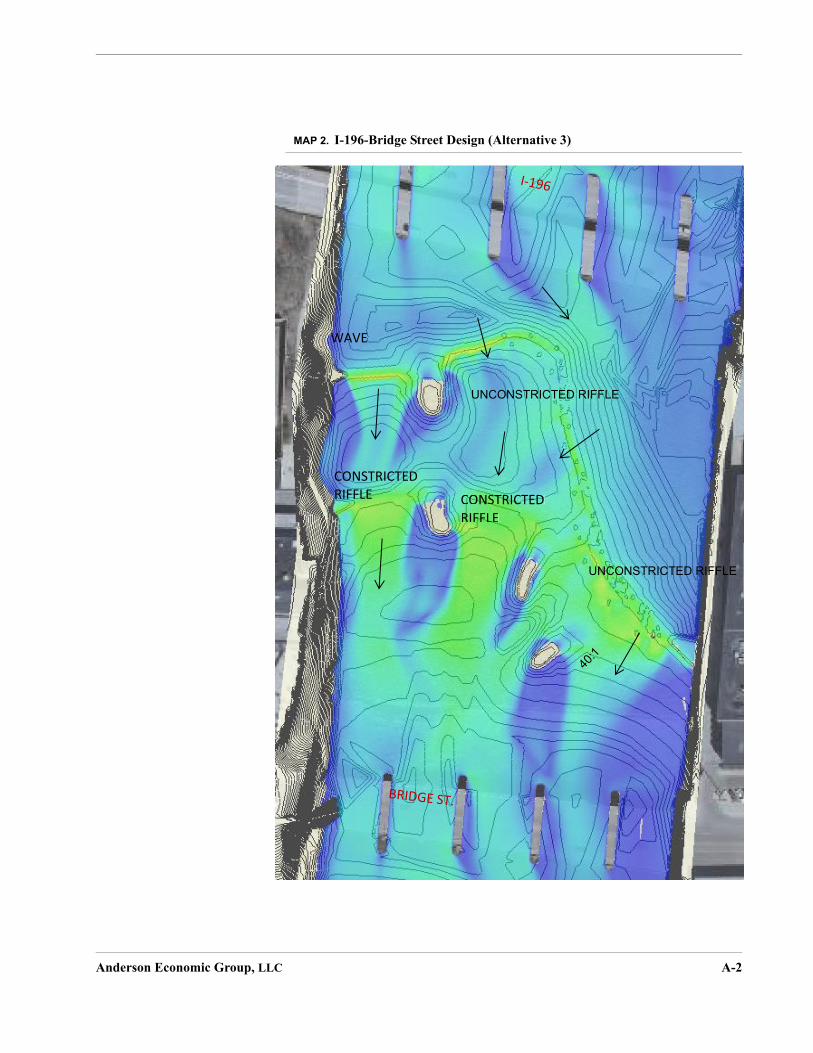
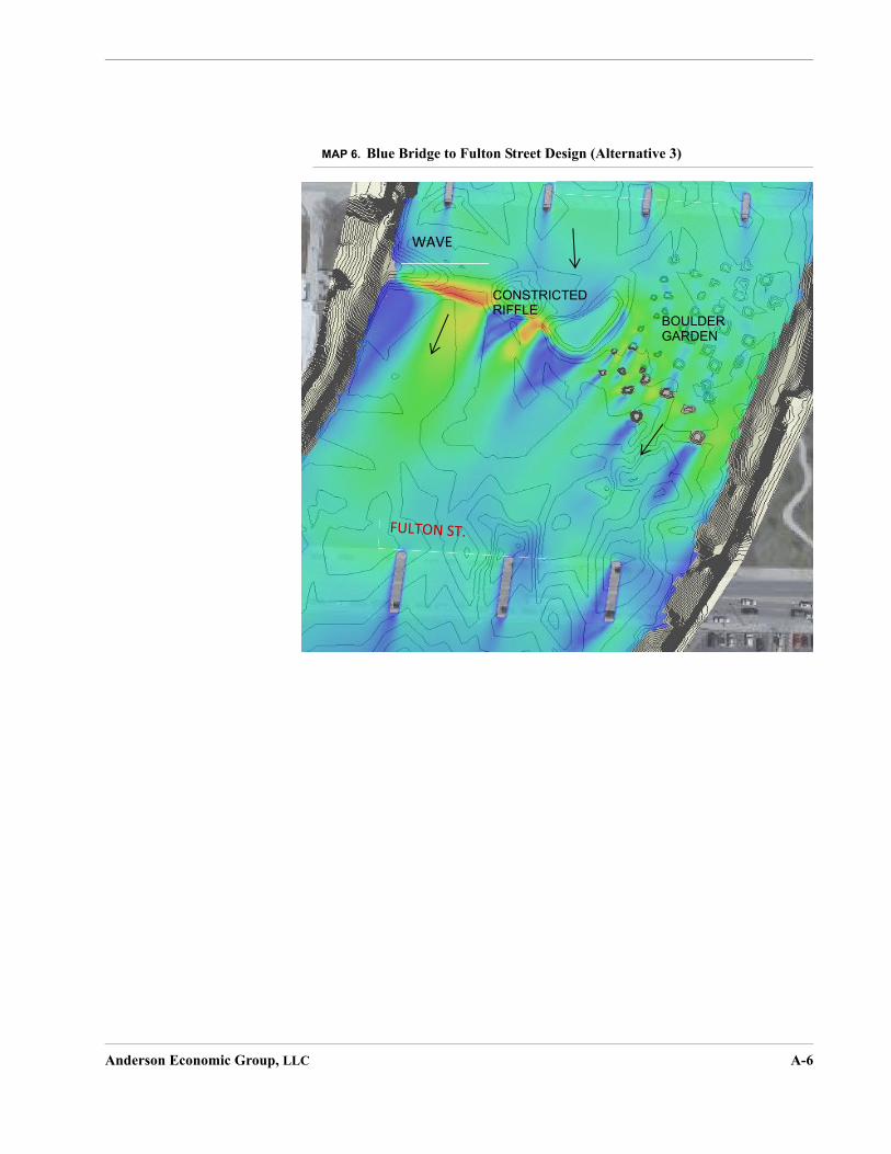
Alternative 3 entails the removal of the four beautification dams as well as the introduction of enhanced substrate. Substrate enhancement would involve com-pletely restructuring the river channel through excavation, grading, and import-ing boulders, cobble, and gravels. These enhancements would create a series of runs, riffles, pools, glides, and eddies. Crews would add scour protection around existing bridge structures, but less would be required as compared to Alternative 2. Moreover, plans call for the creation of five recreational features. See “Appendix A. Overview of Project Area” beginning on page A-1 for detailed maps of the proposed features.
This scenario would create whitewater rapids in the project area and diversify the waterway with rocks, boulders, and other enhancements. The recreational features would be geared toward whitewater kayakers: wave and riffle features would be included as part of the substrate design. Based on our research of other whitewater attractions around the U.S., we expect that the assortment of under-water enhancements with the visage of boulders and rapids would attract white-water kayaking, boating, fishing, and shore-based recreation users. Construction crews would place rocks and other materials to form fishing and wading access and riffles, runs, pools, and glides that are designed as habitat for fish and mus-sels.
Not only would the restoration enhance recreational activities, but it would also
provide enriched aquatic habitat for fish and benthic species.9 Total wetted area available for habitat would decrease by 16%, but hydrophysical habitat for fish and mussels would improve overall. Slower velocities and variabilities in veloc-ity will improve, with the coefficient of variation increasing from 35% to 58%, while the range of depths will also increase by 0.3 m. Width-to-depth ratios would improve and substrate diversity would provide more habitat for host and game fish including cat fish, sunfish, bass, darters, suckers, walleye, and min-
nows. Preferred hydrophysical habitat would improve by 266%.10
9. Benthic species are found in or on the sediment at the bottom of a body of water.
10.Heidi L. Dunn, “Biological Assessment: Impacts to Federal and State Threatened and Endan-gered Species from Rehabilitation of the Grand River Between I-196 and Fulton Street in Grand Rapids, Kent County, Michigan,” EcoAnalysts, Inc., December 2018.
Anderson Economic Group, LLC 12
Costs and Benefits of Proposed Alternatives
III.Costs and Benefits of Proposed Alternatives
The project plan we analyzed for this report is a non-water resource project, meaning that the project is not primarily for flood damage reduction, water sup-ply, water-based recreation, water quality management, or large scale irrigation or drainage. As such, the goal of our cost benefit analysis is to identify the “least costly socially and environmentally acceptable method of achieving the agreed-
upon level of resource protection.”11We followed Principles and Guidelines procedures to identify and quantify the costs and benefits of the project: all costs, including operation, maintenance, and replacement, expected to be incurred over the period of analysis are included. We met and exceeded the expectations outlined by the National Watershed Program Manual by quantify-ing not only the costs for each alternative, but also added benefits not required
for non-water resource plans.12
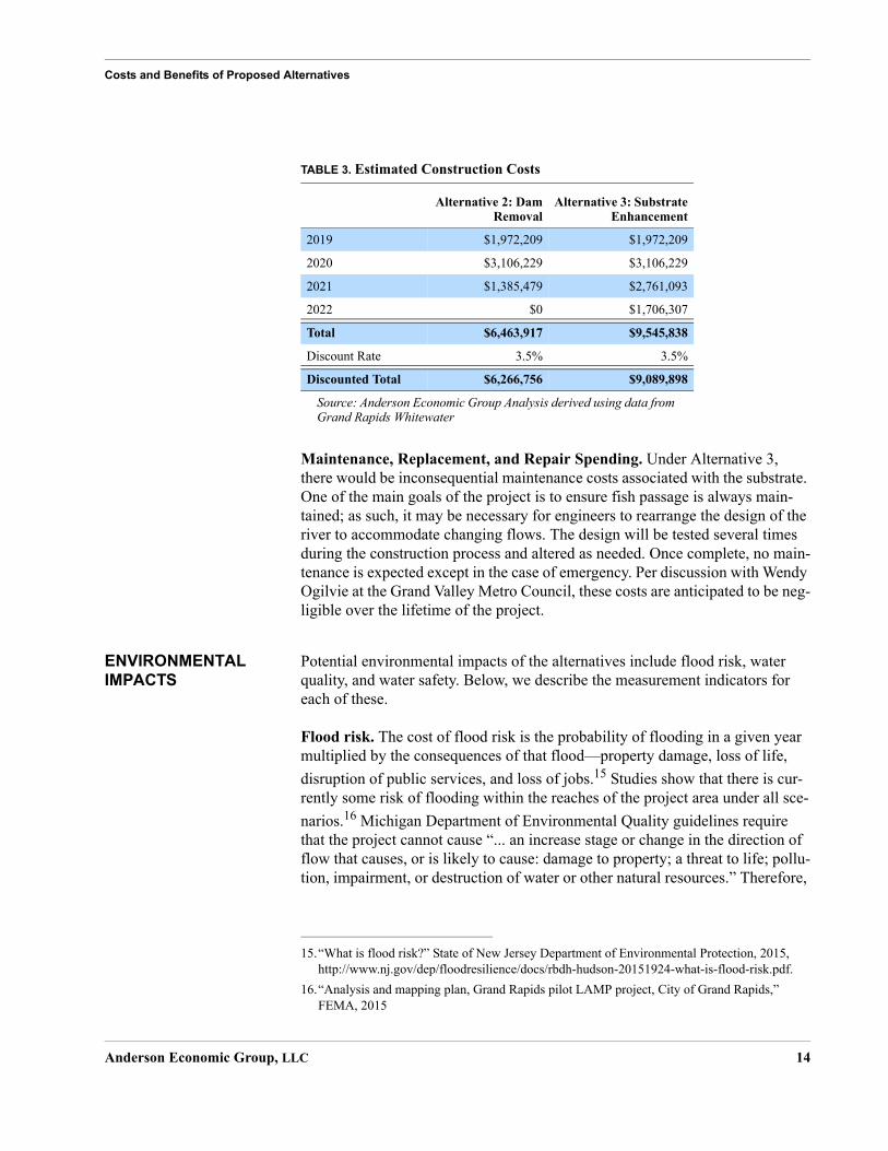
CONSTRUCTION AND MAINTENANCE SPENDING
Construction Spending. Construction spending includes all direct expendi-tures on construction under the various alternatives, including removal of the dams and the cost of substrate enhancement. Plans include the construction of grade controls, a temporary deposition pool, access ramps and bridges, and iso-lation measures. Additionally, construction would include the creation of riffles, pools, runs, glides, and wave features for recreation and aquatic habitat under Alternative 3. These will be achieved by the removal of the four low-head dams, importing substrate, installing whitewater wave catalyst structures, and restruc-
turing the river.13
We discount these costs over the life of the project by a discount rate.14 We used cost estimates from Grand Rapids Whitewater to estimate the total costs of con-struction. These are detailed by year in Table 3 on page 14. The present value of construction for Alternative 2 and 3 are $6.3 and $9.1 million respectively.
11.Natural Resources Conservation Service, Title 390 -- National Watershed Program Manual, Part 500.
12.Natural Resources Conservation Service, “Economic and Environmental Principles and Guidelines for Water and Related Land Resources Implementation Studies,” 1983.
13.Heidi L. Dunn, “Biological Assessment: Impacts to Federal and State Threatened and Endan-gered Species from Rehabilitation of the Grand River Between I-196 and Fulton Street in Grand Rapids, Kent County, Michigan,” EcoAnalysts, Inc., December 2018.
14.For more information about the discount rate, see “Assumptions” on page C-4.
Anderson Economic Group, LLC 13
Costs and Benefits of Proposed Alternatives
Maintenance, Replacement, and Repair Spending. Under Alternative 3, there would be inconsequential maintenance costs associated with the substrate. One of the main goals of the project is to ensure fish passage is always main-tained; as such, it may be necessary for engineers to rearrange the design of the river to accommodate changing flows. The design will be tested several times during the construction process and altered as needed. Once complete, no main-tenance is expected except in the case of emergency. Per discussion with Wendy Ogilvie at the Grand Valley Metro Council, these costs are anticipated to be neg-ligible over the lifetime of the project.
ENVIRONMENTAL IMPACTS
Potential environmental impacts of the alternatives include flood risk, water quality, and water safety. Below, we describe the measurement indicators for each of these.
Flood risk. The cost of flood risk is the probability of flooding in a given year multiplied by the consequences of that flood—property damage, loss of life,
disruption of public services, and loss of jobs.15 Studies show that there is cur-rently some risk of flooding within the reaches of the project area under all sce-
narios.16 Michigan Department of Environmental Quality guidelines require that the project cannot cause “... an increase stage or change in the direction of flow that causes, or is likely to cause: damage to property; a threat to life; pollu-tion, impairment, or destruction of water or other natural resources.” Therefore,
TABLE 3. Estimated Construction Costs
Alternative 2: DamRemoval
Alternative 3: SubstrateEnhancement
2019 $1,972,209 $1,972,209
2020 $3,106,229 $3,106,229
2021 $1,385,479 $2,761,093
2022 $0 $1,706,307
Total $6,463,917 $9,545,838
Discount Rate 3.5% 3.5%
Discounted Total $6,266,756 $9,089,898
Source: Anderson Economic Group Analysis derived using data from Grand Rapids Whitewater
15.“What is flood risk?” State of New Jersey Department of Environmental Protection, 2015, http://www.nj.gov/dep/floodresilience/docs/rbdh-hudson-20151924-what-is-flood-risk.pdf.
16.“Analysis and mapping plan, Grand Rapids pilot LAMP project, City of Grand Rapids,” FEMA, 2015
Anderson Economic Group, LLC 14

Costs and Benefits of Proposed Alternatives
for this project to proceed, no additional flood risk can be incurred. As such, we estimate no costs or benefits associated with flood risk
Water safety. The dams that would be removed in Alternative 2 or 3 could be a minor hazard for some swimmers and boaters in the river. We discussed the potential for increased fire department activity due to changes in use of the river with the Grand Rapids Fire Department Strategic Planning Office. They have not projected the amount of river-related incidents that would occur due to the reorientation of the river. They also noted that in 2017 there were no river inci-dents due to the existence of the four beautification dams.
Representatives of Grand Rapids Whitewater argue that water safety is likely to improve because removing the dams will result in a reduction in the amount of strong tailwater found currently at the base of each of the dams. However, the fire department reported few records of rescues performed directly as a result of the dams’ existence. We assume, based on this evidence, that people are not using the waterway in part due to safety concerns, so any incidental benefit regarding public safety would be captured by increased recreational activity if the dams were removed.
Water quality. Various parties working on the Grand River whitewater project have indicated that they do not expect the removal of the dams to affect water quality due to the fact that there is not a lot of sediment buildup. In fact, water quality may improve—increased flow due to the rapids would cause better oxy-genation, which would be a positive effect on aquatic life located in the project reach. However, we have not seen any assessment on how construction and ongoing alteration of the river would affect water quality, so we do not speculate on those impacts here.
ECOLOGICAL IMPACTS
TES Species. Alternatives 2 and 3 will affect the habitat and population of spe-cies in the Grand River. Though in some cases unionids and other species have direct economic value (and therefore a monetizable benefit) through commer-cial fishing and harvesting, most of the species affected in the proposed alterna-tives have special restrictions in Michigan due to their status as TES.
Economists and ecologists have performed extensive research on how individu-als place value on species that have no direct market value. These non-market benefits accrue for a number of reasons. First, these species have a positive impact on the environment and ecosystem; for example, unionids increase water quality through biofiltration and nutrient cycling and storage. Mussels increase water clarity, which increases the productivity of plants and algae. They also remove contaminants from the water, including bacteria and pharmaceuticals. Mussels may also stabilize and mix sediments.
Anderson Economic Group, LLC 15

Costs and Benefits of Proposed Alternatives
Second, these species also have non-use cultural and existence value, meaning that people value that they exist, whether or not individuals intend to ever use the species directly through consumption or indirectly through use of the envi-
ronment that is affected by the species.17
We use two measures to account for the benefits derived from the alternatives when it came to TES species. The amount of hydrophysical habitat preferred by TES species allows us to measure what area would be available to these species. We also document estimates for the number of TES species that will be adversely affected by construction under each of the alternatives, where avail-able.
There are a number of mussel species found within the project reach, including TES species. Many of these mussels would be killed or injured if construction were to take place due to construction of temporary isolation measures, channel excavation, substrate placement, streambank modifications, placement of scour protection, and equipment tracking within the river channel.
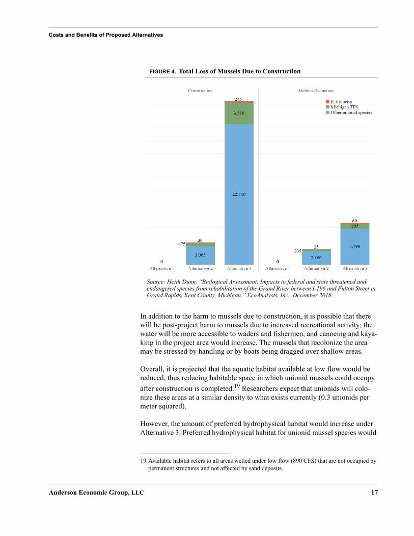
The Biological Assessment estimates the number of mussels killed or injured during construction by calculating the area affected by construction multiplied by the average density of mussels in the project area (0.3 unionids per meter squared). Researchers measure take due to habitat loss by multiplying unionid density by the area lost due to permanent structures and sand deposition. See Figure 4, “Total Loss of Mussels Due to Construction,” on page 17. The project plan includes a strategy to translocate unionids and fish that may be trapped in
construction zones. 18
Though there would be a loss of mussels due to construction, the project would not jeopardize the existence of any mussel species.
17.David L. Strayer, “What are Freshwater Mussels Worth?” Freshwater Mollusk Biology and Conservation 20, 2017, pp. 103-113.
18.The numbers we report assume that the project goal of 80% mussel collection and less than 5% mortality during collection, processing, and translocation is reached. However, the Biological Assessment notes that the impacts and benefits to freshwater mussels cannot be entirely antic-ipated due to complexities surrounding mussel communities. Due to this uncertainty, the Grand Valley Metropolitan Council will establish a donor advised fund for freshwater endan-gered and state listed mussel monitoring and other conservation measures. The council will donate $1.0 million to the fund before work begins for monitoring and to offset impacts. If col-lection efficiency plus mortality is greater than or equal to 10% less than the estimated 80% (with 5% mortality), an additional $50,000 will be added to the fund for each 10% less effi-ciency up to an additional $150,000.
Anderson Economic Group, LLC 16
Costs and Benefits of Proposed Alternatives
FIGURE 4. Total Loss of Mussels Due to Construction
In addition to the harm to mussels due to construction, it is possible that there will be post-project harm to mussels due to increased recreational activity; the water will be more accessible to waders and fishermen, and canoeing and kaya-king in the project area would increase. The mussels that recolonize the area may be stressed by handling or by boats being dragged over shallow areas.
Overall, it is projected that the aquatic habitat available at low flow would be reduced, thus reducing habitable space in which unionid mussels could occupy
after construction is completed.19 Researchers expect that unionids will colo-nize these areas at a similar density to what exists currently (0.3 unionids per meter squared).
However, the amount of preferred hydrophysical habitat would increase under Alternative 3. Preferred hydrophysical habitat for unionid mussel species would
19.Available habitat refers to all areas wetted under low flow (890 CFS) that are not occupied by permanent structures and not affected by sand deposits.
Source: Heidi Dunn, “Biological Assessment: Impacts to federal and state threatened andendangered species from rehabilitation of the Grand River between I-196 and Fulton Street inGrand Rapids, Kent County, Michigan,” EcoAnalysts, Inc., December 2018.
Anderson Economic Group, LLC 17

Costs and Benefits of Proposed Alternatives
decline by 53% under Alternative 2, while it would increase by 266% under Alternative 3. Figure 5 below illustrates these changes. Although recolonization by unionid mussels may require five to over 10 years, the Biological Assess-ment notes that more mussels should be able to inhabit the area than under exist-
ing conditions.20
FIGURE 5. Available Aquatic Habitat and Preferred Hydrophysical Habitat for Unionid Mussels Under Each Alternative (square meters)
RECREATION IMPACTS
One significant benefit of Alternative 3 and (to an extent) Alternative 2 will be the additional recreational opportunities in the Grand River.
20.Unionid mussel recolonization rates are not well documented, but appear to be a function of hydrophysical habitat stability, among other factors. As such, estimates regarding the amount of time to recolonize may be subject to some degree of error. A diverse source of mussels occurs upstream of the project area, which may supply a natural recolonization source; how-ever, the amount of time required for the substrate to feasibly support a mussel population is unknown.
Source: Heidi Dunn, “Biological Assessment: Impacts to federal and state threatened andendangered species from rehabilitation of the Grand River between I-196 and Fulton Street inGrand Rapids, Kent County, Michigan,” EcoAnalysts, Inc., December 2018.
Anderson Economic Group, LLC 18

Costs and Benefits of Proposed Alternatives
We measure whitewater boating, non-whitewater boating, fishing, and shore-based usership in net user days. Net user days are the change in users that will use various recreational opportunities times the number of days those users will participate in those recreational opportunities. We derived usage estimates for each of these groups using local market data, observed usage of analogous proj-ects, and results from national surveys of recreational activities and frequency of participation. We calculated net new user days under a conservative scenario reflective of experiences for similar developments in other regions. We briefly summarize these estimates below in Table 4. For further details on how we esti-mated recreational users, see “Appendix C. Methodology” beginning on page C-1.
Whitewater Boating. Using extensive data on visitorship for similar venues, we estimate that a total of 17,000 net new user days would be added due to whitewater boating under Alternative 3. There would be no whitewater boating under Alternative 2.
Non-Whitewater Boating. The restoration project will provide for a river experience that is also conducive to many other rowing and paddle sports, including recreational kayaking, canoeing, rowing, stand-up paddling, and other primarily non-motorized boating. For Alternative 2, we recognize that increased safety along the project reach will attract boating users, though we do not antic-ipate an increase near the magnitude of Alternative 3, where the river will be much more attractive to users.
Fishing. The Grand River in Grand Rapids is already well-known as a fishing destination, especially among local and regional populations. Alternative 3 would provide greater fishing opportunities along the entire project area. In total, the project is expected to add 500% in fish holding habitat and provide a
275% increase in sport fishing perimeter.21 Under Alternative 2, however, the amount of fish holding area is expected to decline due to removal of the dams. Aquatic habitat would be reduced by approximately 4% in the project area.
TABLE 4. Annual Net-New User Days: Grand Rapids Whitewater Project Visitor and User Estimates
Recreational Activity
Alternative 2:Removal of
Dams
Alternative 3:Substrate
Enhancement
Whitewater Boating Users 0 17,000
Non-Whitewater Boating Users 27,200 68,000
Fishing Users 0 11,541
Shore-Based Users 27,200 142,705
Total: 54,400 285,410
Source: Anderson Economic Group estimates
Anderson Economic Group, LLC 19

Costs and Benefits of Proposed Alternatives
Shore-Based Users. Lastly, we estimate the expected number of people who will come to the riverfront area for other recreational purposes, such as biking or jogging, or to enjoy watching the river, attending a river-related event, or enjoy-ing other shore-based activities.
Our estimates are founded on the assumption that there will be one shore-based user for every water-based user. This produces an estimate of 142,705 shore-based users for Alternative 3 and 27,200 for Alternative 2.
Monetization of Recreational Benefits
In order to evaluate the benefit of increased recreational activity, we split recre-ation into three categories: fishing, whitewater boating, and non-whitewater boating/shore-based recreation. We monetized changes in usership by utilizing the unit day value method; we relied on U.S. Army Corps of Engineers valua-tion techniques and projected details about the recreational opportunities to approximate the average willingness to pay of users based on characteristics of the proposed site.
For details on the unit day value method, see “Monetizing Recreational Bene-fits” on page C-2. We determined that this method was an appropriate choice due to guidance from the Principles and Guidelines for Water and Related Land Resources Implementation Studies. Contingent valuation survey methods were
not feasible in the timeframe allotted for this project.22
Total Accrued Annual Benefits. Using the estimated net new user day esti-mates along with our valuation of the recreational activities, we estimated the total accrued annual benefit that would be realized due to the selection of each
21.Grand Rapids Whitewater Preliminary Plan, November 2013.
TABLE 5. Total Value of Recreational Activity
Recreational Activity
ConsumerSurplus Per
User Day, LowEstimate
ConsumerSurplus Per
User Day, HighEstimate
Whitewater Boating $22.35 $27.93
Fishing $8.00 $9.22
Non-whitewater Boating/Shore-based Rec-reational Activities
$7.32 $8.53
Source: U.S. Army Corps of Engineers, Fiscal Year 2018Note: Benefits are measured in consumer surplus, which is the users’ total willingness to pay to participate in a recreational activity.
22.The Water Resources Council, “Economic and Environmental Principles and Guidelines for Water and Related Land Resource Implementation Studies,” 1983.
Anderson Economic Group, LLC 20

Costs and Benefits of Proposed Alternatives
alternative. These are indicated in Table 6, “Annual Valuation of Recreational Activity,” on page 21.
IMPACTS ON BUSINESS ACTIVITY
Per discussion with various groups associated with economic development, we found that no businesses would be affected adversely by redevelopment of the river, so there are no costs associated with lost or discontinued business oppor-tunities in Alternative 2 or 3.
We also found that substantial development is planned after construction of the river is completed that is due directly to the removal of the dams and enhance-ment of the river substrate. Namely, real estate developers are beginning to show interest in property located in proximity to the river due to the possibility of revival. We conservatively assume that we have captured the benefits of this additional business activity by monetizing the value of recreation, given these businesses are largely present to serve additional recreational users.
NET PRESENT VALUE OF COSTS AND BENEFITS
Net present value (NPV) measures the difference between the present value of benefits and the present value of costs, meaning that future benefits and costs are discounted relative to present benefits and costs.
Figure 6 on page 22 shows the cumulative NPV over time, with a label indicat-ing the net present value at 25 years for each of the alternatives under the low and high estimates for the value of recreation. Alternative 3 yields a net present value of $17.6 to $22.4 million over 25 years. Alternative 2 has a near-negative cumulative net present value after 25 years, indicating that the benefits of recre-ation are likely to approximately equal the discounted costs of construction. See Figure 6 on page 22 for an illustration of the cumulative net present value of the alternatives over time.
TABLE 6. Annual Valuation of Recreational Activity
Alternative 2: Removal of DamsAlternative 3: Removal of Dams
with Substrate Enhancement
Low Estimate High Estimate Low Estimate High Estimate
Whitewater Boating Users $0 $0 $379,950 $474,810
Non-Whitewater Boating Users $199,104 $232,016 $497,760 $580,040
Fishing Users $0 $0 $92,328 $106,408
Shore-Based Users $199,104 $232,016 $1,044,601 $1,217,274
Total $398,208 $464,032 $2,014,639 $2,378,532
Source: Anderson Economic Group analysis using data derived from Grand Rapids Whitewater and U.S. Army Corps of Engineers, Fiscal Year 2018
Anderson Economic Group, LLC 21

Costs and Benefits of Proposed Alternatives
FIGURE 6. Cumulative Net Present Value of the Alternatives over the No Action Alternative
These figures do not capture other benefits that we did not monetize (estimate in dollars). We also quantified but did not monetize the ecological effects of the alternatives for mussel species. These results are discussed in “Ecological Impacts” on page 15. Additional benefits were identified, but not quantified, including increased business activity. See Table 7 on page 23.
Source: Anderson Economic Group analysis using data derived from Grand Rapids Whitewater and U.S. Army Corps of Engineers, Fiscal Year 2018
Anderson Economic Group, LLC 22

Costs and Benefits of Proposed Alternatives
TABLE 7. Catalog of Benefits and Costs of Alternatives 2 and 3 Relative to Alternative 1
Alternative 2: Dam Removal Alternative 3: Substrate Enhancement
Annual Recreation Benefits (Millions)
$0.4 to $0.5 $2.0 to $2.4
Total Construction Costs (Millions)
$6.5 $9.5
Net Benefits, cumulative and discounted over 25 years (Millions)
-$0.6 to $1.0 $17.6 to $22.4
Non-Monetized BenefitsPreferred hydrophysical habitat for mussels could
increase by 8,780 m2
Non-Monetized Costs
Preferred hydrophysical habitat for mussels could
decline by 2,750 m2
Aquatic area available at low flow would decline
by 8,405 m2
Loss of mussels due to construction is estimatedat 3,570
Loss of mussels due to habitat reduction is esti-mated as 2,520
Aquatic area available at low flow is estimated to
decline by 22,490 m2
Loss of mussels due to construction is estimatedas 26,465
Loss of mussels due to habitat reduction isestimated as 6,745
Source: Anderson Economic Group analysis using data derived from Grand Rapids Whitewater and U.S. Army Corps of Engineers, Fiscal Year 2018
Anderson Economic Group, LLC 23

Appendix A. Overview of Project Area
MAP 1. Project Area Location
Mines GolfCourse
KentCountry
Club
AquinasCollege
ReedsLake
CS
XTr anspor t at ion
Norfolk S
outhern
Grand Rapids and EasternCSX
Tra
nspo
rtat
ion
M-37 N
M-37 S
Alp
ine
Ave
NW
Mo n
r oe
Ave
NW
4 Mile Rd NE
Michigan St NE
Burton St SW
Fu l
ler
Ave
SE
Chicago Dr SW
Col
lege
Ave
NE
E Fulton St
Coi
t Ave
NE
Leonard St NE
28th St SE
Ful
ler
Ave
NE
Dea
nL
ake
Ave
NE
Bridge St NW
Plai
nfie
ldAv
eN
E
Fulton St W
Hall St SW
3 Mile Rd NW
Div
isio
nA
veS
Leonard St NW
Pannell Ave NW
Hall St SE
3 Mile Rd NE
Turn
erA
veN
W
Mar
ylan
dA
veN
E
Knapp St NE
Cly
dePa
rkA
veSW
SD
ivis
ion
Ave
Obrien Rd SW
Ann St NE
Breton R
d SE
Robinson Rd SEButterw orth St SW
Bri
stol
Ave
NW
ND
ivis
ion
Av e
Franklin St SE
Plym
ou t hA
veSE
Per
k ins
Ave
NE
Valley
Ave
NW
Lake Dr SE
Cov
ellA
veN
W
WR
iver
Dr
NW
Walker
Ave
NW
Byr
onC
ente
rA
veSW
Market Ave SW
Bur
linga
me
Ave
SW
Fulton St E
Kalam
azoo Ave
SE
28th St SW
Burton St SE
Eas
tern
Ave
SE£¤131
ST45
ST37
ST11
JohnJohnBallBallParkPark
MillenniumMillenniumParkPark
HuffHuffParkPark
Grand RapidsGrand Rapids
WyomingWyoming
East Grand RapidsEast Grand Rapids
§̈¦196
§̈¦96
§̈¦96
§̈¦196
Mon
roe Ave
NW
Bridge St NW
W Fulton St
Michigan St NW
Pearl St NW
£¤131
Gra
nd R
iver
Overview of Grand Rapids and the Project Area
Source: Anderson Economic Group, LLC
0 1 2Miles
0 0.1 0.2Miles
¯
Anderson Economic Group, LLC A-1
MAP 2. I-196-Bridge Street Design (Alternative 3)
UNCONSTRICTED RIFFLE
UNCONSTRICTED RIFFLE
WAVE
CONSTRICTED RIFFLE CONSTRIFFLE
CONSTRICTED RIFFLE
Anderson Economic Group, LLC A-2

MAP 3. Bridge Street to Gillett Bridge Design (Alternative 3)
WIDE RIFFLE
WIDE RIFFLE
WAVE
WAVE
GILLETT
Anderson Economic Group, LLC A-3

MAP 4. Gillett Bridge to Pearl Street Design (Alternative 3)
GILLETT
UNCONSTRICTED RIFFLE
Anderson Economic Group, LLC A-4

MAP 5. Pearl Street to Blue Bridge Design (Alternative 3)
WIDE RIFFLE
CONSTRICTED RIFFLE
WAVE UNCONSTRICTED RIFFLE
UNCONSTRICTED RIFFLE
Anderson Economic Group, LLC A-5
MAP 6. Blue Bridge to Fulton Street Design (Alternative 3)
CONSTRICTED RIFFLE
BOULDER GARDEN
WAVE
Anderson Economic Group, LLC A-6

Appendix B. Sensitivity Analysis
In this appendix, we perform a sensitivity analysis to ensure that our results are robust to changes in our base assumptions. We find that, overall, the positive net benefits shown in this report do not change given reasonable changes in assumptions.
DISCOUNT RATES As is common practice in the cost-benefit literature, we use the Social Discount Rate that gives a Social Rate of Time Preference—a measure of society’s will-ingness to postpone consumption. Using our professional judgement, we
selected a discount rate of 3.5%, which is justified by economists23 and is a
common value used in cost-benefit analysis.24
To see how our results change in response to changes in discount rate, we calcu-lated the net present value of the costs and benefits of the project under Alterna-tive 3. Figure 7 on page B-2 illustrates the net present value of the project under varied discount rates.
We found that a discount rate equal to 15.06% corresponded to a net present value of 0, meaning any higher discount rate would result in a negative value. By any standard, 15.06% is an exceedingly high discount rate for this applica-tion. The return of the S&P 500, considered one of the higher plausible discount rates, grew at a rate of 9.94% in 2018 and had a compounding average growth rate of 11.38% between 2011 and 2018.
TIME HORIZON We chose a time horizon of 25 years based on the average length of time that similar projects have been operating. The net present value of Alternative 3 is positive if the time horizon is greater than nine years under our high estimate and ten years under our low estimate. In other words, the rapids would have to operate for five to six years after construction is completed to return a positive net benefit.
23.Mark A. Moore, Aidan Vining, and Anthony E. Boardman, “More Appropriate Discounting: the Rate of Social Time Preference and the Value of the Social Discount Rate,” Journal of Benefit-Cost Analysis 4(1), 2013, pp. 1-16.
24.Mark Freeman, Ben Groom, and Michael Spackman, “Social Discount Rates for Cost-Benefit Analysis: A Report for HM Treasury,” 2018.
Anderson Economic Group, LLC B-1

FIGURE 7. Net Present Value with Varied Discount Rates
Anderson Economic Group, LLC B-2

Appendix C. Methodology
In the following appendix, we describe our methods for estimating the costs and benefits associated with several impacts of the alternatives analyzed in this report.
USERSHIP ESTIMATES FOR RECREATIONAL ACTIVITIES
Whitewater Boating. To estimate the expected number of whitewater-related users for the planned Grand Rapids Whitewater restoration project, we exam-ined usership data and estimates from other whitewater parks in cities of a simi-
lar population size to Grand Rapids.25 Our total usership estimate for pure whitewater activities on the Grand River in Grand Rapids comes to a conserva-tive 8,500 users per year. We further assume that each user will engage in the recreational activity on two days per year. From this, we arrive at our estimate of 17,000 whitewater boating users under Alternative 3. Alternative 2 does not include whitewater enhancements, so there will be no whitewater activity.
Non-Whitewater Boating. To estimate non-whitewater usership, we observed national industry statistics indicating that recreational kayaking and canoeing participation is approximately three to four times greater than whitewater kaya-
king participation.26 Recognizing that some of this difference in participation level is the greater accessibility that most people have to waters for non-white-water activity, we have assumed that total canoe, recreational kayaking, rowing, and other non-whitewater boating uses will be about four times the whitewater usage estimate, or 68,000 net new user days. On its own merits, we estimate that Alternative 2 will attract about a fifth as many users as Alternative 3, yielding a total of 13,600 users and 27,200 net-new user days.
Fishing. To estimate fishing-related visitors, we primarily relied on a Grand River Assessment conducted by the Michigan Department of Natural Resources in 2017. They used estimates for the number of angler trips between 2003 and 2004. Survey statistics estimated 46,164 angler trips to the river. In our calcula-tions, we estimate that the number of angler trips would increase by approxi-mately 25% to 50% due to improved fishing conditions and larger fish populations due to the river restoration. Based on this assumption and the Grand River surveys, we estimate 57,705 annual angler trips for fishing, an increase of 11,541 in Alternative 3. Under Alternative 2, the amount of fish holding area is expected to decline due to removal of the dams. Aquatic habitat would be reduced by approximately 4% in the project area. As this is a relatively small change, we expect the number of fishing users to remain the same in Alternative 2.
25.These include the South Bend, Indiana waterfront; Columbus, Georgia; Phoenix City, Ala-bama; Wausau, Wisconsin; Golden, Colorado; and Reno, Nevada.
26.Outdoor Participation Report, The Outdoor Foundation, 2017.
Anderson Economic Group, LLC C-1
MONETIZING RECREATIONAL BENEFITS
Unit-Day Value Method
The Unit-Day Value Method for estimating recreational benefits involves using expert judgement to approximate the average willingness to pay of users by selecting values based on characteristics of the proposed site. Activities are sep-arated into “general” and “specialized” recreational activities for the purpose of analysis.
General activities are those that involve
primarily those activities that are attractive to the majority of outdoor users and that generally require the development and maintenance of convenient access and adequate
facilities.27
We defined shore-based activities and non-whitewater boating as general recre-ational activities.
On the other hand, specialized activities are defined as
... those activities for which opportunities in general are limited, intensity of use is low, and a high degree of skill, knowledge, and appreciation of the activity by the user may often be involved.”
We defined whitewater boating as specialized recreation due to the limited nature of opportunity and low intensity of use. Whitewater kayaking also requires some skill and knowledge in order to properly do the activity safely and effectively.
Each recreational activity is evaluated and rated on a scale of “points,” which are assigned a dollar value. The U.S. Corps of Engineers releases these conver-sions annually. Along with the point-to-dollar conversions, the Corps includes guidelines for assigning points for each type of recreation. These include criteria and judgement factors. The criteria include recreational experience, availability of opportunity, carrying capacity, accessibility, and environmental quality, rated from one to five with point assignments for each. The chosen judgement factors are listed in quotes. Below we list our ratings and their justification.
Whitewater Boating
Recreation Experience: “Moderate use, some evidence of other users and occasional interference with use due to crowding."We estimate that 17,000 net-new user days will be added to the project area for whitewater boating. Because of seasonality, we expect that these boaters will only use the river over a five month period beginning in April and ending in September. Therefore,
27.U.S. Army Corps of Engineers, “SUBJECT: Economic Guidance Memorandum, 18-03, Unit Day Values for Recreation for Fiscal Year 2018,” Department of the Army, 2017.
Anderson Economic Group, LLC C-2
over five months it is estimated that there will be an average of 113 users per day on the river. Some crowding may exist on especially warm days or holidays, but the typical day will have minimal crowding and moderate use.
Availability of Opportunity: “Several within 1 hour travel time: none within 30 minutes travel time." There are 15 whitewater parks in the lower peninsula of Michigan. Eight of these are located within two hours of downtown Grand Rapids, two are found within 45 minutes, and one is found within 30 minutes of the downtown area. If the whitewater park in Grand Rapids is com-pleted as a Class III park, then it will be the only park of that rating within three hours of another. As such, we put some weight to the probability of it being a Class III park. Also, it is specialized as the only rapids that go directly through a city center: six of the eight rapids parks are nearby a town or city, but do not go directly through. This whitewater park would be the third longest within a two hour radius of the project area and the second longest to the Rogue River run, located 0.33 miles from downtown Grand Rapids.
Carrying Capacity: “Good access, high standard road to site; good access within site."This project will be housed within the existing infrastructure of Grand Rapids; as such, access to the river would be easy. Boat launches would be built as part of a connected project to revitalize the parks in the area.
Environmental Quality: “Average aesthetic quality; factors exist that lower quality to a minor degree."As part of this project, the substrate of the Grand River will be enhanced with a series of pools, riffles, and glides using a series boulders, cobbles, and gravels. This will make this run of the river highly attrac-tive to whitewater kayakers and canoers; the diversity of substrate and varying water speeds will be interesting. The city of Grand Rapids will provide a back-drop to whitewater boating users for part of the project area. In terms of envi-ronmental quality, it is expected that water quality will increase under the new project by removing silt and adding to the freshwater mussel population -- freshwater mussels strain out particles and pollutants from the water. That noted, water quality is an issue along the Grand River. Concerns exist that the water will be undesirable due to storm water runoff. There is also road runoff, and possible sewage in the water. In addition, cornfields upstream pollute the water with pesticides and other chemicals.
General Recreation, Including Fishing
In addition to whitewater boating, the rapids restoration project will provide an area that is safer and more navigable for non-whitewater boat users than before project implementation. Additionally, the diversity of the rapids will attract shore based users to observe the river as well as to take part in photography and other activities.
Anderson Economic Group, LLC C-3

Recreation Experience: “Several general activities."As noted above, there are several general activities that can be performed in the project area. None of these would be considered “high quality value,” as non-whitewater boating and riverfront access are common to the region.
Availability of Opportunity: “Several within 1 hour of travel time; a few within 30 minutes travel time."The Grand River has many access points for boating and other recreational activities.
Carrying Capacity: “Optimum facilities to conduct activity at site poten-tial."We estimate that between non-whitewater boating users and shore-based recreation users and spectators, there will be 210,705 users per year. The river is very wide and there are many surrounding parks. As such, we expect there to not be many problems with overcrowding.
Accessibility and Environmental Quality. These are rated the same as white-water users, above.
Point Assignment
Points were assigned and are reported in Table 8 below. The points are assigned a dollar value, which we use in our calculation of net benefits.
ASSUMPTIONS In order to complete the cost-benefit analysis, we made a number of assump-tions, which we describe below.
Discount Rate and Sensitivity Analysis
As is common practice in the cost-benefit literature, we use the Social Discount Rate that gives a Social Rate of Time Preference. Using our professional judge-ment, we selected a discount rate of 3.5%, which is a common value used in cost-benefit analysis. Our sensitivity analysis yields that the chosen discount rate would have to be unjustifiably high to make the present value of costs greater than that of the benefits to the project. See “Appendix B. Sensitivity Analysis” on page B-1 for details on our sensitivity analysis and more informa-tion on how we chose a 3.5% discount rate.
TABLE 8. Point Assignments for Unit Day Value Analysis
Activity Points Assigned Dollar Value
Whitewater Boating 43-61 $22.35-$27.39
Non-Whitewater Boating and Shore-Based Activities
32-48 $7.32-$8.53
Fishing 32-48 $8.00-$9.22
Source: Anderson Economic Group
Anderson Economic Group, LLC C-4

Full Employment
We assume that the economy is at full employment during the period of con-struction, maintenance, and repair. This is a simplifying assumption in that it does not require that we estimate benefits associated with employing otherwise underutilized or unemployed labor (i.e. the opportunity cost of construction is equal to the cost of construction). This assumption is conservative in that it rec-ognizes all expenditures as “costs” rather than potential benefits in utilizing under used resources.
National Standing
We take the national perspective when accruing benefits and costs. The benefits and costs are measured as they affect U.S. residents, including benefits and costs that accrue to the U.S. government. This is required by the National Watershed Planning Manual.
Period of Analysis
We use a time horizon of 25 years for our analysis. Per the Biological Assess-ment, it will take five to greater than ten years after construction for mussel pop-ulations to fully populate the project area. Also, this period of analysis reflects the median length of time that similar projects have been operating, providing a more robust empirical basis for our projections for recreational uses. As noted in our sensitivity analysis in “Appendix B. Sensitivity Analysis” on page B-1, our results are not very sensitive to time horizon.
Access Development
We assume that under the No Action alternative, no new access points to the river would be built, and therefore there will be the same amount of recreational activities performed in the future under the No Action alternative as there are now. This assumption would likely play out if the No Action alternative were chosen, since the lack of recreational activity in the river is not due to a lack of access points.
Anderson Economic Group, LLC C-5

Appendix D. About Anderson Economic Group
Anderson Economic Group, LLC is a boutique consulting firm founded in 1996, with offices in East Lansing, Chicago, New York, and Istanbul. We specialize in strategy, valuation, public policy, and market analyses. Our team has a deep understanding of advanced economic modeling techniques and extensive expe-rience in multiple industries in multiple states and countries.
The consultants at Anderson Economic Group are often published on topics within their respective fields of expertise. Publications from our team include:
• Aquatic Invasive Species in the Chicago Area Waterway System, published in 2017;
• The Costs of Aquatic Invasive Species to Great Lakes States, published in 2012 and updated in 2017;
• Economic Impact of the Grand Rapids Whitewater Project, published in 2014.
Past clients of Anderson Economic Group include:
• Governments: The government of Canada; the states of Michigan, North Caro-lina, and Wisconsin; the cities of Detroit, Cincinnati, and Sandusky; counties such as Oakland County, and Collier County; and authorities such as the Detroit-Wayne County Port Authority.
• Corporations: Bank of America Merrill Lynch, InBev USA, ITC Holdings Corp., Ford Motor Company, First Merit Bank, Labatt USA, Lithia Motors, Meijer, Inc., National Wine & Spirits, Nestle, and Relevent Sports; automobile dealers and dealership groups representing Toyota, Honda, Chrysler, Mercedes-Benz, General Motors, Kia, and other brands.
• Nonprofit organizations: Convention and visitor bureaus of several major cities; higher education institutions including Michigan State University, Wayne State University, and University of Michigan; trade associations such as the Michigan Manufacturers Association, Service Employees International Union, Automa-tion Alley, and Business Leaders for Michigan.
Please visit www.AndersonEconomicGroup.com for more information
ABOUT THE AUTHORS
Jason Horwitz
Mr. Horwitz is a Senior Consultant at Anderson Economic Group, serving as the Director of the Public Policy and Economic Analysis practice area. He has pro-vided research, analysis, and expert testimony on policy in a range of fields, including state and local taxes, retirement benefits, business incentives, energy policy, and economic development for governments, trade organizations, and corporations across the country.
Anderson Economic Group, LLC D-1

Brandon Betz
Brandon Betz is a Senior Analyst with Anderson Economic Group, working in the Public Policy and Economic Analysis practice area. His work focuses on cost-benefit, economic impact, and fiscal impact analysis.
Anderson Economic Group, LLC D-2