Cost and Constructability Report - GTA West Corridor Constructability and Cost Draft Report... ·...
21
March Cost and Constructability Report Cost and Constructability Report February 2011 Constructability and Cost Summary Technical Memorandum Draft
Transcript of Cost and Constructability Report - GTA West Corridor Constructability and Cost Draft Report... ·...
March
Cost and Constructability Report
Cost and Constructability Report
February 2011
Constructability and Cost
Summary Technical Memorandum
Report Draft
GTA West Planning and Environmental Assessment Study Draft Cost and Constructability Report
February 2011 DRAFT
TABLE OF CONTENTS
1. INTRODUCTION ................................................................................................................ 1
2. METHODOLOGY ............................................................................................................... 2
2.1 OVERVIEW ................................................................................................................ 2
2.1.1 Improvements to Existing Facilities ....................................................................................................... 2
2.1.2 Improvements to Existing 407 ETR ........................................................................................................ 3
2.1.3 New Freeways ........................................................................................................................................ 3
2.1.4 Cost Estimation Methodology ................................................................................................................ 4
3. FREEWAY-TO-FREEWAY INTERCHANGE CONFIGURATIONS ..... ............................... 6
3.1 HIGHWAY 400 CONNECTION ................................................................................... 7
3.2 HIGHWAY 427 CONNECTION ................................................................................... 7
3.3 HIGHWAY 410 CONNECTION ................................................................................... 7
3.3.1 Further Review of New Highway 410 Extension North of Mayfield Road............................................. 8 3.4 HIGHWAY 401 CONNECTION AT 407 ETR ............................................................... 9
3.4.1 Further Review at Connection to Highway 401 / 407 ETR (Alternative 4-2) ........................................ 9 3.4.2 North –South Link at Highway 401 / 407 ETR .................................................................................... 10
3.5 CONNECTION AT HIGHWAY 401 WEST MILTON / 407 ETR ...................................11
3.5.1 Further Review at Highway 401 Connection in West Milton .............................................................. 11 3.6 HIGHWAY 6 INTERCHANGE NORTH OF GUELPH ..................................................12
3.7 HIGHWAY 6 CONNECTION SOUTH OF GUELPH ....................................................13
4. COST AND CONSTRUCTABILITY FINDINGS ................ .................................................15
4.1 INITIAL COST ESTIMATING AND CONSTRUCTABILITY .........................................15
4.2 ADDITIONAL COST ESTIMATING AND CONSTRUCTABILITY ................................17
..........................................................................19 APPENDIX A – SUMMARY OF UNIT COSTS
LIST OF TABLES Table 3-1: Summary of Key GTA West Interchanges………………………………………………6 LIST OF EXHIBITS Exhibit 3-1: Location of Interchanges Considered at a Conceptual Level …………………………6

GTA West Planning and Environmental Assessment Study Draft Cost and Constructability Report
February 2011 DRAFT Page 1
1. Introduction The Ontario Ministry of Transportation (MTO) has initiated Stage 1 of a formal Environmental Assessment (EA) Study for the GTA West Corridor. The purpose of the study is to proactively plan for future infrastructure needs by examining long-term transportation problems and opportunities to the year 2031 and consider options to provide better movement of both people and goods between urban areas in the GTA West Corridor preliminary study area, including designated Urban Growth Centres.
Recommendations from the Stage 1 study are presented in the Draft Transportation Development Strategy (TDS) Report, February 2011. The draft TDS Report provides a summary and high level overview of an extensive analysis and review of the following options that follow a building block approach:
• Group #1 – Optimize Existing Networks
• Group #2 – New Expanded Non-Road Infrastructure
• Group #3 – Widen / Improve Existing Roadways
• Group #4 – New Transportation Corridor
The above noted options were subject to a comprehensive evaluation based on consideration of Environmental, Transportation and Engineering considerations. The purpose of this report is to provide background information for Groups 3 and 4 in terms of Transportation and Engineering considerations of cost and constructability. The background information presented in this report supplements the evaluation of alternatives in the Draft Transportation Development Strategy Report (Section 4.9 Evaluation of Alternatives – Cost and Constructability).
This Report provides a summary of the methodology used in carrying out initial cost and constructability analysis. The methodology for cost and constructability which was used for this study is consistent with the methodology developed for the Niagara to GTA Transportation Corridor Environmental Assessment. This Report also presents some of the conceptual interchanges which were developed to support the analysis of Groups 3 and 4 Alternatives.
It is noted that all costs and information regarding construction feasibility will be superceded by work in Stage 2 – Route Planning and Preliminary Design. It has only been developed to provide a level of understanding and comparison of alternatives as they may benefit and impact the GTA West Corridor study area.
GTA West Planning and Environmental Assessment Study Draft Cost and Constructability Report
February 2011 DRAFT Page 2
2. Methodology
2.1 OVERVIEW
The Project Team used 2031 lane requirements for the various highway facilities (i.e. Highways 400, 401, 427, 410 and the GTA West transportation corridor) as the primary input to evaluate constructability and cost. These lane requirements were developed as part of the travel demand forecasting work for the various Group 3 and 4 transportation alternatives. Details regarding the transportation modelling work were documented in the Transportation Model Technical Background Report (February 2011).
In order to assess and compare the alternatives, it was first necessary to carry out sufficient critical design work to determine the ‘footprint’ (i.e. the extent of physical impact required) of the various improvement scenarios. These footprints were also important inputs in determining natural environment, socio-economic, transportation, and other impacts.
It should be emphasized that the majority of this work has been prepared only to a conceptual level of design, sufficient for the assessment and comparison of alternatives at the Stage 1 of the study and should not be taken to be representative of the absolute property requirements for this project, which are subject to Stage 2 of the EA.
2.1.1 Improvements to Existing Facilities
The process for assessing improvements to existing roadway facilities involved a generalized approach for identifying ‘footprints’ for constructing additional lanes and modifying interchanges. The approach assumed that the construction of future lanes would be based on retaining the existing centre line of the highway. Footprints were determined by preparing a series of typical cross-sections to reflect each highway improvement scenario. For all scenarios, it was assumed that typical freeway cross-sections would be updated to include standard roadway elements such as standard 3.75 m lanes, 3.0 m outside shoulders, HOV lanes with buffers and a median shoulder width of 4.25 m to include enforcement of HOV lanes. From these typical sections, the width of the new freeway was measured from the centre line of the freeway to the future outside shoulder. This width was used to locate a future edge of shoulder. A required right-of-way width was determined by adding a typical width of 15 m to the future edge of shoulder to allow for cut and fill and roadside drainage. Additional property widths were added as required to account for ramp relocations at interchanges, relocation of service roads and known areas of high fill and deep cuts. Property requirements were determined by calculating the area between the existing right-of-way (ROW) and future ROW lines.
It is recognized that improvement alternatives will each have some unique challenges and opportunities, and that actual ROW requirements will likely vary somewhat from the ROW lines generated for this assessment. However, it is believed that this approach would, in aggregate, provide a reasonable conservative representation of the footprint impacts of the alternatives being evaluated.
Once a future ROW line was determined for each alternative, the following quantities were tabulated:
GTA West Planning and Environmental Assessment Study Draft Cost and Constructability Report
February 2011 DRAFT Page 3
o Property areas were summarized and categorized by the following land uses: agricultural, vacant, residential, commercial, industrial and institutional / office.
o Existing bridges were reviewed using Google Earth to confirm whether they would be able to accommodate additional freeway lanes or whether the bridges would need to be replaced. Bridge improvements were tabulated in terms of minor impact (widening) or major impact (replacement) for sideroad crossings, interchange crossings and mainline crossings.
o The extent of road widening was quantified based on additional lanes (widths and lengths.
2.1.2 Improvements to Existing 407 ETR
One area which required additional analysis was the 407 ETR under Alternative 3-1. 407 ETR has been designed to accommodate a maximum cross-section of 10 lanes. Travel demand forecasting for Alternative 3-1 recommends 12-16 lanes along 407 ETR between Highway 401 and Highway 400. This would require reconfiguring 407 ETR to a Core Collector System since MTO will not widen beyond 10 lanes as a single roadway. A high level analysis was undertaken to identify impacts associated with implementing a Core Collector system. A similar methodology as described above was used for identifying new property footprints.
Long term planning for the 407 ETR includes a separate designated and grade separated transitway corridor with transitway stations planned at key interchanges. Impacts to the future transitway alignment (provided by MTO) were identified. Additional analysis was undertaken to determine the extent of impacts at existing 407 ETR freeway to freeway interchanges with Highways 400, 427, 410 and 401. Existing bridge General Arrangement Drawings and Google Earth were used to confirm existing abutment and pier locations for high level structures at these interchanges. An assessment was undertaken to confirm the feasibility of adding collector lanes through some of these interchanges. Conceptual alignments for collector lanes were prepared and bridge impacts and likely bridge replacements were identified.
2.1.3 New Freeways
The process for assessing new freeway alternatives (Group 4 alternatives) required the generation of conceptual horizontal alignments. Although route planning will be the subject of Stage 2 of this EA process, a conceptual alignment was required for the purposes of defining a length of highway and for determining an approximate number of interchanges, structures and other freeway elements. The conceptual alignment was also used to estimate the amount of footprint based on the minimum right-of-way of 170m which allows for a 110 m freeway and 60 m transitway. As such, it is neither intended nor appropriate to use the conceptual alignment to assess impact on individual properties. The footprint was expanded at select locations to allow for a standard Parclo A-4 interchange with major crossing roads which complies with typical MTO requirements for this type of new facility.
Some sections of the highway network are highly complex and require a greater level of detail in their evaluation. These include major freeway to freeway interchanges and major watercourse crossings.
GTA West Planning and Environmental Assessment Study Draft Cost and Constructability Report
February 2011 DRAFT Page 4
For freeway to freeway interchanges, improvements were developed to a functional level of design. The functional design was used in defining footprint limits, structure requirements and costs. Each freeway to freeway design is unique to account for constraints specific to each location.
Functional designs for freeway to freeway interchanges with proposed GTA West corridors were prepared at the new freeway to freeway interchanges:
o Highway 400
o Highway 427 Extension (proposed)
o Highway 410
o Highway 401/407 ETR
o Highway 401 in West Halton
Functional designs for freeway to freeway interchanges were also used for Highways 6 and 7 New in Guelph. Additional information regarding the above noted freeway to freeway interchanges is discussed in Section 3.
2.1.4 Cost Estimation Methodology
Given the conceptual nature of the improvement alternatives and the high-level nature of the current stage of study, it was necessary to categorize the range of work into major items in cost estimation.
The Ontario Ministry of Transportation’s (MTO) Parametric Estimating Guide, 2007 (PEG) was initially used for the development of unit costs. The PEG provides unit costs for several items including road reconstruction, major widening, new roadway construction, and various structure types.
For certain items such as structures, the PEG costs could be applied and adjusted for contingencies, staging, complexity, etc. Once the cost was adjusted for inflation, as appropriate, the unit cost was applied to the current study. Where appropriate, factors were applied to account for unique contingencies, complex staging, major utilities relocations / impacts, economy-of-scale efficiencies, construction locale (i.e. urban, rural, Greenfield) or other issues that could be expected for a given location.
A limitation of the PEG is that for some major items, such as interchanges, little specific guidance is provided. In order to supplement the PEG, MTO’s Highway Costing (HiCo) System was employed: HiCo is a database of relatively recent contract bids that typically provides users with the tender award, as well as the average of the three low bids.
In order to derive major item costs for the current assignment, several examples of recent projects were identified, of sufficient similarity to the Group #3 and Group #4 alternatives. Contracts were limited to those on 400-series highways in MTO’s Central, Eastern and Southwestern Regions. Once relevant contracts had been selected, the value of each was adjusted to a base year of 2010. Average unit costs were then derived for each item on the basis of per-kilometre (widening), per-square-metre (structures), per-interchange, etc. A summary of unit costs is presented in Appendix A.
For costing of the five special areas, where specific sites had been the subject of recent improvement feasibility studies, this more detailed information was used as
GTA West Planning and Environmental Assessment Study Draft Cost and Constructability Report
February 2011 DRAFT Page 5
the primary source for developing costs, as appropriate. Where specific studies were unavailable or did not provide suitable guidance, the PEG served as the primary input for costs. While the PEG has limitations for this application, as noted above, it was the best available source for an objective, high-level cost estimate of this nature, and provided an indication of relative cost. Costs were adjusted to the 2010 base year.
To overcome the limitations of the PEG for the special items, input was sought from the MTO Contracts Office and other professionals, as appropriate. The PEG estimate was revised by applying a variety of adjustments for items such as staging, complexity, etc. In this way, the resulting cost estimates included more subjectivity than those of the other major items.
As noted, costs for the new freeway components of the GTA West Corridor Group #4 alternatives were calculated on per-kilometre, per-interchange, per-structure, etc., basis, where possible; however, there were some locations that required special attention to develop costs given their complexity. At major watercourse crossings such as the Humber River and Credit River, floodline and contour mapping was reviewed to identify potential bridge crossing requirements.
Costs for engineering, project management, construction administration, and other relevant items were applied to the PEG- and HiCo-based estimates. The initial sources for these costs were recent planning projects; as with the other estimates, these values were adjusted based on professional judgment in consultation with MTO and others.
To account for inflation, costs obtained from the PEG and HiCo were adjusted to 2010 dollars by direct application of MTO’s Tender Price Index (TPI).
GTA West Planning and Environmental Assessment Study Draft Cost and Constructability Report
February 2011 DRAFT Page 6
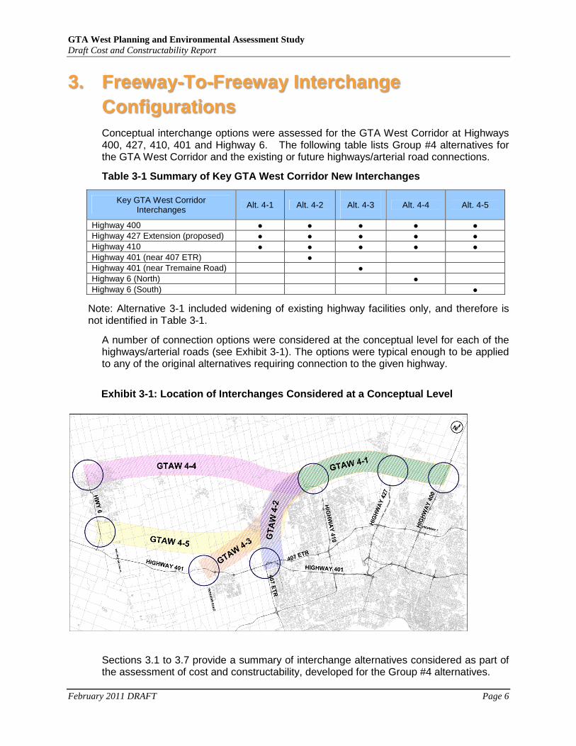
3. Freeway-To-Freeway Interchange Configurations Conceptual interchange options were assessed for the GTA West Corridor at Highways 400, 427, 410, 401 and Highway 6. The following table lists Group #4 alternatives for the GTA West Corridor and the existing or future highways/arterial road connections.
Table 3-1 Summary of Key GTA West Corridor New Inte rchanges
Key GTA West Corridor Interchanges Alt. 4-1 Alt. 4-2
Alt. 4-3
Alt. 4-4 Alt. 4-5
Highway 400 ● ● ● ● ●
Highway 427 Extension (proposed) ● ● ● ● ●
Highway 410 ● ● ● ● ●
Highway 401 (near 407 ETR) ●
Highway 401 (near Tremaine Road) ●
Highway 6 (North) ●
Highway 6 (South) ●
Note: Alternative 3-1 included widening of existing highway facilities only, and therefore is not identified in Table 3-1.
A number of connection options were considered at the conceptual level for each of the highways/arterial roads (see Exhibit 3-1). The options were typical enough to be applied to any of the original alternatives requiring connection to the given highway.
Exhibit 3-1: Location of Interchanges Considered at a Conceptual Level
Sections 3.1 to 3.7 provide a summary of interchange alternatives considered as part of the assessment of cost and constructability, developed for the Group #4 alternatives.
GTA West Planning and Environmental Assessment Study Draft Cost and Constructability Report
February 2011 DRAFT Page 7
3.1 HIGHWAY 400 CONNECTION
A GTA West Corridor interchange at Highway 400 is constrained by the existing King Road interchange to the north and Teston Road interchange to the south. In addition, there are service centres which service northbound and southbound Highway 400. A GTA West Corridor interchange with Highway 400 would fall within the City of Vaughan’s proposed Highway 400 North Employment Area. This connection applies to all Group 4 alternatives (Alternatives 4-1 to 4-5).
The Highway 400 connection assumes a full freeway to freeway intersection between Highway 400 and the GTA West Corridor.
3.2 HIGHWAY 427 CONNECTION
An EA for the Highway 427 Extension from Highway 7 to Major Mackenzie Drive has been approved by the Ministry of the Environment (MOE). Opportunities to provide a connection from Highway 427 to the GTA West Corridor are limited due to the Humber River to the east, the ability to accommodate Hydro One 500 kv transmission corridor and hydro substation to the north and development proposals at different stages of approval to the east and west. The GTA West Corridor is constrained primarily by existing and planned development to a narrow corridor south of Bolton. The 427 connection assumes a full freeway to freeway connection between Highway 427 and the GTA West Corridor. This connection applies to all Group 4 Alternatives (Alternatives 4-1 to 4-5). However, this study does not include further extensions of Highway 427 northerly beyond the GTA West Corridor.
3.3 HIGHWAY 410 CONNECTION
There are primarily two different options for connecting Highway 410 to the GTA West Corridor These options apply to all Group 4 alternatives (4-1 to 4-5).
Option 1 – Extend Highway 410 North Along Highway 1 0
A connection with Highway 410 could be provided by extending Highway 410 as a freeway from its current terminus at Highway 10 northerly along the existing Highway 10 corridor to the GTA West Corridor. Direct freeway to freeway ramps would be constructed between GTA West Corridor and the extended Highway 410 to the south, with additional ramps between the GTA West Corridor and Highway 10 to the north.
This option would require modifications to the current Highway 410 interchange with Highway 10. This option would require a review of access to the Valleywood subdivision northeast of Highway 410 and Highway 10. Constraints include existing and planned development west of the Valleywood subdivision and along Highway 10 north of Highway 410. Highway 410 north of Mayfield Road was constructed to an ultimate cross-section of 4 lanes with reduced geometrics and design speed at the transition to Highway 10.
GTA West Planning and Environmental Assessment Study Draft Cost and Constructability Report
February 2011 DRAFT Page 8
Option 2 – New Highway 410 Extension North of Mayfi eld Road
A connection with Highway 410 could be provided by constructing a new Highway 410 extension between the GTA West Corridor and the north-south section of Highway 410 north of Mayfield Road. This alternative would include a freeway to freeway interchange between GTA West Corridor and the ‘new’ Highway 410 extension. Direct ramp connections to and from the south would be provided while retaining the Mayfield Road interchange.
This option would integrate with the recently constructed Highway 410 extension between Mayfield Road and Highway 10.
Another option was also reviewed: the GTA West Corridor would merge with Highway 410 north of Mayfield Road, and continue westerly along the recently constructed Highway 410 extension. The GTA West Corridor would then continue westerly beyond Highway 10.
This Option was not considered for further study as it does not meet the minimum right-of-way (ROW) requirement for a new freeway and transitway. The existing Highway 410 ROW (~90m) cannot accommodate additional 4 lanes for the GTA West Corridor plus transitway (170m is required).
3.3.1 Further Review of New Highway 410 Extension North o f Mayfield Road
To review the feasibility, Option 2 was developed to a higher level of detail. Two variations of Option 2 were considered. Both options propose a new Highway 410 extension between Mayfield Road and the GTA West Corridor. Bridge General Arrangement Drawings for Mayfield Road and Countryside Drive were reviewed to confirm feasibility of the two options. The following assumptions were incorporated into the options:
o All existing ramp moves to and from Highway 410 and Mayfield Road and to and from Highway 410 and Sandalwood Parkway East should be retained;
o All alternatives should be compatible with a future planned partial interchange with Countryside Drive;
o Minimize additional property impacts to minimize impacts to adjacent development applications.
The options are presented as Options 2A and 2B below.
Option 2A
Option 2A requires a modification to the existing Mayfield Road interchange to accommodate the northbound ramp connection with the GTA West corridor. Ramp S-E/W would be realigned approximately 50m to the east. A new two lane northbound ramp connection to the GTA West Corridor would be constructed between realigned Ramp S-E/W and Ramp W-W. The northbound ramp connection to the GTA West Corridor would be constructed under Mayfield Road. A new two lane southbound ramp connection from the GTA West Corridor to Highway 410 would be accommodated by a high level ramp over the existing

GTA West Planning and Environmental Assessment Study Draft Cost and Constructability Report
February 2011 DRAFT Page 9
Mayfield Road interchange. The new southbound ramp will require a modification to the future Countryside Road Ramp E/W-S. Barrier separation will be required between the ramp and southbound Highway 410 for a distance of 100m. The ramp would extend as a continuous auxiliary lane to Sandalwood Parkway East with a weaving distance of approximately 630m.
Option 2B
Option 2B requires a smaller property footprint as compared to Option 3A. Mayfield Ramp W-W would be replaced by a new eastbound left turn onto a realigned E-W ramp. This will provide space for a new two lane exit for the northbound ramp connection to the GTA West Corridor under the existing Mayfield Road bridge. This will require two consecutive exits along northbound Highway 410 between Countryside Drive and Mayfied Road. The southbound two lane ramp connection from the GTA West Corridor would be the same as Option 2A.
3.4 HIGHWAY 401 CONNECTION AT 407 ETR
Three options for connecting Highway 401 to the GTA West Corridor at 407 ETR were assumed. The options assume that the GTA West Corridor ties in i) to the west of the 407 ETR interchange, ii) directly to the north-south leg of the 407 ETR interchange and iii) to the east of the 407 ETR interchange. These options apply to the Group 4-2 alternative only. GTA West Corridor tie-in locations are constrained by the existing Trafalgar Road interchange and 16 Mile Creek tributary to the west and the existing Winston Churchill Road interchange to the east. The configurations developed as part of Halton Peel Boundary Area Study (H-P BATS) were reviewed.
Option 1 – Connect West of 407 ETR
This option assumes the GTA West Corridor alignment connects (via a new interchange) west of the existing 407 ETR and Highway 401 interchange. The new interchange ramps would allow for full movements to/from the GTA West Corridor to/from Highways 401 and 407 ETR.
Option 2 – Connect at 407 ETR
This option assumes the GTA West Corridor alignment connects into the north-south leg of the 407 ETR at Highway 401. The new interchange ramps would allow for full movements to/from the GTA West Corridor to/from Highways 401 and 407 ETR.
Option 3 - Connect East of 407 ETR
This option assumes the GTA West Corridor alignment connects east of the existing 407 ETR and Highway 401 interchange. The new interchange ramps would allow for full movements to/from the GTA West Corridor to/from Highways 401 and 407 ETR.
3.4.1 Further Review at Connection to Highway 401 / 407 E TR (Alternative 4-2)
Of the three options presented in Section 3.4, Option 1 was developed to a higher level detail to review feasibility. Lane requirements for both mainline and ramps are consistent with Macrosimulation results for both GTA West Corridor and recent Highway 401 (RR25-Credit River) traffic studies. This alternative assumes that all
GTA West Planning and Environmental Assessment Study Draft Cost and Constructability Report
February 2011 DRAFT Page 10
existing 407 ETR bridges will be retained. MTO’s Draft Rural Freeway Safety Standards manual was assumed with the following exceptions:
o Highway 401-407 ETR E-W loop ramp maintained
o Minimum radius of 340m used (desirable 420m & 650m)
o Weaving lengths < desirable at 2 locations
Ramp 407 ETR East to Highway 401 West would need to be realigned to accommodate the proposed interchange. This interchange would require a modification to the recommended interchange plan identified in the ongoing Highway 401 Preliminary Design and Environmental Assessment Study from West of RR25 to east of Trafalgar. The Trafalgar Road interchange ramps N-E and S-E would be combined and grade separated with a ‘basket weave’ structure with Highway 401 W-407 ETR. Multiple new structures would be required to accommodate all of the connections to/from GTA West Corridor. Multi-span bridges (approx. 500m in length) would be required at two locations:
o GTA West Corridor southbound over Highway 401; and
o 407 ETR northbound over Highway 401 to GTA West Corridor northbound.
3.4.2 North –South Link at Highway 401 / 407 ETR
Additional assessment was undertaken for a new North-South Link connecting the GTA West Corridor (Alternative 4-3) to Highway 401 / 407 ETR. The North-South Link would be a new 6 lane freeway from north of Mayfield Road to Highway 401 at 407 ETR. All existing 407 ETR bridges would be maintained. It should be noted that the H-P BATS identified the need for an 8-lane facility. However, traffic analysis carried as part of GTA West Study indicated the need to be a 6-lane facility. See Draft Transportation Model Technical Background Report;
The North-South Link interchange with Highway 401 at 407 ETR would be designed to MTO freeway standards.
MTO’s Draft Rural Freeway Safety Standards manual would be applied with the following exceptions:
o Highway 401-407 ETR loop ramp E-W maintained
o Minimum radius of 340m used (desirable 420m & 650m
o Weaving lengths < desirable at 2 locations
The North-South Link interchange with Highway 401 at 407 ETR would be consistent with recommended lane requirements from GTA West Corridor and the Highway 401 Preliminary Design Study from Trafalgar Road to Regional Road 25 (underway). The North-South Link interchange with Highway 401 at 407 ETR would be a partial moves interchange with connections to and from 407 ETR south and Highway 401 east.
Ramp 407 ETR East to Highway 401 West would need to be realigned to accommodate the proposed interchange. No modifications are required to the recommended interchange plan for Trafalgar Road in the ongoing Highway 401 Preliminary Design and Environmental Assessment Study from West of RR25 to east of Trafalgar. Multiple new structures will be required to accommodate the
GTA West Planning and Environmental Assessment Study Draft Cost and Constructability Report
February 2011 DRAFT Page 11
connections to/from GTA West Corridor. Multi-span bridges (approx. 500m in length) would be required at two locations:
o GTA West Corridor southbound over Highway 401 to Highway 401 eastbound; and
o 407 ETR northbound over Highway 401 to GTA West Corridor northbound.
This interchange could be simplified by providing connections to and from GTA West Corridor and 407 ETR southbound only.
3.5 CONNECTION AT HIGHWAY 401 WEST MILTON / 407 ETR
Three options for connecting Highway 401 to the GTA West Corridor in West Milton were assumed. The options assume that the GTA West Corridor tie in to Highway 401 in the vicinity of the future Realigned Tremaine Road interchange. These options apply to the Group 4-3 alternative only. GTA West Corridor tie-in locations are constrained by the Niagara Escarpment to the west, the existing Regional Road 25 interchange to the east, plans for a new interchange with Realigned Tremaine Road and development proposals at different stages of approval.
Option 1 – GTA West Interchange West of Future Trem aine Road Interchange
This option assumes the GTA West Corridor connects with Highway 401, just west of future Realigned Tremaine Road. This option allows for full movements between Highway 401 and GTA West Corridor, with no direct connections to Tremaine Road.
Option 2 – GTA West Interchange with Direct Connect ion to Future Realigned Tremaine Road
Similar to Option 1, this option assumes the GTA West Corridor connects with Highway 401 at realigned Tremaine Road. This option allows for full movements between Highway 401 and GTA West Corridor, with a direct connection to Tremaine Road to the south. This option would require the reinstatement of existing Tremaine Road as a continuous road with a new bridge over Highway 401. Realigned Tremaine Road north of Highway 401 would be abandoned and replaced with a direct connection to GTA West Corridor.
Option 3 – GTA West Connection West of Future Reali gned Tremaine Road Interchange
This option is similar to Option 1, with a slight difference in location of GTA West Corridor and Highway 401 interchange. The interchange is shifted further west of the proposed Tremaine Road and Highway 401 interchange, relative to Option 1. The shift to the west avoids impacts to approved development lands east of Dublin Line. This option would require a modification to the future Realigned Tremaine Road interchange. A new exit ramp from Highway 401 westbound to GTA West Corridor northbound would be introduced through the interchange. Realigned Tremaine Road Ramp N-W would require realignment and a ‘basketweave’ structure to accommodate the new GTA West Corridor ramp.
3.5.1 Further Review at Highway 401 Connection in West Mi lton
Option 3 requires the least footprint compared to Options 1 and 2 and was developed to a higher level of detail.
GTA West Planning and Environmental Assessment Study Draft Cost and Constructability Report
February 2011 DRAFT Page 12
Option 3 proposed a new full interchange between the GTA West Corridor and Highway 401 with most of the ramps located to the west side of the proposed Realigned Tremaine Road interchange with Highway 401.
Some modifications would be required to the proposed Realigned Tremaine Road interchange at Highway 401. To confirm feasibility, Option 3 was reviewed at a higher level of detail. Two variations of Option 3 were considered. Option 3A provides for a full move interchange with Highway 401 while Option 3B provides for a partial moves interchange. The following assumptions were incorporated into the options as follows:
o Minimize impacts to the Niagara Escarpment and Halton Heritage Park to the west;
o Must be compatible with the recommended interchange alternative for Regional Road 25 per the Highway 401 Preliminary Design and EA Study from RR25 to Trafalgar Road;
o Must be compatible with proposed new interchange at Realigned Tremaine Road; and
o Must minimize impacts to development proposals at different stages of approval, specifically, the approved development proposal east of Dublin Line.
The options are presented as Options 3A and 3B below.
Option 3A - Full Interchange
Option 3A will require the following modifications to the proposed Realigned Tremaine Road interchange:
o Ramps S-W and N-W would be replaced with a diamond Ramp N/S-W, with a new ‘basketweave’ structure for GTA West Corridor Ramp E-N; and
o Ramp S-E would need to be tightened to allow for GTA West Corridor Ramp N-E.
Option 3B - Partial Interchange
Option 3B does not require any modification to the proposed Realigned Tremaine Road interchange. Partial freeway to freeway ramps would be constructed west of the proposed interchange.
3.6 HIGHWAY 6 INTERCHANGE NORTH OF GUELPH
Two options for connecting the GTA West Corridor to Highway 6 in north Guelph were considered. These options apply to the Group 4-4 alternative only. Both options assume that the GTA West Corridor alignment would run near the north part of the corridor to minimize impacts to the existing suburbs of Guelph. Both alternatives assume the following:
• Highway 7N would be constructed as planned by MTO, as a freeway with a direct connection with Highway 6 to the south;
GTA West Planning and Environmental Assessment Study Draft Cost and Constructability Report
February 2011 DRAFT Page 13
• Highway 6 to the south of Highway 7N would be upgraded to a freeway, as planned by MTO; and
• The GTA West Corridor would tie in directly to Highway 7N.
Option 1 – Connection with Highway 6 South
The interchange at GTA West Corridor/Highway 7N/Highway 6 would be a “Trumpet” configuration and would include a loop ramp between northbound Highway 6 and Highway 7N. The proposed connection would be located north of Woodlawn Road.
Option 2 – Connection with Highway 6 Realignment No rth and South
This option considers MTO West Region’s long-term plans to extend Highway 6 northerly to south of Marden. This option provides for a fully directional four level freeway to freeway interchange between GTA West Corridor, Highway 7N, Highway 6 and a future Highway 6 extension.
3.7 HIGHWAY 6 CONNECTION SOUTH OF GUELPH
Two options for connecting the GTA West Corridor to Highway 6 south of Guelph were considered. These options apply to the Group 4-5 alternative only. The options were prepared in considering the following provincial and municipal long term planning initiatives:
• An underpass planned at Wellington Road 34 and Highway 6;
• A Parclo A interchange is planned to be constructed at Highway 6 to provide a new connection road for Wellington Road 34 and Concession Road 7. The west portion of the new road will connect to Wellington Road 34 and the east portion of the road will connect to Concession Road 7;
• A Parclo A interchange at Highway 6 and Laird Road is planned for construction;
• Connections to two of the existing roads (Clair Road and Maltby Road) will be closed in the future as part of future Highway 6 upgrades;
• A partial interchange at Highway 6 / Kortright Road with ramps oriented to the south;
• An extension of existing Southgate Drive further south to Maltby Road; and
• Approved plan of subdivision for the South Guelph Industrial Lands.
Option 1 – Trumpet Interchange at Highway 6
This option assumes that the GTA West Corridor alignment would tie into Highway 6 just north of Maltby Road West using a “Trumpet” interchange.
Option 2 – Freeway to Freeway Interchange at Highwa y 6
This option assumes that the GTA West Corridor alignment would tie into Highway 6 just south of Maltby Road West using a partial freeway to freeway interchange.
Although not currently identified as a planning initiative, this option would allow for a new connection between Maltby Road and Concession Road 4, north of the
GTA West Planning and Environmental Assessment Study Draft Cost and Constructability Report
February 2011 DRAFT Page 14
proposed GTA West Corridor /Highway 6 interchange. This option is compatible with the future mid-block interchange on Highway 6 servicing Wellington Road 34 and Concession Road 7, but would require a basketweave structure separating GTA West Corridor Ramp E-S with mid-block Ramp N-E/W.
GTA West Planning and Environmental Assessment Study Draft Cost and Constructability Report
February 2011 DRAFT Page 15
4. Cost and Constructability Findings
4.1 INITIAL COST ESTIMATING AND CONSTRUCTABILITY
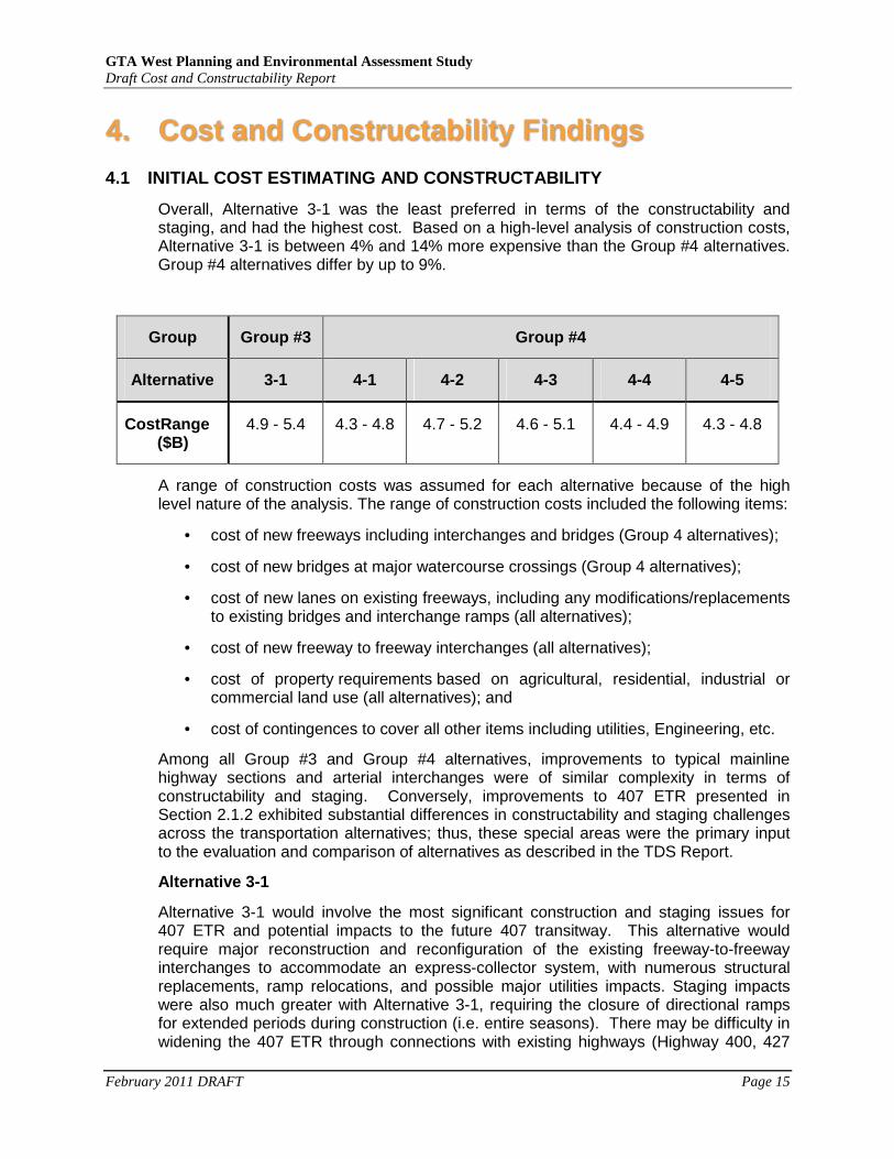
Overall, Alternative 3-1 was the least preferred in terms of the constructability and staging, and had the highest cost. Based on a high-level analysis of construction costs, Alternative 3-1 is between 4% and 14% more expensive than the Group #4 alternatives. Group #4 alternatives differ by up to 9%.
Group Group #3 Group #4
Alternative 3-1 4-1 4-2 4-3 4-4 4-5
CostRange ($B)
4.9 - 5.4 4.3 - 4.8 4.7 - 5.2 4.6 - 5.1 4.4 - 4.9 4.3 - 4.8
A range of construction costs was assumed for each alternative because of the high level nature of the analysis. The range of construction costs included the following items:
• cost of new freeways including interchanges and bridges (Group 4 alternatives);
• cost of new bridges at major watercourse crossings (Group 4 alternatives);
• cost of new lanes on existing freeways, including any modifications/replacements to existing bridges and interchange ramps (all alternatives);
• cost of new freeway to freeway interchanges (all alternatives);
• cost of property requirements based on agricultural, residential, industrial or commercial land use (all alternatives); and
• cost of contingences to cover all other items including utilities, Engineering, etc.
Among all Group #3 and Group #4 alternatives, improvements to typical mainline highway sections and arterial interchanges were of similar complexity in terms of constructability and staging. Conversely, improvements to 407 ETR presented in Section 2.1.2 exhibited substantial differences in constructability and staging challenges across the transportation alternatives; thus, these special areas were the primary input to the evaluation and comparison of alternatives as described in the TDS Report.
Alternative 3-1
Alternative 3-1 would involve the most significant construction and staging issues for 407 ETR and potential impacts to the future 407 transitway. This alternative would require major reconstruction and reconfiguration of the existing freeway-to-freeway interchanges to accommodate an express-collector system, with numerous structural replacements, ramp relocations, and possible major utilities impacts. Staging impacts were also much greater with Alternative 3-1, requiring the closure of directional ramps for extended periods during construction (i.e. entire seasons). There may be difficulty in widening the 407 ETR through connections with existing highways (Highway 400, 427
GTA West Planning and Environmental Assessment Study Draft Cost and Constructability Report
February 2011 DRAFT Page 16
410 and 401) due to the complex layout of ramps and structures (including bridge piers). In addition, duration of construction, risk, disruption to the 407 ETR and adjacent roadways, major utilities, technical challenges and other impacts represent potential issues during construction. Detailed analysis would be required to confirm the feasibility of retaining the existing structures.
407 Transitway
A dedicated grade-separated transitway is proposed by MTO along the 407 ETR corridor, which will initially include a separate and grade-separated two-lane roadway and stations with commuter parking. The widening of the 407 ETR and interchange improvements for Alternative 3-1 may have significant impacts to the transitway including impacts to transit stations, commuter lots, transitway lanes and other transitway infrastructure such as stormwater management facilities. Key challenges include potential changes in road profile, limited flexibility in modifying the location of 407 ETR transitway stations and the close proximity to the existing hydro corridor. Potential impacts to the transitway include: horizontal and vertical alignments, ramps and structures, grade separations, adjacent arterial roads, and access to stations and parking areas.
Property
Additional right-of-way requirements could significantly impact properties adjacent to freeways through built up areas. Alternatives 4-1 and 4-2 require additional lanes along Highway 401 between 407 ETR and Regional Road 25 which will require conversion to a collector-distributor system. Additional costs and staging requirements will come with widening Highway 401 in this area. Traffic staging issues will include the potential for increased delays during the construction period along each widened facility. In addition, the interface of Alternative 4-2 with Highway 401 and 407 ETR requires complex staging. In general, the Group #3 alternative exhibited more challenging constructability and staging issues than Group #4 alternatives, primarily due to impacts to the 407 ETR.
The Group #4 alternatives (i.e. Alternatives 4-1, 4-2, 4-3, 4-4 and 4-5) assume that capacity improvements are achieved by new freeway construction in addition to some existing highway widening. The Group #4 alternatives differ from one another in the extent and location of freeway segment(s). Consequently, Group #4 alternatives that have a larger footprint have the potential to result in more substantial natural and socio-environmental impacts. By comparison, less property is required for Alternative 3-1; however, the property that is required is along existing freeways through developed areas, which would impact existing built-up commercial, industrial and institutional lands.
Alternatives 4-4 and 4-5
Alternatives 4-4 and 4-5 will require the longest length of new construction through rural lands. These alternatives will have additional constructability challenges associated with crossing the Niagara Escarpment and greater number of watercourse crossings. Alternative 4-3 will require a moderate length of new construction with minimal widening of existing freeways.
GTA West Planning and Environmental Assessment Study Draft Cost and Constructability Report
February 2011 DRAFT Page 17
4.2 ADDITIONAL COST ESTIMATING AND CONSTRUCTABILITY
The following is a summary of findings of additional cost and constructability analysis, as referenced in Chapter 7 of the TDS Report.
Alternative 4-2
This alternative requires complex additions and changes to the existing Highway 401 and 407 ETR interchange. The need to accommodate all of the various moves between GTA West Corridor, Highway 401 and 407 ETR would require multiple new ramps, high level multi-span bridges, and relocation of some ramps. The new interchange would be designed to MTO freeway standards and would include direct high speed ramps for all movements. The MTO standard would require a substantial property footprint. Key constructability challenges include:
• Construction of bridges over live traffic would be required at a number of locations along Highway 401 and 407 ETR; this would require major detours along Highway 401 to construct bridge piers;
• Complex staging and detouring of existing ramps including 407 ETR ramps requiring the closure of directional ramps for extended periods during construction (i.e. entire seasons);
• Potential financial consequences if 407 ETR lanes are closed.
Additional analysis of Alternative 4-2 indicated that a new interchange connection with Highway 401 and 407 ETR would cost between $120M and $130M.
Alternative 4-3
This alternative would require a much less complex partial interchange with Highway 401 west of Milton, as only two direct ramp connections would be required between the GTA West Corridor and Highway 401 to and from the west. Other movements from the GTA West Corridor to and from Milton area destinations could be provided via a north-south link from GTA West Corridor to Highway 401 / 407 ETR (assumed for analysis purposes as a municipal initiative) or via existing interchanges in the area. The reduced number of ramps would be simpler to construct and would have a smaller property impact relative to Alternative 4-2. Key constructability challenges including construction over live traffic would be required at one location along Highway 401; this would require minor detours along Highway 401 to construct a new bridge pier in the median.
The additional analysis of Alternative 4-3 indicated that a new interchange would cost $35-$40M, substantially less than the Highway 401 interchange in Alternative 4-2.
North-South Link
As referenced in Section 3.4.2, a new North-South Link connecting GTA West Corridor (Alternatives 4-3, 4-4 and 4-5) to Highway 401 / 407 ETR was identified. Based on preliminary cost estimate, the cost for the interchange between the North-South Link and Highway 401/407 may be in the range of $50 M (limited ramp movements) to $130 M (full interchange). Further traffic analysis will be carried out during Stage 2 of the EA Study to determine and confirm the ramp movements required at this interchange.

GTA West Planning and Environmental Assessment Study Draft Cost and Constructability Report
February 2011 DRAFT Page 18
Summary
While Alternative 4-3 alone would have fewer constructability risks and would result in fewer disruptions during construction compared to Alternative 4-2, the recommended improvements now include a combination of extending the GTA West Corridor south of Georgetown to Highway 401 west of Milton (i.e. new transportation corridor in Alternative 4-3), and the corridor from north of Mayfield Road to Highway 401 at 407 ETR (i.e. the North-South Link), with widening on Highway 401 through Milton (James Snow Parkway to Regional Road 25) to 12 lanes. The overall cost would therefore be comparable to that of Alternative 4-2.
GTA West Planning and Environmental Assessment Study Draft Cost and Constructability Report
February 2011 DRAFT Page 19
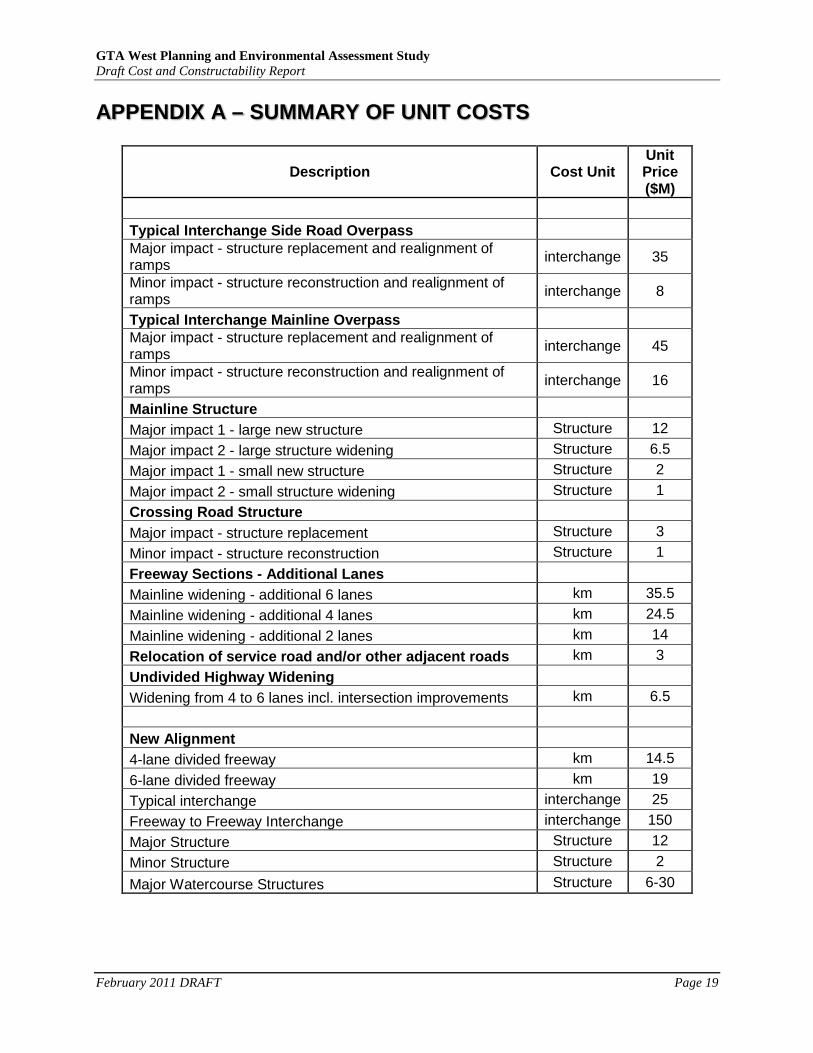
APPENDIX A – SUMMARY OF UNIT COSTS
Description Cost Unit Unit Price ($M)
Typical Interchange Side Road Overpass Major impact - structure replacement and realignment of ramps interchange 35
Minor impact - structure reconstruction and realignment of ramps interchange 8
Typical Interchange Mainline Overpass Major impact - structure replacement and realignment of ramps interchange 45
Minor impact - structure reconstruction and realignment of ramps interchange 16
Mainline Structure Major impact 1 - large new structure Structure 12 Major impact 2 - large structure widening Structure 6.5 Major impact 1 - small new structure Structure 2 Major impact 2 - small structure widening Structure 1 Crossing Road Structure Major impact - structure replacement Structure 3 Minor impact - structure reconstruction Structure 1 Freeway Sections - Additional Lanes Mainline widening - additional 6 lanes km 35.5 Mainline widening - additional 4 lanes km 24.5 Mainline widening - additional 2 lanes km 14 Relocation of service road and/or other adjacent ro ads km 3 Undivided Highway Widening Widening from 4 to 6 lanes incl. intersection improvements km 6.5 New Alignment 4-lane divided freeway km 14.5 6-lane divided freeway km 19 Typical interchange interchange 25 Freeway to Freeway Interchange interchange 150 Major Structure Structure 12 Minor Structure Structure 2
Major Watercourse Structures Structure 6-30