Corte Madera Creek 2009 RPT
29
California Department of Fish and Game East Marin County San Francisco Bay Watersheds Stream Habitat Assessment Reports Corte Madera Creek Surveyed 2009
Transcript of Corte Madera Creek 2009 RPT
California Department of Fish and Game East Marin County
San Francisco Bay Watersheds Stream Habitat Assessment Reports
Corte Madera Creek Surveyed 2009
Corte Madera Creek 2009
1
STREAM INVENTORY REPORT
Corte Madera Creek Survey Completed Summer 2009
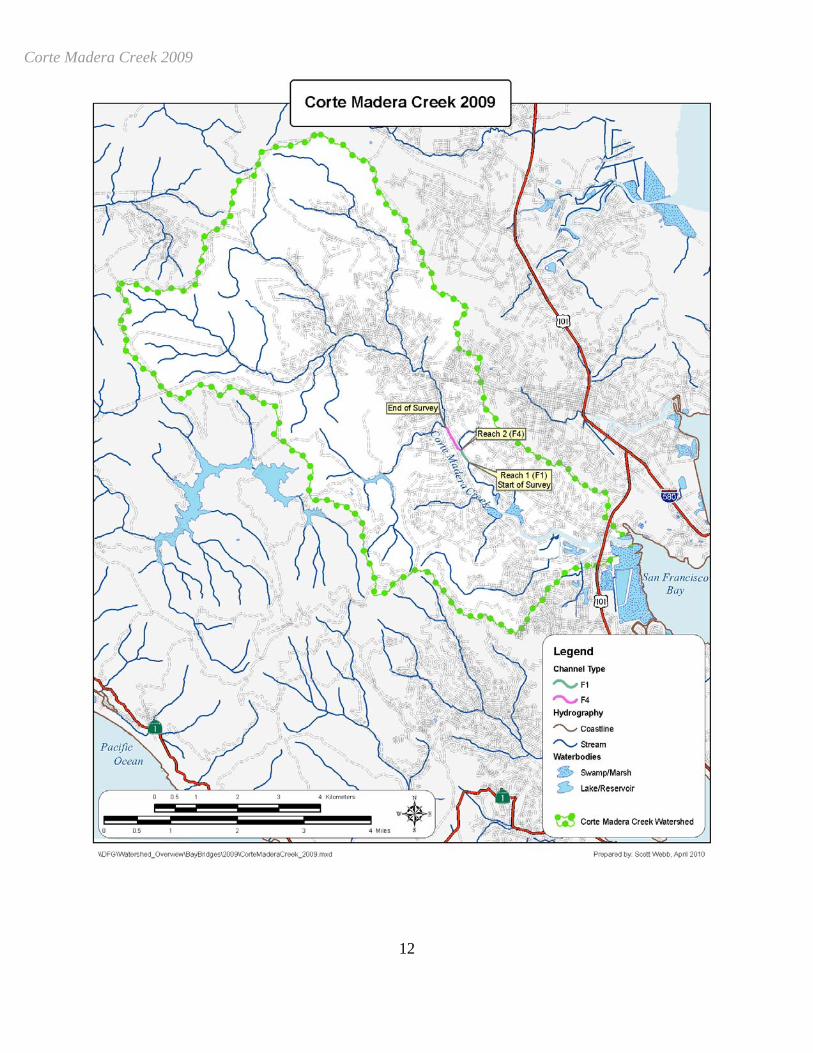
Report completed November 2010 INTRODUCTION A stream inventory was conducted during 8/17/2009 on Corte Madera Creek. The survey began at the confluence with San Francisco Bay and extended upstream 0.6 miles. Stream inventories and reports were also completed for the following tributaries to Corte Madera Creek; Larkspur Creek, Ross Creek, Tamalpais Creek and San Anselmo Creek. The Corte Madera Creek inventory was conducted in two parts: habitat inventory and biological inventory. The objective of the habitat inventory was to document the habitat available to anadromous salmonids in Corte Madera Creek. The objective of the biological inventory was to document the presence and distribution of juvenile salmonid species. The objective of this report is to document the current habitat conditions and recommend options for the potential enhancement of habitat for steelhead trout. Recommendations for habitat improvement activities are based upon target habitat values suitable for salmonids in California's north coast streams. WATERSHED OVERVIEW Corte Madera Creek is a tributary to San Francisco Bay, located in Marin County, California (Map 1). Corte Madera Creek's legal description at the confluence with San Francisco Bay is T01N R06W S10. Its location is 37°56'33.8" north latitude and 122°30'26" west longitude, LLID number 1225061379428. Corte Madera Creek is a fourth order stream and has approximately 47.04 miles of blue line stream within its catchment boundary according to the USGS National Hydrography Dataset (NHD). Corte Madera Creek drains a watershed of approximately 24.4 square miles. Elevations range from about sea level at the mouth of the creek to 2,510 feet in the headwaters. Mixed hardwood forest dominates the watershed. The watershed is primarily privately owned which accounts for 65% of the land area. Sixty five percent of the land is considered natural and 35% of the land is urban. Vehicle access exists via Hwy 101 to Sir Francis Drake Boulevard. METHODS The habitat inventory conducted in Corte Madera Creek follows the methodology presented in the California Salmonid Stream Habitat Restoration Manual (Flosi et al, 1998). The California Conservation Corps (CCC) Technical Advisors and Watershed Stewards Project/AmeriCorps (WSP) Members that conducted the inventory were trained in standardized habitat inventory methods by the California Department of Fish and Game (DFG). This inventory was conducted by a two-person team.
Corte Madera Creek 2009
2
SAMPLING STRATEGY The inventory uses a method that samples approximately 10% of the habitat units within the survey reach. All habitat units included in the survey are classified according to habitat type and their lengths are measured. All pool units are fully measured. All other habitat unit types encountered for the first time in each reach are measured for all the parameters and characteristics on the field form. Additionally, from the ten habitat units on each field form page, one is randomly selected for complete measurement. HABITAT INVENTORY COMPONENTS A standardized habitat inventory form has been developed for use in California stream surveys and can be found in the California Salmonid Stream Habitat Restoration Manual. This form was used in Corte Madera Creek to record measurements and observations. There are eleven components to the inventory form. 1. Flow: Flow is measured in cubic feet per second (cfs) near the bottom of the stream survey reach using a Marsh-McBirney Model 2000 flow meter. 2. Channel Type: Channel typing is conducted according to the classification system developed and revised by David Rosgen (1994). This methodology is described in the California Salmonid Stream Habitat Restoration Manual. Channel typing is conducted simultaneously with habitat typing and follows a standard form to record measurements and observations. There are five measured parameters used to determine channel type: 1) water slope gradient, 2) entrenchment, 3) width/depth ratio, 4) substrate composition, and 5) sinuosity. Channel characteristics are measured using a clinometer, hand level, hip chain, tape measure, and a stadia rod. 3. Temperatures: Both water and air temperatures are measured and recorded at every tenth habitat unit. The time of the measurement is also recorded. Both temperatures are taken in degrees Fahrenheit at the middle of the habitat unit and within one foot of the water surface. 4. Habitat Type: Habitat typing uses the 24 habitat classification types defined by McCain and others (1990). Habitat units are numbered sequentially and assigned a type identification number selected from a standard list of 24 habitat types. Dewatered units are labeled "dry". Corte Madera Creek habitat typing used standard basin level measurement criteria. These parameters require that the minimum length of a described habitat unit must be equal to or greater than the stream's mean wetted width. All measurements are in feet to the nearest tenth. Habitat characteristics are measured using a clinometer, hip chain, and stadia rod.
Corte Madera Creek 2009
3
5. Embeddedness: The depth of embeddedness of the cobbles in pool tail-out areas is measured by the percent of the cobble that is surrounded or buried by fine sediment. In Corte Madera Creek, embeddedness was ocularly estimated. The values were recorded using the following ranges: 0 - 25% (value 1), 26 - 50% (value 2), 51 - 75% (value 3) and 76 - 100% (value 4). Additionally, a value of 5 was assigned to tail-outs deemed unsuited for spawning due to inappropriate substrate like bedrock, log sills, boulders or other considerations. 6. Shelter Rating: Instream shelter is composed of those elements within a stream channel that provide juvenile salmonids protection from predation, reduce water velocities so fish can rest and conserve energy, and allow separation of territorial units to reduce density related competition for prey. The shelter rating is calculated for each fully-described habitat unit by multiplying shelter value and percent cover. Using an overhead view, a quantitative estimate of the percentage of the habitat unit covered is made. All cover is then classified according to a list of nine cover types. In Corte Madera Creek, a standard qualitative shelter value of 0 (none), 1 (low), 2 (medium), or 3 (high) was assigned according to the complexity of the cover. Thus, shelter ratings can range from 0-300 and are expressed as mean values by habitat types within a stream. 7. Substrate Composition: Substrate composition ranges from silt/clay sized particles to boulders and bedrock elements. In all fully-described habitat units, dominant and sub-dominant substrate elements were ocularly estimated using a list of seven size classes and recorded as a one and two, respectively. In addition, the dominant substrate composing the pool tail-outs is recorded for each pool. 8. Canopy: Stream canopy density was estimated using modified handheld spherical densiometers as described in the California Salmonid Stream Habitat Restoration Manual. Canopy density relates to the amount of stream shaded from the sun. In Corte Madera Creek, an estimate of the percentage of the habitat unit covered by canopy was made from the center of approximately every third unit in addition to every fully-described unit, giving an approximate 30% sub-sample. In addition, the area of canopy was estimated ocularly into percentages of coniferous or hardwood trees. 9. Bank Composition and Vegetation: Bank composition elements range from bedrock to bare soil. However, the stream banks are usually covered with grass, brush, or trees. These factors influence the ability of stream banks to withstand winter flows. In Corte Madera Creek, the dominant composition type and the dominant vegetation type of both the right and left banks for each fully-described unit were selected from the habitat inventory form. Additionally, the percent of each bank covered by vegetation (including downed trees, logs, and rootwads) was estimated and recorded.
Corte Madera Creek 2009
4
10. Large Woody Debris Count:
Large woody debris (LWD) is an important component of fish habitat and an element in channel forming processes. In each habitat unit all pieces of LWD partially or entirely below the elevation of bankfull discharge are counted and recorded. The minimum size to be considered is twelve inches in diameter and six feet in length. The LWD count is presented by reach and is expressed as an average per 100 feet. 11. Average Bankfull Width:
Bankfull width can vary greatly in the course of a channel type stream reach. This is especially true in very long reaches. Bankfull width can be a factor in habitat components like canopy density, water temperature, and pool depths. Frequent measurements taken at riffle crests (velocity crossovers) are needed to accurately describe reach widths. At the first appropriate velocity crossover that occurs after the beginning of a new stream survey page (ten habitat units), bankfull width is measured and recorded in the appropriate header block of the page. These widths are presented as an average for the channel type reach. BIOLOGICAL INVENTORY Biological sampling during the stream inventory is used to determine fish species and their distribution in the stream. Fish presence was observed from the stream banks in Corte Madera Creek. In addition, one site was electrofished using a Smith-Root Model 12 electrofisher. These sampling techniques are discussed in the California Salmonid Stream Habitat Restoration Manual. DATA ANALYSIS Data from the habitat inventory form are entered into Stream Habitat 2.0.18, a Visual Basic data entry program developed by Karen Wilson, Pacific States Marine Fisheries Commission in conjunction with the California Department of Fish and Game. This program processes and summarizes the data, and produces the following ten tables:
• Riffle, Flatwater, and Pool Habitat Types • Habitat Types and Measured Parameters • Pool Types • Maximum Residual Pool Depths by Habitat Types • Mean Percent Cover by Habitat Type • Dominant Substrates by Habitat Type • Mean Percent Vegetative Cover for Entire Stream • Fish Habitat Inventory Data Summary by Stream Reach (Table 8) • Mean Percent Dominant Substrate / Dominant Vegetation Type for Entire Stream • Mean Percent Shelter Cover Types for Entire Stream
Corte Madera Creek 2009
5
Graphics are produced from the tables using Microsoft Excel. Graphics developed for Corte Madera Creek include:
• Riffle, Flatwater, Pool Habitat Types by Percent Occurrence • Riffle, Flatwater, Pool Habitat Types by Total Length • Total Habitat Types by Percent Occurrence • Pool Types by Percent Occurrence • Maximum Residual Depth in Pools • Percent Embeddedness • Mean Percent Cover Types in Pools • Substrate Composition in Pool Tail-outs • Mean Percent Canopy • Dominant Bank Composition by Composition Type • Dominant Bank Vegetation by Vegetation Type
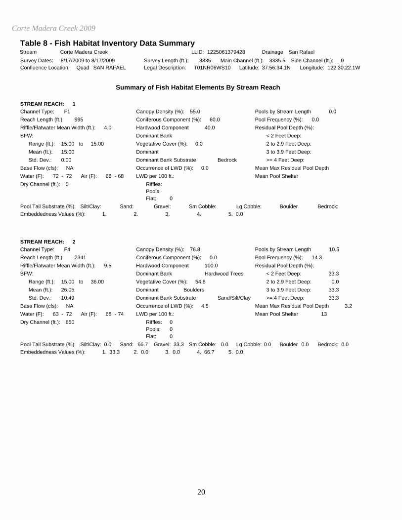
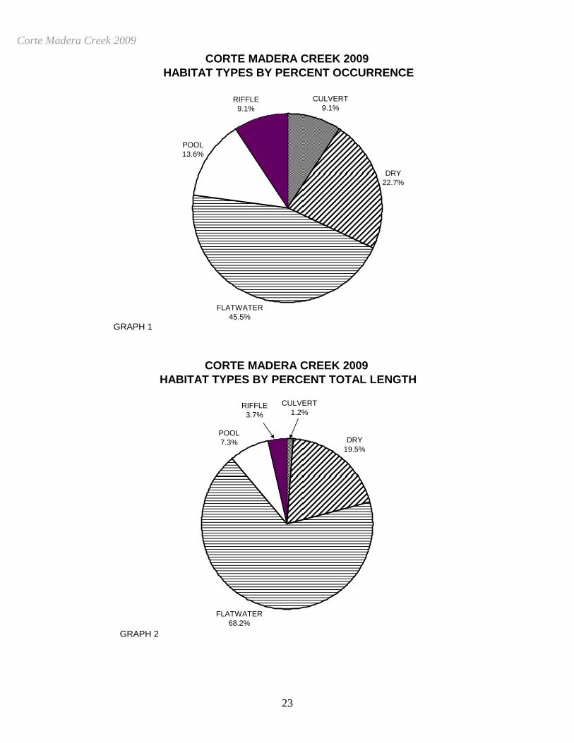
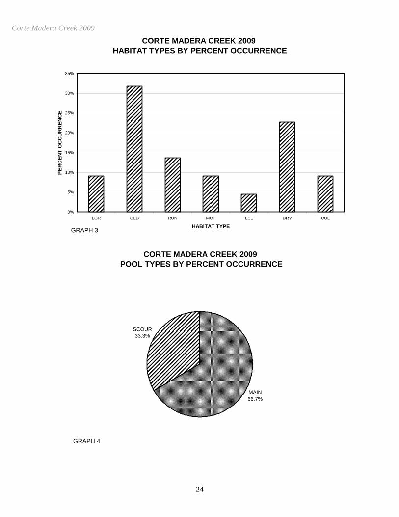
HABITAT INVENTORY RESULTS * ALL TABLES AND GRAPHS ARE LOCATED AT THE END OF THE REPORT * The habitat inventory of 8/17/2009 to 8/17/2009, was conducted by A. Villalobos (WSP) and C. Bell (WSP). The total length of the stream surveyed was 3,336 feet. Stream flow was not measured on Corte Madera Creek. Corte Madera Creek is an F1 channel type for 995 feet of the stream surveyed (Reach 1) and an F4 channel type for 2,341 feet of the stream surveyed (Reach 2). F1 channels are entrenched meandering riffle/pool channels on low gradients with high width/depth ratio, very stable if bedrock controlled channel. F4 channels are entrenched, meandering, riffle/pool channels on low gradients with high width/depth ratios and gravel-dominant substrates. Water temperatures taken during the survey period ranged from 63 to 72 degrees Fahrenheit. Air temperatures ranged from 68 to 74 degrees Fahrenheit. Table 1 summarizes the Level II riffle, flatwater, and pool habitat types. Based on frequency of occurrence there were 45% flatwater units, 23% dry units, 14% pool units, 9% culvert units and 9% riffle units (Graph 1). Based on total length of Level II habitat types there were 68% flatwater units, 19% dry units, 7% pool units, 1% culvert units and 4% riffle units (Graph 2). Seven Level IV habitat types were identified (Table 2). The most frequent habitat types by percent occurrence were 32% Glide units, 23% Dry units and 14% Run units (Graph 3). Based on percent total length the most frequent were 37% Glide units, 31% Run units and 19% Dry
Corte Madera Creek 2009
6
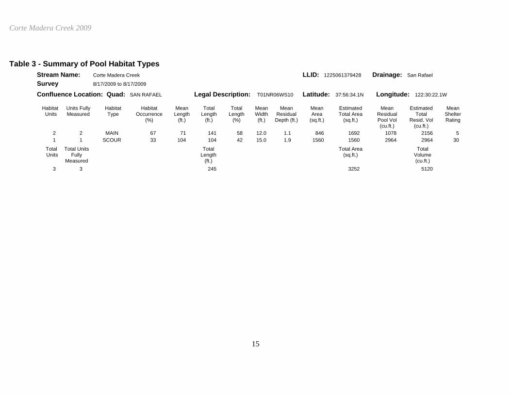
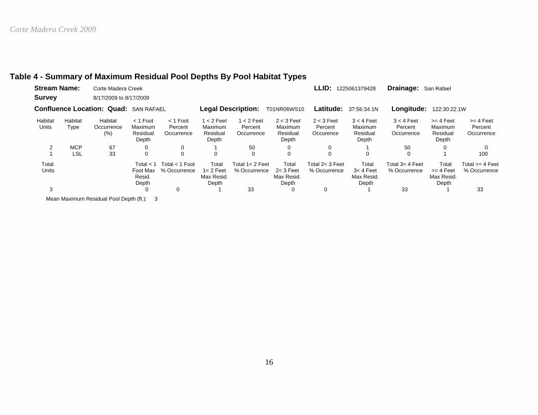
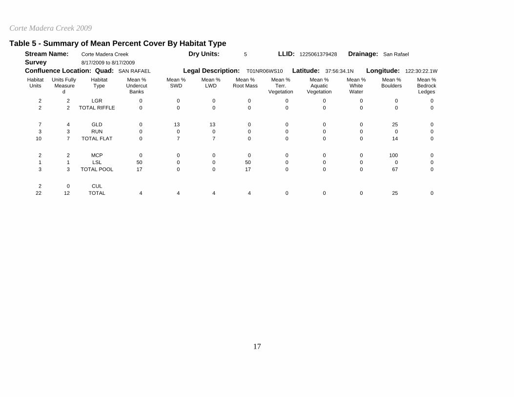
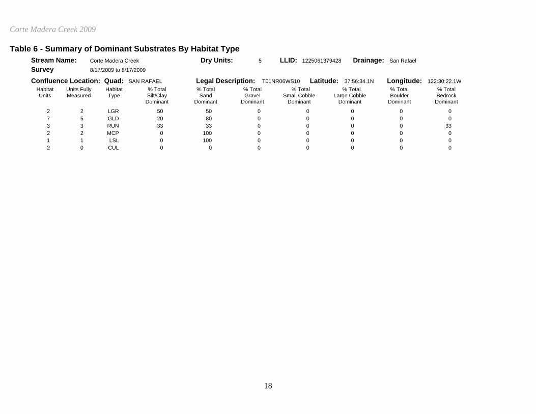
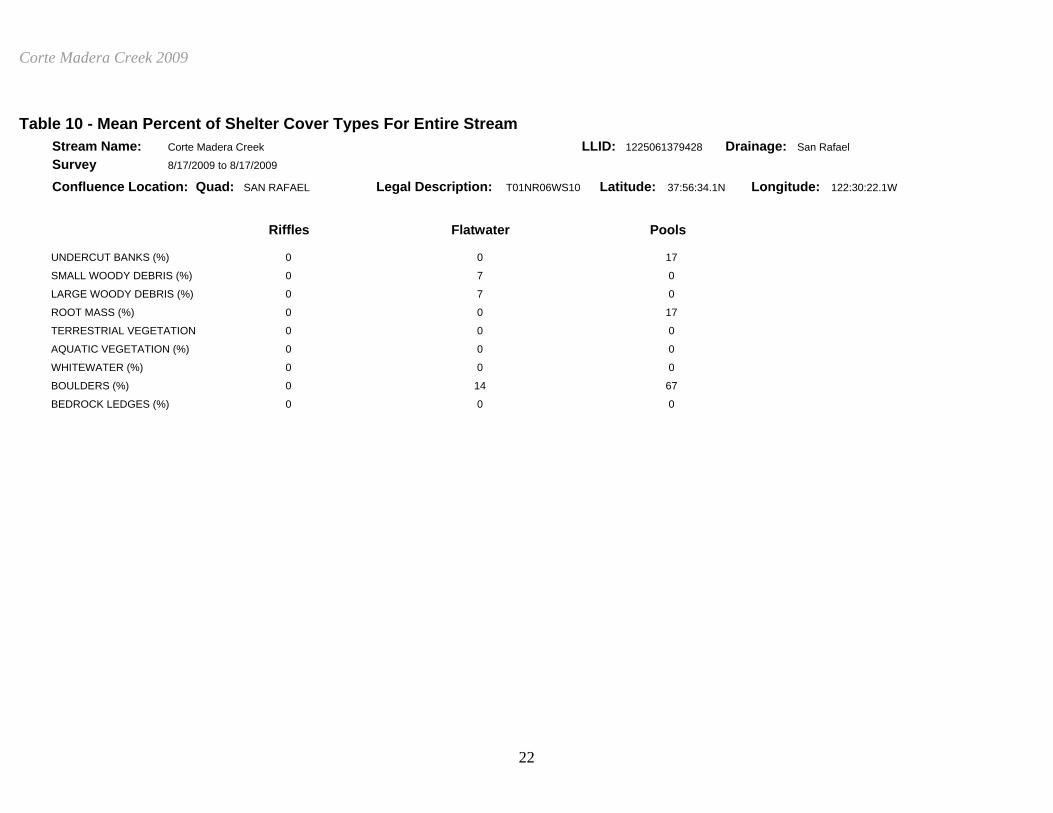
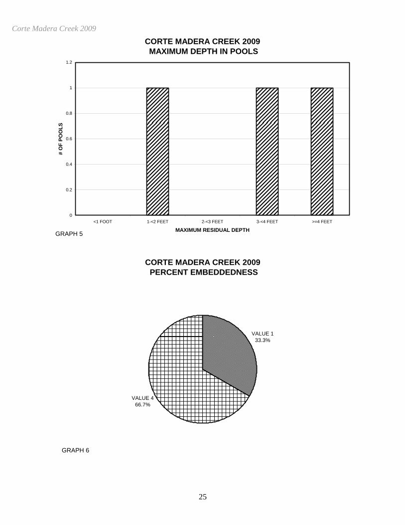
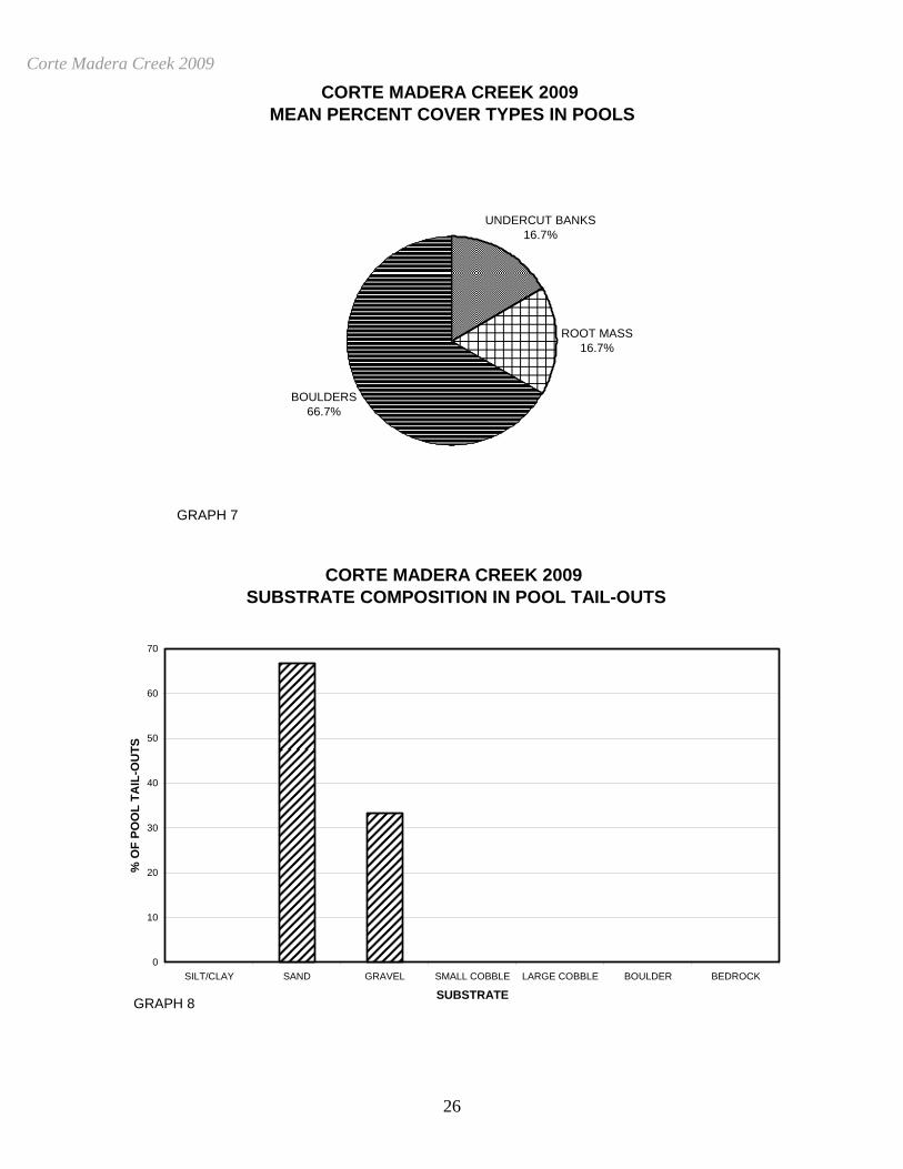
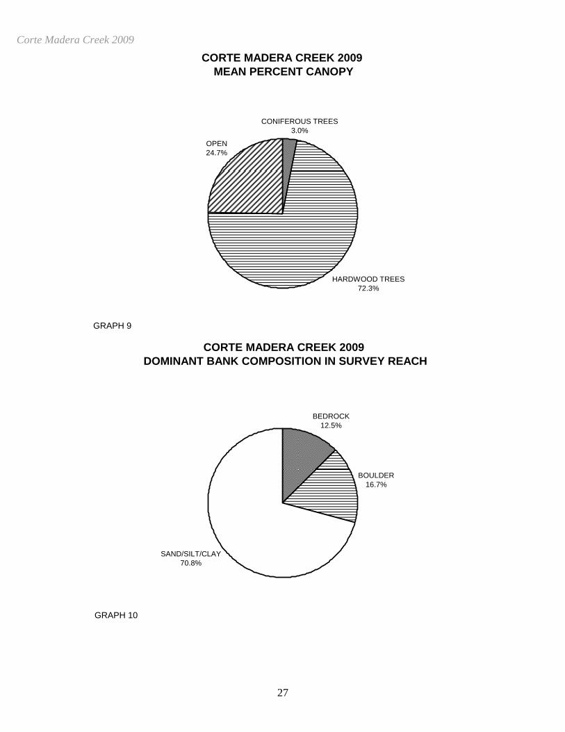
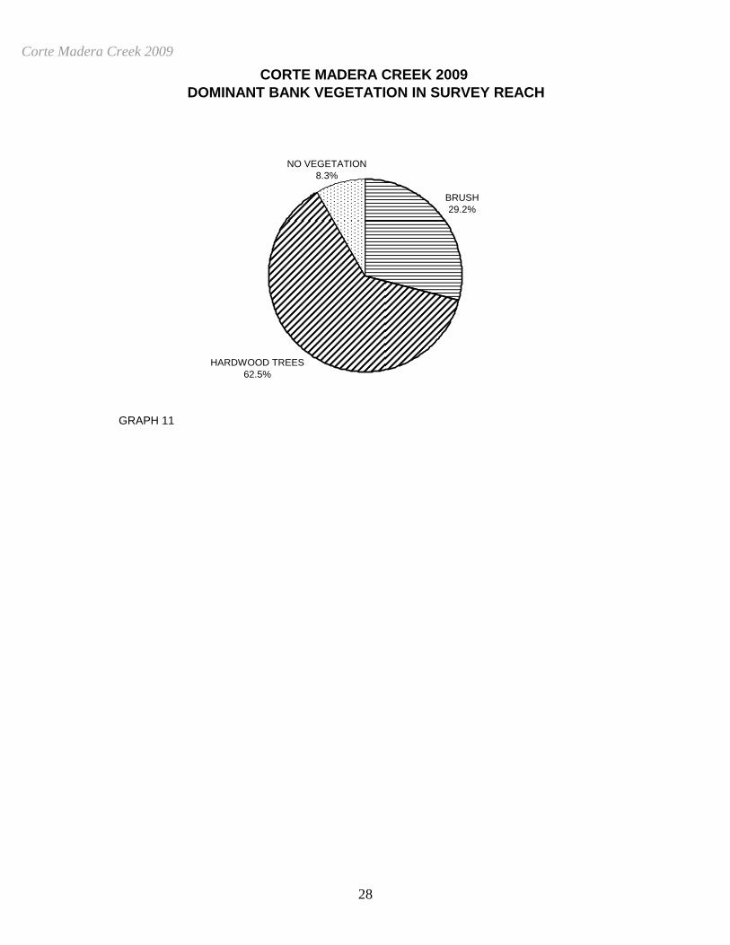
units. A total of 3 pools were identified (Table 3). Main Channel pools were the most frequently encountered, at 67%, and comprised 58% of the total length of all pools (Graph 4). Table 4 is a summary of maximum residual pool depths by pool habitat types. Pool quality for salmonids increases with depth. Two of the 3 pools (67%) had a residual depth of three feet or greater (Graph 5). The depth of cobble embeddedness was estimated at pool tail-outs. Of the 3 pool tail-outs measured, 1 had a value of 1 (33.3%) and 2 had a value of 4 (66.7%) (Graph 6). On this scale, a value of 1 indicates the best spawning conditions and a value of 4 the worst. A shelter rating was calculated for each habitat unit and expressed as a mean value for each habitat type within the survey using a scale of 0-300. Riffle habitat types had a mean shelter rating of 0, flatwater habitat types had a mean shelter rating of 2 and pool habitats had a mean shelter rating of 13 (Table 1). Of the pool types, the Main Channel pools had a mean shelter rating of 5, Scour pools had a mean shelter rating of 30 (Table 3). Table 5 summarizes mean percent cover by habitat type. Boulders are the dominant cover type in Corte Madera Creek. Graph 7 describes the pool cover in Corte Madera Creek. Boulders are the dominant pool cover type followed by root mass and undercut banks. Table 6 summarizes the dominant substrate by habitat type. Graph 8 depicts the dominant substrate observed in pool tail-outs. Sand dominance was observed in 67% of pool tail-outs, gravel dominance was observed in 33% of pool tail-outs. The mean percent canopy density for the surveyed length of Corte Madera Creek was 75%. The mean percentages of hardwood and coniferous trees were 96% and 4%, respectively. 25 percent of the canopy was open. Graph 9 describes the mean percent canopy in Corte Madera Creek. For the stream reach surveyed, the mean percent right bank vegetated was 45%. The mean percent left bank vegetated was 55%. The dominant elements composing the structure of the stream banks consisted of 12% bedrock, 17% boulder and 71% sand/silt/clay (Graph 10). Hardwood trees were the dominant vegetation type observed in 62.5% of the units surveyed. Additionally, 29.2% of the units surveyed had brush as the dominant vegetation type and 8.3% was dominated by no vegetation (Graph 11). BIOLOGICAL INVENTORY RESULTS One site was electrofished for species composition and distribution in Corte Madera Creek on October 28, 2009. Water temperatures taken during the electrofishing period ranged from 58 to 58 degrees Fahrenheit. Air temperatures ranged from 74 to 63 degrees Fahrenheit. The sites were sampled by A. Villalobos (WSP), C. Bell (WSP), T. Macias (WSP), D. Acomb (DFG) and D. Resnik (DFG). In reach 1, which comprised the first 995 feet of stream, one site was sampled. The reach site
Corte Madera Creek 2009
7
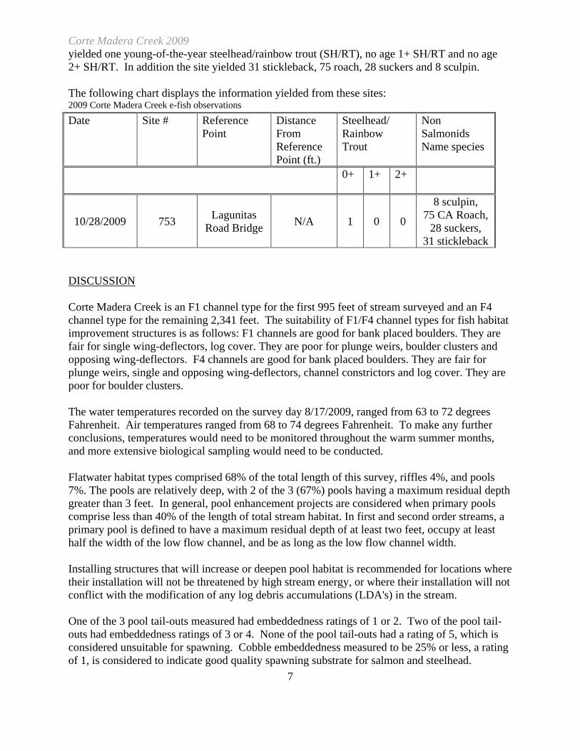
yielded one young-of-the-year steelhead/rainbow trout (SH/RT), no age 1+ SH/RT and no age 2+ SH/RT. In addition the site yielded 31 stickleback, 75 roach, 28 suckers and 8 sculpin. The following chart displays the information yielded from these sites: 2009 Corte Madera Creek e-fish observations Date Site # Reference
Point Distance From Reference Point (ft.)
Steelhead/ Rainbow Trout
Non Salmonids Name species
0+ 1+
2+
10/28/2009 753 Lagunitas Road Bridge N/A 1 0 0
8 sculpin, 75 CA Roach,
28 suckers, 31 stickleback
DISCUSSION Corte Madera Creek is an F1 channel type for the first 995 feet of stream surveyed and an F4 channel type for the remaining 2,341 feet. The suitability of F1/F4 channel types for fish habitat improvement structures is as follows: F1 channels are good for bank placed boulders. They are fair for single wing-deflectors, log cover. They are poor for plunge weirs, boulder clusters and opposing wing-deflectors. F4 channels are good for bank placed boulders. They are fair for plunge weirs, single and opposing wing-deflectors, channel constrictors and log cover. They are poor for boulder clusters. The water temperatures recorded on the survey day 8/17/2009, ranged from 63 to 72 degrees Fahrenheit. Air temperatures ranged from 68 to 74 degrees Fahrenheit. To make any further conclusions, temperatures would need to be monitored throughout the warm summer months, and more extensive biological sampling would need to be conducted. Flatwater habitat types comprised 68% of the total length of this survey, riffles 4%, and pools 7%. The pools are relatively deep, with 2 of the 3 (67%) pools having a maximum residual depth greater than 3 feet. In general, pool enhancement projects are considered when primary pools comprise less than 40% of the length of total stream habitat. In first and second order streams, a primary pool is defined to have a maximum residual depth of at least two feet, occupy at least half the width of the low flow channel, and be as long as the low flow channel width. Installing structures that will increase or deepen pool habitat is recommended for locations where their installation will not be threatened by high stream energy, or where their installation will not conflict with the modification of any log debris accumulations (LDA's) in the stream. One of the 3 pool tail-outs measured had embeddedness ratings of 1 or 2. Two of the pool tail-outs had embeddedness ratings of 3 or 4. None of the pool tail-outs had a rating of 5, which is considered unsuitable for spawning. Cobble embeddedness measured to be 25% or less, a rating of 1, is considered to indicate good quality spawning substrate for salmon and steelhead.
Corte Madera Creek 2009
8
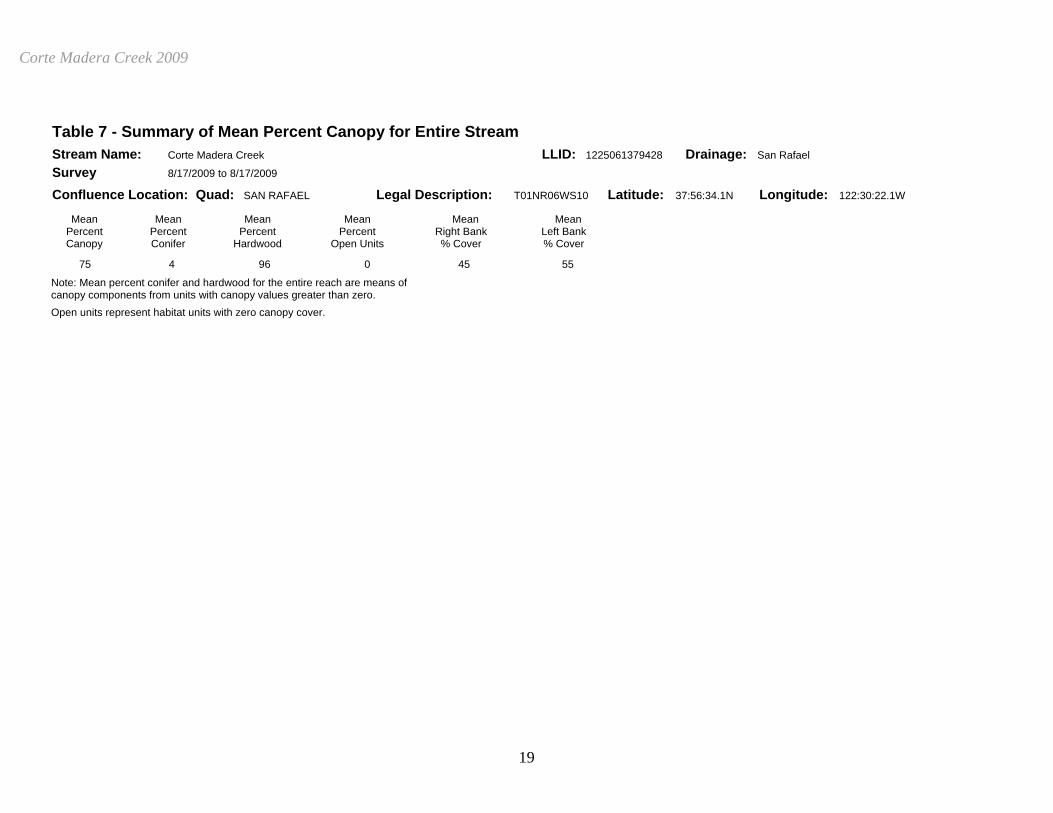
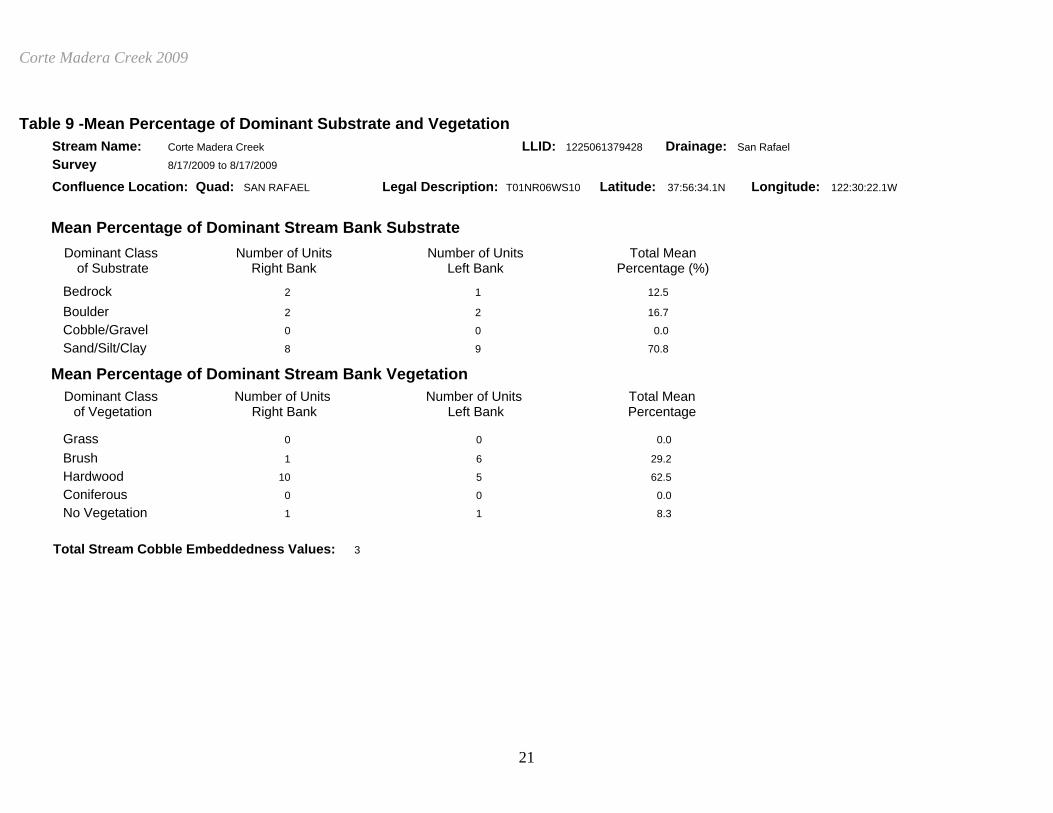
Sediment sources in Corte Madera Creek should be mapped and rated according to their potential sediment yields, and control measures should be taken. One of the 3 pool tail-outs measured had gravel or small cobble as the dominant substrate. This is generally considered good for spawning salmonids. The mean shelter rating for pools was 13. The shelter rating in the flatwater habitats was 2. A pool shelter rating of approximately 100 is desirable. The amount of cover that now exists is being provided primarily by boulders in Corte Madera Creek. Boulders are the dominant cover type in pools followed by root mass. Log and root wad cover structures in the pool and flatwater habitats would enhance both summer and winter salmonid habitat. Log cover structure provides rearing fry with protection from predation, rest from water velocity, and also divides territorial units to reduce density related competition. The mean percent canopy density for the stream was 75%. Reach 1 had a canopy density of 55%, Reach 2 had a canopy density of 76.8%. In general, revegetation projects are considered when canopy density is less than 80%. The percentage of right and left bank covered with vegetation 45% and 55%, respectively. In areas of stream bank erosion or where bank vegetation is sparse, planting endemic species of coniferous and hardwood trees, in conjunction with bank stabilization, is recommended. GENERAL RECOMMENDATIONS Corte Madera Creek should be managed as an anadromous, natural production stream. Winter storms often bring down large trees and other woody debris into the stream, which increases the number and quality of pools. This woody debris, if left undisturbed, will provide fish shelter and rearing habitat, and offset channel incision. Landowners should be sensitive about the natural and positive role woody debris plays in the system, and encouraged not to remove woody debris from the stream, except under extreme buildup and only under guidance by a fishery professional. RECOMMENDATIONS
1) Access for migrating salmonids should be assessed at all road crossings and flood control channels. All fish passage assessments should be done according to Part 9 of the California Salmonid Stream Habitat Restoration Manual (Flosi et al, 1998). Where needed, crossings and flood control channels should be replaced or modified to improve fish passage.
2) Increase woody cover in the pools and flatwater habitat units. Most of the existing
cover in the pools is from boulders. Adding high quality complexity with woody cover in the pools is desirable.
3) Inventory and map sources of stream bank erosion and prioritize them according to
Corte Madera Creek 2009
9
present and potential sediment yield. Identified sites should then be treated to reduce the amount of fine sediments entering the stream. Active and potential sediment sources related to the road system need to be identified, mapped, and treated according to their potential for sediment yield to the stream and its tributaries.
4) Increase the canopy on Corte Madera Creek by planting appropriate native vegetation
like willow, alder, redwood, and Douglas fir along the stream where shade canopy is not at acceptable levels. The reaches above this survey section should be inventoried and treated as well, since the water flowing here is affected from upstream. In many cases, planting will need to be coordinated to follow bank stabilization or upslope erosion control projects.
5) Corte Madera Creek would benefit from utilizing bio-technical vegetative techniques
to re-establish floodplain benches and a defined low flow channel. This would discourage lateral migration of the base flow channel and decrease bank erosion.
6) Where feasible, design and engineer pool enhancement structures to increase the
number of pools. This must be done where the banks are stable or in conjunction with stream bank armor to prevent erosion.
7) The limited water temperature data available suggest that maximum temperatures are
within/above the acceptable range for juvenile salmonids. To establish more complete and meaningful temperature regime information, 24-hour monitoring during the July and August temperature extreme period should be performed for 3 to 5 years.
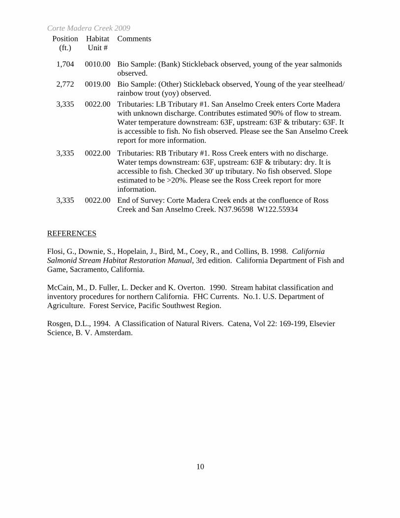
COMMENTS AND LANDMARKS The following landmarks and possible problem sites were noted. All distances are approximate and taken from the beginning of the survey reach.
Position (ft.)
Habitat Unit #
Comments
0 0001.00 Start of Survey: in trapezoid channel out of tidal influence near coordinates 37.95913N 122.55302W.
995 0002.00 General Comment: Channel type change from F1 to F4, Reach 1 changes to Reach 2. Change from engineered trapezoid channel to natural bottom channel.
995 0002.00 Fish Passage: (Dam) Dam #1. L=10.5' H=2.1' W (0)=3' W(d)=33'.Made of wood and rip rap. Flashboards are present. There is downcutting and gravel retention. The height of down cut is 0.9'. Possible barrier to juveniles and adults. N37.96105 W122.55537.
1,605 0008.00 Access Points / Location: (Bridge) Bridge #1. Lagunitas Road. W=68' H=9' L=31'. Made of concrete. There is no downcutting or gravel retention. Not a barrier to fish.
Corte Madera Creek 2009
10
Position (ft.)
Habitat Unit #
Comments
1,704 0010.00 Bio Sample: (Bank) Stickleback observed, young of the year salmonids observed.
2,772 0019.00 Bio Sample: (Other) Stickleback observed, Young of the year steelhead/ rainbow trout (yoy) observed.
3,335 0022.00 Tributaries: LB Tributary #1. San Anselmo Creek enters Corte Madera with unknown discharge. Contributes estimated 90% of flow to stream. Water temperature downstream: 63F, upstream: 63F & tributary: 63F. It is accessible to fish. No fish observed. Please see the San Anselmo Creek report for more information.
3,335 0022.00 Tributaries: RB Tributary #1. Ross Creek enters with no discharge. Water temps downstream: 63F, upstream: 63F & tributary: dry. It is accessible to fish. Checked 30' up tributary. No fish observed. Slope estimated to be >20%. Please see the Ross Creek report for more information.
3,335 0022.00 End of Survey: Corte Madera Creek ends at the confluence of Ross Creek and San Anselmo Creek. N37.96598 W122.55934
REFERENCES Flosi, G., Downie, S., Hopelain, J., Bird, M., Coey, R., and Collins, B. 1998. California Salmonid Stream Habitat Restoration Manual, 3rd edition. California Department of Fish and Game, Sacramento, California. McCain, M., D. Fuller, L. Decker and K. Overton. 1990. Stream habitat classification and inventory procedures for northern California. FHC Currents. No.1. U.S. Department of Agriculture. Forest Service, Pacific Southwest Region. Rosgen, D.L., 1994. A Classification of Natural Rivers. Catena, Vol 22: 169-199, Elsevier Science, B. V. Amsterdam.
Corte Madera Creek 2009
11
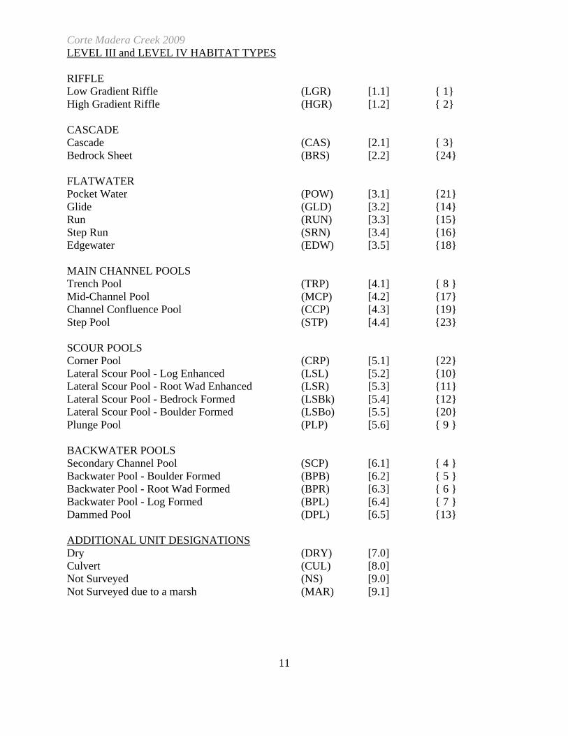
LEVEL III and LEVEL IV HABITAT TYPES RIFFLE Low Gradient Riffle (LGR) [1.1] { 1} High Gradient Riffle (HGR) [1.2] { 2} CASCADE Cascade (CAS) [2.1] { 3} Bedrock Sheet (BRS) [2.2] {24} FLATWATER Pocket Water (POW) [3.1] {21} Glide (GLD) [3.2] {14} Run (RUN) [3.3] {15} Step Run (SRN) [3.4] {16} Edgewater (EDW) [3.5] {18} MAIN CHANNEL POOLS Trench Pool (TRP) [4.1] { 8 } Mid-Channel Pool (MCP) [4.2] {17} Channel Confluence Pool (CCP) [4.3] {19} Step Pool (STP) [4.4] {23} SCOUR POOLS Corner Pool (CRP) [5.1] {22} Lateral Scour Pool - Log Enhanced (LSL) [5.2] {10} Lateral Scour Pool - Root Wad Enhanced (LSR) [5.3] {11} Lateral Scour Pool - Bedrock Formed (LSBk) [5.4] {12} Lateral Scour Pool - Boulder Formed (LSBo) [5.5] {20} Plunge Pool (PLP) [5.6] { 9 } BACKWATER POOLS Secondary Channel Pool (SCP) [6.1] { 4 } Backwater Pool - Boulder Formed (BPB) [6.2] { 5 } Backwater Pool - Root Wad Formed (BPR) [6.3] { 6 } Backwater Pool - Log Formed (BPL) [6.4] { 7 } Dammed Pool (DPL) [6.5] {13} ADDITIONAL UNIT DESIGNATIONS Dry (DRY) [7.0] Culvert (CUL) [8.0] Not Surveyed (NS) [9.0] Not Surveyed due to a marsh (MAR) [9.1]
Corte Madera Creek 2009
12

Corte Madera Creek 2009
13
Table 1 - Summary of Riffle, Flatwater, and Pool Habitat Types Stream Name: Corte Madera Creek LLID: 1225061379428 Drainage: San Rafael Survey 8/17/2009 to 8/17/2009 Confluence Location: Quad: SAN RAFAEL Legal Description: T01NR06WS10 Latitude: 37:56:34.1N Longitude: 122:30:22.1W Habitat Units Fully Habitat Habitat Mean Total Total Mean Mean Mean Mean Estimated Mean Estimated Mean Mean Units Measured Type Occurrence Length Length Length Width Depth Max Area Total Area Volume Total Residual Shelter (%) (ft.) (ft.) (%) (ft.) (ft.) Depth (sq.ft.) (sq.ft.) (cu.ft.) Volume Pool Vol Rating (ft.) (cu.ft.) (cu.ft.) 2 0 CULVERT 9.1 21 42 1.2 5 0 DRY 22.7 130 650 19.5 10 10 FLATWATER 45.5 228 2275 68.2 9.7 0.9 1.9 2146 21461 2406 24060 2 3 3 POOL 13.6 82 245 7.3 13.0 1.4 3.2 1084 3252 1923 5770 1707 13 2 2 RIFFLE 9.1 62 124 3.7 6.0 0.1 0.2 201 402 20 40 0 Total Total Units Total Total Area Total Units Fully Length (sq.ft.) Volume Measured (ft.) (cu.ft.) 22 15 3336 25115 29870
Corte Madera Creek 2009
14
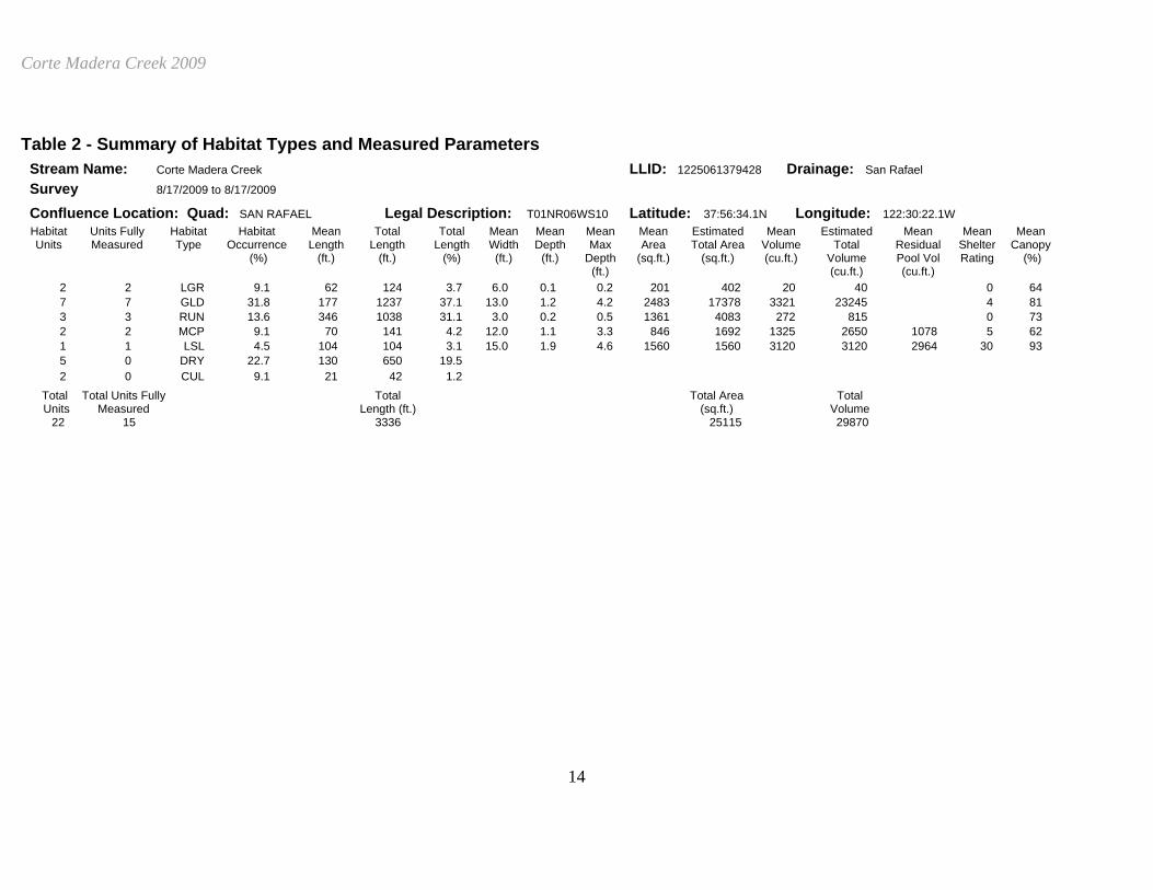
Table 2 - Summary of Habitat Types and Measured Parameters Stream Name: Corte Madera Creek LLID: 1225061379428 Drainage: San Rafael Survey 8/17/2009 to 8/17/2009 Confluence Location: Quad: SAN RAFAEL Legal Description: T01NR06WS10 Latitude: 37:56:34.1N Longitude: 122:30:22.1W Habitat Units Fully Habitat Habitat Mean Total Total Mean Mean Mean Mean Estimated Mean Estimated Mean Mean Mean Units Measured Type Occurrence Length Length Length Width Depth Max Area Total Area Volume Total Residual Shelter Canopy (%) (ft.) (ft.) (%) (ft.) (ft.) Depth (sq.ft.) (sq.ft.) (cu.ft.) Volume Pool Vol Rating (%) (ft.) (cu.ft.) (cu.ft.) 2 2 LGR 9.1 62 124 3.7 6.0 0.1 0.2 201 402 20 40 0 64 7 7 GLD 31.8 177 1237 37.1 13.0 1.2 4.2 2483 17378 3321 23245 4 81 3 3 RUN 13.6 346 1038 31.1 3.0 0.2 0.5 1361 4083 272 815 0 73 2 2 MCP 9.1 70 141 4.2 12.0 1.1 3.3 846 1692 1325 2650 1078 5 62 1 1 LSL 4.5 104 104 3.1 15.0 1.9 4.6 1560 1560 3120 3120 2964 30 93 5 0 DRY 22.7 130 650 19.5 2 0 CUL 9.1 21 42 1.2 Total Total Units Fully Total Total Area Total Units Measured Length (ft.) (sq.ft.) Volume 22 15 3336 25115 29870
Corte Madera Creek 2009
15
Table 3 - Summary of Pool Habitat Types Stream Name: Corte Madera Creek LLID: 1225061379428 Drainage: San Rafael Survey 8/17/2009 to 8/17/2009 Confluence Location: Quad: SAN RAFAEL Legal Description: T01NR06WS10 Latitude: 37:56:34.1N Longitude: 122:30:22.1W Habitat Units Fully Habitat Habitat Mean Total Total Mean Mean Mean Estimated Mean Estimated Mean Units Measured Type Occurrence Length Length Length Width Residual Area Total Area Residual Total Shelter (%) (ft.) (ft.) (%) (ft.) Depth (ft.) (sq.ft.) (sq.ft.) Pool Vol Resid. Vol Rating (cu.ft.) (cu.ft.) 2 2 MAIN 67 71 141 58 12.0 1.1 846 1692 1078 2156 5 1 1 SCOUR 33 104 104 42 15.0 1.9 1560 1560 2964 2964 30 Total Total Units Total Total Area Total Units Fully Length (sq.ft.) Volume Measured (ft.) (cu.ft.) 3 3 245 3252 5120
Corte Madera Creek 2009
16
Table 4 - Summary of Maximum Residual Pool Depths By Pool Habitat Types Stream Name: Corte Madera Creek LLID: 1225061379428 Drainage: San Rafael Survey 8/17/2009 to 8/17/2009 Confluence Location: Quad: SAN RAFAEL Legal Description: T01NR06WS10 Latitude: 37:56:34.1N Longitude: 122:30:22.1W Habitat Habitat Habitat < 1 Foot < 1 Foot 1 < 2 Feet 1 < 2 Feet 2 < 3 Feet 2 < 3 Feet 3 < 4 Feet 3 < 4 Feet >= 4 Feet >= 4 Feet Units Type Occurrence Maximum Percent Maximum Percent Maximum Percent Maximum Percent Maximum Percent (%) Residual Occurrence Residual Occurrence Residual Occurence Residual Occurrence Residual Occurrence Depth Depth Depth Depth Depth 2 MCP 67 0 0 1 50 0 0 1 50 0 0 1 LSL 33 0 0 0 0 0 0 0 0 1 100 Total Total < 1 Total < 1 Foot Total Total 1< 2 Feet Total Total 2< 3 Feet Total Total 3< 4 Feet Total Total >= 4 Feet Units Foot Max % Occurrence 1< 2 Feet % Occurrence 2< 3 Feet % Occurrence 3< 4 Feet % Occurrence >= 4 Feet % Occurrence Resid. Max Resid. Max Resid. Max Resid. Max Resid. Depth Depth Depth Depth Depth 3 0 0 1 33 0 0 1 33 1 33 Mean Maximum Residual Pool Depth (ft.): 3
Corte Madera Creek 2009
17
Table 5 - Summary of Mean Percent Cover By Habitat Type Stream Name: Corte Madera Creek Dry Units: 5 LLID: 1225061379428 Drainage: San Rafael Survey 8/17/2009 to 8/17/2009 Confluence Location: Quad: SAN RAFAEL Legal Description: T01NR06WS10 Latitude: 37:56:34.1N Longitude: 122:30:22.1W Habitat Units Fully Habitat Mean % Mean % Mean % Mean % Mean % Mean % Mean % Mean % Mean % Units Measure Type Undercut SWD LWD Root Mass Terr. Aquatic White Boulders Bedrock d Banks Vegetation Vegetation Water Ledges 2 2 LGR 0 0 0 0 0 0 0 0 0 2 2 TOTAL RIFFLE 0 0 0 0 0 0 0 0 0
7 4 GLD 0 13 13 0 0 0 0 25 0 3 3 RUN 0 0 0 0 0 0 0 0 0 10 7 TOTAL FLAT 0 7 7 0 0 0 0 14 0
2 2 MCP 0 0 0 0 0 0 0 100 0 1 1 LSL 50 0 0 50 0 0 0 0 0 3 3 TOTAL POOL 17 0 0 17 0 0 0 67 0
2 0 CUL 22 12 TOTAL 4 4 4 4 0 0 0 25 0
Corte Madera Creek 2009
18
Table 6 - Summary of Dominant Substrates By Habitat Type Stream Name: Corte Madera Creek Dry Units: 5 LLID: 1225061379428 Drainage: San Rafael Survey 8/17/2009 to 8/17/2009 Confluence Location: Quad: SAN RAFAEL Legal Description: T01NR06WS10 Latitude: 37:56:34.1N Longitude: 122:30:22.1W Habitat Units Fully Habitat % Total % Total % Total % Total % Total % Total % Total Units Measured Type Silt/Clay Sand Gravel Small Cobble Large Cobble Boulder Bedrock Dominant Dominant Dominant Dominant Dominant Dominant Dominant 2 2 LGR 50 50 0 0 0 0 0 7 5 GLD 20 80 0 0 0 0 0 3 3 RUN 33 33 0 0 0 0 33 2 2 MCP 0 100 0 0 0 0 0 1 1 LSL 0 100 0 0 0 0 0 2 0 CUL 0 0 0 0 0 0 0
Corte Madera Creek 2009
19
Table 7 - Summary of Mean Percent Canopy for Entire Stream Stream Name: Corte Madera Creek LLID: 1225061379428 Drainage: San Rafael Survey 8/17/2009 to 8/17/2009 Confluence Location: Quad: SAN RAFAEL Legal Description: T01NR06WS10 Latitude: 37:56:34.1N Longitude: 122:30:22.1W Mean Mean Mean Mean Mean Mean Percent Percent Percent Percent Right Bank Left Bank Canopy Conifer Hardwood Open Units % Cover % Cover 75 4 96 0 45 55 Note: Mean percent conifer and hardwood for the entire reach are means of canopy components from units with canopy values greater than zero. Open units represent habitat units with zero canopy cover.
Corte Madera Creek 2009
20
Table 8 - Fish Habitat Inventory Data Summary Stream Corte Madera Creek LLID: 1225061379428 Drainage San Rafael Survey Dates: 8/17/2009 to 8/17/2009 Survey Length (ft.): 3335 Main Channel (ft.): 3335.5 Side Channel (ft.): 0 Confluence Location: Quad SAN RAFAEL Legal Description: T01NR06WS10 Latitude: 37:56:34.1N Longitude: 122:30:22.1W
Summary of Fish Habitat Elements By Stream Reach
STREAM REACH: 1 Channel Type: F1 Canopy Density (%): 55.0 Pools by Stream Length 0.0 Reach Length (ft.): 995 Coniferous Component (%): 60.0 Pool Frequency (%): 0.0 Riffle/Flatwater Mean Width (ft.): 4.0 Hardwood Component 40.0 Residual Pool Depth (%): BFW: Dominant Bank < 2 Feet Deep: Range (ft.): 15.00 to 15.00 Vegetative Cover (%): 0.0 2 to 2.9 Feet Deep: Mean (ft.): 15.00 Dominant 3 to 3.9 Feet Deep: Std. Dev.: 0.00 Dominant Bank Substrate Bedrock >= 4 Feet Deep: Base Flow (cfs): NA Occurrence of LWD (%): 0.0 Mean Max Residual Pool Depth Water (F): 72 - 72 Air (F): 68 - 68 LWD per 100 ft.: Mean Pool Shelter Dry Channel (ft.): 0 Riffles: Pools: Flat: 0 Pool Tail Substrate (%): Silt/Clay: Sand: Gravel: Sm Cobble: Lg Cobble: Boulder Bedrock: Embeddedness Values (%): 1. 2. 3. 4. 5. 0.0
STREAM REACH: 2 Channel Type: F4 Canopy Density (%): 76.8 Pools by Stream Length 10.5 Reach Length (ft.): 2341 Coniferous Component (%): 0.0 Pool Frequency (%): 14.3 Riffle/Flatwater Mean Width (ft.): 9.5 Hardwood Component 100.0 Residual Pool Depth (%): BFW: Dominant Bank Hardwood Trees < 2 Feet Deep: 33.3 Range (ft.): 15.00 to 36.00 Vegetative Cover (%): 54.8 2 to 2.9 Feet Deep: 0.0 Mean (ft.): 26.05 Dominant Boulders 3 to 3.9 Feet Deep: 33.3 Std. Dev.: 10.49 Dominant Bank Substrate Sand/Silt/Clay >= 4 Feet Deep: 33.3 Base Flow (cfs): NA Occurrence of LWD (%): 4.5 Mean Max Residual Pool Depth 3.2 Water (F): 63 - 72 Air (F): 68 - 74 LWD per 100 ft.: Mean Pool Shelter 13 Dry Channel (ft.): 650 Riffles: 0 Pools: 0 Flat: 0 Pool Tail Substrate (%): Silt/Clay: 0.0 Sand: 66.7 Gravel: 33.3 Sm Cobble: 0.0 Lg Cobble: 0.0 Boulder 0.0 Bedrock: 0.0 Embeddedness Values (%): 1. 33.3 2. 0.0 3. 0.0 4. 66.7 5. 0.0
Corte Madera Creek 2009
21
Table 9 -Mean Percentage of Dominant Substrate and Vegetation Stream Name: Corte Madera Creek LLID: 1225061379428 Drainage: San Rafael Survey 8/17/2009 to 8/17/2009 Confluence Location: Quad: SAN RAFAEL Legal Description: T01NR06WS10 Latitude: 37:56:34.1N Longitude: 122:30:22.1W
Mean Percentage of Dominant Stream Bank Substrate Dominant Class Number of Units Number of Units Total Mean of Substrate Right Bank Left Bank Percentage (%) Bedrock 2 1 12.5 Boulder 2 2 16.7 Cobble/Gravel 0 0 0.0 Sand/Silt/Clay 8 9 70.8 Mean Percentage of Dominant Stream Bank Vegetation Dominant Class Number of Units Number of Units Total Mean of Vegetation Right Bank Left Bank Percentage Grass 0 0 0.0 Brush 1 6 29.2 Hardwood 10 5 62.5 Coniferous 0 0 0.0 No Vegetation 1 1 8.3
Total Stream Cobble Embeddedness Values: 3
Corte Madera Creek 2009
22
Table 10 - Mean Percent of Shelter Cover Types For Entire Stream Stream Name: Corte Madera Creek LLID: 1225061379428 Drainage: San Rafael Survey 8/17/2009 to 8/17/2009 Confluence Location: Quad: SAN RAFAEL Legal Description: T01NR06WS10 Latitude: 37:56:34.1N Longitude: 122:30:22.1W
Riffles Flatwater Pools UNDERCUT BANKS (%) 0 0 17 SMALL WOODY DEBRIS (%) 0 7 0 LARGE WOODY DEBRIS (%) 0 7 0 ROOT MASS (%) 0 0 17 TERRESTRIAL VEGETATION 0 0 0 AQUATIC VEGETATION (%) 0 0 0 WHITEWATER (%) 0 0 0 BOULDERS (%) 0 14 67 BEDROCK LEDGES (%) 0 0 0
Corte Madera Creek 2009
23
CORTE MADERA CREEK 2009 HABITAT TYPES BY PERCENT OCCURRENCE
CULVERT9.1%
DRY22.7%
FLATWATER45.5%
POOL13.6%
RIFFLE9.1%
GRAPH 1
CORTE MADERA CREEK 2009
HABITAT TYPES BY PERCENT TOTAL LENGTH
DRY19.5%
FLATWATER68.2%
POOL7.3%
RIFFLE3.7%
CULVERT1.2%
GRAPH 2
Corte Madera Creek 2009
24
CORTE MADERA CREEK 2009 HABITAT TYPES BY PERCENT OCCURRENCE
0%
5%
10%
15%
20%
25%
30%
35%
LGR GLD RUN MCP LSL DRY CUL
HABITAT TYPE
PER
CEN
T O
CC
UR
REN
CE
GRAPH 3
CORTE MADERA CREEK 2009 POOL TYPES BY PERCENT OCCURRENCE
MAIN66.7%
SCOUR33.3%
GRAPH 4
Corte Madera Creek 2009
25
CORTE MADERA CREEK 2009 MAXIMUM DEPTH IN POOLS
0
0.2
0.4
0.6
0.8
1
1.2
<1 FOOT 1-<2 FEET 2-<3 FEET 3-<4 FEET >=4 FEET
MAXIMUM RESIDUAL DEPTH
# O
F PO
OLS
GRAPH 5
CORTE MADERA CREEK 2009 PERCENT EMBEDDEDNESS
VALUE 133.3%
VALUE 466.7%
GRAPH 6
Corte Madera Creek 2009
26
CORTE MADERA CREEK 2009 MEAN PERCENT COVER TYPES IN POOLS
ROOT MASS16.7%
BOULDERS66.7%
UNDERCUT BANKS16.7%
GRAPH 7
CORTE MADERA CREEK 2009
SUBSTRATE COMPOSITION IN POOL TAIL-OUTS
0
10
20
30
40
50
60
70
SILT/CLAY SAND GRAVEL SMALL COBBLE LARGE COBBLE BOULDER BEDROCK
SUBSTRATE
% O
F PO
OL
TAIL
-OU
TS
GRAPH 8
Corte Madera Creek 2009
27
CORTE MADERA CREEK 2009 MEAN PERCENT CANOPY
CONIFEROUS TREES3.0%
HARDWOOD TREES72.3%
OPEN24.7%
GRAPH 9 CORTE MADERA CREEK 2009
DOMINANT BANK COMPOSITION IN SURVEY REACH
BEDROCK12.5%
BOULDER16.7%
SAND/SILT/CLAY70.8%
GRAPH 10
Corte Madera Creek 2009
28
CORTE MADERA CREEK 2009 DOMINANT BANK VEGETATION IN SURVEY REACH
BRUSH29.2%
HARDWOOD TREES62.5%
NO VEGETATION8.3%
GRAPH 11