Correspondence Regarding Special–Status Species
50
APPENDIX E Correspondence Regarding Special–Status Species E1 Letter to the U.S. Fish and Wildlife Service from USACE (Includes Biological Assessment) E2 Letter to the National Marine Fisheries Service from USACE E3 Fish and Wildlife Coordination Act Report E4 Biological Opinion
Transcript of Correspondence Regarding Special–Status Species

APPENDIX E Correspondence Regarding Special–Status Species
E1 Letter to the U.S. Fish and Wildlife Service from USACE (Includes Biological Assessment)
E2 Letter to the National Marine Fisheries Service from USACE E3 Fish and Wildlife Coordination Act Report
E4 Biological Opinion

E1 Letter to the U.S. Fish and Wildlife Service from USACE
(Includes Biological Assessment)
JewD
Rectangle
JewD
Rectangle
JewD
Rectangle
JewD
Rectangle
JewD
Rectangle
JewD
Rectangle
JewD
Rectangle
JewD
Rectangle

Prepared by: EDAW
2022 J StreetSacramento, CA 95814
May 2008
Biological AssessmentNatomas Levee Improvement Program
Landside Improvements Project
Prepared on behalf of:

Prepared by:
EDAW2022 J Street
Sacramento, CA 95811
Contact:Kelly Fitzgerald
Senior Wildlife Biologist(916) 414-5800
May 2008
Prepared on Behalf of:
Sacramento Area Flood Control Agency1007 7th Street, 7th Floor
Sacramento, CA 95814
Contact:
Mr. John BassettSenior Flood Control Engineer
(916) 874-7606
Prepared for Submittal to:
U.S. Army Corps of EngineersCESPK-PD
1325 J StreetSacramento, CA 95814
Contact:
Elizabeth Holland(916) 557-6763
Biological Assessment
Natomas Levee Improvement ProgramLandside Improvements Project
06110058.01
Sacramento Area Flood Control Agency EDAW NLIP Landside Improvements i Biological Assessment
TABLE OF CONTENTS Section Page Introduction ..............................................................................................................................................................1
Purpose and Focus of this Biological Assessment...............................................................................................1 Species Considered in this Document .....................................................................................................................2
Species Evaluated ................................................................................................................................................2 Critical Habitat.....................................................................................................................................................6
Consultation to Date.................................................................................................................................................7 Description of the Proposed Project .......................................................................................................................8
Project Objectives ................................................................................................................................................8 Existing Project Facilities and Potential Borrow Sites ........................................................................................8 Description of the Proposed Project...................................................................................................................11 Conservation, Avoidance, and Minimization Measures ....................................................................................29
Action Area .............................................................................................................................................................42 Species Accounts.....................................................................................................................................................43
Central Valley Fall-/Late-Fall Run chinook Salmon .........................................................................................43 Sacramento River Winter-Run Chinook Salmon...............................................................................................43 Central Valley Spring-Run Chinook Salmon.....................................................................................................44 Central Valley Steelhead....................................................................................................................................44 Green Sturgeon ..................................................................................................................................................45 Valley Elderberry Longhorn Beetle ...................................................................................................................45 Giant Garter Snake.............................................................................................................................................46
Effects ......................................................................................................................................................................48 Land Cover Conversion .....................................................................................................................................48 Direct and Indirect adverse Effects to Species...................................................................................................50
Cumulative Effects .................................................................................................................................................61 Planning Context and Projects Considered........................................................................................................61 Analysis of Cumulative Impacts ........................................................................................................................68
Growth-Inducing Impacts .....................................................................................................................................71 Analysis of Alternate Actions ................................................................................................................................73
No Project ..........................................................................................................................................................73 Other Project Alternatives..................................................................................................................................73 Other Project Alternatives Considered and Rejected.........................................................................................75
Conclusion and Determination..............................................................................................................................77 Fish.....................................................................................................................................................................77 Valley Elderberry Longhorn Beetle ...................................................................................................................77 Giant Garter Snake.............................................................................................................................................78 Natomas Basin Habitat Conservation Plan ........................................................................................................78
References ...............................................................................................................................................................80
Appendices A Exhibits B Representative Photographs

EDAW Sacramento Area Flood Control Agency Biological Assessment ii NLIP Landside Improvements
Tables 1 Special-status Plant, Fish, and Wildlife Species Evaluated for Potential to Occur in the Action Area ........2 2 Summary of the Major Elements of the Proposed Project ..........................................................................12 3 Land Cover Changes for the 2008 Construction Phase of the NLIP Landside Improvements Project .......51 4 Land Cover Changes for 2008-2010 Construction Phases of the NLIP Landside Improvements Project ..53 5 Survey Information for Elderberry Shrubs That May Require Removal During Construction of the
2008 Sacramento River Levee Improvements.............................................................................................56

Sacramento Area Flood Control Agency EDAW NLIP Landside Improvements iii Biological Assessment
ABBREVIATIONS AND ACRONYMS
Airport Sacramento International Airport
BA Biological Assessment
BMP best management practices
Delta Sacramento–San Joaquin Delta
DFG Department of Fish and Game
DWR Department of Water Resources
EFH Essential Fish Habitat
Elkhorn Canal Elkhorn Main Irrigation Canal
ESA Endangered Species Act
ESU Evolutionary Significant Unit
FAA Federal Aviation Administration
HCP habitat conservation plan
kV kilovolt
Landside Improvements DEIR Draft Environmental Impact Report on the Natomas Levee Improvement Program Landside Improvements Project
Landside Improvements DEIS Draft Environmental Impact Statement on the Natomas Levee Improvement Program Landside Improvements Project
LNWI Lower Northwest Interceptor
NBHCP Natomas Basin Habitat Conservation Plan
NCC Natomas Cross Canal
NCC Phase 1 Improvements NCC South Levee Phase 1 Improvements
NEMDC Natomas East Main Drainage Canal
NGVD National Geodetic Vertical Datum
NLIP Natomas Levee Improvement Program
NMFS National Oceanic and Atmospheric Administration, National Marine Fisheries Service
NMWC Natomas Central Mutual Water Company
NPDES National Pollutant Discharge Elimination System
PGCC Pleasant Grove Creek Canal
RBDD Red Bluff Diversion Dam
RD Reclamation District
Riverside Canal Riverside Main Irrigation Canal
RM River Mile
RWQCB Central Valley Regional Water Quality Control Board
SACOG Sacramento Area Council of Governments

EDAW Sacramento Area Flood Control Agency Biological Assessment iv NLIP Landside Improvements
SAFCA Sacramento Area Flood Control Agency
Salmon Plan Pacific Coast Salmon Plan
SB soil-bentonite
SEIS supplemental environmental impact statement
SMF Master Plan Sacramento International Airport Master Plan
SMUD Sacramento Municipal Utility District
SR State Route
SRA shaded riverine aquatic
SRWTP Sacramento Regional Wastewater Treatment Plant
SSCI/C South Sutter County Industrial/Commercial
SWPPP storm water pollution prevention plan
TNBC The Natomas Basin Conservancy
UNWI Upper Northwest Interceptor
USACE U.S. Army Corps of Engineers
USFWS U.S. Fish and Wildlife Service

Sacramento Area Flood Control Agency EDAW NLIP Landside Improvements 1 Biological Assessment
INTRODUCTION The Sacramento Area Flood Control Agency (SAFCA) is proposing to complete the Landside Improvements Project, which includes improvements to the levee system that protects the 53,000-acre Natomas Basin in northern Sacramento and southern Sutter Counties, as well as related landscape modifications and drainage and irrigation infrastructure improvements. The Natomas Basin is generally bounded by leveed reaches of the Natomas Cross Canal (NCC) on the north, the Sacramento River on the west, the American River on the south, and the Pleasant Grove Creek Canal (PGCC) and Natomas East Main Drainage Canal (NEMDC)/Steelhead Creek on the east (Exhibit 1). This project is part of the larger Natomas Levee Improvement Program (NLIP) being undertaken by SAFCA.
Following the floods of 1997, the U.S. Army Corps of Engineers (USACE), the State of California Reclamation Board and Department of Water Resources (DWR), and SAFCA assessed subsurface conditions to determine the need for deep underseepage remediation for the Natomas Basin levees. These studies determined that, at some locations, there is potential for subsurface permeability that may subject the levees to an unacceptable risk of failure if not addressed. In 2005 and early 2006, SAFCA conducted additional assessments of seepage potential along the east levee of the Sacramento River, the south levee of the NCC, and the north levee of the American River in its Natomas Levee Evaluation Study, using new guidelines adopted by the Sacramento District of the USACE. The study concluded that approximately 26 miles of these levees protecting the Natomas Basin are in need of improvements to correct underseepage potential.
In addition, levee height and seepage remediation improvements in some locations on the Sacramento River east levee, the NCC south levee and the PGCC and NEMDC/Steelhead Creek west levee are needed to provide adequate freeboard and subsequent protection from a 200-year flood. The NLIP would correct these freeboard deficiencies, levee seepage potential, and streambank erosion conditions to provide a 200-year level of protection. The levee evaluation study also indicated that the risk of flooding at the 100-year level is greater than previously assumed, underscoring the urgency of expediting the needed improvements.
The NLIP is being designed, permitted, and implemented in multiple phases. The first phase consisted of the NCC Phase 1 Improvements, which were completed in summer and fall 2007. This next phase of NLIP work, the Landside Improvements Project, which consists of three phases of construction, spanning three years, generally between 2008 and 2010, would improve the 5.3-mile NCC south levee, the 18.6-mile Sacramento River east levee, and the approximately 2.5-mile PGCC west levee. Together, these projects would provide the Natomas Basin with at least a 100-year level of flood protection.
PURPOSE AND FOCUS OF THIS BIOLOGICAL ASSESSMENT The purpose of this Biological Assessment (BA) is to review the proposed NLIP Landside Improvements Project in sufficient detail to determine how it could affect any federally listed threatened or endangered terrestrial species and species that are candidates for listing. This document has been prepared in accordance with requirements set forth under Section 7 of the Endangered Species Act (ESA) (16 U.S.C. 1536[c]). USACE approvals for flood control project alteration under U.S.C. Title 33, Chapter 9, Subchapter 1, Section 408 and fill of waters of the United States under Section 404 of the Clean Water Act will be requested for the proposed project. In connection with these federal actions, the USACE will initiate Section 7 consultation with the U.S. Fish and Wildlife Service (USFWS) and National Oceanic and Atmospheric Administration, National Marine Fisheries Service (NMFS). This BA also serves to initiate consultation on Essential Fish Habitat (EFH) Conservation Recommendations for Pacific salmon (Oncorhynchus spp.) with NMFS, as required by the Magnuson-Stevens Fishery Conservation and Management Act (16 U.S.C. 1801), as amended.
USACE authorizations are anticipated to be issued initially for construction phases scheduled to begin in 2008, with authorizations for 2009–2010 construction phases issued subsequently. This BA evaluates potential effects from the project as a whole at a programmatic level; effects from construction that would begin in the 2008 phase are evaluated in more detail.

EDAW Sacramento Area Flood Control Agency Biological Assessment 2 NLIP Landside Improvements
SPECIES CONSIDERED IN THIS DOCUMENT
SPECIES EVALUATED
A list of special-status species evaluated for consideration in this document was compiled from official species lists maintained by USFWS and the California Department of Fish and Game (DFG) for the Sacramento West, Taylor Monument, and Verona U.S. Geological Survey 7½ minute quadrangles, which encompass the action area. The Natomas Basin Habitat Conservation Plan (NBHCP) (City of Sacramento, Sutter County, and The Natomas Basin Conservancy 2003) was also utilized; this plan applies to the 53,341-acre interior of the Natomas Basin in which the proposed action is located and is a supporting document for Federal Section 10(a)(1)(B) and State Section 2081 permit applications that allows incidental take of special-status species, subject to permit requirements. The regulatory status and habitat association for each species that was evaluated are summarized in Table 1. Potential impacts to these species and other biological resources that are not subject to regulation under ESA, but are subject to regulation under the California Environmental Quality Act and National Environmental Policy Act, are evaluated in the Draft Environmental Impact Report on the Natomas Levee Improvement Program Landside Improvements Project (Landside Improvements DEIR) (EDAW 2007a) and the Draft Environmental Impact Statement on the Natomas Levee Improvement Program Landside Improvements Project (Landside Improvements DEIS) (EDAW 2007b). Those species that are subject to regulation under ESA and were determined to have potential to be adversely affected by the proposed action are evaluated further in this document and discussed in the sections below.
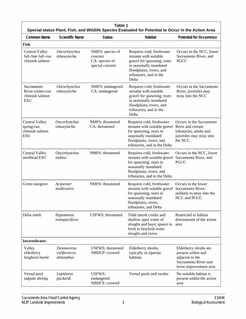
Table 1 Special-status Plant, Fish, and Wildlife Species Evaluated for Potential to Occur in the Action Area
Common Name Scientific Name Status Habitat Potential for Occurrence
Plants
Bogg’s Lake hedge-hyssop
Gratiola heterosepala
CA: endangered CNPS: 1B NBHCP: covered
Vernal pools and lake margins
No suitable habitat is present within the action area
Delta tule pea Lathyrus jepsonii jepsonii
CNPS: 1B NBHCP: covered
Freshwater and brackish marshes and sloughs
Low potential to occur in ditches and ponds in the action area
Legenere Legenere limosa CNPS: 1B NBHCP: covered
Vernal pools No suitable habitat is present within the action area
Colusa grass Neostapfia colusana
USFWS: threatened CA: endangered CNPS: 1B NBHCP: covered
Vernal pools No suitable habitat is present within the action area
Slender orcutt grass
Orcuttia tenuis USFWS: threatened CA: endangered CNPS: 1B NBHCP: covered
Vernal pools No suitable habitat is present within the action area
Sacramento orcutt grass
Orcuttia viscida USFWS: endangeredCA: endangered CNPS: 1B NBHCP: covered
Vernal pools No suitable habitat is present within the action area
Sanford’s arrowhead
Sagittaria sanfordii CNPS: 1B NBHCP: covered
Freshwater ponds, marshes and ditches
Low potential to occur in ditches and ponds in the action area
Sacramento Area Flood Control Agency EDAW NLIP Landside Improvements 3 Biological Assessment
Table 1 Special-status Plant, Fish, and Wildlife Species Evaluated for Potential to Occur in the Action Area
Common Name Scientific Name Status Habitat Potential for Occurrence
Fish
Central Valley fall-/late fall–run chinook salmon
Oncorhynchus tshawytscha
NMFS: species of concern CA: species of special concern
Requires cold, freshwater streams with suitable gravel for spawning; rears in seasonally inundated floodplains, rivers, and tributaries, and in the Delta
Occurs in the NCC, lower Sacramento River, and PGCC
Sacramento River winter-run chinook salmon ESU
Oncorhynchus tshawytscha
NMFS: endangered CA: endangered
Requires cold, freshwater streams with suitable gravel for spawning; rears in seasonally inundated floodplains, rivers, and tributaries, and in the Delta
Occurs in the Sacramento River; juveniles may stray into the NCC
Central Valley spring-run chinook salmon ESU
Oncorhynchus tshawytscha
NMFS: threatened CA: threatened
Requires cold, freshwater streams with suitable gravel for spawning; rears in seasonally inundated floodplains, rivers, and tributaries, and in the Delta
Occurs in the Sacramento River and certain tributaries; adults and juveniles may stray into the NCC
Central Valley steelhead ESU
Oncorhynchus mykiss
NMFS: threatened Requires cold, freshwater streams with suitable gravel for spawning; rears in seasonally inundated floodplains, rivers, and tributaries, and in the Delta
Occurs in the NCC, lower Sacramento River, and PGCC
Green sturgeon Acipenser medirostris
NMFS: threatened Requires cold, freshwater streams with suitable gravel for spawning; rears in seasonally inundated floodplains, rivers, tributaries, and Delta
Occurs in the lower Sacramento River; unlikely to stray into the NCC and PGCC
Delta smelt Hypomesus transpacificus
USFWS: threatened Tidal marsh creeks and shallow open water of sloughs and bays; spawn in fresh to brackish water sloughs and rivers
Restricted to habitat downstream of the action area
Invertebrates
Valley elderberry longhorn beetle
Desmocerus californicus dimorphus
USFWS: threatenedNBHCP: covered
Elderberry shrubs, typically in riparian habitats
Elderberry shrubs are present within and adjacent to the Sacramento River east levee improvement area
Vernal pool tadpole shrimp
Lepidurus packardi
USFWS: endangered NBHCP: covered
Vernal pools and swales No suitable habitat is present within the action area

EDAW Sacramento Area Flood Control Agency Biological Assessment 4 NLIP Landside Improvements
Table 1 Special-status Plant, Fish, and Wildlife Species Evaluated for Potential to Occur in the Action Area
Common Name Scientific Name Status Habitat Potential for Occurrence Midvalley fairy shrimp
Branchinecta mesovallensis
NBHCP: covered Vernal pools No suitable habitat is present within the action area
Vernal pool fairy shrimp
Branchinecta lynchi
USFWS: threatenedNBHCP: covered
Vernal pools and other seasonal wetlands
No suitable habitat is present within the action area
Amphibians
California tiger salamander
Ambystoma californiense
USFWS: threatened CA: species of special concern NBHCP: covered
Vernal pools and seasonal wetlands in upland with burrows and other belowground refuge
No suitable habitat is present within the action area
Western spadefoot toad
Spea hammondii CA: species of special concern NBHCP: covered
Vernal pools and seasonal wetlands in upland with burrows and other belowground refuge
No suitable habitat is present within the action area
Reptiles
Giant garter snake
Thamnophis gigas USFWS: threatened CA: threatened NBHCP: covered
Streams, sloughs, ponds, and irrigation/ drainage ditches; also require upland refugia not subject to flooding during the snake’s inactive season
The Natomas Basin supports key population; rice fields, ditches, and ponds in the action area provide potentially suitable habitat
Northwestern pond turtle
Actinemys marmorata marmorata
CA: species of special concern NBHCP: covered
Ponds, marshes, rivers, streams, sloughs; nest in nearby uplands with suitable soils
Ditches and ponds in the action area provide potentially suitable habitat
Birds
White-faced ibis Plegadis chihi CA: species of special concern NBHCP: covered
Forage and roost in shallow water and flooded fields; nest in freshwater marshes
Rice fields in action area provide foraging habitat; the only nesting colony in the Natomas Basin is approximately 3 miles from the nearest levee improvement area
Aleutian Canada goose
Branta canadensis leucopareia
NBHCP: covered Forage in agricultural fields and roost in aquatic habitats
Could be a winter visitor to the action area, but no recent documented occurrences
Swainson’s hawk
Buteo swainsoni CA: threatened NBHCP: covered
Forage in grasslands and agricultural fields; nest in open woodland or scattered trees
Known to nest and forage in the action area
American peregrine falcon
Falco peregrinus anatum
CA: endangered and fully protected NBHCP: covered
Forage in a variety of open habitats, particularly marshes and other wetlands
Likely to occasionally forage in the action area, but no suitable nesting habitat is present

Sacramento Area Flood Control Agency EDAW NLIP Landside Improvements 5 Biological Assessment
Table 1 Special-status Plant, Fish, and Wildlife Species Evaluated for Potential to Occur in the Action Area
Common Name Scientific Name Status Habitat Potential for Occurrence Burrowing owl Athene
cunicularia CA: species of special concern NBHCP: covered
Grasslands and agricultural fields
Known to occur along the Pleasant Grove Creek Canal
Bank swallow Riparia riparia CA: threatened NBHCP: covered
Forage in various habitats; nest in banks or bluffs, typically adjacent to water
Could forage in the action area, but no colonies have been documented nearby within the past 10 years
Loggerhead shrike
Lanius ludovidianus
CA: species of special concern NBHCP: covered
Forage in grasslands and agricultural fields; nest in scattered shrubs and trees
Known to nest and forage in the action area
Tricolored blackbird
Agelaius tricolor CA: species of special concern NBHCP: covered
Forage in grasslands and agricultural fields; nest in freshwater marsh, riparian scrub, and other dense shrubs and herbs
Known to nest and forage in the action area
Notes: CA = California; CNPS = California Native Plant Society; Delta = Sacramento–San Joaquin Delta; DFG = California Department of Fish and Game; ESU = Evolutionarily Significant Unit; NEMDC = Natomas East Main Drainage Canal; NMFS = National Marine Fisheries Service; NBHCP = Natomas Basin Habitat Conservation Plan ; PGCC = Pleasant Grove Creek Canal; USFWS = U.S. Fish and Wildlife Service California Native Plant Society Listing Categories: 1B Plants considered rare, threatened, or endangered in California and elsewhere 2 Plants considered rare, threatened, or endangered in California but more common elsewhere Sources: CNPS 2007; CNDDB 2007; City of Sacramento, Sutter County, and The Natomas Basin Conservancy 2003; USFWS 2005
SPECIAL-STATUS FISH
Four federally listed anadromous fish species under the jurisdiction of NMFS have the potential to occur in the NCC, lower Sacramento River, and/or PGCC, as described below (Table 2). These species include the Sacramento River winter-run Chinook salmon Evolutionary Significant Unit (ESU), Central Valley spring-run Chinook salmon ESU, Central Valley steelhead ESU, and green sturgeon. Additionally, Central Valley fall-/late fall-run Chinook salmon ESU, a species of Pacific salmon that is not federally-listed but is managed under the Salmon Plan, also has potential to occur in the action area. The Sacramento River, NCC, and PGCC have been designated as EFH for fall-run Chinook salmon.
Delta smelt, which is federally and state-listed as threatened, is found in the Sacramento River, but it occurs downstream of the confluence with the American River. Therefore this species is not expected to occur in the action area. Delta smelt do not occur in the NCC, PGCC, or NEMDC/Steelhead Creek.
SPECIAL-STATUS WILDLIFE
Sixteen special-status wildlife species were evaluated for their potential to occur in the action area (Table 1). Based on review of existing information regarding species occurrences in the project vicinity, habitat requirements of the documented species, field surveys conducted to characterize habitat conditions on the project site, and the nature of the proposed project, it was determined that giant garter snake and valley elderberry

EDAW Sacramento Area Flood Control Agency Biological Assessment 6 NLIP Landside Improvements
longhorn beetle are the only federally listed wildlife species under USFWS jurisdiction that could be affected by the proposed project. Both of these species are known to occur in the action area.
CRITICAL HABITAT
Critical habitat is defined in Section 3(5)A of the ESA as the specific areas within the geographical area occupied by the species on which are found physical or biological features essential to the conservation of the species and that may require special management considerations or protection. Specific areas outside of the geographical area occupied by the species may also be included in critical habitat designations, upon a determination that such areas are essential for the conservation of the species.
The lower Sacramento River and its tributaries, including the NCC and PGCC, are within designated critical habitat for Sacramento River winter-run Chinook salmon, Central Valley spring-run Chinook salmon, and Central Valley steelhead. The project area is not within designated critical habitat for the remaining species listed in Table 1 for which such a designation has been made (i.e., California tiger salamander, valley elderberry longhorn beetle, vernal pool fairy shrimp, or vernal pool tadpole shrimp). No critical habitat has been designated for giant garter snake.

Sacramento Area Flood Control Agency EDAW NLIP Landside Improvements 7 Biological Assessment
CONSULTATION TO DATE
SAFCA has consulted informally with USFWS on several occasions regarding the overall NLIP. An initial meeting to introduce the program to USFWS staff was conducted in fall 2006. A presentation describing the NLIP, including anticipated flood control improvements and habitat creation components was made by SAFCA to the Natomas Joint Vision coordination group on May 10, 2007. This meeting was attended by staff from various regulatory and municipal agencies, including USFWS, USACE, DFG, the City of Sacramento, the Airport, and others. A follow-up meeting to specifically discuss regulatory issues with USFWS and DFG was held on May 17, 2007.
Formal Section 7 consultation was completed for the NCC Phase I Levee Improvements component of the NLIP. A Biological Opinion (1-1-07-F-0207) for this initial portion of NLIP work, which was initiated in 2007, was issued on June 1, 2007.
Informal inter-agency meetings regarding the 2008–2010 construction phases on the Landside Improvements Project resumed in January 2008. Coordination meetings involving SAFCA, USACE, USFWS, and DFG were conducted on and January 11 and 24. TNBC Executive Director John Roberts also attended the January 24 meeting.

EDAW Sacramento Area Flood Control Agency Biological Assessment 8 NLIP Landside Improvements
DESCRIPTION OF THE PROPOSED PROJECT
PROJECT OBJECTIVES
SAFCA is designing the NLIP in coordination with the federal and state flood control project sponsors, USACE, and the State of California Central Valley Flood Protection Board (formerly The Reclamation Board), to address the deficiencies in the Natomas levee system with a focus on achieving a 100-year level of flood protection by 2010. This will require improving the following landside conditions along the NCC south levee, the Sacramento River east levee, and the PGCC west levee:
► Inadequate freeboard—The NCC south levee and portions of the Sacramento River east levee are not high enough to provide at least 3 feet of freeboard above the 100-year water surface elevation, and several reaches do not provide 3 feet of freeboard above the 200-year design water surface elevation.
► Underseepage and through-seepage vulnerability—Most of the levee reaches do not meet recently adopted federal criteria for safely containing underseepage and through-seepage when the water surface in the adjacent channel reaches the 100-year elevation or, in some cases, the 200-year elevation.
The proposed project encompasses addressing freeboard deficiencies through levee raises; addressing seepage potential using a combination of seepage berms, cutoff walls, and relief wells; and acquiring additional right-of-way to construct the improvements and to prevent encroachment into the flood control system. In addition, the project has been designed to include an enlarged levee embankment (adjacent setback levee) along the land side of the existing Sacramento River east levee to minimize the need for substantial removal of vegetation and structural encroachments on the water side of this levee in compliance with USACE guidance. These improvements would include recontouring the levee slopes where necessary to provide a 3:1 horizontal-to-vertical (3H:1V) waterside slope and a 3H:1V (preferred) or 2H:1V (maximum) landside slope.
The specific objectives of the NLIP Landside Improvements Project are to:
(1) provide at least 100-year flood protection as quickly as possible while laying the groundwork to achieve at least urban-standard (200-year) flood protection over time,
(2) use flood control projects in the vicinity of Sacramento International Airport (Airport) to facilitate better management of Airport lands to reduce hazards to aviation safety, and
(3) use flood control projects to enhance habitat quality and values by increasing the extent and connectivity of the lands in the Natomas Basin being managed to provide habitat for giant garter snake, Swainson’s hawk, and other special-status species.
Recognizing the importance of securing maximum federal support for the flood control project, SAFCA has explored implementation approaches that also advance the achievement of federal aviation and wildlife protection objectives where complementary opportunities exist. Accordingly, the proposed project includes the following elements:
► The project would include construction of the GGS/Drainage Canal to provide giant garter snake habitat and some drainage infrastructure west of the Airport. Construction of these facilities would allow for dewatering of the ditch running along the western portion of the Airport runway system, a recognized flight safety hazard, by offsetting the effects on drainage and irrigation needs and giant garter snake habitat.
► The project would combine SAFCA’s need for levee embankment and berm material with the Sacramento County Airport System’s (SCAS’s) need to modify the condition and management of Airport bufferlands so

Sacramento Area Flood Control Agency EDAW NLIP Landside Improvements 9 Biological Assessment
as to reduce wildlife hazards affecting Airport operations, and in a manner that enhances the connectivity of areas managed specifically for their habitat value.
Expanding the landside footprint of the Sacramento River east levee necessitates redesigning and relocating the irrigation and drainage infrastructure currently located along the landside toe of the levee. Approximately 6.5 million cubic yards of soil material would be needed for construction of the levee embankment, berms, and relocated canals along the Sacramento River east levee. About 600,000 cubic yards would be obtained through excavation of the new GGS/Drainage Canal between RD 1000’s existing North Drainage Canal north of the Airport and its existing West Drainage Canal southwest of the Airport.
The new GGS/Drainage Canal would be designed and managed to provide a dispersal corridor for giant garter snake that would link emerging blocks of managed giant garter snake habitat in the vicinity of Prichard Lake north of the Airport and around Fisherman’s Lake south of the Airport. The new canal would intercept much of the flows that are currently routed through the Airport West Ditch, which runs parallel to the west runway. Provision of the proposed new GGS/Drainage Canal, along with rearrangement of local irrigation facilities, would remove most of the flows from the Airport West Ditch and eliminate hazards currently associated with this feature—specifically, the attraction of wildlife (especially birds) that pose both an aircraft strike hazard in the runway area and a physical obstruction hazard to aircraft that may leave the runway during adverse takeoff or landing situations. The new GGS/Drainage Canal would also generally improve stormwater drainage on lands in the western portion of the Natomas Basin, including Airport bufferlands. It would thus reduce standing water on lands near the Airport Operations Area and the aviation hazards associated with the resulting attraction to wildlife.
SAFCA would obtain the balance of the fill material it needs for the improvements along the Sacramento River east levee from parcels in the Airport bufferlands and nearby privately owned agricultural land. Borrow operations would consist of (1) shallow excavation and grading of lands to preserve the current agricultural condition (cropland) or a similar condition (managed grassland) suitable for providing foraging habitat for the Swainson’s hawk, and (2) deeper excavation and reclamation of lands to a “managed marsh” condition similar to existing preserves throughout the area that The Natomas Basin Conservancy (TNBC), as plan operator for the Natomas Basin Habitat Conservation Plan (NBHCP), owns and manages for giant garter snake habitat.
In some areas, the improved levee footprint and maintenance area along the land side of the Sacramento River east levee would extend into mature stands of trees. The proposed project includes planting a substantial number of trees to offset the loss of trees located within the project footprint. Where trees would be planted in corridors, shallow excavation of the land in the corridors may be undertaken before trees are planted; this practice could provide additional borrow for construction while placing the plantings closer to groundwater, thus providing better conditions for more rapid tree growth.
EXISTING PROJECT FACILITIES AND POTENTIAL BORROW SITES
All project construction activities would take place within the Natomas Basin, except for potential development of a borrow site on RD 1001 land northeast of the basin. The following subsections describe the existing flood control facilities, their general setting, and adjacent irrigation infrastructure and the potential borrow sources for the proposed project.
FLOOD CONTROL AND IRRIGATION FACILITIES
NATOMAS CROSS CANAL SOUTH LEVEE
The NCC is a 5.3-mile-long channel that carries water from several tributary watersheds in western Placer County and eastern Sutter County to the Sacramento River. The NCC begins at the PGCC and East Side Canal and extends southwest to its confluence with the Sacramento River near the Sankey Road/Garden Highway intersection. During periods of flooding, the Sutter Bypass, Sacramento River, and NCC all contribute to raised

EDAW Sacramento Area Flood Control Agency Biological Assessment 10 NLIP Landside Improvements
water elevations that can affect the NCC levees. For engineering purposes, the south levee is divided into seven reaches, as shown in Exhibit 2. Much of the south levee contains an existing stability berm with an internal drainage system. Levee slopes are approximately 3H:1V on the water side and 2H:1V on the land side. There is an approximately 80- to 100-foot maintenance access area on the land side of the levee through most of the NCC’s length.
Farms and rural residences are located on both sides of the NCC, with rice the primary crop under cultivation. The Lucich North and Frazer Habitat Preserves, maintained by TNBC, lie south of the NCC south levee from the eastern end of Reach 2 through the western end of Reach 6. A drainage canal, referred to as the Vestal Drain, runs parallel to the NCC south levee through much of Reach 2, approximately 100 feet from the landside levee toe. There is a private irrigation pump and irrigation canal at the landside levee toe in Reach 1. Natomas Central Mutual Water Company’s (NMWC’s) Bennett Pumping Plant and RD 1000’s Pumping Plant No. 4 are located in Reach 2, and the NMWC Northern Pumping Plant is located in Reach 3. NMWC’s North Main Canal runs parallel to the levee through Reaches 4 and 5, approximately 100 feet from the landside levee toe.
SACRAMENTO RIVER EAST LEVEE
An 18-mile-long section of the east levee of the Sacramento River protects the west side of the Natomas Basin between the NCC and the American River. For planning purposes, the levee is divided into 20 reaches, as shown in Exhibit 3. Garden Highway is located on top of the levee crown within all 20 reaches. A drained, 10-foot-wide stability berm is present on the landside slope of the levee between the NCC and Powerline Road (Reaches 1–11). Cutoff walls to address through-levee seepage remediation were previously constructed through the levee in Reaches 12–20.
The land uses along the levee vary from north to south. Along the land side, Reaches 1–13 are bordered mainly by private agricultural lands containing a few rural residences, Airport bufferlands, and two farmed TNBC parcels. Teal Bend Golf Club is west of the Airport, adjacent to the levee along Reach 6. The parcels bordering Reaches 14–18 contain more residences, several rural estates, and three TNBC parcels. The land side of Reaches 19 and 20 is bordered by residential subdivisions, a business park, and the City of Sacramento’s Natomas Oaks Park, undeveloped Costa Park site, and Shorebird Park.
Several irrigation canals, pipelines, wells, and pump stations exist along the Sacramento River east levee. The Elkhorn Canal and the Riverside Canal are key agricultural irrigation canals in the NMWC system. The Elkhorn Canal runs parallel to the Sacramento River east levee from the North Drainage Canal in Reach 4B through Reach 8 and into the start of Reach 9 (1,250 feet south of Elkhorn Boulevard); this canal is supplied by the Prichard and Elkhorn Pumping Plants on the Sacramento River. The Riverside Canal extends from just north of Reach 13 to the middle of Reach 19 and is supplied by the Riverside Pumping Plant, on the Sacramento River just north of Radio Road. Several lateral canals connect to the Elkhorn and Riverside Canals. The existing Elkhorn and Riverside Canals are highline canals that use gravity flow to deliver water for irrigation by maintaining water levels above the surrounding ground levels. These canals have earthen embankments with side slopes that are nearly vertical, requiring regular maintenance. Approximately 1 mile of the existing Elkhorn Canal is concrete lined and the entire Riverside Canal is concrete lined.
In addition to the NMWC irrigation systems, there are several landowner-operated systems along the levee. These facilities are located primarily in Reaches 1–4A and 9–12, in areas not currently served by the NMWC systems. The areas are serviced by either well pumps on the land side or river pumps, which discharge into buried pipelines, small irrigation ditches, or directly onto fields. The distribution systems run along the landside toe of the levee to supply fields that slope away from the levee. There are approximately nine small pumping plants that provide water from the river and approximately 10 groundwater well pumps.
Several drainage pumping plants are operated by RD 1000 along the Sacramento River east levee. These facilities pump drain water from the main drainage canal system into the river. They include Pumping Plant No. 2, located

Sacramento Area Flood Control Agency EDAW NLIP Landside Improvements 11 Biological Assessment
in Reach 4B; Pumping Plant No. 5, located in Reach 10; Pumping Plant No. 3, located in Reach 13; and Pumping Plant No. 1, located in Reach 20A. Pumping Plant No. 2 was temporarily removed as part of an emergency levee repair in 2006 and would be replaced as an element of the proposed project in the 2009–2010 construction phases. In addition to these RD 1000 pumping stations, the City of Sacramento operates the Willow Creek drainage pumping station, which is located in Reach 19B.
PLEASANT GROVE CREEK CANAL WEST LEVEE
The PGCC west levee extends southerly from the east end of the NCC south levee to the north end of the NEMDC/Steelhead Creek levee near the Sankey Road crossing (Exhibit 2). The PGCC west levee protects the Natomas Basin from flood flows from Pleasant Grove Creek and other creeks in western Placer County, as well as from water that backs up in the NCC during high river stages in the Sacramento River. Levee slopes are generally 2H:1V on both the water side and land side of the levee. Natomas Road is located on top of the levee crown. No berms support this levee. A private canal extends parallel to the PGCC west levee for about 1,500 feet at the landside levee toe. Farms and scattered rural residences are located on the land side of the PGCC west levee, and a manufacturing facility and a railroad siding are located within several hundred feet of the levee, just south of Sankey Road.
BORROW SITES
Borrow sites are areas from which earthen materials would be removed for use in construction. Several properties have been identified as likely sources of soil borrow, mainly for use in the improvements to the Sacramento River east levee. SAFCA has identified the following preferred borrow sources for the construction of the flood control and irrigation infrastructure improvements along the Sacramento River east levee in 2008-2010, and a redundant source that may be pursued if negotiations regarding the preferred sources are unsuccessful or additional quantities are found to be needed during construction:
► Brookfield property (2008, 2009, and 2010 preferred): Private property west of the PGCC at Fifield Road, which was in rice cultivation in 2007. Material from this property could be used along the NCC south levee and the upper reaches of the Sacramento River east levee in the 2008 construction phase and on the PGCC west levee in the 2009–2010 construction phases. While the overall property may be used as borrow during multiple years, no area of the property would be used for consecutive years. After the removal of borrow material, the land would be returned to rice cultivation in the same season.
► Airport bufferlands north of the Airport complex (2008 and 2009 preferred, 2010 potential): Sacramento County property north of Elverta Road and west of Powerline Road. These lands could provide soil for use along the middle reaches of the Sacramento River east levee in the 2008 and 2009 construction phases. They could also provide material for construction in the lower reaches of the levee in the 2010 construction phase, if needed. While the overall property may be used as borrow during multiple years, no area of the property would be used for consecutive years. After the removal of borrow material, the areas north of the North Drainage Canal would be converted to managed marsh suitable as giant garter snake habitat, and the remainder would be reclaimed as grassland or restored to crop production. As indicated above under the “Project Objectives” section and described in more detailed below under the “Habitat Development and Management (2008-2010 Construction Phases)” section, the Airport bufferlands are not being returned to rice after borrow operation due to FAA guidelines concerning the necessary reduction of hazardous wildlife-attractant habitat around Airport runways.
► Fisherman’s Lake area (2010 preferred): TNBC-owned and privately owned parcels between TNBC-managed habitat areas. Several parcels may be suitable sources of borrow material for use in the lower reaches of the Sacramento River east levee and are strategically situated for creation of habitat that would link existing TNBC parcels.

EDAW Sacramento Area Flood Control Agency Biological Assessment 12 NLIP Landside Improvements
► RD 1001 (2008, 2009, and 2010 potential): Existing and future borrow sites owned by RD 1001, about 5 miles northeast of the Natomas Basin along Pacific Avenue. Material from the sites could be used along the NCC and PGCC in the 2008–2010 construction phases.
DESCRIPTION OF THE PROPOSED PROJECT
OVERVIEW OF THE PROPOSED PROJECT ELEMENTS
The elements of the proposed project are described in this section in four broad, overlapping categories:
► levee raising and seepage remediation,
► improvements to major irrigation and drainage infrastructure,
► habitat enhancement, development and management, and
► additional actions to meet Federal Emergency Management Agency requirements: encroachment management and bridge crossing modifications.
Additionally, right-of-way would be acquired within the footprint of the proposed features, at borrow sites, and to prevent encroachment and provide for maintenance access along the land side of the flood control facilities.
Table 2 summarizes the major elements of the proposed project and the general timeframes in which the elements are expected to be implemented. The table is divided into the 2008 construction phase (construction initiated in 2008 and completed in 2009), which is described and analyzed in detail, and the construction phases that would begin in 2009 and 2010, which are described and analyzed at a more general, program level of detail. An overview of the major project elements is provided in Exhibit 4. Note that although seepage berms are depicted as the primary means of providing underseepage remediation along the Sacramento River east levee, the use of cutoff walls continues to be evaluated, and cutoff walls will likely be implemented instead of berms in several locations.
Table 2 Summary of the Major Elements of the Proposed Project
Project Element Proposed Activity and Timing
2008 Construction Phase
Levee raising and seepage remediation: NCC south levee
Raise and realign the NCC south levee to provide additional freeboard and more stable waterside and landside slopes and to reduce the need for removal of waterside vegetation. (August 2008–October 2009) Construct a seepage cutoff wall through the levee crown in Reaches 3–7. (August 2008–October 2009)
Levee raising and seepage remediation: Sacramento River east levee (adjacent setback levee)
Construct a raised adjacent setback levee from the NCC to just south of the North Drainage Canal (Reaches 1–4B) with a 100-foot seepage berm in Reach 4A and a 300-foot seepage berm in Reach 4B. (August 2008–October 2009)
Improvements to major irrigation and drainage infrastructure
Construct a new canal designed to provide drainage and associated giant garter snake habitat (the GGS/Drainage Canal) between the North Drainage Canal and Elkhorn Reservoir. (August–November 2008) Relocate the Elkhorn Canal (highline irrigation canal) between the North Drainage Canal and Elkhorn Reservoir in anticipation of the filling of the existing Elkhorn Canal at the toe of the Sacramento River east levee. (August–November 2008) Remove a deep culvert at the location of Pumping Plant No. 2. (August–November 2008)

Sacramento Area Flood Control Agency EDAW NLIP Landside Improvements 13 Biological Assessment
Table 2 Summary of the Major Elements of the Proposed Project
Project Element Proposed Activity and Timing Habitat enhancement, creation and management
Establish vegetative habitat features in the new GGS/Drainage Canal. (Fall 2008) Recontour and create habitat on lands used as borrow sources. (Fall 2009) Establish grassland on the adjacent setback levee slopes and seepage berms. (Fall 2009) Install woodland plantings to offset the loss of portions of tree groves in the landside levee footprint. (Fall 2008–Fall 2009)
Right-of-way acquisition Acquire right-of-way through fee title or easement interest within the footprint of the project features, at the borrow sites and along the flood control system. (Before construction)
2009–2010 Construction Phases
Levee raising and seepage remediation: Sacramento River east levee (adjacent setback levee)
Construct an adjacent setback levee along Stations 55+00 to 68+00 in Reach 2 and from just south of the North Drainage Canal to the American River north levee (Reaches 5A–20B), raised where needed to provide adequate freeboard, with seepage berms, relief wells, and cutoff walls for seepage remediation as required (specific seepage remediation measures are still under study). (May 1, 2009–November 1, 2010)
Seepage remediation: PGCC west levee
Flatten waterside and landside slopes, and construct seepage berms along the PGCC west levee (specific berm widths and potential use of cutoff walls in some areas to be determined). (May 1, 2009–November 1, 2010)
Improvements to major irrigation and drainage infrastructure
Construct the new GGS/Drainage Canal between Elkhorn Reservoir and the West Drainage Canal (specific alignment to be determined), and improve the West Drainage Canal to provide enhanced giant garter snake habitat. (May 1–November 1, 2009) Implement Airport West Ditch improvements in connection with construction of the GGS/Drainage Canal to allow the Airport to decommission the agricultural irrigation function of this facility and eliminate the hazards currently associated with it. The Airport stormwater detention function provided by this ditch would continue. The ditch would therefore be recontoured as a gently sloping swale to facilitate periodic maintenance such as mowing. (May 1–November 1, 2009) Relocate the Riverside Canal and the Elkhorn Canal downstream of Elkhorn Reservoir (specific alignments to be determined) and fill the existing canals. (May 1–November 1, 2009, and May 1-November 1, 2010) Construct RD 1000 Pumping Plant No. 2. (April 1, 2009–September 1, 2010)
Habitat enhancement, creation and management
Establish habitat enhancements in the new GGS/Drainage Canal and improved West Drainage Canal. (Fall 2009) Recontour and create marsh and managed grassland on lands used as borrow sources. (Fall or spring after borrow excavation in 2009 and 2010) Establish grassland on the adjacent setback levee slopes and seepage berms. (Fall after construction in 2009 and 2010) Install woodland plantings to offset the loss of portions of tree groves in the landside levee footprint (locations to be determined). (Fall 2009 and 2010)

EDAW Sacramento Area Flood Control Agency Biological Assessment 14 NLIP Landside Improvements
Table 2 Summary of the Major Elements of the Proposed Project
Project Element Proposed Activity and Timing Additional actions to meet FEMA requirements: encroachment management on the Sacramento River east levee, and bridge crossing modifications at the NCC
Remove encroachments from a portion of the water side and land side of the Sacramento River east levee as needed to ensure that the levee can be certified as meeting the minimum requirements of the NFIP and USACE design criteria (specific criteria still under discussion). (Timing to be determined) Modify the SR 99/70 crossing of the NCC as needed to meet FEMA requirements. (Timing to be determined)
Right-of-way acquisition Acquire right-of-way through fee title or easement interest within the footprint of the project features, at the borrow sites and along the flood control system. (Before construction)
Notes: Airport = Sacramento International Airport; Elkhorn Canal = Elkhorn Main Irrigation Canal; FEMA = Federal Emergency Management Agency; GGS = Giant Garter Snake; NCC = Natomas Cross Canal; NFIP = National Flood Insurance Program; PGCC = Pleasant Grove Creek Canal; RD = Reclamation District; Riverside Canal = Riverside Main Irrigation Canal; SR = State Route; USACE = U.S. Army Corps of Engineers
LEVEE RAISING AND SEEPAGE REMEDIATION
GENERAL METHODS
The following subsections provide an overview of the approaches to addressing freeboard deficiencies and seepage potential that would be used in various combinations on the NCC south levee, Sacramento River east levee, and PGCC west levee and describe the proposed extent of land acquisition for flood control facilities.
Levee Raises
The entire NCC south levee and many of the Sacramento River east levee reaches lack the required 3 feet of freeboard above the 100-year water surface profile. To meet overall NLIP goals, SAFCA would increase the levee freeboard sufficiently in freeboard-deficient areas to meet the desired minimum of 3 feet of freeboard above the 200-year water surface profile. However, along the PGCC west levee at Sankey Road, the current at-grade elevation of the road crossing would be maintained. In all other reaches, the final levee configuration must meet the USACE criteria of a 20-foot-wide minimum crown, a 3H:1V waterside slope, and a 3H:1V (preferred) or 2H:1V (maximum) landside slope. Because the levees in most of the project reaches currently have landside slopes of 2H:1V, the proposed project includes flattening these slopes to at least a 3H:1V profile, and preferably 5H:1V.
The freeboard increases would be accomplished through raises of the existing NCC south levee or through construction of the raised adjacent setback levee adjacent to the existing Sacramento River east levee:
► Raise of existing levee (NCC south levee). For a minor raise of the levee crown elevation (typically 6 inches or less), the raise may be limited to the levee crown area, provided that there is enough existing crown width to accommodate the raise without narrowing the crown to a width that is less than the minimum requirement. For most of the NLIP levee raises, however, a greater crown raise is required and/or the levee slopes must be flattened. The required crown elevation would be met through a full levee raise. Full levee raises consist of an embankment raise from the landside or waterside toe (or both) upward to the increased crown elevation. This requires partially excavating the levee slope to provide a working platform for equipment, typically 10 feet wide, and rebuilding the levee to the appropriate elevation by benching the new embankment material

Sacramento Area Flood Control Agency EDAW NLIP Landside Improvements 15 Biological Assessment
into the existing embankment material. Exhibit 5 illustrates a levee raise and flattening of a landside levee slope from 2H:1V to 3H:1V.
► Adjacent setback levee (Sacramento River east levee). The proposed adjacent setback levee adjoining the Sacramento River east levee would be constructed with a crown elevation 3 feet above the 200-year water surface profile. In the upper reaches, where the existing levee has freeboard deficiencies of as much as 3 feet, the crown of the adjacent setback levee would be higher than the existing levee and Garden Highway roadway (Exhibit 6, top illustration). In the lower reaches, where the existing levee has sufficient freeboard, the adjacent setback levee would be the same height as the existing levee (Exhibit 6, bottom illustration).
Seepage Remediation
Underseepage problems can occur where levees are constructed on low-permeability foundation soil (silt and clay) underlain by a layer of higher permeability (sand and gravel). Excessive underseepage makes the levee susceptible to failure during periods of high river stage. Under these conditions, seepage travels horizontally under the levee and then is forced vertically upward through the low-permeability foundation layer, often referred to as a “blanket.” Failure of the blanket can occur either by uplift, a condition in which the blanket does not have enough weight to resist the confined pressure acting on the bottom of the blanket, or by piping (internal erosion) caused by water flowing under high vertical gradients through the erodible blanket and carrying fine soil particles out of the foundation materials. Through-seepage is seepage through a levee embankment that can occur during periods of high river stage. Depending on the duration of high water and the permeability of embankment soil, seepage may exit the landside face of the levee. Seepage can also pass directly through pervious layers in the levee if such layers are present. Under these conditions, the stability of the landside levee slope may be reduced.
Excessive underseepage gradients can be corrected through the use of cutoff walls, seepage berms, and relief wells. The choice of seepage remediation is influenced by the depth and continuity of pervious soil layers, adjacent land use, environmental constraints, construction cost, construction schedule, and long-term maintenance capability. Fully penetrating cutoff walls are generally the least costly, particularly if a soil-bentonite (SB) mix is feasible; they are the most reliable under uncertain hydraulic and geotechnical conditions (e.g., water surface elevations above design and variations in foundation soil conditions). Seismically induced ground shaking along the Sacramento River east levee could compromise the integrity of a soil-cement-bentonite (SCB) wall constructed through the centerline of the levee (near the channel), and it would be costly to repair the resulting deformation. However, a SB or cement-bentonite (CB) wall constructed through an adjacent levee in this reach would be much less susceptible to deformation in a ground-shaking event because of its malleability and location farther away from the river channel. Relief wells cause the least amount of construction disturbance but require routine maintenance of the wells themselves and the drainage and pumping facilities necessary to support them. Seepage berms are feasible where there is sufficient room for construction.
Land Acquisition
Several of the measures described above would increase the footprint of the flood control system: levees would be widened on the land side as a result of raising, constructing an adjacent setback levee, and flattening the waterside and/or landside slopes. In addition, a 50- to 100-foot-wide access and maintenance corridor would be established at the landside toes of the levees. The proposed improvements also include woodland corridors and groves to replace trees that are removed from within the levee footprint and maintenance access areas, and canal construction east of the flood control features. SAFCA also would acquire adjacent land for relocation of infrastructure from the flood control corridor and planned improvements outside the flood control corridor (e.g., the GGS/Drainage Canal), with appropriate easements provided to utility owners upon completion of the work. To meet its project footprint needs, SAFCA would acquire private lands in fee and would acquire an easement interest where the project features would be on Airport land (owned by Sacramento County). Where the project footprint would overlie land owned and managed by TNBC, SAFCA may either purchase the land in fee or obtain easements.

EDAW Sacramento Area Flood Control Agency Biological Assessment 16 NLIP Landside Improvements
NATOMAS CROSS CANAL SOUTH LEVEE (2008 CONSTRUCTION PHASE)
General Construction Plan for Improvements to the Natomas Cross Canal South Levee
The proposed project would include raising the entire NCC south levee (Station 0+00 to Station 287+50) and would continue the construction of a seepage cutoff wall from the eastern terminus of the NCC South Levee Phase 1 Improvements (NCC Phase 1 Improvements) initiated in 2007 to the eastern end of the NCC south levee (approximately Station 56+00 to Station 287+50). The 2008 construction phase would include the construction of the NCC south levee component, which is anticipated to occur over two construction seasons, beginning in August 2008 and ending in October 2009 (with a break in construction activity from November 2008 through mid-April 2009). The primary construction activities are described below.
Cutoff Wall Construction along the Natomas Cross Canal South Levee
Preparation for construction of the cutoff wall would begin with using scrapers (or other suitable equipment, depending on the slope) to clear and grub/strip the surface to a depth of 2 inches to remove low-growing vegetation, loose stone, and surface soils. The aggregate base from the operating road also would be removed and stockpiled for later reuse. Waste material would be hauled to an off-site location.
Construction of the cutoff wall would include degrading the existing levee to a depth equal to one-half its total height (approximately 9 feet). A 70-foot-deep cutoff wall would be constructed for a total length of 23,150 lineal feet (2 million square feet), with the method of installation at the contractor’s discretion. Given anticipated schedule constraints, a three-heading, double-shift work schedule is anticipated. Material degraded to support cutoff wall construction would be compacted at the landside toe of the levee to support the levee raising operation described below. Unsuitable material generated from cutoff wall construction would be disposed of off-site.
Raising of the Natomas Cross Canal South Levee
Levee raising would occur throughout the entire length of the NCC to provide 3 feet of freeboard over the design water surface profile (this requires raising the levee approximately three feet). Throughout most of the NCC, this would be accomplished by setting the levee back towards the landside, such that there is a theoretical 3H:1V waterside slope extending from the existing waterside toe to the new waterside top. Following degrading of the levee for cutoff wall construction, the new levee crown would be constructed such that the actual waterside slope extends to meet the point of degrade on the waterside slope. This actual slope would be 3H:1V or flatter. The new levee crown would have a width of twenty feet and the new landside slope would be 3H:1V. Where an existing stability berm is present, it would be stripped and incorporated into the new levee prism. Any portion of the berm outside of the limits of new fill would be trimmed back to conform to the new landside 3H:1V slope. Where the berm is fully incorporated, it would be stripped and trimmed as necessary to accommodate placement of new fill material around it. Existing drain pipes exiting the berm would be extended to daylight landward of the new levee landside toe. A landside levee raise is depicted in the upper drawing in Exhibit 7.
Throughout Reaches 6 and 7, Sutter County infrastructure (Howsley Road and related features) and private residences are close to the NCC south levee. To avoid the infrastructure and residences, between Station 215+00 and 245+00, the levee would be raised waterward, encroaching on the NCC channel approximately 30 feet. The lower drawing in Exhibit 7 depicts a typical waterside levee raise. Between Stations 245+00 and 279+50, the levee would be raised on the landside, similar to Stations 54+00 through 215+00. Smooth transition distances of up to 200–500 feet would link the waterward and landward raises.
Vegetation would be removed from the waterside slope in all locations above the elevation corresponding with the projection of the landside levee toe on the waterside slope. Between Station 0+00 and 54+00, where there is significant vegetation on the waterside slope above this elevation, the levee would be set back an additional fifteen feet to provide a “root-free” zone on the levee slope, and the vegetation would remain.

Sacramento Area Flood Control Agency EDAW NLIP Landside Improvements 17 Biological Assessment
Removal of Structures for Improvements to the Natomas Cross Canal South Levee
Relocation of Howsley Road, the Morrison Canal, a roadway drainage pump station, and three residences and outbuildings would be required by landward levee raises in Reaches 6 and 7. If hydraulic modeling indicates that unacceptable hydraulic impacts would not result from waterside levee raising in Reaches 6 and 7, only two structures in Reach 7 (a residence and a semimobile trailer) would require relocation as a result of the proposed levee improvements.
Utility Modifications and Miscellaneous Work for Improvements to the Natomas Cross Canal South Levee
Pipelines penetrate the NCC south levee at four locations: Odysseus Farms (Bolen Ranch); NMWC’s waterside Bennett Pumping Plant; NMWC’s Northern Pumping Plant; and RD 1000’s landside Pumping Plant No. 4. The latter three of these locations are depicted in Exhibit 2. None of these penetrations comply with current USACE regulations; therefore, the pipelines would be raised to have their inverts above the 200-year water surface elevation and would be equipped with waterside shutoff valves. If pipes are corroded, they may have to be replaced down the waterside slope of the levee.
As part of raising the pump station discharge pipelines that cross the NCC south levee, canals south of the levee would need to be relocated farther from the levee toe in the following locations: the RD 1000 Vestal Drain and NMWC Bennett Canal between Station 55+50 and Station 61+50 and the NMWC North Main Canal between Station 120+00 and Station 123+50 and between Station 216+00 and 218+00. The ditch segments would be moved about 100 feet farther away from the levee toe. Some of this work may be accomplished by NMWC as part of its Sankey Diversion Fish Screen Project, but the timing of this NMWC project is uncertain. If the work is not accomplished by NMWC, SAFCA would relocate the canals at the time that the pipelines are raised.
Between Station 0+00 and Station 19+00 of the NCC south levee, SAFCA intends to obtain a landside levee maintenance access area to match the 80- to 100-foot wide maintenance access area already established for the levee. This area is currently in active rice fields. Once the maintenance access area is established, this area would be filled to be above the agricultural field grade to prevent encroachment by farming operations into the maintenance access area and to provide an operating road at the levee toe. Between Station 99+00 and Station 124+00, a low-lying area between the levee’s landside toe and an operating road for the Lucich North Habitat Preserve would be filled to raise the grade of the operating road at the landside toe.
In 1996, as part of SAFCA’s NCC and PGCC Levee Project, 200 feet of floodwall was installed to raise the NCC levee around the State Route (SR) 99/70 bridges over the NCC. The top of wall for this floodwall is at elevation 44.80 feet (National Geodetic Vertical Datum 29). To conform to current levee criteria, the floodwall would need to be raised to elevation 49.3 feet.
Construction Staging Areas and Postconstruction Site Condition for Improvements to the Natomas Cross Canal South Levee
Construction staging would take place in areas adjacent to the NCC south levee, within the maintenance access areas between Stations 0+00 and 56+00, 61+00 and 96+50, 99+00 and 216+00, and 251+00 and 281+00. Cutoff wall construction would require temporary establishment of three on-site slurry batch plants that would occupy about 1–2 acres each. Each batch plant site would likely contain tanks for water storage, a pug mill mixer, bulk bag supplies of bentonite, bentonite and cement storage silos, cyclone mixers, pumps, and generators. The sites would also include slurry tanks to store the blended slurries temporarily until they are pumped to the work sites. Slurry constituents would be mixed with water at the batch plant and the mixture would be pumped from the tanks through pipes to the cutoff wall construction work sites.
After construction, the levee slopes and any previously vegetated areas disturbed during construction, including staging areas, would be seeded with a grass mix.

EDAW Sacramento Area Flood Control Agency Biological Assessment 18 NLIP Landside Improvements
SACRAMENTO RIVER EAST LEVEE REACHES 1–4B (2008 CONSTRUCTION PHASE)
General Construction Plan for Improvements to Sacramento River East Levee Reaches 1–4B
The construction phase that would begin in 2008 for the Sacramento River east levee includes an adjacent levee extending from the northern end of Reach 1 at the NCC south levee through Reach 4B (approximately Station 0+00 to Station 226+00), except for a portion of Reaches 2 and 3 (Station 55+00 to Station 68+00) to be completed in the 2009–2010 construction phases; installation of cutoff wall in Reach 2 of the adjacent levee; construction of a 100-foot seepage berm in Reach 4A and 300-foot berm in Reach 4B; planting of woodlands in a corridor and fallow fields extending from the lower end of Reach 1 through portions of Reach 4A; and reconstruction of the intersections of Sankey Road and Riego Road with Garden Highway.
An adjacent setback levee is proposed in lieu of in-place modification of the existing Sacramento River east levee, which has substantial structural and vegetation encroachments along its water side. The adjacent-levee raise would involve the construction of a new embankment adjacent to the existing levee. A minimum 5-foot-wide shoulder would extend from the landside edge of the crown of the existing levee to the water side of the new adjacent setback levee embankment. A 3H:1V slope would extend up to the crown of the adjacent setback levee. The crown would be at least 20 feet wide and would be topped with an aggregate base access road for inspection and maintenance. The adjacent setback levee would have a 5H:1V landside slope, except for approximately 5,000 feet in Reaches 2 and 3, which would be 3H:V1. It would be constructed of compacted random fill material from borrow sources and from the excavation of the existing landside stability berm. Exhibit 6 (top illustration) shows these dimensions in cross section.
It is assumed that a main construction staging area for this phase would be located on approximately 5 acres near Riego Road. The area would be fenced and would be used for the contractor’s and engineer’s construction trailers, parking for personnel, machine maintenance tools and parts, possibly water trucks, and the storage of fuels and other materials to be used for construction. The project right-of-way along the construction area also would be used for staging of construction materials and equipment. Personnel, equipment, and imported materials would reach the project site via SR 99/70, Sankey Road, Riego Road, and Elverta Road. The primary corridors where construction activity would take place are the adjacent levee alignment and existing dirt roads used for access to the work areas; soil borrow areas; and paved roads, including Powerline, Sankey, and Riego Roads.
Improvements to Reaches 1–4B are anticipated to occur over two construction seasons, beginning in mid-July 2008 and ending in October 2009 (with a break in construction activity from November 2008 through mid-April 2009). The primary construction activities are described below.
Site Preparation (Tree Removal, Clearing, Grubbing, and Stripping)
Site preparation would entail removing trees and other large vegetation from the construction area and stripping the top 6 inches of material from the landside slope of the existing levee, the footprint of the adjacent setback levee, the seepage berm areas, and the 50-foot-wide permanent maintenance access corridor. Large roots and deleterious material would then be grubbed from the working area. To the extent feasible, trees that must be removed from within the footprint of the adjacent setback levee or berms would be relocated outside of the footprint to new woodland planting areas, where a substantial number of new trees would also be planted. Excess earth materials (organic soils, roots, and grass from borrow areas and the adjacent levee foundation and excavated material that does not meet levee embankment criteria) would be used in the reclamation of borrow areas or hauled off-site to landfills. Cleared vegetation (i.e., trees, brush) would be hauled off-site to landfills.
Relocation of Irrigation Ditch
A private irrigation ditch is situated along the top of an existing berm in Reach 1 within the proposed footprint of the adjacent setback levee. Before filling of the existing ditch, a new ditch would be constructed in Reach 1 to

Sacramento Area Flood Control Agency EDAW NLIP Landside Improvements 19 Biological Assessment
serve irrigation needs for agricultural uses of the land along this reach. The new ditch would be constructed from Station 0+00 to Station 25+00 and would be elevated, similar to the existing canal, to allow for gravity flow southward from the NCC. The relocated ditch would cross under Sankey Road through a culvert and meet the existing canal lateral at Station 25+00. The existing ditch would be drained and any unsuitable material from the ditch bottom would be excavated and hauled off-site.
Removal of Landside Structures and Other Facilities
Residences and other farm structures that are within the proposed footprint of the adjacent setback levee embankment, berms, and maintenance areas at Station 35+00 in Reach 1 (house, barn, and shed) would have to be removed or relocated farther from the flood control facilities before the start of levee construction. Irrigation facility collection/distribution boxes, wells, and standpipes within the footprint of the flood control features would be demolished and replaced as needed. Debris from structure demolition, power poles, utility lines, piping, and other materials requiring disposal would be hauled off-site to a suitable landfill. As feasible, demolished concrete could be sent to a concrete recycling facility. Wells and septic systems would be abandoned in accordance with the applicable state and county requirements.
Excavation of Stability Berm and Inspection Trench
The existing stability berm along the levee would be excavated and the soil and drain rock would be stockpiled for use in the construction of the adjacent setback levee. The geotextile fabric from the drain layer would be discarded. A 3-foot-deep inspection trench would also be excavated along the foundation of the adjacent levee raise area after stripping has occurred. The purpose of this trench is to expose or intercept any undesirable underground features such as old drain tile, water or sewer lines, other debris, animal burrows, buried logs, or pockets of unsuitable material (e.g., sand lenses). After inspection, the trench would be backfilled and compacted as part of the embankment construction.
Construction of Adjacent Levee Raise and Cutoff Walls
Borrow material would be excavated from several locations in the project area and would be delivered to the levee construction sites by scrapers or haul trucks where it would be spread by motor graders and compacted by sheepsfoot rollers to build the adjacent levee up to a height equal to about two-thirds of the height of the existing levee. This would create a working platform for cutoff wall installation using an excavator with a long-stick boom capable of digging a trench to a maximum depth of approximately 80 feet. Bentonite slurry would be pumped into the trench during excavation to prevent caving. The soil excavated from the trench would be mixed with bentonite and backfilled into the trench to create the cutoff wall.
Reconstruction of Garden Highway at Intersections
The Garden Highway intersections at Sankey and Riego Roads would require reconstruction to accommodate the raised adjacent setback levee. It is anticipated that Garden Highway would be extended up and onto the widened adjacent levee at these locations to meet with the secondary roads. Approach embankments at the intersections would be enlarged and the entire intersections would be repaved. Intersecting roads would be raised at a slope of 15H:1V, extending the approach embankment approximately 350 feet outward from the levee. The side slopes of the raised embankments would be at a 3H:1V slope.
Installation of Surface Drainage Outlets across Garden Highway
Between the adjacent setback levee and the Garden Highway pavement, new storm drain facilities would be constructed to convey surface water beneath Garden Highway and toward the Sacramento River. A drainage swale collection system would convey runoff water to drop inlets located approximately 1,000 feet apart along an approximately 22,800-foot-long section of the improved levee, and new 12-inch diameter pipe laterals would convey the water beneath Garden Highway to the waterside slope berm. Excavation of a trench across Garden

EDAW Sacramento Area Flood Control Agency Biological Assessment 20 NLIP Landside Improvements
Highway and down the waterside levee slope would be required; those segments of Garden Highway where excavation occurs would have to be reconstructed. Single-lane traffic controls and through-traffic detours would be required during the 2008 construction phase. Drainage outlets would be located on the waterside levee berm, above the two-year ordinary high water mark. The construction of the drainage outlets entail the excavation of a 100 square foot area, of which the lower eighteen to twenty-four inches would be filled with a gravel/cobble mix, and the upper six to twelve inches would be an open depression. Water exiting the drainage outlets would settle in the depression, and then flow overland to the river.
Site Restoration and Demobilization
Following construction, the levee slopes, seepage berms, maintenance access right-of-way, and any previously vegetated areas disturbed during construction would be seeded with a grass mix. Any construction debris would be hauled to an appropriate waste facility. Equipment and materials would be removed from the site, and staging areas and any temporary access roads would be restored to preproject conditions. Demobilization would likely occur in various locations as construction proceeds along the project alignment.
SACRAMENTO RIVER EAST LEVEE REACHES 5A–20A (2009–2010 CONSTRUCTION PHASES)
General Construction Plan for Improvements to Sacramento River East Levee Reaches 5A–20A
Improvements to the Sacramento River east levee that would begin in the 2009-2010 construction phases extend from Reach 5A (below Station 226+00) through Reach 20A (Station 925+50); the portion of Reach 2 not completed in the 2008 construction phase (Station 55+00 to Station 68+00) would also be constructed. It is anticipated that construction of improvements to the Sacramento River east levee would encompass Reaches 5A–6A and 9B–11B in the 2009 construction phase and Reaches 6B–9A and 12–20A in the 2010 construction phase. The construction season is assumed to be mid-April – November in both 2009 and 2010. The following descriptions of design and construction of the improvements to the Sacramento River east levee proposed for the 2009–2010 construction phases are described in less detail than the 2008 construction phase (improvements to the NCC south levee and Sacramento River east levee Reaches 1–4B) because they are not as far along in the project design process.
Required Freeboard Increases and Proposed Underseepage Remediation for Sacramento River East Levee Reaches 5A–20A
Levee crown raises are required to provide adequate freeboard above the 100-year design water surface elevation in Reaches 5A–10 and above the 200-year design water surface elevation in Reaches 11A and 11B. Downstream of Reach 11B (Powerline Road), there is adequate freeboard above the 200-year design water surface elevation, and levee crown raises are not required. Substantial structural encroachments and large amounts of woody vegetation are present on the waterside slope of the existing levee, and the adjacent setback levee is proposed to extend through Reaches 5A–19A to avoid the need for extensive removal of the existing vegetation and encroachments on the waterside slope to meet USACE criteria. The existing levee in Reaches 19B–20B already has a wide crown, and extensive residential development is located along the landside levee toe; therefore, construction of the adjacent setback levee is not proposed for these reaches. The adjacent setback levee would extend outward at least 11 feet from the landside edge of the existing levee crown and would have a 3H:1V landside slope. The upper illustration in Exhibit 6 shows the adjacent setback levee as it would be constructed in Reaches 5A–11B, with a crown elevation above that of the existing levee; the lower illustration shows the adjacent setback levee as it would be constructed in Reaches 12–19A, with a crown elevation the same as that of the existing levee.
Underseepage remediation is required in many of the reaches from 5A through 20A. Reach 20B has sufficient freeboard for the 200-year water surface elevation and a cutoff wall (constructed by USACE in 2000) that meets current design criteria. Because this wall was constructed to an adequate depth, this reach does not need additional

Sacramento Area Flood Control Agency EDAW NLIP Landside Improvements 21 Biological Assessment
seepage remediation. Based on the results of geotechnical investigations, engineering and cost considerations, and land use constraints, cutoff walls are proposed for Reaches 5A–20A.
Removal of Landside Structures and Vegetation along Sacramento River East Levee Reaches 5A–20A
Removal of some residences, other structures, and woodland vegetation, including mature trees, would be required to create ample space for the adjacent setback levee, berms, and maintenance access corridor. It is anticipated that residences would be removed at Station 62+00 in Reach 2, Station 245+00 in Reach 5A, Station 368+00 in Reach 8, Station 436+50 in Reach 9A, Station 468+00 in Reach 10, and at several locations along Reaches 15 through 18.
Miscellaneous Construction Elements and Postconstruction Site Condition for Improvements to Sacramento River East Levee Reaches 5A–20A
Modifications of roadway intersections with Garden Highway, utility relocations, removal of pumps and wells, and relocation of private canals would be similar to these activities as described for the improvements to Sacramento River east levee Reaches 1–4B.
As described for Reaches 1–4B, after construction, the levee slopes, seepage berms, maintenance access right-of-way, and any previously vegetated areas disturbed during construction would be seeded with a grass mix.
PLEASANT GROVE CREEK CANAL WEST LEVEE (2009–2010 CONSTRUCTION PHASES)
The PGCC west levee is vulnerable to seepage and stability concerns. The proposed project includes improvements to 17,400 feet of the PGCC west levee, beginning at the east end of the NCC improvements at Howsley Road and extending southerly to Sankey Road. Construction is anticipated to proceed in 2009–2010 on this component of the NLIP. Details of the proposed improvements will be developed based on additional geotechnical studies and cost analysis. The improvements are expected to consist of the following:
► widening of the levee to provide a minimum top width of 26 feet to accommodate safe lane widths for Natomas Road;
► flattening the water side of the levee to a 3H:1V slope;
► reconstructing the landside levee slope with new, select material to create a 3H:1V slope (the existing slope ranges from 2:1 to 2.5:1); and
► constructing a 100-foot-wide seepage/stability berm.
Irrigation and drainage canals at the landside toe of the existing levee would need to be relocated to the west to accommodate the berm construction. Several structures associated with the industrial facility near the southern end of the PGCC would need to be relocated.
The postproject site condition (grass-covered levee slopes and berms) and long-term maintenance practices would be as described above for the NCC south levee and Sacramento River east levee.

EDAW Sacramento Area Flood Control Agency Biological Assessment 22 NLIP Landside Improvements
MAJOR IRRIGATION AND DRAINAGE INFRASTRUCTURE MODIFICATIONS
OVERVIEW OF MAJOR DRAINAGE AND INFRASTRUCTURE MODIFICATIONS
There are two major canal systems in the Natomas Basin: an irrigation system owned and operated by NMWC and a drainage system owned and operated by RD 1000. NMWC pumps water into the basin to provide irrigation water to its shareholders for agricultural use within the basin. During winter (October–April), drainage is primarily rainfall runoff; during summer (May–September), drainage water from agricultural fields is typically recirculated for irrigation. Because the basin is surrounded by levees, all excess drainage within the basin must be pumped out. In general, irrigation water is pumped into the basin from the Sacramento River and NCC and returned to the perimeter rivers and canals via RD 1000’s drainage system. In the southern part of the Natomas Basin, the City of Sacramento also operates several drainage pump stations that serve residential areas.
As a result of the planned levee improvements in the Natomas Basin, the irrigation canals currently at the toe of the Sacramento River east levee (the Elkhorn Canal and the Riverside Canal) would be replaced by new irrigation canals set back from the existing levee farther to the east. The existing and proposed irrigation canals are highline canals, which mean that the bottom of the canal is roughly equal to the surrounding ground elevation. Irrigation canals would be constructed high enough to raise water levels above the levels of the adjacent fields to allow for gravity flow into the fields. The proposed GGS/Drainage Canal would be constructed with the top of bank roughly at existing ground level to facilitate drainage. Material excavated to construct the GGS/Drainage Canal would generally be used to construct the embankments of the adjacent highline irrigation canals. Some import of soil materials and export of materials to levee construction would be required to accommodate the phasing of the activities.
To avoid interruptions in service along the existing irrigation canals, the relocated canals would be constructed and operational before construction of planned levee improvements that would conflict with the existing irrigation canals. Thus, in any particular reach, the new canal would be constructed before the levee improvements in that same reach. Approximately half of the new Elkhorn Canal (North Drainage Canal to Elkhorn Reservoir) is planned for construction in the 2008 phase, so that it can be in operation before the levee improvements in those reaches are constructed. The GGS/Drainage Canal from the North Drainage Canal to Elkhorn Reservoir also would be constructed in the 2008 phase, because this section would run parallel to and within the same right-of-way as the proposed Elkhorn Canal in this area. Concurrent construction of these new irrigation and drainage facilities would facilitate the use of excavated material from the GGS/Drainage Canal excavation for use as embankment material along the Elkhorn Canal. The remainder of the Elkhorn Canal and GGS/Drainage Canal, as well as the new Riverside Canal would be constructed during the phase beginning in 2009.
To take advantage of common construction practices and to maximize the use of common facilities, the rearrangement of irrigation and drainage facilities required to provide for rerouting of flows that contribute to the Airport West Ditch would be undertaken in conjunction with these proposed NLIP improvements in the 2009 construction phase. This work would include modifications and extension of existing irrigation infrastructure and modification of some local drainage conveyance facilities.
Finally, the proposed project would include the removal of a deep culvert beneath the levee section at the RD 1000 Pumping Plant No. 2 location and the replacement of a relocated RD 1000 Pumping Plant No. 2, which was removed from the western end of the North Drainage Canal in response to underseepage observed during extended winter storms in January 2006.

Sacramento Area Flood Control Agency EDAW NLIP Landside Improvements 23 Biological Assessment
RELOCATION OF THE ELKHORN AND RIVERSIDE CANALS (2008 AND 2009 CONSTRUCTION PHASES)
General Construction Plan for Relocated Canals
The Elkhorn and Riverside Canals would be constructed with sufficient height to raise water levels above the levels of adjacent fields. Design water levels would be based on existing levels at service points along the alignment and the tops of embankments would provide for 1 foot of freeboard. To provide for stable banks, side slopes of 3H:1V would be used. The invert of canals would be lined with concrete to control vegetation and to allow for maintenance with minimal disturbance of aquatic habitat along the water’s edge.
Elkhorn Canal
Approximately 22,300 feet of the Elkhorn Canal would be relocated to accommodate the levee construction. This facility is a main irrigation canal that services NMWC’s Central and Elkhorn systems from the Prichard and Elkhorn Pumping Plants on the Sacramento River. Approximately 1 mile of the existing Elkhorn Canal is concrete lined, including segments between Elverta Road and the Elkhorn Pumping Plant and also just north and south of Elkhorn Road; the remainder is earth lined.
The proposed alignment of the new Elkhorn Canal is based primarily on the extent of the planned levee improvements. The canal was sited as close as possible to the projected toe of the new levee (with allowance made for a 5H:1V landside levee slope). After this initial alignment was determined, a number of site-specific factors were considered and used to refine the alignment. The resulting alignment minimizes conflicts with known cultural resources sites and existing trees and is roughly parallel to the projected levee toe.
North of Elkhorn Reservoir, the maximum bottom width of the new canal would be 20 feet. The top-of-canal embankment (approximately elevation 32+/- North American Vertical Datum 1988) would be 15 feet wide on the field side (east) of the canal to provide a patrol road for operation and 15 feet wide on the levee side for maintenance. Overall, width of the canal would be approximately 150 feet, with additional width required for a buffer and maintenance area for the canal construction north of Elkhorn Reservoir. Exhibit 8 shows the canal cross section through this reach.
The alignment of the Elkhorn Canal through Teal Bend Golf Club is under study. One proposed alignment would be along the levee toe landward of the flood control facility corridor, approximately 220 feet from the existing centerline of Garden Highway based on the proposed levee improvements. As this alignment would infringe on the existing golf course greens and fairways of at least three holes located along Garden Highway, the canal could be piped under the existing golf course in place of constructing a new open canal. For maintenance purposes, it is assumed that parallel pipelines would be required so that flow could be maintained in one pipeline while the other is being cleaned. An alternative alignment is through the golf course along Walnut Road.
South of Elkhorn Reservoir, the proposed bottom width of the canal would likely be narrower, and final design would be based on required capacity.
Riverside Canal
Approximately 18,600 feet of the Riverside Canal would be relocated to accommodate the levee construction. This facility is a main irrigation canal that services NMWC’s Riverside system. The supply for this canal is the Riverside Pumping Plant. The canal flows south along the landside toe of the levee to approximately Bryte Bend Road. The canal south of Bryte Bend Road has not been used in recent years. The canal north of the Riverside Pumping Plant is supplied by relifted water at RD 1000’s Pumping Plant No. 3. From Pumping Plant No. 3, the canal flows north approximately 950 feet and turns away from the levee. The entire existing Riverside Canal is concrete lined, although much of the concrete lining is broken and in poor condition.
EDAW Sacramento Area Flood Control Agency Biological Assessment 24 NLIP Landside Improvements
Like the Elkhorn Canal alignment, the alignment of the Riverside Canal would be based primarily on the extent of the planned levee improvements. The canal would be sited as close as possible to the projected toe of the new levee (allowing for a 5H:1V landside levee slope). After this initial alignment is determined, a number of other factors would be considered and used to refine the alignment. One-half to three-quarters of a mile south of San Juan Road southward to Interstate 80 (I-80), there are a number of residences along the landside toe of the levee. To avoid bisecting these private properties, it is likely that the Riverside Canal alignment would follow the eastern property line of these parcels. The final alignment would also aim to minimize conflicts with existing trees and other site-specific constraints that are identified during design. Based on these site-specific factors and the variation of the proposed seepage remediation methods in different reaches, the alignment would be only roughly parallel to the projected levee toe. The proposed bottom width of the relocated Riverside Canal would be determined during final design to meet existing capacity needs.
2008 Elkhorn Canal Construction
The 2008 phase construction plan would include the new Elkhorn Canal from the North Drainage Canal to Elkhorn Reservoir, between Reach 4B and Reach 6B. On the north end, the new canal would be connected with the existing Prichard Pumping Plant outfall and an outlet to the North Drainage Canal would be constructed. An outfall to provide for connection to RD 1000 Pumping Plant No. 2, during its 2009 phase of construction, would be incorporated into the 2008 canal construction to minimize the need for future canal disturbance. The discharge pipes from the Prichard Pumping Plant would be extended to the relocated canal. The outlet to the North Drainage Canal would be combined with the GGS/Drainage Canal outfall with a gated control structure in the irrigation canal and a piped outlet to the North Drainage Canal.
At the southern end, the relocated Elkhorn Canal would connect into an earthen-lined sediment basin. The sedimentation basin would consist of a number of watered, earthen-bottomed chambers separated by weirs, which may be concrete or rock covered. The basins would have 3H:1V embankments that are 15-foot-wide at the top to provide maintenance equipment access. The total are of basins including the embankments is approximately 9.6 acres, with nearly 3.3 acres of water surface. The proposed sediment basin would be connected to Elkhorn Reservoir with a temporary pipe and outfall structure. During the 2009 construction phase (see below), Elkhorn Reservoir would be dewatered and piping from the Elkhorn Pumping Plant would be extended to the new sediment basin, at which time the Elkhorn Reservoir sediment basin would be abandoned and filled.
The 2008 construction phase work would begin in August and continue through November. Because the 2008 portion of the Elkhorn Canal and the GGS/Drainage Canal would be constructed parallel within the same right-of-way, they would be constructed concurrently. This approach would facilitate the use of material from the GGS/Drainage Canal excavation for use as embankment material along the Elkhorn Canal. The primary construction stages are described in the subsections below.
Clearing and Grubbing/Stripping
Preparation for canal construction would entail using bulldozers/scrapers to clear and grub/strip the surface to a depth of 4–6 inches and remove low-growing vegetation and loose surface soils. Suitable materials removed during this stage could be stockpiled. Unsuitable material would be wasted and hauled off-site. The right-of-way for the canal that would need to be cleared (including the GGS/Drainage Canal right-of-way) is approximately 225 feet wide. Bulldozers/scrapers and front-end loaders would be used to excavate and move material. Water trucks would be used to control dust and dump trucks would be used to haul unsuitable materials away.
This phase of construction would commence immediately after mobilization and would most likely occur in multiple sections of the Elkhorn Canal and GGS/Drainage Canal alignments simultaneously.

Sacramento Area Flood Control Agency EDAW NLIP Landside Improvements 25 Biological Assessment
Pump Discharge Pipe Extension
Because the Elkhorn Canal would be relocated farther from NMWC’s pumping plants than the existing canal, additional pipe would need to be installed to maintain the connections between the pumping plants and the irrigation canals. In particular, discharge pipes would need to be extended at Prichard Pumping Plant and Elkhorn Pumping Plant. Pipes would be transported to the site on flatbed trucks. Excavators and backhoes would be used to dig the pipe trenches and lay the sections of welded steel pipe and backfill the trench. The trench would be deep enough to provide for a minimum of 12 inches of cover. A small compactor would be used to compact the soil over the pipe. The construction of pipelines at the existing Prichard Pumping Plant would occur during the 2008 phase of construction, and at the Elkhorn Pumping Plant pipeline construction would occur during the 2009 phase of construction.
Water Control Facility Construction
New facilities that would be constructed include distribution boxes, gate valves, cast-in-place concrete headwalls and control structures, culverts, and a proposed earthen-lined sediment basin adjacent to Elkhorn Reservoir. Backhoes and excavators would be used to excavate material for the new facilities. Precast distribution boxes, pipes, and other appurtenances would be transported to the site on flatbed trucks. Other concrete facilities would be poured in place and concrete would be transported to the site in ready-mix and boom concrete pumper trucks. Small compactors would be used to compact fill material around the facilities.
Embankment and Access Road Construction
The existing Elkhorn Canal is a highline canal, and construction of its replacement would require little or no excavation but a large amount of borrow material. The bottom of the new Elkhorn Canal channel would be approximately at existing ground level. During construction, borrow material would be required to build up the embankments of the new canal, which would be approximately 4 feet above the channel bottom with 3H:1V side slopes. Bulldozers and graders would be used to move and shape the embankment material, sheepsfoot and smooth drum rollers would be used to compact the embankment material, and water trucks would be used on-site for dust control and moisture conditioning.
Canal Lining
The bottom 6 to 12 inches of the Elkhorn Canal channel would be lined with concrete to provide for maintenance between seasons while minimizing impacts on the adjacent canal banks. Ready-mix and concrete pumper trucks would be required to apply the concrete to the bottom of the channel. It is anticipated that approximately 3,000 cubic yards of concrete would be required in 2008 construction phase for the proposed Elkhorn Canal lining.
Irrigation Interconnections
This phase includes work required to interconnect the relocated Elkhorn Canal with the existing irrigation canals within the Natomas Basin. Excavators and backhoes would be used to trench any connectors and motor graders would be used to shape the embankments. A water truck would be used to control dust and provide moisture conditioning during the excavation and construction of the interconnection facilities. Canal interconnections would be performed before the abandonment of the existing Elkhorn Canal.
Erosion Control
Erosion control measures would be installed before the start of construction and would be maintained throughout the construction period to prevent sedimentation of adjacent waterways. A hydroseeding truck would be used at the end of construction to seed any disturbed area. Water trucks would be used throughout the construction period to control dust in any disturbed areas.

EDAW Sacramento Area Flood Control Agency Biological Assessment 26 NLIP Landside Improvements
Irrigation Canal Abandonment
Once the newly constructed canal is completed and operable, the existing Elkhorn Canal would be abandoned. Irrigation flows would be rerouted to the new canal and the existing canal would be dewatered and abandoned. The filling of the abandoned Elkhorn Canal in Reach 4B would take place as part of the 2008 phase of levee construction and in Reaches 5A to 6B would take place as part of the 2009–2010 phases of levee construction. Portions of farm canals and other irrigation canals would be abandoned because of the relocation of the Elkhorn Canal. Such segments that are outside the footprint of the proposed levee improvements would be filled after the relocation of the Elkhorn Canal is completed. Dump trucks would be used to haul fill material to those canals, rollers would be used to compact the fill, and water trucks would be used for dust control.
Demobilization/Cleanup
This phase includes dismantling any temporary facilities, hauling away any leftover construction materials, and cleaning up the site. All disturbed areas would be reseeded and graded to drain. A front-end loader and dump trucks would be used to move materials. This phase of construction would also entail general cleanup and hauling away unused and waste materials. All construction equipment would be removed.
2009 Construction of the Elkhorn and Riverside Canals
The 2009 construction phase would include the relocation of the remainder of the Elkhorn Canal (south of Elkhorn Reservoir) and the relocation of the Riverside Canal. The 2009 phase of construction would include the same construction phases as described for the 2008 phase of construction. Timing of the new canal construction would be critical to avoid interruptions in irrigation service. The remainder of the relocated Elkhorn Canal, from Elkhorn Reservoir south, and the relocated Riverside Canal would be constructed before existing canals are filled in as part of the levee improvements in Reaches 6B–9A and 12–20B scheduled for construction in 2010.
In addition to the general canal construction activities described for the 2008 construction phase, Elkhorn Reservoir would be dewatered and piping from the Elkhorn Pumping Plant would be extended to the new settling basin, at which time Elkhorn Reservoir would be abandoned and filled. The pipelines from the Elkhorn and Riverside Pumping Plants to the relocated irrigation canals would be constructed.
NEW GGS/DRAINAGE CANAL (2008 AND 2009 CONSTRUCTION PHASES)
General Construction Plan for the GGS/Drainage Canal
The new GGS/Drainage Canal would provide connectivity of aquatic habitat between the North Drainage Canal and West Drainage Canal to enhance migration by giant garter snakes within the Natomas Basin. In addition to providing giant garter snake habitat, the GGS/Drainage Canal would intercept flows from non-Airport property sources. Irrigation and drainage water currently flowing into the Airport West Ditch from non-Airport property would be incorporated into the GGS/Drainage Canal.
The GGS/Drainage Canal would generally extend parallel to the Sacramento River east levee, extending from the North Drainage Canal at the RD 1000 Pumping Plant No. 2 in the north to the West Drainage Canal in the south, approximately 1,000 feet south of Elkhorn Boulevard. The GGS/Drainage Canal construction would include reconstruction of the West Drainage Canal to a point approximately 3,000 feet east of Powerline Road. The length of the entire GGS/Drainage Canal, including the reconstruction, would be approximately 44,000 linear feet. The GGS/Drainage Canal would have a series of check structures along its length to maintain consistent water levels in the low-flow channel of the canal during the snake’s active season (April–October). Supplemental water would be provided from NMWC’s irrigation system. The low-flow channel would have a top width of approximately 50 feet and an average depth of approximately 6 feet. Vegetation would be managed within the canal excavation and on the banks by mowing.

Sacramento Area Flood Control Agency EDAW NLIP Landside Improvements 27 Biological Assessment
The portion of the GGS/Drainage Canal that would be constructed in the 2008 construction phase would be parallel to the Elkhorn Canal. Thus, the alignment was based on the same factors as discussed above for the Elkhorn Canal. North of Reservoir Road (upper illustration of Exhibit 9) the canal would be set back a minimum of 200 feet from the projected levee toe to minimize concerns of excessive seepage exit gradients in the bottom of the canal. The canal in this location would have a 10-foot bottom width and 3H:1V side slopes. The depth would be sufficient to provide a minimum water depth of 4.5 feet with allowance for 1 foot of water level variance and a minimum of 1 foot of freeboard. A 20-foot right-of-way would separate the proposed GGS/Drainage Canal from the proposed relocated Elkhorn Canal.
The alignment in the area of Teal Bend Golf Club would run east along Reservoir Road north of the golf course and then south along the golf course’s eastern boundary (Pecan/Schoolhouse Road) (Exhibit 10). This reach of canal would have a 10-foot bottom width and 3H:1V side slopes.
South of Teal Bend Golf Club and north of I-5 (lower illustration of Exhibit 9), the GGS/Drainage Canal would be set back a minimum of 2,000 feet from the levee to minimize concerns about excessive seepage exit gradients in the bottom of the canal. In this reach, a 15-foot-wide bench would be included on each side of the low-flow channel. Overbank areas would have the potential for flooding during 10-year or greater storm events.
South of I-5, the existing RD 1000 West Drainage Canal would be modified to provide improved snake habitat value in the reach between I-5 and Fisherman’s Lake. This reach of the GGS/Drainage Canal would include a 10-foot-wide bench on the north side. Tules would be planted on the slope adjacent to the bench and would typically be inundated with water. This would allow the existing channel section to remain open for conveyance capacity, while increasing available refugia for the snake. The normal water level for this reach would be 6–7 feet in winter and 7–8 feet in summer. A 20-foot-wide patrol road would flank each side of the GGS/Drainage Canal and would be slightly elevated above adjacent land.
2008 Phase of GGS/Drainage Canal Construction
The 2008 construction phase plan would include the construction of the GGS/Drainage Canal from the North Drainage Canal to the slough east of Elkhorn Reservoir, between Reach 4B and Reach 6B. The GGS/Drainage Canal and Elkhorn Canal would be parallel and separated by a 20-foot right-of-way access. The GGS/Drainage Canal would tie into the North Drainage Canal east of the proposed location of replacement RD 1000 Pumping Plant No. 2. Crossing of the Elkhorn Canal and tie-in to the North Drainage Canal are anticipated to be made via open, arching culverts (e.g., “Con-Arch” culverts) that allow the GGS/Drainage Canal to pass under the Elkhorn Canal and the access road on the south side of the North Drainage Canal without being confined to pipes.
Because portions of the GGS/Drainage Canal and the Elkhorn Canal would be constructed parallel within the same right-of way, they would be constructed concurrently during the 2008 construction phase. This approach would facilitate the use of material from the GGS/Drainage Canal excavation for use as embankment material along the Elkhorn Canal. Construction of the GGS/Drainage Canal would include the same construction phases as described above for the Elkhorn Canal, with a few exceptions. Unlike the Elkhorn Canal, the GGS/Drainage Canal would not be concrete lined. The top of bank for the GGS/Drainage Canal would be approximately at existing ground level. During construction, a trench at least 6 feet deep and an average width of 55 feet would need to be excavated for the construction of the GGS/Drainage Canal. Reclamation would include planting tules on the sloped banks. Backhoes would be used to prepare the planting areas and a water truck would be used to control dust.
2009 Phase of GGS/Drainage Canal Construction
The 2009 construction phase would include the construction of the GGS/Drainage Canal from north of Teal Bend Golf Course to the West Drainage Canal and improvements to the West Drainage Canal to enhance habitat value for giant garter snake. Because the GGS/Drainage Canal would be approximately 3.5–5.5 feet lower in elevation than the Elkhorn Canal, it would cross underneath the Elkhorn Canal, approximately 350 feet north of Elkhorn

EDAW Sacramento Area Flood Control Agency Biological Assessment 28 NLIP Landside Improvements
Reservoir, likely through a structure similar to that described above for the northern crossing. Reclamation would include planting tules on the sloped banks. In the portion of the canal below I-5, tules would be planted above the canal bench. Backhoes would be used to prepare the planting areas and a water truck would be used to control dust.
AIRPORT WEST DITCH (2009 CONSTRUCTION PHASE)
As part of a safety survey conducted by the Federal Aviation Administration (FAA) for the Airport, the FAA expressed concern that the Airport West Ditch provides habitat for wildlife that potentially create a hazard to aircraft. The FAA recommended relocation of the ditch to alleviate the hazard. Additionally, a longstanding problem has existed with leakage from a 24-inch pipeline, resulting in marshy conditions along its route, approximately 11,000 feet between the intake structure and delivery point at the Airport pumps. During the past year the Airport began receiving all of its domestic (drinking) water supply from the City of Sacramento via a pipeline and storage tank project. Two of the on-Airport water wells previously used to provide domestic water were connected to the Airport’s landscape irrigation piping system, and the water supply to the “leaky underground pipe” was deactivated. All of the Airport’s landscape irrigation needs are now provided on-site, and there is no need for the leaky pipe to remain in place. Irrigation water provided by NMWC still flows south through the Airport West Ditch, however, whereupon it is pumped to privately owned farms west of the Airport. The proposed project would include the construction of canal improvements to allow for decommissioning of the agricultural irrigation function of the ditch.
During storms, the Airport West Ditch receives stormwater runoff from a portion of the impervious surfaces on the west side of the Airport. Depending on the water volume, some of the stormwater is retained in the ditch until it can drain off-site to the Sacramento River. Therefore, the stormwater detention function of the Airport West Ditch must continue. In addition to the habitat-related safety issues, the ditch presents a physical obstruction hazard to planes that may leave the runway during adverse takeoff or landing situations. Therefore, the final stage of this project component would consist of regrading the Airport West Ditch to a gently sloping swale that can be easily maintained through mowing or other means. The more gradual gradient would also pose a lower threat to aircraft that may unexpectedly exit the runway.
To take advantage of common construction practices and to maximize the use of common facilities, the rearrangement of irrigation and drainage facilities required to provide for rerouting of flows that contribute to the Airport West Ditch would be accomplished along with the proposed NLIP improvements. The proposed GGS/ Drainage Canal would intercept many of the Airport West Ditch’s off-site irrigation and drainage sources and reroute flows outside of the Airport Operations Area. The intent is to reroute year-round flows through the GGS/Drainage Canal. Additional irrigation infrastructure improvements required to reroute these flows would be implemented along with the GGS/Drainage Canal construction. Equipment that would be utilized in this reconfiguration includes excavators, loaders, compactors, dump trucks, water trucks, hydroseeding trucks, and generators.
PUMPING PLANT NO. 2 IMPROVEMENTS (2008 AND 2009 CONSTRUCTION PHASES)
Removal of Culvert at Pumping Plant No. 2 Site (2008 Phase of Construction)
SAFCA would undertake a second phase of the levee repairs and facility removal adjacent to the RD 1000 Pumping Plant No. 2 site at the west end of the North Drainage Canal as part of the proposed project. This phase of work would include (1) excavating and removing approximately 400 feet of the existing levee section adjacent to the Pumping Plant No. 2 site to expose a deep culvert and possible voids under the levee, (2) removing the deep culvert, (3) reconstructing the levee adjacent to the pumping plant sump with levee embankment fill, and (4) demolishing, removing, and relocating the pumping plant remnants within the project footprint. The last activity, reconstruction of the pumping plant, would be conducted in the 2009 construction phase and is described in the next subsection. The project-related work would be confined to an area of approximately 2.3 acres. A stockpile and staging area of approximately 4.5 acres would be established near the work area.

Sacramento Area Flood Control Agency EDAW NLIP Landside Improvements 29 Biological Assessment
Excavation limits would be extended to reconstruct the levee section adjacent to the sump and to reach areas where anomalies were identified during a geophysical investigation of the site. An area on the water side of the sheet pile wall would be excavated to lower the ground surface so as to reduce the loading on the sheet pile and excavation shoring system as the excavation takes place on the land side of the sheet piles. Excavated material would be stored on the site along the dewatered section of the North Drainage Canal, east of the abandoned sump, and in an adjacent agricultural field along the canal.
During excavation, the remnants of the pumping plant would be demolished and removed. This work includes relocation of a 36-inch irrigation supply pipe that is within the excavation limits. A temporary plastic fabric-lined ditch at the outfall of this pipe would also be relocated to provide for sufficient staging and stockpile areas. A short irrigation system ‘outage’ would be required to allow for relocation of the pipe and ditch.
Heavy equipment required for construction includes semi flatbed and/or box trucks to deliver equipment and materials; a crane to drive sheet pilings for additional shoring needs; dump trucks to haul debris, stockpile excavated levee material, and import select soil materials for levee reconstruction; two hydraulic excavators; two dozers for stripping and stockpiling material, a grader, water truck, and front-end loader for maintenance of haul roads and stockpiles; and a roller compactor for levee construction.
Pumping Plant No. 2 Reconstruction and Relocation (2009 Phase of Construction)
Pumping Plant No. 2 would be reconstructed and relocated as part of the proposed project at the western end of the North Drainage Canal, approximately 900 feet east of the centerline of the levee in the vicinity of the intersection with the P6 Drain. Long discharge pipes would extend over the levee to the Sacramento River. The work is expected to take place in the 2009 construction phase. Two 42-inch steel discharge pipes, approximately 850 feet long, would connect the two 300-horsepower pumps from the pump station to a new concrete outfall structure in the Sacramento River. The new outfall structure would be constructed close to the location of the original Pumping Plant No. 2 outfall structure. Equipment required for construction of Pumping Plant No. 2 includes an excavator, dozer, loader, crane, boom truck, pile driver, concrete pump, generator, and water truck.
INVESTIGATIONS TO AID PROJECT PLANNING AND DESIGN
GEO-TECHNICAL INVESTIGATIONS
Additional exploration of geotechnical conditions is anticipated to be required in 2008-2010 along the NCC south levee, Sacramento River east levee, PGCC west levee, NEMDC/Steelhead Creek west levee, and American River north levee to facilitate refinement of design for flood facility improvements. Exploration of subsurface conditions would primarily be conducted by drilling borings. Borings along the levees would generally be drilled to depths of 60-120 feet below the ground surface using either a rubber-tire truck-mounted drill rig or an all-terrain drill rig equipped with an 8-inch-diameter hollow-stem auger and a 4-inch-diameter rotary wash drill bit. Hollow-stem augers would generally be used to drill through the levee fill and would be left in place to act as temporary casing and protection against hydraulic fracturing of the levee. Rotary wash drilling methods would be used below the augers. Borings located at and landward of the levee toe would be drilled using rotary wash drilling methods.
Exploration of potential borrow sites will also be required to assess suitability of the material. Such exploration could include boring methods similar to those described above, but to shallower depths (10–12 feet below grade). Test pit excavation would be conducted using a tire-mounted backhoe to depths of 10–12 feet below grade. The test pits would likely be 1–3 feet wide along dirt roadways and 3–6 feet wide in agricultural fields by about 10 feet long. Samples would be obtained by hand with shovels from the excavated materials. When the bottom depth has been reached, the test pits would be loosely backfilled with the spoils with minor compaction effort. In the dirt roadways, the backfilled materials would be compacted with more effort to maintain drivability and safety.

EDAW Sacramento Area Flood Control Agency Biological Assessment 30 NLIP Landside Improvements
CULTURAL RESOURCES INVESTIGATIONS
Archeological surveys within potential flood control facility improvement footprints and potential borrow sites are required to facilitate project planning in 2008–2010 and satisfy requirements under Section 106 of the National Historic Preservation Act. The surveys would include up to three stages of work. All excavation work in Stages 1 and 2 would be conducted with hand tools, such as shovels and trowels. Stage 1 entails digging shovel test pits 15 inches in diameter and up to 3 feet deep to evaluate the characteristics of subsurface material; these test pits would be backfilled immediately. Depending on archeological evidence found within the shovel test pits, Stage 2 work may be initiated to allow for a more thorough site investigation. This phase would include excavation of 1-meter-square and 5-foot-deep test units. These test units may need to remain open for several days until examination can be completed. Any sites requiring deeper excavation to further investigate subsurface features identified in the first two stages would be included in Stage 3. This stage would require the use of machinery, such as a backhoe.
HABITAT DEVELOPMENT AND MANAGEMENT (2008-2010 CONSTRUCTION PHASES)
The proposed NLIP Landside Improvements Project includes a Basin-wide habitat creation/enhancement/preservation component and associated conservation strategy. In addition, specific measures will be implemented to avoid and minimize the potential for adverse effects resulting from implementation of the proposed project to Chinook salmon, Central Valley steelhead, green sturgeon, valley elderberry longhorn beetle, and giant garter snake. Although not specifically discussed in this document, measures will be implemented, as necessary, to avoid and minimize potential for adverse effects to additional species covered under the NBHCP. Please refer to the Landside Improvements DEIR and DEIS for a description of measures to be implemented for those species.
CONSERVATION STRATEGY OVERVIEW
The project conservation strategy will, in its entirety, support and significantly contribute towards the emergence of an urban habitat refuge in the Natomas Basin. The refuge is projected to occupy approximately 15,000 acres once the NBHCP objectives and other proposed conservation programs are completed. Through habitat creation, restoration, and preservation, SAFCA will increase the amount of protected habitat available for NBHCP-covered species. Further, SAFCA’s proposed plan will consolidate large areas of habitat, assisting in the expansion of TNBC reserve blocks in the northwestern and southwestern regions of the Basin. Finally, the construction of new canals and the establishment of woodland corridors will greatly improve the connectivity between core habitat reserves that are distributed throughout the Basin, and substantially increase acreage and patch size of these critical habitats.
Overall, the proposed project is an opportunity to employ a landscape scale vision, helping to advance the goals and objectives of the NBHCP and assist the FAA, USACE, and the local Reclamation Districts in achieving their goals. SAFCA’s Natomas Landside Improvements Project presents a unique, one-time opportunity to reconfigure habitat and connective corridors in the Basin at a landscape scale.
Other projects in the Basin before and after this only provide piecemeal approaches to habitat protection. SAFCA’s proposed project secures and expands the amount of habitat protected in the Basin, establishes the components that tie the preserves and disparate mitigation sites together in perpetuity under public ownership, and increases the quality and viability of this emerging urban reserve.
Increase Amount of Protected Habitat
While the project will result in loss and reconfiguration of landside habitats adjacent to the widened levees in the Natomas Basin, the proposed project has been specifically designed to minimize impacts to these landside habitats, and to avoid impacts to riparian habitats along the Sacramento River and NCC. The construction of an

Sacramento Area Flood Control Agency EDAW NLIP Landside Improvements 31 Biological Assessment
adjacent setback levee and installation of seepage cutoff walls enable SAFCA to retain the mature riparian tree corridor and numerous Swainson’s hawk nests that are located along the waterside of the Natomas Basin levees. The project’s conservation strategy includes the preservation, enhancement, and creation of over 2,000 acres of compensatory habitats, including:
► 230 acres of created, managed marsh, ► 1,000 acres of reclaimed or created grasslands, ► 105 acres of canals (16 canal miles) and associated uplands, ► 140 acres of landside valley oak woodlands and savannah, ► 535 acres of preserved rice fields, and ► 50 acres or more of agricultural field crops.
The project will result in the creation of a larger contiguous area managed for giant garter snake and Swainson’s hawk than currently exists. The preservation of rice fields ensures the stability and availability of giant garter snake foraging and rearing habitat in the Natomas Basin. The configuration of preserved rice within an emerging mosaic of managed marsh increases the diversity, value, and functions of these giant garter snake habitats. Further, the project’s conservation strategy emphasizes the protection of managed grassland and supports TNBC’s goal to prioritize foraging opportunities in the Swainson’s hawk zone.
Managed Marsh
Design of the marshes would follow the templates established by TNBC on recent projects, the design of SCAS’s Willey mitigation site being developed in the northeast part of the basin, and the SCAS marsh mitigation project at Prichard Lake. These design templates feature a combination of uplands and shallow water bodies, sinuosity of swales, and good water control structures to manage precise water levels at different times of the year. Marshes would have perimeter fences to control and protect grazing animals, such as goats; low to moderate grazing by goats can be a successful management technique to reduce invasions of weedy thatch and exotic plants while retaining sufficient cover for giant garter snake and other semi-aquatic species that rely on grassy uplands adjoining the wetland ponds.
Marsh design and management would optimize the values of giant garter snake habitat but minimize the attraction to wildlife species (e.g., flocks of waterfowl, starlings, and pheasants) considered to be potentially hazardous to aircraft at low elevations approaching or departing from runways. An essential component of the managed marshes would be procurement of a firm, reliable water supply and good water quality throughout the giant garter snake’s active season of April–October. With a land right to purchase water from NMWC for habitat components, SAFCA will secure long-term contractual agreements from NMWC to ensure a reliable water supply to the created managed marshes.
Created marshes on the Airport’s northern properties and Fisherman’s Lake area parcels would be situated adjacent to or nearby existing TNBC marsh preserves, thereby providing for greater contiguous management areas and enhancing the overall habitat value of the adjacent preserves.
Reclaimed and Managed Grasslands
Much of the existing cropland in the Airport bufferlands that would be used by SAFCA as a source of soil borrow would be reclaimed as grassland after the completion of borrow operations. Managed grasslands would be established on the adjacent levee landside slope and berms. Managed grasslands may include native grass, alfalfa, dry farmed hay, non-irrigated hay, irrigated hay, irrigated pasture, and grazed annual grassland.
Management of non-irrigated hay would include crop selection, groundwork and planting, application of fertilizers, and cutting. Management of irrigated hay would include crop selection, groundwork and planting, irrigation, application of herbicides and fertilizers, and cutting. A variety of forage plants could be grown as irrigated hay, including perennial rye grass, oats, clover, vetch, alfalfa, Sudan grass, and other species.

EDAW Sacramento Area Flood Control Agency Biological Assessment 32 NLIP Landside Improvements
Management of irrigated pasture would include irrigation, grazing, and maintenance of fences and other infrastructure. Pastures would be swathed or grazed as needed by cattle or sheep, and irrigated from April to October. The primary objective of grazing irrigated pasture would be to maintain vegetation at a low height (i.e., less than 12 inches). Alternatively, grazed pastures could be swathed to achieve the same objective. Grazed annual grasslands would be grazed on a seasonal basis, likely during summer. Grazing generally results in vegetation of varied height ranging from 4 to 24 inches. If available animals are not sufficient to maintain vegetation at a desired height, annual grassland could be swathed.
The primary management objective on reclaimed grasslands on the Airport bufferlands would be to reduce populations of hazardous wildlife to the extent necessary to comply with Title 14, Part 139 of the Code of Federal Regulations and FAA advisory circulars that address hazardous wildlife. All management practices on managed grasslands would be consistent with the implementation measures in the Airport’s current Wildlife Hazard Management Plan. Managed grasslands have been determined to be the most effective, feasible option for reducing hazardous wildlife populations that currently exist on these lands while minimizing adverse effects on giant garter snake and Swainson’s hawk. Managed grasslands would attract substantially less hazardous wildlife than the current land uses because they do not provide waste grain, as do cereal crops, or standing water, as does rice. Grasslands can be managed through a variety of practices to further reduce hazardous wildlife use, including modifying the selection of plants and grazing animals, and varying the amount and timing of tillage, irrigation, grazing, and cutting to create opportunities to adaptively manage land.
Managed grassland within 10,000 feet of the Airport runways (the Airport Critical Zone) would be managed primarily to reduce the attractiveness of the area to wildlife considered hazardous to aircraft safety. Within this zone, FAA provides specific recommendations for reducing hazardous wildlife. Certain grassland parcels, particularly those outside of the Airport Critical Zone, would be managed more flexibly than others specifically to provide foraging opportunities for Swainson’s hawk, which is able to find small rodent prey in low-stature grasslands that provide only low-quality habitat for many species of hazardous wildlife. It is anticipated that some of the managed grasslands would be identified as future mitigation for actions on other lands under SCAS management that adversely affect Swainson’s hawk habitat.
In areas that are not adjacent to the Airport runways, grasslands may be managed more specifically as Swainson’s hawk foraging habitat. Management practices would be similar to those described above. Outside the 10,000-foot Critical Zone, enhancement of Swainson’s hawk foraging and nesting habitat would also be permissible, provided that enhancement activities would not result in a net increase in hazardous wildlife species diversity or abundance over baseline conditions, and in particular, within the approach/departure zone of the two runways and the planned third parallel runway that may be constructed between the years 2020 and 2030.
Expansion and Consolidation of Protected Habitat in the Natomas Basin
The project will consolidate large areas of habitat, assisting in the expansion and infill of TNBC reserve blocks in the northwestern and southwestern regions of the Basin. SAFCA will acquire several properties to provide compensatory habitat, either in the form of preserved rice and agricultural crop fields or created managed marsh, managed grasslands, or landside woodlands. Many of these properties are contiguous with existing TNBC reserves or other completed or planned mitigation habitats. Protecting habitat adjacent to existing TNBC reserves and other mitigation sites creates a larger contiguous area managed for giant garter snake and Swainson’s hawk than currently exists. This increases the habitat value, sustainability, and functions that these individual properties would otherwise provide in isolation, contributing to giant garter snake and Swainson’s hawk recovery in the Basin.
SAFCA will create managed marsh in the northwestern (in the Airport’s northern bufferlands) and southwestern (near Fisherman’s Lake) areas of the Basin. The 110-acre managed marsh that will be created on the Airport’s northern bufferlands is contiguous with the expansive Prichard Lake managed marsh mitigation area, and with TNBC’s created wetlands complex north of Prichard Lake. The construction of a 110-acre managed marsh will

Sacramento Area Flood Control Agency EDAW NLIP Landside Improvements 33 Biological Assessment
increase the total area of marsh in the Airport’s northern bufferlands to approximately 230 acres (Exhibit 10). SAFCA will create managed marsh on approximately 120 acres of land in the Fisherman’s Lake area. TNBC recently enhanced a site from a rice field to a managed marsh complex on which giant garter snake were subsequently recorded, thus demonstrating that giant garter snakes will utilize restored managed marsh habitats and that enhancement in this area may contribued towards the sustaining the southern Basin’s giant garter snake population. SAFCA’s proposed expansion of managed marsh habitat in and around Fisherman’s Lake provides an opportunity to assist TNBC in the achievement of its goals—specifically, to sustain giant garter snake populations in the southern reserve area.
A goal of the project’s woodland compensation proposal is to increase overall patch size of existing, isolated groves by enlarging the contiguous size of one or more groves, and creating connecting woodland corridors between two or more existing groves. Increasing the patch size and expanding age class and species diversity of woodland habitat will provide greater nesting success to native bird species, and superior refuge and habitat diversity for many other woodland- and oak savannah-dependent wildlife species. Further, woodlands will be established along the edges of some TNBC reserves in the interior of the Basin that are managed as Swainson’s hawk foraging habitat. Establishing woodlands along the borders of these properties will increase the foraging value of the sites by providing roosting and potential nesting sites for raptors in close proximity to suitable foraging habitats.
Strengthen Connectivity between TNBC Reserves
In many ways, the proposed enhancements of existing Basin landscapes are more important to the successful implementation of the NBHCP, rather than the acquisition of large quantities of mitigation land. The connective canal and woodland corridors that SAFCA proposes to establish and/or improve are enhancements that will aid in HCP implementation, providing TNBC with an opportunity to improve its overall performance towards the goals of the HCP. Canal corridors will provide enhanced habitat functionality by permanently linking TNBC properties in the North and Fisherman’s Lake reserve areas that are managed for giant garter snake habitat. This linkage is depicted in Exhibit 10.
GGS/Drainage Canal Corridor
Replacement of irrigated field crops and rice with urbanization and dryland farming on the bufferlands of the airport Critical Zone has and will continue to diminish the water supply and extent of the lateral canal system within the Basin. SAFCA’s project ensures a reliable water supply and more favorable giant garter snake habitat conditions along a critical north-south corridor. The project includes constructing a new GGS/Drainage Canal and enhancing giant garter snake habitat along 3 miles of the West Drainage Canal, which currently offers low quality giant garter snake habitat and poor linkage functions between giant garter snake populations. This effort will create a continuous, north-south aquatic habitat corridor between the North Drainage Canal (in the northern area of the Basin) and Fisherman’s Lake (in the southern area of the Basin) to enhance giant garter snake migration, habitat connectivity and population resilience within the greater Natomas Basin. Providing reliable connectivity between large clusters of aquatic habitats (rice fields and managed marshes) located in these areas will enhance giant garter snake population viability and exchange. Further, the improved canal design, enhanced shoreline habitat along the West Drainage Canal, and modified canal operations and management practices may reduce sedimentation in Fisherman’s Lake and contribute to improved water quality there.
The length of the entire GGS/Drainage Canal, including the portion of the West Drainage Canal that is proposed for enhancement, is approximately 44,000 linear feet (over 8 miles). The canal system is designed to have excellent control of water levels and through-canal flow rates, and can be adjusted under an adaptive management approach. A series of water control structures would be constructed along the length of the canal to maintain consistent water levels in the low-flow channel of the canal during the snake’s active season (April–October). Supplemental water would be provided by NMWC’s irrigation system as needed; with a land right to purchase water from NMWC, SAFCA would secure a long-term contractual agreement with NMWC to ensure a reliable

EDAW Sacramento Area Flood Control Agency Biological Assessment 34 NLIP Landside Improvements
water supply for the GGS/ Drainage Canal. The low-flow channel would have a top width of approximately 50 feet and a water depth of approximately 4–5 feet. The canal would be part of the RD 1000 drainage system.
The GGS/Drainage Canal has been designed so that management of the canal would result in fewer disturbances to giant garter snake habitat than existing standard canal management practices in the Natomas Basin. A typical existing RD 1000 canal has a narrow channel and right-of-way, and steep side slopes. Some canals have a maintenance road on one side only. The steep side slopes are prone to erosion and earth slope failures, filling the canal bottom with sediment. Sedimentation exacerbates the maintenance problem of aquatic weed invasions, and accretion of sediment (which is costly to remove) reduces the capacity of the canals to direct storm flow, resulting in the need for frequent disturbance by heavy equipment of vegetation and soil on canal banks.
The side slopes of the new GGS/Drainage Canal would be gradual and consistent (3H:1V), resulting in greatly reduced erosion and sedimentation. Vegetation on the banks could easily be mowed to a specified stubble height using cutter blades instead of the existing, high-disturbance practice of flail mowing or scraping vegetation from the banks and canal with a drag bucket. These improved canal maintenance practices would substantially reduce disturbance and incidental mortality of giant garter snakes that use bank and shoreline vegetation as cover and feeding habitat.
The GGS/Drainage Canal north of Teal Bend Golf Club would be managed primarily as a linear high-quality habitat and movement corridor for giant garter snake, with stormwater drainage a secondary function during major storm events. North of the south side of the golf course, there will be inconsequential drainage into the GGS/Drainage canal except during major winter storm events. South of Teal Bend Golf Club, the canal would also serve as a primary habitat area and movement corridor for giant garter snake, but the volume of stormwater drainage would increase in a southerly direction because of the natural slope of the basin. Winter storm–related runoff exceeding the capacity of the West Drainage Canal south of I-5 would be pumped into the Sacramento River using Pumping Plant No. 3, consistent with existing stormwater management practice.
The shoreline and lower bank of the GGS/Drainage Canal (including the improved West Drainage Canal) would be planted or managed to promote tule and other emergent vegetation as suitable cover and foraging habitat for giant garter snake. However, management of the canal would also require removal of noxious aquatic weeds that obstruct the flow of water. A secure water supply would ensure that water of a suitable quality is present and flowing at low velocity in the canal during the active season of the giant garter snake, and that the water surface would be managed within a range of approximately 1 foot to provide consistent cover from predators along the tule fringe of canal banks. Input of supplemental canal water would begin at a diversion point on the North Drainage Canal at the north end of the new GGS/Drainage Canal. Other points of inflow may occur at downstream locations.
Woodland Corridors
A component of the project’s compensation proposal is to connect and improve the continuity between existing, isolated oak groves by planting extensive woodland corridors between groves. Bank erosion on the east bank of the upper Sacramento River reaches has depleted the waterside riparian forest, resulting in large gaps in the forest canopy. Landside woodland corridors to be created in this area will minimize such gaps in woodland and forest continuity. The proposed project will substantially increase the acreage and spatial distribution of landside woodlands. The size and extent of these restored woodlands surrounded by protected and managed grasslands, cropland, and wetlands provides an important opportunity to diversify landscape complexity and edge effects.
Priorities for woodland site selection would be to have tall tree species in groves adjacent to hawk foraging fields but distant from the Airport runways. Woodland planting areas depicted in Reaches 1–4A (Exhibit 4b) represent the most current anticipated locations where planting would occur in the 2008 construction phase; areas depicted along the remainder of the Sacramento River east levee represent conceptual potential locations in which planting may be feasible. Corridors would generally be at least 50 feet wide and several hundred feet long, depending on

Sacramento Area Flood Control Agency EDAW NLIP Landside Improvements 35 Biological Assessment
location constraints. Portions of the created woodlands would be at least 100 feet wide to promote successful nesting by a variety of native birds deeper within the grove canopy, where nest parasitism by crows, cowbirds, and starlings is less of a factor in breeding success. At maturity, stand structure would vary from closed canopy woodland to grassland savanna vegetation types.
The design of restored woodland habitats will include valley oak savannah with grassland, elderberry shrub clusters, mixed riparian forest, and other micro-habitats as well as a mosaic of closed canopy oak, sycamore, and cottonwood woodland. All these woodland-related habitat types will be established on historic riparian soil types and the natural overbank landform of the Sacramento River. Planting sites would require suitable soil conditions, water supply during a 3- to 5-year establishment period, and minimal depth to seasonally high groundwater or other natural water sources to sustain trees once irrigation ceases. A mixture of native species would be planted, but predominant species would be valley oak, the primary tree species that would be affected by the proposed improvements to the Sacramento River east levee, and, where suitable, cottonwood, which is a preferred nest tree for Swainson’s hawks in the basin and is faster growing than valley oak. Establishment of woody vegetation would likely require more than one technique, such as container planting in winter, flood irrigation, drip or agricultural-scale spray heads, cuttings, and acorn planting.
Taking into account predictable and unavoidable mortality within the first 5 years of establishment, the intent is to have an average stem density of approximately 50–100 trees and shrubs per acre within 5–10 years of growth. Where young trees would be removed from existing groves to make way for the proposed flood control system features, they would be transplanted in new locations, including newly planted groves, to the extent feasible. The woodland planting areas would also provide locations for transplanting any elderberry shrubs that would need to be moved from the footprint of flood control improvements and for additional compensatory elderberry plantings.
MANAGEMENT ENTITIES FOR PROJECT FEATURES
Agencies and organizations anticipated to have management responsibility for proposed project features are SAFCA, RD 1000, NMWC, the Airport, and TNBC.
Sacramento Area Flood Control Agency
SAFCA would be responsible for the design and construction of all levee improvements, maintenance access and inspection roads and rights-of-way, replacement canals and associated drainage and irrigation structures, and habitat creation sites. In addition, SAFCA would be responsible for all necessary land acquisitions and easements to construct the project features and achieve the project objectives. However, once these project features are completed, most of the land or land management responsibility would be conferred by SAFCA to the other management entities described below. Memoranda of agreement, land ownership transfers, or management endowments and contracts would be used by SAFCA to transfer land management responsibility to the appropriate public agency or nonprofit land management organization. At the end of the project construction period, all project lands would be in public ownership and/or would be under the permanent control of a natural resource conservation entity.
Reclamation District 1000
The mission and purpose of RD 1000 is to operate and maintain the flood protection levees surrounding the Natomas Basin and to operate and maintain the internal drainage system to evacuate agricultural and urban stormwater and incidental runoff. RD 1000 would be responsible for the management of the proposed levee improvements, reconstructed Pumping Plant No. 2, and drainage features. Typical maintenance activities include mowing grassland along levee slopes, berms, and rights-of-way, removing sediment and noxious aquatic weeds from the canals, and managing bank vegetation.
EDAW Sacramento Area Flood Control Agency Biological Assessment 36 NLIP Landside Improvements
Natomas Central Mutual Water Company
NMWC is a nonprofit mutual water company with the primary focus of keeping the water conveyance functioning to serve the company shareholders. Intensive maintenance to maximize agricultural irrigation services throughout the basin is generally conducted in a given year on only 10% of the approximately 100 miles in the Natomas Basin canal system operated by NMWC. NMWC would be responsible for maintaining and managing the relocated Elkhorn and Riverside Canals and existing irrigation canals. The relocated canals would be maintained in the same manner as the existing canals. Typical maintenance activities include operating and repairing water control structures and barrier gates, periodically removing sediment and noxious aquatic weeds from the canals, repairing canal roads, managing bank vegetation, and mowing grassland along canal and road rights-of-way. However, the relocated Elkhorn and Riverside Canals would have improved levees, better water control structures, and wider roads and rights-of-way than the existing canals. These improvements are expected to ease annual canal management efforts, allowing for a proportionately greater focus on maintenance and operations and less need for system repair and dredging.
Sacramento County Airport System
SCAS manages the Sacramento County–owned bufferlands outside the Airport Operations Area. All project components on land under SCAS management would remain in public ownership.
The Natomas Basin Conservancy
TNBC acquires and manages land for the purpose of meeting the objectives of the NBHCP. To meet the mitigation goals of the NBHCP, developers of projects pay a mitigation fee to TNBC when they apply for building permits. TNBC then uses the mitigation fees to acquire, restore, and manage mitigation lands to provide habitat for protected species and maintain agriculture in the Natomas Basin. TNBC owns approximately 30 mitigation properties totaling more than 4,500 acres. Private land acquired by SAFCA and converted to managed marsh, preserved in rice, or used for woodland establishment likely would be conveyed to TNBC after creation of permanent habitats as marsh, woodlands, and habitat buffer zones. SAFCA may also contract with TNBC for management elements of some habitat features (e.g., the GGS/Drainage Canal).
MITIGATION, MANAGEMENT, AND MONITORING PLAN
A Mitigation, Management, and Monitoring Plan (MMMP) is being prepared to guide SAFCA and its partners as they manage the compensatory land components in perpetuity. This MMMP will address the habitat creation, and preservation components of the proposed project. The MMMP will establish specific success criteria for the habitat components, specify remedial measures to be undertaken if success criteria are not met (e.g., adaptive management, physical adjustments, additional monitoring), and describe short- and long-term management and maintenance of the habitat lands. Also described will be the strategies for the long-term protection of these habitats and funding for the management as provided through appropriate mechanisms, which will be determined by SAFCA, the regulatory agencies, and other entities cooperating in the implementation of the project.
Plan Goal
The goal of the MMMP is to ensure that the conservation values of the preserved, restored, and created habitats are maintained in good condition in perpetuity. The MMMP discusses specific management strategies designed to maintain the conservation values for each of the habitat mitigation components and identifies performance criteria used to determine the success of the mitigation habitats. The MMMP’s biological goals include: (1) the preservation of the abundance and diversity of native species, and particularly special-status species, in the mitigation habitats; (2) the protection of the habitat features from the effects of indiscriminate land uses that may adversely impact mitigation habitats; and (3) the restoration of any adverse condition within the mitigation habitat areas that may affect or potentially affect these areas.

Sacramento Area Flood Control Agency EDAW NLIP Landside Improvements 37 Biological Assessment
Stakeholder-Specific Management Agreements
The MMMP will describe the framework for the design and management of the mitigation habitat components of the proposed project. The actual implementation of this framework will be enacted through Stakeholder-Specific Management Agreements. These contractual agreements will focus on the management obligations specific to each entity, and describe the demonstrated financial and legal assurances necessary to implement the MMMP and protect and manage the habitat mitigation components in perpetuity. These contractual agreements will be subject to review and approval by USFWS, USACE, and DFG, and enforced by SAFCA, in perpetuity, and by USACE through permit issuance.
Funding Mechanism
Funding for implementation of the MMMP has been incorporated into the overall budget for implementation of the proposed project. SAFCA anticipates funding for project construction, monitoring, and long-term management will be provided through the Consolidated Capital Assessment District and existing Operations and Management District. This District funding source will sunset in 2037, at which point, the funding would transition into a non-wasting endowment.
AVOIDANCE AND MINIMIZATION MEASURES
FISH
The following measures will be implemented to avoid and minimize potential adverse effects on fish habitat.
► SAFCA will file a Notice of Intent to discharge stormwater with the Central Valley Regional Water Quality Control Board (RWQCB). Final design and construction plans will require the implementation of standard erosion, siltation, and best management practices (BMPs). SAFCA’s construction contractor will be required to prepare a storm water pollution prevention plan (SWPPP) and comply with the conditions of the National Pollutant Discharge Elimination System (NPDES) general stormwater permit for construction activity. The SWPPP, for work conducted under NPDES authorization, will describe the construction activities to be conducted, BMPs that will be implemented to prevent discharges of contaminated stormwater into waterways, and inspection and monitoring activities that will be conducted.
BMPs will include the following:
• pollution prevention measures (erosion and sediment control measures and measures to control nonstormwater discharges and hazardous spills),
• compliance with all applicable Central Valley RWQCB standards and other applicable water quality standards,
• compliance with regional and local standards for erosion and sediment control,
• identification of responsible parties,
• detailed construction timelines, and
• a BMP monitoring and maintenance schedule.
A monitoring program will be implemented during and after construction to ensure that the project is in compliance with all applicable standards and that the BMPs are effective.
► SAFCA will obtain a streambed alteration agreement, pursuant to Section 1602 of the California Fish and Game Code, for construction activities on the NCC south levee, including removal of potential shaded

EDAW Sacramento Area Flood Control Agency Biological Assessment 38 NLIP Landside Improvements
riverine aquatic (SRA) habitat. SAFCA will comply with all permit conditions of the streambed alteration agreement to protect fish habitat or to restore, replace, or rehabilitate any habitat on a no-net-loss basis.
► A worker awareness training program shall be conducted for construction crews before the start of construction activities. The program shall include a brief overview of sensitive fish resources in the project area, measures to minimize impacts on those resources, and conditions of relevant regulatory permits.
► To the extent practicable, all work immediately adjacent to the rivers shall be conducted during low flows. If any in-water work is to be conducted, a qualified biologist or resource specialist shall be present during such work to monitor construction activities and ensure compliance with mitigation requirements and terms and conditions of permits issued by regulatory agencies.
VALLEY ELDERBERRY LONGHORN BEETLE
The following measures will be implemented to avoid, minimize, and compensate potential adverse effects on valley elderberry longhorn beetle.
► Worker awareness trainings for construction personnel will be conducted by a qualified biologist before the commencement of construction activities and as needed when new personnel begin work on the project. The program will inform all construction personnel about the life history and status of the beetle, the need to avoid damaging the elderberry plants, and the possible penalties for not complying with these requirements. Written documentation of the training will be submitted to USFWS within 30 days of the completion of training.
► All elderberry shrubs that are located adjacent to construction areas, but can be avoided, will be protected through establishment of a fenced avoidance area. The fencing will be placed at least 20 feet from the dripline of the shrubs, unless otherwise approved by USFWS.
► No insecticides, herbicides, or other chemicals that might harm the beetle or its host plant will be used within 100 feet of the elderberry shrubs.
► Dirt roadways and disturbed areas within 100 feet of elderberry shrubs will be watered at least twice a day to minimize dust emissions.
► Elderberry shrubs that require removal will be transplanted to the woodland corridors and woodland restoration/creation areas. If none of the areas of suitable habitat to be created as part of the proposed project would be available before the impact would occur, alternative transplantation locations (e.g., TNBC preserves, Airport lands, etc.) will be identified.
• If feasible, based on USFWS authorization, elderberry shrubs will be transplanted when the plants are dormant (November through the first 2 weeks of February) to increase the success of transplanting. If it is not feasible to transplant elderberry shrubs during their dormant season, compensation would be increased by 2.5 times. Transplantation would not occur during the beetle’s flight season (March 15–June 15). A qualified biologist will be available to monitor transplanting activity.
• Elderberry shrubs to be transplanted will be cut back 3 to 6 feet from the ground or to 50% of their height (whichever is taller) by removal of branches and stems. The trunk and all stems measuring 1 inch in diameter or greater, at ground level, that are removed will be replanted. All leaves on the shrubs will be removed.
• Shrubs will be removed with a Vemeer spade, backhoe, front end loader, or other suitable equipment. When a shrub is being excavated, as much of the root ball as possible will be removed and replanted immediately at the mitigation site. Care will be taken to ensure that the soil is not dislodged from the root ball.

Sacramento Area Flood Control Agency EDAW NLIP Landside Improvements 39 Biological Assessment
• The planting area will be at least 1,800 square feet (0.04 acre) for every transplanted elderberry shrub. In this 1,800-square-foot area, associated tree and shrub species for each elderberry shrub will also be planted. The root ball will be planted so that the top is level with the existing ground and the soil will be compacted so that settlement is minimized.
• A watering basin measuring at least 3 feet in diameter with a continuous berm (approximately 8 inches wide at the base and 6 inches high) will be constructed around each transplanted elderberry shrub. Upon completion of planting, soil will be saturated with water. No fertilizers or other supplements or paint will be used on the shrubs. The frequency of watering will be determined based on soil conditions present at the mitigation site. Either a drip irrigation system or watering truck will be used to provide water to the site.
► Each elderberry stem measuring 1 inch or greater in diameter at ground level that is adversely affected (i.e., transplanted) will be replaced with elderberry seedlings and seedlings of associated species, in accordance with the USFWS Conservation Guidelines (USFWS 1999a). Elderberry seedlings or cuttings will be replaced at ratios ranging from 1:1 to 8:1 (new plantings to affected stems), depending on the diameter of the affected elderberry stems and the presence of beetle exit holes. Native plants will be planted, in association with the replacement elderberry shrub seedlings or cuttings, at 1:1 or 2:1 ratios, depending on the presence of beetle exit holes in the affected elderberry stems. Stock of seedlings and/or cuttings will be obtained from local sources.
► A restoration, monitoring, and management plan will be prepared. This plan will specify how the woodland/elderberry habitat creation areas would be managed to ensure that the appropriate habitat conditions are provided. The plan will, at a minimum, describe requirements for transplantation of shrubs that require removal; specify the number of replacement elderberry shrubs and associated native plants to be established and associated success criteria; specify remedial measures to be undertaken if mitigation success criteria are not met; and describe short- and long-term maintenance and management. Long-term protection of the planting area for elderberry and associated species, and funding for its management, will be provided through appropriate mechanisms to be determined by SAFCA, USFWS, and other entities cooperating in implementation of the proposed project. The plan will be reviewed and approved by USFWS.
GIANT GARTER SNAKE
The following measures will be implemented to avoid, minimize, and compensate potential adverse effects on giant garter snake.
► Worker awareness trainings for construction personnel will be conducted by a qualified biologist before commencement of construction activities and as needed when new personnel begin work on the project. The program will inform all construction personnel about the life history and status of the snake, the need to avoid damaging suitable habitat and causing snake mortality, and the possible penalties for not complying with these requirements. Written documentation of the training will be submitted to USFWS and DFG within 30 days of the completion of training.
► Construction and other ground-disturbing activities within 200 feet of suitable aquatic habitat for the giant garter snake will not commence before May 1, with initial ground disturbance expected to correspond with the snake’s active season (as feasible in combination with minimizing disturbance of nesting Swainson’s hawks). Initial ground disturbance will be completed by October 1.
Some components of the proposed project that may occur beyond the defined giant garter snake active season (and up to November 1 of all construction years); however, these activities would not be within 200 feet of potential aquatic habitat and would be largely limited to site restoration and demobilization activities. SAFCA does not anticipate any construction activities to occur within potential giant garter snake habitat outside of this species’ active season. Should limited construction need to occur in snake habitat outside of the active

EDAW Sacramento Area Flood Control Agency Biological Assessment 40 NLIP Landside Improvements
season, however, SAFCA recognizes that it may be necessary to implement additional avoidance and minimization measures for project activities that occur beyond October 1.
► Any aquatic habitat for the snake that is dewatered will remain dry for at least 15 consecutive days after April 15 and before excavating or filling of the dewatered habitat. If complete dewatering is not possible, potential snake prey (i.e., fish and tadpoles) will be removed so that snakes and other wildlife are not attracted to the construction area.
► Within 24 hours before the commencement of ground-disturbing activities, areas within 200 feet of suitable aquatic habitat for giant garter snake will be surveyed for giant garter snakes by a qualified biologist. The biologist will provide USFWS with written documentation of the monitoring efforts within 48 hours after the survey is completed. The project area will be re-inspected by the monitoring biologist whenever a lapse in construction activity of 2 weeks or greater has occurred. A monitoring biologist will be present onsite during initial ground disturbance activities. The biologist will be available throughout the construction period and will conduct regular monitoring visits to ensure avoidance and minimization measures are being properly implemented.
► Before the commencement of construction activities, high visibility fencing will be erected to protect suitable giant garter snake habitat that is located adjacent to construction areas, but can be avoided, from encroachment of personnel and equipment. The fencing will be inspected before the start of each work day and maintained by the project proponents until completion of the project. The fencing will be removed only when the construction within a given area is completed.
► The number of access routes, the number and size of staging areas, and the total area of the proposed project activity will be limited to the minimum necessary. Routes and boundaries will be clearly demarcated. Movement of heavy equipment to and from the project site will be restricted to established roadways and designated staging areas to minimize habitat disturbance. Project-related vehicles will observe a 20-mile-per-hour speed limit within construction areas, except on county roads and on state and federal highways.
► All snakes encountered will not be harassed, harmed, or killed and will be allowed to leave the construction area on their own volition. If any snake is observed retreating into an underground burrow within the project limits, no construction will be allowed within a 50-foot radius of the burrow. A 50-foot radius non-disturbance buffer zone will established until the monitoring biologist can make a determination that the snake is or is not a giant garter snake. If the monitoring biologist determines that a giant garter snake has retreated into an underground burrow within the project limits, and the area of the burrow cannot be avoided by the project, then under the approval, supervision and direction of USFWS and the monitoring biologist, the burrow will be excavated to allow personnel with appropriate authority to capture and handle the giant garter snake to relocate the giant garter snake outside of the project area. The biologist will notify the USFWS immediately if any listed species are found on-site, and will submit a report, including date(s), location(s), habitat description, and any corrective measures taken to protect the species found.
► During construction operations, stockpiling of construction materials, portable equipment, vehicles, and supplies will be restricted to the designated construction staging areas. All heavy equipment, vehicles, and supplies will be stored at the designated staging area at the end of each work period.
► To eliminate an attraction to predators of the giant garter snake, all food-related trash items, such as wrappers, cans, bottles, and food scraps, will be disposed of in closed containers.
► Tightly woven fiber netting (mesh size less than 0.25 inch) or similar material will be used for erosion control and other purposes at the project site to ensure that giant garter snakes are not trapped or become entangled by the erosion control material. Coconut coir matting is an acceptable erosion control material. No plastic mono-filament matting will be used for erosion control. The edge of the material will be buried in the ground to prevent giant garter snakes from crawling underneath the material. Erosion control structures will be

Sacramento Area Flood Control Agency EDAW NLIP Landside Improvements 41 Biological Assessment
constructed so runoff will be directed away from sensitive habitats, directing water flow into existing drainages or disperse water across vegetated areas to avoid concentrating water.
► After construction activities are complete, any temporary fill or construction debris will be removed and temporarily disturbed areas restored to their pre-project conditions. An area subject to “temporary” disturbance includes any area that is disturbed during the project, but that, after project completion, will not be subject to further disturbance and has the potential to be re-vegetated. All giant garter snake habitats subject to temporary ground disturbances, including storage and staging areas and temporary roads, will be restored. These areas will be re-contoured, if appropriate, and re-vegetated with appropriate locally collected native plant species to promote restoration of the area to pre-project conditions. Appropriate methods and plant species used to revegetate such areas will be determined on a site-specific basis in consultation with the USFWS and the DFG and in accordance with the USFWS’s Guidelines for the Restoration and/or Replacement of Giant Garter Snake Habitat (USFWS 1997).
► SAFCA will maintain and monitor temporarily disturbed areas of giant garter snake habitat for 1 year following the completion of construction and restoration activities. Monitoring reports documenting restoration of these areas will be submitted to USFWS upon the completion of the restoration implementation and 1 year after the restoration implementation. Monitoring reports will include photo-documentation and will describe when restoration was completed, what materials were used, specified plantings, and justifications of any substitutions to the USFWS-recommended guidelines.
► As summarized above under the “Habitat Development and Management (2008-2010 Construction Phases)” section, unavoidable adverse effects to giant garter snake habitat will be compensated through the creation and preservation of suitable aquatic and upland habitat for this species.
NATOMAS BASIN HABITAT CONSERVATION PLAN/ THE NATOMAS BASIN CONSERVANCY
SAFCA will coordinate with TNBC, USFWS, and DFG to determine the most effective means of ensuring that the small encroachment onto reserves (approximately 17 acres) that would result from project implementation does not adversely affect the ability to meet the minimum-size and mitigation-ratio requirements of the NBHCP, implementation of existing management plans, and/or revenue-generation requirements. SAFCA will, in coordination with TNBC, USFWS, and DFG, identify and implement necessary actions to ensure that encroachment does not jeopardize successful implementation of the NBHCP. SAFCA will acquire existing TNBC land not currently dedicated to mitigation to offset acre-per-acre losses. This land acquisition would be part of the overall compensatory package. Additional actions may include SAFCA’s direct supplementation of TNBC funding to offset losses in revenue generation.


![Additional Correspondence Received Regarding the ...noc.ucsc.edu/docs/...additional-letters-Aug-10.pdf · / mark From: dorahbee@comcast.net [mailto:dorahbee@comcast.net] ... north](https://static.fdocuments.in/doc/165x107/609fc18a10683e5cbb4535de/additional-correspondence-received-regarding-the-nocucscedudocsadditional-letters-aug-10pdf.jpg)