CoreWall: A Methodology for Collaborative … A Methodology for Collaborative Visualization of...
79
CoreWall: A Methodology for Collaborative Visualization of Geological Cores BY ARUN GANGADHAR GUDUR RAO B.S. University of Illinois at Chicago, 2003 THESIS Submitted as partial fulfillment of the requirements for the degree of Master of Science in Computer Science in the Graduate College of the University of Illinois at Chicago, 2006 Chicago, Illinois
Transcript of CoreWall: A Methodology for Collaborative … A Methodology for Collaborative Visualization of...

CoreWall: A Methodology for Collaborative Visualization of Geological Cores
BY
ARUN GANGADHAR GUDUR RAO B.S. University of Illinois at Chicago, 2003
THESIS
Submitted as partial fulfillment of the requirements for the degree of Master of Science in Computer Science
in the Graduate College of the University of Illinois at Chicago, 2006
Chicago, Illinois

iii
This thesis is dedicated to my grandparents
Maruthi and Shakunthala Repalle Venkatrama and Savitridevi Gudur

iv
ACKNOWLEDGEMENTS
I would like to thank Jason Leigh, my advisor, and Paul Morin for letting me start
this project and receive the opportunities to meet individuals from other fields of study.
To Andy Johnson, thank for you valuable input as development went on. Thanks to Frank
Rack, for willing to be on my thesis committee and introducing me to many individuals
in the geological community, especially on the two-week ride from Panama to Canada. I
would like to thank Emi Ito, Anders Noren, Doug Schnurrenberger and Amy Myrbo for
guiding me on my first hands-on experiences with cores and continuing to provide me
insights into the science when I needed them. For helping me to understand the ocean
drilling processes, I want to thank Sean Higgins. To Dave Harwood and Richard Levy, I
would like to thank them for adopting this project into their work. For the help in creating
posters, brochures, logos, web pages and all other graphic designs, I would like to thank
Julieta Aguilera. Thanks to Chris Jenkins and Bill Kamp for their developments of
CoreNavigator and CoreCLIP. From CHRONOS, I would like to thank Doug Fils, Cinzia
Cervato, Xiaoyun Tang and Josh Reed, for their collaboration on this project.
I received help in making design decisions from my lab-mates Luc Renambot,
Venkat Vishwanath, Bob Kooima, Cole Krumbholz, Javid Alimohideen and Dimtry
Svistula. A lot of demos were done in order to get community feedback as work
progressed, and I appreciate all the help from the faculty and staff of the Electronic
Visualization Laboratory. Finally, to Yu-Chung “Julian” Chen and Sangyoon “James”
Lee, thanks for helping me finish this phase of work and making strong strides in further
developing the project. If it weren’t for your help, I may not have finished in time.
AGGR

v
TABLE OF CONTENTS
Chapter Page 1. INTRODUCTION ........................................................................................... 1 1.1.BACKGROUND.................................................................................... 1 1.2. EXISTING CORE WORKFLOWS........................................................ 6 1.2.1. INTEGRATED OCEAN DRILLING PROGRAM’S WORKFLOW ... 10 1.2.2. LIMNOLOGICAL RESEARCH CENTER’S WORKFLOW.............. 12 1.2.3. ANTARCTIC GEOLOGICAL DRILLING PROGRAM’S
WORKFLOW........................................................................................... 14 1.3. PROBLEMS WITH EXISTING WORKFLOWS.................................. 17 2. A NEW COMPUTATIONAL APPROACH TO CORE WORKFLOWS......... 20 2.1. CATEGORIES FOR IMPROVING CORE WORKFLOW ................... 20 2.2. COMPARISON TO EXISTING APPLICATIONS ............................... 21 3. EMBEDDING THE COREWALL WORK SUITE INTO A GENERALIZED
WORKFLOW........................................................................................... 25 3.1. CORENAVIGATOR AND DATA DISCOVERY.................................. 30 3.2. CORELYZER, THE CENTRAL ENVIRONMENT .............................. 32 3.2.1. CORELYZER ARCHITECTURE..................................................... 33 3.2.2. HOW CORELYZER MEETS DISPLAY SCALABILITY.................. 35 3.2.3. HOW CORELYZER MEETS IMAGE DATA SCALABILITY........... 39 3.2.4. ANNOTATIONS.............................................................................. 41 3.2.5. USER INTERACTION..................................................................... 44 3.2.6. CORELYZER AND EXTENSIBILITY.............................................. 45 3.3. CORECLIP, A CORELYZER PLUG-IN TO ANALYZE DOWN-HOLE
LOGS ...................................................................................................... 46 3.4. WORKFLOW DATABASE ................................................................ 48 3.4.1. SYNCHRONIZED SESSIONS FOR COLLABORATION ............... 48 4. DETAILED CASE STUDY: ANTARCTIC DRILLING.................................. 49 4.1. ANTARCTIC DRILLING SCENARIO ................................................ 50 4.2. PHYSICAL INTEGRATION INTO THE ANDRILL WORKFLOW ...... 52 4.3. IMAGE AND NUMERICAL LOG MANAGEMENT ............................ 53 4.4. CORELYZER AND PSICAT INTEGRATION..................................... 56 4.5. COMMUNITY RESPONSE TO CORELYZER ................................... 57

vi
TABLE OF CONTENTS (continued)
Chapter Page 5. FUTURE WORK.......................................................................................... 58 6. CONCLUSION............................................................................................. 61 APPENDIX A: GEOLOGY TERMS USED......................................................... 62 REFERENCES................................................................................................... 63 VITA ................................................................................................................. 68

vii
LIST OF FIGURES Figure Page FIGURE 1 A DIGITAL-LINE SCAN OF A 1.5-METER CORE SECTION RETRIEVED FROM LAKE HVITARVATN,
ICELAND. NOTICE THE VISIBLE, ALTERNATING BANDS OF DARK AND LIGHT COLORED MUD. THIS HIGH FREQUENCY BANDING DOES NOT OFTEN OCCUR IN OCEAN CORES. THIS PARTICULAR CORE SECTION WAS RETRIEVED APPROXIMATELY 60 METERS BELOW THE LAKE FLOOR...................................................2
FIGURE 2 A MULTI-SENSOR CORE LOGGER (MSCL) AT THE LRC. MULTI-SENSOR LOGS NON-DESTRUCTIVE
MEASUREMENTS OF CORES USING VARIOUS SENSORS. THE TERM NON-DESTRUCTIVE IS USED HERE BECAUSE THE CORE SECTIONS ARE NOT PHYSICALLY MODIFIED. SOME OF THE MEASUREMENTS MADE BY SENSORS MOUNTED ON THE MSCL’S, ALSO KNOWN AS MULIT-SENSOR TRACKS (MST), INCLUDE ELECTRICAL RESISTIVITY, POROSITY, DENSITY, MAGNETIC SUSCEPTIBILITY AND ACOUSTIC VELOCITY. 3
FIGURE 3 APPROXIMATELY A FOURTH OF THE LIMNOLOGICAL RESEARCH CENTER’S (LRC) REPOSITORY AT
THE UNIVERSITY OF MINNESOTA, TWIN CITIES. CURRENTLY THE REPOSITORY IS HOUSING 10 KM OF CORES, WITH EACH KILOMETER PROVIDING APPROXIMATELY 27 GB OF CORE IMAGERY. .......................3
FIGURE 4 SIMPLIFIED INTEGRATED OCEAN DRILLING PROGRAM’S WORKFLOW SHOWING TIMES WHEN CORES
ARE WHOLE (TOP), AND WHEN CORES ARE SPLIT INTO WORKING (LEFT) AND ARCHIVE (RIGHT) HALVES........................................................................................................................................................................7
FIGURE 5 LIMNOLOGICAL RESEARCH CENTER’S WORKFLOW WITH TIMES WHEN CORES ARE WHOLE (TOP),
AND SPLIT INTO WORKING (LEFT) AND ARCHIVE (RIGHT) HALVES .............................................................8 FIGURE 6 ANTARCTIC DRILLING WORKFLOW WITH TIMES WHEN CORES ARE WHOLE (TOP), AND SPLIT INTO
WORKING (LEFT) AND ARCHIVE (RIGHT) HALVES .......................................................................................9 FIGURE 7 AN EXAMPLE LIMNOLOGICAL RESEARCH CENTER BARREL SHEET (COURTESY OF THE LRC),
WHICH GIVES AN IDEA OF WHAT IS GENERATED BY THE INITIAL CORE DESCRIPTION (ICD) PROCESS. HERE WE SEE MSCL DATA LOGGED NEXT TO A LOWER RESOLUTION CORE IMAGE. IN THIS BARREL SHEET WE SEE LINES INDICATING STRUCTURAL INTERPRETATIONS OF THE EXPRESSION OF FAULTS ON THE CORE, TOGETHER, WITH ANNOTATIONS ON THE SIDE TO FURTHER DESCRIBE CHANGES IN SEDIMENT COMPOSITION AND TEXTURE. .....................................................................................................................13
FIGURE 8 A COMPLEX DIAGRAM MADE WITH PSICAT (COURTESY OF CHRONOS) PSICAT IS AN
APPLICATION USED FOR VISUAL CORE DESCRIPTION (VCD) AND CREATION OF A BARREL SHEET. THE KEY DIFFERENCE BETWEEN A VISUAL CORE DESCRIPTION AND AN INITIAL CORE DESCRIPTION IS THAT THE CENTRAL EFFORT OF CREATING A VCD REVOLVES AROUND PRODUCING AN ABSTRACT VISUAL REPRESENTATION OF A CORE. THE VARIOUS PATTERNS, AND POLYGONS IN THE CENTER OF THE FIGURE ARE REPRESENTATIVE OF CHANGES IN GRAIN SIZE AND COMPOSITION OF THE SEDIMENTARY SEQUENCE RECOVERED IN THE CORE BEING DESCRIBED. ............................................................................................16
FIGURE 9 MUNSELL COLOR CHARTS USED FOR COLOR-CODING FEATURES IN A CORE. COLOR MATCHING IS
OFTEN DONE IN LESS THAN FAVORABLE LIGHTING....................................................................................18 FIGURE 10 APPLICATIONS AND WORKFLOW FEATURE COVERAGE. THREE LEVELS OF FEATURE COVERAGE
ARE USED HERE TO INDICATE THAT AN APPLICATION PROVIDES LITTLE OR NO COVERAGE OF A FEATURE ( SMALL SQUARE), MAKES MODERATE EFFORT TO COVER A FEATURE ( MEDIUM-SIZED SQUARE), OR MAKES A POINT TO FULLY COVER A GIVEN FEATURE (LARGE SQUARE). ..................................................24
FIGURE 11 GENERALIZED CORE WORKFLOW WITH POST-DRILLING ACTIVITIES (GREEN), SHOWN AS A GROUP
OF NODES FOLLOWING CURATION. THE WORKING AND ARCHIVE HALVES CAN BE INTERCHANGED FOR IMAGING AND INITIAL CORE DESCRIPTION OR VISUAL CORE DESCRIPTION WORK. ...............................27

viii
LIST OF FIGURES (continued) Figure Page FIGURE 12 PROTOTYPE CORENAVIGATOR USING GOOGLE EARTH AND KML TO ACCESS DATA ON CORES.
EACH DOT ON THE MAP INDICATES A CORE HOLE, AND DATA ABOUT EACH HOLE IS DISPLAYED BELOW THE MAP AND INSIDE THE MAP (FIGURE 13) ..............................................................................................31
FIGURE 13 CLOSE UP OF PROTOTYPE DATA BUBBLE FOR A PARTICULAR DRILL HOLE. DISPLAYED IN THE
BUBBLE ARE THE NAME, ELEVATION, DRILLING METHOD AND OTHER DATA RELATED TO THE HOLE. ...32 FIGURE 14 A SCREENSHOT OF CORELYZER. WE SEE A CORE SECTION AND TWO GRAPHS PLOTTED ALONGSIDE
THE IMAGE. HERE A USER HAS SELECTED A GRAPH AND A VERTICAL DASHED LINE APPEARS TO HELP VISUALLY ALIGN THE PLOTS WITH THE RESPECTIVE LOCATION ON THE IMAGE.......................................34
FIGURE 15 CORELYZER ARCHITECTURAL LAYERS. THE SCENE GRAPH LAYER IS IN C/C++ FOR RENDERING
EFFICIENCY. THE USER INTERFACE AND PLUG-IN MANAGEMENT ARE DONE IN JAVA FOR RAPID DEVELOPMENT. EXAMPLE PLUG-INS ARE PLACED ON TOP OF BOTH THE PLUGIN MANAGER AND APPLICATION OBJECTS BECAUSE THEY CAN MAKE USE OF ANY PUBLIC OBJECT IN CORELYZER.............35
FIGURE 16 TWO VERSIONS OF A LINE CROSSING A VERTICAL SEAM. ONE IS DRAWN WITH CONTAINER SPACE
DISRUPTION MITIGATION (LEFT), AND THE OTHER WITHOUT (RIGHT). THE VERSION ON THE LEFT REDUCES THE PERCEPTUAL IMPACT THE VERSION ON THE RIGHT CREATES (MACKINLEY 2004). ..........37
FIGURE 17 CORELYZER DISPLAY CONFIGURATION DIALOG. USED TO DESCRIBE THE SCREEN LAYOUT, SCREEN
DIMENSIONS, AND OTHER CHARACTERISTICS TO HELP MITIGATE CONTAINER BASED DISRUPTION AND PROVIDE LIFE-SIZE VIEWS OF CORE SECTIONS. ..........................................................................................38
FIGURE 18 DISPLAY SCALABILITY OF CORELYZER SHOWN HERE RUNNING ON TWO 30" DISPLAY MONITORS,
EACH AT 2560 X1600 PIXELS, AND CORLYZER RUNNING ON A LAPTOP...................................................38 FIGURE 19 AVERAGE TIME TO RENDER WITH MIN AND MAX DEVIATION.......................................................40 FIGURE 20 DETAILED LOOK AT AVERAGE TIME TO RENDER WITH MIN AND MAX DEVIATION, FOR BLOCK
SIZES 256, 512 AND 512 WITH COMPRESSION ...........................................................................................41 FIGURE 21 AN ANNOTATION MARKER PLACED ALONG SIDE A CORE SECTION. GIVEN THE VISUAL FEATURE ON
THE CORE SECTION IMAGE, THE ANNOTATION IS PROBABLY RELATED TO THE GAP IN THE CORE...........42 FIGURE 22 AN ANNOTATION DESCRIBING A FEATURE VISIBLE IN THE PREVIOUS FIGURE. HERE WE SEE THAT
THE USER HAS CATEGORIZED IT UNDER GEOPHYSICS (LOWER LEFT CORNER). AT THE TOP OF THE WINDOW ARE PRIOR ENTRIES MADE, AND AT THE BOTTOM NEW ENTRIES CAN BE CREATED FOR INSERTION INTO THE DISCUSSION...............................................................................................................43
FIGURE 23 SPLICER WITH SOURCE LOGS (LEFT) USED TO CREATE A COMPOSITE LOG (RIGHT)......................47 FIGURE 24 A DIAGRAM DETAILING WHICH POINTS OF THE CORE WORKFLOW INVOLVE INTERACTION WITH
CORELYZER AND THE PROTOTYPE WORKFLOW DATABASE. INCOMING DATA FROM IMAGES AND SENSORS (DASHED LINES) AND ANNOTATIONS FROM DISCUSSION (DOTTED LINE) ARE INSERTED INTO THE DATABASE, TO BE VIEWED IN CORELYZER WHEN A CLIENT PLUG-IN IS USED TO DOWNLOAD AND BROWSE EXISTING DATA. PSICAT IS USED FOR VISUAL CORE DESCRIPTION (VCD) AND INTEGRATED INTO CORELYZER VIA A PLUG-IN, TO ENHANCE SCIENTIFIC DISCUSSION. ................................................51
FIGURE 25 NUMERICAL LOG ACCESS FLOWCHART. VIEWING DATA IS LESS DIFFICULT THAN ACQUIRING
ACTUAL VALUES, IN ORDER TO PRESERVE THE DATA MORATORIUM........................................................56

ix
LIST OF ABBREVIATIONS
ANDRILL Antarctic Geological Drilling Program
ANDRILL-SMO ANDRILL Science Management Office
ASP Andrill Session Plug-in
CDEX Center for Deep Earth Exploration
CLIP Core Log Integration Platform
CWS CoreWall Work Suite
DOSECC Drilling, Observing and Sampling of the Earths Continental Crust
DPI Dots per inch
DSDP Deep Sea Drilling Project
FDA Free Draw Area
GLAD Global Lakes Drilling
ICD Initial Core Description
IODP Integrated Ocean Drilling Program
IODP-TAMU Integrated Ocean Drilling Program, Science Services at Texas A&M University
IODP-USIO Integrated Ocean Drilling Program - U.S. Implementing Organization
IRB Internal Review Board
JAMSTEC Japanese Agency for Marine-Earth Science and Technology
JNI Java to Native Interface
JVM Java Virtual Machine
LacCore National Lacustrine Core Repository
LIMS Laboratory Information Management System
LRC Limnological Research Center
MSCL Multi-Sensor Core Logger
MST Multi-Sensor Track
ODP Ocean Drilling Program

x
LIST OF ABBREVIATIONS (continued)
PPI Pixels per inch
PSICAT Paleontological-Stratigraphic Interval Construction and Analysis Tool
PCP PSICAT Corelyzer Plug-in
SedDB Integrated Data Management for Sediment Geochemistry
VCD Visual Core Description
WDB Workflow Database

xi
Summary
Geological cores are cylindrical bodies containing natural materials, which are
retrieved for the sake of understanding the past climates of the Earth. Whether retrieving
cores from the world’s oceans, lakes, ice sheets or continents, the workflow for studying
geological cores follow a common path. However, because of the cultural differences
between various scientific drilling projects, creating a system to work with all types of
coring operations can be difficult. This is compounded by the fact that certain data fall
under restricted-use moratorium, requiring special access. The contribution of this thesis
is:
1. Development of a generalized workflow model that merges the core workflow of
the three major scientific drilling organizations. A clear definition of the workflow
not only aids in the development of effective software but also enables future IT
specialists to quickly understand the fundamental requirements of scientific
drilling, which is to recover and analyze cores. This workflow could potentially
assist researchers who study and develop workflow technologies (Lei et. al. 1997).
2. Mapping of technology, implemented as the Corelyzer application, to this
generalized model that is useful to anyone interested in developing technological
solutions for the scientific drilling community studying cores.
3. Validation of the efficacy of Corelyzer for a detailed case study- namely the
ANDRILL Program.

xii
4. Discovery of new problems that need to be solved, new adjustments that are
needed to the generalized workflow model based on findings from the case study.
5. Presentation of a proposed solution comprised of multiple applications,
including Corelyzer, to create the CoreWall Work Suite.
The goal of Corelyzer and the CoreWall Work Suite is to provide a common work
environment that can be used to improve the core workflow up to and after the Initial
Core Description process, including those activities undertaken during post-drilling
operations

1
1. Introduction
1.1. Background
Geological cores are cylindrical bodies of mud, rocks, fossils or ice that record
environmental signals that can be interpreted to help understand Earth’s past climate and
natural variations in other processes. The physical signals recorded in sediment cores are
indicators of prior climates, in some cases dating back before the extinction of the
dinosaurs (ODP 2003, Nov) (ODP 2003, Apr). These objects are retrieved from the
world’s continents, lake floors, ocean floors or ice sheets. One of the most pressing
questions in paleo-climatology, or the study of the past climates: are the current observed
changes in climate part of a natural cycle of climate change, or have human interactions
changed the cycle?
The different geological records (e.g. from oceans, lakes, etc.) can leave different
kinds of clues and in different ways. Ocean records tend to preserve indicators of basinal
to global changes that integrate processes operation on various spatial and temporal
scales. These records, when tied together with records from other areas, can provide a
global view of changes in Earth’s systems. Records preserved in ocean cores can go back
to millions of years to the Jurassic period. The Ocean Drilling Programt (ODP) recovered
cores that extend beyond the Cretaceous-Tertiary boundary, also known as the KT-
boundary, (ODP 2003, Apr) and was used to support theories on the extinction of
dinosaurs. While cores retrieved from lakes do not go as far back in time, e.g. only 10
million years were recovered from Lake Tanganyika (Cohen 2003), the information
retrieved display a record preserving higher frequency of information about
environmental changes. Lacustrine cores that are sent to the Limnological Research

2
Center (LRC) often contain banding created during seasonal changes, as can be seen in
Figure 1.
Figure 1 A digital-line scan of a 1.5-meter core section retrieved from Lake Hvitarvatn, Iceland. Notice the visible, alternating bands of dark and light colored mud. This high frequency banding does not often occur in ocean cores. This particular core section was retrieved approximately 60 meters below the lake floor. The Antarctic Geological Drilling (ANDRILL) program, which is retrieving sedimentary
records from below ice shelves and sea ice in McMudro Sound, is expected to reach 40
million years into the past. Their expected goal is to study the environment and climate of
Antarctica before and after the development of the East and West Antarctic ice sheets.
One thing in common among the diverse scientific drilling groups examining
cores is that large amounts of data are being recovered to analyze and help study the
cores retrieved. Efforts are made to gather data from Multi-Sensor Core Loggers (MSCL)
(Figure 2), also known as Multi-Sensor Tracks (MST), that process core sections before
and after they are split down the length of the core. These MSCL devices are primarily
used to acquire non-destructive measurements along the length of the cores using various
sensors. The term non-destructive is used here because the core sections are not
physically modified. Some of the measurements acquired by the MSTs provide
information on electrical resistivity, porosity, density, and magnetic susceptibility.

3
Figure 2 A Multi-Sensor Core Logger (MSCL) at the LRC. Multi-sensor logs non-destructive measurements of cores using various sensors. The term non-destructive is used here because the core sections are not physically modified. Some of the measurements made by sensors mounted on the MSCL’s, also known as Mulit-sensor Tracks (MST), include electrical resistivity, porosity, density, magnetic susceptibility and acoustic velocity.
Figure 3 Approximately a fourth of the Limnological Research Center’s (LRC) repository at the University of Minnesota, Twin Cities. Currently the repository is housing 10 km of cores, with each kilometer providing approximately 27 GB of core imagery.

4
Another common operation performed over the past several years has been to
capture high-resolution, digital line-scan images of the cores. In fact, the amount of
imagery created is enough to overstress many commercial and freeware image-related
applications, such as Adobe Photoshop. The Limnological Research Center (LRC) houses
approximately 10 km of geological cores (Figure 3). The cores are recovered from
individual projects that generate tens of meters of core, and the Global Lakes Drilling
(GLAD) project that can recover hundreds of meters of core per expedition. The
upcoming McMurdo Ice Shelf (MIS) project run by ANDRILL is expecting to recover
one kilometer of sediment, most likely to be more lithified than the softer sediment
recovered in lake and ocean cores. The Integrated Ocean Drilling Program (IODP), an
international successor to the Ocean Drilling Program (ODP) and Deep Sea Drilling
Project (DSDP), can recover cores up to the same order as ANDRILL’s upcoming
project, at each site. Each IODP expedition often includes multiple sites, which can equal
thousands of meters of core per expedition. For example, ODP Leg 202 recovered 7 km
of core (ODP 2002, Sep). These ocean programs have recovered over 330 kilometers of
cores since 1968. All of these cores are stored in repositories that are located in the U.S.,
Japan and Germany.
Housing the most cores amongst the three organizations, IODP houses hundreds
of kilometers of geological cores. IODP has used, and will continue to use and coordinate
the operations multiple scientific drilling vessels. The Integrated Ocean Drilling Program
U.S. Implementing Organization (IODP-USIO) manages one of the vessels, which is
known as the JOIDES Resolution. The Chikyu is the other vessel created by the Japanese
component of IODP, the Center for Deep Earth Exploration (CDEX), which is a branch

5
of the Japanese Agency for Marine-Earth Science and Technology (JAMSTEC). Once
operational in 2007, the Chikyu will be able to drill holes in excess of six to seven
kilometers. This is enough to drill to the Earth’s mantle from the thinnest parts of the
ocean crust. Mission specific platforms are used for special expeditions, such as IODP
Expedition 302 to the Arctic Ocean, with drilling on Lomonosov Ridge (IODP 2004,
Sep).
To understand the magnitude of available data, a calculation can be made as to
how much data the cores from a one-kilometer deep hole can create. Numerical data are
acquired from MSCL sensors through measurements made of intervals of two
centimeters. For 1000 meters of core, each individual physical property being measured
could create 50,000 data points, equating to only 1.6 megabytes of floating-point data.
The numerical logs are orders of magnitude less in storage size than the image data
gathered. The digital line-scan cameras used to create the images of core sections that
were split length-wise are often calibrated to create images with a resolution of 100 dots-
per-centimeter, or 254 dots-per-inch (DPI). Assuming a total depth of 1000 meters, an
average core thickness of 3.5 inches (approximately 9cm) and a resolution of 100 pixels-
per-centimeter, we can calculate that a one-kilometer deep hole could create 10,000,000 x
900 pixels of imagery of split-cores, cores that have been split length-wise into two equal
halves. If the pixels were assigned values using RGB color space, with unsigned bytes,
one kilometer of core can create 27 GB of raw image data. This means that the amount of
data from the LRC archives equates to approximately 270 GB of images, for the 10 km of
core existing in the LRC repository. The DSDP/ODP/IODP archive equals nearly 9 TB
of images.

6
There does not exist an application that can display so much data in a manner that
is capable of helping geologists study cores at this scale, or is able to become an effective
part of improving the real-time or asynchronous workflow for studying geological cores.
Core workflows include activities during drilling, and after the cores have been curated.
In order to understand how to improve the workflow of cores, an understanding of
current practices and applications is needed.
1.2. Existing Core Workflows
Once a core has been recovered, by whatever coring means necessary, the core
goes through a process, or workflow that results in acquisition of measurements and the
curation of the core. Following is a description of the core workflow for the three major
science organizations from the recovery of the core to before the post-drilling activity
occurs.

7
Figure 4 Simplified Integrated Ocean Drilling Program’s Workflow showing times when cores are whole (top), and when cores are split into working (left) and archive (right) halves.

8
Figure 5 Limnological Research Center’s Workflow with times when cores are whole (top), and split into working (left) and archive (right) halves
9
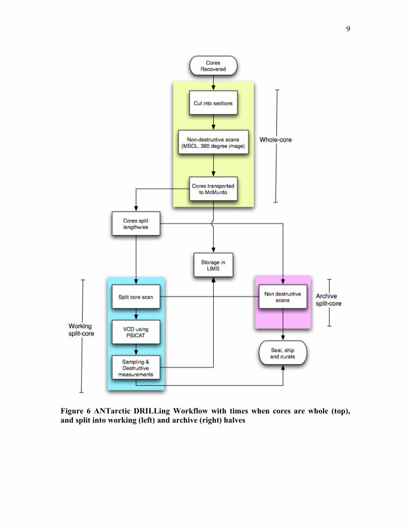
Figure 6 ANTarctic DRILLing Workflow with times when cores are whole (top), and split into working (left) and archive (right) halves

10
1.2.1. Integrated Ocean Drilling Program’s Workflow
Currently, the IODP-USIO is undergoing a transition, with the modification of the
U.S. drilling vessel, formerly the JOIDES Resolution. As such, the workflow will
potentially undergo alterations based on the final construction of the vessel’s science
facilities. Individuals in the IODP science team work in 12-hour shifts and may deal with
recovery on the order of tens to hundreds of meters of core per shift. As such, many
things can go on during 12 hours, which require meetings at shift changes to discuss what
happened and compare observations to promote standardization of data acquisition
procedures.
When drilling on a typical expedition, a ten-meter core is recovered
approximately every thirty minutes. Once recovered, cores are typically cut into seven
sections, placed onto racks and brought into the on-board science lab, so that the cores
can equilibrate to room temperature. This process can take several hours. By this point
the cores are still fully encased in their cylindrical containers (plastic liners), also termed
as being whole cores. Once brought to proper temperature, the core sections are sent
through the MSCL sensors to acquire non-destructive measurements along the length of
the core.
Afterwards, the cores are split length-wise, creating an archive half and a
sampling half. Cores that are split in this manner are called split-cores. The archive half
of the core is used for additional non-destructive measurements, of magnetic
susceptibility (used to indicate concentration of magnetic minerals at a given point in a
core), and digital imaging of the split surface for colorimetry and reflectance
spectrometry. When an archive half is not being processed by other equipment, the split-

11
core is usually located at a core description table for Initial Core Description (ICD) by
scientists. The ICD process sometimes requires the use of small amounts of material from
the core to produce smear slides. Smear slides are microscope slides (glass objects) with
small amounts of geologic material smeared onto them, for the purpose of viewing the
composition and texture of the material under a microscope. Sometimes smear slides
produce images of objects, such as microfossils such as foraminifera or diatoms that are
useful in helping determine how to interpret the environmental record preserved by the
cores.
The sampling half, also known as the working half, is used for destructive
physical properties measurements. The term destructive is used because physical samples
are removed from the split-core half and are run through experiments, such as chemical
analyses that disaggregate or destroy the sample. These samples are taken at a low
resolution, approximately one or two samples per core section, whereas the other
measurements made on the archive halves are made at a higher-resolution of
approximately one data point every one to two centimeters. While the individual sample
processing to gather data occurs, these data are being uploaded into the Laboratory
Information Management System (LIMS) for data management and storage during an
expedition. When the expedition is completed and the drilling vessel is docked, a
permanent on-shore replica of the LIMS database is updated to allow use of the
expedition data on a continuous basis. The LIMS is currently used for data management,
and at this time is not used to perform Initial Core Descriptions (ICD).

12
1.2.2. Limnological Research Center’s Workflow
Lakes are defined as enclosed bodies of standing water surrounded by land
(Cohen 2003). Individuals studying a lake must travel to the lake over land, thus making
it unrealistic to build a ship on the scale of the JOIDES Resolution or the Chikyu. This
fact alone affects the core workflow of individuals who study lake cores, such as those
individuals that are assisted by the Limnological Research Center and National
Lacustrine Core Repository (LRC/LacCore).
As seen in Figure 5, the first major difference between studying lake cores and
the ocean cores is that the lacustrine cores must be transported to a distant laboratory
after acquisition. There can be a long delay, on the order of weeks to months, before the
scientists process the cores. Once they have arrived at the respository, the cores go
through a workflow that is similar to the one that is performed on board the IODP
vessels. However, the cores often arrive at the LRC long before the science crew arrives.
Typically, some of the core sections go through the whole process of non-destructive
scans, core splitting, more scans and imaging, prior to the arrival of the science crew.
This is done to help reduce the amount of time principal investigators have to spend away
from their universities, and to help the process of Initial Core Description (ICD)
including the creation of barrel sheets. Barrel sheets (Figure 7) are paper or electronic
forms that contain core section images at a tenth of the resolution, only a few select
numerical logs that follow along the core and space for the scientists to write down notes
for core description. The descriptions written on barrel sheets will eventually be used for
reports, and as background for analysis and requests for sampling the core in the post-
drilling process. In the LRC workflow, the barrel sheets are owned by the science team,
and are not currently stored in a database such as the LIMS.

13
Figure 7 An Example Limnological Research Center barrel sheet (courtesy of the LRC), which gives an idea of what is generated by the Initial Core Description (ICD) process. Here we see MSCL data logged next to a lower resolution core image. In this barrel sheet we see lines indicating structural interpretations of the expression of faults on the core, together, with annotations on the side to further describe changes in sediment composition and texture.
Scientists have typically written down annotations to describe the attributes of the core
sections on a sheet of paper. As seen in Figure 7, annotations are written on the right side
of the core section image, and lines are drawn to indication geophysical or structural

14
properties such as interpretations of faults preserved in the cores. As of the summer of
2006, scientists performing the ICD now perform this process electronically by inserting
their annotations into a file using an Adobe Illustrator version of the paper barrel sheet.
The process of creating the barrel sheets is tedious; requiring the use of Adobe Photoshop
to prepare core section images; Microsoft Excel and Sigma Plot to visualize, scale and
align the MSCL data; and finally by using Adobe Illustrator to merge the images and logs
into a template created to produce the barrel sheet. A workflow difference between the
LRC and the IODP workflow is that the split-core imaging and ICDs are done on the
working half of the cores rather than on the archive half.
Currently, LRC holds the resulting data in a database that does not provide web
access. The primary cause for this structure is due to a lack of I.T. personnel to build and
maintain an integrated system. This affects post-drilling operations, and web-based
access to data after the data moratorium expires. Future collaborations between IODP and
the LRC may provide a means for the LRC to use a LIMS to help store and access data in
the future.
1.2.3. Antarctic Geological Drilling Program’s Workflow
The workflow for the Antarctic Geological Drilling Program (ANDRILL) is a
mixture between the IODP and the LRC workflows. Like the workflow for LRC projects,
the core sections need to be transported to McMurdo Station for processing in the Crary
Laboratory. However, some measurements and other operations are performed on the
whole core sections (i.e. un-split core sections) as soon as possible, at the drill site. These
operations include: recovery logging, fracture logging, whole round sampling for
microbiology and pore water geochemistry, taking non-destructive Multi-Sensor Core

15
Logging (MSCL) measurements, and acquiring 360 degree images of specific intervals
within a core section.
Once the core sections have been transferred to at the station, within a day or two
if weather permits, the typical sets of operations that can be seen in the LRC workflow
occur. On ANDRILL’s upcoming McMurdo Ice Shelf (MIS) project, the Paleontological-
Stratigraphic Interval Construction and Analysis Tool (PSICAT) (CHRONOS 2006) will
be in use to perform Visual Core Descriptions (VCD). Visual Core Descriptions are
effectively Initial Core Descriptions typically done using an application that allows a user
to select annotations visual objects to create an abstract description that includes
information about a core’s stratigraphy, lithology, geophysical structures, etc. The final
output that is similar to a barrel sheet used for ICD work. The key difference between an
ICD and a VCD is the inclusion of the visual abstraction of the core. Below (Figure 8) is
an example of a VCD created using the PSICAT application. PSICAT is an application
created to let users generate VCDs. From this point in the literature, the use of VCD
creation will imply the use of a program to aid a user in the ICD process, much like a
WYSIWIG editor is used to create web pages.

16
Figure 8 A complex diagram made with PSICAT (Courtesy of CHRONOS) PSICAT is an application used for Visual Core Description (VCD) and creation of a barrel sheet. The key difference between a Visual Core Description and an Initial Core Description is that the central effort of creating a VCD revolves around producing an abstract visual representation of a core. The various patterns, and polygons in the center of the figure are representative of changes in grain size and composition of the sedimentary sequence recovered in the core being described.
Also like the LRC workflow, and unlike the IODP workflow, the VCDs are
created when looking at the working half of the core and not the archive half. With the
aid of the IODP-TAMU offices, ANDRILL will be making use of a Laboratory
Information Management System (LIMS) to store their data on-ice and curing the post
drilling phase of the project. Just like the IODP workflow, there are 12-hour shifts and

17
daily meetings to discuss the past days events and formulate ideas about how the
recovered cores should be interpreted.
1.3. Problems with Existing Workflows
There is a recurring problem with all of the existing workflows. In particular, the
high-resolution core scans are not being utilized fully by the scientists. The process of
color-coding apparent features and intervals on a core section is still done in poor lighting
with munsell solid color charts in hand by some groups (Figure 9). Other groups have
automated this process using optical sensors and standardized illuminants to provide
colorimetry and spectral reflection data in both visible and broader (UV to mid-IR)
bandwidths.
Papers forms, called barrel sheets, used for Initial Core Description (ICD) contain
core section images at a tenth of the resolution and only a few select numerical logs that
follow along the core (Figure 7). All annotations taken down on paper must eventually be
transferred manually to digital form to create a final ICD report. Attempts at completely
electronic interfaces, such as the use of tablet PCs on the Chikyu vessel coupled with the
JCORES data management system, are being made but have deficiencies that prevent
them from being practical. A common feature of tablet PCs and Personal Digital
Assistants (PDAs) is the ability to recognize hand-written words and sentences.
Unfortunately the time taken to perform this task was said to need improvement if regular
use of this technique was to become feasible. Other varieties of electronic-based
descriptions exist using traditional interfaces, such as LRC’s use of barrel sheets created
using Adobe Illustrator.

18
Figure 9 Munsell color charts used for color-coding features in a core. Color matching is often done in less than favorable lighting.
This promotes free form text writing; whereas other stricter data input interfaces cause
the ICD process to be more of a classification process. Both options have benefits and
undesirables consequences with respect to flexibility and ease of use. Classification based
systems need to be continuously updated with new classifications if they hope to prevent
becoming outdated, but the benefit of controlling vocabulary and thus preventing a
deviation of phrases or names to describe features helps to make descriptions searchable.

19
Free form entry of descriptions and annotations lies on the opposite end of the spectrum,
in that it is incredibly flexible but becomes more difficult to create systems to parse the
text. The ability to search through prior preliminary reports and core descriptions is an
important part of improving the post-drilling process of analysis of cores, and
establishing a systematic core description process.
The description and analysis of the cores does not end after the ICD process.
Scientists return to their universities and continue to study the numerical logs and images,
and perform analyses to create more refined interpretations of the available data. It has
often been said that the high-resolution images are best used when a series of core are
printed out, tapped together and rolled out into the middle of a long hallway so that an
individual scientist can walk along their length and look for patterns.
Searching through previous descriptions and reports, and laying out meters of
core images printed out and spread across the floor, requires large amounts of time for a
principle investigator (PI). The fact that the data gathered during drilling falls under a
limited distribution moratorium does not help the PI’s situation. For example, lacustrine
cores currently fall under a two-year moratorium starting from the time that the core
sections are recovered from the lake floor. This is a policy that is currently being
reviewed and reconsidered because of time considerations. For example, from the time
of recovery, the cores may take a couple months before they arrive to the LRC for pre-
ICD processing and another couple weeks after that for the scientists to arrive; therefore,
any extra time spent performing inefficient processes adds to the lag before the PI can
begin publishing results. The post-drilling procedure for studying cores is in need for a
tool to improve the process.

20
20
2. A New Computational Approach to Core Workflows
2.1. Categories for Improving Core Workflow
There is a need for a new software program that can go beyond the capabilities of
existing applications. The key attributes for improving the existing core workflow are:
• Data Scalability: The ability to view large amounts of high-resolution images
and numerical data on the order of gigabytes
• Display Scalability: The ability to take advantage of multiple high-resolution
displays to display as much of the high-resolution imagery as possible, giving
more contextual information.
• Interactivity: The ability to interactively browse the data from anywhere with
respectable frame rates (approx 10 frames-per-second).
• Annotations: A method of keeping track of the analyses and interpretations of
cores studied by many researchers.
• Data Accessibility: The ease at which first-order data (e.g. numerical logs,
images) and second-order data (post-drilling analysis) can be viewed, and
managed.
• Extensibility: An environment that will balance between speed and the ability to
extend applications to include more capabilities that are created with the help of
outside developers
• Multiplatform: The same program should be usable by a vast majority of users
who will have different operating system preferences.

21
Corelyzer, combined with the whole CoreWall Work Suite (CWS) intends to meet the
needs defined by the above categories and more. The entire CWS has not been fully
implemented, but Corelyzer has reached a point that is usable by the community and is
being implemented in core workflows.
2.2. Comparison to Existing Applications
Several existing applications attempt to help scientists perform core logging and
description of cores. AppleCORE is one of the few geological logging programs
available for the Macintosh, designed for use in describing subsurface cores. Created in
the 1990’s before Mac OS X, it has been ported but new features haven’t been added.
This program provided a logging program on the Mac platform that used standard
patterns for displaying lithology and other geological structures. This application was
abandoned by broad community of geoscientists because of its lack of flexibility with
respect to rock types, sedimentary structures, features, etc. The target audience for the
development of the AppleCORE application was the Ocean Drilling Program (ODP),
IODP’s precursor, and has since become outdated. The application had no features for
communicating with outside databases, and had no concept of integrating high-resolution
images of cores. Since the practice of gathering these images hjas became more
commonplace, after the program was abandoned.
After struggling with use of Corel Draw fore core description during the Cape
Roberts Project in Antarctica, the ANDRILL team contacted the CHRONOS group at
Iowa State University to develop the Paleontological Stratigraphic Interval Construction
and Analysis Tool (PSICAT). PSICAT was developed with the goal to create visuals
similar to AppleCORE but to be more flexible and user friendly. The application is stand-

22
alone, and does not rely on an external database. While PSICAT can upload high-
resolution images, because it is written purely in Java it suffers some additional
weaknesses, which include the time required to load images and the limit the in number
of images that can be loaded because of restrictions due to Java heap sizes. The default
maximum heap size is the smaller of one quarter the physical memory or one gigabyte
(Sun). This can be made larger with command-line arguments to the Java Virtual
Machine (JVM), but PSICAT is still limited to the amount of images that can be fit
within the Java heap, preventing it from being able to scale to the amount of data that can
be displayed in Corelyzer.
JCORES, another project developed using 100% pure Java, was created for
CDEX/JAMSTEC, the Japanese arm of the IODP, and its vessel the Chikyu. JCORES is
a very complete package, with many features needed for performing analysis of cores
during an expedition. Being a pure Java application, JCORES modules have the same
image data scalability and load time issues as PSICAT, and the developers have decided
to use scaled down versions of the images for their Visual Core Description (VCD)
module. JCORES heavily relies on the use of an ORACLE® database that is designed
around the ODP JANUS data model, previously created at IODP-TAMU. This reliance
on the database is both its strength and weakness, as the load times for core section
images are also exacerbated due to necessary time spent communicating with the
ORACLE® database. User feedback from trial runs indicated that using the VCD
package seemed to be a tedious task as the interface was complex and had long response
times.

23
The LRC uses several sets of programs (Microsoft® Excel, SigmaPlot, Adobe®
Illustrator, etc.) to create a single sheet of paper for individuals to perform the Initial Core
Description (ICD). The process alone can consume large amounts of time on some of the
large lake drilling projects, such as the Drilling, Observing and Sampling of the Earths
Continental Crust (DOSECC) Projects that make use of the Global Lakes Drilling system
(GLAD) (DOSECC 2006). This ICD process is arduous and is in need of a stable
replacement.

24
AppleCORE PSICAT JCORES Corelyzer
Data Scalability
Display Scalability
Interactivity
Annotation
Data Accessibility
Extensibility
Multiplatform
Figure 10 Applications and workflow feature coverage. Three levels of feature coverage are used here to indicate that an application provides little or no coverage of a feature ( small square), makes moderate effort to cover a feature ( medium-sized square), or makes a point to fully cover a given feature (large square).

25
While the above applications are able to excel at core description with the use of
standard patterns and basic annotative capabilities, these programs lack the ability to
scale to large amounts of images and are mostly fixed in their nature. Corelyzer intends to
meet the majoritiy of the emerging community needs, and provide an environment useful
for syn-drilling and post-drilling activities. Corelyzer will handle large amounts of
numerical data and image data, scale to multiple displays seamlessly, and provide an
interactive means to browse and annotate core sections. With its extensibility, Corelyzer
can provide a common, effective work environment that can bring in data from
heterogeneous databases by creating plug-ins with user-interfaces designed to work with
a given database or web-service. In combination with other tools compromising the
CoreWall Work Suite, Corelyzer will be able to help access and manage individual
studies of geological cores.
3. Embedding the CoreWall Work Suite into a Generalized Workflow
In order to understand the applications of the CoreWall Work Suite, we must first
see view a generalized version of the existing workflows. This will illustrate of the
general functions, or goals of the applications. In Figure 9, a generalized workflow is
diagrammed including a loop that generally describes the post-drilling activities. Most of
the workflow is based on a linear process until the post-drilling activities are invoked.
The loop of the post-drilling activity would be a task (Lei et. al. 1997) that takes the data
created by the linear tasks of the syn-drilling operations to create new data and
interpretations of data. Part of the post-drilling task includes upholding rules of data
moratorium, indicated by the decision box concerning access privileges. Typically, if data
is under moratorium, then the main route to access the data is to contact the core or data

26
curators, or have the curators send the data electronically if more has been acquired. This
system works well in the beginning, for smaller operations and for principle investigators
who have data access privileges and who go on to publish preliminary reports, journal
articles, etc. Once the data is out of moratorium, the data becomes hosted publicly. At
this point the general populace have data access privileges, can perform analysis and
collaborate openly. This point of the core workflow can benefit from collaborative tools
that are designed to fit the workflow.

27
Figure 11 Generalized Core Workflow with Post-Drilling Activities (green), shown as a group of nodes following curation. The working and archive halves can be interchanged for imaging and Initial Core Description or Visual Core Description work.

28
Within the CoreWall Work Suite (CWS), applications are in development to
discover, analyze, and manage data concerning geological cores. There are 4 parts of the
CWS and each has a different visual/data integration or exploration function. The
following sections will describe the purpose of each application, according to the initial
proposal for developing and implementing the CWS.
CoreNavigator- A data discovery tool that has the ability to browse data
using a 2- or 3D “GIS-like” (geographic information system) context. This
tool proivides a visual way of comprehending cored stratigraphic datasets,
integrated with seismic and overlaying oceanographic data where these
exists. This tool will be particularly useful for individuals to “discover”
data from past drilling activites. Within the workflow, this tool is intended
to primarily be used in searching, and requesting of data in the post-
drilling or pre-drilling proposal development tasks. This tool is intended to
be a means to bring data into Corelyzer.
Corelyzer- Designed to be used during ICD/VCD and second order data
creation, this is the primary visual integration workspace that allows users
to view depth-registered data and images from any compatible databases.
Corelyzer is easily expandable through the development of custom plug-
ins. Because individual user communities will always want to integrate
new functionality and features into the CoreWall Suite, a plug-in structure
has been developed that allows programmers to extend the functionality of
the base software on their own. Corelyzer can also pull data from the Web,

29
which was demonstrated at the CoreWall Workshop (Washington, DC;
May 2006) with a CHRONOS Web Data Portal plug-in. In the workflow,
annotative capabilities in Corelyzer could be used for ICD/VCD work,
syn-drilling operations. For pre-or-post drilling tasks, Corelyzer can
retrieve data from known locations, such as those discovered using Core
Navigator, and make use of plug-ins to perform analysis, create second
order data.
CoreCLIP (Core-Log-Integration-Platform)- The revised SPLICER
(stratigraphic composite builder) and SAGAN (core-log mapping)
software that was previously two seperate UNIX applications used mainly
by ODP. CoreCLIP will provide a standalone application and a Corelyzer-
ready plug-in with many new features, such as the ability to use images to
assist users in building composite logs, an integrated text parser to
improve data entry, and add new depth correlation algorithms to improve
composites. This tool would be used syn-drilling operations to help make
drilling decisions after preliminary lab measurements (e.g. MSCL) are
taken. Another point of use would be in post-drilling tasks to create new
interpretations of composite cores, which would become second order
data. The second order data could be used to correlate among
geographically separated sites or be analyzed as time series of
environmental data with addition on an appropriate age model.

30
Workflow Database- A local working database(s) that will be designed to
allow for local interaction with data, interaction with web services and
other databases, data synchronization between multiple CoreWall
setups/databases, and for remote collaborations where data/images are
being shared. To help with on-site and off-site collaboration using
Corelyzer, a workflow database would be used to help manage
communication. This tool would fit entirely within both syn-drilling and
post-drilling tasks.
3.1. CoreNavigator and Data Discovery
For individuals that are new to the techniques of studying geologic cores, data
discovery and searching is one of the first actions taken. Individuals need information
about any previous cores that have been recovered, where they come from, how many
cores at a given location, why and when they were gathered, etc. Searching for this
information can be difficult for individuals that don’t know where to go to access these
data. CoreNavigator is an application in the CoreWall Work Suite that is designed to
meet this need. By taking advantage of existing technology, such as Google Earth
Enterprise (Google 2006) and the Keyhole Markup Language (Google 2006), an
integrated web-services oriented viewer can be developed to provide an interactive
environment, rich with context about the cores available.

31
Figure 12 Prototype CoreNavigator using Google Earth and KML to access data on cores. Each dot on the map indicates a core hole, and data about each hole is displayed below the map and inside the map (Figure 13)

32
Figure 13 Close up of prototype data bubble for a particular drill hole. Displayed in the bubble are the name, elevation, drilling method and other data related to the hole.
Preliminary work by Chris Jenkins of the Institute of Arctic and Alpine Research
(INSTAAR), at the University of Colorado at Boulder, have taken the data accessible by
dbSEABED (Jenkins 2005) and integrated the data points into the Google Earth
application (Figure 11, 12). The second goal of the CoreNavigator component is to take
the set of cores of interest (COI) and create an input file to load into the Corelyzer
application.
3.2. Corelyzer, the Central Environment
Corelyzer, is the central application in the CoreWall Work Suite and the author’s
contribution to the CWS. The aim of the application is to be a central environment to
browse, annotate and analyze geological cores. Once an individual has acquired core

33
section images and numerical logs, Corelyzer can be used. This application fits in
multiple locations in the generalized core description and analysis workflow, but is
designed to be part of any ICD/VCD work and to create second order data. Again the
goal of Corelyzer is to meet the previously stated points for improving core workflow:
display scalability, data scalability, interactivity, the ability to annotate, the ability to
extend capabilities, the ability to access data from various places and to support multiple
operating system platforms.
Designed to be scalable with respect to displays and data, Corelyzer uses OpenGL
to hardware accelerate rendering of core images and data, in order to keep the application
interactive. Java is the front-end language of the application, used to make Graphical
User Interfaces (GUIs) and a plug-in system. Using Java and OpenGL, Corelyzer has
successfully run on multiple operating systems. The user-interface is designed to be
intuitive with a focus on a simple set of interaction schemes. Plug-ins allow outside
developers to create modules for the application to suite their respective needs. This also
allows new features to be created, tested and incorporated, such as to access data from
various databases. The following sections will describe, in detail, how Corelyzer satisfies
the goals to improve workflow.
3.2.1. Corelyzer Architecture
A major focus of Corelyzer is to be able to display vast amounts of numerical
datasets generated from measurements of core sections juxtaposed with high-resolution
digital line scan images whole-round or split surface of the core sections.

34
Figure 14 A screenshot of Corelyzer. We see a core section and two graphs plotted alongside the image. Here a user has selected a graph and a vertical dashed line appears to help visually align the plots with the respective location on the image. The architecture of Corelyzer involves mixing Java and native C/C++ at different levels
of the application (Figure 15). This design choice was made to rapidly develop user
interfaces, keep time taken to perform rendering with OpenGL to a minimum and be able
to make use of the full memory heap given by the user’s operating system for a process.
Java bindings for OpenGL (JOGL) is an open-source development to allow Java
programmers to using natively implemented OpenGL functions. Corelyzer uses this
technology to create OpenGL contexts, but has separate native methods implemented to
effectively manage data, images, other visual objects for rendering. These native methods
are amalgamated into the Corelyzer’s Scene Graph library.
The use of Java also helps in creating an effective plug-in system. Plug-ins are
modules created outside the Corelyzer source code, which can be made to not only

35
process incoming data, but also create new user interfaces to create events and manage
user input.
Figure 15 Corelyzer architectural layers. The Scene Graph layer is in C/C++ for rendering efficiency. The user interface and plug-in management are done in Java for rapid development. Example plug-ins are placed on top of both the plugin manager and application objects because they can make use of any public object in Corelyzer. Development of Corelyzer has focused on supporting multiple platforms, and has been
successfully built for Microsoft Windows, Mac OS X, and several Linux distributions.
3.2.2. How Corelyzer Meets Display Scalability
Unlike studies of the use of multiple monitors with multiple windows and
applications being run (Hutchings et. al. 2004), Corelyzer is a single application that

36
spans across multiple monitors. Multi-screen display systems have become a central
focus for some institutions because those systems can facilitate information richness in
applications, and they provide more interesting problems to solve. While other work has
focused on using clusters to create and display visualizations (Jeong et. al, 2005)
(Krishnaprasad 2004), Corelyzer focuses on scaling to a multi-screen display driven by a
single computer. The main reason for this is to simplify infrastructure needs so that a
scientist can begin performing analysis right away. However, future developments such
as the LambdaTable (Krumbholz et. al, 2005) can provide an environment to promote
collaboration and build community interactions using such a system.
Prior work has shown that when using multiple screens, developers must be aware
that some visualizations benefit from removing the appearance of disjointed visuals due
to screen border seams, termed “mullions.” Two types of visual disruptions created by
seams have been defined (Mackinlay et. al. 2004). One is based on the space used as a
container of graphical objects, the other used "as a metric field to position objects
meaningfully with respect to quantitative axes." Container space disruption mitigation
involves giving the appearance that a graphical object physically continues, undeterred by
the mullions (Figure 16). Given that the predominant visual objects in Corelyzer are the
high-resolution images, container based disruption mitigation has been implemented.
This reduces the perceptual impact that seams create (Mackinley 2004). The same
method for mitigating visual disruptions has also been implemented in the Scalable
Adaptive Graphics Environment (SAGE) (Jeong et. al. 2005). In order to provide a
simple way of customizing the display configuration, so that Corelyzer can automatically
calculate the container based disruption mitigation, Corelyzer employs a user interface

37
that allows a user to customize the display layout (Figure 17), for example,to use
Corelyzer display data spanning two 30-inch displays (Figure 18).
Figure 16 Two versions of a line crossing a vertical seam. One is drawn with container space disruption mitigation (left), and the other without (right). The version on the left reduces the perceptual impact the version on the right creates (Mackinley 2004).

38
Figure 17 Corelyzer display configuration dialog. Used to describe the screen layout, screen dimensions, and other characteristics to help mitigate container based disruption and provide life-size views of core sections.
Figure 18 Display scalability of Corelyzer shown here running on two 30" display monitors, each at 2560 x1600 pixels, and Corlyzer running on a laptop.

39
3.2.3. How Corelyzer Meets Image Data Scalability
Hardware accelerated graphics is commonplace with modern desktop and laptop
computers. Using hardware accelerated graphics allows Corelyzer to take advantage of
the large texture memory that exist on graphics cards (approximately 64 MB to 256 MB
at the time of this writing). Using textures allows less data to be unnecessarily transferred
over the system bus when rendering an image over multiple frames. Aimed to lower disk
usage to view larger amounts of data, an incomplete mip-map pyramid is used for level-
of-detail control. Corelyzer uses a quad-tree structure at each level of detail to make use
of an application-level Least Recently Used (LRU) texture paging system to reduce
transfer of texture blocks from disk to main memory, and the texture paging from main
memory to video memory that is built into the OpenGL drivers. The use of the Scene
Graph layer of the Corelyzer architecture (Figure 15) was used not only to reduce the
overhead of moving from Java to C/C++ for every OpenGL call, but also to be able to
more flexibly use the full heap size given by the user’s operating system. As explained in
section 2.2, the JVM typically does not make full use of a heap available to an
application.
After defining the overall architecture, decisions were made on how to keep the
rendering moderately efficient. In particular, what texture block sizes needed to be used
for the LRU texture paging system. Experimentation was done to determine the optimal
texture block size to use. Four dimensions were compared fairly: 64 x 64, 128 x 128, 256
x 256 and 512 x 512. The scenario consisted of 21.8 meters of core imagery. Each image
had a height of 1000 pixels and the horizontal resolutions of the images were 254 DPI,
which effectively gives 218,000 pixels horizontally and 623 MB of data. The experiment
was constrained to display the images without any scaling aside from scaling the images

40
to fit to the depth scale along the bottom of the visualization. Figure 19 shows that as the
square block dimension grew the time taken to render a frame dropped overall.
With the knowledge that the S3TC/DXT texture compression OpenGL extension has
been specified in November 2001 (SGI 2001) and implemented on every major graphics
chipset since then, the experiment was re-run using 512 x 512 compressed textures.
Figure 19 Average Time to Render with Min and Max Deviation

41
Figure 20 Detailed look at Average Time to Render with Min and Max Deviation, for block sizes 256, 512 and 512 with compression
The experiment showed that not only did average rendering time decrease, but so did the
minimum and maximum deviations. From Figure 20, we surmise that an average frame-
rate of Corelyzer when simply browsing is approximately 20 frames-per-second (FPS), if
we use compressed texture blocks of dimensions 512 x 512 pixels.
3.2.4. Annotations
Being able to annotate a core is an important feature because this is the key
method for creating ICDs. Corelyzer ties annotations directly to a depth relative to the top
of a core section. This information, tied with the sub-surface depth of a core section can
give the depth of the annotation with respect to the top of the borehole.

42
Figure 21 An annotation marker placed along side a core section. Given the visual feature on the core section image, the annotation is probably related to the gap in the core.

43
Figure 22 An annotation describing a feature visible in the previous figure. Here we see that the user has categorized it under geophysics (lower left corner). At the top of the window are prior entries made, and at the bottom new entries can be created for insertion into the discussion.
Above in Figure 21 and Figure 22, we have a view of an annotation marker that indicates
to a user that an annotation has been placed along that depth in the section, and what type
of annotation it is. Different markers indicate different annotation types, and in this case
we have an annotation that refers specifically to a point at that depth. Once a user selects

44
the annotation they can continue a thread of thought and discussion with themselves or
others (Figure 22), simply by adding a new entry into the annotation. This is similar to
the anchoring of textual annotations on web documents (Brush et. al. 2001). Whereas
work by Olsen et. al., in 2004, had annotations with a more free form construct based on
the use of virtual pens. While extremely flexible, storing handwritten notes can become
illegible and Olsen’s work was not tested with multiple users. Thus a decision was made
to use HTML 1.1 documents to store annotations as text and images. Now individuals can
create annotations with references to either images captured through a microscope, text or
provide links to other related work in order to effectively describe a core.
This method of creating annotations combined with the extensibility of Corelyzer,
discussed in the following section, is used to allow synchronous and asynchronous
discussions to take place as cores are recovered by the ANDRILL MIS project. With the
same extensibility, Corelyzer can be modified to used structured annotations (i.e.
annotations that follow a syntax) so that they can be parsed, validated against a
dictionary, and searchable.
3.2.5. User Interaction
Corelyzer has two main interaction schemes. The first is the traditional menu
based user interface that users of many systems are accustomed to (i.e. menu bars with
drop down menu items). The second interaction scheme is used to navigate through the
visualization area. Using a scroll-wheel mouse, or laptop trackpad, individuals can pan,
zoom and interact with objects in the visualization windows. Both left and right mouse
button events are context sensitive and take into account modifier keys. For instance,

45
holding down the left mouse button on an unoccupied space in the virtual world will
automatically place the application in a click-and-drag style of panning. Where as left
mouse button presses over a core section will allow the user to slide the core section
image horizontally along the designated horizontal track that the image belongs to.
3.2.6. Corelyzer and Extensibility
After an NSF workshop focused on CoreWall took place in May 2006,
community response was positive to a proposal to create an extensible environment.
What was shown was a Corelyzer plug-in that used web-services developed at
CHRONOS to access IODP-TAMU’s JANUS database. The plug-in allowed users to
simply query for existing image data, and directly retrieve the images from their
respective URL’s. This was an example of how to bring in new features to the Corelyzer
system without having to make major modifications to the base application source code.
The original purpose of the plug-in system was to create an architecture that
would allow the creation of user interfaces in order to bring similar data from
heterogeneous databases together, effectively making Corelyzer a central work
environment. This architecture was developed to allow individuals to easily install new
modules and could be used to access a central database during an expedition, such as
LIMS, or merge data from other databases such as LIMS, the Petrological Database of
the Ocean Floor (PetDB) (Lehnert 2005), or the Integrated Data Management for
Sediment Geochemistry (SedDB) (Lehnert 1999). Eventually, after the CoreWall
Workshop several new capabilities were defined such as the ability to count clasts (rocks
formed from pre-existing rock fragments) automatically (ANDRILL 2006, May),
incorporating image analysis tools, integration of down-hole experiment logs, various

46
methods of describing cores and the ability to create hardcopy documents of annotations
and descriptions made.
3.3. CoreCLIP, a Corelyzer Plug-in to Analyze Down-hole Logs
A common request for Corelyzer at the CoreWall Workshop has been to integrate
data that is gathered separately from the physical core sections. In particular, scientists
want to be able to integrate down-hole geophysical logs, or data gathered by sending
instruments to measure properties along the walls of a drill-hole. The logs are typically
gathered as sets of numerical values associated with given properties and registered to
given depths within a hole. A common activity with these numerical data is to correlate
the data from multiple adjacent holes together to create a single composite log that
defines the entire interval from where the cores were taken to ensure complete recovery.
Vertical offsets in drilling in adjacent holes are used to compensate for possibly missing
data in any one hole, and to account for expansion of cores in response to their recovery
to the Earth surface conditions and as they equilibrate to room temperatures. The process
of correlating between logs can be fairly subjective and is often based on matching
patterns of plots along graphs that are common to the multiple logs. The Core Log
Integration Platform (CLIP) is comprised of the applications SPLICER (Figure 23) and
SAGAN (deMenocal et. al.1993) and development to update and port the applications has
resulted a single application called NCLIP (Kamp 2006). These programs have been
designed to splice, stretch and shrink the graphical logs to correlate with the composite
logs.

47
Figure 23 SPLICER with source logs (left) used to create a composite log (right) Scientists feel that the process of having individual numerical logs that can be correlated
and used to form composites would benefit from having the core section images
resampled to create a composite image that matches the composite log. To do this
CoreCLIP, short for the Corelyzer Core Log Integration Plug-in, will be tasked with this
development. As a first step, the resulting output from NCLIP composite building can be
taken and brought into Corelyzer to create the composite images with the composite logs
displayed alongside. Due to Corelyzer’s flexibility, a second step will be the development
to integrate the NCLIP interface more directly into CoreCLIP. Development of CoreCLIP
will be done in collaboration with Insight Access Group Partners, Ltd. (IAGP), after the
NCLIP application has stabilized.

48
3.4. Workflow Database
The Workflow Database is designed to be in use along side the Corelyzer
application, which would be during ICD/VCD work and creation of second order data.
During syn-drilling operations, synchronization of descriptions and interpretations of data
can be a useful collaborative tool. Once all syn-drilling operations are complete and
scientists continue analyzing cores at various geographic locations, it is useful to be able
to continue collaborating in the same manner. There still exists the concern over how to
restrict or control access to moratorium data. Following are points of interest for the
Workflow Database to allow collaboration and help existing workflow.
3.4.1. Synchronized Sessions for Collaboration
Collaboration is key for any scientific drilling operation, as scientists need help
from lab technicians, drill operators, curators, and other P.I.s. As a convenience to using
the CoreWall Work Suite, and the Corelyzer application in particular, the Workflow
Database should have a mode of holding a shared, synchronized Corelyzer session for the
duration of a drilling operation, or some user defined time. This entails:
• Broadcasting data availability
• Ensure moratorium policy
• Sharing annotations
Geoscientits who study geological cores are effectively empiricists, or
experimental scientists who require tangible objects. Birnholtz et. al. describe empiricists

49
as people who do not like to share data that required hard-work to acquire, but in the case
of scientific drilling, sharing some data can be key to the success of an expedition
otherwise the ICD process will be compromised due to lack of detail. However, actual
numerical values have to be protected to prevent individuals from violating the data
moratorium. While collocated individuals working together can often form a sense of
trust (Rocco et. al. 2001), policies must still be enforced to protect interested parties.
As noted before, bigger operations need to hold meetings every day on order to
keep everyone synchronized and aware of what operations have transpired, what findings
scientists are gathering from recovered cores and what drilling decisions have been made.
On top of needing to know when data becomes available, there needs to be a mechanism
to support sharing annotations to communicate, whether synchronously like most instant
messaging applications, or asynchronously (Weng et. al. 2004) in order to effectively
meet the communication needs. The same architecture should be usable for post-drilling
collaboration as well.
4. Detailed Case Study: ANTarctic DRILLing
The McMurdo Ice Shelf project is a part of the ANDRILL Program, which will start
in October 2006 and drilling ending December 2006. In order to improve communication
and improve quality of work, ANDRILL will be making using of Corelyzer and a
prototype Workflow Database system.

50
4.1. ANTarctic DRILLing Scenario
The scenario of Corelyzer usage is fairly simple. The goal of the project is to use
Corelyzer as be the application that integrates and visualizes all of the data coming out of
the expedition during drilling, and to provide an environment to promote discussion.
ANDRILL will be operating with teams that work 12-hour shifts on a 24 hour, 7
days a week schedule, and hold daily meetings to discuss operations and analyze data.
For instance, the science team hopes to analyze and interpret the results obtained visible
from the split-core and whole-core images. Scientists would like to be automatically
notified when new data is available to view. Unlike “Screen Crayons” (Olsen et. al.
2004), which focused on single users, annotations from multiple users must be managed.

51
Figure 24 A diagram detailing which points of the core workflow involve interaction with Corelyzer and the prototype Workflow Database. Incoming data from images and sensors (dashed lines) and annotations from discussion (dotted line) are inserted into the database, to be viewed in Corelyzer when a client plug-in is used to download and browse existing data. PSICAT is used for Visual Core Description (VCD) and integrated into Corelyzer via a plug-in, to enhance scientific discussion.

52
In Figure 24, we see at which points in the generalized core workflow (Figure 11)
do Corelyzer and the prototype Workflow Database (WDB) integrate to enhance the
workflow. The dashed lines in Figure 24 indicate at which stages do the curator and
administrators use a client to push first order data to the WDB, which then notifies other
users of the existence of such data. Using a plug-in developed specifically for the
ANDRILL scenario (ANDRILL Session Plug-in), scientists will be able to easily pull in
the visuals necessary to complete their work. As scientists discuss data and
interpretations, annotation entries can be generated and submitted to the WDB. The
following sections discuss the workflow integration in more detail, data management
issues, how Corelyzer extensibility helps to integrate third party applications into a more
complete workflow, and how user feedback can be used to validate the work.
4.2. Physical Integration into the ANDRILL Workflow
Each individual scientist may run Corelyzer on his or her own laptop, hardware
requirements permitting. There will also be two communal Corelyzer-dedicated
workstations at McMurdo station. Sedimentologists will use the first system in order to
support the VCD process by providing a means to view the high-resolution imagery
alongside the physical cores. The second system will be used in a common space to
provide individuals with a readily available means of contributing to discussions in the
shared, synchronized Corelyzer session. Brignull et. al., have performed studies on
communally shared interactive systems. The results from their study said that a shared
system should:

53
• Be able to fit with the artifacts used in the space
• Provide physical and digital flexibility with respect to arrangement
• Be designed so a community can absorb the applications into existing activities
• Provide an intuitive set of display-based interactions
Corelyzer can already provide for all four requirements that follows from their
study, point for point. Corelyzer runs on any computer, and computers are common
artifacts in any space. Physical and digital flexibility are provided for by the display
scalability, and by user interfaces to help describe the display layouts (Figure 17). Point
three was discussed in detail in previous sections concerning core workflow. The final
point is fulfilled based on the OpenGL windows with simple interactions such as
panning, zooming, context based left and right clicks of the mouse (see User
Interactions).
4.3. Image and Numerical Log Management
First order data is defined here as data that has been gathered by sensors (MSCL),
scanners (digital line-scan camera for imagery) and Initial Core Descriptions (VCD /
ICD). ANDRILL, unlike the other drilling operations mentioned, is less likely to be
acquiring soft sediment cores. This means that they will be able to acquire whole-round
images of cores more often, as displayed in the ANDRILL workflow (Figure 6), and be
able to more accurately describe the orientation of a core section to help with
understanding of structural geology and geophysics. It should be understood that
sometimes the whole-round images do not span the length of an entire core, especially if

54
there is too much water and the core disaggregates. ANDRILL will be drilling a single
hole but creating two sets of images or more per core section.
The initial set of non-destructive scans and images are taken when the core
section is whole, and this is done at the drill site. Once transported to McMurdo Station,
the WDB is updated with these section names, whole-core images of particular depth
intervals, and non-destructive whole-core measurements. As the core workflow continues
the WDB will be updated with scans from split-cores, data from discrete analyses, and
creation of Visual Core Descriptions (VCD) will be made using PSICAT. The integration
of PSICAT will be discussed in the following section, but first the management of the
images and numerical logs must be detailed.
Both images and numerical logs fall under the data moratorium. Images are
affectively owned by all science team members, and can be viewed freely. Therefore it is
trivial to host an image using a web server and allow the ANDRILL Session Plug-in
(ASP) to copy the image locally and process it for viewing. However, all science team
members do not own numerical logs from MSCL devices. Individual attributes, such as
magnetic susceptibility, are crucial parts of research for different principal investigators.
As such, individuals should not be able to download the actual numerical values of the
core logs, but the science teams as a whole are able to view simple plots of the logs.
Figure 25 describes the process an individual must undergo in order to view a graphical
plot of numerical logs, or to access a data file of the actual logs in order to perform an
analysis. By the time an individual is at decision point number three, the individual must
be interacting with a database administrator. This inter-personal interaction is designed

55
specifically to prevent moratorium policies from being violated unless special permission
was given.
For Corelyzer to display the graphical plots, the WDB transfers the numerical
logs as per core section tables. The data is stored in main memory by the Corelyzer plug-
in, in main memory (i.e. no copy of the data exists in non-volatile memory). Once a user
exits the application, there will be no existing copy of the core logs. The only way an
individual would be able to violate the data moratorium and access the data would be if
they develop a plug-in to do so. This is highly unlikely to occur as the intended audience
is not well versed in computer science or programming, and time spent in Antarctica is
devoted to other tasks. One critical factor missing in this phase of development is
communication with individuals “off the ice.” ANDRILL scientists communicate with
the globally distributed science team members via low-bandwidth satellite. It is not
feasible to directly serve data to the off-ice individuals directly from Antarctica unless
data were flown to Chirstcurch, New Zealand on harddrives and placed on a server to
access the Internet. Due to time constraints, this problem was not solved for the 2006
MIS drilling project. Fortunately, this system can be used post-drilling in the same
manner, in order to continue any shared discussions.

56
Figure 25 Numerical log access flowchart. Viewing data is less difficult than acquiring actual values, in order to preserve the data moratorium.
4.4. Corelyzer and PSICAT Integration
Visual Core Descriptions (VCD) for the upcoming ANDRILL MIS project will be
done with the PSICAT application. In order to produce a more complete integration of
data, the resulting VCDs should be displayed in some meaningful manner within
Corelyzer. To fulfill this need, CHRONOS has begun development of the PSICAT
Corelyzer Plug-in (PCP). The PCP uses VCD files created by PSICAT as input, and

57
performs the necessary rendering of the VCD to display in Corelyzer. The plug-in is
capable of doing this using an internal construct in Corelyzer that allows a plug-in to
freely draw anything that may be deemed meaningful to the plugin, within a requested
rectangular area. The rectangular areas provided have been termed Free Draw Areas
(FDA).
4.5. Community Response to Corelyzer
In order to validate that the technology created for the purpose of improving core
workflow, the Corelyzer application, prototype Workflow Database and ANDRILL
Session Plug-in were demonstrated to the ANDRILL community. In particular, an
ANDRILL P.I., David Hardwood, and staff scientist, Richard Levy, experimented with
the applications hands-on. Both individuals are key members of the ANDRILL Science
Management Office (ANDRILL-SMO) and responded with the following positive
comments.
"I'm very impressed ... Prior drilling projects, like the Cape Roberts project, suffered from the ability to have all the science team see the data, the core and have it readily accessible to them, ... to maximize their scientific output. .... (Corelyzer) is a superb, easy to use template for the integration of a lot of data. I can see potentials for improving it as we continue to march along into the future." - David Harwood, Ph. D., ANDRILL P.I.

58
“One of the things I've been impressed with ... is the (ANDRILL session plug-in) application that's been developed for the Corelyzer. It's pretty user friendly, pretty easy to pull in core images, get the information we want to view onto the screens. For our (science team members) who don't want to spend a lot of time learning new software, I think the plug-in is simple enough to allow us to effectively use the program. It's going to be interesting to see how it functions, but I think we're in good shape.”
- Richard Levy, Ph. D., ANDRILL Staff Scientist
At the MIS pre-drill meeting, held in early September 2006, scientists that would
describe the cores in the sedimentology room performed a simulation run, using PSICAT
for Visual Core Description and Corelyzer to help aid in viewing the cores. The
simulation did not have physical property logs to go along with the cores because the
cores were borrowed, but the response to Corelyzer was very positive. One scientist said
that with the physical properties positioned alongside the core images, Corelyzer would
be a valuable tool in interpreting cores.
5. Future Work
The CoreWall Work Suite development is not complete. Development for more
effective rendering of datasets need to be incorporated, and development of different
plug-ins must be made. Following necessary technical modifications, user studies support
by the Internal Review Board (IRB) must be made to more fully evaluate the usability
and effectiveness of the CWS as a whole.
Several technical improvements must be made to the Corelyzer system. First, a
modification to the rendering system should be made to provide a more smooth transition
when zooming and panning. Google Earth does this by rendering the lowest resolution of
a particular grid block and gradually filling in with higher resolution images as new
frames are created. Google Map does this by simply not rendering any new visuals until a

59
user has ceased moving the viewpoint. Either of these two methods, or a combination
thereof, like Magic Carpet (Svistula 2006) will work. Secondly a system to export a
current user Corelyzer session is needed to create publishable documents. For instance,
creation of ICD barrel-sheets containing all annotations of a core section. A prototype
output design is currently in the works, and is pending community response before
implementation begins.
As new technical improvements are made to the base system code, more plug-ins
need to be developed to meet community needs. Plug-ins can fulfill a variety of needs.
The first plug-in would be to support image analysis using ImageJ (National Institutes of
Health), a tool with its own variety of plug-ins to perform texture analysis, particle
removing, angle measurements, automatic gamma correction, etc. Secondly, a final
implementation of CoreCLIP to provide integration of data gathered from a borehole,
MSCL data and core section images. CoreCLIP would allow scientists to create a
composite log and a composite image representing the scientist’s vision of what the
complete record preserved in the ground would appear to be. Third, individual scientists
could benefit if a plug-in was developed to allow users to view sample requests, for
example, which requests for physical properties experiments were made, and to be able to
make additional requests from Corelyzer. This type of plug-in would help curators to
avoid having to expose repeatedly those core sections that have been sealed for curation,
and it would help scientists to identify whether new cores must be procured to perform
any necessary analysis. Fourth, a series of plug-ins should be made to support education
and outreach efforts of the various scientific drilling operations. The National Science
Foundation cares deeply about educating the world and developing future generations of

60
scientists of high caliber. Education and outreach activities include both the informal (e.g.
museums) and formal (e.g. high school, college and universities) types. Informal
education can make use of Corelyzer if a plug-in is used to create real-time animations to
tell the story of a core and how it records aspects of the Earth’s history. Formal education
can benefit from plug-ins that allow students to browse existing public preliminary
reports and easily acquire and display the data to create their own reports, and perform
analyses of their own.
As Corelyzer, and the accompanied tools that comprise the CWS are more
actively used, studies should be performed to evaluate the system as a whole. Evaluations
will be critical in improving the system’s interface, reliability, and flexibility for
customization. Other studies can be performed to help further understand the domain of
Computer Supported Collaborative Work (CSCW). Several recent publications have dealt
with collocated and distributed work groups. It has been determined that being collocated
or not usually does not affect performance (Bos et. al. 2004) (Bos et. al. 2006), but it has
been speculated that if everyone in a group is co-located then outside points of view may
be lost that can enrich the work (Bos et. al. 2006). What also seems to form with mixed
co-located and distributed members of a group is two separate “in-groups” (Bos et. al.
2004). The two groups are formed because co-located members practically ignore
distributed members, forcing distributed members to form a group of their own. The
experiment that determined this was done in a simulated environment where the goal was
to score high in a game. Does this situation arise in a real-world environment such as
ANDRILL’s, where ANDRILL not only has individuals in Antarctica, but outside as
well? This is one of the questions to ask when solving the problem of synchronizing

61
communication for the 2007 ANDRILL drilling operations. By this time, perhaps CSCW
organization theory (Barley et. al. 2004) will exist that can be tested in a scientific-
drilling environment.
6. Conclusion
Geological cores are cylindrical objects containing natural records of
environmental change that are retrieved for the sake of understanding the past climates of
the Earth. Whether retrieving cores from the world’s oceans, lakes, ice sheets or
continents, the workflow of studying geological cores follow a common path. However,
because of the cultural differences between various scientific drilling projects, creating a
system to work with all projects can be difficult. This is compounded by the fact that
certain data fall under moratorium, requiring special access, and that the amount of data
that exists and is generated is beyond the scope of existing applications. The contribution
of this thesis is:
1. A generalized workflow model that merges the workflow of three scientific drilling
organizations. A clear definition of the workflow not only aids in the development of
effective software but also enables future IT specialists to quickly understand the
fundamental requirements of scientific drilling projects. This workflow could
potentially assist researchers who study and develop workflow technologies (Lei et.
al. 1997).
2. A mapping of technology, implemented as the Corelyzer application, to this
generalized model that is useful to anyone interested in developing technological
solutions for the scientific drilling community.

62
3. A validation of the efficacy of Corelyzer on a detailed case study- namely
ANDRILL
4. A discovery of new problems that need to be solved, new adjustments that are
needed to the generalized workflow model based on findings from the case study.
With a proposed solution comprised of multiple applications, including Corelyzer, to
create the CoreWall Work Suite.
While development of the whole CoreWall Work Suite is not complete, the ANDRILL
case study has provided a tangible example and positive support that the current strategy
is proceeding in the right direction. More work is needed to complete the system and
meet other needs of the community. As the needs are met, more questions will arise
relative to understanding workflow models and Computer Supported Collaborative Work.

63
APPENDIX A: Geology Terms Used
clast – rock formed from pre-existing rock fragments colorimetry – measurment of the intensity of color geophysics – the physics of the earth lacustrine – of, relating to, or associated with lakes. limnology – the study of the biological, chemical, and physical features of lakes and other bodies of fresh water. lithify – transform (a sediment or other material) into stone lithology – the general physical characteristics of a rock or rocks in a particular area magnetic susceptibility – the fact of being influenced by magnetic force; measurement used to determine metal content sediment – particulate matter that is carried by water or wind and deposited to the surface of the land or bottom of a body of water, and may in time become consolidated into rock spectrometry – measurement of the entire range of wavelengths of electromagnetic radiation

64
REFERENCES
Co-Chiefs, Staff Scientists, Shipboard Scientific Party, Ocean Drilling Program: Leg 210 Preliminary Report, Drilling the Newfoundland Half of the Newfoundland–Iberia Transect: The First Conjugate Margin Drilling in a Nonvolcanic Rift, November 4, 2003, http://www-odp.tamu.edu/publications/prelim/210_prel/210toc.html
Co-Chiefs, Staff Scientists, Shipboard Scientific Party, Ocean Drilling Program: Leg 207
Preliminary Report, Demerara Rise: Equatorial Cretaceous and Paleogene Paleoceanographic Transect, Western Atlantic, April 28, 2003. http://www-odp.tamu.edu/publications/prelim/207_prel/207toc.html
Cohen, Andrew S., Paleolimnology : The History and Evolution of Lake Systems. Cary,
NC, USA. Oxford University Press, Incorporated, 2003. ANTarctic Drilling Homepage, http://www.andrill.org/ Ocean Drilling Program: Leg 202 Preliminary Report, Southeast Pacific
Paleoceanographic Transects , http://www-odp.tamu.edu/publications/prelim/202_prel/202toc.html
IODP MSP Data Portal: Expedition 302, Arctic Coring Expedition (ACEX),
http://iodp.wdc-mare.org/front_content.php?idcat=115 PSICAT Homepage,
http://portal.chronos.org:80/gridsphere/gridsphere?cid=tools_psicat&JavaScript=enabled
CHRONOS's Paleontological-Stratigraphic Interval Construction and Analysis Tool
(PSICAT), Corewall Workshop, Washington D.C., May 8-10, 2006, http://www.evl.uic.edu/cavern/corewall/pubs/workshop/poster-corewall-legal.png
Sun Microsystems, Java J2SE 5.0 Garbage Collector Ergonomics,
http://java.sun.com/j2se/1.5.0/docs/guide/vm/gc-ergonomics.html Google, Google Earth Enterprise, http://earth.google.com/earth_enterprise.html Google, Google Earth KML Documentation, http://earth.google.com/kml/ Jenkins C., DBSeabead Homepage, http://instaar.colorado.edu/~jenkinsc/dbseabed/ OpenGL S3TC/DXT Texture Compression Extension Specificiation,
http://oss.sgi.com/projects/ogl-sample/registry/EXT/texture_compression_s3tc.txt GLAD - Global Lakes Drilling vessel, http://www.dosecc.org/html/body_glad800.html

65
DOSECC – Drilling, Observing and Sampling of the Earths Continental Crust,
http://www.dosecc.org/index.html Lenhert K., PetDB – Petrological Database of the Ocean Floor, http://www.petdb.org/ Lenhert K., SedDB – Integrated Data Management for Sediment Geochemistry,
http://www.seddb.org/ Levy, R., ANTarctic DRILLing and the CoreWall Suite, CoreWall Workshop,
Washington D.C., May 2006, http://www.evl.uic.edu/cavern/corewall/pubs/workshop/ANDRILL_CW_DC.pdf
Group A Session 2 Breakout Group Presentation, CoreWall Workshop, Washington
D.C., May 2006, http://www.evl.uic.edu/cavern/corewall/pubs/workshop/GrpASess2-3.pdf
deMenocal P., Esmay A., SPLICER and SAGAN,
http://www.ldeo.columbia.edu/BRG/ODP/ODP/CLIP/clip.html Kamp W., NCLIP, http://www.iagp.net/NClip/ Mackinlay, J.D.; Heer, J. "Wideband displays: mitigating multiple monitor seams," ACM
International Conference on Human Factors in Computing Systems (CHI 2004); 2004 April 24-29; Vienna, Austria. NY: ACM; 2004; 1521-1524.
Jeong, B., Jagodic, R., Renambot, L., Singh, R., Johnson, A., Leigh, J. Scalable Graphics
Architecture for High-Resolution Displays, Proceedings of IEEE Information Visualization Workshop 2005, Minneapolis, MN, October, 23, 2005
Brush, A. J., Bargeron, D., Gupta, A., and Cadiz, J. J. 2001. Robust annotation
positioning in digital documents. In Proceedings of the SIGCHI Conference on Human Factors in Computing Systems (Seattle, Washington, United States). CHI '01. ACM Press, New York, NY, 285-292.
Olsen Jr., D; Taufer, T; Fails,J.A.; "ScreenCrayons: Annotating Anything", ACM UIST
2004 Conference Proceedings, Santa Fe, New Mexico, 24-27 October 2004, pp 165 - 174.
Hutchings, D.R., Smith, G., Meyers, B., Czerwinski, M., Robertson, G., "Display Space
Usage and Window Management Operation Comparisons between Single Monitor and Multiple Monitor Users," AVI 2004 Conference Proceedings, Gallipoli (LE), Italy, 25-28 May 2004, pp 32 - 39.

66
Rocco, E., Finholt, T.A., Hofer, E.C., & Herbsleb, J.D. (2001, April). "Out of sight, short of trust," Presentation at the Founding Conference of the European Academy of Management. Barcelona, Spain.
Weng, C., Gennari, J., "Asynchronous Collaborative Writing through Annotations,"
Proceedings of CSCW 2004, 6-10, November, 2004, Chicago, Illinois, USA, pp 578 – 581
Lei, K. and Singh, M.. A Comparison of Workflow Metamodels, Proceedings of the ER-
97 Workshop on Behavioral Modeling and Design Transformations: Issues and Opportunities in Conceptual Modeling, Los Angeles, November 1997
Dimitri Svistula, Magic Carpet, http://www.evl.uic.edu/cavern/mc/index.html National Institutes of Health, ImageJ: Image Processing and Analysis in Java,
http://rsb.info.nih.gov/ij/ Bos, N., Olson, J., Nan, N., Shami, N., Hoch, S., Johnston, E., "'Collocation Blindness' in
Partially Distributed Groups: Is There a Downside to Being Collocated?" , Proceedings of CHI 2006, 22-27, April, 2006, Montreal, Quebec, Canada, pp1313 – 1321
Brignull, H., Izadi, S., Fitzpatrick, G., Rogers, Y., Rodden, T., "The Introduction of a
Shared Interactive Surface into a Communal Space," Proceedings of CSCW 2004, Chicago, IL, USA, 6-10 November, 2004, pp 49-58
Tollinger, I., McCurdy, M., Vera, A., Tollinger, P., "Collaborative Knowledge
Management Supporting Mars Mission Scientists," Proceedings of CSCW 2004, Chicago, IL, USA, 6-10 November, 2004, pp 29-38
Lampe, C., Johnston, E., "Follow the (Slash) dot: Effects of Feedback on New Members
in an Online Community," Proceedings of GROUP 2005, Sanibel Island, Florida, USA, 6-9 November, 2005, pp 11-20
Birnholtz, J., Bietz, M., "Data at Work: Supporting Sharing in Science and Engineering,"
Proceedings of 2003 International ACM SIGGROUP Conference on Supporting Group Work, Sanibel Island, Florida, USA, 9-12 November, 2003, pp. 339 – 348
Bos, N., Shami, N., Olson, J., Cheshin, A., Ning, N., "In-group/Out-group Effects in
Distributed Teams: An Experimental Simulation," Proceedings of CSCW 2004, Chicago, IL, USA, 6-10 November, 2004, pp. 429-436
Barley, S., Kiesler, S., Kraut, R., Dutton, W., Resnick, P., Yates, J., "Does CSCW Need
Organization Theory? Proceedings of CSCW 2004, 6-10, November, 2004, Chicago, Illinois, USA, pp 122-124

67
Krishnaprasad, N., Vishwanath, V., Venkataraman, S., Rao, A., Renambot, L., Leigh, J., Johnson, A., Juxtaview – a Tool for Interactive Visualization of large Imagery on Scalable Tile Displays. Proceedings of IEEE Cluster 2004,, 20-23, September, 2004, San Diego, CA, USA, pp 411 – 420
Krumbholz, C., Leigh, J., Johnson, A., Renambot, L., Kooima, R., Lambda Table: High
Resolution Tiled Display Table for Interacting with Large Visualizations. Proceedings of 5th Workshop on Advanced Collaborative Environments, Redmond, Washington, 2005

68
VITA
Name: Arun Gangadhar Gudur Rao Education: M.S., Computer Science, University of Illinois at Chicago, 2006 B.S., Computer Science, University of Illinois at Chicago, 2003 Research Experience:
Electronic Visualization Laboratory, Department of Computer Science, University of Illinois at Chicago, 2003 – 2006
Publications Rao, A., Chen, Y., Lee, S., Leigh, J., Johnson, A., Renambot, L.
Corelyzer: Scalable Geologic Core Visualization using OSX, Java and OpenGL, Apple's Worldwide Developers Conference 2006, 07/08/2006 - 08/11/2006
Rao, A., Rack, F., Kamp, B., Fils, D., Ito, E., Morin, P., Higgins, S.,
Leigh, J., Johnson, A., Renambot, L. CoreWall: A Scalable Interactive Tool for Visual Core Description, Data Visualization, and Stratigraphic Correlation, Eos Trans. AGU,86(52), Fall Meet. Suppl., San Francisco, CA, 12/05/2005 - 12/05/2005
Rao, A., Kamp, B., Noren, A., Ito, E., Schnurrenberger, D., Morin,
P., Leigh, J., Rack, F., Johnson, A., Renambot, L. CoreWall: A Visualization Environment for the Analysis of Lake and Ocean Cores, Geological Society of America Abstracts with Program, Denver, Colorado, 12/12/2004 - 12/12/2004
Renambot, L., Rao, A., Singh, R., Jeong, B., Krishnaprasad, N.,
Vishwanath, V., Chandrasekhar, V., Schwarz, N., Spale, A., Zhang, C., Goldman, G., Leigh, J., Johnson, A. SAGE: the Scalable Adaptive Graphics Environment, Proceedings of WACE 2004, 09/23/2004 - 09/24/2004
Krishnaprasad, N., Vishwanath, V., Venkataraman, S., Rao, A.,
Renambot, L., Leigh, J., Johnson, A., JuxtaView – a Tool for Interactive Visualization of Large Imagery on Scalable Tiled Displays, Proceedings of IEEE Cluster 2004, San Diego, CA, 09/20/2004 - 09/23/2004