Copper Mountain lift and trail upgrade plan
17
-
Upload
bberwyn5659 -
Category
Documents
-
view
739 -
download
4
description
US Forest Service scoping notice for Copper Mountain improvements
Transcript of Copper Mountain lift and trail upgrade plan


1
Notice of Proposed Action
Copper Mountain Resort 2013 Mountain Improvements Project
Dillon Ranger District, White River National Forest Summit County, Colorado
COMMENTS WELCOME The Dillon Ranger District of the White River National Forest (WRNF) welcomes your comments on proposed projects at Copper Mountain Resort. Your comments will help us complete an Environmental Assessment (EA). Details on how to comment are found at the conclusion of this document.
Consistent with direction found in 36 CFR §215.5 (Legal Notice of Proposed Actions), this Notice of Proposed Action (NOPA) has been prepared to solicit public comments on: the Purpose and Need for Action; the Proposed Action; and potential alternatives to the Proposed Action. Potential effects of the Proposed Action on the human and biological environments will be analyzed and disclosed in an EA, which will take into account public comment received in response to this NOPA. A Decision Notice will be released concurrent with the EA. The project Decision Notice will document the Responsible Official s selected alternative. Per 36 CFR §215 (Notice, Comment, and Appeal Procedures for National Forest System Projects and Activities) a 45-day administrative appeal period will accompany release of the Decision Notice.
BACKGROUND Copper Mountain Resort (CMR) opened to the public in 1972 and operates under a Forest Service-issued special use permit (SUP) authorizing the use of National Forest System (NFS) lands for the purposes of constructing, operating and maintaining a winter sports resort, including food services, rentals, retail sales, and other ancillary facilities. CMR is located partially on private land, and partially on the White River National Forest (WRNF), in Summit County, Colorado. The vast majority of the skiing facilities (i.e., the lifts and trails) are located on NFS lands. The ski area is located approximately 75 miles west of Denver, and 20 miles east of Vail. The closest town is Frisco, Colorado, which is approximately 7 miles northeast of the resort. CMR is accessed via exit 195 off of Interstate 70, and is located immediately adjacent to the interstate. The existing ski area provides approximately 2,465 acres of total skiable terrain. Elevations range from 9,710 feet at the base of the mountain to 12,300 feet at the summit.
Guest expectations constantly focus on raising service standards and improving the overall recreational experience. The most substantive infrastructural or qualitative improvements in recent years have been the $500 million redevelopment of the Village at Copper base area, and the installation of two detachable lifts in 1998 the Super Bee and the Excelerator.

Copper Mountain Resort 2013 Mountain Improvements Project Notice of Proposed Action
2
In accordance with the terms of the SUP, CMR completed a Master Development Plan (MDP) in 2011 to outline plans for future development and improvements on NFS lands within the SUP area. All of the projects in this proposal are identified in, and consistent with,
-specific review and assessment as required by NEPA.
The 2011 MDP Project proposal is designed to improve the overall recreational experience at CMR by accommodating existing and future guest expectations. Proposed projects specifically address: the
-mountain experience; teaching opportunities; lift infrastructure; environmental sustainability; and resort maintenance/operations.
Prior to the 2011 MDP, CMR conducted an Environmental Impact Statement (EIS) for a broad array of projects at the resort. That EIS was (ROD) in January 2006. Few, of the projects included in that ROD have been implemented at this time, due to changes in ownership and direction at CMR. That EIS/ROD is relevant to this NOPA because many of the currently proposed projects have similar or identical impacts. The survey work and analysis that was conducted as part of that EIS process are still applicable today and are referred to in this NOPA and will be in the subsequent EA.
PURPOSE AND NEED FOR ACTION The Purpose and Need for Action is focused on improving the quality of the recreational experience at Copper Mountain .
Need #1: Increase Lift Capacity and Update Antiquated Lift Infrastructure Several lifts at Copper Mountain are antiquated, slow, and/or under-sized, which collectively has led to sub-optimal guest service and insufficient lift capacity. Especially during peak days, several of
r ski area managers in terms of long lift lines and choices for access to various areas of the mountain. Furthermore, the existing lifts constrain areas of the mountain which could be better utilized for teaching terrain. For example, the existing Kokomo lift does not efficiently service the surrounding teaching terrain. The base of the lift is too distant from the base area facilities and provides insufficient capacity. Replacing the lift with a high-speed detachable four-place chairlift, and bringing the bottom terminal closer to the Union Creek base area facilities would on peak days.
Antiquated lifts present formidable maintenance and reliability problems. The Storm King lift has been in operation since 1985, and over its life has provided access to Spaulding Bowl and the Upper Enchanted Forest/Copper Bowl. However, this lift now requires excessive maintenance and operates unreliably.
Surface lifts are geared toward sections of the mountain where people frequently hike, such as in terrain parks or bowl skiing, areas where higher capacity lifts are not necessary, where lower trail

Copper Mountain Resort 2013 Mountain Improvements Project Notice of Proposed Action
3
densities are desired, and where wind and terrain conditions do not allow aerial lifts. Two identified opportunities where surface lifts could improve the recreational experience at CMR are Union Meadows, where people hike to access Copper Bowl, and the Catalyst Terrain Park. In particular, a surface lift would be beneficial during the late-spring/early-summer operating period when the Woodward at Copper training program is offered. A surface lift would expedite training and circulation of athletes to the top of the park.
To respond to this need the following projects are proposed:
Kokomo lift replacement
Storm King lift replacement
Union Meadows new surface lift
Woodward and Terrain Park new surface lift
Need #2 , Learn-to-Ski/Ride Experience, and Teaching Facilities CMR is committed to promoting a family-friendly atmosphere and an outstanding learning experience. The resort is well-known for its teaching facilities, and especially for Woodward at Copper the indoor ski and snowboard training center and associated on-mountain facilities. Maintaining an innovative and high quality family and learning experience requires constant attention to facilities, infrastructure, and services.
The Union Creek base portal has long been identified as an important place for Copper Mountain to bolster its teaching facilities. Improved access to the gentle terrain found in the Kokomo and Lumberjack lift areas is needed in order to continue to offer a quality teaching program (see Need #1) and Ride School, especially on peak days when overflow teaching terrain is needed.
Presently, there is no immediate viewing area for the Catalyst Terrain Park and year-round Woodward at Copper on-mountain training facilities (including late-spring/early-summer features such as hits and an airbag). Providing a viewing area here would present a great opportunity for coaches and spectators to oversee the activities of this area.
To respond to this need the following projects are proposed:
Kokomo teaching facilities improvements Roundabout Trail Grading Kokomo Lift Replacement
Kokomo Teaching Surface Lifts Woodward and Terrain Park viewing deck addition
Need #3: Improve Skier Access, Egress, and the On-Snow Experience across Copper Mountain Currently, there are a number of areas on Copper Mountain that present challenges for skiers and ski area managers. These include access trails between key areas of the mountain, egress areas, and areas

Copper Mountain Resort 2013 Mountain Improvements Project Notice of Proposed Action
4
surrounding existing infrastructure that could be improved for better maintenance and a more enjoyable on-snow experience.
present challenges to providing logical and efficient movement between key areas of the mountain. For example, the Lower Woodwinds Traverse trail serves skiers/riders traveling between the Timberline Express and Union Creek Express areas to the Kokomo/Lumberjack/Union Creek areas. This trail is very low angle and is off camber, making it difficult for skiers and nearly impassable for snowboarders.
Towards the Union Creek Base area and base of the Kokomo lift, the existing width of the lower Roundabout trail is constrained. This narrow area has never been remedied due to two factors: 1) a large knob in the current location of tower 3 of the Kokomo Lift; and 2) the presence of Union Creek where it enters a culvert and flows under the ski trail. In conjunction with replacing the Kokomo Lift (project 2), and the potential for tower 3 to be removed/relocated, there exists an opportunity to re-grade and improve this present choke point.
There are also a number of areas that not only present challenges for skiers, but for managers, due to harsh conditions and rugged terrain. The current entrance of the Enchanted Forest trail is narrow, winding, and un-groomable requiring extensive hand-work to maintain skiability. CMR struggles to maintain adequate snow coverage on this trail throughout the season. Similarly, the run-out trail for Spaulding Bowl is presently characterized by large boulders and talus which require extensive snow cover to become skiable. In many instances, the upper areas of Spaulding Bowl become skiable in
Lastly, the terrain immediately surrounding Sierra Lift Tower 7 continues to pose problems for skiing, grooming, and snow retention.
To respond to this need the following projects are proposed:
T-Rex Connector trail
Enchanted Forest improved access
Lower Roundabout trail improvements
Spaulding Bowl runout trail
Sierra Lift tower 7 grading
Need #4
use of renewable energy. Considering the outstanding wind resources available at Copper Mountain, wind turbines present a great opportunity to partially . Small vertical (cylindrical) turbines, at approximately 24 feet in height with a circumference of roughly 2 feet, are capable of generating up to 2,000 kilowatt hours per year.
To respond to this need the following projects are proposed:
Union Peak Wind Turbines (2)

Copper Mountain Resort 2013 Mountain Improvements Project Notice of Proposed Action
5
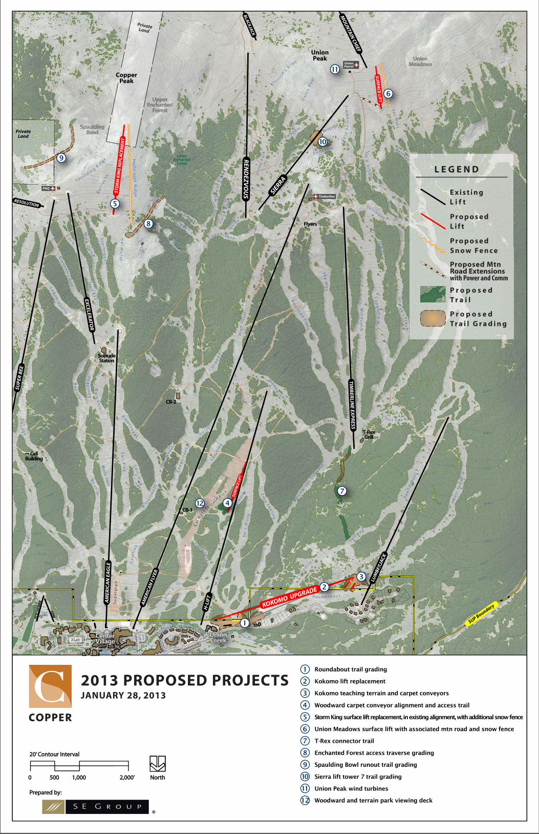
PROPOSED ACTION Components of the Proposed Action focus on addressing the needs that were previously identified. Each proposed project element is identified on the attached figure. If approved, construction of the proposed improvements would occur primarily in the summer months and, given the short construction season at Copper Mountain s higher elevations, could be expected to be completed over multiple construction seasons. In conjunction with any approved ground disturbing activities, best management practices would be implemented to avoid or minimize resource impacts (e.g., soil, water and vegetation). All disturbed areas would be revegetated and stabilized promptly.
Calculations presented in this NOPA document were produced using Geographic Information Systems (GIS) software and while accurate, they are approximate values. As further analysis is completed for the EA, these values will become more precise.
Lower Roundabout Grading The existing width of the lower Roundabout trail is significantly constrained immediately above the Union Creek base area and the base of the Kokomo Lift. This narrow area has never been remedied due to a large earthen berm in the current location of tower 3 of the Kokomo Lift and the presence of Union Creek where it enters a culvert and flows under the ski trail. As the Kokomo Lift is replaced, and tower 3 is removed/moved, there would be an opportunity to re-grade and improve this present choke point. The project would entail re-contouring the current ski trail to establish a consistent skiable grade (+/-10%) for guests as they flow into the base area. Approximately 5 acres of ground disturbance, including 0.2 acre of tree clearing, would also be required to establish the necessary width. While the majority of this project would be located on private property, the disturbance area does extend onto adjacent National Forest System lands. The total project area on National Forest would be approximately 1.6 acres.
Kokomo Lift Replacement and Teaching Facilities
terminal would be located in approximately the same position as the existing Kokomo top terminal. The bottom terminal would be located adjacent to the Union Creek base facilities, on Forest Service land. This new lift would be used for round trip skiing as well as to transport beginning skiers and riders to two conveyor surface lifts that are strategically planned for ease of access from the Kokomo
would be used by pecially on peak days when overflow teaching terrain is needed. The
proposed Kokomo Lift would be approximately 3,000 feet in length and have a capacity of 1,800 people per hour. Roughly half of the new lift alignment would be located on private property.
The Kokomo Lift replacement has a lengthy and complex approval history. The upgrade and replacement of the Kokomo Lift (in its current alignment) was originally authorized via a 1998 Supplemental Information Report. Subsequently, an Environmental Assessment/DN-FONSI1 was finalized in June 2002 which authorized the Kokomo Lift to be upgraded to a gondola, realigned, and lengthened to extend to the top of the present Lumberjack Lift. The lift approved under the EA was 1 Copper Mountain Resort Environmental Assessment Kokomo Lift and Teaching Terrain Improvements, June 2002.

Copper Mountain Resort 2013 Mountain Improvements Project Notice of Proposed Action
6
planned to be 6,830 feet in length and was authorized for 6.9 acres of tree removal to create the lift alignment corridor .2 Additionally this EA granted approval of a 300-seat food service facility, a water storage tank (180,000 gallons), necessary utilities, a teaching chairlift (1,384 feet in length), two surface conveyor lifts, and a new road segment all within the Kokomo/Lumberjack area.
Finally, the 2006 Trails and Facilities Improvements EIS reaffirmed the previous analysis of the Kokomo Lift upgrade with its inclusion of the project as a previously approved, unimplemented, reasonably foreseeable future action. The anticipated impacts of the lift replacement were included within the cumulative effects disclosure.
Given the lengthy history of approvals for this project, it would appear that sufficient documentation exists to allow the presently planned lift replacement and teaching facilities to be authorized without further analysis. However, the planned lift replacement, in its final configuration, has been included within this analysis to provide a final re-authorization of the project.
Woodward and Terrain Park Surface Lift To provide roundtrip access to enthusiasts of the Catalyst Terrain Park, a surface lift is planned to be located immediately to the west of the park adjacent to the Union Creek Express lift. Roughly 1,080 feet in length, this lift would have a capacity of 600 people per hour. The installation of this lift would primarily facilitate summer camps which are presently hosted in conjunction with the Woodward training program. The lift would partially utilize the existing clearing for the Union Creek Express and would additionally be aligned within the tree island to the east. It is anticipated that approximately 1.2 acres of timber would need to be cleared for the lift alignment.
Storm King Lift Replacement Constructed in 1985 and providing primary access to Spaulding Bowl and Upper Enchanted Forest/Copper Bowl, the current Storm King surface lift has served its purpose well. The present lift equipment is antiquated, requires excessive maintenance and operates unreliably. CMR proposes to replace the Storm King lift in essentially its present alignment. The new lift would also be configured as a surface lift approximately 1,900 feet in length and provide an hourly capacity of approximately 1,200 people-per-hour. In conjunction with replacing the lift, a segment of snow/wind fence is planned along the windward (west) side of the lift. The top terminal of the lift, and roughly the top 400 feet of the lift, and snow fence would be located on private land.
Union Meadows Surface Lift Facilitating access into Copper Bowl, a surface lift is proposed to be located west of the existing Sierra Lift in the Union Meadows area. Presently, guests wishing to access Copper Bowl must hike from atop the Sierra Lift to gain the ridge which allows them to drop into Copper Bowl. The proposed surface lift would allow guests to ride the Sierra Lift, ski to the west and take the surface lift to the ridge and thereby to Copper Bowl. This lift would be approximately 850 feet in length and have a capacity of 800 people per hour. To protect the lift from windscour, a snow fence would be installed along the windward (west) side of the lift for the majority of its length. Single phase power is present to the top of the existing Sierra Lift. At this time, CMR anticipates that an additional power line 2 Ibid. p. DN/FONSI-13

Copper Mountain Resort 2013 Mountain Improvements Project Notice of Proposed Action
7
would need to be installed from the primary feed located near the Timberline Patrol station to the bottom terminal of the planned surface lift. The additional power lground using a dozer and vibrating shoe, as was the existing power line in the mid-1990s. A short segment of construction access road would be necessary to reach the bottom terminal location. While equipment would be necessary at the top terminal location, access would be gained via a temporary construction access route without the need for a road.
T-Rex Connector Trail The proposed T-Rex Connector trail would provide improved access for guests wishing to ski from within the Timberline Express, Union Creek Express, and Kokomo/Lumberjack/Union Creek area. The existing skiing connection between these areas requires skiers and riders to utilize the Lower Woodwinds Traverse trail. This trail is very low angle and is off-camber making it difficult for skiers and nearly impassable for snowboarders. The planned trail would originate near the bottom terminal of the Timberline Express Lift and terminate adjacent to the top of the Kokomo Lift. This trail segment would be roughly 2,125 feet in length, have an average width of 50 feet and require approximately 2.3 acres of vegetation clearing. Additionally, ground re-contouring would be required in places (approximately 0.9 acre) to ensure an even, skiable grade along the length of the entire trail.
Enchanted Forest Access The existing entrance to the popular Enchanted Forest trail is presently a narrow and winding track created each season via an assortment of portable snow fencing and extensive hand shoveling. The guest experience remains poor throughout the season. To remedy this challenge, CMR proposes to rework the entrance through a combination of grading, rockwork (which may include rock stacking, blasting and relocation), and the construction of retaining wall segments on the downhill and uphill sides of the traverse. Additionally, a structural boardwalk may be constructed in sections of the traverse to provide a skiable surface. The overall length of the traverse to be improved is approximately 1,150 feet and the project would incorporate roughly 1.2 acres of terrain. While the final design of the project has not yet been completed, the overall goal would be to ultimately create a new trail entrance, which is frequently groomable and is roughly one snowcat in width (+/-25 feet).
Spaulding Bowl Run-out Trail The egress area of Spaulding Bowl is presently characterized by large boulders and talus which require extensive snow cover to become skiable. In many instances, the upper areas of Spaulding Bowl would recontour and smooth an adequate path out of the base of the bowl to allow grooming and skiing earlier in the season. Construction techniques would include rock removal, relocation and potentially blasting. Approximately 1,560 feet in length and varying width, the proposed grading area would be approximately 1.4 acres in total size. Of this total, 0.8 acre (910 linear feet) would be on National Forest System land with the remainder on private property.
Sierra Lift Tower 7 Grading Since the original construction of the Sierra Lift, the terrain immediately surrounding tower 7 has been problematic for skiing, grooming and snow retention. CMR proposes to grade, smooth and rock pick this area to create a more easily prepared skiing surface and to remove the abrupt break-over.
Copper Mountain Resort 2013 Mountain Improvements Project Notice of Proposed Action
8
The total area proposed for disturbance is approximately 1.2 acres. The site would receive full revegetation/reclamation at the completion of the grading project.
Union Peak Wind Turbines Furthering its commitment to sustainability and use of renewable energy, CMR proposes to install two vertical wind turbines in the vicinity of the Union Peak Ski Patrol Station. Capable of generating up to 2,000kWh per year, these turbines would be approximately 24 feet in height and have a circumference of roughly 24 inches. They would be mounted on a small concrete footer.
Woodward and Terrain Park Viewing Deck Enhancing the Catalyst Terrain Park, a new viewing deck is proposed to be constructed around the
-way along the park adjacent to A-Road. Constructed primarily of wood, the deck would be approximately 25 feet by 37 feet in size. A minimal amount of tree clearing may be necessary to provide space behind the existing building
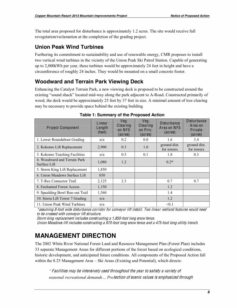
Table 1: Summary of the Proposed Action
Project Component L inear L ength (feet)
Veg. C learing on N FS (acres)
Veg. C learing on Priv. (acres)
Disturbance A rea on N FS
(acres)
Disturbance A rea on Private (acres)
1. Lower Roundabout Grading n/a 0.2 0.0 1.6 3.4
2. Kokomo Lift Replacement 2,900 0.3 1.0 ground dist. for towers
ground dist. for towers
3. Kokomo Teaching Facilities n/a 0.5 0.1 1.8 0.3 4. Woodward and Terrain Park Surface Lift 1,080 1.2 0.2* 5. Storm King Lift Replacement 1,850 6. Union Meadows Surface Lift 850 7. T-Rex Connector Trail 2,125 2.3 0.7 0.7 8. Enchanted Forest Access 1,150 1.2 9. Spaulding Bowl Run-out Trail 1,560 1.4 10. Sierra Lift Tower 7 Grading n/a 1.2 11. Union Peak Wind Turbines n/a <0.1 *assuming 8-foot wide disturbance corridor for conveyor lift install. Two linear wetland features would need to be crossed with conveyor lift structure. Storm king replacement includes constructing a 1,850-foot long snow fence. Union Meadows lift includes constructing a 970-foot long snow fence and a 475-foot long utility trench.
MANAGEMENT DIRECTION The 2002 White River National Forest Land and Resource Management Plan (Forest Plan) includes 33 separate Management Areas for different portions of the forest based on ecological conditions, historic development, and anticipated future conditions. All components of the Proposed Action fall within the 8.25 Management Area Ski Areas (Existing and Potential), which directs:
Facilities may be intensively used throughout the year to satisfy a variety of tection of scenic values is emphasized through

Copper Mountain Resort 2013 Mountain Improvements Project Notice of Proposed Action
9
application of basic landscape aesthetics and design principles, integrated with
convenient access to National Forest System lands in key portal locations with adequate public parking, base facilities, and community infrastructure. Base areas that serve as entrance portals are designed as gateways to public lands. They are architecturally designed to blend with the forest setting and contain convenient facilities and services that provide for the needs of forest visitors. 3
As part of the analysis, the Purpose and Need for Action and the Proposed Action are being reviewed to determine consistency with the Forest-wide/Management Area Goals and Objectives as well as the specific Standards and Guidelines for Management Area 8.25. The 2008 Southern Rockies Lynx Management Direction (SRLMD) amended the 2002 Forest Plan with respect to Forest-wide and Management Area 8.25 Canada lynx standards and guidelines. No inconsistencies between the Proposed Action and pertinent standards and guidelines have been identified at this time.
NATURE OF DECISION TO BE MADE The responsible official is the Forest Supervisor of the White River National Forest. The responsible official will review the upcoming EA and will consider the Purpose and Need for Action, the Proposed Action (and other potential alternatives), any public comments, and the administrative record in order to make this decision.
In addition to determining which alternative to select, the Forest Supervisor will also determine which Project Design Criteria (PDC) and best management practices (BMP) to require to avoid, minimize, and mitigate impacts to resources.
PUBLIC INVOLVEMENT The project was first listed in the Schedule of Proposed Actions in January 2013 and updates are provided quarterly. Further information about this project can be found on our website at http://www.fs.fed.us/nepa/fs-usda-pop.php/?project=41009.
ALTERNATIVES TO THE PROPOSED ACTION No Action The effects of not taking action will be analyzed as required by Council on Environmental Quality regulations (40 CFR 1502.14(d). By definition, the No Action Alternative represents a continuation of existing management practices without changes, additions, or upgrades to existing conditions. The No Action Alternative serves as the baseline for which to compare the potential environmental effects of the Proposed Action.
3 USDA Forest Service, 2002c p. 3-80

Copper Mountain Resort 2013 Mountain Improvements Project Notice of Proposed Action
10
EFFECTS AND ISSUES TO CONSIDER The EA will address the effects of the Proposed Action (and any alternatives) on the following resources: recreation, scenery, cultural environment, wildlife and aquatic species, vegetation, soil resources, and watersheds and wetlands. The EA will be issue-driven and contain detail commensurate to the degree to which a resource may be affected.
Issues are unresolved conflicts that arise as a result of the Proposed Action. Initially, the Forest Service has identified the following issues that will be analyzed in detail in the forthcoming EA. Preliminary analytical indicators are provided for each issue. Both issues and analytical indicators will be refined prior to, and within, the EA. As discussed, the Forest Supervisor may also require additional PDC and/or BMPs.
Human Environment Recreation Issue: By design, proposed projects would alter the recreational experience at CMR, particularly for beginners and families.
A nalytical Indicators & Requirements:
beginners and families.
Quantitative and qualitative analysis of existing and proposed guest service facilities and infrastructure.
Scenery Issue: Proposed projects may be visible from identified critical viewpoints.
A nalytical Indicators & Requirements:
Discussion of the Scenic Integrity Objectives (SIO) for the project area, as defined by the 2002 WRNF Land and Resource Management Plan.
Documentation of the incremental effects to the scenic environment resulting from implementation of the proposed projects compared to historic landscape alterations within the SUP area.
uilt Environment Image Guide (BEIG) as applicable to existing and proposed facilities.
Viewshed analysis, from identified critical viewpoints, of proposed landscape alterations as compared to the existing condition.
Cultural Issue: Proposed projects and associated ground disturbing activities may affect known or unidentified cultural resources.
Discussion of cultural surveys completed to date in the vicinity of the project area.
Inventory project area for cultural resources and historic properties.
Copper Mountain Resort 2013 Mountain Improvements Project Notice of Proposed Action
11
Biological Environment Wildlife and Aquatic Species Issue: Implementation of proposed projects (including construction and use) could affect Threatened, Endangered and Sensitive (T ES) and Management Indicator (MIS) wildlife and aquatic species.
A nalytical Indicators & Requirements:
Potential for the project to affect habitat for Region 2 Sensitive, Management Indicator, and Threatened/Endangered/ Candidate species.
Analysis of physical stream health in the project area and the effects on aquatic life.
Assessment of trout and macroinvertebrate populations in project area streams and at reference sites as based on field surveys.
Documentation of presence/absence of, and impacts to, sensitive amphibians and their habitat within the project area.
Identification of Lynx Analysis Unit (LAU) boundaries in relation to the project area.
Vegetation Issue: Plant communities (including Threatened, Endangered, and Sensitive [T ES] species, WRN F Species with an Identified Viability Concern [SIVC] and invasive plant species) may be impacted as a result of proposed projects.
A nalytical Indicators & Requirements:
Identification of threatened and endangered plant species and habitat present in the project area.
Identification of Region 2 sensitive plant species and habitat present in the project area.
Identification of WRNF species with an identified viability concern and habitat present in the project area.
Quantification (acreage) of proposed ground disturbance and overstory vegetation removal.
Identification of invasive species in the vicinity of the project area and use of BMPs to limit their spread.
Soil Resources Issue: Proposed ground disturbance may (individually and/or collectively) increase erosion and reduce soil organic matter.
A nalytical Indicators & Requirements:
Discussion of site-specific soil conditions and baseline inventory of soil organic matter.
Area (acres) of temporary and permanent disturbance according to high/moderate/low erodibility soils classes.
Analysis of increased erosion hazard due to ground disturbance.
Analysis of slope stability and geological constraints associated with project components.

Copper Mountain Resort 2013 Mountain Improvements Project Notice of Proposed Action
12
Watershed and Wetlands Issue: Proposed ground disturbance (e.g., clearing and grading) may contribute sediment and reduce stream bank stability in on-mountain drainages and affect riparian habitat, wetlands and fisheries.
Issue: Project activities may cause changes in surface and groundwater hydrology that support streams and wetlands.
Issue: Proposed ground disturbance (e.g. clearing and grading) may affect the quantity of wetlands within the Project Area.
A nalytical Indicators & Requirements:
Identification/quantification of waters of the U.S., including wetlands in the vicinity of the project area.
Identification of any Clean Water Act (CWA) impaired or threatened waterbody segments in the project area.
Quantification of connected disturbed areas (CDA) in the vicinity of the project area.
Identification of clearing and grading in the Water Influence Zone (WIZ).
Quantification of changes in water yield or discharge to receiving streams from proposed grading.
Narrative description of effects to wetland functions and values.
Other issues raised in response to this NOPA will be considered and addressed in the upcoming EA. Some issues may be addressed through modification of the Proposed Action, development of a new alternative, or mitigation measures.
SUMMARY OF RESOURCE SURVEYS AND INVENTORIES Wildlife & Vegetation Field Surveys Field surveys were conducted through all project component areas on July 26 and August 6, 2012. For plants, focused (intuitive controlled) survey methods were followed, with systematic surveys conducted at good quality potential habitat for all federally-listed, U.S. Forest Service (USFS) Region 2 (R2) sensitive species, and WRNF plant Species of Local Concern (SOLC). For animals, surveys characterized and field verified habitat and lynx habitat types and opportunistically searched for evidence of all federally-listed, proposed, and candidate species, USFS R2 sensitive species, Management Indicator Species (MIS), and migratory birds that may occur in the vicinity of project component areas or that may be affected otherwise by the implementation of the Proposed Action.
der habitat connectivity considerations. Project-specific field surveys supplemented the extensive plant, habitat, and animal database that is available for CMSA as a result of other project-related field.

Copper Mountain Resort 2013 Mountain Improvements Project Notice of Proposed Action
13
Impact Analyses and Environmental Consequences Field survey results have not been fully analyzed at the time of this writing, so project effects considered in this NOPA are general, qualitative, and tentative. Impacts of the action alternatives will be quantified with respect to direct losses of individuals of particular species, habitat types, lynx habitat types, and changes to LAU statistics. Reasonably foreseeable and reasonably certain project effects will be analyzed, as appropriate, on those species that would be affected by the action alternatives. Forest Plan and Southern Rockies Lynx Assessment (SRLA) consistency analyses will be conducted for all action alternatives. Project Design Criteria will be developed as measures required to avoid, minimize, and mitigate impacts to the plant and animal resources that could be affected by the action alternatives.
Federally Listed Threatened and Endangered Species The focal plant and animal issues associated with the Proposed Action will be potential project effects to the threatened Canada lynx (Lynx canadensis) and the four endangered, big river fish (humpback chub [G . cypha], bonytail [Gila elegans], Colorado pikeminnow [Ptychocheilus lucius], and razorback sucker [Xyrauchen texanus]). All project effects on lynx will be analyzed under the most current FS direction. A SRLA consistency analysis will be conducted for all action alternatives. If all the proposed projects fall within the range of impacts previously considered as part of other projects that have gone through Section 7 consultation and all are consistent with the SRLA, then no further consultation on lynx would be required for this project. Tentatively, the Proposed Action would not meaningfully impair existing habitat connectivity across the ski area and would be consistent with all applicable SRLA.
Other federally-listed and proposed species will be evaluated, including Penland alpine fen mustard (Eutrema penlandii), Uncompahgre fritillary butterfly (Boloria acrocnema), greenback cutthroat trout (Oncorhynchus clarkii stomias), and others as appropriate.
Forest Service Region 2 Sensitive Species Regarding R2 sensitive species, potential project effects will be evaluated on those plants and animals on current lists that could occur in the action area. No R2 plants were located within project component areas during specific surveys. Some R2 animal species and/or their habitats are present in project component areas. Determination of potential project effects to sensitive plants will consider the habitat requirements, number of individuals/ populations affected, size, density, vigor, and location of the affected population(s), total number of individuals and populations, and consequence of adverse effects on the species as a whole within the WRNF and within its range. Determination of potential project effects to sensitive animals (including insects, fish, amphibians, reptiles, birds, and mammals) will consider the area, configuration, and function of suitable and occupied habitat affected, home range size and number of individuals affected, size, density, and location of the population, and consequence of adverse effects on the species as a whole within the WRNF and within its range.
Management Indicator Species Regarding MIS, from the current list of Forest-wide MIS, elk (Cervus elaphus), aquatic macroinvertebrates, and all trout will be evaluated in detail as project MIS, based on Forest Plan selection criteria and the presence or potential occurrence of these organisms and their habitats on
Copper Mountain Resort 2013 Mountain Improvements Project Notice of Proposed Action
14
NFS lands within or adjacent to the project area. Other MIS were not selected as project MIS and will not be evaluated in detail because they do not occur on NFS lands in the project area and they and their associated habitats on NFS lands would not be affected by the Proposed Action.
Migratory Birds Regarding migratory birds, the analysis will consider project effects to migratory bird species that have been identified as candidates for conservation priority by at least one of the following five lists:
rvation Concern list for the Southern Rockies/Colorado Plateau Bird Conservation Region 16, (2) Colorado Partners in Flight Bird Conservation Plan for the Southern Rocky Mountains Physiographic Area (Area 62), (3) the Colorado State Threatened and Endangered list, (4) species designated as Sensitive by the U.S. Forest Service Rocky Mountain Region, (5) species listed under the federal Endangered Species Act, and (6) species designated as MIS on the WRNF.
Plant Species of Local Concern Regarding plant SOLC, the analysis will consider project effects to individuals and aggregations of those species located in the CMSA project component areas during focused (intuitive controlled) and systematic field surveys.
Water Resources The general hydrology of the CMR SUP area was extensively documented during the 2006 EIS process, and including an inventory of existing streamflow, stream health and water quality.
Wetlands Waters of the U.S., including wetlands within the project areas were delineated in 2012 to establish boundaries proximate to proposed project and ground disturbing activities. The U.S. Army Corps of Engineers conducted a site visit with the Forest Service on August 15, 2012, to review delineated and flagged boundaries. Flagged wetland and stream boundaries were GPSed and surveyed within project areas.
Archaeological Previous Cultural Resource Inventories within the CMR SUP Area All areas within the CMR SUP area that were proposed to receive ground disturbance as part of the 2006 EIS, including utility and lift corridors, new facilities locations, and new ski trails, had been surveyed in cultural resource inventories. These surveys included eight cultural resource inventories conducted in the CMR SUP, dating back to 1976. Two surveys were conducted in 1976 by Gordon and Kranzush Archaeological Consultants, and five additional surveys were conducted by Mariah Associates, Inc. in 1984, 1986, 1987, 1989, and 1993. In 2002, Metcalf Archaeological Consultants surveyed approximately 2,300 feet of the proposed North Cabin Chute trail and approximately 1,500 fee of the proposed Tucker Lift access road.

Copper Mountain Resort 2013 Mountain Improvements Project Notice of Proposed Action
15
COMMENT PROCESS At this time, the Forest Service is combining the scoping process with the legal notice and opportunity to comment, as described in 36 CFR 215.3. The public is encouraged to provide substantive comments on this Proposed Action, including supporting reasons the responsible official should consider in reaching a decision (36 CFR 215.6(a)(3). Substantive comments are within the scope and specific to the project and have a direct relationship to the proposed action. This will be your only time to submit formal written comments on this project.
Comments concerning this Proposed Action will be accepted for 30 calendar days following the publication of a legal notice in the Glenwood Post Independent, on or about February 8th, 2013. The regulations prohibit extending the length of the comment period.
Written comments must be submitted via mail, fax, or in person (Monday through Friday, 8:00 a.m. to 4:30 p.m., excluding holidays) to: Scott Fitzwilliams, Forest Supervisor, c/o Shelly Grail Braudis, Snow Ranger, PO Box 620, Silverthorne, CO 80498. Electronic comments including Word (.docx) or PDF attachments can be submitted to https://cara.ecosystem-management.org/Public/CommentInput?Project=41009. The name and mailing address of the person submitting electronic comments must be included.
It is the responsibility of persons providing comments to submit them by the close of the comment period. Only those who submit timely comments will have eligibility to appeal the subsequent decision under 36 CFR 215. Individuals and organizations wishing to be eligible to appeal must meet the information requirements of 36 CFR 215.6. Names and contact information submitted with comments will become part of the public record and may be released under the Freedom of Information Act.
If the agency determines there are no significant impacts, that finding along with the EA and a decision notice will be published. A 45-day appeal period will be provided after release of the EA, finding of no significant impact, and decision notice. If the EA concludes there is potential for significant impacts, then an environmental impact statement will need to be prepared.
Additional information regarding this action can be obtained from Shelly Grail Braudis, Snow Ranger at [email protected] or by phone at (970) 262-3484.
The U.S. Department of Agriculture (USDA) prohibits discrimination in all its programs and activities on the basis of race, color, national origin, gender,
religion, age, disability, political beliefs, sexual orientation, or marital or family status. (Not all prohibited bases apply to all programs.) Persons with disabilities
who require alternative means for communication of program information
(202) 720-2600 (voice and TDD). To file a complaint of discrimination, write USDA, Director, Office of Civil Rights, Room 326-W, Whitten Building, 14th and
Independence Avenue, SW, Washington, DC 20250-9410 or call (202) 720-5964 (voice and TDD). USDA is an equal opportunity provider and employer.
C
ata
a r k
C
ata
a r k
Su
pe
rpip
eS
up
erp
ipe
Su
pe
rpip
e
J ibb
er i sh
J ibb
er i sh
Hi g
h P
oin
t P
ar k
Hi g
h P
oin
t P
ar k
WWWeeeeee
sss tttTTTTTeee
nnnnMMMMMM
iiii lllleeee
RRRRoooooo
uuuuunnnnn
dddaaaaaaaaaaabbbbbbbbbbbb
ooooouuuuuu
tttttttttttt
FFFFFFaaa
iii rrrrr wwwwaaayyyyy
PPPPPPPPPPPPPrrroooooooooooooooossppppppecc ttoooo
r
SSSooo lll i lll oooqqqq uuuu yyyyy
CCC lllllll eeeee aaa rrr CCCCC uuuuuuuuuuuuuuuuuu t
IIIIIIIII ---WWWWWWWWWWWWWWWWWWWWWWWWWWaaaaaaaaaaaaaaaaaaayyyyyyyyyyyyyyyyyyy
JJJJJJJJaaaaccccccc
qqqqqqqqqqqqqqqquuuuuuuu
eeeee’’sssss
PPPPPiiiiiiii qqqq
uuuuueeeeee
TTTTTTTeeeemmmmmmmmppppppppppppp
ooooooooo
CCCCoooo
ppppppppppp
eeeeerrrrr fffffiiieeeeee
lllldddddd
WWWWWii nnnnn
dddssss
oooooonnnn
ggg
AAAAAmmmmmmmmm
eeeeeeeee rrrr iiiii ccccaaaaaaannnnnFFFFFllll yyyeeeee
rrr
TTTTTTThhhhh
eeeeeMMMM
oooozzzzzz
WWWWWWWWWWWooooooooooddddwwwwww
iiiinnnndddddsssss
TTTTTrrrraaaaavvvvvvvvvvvvvvveeeeerrrrr sssss
eeeeeee
EEEEEaaaaaaaa sss yyyyy
FFFFFeeeeeeeeee ll iiiiii nnggggg
VVVVee
iiinGGGGGG
lloooooorrrrr yyy
HHHHHHiiiddd
dddddeeee
nnnVVVV
eeeeeeiiii nnn
rr
LLLLLLLLLLLLLLLoooo
vvvv eeeee rrrr lllllll yyyyyyyyyyyyyyyyyyyy
LLLLaaaaaannnnnn
eeee
LLLLLooovvvvvvvveeeeeeeee rrr ll
yyyy
CCCCCCCCoooopppppppppppppppppppppppeeee rrr tttttt ooooo nnnnn ee
CCCCCCCCoo
ppppppppp
eeeeeeeeeeerr tttt
oonnnn
eee
III -DDDD
rr ooooppp
ppppppppeeeeeee rrr
LLL iiiiii bbbbbeeee rrrrrrrr tttttttt yyyyyyyyy
CCCCCCCCaaaaa
rrrreeeeeeeeeeeeeeeffffff rrrr
eeeeeee
CCCCaaaa rrrrr eeeeeeeeeeeeeeffffff rr
eeeeeeeeeee
MMMMMMMMMMMMMMM iiiiiiiiiiiiii nnnnnnnnnnn ooooooooooo rrrrrrrrrr MMMMMMMMMMMMaaaaaaatttttttttttt ttttttteeeeeeeeeerrr
WWWWWoooooooooodddddwwwww
iiiiiiii nnnnnn dddsssssss
UUnUnUUnUUUnnnnnnnnioioioioooioiooioioioioioii nnnnMMeMMeMMeMeMeMeMeMeMeMeMMMM adadaaddowowowowowwowowowwowo sssssssssss
WWWWWWhhhhhh
eeeeeeeeeeeeeeeeeeee
llllleeeerrrrr
CCCCCCCCCCCrrrreeeeeeeeeeeeeeeee
eeeeeeeeeeeekkkkkkkkkkkkkUUUUU
nnnniii ooooooo
nnnnnnnnnnGGGGGGGGGGGGG
aaaaaaaaaaaaappppppppppppppSSSSSS llllllllll uuuuuuuu iiii ccccc
eee
UUUUnnnnnnnnn
iiiooonnnnnn
PPaaaa
rr kkk
KKKKKK aaaaabbbbbbbb oooo oooooooo mmmmm vvvvvveeeennnnnggggeeee
TTTTTTTTiiiimmmmmm
bbbbbeee
rrrlllliiinnnneeeee
RRRRidddd
gggggggggggggggggggggggeeeeeeeeeeeeeeee
BBBBBBB lll i zzzzzzzzzzaaaaaaaaa rrrrr dddddd
’’’ssssss
AAAAAA llllll llllllll eeeeeeyyyyyy
UUUnnnn
iiiiiii ooooonnnn
BBBBBBBBoooooo
wwwwwwwwwlllll
UUUUUUUUUUUUUUUUUU tttttttttttttttttt eeeeeeeeeeeeeeee OOOOOOOOOOOOOOOOO vvvvvvvvvvvvvvvvvvvvvveeeeeeeeeeeeeeeerrrrrr llllllllllllll oooooooooooooooooooooooooooooookkkkkkkkkkkkkkk
SSSSSSSSSSSSSSSSllllllllllllll iiiiiiiiiiiiiii pppppppppppppppppppppp NNNNNNooooooooootttttt
kkkkkkkkk iiii nnnnnnnnnnnnnnnnnngggggggggggggggggggGGGGGGGGGGGGGGGGGGGGGG
llllllllllll aaaaaaaaaaaaaaaaaaaaa ssssssssssssssssssss ssssssssssssss
UpUpUpUpUpUpppUUpUpppppepepepepep rrrrrEnEnEnEnEnnEnchchchchccchchchchcc ananannnaananannteteteeteeteteeeddddddddd
FoFoFoFFoFoFFFFoFoFF rerereerreereestssststsststs
SSSSSSSSSSS eeeeeeeeeeeeeeeeeeeeeeeee &&&&&&&&&&&&&&&&&&&&& SSSSSSkkkkk iiii
UUUUUUppppppppppppppppppppppppppp
eeeeeeeeeeeeeeerrrrrrrrrrrrrrrrSSSSSSSSSSSSSSSkkkk
iiiiddddRRRRRRRRRRRRooooooooooo
aaaaaaaddddddddddddddd
BBBB iiiii ttttttt tttteee rrrr ssswwweeeeeeeeeeeeeee
eeee ttttt
BBBB iiiiiii ttttttt e
rr sswwwwww
eeeeee
tttt
FFFFFFFaaa
i rrrPPPPPPP
ll aaayyyyyyy
FFFFFFoooooou
lllPPP
llll aaaaaaaaaaaaaaaayyyyyyyy
MMMMMMaaaaa
iiiii nnnnnVVVVVVVV
eeiiii nnn
RRRRRRRRhhhhhh
aaaaaaaapppppp
sssooooddddddd
yyyyy
BBBBBBBBBBooooo
uuuunn
ccccceeeeerrrrrr
BBBBooooo
uuuuunnn
ccceeeeerrrrr
MMMMMMaaaaa
iiii nnnnnnnVVVVVV
eeeiiiii nnnn
SSSSSSSSSSSSSSSSkkkkkk iiiiiidddddddddddd RRRRRRRRRRRRR oooo aaaa dd
CCCCCoooooppppppppppppp
eeeerrrrr oooo
pppoooooo lll iiii ssss
BBBBrrrrreeeeennnnnnnn
nnnnnaaaaannnnn
’’’’’sssssGGGGGGGG
rrrrr iiiii nnnnnCCCC
dddddd lll ’sssssss
MMMMMMMMMMMMMMMMiiiiiiinnnnnnnn
eeeeeeeeeeeeeeDDDDDDDDDDDDD
uuuuummmm
pppppppppppppppppp
PPPPtttt aaaa
rrrmmmmmmigggg
aaaannnn
TTTTTrrrrrraaaaa
iiii ll###
220
HHHHHaaaaaaaa
lllllllleeelllluuuuuu
jjjjjjjjjjaaaaahhhhh
SSS pppp aaaa u lllllll dddddii nnnnn
ggggRRRRR iii ddddd
gggggggggeeeeBBBBBBB
aaa rriii lll
ooooccccchhhhhhhhh
eeee
SpSSpSpSpSpSpSpSpSSpSpSS auauauauauuuuauuuuuua ldldlddldlddldlll ininininnnininnnnnnggggggggggggBoBoBoBoooBoBooBooooowlwwlwwlwwlwlwlwlwwlww
CCCCCooooo
lllllllll llll aaagggg
eee
An
dy
’sE
nco
re
GreenGreeneenAcresAcAcrAcrAcrAcrAcresAcresAcAcresAcrAcrAcrAcrAcrrr
OOOOv
erlo
adddd
OOOOOOrrr eeeee
DDDDDDDDeeee
aaaallll
HHHHiiiii gggg
hhhhhhPPPPPP
oooooooooiiiiii nnnnnn
ttttttt
RRRRR eeeeetttt rrrrrrreeeeeaaaaaatttttt
GGGooo
lldddddDDD
iiii gggggggggggg
eeeerrrrrrrrr
FaaaarrrrWWWWW
eeeeees tttt
LowerEnchanted
Forest
Ha
lH
al
Ha
lH
al
Ha
Ha
lH
al
Ha
lH
lel
l el
ll el
lll eu
j au
j au
j ajjh
Rh
Rh
RRh
RRid
gidid
gid
gididi
geee
11
AM
ERIC
AN
EA
GLE
LUM
BERJ
ACK
KOKOMO UPGRADE
MO
UN
TAIN CH
IEF
BLACKJACK
AMER
ICAN
FLY
ER
SUPE
R BE
E
RESOLUTION
REND
EZVO
US SIE
RRA
TIMBERLIN
E EXPRESS
UnionPeak
CopperPeak
UnionUnionCreekCreek
CenterCenterVillageVillageB LotB Lot
ChapelChapelLotLot
CB-1
T-RexGrill
Flyers
SolitudeStation
PITC
HFO
RK
GEM
SUP Boundary
CB-2
EXCELERATO
R
STO
RM K
ING
REP
LACE
MEN
T
UnionPatrol
PHQ
Timberline
Union Creek LotUnion Creek Lot
H-L
IFT
1
RRRRR oooooo uuu nnnnnnnn dddddddd aaaaa bbbbb oooo uuuuu tttttDDEEE 2
LUM
UM
LUM
LUBE
RB
J
3
SSSSSSSSSccooooooooo ttt eeeeeeeeeeeeeeeerrrrr
aaaa rrr kk
SSSSSS4
ttaaaaaaaaaa
B-112
9
LLLLLLLLLLLooooooooooooooooooooooooooookkkkkkkkkk iiiiiii
8
RRRRReeeeeevvvvvvvvveeeeeeeenngg
EEEEEEEE nnnn dddddddddddd eeeeeee aaaaaaaaaa vvvvvvvvv oooooooooooo rrrrrrr10
SURF
ACE
LIFT
FFFFaaa
6
SURFA
CE LIFT
7
STS
5
CellBuilding
PriPrivatvatateLandd
PrivateLand
0 500 1,000 2,000’0 500 1,000 2,000’
20’ Contour Interval20’ Contour Interval
NorthNorth
2013 PROPOSED PROJECTSJANUARY 28, 2013
E x i s t i n gL i f t
L E G E N D
P r o p o s e dL i f t
P r o p o s e dT r a i l
P r o p o s e dTr a i l G r a d i n g
P r o p o s e dS n o w Fe n c e
Proposed MtnRoad Extensionswith Power and Comm
1 Roundabout trail grading
2 Kokomo lift replacement
3 Kokomo teaching terrain and carpet conveyors
12 Woodward and terrain park viewing deck
9 Spaulding Bowl runout trail grading
5 Storm King surface lift replacement, in existing alignment, with additional snow fence
8 Enchanted Forest access traverse grading
10 Sierra lift tower 7 trail grading
11 Union Peak wind turbines
6 Union Meadows surface lift with associated mtn road and snow fence
7 T-Rex connector trail
4 Woodward carpet conveyor alignment and access trail
R
Prepared by:Prepared by: