COORDINATION OF SECTION 106 AND LONG RANGE...
97
COORDINATION OF SECTION 106 AND LONG RANGE TRANSPORTATION PLANNING NCHRP 25-25/TASK 87 Requested by: American Association of State Highway and Transportation Officials Standing Committee on the Environment Prepared by: ICF International SRI Foundation Marie Venner Consulting July 29, 2014 The information contained in this report was prepared as part of NCHRP Project 25-25, Task 87, National Cooperative Highway Research Program, Transportation Research Board. SPECIAL NOTE: This report IS NOT an official publication of the National Cooperative Highway Research Program, Transportation Research Board, National Research Council, or The National Academies.
Transcript of COORDINATION OF SECTION 106 AND LONG RANGE...

COORDINATION OF SECTION 106 AND LONG RANGE TRANSPORTATION PLANNING
NCHRP 25-25/TASK 87
Requested by:
American Association of State Highway
and Transportation Officials
Standing Committee on the Environment
Prepared by:
ICF International
SRI Foundation
Marie Venner Consulting
July 29, 2014
The information contained in this report was prepared as part of NCHRP Project 25-25, Task 87, National Cooperative Highway Research Program, Transportation Research Board. SPECIAL NOTE: This report IS NOT an official publication of the National Cooperative Highway Research Program, Transportation Research Board, National Research Council, or The National Academies.

COORDINATION OF SECTION 106 AND LONG RANGE TRANSPORTATION PLANNING
Acknowledgements
This study was requested by the American Association of State Highway and Transportation Officials (AASHTO), and conducted as part of the National Cooperative Highway Research Program (NCHRP) Project 25-25. The NCHRP is supported by annual voluntary contributions from the state Departments of Transportation. Project 25-25 is intended to fund quick response studies on behalf of the AASHTO Standing Committee on the Environment. The report was prepared by Terry H. Klein, Principal Investigator, SRI Foundation; David Cushman, SRI Foundation; Marie Venner, Venner Consulting; and Beverly Bowen, ICF International. The work was guided by a task group chaired by Gail D’Avino, Georgia Department of Transportation. The task group included Margaret Barondess, Michigan Department of Transportation; Craig Casper, Pikes Peak Area Council of Governments; Paul Herskowitz, CDM-Smith; Kurt Roedel, Oregon Department of Transportation; Andrea MacDonald, Pennsylvania Historic Preservation Office; Elizabeth B. Rushley, Lawhorn & Associates; Mario Sanchez, Texas Department of Transportation; Lynn Zanto, Montana Department of Transportation; and MaryAnn Naber, Federal Highway Administration. The project was managed by Nanda Srinivasan, NCHRP Senior Program Officer.
Disclaimer
The opinions and conclusions expressed or implied are those of the research agency that performed the research and are not necessarily those of the Transportation Research Board or its sponsors. The information contained in this document was taken directly from the submission of the author(s). This document is not a report of the Transportation Research Board or of the National Research Council.
ii
COORDINATION OF SECTION 106 AND LONG RANGE TRANSPORTATION PLANNING
TABLE OF CONTENTS EXECUTIVE SUMMARY .................................................................................................................................. v
1.0 INTRODUCTION ....................................................................................................................................... 1
2.0 BACKGROUND ON LONG RANGE TRANSPORTATION PLANNING ........................................................... 3
2.1 INTRODUCTION ................................................................................................................................... 3
2.2 MPO LONG RANGE PLANNING............................................................................................................ 3
2.3 STATEWIDE LONG RANGE PLANNING ................................................................................................. 4
2.4 PROGRAMMING .................................................................................................................................. 5
2.5 ENVIRONMENTAL REVIEW – PROJECT DEVELOPMENT ...................................................................... 5
3.0 LITERATURE REVIEW ............................................................................................................................... 7
3.1 RESULTS OF LITERATURE REVIEW ....................................................................................................... 7
3.2 SUMMARY ......................................................................................................................................... 12
4.0 INITIAL SURVEY OF STATE DOTS AND MPOS ........................................................................................ 13
4.1 METHODS .......................................................................................................................................... 13
4.2 RESULTS............................................................................................................................................. 13
4.2.1 Survey Responses from DOT Cultural Resources Management Staff ........................................ 13
4.2.2 Survey Responses from DOT Planning Staff ............................................................................... 19
4.2.3 Survey Responses from MPO Planning Staff.............................................................................. 23
4.2.4 Summary of Survey Responses .................................................................................................. 29
5.0. INTERVIEWS ......................................................................................................................................... 31
5.1 INTRODUCTION ................................................................................................................................. 31
5.2 INTERVIEW APPROACH ..................................................................................................................... 31
5.3 RESULTS OF INTERVIEWS: PATTERNS AND THEMES ......................................................................... 33
5.3.1 The Benefits of Considering Historic Preservation Factors During Long Range Planning.......... 34
5.3.2 Use of Cultural Resource Databases in Long Range Planning. ................................................... 35
5.3.3 Consultation among State DOTs, MPOs, and SHPOs. ................................................................ 37
5.3.4 Linking Long Range Planning, Programming and Project Development. ................................... 39
5.3.5 Form of Long Range Plans Best Suited for Considering Historic Preservation Factors. ............. 40
6.0 CASE STUDIES ........................................................................................................................................ 41
6.1 INTRODUCTION ................................................................................................................................. 41
6.2 ATLANTA REGIONAL COMMISSION (ARC) ........................................................................................ 42
6.3 FLORIDA DOT .................................................................................................................................... 44
6.4 HILLSBOROUGH COUNTY FLORIDA MPO .......................................................................................... 47
6.5 MICHIGAN TRI-COUNTY REGIONAL PLANNING COMMISSION ......................................................... 48
iii

COORDINATION OF SECTION 106 AND LONG RANGE TRANSPORTATION PLANNING
6.6 OREGON DOT .................................................................................................................................... 49
6.7 PENNSYLVANIA DOT.......................................................................................................................... 51
6.8 PENNSYLVANIA - LEBANON COUNTY MPO ....................................................................................... 54
6.9 PENNSYLVANIA - DELAWARE VALLEY REGIONAL PLANNING COMMISSION .................................... 56
6.10 WISCONSIN DOT ............................................................................................................................. 58
7.0 CONCLUSIONS ....................................................................................................................................... 61
7.1 BENEFITS OF CONSIDERING HISTORIC PRESERVATION FACTORS DURING LONG RANGE PLANNING ........................................................................................................................................ 61
7.2 KEYS TO EFFECTIVE PRACTICES ......................................................................................................... 62
7.3 SOME FINAL OBSERVATIONS ............................................................................................................ 64
7.4 SUGGESTIONS FOR ADVANCING RESULTS OF THIS STUDY ............................................................... 67
REFERENCES ................................................................................................................................................ 70
Appendix A: NCHRP 25-25, TASK 87 SURVEY QUESTIONNAIRE FOR STATE DEPARTMENTS OF TRANSPORTATION ...................................................................................................................................... 73
APPENDIX B: NCHRP 25-25, TASK 87 SURVEY QUESTIONNAIRE FOR METROPOLITAN PLANNING ORGANIZATIONS ......................................................................................................................................... 76
APPENDIX C: INTERVIEWED STATE DEPARTMENTS OF TRANSPORTATION, METROPOLITAN PLANNING ORGANIZATIONS, AND STATE HISTORIC PRESERVATION OFFICES (MARCH – APRIL 2014) ....................... 78
APPENDIX D: SUMMARY OF INTERVIEWS................................................................................................... 80
D.1. SUMMARY OF DOT INTERVIEWS (CRM STAFF AND PLANNING STAFF) .......................................... 80
D.2. SUMMARY OF MPO INTERVIEWS .................................................................................................... 83
D.3. SUMMARY OF SHPO INTERVIEWS ................................................................................................... 86
iv

COORDINATION OF SECTION 106 AND LONG RANGE TRANSPORTATION PLANNING
EXECUTIVE SUMMARY
Research Objectives and Approach
The National Cooperative Highway Research Program’s (NCHRP) 25-25, Task 87 study examines how state Departments of Transportation (DOTs) and Metropolitan Planning Organizations (MPOs) consider historic preservation factors in their long range transportation planning process. Long range planning is the process through which the transportation goals for a state, region or metropolitan area are established using a 20-year planning horizon. “Considering historic preservation factors during long range planning” refers to developing long range plans that identify historic properties, consider state and local historic preservation goals, and if possible, result in projects that avoid or minimize impacts to historic properties. Historic properties include, but are not limited to, archaeological sites, the historic built environment, historic landscapes, and places of religious and cultural significance to tribes (i.e., traditional cultural properties or TCPs), that are listed in or eligible for listing in the National Register of Historic Places. This study also looks at the role of State Historic Preservation Offices (SHPOs) in this planning process, and how consultation with SHPOs and considering historic preservation factors during planning streamlines and enhances subsequent Section 106 project reviews. The first element of this study is a literature review. This included a review of all state long range plans available on-line. The second element is an initial survey of state DOT cultural resource management (CRM) and transportation planning staffs, and MPOs. The purpose of the survey is to determine which state DOTs and MPOs consider historic preservation factors during long range planning, which do not, and why. Based on the results of the literature review and initial survey, a sample of state DOT CRM and transportation planning staffs and MPOs were selected for interviews. The DOT and MPO interviews focused on how these agencies and organizations consider historic preservation factors during long range transportation planning. In the initial survey, the project team asked if a DOT or MPO consulted with their SHPO about the consideration of historic preservation factors in long range planning. Based on the responses from the DOTs and MPOs, a number of SHPOs were also selected for interviews. Finally, the project team and the NCHRP panel identified nine (9) case studies based on the literature review, survey, and interviews. The case studies demonstrate how early consideration of historic preservation factors during long range planning streamlines and enhances both the Section 106 project review process and project delivery.
v
COORDINATION OF SECTION 106 AND LONG RANGE TRANSPORTATION PLANNING
Major Findings
Many state DOTs and MPOs include historic preservation goals and objectives in their long range transportation plans. These goals and objectives generally focus on the importance of avoiding and minimizing impacts to historic properties, and in some cases, enhancing these resources. These goals and objectives are usually addressed in the context of Section 106 compliance, during project development. There are several DOTs and MPOs, however, who begin to address these goals and objectives during long range planning, long before the start of Section 106. These DOTs and MPOs have developed programs or implement approaches that identify historic properties within proposed project areas identified in long range plans, assess impacts on these properties from the proposed projects, and consult with their SHPOs and other stakeholders about historic preservation issues associated with these projects. The results of these identification, evaluation, and consultation efforts are then used for decision-making in programming and project development. There are several reasons why some DOTs and MPOs have comprehensive and detailed programs and approaches for considering historic preservation factors during long range planning:
Identifying and avoiding potential fatal flaws and “red flags.” These fatal flaws and “red flags” include historic properties that would be protected under Section 4(f), or would require extensive and complex Section106 reviews and activities. With information from long range planning, DOTs and MPOs can identify transportation solutions and/or project alternatives that avoid these fatal flaws and “red flags,” or even screen out projects and alternatives from further consideration, either in programming or project development, given the scale of potential impacts. Streamlining and enhancing Section 106 project reviews. Information and decisions made during long range planning are refined and supplemented as projects move forward into programming and then again during project development. As a result, Section 106 reviews can focus on those aspects of the historic preservation environment that were not considered during planning or need to be refined due to changes over time. Having a more realistic scope, cost, and schedule for project development. With an understanding of the full range of historic preservation issues associated with a proposed project, based on work done in long range planning and programming, DOTs and MPOs are able to more realistically schedule and cost project development, and plan the extent of Section 106 consultation with SHPOs and other project stakeholders.
vi

COORDINATION OF SECTION 106 AND LONG RANGE TRANSPORTATION PLANNING
Fulfilling local historic preservation goals and values. All of the MPOs showcased in this study are concerned about maintaining the quality of life and character of their communities, and this character is often grounded in the historic built environment. Through the early consideration of historic preservation in long range planning and programming, MPOs can identify transportation solutions and alternatives that balance the need for maintaining and improving local transportation systems with the need to maintain and enhance the local historic environment; and screening out those solutions and alternatives that adversely impact this element of the local environment, especially when historic preservation plays a big role in the local economy.
The keys elements for effectively considering historic preservation during long range planning include 1) using Geographic Information Systems (GIS), 2) conducting a corridor or regional scales of analysis, and 3) consulting and engaging SHPOs and other stakeholders:
Geographic Information Systems. GIS is one of the primary tools DOTs and MPOs use to consider historic preservation factors during long range planning. In fact, many of the long range planning activities conducted by the DOTs and MPOs are only possible through the access and use of a historic property GIS. Several DOTs and some MPOs obtain historic property information for their long range plans from an in-house cultural resource GIS. Others obtain this information from an on-line GIS maintained by the SHPO and/or an on-line GIS maintained by another entity, such as a state university. A few of these GIS not only include an inventory and maps of historic properties, they also include on-line tools for performing environmental and project screening analyses. These analyses are used to compare proposed transportation projects to environmental/historic preservation resource datasets, and to estimate each project’s potential effects on these resources. These GIS also store this information and analyses for use in subsequent project planning and development phases so identified environmental issues are considered during these phases. Scales of Analysis. In discussing the form of long range plans best suited for considering historic preservation factors, the DOTs and MPOs agreed that long range corridor planning was one of the most effective scales of analysis. With well-defined limits and study areas, it is fairly straightforward to collect and map historic property information, similar to what is done during project development/Section 106 reviews. SHPOs interested in participating in long range planning also saw greater value to commenting on historic preservation issues associated with corridor studies, as opposed to statewide plans and MPO plans that often do not provide detailed information on project locations, descriptions, and alternatives. Some DOTs and MPOs also saw the value of taking a regional approach, documenting the location of classes of known and potential historic properties and/or sensitivity areas for regions within a state. This approach is
vii

COORDINATION OF SECTION 106 AND LONG RANGE TRANSPORTATION PLANNING
most effective when the regional plans include project-specific locational and descriptive information. Consultation with SHPOs and Local Stakeholders. Several of the interviews and case studies demonstrate the value of involving the SHPO in long range planning. Through this early consultation, the DOTs, MPOs, and SHPOs work together to identify historic properties and preservation issues. The goal of this early consultation is to identify transportation solutions that avoid and minimize impacts to historic properties, prior to the initiation of Section 106. This early consultation also results in a more focused and targeted Section 106 process, streamlining both Section 106 reviews and project development. DOTs and MPOs also saw the value of consulting with local stakeholders who have an interest in historic preservation. Through this consultation, DOTs and MPOs can identify preservation concerns of local communities, including the preservation value of specific properties. DOTs and MPOs would be criticized by local citizens if the DOTs and MPOs did not give full consideration to potential impacts to historic properties valued by these citizens, especially if these properties have both economic and cultural importance.
Though there are several benefits to considering historic preservation factors during long range planning, the initial survey showed that about half of the state DOTs do not consider these factors during this planning phase. In addition, when asked whether SHPOs participate in the long range planning process, 62% of the state DOT CRM staff, 51% of the MPOs, and 41% of the DOT planners said “no.” When asked which environmental factors were considered during long range planning, when historic preservation factors were not considered, the DOTs noted that their agencies place a high priority on biological factors, wetlands, air and water quality, and environmental justice. The MPO’s had a similar response. These statements are not surprising since Section 106 is a process that does not establish an outcome. The laws associated with the other environmental factors, such as endangered species, wetlands, and air and water quality, are, however, substantive statutes and require a defined outcome. This study also showed that some SHPOs saw no value in their participation in long range planning. The SHPOs noted that the plans they are asked to comment on tend to be very general and conceptual. When the plans include proposed projects, there is often little background information describing the projects, and there is no information on historic properties that may be affected by these projects; therefore, there is little for the SHPO to review and comment on. Some of these SHPOs noted they cannot make the case for participating in long range planning meetings or commenting on the long range plans. Their participation is hard to justify if not associated with a specific project. They need to focus on their Section 106 compliance responsibilities, and to be able to respond to requests for review and comment within required time frames.
viii

COORDINATION OF SECTION 106 AND LONG RANGE TRANSPORTATION PLANNING
The above findings and observations represent hurdles to promoting and advancing the consideration of historic preservation factors during long range planning. Given these hurdles, the project team recommends presenting the results of this and related studies at national meetings of state DOT and MPO transportation planners, such as those sponsored by the Transportation Research Board, the American Association of State Highway and Transportation Officials and the Association of Metropolitan Planning Organizations. Presentations are also recommended at the national meetings of the National Conference of State Historic Preservation Officers. In 2012, FHWA completed a report showcasing innovative and effective state DOT and local transportation agency programs that consider historic preservation factors in planning and early project development. The report is entitled “Planning and Environmental Linkages for Historic Preservation.” As part of this effort, FHWA developed a one-day, facilitated workshop as a way to disseminate information about these innovative programs; and more importantly, to aid state DOTs and local transportation agencies that want to improve their existing environmental review and project delivery programs. During this workshop, participants identify specific approaches and tools to improve and enhance their current programs through early coordination and identification of resources, issues, and consulting parties; and, participants develop an action plan for developing, implementing, and maintaining these approaches and tools. The project team recommends using this facilitated workshop as a venue for disseminating the results of the current NCHRP study, and promoting the benefits of considering historic preservation factors during long range planning. Further, participants in these workshops should include DOT planning and CRM staffs, MPOs, and SHPOs.
ix
COORDINATION OF SECTION 106 AND LONG RANGE TRANSPORTATION PLANNING
1.0 INTRODUCTION
Consideration of environmental factors during transportation planning is an important element of the environmental sections of the Moving Ahead for Progress in the 21st Century Act (MAP-21). Considering environmental factors during planning is also included in Section 6001 of the Safe, Accountable, Flexible, and Efficient Transportation Equity Act: A Legacy for Users (SAFETEA-LU, 2005). Under Section 6001, state Departments of Transportation (DOTs) and Metropolitan Planning Organizations (MPOs) are to consult, as appropriate, with state and local agencies responsible for a range of resource categories, including historic preservation, when developing long range transportation plans. Further, as part of this planning process, state DOTs and MPOs must consider, if available, inventories of natural and historic resources. The Federal Highway Administration’s (FHWA) “Every Day Counts” initiative echoes MAP-21’s and SAFETEA-LU’s goals of adequate consideration of important environmental issues early in the transportation planning process, and improving coordination and consultation associated with various resource agencies involved in transportation projects. The Every Day Counts initiative also promotes more effective linkages between environmental considerations during planning and the National Environmental Policy Act (NEPA) review process. This is accomplished, in part, through FHWA’s Planning and Environmental Linkages (PEL) program.
Building on FHWA’s Every Day Counts initiative and the PEL program, this National Cooperative Highway Research Program (NCHRP) study examines how state DOTs and MPOs consider historic preservation factors in their long range transportation planning process. This study also looks at the role of State Historic Preservation Offices (SHPOs) in this planning process, and how consultation with SHPOs and considering historic preservation factors during planning, streamlines and enhances subsequent Section 106 project reviews. Long range planning is the process through which the transportation goals for a state, region or metropolitan area are established using a 20-year planning horizon.
For the purpose of this study, “considering historic preservation factors during long range planning” refers to developing long range transportation plans that identify historic properties, consider state and local historic preservation goals, and if possible, result in projects that avoid or minimize impacts to historic properties. Historic properties include, but are not limited to, archaeological sites, the historic built environment, historic landscapes, and places of religious and cultural significance to tribes (i.e., traditional cultural properties or TCPs), that are listed in or eligible for listing in the National Register of Historic Places.1
The first element of this study is a literature review. This review focuses on long range planning, and looks at materials not examined by previous NCHRP and FHWA studies on the
1 The term “cultural resources” is also used in this report. Cultural resources include “historic properties,” in addition to historical/archaeological places that have not been evaluated in terms of eligibility for listing in the National Register.
1

COORDINATION OF SECTION 106 AND LONG RANGE TRANSPORTATION PLANNING
consideration of historic preservation factors during planning. The second element is an initial survey of state DOT cultural resource management staff (CRM) and transportation planners, and MPOs. The purpose of the survey is to determine which state DOTs and MPOs consider historic preservation factors during long range planning, which do not, and why.
Based on the results of the literature review and initial survey, the project team interviewed a sample of state DOT cultural resource management and transportation planning staff and MPOs. The DOT and MPO interviews focused on how these agencies/organizations consider historic preservation factors during long range transportation planning. The purpose of these interviews was to identify the specific types of historic preservation information included in long range transportation plans, how this information is obtained, and most importantly, how this information is used in subsequent decision making (i.e., during programming and project development).
In the initial survey, the project team asked if a DOT or MPO consulted with their SHPO about the consideration of historic preservation factors in long range planning. Based on the responses from the DOTs and MPOs, the project team, in consultation with the NCHRP panel, selected a sample of SHPOs for interviews. The SHPO interviews examine how they participate and are consulted during the state DOT’s and/or MPOs’ long range planning process.
Based on the interviews, the project team, in consultation with the NCHRP panel, identified nine (9) case studies. The case studies describe the use of a variety of tools and approaches for considering historic preservation factors in long range planning. Some also illustrate how early consideration of historic preservation factors during long range planning streamlines and enhances both the Section 106 project review process and project delivery. The following section describes how long range planning is conducted by MPOs and state DOTs.
2

COORDINATION OF SECTION 106 AND LONG RANGE TRANSPORTATION PLANNING
2.0 BACKGROUND ON LONG RANGE TRANSPORTATION PLANNING
2.1 INTRODUCTION
The requirements for developing state and MPO long range transportation plans are defined by the federal regulations for transportation planning (i.e., 23 CFR Part 450). Each transportation reauthorization passed by Congress has the potential to revise these requirements; however, the basic structure for MPO and statewide transportation plans tends to remain consistent, with most changes focusing on additional or restated requirements.
2.2 MPO LONG RANGE PLANNING
A MPO is designated for each urbanized area with a population of at least 50,000 “to carry out a continuing, cooperative, and comprehensive multimodal transportation planning process” (23 CFR Part 450.300(a)). This “3-C” process is the basis for transportation decision making in all metropolitan regions. The MPO long range plan is the first step in the selection of potential system improvements. The MPO plan has a minimum 20-year planning horizon and is updated every four to five years, depending on the area’s status with respect to air quality conformity. At a minimum, the plan includes goals and a vision for the region; and, identifies existing and future transportation deficiencies, and strategies for addressing these deficiencies through targeted improvement projects. The MPO planning process is structured around eight planning factors, which the long range plan must address. The current planning factors under the MAP-21 are:
1. Support the economic vitality of the metropolitan area, especially by enabling global competitiveness, productivity, and efficiency;
2. Increase the safety of the transportation system for motorized and non-motorized users;
3. Increase the security of the transportation system for motorized and non-motorized users;
4. Increase accessibility and mobility of people and freight; 5. Protect and enhance the environment, promote energy conservation, improve the
quality of life, and promote consistency between transportation improvements and State and local planned growth and economic development patterns;
6. Enhance the integration and connectivity of the transportation system across and between modes, for people and freight;
7. Promote efficient system management and operation; and
3

COORDINATION OF SECTION 106 AND LONG RANGE TRANSPORTATION PLANNING
8. Emphasize the preservation of the existing transportation system (23 CFR Part 450.6(a)). The requirement to “protect and enhance the environment” is the earliest specific connection between long range planning and historic preservation. Because historic preservation is under the environment “umbrella”, many MPOs discuss historic preservation under this factor in long range planning. This environmental planning factor has been in place through many reauthorizations; however, SAFETEA-LU defined the individual aspects of the environment – including historic preservation. SAFETEA-LU’s emphasis on consultation and coordination strengthens the linkages between transportation planning and environmental considerations. It requires that the MPO “consult with agencies and officials responsible for other planning activities” (23 CFR Part 450.316(3) (b)), in developing the long range plan. These other planning activities include environmental protection, and this is to be coordinated with the planning process “to the maximum extent practicable” (23 CFR Part 450.316(3b)). SAFETEA-LU also requires the consideration of potential mitigation activities, as well as an adopted Participation Plan to document the consultation process.
2.3 STATEWIDE LONG RANGE PLANNING
The long range transportation plan required of state DOTs also must have a 20-year planning horizon; however, in contrast to the very specific requirements of the metropolitan long range plan, the state DOT plan is less proscriptive. The structure of state plans varies widely across the country. In most cases the statewide plan is a policy document that provides the goals and objectives of the agency, often with respect to how funding will be allocated. Some state DOTs develop an investment strategy to meet the long range planning requirements. This type of plan is more targeted to anticipated revenue and identifies ways in which revenue will be spent. In the past, many transportation agencies focused on system expansion, with new construction taking the bulk of the funding. Now, many agencies are devoting most of their resources to system management and maintenance. One additional structure for the statewide long range planning is based on high-value corridors. The focus on corridors is associated with the identification of specific improvement projects and links transportation goals more closely to geographic areas and projects. Although state DOT and MPO structural requirements for the long range plans are different, Appendix A to Part 450 (Linking the Transportation Planning and NEPA Process) and Sections 6001 and 6002 of SAFETEA-LU provide the legislative basis to transfer information from long range planning to programming and project development. The statute specifically identifies “State and local agencies responsible for land use management, natural resources, environmental protection, conservation, and historic preservation” (23 CFR Part 450, Appendix
4

COORDINATION OF SECTION 106 AND LONG RANGE TRANSPORTATION PLANNING
A, Procedural Issues, 3) as interested parties in the planning process. This includes comparison of transportation plans with conservation plans or maps, inventories of natural or historic resources, and other available resources. This language within the planning regulations supports FHWA’s Planning and Environmental Linkages initiative.
2.4 PROGRAMMING
In some regions the long range plan is focused on a list of prioritized projects while other MPOs adopt a scenario of improvements that are not initially defined as specific projects. In either case, the projects selected by the agency become the link between the long range plan and the Transportation Improvement Program (TIP). In the TIP, project limits are specifically defined, appropriate funding is assigned, and a schedule of activities from environmental review through construction is identified. The TIP is also updated at least every four years, and funded projects are identified until construction is complete. The TIP may include projects that are currently unfunded, but these usually will not move into the project development cycle until funding is applied. The TIP must be “fiscally constrained,” total project funding must match reasonably predicted revenue and the requirements of individual funding sources. The metropolitan TIP is the link to the state DOT funding program, the Statewide Transportation Improvement Program (STIP). Each MPO in the state adopts a TIP that is submitted to the state DOT for inclusion in the STIP. The state DOT also includes in the STIP projects for rural areas of the state as well as overarching programs such as bridge and highway maintenance. The full selection of funded transportation improvement projects for the state are included in the STIP, which must be compared to state and Federal requirements, as well as balanced with respect to fiscal constraints.
2.5 ENVIRONMENTAL REVIEW – PROJECT DEVELOPMENT
As noted in FWHA’s PEL initiative, and in previous FHWA and NCHRP studies and reports (Federal Highway Administration 2012; National Cooperative Highway Research Program 2005 and 2009), there are key points in long range planning, programming, and project development phases where shared project information is crucial to improving efficiencies in the project delivery process. Below are some specific points at which the phases in project delivery can be coordinated to achieve these efficiencies:
1. Scoping: In long range planning as in project development, information is collected to inform subsequent activities. Data related to a project or project area considered in
5

COORDINATION OF SECTION 106 AND LONG RANGE TRANSPORTATION PLANNING
planning is documented so this information can be available for programming and project development decision making. The data may include environmental and historic preservation factors.
2. Project prioritization: The link between long range planning and programming is the prioritized list of projects from the long range plan. This also informs project development about related projects in the study area, logical termini, and funding availability. As will be noted later in this report, environmental factors can be included as one of many criteria for project prioritization.
3. Purpose and Need: Regional goals and vision often inform project selection. In addition, a planning level “problem statement” is developed to identify why the proposed project is desirable or necessary. Transportation deficiencies identified in planning are also part of the project basis. This information is critical for National Environmental Policy Act (NEPA) compliance.
4. Evaluation Criteria: Although the data and analysis in the NEPA process are much more detailed than in long range planning, planning level criteria and the analytical outcomes of planning can inform what is considered in NEPA.
5. Alternatives: Planning level alternatives do not get the rigorous detailed scrutiny that NEPA reviews provide; however, options that are fatally flawed, unsupported by the local population/elected officials, or do not support the vision and goals of the region can be identified in long range plan or programming, and these options can be dropped from future consideration prior to initiating NEPA/project development.
6. Mitigation: Advance mitigation strategies and agreements from long range planning can inform permit conditions, compensatory mitigation, and future mitigation commitments where resource avoidance or minimization of impacts is not possible or feasible. The funding allocated for the project in the TIP/STIP informs decision makers about the sufficiency of funding for these activities.
6
COORDINATION OF SECTION 106 AND LONG RANGE TRANSPORTATION PLANNING
3.0 LITERATURE REVIEW
3.1 RESULTS OF LITERATURE REVIEW
The project team first examined past issues of the FHWA’s Success in Stewardship Newsletter. Twenty-six (26) back issue articles from January 2002 to November 2013 were reviewed. Two (2) articles were identified as relevant to the current study. These articles are summarized below:
February 2005, The New Echota Tribal Consultation Process: Building Trust with Non-resident Native American Tribes This article describes Georgia’s tribal consultation process and the “New Echota Traditional Cultural Property” (TCP) study, which was initiated in 2000. In developing the 20-year, long range plan for northwest Georgia, FHWA and Georgia DOT (GDOT) staff began to wonder whether the New Echota site—which was already listed on the National Register of Historic Places and is designated a National Historic Landmark—might also qualify as a place of religious and cultural significance to non-resident Cherokee tribes. New Echota was the capitol of the Cherokee Nation from A.D. 1828 to 1835. Although there were no active projects in the area, long range planning revealed that improvements to nearby bridges would be needed in the future. FHWA and GDOT wanted to establish the full significance of the New Echota site early enough to incorporate this information into future planning. Previously, a TCP had been discovered during an active GDOT construction project, resulting in “difficulties with logistics, funding, and conducting in-person discussions with representatives of non-resident tribes hampered effective Native American consultations.” FHWA and GDOT “realized that identifying …TCPs well in advance of active projects would avoid conflicts and project delays in the future.” The objective of the New Echota TCP study was to determine if the site was a place of religious and cultural significance and, if so, to establish boundaries and produce a National Register nomination. FHWA and GDOT hired a consultant, New South Associates, to conduct the study and arrange consultations with all three federally recognized Cherokee tribes. FHWA and GDOT also brought tribal leaders to New Echota for a final meeting to discuss proposed boundaries for the site. For several tribal members, this was their first visit to New Echota. In the end, the consensus was unanimous—New Echota should be designated as a Cherokee TCP. The Keeper of the National Register concurred and designated the site as a National Register eligible TCP in November 2002. Information on this site was subsequently used in the areas long range planning.
7

COORDINATION OF SECTION 106 AND LONG RANGE TRANSPORTATION PLANNING
November 2003, Geographic Information Systems and Data-Sharing: Mapping the Future of Transportation FHWA’s November 2003 Successes in Stewardship Newsletter notes that Geographic Information Systems (GIS) can depict cultural and historical resources, as well as other ecosystem and societal characteristics “allowing better planning.” The article notes that “GIS data-sharing among federal, state, tribal, and local governments, as well as private companies, nonprofit organizations, and academia can serve as an effective tool, leading to increased program efficiency and cost savings for state DOT projects…Data-sharing allows agencies to focus their time, expertise, and finances on managing the specific resources for which they are responsible, ultimately leading to a more current, accurate, and generally improved quality of data…Data-sharing also leads to an enhanced understanding of projects by allowing stakeholders access to all project-related data. An integrated database serves as the foundation for streamlined decision making because it ensures that agencies are all reviewing the same information.” The article also foresees reduced “data gathering and maintenance costs—sharing of data across agencies and jurisdictions can eliminate the need for repetitive data.” The article recommends that “A multi-disciplinary team of experts, including information management specialists and professionals in the fields in which data will be used, should be relied upon to identify problems and solutions in the development and implementation of the database…In addition, DOTs and partnering agencies must recognize the need for confidentiality as a means to protect specific resources such as endangered species or historic properties.”
The project team also identified the following two (2) web-based references relevant to historic preservation and long range transportation planning:
Indiana’s Statewide GIS System (Indiana Department of Transportation) Indiana DOT’s GIS application is designed in part “as a long range transportation-planning tool.” The GIS application includes over 170 different geospatial data layers, ranging from environmental resources to socio-economic, historical, and geologic feature data. This GIS application was first applied in southwestern Indiana as a resource for completing a Tier 1 Environmental Impact Statement (EIS) for the Interstate-69 Project. The latter data coordination effort was so effective that a statewide expansion of the GIS was implemented.
NCHRP 25-25, Task 69, Defining Community Context in Transportation Project Planning and Development, 2011. This project collected and compiled tools and methods from many disciplines including public health, community development, environmental science, landscape architecture, historic preservation, urban design, and architecture. Tools used by community members and neighborhood organizations were also included in order to benefit from as many perspectives as possible. The goal of this project was to provide practitioners with a wide
8

COORDINATION OF SECTION 106 AND LONG RANGE TRANSPORTATION PLANNING
range of tools that could help define and describe community context in a way that shapes transportation decisions, so that projects are planned, developed, and delivered to be in harmony with community context. In addition to the NCHRP report, the study created a searchable database that allows a user to find and select the "right" community context tool for their situation and purpose. The database includes an extensive array of tools, which have been categorized for convenient searching based on project/study type, project phase, geographic scale, tool purpose, context issue, and tool users.
The project team also reviewed each state’s long range plan, where available through the Internet. Forty-eight (48) long-range plans were reviewed. The majority of the reviewed plans cited Section 106 of the National Historic Preservation Act (NHPA), noting that effects to historic properties are dealt with at the project development stage. Some plans made no mention of historic preservation at all. Nine (9) long-range plans did more than simply cite Section 106 and note that consideration of historic preservation factors occurs in the context of specific projects (i.e., as part of project development and NEPA review). These nine (9) plans are summarized below:
Connecticut Department of Transportation, 2009. Connecticut on the Move: Strategic Long Range Transportation Plan 2009–2035. Connecticut DOT’s long range plan pledges to continue to work with the public early in the transportation planning process and use Context Sensitive Solutions (CSS) “…to preserve the character of neighborhoods, urban, suburban and rural village centers, as well as natural and historic resources.” (page 3-27).Considering historic preservation in the context of long-range planning is implied because Connecticut has a state mandate requiring all state agencies to carry out planning consistent with state conservation’s and development policies. These policies include “conserve and restore the natural environment, cultural and historical resources, and traditional rural lands” (page 1-8). Georgia Department of Transportation, 2007. 2005-2035 Georgia Statewide Transportation Plan. Georgia DOT’s long range plan references the federal planning requirements of SAFETEA-LU, which includes consultation, “as appropriate,” with “state and local agencies responsible for …historic preservation.” (Appendix E, page 1).The state’s Historic Preservation Division, (i.e., SHPO), in the Department of Natural Resources was consulted in the preparation of the plan. GDOT used as a primary data source the SHPO’s statewide preservation plan entitled, “From the Ground Up: A Preservation Plan for Georgia” (Appendix E, page 6). It also accessed GIS data on national and state historic sites and parks near the state’s interstate system in developing an “Analysis Plan for Land Use and Environmental Data,” which the DOT presented in Appendix A of the plan (Appendix A, page 1). Data on archaeological sites were not included in the plan due to the sensitivity of this information.
9
COORDINATION OF SECTION 106 AND LONG RANGE TRANSPORTATION PLANNING
Maryland State Highway Administration, 2009. 2009 Maryland Transportation Plan. The Maryland State Highway Administration (MDSHA) developed its long range plan as a 20-year visionary document. To prepare the plan, MDSHA reached out to the public to identify basic goals. Under the heading “Human and Natural Environment,” one of these goals is to “Preserve Maryland’s heritage by protecting historic, cultural, and natural resources” (page 5). This sentiment was consolidated under “Environmental Stewardship” as one of five overall goals guiding transportation planning and development. The plan presents a number of objectives to achieve these goals. Historic bridges are specifically mentioned in the plan. MDSHA has a historic bridge program that is designed for long-range planning. Michigan Department of Transportation, 2012. MI Transportation Plan, Moving Michigan Forward, 2035 Transportation Plan. In 2012, Michigan DOT released an update to an earlier 2030 long-range planning document. The 2035 plan articulates a vision and establishes policy priorities for future transportation system growth. The word “historic” does not appear in the plan; however, tribal consultation is highlighted with regard to previously identified tribal goals, including cultural preservation. The plan also refers to a separate “White Paper” on the environment, which addresses historic preservation among other environmental issues. The White Paper specifically addresses archaeological and historic resources, explaining the process by which these resources are protected and enhanced. These efforts include:
• Ongoing identification of historic and archaeological resources • Utilizing digital spatial data to map resources in coordination with SHPO • Exploring the use of new techniques for historic bridge preservation • Expanding coordination efforts with Michigan’s tribes over various planning and environmental topics • Continuing publication of an Environmental Research Series (page 7)
The White Paper advocates transportation policies that slow sprawl and encourage reuse of existing infrastructure as means of avoiding impacts to historic resources and to preserve historic farmlands. New Mexico Department of Transportation, 2009. New Mexico 2030 Statewide Multimodal Transportation Plan. New Mexico DOT’s (NMDOT) plan reflects the planning goals of the agency and the goals of the state’s MPOs, Rural Planning Organizations, and tribal governments. The plan reports on the development of a land use and environmental spatial database that assists the agency in identifying the linkages between land use and transportation, and to meet the environmental review requirements of SAFETEA-LU. In developing the plan, NMDOT consulted with local, state, and federal agencies responsible for a wide range of land use and environmental factors, including historic preservation. Under Goal 5D: Community Sustainability and Livability, NMDOT commits to improving
10

COORDINATION OF SECTION 106 AND LONG RANGE TRANSPORTATION PLANNING
coordination with the state Historic Preservation Division (i.e., SHPO) to “…identify and protect non- renewable historic and cultural resources” (page 61). New York Department of Transportation, 2006. Strategies for a New Age: New York State’s Transportation Master Plan for 2030. The New York State DOT’s long range plan mentions historic preservation in the context of project development, but not in terms of long-range planning. The plan does, however, discuss tribal consultation. There are seven federally-recognized resident tribes in New York. The plan commits the state to continue to work with these tribes regarding a broad range of transportation activities. These discussions on tribal transportation needs include addressing historic preservation issues (page 80). Rhode Island Department of Transportation, 2013. Transportation 2035. Preservation of natural and historic heritage is recognized up-front as a priority in the Rhode Island plan’s guiding vision statement. Rhode Island DOT, following the requirements of SAFETEA-LU, conducted extensive public outreach, including consultation with the State Historic Preservation and Heritage Commission, to discuss environmental mitigation strategies for natural and historic resources at the system level. Under the heading “Scenic and Historic Resources,” the plan specifically mentions historic sites and districts, as well as properties such as Native American ceremonial stone landscapes, which are declared worthy of protection (pages 4-6). The state’s historic sites and districts are included in a GIS map at the back of the plan. Policies, goals, and objectives are identified under general planning categories, and include references to historic resources, historic character, and historic town centers. South Dakota Department of Transportation, 2010. Statewide Long Range Transportation Plan. The South Dakota DOT (SDDOT) took a different approach than most state transportation agencies in that it decided not to prepare a 20-year plan but instead to prepared a plan that would govern development of its 5-year STIP. The rationale was that it would be better to establish a decision-making process for actual road projects than to prepare a detailed 20-year plan and assume that the long range plans was correct. In developing the plan, SDDOT consulted with the SHPO and tribal governments. Both historic preservation and tribal consultation are identified as areas of environmental concern. SDDOT pledges to continue to consult with the SHPO “…at all levels of the planning process,” to conserve significant historical areas (pages 3-18). Tribal governments are consulted each year about SDDOT’s STIP. Washington State Department of Transportation, 2006. Washington Transportation Plan 2006-2026. Washington State DOT’s (WSDOT) long range plan articulates a vision for the future, while also reporting on transportation investments that were already underway at the time of the plan’s release. The plan explains that in Washington State, transportation
11

COORDINATION OF SECTION 106 AND LONG RANGE TRANSPORTATION PLANNING
planning is coordinated with land use at the local level under the state’s Growth Management Act passed in 1990. Under the Act, 13 management goals are defined, including, “Preserve important historic resources” (page 135). WSDOT coordinates with Regional Transportation Planning Organizations who in turn work with their local government partners. In those counties and cities that meet certain population thresholds and growth criteria, historic preservation is integrated into the regional and local transportation planning process.
3.2 SUMMARY
This literature review supported the findings of earlier NCHRP and FWHA studies. These findings include: 1) the value of GIS as an important tool for transportation planning, 2) the value of data sharing among agencies, and 3) the importance of considering local context as part of the planning process. The common elements of the reviewed state long range plans include:
• Goals and objectives to preserve the historic character of communities. • Goals and objectives for protecting historic/cultural resources. • Statements on the need for consultation with state and local agencies responsible for
historic preservation, pursuant to the requirements of the planning sections of SAFETEA-LU.
• A process for protecting and enhancing historic properties.
Some of the state plans include maps showing the locations of historic architectural and engineering properties, including historic districts and historic bridges. Archaeological site locations are not shown in these maps due to the sensitivity of this information.
12

COORDINATION OF SECTION 106 AND LONG RANGE TRANSPORTATION PLANNING
4.0 INITIAL SURVEY OF STATE DOTS AND MPOS
4.1 METHODS
The project team used Survey Monkey, a commercial on-line data gathering and analysis service, to conduct the initial survey of state DOT cultural resource management staff and transportation planners, and MPOs. The survey was sent to all 50 states and 364 MPOs. The team obtained MPO contact information from FHWA headquarters and from some of the state DOTs and MPOs responding to the initial survey. The purpose of the initial survey was to identify whether or not states and MPOs included historic preservation factors in their long range plans. If states and MPOs did not include historic preservation factors in these plans, the survey questionnaire asked why this was the case. The state DOTs and MPOs were also asked if they would be willing to participate in a follow-up interview. Different questionnaires were developed for the DOTs and MPOs (See Appendix A and B). The DOT questionnaire was sent separately to the CRM staff and transportation planners given the different roles of these individuals within the DOTs. All of the questionnaires asked if the state DOTs/MPOs consulted with their respective SHPOs as part of long range transportation planning process. The survey was conducted between September 5 and November 7, 2013. The results of the survey are presented below in terms of the three respondent categories.
4.2 RESULTS
4.2.1 Survey Responses from DOT Cultural Resources Management Staff
Twenty-six (26) of 50 state DOT CRM staff (52%) responded to the survey (Table 1). All major regions of the country are represented by the survey respondents.
Table 1. Survey of State DOT CRM Staff
Summary Response Count
Total Contacted 50 Total Responses 26 Response Rate 52%
13

COORDINATION OF SECTION 106 AND LONG RANGE TRANSPORTATION PLANNING
Responding states
Alabama Idaho New Mexico Texas Alaska Massachusetts North Carolina Utah California Maine North Dakota Vermont Connecticut Michigan Ohio Virginia Delaware Montana Oregon Washington Florida Nebraska Pennsylvania Georgia New Jersey Tennessee The first survey question asked if the state DOT considers historic preservation factors in their long range transportation planning process. An answer to this first question was required from all survey respondents. The responses, presented in Table 2, show a clear majority answered in the affirmative.
Table 2. Response of CRM Staff to Question 1
Does your agency consider historic preservation factors in long range transportation planning?
Answer Options Response Percent Response Count
Yes 53.8% 14 No 38.4% 10 Not Sure 7.6% 2 answered question 26
Question 2 asked if those agencies that do consider historic preservation in long range transportation planning have manuals or other guidance documents that describe the procedures for considering historic preservation factors during long range planning (Table 3). By more than two to one the CRM staff indicated that they do not have such documents, suggesting that the manner in which historic preservation is addressed at this stage in the planning process is not, in most cases, formalized. A few states did provide copies of their guidance documents to the project team for review. These documents were used to identify patterns and themes in how states consider historic preservation during long range planning. These documents were also used to develop some of the case studies presented in Section 6.0 of this report.
14

COORDINATION OF SECTION 106 AND LONG RANGE TRANSPORTATION PLANNING
Table 3. Response of CRM Staff to Question 2
If your agency does consider historic preservation factors in long range planning, can you provide us with any documents or manuals that describe how your agency considers these factors during the long range planning process?
Answer Options Response Percent Response Count
Yes 26.9% 7 No 61.5% 16 answered question 23 skipped question 3
Table 4 presents responses to the third question in the survey. Question 3 was designed to explore why DOTs do not consider historic preservation in long range planning (Note: Responding to Question 3 was not a requirement to complete the survey). Seven respondents noted that addressing historic preservation in long range transportation planning is not a priority. Three noted that it was not seen as useful. Respondents could also add other reasons on why they do not consider historic preservation factors in long range planning (“Other” under the answer options). These additional comments suggest that these factors are usually not part of long range planning, and when they are included, are used in a limited way or at a very general level. One respondent dismissed the value of considering these factors during planning, since doing so duplicated their consideration during project development.
Table 4. Response of CRM Staff to Question 3
If the answer to Question 1 is “No,” what is the reason(s) why you do not consider historic preservation factors during long range planning? Please check all of the reasons below that apply.
Answer Options Response Percent Response Count
Do not have historic preservation data to use for long range planning 15.4% 2
Do not have the staff to do this 7.7% 1 Do not have the time to do this 15.4% 2 Do not have the funding to do this 7.7% 1 Is not a priority for my agency 53.8% 7 Do not see this as a useful tool for long range planning 23.1% 3 Other (please specify) 53.8% 7 answered question 13 skipped question 13
15
COORDINATION OF SECTION 106 AND LONG RANGE TRANSPORTATION PLANNING
Other responses to Question 3: 1 Historic preservation data and decisions can be a moving target in far less than a 20-
year window to be a reliable basis for long-term decision-making. In addition, any effort is often duplicated in project development.
2 I answered “yes;” however, I need to add that the degree to which historic resources can be considered is limited by the level of information provided in the local comp plans. This level varies widely.
3 The consideration of historic preservation factors was so simple that there is no document or manual to describe it. The information in the LRP itself says it all.
4 Historic preservation is considered in very general terms—there are no specific goals or objectives in the plan. However, it does receive some attention in open space preservation goals, identification of scenic byways, smart growth initiatives, etc.
5 Long range planning is not a priority due to budget constraints. 6 Our long-range planning at best looks 5 years ahead. The list of planned projects
changes quite often within that time span. 7 I answered “Not Sure” because I think that my agency does consider cultural resources
during SOME types of long-range planning, but not ALL types. For activities that we would call “facility planning” (such as a corridor plan)—yes, cultural resource impacts would be considered. For our state modal plans—not so much... My verbiage here also applies to SHPO involvement (Question #6).
Question 4 was designed to explore what environmental factors state DOTs do consider as part of the long range transportation planning process, if historic preservation factors are not addressed (Table 5). Most participants skipped this question so the responses are anecdotal. Wetland and biological factors are the items most frequently considered during long range planning.
16
COORDINATION OF SECTION 106 AND LONG RANGE TRANSPORTATION PLANNING
Table 5. Response of CRM Staff to Question 4
If the answer to Question 1 is “No,” are there other environmental factors that your agency does consider in long range planning? Please check all of the environmental factors below that apply.
Answer Options Response Percent Response Count
Biological 57.1% 4 Water quality 42.9% 3 Wetlands 57.1% 4 Air quality 42.9% 3 Community cohesion 14.3% 1 Hazardous wastes 28.6% 2 Environmental Justice 42.9% 3 Land use 28.6% 2 Other (please specify) 42.9% 3 answered question 7 skipped question 19
Other responses to Question 4: 1 Land use, community cohesion, and environmental justice are all addressed directly, as
is energy efficiency. Other environmental factors are considered to greater or lesser degrees in the goal of establishing an environmental management system to comprehensively address environmental issues in transportation activities from the inception and throughout the life of a project.
2 It is not clear whether other environmental issues are included in long-range planning. 3 All of these factors are considered, but the qualifier of "at least 20 years" excludes all
from consideration. Question Number 5 asked DOT CRM staff if they were aware of MPOs in their state that do consider historic preservation in their local long range plans; and, asked for contact information for these MPOs (Table 6). A majority of respondents noted they were aware of MPOs that do include historic preservation as part of long range planning.
17

COORDINATION OF SECTION 106 AND LONG RANGE TRANSPORTATION PLANNING
Table 6. Response of CRM Staff to Question 5
Are there Metropolitan Planning Organizations (MPOs) in your state that consider historic preservation factors during their long range planning?
Answer Options Response Percent Response Count
Yes 46.1% 12 No 15.3% 4 Not Sure 38.4% 10 answered question 26 skipped question 0
Question 6 was designed to determine whether or not the SHPOs assist the DOTs in developing the agency’s long range plans (Table 7). SHPOs typically manage the state’s database on cultural resources and also maintain records on where cultural resource inventories have been conducted. By more than 2:1, the answer to this questions is “no,” SHPOs typically do not participate in the long range transportation planning process. Nine (9) state DOTs, however, do invite the SHPOs to participate. Three respondents were not sure.
Table 7. Response of CRM Staff to Question 6
Does your State Historic Preservation Office (SHPO) participate in your agency’s long range transportation planning process?
Answer Options Response Percent Response Count
Yes 26.9% 7 No 61.5% 16 Not Sure 11.5% 3 answered question 26 skipped question 0
In the last question, respondents were asked if they would be willing to talk with the project team in a follow-up conversation to explore in greater detail some of the issues raised by the survey questionnaire. Many of the respondents indicated they would participate in a follow-up interview, as indicated in Table 8.
18
COORDINATION OF SECTION 106 AND LONG RANGE TRANSPORTATION PLANNING
Table 8. Response of CRM Staff to Question 7
Would you be willing to participate in a follow-up telephone interview to discuss how your agency considers historic preservation factors in long range transportation planning?
Answer Options Response Percent Response Count
Yes 60.0% 15 No 40.0% 11 answered question 26 skipped question 0
4.2.2 Survey Responses from DOT Planning Staff
Forty percent (40%) of the state DOT planning offices responded to the initial survey. As seen below, all major regions of the country are represented in survey responses.
Table 9. Survey of State DOT Planning Staff
Summary Response Count
Total States Contacted 50 Total States Responding 20 Response Rate 40%
Responding states
Alaska Maryland South Dakota Arkansas Minnesota Texas Connecticut Montana Utah Illinois North Carolina Vermont Kansas North Dakota Washington State Kentucky Oregon Wyoming Louisiana South Carolina
The first question asked if DOT planning staff consider historic preservation factors in long range transportation planning. An answer to this first question was required from all survey respondents. The responses, presented in Table 10, indicate that a minority, approximately 40%, answered in the affirmative. Just over 54% replied no.
19

COORDINATION OF SECTION 106 AND LONG RANGE TRANSPORTATION PLANNING
Table 10. Response of Planning Staff to Question 1
Does your agency consider historic preservation factors in long range transportation planning?
Answer Options Response Percent Response Count
Yes 40.9% 9 No 54.5% 12 Not Sure 4.5% 1 answered question 22
Question 2 asked whether those agencies that do consider historic preservation in long range planning have manuals or other guidance documents that describe the procedures for considering historic preservation factors during long range planning. Table 11 indicates that a majority do not have such documents, suggesting that the manner in which historic preservation is addressed at this stage in the planning process is not formalized, in most cases; however, a few states did indicate they had guidance they could share with the project team (i.e., Illinois, Kentucky, South Carolina, and Utah). The team reviewed those documents in order to identify patterns and themes in how states consider historic preservation during long range planning.
Table 11. Response of Planning Staff to Question 2
If your agency does consider historic preservation factors in long range planning, can you provide us with any documents or manuals that describe how your agency considers these factors during the long range planning process?
Answer Options Response Percent Response Count
Yes 38.5% 5 No 61.5% 8 answered question 13 skipped question 9
Question 3 (Table 12) was designed to explore why several DOT planners do not consider historic preservation in long range planning. There were 12 responses to this question, which was not mandatory. The responses and comments (see “Other responses to Question 3) suggest that from the perspective of some transportation planners, considering historic preservation factor in long range planning is not very useful or practical, given the scale of the long range plans and the availability of resources within their offices.
20

COORDINATION OF SECTION 106 AND LONG RANGE TRANSPORTATION PLANNING
Table 12. Response of Planning Staff to Question 3
If the answer to Question 1 is “No,” what is the reason(s) why you do not consider historic preservation factors during long range planning? Please check all of the reasons below that apply.
Answer Options Response Percent Response Count
Do not have historic preservation data to use for long range planning 25% 3
Do not have the staff to do this 25% 3 Do not have the time to do this 16.7% 2 Do not have the funding to do this 8.3% 1 Is not a priority for my agency 16.7% 2 Do not see this as a useful tool for long range planning 16.7% 2 Other (please specify) 50% 6 answered question 12 skipped question 10
Other responses to Question 3: 1 We have mapping tools available for analysis of historic preservation factors, but at the
long range planning stage this has not been a major factor since alignments are very preliminary.
2 Plan has historically been a high level policy plan, not tied to specific projects and geography.
3 MDT has a policy-based plan. We haven't specifically called out historic preservation in our long-range plan but do have a policy goal tied to land use planning and also commitment to pre-NEPA planning studies that include historic preservation factors and agencies.
4 The professionals in the historic preservation field do not see the value. 5 Our LRTP is a policy plan and we consult with the Historic preservation office and look
at Historic Preservation as soon as a project is scoped until the NEPA process is complete.
6 Unsure about the federal rules requiring this. Question 4 (Table 13) was designed to explore what environmental factors the DOT planners do consider as part of the long range planning process, if historic preservation factors are not. Many participants skipped this question so the responses are again anecdotal. Air quality and land use are the most frequently considered, followed by wetlands and water quality, and then biological factors and environmental justice.
21

COORDINATION OF SECTION 106 AND LONG RANGE TRANSPORTATION PLANNING
Table 13. Response of Planning Staff to Question 4
If the answer to Question 1 is “No,” are there other environmental factors that your agency does consider in long range planning? Please check all of the environmental factors below that apply.
Answer Options Response Percent Response Count
Biological 33.3% 4 Water quality 41.7% 5 Wetlands 50% 6 Air quality 66.7% 8 Community cohesion 25% 3 Hazardous wastes 8.3% 1 Environmental Justice 33.3% 4 Land use 58.3% 7 Other (please specify) 16.7% 2 answered question 12 skipped question 10
Other responses to Question 4: 1 Our LRTP is a policy plan and we consult with the Historic preservation office and look
at Historic Preservation as soon as a project is scoped until the NEPA process is complete.
2 Environmental stewardship State DOT CRM staff, the state DOT planners were asked if they were aware of MPOs in their state that do consider historic preservation in their local long range plans (Table 14). Half of respondents answered that MPOs in their state do include historic preservation as part of long range planning, and some respondents provide contact information for these MPOs.
Table 14. Response of Planning Staff to Question 5
Are there Metropolitan Planning Organizations (MPOs) in your state that consider historic preservation factors during their long range planning?
Answer Options Response Percent Response Count
Yes 50% 11 No 4.5% 1 Not Sure 45.5% 10 answered question 22 skipped question 0
The state DOT planners were also asked if their SHPOs assisted the planning staff in developing the agency’s long range plans (Table 15). An almost equal number responded in the positive and negative, while around 13% were not sure.
22
COORDINATION OF SECTION 106 AND LONG RANGE TRANSPORTATION PLANNING
Table 15. Response of Planning Staff to Question 6
Does your State Historic Preservation Office (SHPO) participate in your agency’s long range transportation planning process?
Answer Options Response Percent Response Count
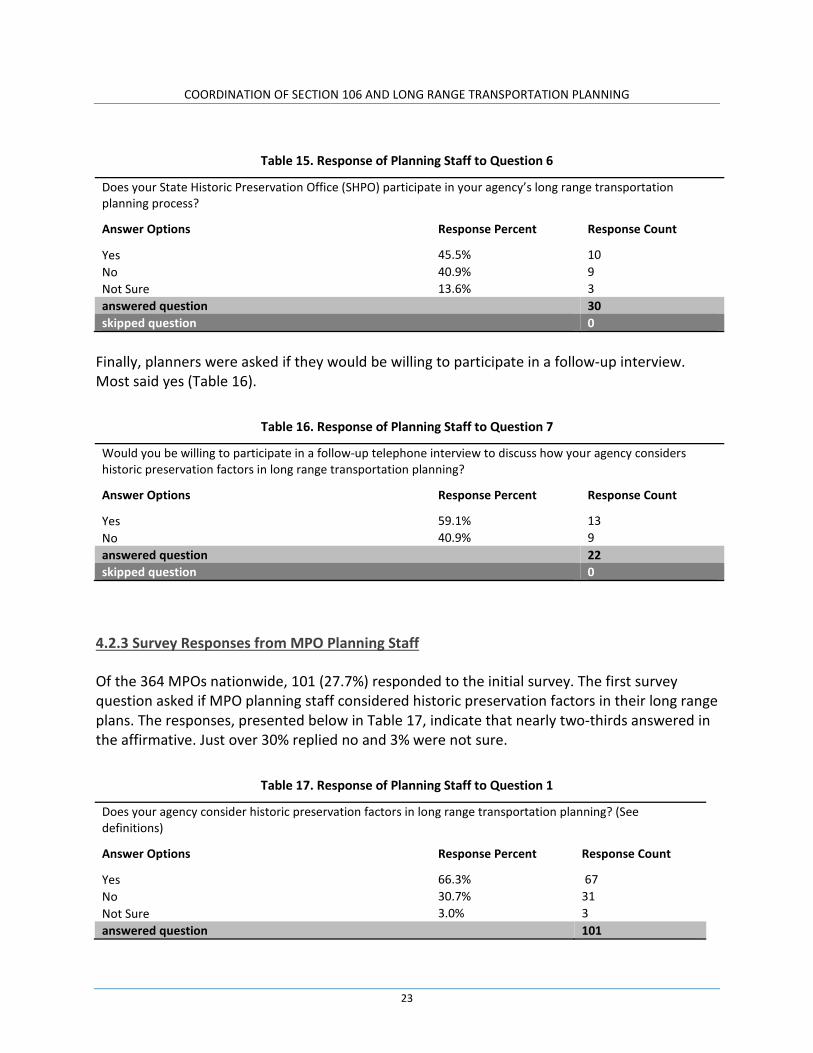
Yes 45.5% 10 No 40.9% 9 Not Sure 13.6% 3 answered question 30 skipped question 0
Finally, planners were asked if they would be willing to participate in a follow-up interview. Most said yes (Table 16).
Table 16. Response of Planning Staff to Question 7
Would you be willing to participate in a follow-up telephone interview to discuss how your agency considers historic preservation factors in long range transportation planning?
Answer Options Response Percent Response Count
Yes 59.1% 13 No 40.9% 9 answered question 22 skipped question 0
4.2.3 Survey Responses from MPO Planning Staff
Of the 364 MPOs nationwide, 101 (27.7%) responded to the initial survey. The first survey question asked if MPO planning staff considered historic preservation factors in their long range plans. The responses, presented below in Table 17, indicate that nearly two-thirds answered in the affirmative. Just over 30% replied no and 3% were not sure.
Table 17. Response of Planning Staff to Question 1
Does your agency consider historic preservation factors in long range transportation planning? (See definitions)
Answer Options Response Percent Response Count
Yes 66.3% 67 No 30.7% 31 Not Sure 3.0% 3 answered question 101
23

COORDINATION OF SECTION 106 AND LONG RANGE TRANSPORTATION PLANNING
Question 2 asked if those MPOs that do consider historic preservation in long range planning have manuals or other guidance documents describing the procedures for considering historic preservation factors during long range planning (Table 18). A majority indicated that they do not have such documents.
Table 18. Response of Planning Staff to Question 2
If your agency does consider historic preservation factors in long range planning, can you provide us with any documents or manuals that describe how your agency considers these factors during the long range planning process?
Answer Options Response Percent Response Count
Yes 44.0% 33 No 56.0% 42 answered question 75 skipped question 26
The MPOs stating that they had manuals and guidance documents include:
• Merced County Association of Governments, California • Hillsborough County MPO (Tampa), Florida • St. Lucie Transportation Planning Organization, Florida • Lake Sumter MPO, Florida • Atlanta Regional Commission, Georgia • Columbus-Phoenix City Metropolitan Planning Organization, Georgia • Allen County, Indiana • Tippecanoe County, Area Planning Association, Indiana • Salisbury-Wicomico MPO, Maryland • Tri-County Regional Planning Commission (Lansing), Michigan • Rochester-Olmsted COG, Minnesota • Yellowstone County Planning Board (Billings), Montana • New York Metropolitan Transportation Council, New York • Gaston Urban Area MPO, North Carolina • Mecklenburg-Union MPO (Charlotte), North Carolina • Wilmington Urban Area MPO, North Carolina • Grand Forks-East Grand Forks MPO, North Dakota • Cincinnati-Northern Kentucky MPO, Ohio • Mid-Ohio Regional Planning Commission (Columbus), Ohio • Toledo Metropolitan Area COG, Ohio • Central Lane MPO, Oregon • Corvallis Area MPO, Oregon • Lebanon County MPO, Pennsylvania
24

COORDINATION OF SECTION 106 AND LONG RANGE TRANSPORTATION PLANNING
• State Planning Council, Providence, Rhode Island • Rapid City, South Dakota • Chattanooga Transportation Planning Organization, Tennessee • Memphis Urban Area MPO, Tennessee • Fredericksburg Area MPO, Virginia • Winchester-Frederick County MPO, Virginia • Appleton/Fox Cities MPO, Wisconsin • Cheyenne MPO, Wyoming
The project team selected around half of these documents for review, with the goal of looking at documents representing a range of community sizes and regions of the country. These documents were used by the project team to identify patterns and themes in how MPOs consider historic preservation during long range planning. These manuals and guidance were also used to develop some of the case studies presented in Section 6.0 of this report. The majority of these documents had one or both of the following elements:
• Goals, objectives, or principles for avoiding impacts to historic properties, protecting these properties, and/or considering the community value of these properties to as a component of the transportation planning process and project delivery.
• Guidance/steps on how to use historic preservation information, along with other environmental information, to prioritize projects to be included in a TIP.
Some of the long range plans included maps showing the locations of historic architectural and engineering properties, especially historic districts. Information on archaeological site locations was not included in these maps. Table 19 presents responses to the third survey question. Question 3 was designed to explore why MPOs do not consider historic preservation factors in long range planning. Thirty-three (33) of the survey participants responded to this questions, which was not mandatory. Nearly 40% of these respondents said they do not have historic preservation data to use for long range planning. A similar number do not have the staff to consider historic preservation factors. Thirty (30) percent said they lacked the time to address historic preservation during planning. Slightly less (27%) said the agency did not have the funds to consider these factors during long range planning, or was not a priority (24%). These responses and the written comments to this question (under “other responses to Question 3) suggest that addressing historic preservation in long range transportation planning is not a priority, and is not seen as possible in some cases or useful in others. Historic properties are considered in the corridor planning level of analysis and during the NEPA/Section 106 review process. Some MPOs plan to incorporate historic
25
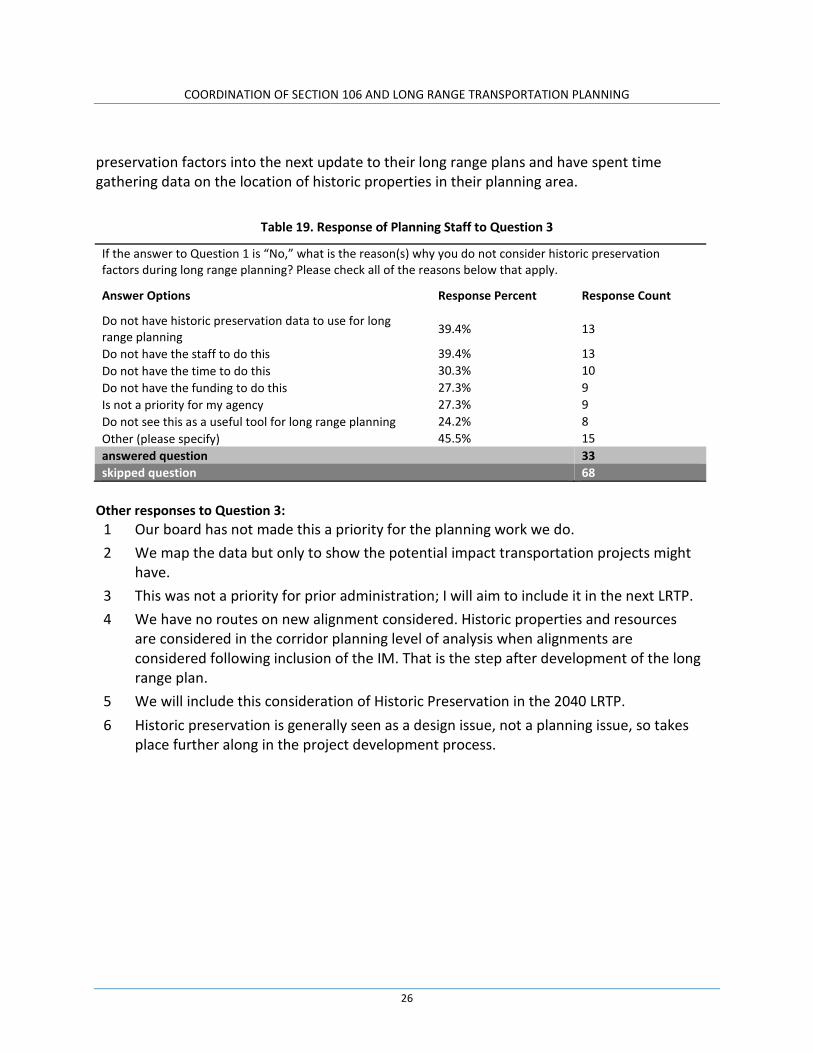
COORDINATION OF SECTION 106 AND LONG RANGE TRANSPORTATION PLANNING
preservation factors into the next update to their long range plans and have spent time gathering data on the location of historic properties in their planning area.
Table 19. Response of Planning Staff to Question 3
If the answer to Question 1 is “No,” what is the reason(s) why you do not consider historic preservation factors during long range planning? Please check all of the reasons below that apply.
Answer Options Response Percent Response Count
Do not have historic preservation data to use for long range planning 39.4% 13
Do not have the staff to do this 39.4% 13 Do not have the time to do this 30.3% 10 Do not have the funding to do this 27.3% 9 Is not a priority for my agency 27.3% 9 Do not see this as a useful tool for long range planning 24.2% 8 Other (please specify) 45.5% 15 answered question 33 skipped question 68
Other responses to Question 3:
1 Our board has not made this a priority for the planning work we do. 2 We map the data but only to show the potential impact transportation projects might
have. 3 This was not a priority for prior administration; I will aim to include it in the next LRTP. 4 We have no routes on new alignment considered. Historic properties and resources
are considered in the corridor planning level of analysis when alignments are considered following inclusion of the IM. That is the step after development of the long range plan.
5 We will include this consideration of Historic Preservation in the 2040 LRTP. 6 Historic preservation is generally seen as a design issue, not a planning issue, so takes
place further along in the project development process.
26

COORDINATION OF SECTION 106 AND LONG RANGE TRANSPORTATION PLANNING
7 Historic Preservation is not specifically identified, however, it is valued by portions of our community and sites are considered when discussing projects.
8 We identify properties on the National Register of Historic Places and those that are eligible for the Register in order to warn project sponsors of potential project impacts and hurdles. Most of the historic building sites are not listed on the Register. And many that are eligible are no longer really economically viable properties based on their existing condition.
9 This should be considered in the NEPA process—not the long range transportation planning process
10 Has not been considered in past LRTPs, may be in future 11 We plan to incorporate historic preservation into the next update to the LRTP and have
spent time gathering data on the location of historic properties in the planning area. 12 Land use, age, and structure of building are considered. However, ranking criteria does
not currently include Historic Preservation. 13 We develop a corridor based plan and without specific projects we receive only the
process for review. 14 There isn't a local historic preservation plan. While we think about historic
preservation in the transportation planning process, there isn't a great mechanism for the LRTP. Obviously our transportation projects go through Section106 review.
15 Too many changes in 20 years to get to specific properties. In the case of districts, that falls under land use or community integrity.
Question 4 (Table 20) was designed to explore what other factors MPOs consider as part of the long range transportation planning process, if historic preservation factors are not addressed. Since nearly two-thirds consider historic preservation factors during long range planning, only 35 MPOs responded to this question. Environmental justice was considered most often, by over 90% of respondents. Land use was considered by 86% of respondents. Air quality was considered by over two-thirds (77%) of respondents and wetlands by slightly less (65%). The written responses under “other” provide further information. Interestingly, one of the Florida MPOs noted that all of these factors are considered through the state DOT’s Efficient Transportation Decision Making process (ETDM), but they are generally not part of a measure or criteria in evaluating projects.
27

COORDINATION OF SECTION 106 AND LONG RANGE TRANSPORTATION PLANNING
Table 20. Response of Planning Staff to Question 4
If the answer to Question 1 is “No,” are there other environmental factors that your agency does consider in long range planning? Please check all of the environmental factors below that apply.
Answer Options Response Percent Response Count
Environmental Justice 91.4% 32 Land use 85.7% 30 Air quality 77.1% 27 Wetlands 65.7% 23 Water quality 31.4% 11 Biological 28.6% 10 Community cohesion 28.6% 10 Other (please specify) 14.3% 5 Hazardous wastes 11.4% 4 answered question 35 skipped question 66
Other responses to Question 4: 1 Critical area preservation 2 Hazardous Material Routes 3 All of these factors are considered through the ETDM process, but they are generally not
part of a measure or criteria in evaluating projects. 4 For Number 5 below we will include the State Historic Preservation Office in our
Transportation Information Network for the LRTP update. 5 Energy, conservation areas
Question 5 asked if SHPOs participate in metropolitan long range planning (Table 21). In over half of cases, the SHPO did not participate. A relatively large number (19 MPOs) were not sure.
Table 21. Response of Planning Staff to Question 5
Does your State Historic Preservation Office (SHPO) participate in your agency’s long range transportation planning process?
Answer Options Response Percent Response Count
Yes 29.7% 30 No 51.5% 52 Not Sure 18.8% 19 answered question 101 skipped question 0
The last question asked if the MPOs would be willing to participate in a follow-up interview. Over half of the respondents said yes (Table 22).
28

COORDINATION OF SECTION 106 AND LONG RANGE TRANSPORTATION PLANNING
Table 22. Response of Planning Staff to Question 6
Would you be willing to participate in a follow-up telephone interview to discuss how your agency considers historic preservation factors in long range transportation planning?
Answer Options Response Percent Response Count
Yes 58.4% 59 No 41.6% 42 answered question 101 skipped question 0
4.2.4 Summary of Survey Responses
Fifty-two percent of state DOT CRM offices, 40% of the state DOT planning offices, and 27.7% (i.e., 101) MPOs responded to the survey. In Table 23, we compare the survey results of each of the three target groups. Most of the DOT cultural resources staff and MPOs indicate that their agencies do consider historic preservation in long range planning; however, 55% of the responding DOT planners said their agencies do not consider these factors during long range planning. One possible reason for these different responses may be a result of the different roles and responsibilities of these staffs within the DOTs. DOT CRM staff may not be active participants in the long range planning process, and as a result do not have a full understanding of what occurs during this planning phase. As shown in Table 23, the state DOT planners who responded to the question “Why do you not consider historic preservation factors during long range planning” stated that doing so was either not a priority or was seen as not useful. These were also the primary reasons why state DOT CRM staff and MPOs do not consider historic preservation factors during long range planning. When asked which environmental factors were considered during long range planning, when historic preservation factors were not considered, each target group provided a slightly different response. The CRM staff noted that their agencies place a high priority on biological factors and wetlands, followed by air and water quality and environmental justice (EJ). MPO staff ranked EJ as the highest valued factor, followed closely by land use, and then air quality and wetlands. The state DOT planners’ responses closely resemble those of the MPO planners. Question 5 asked both the DOT CRM staff and planners if they know of MPOs in their state that considered historic preservation factors as part of local long range planning. While most CRM staff and planners indicated that they knew of MPOs that do consider historic preservation
29
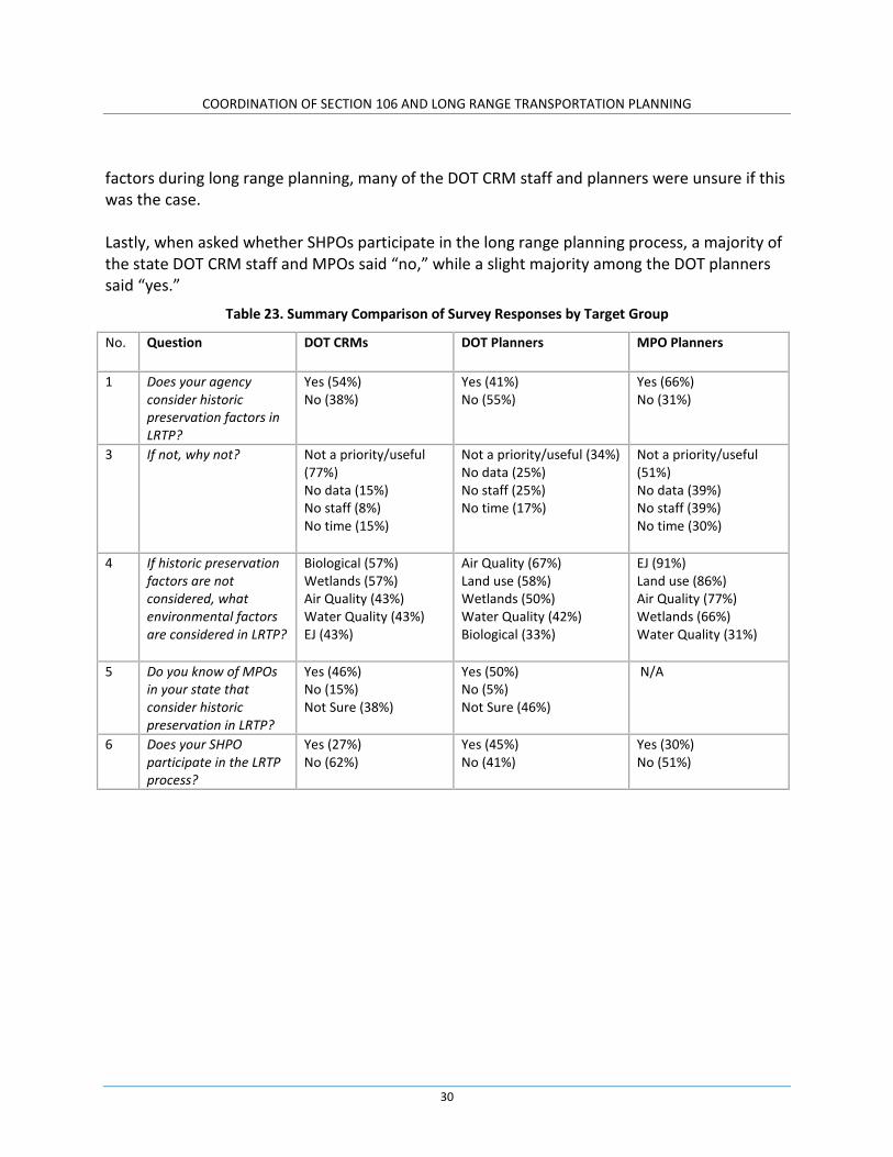
COORDINATION OF SECTION 106 AND LONG RANGE TRANSPORTATION PLANNING
factors during long range planning, many of the DOT CRM staff and planners were unsure if this was the case. Lastly, when asked whether SHPOs participate in the long range planning process, a majority of the state DOT CRM staff and MPOs said “no,” while a slight majority among the DOT planners said “yes.”
Table 23. Summary Comparison of Survey Responses by Target Group
No. Question DOT CRMs DOT Planners MPO Planners
1 Does your agency consider historic preservation factors in LRTP?
Yes (54%) No (38%)
Yes (41%) No (55%)
Yes (66%) No (31%)
3 If not, why not? Not a priority/useful (77%) No data (15%) No staff (8%) No time (15%)
Not a priority/useful (34%) No data (25%) No staff (25%) No time (17%)
Not a priority/useful (51%) No data (39%) No staff (39%) No time (30%)
4 If historic preservation factors are not considered, what environmental factors are considered in LRTP?
Biological (57%) Wetlands (57%) Air Quality (43%) Water Quality (43%) EJ (43%)
Air Quality (67%) Land use (58%) Wetlands (50%) Water Quality (42%) Biological (33%)
EJ (91%) Land use (86%) Air Quality (77%) Wetlands (66%) Water Quality (31%)
5 Do you know of MPOs in your state that consider historic preservation in LRTP?
Yes (46%) No (15%) Not Sure (38%)
Yes (50%) No (5%) Not Sure (46%)
N/A
6 Does your SHPO participate in the LRTP process?
Yes (27%) No (62%)
Yes (45%) No (41%)
Yes (30%) No (51%)
30
COORDINATION OF SECTION 106 AND LONG RANGE TRANSPORTATION PLANNING
5.0. INTERVIEWS
5.1 INTRODUCTION
As noted in Section 1.0, the project team interviewed state DOT cultural resource management and planning staff, MPOs, and SHPOs. The DOT and MPO interviews focused on how these agencies/organizations consider historic preservation factors during long range transportation planning. The purpose of these interviews was to identify the specific types of historic preservation information included in long range transportation plans, how this information is obtained, and most importantly, how this information is used in subsequent decision making. The SHPO interviews also aimed to examine how SHPOs participate in the state DOTs’ and/or MPOs’ long range planning process and what SHPOs contribute to this planning process.
5.2 INTERVIEW APPROACH
During the initial survey, DOTs and MPOs were asked if they would be willing to participate in a follow-up interview on how their agency/organization considers historic preservation factors during long range planning. The project team, in consultation with the technical panel, selected eleven DOTs and eleven MPOs for interviews, out of the pool of DOTs and MPOs who agreed to be interviewed. The project team sent an email to the DOTS and MPOs describing the purpose of the study and the interviews and setting up dates and times for the interviews. A copy of the interview questions was included with the email. Below are the DOT and MPO interview questions:
1. Why does your agency/organization consider historic preservation factors in the long range transportation planning process? What do you see as the benefits? 2. What types of information on historic preservation factors are typically included in your long range transportation plans (e.g., general historic preservation goals or objectives, process for considering historic preservation factors during subsequent programming, process for considering historic preservation factors during project development (i.e., during the NEPA and Section 106 review processes), locations of areas of historic preservation sensitivity or priority preservation areas, locations of specific historic properties, etc.)? 3. How do you obtain information on historic preservation factors for inclusion in your long range plans? Is this information provided by your agency’s/organization’s cultural resource staff? Do you consult with your State Historic Preservation Office (SHPO) to obtain any of this information?
31

COORDINATION OF SECTION 106 AND LONG RANGE TRANSPORTATION PLANNING
4. FHWA’s Statewide Transportation Planning and Metropolitan Transportation Planning rule (23 CFR 450) states that transportation plans shall include a discussion of potential environmental mitigation activities and potential areas to carry out these activities, including activities that may have the greatest potential to restore and maintain the environmental functions affected by the transportation plan. Does your agency/organization’s plan include such a discussion for historical/archaeological properties? If the answer is yes, what is the nature of this discussion? 5. Is the information on historic preservation factors in the long range plans carried forward into programming? Is it carried forward into project development? If “yes,” how is this information used in programming and/or project development? What impact does this information have on the programmed projects in terms of scoping, scheduling, budgeting, consultation, etc.? What impact does this information have on project development in terms of scoping, scheduling, budgeting, consultation, compliance with Section 106, compliance with Section 4(f), etc.?
When the project team contacted the DOTs and MPOs to set up the interviews, a few of the DOTs and MPOs informed the team that they do not consider historic preservation factors during long range planning, even though they had responded in the affirmative during the initial survey. As a result, the project team interviewed a total of eight (8) DOTs. Most of the interviews involved a joint interview with DOT CRM staff and planning staff. When it was not possible to conduct a joint interview due to scheduling difficulties, the team interviewed either the CRM staff person or the planning staff person, depending on who was available. The project team interviewed 12 MPOs. See Appendix C for a list of the state DOTs and MPOs interviewed. Summaries of the interview results are presented in Appendix D. The DOT and MPO interviews revealed several common patterns and themes in how these agencies and organizations consider historic preservation factors during long range planning. These common themes and patterns are discussed below in Section 5.3. In the initial survey, the project team asked if a DOT or MPO consulted with their SHPO about the consideration of historic preservation factors in long range planning. Based on the responses from the DOTs and MPOs, the project team, in consultation with the NCHRP panel, selected 19 SHPOs for interviews. The team sent an email to the SHPOs: 1) describing the purpose of the study, 2) noting that their state DOT or one of MPOs in the their state informed the project team about the SHPO’s involvement in long range planning, and 3) requesting a date and time for an interview. A copy of the interview questions was included with the email. Below are the SHPO interview questions:
1. How are you consulted during the long range planning process, and what does this consultation involve? Are the DOT and MPOs requesting information on the locations of
32

COORDINATION OF SECTION 106 AND LONG RANGE TRANSPORTATION PLANNING
historic properties? Are they asking for information on your office’s historic preservation priorities or objectives? Do you participate in any meetings with the DOT and MPOs as they develop their long range plans? 2. Have the DOT and MPOs requested a copy of your statewide historic preservation plan for use in their long range plan, or do you know if the DOT and MPOs have consulted your statewide plan as part of the development of their long range plans? 3. Do you see your involvement in the development of long range plans as having an effect/impact on Section 106 compliance associated with subsequent projects? If your answer is “yes,” please explain. If your answer is “no,” why is this the case?
In response to the email, two SHPOs said they were not consulted nor did they participate in long range planning, though a MPO in their state or the DOT noted in the initial survey that they did consult with the SHPO during this planning process. Also, some of the SHPOs did not respond to the request for setting up an interview despite repeated attempts. As a result, the project team was able to interview 14 SHPOs. See Appendix C for a list of the SHPOs interviewed. Summaries of these interviews are presented in Appendix D. As with the MPOs and DOTs, the common themes and patterns observed through the SHPO interviews are discussed below.
5.3 RESULTS OF INTERVIEWS: PATTERNS AND THEMES
The interviews revealed several common patterns in terms of how and why state DOTs, MPOs and SHPOs consider historic preservation factors during long range planning. These common patterns can be organized under five overarching themes:
• The benefits of considering historic preservation during long range planning • Use of cultural resource databases in long range planning • Consultation among state DOTs, MPO and SHPOs • Linking long range planning, programming, and project development • Forms of long range planning best suited for considering historic preservation factors
The following is a discussion on these common patterns in the context of these overarching themes.
33

COORDINATION OF SECTION 106 AND LONG RANGE TRANSPORTATION PLANNING
5.3.1 The Benefits of Considering Historic Preservation Factors During Long Range Planning.
Considering historic preservation factors during long range planning, and then carrying this information forward into programming and project development, resulted in the following benefits to project delivery:
• Identifying and avoiding potential fatal flaws and “red flags” within areas covered by long range corridor studies and regional plans (which include multiple potential projects). These fatal flaws and “red flags” include properties that would be protected under Section 4(f), or would require extensive and complex Section106 reviews and activities.
• Streamlining and enhancing subsequent Section 106 project reviews. • Having a better handle on the scope, cost, and scheduling for project development.
If historic preservation factors are not considered in long range planning, there is an increased risk of reversing project decisions and having to do a “redo” in design. This results in increased costs and delays in project delivery. Several MPOs emphasized the need to be careful with their transportation dollars, and discussed the importance of “working smart” and avoiding spending money on projects that may not get built. A frequent reason for considering historic preservation factors during long range planning is to be able to avoid impacts to historic properties that would be considered “red flags,” or result in a fatal flaw in a project and/or project alternatives, especially in the context of Section 4(f). MPOs want their member local governments to avoid having to pay for mitigation and/or experience project delays and increased costs associated with dealing with historic properties during project development that would dramatically increase the cost of a project, costs they cannot handle given their limited transportation dollars. The DOTs, MPOs, and those SHPOs that participate in long range planning, also noted the importance of considering historic preservation factors during planning as a mechanism to recognize, preserve, and enhance local historic preservation goals and the historic character of local communities. This theme was most prevalent in the MPO interviews, which is not surprising since the MPOs have the most direct connection to local communities. MPOs emphasized the importance of historic preservation factors in community identity and long-term economic and community development, especially in the context of supporting tourism and re-development of central, urban areas. MPOs are attuned to local public opinion on the impacts transportation projects may have on historic properties, and want to be aware and understand public opinion about these impacts as early as possible in the project delivery process. Some SHPOs noted that early consideration of these factors in planning lets the SHPO know what is going on in a community.
34

COORDINATION OF SECTION 106 AND LONG RANGE TRANSPORTATION PLANNING
Several of the DOTs noted that paying attention to historic resources early in planning, demonstrates the DOTs’ commitment to preserving and taking into account the historic preservation values of local communities. In addition, considering historic preservation factors during long range planning provides the SHPO and the public an opportunity to comment on and provide resource information and concerns to the DOTs at the earliest possible stage in project delivery. Some of the DOTs and MPOs also stated the reason they consider historic preservation factors during their planning efforts is because of the goals and objectives included in their respective, overarching long range transportation plans. These plans include statements on the value of historic properties to the state and local communities and the need to fully consider the effects of transportation project on these properties, with the goal of avoiding impacts whenever possible. Some DOTs and MPOs also noted the consideration of these factors during long range planning is in response to the requirements of MAP-21 and FHWA’s planning regulation, 23 CFR 450.
5.3.2 Use of Cultural Resource Databases in Long Range Planning.
Geographic Information Systems (GIS) are a critical tool for considering historic preservation factors in long range planning. In fact, many of the long range planning activities conducted by the DOTs and MPOs are only possible through the access and use of a cultural resource GIS. Several DOTs and some MPOs obtain cultural resource information for their long range plans from an in-house cultural resource GIS. Others obtain this information from an on-line GIS maintained by the SHPO and/or an on-line GIS maintained by another entity, such as a state university. In some states, a MPO may have the most up to date and comprehensive GIS as a result of local inventory efforts, or because the SHPO is not able to keep the statewide GIS up to date on a regular basis because of lack of staff and financial resources. Cultural resource GIS maintained by state DOTs, SHPOs, MPOs, and other organizations contain a wide variety of data. The most common data included in these systems are:
• Archaeological sites • Historic architectural/engineering properties • Historic bridge inventories • National Register listed properties • National Register eligible properties
Some DOT and SHPO GIS include information on archaeological sensitivity areas. A few MPO GIS also include the following information:
• Heritage routes
35

COORDINATION OF SECTION 106 AND LONG RANGE TRANSPORTATION PLANNING
• Historic preservation tax incentive projects • Potential historic districts (identified through local planning documents, small area
studies, etc.) • Neighborhood data (to preserve neighborhood integrity)
Not all GIS include data on both the historic built environment and archaeological resources. Some have only one or the other. In addition, access to archaeological resource information is usually restricted to qualified DOT staff and cultural resource management consultants working for a DOT or MPO. A few DOT/SHPO-maintained GIS (i.e., Florida and Pennsylvania) have tools for conducting alternative/project screening analyses, providing information on the number of known and potential properties, distance/density of properties, property types, cultural resource sensitivity values/scores, etc. Some DOTs and several of the SHPOs expressed concern that MPOs may misinterpret information contained within a statewide cultural resource GIS, since most MPOs do not have in-house historic preservation expertise, especially small MPOs. Some SHPOs were concerned that the MPOs could be using incomplete or incorrect data, observations that can only be made by a cultural resource expert. In addition, when a MPO takes information from the statewide GIS and places it into their own GIS, or uses this information for long range planning, the information becomes static. In most cases, the MPO databases are not directly linked to the statewide database, which are generally updated on a regular basis. The interviews also revealed situations where the MPO’s database was the only cultural resources GIS available in an area and/or was updated more often than the statewide database. The DOT and MPO interviews showcased several examples of how GIS is effectively used in long range planning. Florida has one of the most comprehensive environmental and historic preservation databases: the Efficient Transportation Decision Making process (ETDM). Florida DOT uses ETDM to look at potential impacts to historic properties, and other environmental resources, in areas covered by long range planning. On the regional level, ETDM provides both a system of GIS overlays and an agency comment processing system that allows MPOs, and other participants in ETDM, including the SHPO, to:
• Evaluate the relative environmental/historic preservation impacts of transportation projects that are being considered for inclusion in long range plans, and identify fatal flaws/impacts as early as possible in this planning phase.
• Provide comments about potential effects of transportation projects on historic properties (and other resources) – projects proposed for federal and state funding.
36

COORDINATION OF SECTION 106 AND LONG RANGE TRANSPORTATION PLANNING
Pennsylvania’s Linking Planning & NEPA (LPN) on-line decision-making/planning system is linked to the state’s cultural resource GIS. The information contained in the on-line LPN forms includes historic preservation data, and serves as an initial project scoping for long range planning, in addition to programmed projects. The LPN system also generates scores based on the proximity of cultural resources and other environmental resources to a proposed project. MPOs have access to the state’s cultural resource GIS and can use the data in this GIS for their long range plans.
On the MPO side, the Atlanta Regional Commission (ARC) has invested extensively in the development of GIS overlays, providing a qualitative assessment of projects included in the region’s long range plans. Historic preservation factors in the GIS include National Register properties, locally designated historic districts, potential historic districts, data from Section 106 inventories and reviews, local cultural resource survey data, cemeteries, historic preservation tax incentive projects, and archaeological sites. Locational information on the latter is shown at a very general scale. Precise locations of sites are not included in the GIS.
5.3.3 Consultation among State DOTs, MPOs, and SHPOs.
The interviews showed that some DOTs, MPOs, and SHPOs communicate and consult with each other throughout the long range planning process, and that this communication and consultation continues into programming, and of course, during Section 106 review of specific projects once they move out planning. In contrast, even though some DOTs and MPOs noted during the initial survey that they communicate and consult with the SHPO during long range planning, their SHPOs noted during their interviews (or in emails responding to the project team’s request for an interview) that they did not consider these outreach efforts as “consultation.” Some of these SHPOs said they saw no value in their participation in long range planning. A few SHPOs, however, noted that they do not participate in long range planning, or their participation was minimal, but they did want to participate or enhance their current role in long range planning. The following provides more detailed information on these different responses and perceptions about consultation during long range planning. A few SHPOs participate in coordination meetings with their state DOT on a regular or on an as needed basis. Regional plans and projects are reviewed at these meetings. Meeting participants discuss the overview of a region’s environmental issues (including historic preservation factors), along with other elements of the plans. A few DOTs consult with their SHPOs on long range corridor studies in a manner similar to consultation under Section 106 (e.g., Tennessee, Washington State, and Wisconsin). In these states, DOT staff or a consultant hired by the DOT will often conduct historic property inventories as part of a long range plan corridor study. This inventory may include identifying properties, evaluating the National Register eligibility of properties, and assessing possible effects from proposed actions within the corridor study area. The SHPO is involved in these very early surveys and assessment efforts, and may go out to the
37
COORDINATION OF SECTION 106 AND LONG RANGE TRANSPORTATION PLANNING
area to look at specific historic architectural properties in order to discuss with the DOT issues related to eligibility and effects. The goal of this early work is to collect information on the historic built environment and then provide this information to DOT planners in order to avoid and minimize impacts to these properties (e.g., properties protected under Section 4(f)). In a few cases, a DOT’s consultation with the SHPO during long range planning may only consist of sending the SHPO a long range plan, and requesting the SHPO to provide comments or concerns about the content of the plan. These plans may include maps showing the locations of proposed projects or a spread sheet listing potential/proposed projects. MPOs also send copies of their long range plans to the SHPOs, and sometimes invite the SHPOs to attend a meeting on the long range plan. The SHPO may respond to such requests with general comments on the potential effects of the proposed projects on historic properties. The interviews also showed that the MPOs who are most successful in obtaining SHPO input into the long range planning process are the MPOs that make calls directly to the SHPOs, with individual inquiries about specific historic preservation issues and concerns. As noted above, several SHPOs felt their participation in long range planning was not worthwhile. Sending long range plans to the SHPO for their comments is seen as a perfunctory exercise by several SHPOs, and not meaningful consultation. These SHPOs noted that the plans tend to be very general and conceptual. When they include proposed projects, there is little background information describing the projects, and there is no information on historic properties that may be affected by these projects. Consequently, there is little for the SHPO to review and comment on. Further, these SHPOs do not have the staff or resources to search their databases/records for information on historic properties that maybe affected by proposed projects, and then provide this information to the MPOs. Some of these SHPOs noted they cannot make the case for participating in long range planning meetings or commenting on the long range plans. Their participation is hard to justify if not associated with a specific project. They need to focus their limited staff and resources on their Section 106 compliance responsibilities, and to be able to respond to request for review and comment within required time frames. Given these factors, the SHPOs’ response to requests for comments on long range plans is often telling a MPO to look at the statewide cultural resource GIS and to consult with the SHPO at the start of the Section 106 process. Some of the SHPOs noted they do not participate in the development of the state long range plans and/or MPO long range plans, but would like to have the opportunity to participate; or, the SHPOs would like to participate more fully (e.g., beyond just getting an email requesting their attendance at a MPO planning meeting or being sent a MPO long range plan that contains little useful information, at least in the opinion of the SHPOs). To promote and enhance their involvement in long range planning, a few SHPOs (e.g., North Carolina and Pennsylvania) have been going out and doing a “road show” with MPOs on considering historic preservation in planning, a kind of “meet and greet” with locals transportation planners. During these
38

COORDINATION OF SECTION 106 AND LONG RANGE TRANSPORTATION PLANNING
meetings, the SHPOs provide information on how they can assist the MPOs during both planning and project development. These SHPOs, including the Texas SHPO, also try to attend MPO regional conferences to discuss the function of the SHPO, and to provide information on the value of using the SHPOs’ cultural resource GIS database. One MPO, Atlanta Regional Commission, takes a very proactive approach to consultation in the context of long range planning. ARC hosts regional historic preservation forums every year, co-sponsored with the SHPO and the City of Atlanta. For example, the area contains huge numbers of post-World War II houses and neighborhoods that are potentially eligible for listing in the National Register. One of the goals of these forums is to alert local planners about upcoming issues such as the need to consider the eligibility of these ubiquitous properties, and take into account future impacts on these properties from proposed transportation projects. ARC views these forums as an opportunity to discuss and share information on historic preservation issues that will affect project planning. The ARC noted in their interview that issues associated with post-World War II housing are going to be included in their long range planning program.
5.3.4 Linking Long Range Planning, Programming and Project Development.
The DOTs that consider historic preservation factors during long range planning carry this information forward into programming and project development. This information is refined and supplemented as projects move forward into programming. Information on historic preservation factors is used in project programming to screen projects before they enter the NEPA process. The goal is to save time, money and staff resources during project development. Historic preservation information carried into programming is also used to determine the level of effort, cost, and scheduling associated with project development, based on the location of and potential impacts to historic properties, along with other environmental issues. Pennsylvania’s LPN program, for example, serves as an initial project scoping tool, and is used to assess the appropriate level of NEPA review once a project moves out of planning. In addition, the information in the LPN’s on-line project forms is automatically moved into the DOT’s on-line Categorical Exclusion (CE) process if a project will be processed as a CE. Information in the forms also goes to the MPO’s for the preparation of their Transportation Improvement Plans. Working with their local member governments, nearly all MPOs that consider historic preservation factors during long range planning apply information on these factors to project programming and development. These factors are used as a mechanism for screening project alternatives and to avoid problems during project development. Several MPOs, for example, use potential impacts to historic properties as one of several environmental factors for ranking/scoring projects for consideration in programming. These scores/ranks, along with
39

COORDINATION OF SECTION 106 AND LONG RANGE TRANSPORTATION PLANNING
other factors, are used for evaluating project deliverability and public support, and for prioritizing projects for development. And as with the DOTs, information on historic preservation factors obtained during MPOs’ long range planning efforts is refined in programming, and used for project scoping and budgeting.
The Atlanta Regional Commission, for example, takes data from their long range plan and uses these data in their TIP project scoring system/index, which quantifies how each project proposed in the plan could potentially impact a sensitive area. Six environmental factors are weighted equally, including cultural resources, using ARC’s GIS layers associated with these factors. For example, the higher the impact measured by these six factors, the lower the project value. The Hillsborough County MPO in Florida uses information from the state’s ETDM screening program, along with other information, to prioritize projects. The Hillsborough MPO scores each proposed project based on how well the project addresses the MPO’s long range plan criteria, such as minimizing impacts on natural and cultural resources.
5.3.5 Form of Long Range Plans Best Suited for Considering Historic Preservation Factors.
In discussing the form of long range plans best suited for considering historic preservation factors, the DOTs and MPOs agreed that long range corridor planning was the most effective context. With well-defined limits and study areas, it is fairly straightforward to collect and map historic property information, similar to what is done during project development/Section 106 reviews. SHPOs interested in participating in long range planning also saw greater value to commenting on historic preservation issues associated with corridor studies, as opposed to statewide plans and MPO long range plans which often do not provide detailed information on project locations, descriptions, and alternatives. Some DOTs and MPOs did see the value of taking a regional approach, documenting the location of classes of known and potential historic properties and/or cultural resource sensitivity areas for regions within a state. For example, Texas DOT, in consultation with the SHPO, has developed a planning GIS layer for the eastern half of the state using modern and historic maps, and aerial photographs. The purpose of this GIS layer is to identify potential historic architectural properties and also the location of potential historical archaeological sites. Two of the interviewed SHPOs noted that their participation in the review of projects included in a TIP or STIP was of more value than participation in projects/studies with a much longer planning horizon. These SHPOs reasoned that the information contained in long range plans would be out of date by the time Section 106 reviews begin. In addition, the level of project information included in a TIP or STIP was of sufficient detail to allow the SHPO to provide more valuable comments on potential impacts to historic properties, along with raising other historic preservation concerns and issues.
40
COORDINATION OF SECTION 106 AND LONG RANGE TRANSPORTATION PLANNING
6.0 CASE STUDIES
6.1 INTRODUCTION
Based on the literature search, initial survey, and interviews, the project team, in consultation with the NCHRP panel, identified nine (9) case studies. The case studies demonstrate 1) the benefits of joint planning between transportation and historic preservation agencies, and 2) showcase the use of effective tools and approaches for considering historic preservation factors in long range planning. As noted in earlier sections of this report, several DOTs and MPOs consider historic preservation factors during long range planning in some capacity, but a small group of DOTs and MPOs stand out given their unique approaches to considering these factors during this early phase in planning. These approaches involve extensive use of cultural resource GIS and background information, consultation with SHPOs and other historic preservation stakeholders similar to the level of consultation conducted under Section 106 reviews, and in a few cases, cultural resource field investigations. The nine case studies presented below showcase these DOTs and MPOs. The case studies provide 1) a description of a DOT’s or MPO’s program or approach to considering historic preservation factors in long range planning, 2) why a program was developed or an approach (es) was used, 3) the challenges encountered in considering these factors, 4) the benefits of considering these factors in long range planning, and 5) lessons learned through the implementation of a DOT’s or MPO’s program or approach. [Note: if information is missing from a case study, the project team was not able to obtain this information from the DOT or MPO] Florida and Pennsylvania have statewide cultural resource GIS that are linked with on-line decision-making and screening tools. We present one MPO case study from each of these states in order to highlight the participation and role of a MPO in these comprehensive statewide programs. We included an additional MPO from Pennsylvania. This additional MPO, the Delaware Valley Regional Planning Commission (DVRPC), is exploring a unique advanced historic preservation mitigation program, which once in place, would become part of the project planning process. The DVRPC is working with the state DOT and SHPO to develop this advanced mitigation program.
41

COORDINATION OF SECTION 106 AND LONG RANGE TRANSPORTATION PLANNING
6.2 ATLANTA REGIONAL COMMISSION (ARC)
Description
The Atlanta Regional Commission (ARC) serves as both a regional commission under Georgia planning rules and a MPO under federal planning rules. In this capacity, ARC combines programs and services through its Transportation & Mobility Division and Community Development Division for long range transportation planning. The MPO’s 2040 plan combines the requirements for both regional transportation and development planning, and is informed by numerous partners and stakeholders, including the Georgia SHPO as well as local governments and community non-governmental organizations.
As noted in Section 5.0, ARC has invested in developing environmental overlays in GIS. This GIS is used to conduct a qualitative assessment of the projects under consideration in long range planning. Mapped historic preservation factors in the GIS include, but are not limited to, National Register districts, individually listed National Register properties, locally designated historic districts, Section 106 data manually entered by the ARC office, and any survey information currently not available through the SHPO, such as historic resource information from the metro Atlanta area. ARC’s GIS draws data from the statewide Natural, Archaeological, and Historic Resources GIS (NAHRGIS), which is maintained by the University of Georgia’s Information Technology Outreach Service. Georgia DOT funded the creation of this GIS through the use of FHWA Transportation Enhancement funds. NAHRGIS was also developed in partnership with the Georgia SHPO. The GIS includes a cultural resource inventory, with property locations shown as points as opposed to shape files. Access to archaeological site information is through the University’s Site File program, and is open only to qualified individuals. Section 106 consultation information is not included in the GIS; this information is only available through the SHPO or Georgia DOT, either in paper or digital files. The latter are not accessible on-line. This is why ARC manually enters Section 106 data into their GIS.
ARC has conducted historic architectural surveys of their area, including modern building surveys. The MPO also funds a Livable Centers Initiative that includes identifying historic resources, and funds local comprehensive plans that include the identification of known historic properties and potential properties. Cultural resource information generated by these efforts is recorded in ARC’s GIS.
Why the Approach Was Developed
One of the overriding goals of ARC’s long range planning is increasing the livability and quality of life of the region, and the area’s historic character is one of several key factors in achieving these goals. Further, an understanding of environmental factors early in planning allows for a more effective assessment of project feasibility and viability, so a project sponsor understands
42

COORDINATION OF SECTION 106 AND LONG RANGE TRANSPORTATION PLANNING
if the scope of proposed transportation improvement needs to be adjusted, or if project deliverability will be affected by these environmental and historic preservation factors. ARC has regulatory reasons as well. The MPO’s 2040 Regional Resource Plan is a requirement of the state planning rules and requires the ARC to look at sensitive cultural and environmental resources. Regulation 23 CFR 460 requires consultation with resource agencies, including the SHPO, and consideration of resource inventories during the planning process, if these inventories are available. ARC notes they are “not in the business of promoting projects that adversely affect historical sites.” They are also concerned about programming the few federal funds they receive on controversial projects that have large impacts and would require a long time to deliver because of environmental and historic preservation issues. Their policy is to think regionally, but ARC is also very sensitive to local character; the MPO does not want regional improvements to be at the expense of local character, including historic character.
Challenges Encountered
ARC notes there are some limitations in using data from NAHRGIS. ARC uses their GIS to conduct environmental screening analyses, and these analyses require the use of shape files for historic properties, especially for districts or properties with large boundaries. As noted above, NAHRGIS does not include shape files but shows property locations as points. Two years ago ARC tried to engage the archaeology community in order to obtain archaeological resource information for ARC’s GIS, but the archaeology community did not want to provide this information to ARC for security and sensitivity reasons. ARC does have access to a GIS layer that provides information on archaeological significance by census tracts. ARC uses this information for identifying general project proximity impacts, but this information is not sufficient to identify a specific fatal flaw in a proposed project. The latter requires access and review of the state’s archaeological site files maintained by the University of Georgia, and as noted, access to these files is restricted. ARC does not have the in-house experts to access these files.
Benefits
Through the use of their GIS, ARC is generally able to identify fatal flaws that involve historic preservation issues for planned projects. These projects can be screened-out and excluded from subsequent planning documents, or the scale/size of the project can be reduced. For example, ARC recently scaled down an interchange project, addressing just the most serious transportation issues associated with the area of the interchange, thus minimizing the impacts to a community’s historic properties. As another example, ARC identified roadway
43

COORDINATION OF SECTION 106 AND LONG RANGE TRANSPORTATION PLANNING
improvement projects in rural areas that would impact many historic properties and destroy an area’s rural historic and natural/scenic context. These projects were screened out and removed from subsequent planning documents.
Lessons Learned
ARC finds it is important to take a proactive approach to addressing future historic preservation concerns. ARC accomplishes this, in part, by hosting regional historic preservation forums every year, co-sponsored with the SHPO and the City of Atlanta. For example, there are many mid-20th-century historic properties in the area, including ranch houses, which are now potentially National Register eligible. ARC hosted a forum on these types of properties in order to raise awareness of the historic value of these properties, and to alert local transportation planners that consideration of these properties will have an impact on future planning efforts. ARC views these forums as an opportunity to discuss potential historic preservation issues and for their partners to be aware of these issues before they impact project delivery.
6.3 FLORIDA DOT
Program Description
Florida DOT’s primary tool for long range planning decision making is the statewide, GIS-based, on-line Efficient Transportation Decision Making (ETDM) process. One of the many functions of ETDM is to serve as a framework to fulfill federal and state consultation and environmental planning requirements. The ETDM process uses a multiagency team approach to identify transportation solutions that are responsive to environmental and historic preservation goals and community quality of life objectives. The process summarizes all environmental impacts and also identifies “fatal flaws” related to potential impacts to environmental resources. The process also provides for early coordination with tribes, environmental resource agencies and the public. ETDM’s GIS and on-line components are maintained at the University of Florida’s GeoPlan Center. The GIS includes data layers from all the resource agencies, including the SHPO. It is the SHPOs job to update cultural resource data in ETDM. ETDM also includes historic property probability information based on soils, distance to water, and property records that have structure build dates. The latter is used for identifying potential historic buildings/sites. The ETDM process allows the state and MPOs to:
• Evaluate the relative environmental effects of proposed transportation projects that are being considered for inclusion in long range plans, and identify fatal flaws/impacts as early as possible during planning.
44

COORDINATION OF SECTION 106 AND LONG RANGE TRANSPORTATION PLANNING
• Easily obtain comments from stakeholders about potential effects of transportation projects on the environment.
• Facilitate early NEPA reviews/approvals of projects. The ETDM process includes the use of an on-line environmental screening tool. This screening tool is applied through statewide and regional Environmental Technical Advisory Teams (ETAT), consisting of over 20 resource agencies, including the SHPO. Each agency is responsible for providing information regarding their agency’s specific resource conservation plan or initiatives, and identifying future conservation efforts as they relate to specific projects. As a result of the ETAT comments submitted through the screening tool, project flaws and potential mitigation opportunities are identified for planned projects. Though the SHPO is an ETAT member, the agency is generally not involved in Florida DOT’s long range planning efforts. The SHPO does get directly involved, however, with projects in the state’s five-year plan (STIP) through the ETDM process. The SHPO sees their involvement as most effective on projects in the state’s five-year plan, working with the DOT to identify fatal flaws in these projects in terms of impacts to historic properties. The SHPO has noted that there is a turn- over in historic resources within a 20 year period (e.g., properties become 50 years old and thus eligible for listing in the National Register, properties lose their integrity over time, properties that were once considered not worthy of National Register listing are considered potentially eligible in later years, etc.), so it is not really worth the SHPO’s time to participate in the state’s long range planning process, given the SHPO’s limited staff and resources. ETDM establishes a consistent process for screening of projects during long range planning, programming and development. As a project becomes more specific and moves through the planning process, the information collected and reviewed for the project becomes more specific. Florida DOT will look at updated information that is placed in ETDM as a project moves forward from planning into project development. The Florida SHPO database has more detailed information on properties than does ETDM. The SHPO database is part of the Florida Geographic Data Library (FGDL). The database has all available information on a property. Florida DOT staff can access this information to supplement what is in ETDM. Florida DOT also has a Statewide Corridor Planning Initiative. This involves long range corridor planning. Grids are developed for the corridor study areas, using ETDM data. These grids include general information on presence/potential for historic properties. This program is used for early planning, well before the identification of alternatives, and has a 50-year planning horizon. This program is used to identify guiding principles, such as avoidance of historic properties. These guiding principles are used to direct the identification of subsequent project alternatives and transportation solutions.
45

COORDINATION OF SECTION 106 AND LONG RANGE TRANSPORTATION PLANNING
In addition, the DOT has a Strategic Intermodal System planning process for a network of major modes/high volume facilities. These designated facilities go through an environmental screening using ETDM, and are reviewed by agencies/partners involved in ETDM. The plans for these facilities have a 20 year planning horizon. This effort provides an early screening of potential environmental impacts.
FDOT has a computerized system for documenting commitments made in long range planning, in order to make sure that these commitments are carried forward in programming and project development. An Alternative Corridor Evaluation tool is the location of these documented commitments.
Why the Program was Developed
The state’s long range plan includes a goal/objective to support historic preservation and the consideration of historic properties. The outcome of this goal is to identify and avoid project fatal flaws associated with Section 106 and Section 4(f). ETDM is a critical tool for addressing this goal. ETDM combines all environmental issues into one total package whereby participating resource agencies, including the SHPO, work with the DOT to make transportation decisions that balance environmental issues and the need to address the state’s transportation needs.
How the Program is Funded and Maintained
During the first two years (1999 and 2000), Florida DOT, in cooperation with FHWA, used state money and Transportation Equity Act – Section 1309 funds to develop ETDM. Then Florida DOT, again in cooperation with FHWA, used state funds and surface transportation program (STP) funds to implement ETDM. The DOT took the necessary funds for ETDM “off the top” of STP funding.
Challenges Encountered
There is no guarantee that historic preservation and associated project decisions made in long range planning will remain valid when a project moves into programming and then project development. This is due to the changing nature of the historic preservation universe and changing views of what is historic and worthy of preservation. Given this challenge, it is critical that these decisions made during long range planning are re-evaluated during later phases of project delivery, in consultation with the SHPO and other participants in ETDM. ETDM’s on-line screening tool is not used for proposed minor projects, nor does the SHPO participate in any early review of these projects prior to initiating Section 106. As a result, there have been cases where a minor project is advanced by a DOT district, and a critical historic preservation issue is encountered that changes the project’s scope, schedule and cost. The DOT
46
COORDINATION OF SECTION 106 AND LONG RANGE TRANSPORTATION PLANNING
cultural resource staff is working with the districts to establish a sufficient and standard level of screening using the state’s available geographic historic preservation data in order to avoid these situations.
Benefits
By front-loading historic preservation factors and information on other environmental resources into planning, using ETDM, project development moves more quickly, at less cost, and with fewer conflicts. If historic preservation factors are not considered in long range planning, there is an increased risk of reversing future project decisions and having to do a “redo” in design. This results in increased costs and delays in project delivery. Another benefit of this program is the increased engagement between the DOT and resource agencies, including the SHPO. This greater engagement results in improved relationships and partnerships with these agencies.
6.4 HILLSBOROUGH COUNTY FLORIDA MPO
Description
The Hillsborough County MPO uses information from the state’s GIS-based, on-line Efficient Transportation Decision Making (ETDM) process to assist in prioritizing projects included in regional long range plans [see the Florida DOT case study for a description of ETDM]. Using the ETDM process, the Hillsborough County MPO, which includes the city of Tampa, scores each proposed transportation improvement based on how well it addresses long range plan criteria, including minimizing impacts on natural, historic, and archaeological resources. The Hillsborough County MPO has no historic preservation staff, but has access to cultural resource expertise through ETDM’s Environmental Technical Advisory Teams (ETAT). By accessing these expert reviews and ETDM’s automated analytical elements (e.g., the ETDM Environmental Screening Tool (EST)), the MPO can evaluate the relative effects of each proposed transportation project on historic resources, in addition to other resources. The EST is an interactive database and on-line mapping application that integrates project data and environmental resource information from multiple sources into a single, standard format. The EST performs standardized analyses, comparing the proposed transportation projects to environmental resource datasets within a specified buffer area, to estimate each project’s potential effects on the environment. EST stores this information for use in subsequent project planning and development phases so that identified environmental issues are considered during these phases.
47

COORDINATION OF SECTION 106 AND LONG RANGE TRANSPORTATION PLANNING
The Hillsborough MPO also conducts analyses of projects that are not large enough to elicit the attention of ETDM’s ETAT. In such cases, the MPO sends project information directly to the University of Florida’s GeoPlan Center (which maintains the ETDM database) so the project can be placed into ETDM and the statewide EST. The MPO can then run standard ETDM analyses on the project. The MPO also may help local governments enter projects into the ETDM system. The MPO’s long range plans, and local government comprehensive plans, also establish a number of corridors in the region as “constrained” from widening based on environmental issues and the presence of neighborhoods containing historic districts. Roadway widening along these “constrained” corridors is not an option for addressing transportation problems. As a result, impacts to historic districts within neighborhoods along these corridors are avoided proactively.
Benefits
Given the presence of historic properties in the region and citizen concerns about the preservation of these properties, especially in the Tampa area, the Hillsborough MPO acknowledges that potential impacts to historic resources will continue to be an important issue in transportation project development and in local planning. The MPO would be criticized by the public if the MPO and local governments did not give full consideration to potential impacts to historic properties as part of the transportation planning process.
6.5 MICHIGAN TRI-COUNTY REGIONAL PLANNING COMMISSION
Description
The Michigan Tri-County Regional Planning Commission (MITCRPC), which includes the City of Lansing, takes a comprehensive approach to integrating historic preservation into long range transportation planning, incorporating historic preservation information and enhancement of historic properties into regional land use and transportation goals and objectives. Historic preservation information is also used as part of the criteria for selecting and prioritizing projects for programming. MITCRPC participates in mid-Michigan’s green infrastructure planning initiative. This initiative provides for the development and preservation of an interconnected network of green space and other environmental assets that conserve natural systems and associated benefits to communities. MITCRPC has developed a regional green infrastructure map for their area that includes not only these green spaces but also historic and cultural sites and connections between these sites. These cultural and historic sites and connections were identified, in part,
48

COORDINATION OF SECTION 106 AND LONG RANGE TRANSPORTATION PLANNING
through consultation with area stakeholders and local officials. The resulting green infrastructure map is used as a component in the MPO’s transportation planning process. To assist in long range planning and project delivery, the MITCRPC developed a GIS-based “early warning system” for impacts to historic resources and other environmental issues. This GIS provides overlay maps of cultural resource information, generally using a 250 foot buffer around proposed projects. The GIS was built using cultural resource information from the SHPO’s statewide inventory database. It should be noted that the Michigan SHPO is currently moving this database into an in-house cultural resource GIS, and the Michigan DOT is providing significant funding for this GIS conversion. At the time of this report, the SHPO GIS was a “work in progress.” MITCRPC’s GIS is accessible on the MPO’s website, but currently does not provide real-time on-demand mapping capabilities. The MPO hopes to have this capability in the future. MITRPC also plans to develop a citizen engagement portal. In the interim, until this can accomplished, the MPO is posting all the GIS maps, including the layers with historic built environment information, as PDFs for public use.
Challenges Encountered
Completion of GIS layers for the area, in consultation with the SHPO, was a primary challenge. Ongoing training of local government staff to use the GIS tool is an ongoing challenge given local agency staff turnover.
Benefits
The MITCRPC’s GIS-based “early warning system” informs the MPO, SHPO, and local transportation agencies on locations where early coordination on proposed projects may help avoid problems with historic preservation issues that could delay projects, raise project bid costs, or result in future historic preservation conflicts. MITPRC efforts to consider historic preservation factors during long range planning also allow the MPO to proactively enhance the regions’ historic sites and community character.
6.6 OREGON DOT
Program Description
The five Oregon DOT (ODOT) regions prepare facility plans that have a 20-year planning horizon. A facility plan generally focuses on a corridor. There may be multiple projects and alternatives that would address the transportation problems/concerns within the corridor. Development of these facility plans begins with the preparation of an environmental background report, which is used to develop and evaluate project alternatives. Information
49
COORDINATION OF SECTION 106 AND LONG RANGE TRANSPORTATION PLANNING
from the background report is summarized and incorporated into the facility plan. The environmental background reports used to develop these plans are similar to a NEPA existing conditions study. ODOT’s cultural resource staff is involved in the development of the facility plans/environmental background reports as part of a multi-disciplinary team. During development of a facility plan, ODOT cultural resources staff obtains historical and archaeological resource data from the Oregon SHPO’s on-line database and through other research. For some facility plans, ODOT cultural resource staff conducts a historic architectural survey of the corridor and will include location-specific information on known and potential historic properties. The plans also include an assessment of potential impacts on historic resources and other environmental resources that would result from potential project alternatives included in the plan. ODOT sends emails to tribes informing them about the facility plans and the projects identified in the plans. Tribes are invited to participate in the development of the facility plans and the environmental background reports. ODOT contacts the SHPO to identify other consulting parties that may have an interest in the facility plans. ODOT does not meet in person with SHPO staff until the start of NEPA and Section 106 reviews during project development. Information identified in long-range facility plans is refined as projects are programmed for funding in the STIP and then carried forward into project development. Historic preservation information is considered in determining which projects included in the facility plans are programmed for funding. Projects that have significant impacts may be eliminated in the planning process. As project development proceeds, there is more consultation with tribes, and more fine-tuning of information on historic/archaeological resources.
Why the Program was Developed
ODOT considers historic preservation factors during long range planning, especially in the context of facility plans, in response to the Oregon Administrative Rules (statewide planning goals), the Oregon Highway Plan, and the Oregon Transportation Plan. The latter provides direction to local governments and ODOT in conducting their planning efforts. For example, in the Oregon Transportation Plan, Goal 4- Sustainability, Policy 4.3- Creating Communities, Strategy 4.3.4, promotes “ …transportation facility design, including context sensitive design, which fits the physical setting, serves and responds to the scenic, aesthetic, historic and environmental resources, and maintains safety and mobility.” Considering these factors is also part of ODOT’s overarching policy.
50
COORDINATION OF SECTION 106 AND LONG RANGE TRANSPORTATION PLANNING
How the Program is Funded and Maintained
Facility plans are typically funded with federal State Planning Research (SPR) funds. Plans can also be funded from state bond measures and other special funding sources. These special funding sources sometimes include funding to construct the project.
Challenges Encountered
There are no special problems resulting from ODOT’s efforts to incorporate historic preservation factors into the facility planning process. Considering these factors early in the planning process is beneficial for the reasons described in the following section.
Benefits
Having information on historic preservation factors during long range planning, and then carrying this information into programming, helps ODOT determine early in the planning process what types of environmental reviews will be required, either before or during project development. For instance, it may be determined that a project can be processed as a CE and that an EA is not required, based on information obtained and evaluated during planning. This information also may assist in determining the level of effort, cost, and scheduling associated with subsequent projects development, based on the potential impacts of projects on historic/archaeological resources. Having this information also helps to manage public expectations. It can reveal fatal flaws in a project or alternative, which ODOT can share with the public so they understand why a certain project or alternative will not be considered or many need to be modified. This is especially important if a project or alternative is popular with ODOT’s local partners, and ODOT proposes to eliminate the project or alternative for environmental reasons.
6.7 PENNSYLVANIA DOT
Program Description
Pennsylvania’s statewide Mobility Plan includes a goal to “[i]mprove quality of life by linking transportation, land use, economic development, and environmental stewardship.” The Plan envisions a transportation system where the state’s natural, historical, and cultural assets are preserved for future generations. This goal is implemented, in part, through the Pennsylvania Department of Transportation’s (PennDOT) Linking Planning & NEPA (LPN) process. The LPN process and on-line forms used to implement this process include the consideration of historic preservation factors in long range planning by PennDOT and the state’s MPOs.
51

COORDINATION OF SECTION 106 AND LONG RANGE TRANSPORTATION PLANNING
The LPN process covers a project from its conception during long range planning to just before the start of preliminary engineering. As a project proposal moves from long range planning to the TIP/STIP to project development, the form is updated. The initial LPN on-line forms serve as the first step in project scoping. The initial form includes information on the transportation problem to be solved, the proposed project location, and information on land use, economic development/community issues, and potential environmental concerns, including historic preservation issues. The form also includes information on proposed project funding. The use of LPN varies among the MPOs and PennDOT districts. Most MPOs, however, are creating individual LPN proposal forms for the projects in their long range plans that are fiscally-constrained. They do this to support their long range planning environmental analysis. PennDOT uses the state’s Cultural Resources Geographic Information System (CRGIS) to populate LPN forms with historic preservation data. CRGIS has information on the locations of cultural resources and their status in terms of National Register eligibility. The LPN on-line system generates scores based on the proximity of cultural resources and other environmental resources to proposed projects in regional long range transportation plans. MPOs have access to CRGIS and can use the data in CRGIS for their long range plans. PennDOT encourages MPOS to send their own cultural resource GIS data to PennDOT and the Pennsylvania SHPO for inclusion in CRGIS. Some MPOs take CRGIS and add it to their own GIS. The SHPO has regional community coordinators in their office and these planners work with some of the MPOs on their TIPs. The planners also look at particular MPO projects and gave the MPOs information on potential historic preservation conflicts and what may be involved in future Section 106 consultations. This early involvement with MPOs can have an impact on the alternatives the MPOs are considering for future projects. This early involvement results in an expanded LPN process, beyond just the completion of the LPN screening forms, and helps avoid delays in future projects. In PennDOT District 4/5, for example, the District archaeologist reviews MPOs’ initial LPN project screening, and modifies or adds more information if needed. There is a concern that the MPOs may misinterpret the information contained within CRGIS and the LPN forms. They may be using data that are not complete or correct to make planning decisions, and would be unaware of the problems with the data because the majority of MPOs do not have in-house historic preservation expertise. This is one reason why PennDOT’s District 4/5 archaeologist likes to review LPN forms from the MPOs in his district.
52
COORDINATION OF SECTION 106 AND LONG RANGE TRANSPORTATION PLANNING
Why the Program was Developed
As noted in the introduction to the LPN Screening Forms User’s Guide, the program focuses on the state’s most urgent infrastructure needs in planning and provides:
a consistent means of collecting key information relating to purpose and need, potential project limits and characteristics, public participation, and potential environmental resource impacts that will provide a better understanding of the issues that may affect project delivery schedule and budget.
It is anticipated that this program, which has been in place for three years, will also help maintain a database of transportation needs and proposals (and associated land use, environmental, economic, and community issues and concerns) that can be advanced to programming and project development without duplication of effort. The LPN program also serves as a mechanism for fulfilling the mandates of MAP-21 and FHWA’s planning regulations on considering environmental factors, including historic preservation factors, during long range planning. As noted above, it is anticipated that considering these factors in planning results in more efficient project development.
How the Program is Funded and Maintained
The LPN program was developed and is maintained using 100% State Planning and Research funds.
Benefits
As noted above, the LPN process has been in place for three years. PennDOT is currently documenting the benefits of the LPN process, including performance measures. PennDOT anticipates that the benefits will include better project scoping, schedules, and budgets. They also anticipate reduced project cost overruns and a reduction in project schedules.
Lessons Learned
Effective communication is essential to implementation. It is important to establish a clear structure and ground rules for exchanging information, developing guidance, and obtaining program feedback from users. It is also critical to have up-front training for program users. In addition, it is imperative that all of the organizations involved in the program share in the benefits and burdens during implementation. It is also important to understand the unique “needs” of each organization and determine the best methods for addressing the “needs” identified by these organizations.
53

COORDINATION OF SECTION 106 AND LONG RANGE TRANSPORTATION PLANNING
6.8 PENNSYLVANIA - LEBANON COUNTY MPO
Description
The Lebanon County Metropolitan Planning Organization (LEBCO MPO) encompasses all of Lebanon County, which is located east of Harrisburg and west of Reading. As a result of the 2000 Census, rural Lebanon County was reclassified to an urban county with new responsibilities and requirements. This change resulted in a new emphasis on planning and the development of the 2007 Lebanon County Comprehensive Plan. The Lebanon County Planning Department is the lead staff agency for the MPO. Lebanon County’s 2007 County Comprehensive Plan was a pilot project funded with the cooperation of several key state agencies, including the Pennsylvania Department of Environmental Protection (DEP), Department of Conservation and Natural Resources (DCNR), Department of Community and Economic Development (DCED), and the DOT. The Comprehensive Plan contains a section which identifies key historic resources in the county. In addition, the MPO’s long range transportation plan is a component of the Comprehensive Plan. The long range plan incorporates the Comprehensive Plan guidance and information collected on historic resources to help support project evaluation and selection of proposed transportation projects. Maintaining quality of life and character of the community was identified during development of the Comprehensive Plan as something of value to the County. There are many towns, settlements, and farms in the region dating to the 1700s and 1800s. As transportation planners, the MPO is trying to select projects that minimize impacts to these properties and other county resources. The MPO identifies targeted investments that create efficiencies before investing in major transportation upgrades. LEBCO MPO balances the economic impacts that attract tourism while remaining on guard against those changes which would cause harm to this industry. Although the county is growing and anticipates more growth in the future, residents greatly value the agricultural identity and intrinsic features of the area, and want to preserve these values. The long range plan contains policy statements that include reference to “historic communities” as part of the economic vitality of the County. The MPO collaborates with the Pennsylvania Historical and Museum Commission (PHMC) staff (which includes the SHPO) for input and evaluation in the very early stages of project planning. Included in the 2012 long range plan update is a statement of intent to “work with PHMC staff to identify high-priority significant places, character-building corridors and bridges, historic districts and areas with a high probability for archaeological sites and to compare these locations with TIP projects.” The 2012 update refers to a 5-step process for interface between the MPO, the DOT and PHMC to streamline the incorporation of historic and archeological resources into long range
54

COORDINATION OF SECTION 106 AND LONG RANGE TRANSPORTATION PLANNING
transportation plans. Additionally when LEBCO MPO updates the long range plan, they consult and share the plan with the DOT and other agencies as part of the required Agency Coordination Meetings (ACM). The SHPO participates in the ACM process. The Pennsylvania DOT’s Linking Planning & NEPA (LPN) process supports their partner agencies in efforts to identify environmental impacts early in planning, and to determine if the impacts are significant enough to warrant consideration [see Pennsylvania DOT case study for description of LPN program]. As an initial step in project planning, the MPO contacts the SHPO for input on the scope and potential impacts of a proposed project on cultural resources, as well as to determine if the project should be adjusted. The LPN process ensures a project’s impacts are correctly and accurately assessed before moving to a programmed project in the TIP. The Lebanon County Planning Department has no cultural resource staff, so they rely on DOT and SHPO cultural resources staff input and knowledge. Very few projects are capacity adding or an expansion of the existing system, and therefore, generally have minimal impact on cultural resources. Selected projects support the DOT’s Smart Transportation Principles, which focuses on improving and maximizing the operation of the existing transportation network before pursuing expansion projects.
Challenges Encountered
The MPO encounters some difficulties in determining the level of impacts to historic properties by proposed projects, in addition to how to best assess the resulting effects on overall project costs, and to ensure that adequate funding is made available for planning and project development. The MPO has found that the best way to address these concerns is to encourage more frequent dialogue with resource agency staff, including the SHPO, outside of the regular planning update cycle, and to attempt to maintain an ongoing dialogue, so as to keep these agencies up to speed on currently planned projects. These frequent consultations are used to address potential problems and issues before they have a major impact on project delivery or local historic preservation goals.
Benefits
In Lebanon County, early consideration of historic preservation factors ensures the character of the area is preserved, as stated in the County’s long range goals. In addition, early and robust project scoping helps identify potential challenges to individual transportation projects before funding is allocated. This approach reserves transportation funds for viable projects.
55

COORDINATION OF SECTION 106 AND LONG RANGE TRANSPORTATION PLANNING
Lessons Learned
Discussion and coordination with resources agencies, such as the SHPO, should be ongoing, and MPO staff should be familiar with primary resource agency contacts in order to strengthen resource agency involvement in project planning and development, and to ensure they are consulted as a project begins to take shape. This approach is undertaken in order to share information and receive guidance much earlier in the project development process, before potential, major environmental and historic preservation impacts could become an issue.
6.9 PENNSYLVANIA - DELAWARE VALLEY REGIONAL PLANNING COMMISSION
Description – Long Range Planning
The Delaware Valley Regional Planning Commission (DVRPC) region includes Bucks, Chester, Delaware, Montgomery and Philadelphia Counties in Pennsylvania; and Burlington, Camden, Gloucester, and Mercer Counties in New Jersey. DVRPC has been combining land use, environmental, and transportation planning and economic development for many years; half of their planners are working on land use and environmental issues as opposed to working solely on transportation planning. Their environmental planning staff have always been interested in historic preservation, as they see a big connection between historic preservation and land preservation. Also, the general public in the region wants to preserve historic places and landscapes. DVPRC takes an overview approach with their long range plan, establishing general environmental preservation goals that call-out historic preservation objectives and strategies. The plan sets the course for agency staff to include local historic preservation priorities in transportation planning projects, such as a corridor study. Furthermore, the plan calls for the implementation of the state’s Linking Planning and NEPA (LPN) process, which includes the consideration of historic properties. [See Pennsylvania DOT case study for description of the state’s LPN process] Historic property information in the DVRPC’s long range plan and LPN forms relies on the state’s CRGIS. The DVRPC does not take data directly from the CRGIS database. Rather, PennDOT provides DVRPC the data from CRGIS on a regular basis.
Advance Mitigation during Planning
DVRPC is exploring with the PHMC and PennDOT the possibilities of developing a program of advance mitigation during the planning phase as well as project implementation. This approach would involve advance, compensatory mitigation, establishing a mitigation registry and
56

COORDINATION OF SECTION 106 AND LONG RANGE TRANSPORTATION PLANNING
mitigation project fund(s). The proposed program would involve a statewide mitigation system that might have to be regionalized to be most effective. The goal is to enhance and improve community benefits of Section 106-related mitigation. Consideration of an advance mitigation program is a result of the DVRPC’s, the PHMC’s and PennDOT’s efforts to address the following questions:
• Are standard Section 106 mitigation strategies good enough? • Do standard Section 106 mitigation strategies adequately compensate for the loss or
alteration of a historic property? • Do these mitigation strategies result in effective, long-lasting positive benefits to
affected communities? • Are there missed opportunities for more effective and beneficial approaches to
mitigation? There are few “new capacity” transportation projects in the DVRPC region as much of its transit system was developed in late 19th and early 20th centuries, and much of its interstate highway system was first built in the mid-1900s. Rather, the historic environment is experiencing “death by a million cuts” from many smaller projects. A goal of an advance mitigation program is to be able to have the tools to establish local historic values and priorities before the Section 106 review process starts for these small projects. In addition, creative compensatory mitigation can provide a community an opportunity to engage in a historic preservation project that results in a preservation outcome that is meaningful to that community. The proposed program would have two elements: a mitigation project registry and a mitigation project fund or set of funds. The following are some of the components and issues associated with these two elements: Mitigation Project Registry This would involve a list of preservation projects, both capital and non-capital, to be consulted during the selection of appropriate mitigation measures. Issues that would need to be addressed in establishing a register include:
1. How do projects get on this registry? a. At what geographic level is the registry maintained – county, region, and/or
state? b. Is the registry compiled after a needs assessment and prioritization of projects at
the appropriate geographic level? c. Is the registry compiled on an ongoing basis through an open submission
process? 2. What data attributes need to be collected about each entry in order to establish a
rational nexus with adverse effects from proposed projects? a. How frequently does this information need to be updated?
57

COORDINATION OF SECTION 106 AND LONG RANGE TRANSPORTATION PLANNING
3. How long can a project stay on the registry?
Mitigation Project Fund This would involve establishing a fiscal agent to receive, hold, and disburse funds contributed by project sponsors and other sources for mitigation projects.
1. Should there be a single fiscal agent for the entire state or regional agencies? 2. Should this be an existing organization or a new entity?
a. What are the potential conflicts of interest? 3. What role, if any, does this agent play in managing mitigation projects? 4. What level and type of oversight is required of this agent? What is the appropriate body
to provide this accountability? 5. Is this akin to a community foundation? 6. Is this a grant fund or are project leaders identified at the time of fund commitment?
Currently, DVRPC is exploring these issues with PennDOT and the PHMC, and will start to investigate the regulatory issues with FHWA and PennDOT associated with establishing such a program in future fiscal years.
Benefits
DVRPC hopes advance mitigation can encourage more community engagement during the planning phase of a project, and more harmonious interaction during the subsequent Section 106 review process. Ideally a less contentious consulting party process could lead to faster project delivery. They would like to see municipalities be more engaged in transportation planning and take advantage of the opportunities provided by the planning process, including using historic preservation as a way to improve communities.
6.10 WISCONSIN DOT
Program Description
Wisconsin DOT (WISDOT) often consults with the SHPO on corridor studies that have a 20 year planning horizon. These corridor studies examine the full range of alternatives, and the environmental conditions associated with these alternatives. In terms of historic preservation issues, WISDOT conducts a comprehensive historic architectural and archaeological survey of the alternatives within the corridor, and consults with the SHPO on the National Register eligibility of properties identified during these surveys. In addition, the DOT consults with the SHPO on evaluating the effects of the alternatives on these National Register properties. Then, when NEPA and Section 106 begin, the DOT and SHPO consider if there needs to be an amendment or update to the work that was done during planning. For example, some
58

COORDINATION OF SECTION 106 AND LONG RANGE TRANSPORTATION PLANNING
properties may not have been examined during a corridor study since the properties were less than 50 years old at the time of the study. As a result of this re-evaluation of work carried out during planning, the DOT may conduct additional surveys and assessments of effects, in consultation with the SHPO, in order to update historic preservation information on the projects associated with a corridor study. WISDOT implements this level of effort during long range planning for some corridors because the DOT assumes that the projects associated with these corridors will become federally-funded undertakings subject to NEPA and Section 106. It should be noted, however, that not all WSIDOT regions conduct these cultural resource investigations as part of early corridor studies. WISDOT usually hires consultants to conduct the cultural resource work associated with these corridor planning studies, though some work is done in-house.
Why the Program was Developed
Addressing historic preservation factors during these early corridor studies helps project designers identify potential impacts resulting from the alternatives being considered. These early studies also help identify stakeholders that the DOT will need to reach out to once project development begins; and provide a mechanism for identifying public issues and obtaining public feedback very early in the project process. Consideration of these factors during long range planning also helps with future project schedules. Having cultural resource studies completed ahead of time leads to more realistic project budgets and schedules, resulting in smoother project delivery and better environmental/historic preservation compliance.
Benefits
Early coordination helps create a smooth flowing Section 106 process, identifying potential historic properties that will need to be considered as part of the Section 106 process, in addition to identifying the stakeholders that the DOT will need to consult once Section 106 begins. With early coordination and outreach, the DOT can also determine if there are alternatives that avoid historic properties. Project scheduling is a common challenge to project delivery. Proper planning and foresight, such as identifying historic properties during planning, can result in more effective implementation of schedules and realistic timelines during project development. The Wisconsin SHPO sees several benefits to their involvement in these early corridor studies. The SHPO’s involvement helps with early education of regional DOT and MPO staff in terms of
59

COORDINATION OF SECTION 106 AND LONG RANGE TRANSPORTATION PLANNING
the need to consider historic preservation factors in their planning process. The SHPO’s involvement is a way of demonstrating the value of obtaining historic property information early in order to avoid and minimize impacts, so historic preservation is not an impediment to advancing a project. Also, these studies result in the development of preservation plans that can be used when Section 106 begins.
Lessons Learned
Stakeholders do not always agree to meet and consult with the DOT when project construction may take place in the future, or if project funding is uncertain. By informing stakeholders of the importance and value of their input in WisDOT’s planning process, however, stakeholders often consent to provide feedback on proposed projects.
60

COORDINATION OF SECTION 106 AND LONG RANGE TRANSPORTATION PLANNING
7.0 CONCLUSIONS
7.1 BENEFITS OF CONSIDERING HISTORIC PRESERVATION FACTORS DURING LONG RANGE PLANNING
Many state DOTs and MPOs include historic preservation goals and objectives in their long range transportation plans. These goals and objectives generally focus on the importance of avoiding and minimizing impacts to cultural resources, and in some cases, enhancing these resources. These goals and objectives are usually addressed in the context of Section 106 compliance during project development. There are several DOTs and MPOs, however, who begin to address these goals and objectives during long range planning, long before the start of Section 106. These DOTs and MPOs have developed programs or implement approaches that identify cultural resources within proposed project areas identified in long range plans, assess impacts on these resources from the proposed projects, and consult with their SHPOs and other stakeholders about historic preservation issues associated with these projects. The results of these identification, evaluation, and consultation efforts are then used for decision-making in programming and project development. There are several reasons why some DOTs and MPOs have comprehensive and detailed programs and approaches for considering historic preservation factors during long range planning:
• Identifying and avoiding potential fatal flaws and “red flags.” These fatal flaws and “red flags” include historic properties that would be protected under Section 4(f), or would require extensive and complex Section106 reviews and activities. With information from long range planning, DOTs and MPOs can identify transportation solutions and/or project alternatives that avoid these fatal flaws and “red flags,” or even screen out projects and alternatives from further consideration, either in programming or project development, given the scale of potential impacts. This is especially important to MPOs. MPOs are concerned about programming the few federal funds they receive on controversial projects that have large impacts and would require a long time to deliver because of environmental and historic preservation issues.
• Streamlining and enhancing Section 106 project reviews. Information and decisions made during long range planning are refined and supplemented as projects move forward into programming and then again during project development. As a result, Section 106 reviews can focus on those aspects of the historic preservation environment that were not considered during planning or need to be refined due to changes over
61

COORDINATION OF SECTION 106 AND LONG RANGE TRANSPORTATION PLANNING
time. In addition, if long range planning and/or programming shows that certain adverse effects to historic properties cannot be avoided, then the Section 106 consulting parties can work together at the start of the Section 106 process to identify mechanisms for resolving these adverse effects. Addressing the resolution of adverse effects at the initiation of the Section 106 process has the potential to reduce the time and costs for Section 106 review and project development, compared to starting discussions on resolution of adverse effects toward the end of the Section 106 process, which is the standard approach. This would especially be the case if the available mechanisms for resolving adverse effects are complex and potentially controversial.
• Having a more realistic scope, cost, and schedule for project development. With an understanding of the full range of historic preservation issues associated with a proposed project, based on work done in long range planning and programming, DOTs and MPOs are able to more realistically schedule and cost project development, and plan the extent of Section 106 consultation with SHPOs and other project stakeholders. In addition, if all of the parties are aware of the need for resolving adverse effects to historic properties at the initiation of Section 106, then the cost and time for addressing these adverse effects can be included in initial project costs and scheduling.
• Fulfilling local historic preservation goals and values. All of the MPOs showcased in this study are concerned about maintaining the quality of life and character of their communities, and this character is often grounded in the historic built environment. Through the early consideration of historic preservation in long range planning and programming, MPOs can identify transportation solutions and alternatives that balance the need for maintaining and improving local transportation systems with the need to maintain and enhance the local historic environment; and screening out those solutions and alternatives that adversely impact this element of the local environment, especially when historic preservation plays a big role in the local economy.
7.2 KEYS TO EFFECTIVE PRACTICES
Geographic Information Systems
GIS is one of the primary tools DOTs and MPOs use to achieve the above benefits. In fact, many of the long range planning activities conducted by the DOTs and MPOs are only possible through the access and use of a cultural resource GIS. Several DOTs and some MPOs obtain cultural resource information for their long range plans from an in-house cultural resource GIS. Others obtain this information from an on-line GIS maintained by the SHPO and/or an on-line GIS maintained by another entity, such as a state university. In some states, a MPO may have the most up to date and comprehensive GIS as a result of local inventory efforts. A few of these
62
COORDINATION OF SECTION 106 AND LONG RANGE TRANSPORTATION PLANNING
GIS (e.g., the Atlanta region, Florida, and Pennsylvania) not only include an inventory and maps of cultural resources, they also include on-line tools for performing environmental and project screening analyses. These analyses are used to compare proposed transportation projects to environmental/historic preservation resource datasets, and to estimate each project’s potential effects on these resources. These GIS provide what the Michigan Tri-County Regional Planning Commission refers to as an “early warning system.” These GIS also store this information and analyses for use in subsequent project planning and development phases so identified environmental issues are considered during these phases.
Scales of Analysis
In discussing the form of long range plans best suited for considering historic preservation factors, the DOTs and MPOs agreed that long range corridor planning was one of the most effective scales of analysis. With well-defined limits and study areas, it is fairly straightforward to collect and map historic property information, similar to what is done during project development/Section 106 reviews. SHPOs interested in participating in long range planning also saw greater value to commenting on historic preservation issues associated with corridor studies, as opposed to statewide plans and MPO plans that often do not provide detailed information on project locations, descriptions, and alternatives. Some DOTs and MPOs saw the value of taking a regional approach, documenting the location of classes of known and potential historic properties and/or cultural resource sensitivity areas for regions within a state. For example, Texas DOT, in consultation with the Texas SHPO, has developed a planning GIS layer for the eastern half of the state using modern and historic maps, and aerial photographs. The purpose of this GIS layer is to identify potential historic architectural properties and also the location of potential historical archaeological sites. This GIS can be used to assess potential impacts to these resources from proposed projects in these regions, especially if the regional plans include project-specific locational and descriptive information.
Consultation with SHPOs and Local Stakeholders
Several of the interviews and case studies demonstrate the value of involving the SHPO in long range planning. Through this early consultation, the DOTs, MPOs, and SHPOs work together to identify historic properties and preservation issues. The goal of this early consultation is to identify transportation solutions that avoid and minimize impacts to historic properties, prior to the initiation of Section 106. This early consultation also results in a more focused and targeted Section 106 process, streamlining both Section 106 reviews and project development. DOTs and MPOs saw the value of consulting with local stakeholders who have an interest in historic preservation. Through this consultation, DOTs and MPOs can identify preservation
63

COORDINATION OF SECTION 106 AND LONG RANGE TRANSPORTATION PLANNING
concerns of local communities, including the preservation value of specific properties. DOTs and MPOs would be criticized by local citizens if the DOTs and MPOs did not give full consideration to potential impacts to historic properties valued by these citizens, especially if these properties have both economic and cultural importance.
7.3 SOME FINAL OBSERVATIONS
Managing Risk in Project Delivery
NCHRP recently published a report providing guidance for managing NEPA-related and other risks in project delivery (NCHRP 2014, Web-Only Document 183). The purpose of this guidance is to “assist federal and state transportation agencies in managing legal risks in the environmental review process for transportation projects, particularly highway projects, as part of a comprehensive approach to project risk management” (page 1). Not surprisingly, some of the strategies recommended for managing NEPA-related and other risks in project delivery mirror the approaches and programs used by state DOTs and MPOs to consider historic preservation factors during long range planning. Further, the benefits and outcomes of considering historic preservation factors during long range planning are similar to the benefits and outcomes of implementing some of the risk-reducing strategies recommended in the 2014 NCHRP report. These strategies include, for example:
• Gather previous studies and assess their role in the NEPA process, including the potential to adopt decisions or analyses from these studies.
• Asses the adequacy of existing environmental data, including any geographic information systems (GIS) databases. If gaps are found, determine how much time is needed to fill the gaps.
• Meet with regulatory and resource agencies to brief them on the project, assess their level of interest, and identify any potential concerns.
• Build relationships with key stakeholders early in the process, even before the NEPA process begins – e.g. with a collaborative planning exercise that examines future transportation and land use scenarios.
• Use the scoping process effectively…Incorporate avoidance, minimization, mitigation, and enhancement measures into the alternatives at the outset, rather than doing so only in response to specific legal requirements or demands from agencies and stakeholders (pages 2-4).
The consideration of historic preservation factors during long range planning, therefore, not only provides a foundation for a streamlined and enhanced Section 106 process and project delivery, it can also serve as an important tool for managing risk. This is especially the case
64

COORDINATION OF SECTION 106 AND LONG RANGE TRANSPORTATION PLANNING
given the connection between Section 106 and the mandates of Section 4(f) (NCHRP 2014, pages 19-21).
Advance Mitigation
During the interviews with the DOTs and MPOs, the project team asked the following question:
FHWA’s Statewide Transportation Planning and Metropolitan Transportation Planning rule (23 CFR 450) states that transportation plans shall include a discussion of potential environmental mitigation activities and potential areas to carry out these activities, including activities that may have the greatest potential to restore and maintain the environmental functions affected by the transportation plan. Does your agency/organization’s plan include such a discussion for historical/archaeological properties? If the answer is yes, what is the nature of this discussion?
Of all the DOTs and MPOs interviewed, only one agency/organization was considering “potential mitigation activities” as part of their planning process: the Delaware Valley Regional Planning Commission. As noted in the DVRPC case study, this MPO is exploring with the Pennsylvania Historical and Museum Commission and PennDOT the possibilities of developing a program of advance compensatory mitigation during planning, as well as project development. This approach would establish a mitigation registry and mitigation project fund(s), and would involve a statewide mitigation system that can be regionalized. The goal is to enhance and improve community benefits of Section 106-related mitigation. As noted in the case study, there are few new capacity projects in the DVRPC region. Rather, the historic environment is experiencing “death by a million cuts” from many smaller projects. A goal of an advance mitigation program is to be able to have the tools to establish local historic values and priorities before the Section 106 process starts for these small projects. In addition, creative compensatory mitigation can provide a community an opportunity to engage in a historic preservation project that results in a preservation outcome that is meaningful to that community. It is not surprising that the project team was able to find only one example of advance mitigation that dealt with historic preservation issues. In reading 23 CFR 450, the primary focus of planning-level mitigation is on natural resources such as wetland systems and habitats. Historic properties are not mentioned in these and other discussions of advance mitigation (e.g., FHWA’s (see http://www.fhwa.dot.gov/planning/). The program under consideration by the DVRPC and Pennsylvania DOT and PHMC, however, suggests that historic preservation issues and goals could be addressed through advance mitigation strategies, when appropriate, and state DOTs, MPOs and SHPOs now have the tools to begin to consider such mitigation strategies. As noted in the discussion of environmental mitigation in Appendix A of 23 CFR 450,
65

COORDINATION OF SECTION 106 AND LONG RANGE TRANSPORTATION PLANNING
Robust use of remote sensing, GIS, and decision support systems for evaluating conservation strategies are all contributing to the advancement of natural resource and environmental planning. The outputs from environmental planning can now better inform transportation planning processes, including the development of mitigation strategies so that transportation and conservation goals can be optimally met.
The rule goes on to state that these tools and strategies can be used to explore areas where impacts must be avoided and identify areas for mitigation investments.
This can lead to mitigation strategies that are both economical and more effective from an environmental stewardship perspective than traditional project-specific mitigation measures (23 CFR 450, Appendix A, 15).
During their interview, the Oregon SHPO said they would like to see the DOT put more effort into mitigation strategies, taking a corridor approach as opposed to a property-by-property approach. The state’s long range transportation plan should include mitigation strategies and the funding for implementing these strategies, which could include off-site mitigation. The use of advance mitigation for historic properties is clearly in its infancy. As noted above, however, transportation and resource agencies now have the tools to explore this type of mitigation, which has the potential to result in more economical and effective historic preservation stewardship.
Historic Preservation, Local Governments, and Long Range Transportation Planning
Historic preservation issues can be a critical element in local long range transportation planning. For practical and financial reasons, MPOs and their local government partners need to be aware of historic preservation factors that may have an adverse impact on project costs and scheduling, and public opinion. As noted in the Atlanta Regional Commission’s case study, MPOs are “not in the business of promoting projects that adversely affect historical sites.” MPOs want to avoid programming the few federal funds they receive on controversial projects that have large impacts and would require a long time to deliver because of environmental and historic preservation issues. Early and robust project scoping helps identify potential challenges to proposed transportation projects before funding is allocated. This approach reserves limited transportation funds for viable projects. The interviews and case studies also show that MPOs are very sensitive to local character, and do not want regional improvements to be at the expense of local character, including historic character. In the Lebanon County MPO case study, for example, the County tries to select projects that minimize impacts to historic properties and other county resources, because
66
COORDINATION OF SECTION 106 AND LONG RANGE TRANSPORTATION PLANNING
county residents value their historic and agricultural identity, which also plays an important role in attracting tourism to the region. In Hillsborough County, Florida, local citizens are concerned about the preservation of historic properties, especially in Tampa, and the MPO acknowledges that potential impacts to historic resources will continue to be an important issue in transportation project development and in local planning. The MPO would be criticized by the public if the MPO and local governments did not give full consideration to potential impacts to historic properties as part of the transportation planning process. The initial survey and subsequent interviews showed that both large and small MPOs consider historic preservation factors in long range planning. Not surprisingly, the smaller MPOs do not have the comprehensive, robust approaches for considering these factors during long range planning as do the larger MPOs. This is a result of limited staffing, funding, and resources among the small MPOs, along with the smaller number and scale of proposed transportation projects included in their long range plans. Both large and small MPOs, however, rarely have in-house cultural resource expertise. Some MPOs do hire cultural resources management consultants to obtain and analyze historic preservation information to be included in their long range plans, or the MPOs sometime rely on the expertise of DOT and SHPO staffs. Given this lack of internal cultural resource expertise within the MPOs, a few DOTs and several of the SHPOs expressed concern that the MPOs may misinterpret the information contained within a statewide cultural resource GIS. There is a concern that the MPOs may be using data that are not complete or correct, observations that can only be made by a cultural resource expert. In addition, when a MPO takes information from the statewide GIS and places it into their own GIS, and uses this information for long range planning, the information becomes static. The MPO databases are generally not directly linked to the statewide database, which are usually updated on a regular basis. To begin to address these issues, and to promote and enhance their involvement in long range planning, a few SHPOs (e.g., North Carolina and Pennsylvania) have been going out and doing a “road show” with MPOs on considering historic preservation in planning, a kind of “meet and greet” with local transportation planners. During these meetings, the SHPOs provide information on how they can assist the MPOs during both planning and project development. These SHPOs, including the Texas SHPO, also try to attend MPO regional conferences to discuss the function of the SHPO, and to provide information on the value of using the SHPOs’ cultural resource GIS database.
7.4 SUGGESTIONS FOR ADVANCING RESULTS OF THIS STUDY
Though there are several benefits to considering historic preservation factors during long range planning, the initial survey showed that about half of the state DOTs do not consider these factors during this planning phase. In addition, when asked whether SHPOs participate in the
67

COORDINATION OF SECTION 106 AND LONG RANGE TRANSPORTATION PLANNING
long range planning process, 62% of the state DOT CRM staff, 51% of the MPOs, and 41% of the DOT planners said “no.” When asked which environmental factors were considered during long range planning, when historic preservation factors were not considered, the CRM staff noted that their agencies place a high priority on biological factors and wetlands, followed by air and water quality and environmental justice. MPO staff ranked EJ as the highest valued factor, followed closely by land use, and then air quality and wetlands. The state DOT planners’ responses closely resemble those of the MPO planners. These statements are not surprising since Section 106 is a process that does not establish an outcome. The laws associated with the other environmental factors, such as endangered species, wetlands, and air and water quality, are, however, substantive statutes and require a defined outcome. This study also showed that some SHPOs saw no value in their participation in long range planning. The SHPOs noted that the plans they are asked to comment on tend to be very general and conceptual. When the plans include proposed projects, there is often little background information describing the projects, and there is no information on historic properties that may be affected by these projects; therefore, there is little for the SHPO to review and comment on. Further, these SHPOs do not have the staff or resources to search their databases/records for information on historic properties that maybe affected by proposed projects, and then provide this information to the MPOs or states. Some of these SHPOs noted they cannot make the case for participating in long range planning meetings or commenting on the long range plans. Their participation is hard to justify if not associated with a specific project. They need to focus on their Section 106 compliance responsibilities, and to be able to respond to requests for review and comment within required time frames established in 36 CFR 800 (or through statewide Section 106 programmatic agreements for transportation projects and programs). The above findings and observations represent hurdles to promoting and advancing the consideration of historic preservation factors during long range planning. Given these hurdles, the project team recommends presenting the results of this and related studies at national meetings of state DOT and MPO transportation planners, such as those sponsored by the Transportation Research Board, the American Association of State Highway and Transportation Officials and the Association of Metropolitan Planning Organizations. Presentations are also recommended at the national meetings of the National Conference of State Historic Preservation Officers. In 2012, FHWA completed a report showcasing innovative and effective state DOT and local transportation agency programs that consider historic preservation factors in planning and early project development (http://environment.fhwa.dot.gov/integ/practices.asp) The report is entitled “Planning and Environmental Linkages for Historic Preservation.” As part of this effort,
68
COORDINATION OF SECTION 106 AND LONG RANGE TRANSPORTATION PLANNING
FHWA developed a one-day, facilitated workshop as a way to disseminate information about these innovative programs; and more importantly, to aid state DOTs and local transportation agencies that want to improve their existing environmental review and project delivery programs. During this workshop, participants:
• Review and discuss programmatic tools and approaches used by other state DOTs and local agencies to enhance and streamline environmental review and project delivery, by considering Section 106 issues in planning and early project development;
• Review and discuss the lessons-learned from developing and implementing these programmatic tools and approaches;
• Review and discuss their state's current project delivery and environmental review programs, and their associated Section 106 policies and approaches;
• Identify specific approaches and tools to improve and enhance these current programs through early coordination and identification of resources, issues, and consulting parties; and
• Develop an action plan for developing, implementing, and maintaining these approaches and tools.
The project team recommends using this facilitated workshop as a venue for disseminating the results of the current NCHRP study, and promoting the benefits of considering historic preservation factors during long range planning. Further, participants in these workshops should include DOT planning and CRM staffs, MPOs, and SHPOs.
69

COORDINATION OF SECTION 106 AND LONG RANGE TRANSPORTATION PLANNING
REFERENCES
Cambridge Systematics, Inc., 2007. 2005-2035 Georgia Statewide Transportation Plan, prepared for the Georgia Department of Transportation, (http://www.dot.ga.gov/Projects/programs/transportation/Documents/swtp/SWTP_final_report_feb_2007.pdf). Connecticut Department of Transportation, Bureau of Policy & Planning, 2009. Connecticut on the Move: Strategic Long Range Transportation Plan 2009–2035, prepared in cooperation with the U. S. Department of Transportation’s Federal Highway Administration and the Federal Transit Administration, (http://www.ct.gov/dot/lib/dot/documents/dpolicy/lrp/2009lrp/lrp2009_final_document_june_2009.pdf). Federal Highway Administration. Planning and Environmental Linkages, http://environment.fhwa.dot.gov/integ/practices.asp. Federal Highway Administration, 2005. “The New Echota Tribal Consultation Process: Building Trust with Non-resident Native American Tribes,” Success in Stewardship Newsletter, (www.environment.fhwa.dot.gov/strmlng/newsletters/feb05nl.asp). Federal Highway Administration, 2003. “Geographic Information Systems and Data-Sharing: Mapping the Future of Transportation,” Success in Stewardship Newsletter, (www.environment.fhwa.dot.gov/strmlng/newsletters/nov03nl.asp). Indiana Department of Transportation, Statewide GIS System, (http://igs.indiana.edu/arcims/index.html). Maryland Department of Transportation, 2009 Maryland Transportation Plan, January 2009. (http://www.mdot.maryland.gov/Office_of_Planning_and_Capital_Programming/Plans_Programs_Reports/Reports/MTP/2009MTP.pdf). Michigan Department of Transportation, 2012. MI Transportation Plan, Moving Michigan Forward, 2035 Transportation Plan, (http://www.michigan.gov/documents/mdot/MDOT_2035MIPlan4approval_398932_7.pdf). Michigan Department of Transportation, 2012. Environmental White Paper, 2035 MI Transportation Plan, State Long-Range Transportation Plan, (http://www.michigan.gov/documents/mdot/MDOT_EnvironmentalWhitePaperFinal_397576_7.pdf).
70

COORDINATION OF SECTION 106 AND LONG RANGE TRANSPORTATION PLANNING
National Cooperative Highway Research Program, 2014. Web-Only Document 183: Guidance for Managing NEPA-Related and Other Risks in Project Delivery, Volume 2, Expediting NEPA Decisions and Other Practitioner Strategies for Addressing High Risk Issues in Project Delivery, Washington, D.C.: Transportation Research Board. (http://onlinepubs.trb.org/onlinepubs/nchrp/nchrp_w183v2.pdf). National Cooperative Highway Research Program, 2011. NCRHP 25-25, Task 69, Defining Community Context in Transportation Project Planning and Development, Washington, D.C.: Transportation Research Board, (http://onlinepubs.trb.org/onlinepubs/nchrp/docs/NCHRP25-25%2869%29_FR.pdf). National Cooperative Highway Research Program, 2009. NCRHP 25-25, Task 4, Effective Practices for Considering Historic Preservation in Transportation Planning and Project Development, Washington, D.C.: Transportation Research Board, (http://apps.trb.org/cmsfeed/TRBNetProjectDisplay.asp?ProjectID=2374). National Cooperative Highway Research Program, 2005. NCRHP Report 541, Consideration of Environmental Factors in Transportation Systems Planning, Washington, D.C.: Transportation Research Board. New Mexico Department of Transportation, 2009. New Mexico 2030 Statewide Multimodal Transportation Plan, (http://dot.state.nm.us/content/dam/nmdot/planning/New_Mexico_2030_Statewide_Multimodal_Transportation_Plan.pdf). New York Department of Transportation, 2006. Strategies for a New Age: New York State’s Transportation Master Plan for 2030, (https://www.dot.ny.gov/portal/page/portal/main/transportation-plan/repository/masterplan-111406.pdf). State of Rhode Island, Department of Administration, Statewide Planning Program, 2012. Transportation 2035, State Guide Plan, December 13, 2012. (http://www.planning.ri.gov/documents/trans/LRTP%202035%20-%20Final.pdf). South Dakota Department of Transportation, Project Development Office, 2010. South Dakota Statewide Long Range Transportation Plan, prepared in corporation with the United States Department of Transportation, (http://www.sddot.com/resources/reports/FinalSDLRTP.pdf).
71

COORDINATION OF SECTION 106 AND LONG RANGE TRANSPORTATION PLANNING
Washington State Transportation Commission and the Washington State Department of Transportation, 2006. Washington Transportation Plan 2006-2026, (http://www.wsdot.wa.gov/NR/rdonlyres/083D185B-7B1F-49F5-B865-C0A21D0DCE32/0/FinalWTP111406.pdf).
72
COORDINATION OF SECTION 106 AND LONG RANGE TRANSPORTATION PLANNING
Appendix A: NCHRP 25-25, TASK 87 SURVEY QUESTIONNAIRE FOR STATE DEPARTMENTS OF TRANSPORTATION
Here are some definitions to help you complete this questionnaire:
Definitions:
Long Range Transportation Planning provides the foundation for all other aspects of transportation decision making by establishing the vision and goals for transportation within a state or region. It is the starting point for ensuring land use decisions and transportation improvements are coordinated and integrated to support overall community goals. Long range transportation plans have no less than a 20-year planning horizon, and may be policy-oriented or may include a list of specific projects. “Considering historic preservation factors during planning” refers to taking into account and integrating the goals of adopted or approved state and local historic preservation plans with the goals of long range transportation plans. Historic preservation plans may be components of local government comprehensive plans or stand-alone documents adopted by local governments and/or State Historic Preservation Offices. “Considering historic preservation factors during planning” also refers to developing long range transportation plans that avoid or minimize impacts to historic properties, and also may include developing programmatic and advanced mitigation strategies for historic properties as part of long range planning. Historic properties include, but are not limited to, archaeological sites, the historic built environment, historic landscapes, and places of religious and cultural significance to tribes (i.e., traditional cultural properties).
1. Does your agency consider historic preservation factors in long range transportation
planning? (See definitions) Yes No Not Sure
2. If your agency does consider historic preservation factors in long range planning, can
you provide us with any documents or manuals that describe how your agency considers these factors during the long range planning process?
Yes No
73

COORDINATION OF SECTION 106 AND LONG RANGE TRANSPORTATION PLANNING
3. If the answer to Question 1 is “No,” what is the reason(s) why you do not consider
historic preservation factors during long range planning? Please check all of the reasons below that apply.
Do not have historic preservation data to use for long range planning Do not have the staff to do this Do not have the time to do this Do not have the funding to do this Is not a priority for my agency Do not see this as a useful tool for long range planning Other (please specify—100 characters) __________________________________
4. If the answer to Question 1 is “No,” are there other environmental factors that your
agency does consider in long range planning? Please check all of the environmental factors below that apply.
Biological Water quality Wetlands Air quality Community cohesion Hazardous wastes Environmental Justice Land use Other (please specify—100 characters) __________________________________
5. Are there Metropolitan Planning Organizations (MPOs) in your state that consider
historic preservation factors during their long range planning? Yes No Not Sure
If there are MPOs that consider historic preservation factors during their long range planning, can you provide us with their contact information (MPO name, contact person name, contact person email address)? Please send this information to David Cushman at [email protected].
6. Does your State Historic Preservation Office (SHPO) participate in your agency’s long
range transportation planning process? Yes
74

COORDINATION OF SECTION 106 AND LONG RANGE TRANSPORTATION PLANNING
No Not Sure
7. Would you be willing to participate in a follow-up telephone interview to discuss how
your agency considers historic preservation factors in long range transportation planning?
Yes No
75

COORDINATION OF SECTION 106 AND LONG RANGE TRANSPORTATION PLANNING
APPENDIX B: NCHRP 25-25, TASK 87 SURVEY QUESTIONNAIRE FOR METROPOLITAN PLANNING ORGANIZATIONS
Here are some definitions to help you complete this questionnaire: Definitions:
Long Range Transportation Planning provides the foundation for all other aspects of transportation decision making by establishing the vision and goals for transportation within a metropolitan area. It is the starting point for ensuring that land use decisions and transportation improvements are coordinated and integrated to support overall community goals. Long range transportation plans have no less than a 20-year planning horizon.
“Considering historic preservation factors during planning” refers to taking into account and integrating the goals of adopted or approved state and local historic preservation plans with the goals of long range transportation plans. Historic preservation plans may be components of local government comprehensive plans or stand-alone documents adopted by local governments and/or State Historic Preservation Offices. “Considering historic preservation factors during planning” also refers to developing long range transportation plans that avoid or minimize impacts to historic properties; and also may include developing programmatic and advanced mitigation strategies for historic properties as part of long range planning. Historic properties include, but are not limited to, archaeological sites, the historic built environment, historic landscapes, and places of religious and cultural significance to tribes (i.e., traditional cultural properties).
1. Does your organization consider historic preservation factors in long range
transportation planning? (See definitions) Yes No Not Sure
2. If your organization does consider historic preservation factors in long range planning,
can you provide us with any documents or manuals that describe how your organization considers these factors during the long range planning process?
Yes No
76

COORDINATION OF SECTION 106 AND LONG RANGE TRANSPORTATION PLANNING
3. If the answer to Question 1 is “No,” what is the reason(s) why you do not consider historic preservation factors during long range planning? Please check all of the reasons below that apply.
Do not have historic preservation data to use for long range planning Do not have the staff to do this Do not have the time to do this Do not have the funding to do this Is not a priority for my organization Do not see this as a useful tool for long range planning Other (please specify—100 characters) __________________________________
4. If the answer to Question 1 is “No,” are there other environmental factors that your
organization does consider in long range planning? Please check all of the environmental factors below that apply.
Biological Water quality Wetlands Air quality Community cohesion Hazardous wastes Environmental Justice Land use Other (please specify—100 characters) ___________________________________
5. Does your State Historic Preservation Office (SHPO) participate in your organization’s
long range transportation planning process? Yes No Not Sure
6. Would you be willing to participate in a follow-up telephone interview to discuss how
your organization considers historic preservation factors in long range transportation planning?
Yes No
77

COORDINATION OF SECTION 106 AND LONG RANGE TRANSPORTATION PLANNING
APPENDIX C: INTERVIEWED STATE DEPARTMENTS OF TRANSPORTATION, METROPOLITAN PLANNING ORGANIZATIONS, AND STATE HISTORIC PRESERVATION OFFICES (MARCH – APRIL 2014)
STATE DEPARTMENTS OF TRANSPORTATION Connecticut Florida Oregon Pennsylvania South Carolina Texas Virginia Wisconsin METROPOLITAN PLANNING ORGANIZATIONS Area Plan Commission of Tippecanoe County, Indiana Atlanta Regional Commission, Georgia Augusta MPO, Georgia Cheyenne MPO, Wyoming Fredericksburg Area MPO, Virginia Grand Forks-East Grand Forks MPO, North Dakota Hillsborough County, Florida Lebanon County MPO, Pennsylvania Memphis MPO, Tennessee Merced County Association of Governments, California Rhode Island MPO, Rhode Island Tri-County, Lansing, Michigan
78

COORDINATION OF SECTION 106 AND LONG RANGE TRANSPORTATION PLANNING
STATE HISTORIC PRESERVATION OFFICES Colorado Delaware Florida Michigan North Carolina Oregon Pennsylvania South Carolina South Dakota Tennessee Texas Virginia Wisconsin Wyoming
79

COORDINATION OF SECTION 106 AND LONG RANGE TRANSPORTATION PLANNING
APPENDIX D: SUMMARY OF INTERVIEWS
Below are summaries of the DOT, MPO, and SHPO interviews. The summaries are organized around the interview questions for each group.
D.1. SUMMARY OF DOT INTERVIEWS (CRM STAFF AND PLANNING STAFF)
1. Why does your agency/organization consider historic preservation factors in the long range transportation planning process? What do you see as the benefits?
• Some DOTs consider these factors in response to their statewide planning goals. The consideration of these factors is part of the DOTs’ overarching policy.
• Considering these factors shows that the DOTs are paying attention to historic resources early in planning, resources that the SHPO and the public care about.
• Considering these factors during long range planning demonstrates the DOTs’ commitment to take into account historic resources of value to local communities.
• It provides state environmental resource agencies (e.g., SHPOs) the opportunity to comment and provide environmental resource information at the earliest possible stage.
• These factors, along with other factors, are used to screen for fatally flawed projects before the projects are considered for programming. Identifying and evaluating these factors in planning also results in more efficient project development.
• These factors are used to identify and avoid potential fatal flaws within areas covered by long range corridor studies and regional plans (which include multiple potential projects). These fatal flaws include properties that would be protected under Section 4(f), or would require extensive and complex Section106 reviews and activities.
• If historic preservation factors are not considered in long range planning, there is an increased risk of reversing future project decisions and having to do a “redo” in design. This results in increased costs and delays in project delivery.
• Some DOTs consider these factors because of the requirements in MAP-21 and FHWA’s planning regulations.
2. What types of information on historic preservation factors are typically included in your long range transportation plans (e.g., general historic preservation goals or objectives, process for considering historic preservation factors during subsequent programming, process for considering historic preservation factors during project development (i.e., during the NEPA and
80
COORDINATION OF SECTION 106 AND LONG RANGE TRANSPORTATION PLANNING
Section 106 review processes), locations of areas of historic preservation sensitivity or priority preservation areas, locations of specific historic properties, etc.)?
• Long range plans are often policy and guidance documents. Efforts to consider historic preservation factors are presented as part of broad environmental conservation and preservation goals and objectives. Some plans include historic preservation factors as components of implementing a Context Sensitive Solutions approach to project delivery, in order to preserve the character of neighborhoods and historic resources. Consideration of these factors is also discussed in the context of compliance with environmental laws and regulations, including Section 106.
• Some long range plans include maps of historic and culturally sensitive sites. • A few DOTs include very specific cultural resource information in their long range
corridor and regional plans. This information includes the locations of known and potential properties, their National Register status, and more descriptive information as available. Some DOTs include information on historic preservation-related sensitivity areas at a corridor or regional level.
3. How do you obtain information on historic preservation factors for inclusion in your long range plans? Is this information provided by your agency’s/organization’s cultural resource staff? Do you consult with your State Historic Preservation Office (SHPO) to obtain any of this information?
• Many DOTs obtain this information from an in-house cultural resource GIS, a GIS maintained by the SHPO, and/or a GIS maintained by another entity, such as a state university.
• Some DOTs obtain this information from the SHPO’s files and maps. In some cases, this information is not in an electronic database.
• A few DOTs obtain additional information from a GIS maintained by a MPO. • Some MPOs have made substantial investments in data collection and organization
related to historic resources. • If databases are substantially expanding, re-reviews later in planning cycles are desired
by SHPOs. • A few GIS maintained by SHPOs can only be accessed through a paid subscription. In
these cases, the DOT purchases a subscription from the SHPO. • A few GIS have tools for conducing alternative/project screening analyses, providing
information on number of known and potential properties, distance/density of properties, property types, cultural resource sensitivity values/scores, etc.
• Not all GIS include data on both the historic built environment and archaeological resources. Some have only one or the other. Access to archaeological resource
81
COORDINATION OF SECTION 106 AND LONG RANGE TRANSPORTATION PLANNING
information is usually restricted to qualified DOT staff and cultural resource management consultants.
• When historic preservation factors are included in DOT long range plans, DOT cultural resource staff generally provide and review the information included in long range plans.
• In a small number of states, DOT staff or a consultant hired by the DOT will conduct historic property inventories as part of a long range plan corridor study. This inventory may include identifying properties, evaluating the National Register eligibility of properties, and assessing possible effects from proposed actions within the corridor study area.
Additional Information:
In a few cases, a DOT’s consultation with the SHPO during long range planning may consist of sending the SHPO an Excel spread sheet listing the projects including in the plans. The SHPO may then respond with general comments on the potential effects of these projects on historic properties.
4. FHWA’s Statewide Transportation Planning and Metropolitan Transportation Planning rule (23 CFR 450) states that transportation plans shall include a discussion of potential environmental mitigation activities and potential areas to carry out these activities, including activities that may have the greatest potential to restore and maintain the environmental functions affected by the transportation plan. Does your agency/organization’s plan include such a discussion for historical/archaeological properties? If the answer is yes, what is the nature of this discussion?
• Statewide plans may include general statements about mitigation of impacts to cultural resources, but do not describe mitigation strategies or areas where these strategies might be carried out. Mitigation strategies are usually identified during project development, as part of Section 106 compliance.
5. Is the information on historic preservation factors in the long range plans carried forward into programming? Is it carried forward into project development? If “yes,” how is this information used in programming and/or project development? What impact does this information have on the programmed projects in terms of scoping, scheduling, budgeting, consultation, etc.? What impact does this information have on project development in terms of scoping, scheduling, budgeting, consultation, compliance with Section 106, compliance with Section 4(f), etc.?
• The DOTs that consider historic preservation factors during long range planning carry this information forward into programming and project development. This information
82
COORDINATION OF SECTION 106 AND LONG RANGE TRANSPORTATION PLANNING
is refined and supplemented as projects move forward into programming and then development.
• Information on historic preservation factors is used in project programming to screen projects before they enter the NEPA process. The goal is to save time, money and staff resources during project development.
• Historic preservation information carried into programming is used to determine the level of effort, cost, and scheduling associated with project development, based on the location of and potential impacts to historic properties.
D.2. SUMMARY OF MPO INTERVIEWS
1. Why does your agency/organization consider historic preservation factors in the long range transportation planning process? What do you see as the benefits?
• Increases livability and quality of life in the region. • Enhances community character and areas with historic features. • Promotes economic development and tourism business; avoiding what might ruin
tourism. • Assists in targeting development in urbanized areas, where the potential to incorporate
historic redevelopment is possible. • Promotes community identity or uniqueness, and fosters civic pride. • Preserves and maintains regional architectural identity. • Demonstrates agency support of local historic preservation objectives and values. • Addresses the requirements of FHWA planning rule, 23 CFR 450. • Results in understanding potential project impacts before proceeding to programming.
Helps to understand the feasibility or viability of a project, and if the scope of the transportation improvement needs to be adjusted.
• Results in the identification of “big picture fatal flaws” that can, if possible, be avoided in subsequent planning and project development.
• Allows early identification of mitigation strategies for the different types of potential project impacts, in coordination with tribes and resource agencies.
2. What types of information on historic preservation factors are typically included in your long range transportation plans (e.g., general historic preservation goals or objectives, process for considering historic preservation factors during subsequent programming, process for considering historic preservation factors during project development (i.e., during the NEPA and Section 106 review processes), locations of areas of historic preservation sensitivity or priority preservation areas, locations of specific historic properties, etc.)?
83

COORDINATION OF SECTION 106 AND LONG RANGE TRANSPORTATION PLANNING
• National Register districts and sites. • Individually listed properties. • Locally designated historic districts. • Historic bridges. • Heritage routes. • Historic preservation tax incentive projects. • Potential historic districts (identified through planning documents, small area studies,
etc.). • Archaeological sites. • Neighborhood data (to preserve neighborhood integrity). • Data related to livability principles.
3. How do you obtain information on historic preservation factors for inclusion in your long range plans? Is this information provided by your agency’s/organization’s cultural resource staff? Do you consult with your State Historic Preservation Office (SHPO) to obtain any of this information?
• Paper maps on file with MPO and SHPO. • Cultural resource GIS. Statewide system maintained either by the SHPO or DOT. • National Register of Historic Places listing. • Municipal historic preservation offices or councils. • Some large MPOs have their own cultural resource databases or GIS.
Additional Information: MPOs often send their long range plans to the SHPOs for review and comment. The MPOs are requesting information on any historic preservation concerns the SHPOs may have about what is contained in the plans. MPOs also invite the SHPOs to participate in meetings on the long range plans. As noted below in the summary of SHPO interviews, some SHPOs do respond to these requests from the MPOs while other SHPOs do not. The latter group of SHPOs noted that their limited staff and resources restrict their ability to respond to these requests from MPOs. The interviews also showed that the MPOs who are most successful at obtaining SHPO input into the long range planning process are the MPOs who make calls to the SHPOs with individual inquiries about historic preservation issues and concerns.
Few MPOs, and their member local governments, have cultural resources specialists on staff. Some MPOs hire cultural resources management consultants to obtain and analyze historic preservation information to be included in their long range plans.
84
COORDINATION OF SECTION 106 AND LONG RANGE TRANSPORTATION PLANNING
A few DOTs and several of the SHPOs expressed concern that the MPOs may misinterpret the information contained within a statewide cultural resource GIS, since most MPOs do not have in-house historic preservation expertise. There is a concern that the MPOs may be using data that are not complete or correct, observations that can only be made by a cultural resource expert. In addition, when a MPO takes information from the statewide GIS and places it into their own GIS, or uses this information for long range planning, the information becomes static. The MPO databases are generally not directly linked to the statewide database, which are generally updated on a regular basis, though the team also found examples where the MPO’s database was the only cultural resources GIS available in an area and/or was updated more often. In a few cases, DOT cultural resource staff review the historic preservation information contained in MPOs’ long range plans. 4. FHWA’s Statewide Transportation Planning and Metropolitan Transportation Planning rule (23 CFR 450) states that transportation plans shall include a discussion of potential environmental mitigation activities and potential areas to carry out these activities, including activities that may have the greatest potential to restore and maintain the environmental functions affected by the transportation plan. Does your agency/organization’s plan include such a discussion for historical/archaeological properties? If the answer is yes, what is the nature of this discussion?
• Most MPOs do not include historic preservation/cultural resource mitigation strategies in their long range plans.
• When included in a long range plan, these strategies are discussed at a general level (e.g. archaeological data recovery or property documentation as forms of mitigation of impacts to historic properties).
Additional Information: One MPO, the Delaware Valley Regional Planning Commission (DVRPC), is exploring advanced, compensatory mitigation for above ground historic resources. The DVRPC is working with the state DOT and SHPO on the possible creation of a state mitigation registry and mitigation project fund. A goal of this effort is to be able to have the tools to maintain local historic values before the start of what are generally small-scale transportation projects, preserving these values through compensatory mitigation. 5. Is the information on historic preservation factors in the long range plans carried forward into programming? Is it carried forward into project development? If “yes,” how is this information used in programming and/or project development? What impact does this information have on the programmed projects in terms of scoping, scheduling, budgeting, consultation, etc.? What impact does this information have on project development in terms of scoping, scheduling, budgeting, consultation, compliance with Section 106, compliance with Section 4(f), etc.?
85

COORDINATION OF SECTION 106 AND LONG RANGE TRANSPORTATION PLANNING
• Nearly all MPOs that consider historic preservation factors during long range planning
carry this information on these factors into project development, as a mechanism for screening project alternatives and to avoid problems during project development.
• Several MPOs use potential impacts to historic properties as one of several environmental factors for ranking/scoring projects for consideration in programming. These scores/ranks, along with other factors, are used for evaluating project deliverability and public support, and for prioritizing projects for development.
• Information on historic preservation factors obtained during long range planning, and refined in programming, is used for project scoping and budgeting, especially in terms of subsequent NEPA and Section 106 compliance.
Additional Information: A few state DOTs have a statewide, on-line, GIS-based program for long range planning, programming, and project development; and, MPOs participate in these programs (e.g., Florida and Pennsylvania). Through these on-line programs, historic preservation factors included in MPO long range plans are carried forward into programming and then project development. Information on historic properties is used to avoid “red flags” associated with programmed projects, and to identify the studies that will be needed during project development. The goal is to create more accurate project scopes, schedules, and budgets.
D.3. SUMMARY OF SHPO INTERVIEWS
1. How are you consulted during the long range planning process, and what does this consultation involve? Are the DOT and MPOs requesting information on the locations of historic properties? Are they asking for information on your office’s historic preservation priorities or objectives? Do you participate in any meetings with the DOT and MPOs as they develop their long range plans?
• A few SHPOs are consulted on the DOTs long range regional plans and corridor studies in a manner similar to consultation under Section 106 during project development.
• A few SHPOs participate in coordination meetings with their state DOT. Regional plans and projects are reviewed at these meetings, which are sometimes held on an as needed basis. Meeting participants discuss the overview of a region’s environmental issues (including historic preservation factors) prepared by the DOTs, along with other elements of the plans.
• As noted above, SHPO-maintained databases, often in a GIS, are important sources of information on historic preservation factors used in planning. However, some SHPOs noted they do not have the GIS resources or staff-time to maintain a statewide
86

COORDINATION OF SECTION 106 AND LONG RANGE TRANSPORTATION PLANNING
database. Also, some SHPOs are unaware if or how their online database was being used by the DOTs and MPOs.
• As noted above, in a few states, DOT staff or a consultant hired by the DOT will conduct historic property inventories as part of a long range plan corridor study. This inventory may include identifying properties, evaluating the National Register eligibility of properties, and assessing possible effects from proposed actions within the corridor study area. The SHPO is involved in these efforts, and may go out to the area to look at specific historic architectural properties in order to discuss with the DOT issues related to eligibility and effects. The goal of this early work is to collect information on the historic built environment and then provide this information to DOT planners in order to avoid and minimize impacts to these properties (especially properties protected under Section 4(f)).
• Several SHPOs noted they are on MPO mailing lists, so they receive invitations to participate in the MPOs’ long range planning meetings and are asked to comment on the plans. SHPOs are also sent a copy of the MPOs’ long range plans. Many of these SHPOs do not see these communications as meaningful consultation. These SHPOs noted that these plans tend to be very general and conceptual. When they include proposed projects, there is little background information describing the projects, and there is no information on historic properties that may be affected by these projects; therefore, there is little for the SHPO to review and comment on. Further, these SHPOs do not have the staff or resources to search for information on historic properties in their database/records, and then provide this information to the MPOs. Some of these SHPOs noted they cannot make the case for participating in these meetings on long range plans or commenting on these plans. Their participation is hard to justify if not associated with a specific project. They need to focus on Section 106 compliance responsibilities given their 30-day review period. Given these factors, the SHPOs’ response to requests for comments on long range plans is for a MPO to look at the statewide cultural resource GIS and to consult with the SHPO at the start of the Section 106 process.
2. Have the DOT and MPOs requested a copy of your statewide historic preservation plan for use in their long range plan, or do you know if the DOT and MPOs have consulted your statewide plan as part of the development of their long range plans?
• Most SHPOs did not know if the DOT or MPOs use/consult the statewide historic preservation plan for use in long range planning. In a few cases, however, a representative from the DOT participated in the development of the statewide historic preservation plan. The DOT representative usually assisted in the development of the plan’s goals and objectives, linking historic preservation goals with project delivery goals.
87
COORDINATION OF SECTION 106 AND LONG RANGE TRANSPORTATION PLANNING
Additional Information: The Florida DOT uses the state historic preservation plan in their long range planning process. The DOT includes the plan in their statewide on-line, GIS planning tool/program, as part of the program’s board mission statement.
3. Do you see your involvement in the development of long range plans as having an effect/impact on Section 106 compliance associated with subsequent projects? If your answer is “yes,” please explain. If your answer is “no,” why is this the case?
• Some SHPOs see a benefit to participating in the long range planning process. They are able to contribute to the development of preservation actions and plans that can be used in the Section 106 process. Their involvement is a way of demonstrating the value of obtaining historic property information early in order to avoid and minimize impacts, so historic preservation is not an impediment to advancing a project. This early involvement helps the SHPO do their job better.
• Several SHPOs noted that they do not have the staff or resources to participate in long
range planning. These SHPOs stated that they only have enough time and staff to review projects that will actually take place. They see no value in commenting on corridor studies or regional plans that have a very long planning horizon. These studies and plans are too conceptual, and by the time a project comes under a Section 106 review, there may be many changes in terms of the properties within the area covered by the study or plan. Properties will have become 50 years old and will need to be evaluated in terms of National Register eligibility. Some SHPOs noted they would participate if the long range plans included a lot more specific project information, such as information on alternatives, better defined alignments; that is, something more concrete so the SHPO can provide useful comments. There remains, however, the issue of limited SHPO staff time and resources.
• Some of the SHPOs noted that they do not participate in the development of the state
long range plan and/or MPO long range plans, but would like to have the opportunity to participate. Or the SHPOs would like to participate more fully (e.g., beyond just getting an email requesting their attendance at a MPO planning meeting or being sent a MPO long range plan that contains little useful information, at least in the opinion of the SHPOs). To promote and enhance/improve their involvement in long range planning, a few SHPOs have been going out and doing a “road show” with MPOs on considering historic preservation in planning, a kind of “meet and greet” with locals transportation planners. During these meetings, the SHPOs provide information on how they can assist the MPOs during both planning and project development. A few SHPOs attend MPO regional conferences to discuss the function of the SHPO, and to provide information on the value of using the SHPOs’ cultural resource database/GIS.
88