Coordinated Transit Planning in Toronto · Coordinated Transit Planning in Toronto SmartTrack/GO...
44
Coordinated Transit Planning in Toronto Public Information Session June 15, 2016 Transportation Planning Section | City Planning Division Toronto Transit Commission SmartTrack/GO RER | Eglinton West LRT | Eglinton East LRT Scarborough Subway Extension | Relief Line | Waterfront Transit
-
Upload
nguyennhan -
Category
Documents
-
view
217 -
download
0
Transcript of Coordinated Transit Planning in Toronto · Coordinated Transit Planning in Toronto SmartTrack/GO...
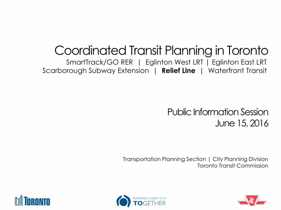
Coordinated Transit Planning in Toronto
Public Information Session
June 15, 2016
Transportation Planning Section | City Planning Division Toronto Transit Commission
SmartTrack/GO RER | Eglinton West LRT | Eglinton East LRT
Scarborough Subway Extension | Relief Line | Waterfront Transit
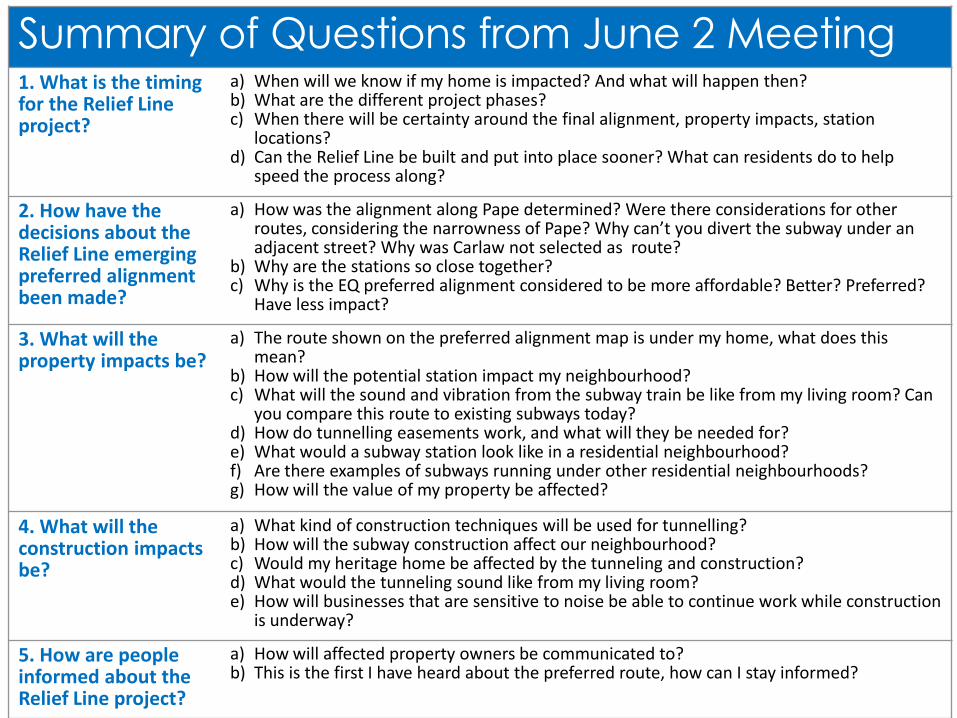
Summary of Questions from June 2 Meeting 1. What is the timing for the Relief Line project?
a) When will we know if my home is impacted? And what will happen then? b) What are the different project phases? c) When there will be certainty around the final alignment, property impacts, station
locations? d) Can the Relief Line be built and put into place sooner? What can residents do to help
speed the process along?
2. How have the decisions about the Relief Line emerging preferred alignment been made?
a) How was the alignment along Pape determined? Were there considerations for other routes, considering the narrowness of Pape? Why can’t you divert the subway under an adjacent street? Why was Carlaw not selected as route?
b) Why are the stations so close together? c) Why is the EQ preferred alignment considered to be more affordable? Better? Preferred?
Have less impact?
3. What will the property impacts be?
a) The route shown on the preferred alignment map is under my home, what does this mean?
b) How will the potential station impact my neighbourhood? c) What will the sound and vibration from the subway train be like from my living room? Can
you compare this route to existing subways today? d) How do tunnelling easements work, and what will they be needed for? e) What would a subway station look like in a residential neighbourhood? f) Are there examples of subways running under other residential neighbourhoods? g) How will the value of my property be affected?
4. What will the construction impacts be?
a) What kind of construction techniques will be used for tunnelling? b) How will the subway construction affect our neighbourhood? c) Would my heritage home be affected by the tunneling and construction? d) What would the tunneling sound like from my living room? e) How will businesses that are sensitive to noise be able to continue work while construction
is underway?
5. How are people informed about the Relief Line project?
a) How will affected property owners be communicated to? b) This is the first I have heard about the preferred route, how can I stay informed?

Today’s Agenda
1. Overview of our coordinated approach
2. Overview: Update of transit initiatives underway
3. Update: Relief Line
4. Next Steps
5. Responses to Questions
6. Additional Questions
3

Today’s Agenda
1. Overview of our coordinated approach
2. Overview: Update of transit initiatives underway
3. Update: Relief Line
4. Next Steps
5. Responses to Questions
6. Additional Questions
4

Our Coordinated Approach The City, TTC and Metrolinx, are working together on integrated transit planning within Toronto
5
• Rapid transit projects underway: − Toronto-York Spadina Subway Extension (TYSSE)
− Eglinton Crosstown LRT
− Finch West LRT
− Sheppard East LRT
• Rapid transit planning underway: − SmartTrack / GO RER integration − Eglinton West LRT − Scarborough Subway Extension − Eglinton East LRT − Relief Line − Waterfront Transit “Reset”
• The next round of rapid transit priorities will be identified through completion of the Feeling Congested? initiative and will result in transit policies and long term network plan in the Official Plan.
Scarborough Optimized Transit

Our Coordinated Approach
6
Scarborough Optimized Transit
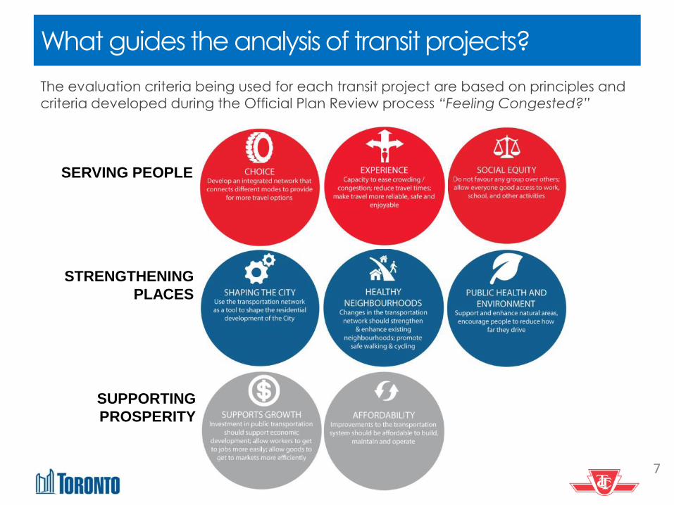
What guides the analysis of transit projects?
The evaluation criteria being used for each transit project are based on principles and
criteria developed during the Official Plan Review process “Feeling Congested?”
7
SERVING PEOPLE
STRENGTHENING
PLACES
SUPPORTING
PROSPERITY

Today’s Agenda
1. Overview of our coordinated approach
2. Overview: Update of transit initiatives underway
3. Update: Relief Line
4. Next Steps
5. Responses to Questions
6. Additional Questions
8

Feb 2016
• City, in partnership with TTC, worked with Metrolinx on the
integration of SmartTrack and GO/RER
• Four options for SmartTrack/GO RER were assessed.
• Options A and B were ruled out due to increased costs and
significant community impacts
Mar 2016
• Council directed staff to focus work on options C and D
May/June 2016
• Public consultation on SmartTrack and RER Integration
• Report to Executive Committee and Council on evaluation
progress
Next Steps
• Continue collaboration with Metrolinx on development of
preferred alignment and station locations for SmartTrack
Options C and D
SmartTrack /GO RER
9
SmartTrack Option C
• 7 to 8 new stations
• Kitchener and Stouffville
through service
SmartTrack Option D
• 4 to 5 new stations
• Kitchener and Stouffville
through service
SmartTrack/GO RER will help relieve many of the transit network’s capacity limitations, which currently affect many parts of the City, including the subways serving Downtown, the SRT in Scarborough, streetcar routes east and west of the downtown and individual
bus routes throughout the City.
Particularly, it will help relieve overcrowding on the Yonge Subway line and address congestion at Bloor-Yonge station.

SmartTrack /GO RER – Proposed Stations
10

Jan
2016
• Feasibility study of SmartTrack Western Corridor options recommended optimizing Phase 2 of the Crosstown LRT, approved in 2009
Mar
2016
• City Council directed staff to remove the heavy rail option and work with Metrolinx to optimize the approved Environmental Assessment for Eglinton
West LRT • Six options assessed for further consideration
May/
June
2016
• Public consultation on emerging preferred LRT alignment and station locations
SmartTrack – Eglinton West Corridor
11
Next Steps
• Continue to work with Metrolinx to optimize the approved Environmental Assessment for Eglinton
West LRT
• Develop Business Case
Part of the SmartTrack concept is connecting the Mississauga Airport Corporate Centre (MACC) to other important employment districts, including downtown Toronto.
A western extension of the Crosstown LRT to MACC and Pearson International Airport would improve access to these important destinations.

Eglinton East LRT
Sept 2009
City Council approved the
recommendations of the
Scarborough-Malvern LRT Transit
Project Assessment
Jan 2016
Executive Committee endorsed
refined transit priorities reintroducing
the Eglinton East LRT, a modification
of the Scarborough-Malvern LRT.
March
2016
City Council endorsed further study of
the Eglinton East LRT
• Up to 18 stops over 11km line
• Improved reliability
• 2 connections to GO RER (Eglinton & Guildwood)
Next Steps July 2016: Report to Council, Seek
authority to proceed with amendment
to Environmental Assessment
Summer 2016: Technical analysis to
amend Environmental Assessment
The Eglinton East LRT would extend the Crosstown east along Eglinton Avenue East, Kingston Road and Morningside
Avenue to the University of Toronto, Scarborough Campus, to improve transportation access along the Avenues and in Neighbourhood Improvement Areas.

Scarborough Subway Extension
Jan. 2016 Executive Committee directed staff to continue technical work on refined Scarborough transit priorities, focusing the subway extension on serving Scarborough Centre
March 2016 City Council endorsed the narrowing of alignment options for the subway extension, and report back to Executive Committee and Council in June/July 2016 with the recommended corridor and alignment
Recommended Express Subway Corridor
McCowan alignment has emerged due to:
• Ability to maintain SRT service throughout construction
• Connection across both sides of Scarborough Centre
with one station
Next Steps July 2016: Report to Council, Seek authority to launch TPAP (EA)
Summer 2016: Initiate TPAP
The Scarborough Subway Extension would extend Line 2 from Kennedy Station to Scarborough Centre, replacing the SRT. The subway extension would encourage the growth and development of Scarborough Centre as a vibrant urban node.

Waterfront Transit “Reset”
The Waterfront Reset will: Provide high quality transit that will integrate waterfront communities, jobs, and destinations and link the waterfront to the broader City and regional transportation network
Phase 2, subject to City Council approval, would consider: Advancing feasibility studies (including but not limited to demand forecasting, operational
assessment(s), further developed cost estimates);
Potential Environmental Assessment(s) or amendments to existing Environmental Assessment(s);
Pursuing the implementation of short term strategic improvements that minimize long term throwaway
costs; and
Advancing a Business Case and pursuing funding opportunities.
Phase 1 will identify reasonable
alternative concepts for a waterfront
transit solution.
Findings will be reported to Council in
July, including:
• Development and analysis of
‘Concept Families’
• Preliminary evaluation of solutions
to create a complete transit
network solution for the Waterfront

Today’s Agenda
1. Overview of our coordinated approach
2. Overview: Update of transit initiatives underway
3. Update: Relief Line
4. Next Steps
5. Responses to Questions
6. Additional Questions
15

Relief Line Project Assessment Study Area
16

Background
17
2009 City Council approves Yonge North Extension EA, contingent on Relief Line and City/TTC commence study to determine need for the Relief Line
2012 Downtown Rapid Transit Expansion Study concludes that initial phase of Relief Line and GO Transit improvements would help ease crowding on the transit network
2012 Relief Line identified as part of the “Next Wave” of transit projects in the Metrolinx Big Move plan and is identified by Metrolinx as a priority for future transit investment
2014 Relief Line Project Assessment launched. City/TTC commence planning for the preferred route alignment and station locations for the Relief Line, to deliver planning approvals in mid-2016. The relationship between SmartTrack and the Relief Line is being reviewed as part of this work.
2015 Yonge Relief Network Study recommendations approved by Metrolinx Board. Allows project development for the Yonge North Subway Extension. Affirms that the Relief Line Project Assessment should continue, to ensure that a project is ready for when needed in 2031.
March 2016
City Council approved preferred corridor for Relief Line: Pape to Downtown via Queen/Richmond.

Study Status
18
• The Preferred Corridor was approved by City Council on March 31, 2016.
• We are now seeking your feedback on the evaluation of alignment options within the Preferred Corridor, the emerging Preferred Alignment and Station Locations.

February/March 2016 Consultations
19
During the last round of consultation, we presented the results from the
evaluation of Potential Corridors and identified the recommended Preferred
Corridor (Corridor B1: Pape Station to Downtown via Queen/ Richmond).
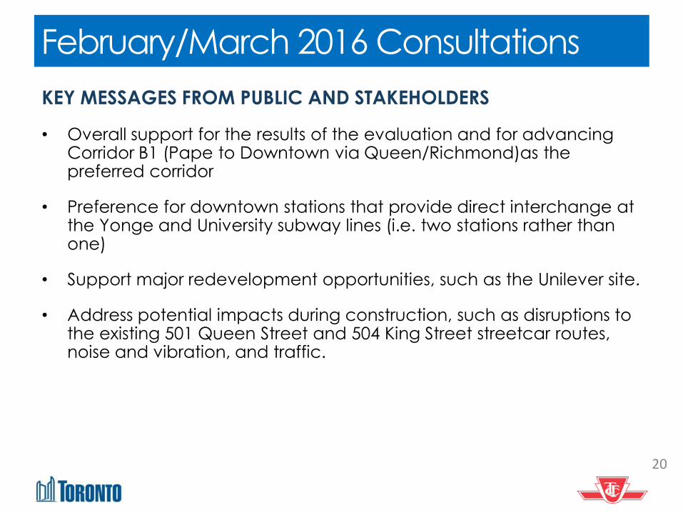
February/March 2016 Consultations
20
KEY MESSAGES FROM PUBLIC AND STAKEHOLDERS
• Overall support for the results of the evaluation and for advancing Corridor B1 (Pape to Downtown via Queen/Richmond)as the preferred corridor
• Preference for downtown stations that provide direct interchange at the Yonge and University subway lines (i.e. two stations rather than one)
• Support major redevelopment opportunities, such as the Unilever site.
• Address potential impacts during construction, such as disruptions to the existing 501 Queen Street and 504 King Street streetcar routes, noise and vibration, and traffic.

21
Alignment Options
• Six potential alignments within the preferred corridor were identified for further evaluation.
• Alignment options
east of the Don Valley connect from Pape via: – GO corridor (‘G’)
or – Queen (‘A’) or – Eastern (‘E’)
• West of the Don Valley, into downtown, they follow: – Queen (‘Q’) or – Richmond (‘R’) Alignments were evaluated using nearly 80 criteria to identify which
would best address project and city-building objectives. Further analysis is underway on costing and deliverability.

22
Emerging Preferred Alignment
AQ
CHOICE Develop an integrated network that connects different
modes to provide for more travel options
EXPERIENCE Capacity to ease crowding/congestion; reduce travel times; make travel more reliable, safe and enjoyable
SOCIAL EQUITY Do not favour any group over others; allow everyone
good access to work, school and other activities
SHAPING THE CITY Use the transportation network as a tool to shape the
residential development of the City
HEALTHY NEIGHBOURHOODS Changes in the transportation network should
strengthen and enhance existing neighbourhoods; promote safe walk and cycling
PUBLIC HEALTH & ENVIRONMENT Support and enhance natural areas; encourage people
to reduce how far they drive
SUPPORTS GROWTH Investment in public transportation should support economic
development; allow workers to get to jobs more easily; allow goods to get to markets more efficiently
AFFORDABILITY Improvements to the transportation system should be
affordable to build, maintain and operate
EQ GR ER
OVERALL PRELIMINARY TECHNICAL SUMMARY
GQ AR SUMMARY OF RESULTS
Alignment EQ is emerging as the preferred
alignment.
EQ connects Pape Station to downtown via Pape,
Eastern and Queen.
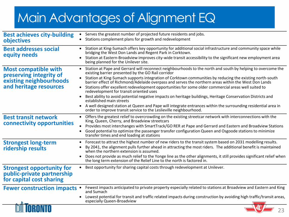
Main Advantages of Alignment EQ Best achieves city-building objectives
Serves the greatest number of projected future residents and jobs. Stations complement plans for growth and redevelopment
Best addresses social equity needs
Station at King-Sumach offers key opportunity for additional social infrastructure and community space while bridging the West Don Lands and Regent Park in Corktown.
Station at Eastern-Broadview improves city-wide transit accessibility to the significant new employment area being planned for the Unilever site.
Most compatible with preserving integrity of existing neighbourhoods and heritage resources
Station at Pape and Gerrard will reconnect neighbourhoods to the north and south by helping to overcome the existing barrier presented by the GO Rail corridor
Station at King-Sumach supports integration of Corktown communities by reducing the existing north-south barrier effect of Richmond/Adelaide overpass and serves the northern areas within the West Don Lands
Stations offer excellent redevelopment opportunities for some older commercial areas well suited to redevelopment for transit oriented uses
Best ability to avoid potential negative impacts on heritage buildings, Heritage Conservation Districts and established main streets
A well designed station at Queen and Pape will integrate entrances within the surrounding residential area in order to improve transit service to the Leslieville neighbourhood.
Best transit network connectivity opportunities
Offers the greatest relief to overcrowding on the existing streetcar network with interconnections with the King, Queen, Cherry, and Broadview streetcars
Provides most interchanges with SmartTrack/GO RER at Pape and Gerrard and Eastern and Broadview Stations Good potential to optimize the passenger transfer configuration Queen and Osgoode stations to minimize
transfer times and end loading at stations
Strongest long-term ridership results
Forecast to attract the highest number of new riders to the transit system based on 2031 modelling results. By 2041, the alignment pulls further ahead in attracting the most riders. The additional benefit is maintained
when the northern extension is assumed. Does not provide as much relief to the Yonge line as the other alignments, it still provides significant relief when
the long term extension of the Relief Line to the north is factored in.
Strongest opportunity for public-private partnership for capital cost sharing
Best opportunity for sharing capital costs through redevelopment at Unilever.
Fewer construction impacts Fewest impacts anticipated to private property especially related to stations at Broadview and Eastern and King and Sumach
Lowest potential for transit and traffic related impacts during construction by avoiding high traffic/transit areas, especially Queen-Broadview
23

24
Proposed Station Locations
Gerrard-Pape
Queen-Pape Eastern-Broadview
King-Sumach
Queen-Sherbourne
Danforth-Pape
Today’s Agenda
1. Overview of our coordinated approach
2. Overview: Update of transit initiatives underway
3. Update: Relief Line
4. Next Steps
5. Responses to Questions
6. Additional Questions
25
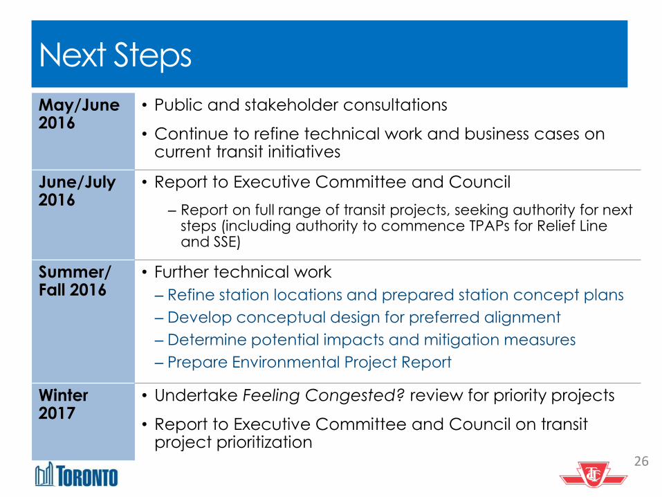
Next Steps
26
May/June 2016
• Public and stakeholder consultations
• Continue to refine technical work and business cases on current transit initiatives
June/July 2016
• Report to Executive Committee and Council
‒ Report on full range of transit projects, seeking authority for next steps (including authority to commence TPAPs for Relief Line and SSE)
Summer/ Fall 2016
• Further technical work
‒ Refine station locations and prepared station concept plans
‒ Develop conceptual design for preferred alignment
‒ Determine potential impacts and mitigation measures
‒ Prepare Environmental Project Report
Winter 2017
• Undertake Feeling Congested? review for priority projects
• Report to Executive Committee and Council on transit project prioritization
Today’s Agenda
1. Overview of our coordinated approach
2. Overview: Update of transit initiatives underway
3. Update: Relief Line
4. Next Steps
5. Responses to Questions
6. Additional Questions
27

Summary of Questions from June 2 Meeting 1. What is the timing for the Relief Line project?
a) When will we know if my home is impacted? And what will happen then? b) What are the different project phases? c) When there will be certainty around the final alignment, property impacts, station
locations? d) Can the Relief Line be built and put into place sooner? What can residents do to help
speed the process along?
2. How have the decisions about the Relief Line emerging preferred alignment been made?
a) How was the alignment along Pape determined? Were there considerations for other routes, considering the narrowness of Pape? Why can’t you divert the subway under an adjacent street? Why was Carlaw not selected as route?
b) Why are the stations so close together? c) Why is the EQ preferred alignment considered to be more affordable? Better? Preferred?
Have less impact?
3. What will the property impacts be?
a) The route shown on the preferred alignment map is under my home, what does this mean?
b) How will the potential station impact my neighbourhood? c) What will the sound and vibration from the subway train be like from my living room? Can
you compare this route to existing subways today? d) How do tunnelling easements work, and what will they be needed for? e) What would a subway station look like in a residential neighbourhood? f) Are there examples of subways running under other residential neighbourhoods? g) How will the value of my property be affected?
4. What will the construction impacts be?
a) What kind of construction techniques will be used for tunnelling? b) How will the subway construction affect our neighbourhood? c) Would my heritage home be affected by the tunneling and construction? d) What would the tunneling sound like from my living room? e) How will businesses that are sensitive to noise be able to continue work while construction
is underway?
5. How are people informed about the Relief Line project?
a) How will affected property owners be communicated to? b) This is the first I have heard about the preferred route, how can I stay informed? 28

a) When will we know if my home is impacted? And what will happen then?
b) What are the different project phases?
c) When will there be certainty around the final alignment, property impacts, station locations etc.?
d) Can the Relief Line be built and put into place sooner? What can residents do to help speed the process along?
1. What is the timing for the Relief Line project?
29
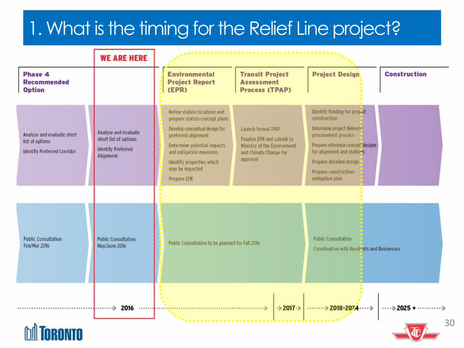
1. What is the timing for the Relief Line project?
30
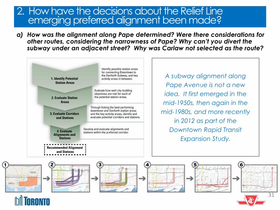
a) How was the alignment along Pape determined? Were there considerations for other routes, considering the narrowness of Pape? Why can’t you divert the subway under an adjacent street? Why was Carlaw not selected as the route?
2. How have the decisions about the Relief Line emerging preferred alignment been made?
A subway alignment along
Pape Avenue is not a new
idea. It first emerged in the
mid-1950s, then again in the
mid-1980s, and more recently
in 2012 as part of the
Downtown Rapid Transit
Expansion Study.
31

Carlaw is not one of the potential alignment options identified and evaluated as part of the Relief Line Project Assessment. The main reasons are: The process itself and how we got to where we are today
Steps leading up to approved corridor and identification of emerging preferred alignment based on a series of steps over 2+ year study process Understanding of current and future conditions Technical analysis – planning and engineering Evaluation of options Consultation with technical experts, stakeholders and the public
Pape to Queen/Eastern identified as most technically feasible
The important role of a Pape/Gerrard station for the approved corridor
Northern extension Reconnect the neighbourhoods to the north and south of the GO
Corridor Open up redevelopment potential of the large parcels of land Interchange with SmartTrack/GO RER station
Potential technical challenges related to Carlaw were identified early on,
such as additional curves which can lead to additional travel time, potential for encountering additional underground infrastructure and additional costs.
2. How have the decisions about the Relief Line emerging preferred alignment been made?
32

b) Why are the stations so close together?
2. How have the decisions about the Relief Line emerging preferred alignment been made?
33
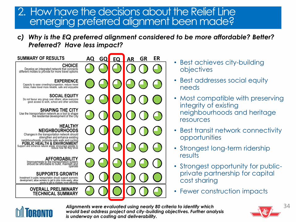
c) Why is the EQ preferred alignment considered to be more affordable? Better?
Preferred? Have less impact?
AQ CHOICE
Develop an integrated network that connects different modes to provide for more travel options
EXPERIENCE Capacity to ease crowding/congestion; reduce travel times; make travel more reliable, safe and enjoyable
SOCIAL EQUITY Do not favour any group over others; allow everyone
good access to work, school and other activities
SHAPING THE CITY Use the transportation network as a tool to shape
the residential development of the City
HEALTHY NEIGHBOURHOODS
Changes in the transportation network should strengthen and enhance existing
neighbourhoods; promote safe walk and cycling PUBLIC HEALTH & ENVIRONMENT
Support and enhance natural areas; encourage people to reduce how far they drive
SUPPORTS GROWTH Investment in public transportation should support economic development; allow workers to get to jobs more easily; allow
goods to get to markets more efficiently
AFFORDABILITY Improvements to the transportation system should be affordable to build, maintain and
operate
EQ GR ER
OVERALL PRELIMINARY TECHNICAL SUMMARY
GQ AR SUMMARY OF RESULTS • Best achieves city-building
objectives
• Best addresses social equity needs
• Most compatible with preserving integrity of existing neighbourhoods and heritage resources
• Best transit network connectivity opportunities
• Strongest long-term ridership results
• Strongest opportunity for public-private partnership for capital cost sharing
• Fewer construction impacts
Alignments were evaluated using nearly 80 criteria to identify which would best address project and city-building objectives. Further analysis is underway on costing and deliverability.
2. How have the decisions about the Relief Line emerging preferred alignment been made?
34

3. What will the property impacts be?
a) The route/station location shown on the preferred alignment map is under my
home, what does this mean?
b) How will the potential station impact my neighbourhood?
Environment Project Report (EPR) will identify potential impacts and mitigation measures. (Fall 2016).
Once potentially impacted properties have been identified, owners will be contacted directly.
Project design will provide further certainty on final alignment, stations and property impacts. (2018 – assuming project funding is in place)
35

3. What will the property impacts be?
c) What will the sound and vibration from the subway train be like from my living room? Can you compare this route to existing subways today?
Noise and Vibration
Study will be conducted
for the Relief Line as part
of the Environment
Project Report (EPR). (Fall
2016).
MOECC guidelines must
be met.
36

3. What will the property impacts be?
d) How do tunnelling easements work, and what will they be needed for?
Below-grade easements
on either side of a
subway tunnel are a
legal requirement for a
buffer zone.
37

e) What would a subway station look like in a residential neighbourhood?
Source: Local Wiki HiMYSYeD.TYO.ca
3. What will the property impacts be?
Subway entrances and
exits can be well-
designed to fit into a
residential context.
The image depicts an
existing station entrance
to the Spadina Subway
Station in a residential
area.
38

f) Are there examples of subways running under other residential
neighbourhoods?
3. What will the property impacts be?
Line 1 – Spadina
• Everden Road, just south of the Eglinton West subway station
• Spadina Road between St. Clair and Bloor.
Line 2 – Bloor-Danforth
• Oakmount Road and Montview Avenue near the High Park Station
• Old Mill Drive and Riverview Gardens near the Jane/Old Mill stations
• Birchview Blvd. near Royal York Station
• Strathmore Blvd. between Woodbine Avenue and Donlands Avenue
g) How will the value of my property be affected?
We recommend that you consult a real estate professional to assist you with questions related to your property value.
39
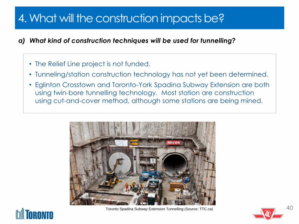
a) What kind of construction techniques will be used for tunnelling?
4. What will the construction impacts be?
• The Relief Line project is not funded.
• Tunneling/station construction technology has not yet been determined.
• Eglinton Crosstown and Toronto-York Spadina Subway Extension are both
using twin-bore tunnelling technology. Most station are construction
using cut-and-cover method, although some stations are being mined.
Toronto Spadina Subway Extension Tunnelling (Source: TTC.ca) 40

Construction impacts may include:
• Short-term access limitations
• Longer-term access limitations where ground stabilization, underpinning, and other construction activities near structures
• Possible acquisition of property for:
‒ construction access and staging for tunnelling below
‒ construction of station entrances
‒ ancillary facilities (such as ventilation), and
‒ emergency exits
Affected owners:
• If reasonable access to residents and businesses cannot be maintained affected owners would be compensated (i.e. lost rental value, temporary relocation, etc.)
• If property needs to be acquired, affected owners would be compensated (i.e. fair market value, relocation services, replacement housing, etc.)
4. What will the construction impacts be?
b) How will the subway construction affect our neighbourhood?
41
c) How would my heritage home be affected by the tunneling and construction?
d) What would the tunneling sound like from my living room?
e) How will businesses that are sensitive to noise be able to continue work while
construction is underway?
What will the construction impacts be? 4. What will the construction impacts be?
If you have a business that is sound sensitive, please identify yourself so
we can include you in the noise and vibration study for the Relief Line.
• Environment Project Report (EPR) will identify potential impacts and mitigation measures. (Fall 2016).
• A noise and vibration assessment will be conducted as part of the EPR.
• Owners of potentially impacted properties will be contacted directly.
• Project design will provide further certainty on final alignment, stations and property impacts. (2018 – assuming project funding is in place)
• During project design/construction, independent conditions inspections would be conducted for potentially impacted properties before and after construction.
42

a) How will affected property owners be communicated to?
5. How are people informed about the Relief Line project?
• Owners of potentially impacted properties will be contacted directly.
• For TTC projects, City Real Estate Services works with property owners with a
focus on negotiating mutually acceptable agreements for the required
property.
• Once the necessary project approvals and funding are in place, the City
obtains an appraisal, survey and other property-related assessments, which
are used as the basis for discussing the terms and conditions of a sale with
the subject property owner.
43

b) This is the first I heard about the preferred route, how can I stay informed?
• Visit reliefline.ca and join the project
mailing list
• Provide your comments online Send us an
email at [email protected]
• Check the City Planning twitterfeed
@CityPlanTO
• Use #TransitTO to share your ideas
• Call the Relief Line hotline at 416-338-1065
• Sign up for mailing lists with your elected
officials
5. How are people informed about the Relief Line project?
44