Cooking Lake - Blackfoot Comm Report FINAL -
75
Riparian Health Summary Final Report Cooking Lake - Blackfoot Grazing, Wildlife and Provincial Recreation Area Alberta Riparian Habitat Management Society (Cows and Fish) December 2010
Transcript of Cooking Lake - Blackfoot Comm Report FINAL -

Riparian Health Summary Final Report
Cooking Lake - Blackfoot Grazing, Wildlife and Provincial Recreation Area
Alberta Riparian Habitat Management Society
(Cows and Fish)
December 2010

Prepared for:
Alberta Tourism, Parks and Recreation
Project Area:
Cooking Lake – Blackfoot Grazing, Wildlife and Provincial Recreation Area
Prepared by:
Cows and Fish Alberta Riparian Habitat Management Society
2nd Floor, YPM Building 530 – 8th Street South
Lethbridge, Alberta, Canada T1J 2J8
(403) 382-4345
Writer: Norine Ambrose
Contributors:
Nicole Bach, Deanna White, Cameron Wood
Suggested report citation: Ambrose, N. 2010. Riparian Health Summary, Final Report, Cooking Lake – Blackfoot Grazing, Wildlife and Provincial Recreation Area. Alberta Riparian Habitat Management Society (Cows and Fish).

i
TABLE OF CONTENTS
1 BACKGROUND .......................................................................................................... 1
1.1 The Cows and Fish Program ............................................................................................1 1.2 What Is A Riparian Area? ................................................................................................1 1.3 Why Are Healthy Riparian Areas Important? .................................................................2 1.4 Why Assess Riparian Health? ..........................................................................................2
2 PROJECT DESCRIPTION ........................................................................................ 3
2.1 Project Background ..........................................................................................................3 2.2 Project Area .....................................................................................................................4 2.3 Site Selection ...................................................................................................................5
3 RIPARIAN HEALTH INVENTORY METHODS .................................................. 7
3.1 Riparian Health Inventory................................................................................................7 3.2 General Inventory Protocol ..............................................................................................7 3.3 What Makes a Riparian Area “Healthy” ..........................................................................8
4 WHAT DID WE FIND? .............................................................................................. 9
4.1 Riparian Health Summary................................................................................................9
5 RIPARIAN HEALTH DISCUSSION ...................................................................... 12
5.1 Historic and Present Influences on Riparian Health ......................................................12 5.2 A Closer Look at the “Pieces” .......................................................................................13 5.3 Riparian Plant Communities ..........................................................................................15 5.4 Woody Plants - Trees and Shrubs: Presence, Reproduction and Health .......................17 5.5 Non-Woody Plants: Diversity and Health .....................................................................18 5.6 Bank and Shore ..............................................................................................................20
6 THE NEXT STEPS .................................................................................................... 23
6.1 Community and Local Site Action ................................................................................23 6.2 Management Objectives .................................................................................................24 6.3 How to Contact Us .........................................................................................................25

ii
TABLES
Table 1 Project Area Description ................................................................................................. 5 Table 2 Description of Riparian Health Ratings .......................................................................... 7 Table 3 Vegetative, Soil and Hydrology and Overall Heath Scores for All Sites in Cooking
Lake – Blackfoot Project Area ................................................................................................ 9 Table 4 Cooking Lake – Blackfoot Project Area Riparian Woody Plant Communities ............ 16
FIGURES
Figure 1 Diagrammatic Representation of a Lentic Riparian Area ............................................ 1 Figure 2 Cooking Lake – Blackfoot Grazing, Wildlife and Provincial Recreation Area Project
2009 ...................................................................................................................................... 6 Figure 3 Cooking Lake - Blackfoot Project Area Riparian Health Score Results .................... 10 Figure 4 Breakdown of Riparian Health Parameter Ratings for Cooking Lake – .................... 14 Blackfoot Project Area .................................................................................................................. 14 Figure 5 Cooking Lake – Blackfoot Project Area Woody Plant Parameter Health Ratings .... 17 Figure 6 Cooking Lake – Blackfoot Project Area Vegetation Cover and Composition ........... 18 Health Ratings ............................................................................................................................... 18 Figure 7 Cooking Lake – Blackfoot Project Area Soil and Hydrology Health Rating ............. 20
APPENDICES APPENDIX A: Glossary of Terms 26 APPENDIX B: UTM co-ordinates For the Sites Assessed within Cooking Lake – Blackfoot
Grazing, Wildlife and Provincial Recreation Area 27 APPENDIX C: Riparian Health Score Sheet – Cooking Lake – Blackfoot Grazing, Wildlife and
Provincial Recreation Area 28 APPENDIX D: Riparian Plant Inventory 29 APPENDIX E: Individual Plant Lists of All Sites Within the Project Area 37 APPENDIX F: Air photos of All Sites Within the Project Area 55 APPENDIX G: Description of Riparian Health Parameters 64

iii
Acknowledgements
A key to the success of this project was the level of interest and co-operation demonstrated by on-site managers and staff at Cooking Lake – Blackfoot Grazing, Wildlife and Provincial Recreation Area and Alberta Tourism, Parks and Recreation staff. We greatly appreciated the support provided by the Alberta Parks in providing use of on-site transportation and access to indoor facilities. Thank you to everyone who assisted with logistical and background data support to this riparian inventory initiative. Funding and in-kind support for this project was provided by the Beaver Hills Initiative and the Cows and Fish members for 2009-10, including in-kind support from Alberta Sustainable Resource Development, Alberta Agriculture and Rural Development and Alberta Beef Producers.
Disclaimer
• Any release of the information contained in this report, in whole or in part, to parties other than Alberta Tourism, Parks and Recreation will not be the responsibility of Cows and Fish. Liabilities with the release of this report or use of the information beyond the original intent of the work will be the responsibility of Alberta Tourism, Parks and Recreation.
• All information in this report is a summary reflecting the overall state of riparian health of
the wetlands examined within Cooking Lake – Blackfoot Grazing, Wildlife and Provincial Recreation Area. It does not include any specific riparian health information on individual sites assessed, although some general individual site location and plant information is included. Details on individual sites are provided separately, via digital spreadsheet files, containing all relevant riparian inventory and derived riparian health assessment scores. [All data associated with this project was provided to Ksenija Vujnovic, Alberta Tourism, Parks and Recreation].
• Due to the broad-scale nature of this representative sampling methodology, there may be
unique areas of riparian zone along the large sampled waterbodies not represented by the overall health rating for that wetland, but wherever possible, representative sampling was the goal of the project. Similarly, some wetland and lake types and health scores may not be represented within the sites included in this report, due to the small number of sites. Additional riparian inventories and/or assessments may be required in subsequent year(s) to fairly represent the overall snapshot of riparian health within the Cooking Lake – Blackfoot Grazing, Wildlife and Provincial Recreation Area. The riparian health of sites outlined in this report generally reflect the health of sites examined, and similar sites – refer to site selection methods outlined below.

1
1 BACKGROUND 1.1 The Cows and Fish Program In 1992, Cows and Fish was formed to foster a better understanding of how improvements in grazing management on riparian areas can enhance landscape health and productivity for the benefit of producers and others who use and value riparian areas. A key feature empowering Cows and Fish is the declaration of ownership of the riparian grazing issue by cattle producers, landowners and community groups. See our enclosed fact sheet called Facing the Issues for more on Cows and Fish and its members and supporters. 1.2 What Is A Riparian Area? Riparian areas are the portions of the landscape strongly influenced by water and are recognised by water-loving vegetation along rivers, streams, lakes, springs, ponds and seeps (Figure 1). Riparian areas can be described as the “green zones” around lakes and wetlands and bordering rivers and streams.
Figure 1 Diagrammatic Representation of a Lentic Riparian Area1
1 Source: Ambrose, N., G. Ehlert, K. Spicer-Rawe. 2004. Riparian Health Assessment for Lakes, Sloughs and
Wetlands –Field Workbook. Modified from Fitch, L., B.W. Adams and G. Hale. 2001. Riparian Health Assessment for Streams and Small Rivers –Field Workbook. Lethbridge, Alberta: Cows and Fish Program. 90 pages.

2
1.3 Why Are Healthy Riparian Areas Important? When in a properly functioning condition or healthy state, riparian areas are one of the most ecologically diverse ecosystems in the world. Healthy riparian areas sustain fish and wildlife populations, provide improved water quality and stable water supplies, and support people on the landscape. In doing so, riparian areas play a role that is disproportionately important to the amount of area that they encompass (approximately 2-5% of the landscape in Alberta). Important ecological functions performed by healthy riparian areas include trapping and storing sediment to maintain and build banks, recharging groundwater supplies, providing stable flows and flood protection, improving water quality by filtering runoff and reducing the amount of contaminants and nutrients reaching the water, and providing habitat for fish and wildlife, and shelter and forage for livestock. Thus, despite occupying only a small percentage of the total land area within a watershed, riparian areas are critical to the long-term sustainability of a healthy landscape. 1.4 Why Assess Riparian Health? The intent of riparian health inventories is to provide a “state of the environment” report to the areas managers. Hopefully, this report will provide better information on riparian health or function to assist managers and the surrounding community make the best decisions on how to manage riparian resources most effectively. Combining this information with existing practical knowledge of resources will provide the best alternatives for the sustaining healthy riparian areas within Cooking Lake – Blackfoot Grazing, Wildlife and Provincial Recreation Area. In general, this information will assist grazing permit holders in the surrounding grazed portions of the Recreation Area and resource managers to identify and effectively develop action plans to address specific riparian land use issues within Cooking Lake – Blackfoot Grazing, Wildlife and Provincial Recreation Area. Assessing riparian health allows communities, managers and resource professionals to:
• Create awareness amongst local landowners, land users and their communities and build common understanding on riparian management issues in their watersheds.
• Take action by assisting local decision-makers develop strategies to find local solutions to address riparian land use issues.
• Monitor progress in improving, maintaining and protecting riparian health for their operation or watershed.
• Identify environmental risk and integrate into local and regional planning • Develop and maintain management plans for long-term productivity and ecological
health. • Establish benchmarks of riparian health from which change over time can be measured.
Working collaboratively on riparian management issues, including riparian health inventories, displays a proactive message to the public that resource managers are taking steps to ensure the health of our landscapes and water supplies are being protected, maintained and improved.

3
2 PROJECT DESCRIPTION 2.1 Project Background Cooking Lake – Blackfoot Grazing, Wildlife and Provincial Recreation Area (Recreation Area) is situated within the Beaver Hills, an area that lies east of Edmonton in the Beaver Hills/Cooking Lake moraine, a geomorphological feature that encompasses 1,572 km2 (607 mi2). The hummocky “knob and kettle” terrain of the moraine forms a mixture of depressional areas, many of which support small lakes and wetlands. These waterbodies allow the moraine to function effectively as a groundwater recharge area which performs a critical role in regional hydrology that extends well beyond the Beaver Hills. The abundant small wetlands throughout the Beaver Hills provide habitat to a diverse group of plants and plant communities, as well as wildlife, including several rare species. They are particularly important for the regional waterfowl production. Sustainability of healthy (functioning) wetlands and ecological processes that regulate them is of the utmost importance for the Beaver Hills. Until recent times, the Beaver Hills have experienced limited development pressure because of their complex terrain and low agricultural potential. As the demand for various land uses grows, so does the development pressure on the Beaver Hills. The Beaver Hills Initiative (BHI) is a multi-stakeholder partnership that came together in 2000 in response to an increasing land use demand for recreation, urban and country residential development, and industry and agriculture pressures on the Beaver Hills/Cooking Lake moraine area. It consists of the five municipalities, the provincial government and federal government, industry, academia and environmental non-government organizations (see http://www.beaverhills.ab.ca/ for further information on the BHI). To further protect precious natural and cultural heritage of the area, while allowing for sustainable growth of the region, the BHI will soon be nominating the Beaver Hills for the Biosphere Reserve, an international designation of recognition from UNESCO (the United Nations Educational, Scientific, and Cultural Organization). This area is particularly suited to this designation as it already has the established key “core” (conservation) Federal and Provincial areas (Elk Island National Park and Miquelon Lake Provincial Park) and protected “buffers” (Cooking Lake – Blackfoot Grazing, Wildlife and Provincial Recreation Area and other provincially protected lands), as well as the functioning collaborative efforts of the BHI partners. Under the Biosphere Reserve designation, Cooking Lake – Blackfoot Grazing, Wildlife and Provincial Recreation Area would serve as a Buffer area, protecting Elk Island National Park (the Core area) from external influence (buffer area is managed in ways that support the conservation objectives of the Core). A network of functioning wetland within Elk Island National Park and the Recreation Area helps preserve regional hydrology as well as larger, regional populations of species. Note: Background and future plans content above provided by Alberta Tourism, Parks and Recreation. Funding and support for this project was provided by the Beaver Hills Initiative and the Cows and Fish members for 2009-10, including in-kind support from Alberta Sustainable Resource Development, Alberta Agriculture and Rural Development, Alberta Beef Producers and Tourism Parks and Recreation. Riparian health inventories for this project were conducted during August, 2009.

4
2.2 Project Area The project area is a selection of riparian areas along numerous lakes and wetlands within the Cooking Lake – Blackfoot Grazing, Wildlife and Provincial Recreation Area. Sites are located within Township 52 and Ranges 19 and 20, west of the Fourth Meridian. At the request of the Alberta Parks Division staff, with input from the Beaver Hills Initiative, one site was sampled which straddled the border with Elk Island National Park, on Blackfoot Lake (refer to project area map – Figure 2).
The project area is located within southern portions of the Boreal Forest Natural Region, Dry Mixedwood Subregion. All sites are part of the North Saskatchewan River basin, within either the Beaverhill or Oldman Creek sub-basins. The headwaters of the North Saskatchewan River basin originate within the Rocky Mountain Natural Region, within the Montane natural subregion, then the river flows into the Foothills Natural Region, the Boreal Forest Natural Region, followed by the Parkland Natural Region and then back into the small outlying area of Boreal Forest Natural Region (within the project area), and finally, returns to the Parkland Natural Region, and flows toward Saskatchewan. The Cooking Lake – Blackfoot Grazing, Wildlife and Provincial Recreation Area is 97 km2 in size, and used for a variety of day-use only recreational activities. Maintained trails are used year round for non-motorised recreation including hiking, mountain biking, horseback riding, and cross-country skiing. Bird watching, canoeing and other recreational activities also occur. Hunting within designated areas is allowed. Petroleum extraction also occurs within the Recreation Area. The area formed part of the Beaverhills Timber Reserve in the 1880s, and was later renamed the Cooking Lake Forest Preserve as part of a smaller designated area in 1899. Forest fires in the 1890s and 1920s and logging in the 1920s reduced the white spruce populations of the area. Since the 1920s, cattle grazing has occurred, with clearing of the forest in some areas beginning in the 1950s for pastureland. The current Recreation Area has designated grazing areas (pastures), used by the Blackfoot Grazing Association, which were mostly established in 1987, through clearing of about 40% of the landbase and seeding of agronomic species. The northern most point of the project area is located in the north eastern portion of the Recreation Area, north of Muskrat Lake (UTM 12U Easting 383112 Northing 5932389), as is the eastern most point (UTM 12U Easting 384479 Northing 5931995). The southern extent of sites examined was east of Islet Lake (UTM 12U Easting 379777 Northing 5925719). The western most site was located west of Arrow Head Lake (UTM 12U Easting 371969 Northing 5928216). In addition, one site was located along the Recreation Area’s boundary with Elk Island National Park on Blackfoot Lake. Refer to Appendix B for location co-ordinates of the sites assessed in the Cooking Lake – Blackfoot Grazing, Wildlife and Provincial Recreation Area project.

5
Table 1 Project Area Description
Waterbody
# Riparian Inventories
Riparian Distance Inventoried (km)
Various (8) unnamed wetland and lakes, Blackfoot Lake,
Moose Meadows Lake 10 4.42
2.3 Site Selection Based on the objectives and resources of the Cooking Lake – Blackfoot Grazing, Wildlife and Provincial Recreation Area, it was not possible for every kilometre of lake and wetland to be assessed. Initial site selection was based on examining stereo pairs of 1989 1:10,000 aerial photographs and spatially-rectified aerial photos, at 0.25 m resolution (aerial photography date: 2007, provided by Beaver Hills Initiative via Alberta Parks Division, for use in the project) for Cooking Lake – Blackfoot Grazing, Wildlife and Provincial Recreation Area and NE35 and SE35 51-21-W4 (with a buffer of ½ mile around them). Alberta Parks staff determined that sites would be classified based on whether they were shrub dominated or graminoid dominated, and then the ten sites to be inventoried would be selected proportionately from these groupings, if possible. A map outlining previously examined sites, using these two categories, was prepared and provided to Cows and Fish by Alberta Parks staff. Upon field inspection, in conjunction with Parks staff, it was determined that some sites had either changed since they had been previously classified, the classification (shrub or graminoid dominated) only applied to a portion of the wetland / riparian area, or some sites were too small to included as representative sites. Efforts were made to geographically spread the sites across the entire Recreation Area, but exclude all pasture/grazing areas and avoid sites within or close to trails or other recreational features (eg. roads, staging areas, etc). Sites were selected that were reasonably accessible for field work in order to stay within allocated time and resources available for the project, and to represent the common spectrum of sites available. The final sites were selected from those originally identified, with the above constraints, or alternatives following these same selection criteria. In all cases, due to the nature of the Recreation Area, all sites were located within land with the same land use – recreation.

Cows and Fish Cooking Lake- Blackfoot Project Area Final Report, December 2010 6
Figure 2 Cooking Lake – Blackfoot Grazing, Wildlife and Provincial Recreation Area Project 2009

Cows and Fish Cooking Lake- Blackfoot Project Area Final Report, December 2010 7
3 RIPARIAN HEALTH INVENTORY METHODS
3.1 Riparian Health Inventory Riparian health inventories provide comprehensive information about the diversity, structure and health of plant communities within the project area. The health inventory establishes an important baseline to compare to in the future, to keep track of whether riparian health is being maintained, improved or is declining. A riparian health inventory differs from the ‘shorter’ riparian health assessment (survey) because it is a detailed inventory that thoroughly examines the vegetative, soil and hydrological parameters of the project area. During a riparian health inventory 79 health parameters are examined to provide comprehensive and detailed information on riparian function. A health score is derived from this data (Table 2) and breaks information down into 9 parameters that are used in this report to discuss the riparian health of Cooking Lake – Blackfoot Provincial Recreation Area. Six of the parameters relate to vegetation2 and three relate to soil and hydrology. A more detailed description of each of these 9 parameters and how they are evaluated is given in Appendix G. By objectively examining each of these health parameters we can determine which pieces are adequately performing the necessary functions of a healthy riparian area, and which are not. This examination provides us with a better understanding of where to concentrate efforts if improvements in riparian management are required, and what land use practices are currently maintaining riparian health.
Table 2 Description of Riparian Health Ratings
3.2 General Inventory Protocol Riparian health parameters are visually assessed by trained observers in the field. A health rating is derived from this field data using a computer software program (FileMaker Pro). A hand-held Garmin GPS60TM Global Positioning System (GPS) receiver is used to record strategic reference locations at each site. For monitoring purposes, benchmark photographs are taken at strategic points within each site. Additional photographs are taken where warranted to document features of interest or concern (e.g., weed infestations, bank erosion etc.). The lateral
2 Invasive plants is considered one parameter, however is broken into two parts separating canopy cover and density
distribution. Utilisation of woody plants is also broken into two parts to take into account browse use by animals and cutting / mowing of woody plants by humans and beavers.
Health Category Score
Ranges DescriptionHealthy 80-100% little to no impairment to any riparian functions Healthy, but with problems 60-79% some impairment to riparian functions due to
management or natural causes
Unhealthy <60% severe impairment to riparian functions due to management or natural causes

Cows and Fish Cooking Lake- Blackfoot Project Area Final Report, December 2010 8
extent of the riparian area is determined using vegetative and topographic features in the field and mapped on an air photo3 (1: 5,500 to 1: 9,000 scale). 3.3 What Makes a Riparian Area “Healthy” Riparian areas are like a jigsaw puzzle and each individual piece or component is important to the successful function of the entire system. How the individual pieces function together affects the health of the riparian ecosystem including the stream, its watershed, and overall landscape health and productivity. Healthy riparian areas have the following pieces intact and functioning properly:
• successful reproduction and establishment of seedling, sapling and mature trees and shrubs (if site has potential to grow them),
• lightly browsed trees and shrubs (by livestock or wildlife), • banks and shores with abundant plant growth, • banks and shores with deep-rooted plant species (trees and shrubs), • very few, if any, invasive weeds (e.g. Canada thistle), • not many disturbance-caused plant species (e.g. Kentucky bluegrass, dandelion), • very little bare ground or altered banks and shores, and • ability to store water, sustain and establish new plant communities even during natural
climatic cycles (e.g. drought). When riparian health degrades it usually means that one or more of the pieces has been impacted by natural or human-caused disturbances such as development, recreation, grazing, flooding or fire. As the rate and intensity of disturbance increases, the severity of health degradation can reach a point when the riparian area fails to perform its functions properly and becomes unhealthy. Riparian areas with moderate levels of impacts will typically fall within the healthy, but with problems category, while those with very few or no impacts will normally be rated as healthy. It is often difficult to see specific parameters decline in health, particularly when the degradation occurs gradually over a long period of time.
Note: Refer to Appendix A for a glossary of terms used in this report
3 Aerial photography was provided for the project by Beaver Hills Initiative.

Cows and Fish Cooking Lake- Blackfoot Project Area Final Report, December 2010 9
4 WHAT DID WE FIND? 4.1 Riparian Health Summary Ten sites were assessed within the project area. Overall the riparian health of Cooking Lake – Blackfoot Grazing, Wildlife and Provincial Recreation Area is healthy (89%) (Table 3). Due to the small number of sites inventoried these health ratings do not necessarily represent the health of the entire Recreation Area but we feel they do well represent the types of areas they were selected based on (i.e. non-pasture components, and not on or immediately adjacent to specific recreational features). The majority (90%) of the sites (9 out of 10) rated healthy; the remaining site (10%) rated healthy, but with problems (Figure 3). Photos a – f (pages 11-12) show examples of riparian areas examined in the Cooking Lake – Blackfoot Grazing, Wildlife and Provincial Recreation Area. Refer to Appendix C for derived health scores for the entire project area.
Table 3 Vegetative, Soil and Hydrology and Overall Heath Scores for All Sites in Cooking Lake – Blackfoot Project Area
Site (Polygon)
#
Shoreline Length / Size of Riparian Area
Vegetative Health
Rating
Soil & Hydrology
Health Rating
Overall Health Rating
Overall Health Description
BLF1 1.1 km / 8.8 ha 61% 100% 79% Healthy, but with problems
BLX1 0.4 km / 2.1 ha 79% 100% 89% Healthy BLX2 0.3 km / 0.8 ha 73% 100% 86% Healthy BLY1 0.3 km / 1.2 ha 82% 100% 90% Healthy BLZ1 0.5 km / 6.2 ha 91% 100% 95% Healthy
MOM1 0.3 km / 3.8 ha 85% 97% 90% Healthy MUY1 0.2 km / 0.9 ha 82% 97% 89% Healthy WAY1 0.5 km / 4.1 ha 88% 100% 94% Healthy WSX1 0.3 km / 1.8 ha 79% 100% 89% Healthy WSY1 0.6 km / 3.7 ha 85% 100% 92% Healthy
Average Score 80.3% 99.3% 89.4% Healthy

Cows and Fish Cooking Lake- Blackfoot Project Area Final Report, December 2010 10
Figure 3 Cooking Lake - Blackfoot Project Area Riparian Health Score Results
Please Keep in Mind:
The objective of completing these riparian health inventories is to provide a coarse filter review of the status of riparian health or function within the project area. The riparian health scores provide a general status of riparian health at the time of inventory, not an absolute one. Riparian areas are dynamic and are constantly changing. Because of this natural variability, the range of possible scores in each category is broad and one inventory is only an approximation of health at that time. Inventories over a period of years at the same locations will provide a more complete picture of whether current management and land use is maintaining, improving or negatively impacting riparian health.

Cows and Fish Cooking Lake- Blackfoot Project Area Final Report, December 2010 11
Examples of shrub dominated riparian areas within project area
Photo a: Site BLZ1 – Rated as healthy. Dense woody plant communities with thick sedge understory provide structurally diverse habitat. (Photographer: D. McCormick, RHIP01BLZ006).
Photo b: Site WSY1 – Rated as healthy. This site displays a high level of species diversity, particularly along the outer edge of the wetland. (Photographer: K. Hull, RHIP01WSY008).
Photo c: Site WAY1 – Rated as healthy. Majority of woody plants in the center of the wetland are dead or decadent, indicating a drying trend of the wetland. (Photographer: K. Adair, RHIP01WAY009).
Photo d: Site MOM1 – Rated as healthy. Vegetative communities of this site were unique compared to rest of project area sites. Inner portions were dominated by vegetation typical of a bog/fen. (Photographer: C. Wood, RHIP01MOM004).

Cows and Fish Cooking Lake- Blackfoot Project Area Final Report, December 2010 12
Examples of graminoid dominated riparian areas within project area
Photo e: Site BLF1 – Rated as healthy but with problems. Invasive plant species have invaded the riparian area, limiting the vegetative species diversity. (Photographer: K.Hull, RHIP01BLF019).
Photo f: Site BLX1 – Rated as healthy. This beaver modified wetland displays high species diversity. (Photographer: K. Hull, RHIP01BLX003).
5 RIPARIAN HEALTH DISCUSSION 5.1 Historic and Present Influences on Riparian Health The following discussion provides some insights regarding the current status of the health of riparian areas within the project area.
• Grazing animals (including livestock and wildlife) have primarily dominated land use in Alberta’s riparian zones for hundreds of years. Prior to the introduction of cattle, bison, deer and moose, likely provided the greatest seasonal grazing pressures on riparian areas within the project area. Cattle grazing has been occurring in the Recreation Area since the 1920s4, although it is currently restricted to portions of the Recreation Area that were not included in this examination of riparian health. Currently, wild ungulate grazing continues, and is one of the primary factors influencing riparian health within Cooking Lake – Blackfoot Provincial Recreation Area5.
• Tame pasture ‘improvements’ for grazing and hay in surrounding areas outside the
inventoried sites, as well as some localised, prolonged continuous season-long grazing by livestock nearby, have likely contributed in a small way to an increased presence of disturbance-caused undesirable plants within the riparian zones. These tame forage species’ preponderance in the surrounding landscape, within and outside the area, increases their ability to spread into the mostly native habitat surrounding the examined wetland areas. Opinions vary on how these plant species should be viewed in terms of
4 Cooking Lake –Blackfoot Grazing, Wildlife Provincial Recreation Area website, accessed March 1, 2010. http://www.dotheblackfoot.ca/grazing.htm 5 Based on data collected and observations from Cows and Fish field crews.

Cows and Fish Cooking Lake- Blackfoot Project Area Final Report, December 2010 13
contributing to riparian health, but generally are thought to reduce long-term productivity of riparian systems.
• Beaver have been building and modifying riparian areas for thousands of years. Beaver
“manage” riparian areas with their extensive dams and through their harvest of trees and shrubs. Over long periods of time stream valleys and wetlands evolve under beaver management, however, in the short term this activity can conflict with our uses of riparian systems, especially if we look at specific sites without the context of the overall watershed. While the project area supports beavers, and beaver have been or were active at many of the sites, their level of harvest of trees and shrubs in the riparian area is currently having minimal impact in the project area.
• Availability of water. Sustained water levels within this landscape are not guaranteed
one year to the next, and may fluctuate considerably. In years of drought, water is scarce. Riparian plant communities in this area have evolved with cycles of drought and natural water level fluctuations, and the relatively low water levels in some of the wetlands appear not to have been particularly stressful on the water-loving plants nor on overall riparian health.
• Recreational activity is not currently impacting riparian health, but is present in the area.
Most sites were selected that were back from the main trail system, and thus human activities at the actual wetlands are minimal or non-existent.
5.2 A Closer Look at the “Pieces” To better understand the overall health ratings for the project area, it is helpful to take a closer look at which pieces of the riparian area are intact and functioning and which area not. Figure 4 provides an overview of the health ratings for each of the riparian health parameters that were assessed. Collectively, the vegetation parameters in the project area were rated as healthy (90%). Riparian areas are very well vegetated with a diversity of plant species. Refer to Appendix D for a list of all plants found in Cooking Lake – Blackfoot Grazing, Wildlife and Provincial Recreation Area and Appendix E for individual plant lists for each site. Plant communities also display a high amount of structure as evidenced by overlap in life form (plant type) layers.

Cows and Fish Cooking Lake- Blackfoot Project Area Final Report, December 2010 14
Figure 4 Breakdown of Riparian Health Parameter Ratings for Cooking Lake –
Blackfoot Project Area Tree cover represents approximately 14% of the project area, shrubs 40%, grass and grass-like plants 73% and forbs 35%. Unlike in most riparian areas in regions of long-term settlement, there is little detracting from the vegetative health of these riparian areas, because there is excellent vegetative cover, except in rare situations due to natural drawdown. All sites scored 100% for minimal presence of disturbance-caused grasses and forbs, which cover less than 5% of each site within the project area (Figure 6). The relatively widespread presence of invasive weeds reduced the vegetative score. Canada thistle (Cirsium arvense) covered only about 2.4% of the project area, but was common. Three other invasive plant species were also found (Appendix D). Soil/hydrology parameters in the project area were rated as healthy (89%) (Figure 7). Human-caused bare ground is absent at all sites—this is excellent. Only trace amounts of physical alterations to a couple of sites were noted, related to recreational use resulting in compaction to the soil or modification of the soil profile. Overall, the minor impacts to vegetation and soil/ hydrology health are related to alterations caused by very limited recreational use on site or nearby, in combination with the presence of non-native plant species in the surrounding areas and landscape.
Unhealthy Healthy but with problems Healthy

Cows and Fish Cooking Lake- Blackfoot Project Area Final Report, December 2010 15
5.3 Riparian Plant Communities The vegetation health rating for a riparian area is determined by the types of riparian plant communities present, and the health of both the woody and non-woody (herbaceous) plant components (refer to Sections 5.4 and 5.5). Background Information on Riparian Plant Communities Typically, a particular species of willow or other shrub will form the understory or inner band within a poplar, spruce or birch tree species, within a riparian area. On smaller systems willows might be the dominant plant in the upper canopy with sedges and smaller shrubs forming the understory. These different combinations of plants occupying the same ecological niche are referred to as the potential natural community. The potential natural community is comprised of habitat types and community types. Habitat types have the potential to support ‘climax plant communities’ or, final state plant communities that are self-perpetuating and in dynamic equilibrium with their environment. Community types have the potential to support ‘seral plant communities’, or interim plant communities that are replaced by another community or species as succession progresses. Using this classification system all the plant communities within the project area, whether habitat types or community types, were identified and stratified. Understanding the type of riparian plant communities a stream, lake, or wetland system has the potential to grow is important for a number of reasons. Firstly it allows land managers to know if the desired plant communities are growing there already and if not, why not? How extensive should the plant communities be? Secondly it provides insight into the feasibility of improving existing site conditions and recovering desired and healthier plant communities, if the desired plant community does not exist or is limited. Knowing how far existing plant communities are from the potential natural community of the riparian area allows managers to:
i. set realistic goals to either improve or maintain existing riparian health, ii. understand how long recovery may take if improvement is needed, and
iii. obtain insight into what management strategies need to be implemented for improvement to occur or to maintain existing riparian health.
If there is one thing a land manager, landowner or community can do to improve riparian health, it is to keep riparian plant communities healthy by using sustainable management strategies and land use practices.
Cooking Lake – Blackfoot Project Area Plant Communities Tree and shrub plant communities form the majority of riparian communities found in the Cooking Lake – Blackfoot Grazing, Wildlife and Provincial Recreation Area project area (Table 3). An indicator of a healthy shrub understory is often the presence of willows (Salix spp.) and red-osier dogwood (Cornus stolonifera), highly palatable shrub species. Nearly 80% of the project area is occupied by naturally occurring habitat types while a small portion of the remainder of the project area is occupied by earlier succession community types. Approximately 16% of the project area was recorded as unclassified types that did not fit within the types

Cows and Fish Cooking Lake- Blackfoot Project Area Final Report, December 2010 16
identified in our classification system. These included a very early seral site resulting from water level drawdown and a bog site that did not fit any community or habitat types in our classification. The dominance of native species habitat and community types is very positive, and maintaining these natural plant communities, with minimal non-native components, should be a goal for promoting healthy plant communities in the project area. Table 4 Cooking Lake – Blackfoot Project Area Riparian Woody Plant Communities
Plant Community6 Classification Area Occupied
(Hectares) Area Occupied (%) Tree Communities aspen/red-osier dogwood Habitat Type 0.45 1.3 aspen/low-bush cranberry Community Type 1.24 3.7 white birch Community Type 6.53 19.5 Tree Total 8.22 24.5
Shrub Communities flat leaved willow/water sedge Habitat Type 7.13 21.31 beaked willow/awned sedge Habitat Type 4.6 13.73 yellow willow/red-osier dogwood
Habitat Type 0.45 1.32
flat leaved willow/bluejoint Habitat Type 0.74 2.2 river alder Community Type 0.11 .3 beaked willow Community Type 0.27 .79 Shrub Total 13.3 39.65
6 Thompson, William H. and Paul L. Hansen. 2003. Classification and management of riparian and wetland sites of Alberta’s Parkland Natural Region and Dry Mixedwood Natural Subregion. Bitterroot Restoration Inc. Prepared for the Alberta Riparian Habitat Management Program-Cows and Fish. Lethbridge, Alberta. 340 pp.

Cows and Fish Cooking Lake- Blackfoot Project Area Final Report, December 2010 17
5.4 Woody Plants - Trees and Shrubs: Presence, Reproduction and Health
0
20
40
60
80
100
Establishment & Regeneration Utilization Utilization (non browse)
Aver
age
Hea
lth R
atin
g (%
)
Figure 5 Cooking Lake – Blackfoot Project Area Woody Plant Parameter Health Ratings
Presence The presence of many different tree and shrub species is often a good indicator of structure and diversity. A diversity of plants provides habitat layers – low, medium, and high, benefiting wildlife.
• 7 tree species and 37 shrub species were recorded within the project area. These are all native tree and shrub species (Appendix D). One unidentified Salix spp. was also recorded, and although it was likely native and represented by the other recorded species, it was not possible to identify it due to limited size and lack of reproductive features.
• Total area covered by all trees and shrubs (based on woody plant cover) combined is 47% of the project area.
• Alaska birch (Betula neoalaskana) and balsam poplar (Populus balsamifera) are the dominant trees occurring in the project area, with Alaska birch providing much more cover than any other tree species. Shrubs with the greatest cover are flat-leaved willow (Salix planifolia), pussy willow (Salix discolor), beaked willow (Salix bebbiana), and velvet-fruited willow (Salix maccalliana).
• Twelve of the shrubs recorded are willow (Salix) species and many others are indicative of moisture-rich habitats.
Reproduction A good indicator of ecological stability of a riparian reach is the presence of woody plants in all age classes, especially young age classes. To maintain age class structure, at least 15% of the total cover of preferred7 trees and shrubs should be comprised of seedlings and saplings. There are no concerns with the reproduction of preferred trees and shrubs in the project area. Successful preferred tree and shrub reproduction is occurring in every site inventoried (Photo b, page 11). 7 Not all trees and shrubs are equally important, useful or desirable for maintaining ecological function. Only those that contribute most beneficially to riparian condition and stability are considered in evaluating establishment and regeneration. See Appendix G, page 66 for further explanation and a list of excluded species.
Healthy Healthy but with problems Unhealthy

Cows and Fish Cooking Lake- Blackfoot Project Area Final Report, December 2010 18
020
4060
8010
0
Vegetative Cover(riparian area)
Invasive Plants(distribution)
Invasive Plants(canopy)
Disturbance Plants
Ave
rage
Hea
lth R
atin
g (%
)Health In 60% of sites (n=6), preferred trees and shrubs species are receiving light browse pressure from wildlife. Three sites had moderate browse pressure. The indicators of moderate browse pressure were mostly flat-topped or hedged seedling and saplings. Woody plants can sustain low levels of use but increased browsing can deplete root reserves and inhibit establishment and regeneration. Only one site had no browse (less than 5% of available stems browsed). A limited amount of beaver use is also occurring, but is not negatively affecting the health of the tree and shrub community. In these wetlands and lakes there is generally a large amount of available material and the amount removed or cut by beavers is a relatively small proportion of the total. How the Health of Trees and Shrubs Could Be Improved If possible, consider management strategies to monitor, and potentially, reduce browse pressure on shrubs. Trees and shrubs that are considered preferred in terms of riparian health also tend to be those that are most palatable to wild ungulates (e.g. red-osier dogwood and some willows). Changing or carefully monitoring deer and moose management, perhaps through directed hunting pressure may be one means to manage browse pressure. Browsing tends to occur more extensively in the fall and winter when woody plants have particularly high nutritional value compared to surrounding vegetation. 5.5 Non-Woody Plants: Diversity and Health
Figure 6 Cooking Lake – Blackfoot Project Area Vegetation Cover and Composition
Health Ratings Diversity Greater diversity lends to more robust and steady productivity over the long term and enhanced resiliency to changes in the environment. An abundance of diversity in plant species occurs in this project area:
• 38 species of grasses and grass-like plants and 89 species of broad leafed plants (forbs) were recorded.
Healthy Healthy but with problems Unhealthy

Cows and Fish Cooking Lake- Blackfoot Project Area Final Report, December 2010 19
• Over 80% (144 species) of the plants recorded are native plants. Native plants provide riparian functions including wildlife habitat, deep, binding root masses and summer and winter forage production for wildlife.
• 4 poisonous plant species: spreading dogbane (Apocynum androsaemifolium), common horsetail (Equisetum arvense), red and white baneberry (Actaea rubra), and water hemlock (Cicuta maculata) were recorded within the project area, with low canopy cover.
Health All sites have adequate amounts of plant cover in the riparian area (greater than 85%). Disturbance-caused undesirable herbaceous species as well as invasive species are low in cover within the project area. Disturbance plants are typically non-native grasses and forbs (broad-leaved flowering plants) that aggressively displace native plants once the soil surface has been disturbed. Invasive plants are primarily those that are listed by the Weed Control Act of Alberta as restricted or noxious weeds. They are non-native species that spread rapidly and are difficult to control.
• None of the 10 sites have more than 5% of the riparian area covered in disturbance-caused undesirable herbaceous species—this is excellent, particularly considering they dominate the cover on nearby mowed trails and in the recreational staging areas. Of the 13 disturbance-caused plants present (all with very low cover), the most prevalent are hemp-nettle (Galeopsis tetrahit) and spreading dogbane (Apocynum androsaemifolium), a native species. All other individual disturbance-caused species were present with much less than 0.5% cover, including white clover (Trifolium repens), common plantain (Plantago major), common dandelion (Taraxacum officinale), and alsike clover (Trifolium hybridum). The only non-native graminoid in the disturbance-caused category was quack grass (Agropyron repens). Some of the disturbance-caused plants are native, including foxtail barley (Hordeum jubatum), rough cinquefoil (Potentilla norvegica), wild strawberry (Fragaria virginiana), and silverweed (Potentilla anserina). Disturbance plants typically do not have a deep, binding root mass and therefore do not provide shoreline protection as well as non-disturbance native species. In the case of native disturbance-caused species, they are a naturally occurring part of the plant community around wetlands, in small amounts, and all sites fell within these expected amounts, and are not detrimentally affecting the sites.
• The present of invasive plants is a concern. Canada thistle (Cirsium arvense) was found at every site (Photo e, page 12). Its distribution in the riparian area ranges from a few sporadically occurring individuals to several patches per site, and in one case was distributed as a continuous occurrence of plants associated with a particular moisture regime along one site. Common tansy (Tanacetum vulgare) was recorded on two sites with a few sporadically occurring individuals at one site, and as a few patches plus several sporadic individuals at the other site. Smooth perennial sow-thistle (Sonchus uliginosus) occurs at two sites as several sporadic individuals in one site and as a few patches plus several sporadic individuals at the other site. Perennial sow-thistle (Sonchus arvensis) was found at four sites, ranging from a few sporadically occurring individuals to few patches plus several sporadic individuals per site.

Cows and Fish Cooking Lake- Blackfoot Project Area Final Report, December 2010 20
How the Health of Non-Woody Plants Could Be Improved
• Prevent an increase in the presence of disturbance-caused plants. Complete elimination of disturbance-caused plants is unrealistic, nor should it be the goal (for native species). However, with careful monitoring of these areas and of the recreational use at and near them, it may be possible to watch for changes in abundance and take action if required.
• Reduce the presence of invasive plants. The abundance of noxious weeds can fluctuate
greatly from year to year and should therefore be monitored closely. The first step is to monitor the existing identified areas and control or eliminate them by hand removal or chemical means. In addition, where possible, monitor the amount of exposed soil where invasive plants can become established, such as exposed soil resulting from beaver activities, pocket gopher or ground squirrel (‘gopher’) soil mounds, or low water levels. This monitoring may help identify risk areas for new or expanded invasion of these species. These wetlands are primarily highly native-dominated vegetation communities, and as such, efforts should be made to reduce and eliminate non-native invasive plants as soon as possible, while infestations are mostly minor in extent and distribution.
To control and manage invasive species, we encourage site and area managers to work with adjoining landowners and land managers, as well as the municipal agricultural fieldman or local weed representative in the surrounding Beaver County (Aimee Boese (780) 663-3730 or cell (780) 208-1304, email: [email protected]).
Where Efforts Could Be Focused
• While these sites are very healthy overall, achieving the above goals requires monitoring the amount of bare ground and controlling disturbance-caused and invasive plants, where possible. A combination of weed control measures and recreational management (including hunting and trail maintenance) should stabilise or reduce further impacts to riparian health.
5.6 Bank and Shore
0
20
40
60
80
100
VegetationAlteration
Physical Alteration Physical Alteration- Severity
Human CausedBare Ground
Artificial WaterLevel Change
Aver
age
Heal
th R
atin
g (%
)
Figure 7 Cooking Lake – Blackfoot Project Area Soil and Hydrology Health Rating
Healthy Healthy but with problems Unhealthy

Cows and Fish Cooking Lake- Blackfoot Project Area Final Report, December 2010 21
Alterations During a lentic health inventory, alterations to the riparian area vegetation and physical alteration to the entire riparian area (shores and banks included) are assessed. A key function of riparian areas is to have abundant plants that filter and trap sediments. This builds a soil layer of moist, fine-textured material. Associated with this, roots and underground fauna create soil structure and macropores that allow water infiltration and storage. These types of soils are very susceptible to vehicle and intensive foot traffic, hoof action and compaction. Modifications to the natural plant community, either by changing or replacing species or proportions of species present, can reduce a site’s ability to adequately perform these functions. When banks and shorelines are physically altered, erosion can increase, water quality can deteriorate and instability can increase.
• Of the ten sites, 80% (n=8) of wetlands show some evidence of human-caused alterations to the vegetation, but only two had sufficient to affect the score, with 5%-15% of those sites affected. The kind of alterations are due to replacing native species with non-native species such as the disturbance-caused introduced species indicated above, primarily associated or related to the recreational use and development of the area.
• The majority of wetlands (8 of 10) have no sign of human-caused physical alterations. Of the two sites with physical alterations, each had only trace amounts (less than 1% of the area), resulting from recreational activities. The alteration related to soil compaction, which reduces that soil’s ability to hold water, filter and buffer runoff, and can, in more extensive cases, change the microsite characteristics and thus the plant community. In all cases, the area altered was very small, and no loss of riparian health was indicated, with the severity of the alterations being slight. Overall, the sites have very minimal impacts to physical site integrity, which is very positive.
Bare Ground Bare ground is unprotected soil that is capable of being eroded by rain drops, overland flow or wind. Bare ground in lentic (non-flowing) riparian areas is often attributed to natural processes, such as natural drawdown in water levels. Bare ground can also result from activities like vehicle and foot traffic, recreational trails, timber harvest or clearing, and landscaping. Areas of natural or human-caused bare ground, even if small, are susceptible to weedy species encroachment. Fortunately, within the Cooking Lake – Blackfoot Grazing, Wildlife Provincial Recreation Area, human activities resulting in bare ground are non-existent within the actual riparian area.
• The amount of bare ground in the project area is minimal, approximately 6%. All bare ground is attributed to natural processes, with the majority of area resulting from naturally exposed soil due to low water levels (one site with 20% bare soil). The majority of sites had bare soil resulting from wildlife uses, but the total area this contributed was very small. All but the one site had less than 5% of the area with bare ground, and seven sites had less than 1% bare ground. Two of the sites had no bare ground. Areas with large areas of bare ground (now or in the future) which are located near or downwind of infestations of invasive plants are at greater risk of expansion or
Cows and Fish Cooking Lake- Blackfoot Project Area Final Report, December 2010 22
new establishment of weedy species, and this may be an area to monitor and plan management around to reduce invasive plant species from spreading within the Recreation Area.
• There was no human-caused bare ground recorded on any sites—this is excellent, and as such there were no detrimental effects to riparian health scores.
Degree of Artificial Addition / Removal of Water Lakes, wetlands and sloughs have naturally fluctuating water levels at different times of the year and between years. Human addition or removal of water can alter the timing and scale of these natural fluctuations. This can inhibit the maintenance of healthy riparian plant communities and lead to areas of extensive exposed shoreline that is susceptible to weedy species encroachment. Fortunately, there was no indication of human damming, diversion, drainage or water extraction from any of the sites examined. This resulted in all sites being assessed as having no artificial addition or removal of water, and no impacts to riparian health—this is positive. How Health of Banks and Shores Could Be Improved Vegetative alterations within the sites examined are generally quite minor, but are generally attributed to encroachment or replacement of native species by non-native species. Because these species dominate the maintained trail system as well as the staging areas, they provide a source for further spread or establishment in the surrounding landscape. Managing these species will be very challenging, and should focus on keeping highly disturbed areas to a minimum, including avoiding creating new trails or lawn areas, and requiring careful and rapid restoration of temporary disturbance that disturb soil or plants (eg. maintenance work, resource extraction, etc). This Recreation Area and adjacent protected areas are rather unique within the surrounding landscape because they are dominated by native species, unlike the surrounding landscape, which is highly dominated by non-native species. A strong effort should be made to maintain the native plant communities in this area. Overall the physical attributes of all sites examined are in excellent condition, showing no or very minimal human-caused impacts of any kind. Their location, generally some distance away from the trail system, means that these sites likely see almost no use from recreationalists, and this minimises the potential for any physical alterations to occur. Management should focus on maintaining these riparian health features in their currently healthy state, including through trail maintenance and future development planning.

Cows and Fish Cooking Lake- Blackfoot Project Area Final Report, December 2010 23
6 THE NEXT STEPS 6.1 Community and Local Site Action
• Take stock of current and past conditions. The first step in addressing riparian management issues has been made within selected parts of the Recreation Area; the collection of baseline information on riparian health and a review of general historical land use practices have answered the question “Where are we now?”, for the non-pasture units of the Recreation Area.
• The work completed in 2009 identified the very high level of riparian health in the Recreation Area, outside of the developed pasture units—do your best to keep these sites healthy. Our general observations of the grazed pasture units in the Recreation Area suggest a very different situation—riparian plant communities do not resemble those in adjacent landscape areas. In particular, where they fall within thoroughly cleared pasture units, they are missing almost all or all tree and shrub components, have extensive presence of agronomic, disturbance-caused grasses, and show extensive physical alterations in the form of pugging and hummocking due to livestock hoof action. Likely, the plant community changes result from a combination of clearing in the late 1980s as well as cattle grazing since then, but further examination of aerial photography, management records, and purposeful monitoring (including riparian health inventory) would be needed to determine the cause and identify the best course of action to improve riparian health in those areas.
• Highlight and profile what’s working in the Recreation Area and surrounding
landscape right now. The next step is to use this knowledge, along with the application of sound range and riparian management techniques, towards the restoration of riparian health in nearby areas. By working with recreational users, site management, the Blackfoot Grazing Association, and adjacent landowners wanting to improve riparian health, practical examples of successful riparian management can be demonstrated to other landowners and communities. Landowners already managing healthy riparian areas in the area can be profiled, meaning their “good news” stories can be shared with others to speed up our knowledge of what works. As these sites yield results, you can better determine “Where do we want to go?”
• Make purposeful management for high levels of riparian health. Within this report and associated data, we have made some suggestions on how to maintain the high levels of health, and address some areas of concern, such as invasive plants and browse pressure. These recommendations will provide insight into the question “How do we get there?” We would be pleased to continue to work with you to discuss management strategies and monitoring for the project area, as well as the other areas of the Recreation Area that we did not assess.
• Continue riparian inventory work over the long-term. We strongly encourage you to
monitor progress of your management efforts, both within this project area and areas in the Recreation Area that appear to have need of improved management. Long-term

Cows and Fish Cooking Lake- Blackfoot Project Area Final Report, December 2010 24
riparian monitoring and refinement in management will answer the question “Did we make it?”
A single evaluation cannot define the absolute status of site health. To measure trend
(improving, declining or staying the same) monitoring should be pursued in subsequent years. Establishing demonstration and profile sites, or another overall riparian inventory can achieve this – every 3 to 5 years.
The Alberta Lentic Wetland Health Assessment (Survey) is available from Cows and
Fish. It explains how to conduct a riparian health assessment, or rapid survey, to quickly check the health status of your riparian area. This tool will allow user groups, managers, and nearby landowners to monitor and track their own progress regarding riparian health. Consider hosting riparian health field days on site to educate users and managers.
6.2 Management Objectives
• Management objectives should include:
Maintain healthy sites!
Monitor and consider reducing browse utilisation of trees and shrubs by wildlife,
particularly if browse increases. This will also ensure continued successful regeneration of woody plant species.
Monitor and prevent the further spread of existing disturbance-caused plants. It is
unrealistic to set goals of completely removing these plants once established in riparian areas, however, sound management practices can be effective in reducing the prevalence of disturbance-caused plants.
Consider developing a monitoring process for bare ground and invasive species
presence or risk. The one site that was healthy, but with problems was very close to healthy, and is most at risk of invasive species expansion due to extensive areas of natural bare ground, resulting from low water levels at the time of the inventory.
Control, and hopefully, eliminate, existing invasive weed infestations. Current
invasive plant distribution and abundance make management still feasible, but further spread will make them much more difficult to control, and will result in negative impacts to habitat quality and riparian health.
Continue to promote recreational use that keeps to the designated trail system—this is
key to preventing physical alterations, and perhaps even reducing the spread of non-native plants.

Cows and Fish Cooking Lake- Blackfoot Project Area Final Report, December 2010 25
6.3 How to Contact Us The Cows and Fish emphasis is to help natural resource managers, individuals, municipalities and local communities address riparian management issues on a watershed basis by increasing awareness and obtaining baseline riparian health information. This riparian health assessment and inventory enables local communities and managers to identify and effectively develop plans to address specific land use issues. Working locally to develop common goals and objectives for entire watersheds is rewarding – it helps keep people invested in natural landscapes. Riparian management tools developed with the community allow people to improve landscape health, for their benefit and for others who use and enjoy these green zones. To inquire about additional references for riparian health monitoring and management and for further information on any aspect of this report, please contact: Norine Ambrose Program Manager Alberta Riparian Habitat Management Society – Cows and Fish Tel: (403) 381-5538 Fax: (403) 381-5723 Email: [email protected]

Cows and Fish Cooking Lake- Blackfoot Project Area Final Report, December 2010 26
APPENDIX A: GLOSSARY OF TERMS Canopy cover – the ground area covered by vegetative growth. Different plant species can
provide varying degrees of cover depending on their overall size and abundance. Total canopy cover can be greater than the area being studied due to overlap in plant structural layers.
Climax (plant) community – Refers to the final or steady state plant community which is self-
perpetuating and in dynamic equilibrium with its environment. Also known as Potential Natural Community.
Community type – An aggregation of all plant communities distinguished by floristic and
structural similarities in both overstory and undergrowth layers. For the purposes of this document, a community type represents seral vegetation, and is never considered to be climax.
Disturbance-caused undesirable herbaceous species – native or introduced non-woody plant
species that are well adapted to disturbance or an environment of continual stress. This term does not include invasive plant species.
Habitat type – the land area that supports, or has the potential to support, the same primary
climax vegetation. It is based on the potential of the site to produce a specific plant community (plant association).
Human-caused bare ground – areas devoid of vegetation as a result of human activity. This can include vehicle roads, recreational trails and livestock trampling.
Invasive plant species – these are typically weed species classified as noxious or restricted by
your municipal district or county and have the potential to infest riparian areas. Lotic – this term means flowing water (i.e., streams and rivers). Lentic – this term means standing or still water (i.e., lakes, ponds and sloughs). Polygon – term used to describe a riparian inventory site. On lotic systems, a polygon has an
upstream and downstream end along a reach of a stream and an associated riparian width. The lateral extent (width) of the riparian area is subjectively determined in the field based on vegetation and terrain clues indicating the flood prone area.
Pugging and Hummocking – the depressions (pugging) and raised mounds of soil
(hummocking) resulting from large animals walking through soft or moist soil. Structural alteration – physical changes to the shape or contour of the bank caused by human
influences. Some examples are livestock crossings, culverts and ‘riprap’ Tree and shrub regeneration – the presence of seedlings and saplings, or the ‘new growth’. Woody plant species – simply refers to trees and shrubs. These plants serve different riparian
functions than grasses and broad-leaf plants.

Cows and Fish Cooking Lake- Blackfoot Project Area Final Report, December 2010 27
APPENDIX B: UTM CO-ORDINATES FOR THE SITES ASSESSED WITHIN
COOKING LAKE – BLACKFOOT GRAZING, WILDLIFE AND PROVINCIAL
RECREATION AREA
Polygon Northing Easting Northing Easting Zone
BLX1 376923 5929861 377031 5929612 12U
BLX2 377026 5929626 376961 5929433 12U
WAY1 371969 5928216 371991 5928106 12U
BLY1 382886 5932282 383112 5932389 12U
WSX1 382057 5927150 381979 5927054 12U
MUY1 384427 5932048 384479 5931995 12U
BLZ1 376549 5930834 376357 5930893 12U
BLF1 380084 5932053 380684 5931705 12U
WSY1 379777 5925719 379984 5925858 12U
MOM1 375692 5928084 375779 5927821 12U
Upper End Lower EndUTM Coordinates of Polygons

Cows and Fish Cooking Lake- Blackfoot Project Area Final Report, December 2010 28
APPENDIX C: RIPARIAN HEALTH SCORE SHEET – COOKING LAKE –
BLACKFOOT GRAZING, WILDLIFE AND PROVINCIAL RECREATION AREA
Average
Riparian Parameter Actual Score
Possible Score
Vegetation 1. Vegetative Cover of Site 5.4 6
2a. Invasive Plant Species Canopy Cover 1.3 3
2b. Invasive Plant Species Density Distribution 0.7 3
3. Disturbance-Caused Undesirable Herbaceous Species 3.0 3
4. Preferred Tree and Shrub Establishment and Regeneration 6.0 6
5a. Browse Utilisation of Available Preferred Trees and Shrubs 1.8 3
5b. Woody Vegetation Removal by Other than Browsing 2.7 3
6. Human Alteration of Site Vegetation 5.6 6
Vegetation Subtotal: 26.5 33 80 % Soil/Hydrology
7a. Human Alteration of Site Physical Structure 12 12
7b. Severity of Human-Caused Alterations to Physical Site 2.8 3
8. Human-Caused Bare Ground 6.0 6
9. Degree of Artificial Removal/Addition of Water 9.0 9
Soil/Hydrology Subtotal: 29.8 30 99 %
Project Area Total: 56.3 63 89 %

Cows and Fish Cooking Lake- Blackfoot Project Area Final Report, December 2010 29
APPENDIX D: RIPARIAN PLANT INVENTORY Percent Canopy Cover²
Life Form Plant Status¹ Area by Species (acres)
Avg Range Constancy³
TREES Alaska birch (Betula neoalaskana) native 8.443 15.39% 0.00% 30.00% 80.00% aspen (Populus tremuloides) native 1.818 2.38% 0.00% 3.00% 90.00% balsam poplar (Populus balsamifera) native 2.667 3.98% 0.00% 10.00% 80.00% black spruce (Picea mariana) native 0.047 0.50% 0.00% 0.50% 10.00% tamarack (Larix laricina) native 0.047 0.50% 0.00% 0.50% 10.00% white birch (Betula papyrifera) native 0.645 1.71% 0.00% 3.00% 40.00% white spruce (Picea glauca) native 0.098 0.50% 0.00% 0.50% 20.00%
SHRUBS autumn willow (Salix serissima) native 2.277 3.48% 0.00% 20.00% 70.00% balsam willow (Salix pyrifolia) native 1.588 3.00% 0.00% 3.00% 50.00% basket willow (Salix petiolaris) native 1.767 2.88% 0.00% 10.00% 80.00% beaked hazelnut (Corylus cornuta) native 0.313 0.50% 0.00% 0.50% 70.00% beaked willow (Salix bebbiana) native 5.302 7.91% 0.00% 30.00% 80.00% bog birch (Betula glandulosa) native 0.931 10.00% 0.00% 10.00% 10.00% bog willow (Salix pedicellaris) native 0.047 0.50% 0.00% 0.50% 10.00% bracted honeysuckle (Lonicera involucrata) native 0.453 1.46% 0.00% 3.00% 50.00% buckbrush/snowberry (Symphoricarpos occidentalis) native 0.184 0.50% 0.00% 0.50% 40.00% bunchberry (Cornus canadensis) native 0.098 0.50% 0.00% 0.50% 20.00% Canada buffaloberry (Shepherdia canadensis) native 0.278 0.50% 0.00% 0.50% 40.00% choke cherry (Prunus virginiana) native 0.054 0.50% 0.00% 0.50% 20.00% cloudberry (Rubus chamaemorus) native 0.047 0.50% 0.00% 0.50% 10.00% common Labrador tea (Ledum groenlandicum) native 1.862 20.00% 0.00% 20.00% 10.00% common wild rose (Rosa woodsii) native 0.162 0.50% 0.00% 0.50% 30.00% dewberry (Rubus pubescens) native 0.183 0.50% 0.00% 0.50% 20.00% false mountain willow (Salix pseudomonticola) native 0.214 0.50% 0.00% 0.50% 40.00% firm leafed willow (Salix pseudomyrsinites) native 0.330 1.70% 0.00% 3.00% 20.00% flat-leaved willow (Salix planifolia) native 7.910 12.15% 0.00% 20.00% 70.00%

Cows and Fish Cooking Lake- Blackfoot Project Area Final Report, December 2010 30
Percent Canopy Cover²
Life Form Plant Status¹ Area by Species (acres)
Avg Range Constancy³
SHRUBS continued low-bush cranberry (Viburnum edule) native 0.075 0.50% 0.00% 0.50% 10.00% northern black currant (Ribes hudsonianum) native 0.107 0.50% 0.00% 0.50% 10.00% northern gooseberry (Ribes oxyacanthoides) native 0.637 1.40% 0.00% 3.00% 70.00% prickly rose (Rosa acicularis) native 0.174 0.50% 0.00% 0.50% 50.00% pussy willow (Salix discolor) native 5.552 7.93% 0.00% 30.00% 70.00% red-osier dogwood (Cornus stolonifera) native 0.242 0.50% 0.00% 0.50% 40.00% river alder (Alnus tenuifolia) native 0.346 1.82% 0.00% 3.00% 20.00% Saskatoon (Amelanchier alnifolia) native 0.022 0.50% 0.00% 0.50% 10.00% Scouler's willow (Salix scouleriana) native 0.075 0.50% 0.00% 0.50% 10.00% skunk currant (Ribes glandulosum) native 0.113 0.50% 0.00% 0.50% 30.00% snowberry (Symphoricarpos albus) native 0.075 0.50% 0.00% 0.50% 10.00% twinflower (Linnaea borealis) native 0.022 0.50% 0.00% 0.50% 10.00% twining honeysuckle (Lonicera dioica) native 0.120 0.50% 0.00% 0.50% 20.00% velvet-fruited willow (Salix maccalliana) native 4.325 11.22% 0.00% 20.00% 50.00% wild black currant (Ribes americanum) native 0.010 0.50% 0.00% 0.50% 10.00% wild red currant (Ribes triste) native 0.054 0.50% 0.00% 0.50% 20.00% wild red raspberry (Rubus idaeus) native 1.184 2.60% 0.00% 10.00% 70.00% willow (Salix spp.) unknown 0.060 0.50% 0.00% 0.50% 20.00% yellow willow (Salix lutea) native 1.189 3.34% 0.00% 20.00% 40.00%
GRASSES AND GRASS-LIKES awned sedge (Carex atherodes) native 17.679 26.37% 0.00% 40.00% 80.00% bluejoint (Calamagrostis canadensis) native 11.720 15.35% 0.00% 60.00% 90.00% brownish sedge (Carex brunnescens) native 0.075 0.50% 0.00% 0.50% 10.00% common great bulrush (Scirpus validus) native 0.751 1.76% 0.00% 3.00% 40.00% common tall manna grass (Glyceria grandis) native 2.491 4.38% 0.00% 10.00% 70.00% cotton grass (Eriophorum spp.) unknown 0.279 3.00% 0.00% 3.00% 10.00% creeping spike-rush (Eleocharis palustris) native 0.154 0.50% 0.00% 0.50% 20.00% fowl bluegrass (Poa palustris) native 1.422 2.59% 0.00% 3.00% 60.00% fowl manna grass (Glyceria striata) native 0.560 1.53% 0.00% 3.00% 20.00%

Cows and Fish Cooking Lake- Blackfoot Project Area Final Report, December 2010 31
Percent Canopy Cover²
Life Form Plant Status¹ Area by Species (acres)
Avg Range Constancy³
GRASSES AND GRASS-LIKES continuedfoxtail barley (Hordeum jubatum) disturbance, native 0.118 0.50% 0.00% 0.50% 20.00% fringed brome (Bromus ciliatus) native 0.429 1.48% 0.00% 10.00% 40.00% graceful sedge (Carex praegracilis) native 0.590 2.77% 0.00% 3.00% 30.00% graminoid (Graminoid) unknown 0.444 10.00% 0.00% 10.00% 10.00% mud sedge (Carex limosa) native 0.047 0.50% 0.00% 0.50% 10.00% narrow reed grass (Calamagrostis stricta) native 2.357 5.75% 0.00% 10.00% 30.00% northern reed grass (Calamagrostis inexpansa) native 0.644 3.00% 0.00% 3.00% 10.00% Nuttall's salt-meadow grass (Puccinellia nuttalliana) native 0.644 3.00% 0.00% 3.00% 10.00% purple oat grass (Schizachne purpurascens) native 0.022 0.50% 0.00% 0.50% 10.00% quack grass (Agropyron repens) disturbance, introduced 0.022 0.50% 0.00% 0.50% 10.00% reed canary grass (Phalaris arundinacea) native 0.787 2.83% 0.00% 3.00% 30.00% rough hair grass (Agrostis scabra) native 2.331 3.05% 0.00% 10.00% 90.00% Sartwell's sedge (Carex sartwellii) native 0.239 0.50% 0.00% 0.50% 40.00% sedge (Carex pachystachya) native 0.237 0.50% 0.00% 0.50% 40.00% sedge (Carex spp.) unknown 0.239 0.50% 0.00% 0.50% 40.00% short awned foxtail; water foxtail (Alopecurus aequalis) native 0.739 1.30% 0.00% 3.00% 50.00% short sedge (Carex curta) native 0.279 3.00% 0.00% 3.00% 10.00% slender wheat grass (Agropyron trachycaulum var. unilaterale) native 0.045 0.50% 0.00% 0.50% 10.00% slender wheat grass (Agropyron trachycaulum) native 0.010 0.50% 0.00% 0.50% 10.00% slough grass (Beckmannia syzigachne) native 0.208 0.50% 0.00% 0.50% 40.00% small bottle sedge (Carex utriculata) native 8.309 14.26% 0.00% 40.00% 70.00% small-fruited bulrush (Scirpus microcarpus) native 0.240 0.62% 0.00% 3.00% 30.00% small-winged sedge (Carex microptera) native 1.757 6.65% 0.00% 10.00% 50.00% spangletop (Scolochloa festucacea) native 4.292 9.44% 0.00% 30.00% 30.00% three-seeded sedge (Carex trisperma) native 0.075 0.50% 0.00% 0.50% 10.00% timothy (Phleum pratense) disturbance, introduced 0.010 0.50% 0.00% 0.50% 10.00% tufted hair grass (Deschampsia cespitosa) native 0.364 7.06% 0.00% 10.00% 20.00% two-seeded sedge (Carex disperma) native 0.075 0.50% 0.00% 0.50% 10.00%

Cows and Fish Cooking Lake- Blackfoot Project Area Final Report, December 2010 32
Percent Canopy Cover²
Life Form Plant Status¹ Area by Species (acres)
Avg Range Constancy³
GRASSES AND GRASS-LIKES continuedwater sedge (Carex aquatilis) native 2.195 3.82% 0.00% 10.00% 50.00%
FORBS agrimony (Agrimonia striata) native 0.102 0.94% 0.00% 3.00% 20.00% alsike clover (Trifolium hybridum) disturbance, introduced 0.167 0.50% 0.00% 0.50% 30.00% arrow-leaved coltsfoot (Petasites sagittatus) native 0.268 0.85% 0.00% 3.00% 40.00% bulb-bearing water-hemlock (Cicuta bulbifera) native 0.172 0.50% 0.00% 0.50% 30.00% Canada anemone (Anemone canadensis) native 0.054 0.50% 0.00% 0.50% 20.00% Canada goldenrod (Solidago canadensis) native 0.270 0.50% 0.00% 0.50% 60.00% Canada thistle (Cirsium arvense) invasive, introduced 1.961 2.57% 0.00% 20.00% 90.00% celery-leaved buttercup (Ranunculus sceleratus) native 0.107 0.50% 0.00% 0.50% 10.00% common cattail (Typha latifolia) native 8.158 13.10% 0.00% 30.00% 60.00% common dandelion (Taraxacum officinale) disturbance, introduced 0.132 0.50% 0.00% 0.50% 30.00% common fireweed (Epilobium angustifolium) native 0.306 0.61% 0.00% 3.00% 70.00% common horsetail (Equisetum arvense) poisonous, native 0.228 0.50% 0.00% 0.50% 70.00% common mare's-tail (Hippuris vulgaris) native 0.158 0.50% 0.00% 0.50% 20.00% common nettle (Urtica dioica) native 5.942 7.78% 0.00% 20.00% 90.00% common pink wintergreen (Pyrola asarifolia) native 0.067 0.50% 0.00% 0.50% 20.00% common plantain (Plantago major) disturbance, introduced 0.117 0.50% 0.00% 0.50% 20.00% common scouring-rush (Equisetum hyemale) native 0.075 0.50% 0.00% 0.50% 10.00% common tansy (Tanacetum vulgare) invasive, introduced 0.058 3.00% 0.00% 3.00% 10.00% common yarrow (Achillea millefolium) native 0.011 0.50% 0.00% 0.50% 10.00% cow parsnip (Heracleum lanatum) native 0.153 0.50% 0.00% 0.50% 40.00% cream-colored vetchling (Lathyrus ochroleucus) native 0.130 0.50% 0.00% 0.50% 20.00% curled dock (Rumex crispus) introduced 0.097 0.50% 0.00% 0.50% 20.00% cut-leaved ragwort (Senecio eremophilus) native 0.130 0.50% 0.00% 0.50% 20.00% giant bur-reed (Sparganium eurycarpum) native 0.045 0.50% 0.00% 0.50% 10.00% giant hyssop (Agastache foeniculum) native 0.010 0.50% 0.00% 0.50% 10.00% golden dock (Rumex maritimus) native 0.497 0.91% 0.00% 3.00% 40.00% graceful cinquefoil (Potentilla gracilis) native 0.107 0.50% 0.00% 0.50% 10.00%
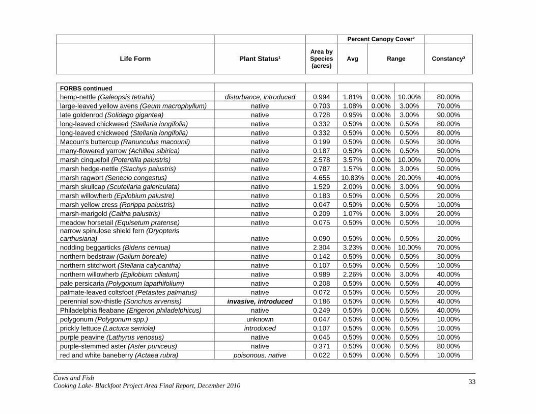
Cows and Fish Cooking Lake- Blackfoot Project Area Final Report, December 2010 33
Percent Canopy Cover²
Life Form Plant Status¹ Area by Species (acres)
Avg Range Constancy³
FORBS continued hemp-nettle (Galeopsis tetrahit) disturbance, introduced 0.994 1.81% 0.00% 10.00% 80.00% large-leaved yellow avens (Geum macrophyllum) native 0.703 1.08% 0.00% 3.00% 70.00% late goldenrod (Solidago gigantea) native 0.728 0.95% 0.00% 3.00% 90.00% long-leaved chickweed (Stellaria longifolia) native 0.332 0.50% 0.00% 0.50% 80.00% long-leaved chickweed (Stellaria longifolia) native 0.332 0.50% 0.00% 0.50% 80.00% Macoun's buttercup (Ranunculus macounii) native 0.199 0.50% 0.00% 0.50% 30.00% many-flowered yarrow (Achillea sibirica) native 0.187 0.50% 0.00% 0.50% 50.00% marsh cinquefoil (Potentilla palustris) native 2.578 3.57% 0.00% 10.00% 70.00% marsh hedge-nettle (Stachys palustris) native 0.787 1.57% 0.00% 3.00% 50.00% marsh ragwort (Senecio congestus) native 4.655 10.83% 0.00% 20.00% 40.00% marsh skullcap (Scutellaria galericulata) native 1.529 2.00% 0.00% 3.00% 90.00% marsh willowherb (Epilobium palustre) native 0.183 0.50% 0.00% 0.50% 20.00% marsh yellow cress (Rorippa palustris) native 0.047 0.50% 0.00% 0.50% 10.00% marsh-marigold (Caltha palustris) native 0.209 1.07% 0.00% 3.00% 20.00% meadow horsetail (Equisetum pratense) native 0.075 0.50% 0.00% 0.50% 10.00% narrow spinulose shield fern (Dryopteris carthusiana) native 0.090 0.50% 0.00% 0.50% 20.00% nodding beggarticks (Bidens cernua) native 2.304 3.23% 0.00% 10.00% 70.00% northern bedstraw (Galium boreale) native 0.142 0.50% 0.00% 0.50% 30.00% northern stitchwort (Stellaria calycantha) native 0.107 0.50% 0.00% 0.50% 10.00% northern willowherb (Epilobium ciliatum) native 0.989 2.26% 0.00% 3.00% 40.00% pale persicaria (Polygonum lapathifolium) native 0.208 0.50% 0.00% 0.50% 40.00% palmate-leaved coltsfoot (Petasites palmatus) native 0.072 0.50% 0.00% 0.50% 20.00% perennial sow-thistle (Sonchus arvensis) invasive, introduced 0.186 0.50% 0.00% 0.50% 40.00% Philadelphia fleabane (Erigeron philadelphicus) native 0.249 0.50% 0.00% 0.50% 40.00% polygonum (Polygonum spp.) unknown 0.047 0.50% 0.00% 0.50% 10.00% prickly lettuce (Lactuca serriola) introduced 0.107 0.50% 0.00% 0.50% 10.00% purple peavine (Lathyrus venosus) native 0.045 0.50% 0.00% 0.50% 10.00% purple-stemmed aster (Aster puniceus) native 0.371 0.50% 0.00% 0.50% 80.00% red and white baneberry (Actaea rubra) poisonous, native 0.022 0.50% 0.00% 0.50% 10.00%

Cows and Fish Cooking Lake- Blackfoot Project Area Final Report, December 2010 34
Percent Canopy Cover²
Life Form Plant Status¹ Area by Species (acres)
Avg Range Constancy³
FORBS continued rough cinquefoil (Potentilla norvegica) disturbance, native 1.092 1.65% 0.00% 3.00% 80.00% showy aster (Aster conspicuus) native 0.045 0.50% 0.00% 0.50% 10.00% silverweed (Potentilla anserina) disturbance, native 0.107 0.50% 0.00% 0.50% 10.00% small bedstraw (Galium trifidum) native 1.311 1.84% 0.00% 10.00% 70.00% small enchanter's nightshade (Circaea alpina) native 0.075 0.50% 0.00% 0.50% 10.00% smooth aster (Aster laevis) native 0.054 0.50% 0.00% 0.50% 20.00% smooth perennial sow-thistle (Sonchus uliginosus) invasive, introduced 0.644 3.00% 0.00% 3.00% 10.00% spotted touch-me-not (Impatiens capensis) native 0.322 0.50% 0.00% 0.50% 70.00% spreading dogbane (Apocynum androsaemifolium)
disturbance, poisonous, native 0.120 0.50% 0.00% 0.50% 20.00%
star-flowered Solomon's-seal (Smilacina stellata) native 0.098 0.50% 0.00% 0.50% 20.00% strawberry blite (Chenopodium capitatum) native 0.107 0.50% 0.00% 0.50% 10.00% swamp horsetail (Equisetum fluviatile) native 0.464 2.69% 0.00% 3.00% 20.00% sweet-scented bedstraw (Galium triflorum) native 0.163 0.50% 0.00% 0.50% 40.00% tall blue lettuce (Lactuca biennis) native 0.022 0.50% 0.00% 0.50% 10.00% tall lungwort (Mertensia paniculata) native 0.123 0.50% 0.00% 0.50% 40.00% three-leaved Solomon's-seal (Smilacina trifolia) native 0.047 0.50% 0.00% 0.50% 10.00% veiny meadow rue (Thalictrum venulosum) native 0.131 0.50% 0.00% 0.50% 30.00% water arum (Calla palustris) native 0.981 5.07% 0.00% 10.00% 20.00% water parsnip (Sium suave) native 0.830 1.17% 0.00% 3.00% 70.00% water smartweed (Polygonum amphibium) native 0.259 0.50% 0.00% 0.50% 50.00% water-hemlock (Cicuta maculata) poisonous, native 4.053 5.69% 0.00% 10.00% 70.00% western dock (Rumex occidentalis) native 0.300 0.50% 0.00% 0.50% 50.00% western water-horehound (Lycopus asper) native 0.047 0.50% 0.00% 0.50% 10.00% western willow aster (Aster hesperius) native 0.107 0.50% 0.00% 0.50% 10.00% white clover (Trifolium repens) disturbance, introduced 0.107 0.50% 0.00% 0.50% 10.00% wild mint (Mentha arvensis) native 3.115 5.65% 0.00% 10.00% 60.00% wild sarsaparilla (Aralia nudicaulis) native 0.264 0.86% 0.00% 3.00% 40.00% wild strawberry (Fragaria virginiana) disturbance, native 0.139 0.50% 0.00% 0.50% 50.00% wild vetch (Vicia americana) native 0.367 0.50% 0.00% 0.50% 80.00%

Cows and Fish Cooking Lake- Blackfoot Project Area Final Report, December 2010 35
Percent Canopy Cover²
Life Form Plant Status¹ Area by Species (acres)
Avg Range Constancy³
FORBS continued willowherb (Epilobium glaberrimum) native 0.050 0.50% 0.00% 0.50% 10.00% willow-herb (Epilobium spp.) unknown 0.047 0.50% 0.00% 0.50% 10.00% woodland horsetail (Equisetum sylvaticum) native 0.274 0.50% 0.00% 0.50% 80.00% wormseed mustard (Erysimum cheiranthoides) disturbance, introduced 0.010 0.50% 0.00% 0.50% 10.00% yellow avens (Geum aleppicum) native 0.967 1.27% 0.00% 3.00% 90.00%
1 Plant status is designated by Cows and Fish in association with Alberta Agriculture, Food and Rural Development and the Alberta Weed Control Act. 'unknown' = plant not identified to species plant status unknown. 2 Based on visual estimates of the amount of ground the canopy of the plant covers. The percent cover values presented are the mid-values for the following ranges: 0.5=less than 1%; 3.0=1%-5%; 10.0=5%-15%; 20.0=15%-25%; 30.0=25%-35%; 40.0=35%-45%; 50.0=45%-55%; 60.0=55%-65%; 70.0=65%-75%; 80.0=75%-85%; 90.0=85%-95%; 97.5=greater than 95%; = not observed. 3 Constancy is the number of times the species occurrs divided by the total number of polygons.
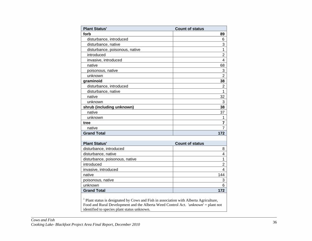
Cows and Fish Cooking Lake- Blackfoot Project Area Final Report, December 2010 36
Plant Status' Count of status forb 89
disturbance, introduced 6 disturbance, native 3disturbance, poisonous, native 1introduced 2invasive, introduced 4native 68poisonous, native 3unknown 2
graminoid 38disturbance, introduced 2disturbance, native 1native 32unknown 3
shrub (including unknown) 38native 37unknown 1
tree 7native 7
Grand Total 172
Plant Status' Count of status disturbance, introduced 8disturbance, native 4disturbance, poisonous, native 1introduced 2invasive, introduced 4native 144poisonous, native 3unknown 6Grand Total 172
1 Plant status is designated by Cows and Fish in association with Alberta Agriculture, Food and Rural Development and the Alberta Weed Control Act. 'unknown' = plant not identified to species plant status unknown.

Cows and Fish Cooking Lake- Blackfoot Project Area Final Report, December 2010 37
APPENDIX E: INDIVIDUAL PLANT LISTS OF ALL SITES WITHIN THE
PROJECT AREA Riparian Plant Information (BLF1)
Category Species Common Name (Scientific Name) Plant % Canopy Cover2 Status1 BLF1
Trees aspen (Populus tremuloides) native 3.0 balsam poplar (Populus balsamifera) native 3.0
Shrubs autumn willow (Salix serissima) native 0.5 balsam willow (Salix pyrifolia) native 3.0 basket willow (Salix petiolaris) native 3.0 beaked hazelnut (Corylus cornuta) native 0.5 beaked willow (Salix bebbiana) native 3.0 buckbrush/snowberry (Symphoricarpos occidentalis) native 0.5 Canada buffaloberry (Shepherdia canadensis) native 0.5 common wild rose (Rosa woodsii) native 0.5 dewberry (Rubus pubescens) native 0.5 false mountain willow (Salix pseudomonticola) native 0.5 flat-leaved willow (Salix planifolia) native 10.0 northern black currant (Ribes hudsonianum) native 0.5 pussy willow (Salix discolor) native 3.0 red-osier dogwood (Cornus stolonifera) native 0.5 yellow willow (Salix lutea) native 0.5
Grasses (and Grass-like species)
awned sedge (Carex atherodes) native 20.0 bluejoint (Calamagrostis canadensis) native 3.0 common great bulrush (Scirpus validus) native 3.0
common tall manna grass (Glyceria grandis) native 3.0 creeping spike-rush (Eleocharis palustris) native 0.5 fowl bluegrass (Poa palustris) native 3.0 fowl manna grass (Glyceria striata) native 0.5 foxtail barley (Hordeum jubatum) disturbance, native 0.5 narrow reed grass (Calamagrostis stricta) native 10.0 northern reed grass (Calamagrostis inexpansa) native 3.0 Nuttall's salt-meadow grass (Puccinellia nuttalliana) native 3.0 reed canary grass (Phalaris arundinacea) native 3.0 rough hair grass (Agrostis scabra) native 3.0 Sartwell's sedge (Carex sartwellii) native 0.5 sedge (Carex pachystachya) native 0.5 sedge (Carex spp.) unknown 0.5
short awned foxtail; water foxtail (Alopecurus aequalis) native 0.5
slough grass (Beckmannia syzigachne) native 0.5 small bottle sedge (Carex utriculata) native 3.0 small-fruited bulrush (Scirpus microcarpus) native 0.5 spangletop (Scolochloa festucacea) native 0.5 water sedge (Carex aquatilis) native 0.5
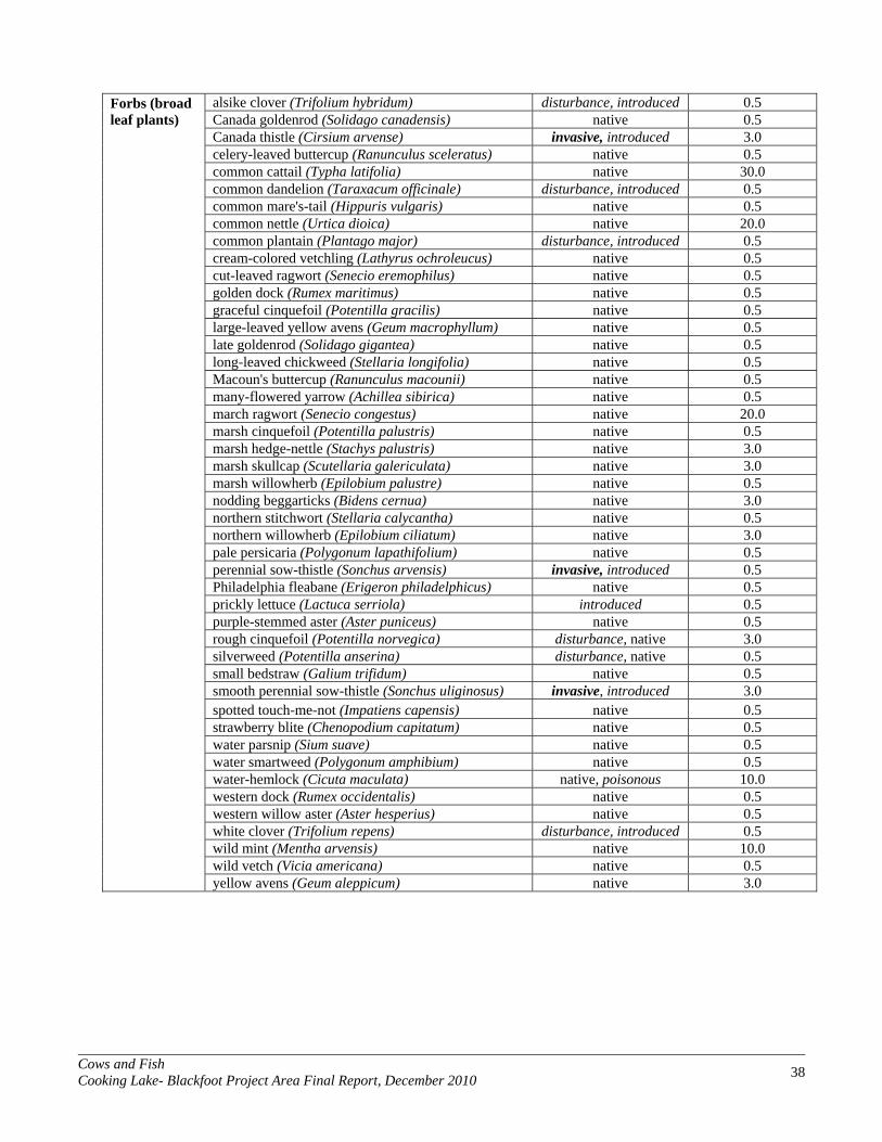
Cows and Fish Cooking Lake- Blackfoot Project Area Final Report, December 2010 38
Forbs (broad leaf plants)
alsike clover (Trifolium hybridum) disturbance, introduced 0.5 Canada goldenrod (Solidago canadensis) native 0.5
Canada thistle (Cirsium arvense) invasive, introduced 3.0 celery-leaved buttercup (Ranunculus sceleratus) native 0.5 common cattail (Typha latifolia) native 30.0 common dandelion (Taraxacum officinale) disturbance, introduced 0.5 common mare's-tail (Hippuris vulgaris) native 0.5 common nettle (Urtica dioica) native 20.0 common plantain (Plantago major) disturbance, introduced 0.5 cream-colored vetchling (Lathyrus ochroleucus) native 0.5 cut-leaved ragwort (Senecio eremophilus) native 0.5 golden dock (Rumex maritimus) native 0.5 graceful cinquefoil (Potentilla gracilis) native 0.5 large-leaved yellow avens (Geum macrophyllum) native 0.5 late goldenrod (Solidago gigantea) native 0.5 long-leaved chickweed (Stellaria longifolia) native 0.5 Macoun's buttercup (Ranunculus macounii) native 0.5 many-flowered yarrow (Achillea sibirica) native 0.5 march ragwort (Senecio congestus) native 20.0 marsh cinquefoil (Potentilla palustris) native 0.5 marsh hedge-nettle (Stachys palustris) native 3.0 marsh skullcap (Scutellaria galericulata) native 3.0 marsh willowherb (Epilobium palustre) native 0.5 nodding beggarticks (Bidens cernua) native 3.0 northern stitchwort (Stellaria calycantha) native 0.5 northern willowherb (Epilobium ciliatum) native 3.0 pale persicaria (Polygonum lapathifolium) native 0.5 perennial sow-thistle (Sonchus arvensis) invasive, introduced 0.5 Philadelphia fleabane (Erigeron philadelphicus) native 0.5 prickly lettuce (Lactuca serriola) introduced 0.5 purple-stemmed aster (Aster puniceus) native 0.5 rough cinquefoil (Potentilla norvegica) disturbance, native 3.0 silverweed (Potentilla anserina) disturbance, native 0.5 small bedstraw (Galium trifidum) native 0.5 smooth perennial sow-thistle (Sonchus uliginosus) invasive, introduced 3.0 spotted touch-me-not (Impatiens capensis) native 0.5 strawberry blite (Chenopodium capitatum) native 0.5 water parsnip (Sium suave) native 0.5 water smartweed (Polygonum amphibium) native 0.5 water-hemlock (Cicuta maculata) native, poisonous 10.0 western dock (Rumex occidentalis) native 0.5 western willow aster (Aster hesperius) native 0.5 white clover (Trifolium repens) disturbance, introduced 0.5 wild mint (Mentha arvensis) native 10.0 wild vetch (Vicia americana) native 0.5 yellow avens (Geum aleppicum) native 3.0

Cows and Fish Cooking Lake- Blackfoot Project Area Final Report, December 2010 39
Riparian Plant Information (BLX1)
Category Species Common Name (Scientific Name) Plant % Canopy Cover2 Status1 BLX1
Trees aspen (Populus tremuloides) native 0.5 balsam poplar (Populus balsamifera) native 20.0
Shrubs basket willow (Salix petiolaris) native 0.5 beaked hazelnut (Corylus cornuta) native 10.0 beaked willow (Salix bebbiana) native 3.0 birch (Betula spp.) native 0.5 bracted honeysuckle (Lonicera involucrata) native 0.5 buckbrush/snowberry (Symphoricarpos occidentalis) native 0.5 choke cherry (Prunus virginiana) native 0.5 common wild rose (Rosa woodsii) native 0.5 flat-leaved willow (Salix planifolia) native 0.5 northern gooseberry (Ribes oxyacanthoides) native 0.5 prickly rose (Rosa acicularis) native 0.5 wild red currant (Ribes triste) native 0.5 wild red raspberry (Rubus idaeus) native 10.0 yellow willow (Salix lutea) native 0.5
Grasses (and Grass-like species)
awned sedge (Carex atherodes) native 30.0 bluejoint (Calamagrostis canadensis) native 30.0 common tall manna grass (Glyceria grandis) native 10.0
creeping spike-rush (Eleocharis palustris) native 10.0 fowl bluegrass (Poa palustris) native 0.5 fringed brome (Bromus ciliatus) native 3.0 graceful sedge (Carex praegracilis) native 0.5 Kentucky bluegrass (Poa pratensis) disturbance, introduced 0.5 orchard grass (Dactylis glomerata) introduced 0.5 reed canary grass (Phalaris arundinacea) native 0.5 rough hair grass (Agrostis scabra) native 0.5 Sartwell's sedge (Carex sartwellii) native 3.0 sedge (Carex spp.) unknown 3.0
short awned foxtail; water foxtail (Alopecurus aequalis) native 0.5
small-winged sedge (Carex microptera) native 3.0
slender wheat grass (Agropyron trachycaulum var. unilaterale) native 0.5
slough grass (Beckmannia syzigachne) native 3.0 small bottle sedge (Carex utriculata) native 10.0 small-fruited bulrush (Scirpus microcarpus) native 0.5 timothy (Phleum pratense) disturbance, introduced 0.5 tufted hair grass (Deschampsia cespitosa) native 3.0
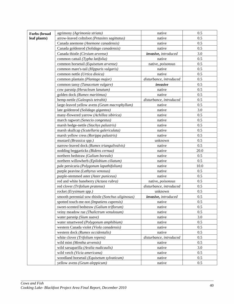
Cows and Fish Cooking Lake- Blackfoot Project Area Final Report, December 2010 40
Forbs (broad leaf plants)
agrimony (Agrimonia striata) native 0.5 arrow-leaved coltsfoot (Petasites sagittatus) native 0.5
Canada anemone (Anemone canadensis) native 0.5 Canada goldenrod (Solidago canadensis) native 0.5 Canada thistle (Cirsium arvense) invasive, introduced 3.0 common cattail (Typha latifolia) native 0.5 common horsetail (Equisetum arvense) native, poisonous 0.5 common mare's-tail (Hippuris vulgaris) native 0.5 common nettle (Urtica dioica) native 0.5 common plantain (Plantago major) disturbance, introduced 0.5 common tansy (Tanacetum vulgare) invasive 0.5 cow parsnip (Heracleum lanatum) native 0.5 golden dock (Rumex maritimus) native 0.5 hemp-nettle (Galeopsis tetrahit) disturbance, introduced 0.5 large-leaved yellow avens (Geum macrophyllum) native 0.5 late goldenrod (Solidago gigantea) native 3.0 many-flowered yarrow (Achillea sibirica) native 0.5 march ragwort (Senecio congestus) native 0.5 marsh hedge-nettle (Stachys palustris) native 0.5 marsh skullcap (Scutellaria galericulata) native 0.5 marsh yellow cress (Rorippa palustris) native 0.5 mustard (Brassica spp.) unknown 0.5 narrow-leaved dock (Rumex triangulivalvis) native 0.5 nodding beggarticks (Bidens cernua) native 20.0 northern bedstraw (Galium boreale) native 0.5 northern willowherb (Epilobium ciliatum) native 0.5 pale persicaria (Polygonum lapathifolium) native 10.0 purple peavine (Lathyrus venosus) native 0.5 purple-stemmed aster (Aster puniceus) native 0.5 red and white baneberry (Actaea rubra) native, poisonous 0.5 red clover (Trifolium pratense) disturbance, introduced 0.5 rocket (Erysimum spp.) unknown 0.5 smooth perennial sow-thistle (Sonchus uliginosus) invasive, introduced 0.5 spotted touch-me-not (Impatiens capensis) native 0.5 sweet-scented bedstraw (Galium triflorum) native 0.5 veiny meadow rue (Thalictrum venulosum) native 0.5 water parsnip (Sium suave) native 3.0 water smartweed (Polygonum amphibium) native 0.5 western Canada violet (Viola canadensis) native 0.5 western dock (Rumex occidentalis) native 0.5 white clover (Trifolium repens) disturbance, introduced 0.5 wild mint (Mentha arvensis) native 0.5 wild sarsaparilla (Aralia nudicaulis) native 3.0 wild vetch (Vicia americana) native 0.5 woodland horsetail (Equisetum sylvaticum) native 0.5 yellow avens (Geum aleppicum) native 0.5

Cows and Fish Cooking Lake- Blackfoot Project Area Final Report, December 2010 41
Riparian Plant Information (BLX2)
Category Species Common Name (Scientific Name) Plant % Canopy Cover2 Status1 BLX2
Trees Alaska birch (Betula neoalaskana) native 0.5 aspen (Populus tremuloides) native 3.0 balsam poplar (Populus balsamifera) native 0.5
Shrubs basket willow (Salix petiolaris) native 0.5 beaked hazelnut (Corylus cornuta) native 0.5 beaked willow (Salix bebbiana) native 3.0 bracted honeysuckle (Lonicera involucrata) native 0.5 buckbrush/snowberry (Symphoricarpos occidentalis) native 0.5 choke cherry (Prunus virginiana) native 0.5 common wild rose (Rosa woodsii) native 0.5 false mountain willow (Salix pseudomonticola) native 0.5 northern gooseberry (Ribes oxyacanthoides) native 0.5 velvet-fruited willow (Salix maccalliana) native 0.5 wild black currant (Ribes americanum) native 0.5 wild red currant (Ribes triste) native 0.5 wild red raspberry (Rubus idaeus) native 10.0 willow (Salix spp.) unknown 0.5
Grasses (and Grass-like species)
awned sedge (Carex atherodes) native 30.0 bluejoint (Calamagrostis canadensis) native 30.0 common great bulrush (Scirpus validus) native 0.5
common tall manna grass (Glyceria grandis) native 10.0 fowl bluegrass (Poa palustris) native 3.0 fringed brome (Bromus ciliatus) native 0.5 graceful sedge (Carex praegracilis) native 0.5 reed canary grass (Phalaris arundinacea) native 0.5 rough hair grass (Agrostis scabra) native 0.5 Sartwell's sedge (Carex sartwellii) native 0.5 sedge (Carex pachystachya) native 0.5 sedge (Carex spp.) unknown 0.5
short awned foxtail; water foxtail (Alopecurus aequalis) native 0.5
small-winged sedge (Carex microptera) native 0.5 slender wheat grass (Agropyron trachycaulum) native 0.5 slough grass (Beckmannia syzigachne) native 0.5 small bottle sedge (Carex utriculata) native 3.0 small-fruited bulrush (Scirpus microcarpus) native 3.0 timothy (Phleum pratense) disturbance, introduced 0.5 water sedge (Carex aquatilis) native 0.5

Cows and Fish Cooking Lake- Blackfoot Project Area Final Report, December 2010 42
Forbs (broad leaf plants)
agrimony (Agrimonia striata) native 3.0 alsike clover (Trifolium hybridum) disturbance, introduced 0.5
Canada anemone (Anemone canadensis) native 0.5 Canada goldenrod (Solidago canadensis) native 0.5 Canada thistle (Cirsium arvense) invasive 3.0 common cattail (Typha latifolia) native 20.0 common dandelion (Taraxacum officinale) disturbance, introduced 0.5 common fireweed (Epilobium angustifolium) native 0.5 common horsetail (Equisetum arvense) native, poisonous 0.5 common nettle (Urtica dioica) native 3.0 common plantain (Plantago major) disturbance, introduced 0.5
common tansy (Tanacetum vulgare) invasive, introduced,
poisonous 3.0 giant hyssop (Agastache foeniculum) native 0.5 hemp-nettle (Galeopsis tetrahit) disturbance, introduced 0.5 late goldenrod (Solidago gigantea) native 3.0 long-leaved chickweed (Stellaria longifolia) native 0.5 many-flowered yarrow (Achillea sibirica) native 0.5 marsh hedge-nettle (Stachys palustris) native 0.5 marsh skullcap (Scutellaria galericulata) native 0.5 nodding beggarticks (Bidens cernua) native 0.5 pale persicaria (Polygonum lapathifolium) native 0.5 perennial sow-thistle (Sonchus arvensis) invasive, introduced 0.5 purple-stemmed aster (Aster puniceus) native 0.5 rough cinquefoil (Potentilla norvegica) disturbance, native 0.5 small bedstraw (Galium trifidum) native 0.5 smooth aster (Aster laevis) native 0.5 spotted touch-me-not (Impatiens capensis) native 0.5 water parsnip (Sium suave) native 0.5 water smartweed (Polygonum amphibium) native 0.5 water-hemlock (Cicuta maculata) native, poisonous 0.5 wild mint (Mentha arvensis) native 0.5 wild strawberry (Fragaria virginiana) disturbance, native 0.5 wild vetch (Vicia americana) native 0.5 woodland horsetail (Equisetum sylvaticum) native 0.5 wormseed mustard (Erysimum cheiranthoides) disturbance, introduced 0.5 yellow avens (Geum aleppicum) native 3.0
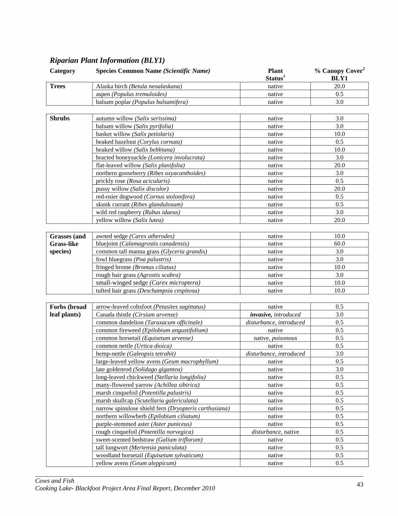
Cows and Fish Cooking Lake- Blackfoot Project Area Final Report, December 2010 43
Riparian Plant Information (BLY1) Category Species Common Name (Scientific Name) Plant % Canopy Cover2
Status1 BLY1 Trees Alaska birch (Betula neoalaskana) native 20.0 aspen (Populus tremuloides) native 0.5 balsam poplar (Populus balsamifera) native 3.0
Shrubs autumn willow (Salix serissima) native 3.0 balsam willow (Salix pyrifolia) native 3.0 basket willow (Salix petiolaris) native 10.0 beaked hazelnut (Corylus cornuta) native 0.5 beaked willow (Salix bebbiana) native 10.0 bracted honeysuckle (Lonicera involucrata) native 3.0 flat-leaved willow (Salix planifolia) native 20.0 northern gooseberry (Ribes oxyacanthoides) native 3.0 prickly rose (Rosa acicularis) native 0.5 pussy willow (Salix discolor) native 20.0 red-osier dogwood (Cornus stolonifera) native 0.5 skunk currant (Ribes glandulosum) native 0.5 wild red raspberry (Rubus idaeus) native 3.0 yellow willow (Salix lutea) native 20.0
Grasses (and Grass-like species)
awned sedge (Carex atherodes) native 10.0 bluejoint (Calamagrostis canadensis) native 60.0 common tall manna grass (Glyceria grandis) native 3.0
fowl bluegrass (Poa palustris) native 3.0 fringed brome (Bromus ciliatus) native 10.0 rough hair grass (Agrostis scabra) native 3.0 small-winged sedge (Carex microptera) native 10.0 tufted hair grass (Deschampsia cespitosa) native 10.0
Forbs (broad leaf plants)
arrow-leaved coltsfoot (Petasites sagittatus) native 0.5 Canada thistle (Cirsium arvense) invasive, introduced 3.0
common dandelion (Taraxacum officinale) disturbance, introduced 0.5 common fireweed (Epilobium angustifolium) native 0.5 common horsetail (Equisetum arvense) native, poisonous 0.5 common nettle (Urtica dioica) native 0.5 hemp-nettle (Galeopsis tetrahit) disturbance, introduced 3.0 large-leaved yellow avens (Geum macrophyllum) native 0.5 late goldenrod (Solidago gigantea) native 3.0 long-leaved chickweed (Stellaria longifolia) native 0.5 many-flowered yarrow (Achillea sibirica) native 0.5 marsh cinquefoil (Potentilla palustris) native 0.5 marsh skullcap (Scutellaria galericulata) native 0.5 narrow spinulose shield fern (Dryopteris carthusiana) native 0.5 northern willowherb (Epilobium ciliatum) native 0.5 purple-stemmed aster (Aster puniceus) native 0.5 rough cinquefoil (Potentilla norvegica) disturbance, native 0.5 sweet-scented bedstraw (Galium triflorum) native 0.5 tall lungwort (Mertensia paniculata) native 0.5 woodland horsetail (Equisetum sylvaticum) native 0.5 yellow avens (Geum aleppicum) native 0.5

Cows and Fish Cooking Lake- Blackfoot Project Area Final Report, December 2010 44
Riparian Plant Information (BLZ1)
Category Species Common Name (Scientific Name) Plant % Canopy Cover2 Status1 BLZ1
Trees Alaska birch (Betula neoalaskana) native 30.0 aspen (Populus tremuloides) native 3.0 balsam poplar (Populus balsamifera) native 3.0 white birch (Betula papyrifera) native 0.5 white spruce (Picea glauca) native 0.5
Shrubs autumn willow (Salix serissima) native 0.5 balsam willow (Salix pyrifolia) native 3.0 beaked hazelnut (Corylus cornuta) native 0.5 beaked willow (Salix bebbiana) native 3.0 bracted honeysuckle (Lonicera involucrata) native 0.5 bunchberry (Cornus canadensis) native 0.5 Canada buffaloberry (Shepherdia canadensis) native 0.5 dewberry (Rubus pubescens) native 0.5 flat-leaved willow (Salix planifolia) native 20.0 low-bush cranberry (Viburnum edule) native 0.5 northern gooseberry (Ribes oxyacanthoides) native 0.5 prickly rose (Rosa acicularis) native 0.5 pussy willow (Salix discolor) native 3.0 red-osier dogwood (Cornus stolonifera) native 0.5 Scouler's willow (Salix scouleriana) native 0.5 skunk currant (Ribes glandulosum) native 0.5 snowberry (Symphoricarpos albus) native 0.5 twining honeysuckle (Lonicera dioica) native 0.5 velvet-fruited willow (Salix maccalliana) native 20.0 wild red raspberry (Rubus idaeus) native 0.5
Grasses (and Grass-like species)
awned sedge (Carex atherodes) native 40.0 bluejoint (Calamagrostis canadensis) native 20.0 brownish sedge (Carex brunnescens) native 0.5
fowl bluegrass (Poa palustris) native 3.0 fowl manna grass (Glyceria striata) native 3.0 fringed brome (Bromus ciliatus) native 0.5 narrow reed grass (Calamagrostis stricta) native 0.5 rough hair grass (Agrostis scabra) native 3.0 Sartwell's sedge (Carex sartwellii) native 0.5 sedge (Carex pachystachya) native 0.5 sedge (Carex spp.) unknown 0.5
short awned foxtail; water foxtail (Alopecurus aequalis) native 0.5
small-fruited bulrush (Scirpus microcarpus) native 0.5 spangletop (Scolochloa festucacea) native 10.0 three-seeded sedge (Carex trisperma) native 0.5 two-seeded sedge (Carex disperma) native 0.5 water sedge (Carex aquatilis) native 10.0

Cows and Fish Cooking Lake- Blackfoot Project Area Final Report, December 2010 45
Forbs (broad leaf plants)
arrow-leaved coltsfoot (Petasites sagittatus) native 0.5 bulb-bearing water-hemlock (Cicuta bulbifera) native 0.5
Canada goldenrod (Solidago canadensis) native 0.5 Canada thistle (Cirsium arvense) invasive, introduced 0.5 common cattail (Typha latifolia) native 0.5 common fireweed (Epilobium angustifolium) native 0.5 common horsetail (Equisetum arvense) native, poisonous 0.5 common nettle (Urtica dioica) native 0.5 common scouring-rush (Equisetum hyemale) native 0.5 cow parsnip (Heracleum lanatum) native 0.5 golden dock (Rumex maritimus) native 0.5 hemp-nettle (Galeopsis tetrahit) disturbance, introduced 0.5 large-leaved yellow avens (Geum macrophyllum) native 3.0 late goldenrod (Solidago gigantea) native 0.5 long-leaved chickweed (Stellaria longifolia) native 0.5 marsh cinquefoil (Potentilla palustris) native 3.0 marsh hedge-nettle (Stachys palustris) native 0.5 marsh skullcap (Scutellaria galericulata) native 3.0 marsh willowherb (Epilobium palustre) native 0.5 marsh-marigold (Caltha palustris) native 0.5 meadow horsetail (Equisetum pratense) native 0.5
narrow spinulose shield fern (Dryopteris carthusiana) native 0.5
nodding beggarticks (Bidens cernua) native 0.5 northern bedstraw (Galium boreale) native 0.5 purple-stemmed aster (Aster puniceus) native 0.5 rough cinquefoil (Potentilla norvegica) disturbance, native 0.5 small bedstraw (Galium trifidum) native 0.5 small enchanter's nightshade (Circaea alpina) native 0.5 spotted touch-me-not (Impatiens capensis) native 0.5
spreading dogbane (Apocynum androsaemifolium) disturbance, native,
poisonous 0.5 star-flowered Solomon's-seal (Smilacina stellata) native 0.5 swamp horsetail (Equisetum fluviatile) native 3.0 sweet-scented bedstraw (Galium triflorum) native 0.5 tall lungwort (Mertensia paniculata) native 0.5 veiny meadow rue (Thalictrum venulosum) native 0.5 water parsnip (Sium suave) native 0.5 water smartweed (Polygonum amphibium) native 0.5 water-hemlock (Cicuta maculata) native, poisonous 10.0 western dock (Rumex occidentalis) native 0.5 wild mint (Mentha arvensis) native 3.0 wild sarsaparilla (Aralia nudicaulis) native 0.5 wild vetch (Vicia americana) native 0.5 woodland horsetail (Equisetum sylvaticum) native 0.5 yellow avens (Geum aleppicum) native 0.5

Cows and Fish Cooking Lake- Blackfoot Project Area Final Report, December 2010 46
Riparian Plant Information (MOM1)
Category Species Common Name (Scientific Name) Plant % Canopy Cover2 Status1 MOM1
Trees Alaska birch (Betula neoalaskana) native 30.0 aspen (Populus tremuloides) native 0.5 black spruce (Picea mariana) native 0.5 tamarack (Larix laricina) native 0.5 white birch (Betula papyrifera) native 3.0
Shrubs autumn willow (Salix serissima) native 0.5 basket willow (Salix petiolaris) native 0.5 bog birch (Betula glandulosa) native 10.0 bog willow (Salix pedicellaris) native 0.5 cloudberry (Rubus chamaemorus) native 0.5 common Labrador tea (Ledum groenlandicum) native 20.0 false mountain willow (Salix pseudomonticola) native 0.5 firm leafed willow (Salix pseudomyrsinites) native 3.0 pussy willow (Salix discolor) native 10.0 velvet-fruited willow (Salix maccalliana) native 10.0
Grasses (and Grass-like species)
bluejoint (Calamagrostis canadensis) native 10.0 common great bulrush (Scirpus validus) native 0.5 common tall manna grass (Glyceria grandis) native 10.0
cotton grass (Eriophorum spp.) unknown 3.0 creeping spike-rush (Eleocharis palustris) native 0.5 graceful sedge (Carex praegracilis) native 3.0 mud sedge (Carex limosa) native 0.5 rough hair grass (Agrostis scabra) native 3.0 Sartwell's sedge (Carex sartwellii) native 0.5 sedge (Carex spp.) unknown 0.5
short awned foxtail; water foxtail (Alopecurus aequalis) native 3.0
short sedge (Carex curta) native 3.0 small-winged sedge (Carex microptera) native 10.0 slough grass (Beckmannia syzigachne) native 0.5 small bottle sedge (Carex utriculata) native 10.0
Forbs (broad leaf plants)
bulb-bearing water-hemlock (Cicuta bulbifera) native 0.5 Canada thistle (Cirsium arvense) invasive, introduced 0.5
common cattail (Typha latifolia) native 10.0 common fireweed (Epilobium angustifolium) native 0.5 common nettle (Urtica dioica) native 0.5 curled dock (Rumex crispus) introduced 0.5 golden dock (Rumex maritimus) native 0.5 hemp-nettle (Galeopsis tetrahit) disturbance, introduced 0.5 late goldenrod (Solidago gigantea) native 0.5 long-leaved chickweed (Stellaria longifolia) native 0.5
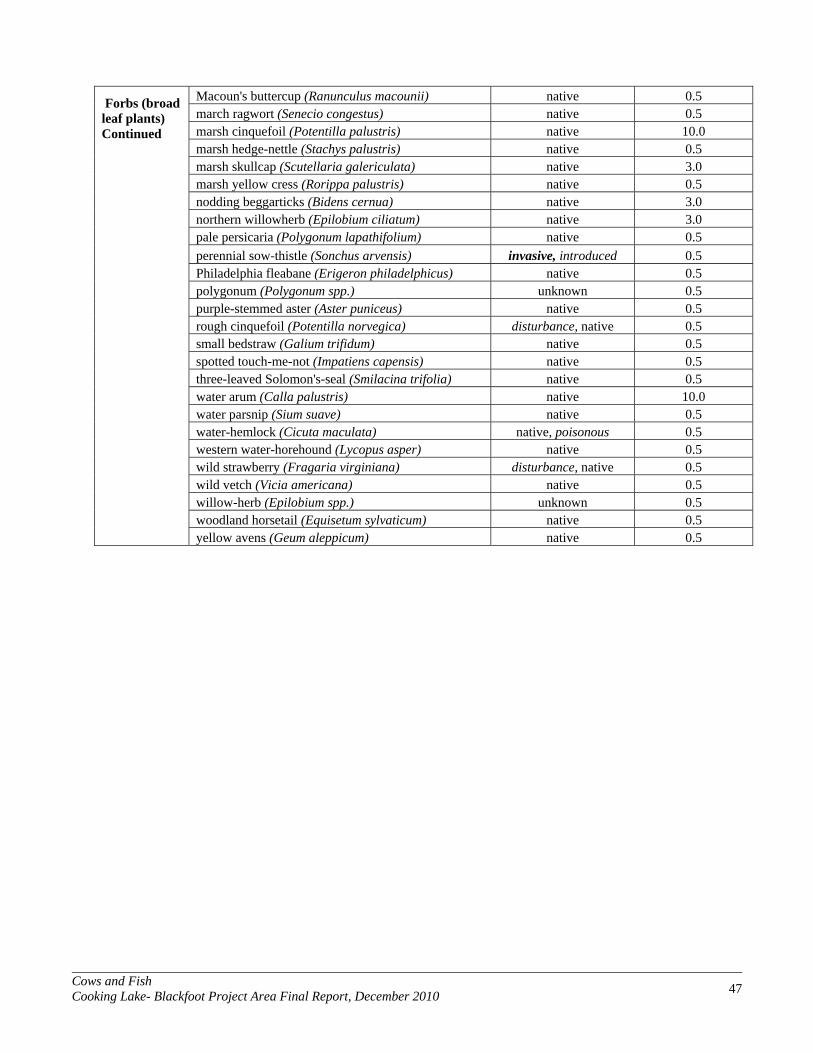
Cows and Fish Cooking Lake- Blackfoot Project Area Final Report, December 2010 47
Forbs (broad leaf plants) Continued
Macoun's buttercup (Ranunculus macounii) native 0.5 march ragwort (Senecio congestus) native 0.5 marsh cinquefoil (Potentilla palustris) native 10.0 marsh hedge-nettle (Stachys palustris) native 0.5
marsh skullcap (Scutellaria galericulata) native 3.0 marsh yellow cress (Rorippa palustris) native 0.5 nodding beggarticks (Bidens cernua) native 3.0 northern willowherb (Epilobium ciliatum) native 3.0 pale persicaria (Polygonum lapathifolium) native 0.5 perennial sow-thistle (Sonchus arvensis) invasive, introduced 0.5 Philadelphia fleabane (Erigeron philadelphicus) native 0.5 polygonum (Polygonum spp.) unknown 0.5 purple-stemmed aster (Aster puniceus) native 0.5 rough cinquefoil (Potentilla norvegica) disturbance, native 0.5 small bedstraw (Galium trifidum) native 0.5 spotted touch-me-not (Impatiens capensis) native 0.5 three-leaved Solomon's-seal (Smilacina trifolia) native 0.5 water arum (Calla palustris) native 10.0 water parsnip (Sium suave) native 0.5 water-hemlock (Cicuta maculata) native, poisonous 0.5 western water-horehound (Lycopus asper) native 0.5 wild strawberry (Fragaria virginiana) disturbance, native 0.5 wild vetch (Vicia americana) native 0.5 willow-herb (Epilobium spp.) unknown 0.5 woodland horsetail (Equisetum sylvaticum) native 0.5 yellow avens (Geum aleppicum) native 0.5

Cows and Fish Cooking Lake- Blackfoot Project Area Final Report, December 2010 48
Riparian Plant Information (MUY1) Category Species Common Name (Scientific Name) Plant % Canopy Cover2
Status1 MUY1 Trees Alaska birch (Betula neoalaskana) native 3.0 aspen (Populus tremuloides) native 0.5 balsam poplar (Populus balsamifera) native 3.0
Shrubs autumn willow (Salix serissima) native 3.0 basket willow (Salix petiolaris) native 3.0 beaked hazelnut (Corylus cornuta) native 0.5 beaked willow (Salix bebbiana) native 20.0 bracted honeysuckle (Lonicera involucrata) native 0.5 flat-leaved willow (Salix planifolia) native 3.0 northern gooseberry (Ribes oxyacanthoides) native 0.5 prickly rose (Rosa acicularis) native 0.5 pussy willow (Salix discolor) native 30.0 velvet-fruited willow (Salix maccalliana) native 3.0 wild red raspberry (Rubus idaeus) native 3.0 yellow willow (Salix lutea) native 10.0
Grasses (and Grass-like species)
awned sedge (Carex atherodes) native 30.0 bluejoint (Calamagrostis canadensis) native 50.0 common tall manna grass (Glyceria grandis) native 3.0
foxtail barley (Hordeum jubatum) disturbance, native 0.5 rough hair grass (Agrostis scabra) native 3.0 small-winged sedge (Carex microptera) native 10.0 small bottle sedge (Carex utriculata) native 20.0 tufted hair grass (Deschampsia cespitosa) native 3.0
Forbs (broad leaf plants)
Canada goldenrod (Solidago canadensis) native 0.5 Canada thistle (Cirsium arvense) invasive 3.0
common fireweed (Epilobium angustifolium) native 3.0 common horsetail (Equisetum arvense) native, poisonous 0.5 common nettle (Urtica dioica) native 3.0 common yarrow (Achillea millefolium) native 0.5 cow parsnip (Heracleum lanatum) native 0.5 hemp-nettle (Galeopsis tetrahit) disturbance, introduced 0.5 large-leaved yellow avens (Geum macrophyllum) native 0.5 late goldenrod (Solidago gigantea) native 0.5 long-leaved chickweed (Stellaria longifolia) native 0.5 many-flowered yarrow (Achillea sibirica) native 0.5 marsh hedge-nettle (Stachys palustris) native 0.5 marsh ragwort (Senecio congestus) native 0.5 marsh skullcap (Scutellaria galericulata) native 0.5 rough cinquefoil (Potentilla norvegica) disturbance, native 0.5 spotted touch-me-not (Impatiens capensis) native 0.5 swamp horsetail (Equisetum fluviatile) native 0.5 tall lungwort (Mertensia paniculata) native 0.5 veiny meadow rue (Thalictrum venulosum) native 0.5 wild mint (Mentha arvensis) native 0.5 wild sarsaparilla (Aralia nudicaulis) native 0.5 wild strawberry (Fragaria virginiana) disturbance, native 0.5 wild vetch (Vicia americana) native 0.5 woodland horsetail (Equisetum sylvaticum) native 0.5 yellow avens (Geum aleppicum) native 0.5
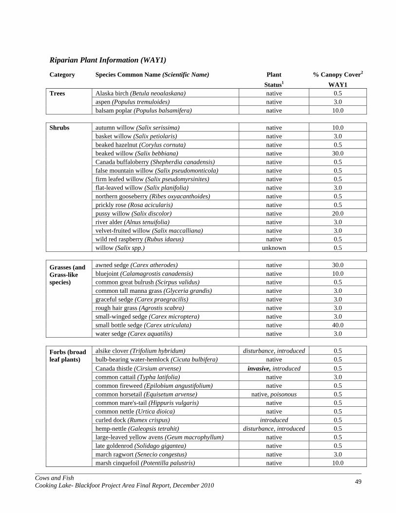
Cows and Fish Cooking Lake- Blackfoot Project Area Final Report, December 2010 49
Riparian Plant Information (WAY1)
Category Species Common Name (Scientific Name) Plant % Canopy Cover2 Status1 WAY1
Trees Alaska birch (Betula neoalaskana) native 0.5 aspen (Populus tremuloides) native 3.0 balsam poplar (Populus balsamifera) native 10.0
Shrubs autumn willow (Salix serissima) native 10.0 basket willow (Salix petiolaris) native 3.0 beaked hazelnut (Corylus cornuta) native 0.5 beaked willow (Salix bebbiana) native 30.0 Canada buffaloberry (Shepherdia canadensis) native 0.5 false mountain willow (Salix pseudomonticola) native 0.5 firm leafed willow (Salix pseudomyrsinites) native 0.5 flat-leaved willow (Salix planifolia) native 3.0 northern gooseberry (Ribes oxyacanthoides) native 0.5 prickly rose (Rosa acicularis) native 0.5 pussy willow (Salix discolor) native 20.0 river alder (Alnus tenuifolia) native 3.0 velvet-fruited willow (Salix maccalliana) native 3.0 wild red raspberry (Rubus idaeus) native 0.5 willow (Salix spp.) unknown 0.5
Grasses (and Grass-like species)
awned sedge (Carex atherodes) native 30.0 bluejoint (Calamagrostis canadensis) native 10.0 common great bulrush (Scirpus validus) native 0.5
common tall manna grass (Glyceria grandis) native 3.0 graceful sedge (Carex praegracilis) native 3.0 rough hair grass (Agrostis scabra) native 3.0 small-winged sedge (Carex microptera) native 3.0 small bottle sedge (Carex utriculata) native 40.0 water sedge (Carex aquatilis) native 3.0
Forbs (broad leaf plants)
alsike clover (Trifolium hybridum) disturbance, introduced 0.5 bulb-bearing water-hemlock (Cicuta bulbifera) native 0.5
Canada thistle (Cirsium arvense) invasive, introduced 0.5 common cattail (Typha latifolia) native 3.0 common fireweed (Epilobium angustifolium) native 0.5 common horsetail (Equisetum arvense) native, poisonous 0.5 common mare's-tail (Hippuris vulgaris) native 0.5 common nettle (Urtica dioica) native 0.5 curled dock (Rumex crispus) introduced 0.5 hemp-nettle (Galeopsis tetrahit) disturbance, introduced 0.5 large-leaved yellow avens (Geum macrophyllum) native 0.5 late goldenrod (Solidago gigantea) native 0.5 march ragwort (Senecio congestus) native 3.0 marsh cinquefoil (Potentilla palustris) native 10.0

Cows and Fish Cooking Lake- Blackfoot Project Area Final Report, December 2010 50
Forbs (broad leaf plants) Continued
marsh skullcap (Scutellaria galericulata) native 0.5 nodding beggarticks (Bidens cernua) native 10.0 northern willowherb (Epilobium ciliatum) native 0.5 palmate-leaved coltsfoot (Petasites palmatus) native 0.5
Philadelphia fleabane (Erigeron philadelphicus) native 0.5 purple-stemmed aster (Aster puniceus) native 0.5 small bedstraw (Galium trifidum) native 10.0 spotted touch-me-not (Impatiens capensis) native 0.5 sweet-scented bedstraw (Galium triflorum) native 0.5 water arum (Calla palustris) native 0.5 water parsnip (Sium suave) native 3.0 water-hemlock (Cicuta maculata) native, poisonous 0.5 western dock (Rumex occidentalis) native 0.5 wild mint (Mentha arvensis) native 0.5 wild strawberry (Fragaria virginiana) disturbance, native 0.5 wild vetch (Vicia americana) native 0.5 willowherb (Epilobium glaberrimum) native 0.5 woodland horsetail (Equisetum sylvaticum) native 0.5 yellow avens (Geum aleppicum) native 0.5

Cows and Fish Cooking Lake- Blackfoot Project Area Final Report, December 2010 51
Riparian Plant Information (WSX1)
Category Species Common Name (Scientific Name) Plant % Canopy Cover2 Status1 WSX1
Trees Alaska birch (Betula neoalaskana) native 3.0 aspen (Populus tremuloides) native 0.5 balsam poplar (Populus balsamifera) native 3.0 white birch (Betula papyrifera) native 0.5 white spruce (Picea glauca) native 0.5
Shrubs autumn willow (Salix serissima) native 20.0 balsam willow (Salix pyrifolia) native 3.0 basket willow (Salix petiolaris) native 3.0 beaked willow (Salix bebbiana) native 3.0 buckbrush/snowberry (Symphoricarpos occidentalis) native 0.5 bunchberry (Cornus canadensis) native 0.5 flat-leaved willow (Salix planifolia) native 20.0 northern gooseberry (Ribes oxyacanthoides) native 3.0 prickly rose (Rosa acicularis) native 0.5 Saskatoon (Amelanchier alnifolia) native 0.5 skunk currant (Ribes glandulosum) native 0.5 twinflower (Linnaea borealis) native 0.5 wild red raspberry (Rubus idaeus) native 10.0
Grasses (and Grass-like species)
awned sedge (Carex atherodes) native 3.0 bluejoint (Calamagrostis canadensis) native 20.0 fowl bluegrass (Poa palustris) native 3.0
graminoid (Graminoid) unknown 10.0 narrow reed grass (Calamagrostis stricta) native 3.0 purple oat grass (Schizachne purpurascens) native 0.5 quack grass (Agropyron repens) disturbance, introduced 0.5 reed canary grass (Phalaris arundinacea) native 3.0 rough hair grass (Agrostis scabra) native 10.0 small bottle sedge (Carex utriculata) native 30.0
Forbs (broad leaf plants)
arrow-leaved coltsfoot (Petasites sagittatus) native 3.0 Canada goldenrod (Solidago canadensis) native 0.5
Canada thistle (Cirsium arvense) invasive, introduced 20.0 common cattail (Typha latifolia) native 0.5 common horsetail (Equisetum arvense) native, poisonous 0.5 common nettle (Urtica dioica) native 10.0 common pink wintergreen (Pyrola asarifolia) native 0.5 cow parsnip (Heracleum lanatum) native 0.5 cream-colored vetchling (Lathyrus ochroleucus) native 0.5 cut-leaved ragwort (Senecio eremophilus) native 0.5 hemp-nettle (Galeopsis tetrahit) disturbance, introduced 10.0 large-leaved yellow avens (Geum macrophyllum) native 0.5 late goldenrod (Solidago gigantea) native 0.5
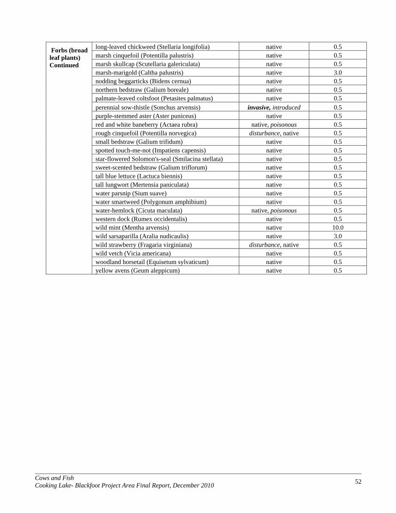
Cows and Fish Cooking Lake- Blackfoot Project Area Final Report, December 2010 52
Forbs (broad leaf plants) Continued
long-leaved chickweed (Stellaria longifolia) native 0.5 marsh cinquefoil (Potentilla palustris) native 0.5 marsh skullcap (Scutellaria galericulata) native 0.5 marsh-marigold (Caltha palustris) native 3.0
nodding beggarticks (Bidens cernua) native 0.5 northern bedstraw (Galium boreale) native 0.5 palmate-leaved coltsfoot (Petasites palmatus) native 0.5 perennial sow-thistle (Sonchus arvensis) invasive, introduced 0.5 purple-stemmed aster (Aster puniceus) native 0.5 red and white baneberry (Actaea rubra) native, poisonous 0.5 rough cinquefoil (Potentilla norvegica) disturbance, native 0.5 small bedstraw (Galium trifidum) native 0.5 spotted touch-me-not (Impatiens capensis) native 0.5 star-flowered Solomon's-seal (Smilacina stellata) native 0.5 sweet-scented bedstraw (Galium triflorum) native 0.5 tall blue lettuce (Lactuca biennis) native 0.5 tall lungwort (Mertensia paniculata) native 0.5 water parsnip (Sium suave) native 0.5 water smartweed (Polygonum amphibium) native 0.5 water-hemlock (Cicuta maculata) native, poisonous 0.5 western dock (Rumex occidentalis) native 0.5 wild mint (Mentha arvensis) native 10.0 wild sarsaparilla (Aralia nudicaulis) native 3.0 wild strawberry (Fragaria virginiana) disturbance, native 0.5 wild vetch (Vicia americana) native 0.5 woodland horsetail (Equisetum sylvaticum) native 0.5 yellow avens (Geum aleppicum) native 0.5
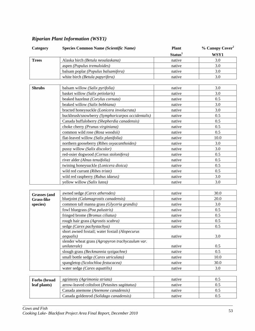
Cows and Fish Cooking Lake- Blackfoot Project Area Final Report, December 2010 53
Riparian Plant Information (WSY1)
Category Species Common Name (Scientific Name) Plant % Canopy Cover2 Status1 WSY1
Trees Alaska birch (Betula neoalaskana) native 3.0 aspen (Populus tremuloides) native 3.0 balsam poplar (Populus balsamifera) native 3.0 white birch (Betula papyrifera) native 3.0
Shrubs balsam willow (Salix pyrifolia) native 3.0 basket willow (Salix petiolaris) native 3.0 beaked hazelnut (Corylus cornuta) native 0.5 beaked willow (Salix bebbiana) native 3.0 bracted honeysuckle (Lonicera involucrata) native 3.0 buckbrush/snowberry (Symphoricarpos occidentalis) native 0.5 Canada buffaloberry (Shepherdia canadensis) native 0.5 choke cherry (Prunus virginiana) native 0.5 common wild rose (Rosa woodsii) native 0.5 flat-leaved willow (Salix planifolia) native 10.0 northern gooseberry (Ribes oxyacanthoides) native 3.0 pussy willow (Salix discolor) native 3.0 red-osier dogwood (Cornus stolonifera) native 0.5 river alder (Alnus tenuifolia) native 0.5 twining honeysuckle (Lonicera dioica) native 0.5 wild red currant (Ribes triste) native 0.5 wild red raspberry (Rubus idaeus) native 3.0 yellow willow (Salix lutea) native 3.0
Grasses (and Grass-like species)
awned sedge (Carex atherodes) native 30.0 bluejoint (Calamagrostis canadensis) native 20.0 common tall manna grass (Glyceria grandis) native 3.0
fowl bluegrass (Poa palustris) native 0.5 fringed brome (Bromus ciliatus) native 0.5 rough hair grass (Agrostis scabra) native 0.5 sedge (Carex pachystachya) native 0.5
short awned foxtail; water foxtail (Alopecurus aequalis) native 3.0
slender wheat grass (Agropyron trachycaulum var. unilaterale) native 0.5
slough grass (Beckmannia syzigachne) native 0.5 small bottle sedge (Carex utriculata) native 10.0 spangletop (Scolochloa festucacea) native 30.0 water sedge (Carex aquatilis) native 3.0
Forbs (broad leaf plants)
agrimony (Agrimonia striata) native 0.5 arrow-leaved coltsfoot (Petasites sagittatus) native 0.5
Canada anemone (Anemone canadensis) native 0.5 Canada goldenrod (Solidago canadensis) native 0.5

Cows and Fish Cooking Lake- Blackfoot Project Area Final Report, December 2010 54
Forbs (broad leaf plants) Continued
Canada thistle (Cirsium arvense) invasive, introduced 0.5 common fireweed (Epilobium angustifolium) native 0.5 common horsetail (Equisetum arvense) native, poisonous 0.5 common nettle (Urtica dioica) native 10.0
common pink wintergreen (Pyrola asarifolia) native 0.5 cow parsnip (Heracleum lanatum) native 0.5 giant bur-reed (Sparganium eurycarpum) native 0.5 golden dock (Rumex maritimus) native 3.0 hemp-nettle (Galeopsis tetrahit) disturbance, introduced 3.0 large-leaved yellow avens (Geum macrophyllum) native 0.5 late goldenrod (Solidago gigantea) native 3.0 long-leaved chickweed (Stellaria longifolia) native 0.5 Macoun's buttercup (Ranunculus macounii) native 0.5 many-flowered yarrow (Achillea sibirica) native 0.5 marsh cinquefoil (Potentilla palustris) native 0.5 marsh skullcap (Scutellaria galericulata) native 0.5 nodding beggarticks (Bidens cernua) native 3.0 northern bedstraw (Galium boreale) native 0.5 pale persicaria (Polygonum lapathifolium) native 0.5 Philadelphia fleabane (Erigeron philadelphicus) native 0.5 purple peavine (Lathyrus venosus) native 0.5 purple-stemmed aster (Aster puniceus) native 0.5 rough cinquefoil (Potentilla norvegica) disturbance, native 3.0 showy aster (Aster conspicuus) native 0.5 small bedstraw (Galium trifidum) native 0.5 smooth aster (Aster laevis) native 0.5
spreading dogbane (Apocynum androsaemifolium) disturbance, native,
poisonous 0.5 veiny meadow rue (Thalictrum venulosum) native 0.5 water parsnip (Sium suave) native 3.0 water smartweed (Polygonum amphibium) native 0.5 water-hemlock (Cicuta maculata) native, poisonous 3.0 western dock (Rumex occidentalis) native 0.5 wild sarsaparilla (Aralia nudicaulis) native 0.5 wild vetch (Vicia americana) native 0.5 woodland horsetail (Equisetum sylvaticum) native 0.5 yellow avens (Geum aleppicum) native 0.5
1 Plant status is designated by Cows and Fish in association with Alberta Public Lands and the Alberta Weed Control Act. 2 Based on visual estimates of the amount of ground the canopy of the plant covers. The percent cover values presented are the mid-values for the following ranges: 0.5=less than 1%; 3.0=1%-5%; 10.0=5%-15%; 20.0=15%-25%; 30.0=25%-35%; 40.0=35%-45%; 50.0=45%-55%; 60.0=55%-65%; 70.0=65%-75%; 80.0=75%-85%; 90.0=85%-95%; 97.5=greater than 95%.

Cows and Fish Cooking Lake- Blackfoot Project Area Final Report, December 2010 55
APPENDIX F: AIR PHOTOS OF ALL SITES WITHIN THE PROJECT AREA

Cows and Fish Cooking Lake- Blackfoot Project Area Final Report, December 2010 56

Cows and Fish Cooking Lake- Blackfoot Project Area Final Report, December 2010 57

Cows and Fish Cooking Lake- Blackfoot Project Area Final Report, December 2010 58

Cows and Fish Cooking Lake- Blackfoot Project Area Final Report, December 2010 59

Cows and Fish Cooking Lake- Blackfoot Project Area Final Report, December 2010 60

Cows and Fish Cooking Lake- Blackfoot Project Area Final Report, December 2010 61

Cows and Fish Cooking Lake- Blackfoot Project Area Final Report, December 2010 62
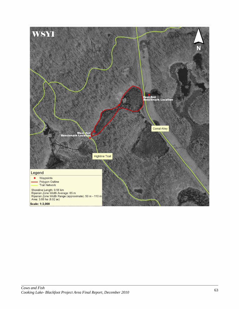
Cows and Fish Cooking Lake- Blackfoot Project Area Final Report, December 2010 63

Cows and Fish Cooking Lake- Blackfoot Project Area Final Report, December 2010 64
APPENDIX G: DESCRIPTION OF RIPARIAN HEALTH PARAMETERS
The riparian health score is based on 9 basic parameters pertaining to riparian health. This appendix addresses the guidelines and stipulations followed when each parameter was answered during the assessment. Keep in mind that these parameters are meant to encompass the broad range of ecological diversity that lake and wetland systems have the potential to express. The interpretations are not completely specific to any one type of stream system, yet still capture the essential factors of riparian health and function. Many different factors must be considered when answering any one of these parameters. It is quite possible that every scenario that could be encountered when conducting assessments is not covered here. Personal judgment based on sound riparian knowledge and good visual estimations are critical tools necessary for answering these questions consistently. This description of riparian health parameters is based on the Alberta Lentic Wetland Health (Survey) User Manual as created by Bitterroot Restoration, Inc. (2002).
LENTIC RIPARIAN HEALTH PARAMETERS
Some factors on the evaluation will not apply on all sites. For example, sites without potential for woody species are not rated on factors concerning trees and shrubs. Vegetative site potential can be determined by using a key to site type (e.g., Hansen and others 1995, Kovalchik 1987, or another appropriate publication). On severely disturbed sites, vegetation potential can be difficult to determine. On such sites, clues to potential may be sought on nearby sites with similar landscape position. Most of the factors rated in this evaluation are based on ocular estimations. Such estimation may be difficult on large, brushy sites where visibility is limited, but extreme precision is not necessary. While the rating categories are broad, evaluators do need to calibrate their eye with practice. It is important to remember that a health rating is not an absolute value. The factor breakout groupings and point weighting in the evaluation are somewhat subjective and are not grounded in quantitative science so much as in the collective experience of an array of riparian scientists, range professionals, and land managers. Each factor below will be rated according to conditions observed on the site. The evaluator will estimate the scoring category and enter that value on the score sheet. 1. Vegetative Cover of the Polygon. Around lentic water bodies vegetation cover helps to stabilize shorelines, control nutrient cycling, reduce water velocity, provide fish cover and food, trap sediments, reduce erosion, reduce the rate of evaporation (Platts and others 1987), and contributes primary production to the ecosystem. This question focuses on how much of the entire polygon area is covered by plant growth. Item #10 below assesses the amount of human-caused bare ground. Although there is some overlap between these two items, the bare ground to be counted in item #10 is strictly limited in definition, whereas all unvegetated area not inundated by water is counted in this item. The only area within the polygon exempt from consideration here is area covered by water. Areas such as boat docks, hardened pathways, and artificial structures are counted as unvegetated along with any bare ground, human-caused or natural. The rationale is that all such unvegetated areas contribute nothing to several of the important lentic wetland functions. The evaluator is to estimate the fraction of the polygon covered by plant growth. Vegetation cover is ocularly estimated using the canopy cover method (Daubenmire 1959).

Cows and Fish Cooking Lake- Blackfoot Project Area Final Report, December 2010 65
Scoring: 6 = More than 95% of the polygon area is covered by plant growth. 4 = 85% to 95% of the polygon area is covered by plant growth. 2 = 75% to 85% of the polygon area is covered by plant growth. 0 = Less than 75% of the polygon area is covered by plant growth. 2. Invasive Plant Species. Invasive plants (weeds) are alien species whose introduction does or is likely to cause economic or environmental harm. Whether the disturbance that allowed their establishment is natural or human-caused, weed presence indicates a degrading ecosystem. While some of these species may contribute to some riparian functions, their negative impacts reduce overall site health. This item assesses the degree and extent to which the site is infested by invasive plants. The severity of the problem is a function of the density/distribution (pattern of occurrence), as well as canopy cover (abundance) of the weeds. In determining the health score, all invasive species are considered collectively, not individually. A weed list should be used that is standard for the locality and that indicates which species are being considered (i.e., Invasive Weed and Disturbancecaused Undesirable Plant List [Cows and Fish 2002]). Some common invasive species are listed on the form, and space is allowed for recording others. Leave no listed species field blank, however; enter “0” to indicate absence of a value. 2a. Total Canopy Cover of Invasive Plant Species. The observer must evaluate the total percentage of the polygon area that is covered by the combined canopy of all plants of all species of invasive plants. Determine which rating applies in the scoring scale below. Scoring: 3 = No invasive plant species (weeds) on the site. 2 = Invasive plants present with total canopy cover less than 1 percent of the polygon area. 1 = Invasive plants present with total canopy cover between 1 and 15 percent of the polygon area. 0 = Invasive plants present with total canopy cover more than 15 percent of the polygon area. 2b. Density/Distribution Pattern of Invasive Plant Species. The observer must pick a category of pattern and extent of invasive plant distribution from the chart below that best fits what is observed on the polygon, while realizing that the real situation may be only roughly approximated at best by any of these diagrams. Choose the category that most closely matches what you see.
Figure 1. Density and distribution of invasive plants.

Cows and Fish Cooking Lake- Blackfoot Project Area Final Report, December 2010 66
Scoring: 3 = No invasive plant species (weeds) on the site. 2 = Invasive plants present with density/distribution in categories 1, 2, or 3. 1 = Invasive plants present with density/distribution in categories 4, 5, 6, or 7. 0 = Invasive plants present with density/distribution in categories 8, or higher. 3. Disturbance-Caused Undesirable Herbaceous Species. A large cover of disturbance-increaser undesirable herbaceous species, native or exotic, indicates displacement from the potential natural community (PNC) and a reduction in riparian health. These species generally are less productive, have shallow roots, and poorly perform most riparian functions. They usually result from some disturbance which removes more desirable species. Invasive species considered in the previous item are not reconsidered here. As in the previous item, the evaluator should state the list of species considered. A partial list of undesirable herbaceous species appropriate for use in Alberta follows. The evaluator should list additional species included. Antennaria spp. (pussy-toes) Hordeum jubatum (foxtail barley) Potentilla anserina (silverweed) Brassicaceae (mustards) Plantago spp. (plantains) Taraxacum spp. (dandelion) Bromus inermis (smooth brome) Poa pratensis (Kentucky bluegrass) Trifolium spp. (clovers) Fragaria spp. (strawberries) __________________________ _________________________ Scoring: 3 = Less than 5% of the site covered by disturbance-caused undesirable herbaceous species. 2 = 5% to 25% of the site covered by disturbance-caused undesirable herbaceous species. 1 = 25% to 45% of the site covered by disturbance-caused undesirable herbaceous species. 0 = More than 45% of the site covered by disturbance-caused undesirable herbaceous species. 4. Preferred Tree and Shrub Establishment and Regeneration. (Skip this item if the site lacks potential for trees or shrubs; for example, the site is a herbaceous wet meadow or cattail marsh.) Not all riparian areas can support trees and/or shrubs. However, on those sites where such species do belong, they play important roles. The root systems of woody species are excellent bank stabilizers, while their spreading canopies provide protection to soil, water, wildlife, and livestock. Young age classes of woody species are important indicators of the continued presence of woody communities not only at a given point in time but into the future. Woody species potential can be determined by using a key to site type (Thompson and Hansen 2001, Hansen and others 1995). On severely disturbed sites, the evaluator should seek clues to potential by observing nearby sites with similar landscape position. (Note: Vegetation potential is commonly underestimated on sites with a long history of disturbance.) Elaeagnus angustifolia (Russian olive) and three other shrub genera (Symphoricarpos spp. [buckbrush/snowberry], Rosa spp. [rose], and Crataegus spp. [hawthorn] are excluded from the evaluation of establishment and regeneration. These are species that may reflect long-term disturbance on a site, that are generally less palatable to browsers, and that tend to increase under long-term moderate-to-heavy grazing pressure; AND for which there is rarely any problem in maintaining presence on site. Elaeagnus angustifolia (Russian olive) is considered an especially aggressive, undesirable exotic plant. The main reason for excluding these plants is that they are far more abundant on many sites than are species of greater concern (i.e., Salix spp. [willows], Cornus stolonifera [red-osier dogwood], Amelanchier alnifolia [Saskatoon], and many other taller native riparian species), and they may mask the ecological significance of a small amount of a species of greater concern. FOR EXAMPLE: A polygon may have Symphoricarpos occidentalis (buckbrush/snowberry) with 30% canopy cover showing young plants for replacement of older ones, while also having a trace of Salix exigua (sandbar willow) present, but represented only by older mature individuals. We feel that the failure of the willow to regenerate (even though there is only a small amount) is very important in the health evaluation, but by including
Cows and Fish Cooking Lake- Blackfoot Project Area Final Report, December 2010 67
the snowberry and willow together on this polygon, the condition of the willow would be hidden (overwhelmed by the larger amount of buckbrush/snowberry). For shrubs in general, seedlings and saplings can be distinguished from mature plants as follows. For those species having a mature height generally over 6.0 ft (1.8 m), seedlings and saplings are those individuals less than 6.0 ft (1.8 m) tall. For species normally not exceeding 6.0 ft (1.8 m), seedlings and saplings are those individuals less than 1.5 ft (0.45 m) tall or which lack reproductive structures and the relative stature to suggest maturity. (Note: Evaluators should take care not to confuse short stature resulting from heavy browsing with that due to youth.) Scoring: (If the site has no potential for trees or shrubs [except for the species listed above to be excluded], replace both Actual Score and Possible Score with NA.) 6 = More than 15% of the total canopy cover of preferred trees/shrubs is seedlings and saplings. 4 = 5% to 15% of the total canopy cover of preferred trees/shrubs is seedlings and saplings. 2 = Less than 5% of the total canopy cover of preferred tree/shrubs is seedlings and saplings. 0 = Preferred tree/shrub seedlings or saplings absent. 5a. Utilization of Preferred Trees and Shrubs. (Skip this item if the site lacks trees or shrubs; for example, the site is a herbaceous wet meadow or cattail marsh.) Many riparian woody species are browsed by livestock and/or wildlife. Heavy browsing can prevent establishment or regeneration of these important species. Excessive browsing can eliminate them from the community and result in their replacement by undesirable invaders. Elaeagnus angustifolia (Russian olive) and three other shrub genera (Symphoricarpos spp. [buckbrush/snowberry], Rosa spp. [rose], and Crataegus spp. [hawthorn] are excluded from the evaluation of utilization of woody species. These are plants that may reflect long-term disturbance on a site, that are generally less palatable to browsers, and that tend to increase under long-term moderate-to-heavy grazing pressure; AND for which there is rarely any problem in maintaining presence on site. Elaeagnus angustifolia (Russian olive) is considered an especially aggressive, undesirable exotic plant. The main reason for excluding these plants is they are far more abundant on many sites than are species of greater concern (i.e., Salix spp. [willows], Cornus stolonifera [red-osier dogwood], Amelanchier alnifolia [Saskatoon], and many other taller native riparian species), and they may mask the ecological significance of a small amount of a heavily utilized species of greater concern. FOR EXAMPLE: A polygon may have Symphoricarpos occidentalis (buckbrush/snowberry) with 30% canopy cover showing only light utilization, while also having a trace of Salix exigua (sandbar willow) present showing heavy utilization. We feel that, although there is only a small amount of willow present, the fact that it is being heavily utilized is very important to the health evaluation. By including the snowberry and willow together on this polygon, the condition of the willow would be hidden (overwhelmed by the larger amount of buckbrush/snowberry). When estimating degree of utilization, count browsed second year and older leaders on representative plants of woody species normally browsed by ungulates. Do not count current year's use since this may not accurately reflect actual use because significant browsing can occur late in the season. Determine percentage by comparing the number of leaders browsed with the total number of leaders available (those within animal reach) on a representative sample (at least three plants) of each tree and shrub species present. Do not include use of dead plants unless it is clear this condition was the result of over-grazing. Scoring: (If the site has no potential for trees or shrubs [except for the species listed above to be excluded], replace both Actual Score and Possible Score with NA.) 3 = None (0% to 5% of available second year and older leaders of preferred species are browsed). 2 = Light (5% to 25% of available second year and older leaders of preferred species are browsed). 1 = Moderate (25% to 50% of available second year and older leaders of preferred species are browsed). 0 = Heavy (More than 50% of available second year and older leaders of preferred species are browsed).
Cows and Fish Cooking Lake- Blackfoot Project Area Final Report, December 2010 68
5b. Live Woody Vegetation Removal by Other Than Browsing. (Skip this item if the polygon lacks trees and shrubs AND there are no stumps or cut woody plants to indicate that it ever had any.)
Excessive cutting or removing parts of plants or whole plants by agents other than browsing animals (e.g., human clearing, cutting, beaver activity, etc.) can result in many of the same negative effects to the community that are caused by excessive browsing. However, other effects from this kind of removal are direct and immediate, including reduction of physical community structure and wildlife habitat values. Do not include natural phenomena such as natural fire, insect infestation, etc. in this evaluation. For this item consider all woody vegetation together: trees and shrubs of all age classes, except for the invasive species (Elaeagnus angustifolia [Russian olive], Caragana species [caragana], Rhamnus cathartica [European/common buckthorne], and Tamarix species [salt cedar]). Record the amount of cutting or removing parts of plants or whole plants by agents other than browsing animals (e.g., human clearing, cutting, beaver activity, etc.). Do not include natural phenomena such as natural fire, insect infestation, etc. in this evaluation. Removal of woody vegetation may occur at once (a logging operation), or it may be cumulative over time (annual firewood cutting or beaver activity). This question is not so much to assess long term incremental harvest, as it is to assess the extent that the stand is lacking vegetation that would otherwise be there today. Give credit for re-growth. Consider how much the removal of a tree many years ago may have now been mitigated with young replacements.
Scoring: (If the site has no trees or shrubs AND no cut plants or stumps of any trees or shrubs [except for the species listed above to be excluded], replace both Actual Score and Possible Score with NA.) 3 = None (0% to 5% of live woody vegetation expected on the site is lacking due to cutting). 2 = Light (5% to 25% of live woody vegetation expected on the site is lacking due to cutting). 1 = Moderate (25% to 50% of live woody vegetation expected on the site is lacking due to cutting). 0 = Heavy (More than 50% of live woody vegetation expected on the site is lacking due to cutting). 6. Human Alteration of Polygon Vegetation. Human alteration of the vegetation is meant to include all changes to the plant community composition or structure on the polygon caused by human actions (e.g., logging, mining, roads, construction, or development) or by agents of human management (e.g., livestock). It is not meant to include transitory or short-term removal of plant material that does not impact plant community composition (i.e., grazing at carefully managed levels). Of concern are the kinds of change that diminish or disrupt the natural wetland function of the vegetation. These include, but are not limited to, vegetation clearing, changing plant community composition (e.g., replacing willows with rose and buckbrush, woody species with herbaceous species, etc.), replacing native plants with tame plants, replacing deep rooted plants with shallow rooted plants, and/or replacing tall species with short species. On polygons adjacent to deep water, remember that the polygon extends out to where the water is two meters deep. (NOTE: Do not count the same area twice by including it as both a vegetative and a physical alteration, unless there clearly are both kinds of alteration. Decide into which category a particular effect should go. For example: A timber harvest may clear vegetation, but not necessarily cause physical damage on one area; while on another area cause both clearing of vegetation and disruption of the soil by skidding of logs.) Scoring: 6 = Less than 5% of polygon vegetation is altered by human activity. 4 = 5% to 15% of polygon vegetation is altered by human activity. 2 = 15% to 35% of polygon vegetation is altered by human activity. 0 = 35% or more of polygon vegetation is altered by human activity.

Cows and Fish Cooking Lake- Blackfoot Project Area Final Report, December 2010 69
7. Human Alteration of Polygon Physical Site. This evaluation of human alteration of the physical site is meant to include all changes to the physical attributes of the site caused by human actions (e.g., logging, mining, housing development) or by agents of human management (e.g., livestock). The kinds of physical change that diminish or disrupt the natural wetland functions on the site include, but are not limited to, hummocking, pugging, and trails by livestock; human roads, trails, buildings, landscaping, boat launches/docks, beach clearing and building, or rip-rapping shores and banks. (NOTE: Do not count the same area twice by including it as both a vegetative and a physical alteration, unless there clearly are both kinds of alteration. Decide into which category a particular effect should go. For example: A cottage owner may clear vegetation to gain a view of the lake without causing physical damage to one area; whereas, if he/she hauls in sand to enhance the beach, there is also physical alteration.) Scoring: 12 = Less than 5% of the polygon is physically altered by human activity. 8 = 5% to 15% of the polygon is physically altered by human activity. 4 = 15% to 35% of the polygon is physically altered by human activity. 0 = 35% or more of the polygon is physically altered by human activity. 8. Human-Caused Bare Ground. Bare ground is exposed soil surface (not covered by plants, litter or duff, down wood, or rocks larger than 2.5 inches [6 cm]). Bare ground may result naturally from several processes (i.e., sedimentation, flood erosion, fire, tree fall, and exposure of lakebed by low water level), but that caused by human activity always indicates an impairment of wetland health. Exposed soil is vulnerable to erosion and is where weeds become established. Bare soil is not producing, nor providing habitat. Sediment deposits and other natural bare ground are excluded as normal and probably beyond management control. Human land uses often causing bare ground include livestock grazing, recreation, off road vehicle use, and resource extraction activities. After considering the causes of all bare ground on the site, the evaluator must estimate what percent of the site (polygon) area is human-caused bare ground. Scoring: 6 = Less than 1% of the site is human-caused bare ground. 4 = 1% to 5% of the site is human-caused bare ground. 2 = 5% to 15% of the site is human-caused bare ground. 0 = 15% or more of the site is human-caused bare ground. 9. Degree of Artificial Removal of Water. Although water levels naturally fluctuate on a seasonal basis in most systems, many wetland systems are affected by water removal for human uses. This artificial removal of water level often does not follow a temporal regime conducive to maintaining healthy native wetland plant communities. The result is often a barren band of shore exposed for much of the growing season. This withdraws soil water from the rooting zone of established shore vegetation communities, causes shore material to destabilize, and provides sites for weeds to invade. Such conditions are extremely detrimental to the riparian vegetation, site productivity, and wildlife values. Not all lentic wetlands evaluated with this form will have surface water potential, but any wetland may have its water table degraded by draining, pumping, or diverting its surface or subsurface supply. On such lentic wetlands as marshes and wet meadows, look for evidence of drainage ditching, pumping, and the interruption of normal surface drainage inputs by livestock watering dugouts, cross slope ditches, or dams upslope. In this item the evaluator is asked to categorize the degree to which the system is subjected to artificially rapid or unnaturally timed fluctuations in water level. Reservoirs intended for storage of water for power generation, irrigation, and/or livestock watering typically exhibit the most severe effects, but water may be diverted or pumped from natural systems for many other reasons (domestic use, industrial use, livestock watering, etc.). This item requires the evaluator to make a subjective call by choosing as a “best fit” one of the categories of drawdown severity described below. (Note: Be careful to consider the scale of the water body as it relates to the scale of water

Cows and Fish Cooking Lake- Blackfoot Project Area Final Report, December 2010 70
removal. Pumping a small dugout full of water for livestock might severely impact a two acre slough, but be negligible to a lake covering a section of land.) Be sure to document the grounds for your estimate here. If there is no way to know with any reasonable degree of certainty how much water is being removed, it may be better to document the situation and to “zero out” this item (not answer it). During periods of drought lakebeds become exposed and often exhibit wide zones of almost barren shore. The evaluator must be careful not to attribute this natural phenomenon unfairly to a human cause.
Categories of Lentic Water Removal Severity
Scoring: 9 = The waterbody, or wetland, is “Not Subjected” to artificial water removal 6 = The degree of artificial water removal is “Minor” 3 = The degree of artificial water removal is “Moderate” 0 = The degree of artificial water removal is “Extreme”
CATEGORY DEFINITION Not Subjected The waterbody is not subjected to artificial drawdown. Minor The waterbody is subject to no more than minor artificial water level
change. The shore area remains vegetated and withdrawal of water is limited or slow enough that vegetation is able to maintain growth and prevent exposed soil. A relatively narrow band affected by the water level fluctuation may support only annual plants.
Moderate The waterbody is subject to moderate quantities, speed and/or frequency of artificial water level change. Where water is removed, it is done in a way that allows pioneer plants to vegetate at least half of the exposed area resulting from drawdown. Where water is added, some flooding may occur at levels or times not typical to the area/season.
Extreme The waterbody is subjected to extreme changes in water level due to volume (extent), speed and/or frequency of artificial water addition or removal. Frequent or unnatural levels of flooding occur where water is added, including extensive flooding into riparian and/or upland areas; or no natural annual drawdown is allowed to occur. In extreme artificial drawdown situations, a wide band of exposed bottom remains unvegetated.