Contents - Geo-EM 2017gem2017.org/Program Book.pdf · 2 Contents Preface from the Chairman of the...
93
Transcript of Contents - Geo-EM 2017gem2017.org/Program Book.pdf · 2 Contents Preface from the Chairman of the...


2
Contents
Preface from the Chairman of the 1st Geo-EM 2017 1
Preface from Head of Applied Geophysics and Exploration Expertise Group 2
ITB Campus Map 3
Field Trip Destination Preview 4
Program Schedule 5
Poster Schedule 9
Abstracts of Keynote Speakers 20
Abstracts of TM Group (Theory, Modeling, and Inversion) 28
Abstracts of OG Group (Geophysical Exploration, Oil, and Gas) 36
Abstracts of NR Group (Geophysical Exploration for New and Renewable Energy) 42
Abstracts of EV Group (Environmental Geophysics) 50
Abstracts of EG Group (Engineering Geophysics) 61
Abstracts of TH Group (Tectonic and Monitoring Hazard) 71
Abstracts of RM Group (Rock Magnetic) 81

3
Committee
General chair Dr.rer.nat. Widodo, ST, MT
Steering Committee Members Prof. Sri Widiyantoro, Ph.D
Prof. Dr. Ir. Djoko Santoso
Prof.Dr. Wawan Gunawan A. Kadir
Dr.rer.nat. Wahyudi W. Parnadi
Dr. Susanti Awaliyah
Dr. Hendra Grandis
Dr. Daharta Dahrin
Dr. Andri Dian Nugraha S.Si, M.Si
Dr. Agus Laesanpura
Dr. Warsa, S.Si., MT
Program Committee Members Dr. Setianingsih
Dr. Eko Januari Wahyudi, ST., MT
Ir. Indra Gunawan, M.Sc., M.Si
Dadi Abdurahman, ST., MT
Silvia Jannatul Fajar, ST., MT
Kartika Hajar Kirana, S.Pd., M.Si
Azizatun Azimmah
Siti Nurjanah
Ridho Nanda Pratama
Nadia Amalia
Erisha Aryanti
Rifki Mega Saputra
Rianty Kusuma Dewi
Febri Taufik
Indriani Yunitasari
Sevi Maulinadya
Kana Agatha Natania
Kuto Hillary
Gatot Nugroho
Arifa Hijriani
Probo Mukti
Andrianus Boas
Muhamad Lutfi Ramadhan
Liaison Officer (LO) Sevi Maulinadya
Nur Rachmad Madyantara
Nadhila Hizhwati
Chairul Rajib
Okta Indah Sulistyorini
Tara Annisa

1
Dear Participant,
On behalf of committees, I would like to welcome you to The 1st Geo-Electromagnetic (Geo-EM) Workshop
2017 here in Bandung, Indonesia. It is an honor for me to be the chairman of this workshop. Geo-EM workshop
is a biennial event held by Applied Geophysics Department, Geophysical Engineering, and Institut Teknologi
Bandung. This first ever Geo-EM workshop is focusing on theories and applications of geoelectrical science,
electromagnetic, and rock magnetic in the field of geosciences, engineering, environment, geotechnical, and
exploration of natural resources. Although, this is the first-time Geo-EM has been held, it is participated by
many from scientist and engineer. At least more than a hundred of abstracts are submitted, not only from
Indonesia, but also from overseas such as Malaysia, Thailand, Japan, China, Africa, Germany, France, Russia,
and many more. This is beyond our expectation and target.
This 1st Geo-EM Workshop with the theme “Development and Application of Geoelectric-Eletromagnetic and
Rock Magnetic Methods for Earth Resources Exploration”, is meant to encourage the development and
application of geo-electric & EM methods and rock magnetic to support sustainable energy in the fulfillment of
the human needs. It also has a wide meaning in environmental conservation and monitoring efforts in an attempt
to minimize the disaster victims, especially in Indonesia. To this, in this workshop we hope for participants to
share their knowledge, ideas, and develop new methods particularly in rock magnetic, geoelectric, and
electromagnetic field. Following the participant’s presentations we expect all presenters to submit their extended
abstract which then will be published in international conference proceeding indexed by SCOPUS.
This workshop will be held for five days including a course collaborating with Society of Exploration
Geophysicist (SEG) in Distinguished Instructor Short Course 2017 with the topic of Geophysical
Electromagnetics: Fundamentals and Applications and will be presented by Professor Doug Oldenburg on
February 20th
, 2017. The courses then continued by workshop for the next three days after on February 21st-23
rd,
2017. Lastly, on February 24th
we will be having a field trip to Mount TangkubanPerahu, tea walk among the tea
gardens, and enjoy the breathtaking view of CurugDawuan, and relaxing visit to a hot spring spa in
GraciaSubang.
We would like to thank all sponsors, Institute of Research and Community Services (LPPM) – ITB, Faculty of
Mining and Petroleum Engineering – ITB, Geophysichal Engineering- ITB, LAPI-ITB, Institute of Geophysics
and Meteorology (IGM), University of Cologne, Ocean University of China, Soceity of Exploration
Geophysicist (SEG), Honda, Villa Cisitu Indah 6 No. 17, PT. Kuarsa Hexagon, KMS Technologies, Premier
Oil, Semen Indonesia, Wardah, KMS Technologies, and all donors that participated to this workshop. Thanks to
all students of Geophysical Engineering-ITB that supported this event. To all committees, my highest
appreciation for the hard work in creating this workshop. I hope everyone enjoy their stay in Bandung, connects
with new colleague from across nations that enrich the knowledge in our workshop.
Chairman Geo-EM Bandung 2017
Dr.rer.nat. Widodo

2
Dear all colleagues,
On behalf of Head of Applied Geophysics and Exploration Expertise Group, we would like to welcome you to
The 1st Geo-Electromagnetic (Geo-EM) Workshop 2017. This workshop is one of the acts to empower and
enhance research performance, community service, and innovation particularly in application and development
of knowledge in geophysics. Hopefully the theme “Development and Application of Geoelectric-Eletromagnetic
and Rock Magnetic Methods for Earth Resources Exploration” this workshop will support collaboration,
sharing, and innovation development in application of knowledge particularly in rock magnetic, geoelectric, and
electromagnetic field.
This workshop is expected to be held continuously, that it will be the main program of our Expertise Group and
held biennially. It is an honor for us that there are many participants in this workshop not only from Indonesian
institutions, but also from nine other countries from Asia, Africa, America, and European continents. This will
bridge further collaboration in research, innovation, and enhancement in human resources.
I thank all sponsors for the support towards this event. To all committees and students, my highest appreciation
for the hard work and support from the very beginning to the very end of this workshop. Lastly, I thank
scientific reviewers and all participants that contributed in this workshop whether it is poster or oral
presentation.
Please enjoy the ideas and development of knowledges that could enhance and compliance human life and the
environment. Make this workshop a medium to seek new friends, collaborate, and bridge knowledge.
Head of Applied Geophysics and Exploration Expertise Group,
Prof. Dr. Djoko Santoso

3

4
Tea Walk
Curug Dawuan

5
PROGRAM SCHEDULE
DISC (Distinguished Instructor Short Course )
Monday, 20 Feb 2017
7.00
8.00
Registration & Ice Breaking
8.00
16.00 Geophysical Electromagnetics: Fundamentals and Applications
( Prof. Doug Oldenburg and Sogie Kang)
PROGRAM AND ORAL SESSIONS
Tuesday, 21 Feb 2017
7.00
8.00
Registration & Ice Breaking
8.00
8.45
Opening Remarks
8.45
9.45
Keynote Prof. Dr. Bülent Tezkan (Universität zu Köln, Germany)
9.45
10.00
Coffee Break
10.00
10.45
Keynote Prof. Dr. Ir. Djoko Santoso, M.Sc. (Institut Teknologi Bandung , Indonesia)
10.45
11.05
Oral Presentation I: Nazli Ismail, Muhammad Yanis, Muyassir (Imaging the Northern part of t Great Sumatran Fault system based on 2D Inversion of Magnetotelluric Determinant data)
11.05
11.25
Oral Presentation II: Febriani, Widarto, Gaffar, Nasution, and Grandis (Subsurface Structure Imaging of the Sembalun-Propok Area, West Nusa Tenggara by using the Audio-frequency Magnetotelluric Data)
11.25
11.45
Oral Presentation III: M. Jinmin, S. Rosli, M. M. Nordiana, S. Mokhtar (Trilogy Possible Meteorite Impact Crater at Bukit Bunuh, Malaysia using 2-D Electrical Resistivity Imaging)
11.45
12.45
Lunch
12.45
13.30
Poster Introduction
13.30
14.30
Poster Presentation
14.30
14.50
Coffee Break
14.50
15.10
Oral Presentation IV: Hidayat, Asep Rohiman, Saultan Pandjaitan (Identification of Pre-Tertiary Deposit by using Magnetotelluric Method in Bintuni Basin, West Papua, Indonesia)
15.10
15.30
Oral Presentation V: Teuku Abdullah Sanny (Identification of Fault Structure along Jakarta-Bandung High Speed Train Railway by Using CSAMT and Seismic Tomography Methods)

6
15.30
15.50
Oral Presentation VI: Hazrul Hisham, M.M. Nordiana and Teoh Ying Jia (The Study of Mudrocks Resistivity in Northwestern Peninsula Malaysia using Electrical Resistivity Survey)
15.50
16.10
Oral Presentation VII: Jaingot A. Parhusip, Agung Harijoko, Doni Prakasa E.P., Wiwit Suryanto (Assessment of Leachate Infiltration from Piyungan Landfill using Electrical Resistivity Method)
Wednesday, 22 Feb 2017
7.30
8.00
Opening Remarks
8.00
8.45
Prof. Doug Oldenburg (Invited Speaker)
8.45
9.05
Oral Presentation I: Bryna Mustika and Niken Ramadianti (3-D Modelling for Exploration Iron Ore in Tanjung Mahuroy Village, Central Kalimantan using Geoelectrical Method IP and Dipole-Dipole)
9.05
9.25
Oral Presentation II: Agus Laesanpura and Warsa (Resistivity and Gravity Data for Aquifer Modelling in Kendari (South Sulawesi) )
9.25
9.40
Coffee Break
9.40
10.25
Prof.Satria Bijaksana (Invited Speaker)
10.25
10.45
Oral Presentation III: Pranitha Septiana, Siti Zulaikah, Arif Hidayat, Rosyda Azzahro (Magnetic Susceptibility and Dielectric Properties of Peatland in Central Kalimantan, Indonesia)
10.45
11.05
Oral Presentation IV: Siti Zulaikah, Dian Sisinggih, Zem Dani, Mahfud David Ong, and Yusuf Bungkang (Magnetic Susceptibility, Fe Content and Morphology of Magnetic Mineral extracted from surface sediment of Kamp Walker and Hubai River as an Inlet of Sentani Lake, Papua-Indonesia)
11.05
11.20
Poster Introduction
11.20
12.20 Poster Presentation
12.20
13.20 Lunch
13.20
14.05
Prof.Weerachai Saripunvaraporn (Invited Speaker)
14.05
14.25
Oral Presentation V: Wahyu Srigutomo and Ariel A. Rahardi (Numerical Techniques for Solving Gauss Quadrature Semi-infinite Integral used in Vertical Magnetic Dipole Forward Modeling)

7
14.25
14.45
Oral Presentation VI: Ida Bagus Suanadna Yogi, and Widodo (Time Domain Electromagnetic 1D Inversion using Genetic Algorithm and Particle Swarm Optimization)
14.45
15.05
Oral Presentation VII: Agus Setyawan, Nur Rachmaningtias, and Imam B. Raharjo (Two-Dimensional Inversion Finite Element Modeling of Magnetotelluric Data at “J” Geothermal Area, Indonesia)
15.05
15.20
Coffee Break
15.20
15.40
Oral Presentation VIII: Yunus Daud, Wambra Aswo Nuqramadha, Fikri Fahmi, Surya Aji Pratama, Khalif Radhiyya Rahman3, Wisnu Subroto (Discovering “Hidden” Geothermal Reservoir in Blawan-Ijen Geothermal Area (Indonesia) Using 3D Inversion of MT Data)
15.40
16.00
Oral Presentation IX: M.M. Nordiana, Rosli Saad, I.N. Azwin,and Andy A. Bery (Determination of Slope Failure using 2D Resistivity Method)
16.00 16.20 Oral Presentation X: Y. C. KIU, S. ROSLI1, I. N. Azwin, S. Mokhtar (The General Indications of An Impact Crater using Integrated Geophysical Methods)
Thursday, 23 Feb 2017
7.30
8.00
Opening Remarks
8.00
8.45
Prof. Yuguo Li (Invited Speaker)
8.45
9.05
Oral Presentation I: Yuri A. Agafonov, Igor V. Buddo, Olga V. Tokareva, M. Shukur M. Ali, Mustapha M. Salleh (Application of TEM Technique in South-East Asia)
9.05
9.25
Oral Presentation II: Sintia Windhi Niasari (Resistivity Image Beneath Parangwedang Geothermal Field (Indonesia) Inferred from Magnetotelluric Data)
9.25
9.40
Coffee Break
9.40
10.25
Dr. Amir Haroon (Invited Speaker)
10.25
10.45
Oral Presentation III: R. Aftartu, S. Davydycheva, and K. Strack (Uses of Lotem for Indonesian Hydrocarbon Applications)
10.45
11.05
Oral Presentation IV: Andri Yadi Paembonan, Sonya Davydycheva, Maxim Smirnov, Rungroj Ajdwech, Kurt M. Strack (An Application of LOTEM around Salt Dome near Houston, Texas)
11.05
11.20
Poster Introduction
11.20 12.20 Poster Presentation

8
12.20
13.20 Lunch
13.20
14.05
Dr. Kurt Strack (Invited Speaker)
14.05
14.25
Oral Presentation V: Sirelkhatim H. Mukhtar (Time Domain Electromagnetic Survey for Geotechnical Exploration at Singa Substation)
14.25
14.45
Oral Presentation VI: Muhammad Hasbi Assiddiqy, and Warsa (Reservoir Identification using Short Offset Transient Electromagnetic Method)
14.45
15.05
Oral Presentation VII: S. Nabila, M.M Nordiana, I.N Azwin and Mokhtar Saidin (Analyzing Soil Electrical and Strength Parameters using Geophysical Methods in Sungai Batu, Kedah)
15.05
15.20
Coffee Break
15.20
15.40
Oral Presentation VIII: Azim Hilmy Mohamad Yusof , Muhamad Iqbal Mubarak Faharul Azman, Nur Azwin Ismail, Noer El Hidayah Ismail, (Applying 2-D Resistivity Imaging and Ground Penetrating Radar (GPR) Methods to Identify Infiltration of Water in the Ground Surface)
15.40
16.00
Oral Presentation IX: A. N. Nordiana, and M. M. Nordiana, Teoh Ying Jia (Application of Geosciences Parameters in Identifying Rock Properties at Bukit Chondong, Malaysia)
EXCURSION Friday, 24 Feb 2017
6.30
AM Depart from ITB to Tangkuban Perahu Vulcano
7.30
AM Arrive at Tangkuban Perahu Vulcano
10.00
AM Enjoy Vulcano and Landscape
10.30
AM Visit Rain Fall Curug Dawuan
11.00
AM Tea Walk
12.00
PM Visit Hot Spring Spa
12.30
PM Have Lunch at Gracia Hot Spring Spa
1.30
PM Enjoy Hot Spring Spa
4.00
PM Depart from Gracia
5.30
PM Arrive at ITB

9
POSTER SCHEDULE
No Name of Author(s) Institution Code of Abstract
Title
Tuesday, 21 February 2017
1 Rahmat Fajri, Amajid Sinar, Kevin Hartono, Indriani Yunitasari, Widodo
Geophysical Engineering, Faculty of Mining and Petroleum Engineering, Institut Teknologi Bandung
EG-01 Underground Infrastructure Detection using Ground Penetrating Radar Method
2 M Fariz Gumai, Stephen Fernando, Gatot Nugroho, Kana Natania, Widodo
Geophysical Engineering, Faculty of Mining and Petroleum Engineering, Institut Teknologi Bandung
EG-02 Quality Investigation of Building Structure using Ground Penetrating Radar Method which is Effective and Enviromentally Friendly as An Early Study to Prevent Severe Structural Damage
3 Erina Prastyani1, Sintia Windhi Niasari2
Program of Geophysics, Universitas Gadjah Mada, Indonesia; 2Geophysics Sub-Department, Faculty of Mathematics and Natural Sciences, Universitas Gadjah Mada, Indonesia
EG-03 Interpretation of VLF-EM & VLF-R Data Using Tipper and Impedance Analyses: A Case Study from Candi Umbul-Telomoyo, Magelang, Indonesia
4 Adella Putri Affanti1, Sinthia Windhi Niasari2
1Undergraduate Program of Geophysics, Universitas Gadjah Mada; 2Geophysics Sub Deartment, Universitas Gadjah Mada
EG-04 VLF EM and VLF R Modelling using 2layinv and Karous-Hjelt MATLAB in Candi Umbul Magelang
5 Puspita Dian Maghfira, Sintia Windhi Niasari
Geophysics Sub-Departement, Faculty of Mathematical and Natural Sciences, Universitas Gadjah Mada
EG-05 Analysis Magnetic Data to Indetification Structure in Candi Umbul Geothermal Prospect Area, Central Java
6 M. Dika Arzaldi, M. Izzuddin Prawiranegara, Emirza Faisal D., Arzalia Wahida, Widodo
Geophysical Engineering, Faculty of Mining and Petroleum Engineering, Institut Teknologi Bandung
EV-01 Investigation of Cikapundung Rivers Sedimentation using 2D Resistivity Method
7 Arifa Hijriani, Aji Surya Utama, Andrianus Boas, M. Ridho Mukti, Widodo
Geophysical Engineering, Faculty of Mining and Petroleum Engineering, Institut Teknologi Bandung
EV-02 Plug Identification in Drainase System Using Electromagnetic Wave

10
8 F. N. Izzati, Z. S. Laksmana, B. Marcelina, S. S. Hutabarat, Widodo
Geophysical Engineering, Faculty of Mining and Petroleum Engineering, Institut Teknologi Bandung
EV-03 Identifying Potential Ground Movement as A Landslide Mitigation Approach using Resistivity Method
9 Rianty Kusuma Dewi1, Adityo Kurniawan1, Reyhan Fariz Taqwantara1, Farras M. Iskandar1, Taufiq Ziyan Naufal2,Widodo1
1Geophysical Engineering; 2Geological Engineering, Institut Teknologi Bandung
EV-04 Innovation in Evacuation of Natural Disaster with GPR Method
10 Erisha Aryanti, Ahmad P. Ardi, Muaz Almunziri, Zael Yahd Xanggam, Adino Eleazar, Widodo
Geophysical Engineering, Faculty of Mining and Petroleum Engineering, Institut Teknologi Bandung
EV-05 Waste Disposal Mapping with Electrical Resistivity Tomography, case: Leuwigajah Landfill
11 Wiwid Joni1,2, Darharta Dahrin1, Asep Sugianto2
1Geophysical Engineering, Institut Teknologi Bandung, 2Geological Agency of Indonesia
NR-01 Delineation of Dolok Marawa Geothermal Prospect Area by Applying 2-D Inversion that Utilize Magnetotelluric, Audio Magnetotelluric, and Time Domain Electromagnetic Data
12 Achmad Fajar Narotama Sarjan, Sintia Windhi Niasari
Geophysics Sub-Departement, Faculty of Mathematics and Natural Science, Universitas Gadjah Mada
NR-02 Measurement of Subsurface Structures in Telomoyo Mountain Geothermal Area, Magelang using, 1-D Audio Magnetotelluric Method
13 Kevin Gardo Bangkit Ekaristi, Aditya Aries Furkhan, Agra Adipta
Geophysical Engineering Department, Pembangunan Nasional University Yogyakarta
NR-03 The Revealation of Structure Controlled Hotspring using Passive Single Component Electromagnetic Method
14 Muhammad Bisri Mustofa, Umar fauzi, and Fourier D. E. Latief
Earth Physics and Complex Systems, Faculty of Mathematics and Natural Sciences, Institut Teknologi Bandung
OG-05 Formation Factor Calculation of Digital Rock Images with the Help of FEM
15 Donny Prasetyo1, Warsa 1), Wahyu Srigutomo2) and M. Rachmat Sule1)
1Geophysical Engineering Department, ITB; 2Physics Department, ITB
OG-07 Non-linear Inversion Modeling of TDEM Data for Reservoir Characterization
16 Yovan Prananda1, Febri Taufik1, Alief Rizki1, Fikrianti Surachman2, M Hardian T3, Naufal Rachman Akbar4, Widodo1
1Geophysical Engineering Institut Teknologi Bandung, 2Pharmaceutical Care Institut Teknologi Bandung, 3Chemistry Institut Teknologi Bandung, 4Biology Institut Teknologi Bandung
RM-01 Pollution Detected Innovation of The Hazardous and Toxic, Subtance Disposal by Magnetic Susceptibility Method around Cikijing River, Rancaekek for Testing Water Quality Standards

11
17 Ganendra Chandra Ditya, Arno Germanndaputra Sulistyanto, Satria Bijaksana
Geophysical Engineering, Faculty of Mining and Petroleum Engineering, Institut Teknologi Bandung
RM-02 Construction of An Inexpensive Field Gradiometer based on FGM3-sensor and SCL007 IC Chip
18 Mariyanto, Satria Bijaksana
Geophysical Engineering, Faculty of Mining and Petroleum Engineering, Institut Teknologi Bandung
RM-03 Magnetic Properties of Deposited Sediments in Surabaya River, East Java, Indonesia
19 Abd Mujahid Hamdan1, Satria Bijaksana1, Aiyen Tjoa2, and Darharta Dahrin1
1 Faculty of Mining and Petroleum Engineering, Institut Teknologi Bandung 2Agriculture Faculty, Tadulako University
RM-04 Low-Temperature Thermomagnetic Method and identification of Impurities in Ni Hyperaccumulator Plants
20 Sevi Maulinadya, M. Lutfi Ramadhan, Nanda Wening F., David Pinehas, Widodo
Geophysical Engineering, Faculty of Mining and Petroleum Engineering, Institut Teknologi Bandung
TH-01 Lembang Fault Plane Identification using Electrical Resistivity Tomography for Disaster Mitigation
21 Selvi Misnia Irawati, Dina Sari Handayani, Wahyu Kusdyantono
Geophysics Study Program, Department of Physics, Universitas Gadjah Mada
TH-03 Magnetotelluric Data Analysis in Cascadia Subduction Zone, USA
22 Irwandi, Marwan, Muksin
Syiah Kuala University TH-04 Applications of the VLF induction Method for Rapid Sumatran Fault Identification in Leuser National Park, Aceh
23 Wen J Whan 3Jtech TM-01 Magnetotelluric Array and Magnetic Magnetotelluric Surveys
24 Suparwoto1, Kirbani SBp.1, Ari Setiawan1, Agus Kuncaka2
1Departemen Fisika, FMIPA, UGM, Yogyakarta, 2Departemen Kimia, FMIPA, UGM,Yogyakarta
TM-02 Design of Device for Spectral Induced Polarization Laboratory Measurements in Geophysics Exploration
25 Accep Handyarso1*
and Hendra Grandis2
1Geophysics Research Group, Centre of Geological Survey, Indonesia Geological Agency, 2Applied and Exploration Geophysics Group, Faculty of Mining and Petroleum Engineering, Institut Teknologi Bandung
TM-03 MT Data Smoothing in Frequency Domain Based on the B-Spline Algorithm and Qualitative Spectral Analysis

12
26 Franto1,2, Subagyo Pramumijoyo1,Lucas Donny Setijadji1
1Departement of Geological Engineering, Universitas Gadjah Mada, Yogyakarta, 2Department of Mining Engineering, Bangka Belitung University
NR-11 USING LANDSAT IMAGE 8 AND GIS FOR SURFACE MINERAL ANALYSIS IN THE SOUTHERN BANGKA
Wednesday, 22 February 2017
1 Aprillia Himatina Retnowati,Reza Fauziah
Bachelor Program of Geophysics, Padjadjaran University
NR-04 Identification of Water Spring, Water Flow Patterns and Quality Contents of Soil Water using Conductivity Measurement Direct (CMD), Geoelectricity and Coring Method, Case Study: Padjadjaran University
2 Arriqo’ Fauqi Romadlon, Sintia Windhi Niasari
Geophysics Sub-Department, Faculty of Mathematics and Natural Science, Universitas Gadjah Mada
NR-05 Identification of Geothermal system using G492D Audio Magnetotelluric Method in Mount Telomoyo Area
3 Sintia Windhi Niasari Geophysics Laboratory, Physics Department, Faculty of Mathematics and Natural Sciences, Sekip Utara, BLS 21, Yogyakarta, Indonesia
NR-07 Water Table Monitoring around the Parangwedang Geothermal Field (Indonesia) Inferred from Audio Magnetotelluric Data
4 Muhammad Yanis1, Muzakir2, Marwan2, Nazli Ismail3
1Physics Department, Syiah Kuala University; 2Department of Geophysical Engineering, Syiah Kuala University; 3Graduate Program in Disaster Science, Syiah Kuala University
EV-06 Investigation of Buried Paleochannel in Rumpet Village Eastern Banda Aceh using Electromagfnetic Induction Method
5 S. Irawan1, R. R. Aly1, R. Syahputra2, T.H.W. Kristyanto2, and A.S. Tempessy2
1Geophysics Study Program. FMIPA, Universitas Indonesia, Depok, Indonesia; 2Geology Study Program. FMIPA, Universitas Indonesia, Depok, Indonesia
EV-07 GPR Application to Investigate Soil Cracks Persistence in Cianjur Landslide
6 Shallom Samuel Harmany1, Tedy Setiawan2
Geophysical Engineering, Faculty of Mining and Petroleum Engineering, Institut Teknologi Bandung
EV-08 New Instrumentation Device, Based on Resistivity for Agricultural Geophysics

13
7 Muhamad Iqbal Mubarak Faharul Azman1, Azim Hilmy Mohd Yusof1, Nur Azwin Ismail1, Noer El Hidayah Ismail2
1Geophysics Department, School of Physics, 11800 Universiti Sains Malaysia, Penang, Malaysia; 2Department of Geology, Faculty of Science, Universiti of Malaya, 50603 Kuala Lumpur, Malaysia
EV-10 Slope Monitoring using 2D Resistivity Method at Sungai Batu, Pulau Pinang, Malaysia
8 Siti Nurjanah1 and Widodo2
Geophysical Engineering, Faculty of Mining and Petroleum Engineering, Institut Teknologi Bandung
EV-11 Innovation of Floating Time Domain Electromagnetic Method in the Case of Environmental Geophysics
9 S. Byrdina1, 2, S. Friedel3, J. Vandemeulebrouck1 , A. Budi-Santoso4 , Suhari5 , W. Suryanto5 , M.H. Rizal5 , E. Winata5 , Kusdaryanto5 , H. Grandis6
1Universite de Savoie Mont Blanc, CNRS, ISTerre, F-73376 Le Bourget du Lac, France; 2IRD, ISTerre, F-73376 Le Bourget du Lac, France; 3Comsol Multiphysics GmbH, Technoparkstrasse 1, CH-8005 Zürich; 4BPPTKG, Jl. Cendana No. 15, Yogyakarta 55166, Indonesia; 5Gadjah Mada University, Yogyakarta, 55281, Indonesia; 6Institut Teknologi Bandung, Jln. Ganesha 10, Bandung, 40132, Indonesia
TH-05 Geophysical Image of the Hydrothermal System of Merapi Volcano
10 Muhamad Afiq Saharudin, M.M Nordiana, and I.N Azwin
Geophysics Section, School of Physics, Universiti Sains Malaysia, 11800, Pulau Pinang
TH-07 Application of 2-D Resistivity Imaging and Ground Penetrating Radar (GPR) Methods in Detecting Cavities Regarding the Geohazard Assessment
11 Rifki Mega Saputra
and Widodo Geophysical Engineering, Institut Teknologi Bandung
TH-11 Identification of Near-surface Fault Structure using Radio Magnetotelluric (RMT)
12 Svetlana Byrdina1, 2, Hendra Grandis3, André Revil1, Hendra Gunawan4, and Ugan B. Saing4
1Université de Savoie Mont Blanc, Institut des Sciences de la Terre (ISTerre), Le Bourget du Lac, France; 2Institut de Recherche pour le Développement (IRD), Le Bourget du Lac, France; 3Faculty of Mining and Petroleum Engineering, Institut Teknologi Bandung, Indonesia; 4Center for
TH-12 Hydrothermal System of the Papandayan Volcano from Temperature, Self-Potential (SP) and Geochemical Measurements

14
Volcanology and Geological Hazard Mitigation, Indonesia
13 Nadia Amalia, M. Husaini, Ngurah Ade Kalyana, Probo Mukti Nugroho, Widodo
Geophysical Engineering, Faculty of Mining and Petroleum Engineering, Institut Teknologi Bandung
EG-06 Identification and Monitoring of Subsurface Structure of Tunnel using Electromagnetic Method
14 Z. M. Taqiuddin1, S. Rosli1, M. M. Nordiana1, I. N. Azwin1, S. Mokhtar2
1Geophysics Section, School of Physics, 11800 Universiti Sains Malaysia, Penang, Malaysia; 2Centre for Global Archaeological Research Malaysia, 11800 Universiti Sains Malaysia, Penang, Malaysia
EG-08 Utilizing of 2D Resistivity with Geotechnical Method for Sediment Mapping in Sungai Batu, Kedah
15 A. A. Bery1, M. M. Nordiana1, M. K. A. Nur Amalina1, Y. C. Kiu1, M. Saidin2, A. Mohammad-Afiq1, and A. M. Nur-Amalina1
1 School of Physic, Universiti Sains Malaysia, 11800 Penang, Malaysia; 2Centre for Global Archaeological Research, Universiti Sains Malaysia, 11800 Penang, Malaysia
EG-09 Subsurface Imaging using Integration of Electrical Resistivity Imaging and Geotechnical Engineering Methods in Penang, Malaysia
16 Nur Azwin Ismail1, Muhamad Iqbal Mubarak Faharul Azman1, Azim Hilmy Mohd Yusof 1, and Noer El Hidayah Ismail2
1Geophysics Section, School of Physics, Universiti Sains Malaysia, 11800 USM, Pulau Pinang, Malaysia; 2Department of Geology, Faculty of Science, University of Malaya, 50603 Kuala Lumpur, Malaysia
EG-11 Identifying Causative Factors of Mass Movements in Terengganu, Malaysia via 2-D Electrical Resistivity
17 Gesti Cita Novala*, Sudarningsih, Silvia Jannatul Fajar , Marianto, Kartika Hajar Kirana, Satria Bijaksana
Engineering Geophysics, Faculty of Mining and Petroleum Engineering, Institut Teknologi Bandung
RM-05 Testing the effectivity of Magnetic Stirrer in Extraction of Magnetic Minerals from Riverine and Lacustrine Sediments
18 Aditya Pratama1, Abd. Hafidz1, Mirzam Abdurrachman2, Satria Bijaksana1
1Engineering Geophysics, Faculty of Mining and Petroleum Engineering, Institut Teknologi Bandung; 2Geological Engineering, Faculty of Earth Sciences and Technology, Institut Teknologi Bandung
RM-06 Identification of Magnetic Processes using Magnetic Method and Petrogenesis Approaches in Ijen Volcanic Complex, Banyuwangi, East Java
19 Arif Wijaya, Satria Bijaksana, Silvia Jannatul Fajar
Geophysical Engineering, Faculty of Mining and Petroleum Engineering, Institut Teknologi Bandung
RM-07 Magnetic Characterization of Pyroclastic Density Current (PDC) of The 1257 AD Eruption of Mt. Samalas, Lombok, Indonesia:

15
Preliminary Results
20 Raghel Yunginger1, Satria Bijaksana1, Darharta Dahrin1, Siti Zulaikah2
1Engineering Geophysics, Faculty of Mining and Petroleum Engineering, Institut Teknologi Bandung; 2Physics Department, Faculty of Mathematics and Natural Sciences, Malang University
RM-08 Distribution Pattern of Magnetic Minerals and Heavy Metals in Sediments from Lake Limboto, Gorontalo
21 Rizky Ramdani, Sudarningsih, Satria Bijaksana
Engineering Geophysics, Faculty of Mining and Petroleum Engineering, Institut Teknologi Bandung
RM-09 Characterization of Magnetic Minerals and Heavy Metals from Sediments in Tributaries of Citarum River, West Java
22 Ida Bagus Suanadna Yogi and Widodo
Geophysical Engineering, Faculty of Mining and Petroleum Engineering, Institut Teknologi Bandung
TM-04 Implementation of Hybrid Optimization for Time Domain Electromagnetic 1D Inversion
23 DESMEX Team TM-06 DESMEX – Deep Electromagnetic Sounding for Mineral Exploration, Part I – Motivation & Methodology
24 R. Rochlitz, W. Mörbe, C. Nittinger, T. Martin, B. Tezkan, & DESMEX team
TM-07 DESMEX – Deep Electromagnetic Sounding for Mineral Exploration, Part II – Recent Results
25 Xiafei LYU, Chunmei DONG, and Chengyan LIN
China University of Petroleum (East China), Qingdao, China 266580
TM-08 Forward Modeling of Sedimentary Processes and Distribution of a Braided Delta System in the Xihu Depression, East China Sea
26 Andry D. Wardhana and Hendra Grandis
Geophysical Engineering, Faculty of Mining and Petroleum Engineering, Institut Teknologi Bandung
OG-08 Magnetotelluric (MT) Layer Stripping to Identify Sub-surface Resistivity Changes: Preliminary Results

16
Thursday, 23 February 2017
1 Mayvita Dewi1, Widodo1, Imam B Raharjo2
1 Geophysical Engineering, Faculty of Mining and Petroleum Engineering, Institut Teknologi Bandung; 2PT. Pertamina Geothermal Energi
NR-09 Phase Tensor Analysis of Magnetotelluric data: Case Study of “X” Geothermal Field Data
2 Ramdani Salam1 and Rahim Achmad2
1 Faculty of Geography Universitas Gadjah Mada, Indonesia; 2Physics Dept. Of Khairun University, Indonesia
NR-10 Geothermal Potential in a Small Volcanic Island (A Study Case at Ternate Island)
3 Ramadhani Yasyfi Cysela1, Tony Rahadinata2, Asep Harja1
1Geophysics Department, Faculty of Mathematics and Natural Sciences, Universitas Padjadjaran; 2Geological Agency, Ministry of Energy and Mineral Resources of Indonesia
NR-11 Static Shift Correction of MT Data Using TDEM Data. Case Study : Geothermal area of South Sumatera
4 Edner Lumenta and Tedy Setiawan
Geophysical Engineering, Faculty of Mining and Petroleum Engineering, Institut Teknologi Bandung
EV-12 A Horizontal Electrical Mapping Method for Agricultural Soil Survey in West Java Area with New Instrumentation Device
5 Umi Maslinda, M.M. Nordiana, and A.A. Bery
Geophysics Section, School of Physics, Universiti Sains Malaysia
EV-14 Porosity Determination from 2-D Resistivity Method in Studying The Slope Failure
6 Rahmania and Wiwit Suryanto
Geophysics laboratory, Department of Physics, Faculty of Mathematics and Natural Sciences, Universitas Gadjah Mada, Yogyakarta
EV-16 Genesis of Mujil Hill been revealed: Using Audio Magnetotelluric (AMT) profiling
7 Iqbal F. Aditama,
Widodo, Tedy Setiawan, Satria Bijaksana, Teuku A. Sanny
Geophysical Engineering, Faculty of Mining and Petroleum Engineering, Institut Teknologi Bandung
EV-17 Use of Electrical Geophysical Methods for Supporting Agricultural Practices
8 Iqbal F. Aditama,
Widodo, Tedy Setiawan, Satria Bijaksana, Teuku A. Sanny
Geophysical Engineering, Faculty of Mining and Petroleum Engineering, Institut Teknologi Bandung
EV-18 Innovation for Soil Studies with Electromagnetic Induction Techniques
9 Asep Harja, Dini Fitriani, Bambang Wijatmoko
Geophysics Department, Faculty of Mathematics and Natural Sciences, Universitas Padjadjaran
EV-19 Applied EM and Resistivity methods for near surface Investigation Arround Unpad Jatinangor

17
10 Teuku Abdullah Sanny
Geophysical Engineering, Faculty of Mining and Petroleum Engineering, Institut Teknologi Bandung
TH-13 Geological Control Function for Controlled Source Audio-frequency Magnetotellurics (CSAMT) Interpretation
11 Agus Laesanpura 1, Darharta Dahrin1, and Asep Sugianto2
1 Institut Teknologi bandung; 2 Geology Developmbent Center
TH-15 The AMT and Gravity Across the lithology limits in PraTertiary rock of Kebumen (Central Java)
12 Faeruz Maulana Rasyid, Widodo
Geophysical Engineering, Faculty of Mining and Petroleum Engineering, Institut Teknologi Bandung
TH-16 Application of Time Domain Electromagnetic Method to Study Lembang Fault, West Java
13 Rianty Kusuma Dewi, Donny Satrio Mahartha, Kevin Hartono, Lidwina, Grasiani Kristi, Widodo
Geophysical Engineering, Faculty of Mining and Petroleum Engineering, Institut Teknologi Bandung
TH-17 Survey the Potency of Landslides in Lembang Fault using Resistivity Tomography
14 Azizatun Azimmah and Widodo
Geophysical Engineering, Faculty of Mining and Petroleum Engineering, Institut Teknologi Bandung
EG-11 Detection of Underground Voids in Tahura Japan Cave Bandung using Ground Penetrating Radar
15 Apulina Priska and Wahyudi W Parnadi
Geophysical Engineering, Faculty of Mining and Petroleum Engineering, Institut Teknologi Bandung
EG-12 Underground Utility Mapping using Multi Frequency Ground Penetrating Radar Method in Muara Karang Power Plant, Jakarta, Indonesia
16 Mauludin Kurniawan1, Muhammad Rusli M2, Muhammad Rusydi H.2
1Tadulako Geoexploration Services, Palu, Central Sulawesi; 2Physics Departement, Faculty of Mathematics and Natural Sciences, Tadulako University
EG-14 Analysis of Earthquake-Resistant Buildings in Palu City Based on Microtremor Measurement
17 Wahyudi W Parnadi1, Rizandi G Parnadi2, and Apulina Priska1
1 Geophysical Engineering, Faculty of Mining and Petroleum Engineering, Institut Teknologi Bandung; 2Department of Physics, Faculty of Mathematics & Natural Sciences, Institut Teknologi Bandung
EG-15 Detection of Underground High-Voltage Electrical Cable in Urban Area

18
18 Wahyudi W Parnadi1 and Rizandi G Parnadi2
1 Geophysical Engineering, Faculty of Mining and Petroleum Engineering, Institut Teknologi Bandung; 2Department of Physics, Faculty of Mathematics & Natural Sciences, Institut Teknologi Bandung, Jalan Ganeca 10, Bandung 40132 Indonesia
EG-16 Simulation of Earthquake-Induced Landslide in West Java, Indonesia : Geometry and Its Geoelectrical Responses
19 Rosyida Azzahro, Siti Zulaikah, Markus Diantoro, Pranitha Septiana Budi
Departement of Physics, State University of Malang
RM-10 Magnetic Susceptibility and Element Composition of Mangrove Sediment in Malang, East Java Indonesia
20 Muhammad Rusli M 1,3, Subagyo Pramumijoyo1, I Wayan Warmada1, Wiwit Suryanto2
1Geogical Engineering, Gadjah Mada University; 2Geophysics, Gadjah Mada University; 3Geophysics, Tadulako University
RM-13 PALEOMAGNETISM AND GEOCHRONOLOGY OF GRANITIC ROCKS IN CENTRAL SULAWESI, INDONESIA: IMPLICATIONS FOR TECTONIC SETTING
21 Faris Sarma Putra, Fikri Zaim Karim, Denis Candra, Eleonora Agustine
Geophysical Engineering, Faculty of Mathematical and Natural Science, Universitas Padjadjaran
RM-14 The Characterization of Magnetic Soil in the Burnt Garbage Zone at Garbage Disposal Jatinangor
22 Timothy Antonio, Muhammad Khodhi Robbani, Eleonora Agustine
Geophysical Engineering, Faculty of Mathematical and Natural Science, Universitas Padjadjaran
RM-15 Comparation high calory between low calory of coal using Suseptibility, Electric Conductivity(EC), pH (Potential of Hydrogen) parameter in Mining field Bengkulu,West Sumatera,Indonesia
23 Adinda Syifa Azhari, Eleonora Agustine, Dini Fitriani
Geophysical Engineering, Faculty of Mathematical and Natural Science, Universitas Padjadjaran
RM-16 ANALYSIS OF POLLUTION IN AGRICULTURAL LAND POTENTIAL USING ROCK MAGNETISM METHOD
24 Ridho N. Pratama and Widodo
Geophysical Engineering, Faculty of Mining and Petroleum Engineering, Institut Teknologi Bandung
TM-09 Stable Iterative Methods for 1-D Joint Inversion of Radiomagnetotelluric and Transient Electromagnetic Data in Thessaloniki, Northern Greece
25 Disha Ekaputri, Sevi Maulinadya, and Hendra Grandis
Geophysical Engineering, Faculty of Mining and Petroleum Engineering, Institut Teknologi Bandung
TM-11 Simple Analysis for Magnetotelluric (MT) Depth Resolution using Equivalence Concept in 1D
26 Lia Maryani1, Lucki Junursyah2, Asep Harja1
1Geophysics Department, Faculty of Mathematics and Natural Sciences, Universitas Padjadjaran;
OG-09 Rotation Analysis For Magnetotelluric Data at Buton Field, Southeast Sulawesi

19
2Geological Agency
27 Fitrianita1, 3, Yunus Daud1, 2, a), Fikri Fahmi2, 3, Miman Afiff4, Yudistian Yunis4
1Department of Physics, Faculty of Mathematics and Natural Science, Universitas Indonesia 2Graduate Program of Physical Science, Universitas Indonesia 3PT NewQuest Geotechnology, Pesona Khayangan Estate DC-12 Depok, Indonesia 4PT PLN (Persero), Indonesia
TM-14 (Comparison between Magnetotelluric Short-Sounding and Full-Sounding Data During High Sunspot Activity Cycle)

20
On the new developments for the near surface
investigation using electromagnetic techniques
B. Tezkan
Institute of Geophysics and Meteorology, University of Cologne, Germany
Controlled source radiomagnetotellurics (CSRMT) and Very Low Frequency (VLF) using an unmanned aerial
system (UAS) can be considered as new and innovative methods of near surface geophysics.
Abstract. We applied the CSRMT method for the detection of a buried fault beneath a test area close to St.
Petersburg. During this survey, a rectangular current was injected into the ground using an electrical horizontal
dipole with a length of 700 m and O.5, 11.5, 30 and 105 kHz – as well as their subharmonics - were used as main
frequencies. The time series of two horizontal field components and three magnetic field components were observed
at 97 stations with a station interval of 20 m in the near, the transition, and the far field zone of the electrical dipole.
Transfer functions were derived in the frequency interval of 1 kHz to 1000 kHz from the observed electric and
magnetic time series using the newly developed processing software. They showed a smooth dependence of
frequency indicating the reliability of the observed CSRMT data. The CSRMT data were interpreted in the far field
zone by using a 2D inversion algorithm and in the near zone by using 2D forward calculations. The derived 2D
conductivity models showed clearly the location of buried faults as large resistivity contrasts. Successful VLF
measurements using an UAS could be realized successfully for the first time. Time series of the three components of
the magnetic field of VLF transmitters were observed. The UAS had a payload of 18 kg and was suitable for
geophysical measurements. A suspension system was developed enabling a stable flight of the helicopter as a
geophysical measuring platform. The optimal distance between the sensor and the helicopter was determined
through noise measurements. A low speed of 1 m/s was used during the measurements and the sensor height above
ground was approximately 3 m so that a good resolution for small-scale anomalies in the subsurface was achieved.
The developed suspension system was a first attempt to realize UAS-VLF measurements. A processing algorithm
was developed to analyze the time series of the VLF magnetic field components and to derive transfer functions
using scalar and bivariate approaches. The derived transfer functions were rotated to the strike direction of the
assumed 2D subsurface anomaly, thus enabling their quantitative interpretation by 2D inversion calculations. Two
UAS-VLF surveys were conducted over buried anthropogenic anomalies in Switzerland and over a saltwater-
freshwater transition zone in Northern Germany. Clear zero crossings of VLF transfer functions were observed on
both surveys indicating lateral inhomogeneities in the subsurface and thus proving the capability of the UAS-VLF
method to detect both the buried anthropogenic anomalies and the saltwater-freshwater transition zone. These first
applications of the UAS-VLF method in the present study show that this method can be a powerful geophysical tool
for the fast mapping of near surface subsurface.
21
Oportunity of Earth Resource Exploration using
Geophysic Method in Indonesia
Djoko Santoso
Applied and Exploration Geophysics Research Group, Faculty of Mining and Petroleum Engineering,
Institute of Technology Bandung, Indonesia
Abstract. Indonesia is country the country with large area. Compare to United State it covers from eastern to
western part of this country. Consequently, it has some significant resources such as geothermal and hydrocarbon.
Beside that in order to fulfill the need of community, a huge volume of infrastructure should be built. These
activities need support a geophysical engineering application. As an Island arc, Indonesia rich in volcano. The
number of active volcanoes are 129. The locations of geothermal potential area are distributed throughout the
country. They are 90 in Sumatra, 71 in Java, 28 in Bali and Nusatenggara, 12 in Kalimantan, 65 in Sulawesi, 30 in
Maluku, 3 in Papua. Total 299 locations. From these locations only 13336 MW had been installed until 2012 from
total potential 28617 MW. In the term of oil and gas, 16 basins are production basin, Undeveloped discovery 7,
Drilled basin with no discovery 15 and unexplored basin 22. These two areas of energy sectors, there are still big
opportunity to do an exploration work. Beside geological method, some geophysical method will play as an
important method. In relation to those two areas relatively deep target of geophysical anomalies are should be
clarify. General methods such as gravity, magnetic and electric are widely used. On the other electromagnetic
method also has been used to support better subsurface determination. Current Infrastructure development in
Indonesia also a promising activities in the future. According to infrastructure development plan of Government
Indonesia until 2019 the cost is approximately 5.5 trillion rupiahs. It will cover by National Government budget
40%, State Enterprises 20%, Private Enterprises 30% and Local Government 10%. The activities are including road
and bridges, railways, sea infrastructure, air infrastructure, river transportation and it cross transportation, city
transportation, information and telecommunication, water resources and housing. Most of these activities are related
to underground condition, such as foundation of any kind infrastructures, ground water location, etc. Therefore the
application of geophysical method will be promising in the future Indonesia development.

22
“All charged up": Advances and applications for induced
polarization surveys
Douglas W. Oldenburg and Seogi Kang
Geophysical Inversion Facility, UBC, Canada
Abstract. Induced polarization (IP) surveys have been an important for mineral exploration and are continuing to
find new applications in permafrost, ground water studies, and some environmental contaminant problems. In a
traditional IP survey a DC current is input to the ground and voltages, measured during an off-time, indicate
chargeability. This talk focuses on two advancements that have arisen over the last decade that allow us to extract
more information about the chargeable earth. The first is the ability to sample the voltage waveform at a high
sampling rate. Voltages at early times after shut-off are generally heavily affected with EM induction signals and
these are traditionally thrown away. However, we show how these early time data can be inverted to yield
information about the background conductivity. In a subsequent process, at later times where chargeability is
important, we use this conductivity to remove the contaminating EM induction effects. This enhances the time range
over which IP signals are available and thereby makes them more useful in detection and discrimination problems. A
second advance is the application of IP surveys that use inductive transmitters. Although the same physical
principles apply as in the traditional grounded DC/IP survey, the charging process is never allowed to achieve a
steady state. This complicates the analysis. We outline a general procedure to overcome the hurdles and apply the
technique to an airborne time domain EM survey over a kimberlite pipe in Canada. The same analysis has
applications for permafrost studies and near-surface geologic mapping.

23
Rock Magnetic Methods and Their Application in
Environmental Studies
Satria Bijaksana
Global Geophysics Research Group, Faculty of Mining and Petroleum Engineering, Institut Teknologi Bandung
corresponding author’s email : [email protected]
Abstract. Since the mid-80s, the roles of rock magnetism have evolved from supporting paleomagnetism to versatile
tools in varios applications from environmental studies, paleoclimate reconstruction to to exploration of minerals and
hydrocarbon. Such evolution provides ample opportunities to scientists and engineers working in environmental
issues not only use new methods but also to develop new magnetic methods and approaches that are more
appropriate for environmental studies. In this presentation, I will introduce methods in rock magnetism that are
routinely used in environmental studies. Examples of case studies in Indonesia will be presented, in particular
paleoclimatic reconstruction using lacustrine sediment from Lake Towuti in South Sulawesi, characterization of
landfill leachate and pollution monitoring in river sediments.
24
Three-dimensional Magnetotelluric Inversion
Weerachai Siripunvaraporn
Department of Physics, Faculty of Science, Mahidol University, Rama 6 Rd., Rachatawee, Bangkok 10400,
THAILAND.
Abstract. Recently, the three-dimensional (3-D) magnetotelluric (MT) survey has become the standard practices for
many applications. This is due largely to the availability of the 3-D MT inversion codes in the market, such as
WSINV3DMT and MOD3DEM and many others. As we all know that the Earth is really 3-D, there are several pros
to do the 3-D MT survey. However, there are also several drawbacks particularly if ones do not understand how the
3-D MT inversion works, the results can be misleading. Both pros and cons will be greatly mentioned in this
presentation. In addition, the techniques behind the 3-D MT inversion, such as the Occam’s inversion both model
space and data space methods, the Gauss-Newton, the Gauss-Newton with the conjugate gradient, the quasi-Newton
and the non-linear conjugate gradient methods, will be summarized. In addition to the main driven mechanisms,
other necessary components such as the forward modeling, the sensitivity calculations, model covariance, and the
parallel implementation will also be reviewed.

25
Advances in Marine Controlled-Source Electromagnetic
Research
Yuguo Li
College of Marine Geosciences, Ocean University of China, Qingdao, China
Key Lab of Submarine Geosciences and Prospecting Techniques of Ministry of Education
Abstract. This presentation will report on advances in marine controlled-source electromagnetic (MCSEM) research
at the Marine EM laboratory at Ocean University of China. The marine controlled-source electromagnetic method
(CSEM) has emerged as a useful exploration technique for mapping offshore hydrocarbon reservoirs and
characterizing gas hydrates bearing in shallow sediments. In a marine CSEM survey, a horizontal electric dipole
source (HED) generally is towed at a height of a few tens of meters above the seafloor. The HED source transmits
low frequency electromagnetic signals to an array of ocean bottom electro- magnetic (OBEM) receivers, which
detect and record the electromagnetic signals from the source. The resistivity distribution below the seabed may be
determined by interpreting the recorded electromagnetic fields. A new type of broadband Ocean-Bottom
ElectroMagnetic (OBEM) receiver has been recently developed at OUC. The OBEM receiver is an autonomous
seafloor data logging system and is designed to measure both the magnetotelluric signal and the controlled-source
electromagnetic signal on the seafloor. The OBEM receiver collects three components of the electrical field and two
horizontal components of the magnetic field. A high dynamic range, high gain amplifier unit and a high precision
clock unit, specially designed for detecting weak signals, were added to the 6 channel, 24-bit data logger. A pair of
the low noise silver-silver chloride electrodes measure the electric field at the end of 10 meter long dipole and the
magnetic fields are measured by using the induction coil magnetometers. A CTD unit with the compact compass is
mounted on the top of the non-magnetic frame. Our receiver is capable of resisting water pressure to depth of 4000
meters. These seafloor electromagnetic receivers concluded their 1000- and 4000-meter deep sea trials in the South
China Sea last year, marking great progress in its initial stage in the development of marine electromagnetic
instruments and techniques. We have seen more than 40 deployments with 100% recovery rate. We also have
developed a new transmitter for the marine CSEM sounding. The transmitter can deliver up to 1000A current into a
neutrally buoyant antenna of 200m long. It was deep-towed at the end of a cable containing three optical fibers that
is used to power the transmitter and for telemetry between the deep-towed transmitter and the shipboard control
console. It hosts an altimeter to measure height above the seafloor and an ultra-short baseline acoustic transponder to
locate the position of the transmitter. It also hosts a CTDV (conductivity, temperature, depth and sound velocity)
sensor to measure the seawater conductivity and velocity. The transmitter has been successfully tested in the Yellow
Sea and in the Southern China Sea. In this presentation, we will report on field results collected using our transmitter
and OBEM receivers.

26
The Differential Electric Dipole: A New Marine Time-
Domain Electromagnetic Method to Study the Shallow
Sub-Seafloor Resistivity Structure in Coastal Regions
Amir Haroon1, a)
and Bülent Tezkan1, b)
1 Institute of Geophysics and Meteorology, University of Cologne, Germany
a)
Abstract. To study the near-surface resistivity structure within shallow marine environments, a new time-domain
electromagnetic method called Differential Electrical Dipole (DED) was developed at the Institute of Geophysics
and Meteorology, University of Cologne. The DED transmitter consists of two horizontal electric dipoles that share a
common central electrode. Thereby, the central electrode has one polarity while the two outer electrodes have the
other polarity, so that the current in each dipole flows in opposite directions. In theory, the excited EM field of DED
is more sensitive towards lateral resistivity discontinuities with the drawback of weaker signal strength in
comparison to the conventional time-domain CSEM systems. Preliminary 1D and 2D modelling studies compare the
novel DED method to the conventional marine time-domain CSEM method, sometimes also referred to as the
marine Long Offset Transient Electromagnetic (LOTEM). The results show that for the given resistivity structure, it
is advisable to apply a step-on current excitation to delineate the depth of the resistive freshwater aquifer more
precisely. Furthermore, the studies indicate that a multi-dimensional interpretation scheme is needed to adequately
assess measured DED data in coastal regions due to the effect of bathymetry on the measured data. A first DED
application was realised in April 2016 in the coastal region of Bat Yam, Israel to study the seaward extent of a
freshwater aquifer underneath the Mediterranean Sea. The application proved the feasibility of marine DED in
shallow marine environments and, additionally, detected the seaward extent of the resistive sub-seafloor freshwater
body. Based on the measured step-on data, the freshwater/seawater interface at the western aquifer boundary was
precisely determined using a 1D inversion and subsequent 2D modelling approach. Moreover, the data allowed a
preliminary delineation of the resistivity structure at the western aquifer boundary.

27
A new array system for Multiphysics (MT, Lotem &
microseismics) with focus on reservoir monitoring
K. Strack, S. Davydycheva, T. Hanstein and M. Smirnov
KMS Technologies (Thailand, USA & Germany)
corresponding author’s email : [email protected]
Abstract. Over the last 6 years we developed an array system for electromagnetic acquisistion (magnetotelluric &
Lotem) that includes microseismic acquisition. While the system is being used in many countries for
magnetotellurics, we focus here on the autonomous operation as reservoir monitoring system including a shallow
borehole receiver and 100/150 KVA transmitter. Marine extension are also under development. For Enhanced Oil
recovery, in addition to reservoir flood front movements, reservoir seal integrity has become an issue (Carlson,
2013). Seal integrity is best addressed with microseismics while the water flood front is best addressed with
electromagnetics. Since the flooded reservoir is conductive and the hydrocarbon saturated part is resistive, you need
both magnetic and electric fields. The fluid imaging is addressed using electromagnetics, and after careful 3D
feasibility and noise tests, we selected Controlled Source Electromagnetics (CSEM) in the time domain as the most
sensitive method (Strack and Aziz, 2013; Kumar and Hoversten, 2012). From the 3D modeling we derived a key
requirement that borehole and surface data needed to be integrated by measuring between surface to borehole and
also calibrated using conventional logs including anisotropy. This would significantly reduce the risk (He et al., 2006
and 2010; Tietze et al., 2015). To overcome the volume focus inherent to electromagnetics we added a new
methodology to focus the sensitivity under the receiver. The same can be achieved using a shallow borehole system
that includes microseismic, 3C magnetics and 3C electrical measurements. Field data and 3D modeling confirm this
and as results this could increase the efficiency of applying Lotem to exploration and reservoir monitoring problems.

28
Code Paper Title
TM-01 Magnetotelluric Array andMagnetic Magnetotelluric Surveys
TM-02 Design of device for Spectral Induced Polarization Laboratory
measurements in Geophysics Exploration
TM-03 Magnetotelluric (MT) Data Smoothing based on B-Spline Algorithm and
Qualitative Spectral Analysis
TM-04 Implementation of Hybrid Optimization for Time Domain
Electromagnetic 1D Inversion
TM-05 Time Domain Electromagnetic 1D Inversion Using Genetic Algorithm
and Particle Swarm Optimization
TM-06 DESMEX – Deep Electromagnetic Soundings for Mineral Exploration,
Part I – Motivation & Methodology
TM-07 DESMEX – Deep Electromagnetic Soundings for Mineral Exploration,
Part II – Recent Results
TM-08 Forward Modeling of Sedimentary Processes and Distribution of a
Braided Delta System in the Xihu Depression, East China Sea
TM-09 Single and Sequential Inversion of Radiomagnetotelluric and Transient
Electromagnetic Data
TM-10 Two-Dimensional Inversion Finite Element Modeling of Magnetotelluric
Data at “J” Geothermal Area, Indonesia
TM-11 Simple Analysis for Magnetotelluric (MT) Depth Resolution using
Equivalence Concept in 1D
TM-12 Resistivity and Gravity Data for Aquifer Modelling in Kendari (South
Sulawesi)
TM-13 Numerical Techniques for Solving Gauss Quadrature Semi-infinite
Integral used in Vertical Magnetic Dipole Forward Modeling
TM-14 Comparison between Magnetotelluric Short-Sounding and Full-Sounding
Data During High Sunspot Activity Cycle
TM-06
TM-01

29
Magnetotelluric Array and Magnetic Magnetotelluric
Surveys
Dr. Wen J Whan
3JTech
Abstract. Surveys using synchronous MT array could further reduce the local noise. Multi variance
analysis(Egbertand Booker)transformsthe array data into two large eigenvalue, which corresponding to nearly
uniform source fieldsand comes out with a multivariate transfer function.Synchronous MT array at three or more
sites ensure removal of galvanic distortions in MT apparent resistivity curves (V. Plotkin). In 2012, we patented an
EM and its Combined Surveying Apparatus and Method. On the method, we proposed a magnetic MT (MMT)
survey, where the electric field is calculated by the change of vertical magnetic field. The method would be
convenient for area where the reasonable spacingfor electrodes isdifficult to be located. Figure above represents the
notations for calculating the electrical field from the vertical component of electromagnetic field. From Maxwell
Equations, we get
∮ E.dx = -dΦn,s / dt (2)
Equation (2) states that the sum of the electrical field along a closed path equals to the negative change rate of the
vertical components of the magnetic flux through the surface enclosed by the closed path. Assuming Ei,jis the
circular electrical field on the Cell[I,j] and BZi,jis the vertical component of the magnetic field through the cell, also
assuming the cell size is small enough so that both Ei,jand BZi,jare uniform, we get
Ei,j= -(dl * dBZi,j/ dt ) / 4 (3)
where dl is the distance between the grids. The X component of the electrical field is then EXi,j= Ei,j-Ei,j-1, while the
Y component of the electrical field is EYi,j= Ei-1,j-Ei,j. 3JTech and National Taiwan Ocean University (NTOU)has
carried out a MT array survey in south I-Lan,Taiwan. There are 10 arrays. Each array has 8 stations and one remote
reference. Between each adjacent array, there are two overlapped stations. The data will beusedfor array processing
and MMT verification.
Design of device for Spectral Induced Polarization
Laboratory measurements in Geophysics Exploration
Suparwoto1, Kirbani SBp.
1, Ari Setiawan
1, Agus Kuncaka
2
1Departemen Fisika, FMIPA, UGM, Yogyakarta
2Departemen Kimia, FMIPA, UGM,Yogyakarta
Abstract. Laboratory experiments to study the induced polarization (IP) phenomenon on natural and artificial
samples are of great importance as they can explain on the cause and nature of the phenomenon. IP method has been
the most succesful in mining exploration, particularly in the search for metal oxide and sulphide mineralizations.
The Spectral Induced Polarization or Complex Impedance Method is essentially a multi-frequency version of IP. The
basic techniques for measuring complex impedance are amplitude voltage measurement, current measurement and
phase difference detection between voltage and current as function of frequency. The device consist of two main
part, the transmitter and receiver. Transmitter transmits sinus wave current with frequency varied automatically
from 0,1 Hz to 1000 Hz. In order to improve the accuracy of the device, the high impedance differential
instrumentation amplifier are used in the receiver. The outputs from voltage amplifier and current amplifier are sent
to data logger. Experimental measurement on RC circuits were carried out to prelimininary evaluate the performance
of the device. Different type of ore bodies can be distinguished based on typical shapes of their spectral IP
responses.The result obtained by the device were found to be in good agreement with the teoretical computation
obtained on RC circuits. Overall mean error of 1 % in magnitude and 0,2o in phase over frequency range of 0,1 Hz
to 1000 Hz. The largest error in phase measurement occured at low frequency below 1 Hz.
TM-02
TM-01

30
Magnetotelluric (MT) Data Smoothing based on B-Spline
Algorithm and Qualitative Spectral Analysis
Accep Handyarso1, a)
and Hendra Grandis2, b)
1Geophysics Research Group, Centre of Geological Survey, Indonesia Geological Agency.
Building B 1st Floor, Jalan Diponegoro no. 57, Bandung 40122, Indonesia. 2Applied and Exploration Geophysics Group, Faculty of Mining and Petroleoum Engineering, Institut Teknologi
Bandung (ITB). Basic Science Centre B 2nd
Floor. Jalan Ganesha 10, Bandung 40132, Indonesia.
a)
Corresponding author: [email protected]; b)
Abstract. Data processing is one of the essential steps to obtain optimum response function of the Earth's
subsurface. The MT Data processing is based on the Fast Fourier Transform (FFT) algorithm which converts the
time series data into its frequency domain counterpart. The FFT combined with statistical algorithm constitute the
robust processing algorithm implemented in the proprietary SSMT2000 software. The robust processing has three
variants, i.e. No Weight (NW), Rho Variance (RV), and Ordinary Coherency (OC). The RV and OC options allow
for denoising the data but in many cases the robust processing still results in not so smooth sounding curve, such that
the XPR (crosspower) analysis must be conducted during the data processing. The XPR analysis or selection is done
using the MT-Editor software and this step is very time consuming. The collaboration of B-Spline algorithm and
Qualitative Spectral Analysis in the frequency domain could be of advantages during these steps. The technique is
started by using the best coherency from the robust processing results. In the Qualitative Spectral Analysis we
determine which part of the data within each frequency that is more or less reliable, then the next process invokes B-
Spline algorithm for data smoothing. This algorithm would select the best fit of the data trend in the frequency
domain. The smooth apparent resistivity and phase sounding curves can be considered as more appropriate to
represent the subsurface. This algorithm has been applied to the real MT data from several survey and give
satisfactory results.
Implementation of Hybrid Optimization for Time Domain
Electromagnetic 1D Inversion
Ida Bagus Suanadna Yogi and Widodo
Institut Teknologi Bandung
Corresponding author: [email protected]
Abstract. Time domain electromagnetic (TDEM) is one of non-invasive geophysical methods. This method is an
active method that applied the electromagnetic wave properties so that the conductivity of the lithology in the
subsurface can be measured. Inversion of TDEM data was usually calculated using derivative of least square
method, such as Levenberg-Marquardt and Occam algorithms. These methods have drawbacks, such as the results
are very depend on good starting models, and the final results sometimes is local minimum, instead of global
minimum. These drawbacks can be overcome by using global optimization approach, such as Monte Carlo,
simulated annealing, and genetic algorithm. However, these global optimization methods need long calculation time.
Because of that, this research try to combine these two approach as hybrid optimization method. The hybrid
optimization method is combination of conjugate gradient (CG) method and very fast simulated annealing (VFSA)
method. The algorithm was applied to inverted several synthetic models of TDEM data. The synthetic data was
added with noise to test the capabilities of hybrid optimization algorithm. This combination method was the most
efficient method when compared to the conjugate gradient or simulated annealing method separately. Levenberg-
Marquardt and genetic algorithm inversion results of Volvi Basins TDEM data were compared with the hybrid
optimization algorithm results. The hybrid optimization results were better than Levenberg-Marquardt results, and
when compared to the genetic algorithm processes, the calculation times were faster.
TM-03
TM-04

31
Time Domain Electromagnetic 1D Inversion Using
Genetic Algorithm and Particle Swarm Optimization
Ida Bagus Suananda Yogi and Widodo
Institut Teknologi Bandung
Corresponding author: [email protected]
Abstract. Most of geophysical data needs to be inverted, so that the inversion results can be interpreted further.
There are two mayor methods to approach inversion calculation, they are least square methods with its derivative,
and global optimization methods. The global optimization methods have two advantages over least square methods
and its derivative; the inversion result are not sensitive to the starting model and this method can get results from
global minimum instead of local minimum. These advantages make the global optimization methods give better
results when priori data is unavailable. In this research we tried to implement genetic algorithm (GA) and particle
swarm optimization (PSO) to do inversion of time domain electromagnetic (TDEM) 1D data with central loop
configuration. The inversions were applied for synthetic models with and without noise addition. The starting
models were varied from the closest to the furthest from the real synthetic models. With the same starting models,
the Levenberg-Marquardt algorithm was applied and compared to see the significance of starting models
determination. After that, the results and the processes from the two global optimization methods were compared.
This comparison results showed that the results and the performance were not much different. Both inversion results
give similar models with the synthetic models. At the end of the research, the global optimizations methods were
applied to TDEM real data from Volvi Basin, Greece.
DESMEX – Deep Electromagnetic Soundings for Mineral
Exploration, Part I – Motivation & Methodology
Authors Part I: DESMEX team
Abstract. The interdisciplinary research project DESMEX (Deep Electromagnetic Soundings for Mineral
Exploration) is focused on various electromagnetic methods, instrumental design, petrophysics, mineralogy and
geochemistry. It particularly aims to identify deep mineral deposits up to 1 km depth. The main goal is to establish a
new semi-airborne mineral exploration system using highly-sensitive airborne magnetic field sensors and powerful
ground-based electric dipole transmitters. The semi-airborne experiment is supported by ERT (Electrical Resistivity
Tomography) and LOTEM (Long Offset Transient ElectroMagnetics) measurements as well as modeling studies and
laboratory investigations of rock samples. In the first part (I – Motivation & Methodology), we introduce the
DESMEX objectives related to the survey area, which is a former Antimonite deposit near Schleiz, Germany.
Furthermore, an overview of the involved universities, research institutes and companies is given. In this context, the
individual methods and competences of all project-partners and their impact on the study objectives are presented. In
particular, both, a new coil and LT (Low Temperature) SQUID based helicopter receiver system, have been
developed by Metronix and IPHT/Supracon for most accurate magnetic field records with respect to impulse or step
response measurements, respectively. The semi-airborne survey design is developed by University of Muenster and
the flight tests are conducted in cooperation with BGR. High-current source signals for an optimum signal-to-noise
ratio can be generated by two different transmitters, which are also utilized for the large-scale ERT and LOTEM
support surveys by University of Cologne and LIAG. Finally, BGR and Freiberg University of Mining and
Technology use various laboratory methods such as SIP for detailed rock characterization.
TM-05
TM-06

32
DESMEX – Deep Electromagnetic Soundings for Mineral
Exploration, Part II – Recent Results
Authors Part II: R. Rochlitz, W. Mörbe, C. Nittinger, T. Martin, B. Tezkan, &
DESMEX team
Abstract. The interdisciplinary research project DESMEX (Deep Electromagnetic Soundings for Mineral
Exploration) is focused on various electromagnetic methods, instrumental design, petrophysics, mineralogy and
geochemistry. It particularly aims to identify deep mineral deposits up to 1 km depth. The main goal is to establish a
new semi-airborne spatial resolution is worse. Finally, first data examples of flight tests with the newly developed
airborne receiver systems using a ground-based dipole source are presented. The geophysical data gathered in the
area of investigation are jointly analyzed as basis for the semi-airborne survey design. Furthermore, these data are
the reference for the novel semi-airborne system, whose main application is planned in summer 2017.
Forward Modeling of Sedimentary Processes and
Distribution of a Braided Delta System in the Xihu
Depression, East China Sea
Xiafei LYUa), Chunmei DONG
b) and Chengyan LIN
China University of Petroleum (East China), Qingdao, China 266580
a)
Corresponding author: [email protected] b)
Abstract. The Xihu Depression, located in the East China Sea, is a promising yet challenging deep water low-
permeability frontier with abundant gas potential. The target Oligocene Huagang Formation comprises massive braid
delta deposit, but its source locations and sedimentary patterns are not well constrained. We proposed a
comprehensive numerical modeling workflow to reconstruct the reservoir distribution within the Xihu Depression.
Based on detailed analyses of seismic, well logs, core data and modern analogs, we documented the controlling
factors for sedimentary processes and their spatial and temporal deposition patterns. Good reservoir sand is modeled
to have deposited on both slopes and depression floor due to a combination of slope angles, hydrodynamics of river
flow and waves. Sedimentary patterns differ on flanks. The result shows that sand was deposited along the northwest
slope continuously. However, large volume of sand dispersed on the southeast slope since this slope is steeper and
water is rather shallow; sand displayed discontinuity and spread to the center of the depression floor. Silt contributed
little to the whole stratigraphy and accumulated mostly on the periphery of sand deposit. Shale was distributed
primarily in the center of the depression. The modeling result confirms that sediment was derived from both
southeast and northwest source areas. This conclusion is also proved by core observation results. The result also
supports that sediment in the center of the depression sharing mixed sources. This study combines established
knowledge and leading-edge forward modeling technique to document a braided delta system for a thorough
assessment of sedimentary processes and distribution in an emerging deep water frontier, which tailors our
understanding on the braided delta depositional model of the Huagang Formation in the Xihu Depression. It is found
that the workflow offers a fresh perspective to delineate reservoir distribution for future drilling in exploration
frontier.
TM-07
TM-08

33
Single and Sequential Inversion of Radiomagnetotelluric
and Transient Electromagnetic Data
Ridho N. Pratama1 and Widodo
2
1Undergraduate Program of Geophysical Engineering, Institut Teknologi Bandung,
2Lecturer of Geophysical Engineering, Institut Teknologi Bandung.
Corresponding author: [email protected]
Abstract. The Volvi basin is an alluvial valley located 45 km northeast of the city of Thessaloniki in Northern
Greece. It is a neotectonic graben (6 km wide) structure with increasing seismic activity where the large 1978
Thessaloniki earthquake occurred. Hence, near surface Electromagnetic (EM) which are Radiomagnetotelluric
(RMT) and Transient Electromagnetic (TEM) measurements are carried out to understand the location of the local
active fault and the top of the basement structure of the research area. The sequential Inversion of both data was
performed to get detailed information of subsurface structure. Whereas RMT data is sensitive to describe in the
shallow structure, while the deeper structure is related to TEM data. We derived the sequential inversion scheme
from the second order of Marquardt algorithm using singular value decomposition (SVD). The sequential model has
been improved the resolution of the single model which has more than 0.9 on the importance value. Single and
sequential inversions of RMT and TEM give a consistent result in which both identify the fault structure indication.
Two-Dimensional Inversion Finite Element Modeling of
Magnetotelluric Data at “J” Geothermal Area, Indonesia
Agus Setyawan1, a)
, Nur Rachmaningtias2, b)
and Imam Baru Raharjo3, c)
1 Department of Physics, Faculty of Science and Mathematics, Diponegoro University, Tembalang, Semarang,
Indonesia, 50275 2 Undergraduate Student of Department of Physics, Faculty of Science and Mathematics, Diponegoro
University, Tembalang, Semarang, Indonesia, 50275 3 PT.Pertamina Geothermal Energy,Menara Cakrawala fl.15
th, MH.Thamrin , Jakarta, Indonesia, 10340
a)Corresponding author: [email protected]
Abstract. Two-dimensional resistivity analysis of magnetotelluric data has been done at “J” geothermal area which
is located in southern part of Indonesia. The objective is to understand subsurface structure beneath reasearch area
based on 2-D modeling of magnetotelluric data. The inversion finite element method were used for numerical
simulations which requires discretization on the boundary of the modeling domain. The modeling results of
magnetotelluric data shows relativity structure dissemination: 0-10 ohm.m in a thickness of 1 km (Clay Cap), 10-100
ohm.m with 1-2 km depth respectively (reservoir zone), and on a scale of 100-1000 ohm.m in a depth of 2-3 km
(heat source zone). The result of relativity structure can be used to delineate an area with geothermal prospect around
12 km2 moreover the geothermal potency is up to 96 Mwe.
TM-10
TM-09
34
Simple Analysis for Magnetotelluric (MT) Depth
Resolution using Equivalence Concept in 1D
Disha Ekaputri1, Sevi Maulinadya
1 and Hendra Grandis
1, 2
1Geophysical Engineering Program, Faculty of Mining and Petroleum Engineering, Institut Teknologi Bandung
2Applied and Exploration Geophysics Research Group, Faculty of Mining and Petroleum Engineering,
Institut Teknologi Bandung
Corresponding author: [email protected]
Abstract. The magnetotelluric (MT) method is capable of providing an estimate of the earth's resistivity variation up
to a relatively great depth depending on the frequency (or period) of the recorded electromagnetic (EM) fields. The
MT investigation depth is well-known and expressed by the skin depth formula, although it is only a rough
approximation derived for a homogeneous medium. On the other hand, MT resolution in depth is much more
complex even for a simple medium, e.g. 1D. It is widely accepted that MT resolution is decreased with depth due to
diffusive character of the EM fields. We tried to investigate the resolving capability of MT by using a simple
synthetic 1D model where a thin conductive layer is embedded in a homogeneous more resistive medium. In such a
case, we consider that the second thin layer can be resolved only if it has a conductance (conductivity-thickness
product) at least the same as the overburden layer. For an overburden with a higher resistivity, a deeper thin layer
can be resolved, which in accord with the skin depth principle. Within the equivalence concept, a very much thinner
layer can produce the same conductance with the similar model response, i.e. can be resolved. However, such
situation is less likely from the commonly accepted practical point of view. Although we cannot formally formulate
the lower thickness threshold, this exercise can exemplify the limitation of MT method in resolving a thin layer at
depth. In Indonesia, there are studies using MT with results beyond its real capability, i.e. models with a very thin
layer at depth from unconstrained inversion. A deeper comprehension on the fundamental concept of the method and
on inversion modeling is needed to avoid such misconduct.
Resistivity and Gravity Data for Aquifer Modelling in
Kendari (South Sulawesi)
Agus Laesanpura and Warsa
Institut Teknologi Bandung
Corresponding author: [email protected]
Abstract. Kendari is a town in south east Sulawesi (Celebes) where the old rock of Triassic age is superposed with
younger rock as unconformable. The emerging people and development infrastructure, is demanding the available
water for domestic needs, not only from the river but also the groundwater. The water basin and its aquifer is
investigate by resistivity and gravimeter. The resistivity-IP imaging of Wenner-Schlumberger configuration in
several section, and the Wenner sounding in several site is also executed. The deepest part of basin is delineated by
gravity data. Besides the geophysics data, the cropouts of significance rock is also observed. Several section show
the the resistivity result in near surface is agree well with crop out observation, such as conglomeratic rock and the
resistivity signal of low velocity layer. The oldest rock crop out in surface is also agree well with the high resistivity
value. The IP data to determine the water contents inside the rock in aquifer layer is also show up, and agree with the
water availability. The prediction of groundwater basin could be detected by several mGal of gravity value. As
result, we could draw the conceptual model of groundwater basin and hydrology aquifer.
TM-11
TM-12

35
Numerical Techniques for Solving Gauss Quadrature
Semi-infinite Integral used in Vertical Magnetic Dipole
Forward Modeling
Wahyu Srigutomo and Ariel A. Rahardi
Physics of Earth and Complex Systems, Faculty of Mathematics and Natural Sciences, Institut Teknologi
Bandung, Jl. Ganesa 10 Bandung, Indonesia 40132
Abstract. Forward modeling of time domain electromagnetic responses including the vertical magnetic dipole
configuration involves calculation of semi-infinite integral used in transformation of response from frequency
domain into time domain. The realization of the Gauss quadrature integration was implemented by four different
techniques: Gauss-Legendre, Gauss-Laguerre, Gauss-Lobatto and Gauss-Kronrod. In this study, comparison of these
four techniques for a homogeneous half-space and a horizontally layered Earth showed that the Gauss-Legendre
technique yielded better accuracy to the analytical responses.
Comparison between Magnetotelluric Short-Sounding and
Full-Sounding Data During High Sunspot Activity Cycle
Fitrianita1, 3
, Yunus Daud1, 2, a)
, Fikri Fahmi2, 3
, Miman Afiff4, Yudistian Yunis
4
1Geothermal Laboratory, Department of Physics, Faculty of Mathematics and Natural Science, Universitas
Indonesia, Depok, Indonesia 2Master Program in Geothermal Exploration, Graduate Program of Physical Science, Universitas Indonesia,
Jakarta, Indonesia 3PT NewQuest Geotechnology, Pesona Khayangan Estate DC-12 Depok, Indonesia
4PT PLN (Persero), Indonesia
a)
Corresponding author: [email protected]
Abstract. The maximum sunspot cycle that occurs every 11 years reached peak in 2014 and the next peak is
predicted will be occurred in 2025. High sunspot activity causes increasing of earth's magnetic field intensity so it
can affect the magnetotelluric (MT) measurement result. Fifteen to seventeen hour magnetotelluric sounding had
been done in Ulumbu Geothermal Field (Flores) in year of 2015 obtained high coherency value, reaching 60-90%.
The high coherence value that successfully obtained especially for the data in lower frequency (0,01 – 0,1 Hz),
become the basis to study the possibility of conducting MT measurement with shorter duration. In this research, we
tried to cut the duration of magnetotelluric acquisition becoming 3-5 hours. MT curve from minimum 3 hours short
sounding measurement showed a smooth and similar trend with the full sounding result (15-17 hours) mainly when
the coherence value is more than 60%. Results of the 3-D MT data inversion for the short sounding and full
sounding measurements also showed the similarity in delineating the subsurface structure of geothermal system.
Therefore, short time sounding of MT data acquisition (with minimum duration of 3 hours) is possible to be done
when the sunspot activity is maximum. Short time sounding of the MT data acquisition can reduce the cost of MT
survey and increase the effectiveness of the MT result.
TM-13
TM-14

36
Code Paper Title
OG-01 Uses of Lotem for Indonesian hydrocarbon applications
OG-02 An Application of LOTEM around Salt Dome near Houston, Texas
OG-03 Identification of Pre-Tertiary Deposit by Using Magnetotelluric Method
in Bintuni Basin, West Papua, Indonesia
OG-04 Application of TEM technique in South-East Asia
OG-05 Formation Factor Calculation of Digital Rock Images with the Help of
FEM
OG-06 Reservoir Identification using Short Offset Transient Electromagnetic
Method
OG-07 Non-linear Inversion Modeling of TDEM Data for Reservoir
Characterization
OG-08 Magnetotelluric (MT) Layer Stripping to Identify Sub-surface Resistivity
Changes: Preliminary Results
OG-09 Rotation Analysis For Magnetotelluric Data at Buton Field, Southeast
Sulawesi
OG-03
OG-08

37
Uses of Lotem for Indonesian hydrocarbon applications
R. Aftartu1, S. Davydycheva
2 and K. Strack
2
1Sucofindo, Jakarta
2KMS Technologies (Thailand, USA & Germany)
corresponding author’s email : [email protected]
Abstract. While magnetotellurics has been used extensively in Indonesia, the percentage of good quality data is
limited due to the high population density and often the geologic condition. We are investigating to apply controlled
source EM in the time domain (sometimes also known as Lotem) because it overcomes the noise issue by using a
high power transmitter. Among the many applications for Indonesia we have selected sub-basalt and porosity
mapping in carbonates because we can demonstrate the benefit of the technology with succeful Lotem case histories
of the past and illustrate the new use with 3D modeling. Sub-basalt exploration is hindered by either diffuse
reflection of the seismic wave or high seismic velocities. EM sees transparently through them. Target are resistive
(hydrocarbon) and conductive (sediments). We are illustrating the succes of Lotem with results from Europe and
India for similar situations including joint inversion with magnetotellurics. Carbonate porosity mapping is also
difficult for seismic due to the high velocities and the low acoustic velocity contrats between oil and brine. The later
shows an excellent resistivity contrast and since the section is resistive it is also an ideal Lotem target. Over the past
few decades there have been similar applications in Australia and Europe which at that time appeared challenging
but in today world with more successes in Em make complete sense. We also illustrate the use of improved focusing
for a case history in PNG where we are able to avoid the influence of near surface carsting.
An Application of LOTEM around Salt Dome near
Houston, Texas
Andri Yadi Paembonan1, c)
, Rungroj Ajdwech1, b)
, Sonya Davydycheva3, d)
,
Maxim Smirnov2, 3, e)
, and Kurt M. Strack3, a)
1Master Program of Getechnology, Khon Kaen University
2Department of Civil, Environmental and Natural Resources Engineering Geothermal Engineering,
Luleå University of Technology 3KMS Technologies.
a)
Corresponding author: [email protected] b)
Corresponding author: [email protected] c)
Abstract. A salt dome is an important large geologic structure for hydrocarbon exploration. It may seal a porous
reservoir of rocks that form petroleum reservoirs. Several techniques such as seismic, gravity, and electromagnetic
including magnetotelluric have successfully yielded salt dome interpretation. Seismic has difficulties seeing through
the salt because the seismic energy gets trapped by the salt due to it high velocity in salt. Gravity and
electromagnetics are more ideal methods. Long Offset Transient Electromagnetic (LOTEM) and Focused Source
Electromagnetic (FSEM) were tested over a salt dome near Houston, Texas. LOTEM data were recorded at several
stations with varying offset, and the FSEM tests were also made at some receiver locations near a suspected salt
overhang. The data were processed using KMS’s processing software: First, for assurance, including calibration and
header checking; then transmitter and receiver data are merged and microseismic data is separated; Finally, data
analysis and processing follows. LOTEM processing leads to inversion or in the FSEM case 3D modeling. Various
3D models verify the sensitivity under the salt dome. In addition, the processing was conducted pre-stack, stack, and
post-stack. After pre-stacking, the noise was reduced but it showed the ringing effect due to a low-pass filter.
Stacking and post-stacking with applying recursive average could reduce the Gibbs effect and produce smooth data.
OG-01
OG-02

38
Identification of Pre-Tertiary Deposit by Using
Magnetotelluric Method in Bintuni Basin, West Papua,
Indonesia
Hidayata), Asep Rohiman
b), and Saultan Pandjaitan
Center of Geological Survey, Geological Agency, Ministry of Energy and Mineral Resources Republic
Indonesia
a)
Corresponding author: [email protected] b)
Abstract. Bintuni Basin is categorized as a Paleogene Passive Margin-Neogene Foreland Basin which has proven
production of hydrocarbon. Recent study has stated possibility of new hydrocarbon discovery from Ainim pre-
tertiary deposit which is believed to have better TOC value than its in tertiary source rock. To image distribution of
subsurface pre-tertiary deposit which is deposited below limestone Kais Formation as seismic fail to penetrate
through this formation, magnetotelluric method is used as its ability to penetrate deeper depth. Frequency range
which is used in this research is between 320 to 0.0034 Hz. Magnetotelluric measurements were taken 35 times from
southeast to northwest and covered five Districts in West Papua. From magnetotelluric 1D analysis, distribution of
pre-tertiary deposit which consists of mudstone, sandstone and intercalation of muddy sandstone and coal,
characterized with range of resistivity between 10 to 100 Ωm is imaged in various depth and thickness. From 2D
inversion of magnetotelluric data, deeper and thicker pre-tertiary deposit is shown in southeastern of Manimeri,
Bintuni and Tuhiba District, then being more shallow and thin in northwestern of Tembuni and Meyado District. To
get a better understanding of subsurface pre-tertiary deposit and play concept in Bintuni Basin, more research should
be done in the northwestern of Tembuni and Meyado District.
Application of TEM technique in South-East Asia
Yuri A. Agafonov1, Igor V. Buddo
1, Olga V. Tokareva
1, M. Shukur M. Ali
2, and
Mustapha M. Salleh2
1JSC Irkutsk electroprospecting company
2Onyx Engineering Sdn Bhd
corresponding author: [email protected]
Abstract. Application of electromagnetic methods for oil and gas exploration is developing world-wide. Two main
types of EM methods are applied: natural source (MT) and methods with artificial source of EM field (TDEM,
FDEM). For hydrocarbon exploration on land high efficiency has transient electromagnetic method in frequency or
time domain mode. The role of EM methods is increasing at the areas with poor seismic data quality, non-structural
fields and zones with complicated structure of sedimentary cover. Joint interpretation of EM data with seismic or
other geological data is a way to reduce the risks and optimize the process of geophysical investigation. For oil and
gas exploration it is possible to study sedimentary layers resistivity at the depth interval from surface to basement
and also a lot of information can be received from induced polarization (IP) parameters. The paper is devoted to
technique of EM methods combination – TEM and EM-IP for oil and gas exploration, and possible ways of its
effective application. Electroprospecting surveys have been performed over one of the blocks in the Southeast Asia.
Two techniques were used: Transient Electromagnetic Soundings in Time Domain (TEM) and Induced Polarization
Electromagnetic method (EM-IP). The objective is to conduct a comprehensive study of the sedimentary cover using
TDEM. This includes mapping of zones with potential reservoirs properties from TEM, and to qualify these areas
with Induced Polarization (IP) anomalies, usually related to presence of hydrocarbon system.
OG-03
OG-04

39
Formation Factor Calculation of Digital Rock Images with
the Help of FEM
Muhammad Bisri Mustofaa), Umar fauzi
b), and Fourier D. E. Latief
c)
Earth Physics and Complex Systems, Faculty of Mathematics and Natural Sciences, Bandung Institute of
Technology, Jalan Ganesha 10, 40132, Bandung, Indonesia
a)
Abstract. Understanding of formation factor as a key role in identifying oil and gas reservoir is important. Studies
on this topic have been done by many researchers, e.g. by examining the relationship of formation factor with a pore
radius, grain shape, and many more microstructure parameters. In this paper, calculation of formation factor for
digital rock models with different pore shape are investigated. The models are generated based on random deposition
of grains with basic shape of sphere, ellipsoid, polyhedral, and pigeonhole. Formation factor calculations are
performed by computational techniques using finite element method (FEM) through energy approach, which has
been validated in advance by analytical approach. Among the analytical approaches used to validate the numerical
codes are series-parallel layers, the Brown’s equation, and Keller-Mendellson. Validation has been done both for 2D
and 3D models. The results show that deviation of FEM and analytical is less than 0.1. The study was conducted by
varying the value of porisity (i.e.: 0.10 to 0.30), the size of sample size (163 voxel-2563 voxels), and the porous rock
model parameters (i.e.: grain shape and grain parameters). Based on calculations, the trend is in accordance with
Archie’s law, with the value of the formation factor between 0.8- 1 and cementation exponent value between 0.7-1.5.
Reservoir Identification using Short Offset Transient
Electromagnetic Method
Muhammad Hasbi Assiddiqy and Warsa
Geophysical Engineering Department, ITB
Corresponding author: [email protected]
Abstract. Short offset transient electromagnetic method (SHOTEM) is a time domain electromagnetic geophysical
method that can be used to obtain the variation of the resistivity of the subsurface as reference information for the
identification of anomalous body in particular reservoir. Beside the received signal obtained are free from the
sources signal influence, SHOTEM superior in terms of the depth range and resolution than using another transient
electromagnetic (TEM) configuration. This study used 18 points field data sounding obtained with SHOTEM
method. Several stages of data processing that utilizes wave properties, the principles of statistics, and numerical
approaches made to clean up the data from the noise, and then carried one-dimensional forward modeling and
inversion modeling using software IX1D to produce one-dimensional model of the subsurface resistivity. 18 one-
dimensional resistivity model interpolated to produce a two-dimensional image of the resistivity variations to
identify the body of anomalies in the subsurface area of the field data measurements. From the resulting model, there
is a high resistivity anomaly associated with the presence of a hydrocarbon reservoir 800 – 1000m under the surface
in the area of research. RMS error objective function are unstable and contain extreme distribution of resistivity
values in the 18 one-dimensional models generated raise a tendency that the models are not representative. The result
can be caused by the data that still contain noise as a result of the measurement system, noise due to the influence of
local geological features, and their incompatibility with the function of data modeling used.
OG-05
OG-06
40
Non-linear Inversion Modeling of TDEM Data for
Reservoir Characterization
Donny Prasetyo1, Warsa
1, Wahyu Srigutomo
2, and M. Rachmat Sule
1
1Geophysical Engineering Department, ITB
2Physics Department, ITB
Corresponding author: [email protected]
Abstract. In order to reservoir characterization for CCS (carbon capture storage) in Gundih area, a TDEM (time
domain electromagnetic) or TEM (transient electromagnetic) exploration of deep target is addressed using a
grounded wire dipole source. The grounded electric source mode of TDEM method can potentially probe the depths
of hundreds to thousands of meters. Therefore this method has been popularly used for deep structure exploration,
such as reservoir characterization, geothermal investigation and ore prospecting. In our research, a TDEM data-
processing sequence consists of many different modules which may be applied before and after stacking. Most of
where these processing steps are now standardized. Here we would like to discuss the TDEM data-processing
techniques, which assist in removing the problem of periodic and sporadic noise, respectively: the improved, pre-
stack digital recursive filter and the selective stack. Based on singular value decomposition (SVD) scheme, it takes
the non-linearity of the inverse problem into account. The SVD resolution and variance analysis is performed on a
single cell at a time. A 1D model of TDEM data has been resulted from non linear inversion process using a damped
least-square SVD technique. TDEM data inversion method have been introduced and applied to both synthetic and
real data, which illustrate their importance in processing data from noisy area. Inversion modeling results of field
data have shown a Wonocolo layer formation which is a cap rock and Ngrayong formation as a target reservoir. This
suspected area has a probability to be a leakage area of reservoir also shown by this model. In the next step, this
method will be used after CO2injection formonitoring CO2mobility in the subsurface.
Magnetotelluric (MT) Layer Stripping to Identify Sub-
surface Resistivity Changes: Preliminary Results
Andry Deni Wardhana and Hendra Grandis
Dept. of Geophysical Engineering, Faculty of Mining and Petroleum Engineering, Institut Teknologi Bandung
Jalan Ganesha 10 Bandung 40132, INDONESIA
Corresponding author: [email protected]
Abstract. Magnetotelluric (MT) measurement can be applied to monitor resistivity change at depth, for example due
to fluid injection in EOR process. With the resistivity change limited in only one layer (limited depth extent) and a
well defined host, 1D modeling can be used for such situation. The resistivity changes of a layer in a 1D
environment give rise to a minor change in MT data (apparent resistivity and phase) at the surface. We proposed the
layer stripping method to calculate MT data changes as if the observation is made at the surface of a layer at depth.
For that purpose we reformulated the well-known 1D MT forward modeling resulting in an analytical recursive
formula that relates impedance at two consecutive layers. We used a synthetic layered model and the Monte Carlo
approach to estimate the result’s uncertainties. The layer stripping formula was also formulated by using other type
of 1D MT forward modeling, i.e. matrix multiplication method. The latter was intended to minimize the error
propagation when the calculation is made from the field data containing noise. However, both methods showed
equivalent results in terms of stability and sensitivity to data errors and their propagations to the final apparent
resistivity and phase sounding curves. The layer stripping calculation is unstable and has the greatest uncertainty at
short periods where the real and imaginary parts of the impedance tend to be equal, i.e. the homogeneous response.
Therefore, the layer stripping approach should be use with great cautions.
OG-07
OG-08
41
Rotation Analysis For Magnetotelluric Data at Buton
Field, Southeast Sulawesi
Lia Maryani1, a)
, Lucki Junursyah2, b)
, and Asep Harja1, c)
1Geophysics Department, Faculty of Mathematics and Natural Sciences, Universitas Padjadjaran,
Jl. Bandung-Jatinangor km. 21, Jatinangor 45363, Indonesia. 2Geological Agency
a)
Abstract. A geophysical investigation has been done using Magnetotelluric (MT) method, at hydrocarbon
prospected area, Buton Field, Southeast Sulawesi. The MT data has a good quality in the frequency range between
5.6-320 Hz (Time Series 3 and 4). In some measurement points, the data have no good quality (still under 75%).
After doing coherency analysis and time series analysis, the data quality have increased up to 75%. For better
interpretation, we doing cross power (XPR) analysis, and the data quality increased up to 90%. For identification
resistivity of subsurface, it has been done MT data processing and 2D inversion modelling. In general, the 2D MT
model was used for imaging subsurface structure which is near to field situation. But, the real structure is not same
anyway with the models. Then, it is necessary to analyze the strike direction preference, with rotating strike direction
the MT data. From the strike direction rotation, we can compare the MT data before rotated and after rotated. Then
we can use which is better for modelled and interpretation.
OG-09
42
Code Paper Title
NR-01 Delineation of Dolok Marawa Geothermal Prospect Area by Applying 2-
D Inversion that Utilize Magnetotelluric, Audio Magnetotelluric, and
Time Domain Electromagnetic Data
NR-02 Measurement of Subsurface Structures in Mount Telomoyo Geothermal
Area, Magelang Using 1-D Audio Magnetotelluric Method
NR-03 The Revealation of Structure Controlled Hotspring Using Passive Single
Component Electromagnetic Method
NR-04 Identification Of Water Spring, Water Flow Patterns and Quality Contents
of Soil Water Using Conductivity Measurement Direct (CMD),
Geoelectricity and Coring Methods. Case Study: Padjadjaran University
NR-05 Identification of Geothermal System Using 2D Audio Magnetotelluric
Method in Telomoyo Volcanic Area
NR-06 Resistivity Image beneath Parangwedang Geothermal Field (Indonesia)
Inferred from Magnetotelluric Data
NR-07 Water Table Monitoring around the Parangwedang Geothermal Field
(Indonesia) Inferred from Audio Magnetotelluric Data
NR-08 3-D Modelling for Exploration Iron Ore in Tanjung Mahuroy Village,
Central Kalimantan Using Geoelectrical Method IP and Dipole - Dipole
NR-09 Phase Tensor Analysis of Magnetotelluric data: Case Study of “X”
Geothermal Field Data
NR-10 Geothermal Potential in a Small Volcanic Island: Case Study Case at
Ternate Island
NR-11 Using Landsat Image 8 and GIS for Surface Mineral Analysis in the
Southern Bangka
NR-12 Magnetotelluric Static Shift Correction Using Time Domain
Electromagnetics Case Study: Southern Sumatera Geothermal Field
NR-13 Discovering “Hidden” Geothermal Reservoir in Blawan-Ijen Geothermal
Area (Indonesia) Using 3D Inversion of MT Data
NR-07
NR-08
NR-12
43
Delineation of Dolok Marawa Geothermal Prospect Area
by Applying 2-D Inversion that Utilize Magnetotelluric,
Audio Magnetotelluric, and Time Domain
Electromagnetic Data
Wiwid Joni1, 2
, Darharta Dahrin1, and Asep Sugianto
2
1Geophysical Engineering, ITB
2Geological Agency of Indonesia
Abstract. Dolok Marawa geothermal area is located in Simalungun regency, North Sumatera and categorized by
volcanic area. Geothermal indications of the area are presented by many manifestations of high temperature 370C -
650C at the surface. In order to delineate geothermal system area, we conduct the subsurface resistivity modelling of
magnetotelluric (MT) and audio magnetotelluric (AMT) data. By applying 2D inversion using Non-Linear
Conjugate Gradients algorithm, we generate the model inversion. Meanwhile, Time Domain Electromagnetic
(TDEM) data is used as a static shift correction for MT data. These data is obtained from geological agency's
measurement in 2015. The result models show that the third to the tenth profiles are interpreted to the presence of
cap rock with resistivity value < 20 Ohm-m in ±600 meters depth and reservoir with resistivity value 20 – 200 Ohm-
m is located in the western part of those profiles which are supported by MT and AMT resistivity map at 1000
meters depth. Dolok Marawa prospect area is about 8 km2 as a delineation result of MT, AMT, and constrained data.
Measurement of Subsurface Structures in Mount
Telomoyo Geothermal Area, Magelang Using 1-D Audio
Magnetotelluric Method
Achmad Fajar Narotama Sarjan1, a)
and Sintia Windhi Niasari2, b)
1Undergraduate Program of Geophysics, Universitas Gadjah Mada, Indonesia.
2Geophysics sub-Department, Universitas Gadjah Mada, Indonesia.
a)
Corresponding author: [email protected] b)
Abstract. There are some of Geothermal prospects around Java Island. One of them are located in Mount Telomoyo,
Magelang, Central Java. The existence of hot spring manifestations in Mount Telomoyo shows the presence of
geothermal system. The upflow zone of this geothermal system was formed in the caldera of Mount Telomoyo,
while the outflow zone was formed around Candi Umbul. In addition, from the geological map shows a geological
structure assumed as a normal fault with southwest-northeast orientation. The aim of this research is to map the
subsurface properties in Mount Telomoyo using 1-D audio magnetotelluric method. Thus, we can determine the base
of clay cap layer in this geothermal system. The audio magnetotelluric method have been measured to model the
heat flow of Telomoyo geothermal system. The apparent resistivity, phase, and coherence values were obtained from
the field data acquisition. Then, the data were processed using 1-D inversion to determine the true resistivity value of
each layer in Mount Telomoyo, Magelang. The result from this investigation is a resistivity map which shows the
presence of clay cap characterized by a low resistivity layer. A layer below the clay cap with a medium resistivity
value interpreted as the reservoir of this geothermal system. This investigation is still in progress to acquire the exact
values of resistivity from each layer in Mount Telomoyo, Magelang.
NR-01
NR-02

44
The Revealation of Structure Controlled Hotspring Using
Passive Single Component Electromagnetic Method
Kevin Gardo Bangkit Ekaristia), Aditya Aries Furkhan
b), and Agra Adipta
c)
Geophysical Engineering Department, Faculty of Mineral Technology, Universitas Pembangunan Nasional
“Veteran” Yogyakarta
Jalan SWK 104, Depok Subdistrict, Sleman Regency, Special District of Yogyakarta
a)
Corresponding author: [email protected] b)
Abstract. Karangsambung, Central Java is one of well known tectonically complex region in Indonesia which
became a huge geological interest in recent decades. Hotspring is a one of geothermal manifestation that has arisen
at Krakal, a local village in Karangsambung. The presence of this manifestation caused several speculations on its
genesis due the lack of local geological data. Recent geology studies defines Krakal hotspring particulary located at
Panosogan formation in which consists of claystone unit without any indication of associated structures and
mineralizations nearby. A sight of geologists fails on this peculiar case to interpret geological features beneath the
surface refering to this manifestation occurence. Thus, preliminary geophysical surveys are necessary to delineate
possible subsurface structures and mineralizations boundaries in which may affect or a byproduct of the
manifestation. Passive single component eletromagnetic is a cost effective and practical method which suits for
preliminiraly structural studies. This research constructs conductivity section and three dimentional conductivity
cube to seek desirable subsurface geological features. The analysis indicate the existence of a structural fault located
at south side of the hotspring which extend approximately ±40 m beneath the surface. A high anomalous closure
spreads thoughout East – West direction with a scale value of 20 A/m2 to 80 A/m2. Minor anomalous closure
identified as spots of clay minerals accumulation and cultural noise derived from surrounding residences. Secondary
data of amplification map expressed similiar relatively high anomalous closure throughout East – West direction
which indicates weak zones that caused by the corresponding structural fault.
Identification Of Water Spring, Water Flow Patterns and Quality Contents
of Soil Water Using Conductivity Measurement Direct (CMD),
Geoelectricity and Coring Methods. Case Study: Padjadjaran University
Aprillia Himatina Retnowati and Reza Fauziah
Bachelor Program of Geophysics, Padjadjaran University
Abstract. The aim of this research is investigating the water spring, distribution patterns and the flow of water, and
find out the water quality in Padjadjaran University area. There is a big pool named Arboretum which has not known
until now where the water source comes. Indicated that the water spring comes from the back part of the
Padjadjaran University because there is a soil water flow which is suddenly appears in the area. Geophysical
methods that used in this research are Conductivity Measurement Direct (CMD) , geoelectric resistivity, and coring.
Conductivity Measurement Direct methods used to delineate the lateral zone of the study area in order to obtain a
more significant area. The result values of this measurement methods mostly obtained 22. Furthermore, geoelectric
methods which is an active method is used to determine the distribution and the flow of soil water from the
indication area until Arboretum area. The measurement results of geoelectric methods produce cross sectional
resistivity which shows aquifer layers. To determine the quality and content of soil water in every measurement
point. SEM analysis is used for this case. Geological data is also used as a priori information to support the analysis
of the obtained results. The type of the rocks which is found in the area of this research is quaternary volcanic rock
which the geology products are potential of water sources. Those geophysical methods that has been used are
combined and correlated each other so we can get the expected results in the form of local water sources, water
distribution pattern and direction of water flow, and also the quality and contents of soil water. From there, we can
found out the water springs, as well as the distribution pattern of groundwater flow that leads to the Big Pool
Arboretum.
NR-03
NR-04

45
Identification of Geothermal System Using 2D Audio
Magnetotelluric Method in Telomoyo Volcanic Area
Arriqo’ Fauqi Romadlon1, a)
and Sintia Windhi Niasari2, b)
1Undergraduate Program of Geophysics, Universitas Gadjah Mada, Indonesia.
2Geophysics sub-Department, Universitas Gadjah Mada, Indonesia.
a)
Corresponding author: [email protected] b)
Abstract. Geothermal area of Candi Umbul Telomoyo is one of geothermal fields in Indonesia. This geothermal
field located in the Grabag district, Magelang, Central Java. This geothermal field was formed in a volcanic quarter.
In this research aimed to identify geothermal system at Telomoyo volcanic area. There are surface manifestations
such as warm springs and altered rocks. Results of geochemistry study showed reservoir’s temperature was 2300C.
The Warm spring in Candi Umbul was the outflow zone of the Telomoyo geothermal system. The Telomoyo
geothermal system was indicated chloride-bicarbonate type of warm spring. In addition, the results of geological
mapping indicate that the dominant fault structure has southwest-northeast orientation. The fault was caused by the
volcanic activity of mount Telomoyo. We conducted survey with audio magnetotelluric method to find out more
information in the subsurface of Candi Umbul-Telomoyo area. We used non linear conjugate gradient to solve 2D
data inversion. Inversion results with hypothetically showed that the layer with low resistivity is 10 100 Ω.m which
is interpreted as a clay cap, high resistivity is 250 Ω.m which is interpreted as a heat source, and the medium
resistivity is 100 Ω.m which is interpreted as a reservoir. This mapping result was supported by geological and
geochemical studies. This research is still in progress to obtain quatitative result of subsurface resistivity in
Telomoyo geothermal system.
Resistivity Image beneath Parangwedang Geothermal
Field (Indonesia) Inferred from Magnetotelluric Data
Sintia Windhi Niasari
Geophysics Laboratory, Physics Department, Faculty of Mathematics and Natural Sciences, Sekip Utara, BLS
21, Yogyakarta, Indonesia.
Corresponding author: [email protected]
Abstract. Two warm springs that indicate a signature of the Parangwedang geothermal field (Indonesia) are located
on the margins of the Indian ocean to the west in the distnace less than 100 m. Saline water of the ocean can increase
the bulk conductivity of the region and give an effect to magnetotelluric data, called ocean effect. This effect leads
us to propose that the anomalous conductivity in this region is affected by the ocean. Here we test this hypothesis by
using magnetotelluric data. Our synthetic magnetotelluric data reveal that the ocean effect appears in the long period
data, correspond to deeper part of the Parangwedang geothermal field. However, as our measurements were made
during normal solar activity and were made in dense population, long period of our measured data are very noisy.
From modelling of measured data, we imaged a shallow (around 60 m depths) layer of low resistivity (below 10
Ohm.m) beneath the Parangwedang geothermal field. This conductor can be interpreted as the water table. Below
this conductive layer, electrical resistivity increase by depth. We infer that the Parangwedang geothermal field is a
medium to low temperature geothermal system due to Miocene andesite and not due to a volcano. By absence of
smectite conductor alteration, the resistivity image in non-volcanic is different with volcanic geothermal systems.
Our interpretation is consistent with the geological, geochemistry and other geophysical studies from the
Parangwedang geothermal field, and explains the low temperature but high chloride (and low sulphate) of the fluids
observed on the warm springs.
NR-05
NR-06
46
Water Table Monitoring around the Parangwedang
Geothermal Field (Indonesia) Inferred from Audio
Magnetotelluric Data
Sintia Windhi Niasari
Geophysics Laboratory, Physics Department, Faculty of Mathematics and Natural Sciences, Sekip Utara, BLS
21, Yogyakarta, Indonesia.
Corresponding author: [email protected]
Abstract. The Parangwedang geothermal field (Indonesia) is located very close to the Parangtritis beach, a very
popular local touristic destination. The Parangwedang itself, is popular and is used for spa since more than 30 years
ago. In the last five years, the number of visitors, both in the Parangtritis and the Parangwedang, increased
significantly. This means that the water consumption in this study area is also increase. Here we test this hypothesis
by using audio magnetotelluric data. From modelling of measured data, from 2010 and 2015 at the same location of
AMT site, we found a shallow layer of low resistivity (below 10 Ohm.m). This conductor can be interpreted as the
water table. Additionally, there is decreasing of water level in the last five years. On 2010, the shallow conductor
layer was around 40 m depths, but on 2015, the low resistivity anomaly was at 60 m depths. This indicates a high
demand of water for consumption and for spa. Some policy from the local government should be made to prevent
excessive water utilization.
3-D Modelling for Exploration Iron Ore in Tanjung
Mahuroy Village, Central Kalimantan Using Geoelectrical
Method IP and Dipole - Dipole
Bryna Mustikaa) and Niken Ramadianti
b)
Geophysical Engineering Departmenr, Faculty of Technology Mineral, University of Pembangunan Nasional
“Veteran” Yogyakarta
Abstract. Indonesia has abundant mineral resources and much used in the mining industry, one of which is iron ore.
Iron ore is the raw material metal industry are included in group B. Lester Brown of the Worldwatch Institute has
estimated that iron ore could run out within 64 years based on a conservative extrapolation of 2% growth per year.
This is because the reserves of iron ore began to decrease. Therefore, as explorationist we do the exploration, one of
which is exploration of mineral resources. One of the mineral resources that may be explored is iron ore. In the
exploration of iron ore can be done by using geophysical methods, one of which methods is geoelectrical method.
Exploration of this iron ore is in Tanjung Mahuroy Village, Cental Kalimantan. Configuration of geoelectical
method that used in this exploration are Dipole-Dipole and Induced Polarization. Based on the result of acquisition
that have been processed, the range of resistivity value that were thought to be iron ore is 2000 ohm.m and value of
chargeability is 250. Iron ore is estimated to be at a depth of 60 meters. By using 3D modelling it can be seen the
spreading direction of this iron ore.
NR-07
NR-08
47
Phase Tensor Analysis of Magnetotelluric data: Case
Study of “X” Geothermal Field Data
Mayvita Dewi1, Widodo
1, and Imam B Raharjo
2)
1Geophysical Engineering, Institut Teknologi Bandung, Basic Science Center-B Building, 2nd Floor,
Ganesha St. No. 10, 40132, Bandung, Indonesia 2PT. Pertamina Geothermal Energi
Corresponding author: [email protected]
Abstract. Magnetotelluric method is commonly used for geothermal investigation due to its ability to image changes
in resistivity distribution from the greater depth. However, the field magnetotelluric data is affected by distribution
of geometry and conductivity heterogeneity near the surface. It can distort the magnetotelluric data response. In
order to resolve the problem, the phase tensor analysis has been conducted in this paper. Phase tensor analysis has
been implemented to “X” geothermal field data. The results show that the dimensionality of the area is closed to 2D
from the frequency of 0.5 to 10-2 Hz, and is 3-D for lower frequency. While, the resistivity analysis has shown that
the strike direction of the measurement area is N0oE – N18oE, with 90o ambiguity, or N90oE-N108oE. The resistivity
increases with the depth and a conductive layer detected on the southern part of the study area. The results of phase
tensor analysis have been applied to modeling of geothermal system. This model consists of layers with varying
resistivity which were interpreted as lava flows at depths of 0-500 meters, strong conductor which was interpreted as
geothermal clay cap, a layer with resistivity value of 10-60 Ωm meters up to a depth of 2,000 meters which was
interpreted as geothermal reservoir, and layer with resistivity values of 60-80 Ωm which was interpreted as a
transition zone between the reservoir with the heat source.
Geothermal Potential in a Small Volcanic Island: Case
Study Case at Ternate Island
Ramdani Salam 1, a)
and Rahim Achmad 2, b)
1 Faculty of Geography Universitas Gadjah Mada, Indonesia
2 Physics Dept. of Khairun University, Indonesia
a)
Corresponding author: [email protected] b)
Abstract. In this paper we report the continuation of previous observation of hot spring phenomenon in northern
Ternate island. The hot spring location spreads unevenly with temperature ranging from 29 °C to 35.5 °C along the
shore line. Geomagnetic measurements and determination of chemical and physical water properties have been
carried out to find the cause of unevenly hot spring distribution . This research intends to reveal geothermal
potential in a small volcanic island. The result of geomagnetic measurements, showed low magnetic anomalies as
demagnetization rock by heat. Magnetic anomaly map shown any fault structure alignment with the northeast –
southwest strike direction. The fault structures create path of heat. The result of chemical and physical water
properties measurement also agree with geomagnetic measurement that show indication out flow of geothermal
system. The heat source does not come directly from magma chamber but passes through fracture rock as known as
the out flow geothermal system.
NR-09
NR-10

48
Using Landsat Image 8 and GIS for Surface Mineral
Analysis in the Southern Bangka
Franto1, 2
, Subagyo Pramumijoyo1, and Lucas Donny Setijadji
1
1Departement of Geological Engineering,Universitas Gadjah Mada, Yogyakarta
2Department of Mining Engineering, Bangka Belitung University
Corresponding author: [email protected]
Abstract. Utilization of remote sensing data in mineral mapping of the surface of arid and semi-arid areas shows the
success rate is quite good, because the surface of the mineral occurrences easily captured by satellite sensors. But it
would be different for tropical areas with dense vegetation a major problem, thus requiring image enhancement
method that is able to minimize disturbance of vegetation in mineral exploration.This study uses Landsat 8 And SIG
For Analysis Surface Mineral In Southern Bangka Island. The data analysis was also conducted by using defoliant.
Defoliant Technique is one of the main methods of sharpening remote sensing imagery serves to reduce disturbance
of vegetation in mapping the mineral surface, by analyzing the process Directed Principal Component of the two
ratios channel Principle Component Analysist, success in mineral mapping set of abilities which the input of the
ratio of the channel, where the ratio the first line contains information about the target minerals, while the ratio of the
second channel contains noise information.The results were good in determining the mineral resources (Hematite,
Quartz, Limonite, Kaolinite) in the study area.
Magnetotelluric Static Shift Correction
Using Time Domain Electromagnetics
Case Study: Southern Sumatera Geothermal Field
Ramadhani Yasyfi Cysela1, a)
, Asep Harja1, b)
, and Tony Rahadinata
2
1Department of Geophysics, Faculty of Mathematics and Natural Sciences, Universitas Padjadjaran
2Geophysicist of Pusat Sumber Daya Mineral Panasbumi dan Batubara, Geological Agency
Ministry of Energy and Mineral Resources of Indonesia
a)
Corresponding author: [email protected] b)
Abstract. The integrated survey of geology, geochemist, and geophysics in area X, Southern Sumatra, shows a
geothermal potential. The potential site in Southern Sumatra have rough topographical condition. This topography
condition, causing a static shift in magnetotellurics (MT) data on apparent resistivity curve. The data of
magnetotellurics are really vulnerable to shifting because of topographic effect or an in-homogeneity near surface.
To overcome a static shift in MT data, we used a method that not influenced by static shift effect which is TDEM
method. TDEM is an active electromagnetic method which have effective range in 10-500 meter below surface so
that is highly recommended to do TDEM method and MT together because MT data have poor resolution in shallow
zone. This research will showing an influence of static shift in MT method with TDEM data at geothermal site,
Southern Sumatra.
NR-11
NR-12
49
Discovering “Hidden” Geothermal Reservoir in
Blawan-Ijen Geothermal Area (Indonesia) Using
3D Inversion of MT Data
Yunus Daud1, a)
, Wambra Aswo Nuqramadha2, Fikri Fahmi
2, Surya Aji
Pratama2, Khalif Radhiyya Rahman
3, Wisnu Subroto
3
1Master Program of Geothermal Exploration, Universitas Indonesia, Depok Campus, Indonesia
2PT NewQuest Geotechnology, Depok, Indonesia
3PT Medco Cahaya Geothermal, Jakarta, Indonesia
a)
Corresponding author: [email protected].
Abstract. Blawan-Ijen Geothermal Area is located in the Banyuwangi and Bondowoso Districts in the east Java
Province. The occurrence of geothermal system is probably related with Kendeng Caldera with diameter about 15
km. Unimpressive surface manifestations are found in the northern caldera margin within Blawan area, including
bicarbonate springs with temperature between 35 – 50OC. The only “impressive” manifestation is Ijen crater lake
with abundant solfatara located in the eastern margin of the caldera. Unfortunately, the fluid has extremely low pH
of less than 0.3. The rest of the caldera has no other surface manifestations. Accordingly, the crucial questions are:
(1) is there promising geothermal reservoir exists within Kendeng caldera? (2) if yes, does the fluid have high
temperature with neutral pH? (3) where is the promising zone (high temperature, high permeability and neutral
fluid)? Those questions are challenging to answer within such “hidden” geothermal area. To answer the questions,
MT data is optimized by employing careful and proper data processing before applying 3-D inversion. According to
the reprocessing and 3-D inverse modeling of 67 MT data, the prospect zones is identified which are located at the
central part of Blawan-Ijen geothermal prospect. In order to determine drilling location, additional MT survey were
carried out which was focused at the prospect areas. A number of 30 MT points were surveyed. All the 97 MT data
(including the additional data) were then inverted using 3-D inversion approach. The additional MT data give more
detailed information of the subsurface condition, especially the promising zone in the central part of the Kendeng
caldera. The promising zone is well correlated with the youngest volcanic activity, where indicated upflow (in the
central part) and outflow zones (in the southern part) are controlled by geological structure in which the boundary
could be clearly delineated. Drilling target was then recommended to test the indicated upflow zone. The slim hole
drilling program, which the total depth reached 2000 m, finally discovered high temperature (283oC) and neutral
reservoir in Blawan-Ijen geothermal area. This is one example of the 3-D MT inversion role for discovering
“hidden” geothermal reservoir.
NR-13
50
Code Paper Title
EV-01 Investigation of Cikapundung River’s Sedimentation Using 2D Resistivity
Method
EV-02 Plug Identification in Drainage System Using Electromagentic Wave
EV-03 Identifying Potential Ground Movement as a Landslide Mitigation
Approach using Resistivity Method
EV-04 Innovation in Evacuation of Natural Disaster with GPR Method
EV-05 Waste Disposal Mapping with Electrical Resistivity Tomography case:
Leuwigajah Landfill
EV-06 Investigation of Buried Paleochannel in Rumpet Village Eastern Banda
Aceh using Electromagnetic Induction Method
EV-07 GPR Application to Investigate Soil Cracks Persistence in Cianjur
Landslide
EV-08 New Instrumentation Device, Based on Resistivity for Agricultural
Geophysics
EV-09 The Study of Mudrock Resistivity in Northwestern Peninsula Malaysia
Using Electrical Resistivity Survey
EV-10 Slope Monitoring Using 2-D Resistivity Method at Sungai Batu, Pulau
Pinang, Malaysia
EV-11 Innovation of Floating Time Domain Electromagnetic Method In The
Case of Environmental Geophysics
EV-12 A Horizontal Electrical Mapping Method for Agricultural Soil Survey in
West Java Area with New Instrumentation Device
EV-13 Determination of Slope Failure Using 2-D Resistivity Method
EV-14 Porosity Determination from 2-D Resistivity Method in Studying the
Slope Failures
EV-15 Assessment of Leachate Infiltration from Piyungan Landfill Using
Electrical Resistivity Method
EV-16 Genesis of Mujil Hill has been Revealed: Using Audio Magnetotelluric
(AMT) Profiling
EV-17 Use of Electrical Geophysical Methods for Supporting Agricultural
Practices
EV-18 Innovation for Soil Studies with Electromagnetic Induction Techniques
EV-19 Applied EM and Resistivity methods for near surface Investigation
Arround Unpad Jatinangor
51
Investigation of Cikapundung River’s Sedimentation
Using 2D Resistivity Method
M. Dika Arzaldi, M. Izzuddin Prawiranegara, Emirza Faisal D., Arzalia
Wahida, and Widodo
Geophysical Engineering Department, Faculty of Mining and Petroleum, Institut Teknologi Bandung
Jl. Ganesha No. 10, Kota Bandung, Jawa Barat, 40132
Corresponding author: [email protected]
Abstract. High rainfall rate in Indonesia makes the outcrop located in the upstream areas easily eroded and some
rocks carried by the water flow towards the downstream areas. This research is done in order to identify the silting of
Cikapundung’s River in Bandung. The method used is 2D resistivity method for mapping sedimentation of
Cikapundung’s River. The data was taken in Kampung Padi Residence, Cisitu, Bandung, West Java. Geological
observation’s results show that top layer consists of alluvial’s sedimentation, basalt tuff, and volcanic conglomerate.
Basement of river’s flow is volcanic conglomerate which has eroded and alluvial’s sedimentation. Discussion’s
results show that Cikapundung’s river has sedimentation’s thickness until 13 m. This sedimentation consists of top
soil and conglomerate rocks. Furthermore, from data processing’s result there is an indication that ancient
Cikapundung’s river, in meander section has already eroded therefore river’s flow shifted to south.
Plug Identification in Drainage System Using
Electromagentic Wave
Arifa Hijriani, Aji Surya Utama, Andrianus Boas, M. Ridho Mukti, and Widodo
Geophysical Engginering, Bandung Institute of Technology, Ganesha St.
Corres[onding author: [email protected]
Abstract. The evaluation of drainage system’s performance is an important thing to do to prevent flooding.
Conventionally, the government evaluates the drainage system by opening one by one the lid of drainage and find
the plug manually. This method is not effective and efficient because this method need many people, much time and
relatively expensive. The purpose of this paper is to identify plugs in drainage system in G street at Bandung
Institute of Technology by using electromagnetic wave. Ground Penetrating Radar (GPR) is one of geophysics
method that using electromagnetic wave with high frequency. GPR is a non-destructive method with high resolution
imaging for shallow depth (~100m) and relatively cheap. We could identify the plug without opening the lid
manually so that we could save much time. GPR’s sensitivity is depends on resistivity, magnetic permeability, and
permittivity of an object. The result of this research is we could identify the plug on the radargram that observed by a
build-up amplitude anomaly.
EV-01
EV-02

52
Identifying Potential Ground Movement as a Landslide
Mitigation Approach using Resistivity Method
F. N. Izzati, Z. S. Laksmana, B. Marcelina, S. S. Hutabarat, and Widodo
Geophysical Engineering, Bandung Institute of Technology, Jalan Ganesha No. 10-12, Bandung, 40116
corresponding author: [email protected]
Abstract. Landslide is defined as a form of ground movement in which land mass suddenly fails downward a slope
as a result of gravity. One of the mitigative approaches into investigating landslide is to identify a potential slip zone
using resistivity method. In this study, we chose to acquire the resistivity data using Wenner array as this array
provides a robust resolution in mapping lateral resisitivity variations. This method will generate a contour map
potraying the distribution of resistivity values of the subsurface. Beforehand, 2-dimensional forward modelling is
done to acquire an expected ideal result of possible potential slip zone. Landslides are affiliated with a low resistivity
zone that is located between two high resistivity zones. We conducted this study in a ground slump in Jalan Citra
Green, Northern Bandung, in which the area is comprised of mostly unconsolidated soil. By applying a least-square
inversion to the resistivity data obtained, we attained resistivity values of 10-200 Ωm. Based on the inversion result,
we manage to identify a low resistivity zone of 10-20 Ωm spanning from the surface to approximately 10 meters
deep. In conclusion, further investigations are needed to determine whether the low resistivity zone is associated
with potential slip zone as our data is limited to a single line.
Innovation in Evacuation of Natural Disaster with GPR
Method
Rianty Kusuma Dewi, Adityo Kurniawan, Reyhan Fariz Taqwantara, Farras M.
Iskandar, Taufiq Ziyan Naufal, and Widodo
Geophysical Engineering, Bandung Institute of Technology, Ganesha St. Indonesia.
Correspondence author: [email protected]
Abstract. Indonesian is one of the most seismically active regions in the world and has very complicated plate
convergence because there are meeting point of several tectonic plates. The complexity of tectonic features causes a
lot of natural disasters such as land slides, tsunamis, earth quakes, volcanoes eruption, etc. Sometimes, the disasters
occurs in high populated area and causing thousands to millions of victim been buried under the rumble.
Unfortunately, the evacuation still uses the conventional method such using rescue dogs whereas the sensitivity of
smell is decrease when the victims buried under the level of the ground . The purpose of this study is to detect
buried bodies using GPR method, so it can enhance the effectiveness and the efficiency in looking for the disaster
victims. GPR method is used because it can investigate things under the ground. A detailed GPR research has been
done in Cikutra Graveyard, Bandung, with corpse buried two week until two years before the research. The radar
profiles from this research showed amplitude contras anomaly between the new corpse and the old ones. We
obtained the amplitude contras at 1.2-.1.4 metres under the surface. This method proved to be effective but still need
more attention on undulated surface and non-soil areas.
EV-03
EV-04
53
Waste Disposal Mapping with Electrical Resistivity
Tomography case: Leuwigajah Landfill
Erisha Aryanti, Ahmad P. Ardi, Muaz Almunziri, Zael Yahd Xanggam, Adino
Eleazar, and Widodo
Department of Geophysical Engineering, Institut Teknologi Bandung
Corresponding author: [email protected]
Abstract. Leuwigajah landfill is a landfill located in Cimahi, about 12 km south of Bandung city, West Java
Province, that has an environmental and social problem that caused aquifer contamination due to the big amount of
waste from Bandung city, Cimahi and Bandung regency. The research is to map the geology structure and to study
the leachate towards aquifer layer below Leuwigajah landfill. Here, we present the study of Leuwigajah landfill
subsurface using Electrical Resistivity Tomography (ERT). ERT is one of the most promising prospecting
techniques mainly concerning its effective contribution to resolve several environmental problems, was applied for
the geophysical modeling. ERT is a robust imaging method the theory and implementation of which are well
documented in geophysical research literature. The geological setting comprises clayed weathered layer, fractured
andesitic dike. Due to the above-mentioned geological singularity and in the light of the requirement for an
environmentally safe construction of the landfill, an ERT survey was carried out with dipole-dipole array, 78 m of
acquisition line and 6 m of electrode spacing. The model consists of 4 layers below the Leuwigajah landfill and
andesitic fracture until depth of 18.7 m below the surface.
Investigation of Buried Paleochannel in Rumpet Village
Eastern Banda Aceh using Electromagnetic Induction
Method
Muhammad Yanis1, Muzakir
2, Marwan
2, and Nazli Ismail
3
1Physics Department, Syiah Kuala University
2Department of Geophysical Engineering, Syiah Kuala University 3Graduate Program in Disaster Science, Syiah Kuala University
corresponding author: [email protected]
Abstract. The delta of the Aceh River dominates the coastal landscape around Banda Aceh. The areas were
constructed by paleochannel activities in the past. We propose to learn the past history of these formation, so that we
might provide a better understanding of paleotsunami impact around coastal area of Banda Aceh. As a preliminary
study, we have conducted electromagnetic induction method measurement in the suspected of paleochannel area in
Rumpet village, eastern of Banda Aceh. The EM induction measures an apparent electrical conductivity at the
surface, which represents a weighted average of the electrical conductivity distribution over a certain depth range.
The measurements were performed along a profile with 250 meters length and 10 meter spacing between stations
crossing the suspected buried paleochannel. The apparent conductivity data collected along the profile clearly reflect
geometry of the expected paleochannel in the area. Compared to electrical resistivity methods, the EM induction data
reveal almost the same trend as showed in the electrical resistivity model. Therefore the EM induction method is
potentially used for paleochannel investigation, especially in preliminary study since the EM induction method can
be operated fast and costly effective in large areas surveys.
EV-05
EV-06

54
GPR Application to Investigate Soil Cracks Persistence in
Cianjur Landslide
S. Irawan1, a)
, R. R. Aly1, R. Syahputra
2, T.H.W. Kristyanto
2, b), and A.S.
Tempessy2
1Geophysics Study Program. FMIPA, Universitas Indonesia, Depok, Indonesia
2Geology Study Program. FMIPA, Universitas Indonesia, Depok, Indonesia
a)
corresponding author: [email protected] b)
Abstract. Cianjur region, located in West Java, is one of regions in Indonesia with high rain intensity. A medium
land movement may be inevitable. The presence of joints on sandstone outcrops conducts as water access and
accelerates weathering process. The survey aims to study the continuity of the soil cracks that develop in the body of
slope. Review of geophysical techniques applied to landslide reconnaissance pointed out the large number of
available methods. This survey used Ground Penetrating Radar method to study landslides in both favorable and
unfavorable light. Ground Penetrating Radar, GPR, was the method that adopts electromagnetic wave propagation to
map subsurface properties. GPR was one of the effective methods to delineate subsurface with the highest resolution
in the shallow depth, even it had highly variation results corresponded to complex of geological features and clay-
rich materials. To constrain GPR result for delineating subsurface, the bore-hole data gave the boundary of
interpretation and provided the fittest mapping. The combination of GPR and well data could show the weak zone of
formation by presenting the soil crack in the formation target. The result section showed soil crack continuation into
deeper part of the layer, most of section then showed the crack occurrence is dominated in the above 200ns. Crack
density is affected by terrain; higher layer has lower density value. The area was approximately affected by
landslides that usually exhibited dramatic spatial and temporal variations of lithological and hydrogeological
conditions. It will need further survey to know the effect of soil crack toward the sliding surface of the landslide
from other surveys.
New Instrumentation Device, Based on Resistivity for
Agricultural Geophysics
Shallom Samuel Harmany1
and Tedy Setiawan2
1Undergraduate Program of Geothermal Engineering, Institut Teknologi Bandung
2Global Geophysics Group, Institut Teknologi Bandung
corresponding author: [email protected]
Abstract. Geophysical methods are used to map geological structures and find prospect underground. But due to
technological advancement, geophysical method become a valuable tool in any agroecosystem. Geophysical method
can observe variability of soil containment. The three geophysical methods predominantly used in agricultural are
resistivity, electromagnetic induction, and ground penetrating radar (GPR). In this paper, we are using resistivity
method for mapping the variability of soil containment with our own device. Resistivity can be variated due to soil
containment, pore, and the material itself. In agricultural, it is important to recognize the fertility of the soil in order
to determine the correct treatment for a specific field. In order to measure resistivity, we can use a regular
resistivitymeter, but it’s not really applicable due to its weight and very time consuming process. We are developing
a new device that use to measure resistivity, portable, rapid, and user friendly. We already test our first prototype and
compare it with McOhm OYO. The result shows a good correlation (correlation of +0.9) between our new device
and McOhm Oyo. In this paper we only cover our initial step of research and we hope that we can develop better
instrument for this application in the future.
EV-07
EV-08

55
The Study of Mudrock Resistivity in Northwestern
Peninsula Malaysia Using Electrical Resistivity Survey
Hazrul Hisham, M.M. Nordiana, and Teoh Ying Jia
Geophysics Section, School of Physics, Universiti Sains Malaysia 11800 Pulau Pinang, Malaysia.
Corresponding author: [email protected]
Abstract. Mudrock is a type of sedimentary rock whose original constituents are clays and muds. Mudrocks are fine
grained siliciclastic which include mudstone and claystone depending on the grain size. The colour of mudstone is a
function of its minerology content and geochemistry processes. One common sedimentary structure of mudrocks is
lamination due to variations in grain size and composition changes. The importance of mudrocks is as a mixture for
cement and to produce brick used for building structure. This research emphasizes on the resistivity value of
mudrocks; claystone and mudstone which exist in northwestern of Malaysia. Mudstone of Kubang Pasu Formation,
red mudstone and grey mudstone of Chepor Member and claystone of Semanggol Formation were chose as the study
area as each of the mudrock was formed in a different environmental condition. Electrical resistivity survey was
conducted on top of the outcrops using Wenner – Schlumberger array with 2 m electrode spacing. The data was
processed using Res2Dinv software to get the inversion model resistivity and the results were imported to Surfer10
software for labelling purposes. The mudstone resistivity value of Kubang Pasu Formation formed by depositional of
calm water gives resistivity value from 20 – 120 Ωm. The red mudstone of Chepor Member formed at high oxidation
environment gives resistivity value of 15 – 100 Ωm contrast to grey mudstone which formed under low oxidizing
condition gives 120 – 500 Ωm resistivity value. The claystone of Semanggol Formation formed from shallow
depositional environment gives resistivity value from 400 – 1000 Ωm. As a conclusion, electrical resistivity survey
was successfully applied in differentiating the type of mudrocks. Also mudrocks formed from different depositional
environment gives different values of resistivity.
Slope Monitoring Using 2-D Resistivity Method at Sungai Batu,
Pulau Pinang, Malaysia
Muhamad Iqbal Mubarak Faharul Azman1, a)
, Azim Hilmy Mohd Yusof1, b)
, Nur Azwin
Ismail1, c)
, and Noer El Hidayah Ismail2, d)
1Geophysics Department, School of Physics, 11800 Universiti Sains Malaysia, Penang, Malaysia
2Department of Geology, Faculty of Science, Universiti of Malaya, 50603 Kuala Lumpur, Malaysia
. a)
Corresponding author: [email protected] b)
Abstract. Slope is a dynamic system of geo-environmental phenomena that related to the movement of the soil and
rock masses. In Pulau Pinang, the occurrence of slope related phenomena such as landslide and rock fall has become
a huge issue especially during rainy season as the government would have to invests more for the people safety. 2-D
resistivity method is one of the geophysical methods that can be apply to overcome this issue thus prepare
countermeasure actions. Monitoring is one of the common acquisition technique that has been used in solving such
issue. This technique was applied to identify and monitor changes at the suspected area and thus, countermeasure
steps can be taken accordingly and not blindfolded. Starting from August until October 2016, a 200-meter survey
line of 2-D resistivity survey had been conducted monthly at Sungai Batu, Pulau Pinang slope for monitoring
purpose. The results showed that between distance 0 – 120 meter, some countermeasure steps need to be taken as the
inversion model of 2-D resistivity indicated that this part consists of weathered granite (550 – 1500 ohm-m). This
may be hazardous especially during rainy season as they may be loose thus triggering movement in the soil and rock
masses or worse to be collapse. The saturated zone was also found at distance 100 – 120 meter with resistivity value
< 250 ohm-m which may cause slope failure. Saturated zone became a factor especially during rainy season due to
the exceeded water content in the subsurface triggering the water to wash out the soil in order to achieve new
equilibrium state. As a conclusion, monitoring slope using 2-D resistivity method is indeed helpful in overcoming
landslide and rock fall issue as pre-countermeasure.
EV-09
EV-10

56
Innovation of Floating Time Domain Electromagnetic
Method In The Case of Environmental Geophysics
Siti Nurjanah 1 and Widodo
2
1Undergraduate Program of Geophysical Engineering, Institut Teknologi Bandung
Basic Science Center-B Building, 2nd
Floor, Ganesha St. No. 10, 40132, Bandung, Indonesia 2Lecturer of Geophysical Engineering, Institut Teknologi Bandung
Corresponding author: [email protected]
Abstract. Geophysics has some methods that can be used to reveal the subsurface structure of the earth. The
physical features obtained from the acquisition then analyzed and interpreted, so that it can be a great lead to
interpreting the physical contents (rock), determine its position and its distribution. Geophysical methods also can be
used to help the environment contamination survey, which is referred to environmental geophysics. There are many
sources of pollution that can harm the nature, for example, the source in the form of solid waste, liquid waste
containing heavy metals, or radioactive, and etc. As time passes, these sources might settle in any sedimentary area
and become sediments. Time domain electromagnetic (TDEM) is a trustworthy method to detect the presence of
conductive anomaly due to sediment accumulation. The innovation of floating TDEM created to maximize the
potential of the method so that it can be used in aquatic environments. The configuration of TDEM modified using
pipes and tires during the process of measurements. We conducted numerical simulation using Levenberg-Marquardt
and Occam Algorithms towards the synthetic model to make sure the capability of the proposed design. The
development of this innovation is expected to be very useful to repair the natural conditions, especially in the water.
A Horizontal Electrical Mapping Method for Agricultural
Soil Survey in West Java Area with New Instrumentation
Device
Edner Lumenta1 and Tedy Setiawan
2
1Undergraduate Program of Geophysical Engineering, Institut Teknologi Bandung
2Global Geophysics Group, Institut Teknologi Bandung
Abstract. Agricultural geophysics survey still practically new and in agricultural geophysics survey the important
parameter is soil properties. Soil survey in geophysics often used resistivity, electromagnetic induction (EMI), and
ground penetrating radar (GPR) because those methods are quick and can estimate many soil properties, such as
salinity, stone content, and groundwater depths, but they cannot give the information about soil property variations
within a soil profile. Wenner array often used to define soil apparent resistivity in shallow depth. Wenner array can
easily calculated soil apparent resistivity in an area and the instrument sensitivity is not as crucial as with other array
geometries. Relatively small current magnitudes are needed to produce measurable potential differences. The
disadvantages are that for each sounding, all of the electrodes have to be moved to a new position. The most
common resistivity method instruments for soil mapping used cable because they can be used with many array
option, this new instrument is designed only to measure shallow depth and with this new instrument we can measure
shallow soil properties faster, easier, and cheaper. This instrument has been tested and show a great result, so in this
paper we will measure the soil properties in west java area, so we will know if these areas are good for planting or
not.
EV-11
EV-12

57
Determination of Slope Failure Using 2-D Resistivity
Method
M.M. Nordiana a)
, Rosli Saad b)
, I.N. Azwin
c), and Andy Anderson Bery
d)
Geophysics Section, School of Physics, Universiti Sains Malaysia, Glugor
11800 Pulau Pinang, Malaysia.
a)
Corresponding author: [email protected] b)
Abstract. Landslides and slope failure may give negative economic effects including the cost to repair structures,
loss of property value and medical costs in the event of injury. To avoid landslide, slope failure and disturbance of
the ecosystem, good and detailed planning must be done when developing hilly area. Slope failure classification and
various factors contributing to the instability using 2-D resistivity survey conducted in Selangor, Malaysia are
described. The study on landslide and slope failure was conducted at Site A and Site B, Selangor using 2-D
resistivity method. The implications of the anticipated ground conditions as well as the field observation of the actual
conditions are discussed. The results were supported by borehole records and soil resistivity test of the selected soil
samples. Nine 2-D resistivity survey lines were conducted in Site A and six 2-D resistivity survey lines with 5 m
minimum electrode spacing using Pole-dipole array were performed in Site B. The data were processed using
Res2Dinv and Surfer10 software to evaluate the subsurface characteristics. 2-D resistivity results from both locations
show that the study areas consist of two main zones. The first zone is alluvium or highly weathered with the
resistivity of 100-1000 Ωm at 20-70 m depth. This zone consists of saturated area (1-100 m) and boulders with
resistivity value of 1200-3000 m. The second zone with resistivity values of > 3000 m was interpreted as granitic
bedrock. The study area was characterized by saturated zones, highly weathered zone, highly contain of sand and
boulders that will trigger slope failure in the survey area. Borehole record and soil resistivity test of the samples are
well correlated with 2-D resistivity results. Based on the results obtained from the study findings, it can be
concluded that 2-D resistivity method is useful method in determination of slope failure.
Porosity Determination from 2-D Resistivity Method in
Studying the Slope Failures
Umi Maslindaa), M.M. Nordiana
b), and A.A. Bery
c)
Geophysics Section, School of Physics, Universiti Sains Malaysia
11800 Minden, Penang, Malaysia
a)
Corresponding author: [email protected] b)
Abstract. Slope failures have become the main focus for infrastructures development on hilly areas in Malaysia
especially the development for tourism and residential. Lack of understanding and information of the subsoil
conditions and geotechnical issues are the main cause of the slope failures. The failures happened are due to a
combination of few factors such as topography, climate, geology and land use.2-D resistivity method was conducted
at the collapsed area in Selangor. The 2-D resistivity was done to study the instability of the area. The collapsed
occurred because of the subsurface materials was unstable. Pole-dipole array was used with 5 m minimum electrode
spacing for the 2-D resistivity method. The data was processed using Res2Dinv software and the porosity was
calculated using the Archie’s law. The results show that the saturated zone (1-100 Ωm), alluvium or highly
weathered rock (100-1000 Ωm), boulders (1600-7000 Ωm) and granitic bedrock (>7000 Ωm). Generally, the slope
failures or landslides occur during wet season or after rainfall. It is because of the water infiltrate to the slope and
cause the saturation of the slope which can lead to landslides. Then, the porosity of saturated zone is usually high
because of the water content. The area of alluvium or highly weathered rock and saturated zone have high porosity
(>20%) and the high porosity also dominated at almost all the collapsed area which means that the materials with
porosity >20% is potential to be saturated, unstable and might trigger slope failures.
EV-13
EV-14

58
Assessment of Leachate Infiltration from Piyungan
Landfill Using Electrical Resistivity Method
Jaingot Anggiat Parhusip1, 2, a)
, Agung Harijoko1, b)
, Doni Prakasa Eka Putra1, c)
,
and Wiwit Suryanto3, d)
1Jurusan Teknik Geologi Fakultas Teknik Universitas Gajah Mada, Yogyakarta Indonesia
2Jurusan Teknik Pertambangan Fakultas Teknik Universitas Cenderawsaih, Jayapura Indonesia
3Jurusan Geofisika Fakultas Matematika dan Ilmu Pengetahuan Alam Universitas Gajah Mada, Yogyakarta
Indonesia.
a)
Abstract. The purpose of this study is to estimate leachate infiltration in the area near Piyungan landfill. Leachate
flow in the Banyak river through paddy fields on the north side Piyungan landfill. Soil samples were collected at the
point of X = 437 172m; Y = 9130495m; Z = 75.5m. Samples saturated using a fluid (distilled water + leachate) on
12 levels concentration. Resistivity values of saturated soils obtained between 5.5 to 9.7 Ωm. This value is used to
interpret sandy clay bedding. Groundwater samples obtained from wells around the center of the geoelectric line has
resistivity 24.39 Ωm. survey resistivity is done by using the configuration Wenner-Schlumberger multi-electrode /
multi-channel. Minimal electrode distance is 5m and distance maximum is 190m. the line is 3000NW perpendicular
to the fault in the area. This line was cutting the Banyak river that drains leachate from Piyungan landfill. Soil
resistivity in the site ranged from 2- 60 Ωm. In the Eastern part of the line that cut the river at a point 135 m,
resistivity is 2-10 Ωm were at 10-12 m depth. This was estimated as watering andesitic breccias which infiltrated by
leachate. Around the line point, 40-130m contained resistivity 2-12 Ωm to depths of 15m is expected as a layer of
sandy clay saturated water. Resistivity between 20- 60 Ωm estimated as tuffaceous sandstone layer.
Genesis of Mujil Hill has been Revealed: Using Audio
Magnetotelluric (AMT) Profiling
Rahmaniab)
and Wiwit Suryantoa)
Department of Physics, Faculty of Mathematics and Natural Sciences,
Universitas Gadjah Mada, Yogyakarta, Indonesia
a)
Corresponding author: [email protected] b)
Abstract. Gunung Mujil is an isolated hill located near Pondoworejo village, Kalibawang sub-district, Kulon Progo
district, and Special Province of Yogyakarta. The hill is part of the eastern Kulon Progo mountain range extended
relatively in the North-South direction. The lithology of the hill consists of andesite breccia and it’s similar with the
Old Andesite Formation that built the Kulon Progo Mountains. There are at least two hypothesis about the genesis
and the formation mechanism of this hill, (1) it was formed by an intrusion and (2) from the debris mass of Kulon
Progo Mountains. Our study intended to determine the subsurface resistivity below the hill and to relating those
results to with the scenario of the genesis of the Mujil hill. We conducted Audio magnetotellurics (AMT)
measurements along two lines survey crossing the Mujil hill consisting of 20 measurements. Since the measurements
are located near the villages, most of the data has a fair to bad quality and only one station yielded an excellent data.
A 1D Forward modeling was then applied to find best-fit model of the AMT data. The results shows that the Mujil
hill was built by debris mass of the Old Andesite Formation from Kulon Progo mountain which is represented by a
lower resistivity value under the Mujil hill.
EV-15
EV-16

59
Use of Electrical Geophysical Methods for Supporting
Agricultural Practices
Iqbal F. Aditama a)
, Widodo
b), Tedy Setiawan,
Satria Bijaksana, and Teuku A.
Sanny
Geophysical Engineering Department, Bandung Institute of Technology, Bandung, Indonesia.
a)
Corresponding author: [email protected] b)
Abstract. Geophysical methods have been increasingly popular for shallow and environmental studies in the
worldwide. In particular an electrical geophysics method is helpful in soil a investigation which is focused on an
interval from ground surface down to a depth of 2 meters. The instrument of electrical geophysics were developed
and successfully applied to assist in precision agricultural practices in the worldwide, i.e. Russia and USA. Our
group from Indonesia has developed a geophysical instrument that integrated with agricultural machinery to
measuring electrical resistivity, conductivity, and potential that can be used for mapping agricultural production
fields. In addition, we created a forward modelling for help us to understand detection limits of our target.
Innovation for Soil Studies with Electromagnetic
Induction Techniques
Iqbal F. Aditama a)
, Widodo
b), Tedy Setiawan,
Satria Bijaksana, and Teuku A.
Sanny
Geophysical Engineering Department, Bandung Institute of Technology, Bandung, Indonesia.
a)
Corresponding author: [email protected] b)
Abstract. Electromagnetic methods for soil research have been applied in the worldwide over the decades. In
particular Electromagnetic induction (EMI) techniques have been developed to provide more accurately soil maps.
Present EMI methods can identify, characterize, and map spatially-varying soil types and properties offers better
than traditional methods. In the future, the EMI techniques will be integrated with agricultural machinery and will be
more effective to mapping of both lateral and vertical variations in soil properties. With that advantages, the systems
should be utilized in precision agriculture more often in Indonesia. In addition, forward modelling also included in
this research as a survey design tool before the outset of field campaign.
EV-17
EV-18

60
Applied EM and Resistivity methods for near surface
Investigation Arround Unpad Jatinangor
Asep Harja, Dini Fitriani, and Bambang Wijatmoko
Geophysics Department, Faculty of Mathematics and Natural Sciences, Universitas Padjadjaran,
Jl. Bandung-Jatinangor km. 21, Jatinangor 45363, Indonesia.
Corresponding author: [email protected]
Abstract. Using inductive and galvanic resistivity of geophysical methods for mapping near surface and knowing
qualitatively of soil fertility have applied in Unpad campus area. First is inductive method of Horizontal Coplanar
(HCP). This equipment is used one of geometry of electromagnetic induction methods in which consist of two coils,
as transmitter and receiver. Using of 10 KHz frequency, ability of this can measure variation of apparent
conductivity six to nine meters in depth for suitable of near surface investigation. Second is galvanic methods of
DC-Resisitivity and IP used for mapping and sounding the structure of the shallow subsurface of sediment, rock and
mineralization. Based on ions in the soil, conductivity value can be used for identify of soil fertility. More
conductive soil indicates that soil contains more in as plant nutrients. In this research, we have carried out
conductivity measurement at farms and plantations campus Jatinangor and complimented by pH measurement of the
soil. The results shows that the conductivity value in this area is quite low. It indicate that high conductivity values
correlated with high nutrient content and pH less than 7. The results based on analysis of this soil conductivity
values with the pH value and nutrient content required for the plant. Conductivity values obtained in the study is low
and correlated with nutrient content are quite low and below a neutral pH. Topography slope of this investigation
area is suspected as cause the displacement of the fertile soil layer from high to lower topography by flow of water
when it rains (water run-off). The results of the analysis of conductivity value and nutrient content of the soil showed
that investigation area is susceptible to ground motion when water saturated and dry condition.
EV-19
61
Code Paper Title
EG-01 Underground Infrastructure Detection Using Ground Penetrating Radar
Method
EG-02 Quality Investigation of Building Structure Using Ground Penetrating
Radar Method which is Effective and Environmentally Friendly as an
Early Study to Prevent Severe Structural Damage
EG-03 Interpretation of VLF-EM & VLF-R Data Using Tipper and Impedance
Analyses: a Case Study from Candi Umbul-Telomoyo, Magelang,
Indonesia
EG-04 VLF-EM and VLF-R Modelling Using 2layinv and Karous-Hjelt
MATLAB in Candi Umbul Magelang Indonesia
EG-05 Magnetic Data Analysis to Determine the Subsurface Structures in Candi
Umbul Geothermal Prospect Area, Central Java
EG-06 Identification and Monitoring of Subsurface Structure of Tunnel Using
Electromagnetic Method
EG-07 Time Domain Electromagnetic Survey for Geotechnical Exploration at
Singa Substation
EG-08 Utilizing of 2-D Resistivity with Geotechnical Method for Sediment
Mapping in Sungai Batu, Kedah
EG-09 Subsurface Imaging using Electrical Resistivity Imaging and
Geotechnical Engineering Methods in Penang, Malaysia
EG-10 Analyzing Soil Electrical and Strength Parameters Using Geophysical and
Geotechnical Methods in Sungai Batu, Kedah
EG-11 Identifying Causative Factors of Mass Movements in Terengganu,
Malaysia via 2-D Electrical Resistivity
EG-12 Detection of Underground Voids in Tahura Japan Cave Bandung Using
Ground Penetrating radar
EG-13 Underground Utility Mapping Using Multi Frequency Ground Penetrating
Radar Method in Muara Karang Power Plant, Jakarta, Indonesia
EG-14 Application of Geosciences Parameters in Identifying Rock Properties at
Bukit Chondong, Malaysia
EG-15 Analysis of Earthquake-Resistant Buildings in Palu City Based on
Microtremor Measurement
EG-16 Detection of Underground High-Voltage Electrical Cable in Urban Area
EG-17 Simulation of Earthquake-Induced Landslide in West Java, Indonesia:
Geometry and Its Geoelectrical Responses
62
Underground Infrastructure Detection Using Ground
Penetrating Radar Method
Rahmat Fajri, Amajid Sinar, Kevin Hartono, Indriani Yunitasari, and Widodo
Geophysical Engineering, Faculty of Mining and Petroleum Engineering, Institute of Technology Bandung,
Ganesa st. Indonesia
Corresponding author: [email protected]
Abstract. State development in Indonesia heavily damaged the old underground infrastructure such as pipes and
cables. Incomplete analysis of initial conditions caused high cost and a fairly long process. The study aimed to find
innovative use of Ground Penetrating Radar (GPR) as one of geophysical methods to detect underground
infrastructure, which in this context is the underground piping at ITB, Ganesha. We used ReflexW to model the
subsurface containing the soil, asphalt, and the steel pipes itself. The contrast shown in radargram were interpreted
as the difference of electrical property below the surface. The detected anomalies below the planned area were cross-
checked with the ITB pipeline blueprint as the reference to determine the existence of pipeline. We found expected
anomalies with the diameter of 30-50 cm at half meter below the surface. Further research is needed to detect
underground infrastructure other than pipelines.
Quality Investigation of Building Structure Using Ground
Penetrating Radar Method which is Effective and
Environmentally Friendly as an Early Study to Prevent
Severe Structural Damage
M Fariz Gumai1, Stephen Fernando
1, Gatot Nugroho
1, Kana Natania
1, and
Widodo2
Corresponding author: [email protected]
1Program Studi Teknik Geofisika – Institut Teknologi Bandung, Jl. Ganesha No. 10 Bandung 40132.
2KK Geofisika Terapan – Fakultas Teknik Pertambangan dan Perminyakan – Institut Teknologi Bandung, Jl.
Ganesha No. 10 Bandung 40132.
Abstract. Many infrastructures in Indonesia suffered damage in a short period of time. It proves that there are still
many buildings in Indonesia which have questionable quality so we need a method for checking the quality of the
building. Ground Penetrating Radar (GPR) is a method used to describe the structure of the building on the inside
that cannot be seen from the outside in this case we examined PASAGA bridge with 19,7 m X 3,3 m X 1,5 m
dimension. This method uses propagation of electromagnetic wave, which will give Radargram response inside a
building based on the characteristics of the medium such as magnetic permeability, electric permittivity and
electrical conductivity. GPR method is one of geophysical method which is effective, efficient, and environmentally
friendly. From this study, we found indications of fracture at less than 1 m depth in the structure from the Radargram
display of PASAGA Bridge and supported by the observation data on the surface.
EG-01
EG-02

63
Interpretation of VLF-EM & VLF-R Data Using Tipper
and Impedance Analyses: a Case Study from Candi
Umbul-Telomoyo, Magelang, Indonesia
Erina Prastyani1, a)
and Sintia Windhi Niasari2, b)
1Undergraduate Program of Geophysics, Universitas Gadjah Mada, Indonesia.
2Geophysics sub-Department, Universitas Gadjah Mada, Indonesia.
a)
Corresponding author: [email protected] b)
Abstract. The goal of all geophysical survey techniques is to image the properties of the Earth’s subsurface. Very
Low Frequency (VLF) is one of the geophysical survey technique that has been commonly used for ore exploration
and mapping faults or fracture zones. Faults or fracture zones are necessary components in providing the fluid
pathway in geothermal systems. The Candi Umbul-Telomoyo is one of the geothermal prospect sites in Indonesia,
which is located in Magelang, Central Java. Recent studies hypothesized that this site was an outflow area of
Telomoyo volcano geothermal complex. We used the VLF-EM and VLF-R techniques to infer faults or fracture
zones that might be a path for geothermal fluids in the Candi Umbul-Telomoyo. From the measurements, we got tilt
angle and ellipticity for VLF-EM data; and apparent resistivity and phase angle for VLF-R data. To interpret the
data, we used tipper and impedance analyses. The result of both analyses show similarities in the directions and
positions of anomalous conductive features which were assumed as faults or fracture zones. The inferred structures,
from the data analyses could be geothermal fluids pathways upward to the surface. We are still doing this research in
order to obtain quantitative results of the conductive anomalies.
VLF-EM and VLF-R Modelling Using 2layinv and
Karous-Hjelt MATLAB in Candi Umbul Magelang
Indonesia
Adella Putri Affanti1, a)
and Sintia Windhi Niasari2, b)
1Undergraduate Program of Geophysics, Universitas Gadjah Mada, Indonesia.
2Geophysics sub-Department, Universitas Gadjah Mada, Indonesia.
a)
Corresponding author: [email protected] b)
Abstract. A research for geothermal energy is increased due to the need of green energy. The presence of
geothermal manifestations indicate the existence of geothermal system. One of the geothermal manifestations is
warm spring. Candi Umbul area which located in Telomoyo, Magelang has warm spring as the geothermal
manifestation. Very Low Frequency (VLF) is one of geophysical method that can be used to map the subsurface in
Candi Umbul, Telomoyo. VLF is a method using electromagnetic field that powered and transferred by the
transmitter. The receiver read the electromagnetic signal which induce the rock and give information about the
conductivity as the physical property measurred. In this research, after collecting and processing data, we modelled
VLF-EM and VLF-R data to explain the geothermal system of Candi Umbul. The modelling was conducted using
2layinv and Karous-Hjelt MATLAB. Both VLF-EM and VLF-R model were correlated for the interpretation. The
model showed an anomalous conductive feature beneath the research area. The result of this research showed that
the anomaly is oriented in NW-SE direction. This direction is assumed as a fluid path way of Candi Umbul which
become the outflow of Telomoyo geothermal system. To prove the early deduction this research is still on going.
EG-03
EG-04
64
Magnetic Data Analysis to Determine the Subsurface
Structures in Candi Umbul Geothermal Prospect Area,
Central Java
Puspita Dian Maghfira1, a)
and Sintia Windhi Niasari 1, b)
1Geophysics Sub-Departement, Faculty of Mathematical and Natural Sciences, Universitas Gadjah Mada.
a)
Corresponding author: [email protected] b)
Abstract. Candi Umbul is one of the manifestation locations in Telomoyo geothermal prospect area. This
manifestation is warm spring which assumed as outflow. A magnetic study had been conducted in a geothermal
prospect area in Candi Umbul, Telomoyo, Central Java. Magnetic method is one of the geophysical methods used to
geothermal exploration. Magnetic method measures in the Earth’s magnetic field. The purpose of this research has to
map the susceptibility distribution in the subsurface due to the geothermal system. Proton Precession Magnetometer
(PPM) was used to measure the magnetic field. Data processing started from correcting magnetic data with diurnal
and IGRF correction, to achieve the total anomaly magnetic field. Then, the total anomaly magnetic field was
reduced to pole and to pseudo gravitation. For the qualitative interpretation, we used the result of the horizontal
gradient measurement, while the quantitative interpretation, we used 2D forward modelling. The 2D forward
modelling was conducted to produce the magnetic anomaly modelling with using mag2DC for windows. The result
of the quantitative interpretation is the horizontal position of the body due to the anomaly which is located close to
the Candi Umbul warm spring. This warm spring was controlled by fault which is the weak zone in this area, so the
hot water can easily passed from Telomoyo geothermal reservoir. The research is still ongoing to support the
conclusion of qualitative interpretation.
Identification and Monitoring of Subsurface Structure of
Tunnel Using Electromagnetic Method
Nadia Amalia1, M. Husaini
1, Ngurah Ade Kalyana
1, Probo Mukti Nugroho
1,
Widodo2
1Bachelor Program of Geophysical Engineering, Institut Teknologi Bandung
2Applied Geophysics and Exploration, Institut Teknologi Bandung
corresponding author: [email protected]
Abstract. Since ITB-Saraga tunnel was built in 1997, there was no such a monitoring ever took to investigate the
internal structure. In contrast, the information of internal structure is needed to identify the self-defect of tunnel
caused by the active traffic on the upside of tunnel. The aim of this survey is to identify and monitor the internal
structure of ITB-Saraga tunnel using Ground Penetrating Radar (GPR). GPR is chosen because it can detect defects
of tunnel using electromagnetic wave which is showed in the existence of contrast anomalies of magnetic
permeability, dielectric constant, and resistivity. To fulfil the requirements, acquisition along the surface, processing
and interpretation data, and analysing the results are necessary. The 100 MHz antenna is chosen from forward
modelling, and sampling rate value is 850 MHz with trace interval 0.1 meter. The data then is processed with
ReflexW software. The result is radargrams that shows the upper structure of the tunnel (0-8.5 meters), and further
analysis could give more detailed structures, even the self-defect tunnel itself. The results can be used as additional
information to minimize the casualties if disaster occurs.
EG-05
EG-06

65
Time Domain Electromagnetic Survey for Geotechnical
Exploration at Singa Substation
Sirelkhatim H. Mukhtar
Geophysicist, Director of Majussat Geosciences
Abstract. In 2008 the National Electric Corporation NEC in Sudan built an electric substation near Singa town in
the Blue Nile province in Sudan, the location is flat clay surface. Sandy slab was laid to construct the structure on
top of it. When they start building the concrete foundation of the steel towers groundwater accumulates around the
foundation. INEC recommend us to find the source of groundwater and suggest a solution for their problem, since
the water leak is very shallow we carried out 125 high resolution Time Domain Electromagnetic soundings, because
the substation is all metal structure we run our survey around the substation in a pattern so as to capture any buried
channel or water bearing sand lenses within the area. The survey was carried out using Geonics Protem system; it is
composed of digital receiver Protem 58 with air core receiver coil and high resolution time domain transmitter
Protem 47 energizing a 10x10 single turn loop, the loop-loop geometry configuration was used with offset of 15m
center to center, the measurement was carried in single frequency sweep: Ultra high frequency 273.5 Hz. The total
time span for this frequency starts from 0.035 millisecond to 3 milliseconds, soundings are spaced at 15m interval.
Due to large amount of data, Occam inversion was applied to generate smooth resistivity model, smooth models are
used to construct layered seed models for automatic inversion. Results of modeling is used to construct geo-electric
sections which reveals water saturated sandy layer overlain by 20-25 m of clay layer partially saturated with water
with 2-4m dry clay on top, as a result of NEC construction and the resulting load the water is squeezed from the clay
into the sandy slab on top which cause the foundations problem.
Utilizing of 2-D Resistivity with Geotechnical Method for
Sediment Mapping in Sungai Batu, Kedah
Z. M. Taqiuddin1, a)
, S. Rosli1, b)
, M. M. Nordiana1, c)
, I. N. Azwin1, d)
, and S.
Mokhtar2, e)
1Geophysics Section, School of Physics, 11800 Universiti Sains Malaysia, Penang, Malaysia.
2 Centre for Global Archaeological Research Malaysia, 11800 Universiti Sains Malaysia, Penang, Malaysia
a)
Corresponding author: [email protected]
Abstract. Sungai Batu is Bujang Valley subdistrict, located at northern region of Peninsular Malaysia, recognized as
an international cultural and commercial crossroad for 2000 years ago, and recorded as the oldest archaeological site
in southeast Asia. The discoverer of iron smelting area (1st-4th century) shows the evidence of important iron
industry in Malay Peninsula to others civilization. Nowadays, a lot of interdisciplinary research were conducted in
this area including geophysical prospect to understand the subsurface profile for this locality. Geophysical approach
such as 2-D resistivity was performed with the main objective is to identify sediment deposit for this area. Four 2-D
resistivity survey lines were design acrossing borehole and data acquired using of ABEM SAS4000 system with
Pole-dipole array using 2.5 m minimum electrode spacing. The data obtained was process using Res2Dinv software
to produce inversion model and Surfer10 software used for interpretation and correlation with respective borehole
record. The 2-D resistivity inversion model shows that, the area dominated by clay soil with resistivity values of <50
Ωm while high resistivity values of >500 Ωm interpreted as hard layer. The saturated zone (<100 Ωm) were
identified at depth of >25 m which consider large volume of soil deposit during sedimentation process. The
correlation with the borehole recorded shows that clay profile distributed at depth >20 m. The present of shale in
certain borehole record indicate that the environment deposit is clam/stagnant water condition during the formation
process which suspected controlled by the deposition process from the land deposit.
EG-07
EG-08
66
Subsurface Imaging using Electrical Resistivity Imaging
and Geotechnical Engineering Methods in Penang,
Malaysia
Andy Anderson Bery1, M. M. Mordiana
1, Y. C. Kiu
1, M. K. A. Nur Amalina
1,
M. Saidin2, A. Mohamamad-Afiq
1, and A. M. Nur-Amalina
1
1School of Physics, Universiti Sains Malaysia, 11800 Penang, Malaysia
2Centre for Global Archaeological Research, Universiti Sains Malaysia, 11800 Penang, Malaysia
Corresponding author: [email protected]
Abstract. There have been improvement in the subsurface investigation using non-destructive geophysical method.
These were supported by improvement in data inversion method for 2-D imaging method. This geophysical method
have been used for many environmental and engineering studies, such as slope monitoring, cavities detection, buried
man-made structures and so on. This paper present the 2-D data inversion in electrical resistivity method which was
carried out in Penang, Malaysia. This non-destructive method is used to image the subsurface for soil’s lithology
purpose. In addition, two inline boreholes were used to validate and verify the obtained results of electrical
resistivity imaging. Based on the electrical resistivity imaging, the subsurface is made up of four type of materials.
They are sandy silt, silty sand, sand and lastly weathered granite. Sandy silt and silty sand soils give resistivity
values of 200-300 Ω.m and 200-700 Ω.m. Meanwhile for sand and weathered granite materials, their resistivity
values are 400-800 Ω.m and 2800-3400 Ω.m respectively. Beside than electrical resistivity imaging, this work also
present the distribution of conductivity for the investigated subsurface via the 2-D conductivity model. In
conclusion, the used of the non-destructive geophysical method in this study is successful in image the investigated
subsurface lithology and the investigation coverage area is enhanced instead of information from two discrete points
of the geotechnical boreholes. Therefore, the integration of these two technical methods is capable and reliable to
give information about the Earth’s subsurface lithology.
Analyzing Soil Electrical and Strength Parameters Using
Geophysical and Geotechnical Methods in Sungai Batu,
Kedah
S Nabila1, M M Nordiana
1, I N Azwin
1 and Mokhtar Saidin
2
1School of Physics, Universiti Sains Malaysia, 11800 USM, Penang, Malaysia.
2Centre for Global Archaeological Research Malaysia, 11800 USM, Penang, Malysia.
Corresponding author: [email protected]
Abstract. Engineering structures require strong foundations to prevent hazards occur due to lack of understanding
the subsurface soil. Geophysical and geotechnical surveys were conducted in Sungai Batu, Kedah to determine the
effectiveness of correlating electrical parameters for vertical resolution and to evaluate soil strength by integrating
Electrical Resistivity Tomography (ERT), Ground Penetrating Radar (GPR) and Standard Penetration Test (SPT).
Results from ERT and GPR showed heterogeneity in the subsurface stratigraphy from surface to 8.6 m depth. The
inversion model showed two zones of saturated (<150 Ωm) and dry zone (>150 Ωm). The integration of ERT, GPR
and SPT is applied at the borehole position which is at distance of 9.5 m of the survey line. The resistivity values at
distance of 9.5 m range from 7 – 30 Ωm due to soil formed by sedimentation originated from fluvial system (sandy
clay and clay). Calculated electrical conductivity values from GPR radargram coincide and in range with values
from ERT. At distance of 9.5 m, the electrical conductivity range from 32 – 148 mS/m. The N-value from SPT
showed low value with range of 12 – 20. The correlation of electrical parameters from ERT and GPR showed good
agreement which is effective for vertical resolution. Low resistivity (high conductivity), low N-value and
heterogeneity of the soil denote unstable subsurface. Sandy clay/clay in Sungai Batu are detrimental for shallow
foundation as the soil material is susceptible to subsidence and has irregular characteristics influenced by the
weather. Hence, the soils up to 8 m depth were unstable, weak and may cause harm to building structure.
EG-09
EG-10
67
Identifying Causative Factors of Mass Movements in
Terengganu, Malaysia via 2-D Electrical Resistivity
Nur Azwin Ismail1, a)
, Muhamad Iqbal Mubarak Faharul Azman1, b)
, Azim Hilmy
Mohd Yusof 1, c)
, and Noer El Hidayah Ismail2, d)
1Geophysics Section, School of Physics, Universiti Sains Malaysia, 11800 USM, Pulau Pinang, Malaysia
2Department of Geology, Faculty of Science, University of Malaya, 50603 Kuala Lumpur, Malaysia
a)
Corresponding author: [email protected] b)
Abstract. The creeping of soils and mass movement often related with the unstable soil condition along the slope
area. The presence of boulders embedded within the subsurface and saturated zones have high potential to trigger the
mass movement. This study evaluates and identifies the causative factors of mass movements in Terengganu,
Malaysia by injecting current into the ground to map the subsurface of the study area. Nine 2-D electrical resistivity
survey lines were performed with 2.5m electrode spacing, giving the total length for each line is 100m. Terrameter
ABEM SAS 4000 system were used with Pole-dipole electrode configuration. Results indicate that the whole study
area is fractured metasediment shale bedrock with resistivity value of > 5000 Ωm covered with colluviums layer
with thickness and resistivity value of < 5m and 1500-3000 Ωm respectively. There are also presence of weathered
boulders are detected scattered near surface of study area with resistivity value >5000 Ωm. Saturated zones with low
resistivity value of <100 Ωm are also identified tabulated at the center of each model resistivity section as the survey
lines crossed the trough at 50m. Saturated zones and presence of weathered boulders within the subsurface are
identified as the two main causative factors of mass movement in this study area. They have potential to create the
unstable soil condition and induce slope failure and it should be taken into consideration for future development
works.
Detection of Underground Voids in Tahura Japan Cave
Bandung Using Ground Penetrating radar
Azizatun Azimmah1, a)
and Widodo2)
1Undergraduate Program of Geophysical Engineering, Institut Teknologi Bandung,
Basic Science Center-B Building, 2nd
Floor,
Ganesha St. No. 10, 40132, Bandung, Indonesia 2Lecturer of Geophysical Engineering, Institut Teknologi Bandung.
a)
Corresponding author: [email protected]
Abstract. The detection of underground voids is important due to their effects on subsidence higher risk. Ground
Penetrating radar is one of geophysical electromagnetic methods that has been proven to be able to detect and locate
any void beneath the surface effectively at a shallow depth. This method uses the contrasts of dielectric properties,
resistivity and magnetic permeability to investigate and map what lies beneath the surface. Hence, this research
focused on how GPR could be applied for detecting underground voids in the site of investigation, The Japan Cave
in Taman Hutan Raya located in Dago, Bandung, Indonesia. We used 100 MHz GPR shielded antenna frequency
with three >80 meters long measurement lines. The result showed a different amplitude region which is proven to be
the air-filled cavities.
EG-11
EG-12
68
Underground Utility Mapping Using Multi Frequency
Ground Penetrating Radar Method in Muara Karang
Power Plant, Jakarta, Indonesia
Apulina Priskaa)
and Wahyudi W Parnadib)
Applied and Exploration Research Group, Department of Geophysical Engineering, Faculty of Mining &
Petroleum Engineering, Institut Teknologi Bandung, Jalan Ganeca 10, Bandung 40132 Indonesia
a)
Corresponding author: [email protected] b)
Abstract. Ground penetrating radar (GPR) has proven as a nondestructive geophysical method that capable to give
information about the presence, location, and depth of buried object. For mapping underground conditions of vital
power plant like Muara Karang Power Plant, a nondestructive geophysical method was needed so that the power
plant activity could work normally during the mapping activity. In this paper, GPR method was used to map
underground utility condition below Muara Karang Power Plant. Multi frequency GPR method was used to give
better information about the underground condition. Using 100 MHz and 250 MHz GPR shielded antenna from
RAMAC system with CRP method survey, the underground utility mapping was performed to detect the type of pipe
network according to the pipes size. Data acquisition for this survey was performed on about 100 profile lines, with
but this paper only shows three sample profiles to show the difference of each pipe networks available in this
location. The radargram from each frequency is taken on same profile line and then combined as a composite image
using radargram combination technique by modifying the radargram using matGPR and Matlab code. Those
composite radargrams then processed using ReflexW software by applying static correction, dewow, frequency gain,
bandpass butterworth filter, background removal, and f-k filter. Composite radargram datasets were interpreted as
the overview estimation of underground utility condition of Muara Karang Power Plant. The radargram profile can
show the pipelines below Muara Karang Power Plant, with their diameter varies between 15 until 200 centimeters,
which classified as water network pipelines, gas network pipelines, and waste pipe network according to their
diameter.
Application of Geosciences Parameters in Identifying
Rock Properties at Bukit Chondong, Malaysia
A. N. Nordiana, M. M. Nordiana, and Teoh Ying Jia
School of Physics, 11800, Universiti Sains Malaysia, Penang, Malaysia.
Corresponding author: [email protected]
Abstract. Rock is a naturally occurring substance. The study of rock properties and its mineral composition have
many useful information and benefits, such as for building construction and aggregates. Understanding of how rock
material was formed will reveal how it can be used in a building, its limitations and how it will weathered over time.
The research objectives are to categorize the rock properties based from the methods of geophysics, geotechnical and
petrography analysis, and to identify the possibility of the material used for construction purpose. The location of the
study is at Bukit Chondong, Beseri, Perlis, Malaysia. The study was conducted using 2-D Resistivity method,
geotechnical test and thin section analysis. For 2-D Resistivity method, the length of a single survey line is 40 m
with minimum of 1 m electrode spacing and the array used was Pole Dipole. For geotechnical test, there are two test
conducted on the core samples of mudstone and sandstone, which are permeability test and porosity test. Finally, the
core samples was analysed from thin section to observe the shape and sorting of the grains. The result was tabulated,
where sandstone has high conductivity compare with mudstone, which in the range of 8.6 to 70.0 mS/m and 3.2 to
8.0 mS/m respectively. The value of permeability for sandstone is high compare with mudstone, which is 4.48 and
0.883 (x10-22 m2) respectively. However, sandstone has low porosity of (0.9 %) compare with mudstone with
percentage of (1.6 %). By comparing both types of rocks in this area, sandstone has high conductivity, high
permeability and low porosity, while mudstone has low conductivity, low permeability and high porosity giving
sandstone and mudstone are suitable material for construction and aggregates. The methods of geophysics,
geotechnical and petrography analysis successfully identify the rock properties.
EG-13
EG-14

69
Analysis of Earthquake-Resistant Buildings in Palu City
Based on Microtremor Measurement
Mauludin Kurniawan1, Muhammad Rusli M.
2, and Muhammad Rusydi H.
2
1Tadulako Geoexploration Services, Palu, Central Sulawesi
2Physics Departement, Faculty of Mathematics and Natural Sciences, Tadulako University
Corresponding author: [email protected]
Abstract. Palu-Koro Fault is one of active faults in Indonesia. The presence of of this fault caused high seismic
activity in the Palu city. The high seismic activity in Palu City should be accompanied with infrastructure based
earthquake resistant and appropriate regulatory risk reduction. infrastructure based on Earthquake resistant building
is an asset long-term government in sustainable development in the Palu city. This study aimed to find out the
suitability of public facilities in Palu city based SNI 03-1726-2012 in earthquake resistant building. Sample that be
used in this research is public fasility buildings, such as : school, government building, hospital, market, and hotel.
This daata aacquisition is done by recording the microtremor data on those buildings. Microtremor data Analysis
used Horizontal to Vertical Spectrum Ratio (HVSR) method to know natural frequency value of building. This
research result show that the building public facility that be used as sampled measurement, 70.6% of the sample
buildings do not SNI qualify and only 29.4% of buildings is eligible SNI earthquake resistant buildings.
Detection of Underground High-Voltage Electrical Cable
in Urban Area
Wahyudi W Parnadi1, a)
, Rizandi G Parnadi2, b)
, and Apulina Priska1,c)
1 Applied and Exploration Research Group, Department of Geophysical Engineering, Faculty of Mining &
Petroleum Engineering, Institut Teknologi Bandung, Jalan Ganeca 10, Bandung 40132 Indonesia 2Department of Physics, Faculty of Mathematics & Natural Sciences, Institut Teknologi Bandung, Jalan Ganeca
10, Bandung 40132 Indonesia
a)
Corresponding author: [email protected] b) [email protected]
Abstract. High-voltage electrical cable buried underground is a dangerous object for workers during man-made
construction at all building construction site if its location is unknown. Detecting and locating its existence is
therefore a very important priority activity prior to building construction. In this paper we report our effort in
detecting and locating a 150kV electrical cable at a project site for high rise building construction in Jalan Gatot
Subroto, Jakarta, Indonesia.. Due to high potential risk to work at site, we conducted Ground-penetrating Radar
(GPR) and Induced Polarisation (IP) measurements at that site. GPR measurement was carried out using RAMAC
system with 100MHz and 200MHz antenna on two 50m long profiles each frequency, whilst IP measurement was
conducted with 4 light HP IP system from Lipmann on ten 25m long profiles around GPR profiles. The Acquired
data were processed using conventional processing flow including dewow, bandpass filtering and f-k filtering. In
interpretation phase, we conducted simulation to calculate theoretically GPR response due to noise resulting from
high frequency electromagnetic wave source generated in subsurface and then proposed a method to remove such a
noise from radargram. Using such a method to reduce the influence of electrical cables locating at subsurface, we are
able to locate and detect electrical cable needed by geotechnical as well as civil engineer to plan and construct
reinforcement bar with a distinct distance from the high voltage electrical cable.
EG-15
EG-16

70
Simulation of Earthquake-Induced Landslide in West
Java, Indonesia: Geometry and Its Geoelectrical
Responses
Wahyudi W Parnadi1, a)
and Rizandi G Parnadi2, b)
1 Applied and Exploration Research Group, Department of Geophysical Engineering, Faculty of Mining &
Petroleum Engineering, Institut Teknologi Bandung, Jalan Ganeca 10, Bandung 40132 Indonesia 2Department of Physics, Faculty of Mathematics & Natural Sciences, Institut Teknologi Bandung, Jalan Ganeca
10, Bandung 40132 Indonesia
a)
Corresponding author: [email protected] b) [email protected]
Abstract. There are many landslide occurrence in Indonesia every year, especially in months October – March
during rainy season. The occurrence of earthquake induced by earthquake in Indonesia is seldom, however its
influence for human life must be taking into account. The Mw 7.5 Padang earthquake is an earthquake that caused
significant damage including landslides in some villages in and around Padang City. More than 1,100 peoples were
killed and over 2,900 injured. Such earthquake-induced landslide occurred also in West Java, including Cililin
district area. We conducted simulation to generate earthquake-induced landslide using available data from that area.
First we built land profiles with slope and determined its landslide potential through its safety factor. Safety factor is
calculated with as well as without earthquake influence. Using the same geometry, we simulated its geoelectrical
response at surface to know the effect of landslide potential on geoelectrical response. Using results of both
simulations, we proposed a strategy to monitor a landslide potential on slope based on geoelectrical data combined
with soil physical properties data.
EG-17

71
Code Paper Title
TH-01 Lembang Fault Plane Identification using Electrical Resistivity
Tomography for Disaster Mitigation
TH-02 Imaging the Northern part of the Great Sumatran Fault system based on
2D Inversion of Magnetotelluric Determinant data
TH-03 Magnetotelluric Data Analysis in Cascadia Subduction Zone, USA
TH-04 Applications of the VLF induction method for Rapid Sumatran Fault
Identification in Leuser National Park, Aceh
TH-05 Geophysical image of the hydrothermal system of Merapi volcano
TH-06 Applying 2-D Resistivity Imaging and Ground Penetrating Radar (GPR)
Methods to Identify Infiltration of Water in the Ground Surface
TH-07 Application of 2-D Resistivity Imaging and Ground Penetrating Radar
(GPR) Methods in Detecting Cavities Regarding the Geohazard
Assessment
TH-08 The General Indications of An Impact Crater Using Integrated
Geophysical Methods
TH-09 Subsurface Structure Imaging of the Sembalun-Propok Area, West Nusa
Tenggara by Using the Audio-frequency Magnetotelluric Data
TH-10 Trilogy Possible Meteorite Impact Crater at Bukit Bunuh, Malaysia Using
2-D Electrical Resistivity Imaging
TH-11 Identification of Near-surface Fault Structure Using Radio
Magnetotelluric (RMT)
TH-12 Hydrothermal System of the Papandayan Volcano from Temperature,
Self-Potential (SP) and Geochemical Measurements
TH-13 Geological Control Function for Controlled Source Audio-frequency
Magnetotelurrics (CSAMT) Interpretation
TH-14 Identification of Fault Structure along Jakarta-Bandung High Speed Train
Railway by using CSAMT and Seismic Tomography Methods
TH-15 The AMT and Gravity Across the lithology limits in PraTertiary rock of
Kebumen (Central Java)
TH-16 Application of Time Domain Electromagnetic Method to Study Lembang
Fault, West Java
TH-17 Survey the Potency of Landslides in Lembang Fault using Resistivity
Tomography
TH-14

72
Lembang Fault Plane Identification using Electrical
Resistivity Tomography for Disaster Mitigation
Sevi Maulinadya, M. Lutfi Ramadhan, Nanda Wening F., David Pinehas, and
Widodo
Geophysical Engineering Department, Faculty of Mining and Petroleum Engineering, Institut Teknologi
Bandung
Jl. Ganesha No. 10, Kota Bandung, Jawa Barat, 40132
Corresponding author: [email protected]
Abstract. Lembang Fault is an active fault lies from West to East located 10 kilometers in north of Bandung. It is a
normal fault that its foot wall raises 40-450 meters above the ground. Its location that is not so far from Bandung,
which is densely populated and frequently visited by tourists, makes Lembang Fault a threat if it becomes suddenly
active. Its movement can cause earthquakes or even landslides that can result in fatalities. Therefore, act of
mitigation is necessary, such as educating people about Lembang Fault and its potential to cause disaster. The
objective of this study is to find Lembang Fault plane below the surface with geo electrical mapping method and
vertical electrical sounding method around Ciwarega and The Peak, Lembang (west side of Lembang Fault). Both of
these methods are using electricity current to measure rock resistivity. Currents are injected to the ground and
potential differences are measured. According to Ohm’s Law, resistivity can be calculated so that resistivity
distribution can be obtained. In this study, high resistivity contrast is obtained; it is about 1400-5000 Ohm.m. This
resistivity contrast can be caused by lateral lithology difference resulted by fault existence. This proves that there is
actually a fault in Lembang that potentially cause disasters like earthquakes and landslides.
Imaging the Northern part of the Great Sumatran Fault
system based on 2D Inversion of Magnetotelluric
Determinant data
Nazli Ismail1, Muhammad Yanis
2, and Muyassir
3
1Graduate Program in Disaster Science, Syiah Kuala University
2Physics Department, Syiah Kuala University
2Department of Geophysical Engineering, Syiah Kuala University
corresponding author’s email : [email protected]
Abstract. It has been conducted a study for interpretation of subsurface resistivity model by using magnetotellurics
data at Seulawah Agam geothermal area, Aceh Province. The data were acquired at 7 stations along 35 km length of
a profile directed in north-south accross Seulawah Agam volcano. There is no preliminary geoelectrical strike
information in the area. Therefore the determinant of apparent resistivitiy and phase in range of frequency of 2.34 –
320 Hz were inverted using 2D inversion of REBOCC code (Siripunvarapon and Egbert, 2000). The 2D inverted
model have been able to obtain conceptual model of the geothermal system in Selawah Agam volcano based on
electrical resistivity variation within the subsurface. The upper most layer with slightly low resistivity values (i.e.
<10 Ωm) is interpreted as clay cap layer. While the layer with resistivity values range in 10-100 Ωm is interpreted as
reservoir area. The recharge areas are located at the northern and the southern part of profile.
TH-01
TH-02

73
Magnetotelluric Data Analysis in Cascadia Subduction
Zone, USA
Selvi Misnia Irawati a)
, Dina Sari Handayanib)
, and Wahyu Kusdyantonoc)
Geophysics Study Program, Department of Physics, Universitas Gadjah Mada.
. a)
c)
Abstract. The Cascadia subduction zone is a subduction zone that extends 1,000 km long from Vancouver Island,
Canada to California, USA. This subduction zone is formed by the subduction of Juan de Fuca plate to the North
American plate and resulted in geological features such as Cascadia Volcanic Range in the west USA. Geophysical
mapping is needed to image the subduction in this zone. From previous geophyscial research of this area, a research
that focusing on data analysis have not been conducted yet. This research is aimed to analyze the magnetotelluric
data in Cascadia subduction zone using Swift skew, Bahr skew, polar diagram, and phase tensor. From this data
analysis, we make 1-D and 2-D modeling. Then, we interpolate the 2-D model to make 3-D model. Thus, we can
make interpretation from that model. The result showed that generally data in research area are dominated by 2-D
and 3-D character. Impedance skew values varied for each site (<0.12 and >0.12 for Bahr skew and <0.2 and >0.2
for Swift skew), indicating 1-D or 2-D and 3-D character. Polar diagram and phase tensor analysis indicated the data
are mostly 2-D and 3-D, and some 1-D data also exist. Specifically, the west part of the research area, which
represent the subduction zone, has 1-D and 2-D character data. Meanwhile, the east part of the research area, which
represent the Yellowstone plume, has 2-D and 3-D character data. This characteristic makes 1-D and 2-D model are
more identical in the west part rather than the east part. Based on this research, polar diagram is the analysis
parameter that easier to use and can provide the information of geoelectrical strike in research area.
Applications of the VLF induction method for Rapid
Sumatran Fault Identification in Leuser National Park,
Aceh
Irwandi, Marwan, Muksin
Syiah Kuala University
Abstract. Aceh is an area that is in the active region of the volcanic and tectonic, where are many mountain
formation, folds, and active fault. One of them is Leuser mountain system in Gayo Luwes, Aceh. In this research, we
used T-VLF (Very Low Frequency) to detect fault along street from Babah Rot – Blangkejeren – Pinding which is
pass the Sumatran Fault. Preliminary identification of fault location is getting from literature and morphological
patterns of data topography of SRTM (Shuttle Radar Topography Mission). According the location we conduct VLF
observation. We have measured three profiles with a length of 12-16 km. Profile 1 has fluctuation data due to its
location related to high iron deposition. Profile 2 shows the results very consistent with the fault Blangkejeren
location. While profile 3 shows Lokop-Kutacane fracture and demonstrate the topography correction. In general
VLF method highly affected by noise which is a consequence of passive electromagnetic measurements. In order to
improve VLF processing, we need to develop a method how to integrate between topographic correction and the
VLF data to achieve geological fault mapping.
TH-03
TH-04

74
Geophysical image of the hydrothermal system of Merapi volcano
S. Byrdina 1, 2,
, S. Friedel3, J. Vandemeulebrouck
1, A. Budi-Santoso
4, Suhari
5, W. Suryanto
5,
M.H. Rizal5, E. Winata
5, Kusdaryanto
5, and H. Grandis
6
1Universite de Savoie Mont Blanc, CNRS, ISTerre, F-73376 Le Bourget du Lac, France
2IRD, ISTerre, F-73376 Le Bourget du Lac, France
3Comsol Multiphysics GmbH, Technoparkstrasse 1, CH-8005 Zürich
4BPPTKG, Jl. Cendana No. 15, Yogyakarta 55166, Indonesia
5Gadjah Mada University, Yogyakarta, 55281, Indonesia
6Institut Teknologi Bandung, Jln. Ganesha 10, Bandung, 40132, Indonesia
corresponding author: [email protected]
Abstract. We present the hydrothermal system of Merapi volcano based on results from electrical resistivity
tomography (ERT), self-potential (SP) and CO2 flux mappings. The ERT models identify two distinct low resistivity
bodies interpreted as two parts of a probably interconnected hydrothermal system: at the base of the south flank and
in the summit area. In the summit area, a sharp resistivity contrast at ancient crater rim Pasar-Bubar separates a
conductive hydrothermal system (20-50 Ωm) from the resistive andesite lava flows and pyroclastic deposits (2,000-
50,000 Ωm). The existence of preferential fluid circulation along this ancient crater rim is also evidenced by SP data.
A significant diffuse CO2 degassing (with a median value of 400 g m−2 d−1) is observed in a narrow vicinity of the
active crater rim and close to Pasar-Bubar. The total CO2 degassing across the accessible summit area with a surface
of 1.4x10⁵ m2 is around 20 t d−1, while it was higher (about 200-230 t d−1) before the 2010 eruption. This drop can be
related to the decrease in the magmatic activity, to the change of the summit morphology, to the approximations
used, or more likely, to a combination of these factors. On the south flank of Merapi, the resistivity model shows
spectacular stratification, i.e. superficial recent andesite lava flows characterized by resistivity exceeding 100,000
Ωm and resistivity as low as 10 Ωm at a depth of 200 m interpreted as a presence of the hydrothermal system. No
evidence of a hydrothermal system on the base of the north flank at the same depth. This asymmetry might be caused
by the asymmetry of the heat supply source of Merapi whose activity is moving south and/or to the asymmetry in
topography caused by the presence of Merbabu volcano in the north. We suggest that stratified pyroclastic deposits
on the south flank of Merapi screen and separate the flow of hydrothermal fluids with the gaseous part rising through
the crater rims, while the liquid part is flowing downwards to the base of the edifice.
Applying 2-D Resistivity Imaging and Ground Penetrating Radar
(GPR) Methods to Identify Infiltration of Water in the Ground
Surface
Azim Hilmy Mohamad Yusof1, a)
, Muhamad Iqbal Mubarak Faharul Azman1, b)
, Nur Azwin
Ismail1, c)
, and Noer El Hidayah Ismail2, d)
1Geophysics Department, School of Physics, 11800, Universiti Sains Malaysia, Penang, Malaysia.
2Department of Geology, Faculty of Science, Universiti Malaya, 50603, Kuala Lumpur, Malaysia.
a)
Corresponding author: [email protected] b)
Abstract. Infiltration of water into the soil mostly happen in area near to the ocean or area where rain occur
frequently. This paper explains about the water infiltration process that occur vertically and horizontally at the
subsurface layer. Infiltration act as an indicator of the soil’s ability to allow water movement into and through the
soil profile. This research takes place at Teluk Kumbar, Pulau Pinang, an area that located near to the sea. Thus,
infiltration process occurs actively. The study area consists of unconsolidated marine clay, sand and gravel deposits.
Furthermore, the methods used for this research is 2-D Resistivity Imaging by using Wenner-Schlumberger array
with 2.5 m minimum electrode spacing, and the second method is Ground Penetrating Radar (GPR) with antenna
frequency of 250MHz. 2-D Resistivity Imaging is used to investigate the subsurface layer of the soil. Other than that,
this method can also be used to investigate the water infiltration that happen horizontally. GPR is used to investigate
shallow subsurface layer and to investigate the water infiltration from above. The results of inversion model of 2-D
Resistivity Imaging shows that the subsurface layer at distance of 0 m to 20 m are suspected to be salt water
intrusion zone due to the resistivity value of 0 Ω.m to 10 Ω.m. As for the radargram results from the GPR, the
anomaly seems to be blurry and unclear, and EM waves signal can only penetrate up to 1.5 m depth. This features
show that the subsurface layer is saturated with salt water. Applying 2-D resistivity imaging and GPR method were
implemented to each other in identifying infiltration of water in the ground surface.
TH-05
TH-06
75
Application of 2-D Resistivity Imaging and Ground
Penetrating Radar (GPR) Methods in Detecting Cavities
Regarding the Geohazard Assessment
Muhamad Afiq Saharudin, M.M Nordiana, and I.N Azwin
Geophysics Section, School of Physics, Universiti Sains Malaysia, 11800, Pulau Pinang.
Corresponding author: [email protected]
Abstract. Karstic features such as voids or cavities are often a major engineering risk associated with construction in
areas underlain by carbonate rocks topography. This research was conducted to distinguish the geophysical
parameters indicating between two types of cavities which are the air-filled cavity and in-filled cavity. There is one
study area acts as the air-cavity model and two study areas act as the in-filled cavity model. All the study areas
located at Universiti Sains Malaysia (USM), Pulau Pinang. The other study area is at Bukit Kalong, Perlis in which
could represents the in-filled cavity that fill with sediments. The air-filled cavity will have a higher resistivity value
between 500 Ωm until 800 Ωm while the in-filled cavity will have lower resistivity value of 10 Ωm until 250 Ωm.
The result from Bukit Kalong is compared with both of the results that have been done at USM. A higher
conductivity value of 0.0909 S/m represents as the in-filled cavity while lower conductivity value of 0.0016 S/m
represents the air-filled cavity. The attenuation value of electromagnetic (EM) wave for in-filled cavity is higher
with 65.7074 dB/m while lower value is for air-filled cavity with 0.9901 dB/m. As for the GPR results the
hyperbolic patterns will be much clearer as for the air-filled cavity compared with the in-filled cavity due to the
difference of the dielectric permittivity. Based from geophysical parameters obtained from both of those geophysical
method used, Bukit Kalong study area was considered as in-filled cavities dominated as sediments-filled cavity.
The General Indications of An Impact Crater Using
Integrated Geophysical Methods
Y. C. KIU1, a)
, S. ROSLI1, b)
, I. N. Azwin1, c)
, and S. Mokhtar2, d)
1Geophysics Section, School of Physics, 11800 Universiti Sains Malaysia, Penang, Malaysia.
2Centre for Global Archaeological Research Malaysia, 11800, Universiti Sains Malaysia, Penang, Malaysia
a)
Corresponding author email’s: [email protected] b)
Abstract. The study area located at the tropical region which may induced a deeply eroded structure over a complex
subsurface. Therefore, the geophysical methods were applied to estimate crater dimension and study the signature of
an impact crater. Commonly, an impact crater is characterized with the aid of potential field method which can cover
larger area and cost effective. The application of seismic measurements is to complement the potential fields’
method for better data interpretation. This study emphasized on utilizing integrated study of geophysical methods
which include potential field method (ground magnetic) and seismic for bedrock delineation on impact crater
structure characterization. The results induced a positive signs of impact crater which associate with a few
indications on crater type and its structures. The integration of ground magnetic and seismic refraction reveal the
Bukit Bunuh impact crater is a complex crater at. Both of the geophysical methods agreed with the notable size
impact crater of 5 km with central uplift at the Bukit Bunuh area.
TH-07
TH-08
76
Subsurface Structure Imaging of the Sembalun-Propok
Area, West Nusa Tenggara by Using the Audio-frequency
Magnetotelluric Data
Febriani, F1, Widarto, D. S
2, Gaffar, E
3, Nasution, A
3, and Grandis, H
4
1Research Center for Physics, Indonesian Institute of Science (LIPI), Kawasan Puspiptek Bldg. 440-442
Serpong, Banten Indonesia, 15134 2Upstream Technology Center, PT Pertamina, Jakarta, Indonesia, 10110
3Research Center for Geotechnology, Indonesia Institute of Sciences (LIPI), Jln. Sangkuriang, Kompleks LIPI,
Bldg. 70, Bandung, Indonesia 40135 3Department of Geology Engineering, Bandung Institute of Technology (ITB), Bandung, Indonesia, 40132
4Department of Geophysical Engineering, Bandung Institute of Technology (ITB), Bandung, Indonesia, 40132
Corresponding author: [email protected]
Abstract. We have investigated the subsurface structure of the Sembalun-Propok Area, West Nusa Tenggara, by
using the audio-frequency magnetotelluric (AMT) method. This area is one of the geothermal prospect areas in
eastern Indonesia. There are 38 AMT observation points, which were deployed along three profiles. We applied the
phase tensor analysis on all observation points to determine both the dimensionality of and the regional strike of the
study area. The results of the phase tensor analysis show that the study area can be assumed as 2-D and the regional
strike of the study area is about N330oE. Then, after rotating the impedance tensor data to the regional strike, we
carried out the 2-D inversion modeling to know more detail the subsurface structure of the study area. The results of
the 2-D MT inversion are consistent with the geology of the study area. The near surface along all profiles is
dominated by the higher resistivity layer (> 500 Ωm). It is highly associated with the surface geology of the study
area which is characterized by the volcanic rock and mostly consist of andesitic to dacitic rocks of a calc-alkaline
suite. Below the resistive layer at the near surface, the modelings show the layer which has the lower-moderate
resistivity layer. It is possibly a cap rock layer of geothermal system of the Sembalun-Propok area. Lastly, the third
layer is the very conductive layer and possibly associated with the presence of thermal fluids in the study area.
Trilogy Possible Meteorite Impact Crater at Bukit Bunuh,
Malaysia Using 2-D Electrical Resistivity Imaging
M. Jinmin1, a)
, S. Rosli1, b)
, M. M. Nordiana1, c)
, and S. Mokhtar 2, d)
1Geophysics Section, School of Physics, 11800 Universiti Sains Malaysia, Penang, Malaysia
2Centre for Global Archaeological Research Malaysia, 11800 Universiti Sains Malaysia, Penang, Malaysia
a)
Corresponding author email’s: [email protected] b)
Abstract. Bukit Bunuh situated in Lenggong (Perak) is one of Malaysia’s most important areas for archeology that
revealed many traces of Malaysia’s prehistory. Geophysical method especially 2-D resistivity imaging method is
non-destructive which applied in geo-subsurface study for meteorite impact. The study consists of two stages that are
regional and detail study which a total of fourteen survey lines. The survey lines were conducted using Pole-dipole
array with 5 m minimum electrode spacing. The result of each stage are correlated and combine to produce detail
subsurface resistivity distribution of the study area. It shows that the area consists of two main layers which are
overburden and granitic bedrock. The first layer is overburden mix with boulders with resistivity value of 10-800
Ωm while the second layer is granitic bedrock with resistivity value of >1500 Ωm. This study also shows few spotted
possibility of uplift (rebound) due to the high impact which suspected from meteorite. A lot of fracture were found
within the survey area which could be one of the effect of meteorite impact. The result suggest that Bukit Bunuh is
under layer by a complex crater with diameter of crater rim is approximately 5-6 km.
TH-09
TH-10

77
Identification of Near-surface Fault Structure Using Radio
Magnetotelluric (RMT)
Rifki Mega Saputraa) and Widodo
b)
1Geophysical Engineering, Institut Teknologi Bandung
Jalan Ganesha 10, Bandung, Indonesia, 40132
a)
Abstract. This study area of Mygdonian Basin in Northern Greece is one of the most active seismic zones in
Europe. It is the location where was affected by the largest recent earthquake in 1978 with magnitude 6.5. The
geology of this area consists four major unit, which are the lower terrace deposit, Holocene deposit, fans, and the
metamorphic. Measurement using RMT was intended to get a better understanding of the near-surface fault
structure. We used frequency ranges from 18.3 kHz to 864 kHz. Due to high frequency and high resistivity in the top
layer, the approximation of skin depth is about 35 meters. Data were collected along one profile which had 1,250
meters in length and 50 meters of each station distance, so the RMT soundings gave a total number of 26 data. Then,
the model is presented in 1D to know information between resistivity and depth. We also made the 2D model to gain
clear structures and interpret more easily. The result implies that near-surface fault structure can be defined from
RMT data.
Hydrothermal System of the Papandayan Volcano from
Temperature, Self-Potential (SP) and Geochemical
Measurements
Svetlana Byrdina1, 2 a)
and Hendra Grandis3, b)
André Revil1, Hendra Gunawan
4
and Ugan B. Saing4
1Université de Savoie Mont Blanc, Institut des Sciences de la Terre (ISTerre), Le Bourget du Lac, France
2Institut de Recherche pour le Développement (IRD), Le Bourget du Lac, France
3Faculty of Mining and Petroleum Engineering, Institut Teknologi Bandung, Indonesia
4Center for Volcanology and Geological Hazard Mitigation, Indonesia
a)
Abstract. Papandayan is an active volcano in West Java, Indonesia. The volcano is characterized by intense
hydrothermal activities manifested by numerous fumaroles at three craters, Kawah Mas, Kawah Manuk and Kawah
Baru. The latter was created after November 2002 phreatic eruption. Since 2011, numerous volcano-tectonic B
events are encountered and Papandayan volcano is set on alert status on several occasions. The purpose of the
present study is to delineate the structure of the summital hydrothermal system using the data of self-potential (SP),
soil temperature and gas concentrations in the soil (CO2, SO2 and H2S). This combination of geophysical and
geochemical methods allows identification of the weak permeable zones serving as preferential pathways for
hydrothermal circulation and potential candidates to future landslides or flank collapses. This study is an ongoing
collaborative research project and we plan to conduct geo-electrical measurements, i.e. electrical resistivity
tomography (ERT) and also Induced-Polarization (IP) surveys. Additional data would allow the 3D imaging of the
studied area. The IP parameters will be used to characterise and to quantify the degree of alteration of the volcanic
rocks as has been shown very recently in the laboratory studies by Revil (Revil, in prep.) There are also thirteen
rocks samples that will undergo laboratory analyses at ISTerre for IP and complex resistivity parameters at sample
scale that will help to interpret the survey results.
TH-11
TH-12
78
Geological Control Function for Controlled Source Audio-
frequency Magnetotelurrics (CSAMT) Interpretation
Teuku Abdullah Sanny
Geophysical Engineering, Faculty of Mining and Petroleum Engineering, Bandung Institute of Technology
[email protected]/[email protected]
Abstract. Surface geological mapping is one of important think to discribe evidently shows of how the earth
forming of generally geological process and structured by tectonics activity. Based on some of researcher from
geodetic investigation, the Lembang fault is active fault. So, the study of Lembang fault is important thing. The
objective of this study is to determine to interprate the correlation between surfrace Lembang Fault and the
subsurface fault. For detail study we use three methodologies: (1). Identification and mapping the fault structure
along surface deformation, (2). Considering the CSAMT image, and (3) Borehole identification, considering
simulation by using Boundary Element Methods (BEM). Based on the study by using geological mapping by using
Boundary Element Methods (BEM) that is the direction Lembang fault has dominant displacement in east direction.
The eastward displacement at the nothern fault block is smaller than the eastward displacement at the southern fault
block which indicates that each fault block move at left direction relative to each other. From this study we know
that Lembang fault in this area has left lateral strike slip component. The western part of the Lembang fault move in
west direction different with the eastern part that move in east direction. Stress distribution map of Lembang fault
shown has difference between the eastern and western segments of Lembang fault. Displacement distribution map
along x-direction and y-direction of Lembang fault shown a linement oriented in northeast-southwest direction right
on Tangkuban Perahu Mountain. Based on surface geological mapping that we know the characteristic of Lembang
fault as normal fault. Based on CSAMT method the lembang fault is not single normal fault but the structure are that
different of dip which formed as graben structure.
Identification of Fault Structure along Jakarta-Bandung
High Speed Train Railway by using CSAMT and Seismic
Tomography Methods
Teuku Abdullah Sanny
Geophysical Engineering, Faculty of Mining and Petroleum Engineering, Bandung Institute of Technology
[email protected]/[email protected]
Abstract. The interest of the study was to prove the existance of fault structure and geological contact along Jakarta-
Bandung High Speed Train Railways. Based on surface geological mapping with precences of outcrops can be
determined geological contact between layer rock and geological events like fold, crack, fault, and intrusion.
Controlled source Audio-frequency Magnetotelluric (CSAMT) is a geophysical investigation method to obtaining
subsurface resistivity values which related to critical information about lithology, weathering zone, geological
structure, and hidrogeology. By involves transmitting a controlled signal at a suite of frequencies into the ground
from one location of transmitter site and measuring the electric and magnetic fields by using the receiver in the
interest area which identified having fault structure. The ratios of orthogonal,, horizontal electric and magnetic field
magnitude are used to calculate the subsurface resistivity structure. For this study, distance suite of transmitter site
and receiver site are between 5-7 km. By using CSAMT method ha proven usefull for subsurface geological and
fault structure mapping in the 300 to 500m. For CSAMT interpretation of boundary layer of geology and fault
strucure we also considered from surface geological mapping and controled by borehole. Especially for
identification along the tunnel line we considered that using the refraction seismic tomography method dan seismic
crosshole tomography. Results from both methods were integrated to get data correlation. There are good correlation
produced which succesfully proved the existence of weathering zone, lithology, fold, crack, fault, and intrusion
along Jakarta-Bandung high speed train railway which will considered by civil engineers for construction of railway
throughout 147 km and 11 (eleven) of tunnel.
TH-13
TH-14
79
The AMT and Gravity Across the lithology limits in
PraTertiary rock of Kebumen (Central Java)
Agus Laesanpura1, Darharta Dahrin
1, and Asep Sugianto
2
1Institut Teknologi bandung
2Geology Developmbent Center
Corresponding author: [email protected]
Abstract. The Kebumen in central java, is famous for Pretertiary rock of old subduction zone, hence rock variation
is very high, from sedimentary, metamorphic, and also igneous rock. The relationship between these rock on limited
zone such as the limestone, igneous, and Conglomeratic-clay of Karangsambung Formation is poor recognize in
subsurface. The current survey of gravity and AMT data is executing to delineate this boundary. The gravity profile
and four point AMT is measure for reconnaissance study. The field observations is also observable, but the soil is
prohibiting deep in detail. The general result show for the deep of one and half kilo meter, the gravity data cover
the mayor rock, but the AMT is more significance in better delineating the boundary. Hence the lithology could be
distinguished for mélange rock(1000 Ohm.m) and karangsambung Formation of clay-conglomerate(80 Ohm.m), but
also diabase of volcanic-plutonic rock (4000 Ohm.m). The preliminary result show the limestone spread-out on this
area is probably the olistolit, and the extensions is more pronounce that the surface observations only, the second
mysterious of diabase is more probably as sill product rather than dike.
Application of Time Domain Electromagnetic Method to
Study Lembang Fault, West Java
Faeruz Maulana Rasyid and Widodo
Geophysical Engineering, Institut Teknologi Bandung,
Basic Science Center-B Building, 2nd Floor,
Ganesha St. No. 10, 40132, Bandung, Indonesia
Corresponding author: [email protected]
Abstract. Lembang Fault is an active fault structure exceeds populous area. It is located about 9 km of the city
centre of Bandung in the West Java. We conducted electromagnetic survey that involves area of the Lembang Fault
in the Karyawangi Village, West Bandung. Time domain electromagnetic (TDEM) measurements were carried out
on two profiles, with a total number of 34 soundings. The TDEM data gives detail information of the shallow
conductivity structure down to a depth of 100 m. The 1-D models consist of three layers in the research area. The
first layer in the depth between 0 to 3 meters is dominated by low resistivity (<10 Ωm) which associates with the top
soil, the second layer is tuff in the depth of 3 to 35 meters is represented by high resistivity ( > 100 Ωm). The third
layer with resistivity of 10 – 100 Ωm is corresponds to sandstone. The model indicates a local fault structure in the
study area.
TH-15
TH-16

80
Survey the Potency of Landslides in Lembang Fault using
Resistivity Tomography
Rianty Kusuma Dewia), Donny Satrio Mahartha, Kevin Hartono, Lidwina
Grasiani Kristi, and Widodob)
Geophysical Engineering, Bandung Institute of Technology, Ganesha St 10,. Indonesia.
a)
Correspondence author: [email protected] b)
Abstract. Lembang especially in Langensari Village has a big potency of landslides. This potency are arising
because the existence of the Lembang fault. Lembang fault has turf layer with a big value of dip more than 45⁰, high
rate of rainfall per year, has a big the potency of earthquakes, and the important thing in this area just have a little
vegetation which makes the landslides easily happened. The aim of this research are identification potency and cause
of the landslides in Langensari Village (District Lembang, Bandung Barat), identification the shape and
characteristics of the landslides, and mapping the area which has potency of landslides. The object of this research
are structure of the fault, layering of the rocks, and water content of the rocks. We used resistivity tomography
method for understanding the layering of the stones and water content of the soils. We used dipole-dipole
configuration and processing data and forward modelling with RES2DINV. The pseudo section shows the high
contrast of resistivity and high porosity in 8 meters under the surface, the rate of rainfall 2000-2500 mm/year, and
the movement of the fault is 3-5.5 mm/year. All of the result especially high contrast can be the indication of the
landslides in the next days.
TH-17
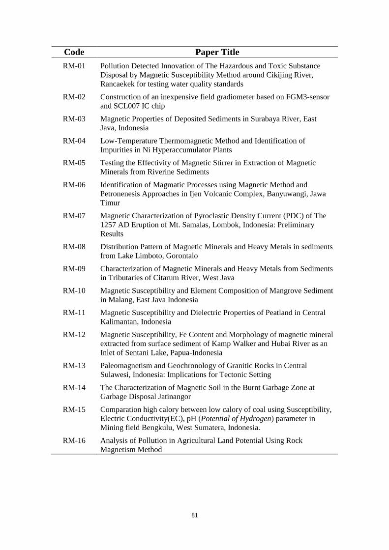
81
Code Paper Title
RM-01 Pollution Detected Innovation of The Hazardous and Toxic Substance
Disposal by Magnetic Susceptibility Method around Cikijing River,
Rancaekek for testing water quality standards
RM-02 Construction of an inexpensive field gradiometer based on FGM3-sensor
and SCL007 IC chip
RM-03 Magnetic Properties of Deposited Sediments in Surabaya River, East
Java, Indonesia
RM-04 Low-Temperature Thermomagnetic Method and Identification of
Impurities in Ni Hyperaccumulator Plants
RM-05 Testing the Effectivity of Magnetic Stirrer in Extraction of Magnetic
Minerals from Riverine Sediments
RM-06 Identification of Magmatic Processes using Magnetic Method and
Petronenesis Approaches in Ijen Volcanic Complex, Banyuwangi, Jawa
Timur
RM-07 Magnetic Characterization of Pyroclastic Density Current (PDC) of The
1257 AD Eruption of Mt. Samalas, Lombok, Indonesia: Preliminary
Results
RM-08 Distribution Pattern of Magnetic Minerals and Heavy Metals in sediments
from Lake Limboto, Gorontalo
RM-09 Characterization of Magnetic Minerals and Heavy Metals from Sediments
in Tributaries of Citarum River, West Java
RM-10 Magnetic Susceptibility and Element Composition of Mangrove Sediment
in Malang, East Java Indonesia
RM-11 Magnetic Susceptibility and Dielectric Properties of Peatland in Central
Kalimantan, Indonesia
RM-12 Magnetic Susceptibility, Fe Content and Morphology of magnetic mineral
extracted from surface sediment of Kamp Walker and Hubai River as an
Inlet of Sentani Lake, Papua-Indonesia
RM-13 Paleomagnetism and Geochronology of Granitic Rocks in Central
Sulawesi, Indonesia: Implications for Tectonic Setting
RM-14 The Characterization of Magnetic Soil in the Burnt Garbage Zone at
Garbage Disposal Jatinangor
RM-15 Comparation high calory between low calory of coal using Susceptibility,
Electric Conductivity(EC), pH (Potential of Hydrogen) parameter in
Mining field Bengkulu, West Sumatera, Indonesia.
RM-16 Analysis of Pollution in Agricultural Land Potential Using Rock
Magnetism Method

82
Pollution Detected Innovation of The Hazardous and
Toxic Substance Disposal by Magnetic Susceptibility
Method around Cikijing River, Rancaekek for testing
water quality standards
Yovan Prananda1, Febri Taufik
1, Alief Rizki
1, Fikrianti Surachman
2, M Hardian
T3, Naufal Rachman Akbar
4, and Widodo
1
1Geophysical Engineering, Bandung Institute of Technology, Ganesa St. Indonesia
2Pharmaceutical Care, Bandung Institute of Technology, Ganesa St. Indonesia
3Chemistry, Bandung Institute of Technology, Ganesa St. Indonesia 4Biology, Bandung Institute of Technology, Ganesa St. Indonesia
a)Corresponding author: [email protected]
Abstract. Water pollution can be a defect to surround the source of pollution. An example is Cikijing River, located
in Rancaekek, Bandung which has expected contaminated by water disposal. Total loss approach by Total Economic
Valuation is Rp 11.385.847.532.188 (± 11,4 trillion). One of the dangerous effect is the water quality in there. The
aim of this research is to know and prove water disposal contaminated in that river. This research was conducted by
mapping the magnetic anomaly which obtained from the surrounding river. Afterward, we was modelling the
research to get the susceptibility value. In the previous research, the geological condition of our research field is
Kosambi Formation (clay, sandstone, shale). The Kosambi Formation susceptibility value estimated 0.017 cgs unit
thereafter it used to be background susceptibility. As the result of modelling magnetic anomaly from the anomaly
map, we got the susceptibility contrast which has negative value. The relation between magnetic anomaly and
susceptibility indicated the hazardous and toxic substance pollution, which affected Cikijing River and around there.
Construction of an inexpensive field gradiometer based on
FGM3-sensor and SCL007 IC chip
Ganendra Chandra Ditya, Arno Germanndaputra Sulistyanto, and Satria
Bijaksana
Geophysical Engineering Program, Faculty of Mining and Petroleum Engineering, Institut Teknologi Bandung
Jalan Ganesa 10, Bandung 40132, Indonesia
Corresponding author: [email protected]
Abstract. Geomagnetic survey is a well known geophysical method that has used widely in exploration of natural
resources or minerals, archeology, and detection of underground pipe and metallic objects. Apart from using
magnetometers, geomagnetic survey might also uses gradiometers that use two instead of one magnetic sensor.
Magnetometers and gradiometers are rather expensive. In this research, a construction of inexpensive gradiometer is
reported. The instrument uses two fluxgate sensors, FGM-3 (Speake & Co. Ltd., UK) and electrical circuits that are
centered on SCL007 IC chip. The body of the instrument was constructed from non-magnetic PVC pipes. To
calibrate the instrument, two specific solenoids were built. Calibration processes produce chart that convert voltage
RM-01
RM-02

83
reading from the instrument to magnetic field gradient. The linear segment of the chart is considered as to be the
working range of the instrument. The instrument is now undergoing field test and good results are expected.
Magnetic Properties of Deposited Sediments in Surabaya
River, East Java, Indonesia
Mariyanto and Satria Bijaksana
Geophysical Engineering Program, Faculty of Mining and Petroleum Engineering, Institut Teknologi Bandung
Corresponding author: [email protected]
Abstract. Surabaya river is one of urban rivers in East Java Province, Indonesia that is a part of Brantas river that
flows in four urban and industrial cities of Mojokerto, Gresik, Sidoarjo, and Surabaya. The urban populations and
industries along the river pose serious threat to the river mainly for their anthropegenic pollutants. This study aims to
characterize the magnetic properties of deposited sediments in various locations along Surabaya river and correlate
these magnetic characters to the level of pollution along the river. Samples were taken and measured through a series
of magnetic measurements. The mass-specific magnetic susceptibility of deposited sediments range from 259.4 to
1134.8 × 10-8 m3kg-1. The magnetic minerals are predominantly pseudo-single domain magnetite with the grain size
range from 6 to 14 µm. Magnetic susceptibility tends to decrease downstream as accumulation of magnetic minerals
in sediments is affected not only by the amount of household and industrial wastes but also by sediment dredging,
construction of embankments, and extensive erosion from farmlands.
Low-Temperature Thermomagnetic Method and
Identification of Impurities in Ni Hyperaccumulator
Plants
Abd Mujahid Hamdan1, a)
, Satria Bijaksana1, Aiyen Tjoa
2, and Darharta Dahrin
1
1 Faculty of Mining and Petroleum Engineering, Institut Teknologi Bandung
2Master Program of Geothermal
Engineering, Institut Teknologi Bandung 2 Agriculture Faculty, Tadulako University
Corresponding author: [email protected]
Abstract. Ni hyperaccumulators are plants that can absorb Nickel > 1000 ppm in dry biomass. Removal of
impurities in epidermis tissues of these plants is very important to good measurement and characterization results. In
this paper, the results of low-temperature thermomagnetic experiments in identifying and removal of such impurities
are reported. In addition, the low-temperature thermomagnetic method is expected to be able to assess and describe
qualitatively the center of coordination complexes in molecules, ligands and the structure of bio-molecules in
hyperaccumulators. Measurement results showed that the samples that have been cleaned with alcohol, methanol,
and detergent still demonstrate their ferromagnetic mineral impurities. The assumption is also confirmed by TEM
(transmission electron microscopy) investigation.
RM-03
RM-04

84
Testing the Effectivity of Magnetic Stirrer in Extraction of
Magnetic Minerals from Riverine Sediments
Gesti Cita Novala, Sudarningsih, Silvia Jannatul Fajar, Marianto, Kartika Hajar
Kirana, and Satria Bijaksana
Engineering Geophysics Program, Faculty of Mining and Petroleum Engineering, Institut Teknologi Bandung
Corresponding author: [email protected]
Abstract. Magnetic methods have been used widely in environmental studies as they are useful in inferring heavy
metal pollution in soil and sediment. In many studies, magnetic methods often require observation of magnetic
grains extracted from sediments. As the quantity of magnetic minerals in sediments is very low, such extraction
technique is often either unsuccessful or inconsistent. In this study, we reported the effectiveness of magnetic
extraction using magnetic stirrer and manual extraction method for riverine sediment. The effectiveness of such
method tested by measuring both not extracted sediment and extracted magnetic grains through a number of
magnetic measurements that include mass-specific magnetic susceptibility, isothermal remanent magnetization
(IRM) saturation, and anhysteretic remanent magnetization (ARM) decay. Results will be presented.
Identification of Magmatic Processes using Magnetic
Method and Petronenesis Approaches in Ijen Volcanic
Complex, Banyuwangi, Jawa Timur
Aditya Pratama1, Abd. Hafidz
1, Mirzam Abdurrachman
2, and Satria Bijaksana
1
1Engineering Geophysics Program, Faculty of Mining and Petroleum Engineering, Institut Teknologi Bandung
2Geological Engineering Program, Faculty of Earth and Science Technology, Institut Teknologi Bandung
Corresponding author: [email protected]
Abstract. Reliable volcanic map and deep understanding of magmatic processes are very important in exploration of
natural resources and mitigation of volcanic hazards. The conservative method in volcanic mapping still depends on
qualitative approach so that it often fail to characterize volcanic products properly. Rock magnetic methods are quantitative
approach that classify rocks based on their magnetic properties. In this study, magmatic processes in basaltic lavas from Ijen
volcanic complex in Banyuwangi, East Java were studied using combined rock magnetic and petrogenesis approaches.
Samples of basaltic lavas from 13 localities were measured for their mass-specific magnetic susceptibility. The samples were
also subjected to isothermal remanent magnetization (IRM) saturation, anhysteretic remanent magnetization (ARM) decay,
and magnetic hysteresis measurements. The samples were then also subjected to petrographic and X-ray Fluorescence
Spectrometry (XRF) analyses for their minerals composition and petrogenesis. Preliminary results show that the distinction
in magnetic characters might be due to differences in magma oxidation level during formation of magnetic minerals.
RM-05
RM-06

85
Magnetic Characterization of Pyroclastic Density Current
(PDC) of The 1257 AD Eruption of Mt. Samalas, Lombok,
Indonesia: Preliminary Results
Arif Wijayaa), Satria Bijaksana
b) and Silvia Jannatul Fajar
c)
Engineering Geophysics Program, Faculty of Mining and Petroleum Engineering, Institut Teknologi Bandung,
Bandung 40132, Indonesia
a)
Abstract. The 1257 AD Mt. Samalas eruption (Lombok, Indonesia) is one of the major volcanic eruption that cause
global climate change and ejected thick layers (50 m) of pyroclastic density current (PDC). In this study, this PDC
deposits from two different locations, namely Luk and Jugil, in northern coast of Lombok were subjected to series of
magnetic measurements that include mass-specific magnetic susceptibility, isothermal remanent magnetization
(IRM) saturation, anhysteretic remanent magnetization (ARM) decay as well as hysteresis parameter. Prior to
magnetic measurements PDC samples were sieved through to divide the samples in five different grain sizes, i.e.,
clay, silt, fine sand, coarse sand and granule and magnetic measurements were carried out for each grain size. The
results show that the predominant magnetic mineral in all samples is PSD (pseudo-single domain) and MD (multi
domain) magnetite. However, the mass specific magnetic susceptibility of clay size samples from Luk (~ 501 × 108
m3/kg) differ significantly from that of Jugil (~ 848 × 108 m3/kg) suggesting although the deposits from Luk and
Jugil were of the same sources, they came from different eruption events. So far, the concentration dependent
magnetic parameter, i.e., mass-specific magnetic susceptibility is still the best parameter to identified PDC deposits
of Mt. Samalas based on their eruptive events.
Distribution Pattern of Magnetic Minerals and Heavy
Metals in sediments from Lake Limboto, Gorontalo
Raghel Yunginger1, a)
, Satria Bijaksana1, b)
, Darharta Dahrin1, c)
, and Siti
Zulaikah2, d)
1Engineering Geophysics Program, Faculty of Mining and Petroleum Engineering, Institut Teknologi Bandung
2Physics Department, Faculty of Mathematics and Natural Sciences, Malang University
a)
Corresponding-author: [email protected] b)
Abstract. Recorded in rocks, sediments, and soils, magnetic properties could serve as proxy indicators for
environmental changes in the past. Among the lakes in the island of Sulawesi, Indonesia, Lake Limboto one that is
currently experiencing fast sedimentation process that shrink its area significantly to the extent that Indonesian
government classified this lake as a critical that need immediate rehabilitation. In this study, surface sediments from
17 points throughout Lake Limboto Gorontalo were subjected to series of magnetic measurements to characterize
their lithogenic and anthropogenic components. Prior to magnetic measurements, the sediments were sieved (in 325
mesh size) so that only fine particles were analyzed. The magnetic methods include measurements of mass-specific
magnetic susceptibility meter, IRM (isothermal remanent magnetization) saturation and ARM (anhysteretic
remanent magnetization) decay. These magnetic measurements were complemented by AAS (atomic absorption
spectrophotometer). The results of these measurements will be presented.
RM-07
RM-08
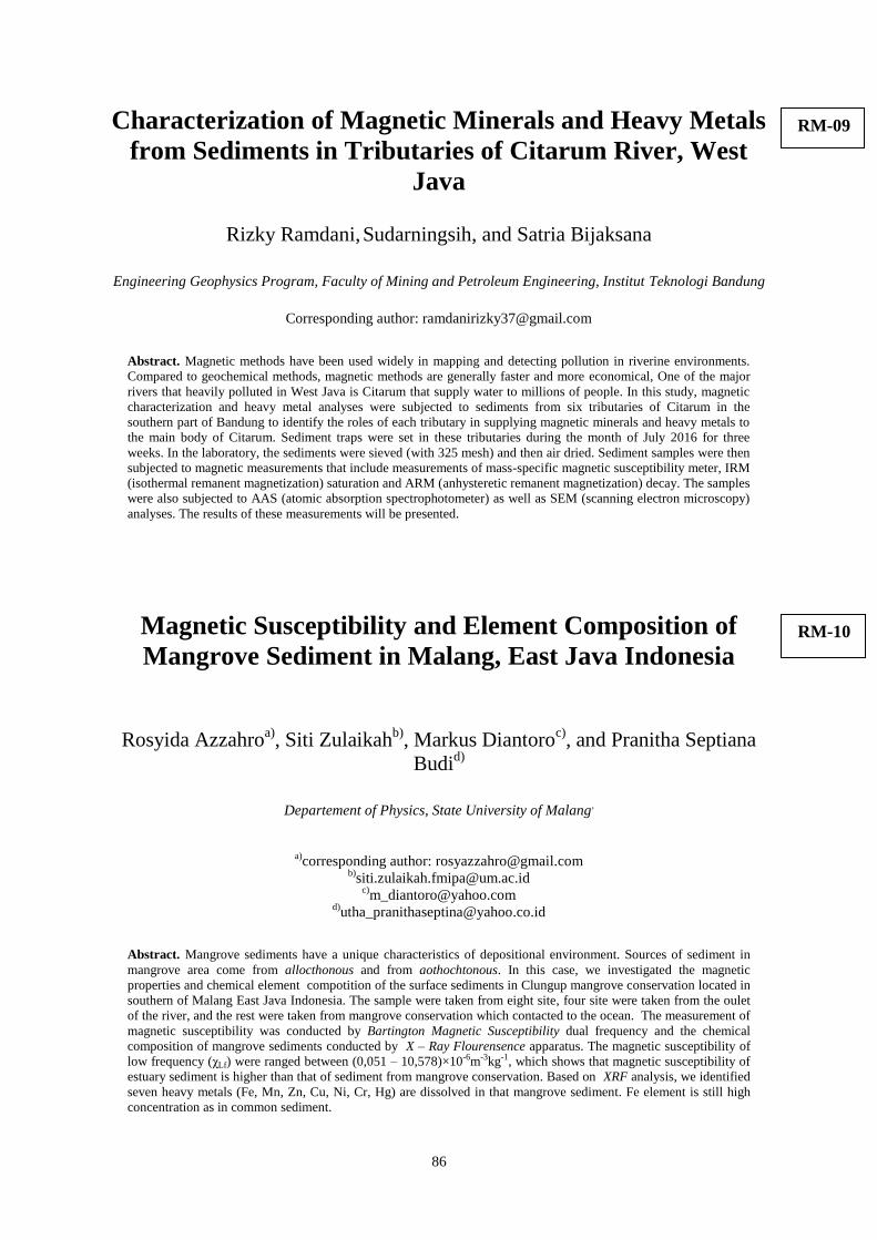
86
Characterization of Magnetic Minerals and Heavy Metals
from Sediments in Tributaries of Citarum River, West
Java
Rizky Ramdani, Sudarningsih, and Satria Bijaksana
Engineering Geophysics Program, Faculty of Mining and Petroleum Engineering, Institut Teknologi Bandung
Corresponding author: [email protected]
Abstract. Magnetic methods have been used widely in mapping and detecting pollution in riverine environments.
Compared to geochemical methods, magnetic methods are generally faster and more economical, One of the major
rivers that heavily polluted in West Java is Citarum that supply water to millions of people. In this study, magnetic
characterization and heavy metal analyses were subjected to sediments from six tributaries of Citarum in the
southern part of Bandung to identify the roles of each tributary in supplying magnetic minerals and heavy metals to
the main body of Citarum. Sediment traps were set in these tributaries during the month of July 2016 for three
weeks. In the laboratory, the sediments were sieved (with 325 mesh) and then air dried. Sediment samples were then
subjected to magnetic measurements that include measurements of mass-specific magnetic susceptibility meter, IRM
(isothermal remanent magnetization) saturation and ARM (anhysteretic remanent magnetization) decay. The samples
were also subjected to AAS (atomic absorption spectrophotometer) as well as SEM (scanning electron microscopy)
analyses. The results of these measurements will be presented.
Magnetic Susceptibility and Element Composition of
Mangrove Sediment in Malang, East Java Indonesia
Rosyida Azzahroa), Siti Zulaikah
b), Markus Diantoro
c), and Pranitha Septiana
Budid)
Departement of Physics, State University of Malang,
a)
corresponding author: [email protected] b)
Abstract. Mangrove sediments have a unique characteristics of depositional environment. Sources of sediment in
mangrove area come from allocthonous and from aothochtonous. In this case, we investigated the magnetic
properties and chemical element compotition of the surface sediments in Clungup mangrove conservation located in
southern of Malang East Java Indonesia. The sample were taken from eight site, four site were taken from the oulet
of the river, and the rest were taken from mangrove conservation which contacted to the ocean. The measurement of
magnetic susceptibility was conducted by Bartington Magnetic Susceptibility dual frequency and the chemical
composition of mangrove sediments conducted by X – Ray Flourensence apparatus. The magnetic susceptibility of
low frequency (χLf) were ranged between (0,051 – 10,578)×10-6m-3kg-1, which shows that magnetic susceptibility of
estuary sediment is higher than that of sediment from mangrove conservation. Based on XRF analysis, we identified
seven heavy metals (Fe, Mn, Zn, Cu, Ni, Cr, Hg) are dissolved in that mangrove sediment. Fe element is still high
concentration as in common sediment.
RM-09
RM-10

87
Magnetic Susceptibility and Dielectric Properties of
Peatland in Central Kalimantan, Indonesia
Pranitha Septiana Ba), Siti Zulaikah
b), Arif Hidayat
c), and Rosyda Azzahro
d)
Department of Physics, State University of Malang. Jl. Semarang 5, Malang
a)
Corrresponding author: [email protected] b)
Abstract. Peat soil is wealth spread in Indonesia which includes limnis sediment that has not been used optimally. In
this study, we identify the magnetic susceptibility and dielectricproperties of peat land in Central Kalimantan,
Indonesia at six locations to characterize magnetic minerals of the peat land by using the Bartington Susceptibility
Meter (MS2B) dual frequency and to determine the nature dielectric constant. The average of magnetic susceptibility
is known at locations T1, T3 and T5 has a value range of magnetic susceptibility 6,92.10-8 m3 / kg up to 9,22.10-8
m3 / kg may classified as paramagnetic mineral. While T2, T4 and T6 which range of magnetic susceptibility from -
0,573.10-8 m3 / kg to -0,151.10-8 m3 / kg, was classified as diamagnetic mineral. Magnetic minerals in six
locations peat deducted aspyrite (FeS2) and epidote (Ca, Fe, Al silicate) due to XRF analysis. Based on the magnetic
suseptibility frequency dependence and magnetic susceptibility of low frequency, magnetic minerals grain was
dominated by Single Domain - Pseudo Single Domain (SD-SSD) and some sample shows Superparamagnetic (SP)
and Multi domain (MD) grains. Meanwhile, the dielectric constant was maximum at T6.4 of around 35 and the
minimum value at T1.11 of around 21.The high magnitude of dielectric constant could indicate samples pore is
reduced.
Magnetic Susceptibility, Fe Content and Morphology of
magnetic mineral extracted from surface sediment of
Kamp Walker and Hubai River as an Inlet of Sentani
Lake, Papua-Indonesia
Siti Zulaikah1, Dian Sisinggih
2, Zem Dani
2, Mahfud David Ong
2, and Yusuf
Bungkang3
(1)Jurusan Fisika FMIPA Universitas Negeri Malang
Lab Sentral Universitas Negeri Malang (2)
Jurusan Teknik Pengairan Universitas Brawijaya (3)
Jurusan Fisika Universitas Cendrawasih
Corresponding author: [email protected]
Abstract. As an inlet of Sentani lake, Kam Walker and Hubay river has a different environment characteristic, i.e.
Kamp Walker has a proximate inhabitant, while Hubay has relatively natural environment. In this study, we
conducted measurement of magnetic susceptibility, Fe content and morphology of magnetic mineral extracted from
surface sediment of that two rivers that would be benefit for deeply understanding of Sentani lake sediment
characteristic. The magnetic susceptibility of low frequency of the sample from that two rivers are varies from (lf)
11.105 10-6 kg/m3 to 24.958 10-6 kg/m3 for Kam Walker with dependence frequency susceptibility from fd
0.031% to 0.367% and (lf) 4.561 10-6 kg/m3 to 16.926 10-6 kg/m3 with fd 0.104% to 1.033% for Hubay. Fe
content of the sample from the two river also shows a different average i.e around 60% for Hubay and 50% for Kam
Walker. That different value may because of the source of magnetic mineral on the two sediment may are lithogenic
for the Hubay and lithogenic and antropogenic for Kam Walker. The morfhology of magnetic mineral, based on the
SEM image shows a rounded and crystalline magnetic mineral.
RM-11
RM-12

88
Paleomagnetism and Geochronology of Granitic Rocks in
Central Sulawesi, Indonesia: Implications for Tectonic
Setting
Muhammad Rusli M 1, 4
, Subagyo Pramumijoyo2, I Wayan Warmada
2, and
Wiwit Suryanto3
1)Doctoral Program, Geological Engineering, Universitas Gadjah Mada
2)Depth. Geogical Engineering, Universitas Gadjah Mada
3)Depth. Geophysics, Universitas Gadjah Mada
4Geophysics Study Program, Tadulako University
corresponding author’s email : [email protected]
Abstract. Paleomagnetism and geochronology of granitic rocks from Central Sulawesi, especially from Palu area are
presented in order to elucidate their Characteristic Of Remanent Magnetization (ChRM) and implication for
tectonic setting. The granitic rocks in these are as are dominated by granite and Monzonit-Quartz in composition,
with high-K calc-alkaline photasik (KAP) and show metaluminous-peraluminous affinity. Paleomagnetic analyses of
37 specimens from 7 sites yield Characteristic Remanent Magnetization (ChRM) directions. The measurement
results display a means direction (D=23.4, I=-27,7°, α95=16.40°, k=14.50). Interpretation the results show the
relationship syncollision between Sulawesi Island with micro-continent plate Banggai-Sula and are syn-kinematic
with Faulting Palu-Koro were active at of Neogen until now.
The Characterization of Magnetic Soil in the Burnt
Garbage Zone at Garbage Disposal Jatinangor
Faris Sarma Putraa), Denis Candra, Fikri Zain Karim
b), and Eleonora Agustine
c)
Geophysics Department, Faculty of Mathematics and Natural Sciences, Universitas Padjadjaran,
Jl. Bandung-Jatinangor km. 21, Jatinangor 45363, Indonesia.
a)
Corresponding author: [email protected] b)
Abstract. Garbage is a material that has no longer being used after a certain process. A garbage at jatinangor region
isn’t well managed that will harm the environmental itself, accordingly to that so we made a research which aim to
recognize the soil characterization in physical way at burnt zone Jatinangor site. The physical parameter will be
observed about soil susceptibility itself. Susceptibility research of the soil contaminated that affect from another
factor will be bigger because the soil itself already contaminated by another material – material which already exist
by the process of the burnt soil. When susceptibility value of soil will increase, so the level of soil fertility will be
decrease. We will see the comparison how much the contaminated level from the data comparison coring has been
do in the 2 site, that is a burnt soil and the original soil that has zero contaminated factor.
RM-13
RM-14

89
Comparation high calory between low calory of coal using
Susceptibility, Electric Conductivity(EC), pH (Potential of
Hydrogen) parameter in Mining field Bengkulu, West
Sumatera, Indonesia.
Timothy Antonio, Muhammad Khodhi Robbani, and Eleonora Agustine
University of Padjadjaran (Unpad), Faculty of mathematical and science, Department Geophysics
Abstract. Calorific value of coal is important in the production of coal mines, Nowdays, to identify calorie of coal
requires process in a long time. There has been no research to identify calorie of coal using a rock magnetism
method based on parameters Susceptibility, Electrical Conductivity (EC) and pH (Potential of Hydrogen).
Advantages of calory analysis on coal using this method are efisiens in determining the outcome. One field in
Bengkulu, West Sumatra, Indonesia is a coal mining area with a variety of high and low calorific value as the
location of reviews of research. Identification study was conducted in calorie coal in Bengkulu, West Sumatra,
Indonesia for coal mining land has a variety of low and high calorific value as the location of reviews of research.
Coal with high calorie and low calorie in this study is taken by way of coring as deep as 60cm in two locations of
this research, the first point in a mining are a with a low calorific value and the second point in a mining area with a
high calorific value. By using rock magnetism method on these both object of coal that has a high calorific value and
low will get a comparison of the physical properties of value Conductivity, Susceptibility. From these physical
properties can be identified character of high and low calory of coal. Data processing are using Bartington MS-2B
and Hanna combo meter to see the value of Ph,EC. The results of the measurement of physical parameters for the
susceptibility of low calory coal is 48 and 0.18 dS / cm. pH low calory coal value is head to alkaline and high
calorie coal head to the acid. low calory coal has a susceptibility and EC values higher than high-calorie coal, high
susceptibility value indicates the distribution of magnetic minerals that are contained in the coal for more.
Analysis of Pollution in Agricultural Land Potential Using
Rock Magnetism Method
Adinda Syifa Azharia), Eleonora Agustine
b), and Dini Fitriani
c)
Geophysics Department, Faculty of Mathematics and Natural Sciences, Universitas Padjadjaran,
Jl. Bandung-Jatinangor km. 21, Jatinangor 45363, Indonesia.
a)
Corresponding author: [email protected] b)
Abstract. Industrial activities have the potential to make pollution in agricultural land, the waste contains poisonous
material and it is dangerous for the environment. In general, waste from factory is dumped directly into the river, but
in the current study an object that is going to be conscientious is soil on around mill. There are three sampling sites
are around fertilizer plants, feed mills and original uncontaminated soil. This research has been conducted to assess
the impact of pollution resulting from the two mills for the environment. Physical parameters that used is magnetic
susceptibility. Sampling was conducted using the method of magnetic susceptibility of rock to see the value of low
frequency (XLF) and Frequenccy Dependent (FD%) using Bartington MS2B. The results from this study is at a
location close to the fertilizer plant at a depth of 0-5 cm has a value susceptibility low frequency (XLF) = 187.1 -
494.8, FD (%) = 1.37 - 2:46, at a depth of 6-10 cm susceptibility value of low frequency (XLF) = 211 - 832.7, FD
(%) = 1.04 - 5.37. Results in the area of animal feed mill at a depth of 0-5 cm value susceptibility low frequency
(XLF) = 111.9 - 325.7, FD (%) = 0.8 - 3.57, at a depth of 6-10 cm cm value susceptibility low frequency (XLF) =
189.2 to 386.8, FD (%) = 0.33 - 3.07. Results in the original soil at a depth of 0-5 cm susceptibility value of low
frequency (XLF) = 1188.7 - 2237.8, FD (%) = 2.75 - 4.65, at a depth of 6-10 cm value susceptibility low frequency
(XLF) = 977.7 - 2134.7, FD (%) = 3.06 - 6.21.
RM-15
RM-16
90