Contentgujenvis.nic.in/PDF/soe-rann.pdf · 2 Content Pressure Desertification in Rann & Its...
53
2 Content Pressure Desertification in Rann & Its Environs Environmental concern in Rann Threats on Biodiversity in LRK Wild Ass – Human Conflict Environmental Issues in GRK Recent Incident in Flamingo city Salt Pans and Agariyas in Little Rann of Kachchh Wild Ass sanctuary and related issues Bromine extraction from salt water of GRK State Geology Geomorphology Hydrology Landuse/Landcover Pattern Rainfall and Land use/Land cover Pattern Biodiversity Great Rann of Kachchh Little Rann of Kachchh Agariyas in LRK Impact Desertification and soil erosion Intensive salt farming in LRK Impact on Biodiversity Responses Programmes for combating desertification Livelihood improvement of Salt Producers Conservation & management measures Case Study – Rann Reclamation in GRK Vegetation Cover Development Prawn Fishery in LRK Artemia Culture Aquaculture Potential Biodiesel Potential and Diatoms Tourism Options Research Gap
Transcript of Contentgujenvis.nic.in/PDF/soe-rann.pdf · 2 Content Pressure Desertification in Rann & Its...

2
Content
Pressure
Desertification in Rann & Its Environs
Environmental concern in Rann
Threats on Biodiversity in LRK
Wild Ass – Human Conflict
Environmental Issues in GRK
Recent Incident in Flamingo city
Salt Pans and Agariyas in Little Rann of Kachchh
Wild Ass sanctuary and related issues
Bromine extraction from salt water of GRK
State
Geology
Geomorphology
Hydrology
Landuse/Landcover Pattern
Rainfall and Land use/Land cover Pattern
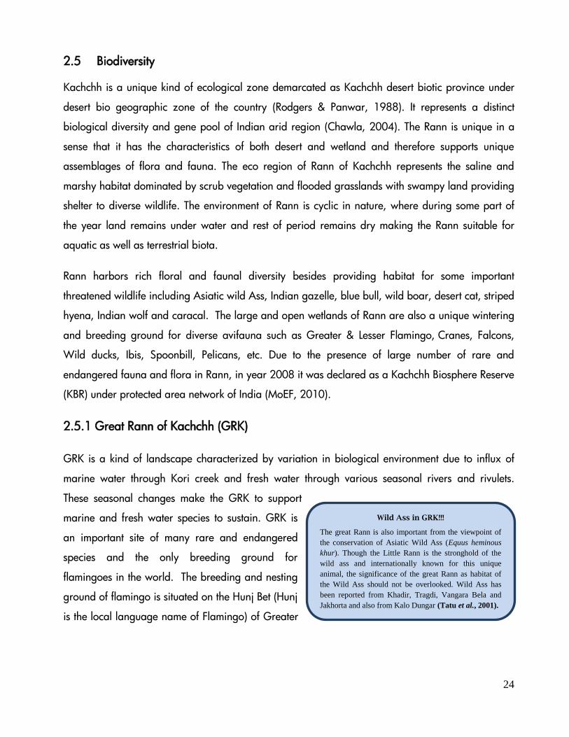
Biodiversity
Great Rann of Kachchh
Little Rann of Kachchh
Agariyas in LRK
Impact
Desertification and soil erosion
Intensive salt farming in LRK
Impact on Biodiversity
Responses
Programmes for combating desertification
Livelihood improvement of Salt Producers
Conservation & management measures
Case Study – Rann Reclamation in GRK
Vegetation Cover Development
Prawn Fishery in LRK
Artemia Culture
Aquaculture Potential
Biodiesel Potential and Diatoms
Tourism Options
Research Gap

3
1 PRESSURE
Kachchh district is a crescent shaped peninsula located on the western part of Gujarat State in India. It
falls under the arid zone and is poorly endowed in terms of its ecosystem ecology, as about 23,310
km2 (51%) area is covered by saline deserts (Greater and Little Ranns) along the northern and eastern
part of the district and the main land area comprises of 22,342 km2 (GUIDE 2007).
In arid ecosystems, vegetation is sparsely distributed, resulting in a heterogeneous horizontal pattern
of vegetation patches alternating with areas of bare soil (Noy-Meir 1973). The distribution of rain in
arid regions is extremely patchy and the primary production of the region corresponds directly to
the rainfall (Rutherford 1980, Le Houerou 1984). Nevertheless, the distribution of rainwater on the
ground depends, on the total amount of rain, on topography and runoff (Ludwig 1986), thus
affecting the primary production, which subsequently leads to loss of ecosystem functions and its
degradation. Rann of Kachchh is not an exemption to this.
1.1 Desertification in Rann & Its Environs
Desertification, as defined by UNEP in 1992 and adopted by United Nations Convention to Combat
Desertification (UNCCD), is ‘land degradation in arid, semiarid and dry sub-humid areas resulting
from various factors, including climatic variations and human activities’. In another words
“Desertification is best to be treated as an extreme case of land degradation, which is expressed in
a persistent reduction or loss of biological and economic productivity of lands that are under various
uses by human whose livelihoods depend on this productivity, yet the reduction or loss of this
productivity is driven by that use” (Vogt et al., 2009).
Desertification is more severe in drylands that encompasses an area of about 41% of Earth’s land
surface and are inhabited by more than 2 billion people. The arid, semi-arid and dry sub humid
regions (those regions where the ratio of the mean annual precipitation to the mean annual evapo-
transpiration is in the range of 0.05 to 0.65, are collectively termed as drylands where soil moisture
is limited by low rainfall and high evaporation. In India, about 50.8 mha land area (15.8% of the
country’s geographical area) is arid, 123.4 mha (37.6%) is semi-arid and 54.1 mha (16.5%) areas
falls in the dry sub-humid region. All together, about 228 mha area, i.e. 69% of the geographic
area of the country is under drylands (MoEF, 2001). The dominant processes of land degradation

4
are water erosion, vegetal degradation, wind erosion, salinization/alkalization, water logging, etc.
(Ajai et al. 2009), while the causes of desertification are change in frequency and amount of
rainfall, reduction in vegetal cover, erratic agricultural management practices, cultivation on
marginal lands, over-exploitation of the natural resources, excessive grazing, etc.
According to the ‘Desertification and Land Degradation Atlas of India’ (2007), about 68% of the
Gujarat state is facing land degradation and desertification which is highest among the states of the
country. In Gujarat, 65% area is experiencing desertification due to climatic factors and 35% area is
undergoing human induced desertification processes. Among the factors responsible for
desertification, water erosion contributes 35%, followed by salinization (14%), vegetation
degradation (14%) and wind erosion (3%) in the state (SAC, 2007). The districts located along the
periphery of the Rann of Kachchh are drought prone areas where climate is a major factor for land
degradation. Salinization is another factor for desertification in some areas around Rann
(Mudrakartha, 2007).
Desertification in agricultural land is spreading rapidly which is a grave problem, especially along
the peripheral areas of Rann. Little Rann of Kachchh is also experiencing desertification due to
water erosion, salinization and vegetal decline. Nevertheless, the outdated farming techniques and
changing weather patterns such as flash floods in monsoon are also compounding the effects
(‘Lilorann: The Pilot”, 2011).
The desertification in Kachchh is mainly the result of:
Increase in population of both humans and livestock
Mobility of saline dust from the broken and cracked coastal area
Movement of salt particles due to high velocity of the wind during summer
Increased salinity due to intrusion of saline water in fertile areas during the rainy season.
India occupies only 2.4% of the world’s geographical area to support 16.7% of the world’s human
population; it has only 0.5% of the world’s grazing land but supports 18% of the world’s cattle
population (MEA, 2005). The human population of the Kachchh region is very meager (density
35/km2) as compared to the population density of the country (density 312/km2), however, the
region supports good population of livestock. The spatial pattern of land degradation in Kachchh
5
region including the Rann is very complex, but broadly severe and very severe erosion occur in the
hilly terrain, while moderate erosion takes place in the coastal plains and some colluvial plains.
Approximately 32% area of Kachchh experiences erosion problems, of which, 17.1% area is
affected by very severe water erosion followed by 9.9% area under severe erosion and 5.2% under
moderate erosion. Further, 65% area of the Kachchh faces various magnitudes of salinity problems,
of which, 57.2% area is affected by very severe salinity problems (Kar and Singh, 2003). Much of
the land degradation in Kachchh Region is primarily related to the natural causes, largely due to the
periodic tectonic activities and partly due to the past changes of climate (especially in case of the
relict mudflats and Ranns that emerged out of the sea due to the recession of the Arabian Sea).
Human activities are only assisting in the aggravation of the degradation processes in some
localities of the Kachchh (Kar and Singh, 2003).
The adjoining areas of LRK and eastern part of GRK received maximum rainfall during the last
decade. Interestingly, rain fed agriculture decreased while irrigated crops (cash crops) notably
increased in last three decades. Further, livestock population has increased in adjoining areas of
Rann leading to more pressure on vegetation, and consequently land degradation. Overall, the
talukas adjoining the Rann are facing high environmental risk leading to desertification, whereas
the talukas towards coastal area face minimum environmental risk (GUIDE, 2011).
1.2 Environmental Concern in Rann
Rann is a specific kind of landscape surrounded by arid and semi-arid environment. Naturally, it is
a high saline marshy land where seasonal water logging provides habitat for some unique types of
biodiversity. Except the salt farming and tourism, there is no other specific linkage between human
population and Rann. In general, the problems of Rann environment are mainly due to
developmental initiatives like construction of roads and bunds which could block the natural flow of
sea and fresh water into the Rann. The fringe areas of Rann are facing threats by overgrazing,
increasing vehicular traffic, intensive salt farming, industrialization which cumulatively cause some
extant of changes to the fragile ecosystem. The above activities result in disturbances to the unique
wildlife, especially to the wild ass, floricans, bustards, flamingoes, pelicans, and other bird species
(WII, 1993). During the past years, there is an increase in the conflict between Asiatic Wild Ass and
local agro-pastoral communities around LRK. Cutting of trees on large scale to make charcoal is
also an emerging issue in the adjoining areas of Rann.

6
1.2.1 Threats to Biodiversity in LRK
In Rann environment various types of threats have been identified from species level to the habitat
level. The vast stretch of the shallow water bodies of Rann provides an important breeding and
feeding ground for large number of bird species. Moreover, LRK is the only habitat for Asiatic Wild
Ass. The infra-structural development in Rann and adjoining environment, increasing vehicular
traffic and intensive salt farming cause degradation and fragmentation of habitat which is a threat
to native biodiversity. The envisaged threats to Rann include:
a) Landuse study revealed that agricultural cultivation has increased by 0.63% (about 2,410 ha
agriculture land from 1999 to 2009)(BCRLIP, 2007). Intensive agriculture practice has been
undertaken due to availability of water from Narmada canal and watershed development
programmes. It will cause changes in the landuse/land cover pattern. Because of the
increased use of chemical fertilizers and pesticides, Rann will be the ultimate sink to receive
all the residues of chemicals and pesticides from upstream agricultural farms which can lead
to a bio-magnification in fish, prawns and aquatic birds.
b) Spreading of Prosopis juliflora (33 % of Bet areas and 8 % of total WAS area) were
observed to be invaded by Prosopis (GEER, 1995) poses problems to Wild Ass and
Chinkara by reducing their grazing ground and fodder.
c) Spread of diseases from domestic livestock to wild animal through use of common drinking
water bodies and grazing land.
1.2.2 Wild Ass – Human Conflict
In a span of about 30 years from the first census by the Forest Department in 1976, Wild Ass
population has increased from 720 to 3863. The increasing population has established its abode in
adjoining habitat of Wild Ass Sanctuary. Interestingly, the concentration of Wild Ass in the WAS
has been highest in the southern and eastern zones, where highest concentration of salt farming
works is going on (BCRLIP, 2007).
Since Rann landscape is saline and remains submerged during monsoon and early winter months,
few of the Wild Ass population moves to the surrounding agricultural landscape (Dave, 2010). Such
seasonal migration in agricultural field results crop raiding, which cause conflict between Wild Ass
and agro-pastoral communities. The crop raiding issues have recently increased because field
results crop raiding, which causes conflict between Wild Ass and agro- pastoral use of natural
dispersal of increasing populations into adjacent agriculture landscape (Shah, 2004 and Singh,
7
2000). Although several efforts were made to estimate wild ass population in LRK (Ali, 1946; Gee,
1963; shah, 1993; Singh et al, 1999), issues related to quantification and mitigation of human-
wildlife conflicts have not been addressed comprehensively.
In addition to Wild Ass, other wild herbivores like Nilgai, Chinkara and Wild boar are also causing
damage to the crops in agriculture lands. Such crop damage subsequently causes antagonism of
local community towards large herbivores. According to Dave (2010), the invasion of Prosopis
juliflora in the fringe areas of LRK causes increase in crop raiding by wild herbivore, as P. juliflora
provides shelter to them and the nearby agricultural fields provide food for them.
1.2.3 Environmental Issues in GRK
a) A large portion of the Rann is rather inaccessible during the monsoon, while certain areas
are not accessible throughout the year (Merh and Malik, 1999).
b) The evaporation rate is very high.
c) The inundation of Linear Trench Zone is caused mainly by saline water.
d) The flat topography of Rann proper makes it impossible to create suitable out-fall
conditions for drainage.
e) Less/ no possibility of exploring productive ground water in the Rann area.
f) Excess Sodium concentration results in alkali soils in which reclamation is difficult.
g) Lack of up-to-date scientific information.
1.2.4 Recent Incident in Flamingo City
In a recent incident in GRK near Khadir Island, hundreds of flamingoes died accidently due to high
tension electric wires passing over their feeding grounds (Times of India, 2011; Tere & Parasharya,
2011; Palliwal, 2011). Flamingos are highly sensitive to even small disturbances. A passing vehicle
or even a flipping fish can create a flutter in the flamingo colonies which sometimes leads to
collision with power cables before visualizing and avoiding it. Officials have attached radium tags
on the high tension wires which act as reflectors during the day and night to repel the birds. The
forest department has taken initiatives with the state electricity board for underground cables in bird
sensitive areas.
1.3 Salt Pans and Issues of Agariyas in Little Rann of Kachchh
Intensive salt production is carried out in LRK contributing to a major salt requirement of the country.
The local community around LRK known as “Agariyas” works as salt pan workers. Since there is a
8
paucity of other employment opportunities due to socio- economic backwardness, scarce water,
fragile natural resource and poor conditions of land for agriculture, salt pan provide livelihood
options to many local villagers around LRK.
In the year 1993, ‘Dhangadhra Prakruti Mandal’ and ‘Gondal Forest Youth club’ jointly filed public
interest litigation. As a follow up action, the Government of Gujarat had initiated an Ecological
Study of the LRK through GEER Foundation. Based on the recommendations, initiatives were taken
for demarcating salt zones for salt production within the Sanctuary areas.
The land area of Ranns belong to the Government of Gujarat and till date times it has been
administered by five adjoining district collectors – Surendranagar, Patan, Banaskantha, Kachchh
and Rajkot. Though administratively managed by five different collectors, this vast land mass has
never been surveyed. Thus, the land lease given for the salt making in the Rann has never had any
specific location or proper survey number like other revenue areas (Sandarbh, 2008).
1.4 Wild Ass Sanctuary and Related Issues
The Wild Ass Sanctuary presents a very unique place. The core area of the sanctuary has two
distinct phases; dry and wet. These two phases support two distinct modes of livelihood options; salt
production and prawn fishery. The Wild Ass, a globally threatened species, uses entire area of
Rann and bets for foraging and breeding purpose. Currently, wildlife conservation and rural
livelihood in the landscape are overlapping each other in many ways. There are a few important
livelihood issues related to wildlife and sanctuary which includes:
The incidence of crop raiding by wild animals (mainly wild ass, blue bull and wild boars)
along the periphery of the sanctuary and killing of sheep and goats by wolves are increasing
and almost touching the threshold level.
No or very limited space for local people and their traditional knowledge systems in the
planning and management of WAS.
1.5 Bromine Based and Other Industries in Great Rann of Kachchh
In GRK, the sea water enters through Kori creek and floods in the Rann. The distance between Kori
creek and Pachchham Island in Kachchh is approximately 70-80 km, therefore, most of the water
evaporates and fine mineral deposits are available in the Rann terrain. Two industries, namely
9
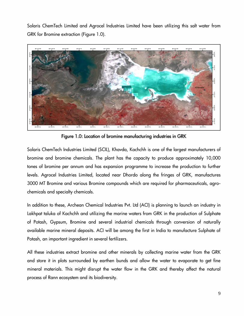
Solaris ChemTech Limited and Agrocel Industries Limited have been utilizing this salt water from
GRK for Bromine extraction (Figure 1.0).
Figure 1.0: Location of bromine manufacturing industries in GRK
Solaris ChemTech Industries Limited (SCIL), Khavda, Kachchh is one of the largest manufacturers of
bromine and bromine chemicals. The plant has the capacity to produce approximately 10,000
tones of bromine per annum and has expansion programme to increase the production to further
levels. Agrocel Industries Limited, located near Dhordo along the fringes of GRK, manufactures
3000 MT Bromine and various Bromine compounds which are required for pharmaceuticals, agro-
chemicals and specialty chemicals.
In addition to these, Archean Chemical Industries Pvt. Ltd (ACI) is planning to launch an industry in
Lakhpat taluka of Kachchh and utilizing the marine waters from GRK in the production of Sulphate
of Potash, Gypsum, Bromine and several industrial chemicals through conversion of naturally
available marine mineral deposits. ACI will be among the first in India to manufacture Sulphate of
Potash, an important ingredient in several fertilizers.
All these industries extract bromine and other minerals by collecting marine water from the GRK
and store it in plots surrounded by earthen bunds and allow the water to evaporate to get fine
mineral materials. This might disrupt the water flow in the GRK and thereby affect the natural
process of Rann ecosystem and its biodiversity.
10
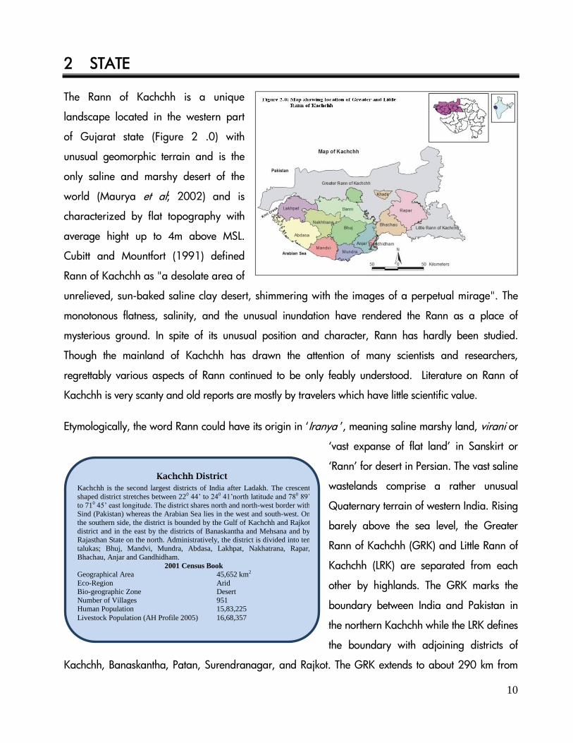
2 STATE
The Rann of Kachchh is a unique
landscape located in the western part
of Gujarat state (Figure 2 .0) with
unusual geomorphic terrain and is the
only saline and marshy desert of the
world (Maurya et al; 2002) and is
characterized by flat topography with
average hight up to 4m above MSL.
Cubitt and Mountfort (1991) defined
Rann of Kachchh as "a desolate area of
unrelieved, sun-baked saline clay desert, shimmering with the images of a perpetual mirage". The
monotonous flatness, salinity, and the unusual inundation have rendered the Rann as a place of
mysterious ground. In spite of its unusual position and character, Rann has hardly been studied.
Though the mainland of Kachchh has drawn the attention of many scientists and researchers,
regrettably various aspects of Rann continued to be only feably understood. Literature on Rann of
Kachchh is very scanty and old reports are mostly by travelers which have little scientific value.
Etymologically, the word Rann could have its origin in ‘Iranya ’, meaning saline marshy land, virani or
‘vast expanse of flat land’ in Sanskirt or
‘Rann’ for desert in Persian. The vast saline
wastelands comprise a rather unusual
Quaternary terrain of western India. Rising
barely above the sea level, the Greater
Rann of Kachchh (GRK) and Little Rann of
Kachchh (LRK) are separated from each
other by highlands. The GRK marks the
boundary between India and Pakistan in
the northern Kachchh while the LRK defines
the boundary with adjoining districts of
Kachchh, Banaskantha, Patan, Surendranagar, and Rajkot. The GRK extends to about 290 km from
Kachchh District
Kachchh is the second largest districts of India after Ladakh. The crescent
shaped district stretches between 220 44’ to 240 41’north latitude and 780 89’
to 710 45’ east longitude. The district shares north and north-west border with Sind (Pakistan) whereas the Arabian Sea lies in the west and south-west. On
the southern side, the district is bounded by the Gulf of Kachchh and Rajkot
district and in the east by the districts of Banaskantha and Mehsana and by Rajasthan State on the north. Administratively, the district is divided into ten
talukas; Bhuj, Mandvi, Mundra, Abdasa, Lakhpat, Nakhatrana, Rapar,
Bhachau, Anjar and Gandhidham.
2001 Census Book
Geographical Area 45,652 km2
Eco-Region Arid Bio-geographic Zone Desert
Number of Villages 951 Human Population 15,83,225
Livestock Population (AH Profile 2005) 16,68,357

11
Rann (Desert)?
Deserts are the world’s dryland where evapotranspiration is
much higher than the precipitation. They are the barren lands
which support only few life forms that are capable of surviving in the extreme conditions.
Ranns is a saline marsh, originally an extension of the Arabian
Sea. The Rann of Kachchh has been closed off by centuries by silting. During the time of Alexander the Great, it was a
navigable lake, but it is now an extensive mudflat, inundated by
sea water and during monsoon seasons.
east-west with width varying from 30 to 100 km, spanning over an area of about 16,780 km2 (GUIDE
1997) while LRK encompasses an area of 6,530 km2 (GEC, 1994). In fact, the two Ranns represent
filled up Gulfs and mark the sites of sedimentary accumulation in the typical estuarine delta
environment.
There are many slightly raised isolated patches of land in GRK known as ‘bets’ (Islands) or ‘dhoi’.
The important ones are Kuar bet, Dhramsala, Bedia bet, Bawarla bet, Bada Sarbela, Chota
Sarbela, Vigukot, Karim Dhahi, Chad bet, Khadir, Bela, Trangadi bet etc. Similar to GRK, there are
certain island like features, raised few meters (5-
7m) above the Rann surface which are also
termed as ‘bets’, having sparse vegetation. LRK
is dotted with more than 74 bets, which
encompass an area of about 185 km2.
Important bets of LRK are Wasraj and its chain
of islands like Andheri Wen, Khijadia,
Maharajawali, Miyan and Pancham. The other bets are Pung, Dhut, Mardak, Shedwa, Nanda and
Jhilandar. Pung is the largest bet in LRK covering an area of 30.5 km2 while Mardak bet is the
highest, 55m above MSL.
Information on climate, specific to the GRK area is not available, though it experiences three
seasons; monsoon that extends from end of June to September with October and November being
the transition months; winter extends from December to February and summer between March to
June. The temperature is predominantly high and it reaches a maximum of 48-490 C during May-
June. The winter temperature goes down to 100 C with January and February being the coldest
months. The average humidity is about 60 per cent, which ranges between 0.8 to 98 per cent.
During summer, dust-laden winds are very frequent and the average wind speed recorded during
winter, summer and monsoon is 16, 24 and 9 km/hr respectively (GUIDE, 2007).
LRK lies under desert and semi-arid steppe climatic zones of India and consequent to its bio-
geographic location, it lies partially in Desert and semi-arid bio-geographic zones of India. The
climate is characterized by extremely hot and dry summer (average 44° C), wet monsoon with
flooded land and cold winter (average 10° C) seasons. The rainfall is very scanty and annual

12
average rainfall is normally less than 60 cms. The peak summer of LRK is in May, peak winter from
December to January and monsoon prolongs between July and August.
2.1 Geology
The landscape of Kachchh is unique as it has evolved as a result of several phases of tectonic
movements since the late Jurassic. The long history of devastating earthquakes in Kachchh peninsula
indicates continuous rejuvenation of this area. Sediments of the two Ranns and coastal mud flats
with sandy beaches are recognized as Holocene deposits in the Kachchh region and are
characterized as unconsolidated formations. The Great Rann and Gulf of Kachchh are also the sites
of deposition of early Holocene sediments under estuarine deltaic environment (Vyas, 2011). The
two Ranns, Great Rann in the north and Little Rann in the east comprise vast saline wasteland. The
boundaries of these geographical areas are bounded by the major East-West trending faults. The
residual depressions or low-lying regions between the uplifts consist of quaternary sediment
successions (Figure 2.1 & 2.2). These low lying areas are marked by alluvial river terraces in the
rocky mainland and the mud-flats and salt pans in the Great Rann, Little Ranns and Banni Plains
(Biswas, 1987).
The sedimentary rocks formed
by volcanic activity in this
region range from Jurassic to
Eocene age. The northern
range is about 160 km long
and broken into four islands
(Pachham, Khadir, Bela and
Chorar) in the Rann of Kachchh
(Krishnan, 1982). The northern
part of the Kachchh peninsula
is Source: DRM, Geological
Survey of India, 2002 covered by recent marine deposits on which Jurassic rocks form
outcrops. Sedimentary rocks of this region are generally well indurated and behave like hard rocks.
The pore spaces are mostly cemented with calcium carbonate and therefore are mostly impervious
(Eidinger, 2001). Both limestone and sandstones are used as building materials in this region.

13
Mesozoic rocks of Kachchh region are exposed in three chains of east-west trending ridges. The
2000m thick successions of marine sedimentary rocks represent a phase of transgression of sea
along the west coast during Jurassic-Early Cretaceous times. Mesozoic rocks of Kachchh region are
grouped into several formations. Pachchham Formation marks the beginning of Jurassic marine
transgression in Kachchh. It consists of 300m thick succession of limestone, marl and shale and has
yielded pelecypods, corals and ammonites. The Great Rann of Kachchh has been the site of the
1819 earthquake which produced surface rupture known as ‘Allah Bund’ resulting in the upliftment
of the northern part of the Rann (Macmurdo, 1824).
Source: Karanth and Gadhavi, 2007

14
Panjabi Road in GRK
During the year 1965, Indian army had constructed a road
between Khavda to Kuwar Bet. This road has restricted the
eastward flow of sea water into the eastern portion of Great
Rann. The sea water flow entering through the Kori Creek has
now changed the direction and flooding in the northern fringes
of Banni grasslands leads to the advancement of Rann towards
into Banni area by 244 km2 between 1961 and 1989
(Jothimani and Garg, 1992).
The soil type of the Rann varies from sandy
loam to silty clay to clay in texture, and is
slightly lighter in the lower layers. The lower
depths indicate alternate reduction and
oxidation conditions. The soils are generally
stratified. A compact and impervious layer
varying in thickness of about 0.15m to 1m and
relatively was observed less saline in nature in some areas at a depth of 0.5 to 2 m below the
surface (MFACDC, 1966). There is a paucity of
information on soil permeability both horizontal
and vertical, which is an important characteristic
feature to assess the possibility of leaching of salts
and reclamation of saline soils.
In the stratified and water saturated Rann soils,
clay content varies from 19 to 49% and silt from 8 to 40% with water retention capacity from 30 to
70%. The pH ranges from 7.7 to 8.7 and EC from 6.0 to 61dsm-1. Organic carbon ranges from
0.08 to 0.8%, available Phosphorus from 4 to 25 kg/ha and Potassium from 242 to 1250 kg/ha
(GUIDE, 2007)
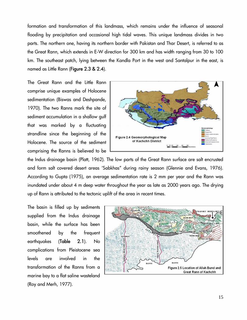
2.2 Geo-Morphology
The Kachchh landmass comprises
hill ranges, gently sloping coastal
tract, coastal erosion plain and
tidal flats can broadly divided into
four characteristic units, viz, Rann,
Banni plains, Hilly tracts and
Coastal plains. The Rann is a
marshy and salt encrusted
wasteland, the remnant of a very
late marine transgression of Miocene Epoch, which is undergoing rapid siltation. The receding sea
level, neo-tectonic activity and silting by the rivers have been attributed as the causes for the
Allah Bund
The 1819 earthquake gave rise to the slightly elevated land north
of Sindree, known as Allah Bund. In the year 1844 there was a
series of earthquakes, which further raised the elevated land
around Allah Bund. This Bund comprises an important paleaeo-
seismic landform feature in the northwestern part of the GRK and
represents an EW trending raised landmass. This upliftment that
encompasses an area of about 2136 km2 is responsible for the
present day geomorphic configuration and the inundation pattern
of the western part of the GRK.
15
formation and transformation of this landmass, which remains under the influence of seasonal
flooding by precipitation and occasional high tidal waves. This unique landmass divides in two
parts. The northern one, having its northern border with Pakistan and Thar Desert, is referred to as
the Great Rann, which extends in E-W direction for 300 km and has width ranging from 30 to 100
km. The southeast patch, lying between the Kandla Port in the west and Santalpur in the east, is
named as Little Rann (Figure 2.3 & 2.4).
The Great Rann and the Little Rann
comprise unique examples of Holocene
sedimentation (Biswas and Deshpande,
1970). The two Ranns mark the site of
sediment accumulation in a shallow gulf
that was marked by a fluctuating
strandline since the beginning of the
Holocene. The source of the sediment
comprising the Ranns is believed to be
the Indus drainage basin (Platt, 1962). The low parts of the Great Rann surface are salt encrusted
and form salt covered desert areas ‘Sabkhas” during rainy season (Glennie and Evans, 1976).
According to Gupta (1975), an average sedimentation rate is 2 mm per year and the Rann was
inundated under about 4 m deep water throughout the year as late as 2000 years ago. The drying
up of Rann is attributed to the tectonic uplift of the area in recent times.
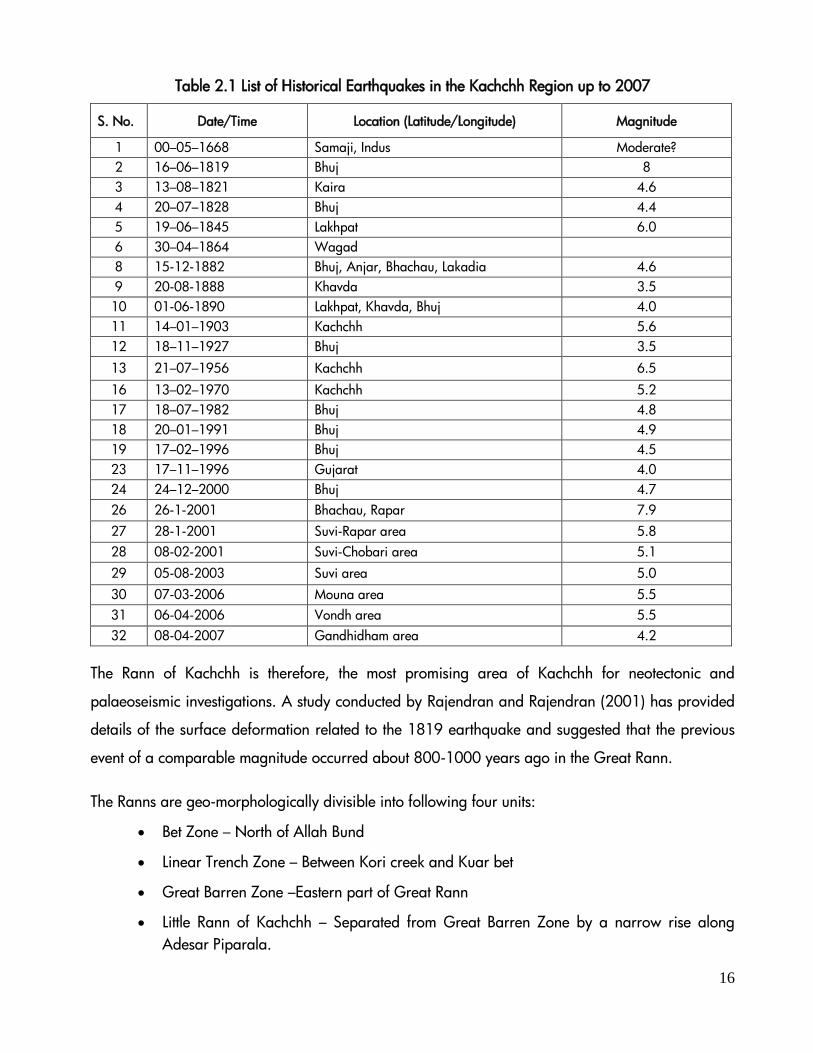
The basin is filled up by sediments
supplied from the Indus drainage
basin, while the surface has been
smoothened by the frequent
earthquakes (Table 2.1). No
complications from Pleistocene sea
levels are involved in the
transformation of the Ranns from a
marine bay to a flat saline wasteland
(Roy and Merh, 1977).
16
Table 2.1 List of Historical Earthquakes in the Kachchh Region up to 2007
S. No. Date/Time Location (Latitude/Longitude) Magnitude
1 00–05–1668 Samaji, Indus Moderate?
2 16–06–1819 Bhuj 8
3 13–08–1821 Kaira 4.6
4 20–07–1828 Bhuj 4.4
5 19–06–1845 Lakhpat 6.0
6 30–04–1864 Wagad
8 15-12-1882 Bhuj, Anjar, Bhachau, Lakadia 4.6
9 20-08-1888 Khavda 3.5
10 01-06-1890 Lakhpat, Khavda, Bhuj 4.0
11 14–01–1903 Kachchh 5.6
12 18–11–1927 Bhuj 3.5
13 21–07–1956 Kachchh 6.5
16 13–02–1970 Kachchh 5.2
17 18–07–1982 Bhuj 4.8
18 20–01–1991 Bhuj 4.9
19 17–02–1996 Bhuj 4.5
23 17–11–1996 Gujarat 4.0
24 24–12–2000 Bhuj 4.7
26 26-1-2001 Bhachau, Rapar 7.9
27 28-1-2001 Suvi-Rapar area 5.8
28 08-02-2001 Suvi-Chobari area 5.1
29 05-08-2003 Suvi area 5.0
30 07-03-2006 Mouna area 5.5
31 06-04-2006 Vondh area 5.5
32 08-04-2007 Gandhidham area 4.2
The Rann of Kachchh is therefore, the most promising area of Kachchh for neotectonic and
palaeoseismic investigations. A study conducted by Rajendran and Rajendran (2001) has provided
details of the surface deformation related to the 1819 earthquake and suggested that the previous
event of a comparable magnitude occurred about 800-1000 years ago in the Great Rann.
The Ranns are geo-morphologically divisible into following four units:
Bet Zone – North of Allah Bund
Linear Trench Zone – Between Kori creek and Kuar bet
Great Barren Zone –Eastern part of Great Rann
Little Rann of Kachchh – Separated from Great Barren Zone by a narrow rise along
Adesar Piparala.

17
Bet Zone
The Bet zone landscape points to a wetter past and comprises relicts of an ancient delta (Malik et
al., 1999). It lies to the north of the line joining the Kuar bet and Bedia bet and forms a slightly
uplifted area. The southern part of this upliftment is marked by the Allah Bund, while to the north it
merges into the sand ridges of Sindh (Figure 2.5).
The Linear Trench Zone
Trench like feature lying between Banni and the Allah Bund comprises a depressed terrain,
extending from Kori creek eastward up to Kuar bet, which is inundated by tidal water of the
Arabian Sea through the Kori creek. The seawater in this depression gives rise to an extensive salt
encrusted plain.
The Great Barren Zone
This is on eastern portion and is free from the seawater inundation. It is a vast saucer shaped
depression, which to the north merges into sand dunes of the Thar Desert (Pakistan); to the south
adjoins with Kachchh mainland; to the east it rises into the alluvial plains of Banaskantha and to the
west it is separated from the Linear Trench Zone by a narrow high ground. The narrow high ground
is now called as Panjabi road. The river Luni and other streams discharge rain water into this
depression, therefore, this zone generally remains under a thin sheet of water during rainy season
(Roy and Merh, 1977).
The Little Rann of Kachchh
It represents the former extension of the Gulf of Kachchh. The Little Rann was an extension of the
Gulf of Kachchh when the sea level was high during the Holocene transgression (Malik et al.,
1999). It is featureless marshy ground annually flooded under 0.5-1.0m deep water. The Little Rann
gradually rises about 4 m above the high waterline (HWL) at its northern point. The inundation of
Little Rann is caused by the tidal waters and the discharge by various inland rivers. Generally, the
inundated water from Great Rann does not reach to Little Rann.

18
2.3 Hydrology
The hydrology pattern of GRK represents an interesting case of recent tectonic adjustments and
consequential environmental changes of far reaching anthropo-geographic significance. The causes
of inundation in Rann are manifold (Malik et al., 1999) and are mainly due to the movement of
rainwater along channels, seasonal rivers and streams. The inundation also due to direct
precipitation and tidal water of Arabian sea entering through the Kori creek.
Figure 2.6 Inundation Pattern in Greater Rann of Kachchh
The aquifer system of GRK and LRK is broadly classified based on yield potential as alluvium (>40
LPS) distributed extensively and Alluvium and sandstone (10-40 LPS) distributed discontinuously
(CGWB, 1995). Apart from the meteorological factors such as rainfall, tidal movement etc., certain
indirect factors also control water movement or water stagnation to a great extent, which include
geomorphology of the area and the nature of sediments. Geo-morphologically, Rann has certain
landforms that control the flow and stagnation. The fineness of the sediments and the presence of
salts play an important role in the transfer of moisture through the profile, and this process has been
found to be a major factor contributing to water logging at many places of Rann. Interestingly,
rainwater carried by major rivers into GRK is questionable, because the only major river flowing
into the GRK is Luni, which has a sizeable catchment area of 62093 km2. However, inundation
caused by this river is very inadequate, as most of its water has been dammed upstream for
irrigation by the Rajasthan government. Therefore, it is clear that saline water from Arabian Sea or
fresh water from small highland streams and monsoonal precipitation are the major causes of
inundation of GRK (Figure 2.6).
19
No systematic data is available for the water table fluctuation in the GRK. The Ministry of Food,
Agriculture, Community Development and Co-operation, Government of India (1966) estimated that
the water table of Rann ranges between 1-2m. Further, Rann sediments are more impervious, hence
their plasticity is increased due to inherent salinity of the soil. Thus a flat terrain with sediments
provides an ideal site for inundation. As a result, sheets of water (including rain, river, and sea)
inundate larger areas the Rann. The lower parts of the Rann surface are salt encrusted, and form
salt palayas during rains. The deeper portion of the palaya lakes are made up of silty gypseous clay
with traces of mica, while sand percentage increases along the margins. Due to excessive salinity,
the sediments show poor organic life, however few worn out shells belonging to the family
Rotalidae, Miliotidae and Elphidiiae were recorded from these areas.
Rann receives an average rainfall of 35 cm per year. The region does not have any perennial river
and the development of drainage is poor. Only seasonal rivulets, originating from the central
highland, drain the rain water of Kachchh region through the Rann. The streams flowing to the
north of the highland and disappearing in the vast expanse of the GRK are Nara, Panjarwati,
Chhari, Bhukhi, Tramdo, Kaila, Pur and Kaswali. The drainages of Bhamban, Kankavati,
Machchhu, Godhra and Umai from the southern fringe, Saraswati and Rupan from eastern fringe
and Banas from northern fringe debouch into the LRK. Therefore, inundation in LRK is mainly by
tidal waters from the Gulf of Kachchh with major contribution from surface runoff from various
inland rivers draining the adjoining region. To utilize the scanty water resources for irrigation
purposes, many of the rivers and rivulets were dammed at many locations which reduced the fresh
water flow into Rann areas.
2.4 Landuse/Land Cover Pattern
Rann of Kachchh is a coastal desert influenced by oceanic environment with annual precipitation
below 500 mm showing coefficient of variability in annual rainfall (above 60%). Rann of Kachchh is
a hot sub tropical coastal desert based on climatic conditions (Meigs, 1973). The coastal desert of
Rann of Kachchh covers an area of 9000 km2 (Sen and Shankarnarayan, 1977).
Land use refers to human activities and the various forms of utilization of land, whereas land cover
refers to natural vegetation, water bodies, rock/soil and others, resulting due to land
transformations. To a large extent, the land use/land cover reflects the quality of life of the

20
inhabitants of the region. The Ranns and their peripheral area represent a wide variety of land
use/land cover type. In general, GRK and LRK comprise of vast expanse of saline wasteland which
remains under shallow water during the monsoon season. The islands distributed in the Rann are
dominated with wastelands with scrubby vegetation.
To understand the changes in land use and land cover pattern of Rann, a comparative analysis of
satellite imagery of the year 1999 and 2009 of all talukas fringing the Ranns were undertaken
(Figure 2.7). The land use and land cover (LULC) of Rann and its adjoining talukas were divided
into seven geo-ecological classes, viz; saline area, barren land, agriculture, grassland, water,
Suaeda and forest/vegetation area (Table 2.2).
In GRK and LRK, the saline area has been increased by 8.21 % and 8.46 % and barren land has
increased to 1.13 % and 0.40 %, respectively. Very high reduction in area of Suaeda vegetation
has been recorded; -7.41% in GRK and -6.30% LRK (Table 2.2). In general, high saline areas are
devoid of vegetation due to the tolerance levels of plants to various salinity levels. Suaeda is a
salinity tolerant plant that can withstand only 200 to 400 molm-3 NaCl and shows inhibited growth
in 600 to 1000 molm-3 NaCl (Khan, et al. 2000). Higher saline soil (above 1000 molm-3 NaCl)
may be unsuitable for its growth. Therefore, the reduction in land under Suaeda has been gradually
converted into either barren or saline areas, which are unhealthy habitats to support any
vegetation. Area under agriculture has shown a reduction around GRK, but minor increase in
periphery of LRK.

21
Interestingly, forest/vegetative cover has shown a slight increase in GRK areas, which may be due
to plantation programmes. Even though rainfall has increased during the period, the areas under
water bodies, grassland, and agriculture showed a decreasing trend.
Table 2.2 Landuse/ Land Cover Changes in GRK and LRK (Between 1999 and 2009)
S.
No LU/LC Class
1999 2009 Change
Total Area
(Ha) % Area
Total Area
(Ha) % Area Area (Ha) % Area
Greater Rann of Kachchh
1 Saline 694473.03 48.51 806895.84 56.71 112422.81 8.21
2 Barrenland 39472.61 2.76 55253.17 3.88 15780.56 1.13
3 Agriculture 7158.18 0.50 6004.97 0.42 -1153.21 -0.08
4 Grassland 4626.35 0.32 2689.02 0.19 -1937.33 -0.13
5 Water 357368.04 24.96 329685.12 23.17 -27682.93 -1.79
6 Suaeda 326596.69 22.81 219195.09 15.41 -107401.60 -7.41
7 Forest 2029.21 0.14 3043.38 0.21 1014.16 0.07
Little Rann of Kachchh
1 Saline 233636.10 62.12 266665.92 70.58 33029.82 8.46
2 Barrenland 15524.23 4.13 17119.64 4.53 1595.41 0.40
3 Agriculture 7519.66 2.00 9929.76 2.63 2410.10 0.63
4 Grassland 5832.55 1.55 1112.12 0.29 -4720.44 -1.26
5 Water 27685.48 7.36 25962.01 6.87 -1723.47 -0.49
6 Suaeda 70182.00 18.66 46684.73 12.36 -23497.27 -6.30
7 Forest 15731.19 4.18 10335.96 2.74 -5395.23 -1.45
2.4.1. Rainfall and Landuse and Land Cover Pattern
Rainfall pattern of an area plays a significant role in Landuse and landcover pattern. There is no
weather station pertaining to GRK, therefore, rainfall data available nearer to GRK was taken into
account. During the period between 1932 and 2008 (a span of 77 years), Kachchh district
experienced a total of 26 severe to very severe droughts (1 in 1932-1940, 2 in 1941-1950, 3 in
1951-1960, 4 in 1961-1970, 3 in 1971-1980, 4 in 1981-1990, 4 in 1991-2000 and 5 in 2001-
2008). It is important to note that the number of severe droughts as well as severe consecutive droughts
showed an increasing trend during recent decades (Table 2.3) with the magnitude further intensified

22
between 2001 and 2010. This situation predominantly may affect the soil moisture and led to land
degradation.
Table 2.3 Droughts in Kachchh (1901-2008) (Vijaykumar et al., 2011)
Deca
des Mild and Moderate
Drought Years Severe and Very Severe Drought
Years Number of Severe and
Very Severe Droughts
1932-1940 1938, 1940 1939, 1
1941-1950 1943, 1946 1942, 1948 2
1951-1960 1955 1951, 1957,1960 3
1961-1970 1962,1965, 1966 1963, 1964, 1968, 1969 4
1971-1980 1971, 1976, 1977 1972, 1973, 1974 3
1981-1990 1984,1990 1982,1985,1986,1987 4
1991-2000 1999,2000 1991,1993,1995,1996 4
2001-2010 0 2002,2004,2005,2006,2007 5 (Note: DI Drought Index= (P-X)/SD Where P is Annual Precipitation and X is long-term average rainfall)
A further analysis of last two decades was undertaken with a view of recent increase in rainfall in
Kachchh. The rainfall data of Kachchh region showed an increasing trend from 1990 to 2010.
However, looking at the decadal patterns, it showed a decreasing trend from 1990 to 2000 and an
increasing trend from 2000 to 2010. Interestingly, rainfall during the last few consecutive years was
above normal and in excess being 663 mm in 2008, 498 mm in 2009 and 888 mm in 2010. This
could also be a reason for increasing vegetation cover around GRK (Figure 2.8).

23
Figure 2.8 Average Rainfall Value (mm) of Kachchh District from 1990 to 2010
24
Wild Ass in GRK!!!
The great Rann is also important from the viewpoint of
the conservation of Asiatic Wild Ass (Equus heminous
khur). Though the Little Rann is the stronghold of the
wild ass and internationally known for this unique
animal, the significance of the great Rann as habitat of
the Wild Ass should not be overlooked. Wild Ass has
been reported from Khadir, Tragdi, Vangara Bela and
Jakhorta and also from Kalo Dungar (Tatu et al., 2001).
2.5 Biodiversity
Kachchh is a unique kind of ecological zone demarcated as Kachchh desert biotic province under
desert bio geographic zone of the country (Rodgers & Panwar, 1988). It represents a distinct
biological diversity and gene pool of Indian arid region (Chawla, 2004). The Rann is unique in a
sense that it has the characteristics of both desert and wetland and therefore supports unique
assemblages of flora and fauna. The eco region of Rann of Kachchh represents the saline and
marshy habitat dominated by scrub vegetation and flooded grasslands with swampy land providing
shelter to diverse wildlife. The environment of Rann is cyclic in nature, where during some part of
the year land remains under water and rest of period remains dry making the Rann suitable for
aquatic as well as terrestrial biota.
Rann harbors rich floral and faunal diversity besides providing habitat for some important
threatened wildlife including Asiatic wild Ass, Indian gazelle, blue bull, wild boar, desert cat, striped
hyena, Indian wolf and caracal. The large and open wetlands of Rann are also a unique wintering
and breeding ground for diverse avifauna such as Greater & Lesser Flamingo, Cranes, Falcons,
Wild ducks, Ibis, Spoonbill, Pelicans, etc. Due to the presence of large number of rare and
endangered fauna and flora in Rann, in year 2008 it was declared as a Kachchh Biosphere Reserve
(KBR) under protected area network of India (MoEF, 2010).
2.5.1 Great Rann of Kachchh (GRK)
GRK is a kind of landscape characterized by variation in biological environment due to influx of
marine water through Kori creek and fresh water through various seasonal rivers and rivulets.
These seasonal changes make the GRK to support
marine and fresh water species to sustain. GRK is
an important site of many rare and endangered
species and the only breeding ground for
flamingoes in the world. The breeding and nesting
ground of flamingo is situated on the Hunj Bet (Hunj
is the local language name of Flamingo) of Greater
25
Rann between Pachchham and Khadir islands, popularly known as Flamingo city. To conserve the
breeding ground of Greater Flamingos and some other species of conservation significance, the
Kachchh Desert Sanctuary was established in the Great Rann in 1986.
The floral diversity of GRK (Rann proper and low lying salt encrusted areas) is scanty but rich
diversity of flora is found in many of the bets falling under GRK. Pachchham is the largest island of
the GRK and its diverse habitats support many plant species. Similarly, Khadir is another largest
island of GRK having mixed thorn scrub and savanna types of vegetation that supports diverse floral
species (Joshi and Sunderraj, 2009).
Some of the principal plant species of the Rann are Accacia sp, Salvadora spp, Zizyphus
nummularia and Streculia urens etc. A few highly salt tolerant halophytes like Suaeda and Atriplex,
grasses like Aeluropus lagopoides, Sporobolus helvolus and Halophyrum mucronatum and some
xerophytes like Capparis sps, Tamarix sps and Euphorbia nivulathrive are surviving successfully.
Prosopis juliflora is also predominant on the Bets and fringes of the Rann (Tatu et al., 2001).
Rare and Endangered plant species of GRK include Citullus colocynthis, Commiphora wighitii,
Convolvulus stoksii, Dactyliandra welwitschii, Dipcadi erythraem, Ephedra foliate, Helichrysum
cutchicum, Heliotropium bacciferum, Heliotropium rariflorum, Ipomoea kotschyana, Indigofera
caeruela, Limonium stocksii, Pavonia certatocarpa, Sida tiagi and Trilumbs rajasthanisis (Pardeshi et
al., 2010). A study carried out by GUIDE has reported 261 plant species (Table 2.4 & 2.5) from the
bets of GRK. This includes 138 species of herbs which showed dominance in the bet areas followed
by 50 species of grasses, 37 species of shrubs and 18 species of trees (GUIDE, 2007).
Table 2.4 Plant Life Forms Recorded in Bets of GRK during the Year 2006 (GUIDE, 2007)
S. No Life Forms No. of Species & Relative Dominance
1 Grass 50 (19%)
2 Herb 138 (53%)
3 Shrub 37 (14%)
4 Tree 18 (7%)
5 Climber 18 (7%)
Total 261 (100%)
26
Protected Area Network in Ranns
The rann of Kachchh represents two Wildlife sanctuaries and
one Biosphere reserve due to the presence of rich
biodiversity and a unique landscape for wildlife. The Indian
Wildass Sanctuary of LRK (4,954 km2), Desert Wildlife
Sanctuary (7,500 km2) of GRK and Kachchh Biosphere
Reserve (12,454 km2) of overall Rann together comprise the
largest tract of protected area network in India. Three
protected areas cover more than three-fourth of the North
West part of Gujarat (Meena et al, 2005).
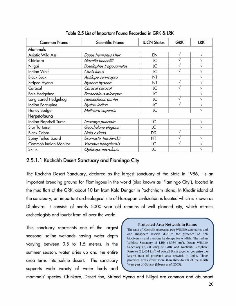
Table 2.5 List of Important Fauna Recorded in GRK & LRK
Common Name Scientific Name IUCN Status GRK LRK
Mammals
Asiatic Wild Ass Equus hemionus khur EN √ √
Chinkara Gazella bennettii LC √ √
Nilgai Boselaphus tragocamelus LC √ √
Indian Wolf Canis lupus LC √ √
Black Buck Antilope cervicapra NT √
Striped Hyena Hyaena hyaena NT √ √
Caracal Caracal caracal LC √ √
Pale Hedgehog Paraechinus micropus LC √
Long Eared Hedgehog Hemiechinus auritus LC √ √
Indian Porcupine Hystrix indica LC √ √
Honey Bodger Mellivora capensis LC √
Herpetofauna
Indian Flapshell Turtle Lessemys punctata LC √
Star Tortoise Geochelone elegans LC √
Black Cobra Naja oxiana DD √
Spiny Tailed Lizard Uromastix hardwickii NT √ √
Common Indian Monitor Varanus bengalensis LC √ √
Skink Ophisops microlepis LC √
2.5.1.1 Kachchh Desert Sanctuary and Flamingo City
The Kachchh Desert Sanctuary, declared as the largest sanctuary of the State in 1986, is an
important breeding ground for Flamingoes in the world (also known as ‘Flamingo City’), located in
the mud flats of the GRK, about 10 km from Kala Dungar in Pachchham island. In Khadir island of
the sanctuary, an important archeological site of Harappan civilization is located which is known as
Dholavira. It consists of nearly 5000 year old remains of well planned city, which attracts
archeologists and tourist from all over the world.
This sanctuary represents one of the largest
seasonal saline wetlands having water depth
varying between 0.5 to 1.5 meters. In the
summer season, water dries up and the entire
area turns into saline desert. The sanctuary
supports wide variety of water birds and
mammals’ species. Chinkara, Desert fox, Striped Hyena and Nilgai are common and abundant

27
mammal species of this sanctuary. Apart from the numbers of resident and migratory avifaunal
species some raptors and Houbara bustard are also found occasionally. Many timid and harmless
Spiny-tailed lizards, with their typical hide and run activity are found in abundance in this
sanctuary.
The Sandal bet, right in the centre of the GRK, popularly known as Flamingo city is a part of
Kachchh Desert Wildlife Sanctuary. It was first reported and discovered in 1886 by Maharao
Khengarji (Patel, 1971). Dr. Salim Ali, a well known ornithologist, also visited Flamingo city and
estimated a population of half million birds. The flamingo city after rainfall transforms as a marshy
island where large number of Greater and Lesser flamingoes visit for breeding. They construct their
muddy nests, lay eggs and rear young ones. Nesting takes place during monsoon in between July
and October when the area gets covered with shallow stretch of water partly from fresh water
outflow due to monsoon and partly from the sea. However, depending on rainfall and inundation
conditions, nesting has also occurred as late as March-April. Besides Greater and Lesser flamingo,
Rosy pelican and Avocet have also been recorded to breed in the GRK in the past.
In GRK, the diversity of wild
animals is very scarce
(GUIDE 1999). The faunal
composition including
sixteen species of
herpetofauna (15 species of
reptiles and 1 species of
amphibian) belonging to 13 genera and 9 families, 14 species of mammals and 49 species of birds
belonging to 42 genera and 25 families recorded from GRK (GUIDE, 1997)
The Jurassic and Cretaceous rocks on Khadir, Kuvar and Pachchham bets are having plenty of
fossils of vertebrates, invertebrates and plants embedded within it. There is also the first record of
oldest fossil dinosaur from the earliest Middle Jurassic period (approximately 165 million years ago)
from Kachchh by a team of Geologists from ONGC, Mumbai. They have excavated fossils of
dinosaurs (large number of well-preserved bones) and tree trunks of Middle Jurassic rocks of Kuar
bet in GRK (Satyanarayana et al. 1999). There are plenty of marine fossils in hillocks located in
GRK and Pachchham areas. Fossilized forests have also been found in the rocks belonging to

28
Mangroves in GRK
Guneri village (Area 52 km2) located in Lakhpat
taluka along the fringes of GRK supports a small
patch of remanent mangroves in the GRK areas.
The nearest coastal belt mangroves are located
approximately 15 km from these mangrove
patches.
Jurassic and Cretaceous period. The Jurassic period was considered as a golden age for the large
herbivorous dinosaurs. These fossils of Jurassic dinosaurs and trees have highlighted the fact that the
GRK and surrounding areas once had a luxuriant forest to support populations of dinosaurs. The
marine fossils in and around GRK indicate the fact that the area was submerged under ocean for
some time. These evidences highlight some interesting paleo-archeological facts about GRK.
Interestingly, there is no mangrove in GRK and under
high saline conditions the habitat is unsuitable for the
growth of mangroves. However, a single isolated patch
of mangroves is located in Guneri village of Lakhpat
taluka of the Kachchh district. This patch encompasses an
area of one acre and the nearest mangrove patch is located about 15 km distance along the coast
of Narayan Sarovar.
2.5.2 Little Rann of Kachchh (LRK)
The LRK is located between 230 10’-230 45’ N latitude and 700 45’-710 45’ E longitude on the
eastern fringe of Kachchh district encompassing an area of 6,530 km2. The LRK is southward
extension of GRK usually described as a flat, saline waste or salt marsh. The LRK is similar to GRK in
physiographic, edaphic, eco-climatic conditions and vegetation pattern. LRK is situated close to and
connected with the Gulf of Kachchh and falls under Kachchh, Rajkot, Surendranagar, Banaskantha
and Patan district of Gujarat. It is a unique landscape comprising saline mudflat and marshes,
which gets transformed into a large seasonal wetland in monsoon proving a heaven for the migrant
avifaunal species. The LRK is the only habitat for the last remaining population of endangered
Asiatic Wild Ass in the world. It is also a major nursery ground for the famous endemic “Kachchh
Prawn” (Metapenaeus kutchensis) and a feeding ground for numerous fish and invertebrate species.
This large saline mudflat has been the traditional breeding ground for the lesser flamingo since
1893. It lies in the migratory route of a large number of bird species and a common ground for
waterfowl and demoiselle and common cranes.
The landscape of LRK comprises of five major habitats a) Rann fringe, the elevated rim that carries
thorn-scrub forest and human habitations; b) Bets or uplifting islands also carry thorn-scrub; c)
Inflowing riverine tracts d) Water bodies and e) barren mudflats. The LRK is enriched with high
29
floral and faunal diversity. Floral diversity is composed of both aquatic and terrestrial vegetation
(Table 2.6). Aquatic flora is mainly composed of grasses and sedges. The vegetation in islands and
fringe areas is scattered thorn type intermixed with grass patches dominated with luxuriant growth
of Prosopis juliflora. Bets and fringe area of extensive marine saline flats of the LRK mainly support
a variety of indigenous plants like Suaeda spp., Salvadora persica, Capparis decidua, Calotropis
procera, Tamarix sp., Aeluropus lagopoides, Cressa cretica, Sporobolus spp., Prosopis cineraria,
etc (Table 2.7). A total of 253 flowering plant species have been recorded from LRK region (Meena
et al., 2005), however Ishvana et al. (2011) recorded 108 plant species (44-herbs, 35-grasses, 10-
trees and 7- climbers) from LRK. The dominant families representing more than 10 species are
Fabaceae, Asteraceae, Cyperaceae and Poaceae. Herbaceous taxa are predominant over shrubs
and trees. 107 species of algae are present in the water bodies of the area. Some of the
ecologically important plants like Cressa cretica, Aeluropus lagopoids, Urochondra setulosa, Acacia
nilotica, A. Senegal, Capparis deciduas, Salvadora oleoides, S. persica, Suaeda fruticosa, S.
nudiflora and Tamarix aphylla, which are also helpful in reclaiming the fragile soil of the LRK have
also been reported (Ishvana et al. 2011). Due to the similar habitat conditions, the floral
assemblage of LRK is similar to GRK.
Among the vertebrate species of LRK, 21 species of fish, 29 species of herpetofauna, 178 species of
birds and 33 species of mammals have been recorded. A total 93 species of invertebrates including
25 species of zooplanktons, one species of Annelid, 4 crustaceans, 24 insects, 12 mollusca, 27
spiders have been recorded from different bets of LRK (BCRLIP, 2007). The mixing of tidal water
from the Gulf of Kachchh with the freshwater discharged from the rivers takes place in the Little
Rann of Kachchh, making it an important spawning ground for prawns. A total of 11 species of
prawn have also been recorded from LRK, remarkably Metapenaeus Kachchhensis is the most
dominant and important endemic species of prawn in this area. The LRK supports one of the largest
concentrations of a threatened and migratory bustard in Gujarat, namely, Mac Queen’s Bustard.
About 81 terrestrial (9 migratory) and 97 water birds (42 migratory) have been recorded from 16
sites of the Wildass sanctuary in LRK (Singh, 2001). However, a survey conducted during 2004 by
Corbett Foundation has reported 186 bird species from this area. In 1998, a large breeding colony
of lesser flamingo was also observed in the LRK (Pardesi et al. 2010).
30
Table 2.6 Vegetation Types of LRK and Their Distribution
Vegetation Type Major Location and Characteristics
Prosopis juliflora
forest
Entire Rann fringe, all the bets, village gauchars and wastelands. Seed dispersal
mainly by livestock and herbivorous. Spreading rapidly and forming dense thickets
Salvadora persica - Suaeda nudiflora
Scrub
Mostly in saline periphery of few bets including the Dhut bet
Cassia auriculata
scrub
Mainly in the village wastelands
Salvadora persica-Tamarix scrub
Saline periphery of few bets
Suaeda fruticosa
scrub
Entire Rann fringe and saline periphery of bets like Saheblana, Dhut, Khijaliya, Lai
etc. in association with Aeluropus, Cressa cretica, etc.
Capparis scrub Interior parts of bets, less saline fringe areas and periphery of villages.
Short grasslands Patchily on bets and other open areas in the village fringes and gauchars
Saline grasslands Vast extent in the southern fringe areas and on bets having saline alluvial soil.
Aeluropus lagopoides is the most dominant grass.
Saline herbaceous Patches of Cressa cretica and Sueada fruticosa grows in the mudflats and periphery
of bets. Wild ass feed on the plant
Marsh Patches of Cyperus species (Theg) are present in the waterlogged areas. Its bulbs
are the major food for cranes and many birds and reptiles.
Mangrove scrub Patches of Avicineeia marina are found in the creeks near the Surajbari.
Source: Adopted from GEER (1999) and BCRLIP, (2007)
Table 2.7 List of Threatened Plant Species of LRK
Species Type Global Threat Level
Aeluropus lagopoides Grass En
Arthrocnemum indicum Herb Vu
Suaeda maritime Herb En
Suaeda nudiflora Shrub En
Urochondra setulosa Grass En
Tamarix troupii Shrub En
Commiphora wightii Small tree En
Polycarpea spicata Herb ?
Source: GEER (1999)
2.5.2.1. Indian Wild Ass Sanctuary
The famous Indian Wild Ass Sanctuary, which is the only natural habitat of the endangered Indian
wild ass (Equus hemionus khur), is located in the LRK. This sanctuary covers an area of 4954 km²

31
characterized by vast cover of saline mudflats with scanty vegetation on the fringes and bets.
Vegetation is largely xerophytic with the ground cover predominated by ephemerals. Although the
islands and fringes both have been colonized by Prosopis juliflora, the islands have a richer floral
diversity than that in fringe areas.
The Sanctuary is inhabitated by about
93 species of invertebrates (including
25 species of zooplanktons, 1 species
of annelid, 4 crustaceans, 24 insects,
12 molluscs and 27 spiders), 4 species
of amphibians (frogs and toads) and
29 species of reptiles (2 species of
turtles, 14 species of lizards, 12
snakes and 1 crocodile). The sanctuary
provides an important feeding, breeding and roosting habitat for a large number of birds due to its
strategic location on bird migration route and its connection with the dynamic Gulf of Kachchh.
According to an estimate about 70,000-75,000 birds nests in an area spread over 250 acres. Nine
mammalian orders with 33 species/subspecies have been reported from the sanctuary, including
the world’s last population of the khur sub-species of the Wild Ass (GEER, 1999).
The Indian Wild Ass
The Indian Wild Ass (Equus hemionus khur) is a large size ungulate and a ‘flagship’ species, listed
as an endangered species in IUCN’s redlist of threatened animal (2011) and a Schedule-I species in
Indian Wildlife (Protection) Act, 1972. The last remaining population of this species only survives in
the Little Rann of Kachchh around the world. Historically, Wild Ass was widely distributed in the
whole arid zone of north–west India including Sindh, Pakistan. Later on, the species was restricted
to the Little Rann of Kachchh. Recently, some of the population of wild ass has migrated towards
agricultural field adjoining this sanctuary
(BCRLIP, 2007).
According to the census carried out in 2009,
the total population of wild ass is about 4038

32
(Times of India, 2009). The population census in 2004 by the Forest Department showed that
maximum individuals of this species have been found in Rann and fringe areas (Table 2.8).
Interestingly, about 17% of the population has been recorded from outside of this sanctuary.
According to the wild ass census of Gujarat State Forest Department in 2004, more than 650 wild
asses were recorded beyond 10 km of the Wild Ass Sanctuary. A family band of about 25
individuals was reported in the north-eastern part of Nal Sarovar. Conclusively, the population
trends of wild ass in last six decades (Figure 2.9) suggests that the wild ass population is growing
exponentially and the increased animals are dispersing and occupying different habitats well
beyond the LRK. Most of these dispersed animals raid the nearby crop fields to meet their food
requirement. This is one of the major issues of human-wildlife conflicts in the entire landscape. The
increase in the population of Wild ass is remarkable mainly due to the absence of natural
predators, increased fodder availability and strict conservation measures.
Table 2.8 Habitat Wise Records of Wild Ass Population
S.
No Habitat
1998* 2004** Importance of Habitat
Population % Population %
1 Bets 541 18.4 554 14.4
Most critical habitat for Wild Ass.
Provide year round fodder & drinking
water. Also, used as breeding ground.
2 Rann 688 23.4 1433 37.1
Provide grounds for galloping, social-
congregations and breeding. Suaeda
provide good fodder value.
3 Fringe
Area 1271 43.2 1210 31.3
Provide good grazing resources in the
form of Aeluropus lagopoides-Cressa cretica cover. Prosopis thickets provide
good shelter.
4 Outside
WAS 440 15.0 666 17.2
Wastelands with sparse cover of
Prosopis juliflora and crop fields provide
assured foods as well as drinking water.
Total 2940 3863
* Based on GEER Foundation Survey, ** Based on Wild Ass Census by Gujarat State Forest Department
2.6 Agariyas in LRK
Gujarat is the largest salt making State of India,
accounting more than 70 % of India’s total salt
production. It is also the only Indian State that
Agariya Community in LRK
The communities involved in salt production are mainly
Chunvaliya Koli, Ahir and Miyana (Muslim), residing in 108
villages in the periphery of LRK. These communities have
traditional skills of salt production. Water quality in 108
villages of LRK is saline, thus agricultural production is very
low. Salt production is the major livelihood option for
Agariyas in the absence of any other alternatives for
livelihood. As per the Salt Commission’s report there are
about 45,000 agariyas working in the salt pans of LRK.
33
uses sea brine and sub-soil brine as the source of marine and inland salts, and both types of brines
are used in LRK for salt farming (Sandarbh, 2008). Salt produced in LRK is known as ‘Vadagaru’
salt. It is believed that the British used to call the large salt pans of Rann as “Bada Agar” which
became vada agar and from there the name ‘Vadagaru’ was derived. Salt production is one of the
major livelihood options and is the traditional and old age occupation of the local people living in
LRK. The community involved in this occupation is known as “agariyas” that lives on the edge of the
LRK and is having a unique relationship with the Rann and their traditional salt farming practices.
LRK is the only desert in the world where salt production is carried out by making small salt pans
(AHRM 2007).
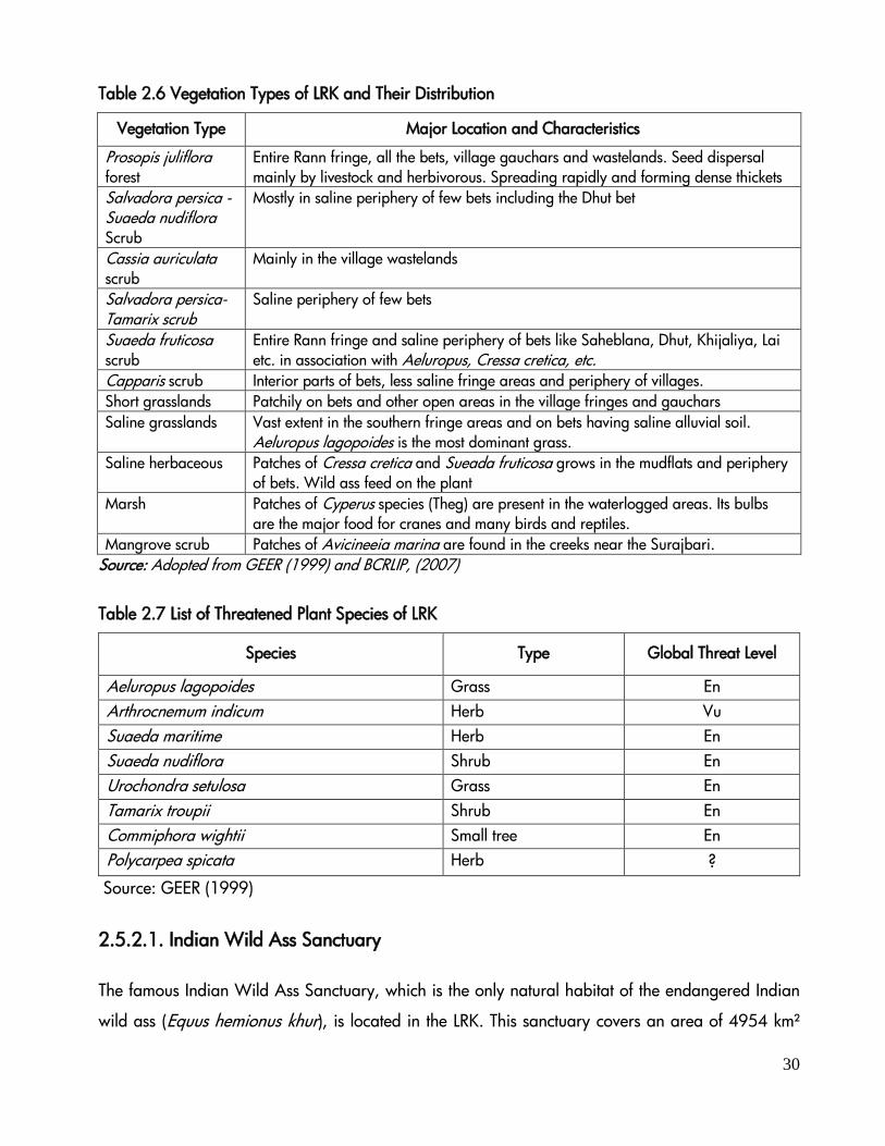
The salt manufacturing activity in LRK is
continued for eight months by the Agariyas and
during the monsoon they migrate to the sea coast
for manufacturing salt from marine water (AHRM
2007). After the monsoon, the Agariyas migrate
to the Rann and stay there in extremely poor
living conditions with almost no facility for eight
months up to mid‐summer. Just before the onset
of monsoon, they sell their entire produce to traders and return to their native villages. They migrate
with whole families to salt pans as the salt making process is highly labour intensive and each of the
family member including children shares the work. This led to poor education of children for which
an innovative initiative was undertaken by a NGO for improving the educational standards (Pandya
2010).
Table 2.8 highlights that during the year 2001 LRK contributed 23% of the salt produced in the
Gujarat State while in 2003 it decreased to 17%.
Table 2.8 Production of Salt from Various Sectors in Gujarat
Year Production in ‘000 tons % of
Marine
in Total
% of
Recognized
in the Total Total Marine Inland* Recognized
Sector
Unrecognized
Sector**
2001 9647.8 7408.0 2239.8 7665.4 1982.4 76.78 79.5
2002 13107.8 11254.9 1852.9 10433.6 2674.2 85.86 79.6

34
Source: Annual Report: 2003-2004. Salt Dept, Ministry of Commerce and Industries
2003 10585.9 8816.7 1769.2 8874.5 1711.4 83.29 83.8
* Inland salt in Gujarat meant salts produced from LRK & ** Unrecognized sector include salt pans of less than 10 acre size.

35
3 Impacts
3.1 Desertification and Soil Erosion
Desertification, which by definition occurs only in drylands, causes adverse impacts on non-dryland
ecosystems (MEA, 2005). For example, dust storms resulting from wind erosion, driven by
degradation of the dryland vegetation cover, may affect people and ecosystems elsewhere.
Similarly, transport of sediments, pesticides, and nutrients from dryland agricultural activities affect
coastal ecosystems. Droughts and loss of land productivity are considered predominant factors in
the migration of people from drylands to other areas (MEA, 2005)
Among dryland subtypes, ecosystems and populations of semiarid areas are most vulnerable to loss
of ecosystem services. The unsustainable management within the drylands often led to over-
exploitation of the natural resources and a decline in productivity, the consequent desertification,
followed by poverty and migration (MEA, 2005).
The Banni grasslands located on the periphery of GRK faces severe salinity problems that support
the spread of hardy Prosopis juliflora in major part of Banni. The Pachchham and Khadir areas of
GRK face severe soil erosion threats. The soil of Rann has been categorized into 4 types (Rao &
Aggrawal, 1964) which are; Sandy strand, Rocky sandy strand, Salt marsh and Slack and mud
formations. The tidal mudflats having deep to very deep fine loamy saline soils at the base and deep
coarse sandy soils with predominant halophytes like Suaeda are facing desertification. The areas
affected by salinity, water logging and wind erosion are subjected to severe to very severe
desertification hazard. In some pockets, Kachchh region faces severe desertification hazard due to
lack of vegetation cover. The saline flat water logged areas of Rann which are flooded during south
west monsoon get dry during late winter and summer, which gets salinization through high velocity
winds and evaporation.
3.2 Intensive Salt Farming in LRK
The LRK covers 108 villages of Kachchh, Rajkot, Surendranagar, Patan and Banaskantha districts.
The livelihood of the people is highly dependent on the resources of the Rann i.e. salt farming on the
dry Rann and its underground brine, seasonal brackish water prawn fisheries in the flooded parts of

36
the Rann, and livestock grazing in the bets and fringe areas. The industry is now facing a setback
due to shortage of water that has led the salt pan owners to start digging deeper and farther in the
Rann (BCRLIP 2007). Salt pans on the fringes of the Rann are indicative of salinity spread in the
area, which degrades the fragile and delicate ecosystems of the area (GEC and GES 1999). Remote
Sensing data reveals that the salt work area has increased from 69.48 km2 in 1982 to 133.57 km2
in 1995 (GEER, 1998).
Salt pans and salt production pave the way to
habitat fragmentation to many faunal species.
Further, the continuous bunds of salt pans cause
disruption or blockade of saline water and fresh
water flow, thereby increasing the salinity levels
in many areas of LRK which cause problems to
wetland birds (Cranes, Ducks, Waders etc),
prawns (Metapenaeus kutchensis) etc. M.
kutchensis is a significant source of seasonal
fishery in shallow estuarine water of the LRK during the monsoon months. The average annual catch
of the species has been reported to be 605 tons by Deshmukh (2006).
The intensive salt production in Rann and the livelihood of Agariyas are facing some conflicts by
displacement of agariyas in LRK. This creates an uncertainty of future of salt making at one side and
socio-economic impoverishment of Agariyas on other side. Agariya Hit Rakshak Manch (AHRM), a
forum of salt workers has taken initiatives for overcoming the issues of Agariyas and devising
strategies for collaboration between various salt producing states to discuss upon the issues of the
salt workers and to adopt a common strategy for the future. An outline of national consultation was
designed in collaboration with respective states and office of central salt commissioners. However, it
would take some time to reach out to a common understanding of the legislature.
There are two independent scenes being enacted in this sector. Due to severe escalation in input
cost, the economy of the salt making in the lower fringe (which has some of the high density of salt
pans) is becoming unviable. With enforcement of regulation on the activity, the primary producers
would be limited to certain areas and its inherent nature of water availability, which can or cannot
37
suit the economy. What needs more exploration is, how far these locations are going to be located
and what would be implications on families in terms of their movement.
3.3 Impact on Biodiversity
Uncontrolled expansion of salt pans around Suraj Bari area and in GRK, bunds erected to divert
water from creek to their pans, are causing serious damage to prawns, fishes and other
microorganisms which also form food for flamingos. Due to such diversion of water, there is a
shortage of food in the potential breeding areas and thus flamingoes are abandoning the site
(GUIDE, 2002). Apart from this, developmental activities like construction of road and watch tower
for security purpose, electrification of area and regular disturbances through fishermen communities
are major threats to the biodiversity. The cutting and lopping of Prosopis juliflora cover for making
charcoal cause’s destruction of hides, breeding and dening areas of wolf, common fox, desert fox,
hyena etc and make them more vulnerable. The increase in the saltpan area is also a threat to the
habitat of Wild Ass and other faunal diversity. The conservation of biodiversity in landscape is
imposed mainly due to following proximate threats:
1. Degradation of bets & fringe habitats mainly due to excessive grazing and, as a result of this,
the spread of P. juliflora.
2. Fragmentation of Rann desert mainly due to inland salt-work
3. Degradation of wetland habitat mainly due to change in hydrological regime
4. Degradation of creek habitat mainly due to marine salt-work
5. Human-wildlife conflicts in the form of crop depredation by wild herbivores and lifting of
sheep and goats by wolf
6. Local people’s antipathy to PA based conservation and non-participation in conservation
practices
38
4 RESPONSES
Apart from desertification, the Rann of Kachchh and its adjoining environment are facing some
natural and anthropogenic pressure and, consequently, have some impacts on the natural
environment and local communities. Desertification is a global problem, and it is attributed to
climate change and global warming. Though it is a gigantic problem, difficult to be addressed in a
short time, the combined efforts of government, public and private partners can help combating
desertification to some extent by applying following measures:
Afforestation following shelter belt plantation/wind break plantation and grassland
development in fringe areas.
Recharging ground water through water harvesting structure.
Management of pastures and range lands
Promotion of productive dry land agriculture based on soil, water, climate factors
Reorient cropping method with application of dry land farming technique and mulching
Application of appropriate control measure to soil by wind erosion and conservation of
water through watershed development.
Reducing pressure of grazing and protecting natural vegetation.
Treatment of industrial effluents before discharging into Rann environment
Rehabilitation of mine spoil areas around Rann
Control of water logging and salinity-alkalinity through agronomic practices
Drainage management and improvement of irrigation system
Management of arable land, permanent pastures and rangelands
These solutions to control desertification and land degradation in drought prone areas around Rann
require technological improvements in traditional methods to reverse land degradation that are
firmly anchored in the socio-economic and policy contents of the government.
4.1. Programmes for Combating Desertification
The programme and initiative to combat desertification is broadly categorized in strengthening 6
areas including land, water, livelihoods, renewable energy, science and technology initiatives, and
sustainable land and ecosystem management. A total of 27 programmes were initiated for the
period between 2007 and 2010 by the Government of India in collaboration with UNCCD (MoEF,
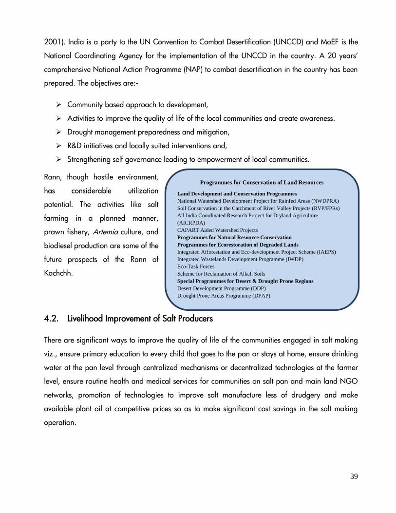
39
2001). India is a party to the UN Convention to Combat Desertification (UNCCD) and MoEF is the
National Coordinating Agency for the implementation of the UNCCD in the country. A 20 years’
comprehensive National Action Programme (NAP) to combat desertification in the country has been
prepared. The objectives are:-
Community based approach to development,
Activities to improve the quality of life of the local communities and create awareness.
Drought management preparedness and mitigation,
R&D initiatives and locally suited interventions and,
Strengthening self governance leading to empowerment of local communities.
Rann, though hostile environment,
has considerable utilization
potential. The activities like salt
farming in a planned manner,
prawn fishery, Artemia culture, and
biodiesel production are some of the
future prospects of the Rann of
Kachchh.
4.2. Livelihood Improvement of Salt Producers
There are significant ways to improve the quality of life of the communities engaged in salt making
viz., ensure primary education to every child that goes to the pan or stays at home, ensure drinking
water at the pan level through centralized mechanisms or decentralized technologies at the farmer
level, ensure routine health and medical services for communities on salt pan and main land NGO
networks, promotion of technologies to improve salt manufacture less of drudgery and make
available plant oil at competitive prices so as to make significant cost savings in the salt making
operation.
Programmes for Conservation of Land Resources
Land Development and Conservation Programmes
National Watershed Development Project for Rainfed Areas (NWDPRA)
Soil Conservation in the Catchment of River Valley Projects (RVP/FPRs)
All India Coordinated Research Project for Dryland Agriculture
(AICRPDA)
CAPART Aided Watershed Projects
Programmes for Natural Resource Conservation
Programmes for Ecorestoration of Degraded Lands
Integrated Afforestation and Eco-development Project Scheme (IAEPS)
Integrated Wastelands Development Programme (IWDP)
Eco-Task Forces
Scheme for Reclamation of Alkali Soils
Special Programmes for Desert & Drought Prone Regions
Desert Development Programme (DDP)
Drought Prone Areas Programme (DPAP)

40
There should be formulation of Government policies for salt producers to ensure that they get the
best price for their hard work and there should be some subsidies or schemes for Agariyas so that
they can buy machineries to produce salt and improve their livelihood.
4.3. Conservation and Management Measures
Conservation and management of an area requires clear understanding of the role of different
environmental, ecological and social factors. One of the necessary prerequisites for conservation of
any area depends on the various environmental attributes prevailing there. Keeping these aspects in
mind following measures could be opted to improve the environmental conditions in the Rann.
Develop a comprehensive conservation plan and collect information on physico-chemical
properties of soil and water which directly have an effect on biodiversity of the area. The
research project should also focus on the species and area specific threat factors and their
magnitude to prioritize the conservation and management plan.
Apart from protection measures, it should be essential to monitor sensitive areas to assess
and understand the ecological information about rare and endangered species in Rann
area.
Local communities including fishermen and Agariyas should be well informed about the
breeding areas of flamingoes and the protected area boundaries to avoid conflicts.
Environmental awareness amongst defense personnel and local villagers for the protection of
biodiversity in the area.
Environmental Impact Assessment should be a statutory requirement, even for a small scale
development in the Rann area.
4.4. Is Land Reclamation Possible in GRK? A Case Study by GUIDE
Restoration of ecosystem functions is of paramount importance for the benefit of the society. Further,
it is important to note that the natural recovery following degradation is a slow process; it depends
on time and space, and is influenced by geographical, climatic factors and ecological conditions of
the site (Singh & Jha, 1992). Therefore, a successful restoration / reclamation programme attempts
to accelerate the natural recovery process through eco-friendly exercises in order to achieve the
goal in a short time.

41
In order to restore the productive and protective functions, a degraded land needs human
assistance, i.e. protection, pre-treatment for habitat rectification such as soil moisture conservation
amendments, slope modification, nutrient and organic matter amendments, etc. (Singh & Jha,
1992). Further, soil, water and vegetation are the most vital natural resources for the survival of
man. To obtain optimum production of vegetation, the other two resources, i.e. soil and water, will
have to be managed efficiently. Man’s struggle for land resource conservation started in antiquity.
Until recently, most of the success in obtaining higher productivity from arid and semi-arid regions
came through the traditional techniques of land resource conservation (Altieri & Toledo, 2005).
It is also important to note here that, Chapter 22nd of the 3rd Five Year Plan of Planning Commission
(1960) emphasized a pilot project for examining the methods and economics of reclaiming desert
lands in a portion of the Rann of Kachchh through suitable soil conservation measures including
afforestation and pasture development. The afforestation of Prosopis chilensis along the Banni-Rann
fringe covering an area of 31,500ha during the year 1960-61 was the outcome of the above
recommendations of the Planning Commission. However, no other interventions were carried in the
Greater Rann of Kachchh or in any of the Bets in it (Kar et al. 2009).
With the above background, to overcome the existing ecological issues in the Greater Rann of
Kachchh and to enhance the ecological status of Rann as well as socio-economic status of the local
inhabitants living along the fringes of Rann, the project on “Integrated Rann Reclamation and
Development in Kachchh District, Gujarat” was initiated on a pilot basis with financial assistance
from Department of Land Resources of the Ministry of Rural Development, New Delhi.
GUIDE had undertaken the project on land reclamation from 2001 to 2007 in Great Rann of
Kachchh which covered an area of 1440 ha of wastelands, including 940 ha located in the
Kuar/Mori Bet area and 500 ha in adjoining Rann areas.
The aim of the GUIDE project was to create a long-term sustainability in the project area by
reclaiming the saline soil through various soil amendments and water conservation techniques which
may render the habitat conditions suitable for developing vegetative cover and ecological
advancement. The implications are:
Development of vegetative cover would reduce the saline underground water coming on the
surface through capillary action and thereby improve the soil quality.

42
Soil amendments would create a suitable moisture regime for growth and production of plant
species.
Addition of mixed leguminous plants will help in improving the soil fertility of the area and
support further vegetative growth.
Apart from the land improvement and ecological sustainability, the developed vegetative cover
would also support to meet the fodder deficit of the Kachchh district.
The development of vegetative cover would also help in enhancing the faunal diversity of the
area.
Looking at the topography of the project area and the suitability / usability of contour bunding
under soil and water conservation programmes in the entire Kuar and Mori bets and adjoining
Rann area, a total of 99,433 CMT of contour bunds, 48,504 CMT of earthen bunds and 11,462
CMT of bunds in the Rann (50-150m from the fringes of Bet) were constructed with a height varying
from 0.75 to 2.5m. As part of rain water harvesting and improvement of soil moisture, a total of
eight earthen check dams, eight storage tanks and sixteen open tanks, with a total water storage
capacity of 17,00,846 CMT, were developed in the project area. Apart from the above, nallah
bunds (10,981 CMT of additional storage capacity), staggered trenches (1440 CMT), continuous
staggered trenches (12,704 CMT), loose boulders and silt traps (4878 CMT) were also developed in
many parts of the Kuar/Mori bets for land reclamation. Further, 56 earthen mounds that constitute
15,761 CMT were also developed in the high saline Rann for vegetation development on an
experimental basis.
4.4.1 Vegetation Cover Development
To improve the vegetative cover, 57,480 saplings of the tree species including Acacia nilotica,
Salvadora persica, Suaeda sp., Tamarix aphylla, Phoenix sp., Casuarina sp., Delonix sp.,
Azardirachta indica, Aloe barbadensis, Acacia senegal, Grewia tenax, Prosopis cineraria, Albizia
lebbeck and Parkinsonia aculeate were planted. In addition, 28000 saplings of Agave and 10200
saplings of Aloe were planted during the monsoon season on hilly and barren area for erosion
control and development of green belt. Vegetative cuttings of Commiphora wightii (3000 nos.) were
planted on rocky barren area. Seeds of different grass, shrubs and tree species were broadcasted in
the project area. About 7,132 kg of different species of grass seeds and about 1,636 kg of seeds of
shrub and tree species were broadcasted with healthy/nutritive soil for reclamation purposes
especially in newly developed barren sites or non productive lands. It improved the ground cover
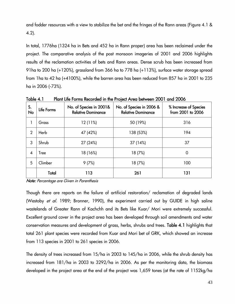
43
and fodder resources with a view to stabilize the bet and the fringes of the Rann areas (Figure 4.1 &
4.2).
In total, 1776ha (1324 ha in Bets and 452 ha in Rann proper) area has been reclaimed under the
project. The comparative analysis of the post monsoon imageries of 2001 and 2006 highlights
results of the reclamation activities of bets and Rann areas. Dense scrub has been increased from
91ha to 200 ha (+120%), grassland from 366 ha to 778 ha (+113%), surface water storage spread
from 1ha to 42 ha (+4100%), while the barren area has been reduced from 857 ha in 2001 to 235
ha in 2006 (-73%).
Table 4.1 Plant Life Forms Recorded in the Project Area between 2001 and 2006
S.
No Life Forms
No. of Species in 2001&
Relative Dominance
No. of Species in 2006 &
Relative Dominance
% Increase of Species
from 2001 to 2006
1 Grass 12 (11%) 50 (19%) 316
2 Herb 47 (42%) 138 (53%) 194
3 Shrub 27 (24%) 37 (14%) 37
4 Tree 18 (16%) 18 (7%) 0
5 Climber 9 (7%) 18 (7%) 100
Total 113 261 131
Note: Percentage are Given in Parenthesis
Though there are reports on the failure of artificial restoration/ reclamation of degraded lands
(Westoby et al. 1989; Bronner, 1990), the experiment carried out by GUIDE in high saline
wastelands of Greater Rann of Kachchh and its Bets like Kuar/ Mori were extremely successful.
Excellent ground cover in the project area has been developed through soil amendments and water
conservation measures and development of grass, herbs, shrubs and trees. Table 4.1 highlights that
total 261 plant species were recorded from Kuar and Mori bet of GRK, which showed an increase
from 113 species in 2001 to 261 species in 2006.
The density of trees increased from 15/ha in 2003 to 145/ha in 2006, while the shrub density has
increased from 181/ha in 2003 to 3292/ha in 2006. As per the monitoring data, the biomass
developed in the project area at the end of the project was 1,659 tones (at the rate of 1152kg/ha
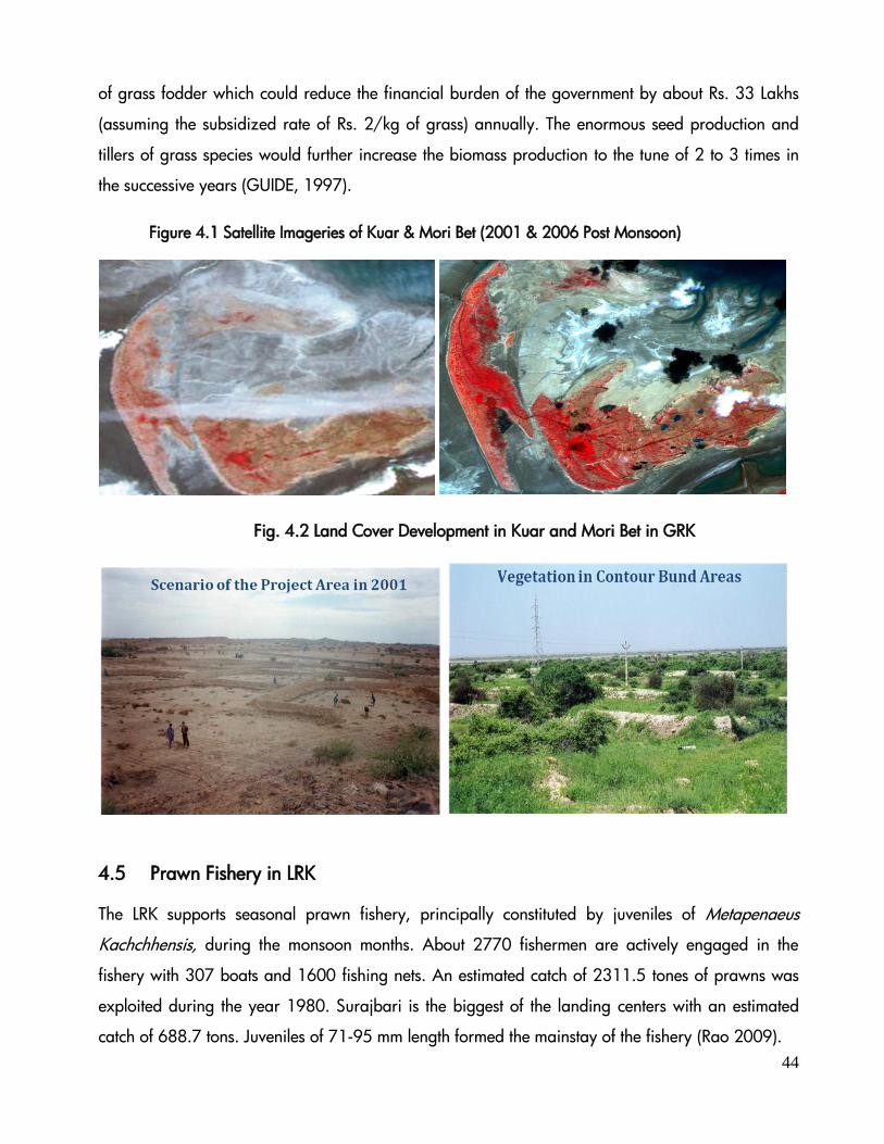
44
of grass fodder which could reduce the financial burden of the government by about Rs. 33 Lakhs
(assuming the subsidized rate of Rs. 2/kg of grass) annually. The enormous seed production and
tillers of grass species would further increase the biomass production to the tune of 2 to 3 times in
the successive years (GUIDE, 1997).
Figure 4.1 Satellite Imageries of Kuar & Mori Bet (2001 & 2006 Post Monsoon)
Fig. 4.2 Land Cover Development in Kuar and Mori Bet in GRK
4.5 Prawn Fishery in LRK
The LRK supports seasonal prawn fishery, principally constituted by juveniles of Metapenaeus
Kachchhensis, during the monsoon months. About 2770 fishermen are actively engaged in the
fishery with 307 boats and 1600 fishing nets. An estimated catch of 2311.5 tones of prawns was
exploited during the year 1980. Surajbari is the biggest of the landing centers with an estimated
catch of 688.7 tons. Juveniles of 71-95 mm length formed the mainstay of the fishery (Rao 2009).

45
The Gulf of Kachchh and adjacent estuarine system supports prawn fishery of considerable
magnitude. Srivastava (1953) reported prawn fishery of the Gulf of Kachchh and Lakumb (1960)
described the marketing and socio-economic condition of the fishermen of the region. Ramamurthy
(1963a) described the prawn fishery of the creeks and also studied the prawn fishery at Adesar
camp (1963b). Many other species of prawns were also reported from LRK areas; M. stebbingi
(Ramamurthy, 1964) and M. alcocki (George and Rao, 1966).
4.6 Artemia Culture
Vast area of GRK is inundated by sea water from Arabian Sea through Kori creek. Since the water
travels over 90 km, the salinity levels of the water spread in the Rann area has been found to range
between 70-150 ppt. During summer, salinity further increases up to 180 ppt and decreases to 40-
45 ppt during monsoon due to mixing of rainwater from rivers and rivulets that debouch into Rann
(GUIDE, 2007).
Commercial importance of Brine shrimp (Artemia
species) is tremendous since it is an ideal food for
the larvae of cultivable crustaceans (such as
shrimps). In India, brine shrimps are widely
distributed in the saltpans of Gujarat, Tamil Nadu
and Maharashtra, which are identified as potential
states for their commercial culture. The economic
importance of Artemia for shellfish and marine
larviculture is substantial.
Brine shrimp (Artemia species) is a unique marine organism having adaptability to tolerate and
flourish in extremely wide range of environmental milieu (Salinity 10–138 ppt, Dissolved Oxygen-
0.5-3.5 ml/l; pH 7.5-11). The salinity conditions of GRK, with salinity up to 150 ppt during summer
and 40-50 ppt during monsoon provides an ideal habitat for culturing Artemia in GRK. The
experiments conducted by GUIDE at GRK for Artemia cyst production from Great Rann of Kachchh
region could be of immense use for future research.

46
Saltpan-produced cysts of bisexual Artemia (Thothukudi strain, TN) were collected and were used
for the experiment. The number of cysts carried by the female varied from 41 to 113(63) in the
control pond, 52 to 146(68) in pond fertilized with inorganic fertilizer, 68 to 196(84) in pond
fertilized with chicken manure and 48 to 123(65) in pond fertilized with cow dung. It has been
reported that the female A. franciscana produces an average production of 107 cysts, with a
maximum of 303 cysts. During the present study the biomass production of Artemia cyst was on the
higher side when fertilized with chicken manure compared to other organic and inorganic
fertilizers. Thus the present study is a milestone in the case of Artemia cyst production from Great
Rann of Kachchh. This preliminary attempt indicates that the Artemia cyst production is possible in
Rann. Present study also indicated that fertilization pond is necessary for the production of Artemia
cyst. Further attempts are needed to optimize the standard protocol for the production of Artemia
cyst from the Rann region.
4.7 Aquaculture Potential
The prevailing scenario of GRK also prompted to explore the possibilities of experimenting
aquaculture using economically important species with the consultation of experts of Marine Product
Export Development Authority (MPEDA), GoI. Based on the expert advice, three experiments using
different species like Metapenaeus kutchensis and Chanos chanos were carried out in GRK. The
success of the experiments would help us to decide the reliability of such models by the villagers
located along the fringes of Rann area. It would also help in improving the socio-economic
condition of about 25 villages of Kachchh district located along the fringe of Rann besides providing
a nutritive food source to the local people of Pachchham, Banni and Security Personnel, covering a
population of about 30,000. Some species, which are experimented, are described below:
Metapenaeus kutchensis is an endemic prawn species available in the Gulf of Kachchh. It possesses
a wide tolerance to different environmental conditions, especially salinity and temperature, which
makes it a prospective candidate for culture in suitable sites of Rann, especially in GRK. For
undertaking prawn culture using Metapenaeus kutchensis and other species, a culture pond was
developed in the project area, which included a reservoir to collect excess rainwater from Aqua
check dam (a back up check dam to support the experiment), a mixing pond (to get appropriate
salinity range for the experiment by mixing saline water from Rann and fresh water from reservoir)

47
and a culture pond (for culturing activities). Though the candidate species were amendable under
the prevailing conditions in the Rann area, in reality, the experiment was not successful due to
severe droughts that prevailed during 2002-03 (78mm) and 2004-05 (16mm), and heavy floods
during 2003-04 (over 544mm in 36hrs). This unexpected heavy downpour and highly raised water
table in the Rann (sea water from Kori creek, rain water from Kachchh mainland, Rajasthan and
even from Pakistan) damaged some portions of the aquaculture structures. Due to this damage, the
experiment was not undertaken during the project periods. However, the area has the potential to
undertake aquaculture trails during normal rainfall years.
4.8 Biodiesel Potential and Diatoms
Rann environment is ideal for the growth of diatoms with high lipid contents, suitable for extracting
biodiesel. No attempt in this direction has been taken so far. The marine team of GUIDE has
submitted a proposal to MoES on Culture, Screening and Characterization of Marine Diatoms for
Biofuel Potential from Rann of Kachchh, Gujarat with the following main objectives:
a) Collect and screen potential species of diatoms from Rann of Kachchh for lipid production in
their natural environment.
b) Characterize selected strains by triggering lipid production; quantify growth rates and lipid
productivity as biodiesel feedstock.
The study will identify the most potential local diatom strains in Rann for mass culture attempts for
the purpose of lipid and biodiesel extraction. The proposed investigation will characterize the
productivity and lipid (oil) yields of various strains of diatoms which will have a significant bearing
on the industrial level outdoor culture conditions. Desirable characteristics like high productivity,
high lipid content and tolerance to fluctuations in temperature, salinity and light intensity will be
conclusively known for the identified strains which will have practical application in outdoor mass
culture activities.
4.9 Tourism Options
Most of the areas of GRK are under the control of Indian Army and therefore inaccessible for
civilians due to security reasons. However, the white Rann located near Dhordo village of Banni
attracts thousands of tourists every year. Rann of Kachchh is in highlight during the recent years
due to “Rann utsav” initiatives by the Government of Gujarat. It gives an opportunity to the visitors

48
from India and also from other parts of the world to enjoy the scenic beauty of White Rann. This
programme has been boosted the Gujarat Tourism Nigam Limited in a great success. Apart from
this, Kalladungar (Black Hills of Kachchh) which is the highest point (410m) in Kachchh district
located in Pachchham area of GRK, the Harappan excavations of Dholaveera in Khadir island of
GRK and LRK (WAS) attract many tourists and researchers of diverse interests.
4.10 Research Gap
There is an urgent need to identify research gaps, as very sparse and fragmentary information is
available on environmental aspects of Rann of Kachchh. GRK is a unique environment with high
amplitude of salinity variation during summer and monsoon. This condition provides ideal habitat
for a variety of microorganisms, flora and fauna. A detailed study of microorganisms in GRK is very
essential since many have excellent commercial values. In the same time, intensive survey and
research needed on the rare and threatened flora and fauna for their conservation and
management point of view. The above activities will help in maintaining the environment and
ecological system of Rann remain naturally and forever.
49
Bibliography
Agariya Hit Rakshak Manch (AHRM) (2007) Workshop on issues of salt workers, organized by
AHRM in Association with Central Salt Commissioner’s, Office of Industry Commissioner –
Gujarat & Tamil Nadu Salt Corporation Ltd. supported by Care (India) Snehal Programme.
Ajai, Arya, A. S., Dhinwa, P. S., Pathan, S. K. and Ganesh Raj, K. (2009) Desertification/land
degradation status mapping of India. Current Science, 97(10): 1478-1483
Ali, S. (1946) The wild ass of Kutch, J. Bomb. Nat. Hist. Soc., 46: 472-477.
Altieri, M. A. and Toledo, V. M. (2005) Natural Resource Management among Small-scale Farmers
in Semi-arid Lands: Building on Traditional Knowledge and Agroecology. Annals of Arid
Zone, 44(3&4): 365-385.
BCRLIP (2007) Biodiversity Conservation and Rural Livelihood Improvement Project for Little Rann of
Kachchh Landscape Indicative Plan prepared by Centre for Environment and Social
Concerns (CESC), Ahmedabad
Biswas, S. K. (1971) Note on the geology of Kachchh. Quart. Jour. Geol. Min. Metal Soc. India,
43: 223-235.
Biswas, S. K. (1974) Landscape of Kachchh-a morphotectonic analysis. Ind. Jour. Earth Sci., 1:
177-190.
Biswas, S. K. (1987) Hydrocarbon exploration in western offshore basins of India. In Recent Geo-
scientific studies in the Arabian Sea off India, Geological Survey of India, Spl. Pub. 24: 185-
194,
Biswas, S. K. and Deshpande, S. V. (1970) Geological and Tectonic maps of Kachchh, Bull
O.N.G.C. 7: 115–123
Burnes, A. (1835) A memoir on the Eastern Branch of the River Indus giving an account of the
alterations produced by it by an earthquake in 1819, also a theory of the Runn, and some
conjectures on the Route of Alexander the Great, drawn up in the years 1827-28, Royal
Asiatic Soc., 3: 550-588.
Business Standard (2006) SolarisChem to invest Rs. 120 cr over 3 years, New Delhi, May 2006
Chawla, C. (2004) Indigenous means of managing biodiversity: a case study of Khadir bet in
Kachchh, Youth for utility and voluntary action, Mumbai
CSE, (2002) Impact of climate change, western and central India. Global Environmental
Negotiations. http://old.cseindia.org/programme/geg/pdf/ western.pdf
Das Gupta, S. K. (1975) A revision of the Mesozoic-Tertiary stratigraphy of the Jaisalmer Basin,
Rajasthan. Indian Journal of Earth Sciences, 2 (1): 77-94.
50
Dave, C. V. (2010) Understanding conflicts and conservation of Indian wild ass around Little Rann
of Kachchh, Gujarat, India. Final technical report submitted to Rufford Small Grant Program,
UK.
Deshmukh, V. D. (2006) Fishery and biology of the ginger prawn, Metapenaeus kutchensis George,
George and Rao, 1963 along the northwest coast of India. Journal of the Marine Biological
Association of India, 48 (2): 173-179.
Eidinger, J.M. (2001) Gujarat (Kutch) India M7.7 Earthquake of January 26, 2001 and Napa
M5.2 earthquake of Sep. 3, 2000. Technical Council on lifeline earthquake Engineering
Monograph No. 19. USA
GEC and GES (1999) Salinisation and ecological degradation around the Ranns, Gujarat Report.
Gee, E. P. (1963) The Indian wild ass: A survey. J. Bomb. Nat. Hist. Soc., 60: 517-529.
GEER (1998) Ecological study of Wild Ass Sanctuary, Little Rann of Kachchh: A comprehensive
study on biodiversity and management issues, Gandhinagar
George, M. J. and Vedavyasa, R. P. (1966) A new species of Metapenaeus (Decapoda:
Penaeidae). J. Mar. Biol. Ass. India, 8: 146-151.
George, P. C., George, M. J. and Vedavyasa, R. P. (1963) Metapenaeus kutchensis sp. nov., a
penaeid prawn from the Gulf of Kutch, J. Mar. Biol. Ass. India, 5: 285-288.
Glennie K. W. and G. Evans (1976) A reconnaissance of the Recent sediments of the Ranns of
Kutch, India. Sedimentology, 23: 625--647.
GMDC (2011) Geological evolution and mineral resources of Gujarat Report.
GUIDE (1996) Process of desertification in Kachchh and Banaskantha districts of Gujarat, India
Report
GUIDE (2002) Kachchh sub-state biodiversity strategy and action plan under the national
biodiversity strategy action plan (NBSAP).
GUIDE (2007) Integrated Rann reclamation and Development in Kachchh district Report
GUIDE (2011) A Study on the Effects of Desertification and Climate Change in Kachchh,
Banaskantha, and Patan Districts of Gujarat State
Gujarat Ecology Commission (1994) Current Ecological Status of Kachchh. Baroda.
Ishnava, K., Ramarao, V., Mohan, J. S. S. and Kothari, I. L. (2011).Ecologically important and life
supporting plants of little Rann of Kachchh, Gujarat
IUCN (2000) The IUCN Species Survival Commission and the International Union for Conservation
of Nature and Natural Resources Kachchh, India.
51
Joshi, P. N. and Sunderraj, S. F. W. (2009) Establishment of Medicinal Plants Conservation Areas
(MPCAs) of Highly traded and rare medicinal species in Kachchh saline desert, Gujarat
Institute of Desert Ecology (GUIDE), Gujarat, India.
Jothimani, P. and Garg, J. K. (1992) Mapping and monitoring of Rann (tidal) ingress in Banni
plains, Kachchh, Gujarat using multi-temporal satellite data, remote sensing applications
group, space application centre, ISRO
Kar, A. and Singh, N. (2003) Desertification in arid Kachchh Region of Gujarat: present status and
responsible factors. In Human impact on desert environment (edited by Narain, P., Kathju,
S., Kar, A., Singh, M. P. and Praveen Kumar), 26-38pp.
Kar, A., Garg, B.K., Singh, M. P. and Kathju, S. (2009) Trends in Arid Zone Research in India.
Central Arid Zone Research Institute, Jodhpur. 481 pp.
Krishnan, M. S. (1982) Geology of India and Burma, CBS Publishers and distributors, New Delhi
Kutch Development Forum (1993) A Demand for Review of Water Allocation to Kutch.
Recommendations, Observations, Extracts from Report of Review Group on Narmada.
Bombay.
Lakumb, N. C. (1960) Prawn fishery of Kutch, Gujarat State, The Fishing industry of Gujarat, 49-
54.
Le Houerou, H. N. (1984) Rain use efficiency: a unifying concept in arid-land ecology. Journal of
Arid Environment, 7: 213-247.
Macmurdo, J. (1824) Paper relating to the earthquake which occurred in India in 1819.
Philosophical Magazine and journal, 63: 105-119.
Malik, J. N., Sohoni, P. S., Karanth, R. V. and Merh, S. S. (1999) Modern and Historic seismicity of
Kachchh Peninsula, Western India. Jour. Geol. Soc. of India, 54: 545
Malik, J.N., Merh, S.S. and Sridhar, V., (1999) Palaeo-delta complex of Vedic Sarasvati and other
ancient rivers of northwestern India. Geological Society of India Memoirs, 42: 163–174
Maurya, D. M., Thakkar, M. G. and Chamyal, L. S. (2003) Quarternary geology of arid zone of
Kachchh: Terra Incognita. Proc. Indian Nat. Sci. Acad., 69 A (2): 123-135.
Meena, R. L., Verma, Y. L., Korvadia, V. T., Pathak, B. J. and Kshatriya, A. R. (2005) Kachchh
Biosphere Researve (A management plan for protection, conservation, research and
development) Gujarat State forest Department, Gujarat
MFACDC (1966) Reclamation and development of the Great Rann of Kutch. Ministry of Food,
Agriculture, Community Development and Co-operation, Govt. of India, New Delhi.

52
Millennium Ecosystem Assessment (2005) Ecosystems and Human Well-being: Desertification
Synthesis. World Resources Institute, Washington, DC.
MoEF (2001) Status of Desertification, Volume-I In: India’s National Action Programme To Combat
Desertification In The Context of United Nations Convention To Combat Desertification
(UNCCD), 352 Pp.
MoEF (2010) Elucidation of the 4th National Report submitted to UNCCD Secretariat 2010, Edited
by Centre for Environment Education (CEE), Ahmedabad.
MoEF (2010) Conservation, Chap-2, Annual Report 2009-2010, Ministry of Environment and
Forests, Govt. of India.
Mountfort, G. (1991) Wild India. The Wildlife and Scenery of India and Nepal. MIT Press,
Cambridge, MA, 208 pp.
Mudrakartha, S. (2007) Adapt or not to adapt: The dilemma between long term resource
management and short term livelihood. In The agricultural and groundwater revolution
opportunities and threat to development (Edited: Mark Giordano and Karen G. Villholth),
CAB International, UK, 243-265.
Narmada Planning Group (1989) Planning for Prosperity. Sardar Sarovar Development Plan.
Gandhinagar: Sardar Sarovar Narmada Nigam Ltd.
Noy- Meir, I. (1973) Desert ecosystem: Environment and Producers. Annual review of ecology and
systematic, 4: 25-52.
Oldham, T., (1883) Catalogue of Indian earthquakes, Mem. Geol. Surv. India, 19: 163-215
Paliwal, A. (2011) Killing ground, Down to Earth Dec 31, 2011
Pandya, H. (2010) Agariyas and wild ass sanctuary in the little Rann of Kutch, Gujarat: a brief
note. Mukt-Saad, 0(7), Retrieved May 19, 2012.
Pardeshi, M., Gajera, N., and Joshi, P. N. (2010) Kachchh biosphere reserve: Rann and
biodiversity, Research Journal of Forestry, 4(2): 72-76.
Patel, G. D. (1971) Gujarat state gazetteers- Government of Gujarat, Gujarat State, Ahmedabad
Raj, P A. (1996) Fact. Sardar Sarovar Project. Gandhinagar: Sardar Sarovar Narmada Nigam Ltd,
1991 and 1996.
Rajendran, C. P. and Rajendran, K. (2001) Characteristics of deformation and past seismicity with
the 1819 Kachchh earthquake, northwestern India. Bull. Seismol.l Soc. America, 91: 407-
426.
Raju, K. (1995) Strategies to Combat Drought in Kutch. Mandvi: Vivekanand Research and Training
Institute, Kachchh.

53
Ramamurthy, S. (1963a). A note on the prawn fishery of Kutch. J. Mar. Biol. Ass. India, 5: 146-
148.
Ramamurthy, S. (1963b) A note on the prawn fishery of Adesar camp. J. Mar. Biol. Ass. India, 5:
318-320.
Ramamurthy, S. (1964). On a new record of Metapenaeus stebbingi Nobili in Indian waters. J.
Mar. Biol. Ass. India, 6: 170-171.
Ramamurthy, S. (1967) On the prawn fishery of Kutch. Proc. Symp. Crustacea, Mar. Biol. Ass.
India, Part IV: 1424-1436.
Rao, S. G. (2009) Observations on the seasonal prawn fishery of the little rann of kachchh during
1980, Central Marine Fisheries Research Institute Research Centre, Veraval.
Rodgers, W. A. and Panwar, H. S. (1988) Planning wildlife protected area network in India,
Wildlife Institute of India (WII), Dehradun
Roy, B. and Merh. S. S. (1977) Geomorphology of the Rann of Kachchh and climatic changes. In:
Ecology and Archeology of western India. (Eds. Agarwal, D. P. and B. M. Pande) Ocept.
Publ. Co., Delhi. 195-200 pp.
Rutherford, M. C. (1980) Annual plant production- precipitation relations in arid and semi-arid
regions. South Africa Journal of Science, 76:53-56.
SANDARBH (2008) Ahmedabad, for National Consultation on Salt Workers, India, Yet to be Freed
Agariyas’ Lives and Struggle for Survival in the Little Rann of Kutch
Sanghvi, V. (1992) “A Dream Fulfilled.” Hindustan Times. New Delhi, 12 January 1992.
Sarvaiya, R. T. (1981) Prawn fisheries of Kutch with special reference to Sukhpar and Lakhpat.
Indian J. Fish, 25: 35-40.
Satyanarayana, K., Dasgupta, D. K., Dave, A. and Das. K. K. (1999) Record of skeletal remains of
dinosaur from early Middle Jurassic of Kuar Bet, Kutch, Gujarat. Current Science, 77 (5):
Shah, N. V. (1993) Ecology of wild ass (Equus hemionus khur) in Little Rann of Kutch, Ph.D.
Dissertation, M.S.University, Baroda, Gujarat.
Shah, N. V. (2004) Indian Wild Ass (Equus hemionus khur), ENVIS Bulletin, Vol-7, Wildlife Institute
of India, Dehradun.
Shastri, P. (2011) Little Rann no longer worth its salt? Times of India, Ahmedabad.
Singh, H. S. (2000) Status of Indian Wild Ass (Equus homionus khur) in the little rann of Kachchh,
Zoo’s Print Journal, 15(5): 253-256
Singh, H. S. (2001) Natural Heritage of Gujarat, GEER Foundation, Gandhinagar, 262 pp
54
Singh, H. S., Patel, B.H., Parvez, R., Soni, V. C., Shah, N. V., Tatu, K. and Patel, D. (1999).
Ecological study of the Wild Ass Sanctuary, Little Rann of Kutch, Gujarat Ecological
Education and Research (GEER) Foundation, Gandhinagar.
Singh, J. S. and Jha, A. K. (1992) Restoration of Degraded land: An over view. In: Restoration of
Degraded land: Concepts and Strategies (Eds.). J. S. Singh, Rastogi Publ.
Sohoni, P. S. and Malik, J. N. (1998) Remnants of large magnitude earthquakes: Evidence from the
Great Rann sediments, Kachchh, Western India, Curr. Sci. 74: 985
Srivastava, K.R. (1953) A survey and comparative analysis of the prawn (shrimp) fishery of the Gulf
of Kutch in Saurashtra in western India. Govt. of Gujarat Publication, Saurashtra, India.
Tatu, K., Patel, B. H. and Vyas, R. (2001) A study on biodiversity in Kachchh desert Wildlife
sanctuary and its environs in Great Rann of Kachchh (unpublished report), Gandhinagar
Tere, A. and Parasharya, B.M. (2011) Flamingo mortality due to collision with high tension electric
wires in Gujarat, India. J. Threatened Taxa 3(11): 2192–2201
Thakker, M. (1988) Sindhu waters and Kutch. Bhuj: Aaradhana Trust, 1988.
Times of India (2011) 400 flamingos die in Gujarat. Times of India, Ahmadabad, Dec. 1, 2011
Times of India (2011) Wild Asses population raises by 4%, TNN, 11 April 2009, Ahmadabad.
Vijay Kumar, V., N. Gajera and Patel, P. (2011) Grasslands of Kachchh. In: State of Environment in
Kachchh. Publ. GEER Foundation & GUIDE. Pp. 113-132.
Vogt, J., Hill, J., Bied-Charreton, M., Rohrig, J., Safriel, U., Sokona, Y., von Maltitz, G., and
Zougmore, R. (2009) Introduction. In Integrated Methods for Monitoring and Assessing
Desertification/Land Degradation Processes and Drivers (Land Quality). White Paper of DSD
Working Group 1, Version 2. Dryland science for Development Consortium (DSD), 173 p.
Vyas, D. U. (2011) Gujarat Mineral Development Corporation Ltd, Ahmadabad, State of
Environment in Kachchh
WII (1993) Ecology of wild ass (Equus hemionus khur) in little Rann of Kachchh, Wildlife Institute of
India Report, 183 pp.
Wynne, A. B. (1872) Memoir on the Geology of Kachchh, Memoirs of the Geological Survey of
India, 9: 1-294.