CONSULTANT FIELD NOTES & OBSERVATIONS OF MERCER …
41
A-31 DRAFT DRAFT DRAFT DRAFT CONSULTANT FIELD NOTES & CONSULTANT FIELD NOTES & OBSERVATIONS OF MERCER ISLAND OBSERVATIONS OF MERCER ISLAND PARKS SYSTEM PARKS SYSTEM Consultant field visits to all Mercer Island parks, trails and open space areas were completed in 2019 prior to the PROS Plan project being suspended in early 2020. Review of this document is still underway to ensure changes that have occurred since 2019 are accounted for and reflected in the final PROS Plan. Exhibit H | Page 37
Transcript of CONSULTANT FIELD NOTES & OBSERVATIONS OF MERCER …

A-31
DRA
FTD
RAFT
DRA
FTD
RAFT
CONSULTANT FIELD NOTES & CONSULTANT FIELD NOTES & OBSERVATIONS OF MERCER ISLAND OBSERVATIONS OF MERCER ISLAND
PARKS SYSTEMPARKS SYSTEM
Consultant field visits to all Mercer Island parks, trails and open space areas were completed in 2019 prior to the PROS Plan project being suspended in early 2020. Review of this document is still underway to ensure changes that have occurred since 2019 are accounted for and reflected in the final PROS Plan.
Exhibit H | Page 37

A-32
Mercer Is land Parks, Recreation & Open Space Plan
DRA
FTD
RAFT
DRA
FTD
RAFT
Exhibit H | Page 38

A-33
DRA
FTD
RAFT
Amenities
Aubrey DAvis PArk
91.81 acres72nd SE & SE 22nd
Regional Park
Capital Improvement & Planning Opportunities � ADP Master Plan was adopted in 2019. Recommendations from the adopted
Master Plan should be assimilated into capital planning. � Owned primarily by WSDOT. Decision-making is a joint effort for operational
considerations. � Three primary vegetation management strategies from the Master Plan include
1.) Intensive soil amendments and replanting for high visibility areas; 2.) Infill plantings in lower visibility areas; and 3.) Modification of non-active recreation lawn areas to capture reduced maintenance and lower water use needs.
� Trail improvements through Aubrey Davis Park focus on re-establishing sight lines and clear zones along the existing Mountains to Sound Trail, renovating the trail in conjunction with the sewer upgrade project, improving trail safety for all trail users and integrating wayfinding along the corridor. New trail connections for ADA access to existing amenities is also recommended.
� Two new amenities are proposed in the Master Plan: an off-leash area (in the open space around the stacks) and a second restroom (near the soccer fields &
� Baseball fields (2) � Basketball courts (2 full court) � BBQs � Benches � Bike racks � Bleachers � Boat launch � Bocce/petanque courts (2) � Drinking fountains � Formal landscaping � Formal plaza � Local trails � Mountains to Sound Regional Trail
� Open grass areas � Paved pathways � Picnic shelter � Picnic tables � Picnic tables with chess-checkers
boards � Play structures (2) � Public art � Restrooms (1) � Soccer/lacrosse field (1) � Tennis courts (4) � Water Trail trailhead
(cont.)
Exhibit H | Page 39

A-34
Mercer Is land Parks, Recreation & Open Space Plan
DRA
FTD
RAFT
DRA
FTD
RAFT
playground along West Mercer Way). An improved shoreline access area on the east end of the Park is also recommended.
� In addition to the Master Plan recommendations, consider working withWSDOT to paint the exhaust stacks and massive concrete wall at the basketballcourts.
� The boat launch at the east end of Aubrey Davis Park is a water trailhead, soconsider park signage that is oriented to the water in conjunction with MasterPlan recommendations for shoreline access development at this location.
� A rowing facility opportunity could be included at the boat launch.� Implement trail safety projects per the Master Plan.
Maintenance Considerations� All natural grass areas look excellent.� Tennis courts have minor cracks that likely do not affect play yet, but should be
monitored.� A few of the benches at the western most playfield are degraded and should be
replaced.� All of the bike racks are “wheel benders” and should be replaced according to the
Master Plan’s recommendations.� Drainage issues exist where catch basins need to be reset or regraded. � Irrigation is showing wear and tear. Valve clusters and supply lines fail periodically.
Irrigation is not as effective as it could be. Consider a better system for heads thatdon’t break.
� The Master Plan revealed long-term needs for managing tree cover and the urbanforest canopy. These needs should be addressed.
� Bollards should be removed. � Pavement heaving and roots are a concern on the trails.� Pay to park (phone app) at the boat launch is being instituted this year, remove
ticket machine.
Exhibit H | Page 40
A-35
DRA
FTD
RAFT
Amenities
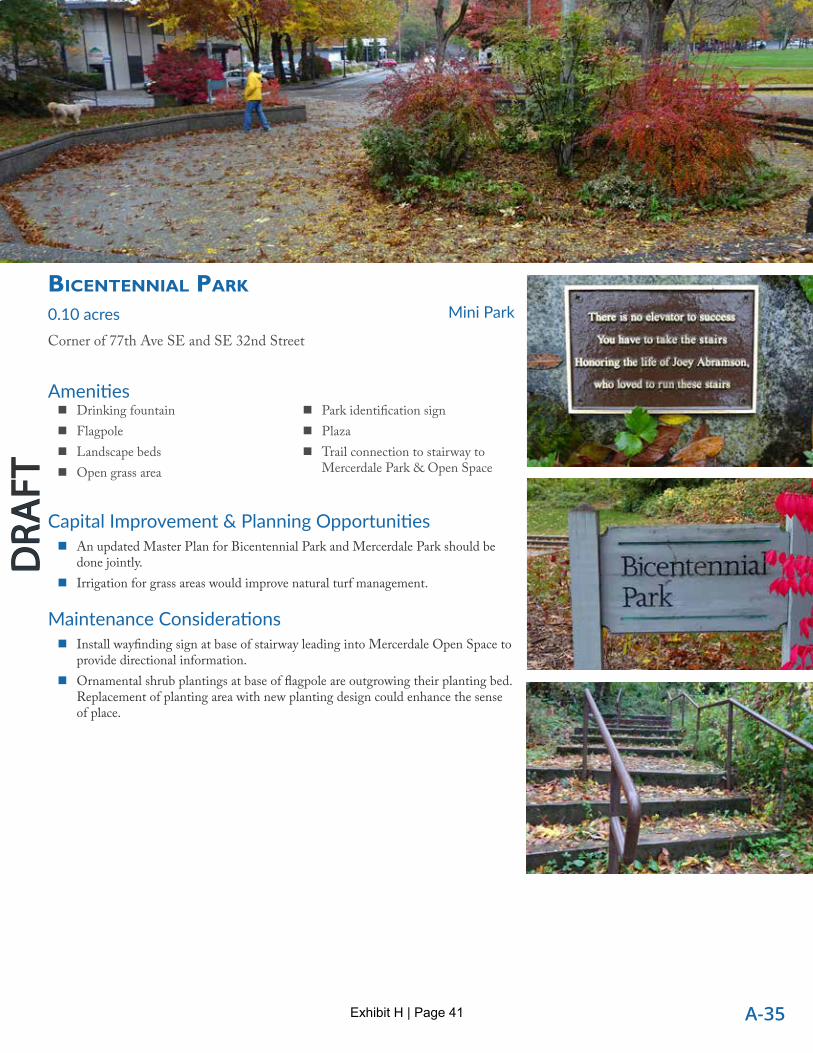
bicentenniAl PArk
0.10 acresCorner of 77th Ave SE and SE 32nd Street
Mini Park
Capital Improvement & Planning Opportunities� An updated Master Plan for Bicentennial Park and Mercerdale Park should be
done jointly.� Irrigation for grass areas would improve natural turf management.
Maintenance Considerations� Install wayfinding sign at base of stairway leading into Mercerdale Open Space to
provide directional information.� Ornamental shrub plantings at base of flagpole are outgrowing their planting bed.
Replacement of planting area with new planting design could enhance the senseof place.
� Drinking fountain� Flagpole� Landscape beds� Open grass area
� Park identification sign� Plaza� Trail connection to stairway to
Mercerdale Park & Open Space
Exhibit H | Page 41
A-36
Mercer Is land Parks, Recreation & Open Space Plan
DRA
FTD
RAFT
DRA
FTD
RAFT
Amenities
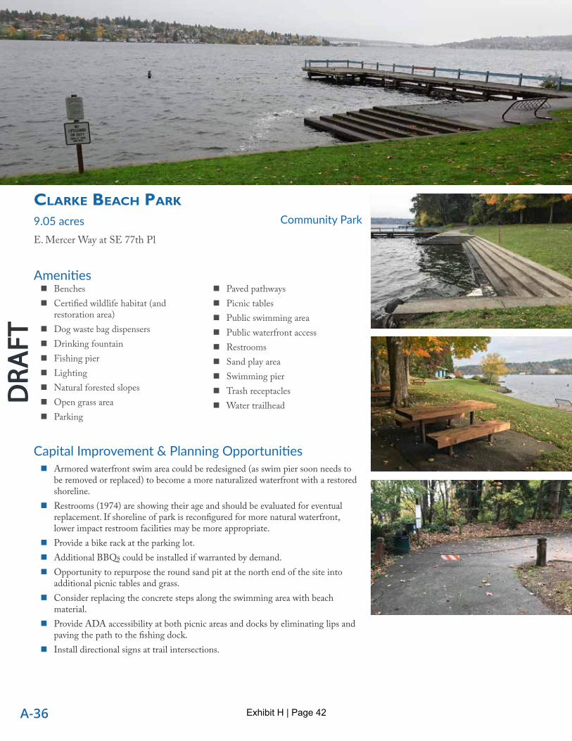
clArke beAch PArk
9.05 acresE. Mercer Way at SE 77th Pl
Community Park
Capital Improvement & Planning Opportunities � Armored waterfront swim area could be redesigned (as swim pier soon needs to
be removed or replaced) to become a more naturalized waterfront with a restored shoreline.
� Restrooms (1974) are showing their age and should be evaluated for eventual replacement. If shoreline of park is reconfigured for more natural waterfront, lower impact restroom facilities may be more appropriate.
� Provide a bike rack at the parking lot. � Additional BBQs could be installed if warranted by demand. � Opportunity to repurpose the round sand pit at the north end of the site into
additional picnic tables and grass. � Consider replacing the concrete steps along the swimming area with beach
material. � Provide ADA accessibility at both picnic areas and docks by eliminating lips and
paving the path to the fishing dock. � Install directional signs at trail intersections.
� Benches � Certified wildlife habitat (and
restoration area) � Dog waste bag dispensers � Drinking fountain � Fishing pier � Lighting � Natural forested slopes � Open grass area � Parking
� Paved pathways � Picnic tables � Public swimming area � Public waterfront access � Restrooms � Sand play area � Swimming pier � Trash receptacles � Water trailhead
Exhibit H | Page 42

A-37
DRA
FTD
RAFT
� An additional soft surface trail is possible at the south end of the site connecting the fishing dock and the parking lot.
� Clarke Beach Park is a water trailhead, so consider wayfinding signage that is oriented to the water.
� Swimming pier rail is patched and disintegrating. Likely the entire pier structure is compromised and should be replaced. Swim enclosure is falling apart, does not qualify for permits to repair because of salmon habitat issues.
Maintenance Considerations � Second ADA parking stall does not have marked travel lane to access pathway
entry. One ADA parking sign missing. � Numerous pavement cracks along pathway from swim pier to fishing pier need
repair. � The parking lot has two older globe lights that may not provide adequate
illumination and need cleaning. Consider replacing the globe lights with cut-off type lighting fixtures to reduce light pollution and provide additional fixtures at the paths to the beach.
� Sandy alluvium that appears to have come from the bank below E Mercer Way was present on the west side of parking lot.
� The drinking fountain at the upper picnic area does not work, so should be replaced or removed.
� The drinking fountain at the restroom is damaged and needs to be replaced. � Much of the site is still covered in English ivy and blackberry. Restoration efforts
should continue. � Native plant management was observed at the south and north ends of the site.
Entire site has received vegetation management. � Both asphalt trails from the parking lot have excessive cross slopes due to
slumping of the downhill edge subgrade. � One of the three timber picnic tables in the upper picnic area has excessive
longitudinal pitch and should be replaced. � If restrooms stay, they should be renovated and fitted with automatic locks on
timers. � Install raw water irrigation in the lake.
Exhibit H | Page 43

A-38
Mercer Is land Parks, Recreation & Open Space Plan
DRA
FTD
RAFT
DRA
FTD
RAFT
Amenities
DeAne’s chilDren’s PArk
3.04 acres5500 Island Crest Way
Neighborhood Park
Capital Improvement & Planning Opportunities � Children access Island Park Elementary School by foot and bike through the site, so consider extending the asphalt trail from the
parking lot to the gate in the fence on the south side of the school. This is consistent with the Pedestrian and Bicycle Facilities Plan, which calls for upgrading the existing soft surface path from the southwest corner of the park to Island Park Elementary School into a shared use path (Project S3).
� The excavator should be moved to a more visible location and set in soil that is conducive to digging. Its current location is somewhat obscured by vegetation and the soil appears to be too compacted for kids to excavate.
� Many of the thresholds into the play structures have lips that preclude ADA access. � The storage building next to the picnic shelter is unsightly and should be replaced.
Maintenance Considerations � There is a short concrete path around the trees south of the main play structure that is partially obscured by vegetation, which
could be cleared. � The play structures are in good condition, but many of the wood borders surrounding them are leaning outward or in disrepair. � The roof and skylights of the picnic shelter should be cleaned. � Swings should be replaced (2020).
� Adventure playground � Bathroom � Benches � Bike rack � Climbing rock � Dragon play structure � Excavator � Paved pathways
� Peace pole � Picnic shelter � Picnic tables (5, plus 1 ADA) � Play structures (3) � Swings (toddler and child) � Trails � Xylophones (2)
Exhibit H | Page 44
A-39
DRA
FTD
RAFT
Amenities
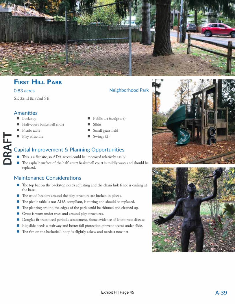
First hill PArk
0.83 acresSE 32nd & 72nd SE
Neighborhood Park
Capital Improvement & Planning Opportunities � This is a flat site, so ADA access could be improved relatively easily. � The asphalt surface of the half-court basketball court is mildly wavy and should be
replaced.
Maintenance Considerations � The top bar on the backstop needs adjusting and the chain link fence is curling at
the base. � The wood headers around the play structure are broken in places. � The picnic table is not ADA compliant, is rotting and should be replaced. � The planting around the edges of the park could be thinned and cleaned up. � Grass is worn under trees and around play structures. � Douglas fir trees need periodic assessment. Some evidence of latent root disease. � Big slide needs a stairway and better fall protection, prevent access under slide. � The rim on the basketball hoop is slightly askew and needs a new net.
� Backstop � Half-court basketball court � Picnic table � Play structure
� Public art (sculpture) � Slide � Small grass field � Swings (2)
Exhibit H | Page 45

A-40
Mercer Is land Parks, Recreation & Open Space Plan
DRA
FTD
RAFT
DRA
FTD
RAFT
Amenities
GrovelAnD beAch PArk
3.07 acresSE 58th &80th Ave SE
Community Park
Capital Improvement & Planning Opportunities � Opportunity to replace play structure with something interesting and inspiring,
such as a pyramidal rope structure affording better water views and/or a zip line. � Consider adding additional BBQs. � Consider installing a bike rack at the parking lot. � Groveland Beach Park is a water trailhead, so consider park signage that is
oriented to the water.
� BBQ (1) � Benches (3) � Bulkhead � Dock � Drinking fountains (2) � Grass area � Paved parking � Picnic tables (4)
� Playground � Restrooms � Shower � Staircase to shoreline � Swimming beach � Volleyball court with two backless
benches � Water trailhead
� The trail to the north upper picnic area is steep and moderately eroded; consider improvement opportunities. � The main asphalt path to the beach is steep (28% slope). The downhill edge of the path is beginning to slump in places. Repair as
needed. � The concrete slabs comprising the dock surface are uneven in places resulting in lips between panels that may exceed ADA
thresholds. Long-term dock replacement strategy is needed. � Install raw water irrigation intake in lake.
Maintenance Considerations � The two upper picnic tables are in poor condition and should be replaced. � The chain gate at the top of the asphalt path is closed, forcing foot traffic over a curb and grass area and prohibiting wheeled
access. Replace with bollard. � The sand from the volleyball court has migrated beyond the frame of the court down the bank toward the water, which is not a
problem per se but may require more frequent replacement of sand. � A clay subsurface drainpipe is exposed by the concrete wall at the beach and should be repaired.
Exhibit H | Page 46

A-41
DRA
FTD
RAFT
Amenities
homesteAD PArk
11.09 acresSE 40th & 82nd
Community Park
Capital Improvement & Planning Opportunities � The asphalt basketball court pad seems excessively large so could be broken into a separate basketball court and other smaller
surfaces (e.g. for foursquare). � With reduction of the asphalt pad at the basketball courts, picnic tables and BBQs could be provided between the restroom and
the basketball courts. � Opportunity to develop a loop trail through the wooded area on the south side of the park. This area could offer environmental
education for West Mercer Elementary School. � The top of the hill at the parking lot offers great prospect, but only has one bench. Consider providing additional seating
overlooking the park. � Provide additional bike racks at the baseball fields. � Install park signage at south, west and northwest entries. � 2002 Master Plan (by Bruce Dees) recommendations included additional circulation through ADA-compliant paved pathways
and a picnic area along the edge of the paved pathway at the woodland edge.
Maintenance Considerations � The brick pad at the two half benches near the northeast corner of the park needs repair. This seating arrangement works nice for
ADA accommodation, with a space between the two benches for a wheelchair, but the adjacent shrubs limit access around the benches.
� The parking lot has ADA spaces; however, the access aisles lead to a gravel path that has moderate lips at asphalt path edges. The curb ramp is abrupt and does not have a detectable warning. Consider paving the path along the west edge of the parking lot.
� Both asphalt paths leading down the bank from the parking lot have some cracks and root heave. � The play structure edging has lips that preclude ADA access. � Ponding was observed on the southwest baseball field (foul territory, third base side). � Some cracking and root heave observed on the asphalt path on the west side of the park.
� Baseball fields (2)/Soccer field, seasonal (1)
� Basketball courts (1 half courts) � Bathrooms � Benches � Bike rack
� Drinking fountain (ADA) � Paved Parking � Play structure � Public art (sculpture) � Tennis courts (4) � Trails
Exhibit H | Page 47

A-42
Mercer Is land Parks, Recreation & Open Space Plan
DRA
FTD
RAFT
DRA
FTD
RAFT
Amenities
islAnD crest PArk
38.91 acres5500 Island Crest Way
Community Park
Capital Improvement & Planning Opportunities � Opportunity to convert the south baseball field infield and outfield to synthetic
turf. � Some of the passages between and behind the ball field bleachers may not meet
ADA minimum clearances. Consider new seating / ADA approach. � The network of walking trails could be branded and signed to improve wayfinding,
particularly at park entry points. � The walking trails access several higher quality forest environments that could
benefit from benches and branding (e.g. “The Fern Garden” or “Ravine Vista”). � The picnic tables at the baseball fields would benefit from a couple of BBQs and
ADA access from the concrete walkway. � Grades are relatively mild on the walking trails, so an ADA accessible trail or loop
should be considered. � No dedicated pedestrian or bicycle access exists between the Island Crest Way
trail and the sidewalk within the park. Consider creating shoulders along the entrance drive for bicycles and pedestrians.
� Note that the Pedestrian and Bicycle Facilities Plan calls for upgrading the existing soft surface path from the southwest corner of the park to Island Park Elementary School into a shared use path (Project S3).
� Resurface tennis courts to repair cracking.
� Baseball fields (seasonal soccer & football)
� Batting cage (structure) � BBQ (1) � Benches (2 at tennis) � Bike rack � Bleachers � Concession stand � Dog waste bag dispensers (2)
� Drinking fountains � Parking � Paved pathways � Picnic tables (5) � Restroom � Synthetic turf field � Tennis courts (2) � Trails
Exhibit H | Page 48

A-43
DRA
FTD
RAFT
� Add safety railings to existing open bleachers or replace with newer bleachers that comply with International Building Code for safety.
Maintenance Considerations � The low bridge in the walking trail area is in good condition, but one of the
railings is leaning moderately. The bridge is also not ADA accessible due to excessive gap width between the planks.
� Vegetation management occurring in the natural areas. Over 30 acres of parkland is managed as open space.
Exhibit H | Page 49

A-44
Mercer Is land Parks, Recreation & Open Space Plan
DRA
FTD
RAFT
DRA
FTD
RAFT
Amenities
luther burbAnk PArk
54.52 acres72nd SE & SE 22nd
Regional Park
Capital Improvement & Planning Opportunities � Restrooms appear like concrete bomb shelters – not very inviting. As restroom
facility ages and dictates replacement, consider building designs with more natural light.
� Pier replacements could provide opportunity to design for better ADA compliance. Dock re-design project underway.
� The bulk of picnic tables and picnic groves are not universally accessible. Provide some additional pathways to ADA-compliant tables (cited as need in 2006 Master Plan).
� 2006 Master Plan recommendations yet to be completed: ‐ South entry improvements - kayak/canoe boat launch with path & dock ‐ Source Area - pathway, irrigation & drainage improvements ‐ Expanded Swim Beach - with new restroom/lifeguard building, added sand play area
and volleyball court
� Waterfront access & beach � Park and Rec administration bldg. � Parking (2 lots) � Restrooms � Amphitheater � Tennis courts � Playgrounds � Paved pathways � Picnic tables some with umbrellas � BBQ grills � Benches � Trash & recycling receptacles � Dog waste bag dispensers � Flagpole � Lighting � Drinking fountains
� Off-leash dog areas (large & small) � Dairy barn ruins � Open grass lawns � Shade trees � Natural areas � Boardwalk � Observation platform � Interpretive signs � Wayfinding maps � Kiosk � Public art � Peace pole � Wall mural (@ tennis courts) � Mosaic at playground � Main entry pergola walkway � Water trailhead
Exhibit H | Page 50

A-45
DRA
FTD
RAFT
‐ Main Entry improvements – pavement treatment and overlook addition ‐ Campus Area – new recreational amenities, covered group picnic shelter, maintenance
yard upgrades, entry road enhancements ‐ Dock/Boiler Building Area – pier restoration, improved access, rowing/boating facility
‘shell’ house, improved shoreline beach access, security & utilities upgrades ‐ Shoreline – improved vegetation management, environmental learning & wayfinding
components ‐ Amphitheater – replacement of aging infrastructure & terracing ‐ Off-Leash Areas – addition of covered shelter & benches ‐ Calkins Point – addition of covered shelter & art installations
� Proposed 2006 Master Plan spatial layout of the West Hill P-patch gardens should be modified to accommodate the current (working) garden plot alignments. Buffer planting enhancements and loop pathways could remain as future improvements but with modified alignments.
� Fishing pier is not universally accessible. Planned trail/pathway improvements will improve better ADA access. Piers have been evaluated by marine engineer for safety and timing of needed replacement (reported in 2014 overwater structures assessment).
� Moorage was built in 1974. Over 40 years old, the piers and entire structures should be scheduled for replacement. Re-design project is underway.
� Tennis court is wavy. DA Hogan report indicates need for full repaving. Consider whether other recreational amenities could share or replace the tennis courts which currently have chronic drainage problems due to elevation.
� Boiler Building study 2017 calls for seismic retrofits, new roof as Phase 1. Phase 2 is conversion to office and classroom for small boat facility.
Maintenance Considerations � ADA parking at south parking lot lacks striped travel aisle for 2nd stall. � Pavement cracks along pathway to south parking lot. � ADA access barrier into fire engine play area at entry. � Erosion at south beach area where waves hit edges of armored walls, paths and steps. � Edge of paved plaza at Boiler Building is failing and roped off. Repairs underway. � Restroom signs are not ADA-compliant. Add uniform gender designations with ADA signs. � Beavers have gnawed at Lombardy poplar trunks, weakening tree structure. Plan for removal and replacement with native Pacific
NW tree species. � Playground needs two new pieces. � Source landform sculpture needs some restoration. � Add raw water irrigation intake to water Calkins Point and south beach. � Continue restoration of 84th slope and wetlands and Hawthorn Hill forest.
Exhibit H | Page 51

A-46
Mercer Is land Parks, Recreation & Open Space Plan
DRA
FTD
RAFT
DRA
FTD
RAFT
Amenities
mercerDAle PArk
12.17 acresSE 32nd St & 78th Ave SE
Community Park
Capital Improvement & Planning Opportunities � Side entrance pathways into park would benefit from park identification signage
(smaller signs). � Playground equipment should be replaced. Project is underway. � Plan for replacement of Callery pear trees in ‘Bosque’ arrangement in plaza. When
tree species is selected for replacement, native tree species should be chosen. If opportunity arises, soil-root zone for planting pit should be expanded to support longer life for trees.
� Opportunity for stormwater enhancement planting in drainage swale near Thrift Shop parking.
� Recycling Center and Native Plant Garden need integrated plan. Native plant garden is planted on Groco biosolids over native glacially-compacted fine textured strata. Plant performance is inadequate for a representative native plant garden as a result. Adjacent hillside shows similar low performance in native vegetation.
� Storage building showing signs of age. Downspouts need repair. Fixtures in restrooms replaced in 2010. Bathroom roof being replaced 2020.
� Benches � Bike rack � Drinking fountain � Exercise stations � Memorials (Trees, pavers, etc.) � Native garden � Natural area � Open grass lawn � Ornamental landscapes � Park signs � Paved loop pathway � Peace pole
� Pergola � Picnic tables with umbrellas � Playground � Plaza � Public art � Recycling center � Restrooms � Shade trees � Sizzling Water garden � Skate park � Trash receptacles
Exhibit H | Page 52

A-47
DRA
FTD
RAFT
� Original Master Plan done in 2001 and should be updated. Integrate planning with Bicentennial Park.
Maintenance Considerations � Plantings should consider heavily impacted soils from excavation and grading.
Dense glacially-compacted fine textured soils without organic matter or profile development.
� Sweetgum tree stump that is suckering could be trained to a multi-stemmed tree if suckers are thinned.
� Hedge of strawberry trees should be pruned away from backs of benches in plaza area – or benches should be shifted away from hedge encroachment. Hedge is also beginning to encroach into side entrance walkway.
� Callery (Bradford) pears are beginning to outgrow iron grates. Plan for grate replacement to allow tree trunk growth (or eventual replacement with preferred tree species). Uneven grate edges present tripping hazard.
� Exercise stations are not ADA compliant due to uneven paved surfaces and edging.
� Park and skate park signage needs updating.
Exhibit H | Page 53

A-48
Mercer Is land Parks, Recreation & Open Space Plan
DRA
FTD
RAFT
DRA
FTD
RAFT
Amenities
roAnoke PArk
1.46 acres70th Ave SE &W Mercer Way
Neighborhood Park
Capital Improvement & Planning Opportunities � Install a park sign (none exists) and a bike rack � Installation of a timber rail along the top of the slope along W Mercer Way would
help define the west edge of the lower portion of the park and help prevent young children from venturing too close to the road.
� The shrubs along the east side of the tennis court could be removed and replaced with grass to create a more open feel and forgiving edge for errant tennis balls and provide a place for people to watch or wait. New backed benches could be located near the tennis court.
� Install new stairs leading to the tennis court. � In the lower part of the park, a maple and a fir tree are conjoined at the base,
which is an interesting natural feature that could be celebrated with signage or ground plane design.
� The wood frames around the play structures are coming apart and leaning outward in places. The playground should be aevaluated for replacement.
� There is no ADA access.
Maintenance Considerations � The tennis court has a lot of cracks, but all are narrow. � The top tape on the tennis net is frayed needs to be replaced. � The steps leading to the tennis court are degraded and should be replaced. � The grass has a few bald spots but is generally fine.
� Art piece totem � Benches � Drinking fountain � Gravel parking (2 spaces) � Native trees
� Open grass area � Play structures (Climbing, rope,
swing) � Tennis court (1)
Exhibit H | Page 54

A-49
DRA
FTD
RAFT
Amenities
rotAry PArk 4.83 acres88th SE & SE 44th
Neighborhood Park
Capital Improvement & Planning Opportunities � The park has a central ‘plaza’ area with 2 benches facing the ‘rock garden’. The
picnic table is outside the central area and open to the street. Some picnic tables or small picnic shelter could be added to the central open area in the park to create a place that’s more comfortable to gather.
� The isolated picnic table is not connected to the paved pathway and does not meet ADA guidelines. A paved path could be added to the table or another picnic table (within a small shelter) could be added to the central open area to meet the 50% minimum for ADA site furnishings.
� Replace benches with the same style bench so that they match.
Maintenance Considerations � None noted.
� Benches � Emergency well � Open grass areas � Park ID sign � Paved pathways � Peace pole
� Perimeter loop trail � Picnic table � Rock garden � Shade trees � Trails � Trash receptacles
Exhibit H | Page 55

A-50
Mercer Is land Parks, Recreation & Open Space Plan
DRA
FTD
RAFT
DRA
FTD
RAFT
Amenities
se 28th street mini PArk
0.06 acresSE 28th Street
Mini Park
Capital Improvement & Planning Opportunities � Consider the future opportunity to provide ADA access to bench with a paved
trail. � This site might benefit from a design for a more functional park. � Opportunity to reestablish the view that may have existed from this park. � The Aubrey Davis Park master plan calls for a staircase to connect from the lid to
somewhere near this location.
Maintenance Considerations � Slab stairs are uneven and likely do not meet code. Remove stairs and develop a
paved path that connects to the sidewalk at the far southeast corner of the site. � This site may have afforded a nice view of the water and mountains at one point,
but the trees have grown and blocked the view. Consider selectively thinning to open up the view.
� Bench � Open grass area
Exhibit H | Page 56

A-51
DRA
FTD
RAFT
Amenities
secret PArk
0.86 acresSE 27th &W Mercer Way
Mini Park
Capital Improvement & Planning Opportunities � Install a park sign at the north, open end of the site. � Trails need some design. Entire park should undergo site design (mini-master
plan) to determine what recreational amenities could be added and how trails or pathways should be configured.
� There is no parking for this park. Add ADA parking. � Consider installing a zip line.
Maintenance Considerations � The one trail is primitive and overgrown. � The site is thick with underbrush. � Big fir trees need monitoring.
� Play structure � Swings � Picnic table (not ADA) � Small grass area
Exhibit H | Page 57
A-52
Mercer Is land Parks, Recreation & Open Space Plan
DRA
FTD
RAFT
DRA
FTD
RAFT
Amenities
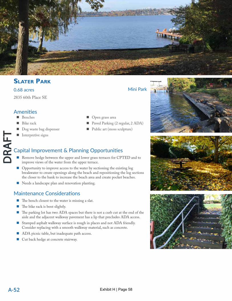
slAter PArk
0.68 acres2835 60th Place SE
Mini Park
Capital Improvement & Planning Opportunities � Remove hedge between the upper and lower grass terraces for CPTED and to
improve views of the water from the upper terrace. � Opportunity to improve access to the water by sectioning the existing log
breakwater to create openings along the beach and repositioning the log sections the closer to the bank to increase the beach area and create pocket beaches.
� Needs a landscape plan and renovation planting.
Maintenance Considerations � The bench closest to the water is missing a slat. � The bike rack is bent slightly. � The parking lot has two ADA spaces but there is not a curb cut at the end of the
aisle and the adjacent walkway pavement has a lip that precludes ADA access. � Stamped asphalt walkway surface is rough in places and not ADA friendly.
Consider replacing with a smooth walkway material, such as concrete. � ADA picnic table, but inadequate path access. � Cut back hedge at concrete stairway.
� Benches � Bike rack � Dog waste bag dispenser � Interpretive signs
� Open grass area � Paved Parking (2 regular, 2 ADA) � Public art (moss sculpture)
Exhibit H | Page 58

A-53
DRA
FTD
RAFT
Amenities
south mercer PlAyFielDs
17.31 acresSE 78th & 84th SE
School / Park
Capital Improvement & Planning Opportunities � If the school district is willing to increase the recreational amenities on the site,
the open area in the southeast corner of the site can accommodate additional program elements, such as: a half or full court basketball court, skate spot, P-patch, expansion of the playground, or expanded picnic area with BBQs and a shelter.
� Opportunity to upgrade the northwest baseball field by constructing covered dugouts and installing synthetic turf in the infield.
� Currently the only pedestrian access from the sidewalk/path along SE 78th Street to the site is through the parking lot. Consider installing a sidewalk connection around southwest corner of the parking lot.
� Baseball/softball fields: (three 60’ fields with synthetic turf infield, one 90’(?) field with dirt infield
� BBQ (1) � Benches (2) � Bike rack (1) � Bleachers � Concession stand
� Indoor batting cage (structure) � Parking � Paved pathways � Picnic tables (2) � Playground � Restrooms � Seasonal soccer and lacrosse fields
� Small park signs could be installed at each entrance. � Islander Middle School could use more bike parking, as bikes are spilling out onto the track. � Cottonwoods are not an appropriate tree for this site. Replacement should be plated via a landscape plan.
Maintenance Considerations � The playground is not ADA accessible due to a lip at the entry gate and unsuitable surfacing. � The northwest baseball field spectator area is not ADA accessible. � The foul poles on field #1 should be integrated with the outfield fence, not behind it. � One of the two aluminum bleachers at the synthetic field south of Islander Middle School is badly dented.
Exhibit H | Page 59

A-54
Mercer Is land Parks, Recreation & Open Space Plan
DRA
FTD
RAFT
DRA
FTD
RAFT
Amenities
WilDWooD PArk 2.84 acres7400 86th Ave SE
Neighborhood Park
Capital Improvement & Planning Opportunities � Amenity area could be more defined, with crushed rock surface in lieu of spotty
grass. � Opportunity for an ADA accessible soft surface perimeter path along 86th Ave
SE and around the grass area connecting to the amenities. � Consider an ADA trail connection from Island Crest Way to 86th Ave SE. � No ADA access to picnic table or other parts of the park. � Consider park sign on Island Crest Way frontage.
Maintenance Considerations � Grass is spotty by picnic area. � Evidence of moles digging holes in the grass near the picnic table. � Short, 30” wide boardwalk is in good condition. � Lots off-leash dog walking/play/fetching observed (weekday morning). � All amenities in good condition. � Soft surface trails are relatively smooth except for a few locations with roots. � Two trash receptacles, but no recycling.
� Bench (1) � Book exchange box � Dog waste bag dispenser � Natural areas � Open grass area
� Peace Pole � Picnic table (1) � Trails � Trash receptacles (2)
Exhibit H | Page 60

A-55
DRA
FTD
RAFT
Amenities
cAyhill oPen sPAce
1.08 acres5400 Mercer Way
Open Space
Capital Improvement & Planning Opportunities � None.
Maintenance Considerations � The site is steep and overgrown. Trash has been dumped into the ravine along the
south edge of the site. � Vegetation management for canopy retention.
� None
Amenities
clise PArk
1.47 acresSE 40th & Island Crest Way
Open Space
Capital Improvement & Planning Opportunities � The site is centrally located and has high visibility from Island Crest Way and
SE 40th Street, as an open space more amenities may not be warranted. If the demand for more developed park spaces should grow, this site could be developed into more high profile park.
� Potential for an art installation or earthwork.
Maintenance Considerations � The park sign is at the intersection of Island Crest Way and SE 40th Street has
lots of clutter around it. Consider moving the sign away from the intersection toward the SE 40th Street path junction.
� Trail
Exhibit H | Page 61

A-56
Mercer Is land Parks, Recreation & Open Space Plan
DRA
FTD
RAFT
DRA
FTD
RAFT
Amenities
ellis PonD PArk
4.04 acres90th Avenue SE
Open Space
Capital Improvement & Planning Opportunities � Opportunity for environmental interpretation signs about habitat and water
treatment. � Wayfinding trail signs could help identify location and directional information.
Maintenance Considerations � Connection to boardwalk from path has barrier to ADA access. Trail needs more
crushed rock surfacing to remove grade difference. � Root intrusions occurring along trail. � Boundary definition with adjacent residences may be an issue. Encroachment
should be evaluated.
� Benches � Boardwalk � ‘Don’t feed ducks’ signs � Natural area/ certified wildlife habitat
� Park Sign � Pond � Trails � Trash receptacles
Exhibit H | Page 62

A-57
DRA
FTD
RAFT
Amenities
enGstrom oPen sPAce
8.5 acresE. Mercer Way
Open Space
Capital Improvement & Planning Opportunities � Trail network could benefit from wayfinding signage system by providing
locational and directional information to trail users. � Interpretive signage about restoration efforts and the value of management of
healthy forests could be added in key locations.
Maintenance Considerations � Timber stairs, retaining walls, bridge, turnpike, and other trail structures require
regular monitoring to repair settling, shifting, rotting wood, etc.
� Benches � Bridge � Map sign
Amenities
GAllAGher hill oPen sPAce
11.29 acres3701 SE Gallagher Hill Rd
Open Space
Capital Improvement & Planning Opportunities � Explore the feasibility of developing a trail connection up the ravine to the top of
SE Gallagher Hill Road or through the SE 36th Street ROW on the west side of the site.
Maintenance Considerations � The trail crosses two small drainages. One crossing has a small culvert, the
capacity of which has recently been exceed, as the trail at this location has been slightly washed out.
� The two bridges are in good condition but have a slight lip where they meet grade.
� Bridges � Pea Patch (unofficial)
� Restoration areas � Trail network � Trail signs
� Park sign � Trail
Exhibit H | Page 63

A-58
Mercer Is land Parks, Recreation & Open Space Plan
DRA
FTD
RAFT
DRA
FTD
RAFT
Amenities
hollerbAch oPen sPAce
5.23 acresSE 45th St & 91st Ave SE
Open Space
Capital Improvement & Planning Opportunities � Potential trail system has had scoping and geotechnical evaluation.
Maintenance Considerations � Managed as open space.
� None
Amenities
mercerDAle hillsiDe oPen sPAce
18.59 acres-----
Open Space
Capital Improvement & Planning Opportunities � Trail network could benefit from wayfinding signage system by providing
locational and directional information to trail users.
Maintenance Considerations � Extensive sets of timber stairways require regular inspection and monitoring
to ensure adequate tread stability. Some stair sections could be evaluated to be unnecessary where trail gradient does not require built steps. Removal of unnecessary stairways could help reduce burden of constant monitoring, repair and replacement. Some timber stairways should have crushed stone tread areas filled to compensate for settling.
� Managed as open space.
� Trail system � Natural area � Timber stairways � Handrails � Restoration areas
� Bike rack � Benches � Bollards � Signs � Certified wildlife habitat
Exhibit H | Page 64

A-59
DRA
FTD
RAFT
Amenities
north mercerDAle hillsiDe oPen sPAce 5.11 acres7415 SE 27th St
Open Space
Capital Improvement & Planning Opportunities � Opportunity to develop additional trails at the north end of the site. � Consider installing additional benches. � Only one of the four entrances to this site has a park sign. Park signs should be
added to each entrance. � Internal wayfinding signs would be beneficial.
� Benches � Bridge � Handrails
� Timber stairways � Trails
Amenities
PArkWooD riDGe oPen sPAce
3.79 acres9165 Parkwood Ridge Rd
Open Space
Capital Improvement & Planning Opportunities � This open space could be part of a loop with SE 53rd Street Open Space through the use of on-street wayfinding system. � The trail could use a bench or two for resting and enjoying the natural setting.
Maintenance Considerations � The lower park sign is split horizontally and separated from the bottom two lag screws. � The trail is well built and in excellent condition. � Managed as open space.
� Trail � Park signs at top and bottom
Maintenance Considerations � Many of the stairways need replacing due to extremely slippery treads, settling of interior tread fill. � Many of the posts for stair handrails are split and/or rotting; handrails may not meet code. � Vegetation is thick and has invasive plants in many locations. � No dedicated parking apparent at this site. � Trails are in good condition, but in some locations have excessive cross slope (e.g. 75th Ave SE trail intersection with SE 29th
Street stairs).
Exhibit H | Page 65

A-60
Mercer Is land Parks, Recreation & Open Space Plan
DRA
FTD
RAFT
DRA
FTD
RAFT
Amenities
Pioneer PArk
188.85 acresIsland Crest Way & SE 68th St
Open Space
Capital Improvement & Planning Opportunities � Trail network could benefit from wayfinding signage system by providing locational and directional information to trail users. � Consider trail lighting on the paved trail (access for all). � Signs with Pioneer Park and Engstrom Open Space maps provide some directional information, but numerous trail intersections
are unmarked. Small metal map signs at some intersections are not intuitive since the “you are here” marker is the same screw top as the corner screws.
� Master Plan 2001 recommendations also included trail improvements, viewpoints, street crossings, interpretive signage, boundary marking and landscape enhancements.
� Laminated root rot (Armillaria) management plan needed.
Maintenance Considerations � Aging interpretive signs should be scheduled for replacement. � Some timber stairways require regular inspection and monitoring to ensure adequate tread stability. Some stair sections could be
evaluated to be unnecessary where trail gradient does not require built steps. Removal of unnecessary stairways could help reduce burden of constant monitoring, repair and replacement.
� Address erosion around ravine bridge. � Restoration work continues per extensive history of planning and reinvestment. � Conflicts between roots and trails create ongoing maintenance. � Periodic replacement of log furniture in kiosk area. � Donation benches plan/policy. 2001 Master Plan recommended a standard bench type. � Trail decommission/reroutes based on ongoing trail assessments. � Remove parking above (east of ) curb on 84th.
� Benches � Dog waste bag dispensers � Interpretive signs � Kiosk � Limited on-street parking � Park signage with maps � Picnic tables
� Port-a-potty � Public art (totem) � Restoration areas � Trail network consists of paved
pathways, crushed stone trails & natural trails
� Trash receptacles � Wayfinding signs
Exhibit H | Page 66
A-61
DRA
FTD
RAFT
Amenities
sAlem WooDs oPen sPAce
0.32 acres6300 90th Ave SE
Open Space
Capital Improvement & Planning Opportunities � Potential trailhead to Pioneer Park/Engstrom with easements on adjacent
property.
Maintenance Considerations � Steep slope covered in ivy.
� None
Amenities
se 47th street oPen sPAce
1.27 acres4701 E Mercer Way
Open Space
Capital Improvement & Planning Opportunities � Potential trail connecting to 91st Ave SE identified in 2010 ped bike plan project
C12.
Maintenance Considerations � Managed as open space.
� None
Exhibit H | Page 67

A-62
Mercer Is land Parks, Recreation & Open Space Plan
DRA
FTD
RAFT
DRA
FTD
RAFT
Amenities
se 50th street oPen sPAce
1.78 acresSE 50th Street and Island Crest Way
Open Space
Capital Improvement & Planning Opportunities � A trail connection from 88th Avenue SE at the north end of the side to Island
Crest Way may be possible, but this ravine is steep and overgrown.
Maintenance Considerations � A rogue trail appears to access the south end of this open space below the
residence at 5030 88th Ave SE. � Managed as open space.
� None
Amenities
se 53rD street oPen sPAce
24.01 acres9100 SE 53rd Pl
Open Space
Capital Improvement & Planning Opportunities � Opportunity to install additional benches at scenic locations. � Trail intersections would benefit from wayfinding signs. � Create a protected walkway from the parking area at the bottom of SE 53rd
Street to the trailhead on E Mercer Way. � The trail could be part of a loop with Parkwood Ridge Open Space through the
use of on-street wayfinding system.
Maintenance Considerations � Existing stairs are in good condition. � Existing bench is worn and spartan. Consider replacing with a more rustic timber
bench. � Managed as open space.
� Trails � Benches
� Gravel parking (on road shoulder)
Exhibit H | Page 68
A-63
DRA
FTD
RAFT
Amenities
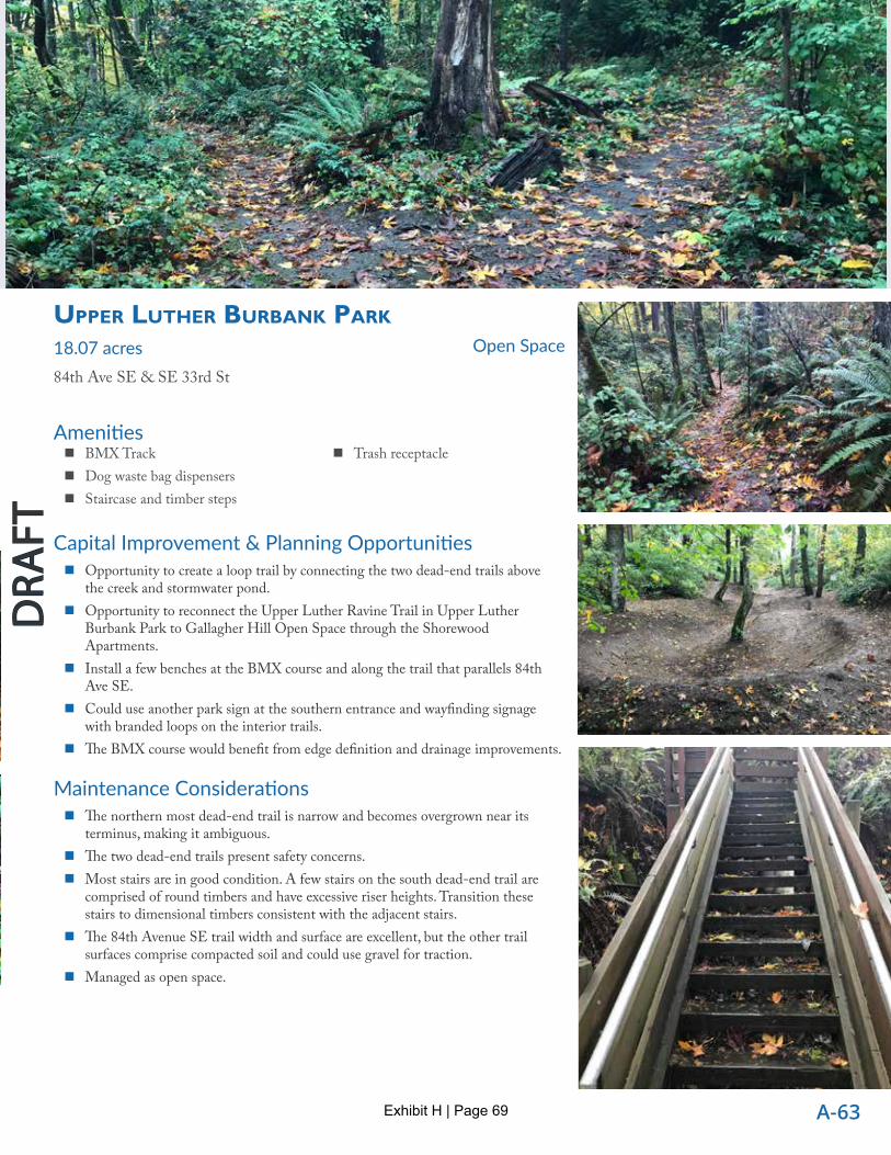
uPPer luther burbAnk PArk 18.07 acres84th Ave SE & SE 33rd St
Open Space
Capital Improvement & Planning Opportunities � Opportunity to create a loop trail by connecting the two dead-end trails above
the creek and stormwater pond. � Opportunity to reconnect the Upper Luther Ravine Trail in Upper Luther
Burbank Park to Gallagher Hill Open Space through the Shorewood Apartments.
� Install a few benches at the BMX course and along the trail that parallels 84th Ave SE.
� Could use another park sign at the southern entrance and wayfinding signage with branded loops on the interior trails.
� The BMX course would benefit from edge definition and drainage improvements.
Maintenance Considerations � The northern most dead-end trail is narrow and becomes overgrown near its
terminus, making it ambiguous. � The two dead-end trails present safety concerns. � Most stairs are in good condition. A few stairs on the south dead-end trail are
comprised of round timbers and have excessive riser heights. Transition these stairs to dimensional timbers consistent with the adjacent stairs.
� The 84th Avenue SE trail width and surface are excellent, but the other trail surfaces comprise compacted soil and could use gravel for traction.
� Managed as open space.
� BMX Track � Dog waste bag dispensers � Staircase and timber steps
� Trash receptacle
Exhibit H | Page 69

A-64
Mercer Is land Parks, Recreation & Open Space Plan
DRA
FTD
RAFT
DRA
FTD
RAFT
Amenities
cAlkins lAnDinG
0.31 acresSE 28th St & 60th Ave SE
Street End
Capital Improvement & Planning Opportunities � Install a bike rack near the west end of the parking lot. � This is one of the few parks with excellent ADA accommodation, however it
lacks ADA parking spaces. Consider converting one parking space in the parking lot into an ADA space. Nearby on-street parking appears adequate.
Maintenance Considerations � Park looks great.
� Benches � Paved parking (3, but no ADA spaces)
� Picnic table (ADA) � Open grass area
Amenities
Forest lAnDinG
0.03 acresSE 43rd St & Forest Ave SE
Street End
Capital Improvement & Planning Opportunities � Fixed concrete pump station vaults and poor water access preclude additional
design opportunities.
Maintenance Considerations � The site could be signed.
� Bench
Exhibit H | Page 70

A-65
DRA
FTD
RAFT
Amenities
FrAnklin lAnDinG
0.03 acres78th Ave SE & SE 42nd St
Street End
Capital Improvement & Planning Opportunities � ADA access is possible here, though no ADA parking space.
Maintenance Considerations � Nice street end with great stone steps to small gravel beach. � Gravel bench pad is becoming overgrown with grass.
� Bench � Gravel beach � Informal parking at street end (2
spaces) � Moveable armchairs
� Open grass area � Park sign � Trash receptacle � Water Trail trailhead
Amenities
FruitlAnD lAnDinG
0.15 acres97th Ave SE & SE 34th St
Street End
Capital Improvement & Planning Opportunities � This site has a gentle grade down to the water’s edge, so can easily be made ADA
accessible, although there is no dedicated parking, only on-street parking nearby. � This site is getting totally reconstructed with a new pump station LS11. Any
considered future improvements should be deferred until pump station is completed.
Maintenance Considerations � Nice landing with relatively open view north. � The park sign is slightly weathered.
� Bench � Picnic table (not ADA) � Park sign
� Small grass area � Water trailhead
Exhibit H | Page 71

A-66
Mercer Is land Parks, Recreation & Open Space Plan
DRA
FTD
RAFT
DRA
FTD
RAFT
Amenities
GArFielD lAnDinG
0.34 acresSE 30th St & 60th Ave SE
Street End
Capital Improvement & Planning Opportunities � Consider installing a bike rack near the edge of the asphalt drive aisle. � Opportunity to install one or two new benches that provide better views of the water. � Vegetation along the bank could be cleared to provide better access to the water. � Garfield Landing is a water trailhead, so consider park signage that is oriented to the water.
Maintenance Considerations � The bench is weathered, worn and outdated. � The bank is overgrown with shrubs and constrains access to the beach and water. These shrubs could be removed to some extent
to provide better access. � A “doggydock” (portable mat to create easy dog access to the water) has been placed on the beach and may be a user-placed
amenity. � This site has no parking. � White poplars are weak wooded, need to be managed for replacement with more reliably sturdy native canopy trees species.
� Bench � Open grass area
� Water Trail trailhead
Amenities
lincoln lAnDinG
0.23 acres76th Ave SE & SE 22nd St
Street End
Capital Improvement & Planning Opportunities � This site has a gentle grade down to the water’s edge, so can easily be made ADA accessible, although there is no dedicated
parking, only on-street parking nearby. � Improvements to the drainage that flows along the west side of this site (like Calkins Landing) are planned through King County
Flood Control funding
Maintenance Considerations � No park sign. � The drainage that flows along the west side of this site is overgrown and contains trash that will be totally redone. � Giant sinkhole under paving.
� Picnic tables (2, none ADA) � Concrete steps leading to gravel beach
� Overhead shoebox light (1) � Small grass area
Exhibit H | Page 72

A-67
DRA
FTD
RAFT
Amenities
miller lAnDinG
0.30 acresForest Ave SE & SE 48th St
Street End
Capital Improvement & Planning Opportunities � Opportunity to install a sign, improve the path at the bottom of the staircase, and install a bench at the concrete utility vault. � Design the access across the driveway to feel more inviting.
Maintenance Considerations � Lower portion of site at water is overgrown with ivy. The “cable crossing” sign adds character to the site but is faded and
overgrown with ivy.
� Wooden steps and trail to shore
Amenities
Proctor lAnDinG
0.30 acresSE 32nd St & 60th Ave SE
Street End
Capital Improvement & Planning Opportunities � One or two benches could be added near the beach. � If this site is mainly used for “cartop boat launching,” consider replacing the elevated dock with a low floating dock to
accommodate watercraft with low freeboards. � Proctor Landing is a water trail trailhead, so consider park signage that is oriented to the water. � Consider installing an outdoor shower to support boating activities, if public demand and use of water trail indicates the need. � Install a bike rack at the west end of the parking lot.
Maintenance Considerations � The south end of the parking area is illuminated by a single Cobra head light. � The grass near the beach is well worn, likely due to watercraft launching activity. � Relocate the trash receptacle at the west edge of the parking lot.
� Paved parking (12, no ADA) � Small grass area � Water trailhead
Exhibit H | Page 73

A-68
Mercer Is land Parks, Recreation & Open Space Plan
DRA
FTD
RAFT
DRA
FTD
RAFT
Amenities
roAnoke lAnDinG
0.18 acresWest Mercer Way & Roanoke Way
Street End
Capital Improvement & Planning Opportunities � The old concrete roadway extending all the way to the concrete breakwater could be removed to create a landscaped park/street
end containing additional amenities, such as picnic tables. It may also be possible to provide a couple of parking spaces within the street end. A natural drainage feature running the length of site could be integrated in the design and possibly qualify for stormwater LID funding.
� This site has a gentle grade down to the breakwater so can easily be made ADA accessible, although there is no dedicated parking, only on-street parking nearby.
� The water’s edge comprises a 3-4’ high concrete wall (former ferry landing) with no water access or formal parking. The site offers expansive water views, has historic significance, and could accommodate additional amenities.
Maintenance Considerations � Although an interpretive sign exists, there is no park sign.
� Bench � Interpretive sign
Amenities
72nD Ave se lAnDinG
0.17 acres1605 72nd Ave SE
Street End
Capital Improvement & Planning Opportunities � Minimal parking. � Opportunity to install a bench or two. � Install a sign to identify public access (feels private).
Maintenance Considerations � No amenities, but very nice grass open space to gravel beach. � Great trees and nice landscaping! � Good view to the north. � ADA accessibility is prohibitive.
� None
Exhibit H | Page 74

A-69
DRA
FTD
RAFT
Amenities
74th Ave se0.05 acres----
Street End
Capital Improvement & Planning Opportunities � Opportunity to install a bench. � Sign to identify public access (feels very private). � No parking. � No true path. � Not ADA accessible.
Maintenance Considerations � None noted.
� No amenities but intimate grass area at small gravel beach.
Amenities
se 56th street lAnDinG
0.21 acres5495 W Mercer Way
Street End
Capital Improvement & Planning Opportunities � Relatively generous site. � Install sign at the end of Brook Bay Road to identify public access (feels private). � Could easily be made ADA accessible. � Develop and sign the steep, primitive trail connection up to 80th Avenue SE. � This is a relatively generous site with a concrete sewer vault at the water and a small fenced enclosure. � Limited parking along Brook Bay Road.
Maintenance Considerations � Replace existing bench.
� Bench � Nice trees!
Exhibit H | Page 75

A-70
Mercer Is land Parks, Recreation & Open Space Plan
DRA
FTD
RAFT
DRA
FTD
RAFT
Amenities
se 72nD street lAnDinG
0.12 acres9603 SE 72nd Place
Street End
Capital Improvement & Planning Opportunities � No design opportunities. The site is comprised entirely of the Metro pump station.
Maintenance Considerations � None.
� None
Amenities
south Point lAnDinG
0.03 acres8790 85th Ave SE
Street End
Capital Improvement & Planning Opportunities � Opportunity to install a bench or two. � No signs. � No parking. � Not ADA accessible. � The short trail from the street down to the vault could be improved by adding steps.
Maintenance Considerations � Sewer vault comprises the lower portion of the site. � The site has great south aspect and expansive views of Lake Washington to the south, but beach access is rocky. � Existing bench is worn and spartan. Consider replacing with a more rustic timber bench. � Adjacent property is using part of the public right of way at the site for parking. � Existing plants could be supplemented with low-maintenance native plants.
� Tether Ball (rogue)
Exhibit H | Page 76

A-71
DRA
FTD
RAFT
Amenities
77th Ave se lAnDinG
0.29 acres7670 SE 22nd St
Street End
Capital Improvement & Planning Opportunities � This site has a moderate grade down to the concrete breakwater so could possibly be made ADA accessible, although there is no
dedicated parking, only on-street parking nearby. � No water access due to low concrete breakwater.
Maintenance Considerations � The primitive timber steps are worn and rotting in places. The grade to the water is moderate and could be turned into a gravel
path.
� Arbor with wisteria � Bench � Open grass area
� Park sign � Trash receptacle � Water trailhead
Exhibit H | Page 77