Connecting Water to Water Physical Planning Practicum · 2015-02-09 · Connecting Water to Water 1...
16
Connecting Water to Water 1 Physical Planning Practicum CRP 685: Planning Studio Dr. Junfeng Jiao Group Three Coleen Gentles Jonathan Mosteiro Samuel Rojas December 10, 2014 South Central Austn Waterfront
Transcript of Connecting Water to Water Physical Planning Practicum · 2015-02-09 · Connecting Water to Water 1...

Connecting Water to Water 1
Physical Planning Practicum
CRP 685: Planning StudioDr. Junfeng Jiao
Group ThreeColeen Gentles
Jonathan MosteiroSamuel Rojas
December 10, 2014
South Central Austn Waterfront
Connecting Water to Water 2
REGIONAL CONTEXT AND DESIGN CONCEPT
DIAGRAMS
EAST BOULDIN CREEK
AERIAL OVERVIEW
LADY BIRD LAKE
MIXED-USE DEVELOPMENT
PRO FORMA AND CONCLUSION
SECTIONS
SITE PLAN
PHASING
PAGES 3-4
PAGE 6
PAGES 8-9
PAGE 5
PAGES 10-11
PAGE 13
PAGE 16
PAGE 12
PAGE 7
PAGES 14-15
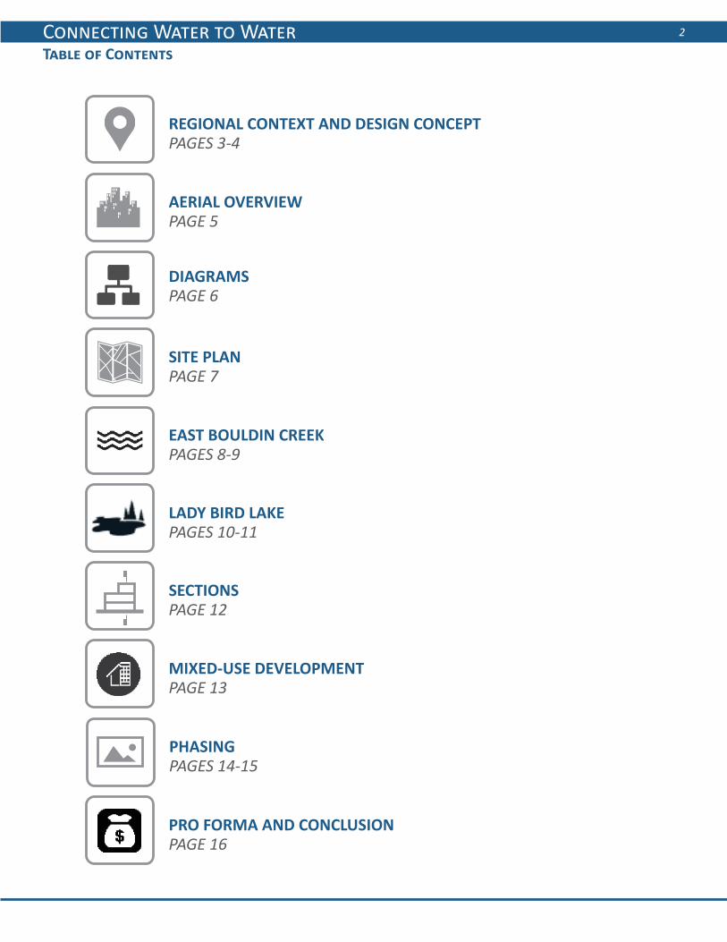
Table of Contents

Connecting Water to Water 3
Regional Context
The South Central Waterfront is situated in the heart of Austin, directly across Lady Bird Lake from Austin’s burgeoning downtown, stretching between South First Street and East Bouldin Creek. The proximity to Austin’s revered Hike & Bike Trail situates the site squarely in the midst of Austin’s recreational identity. While the Lady Bird Lake waterfront experiences a high level of activity, East Bouldin Creek remains a relatively obscure environmental feature on few Austinite’s radar. It is much less accessible than any other central Austin creek, and presents a real opportunity to further engage the South Central Waterfront with a natural amenity intrinsically linked to the city’s psyche.

Connecting Water to Water 4
Introduction and Design Concept
The South Central Waterfront is located opposite the Austin Central Business District across Lady Bird Lake - a coveted position close to the heart of everything that makes Austin unique. Yet, the neighborhood is today a disconnected hodge-podge of outdated office buildings, parking lots, and has limited residential availability. Despite its waterfront location, the vibrant recreational opportunities of the lake feel separated and distant.
Historically the South Central Waterfront was a river bed and flood plains. Because the southern shore was under constant threat of flooding from the Colorado River, the area was used for cattle and crops. The completion of the Longhorn Dam and impoundment and creation of Town Lake in 1960 established a stable river bank and allowed development to occur in the area.
Photo Credit: Coleen Gentles
Photo Credit: Austin History Center
Previous designs for the South Central Waterfront focus heavily on the shore of Lady Bird Lake while largely downplaying the underutilized potential of Bouldin Creek. Given the cherished place that creeks occupy in Austin’s culture, revitalizing Bouldin Creek and connecting it to the ever-popular lakefront is the primary aim of the design.
Currently, the street network is sparse, limiting the number of connections that can be made between Bouldin Creek and Lady Bird Lake. Superblocks provide a hostile environment for pedestrians and cyclists, detracting from potential enjoyment of the natural amenities.
The design framework establishes a new street network, featuring a hierarchy of street typologies catering to a wide range of transportation modes to maximize connectivity both within the site and to the surrounding area.
Safe pedestrian routes and clear greenways linking creek to lake are proposed in the design. Ways to increase public transportation, reduce automobile dependency and eliminate excess parking are also examined.
Lastly, the design incorporates elements of the South Central Waterfront’s historic roots by utilizing existing space for green roofs and urban agriculture.

Connecting Water to Water 5
Diagrams
Pedestrian
Transit
Automobile Parking
Greenways
Connecting Water to Water 6
Aerial Overview
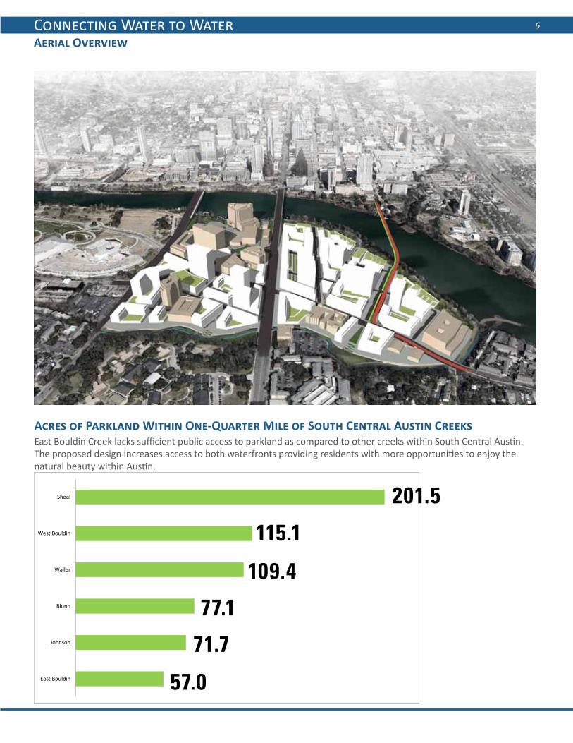
Acres of Parkland Within One-Quarter Mile of South Central Austin Creeks
East Bouldin
Johnson
Blunn
Waller
West Bouldin
Shoal 201.5
115.1
109.4
77.1
71.7
57.0
East Bouldin Creek lacks sufficient public access to parkland as compared to other creeks within South Central Austin. The proposed design increases access to both waterfronts providing residents with more opportunities to enjoy the natural beauty within Austin.

Connecting Water to Water 7
Site Plan
The master plan for the site shows how all of the urban design elements will eventually come together to form a cohesive, environmentally innovative urban district. While the actual dimensions and aesthetic characteristics of building interventions will vary, the district should adopt a design overlay that specifies how streets and public space should be dedicated according to this plan. The overlay should also encourage sustainable stormwater management solutions for new structures, like green roofs and water cisterns, to lessen the environmental impact on Lady Bird Lake and East Bouldin Creek.
A
B
C
E
F
D
3
1
2
6
7
9
8
10
N
3
5
4
Points of Interest
1. Affordable Housing2. One Texas Center3. Creek Access Plaza4. Hike + Bike Trail5. Habitat Restoration
6. Community Center7. Grocery Store8. Light-rail Station9. Lakeside Plaza10. Boardwalk
S Co
ngre
ss A
ve
S Fi
rst S
t
Barton Springs Rd
E Riverside Dr

Connecting Water to Water 8
East Bouldin Creek
After
Before Bouldin Creek Facing Southwest
The South Central Waterfront’s “other” waterfront – East Bouldin Creek – acts as the front door for the final build-out of the site. The varied scale of buildings acts as both a complement to the highrises downtown as well as a transition between the emerging “big city” identity of downtown and the neighborhood-scale commercial districts along South Congress and South First streets.
Photo Credit: Coleen GentlesPhoto Credit: Samuel Rojas
Connecting Water to Water 9
East Bouldin Creek
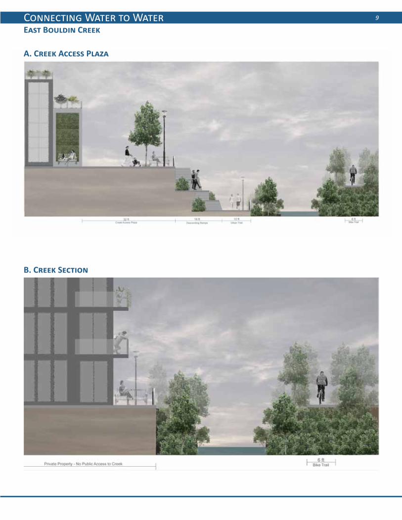
A. Creek Access Plaza
B. Creek Section

Connecting Water to Water 10
Lady Bird Lake
After
C. Multi-Modal Street
Before
Photo Credit: Coleen Gentles
Connecting Water to Water 11
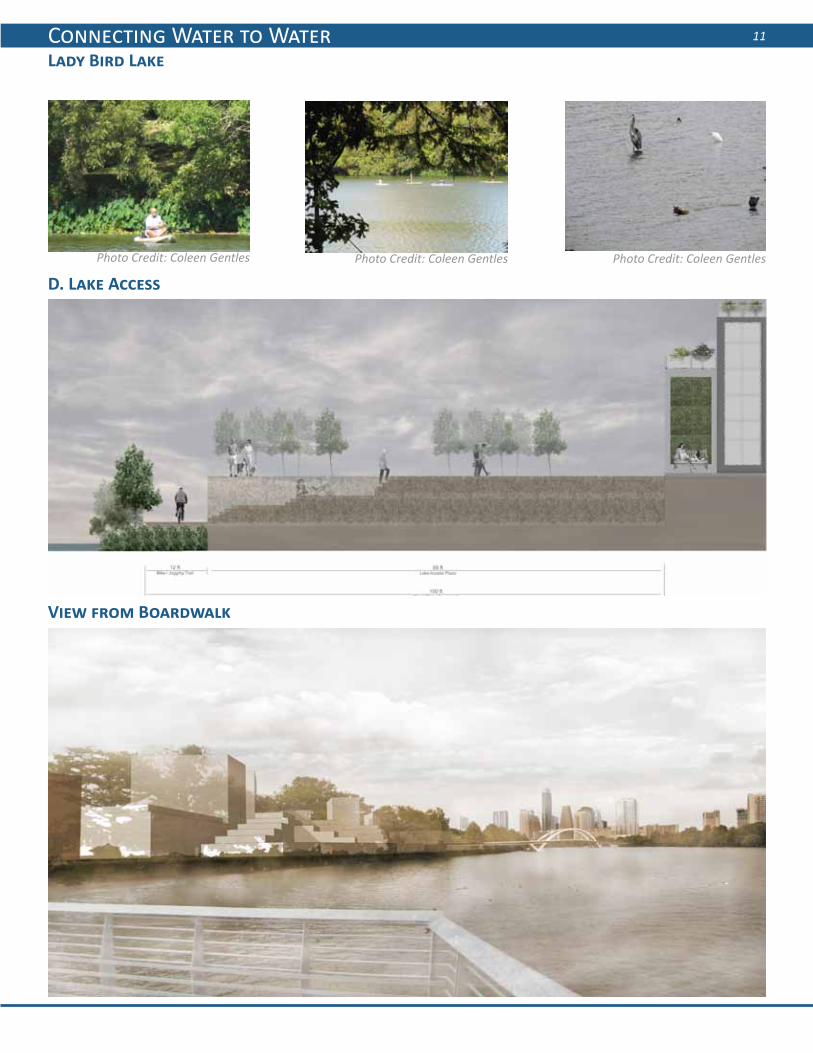
D. Lake Access
View from Boardwalk
Lady Bird Lake
Photo Credit: Coleen GentlesPhoto Credit: Coleen GentlesPhoto Credit: Coleen Gentles
Connecting Water to Water 12
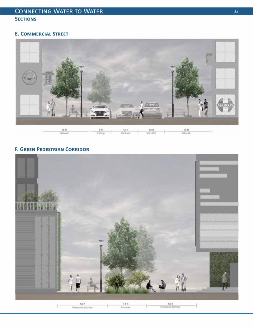
Sections
F. Green Pedestrian Corridor
E. Commercial Street
Connecting Water to Water 13
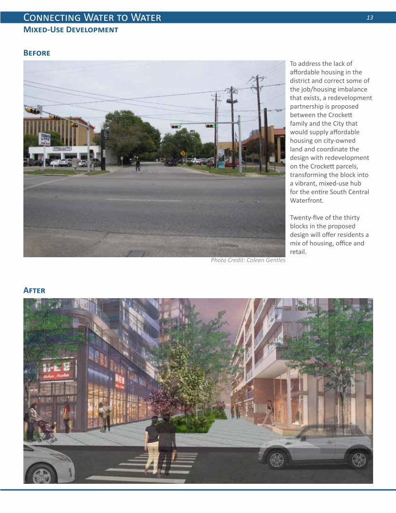
Mixed-Use Development
After
Before
Photo Credit: Coleen Gentles
To address the lack of affordable housing in the district and correct some of the job/housing imbalance that exists, a redevelopment partnership is proposed between the Crockett family and the City that would supply affordable housing on city-owned land and coordinate the design with redevelopment on the Crockett parcels, transforming the block into a vibrant, mixed-use hub for the entire South Central Waterfront.
Twenty-five of the thirty blocks in the proposed design will offer residents a mix of housing, office and retail.

Connecting Water to Water 14
Existing: Evaporation
Phase 1: Condensation
Parking
Civic
Retail
Office
Housing-Rental
69%
13%12%
1%6%
The site is currently characterized by haphazard, mostly commercial development separated by large parking lots. Several new residential structures under construction foreshadow the transition to a more mixed-use neighborhood envisioned in this plan.
Although property ownership in the South Central Waterfront is fragmented, one property owner – the Crockett family – owns two large tracts whose redevelopment can catalyze the redevelopment of the entire district. The two blocks – Crockett South (SW of Riverside and Congress) and Crockett North (NE of Riverside and Congress) would introduce several key urban design elements to the site. Most prominent is the urban edge constructed along East Bouldin Creek along with a portion of a new hike & bike trail opposite the creek in partnership with the Texas School for the Deaf. These two phases would also introduce several street typologies intended to be replicated across the district – particularly the typical mixed-use street and the green pedestrian corridor.

Connecting Water to Water 15
Phase 2: Precipitation
Phase 3: Infiltration
Retail
Housing-Rental
Housing-Ow
ner
73%
15%12%
Retail
Office
Housing-Rental
Housing-Ow
ner
53%
23%12%
14%
After the initial success of the Crockett properties, this plan anticipates other larger property owners to redevelop their parcels. Most impactful will be the redevelopment of the Statesman building (owned by the Cox entertainment conglomerate). A proposal to transfer some of the development rights from the Cox parcel to the Crockett parcels will ensure that Cox can redevelop its prime waterfront property in a profitable manner that is still sensitive to the cherished role the Lady Bird waterfront occupies in Austin’s built environment, with residential buildings tapering in height as they approach the waterfront so as not to overpower it. Included in this phase is a new terraced place that will act as a placemaking gathering spot on the lakefront.
As most of the major site interventions occur in phases one and two, the final phase expresses the long term vision of several sites being redeveloped which are currently not anticipated to face high development pressure. The final element to complete the waterfront vision will be the eventual construction of a light-rail line through the eastern portion of the site, with an associated high density TOD site located at the station.

Connecting Water to Water 16
Pro Forma and Conclusion
Conclusion
Return on Investment Models from Envision Tomorrow
The South Central Waterfront proposed design incorporates a sustainable vision to create a connection to both waterfronts. The pro forma calculation provides the financial backing to justify the proposed design. By developing blocks in phases according to current property owners, the design allows for the introduction of residential, office, and retail units early in development to increase revenue to the area.
Although the proposed light rail did not pass the ballot in the November 2014 elections, the design supports increased public transit options to the South Central Waterfront. The light rail right-of-way can be used for urban agriculture in the interim, keeping with the historical use of the site. The South Central Waterfront will be a complete community and another vibrant destination place for Austin.Photo Credit: Coleen Gentles