CONGLOMERATES THE NORTHERN FOSSA MAGNA …
15
The Association for the Geological Collaboration in Japan (AGCJ) NII-Electronic Library Service The Association for theGeological Collaboration in Japan{AGCJ) EAIITH SCIENCE ; JOURNAL OF THE ASSOCtATION COLLABORATION IN JAPANFOR GEOLOGICAL Vol.24,No. 4. pp. 115N12S July 1970 NEOGENE CONGLOMERATES AND NORTHERN FOSSA MAGNA INCENOZOgC GEOHISTORY OF THE CENTRAL JAPAN (Part II)" by TeruoHIRABAYASHI** V Result of the Study In this chapter the resuks of the study are described according to geological ages, The number and the name of the investigated localities are given in Table 2. The geographic locations and the stratigraphic position of the rcspective localities are shown in Fig. 5. The materials treated in the study are summarized in Table 6, Fig, ].O (A-G) are pie diagrams showing the average diameters of pebbles and the abundance ratios of the component rock type at the localities grouped by formation. Description of the datailed results of the investi- .cratiens ef each Iocality is omitted in this report. Fig, 11 is bar charts showing the abundance ratios of the component rock kinds. VI Considerations In this chapter the geo!ogical history of the Northern Fossa Magna will be considered mainly on the basis of the results ef investigations of the Neogene conglomerates. A. Pageag'ene !nside the Northern Fossa Magna, distribution ef the Paleogene system is unknown, and the Neogene system lies directly on the Pre-Tertiary basement. But few students are of the opillion that the Paleogene system is distributed in Saku Mountains, And the Ishizakaliparite seen in the Otari upheaved zene <Hu{ABAyAsHi, 1969) has been dated 58 million years old, but no Paleogene sedi- mentary rocks are diistributed there, However, these distributions are seen outside the Northern Fossa Magna. B. Early Miocene The litholegy of this peried is represented by green tuff. IIoweve]', the depcsiticm of green tuff * ** Matsumoto Branch was preccded by ordinary sedimentary recks as observed in Mt. Moriya, in the I{achibuse Moun- tains, in the north of Ueda City and in the Saku Mountains (Fig. 2), The center of deposition of these sedimentary recks was lccatedwest of the Median belt of upheaval, and conglomerates are well develeped there, In the east, on the othcr hand,the volcanic activities that accumulatcd green tuff took place, The detrital inaterials during those times must have been supplied from the Akaishi Mountains, the Ryoke belt along the Tcnryu River,and from the area in the south extending from the southern Kiso district to Gifu Prefecture (Fig, 12), The first two areas are close to the place of deposition, but the latteris quite distant, 100km from the pre- sent exposures. This would leadito the following assumption : a single great rlver was fiowing at that time from the Kiso district, whereas minor rivers were corning from the Akaishi Mountains and the Tenryu River draina.ue area to join in the basin. In the Mt. Moriya arca at the northern end of the Ina Mountains, the Neogene system rests un- conformably on the Paleozoi'c system, The pebbles become larger in size, and Iewer in roundness toward the upper horizons, suggesting the increase of the amount of upheaval ef the hinterland, At the Hachibuse Mountains the conglornerate in the lower part contains pebbles of the Yol<okawagawa metamorphic rocks that are exposed on the imme- diateeast, Toward the upper horizons, durable chert increa$es in number, while slate decreases. The reck types which indicate that the supply source of pebbles was in the south at that time, are the Nohi t},pe quartz-porphyry (so-called Nohi- liparite), the sandstone of the Todai formation ' the Ryoke type granjte and the Sanbagawa type meta;norphic rocks. It seems that almost no pebl)Ies were supplied from the IIida Mountains The Dactor T]iesis presented to Kyoto University. Teachers' Consultant of the Nagano Prefecture Education Cci'iter and Instructor of Shinshu tmiversity
Transcript of CONGLOMERATES THE NORTHERN FOSSA MAGNA …

The Association for the Geological Collaboration in Japan (AGCJ)
NII-Electronic Library Service
The Association for theGeological Collaboration in Japan{AGCJ)
EAIITH SCIENCE ; JOURNAL OF THE ASSOCtATION
COLLABORATION IN JAPANFOR GEOLOGICAL
Vol. 24, No. 4. pp. 115N12S July 1970
NEOGENE CONGLOMERATES AND
NORTHERN FOSSA MAGNA INCENOZOgC
GEOHISTORY OF THE
CENTRAL JAPAN (Part II)"
by
TeruoHIRABAYASHI**
V Result of the Study
In this chapter the resuks of the study are
described according to geological ages, The
number and the name of the investigated localities
are given in Table 2. The geographic locationsand the stratigraphic position of the rcspective
localities are shown in Fig. 5. The materials
treated in the study are summarized in Table 6,
Fig, ].O (A-G) are pie diagrams showing the average
diameters of pebbles and the abundance ratios of
the component rock type at the localities groupedby formation.
Description of the datailed results of the investi-.cratiens ef each Iocality is omitted in this report.
Fig, 11 is bar charts showing the abundance ratios
of the component rock kinds.
VI Considerations
In this chapter the geo!ogical history of the
Northern Fossa Magna will be considered mainly
on the basis of the results ef investigations of theNeogene conglomerates.
A. Pageag'ene
!nside the Northern Fossa Magna, distribution
ef the Paleogene system is unknown, and theNeogene system lies directly on the Pre-Tertiary
basement. But few students are of the opillion
that the Paleogene system is distributed in Saku
Mountains, And the Ishizaka liparite seen in the
Otari upheaved zene <Hu{ABAyAsHi, 1969) has beendated 58 million years old, but no Paleogene sedi-
mentary rocks are diistributed there, However,these distributions are seen outside the NorthernFossa Magna.
B. Early Miocene
The litholegy of this peried is represented by
green tuff. IIoweve]', the depcsiticm of green tuff
*
**
Matsumoto Branch
was preccded by ordinary sedimentary recks as
observed in Mt. Moriya, in the I{achibuse Moun-tains, in the north of Ueda City and in the SakuMountains (Fig. 2),
The center of deposition of these sedimentary
recks was lccated west of the Median belt of
upheaval, and conglomerates are well develepedthere, In the east, on the othcr hand,the volcanicactivities that accumulatcd green tuff took place, The detrital inaterials during those times musthave been supplied from the Akaishi Mountains,the Ryoke belt along the Tcnryu River, and fromthe area in the south extending from the southernKiso district to Gifu Prefecture (Fig, 12), Thefirst two areas are close to the place of deposition,but the latter is quite distant, 100km from the pre-sent exposures. This would leadi to the followingassumption : a single great rlver was fiowing at thattime from the Kiso district, whereas minor rivers
were corning from the Akaishi Mountains and theTenryu River draina.ue area to join in the basin. In the Mt. Moriya arca at the northern end ofthe Ina Mountains, the Neogene system rests
un-
conformably on the Paleozoi'c system, The pebblesbecome larger in size, and Iewer in roundness
toward the upper horizons, suggesting the increaseof the amount of upheaval ef the hinterland, Atthe Hachibuse Mountains the conglornerate in thelower part contains pebbles of the Yol<okawagawametamorphic rocks that are exposed on the imme-diate east, Toward the upper horizons, durablechert increa$es in number, while slate decreases.
The reck types which indicate that the supply
source of pebbles was in the south at that time,are the Nohi t},pe quartz-porphyry (so-called Nohi-liparite), the sandstone of the Todai formation 'the Ryoke type granjte and the Sanbagawa typemeta;norphic rocks. It seems that almost
no
pebl)Ies were supplied from the IIida Mountains
The Dactor T]iesis presented to Kyoto University.Teachers' Consultant of the Nagano Prefecture Education Cci'iter and Instructor of Shinshu tmiversity

The Association for the Geological Collaboration in Japan (AGCJ)
NII-Electronic Library Service
The Association for theGeologicalCollaboration in Japan {AGCJ)
116A)
Moriya andUchimuraformations
c)Aokiiormation
B)]3esshoformation
D) Ogawa formation
/'/
caiii
I1/
l

The Association for the Geological Collaboration in Japan (AGCJ)
NII-Electronic Library Service
TheAssociationfortheGeologicalCollaboration in Japan {AGCJ)
117
E)Shi igaramlforrnation
9
F) Sarurnaruformation
G)Toyonoformation
1/
chertgrarvackes)ateg
harnfe16
sandsteneeenglemeTate
mudstene-1
greentUffil
dacite(Omine
anaes ±tety?e)
liparite(a]terated
N
Fig.10.Pieand
legend
aacite)
CX: point
basaLtporphyrite
dior ±te(TerLiars
guartz-porphyry
granitevelnquartz
Eerpentinite
crystalline
gnelSSotherrecks
granite)・
schist
O-.-.t.ny-.h.O 20im
ot :oealM7)
diagrams showing rock cornposition
pebble size for each formation.
(The numerals in thethe.Iocality number inmeter of one fourth of
of onehundredpebb!es
figures comcide with
Table 2, and the dia-the average diameter
at each locality).

The Association for the Geological Collaboration in Japan (AGCJ)
NII-Electronic Library Service
TheAssociationfortheGeologicalCollaboration inJapan{AGCJ)
1
!18
Meriyaformation
Uch ±rnuraformatien
Besshoformat ±en
Aeltiformat ±on
t±on
7911IS---------1---m--t--
16a81921222J2425
'1;
tion
'1
1
28293051J}56}8S9414446474849paS2S658Go6a62S3646S67697o7J7S778oBn66/
."--+--
"--11Hbtlll-tIH
-.---"-
ny--------
,ll/1/tV
-----"-
--------
"Wt"vvv--11dlHPt17d/tldll)tVV------:/1/1/T
---------1-t-------
-t---4--4--/mmrr'
----.---.--"".----ny
--------
"--------
tNll/dTtMl
:1--th
';::
--.-.---F.---..--.-m
-."-"--ll--".-.--
- - i - - - - - + - ny - O t - - - - t ny
- t " t
---tt-"-"-----l------+++:l
ld/1++++++ lti"UU
..`.o::l:':::ll1 l i" UL't "el//
--r--------"r
max
/--"--"-"-----"-".tiL/t/tirTTrTi/irTrT
dl--・・・・・J・・-・・
--+-----.---d---
=.-.IM/re/"nd
-------hT:ttrrxx--------o------"---------------i----------tunllutt
uit.!u
-----"-"----r---J"
--------t
------==
i--+-.lldlttltT/ltl/IEI.
tM/b:11dlHHI
----t----
:ldltHtt/7111:1:/
--d---Ioo
---to---
.Ptll!111rlltll/------b--tll4
---------xx
.b------,-+4-t-----
n--e---i-
++++++siuuuut-
ullulluuuu'
Sarumaru formatien
8788899o9192949S96
reyoneformation
97
I 98 99 Ol 021
+aiu
ll------e--=====uu
-=-uu=mtilt
J Tr:,-----''
-t-L--""-- r""p-"-
/--m'-"'--f"---'-'
--------H-T----/
--"---l--o-..--vvvVVvvvvMrvVVWesJh'"'"'
'':
edi-e"tyXX.--t------m--1------ o - -"m-"--n--F-p--pp-n"p---------"------e-
--.-------1------s- i
-e---e---1----4----
IXirmVV)OCI X
-"--------+eevvvvWVVvvvVVv
vvvvvvrvvvvuvuv:l311
-=!lt"-VVVVVVWVVvvvvvvwvwvvvv' /-.---L---L--------
---x±
b,
-------'
vvvvvvvrmvv
.--.----f.--.-.-- `--"--t--t---------------n"t--------r---H---i-1----""-----------
x+-.-.----
""---t----tHHP--'--e-t-vvvWvrvww
------v vvvvvvvvvvvvwwvvvvvvvvvvvw
t:::-m"---e.
=rllT ±wr-----L--
v
nt,rvvvWrwvvvvvVVIT)=[x) )ot
vvvv7rvVVtNV vvv
VVvvvvV/vvvvvvvv
vwwvvilrmwwv
--L".-----s------
'
y'im
------+t.ny-
rv--J
'r
vvve-----OO
vvvvwvvl----t
--'--t-p-
utrvmrvvur
'=== e
vvvvJvv
/ltNrPTIT/;///
iVVwwwvvvv---"-H-t--P-m="--
t-----e-ii""''"
--d-----X
===UUIiUl-uu"uuuu"u
'i------t-=mus111e]OOCXmui++++NU
'-'---"t..".ilti
pa--Hn-t-++ "'lii
.
i
------o Y........-=mx]o[-g--F==:rT
---i----//I/tll:1/:ee7"1/
e--"--oo-1
-----
-.------s =s:utTltlldHHtlllt-t----
..oOOSIItlll
--L""----t--e-e----
.-.----"-el
tst+++o--;o
U=UiLt+u-+
".ttTlpm ±
-o-------
vvvvvvoeooT)Tlm/v
v==!=tttT
------
1/aMo"/rTlld ±ld
.
vVwwILEIua
.
s:ltUl:ldllltltl"TwnVVVV
"r-.--N-;----"----+.r
-------"---------
LLU+++ii
------u:u::stUiL!U
tit.ut1++
ete+++
+++it++11!+++++e-!
++++u+++SIUtallt
+iiisuu"
uITtMliUl++tTmmittt'・
thtt--tu-}tcu-:++++stll"uu":++'tis++funu++++s+--Li+++nunuli++itut
m,++++1-g
."tu::+++
=7.=iLUUSi
...q・+++g
om'"rto
------tchertt."t-------itMEraywacke!t
ate&-'s hernfel.s
======sandstone
oooooocongornerae
rmidgtone
11!1/1/trl/tt+igreentufS''
-t
mmetypett.dacite'vvvvvvtt'Hndesite-tttttt
nmxxli-arite&decoleumstited,
20 5o
Legend
4o
yvV ss+t-"tl
(The Fig. 11,
numerals in
riac],te(Uchlmura F.
++++++i"ltixm-f+zauu"uuulslt"e"lluuu"
5o 6o 7o o ee1oo
EEff.pg!pgtl;ite
glLartz-d ±orite(Tertiaranite)
h{Nohite&hT ±shinate
'LgEl!gl!!artzorgranitevelnquartz
se!p!nXtnl"te(ultrabastcrock
!i'ISV.q]1±neshi.st
{pelssifherrockE t-tt-tt--....ttt'
Rock composition of the conglemerates in each locality.
the left side of figures coincide with locality nurnber inTable 2)

The Association for the Geological Collaboration in Japan (AGCJ)
NII-Electronic Library Service
The Association for the GeologicalCollaboration inJapan {AGCJ)
119
A) Meri raandVchimuraAges
E
B) Besshe Age
r
L..
/ it/
a
C) AekiAge D) Ogawa Age
N; Nagano Ceo; Orna¢ hi c,M;
NatsumoteH; Haknba V.
!
C. U; Ueda C.---'Center
ofS;
Suwa C. Sa;Median Belt of
1/
a
saku c.Upheaval

The Association for the Geological Collaboration in Japan (AGCJ)
NII-Electronic Library Service
The Association for theGeologicalCollaboration mJapan {AGCJ)
120
E) Shigarami Age F) Sarumaru Age
G)
/
Toyeno Age
Sa
/
-m
N
,,p
s
va
fi p gg # o x
e・s
N
+/
Fig. 12,Supply source inferred for each age.
(The dotted areas show the present exposures of each formation.the pebble direction and strength of transportation).
O 20km'
The arrows show

The Association for the Geological Collaboration in Japan (AGCJ)
NII-Electronic Library Service
TheAssociationfor the Geological Collaboration in Japan
in the west. This is perhaps for the reason that
the amount of erosion was smaller on the east
side of the Hida Mountains than in the Akaishi
Mountains or the Kiso Meuntains, or that the iorce
of the coastal current from thc seuth was strong.
In those times, great ciuantities of pebbles were'
supplied into the Southern Fossa Magna on the
east side of the Akaishi Mountains.
In the Toyarna sedimentary ba$ln, northwest of
the Hida Mountains, the Hokuriku group, ranging
in age from Miocene to Pliocene, was deposited
with the total thickness exceeding 5,OOO m (SAKA-MoTo et al., 1959). The hitherto prevalent vicwthat the Hida Mountains is tilted westward may
have been deduced frorn the mode of erosien.
The Early Miocene "green
tuff," which was de-
posited in the eastern area, is locally intercalat'edwith ordinary sedimentary rocks such as sand-
stone and mudstone. This suggests that thick
beds of green tuff are a result of well-balanced
subsidence and sedimentation. Thus, the ejecta of
submarine volcanoes were successively depositedin the eastern area where the amount of sub-
sidence was great, and supply of pebbles frorn the
surrounding older rocks was very little, In the
western area, on the contrary, transgression
occurred somewhat later than in the east, and
flysch-type deposits were accumulated, In both
areas, the depositional plane was in a roughly
identical cendition during the same stage, and the
strata of the eastern area interfingered with those
of the western area. The western area is inierredto have undergone warp-like subsidence. And
pebbles were supplied from the Akaishi Mountains
and the Kiso district in the south. However,
evidences verifing the view that the eastern area
made an anticlinal upheaval and abundantly sup-
plied deposits into the western area, are scarce
except fer the fact that sorne amounts of tuffa-
ceous materials were transported. The conglomerate developed in the Uchimura
formation north of Matsumoto City is distributed
in an E-W direction. Any variations of rock
types or pebble sizes due to the place of depositionare not recognized, which may suggest that the
main stream coming from the Kiso district had
branched out into distributaries here befere itfiowed into the sea of those days.
During the Uchimura stage, intrusion of pha-colith (esoplith)-like porphyrite took place, injecting
or disturbing the strata. The porphyrite is sup-
posed to be contemporaneous with the quartz-
diorite belonging to the folding period of the Bessho
phase (KoBAyAsm, 1957). Dating of the quartz-diorite shewed 8.5 milliQn years, which is quite
{AGCJ)
121
young (Fossa Magna, 1968).
Toward the encl of the Uchimura stage, basicvolcanic activities, represented by basalt, becameviolent in the eastern area. The basalt is partiallyspilite or has a pillow strueture, and is locallyintercalated with argillaceous bcds which are called
Kokuzo member, being 600m at the thickest.
Above this lies the 1;ujisan member, as thick as
1,500m, charaterized by acidic velcanlc rocks.
Though decreasing in thickness the Fujisan
member extends far into the western area. Itslithology is composed of pyroclostics of glassyandesite and dacite, with intercalations of sand-
stene, mudstene and tuff breccia. Both Kokuzo
and Fujisan rnembers have been altered to green
rocks which, in the form of pebbles, are to betransported out during the post-Uchimura stage,
C. Mialdge vaocene
The Bessho stage is known as a period of sudden
increase in the amount of subsidence and expan-
sion of the marine region, Abnormal sedimenta-
tion is eften observed in the rock facies, but on
the whole the deposits were laid dowz in a calm
envlronment. '
From the end of the Bessho stage to the Aekistage, the ameunt of tran$ported pebbles becornes
larger. The area where the Uchimura formationwasdepositedwasupheavedanderosienbegan, The
felding of the Bessho phase was followed by the
intrusion of quartz-diorite and porphyrite; the
existence of the median belt of upheaval becameconspicuous, by which the Northern Fossa Magnawas split intQ two sedimentary basins, east and
west, as verified by the sedimentary facies revealeclthrough the study of pebbles. However, putting
aside the median belt of upheaval, the writer drewthe Matsumeto-Nagano line (HiRABAyAsHi, 1969) tocompare the eastern and western areas, by taking
into account the structural differences between
these two areas.
Successively irom Early Miocene, thick ordinarysedimentary rocks were deposited in the western
area. Rock composition of pebbles is relatively
sirnple. But, in Middle Miocene, chert begins to
increase while the Nohi type quartz-porphyry de-
creases, both becoming smaller in pebble size. Asthe cause of this phenomenon, an increase in thedistance of transportation and a topographical
change in the hinterland may be considered. In
those days, pebbles were supplied mostly from the
south, not from the Hida Mountains in the west
in spite of the short distance. The major river
systems may have been roughly the same as those
of the Early Miocene period, Judging from the
high degree of roundness and the small diameter,

The Association for the Geological Collaboration in Japan (AGCJ)
NII-Electronic Library Service
TheAssociationfor the Geological Collaboration in Japan{AGCJ)
122
some of the pebbles may be derived pebbles frornthe Early Miocene deposits,
The Middla Mioccne deposits are centinuos over
t.he eastcrn and western basins, though they are
thinner in the median belt of upheax,al, Theamom]t of upheaval of this belt mav・ ]tavc 1)eciismaller in the Ueda City area.
In the east of the median t)elt of upheax,al,
pebbles of volcanic rocks from the area of greentuff of the Uchimura formation begin to appear inthe strata o/E the latest p6riecl of the Bessho stage,and they keep on increasing duTing the carly
period of the Aoki stage, But, they never Teached
the western ba$in beyond the median belt of up-
heaval. Accordingly. it is considered that the
water systern at that time was different betweenthe eastern sedimentary basin and the western
one, and only the fille-grained deposits were dis-tributed in these two basins beyond the median
belt of upheaval, On the other hand, the Nohitype quartz-porphyry, which is abundant in the
western basin, is found to have been transported,
though in a srnall amount, down to the vicinity
oi Ueda City. This fact may be explained byassuming the existence of a coastal current flow-ing from west to east, as will be supportedi by thecrossbedding in the sandy parts indicating an
eastward flow (near Mameishi Pass). Tbis as-
sumption is based on the impossibility of trans-
portation of the Nohi type quartz-porphyry fromthe Kanto district side.
In the eastern sedimentary basin, with an in-crease in the abundance ratio of the Tertiarypebbles of the Uchimura stage, the pel]bles of
Paleozoic rocks decrease, However, the Paleozeic
pebbles are generally larger in sizc and lower inrounclness than those found in the western basin.So, these pebbles were supplied probabl)' from theSal{u Mountains. In the distribution area of theUchimura forrnation on the south side of the
sedimentary basin, there are no beds that could sup-
ply derived the pebbles of Paleozoic rocks. There-'fore,
the water svstcm frorn the south must have -been developed in the eastern basin, too. Thiscan be deduced frem the presence of pebbles of
suppesedly Mog. iyama granite, as well as the peb-bles of Paleozic rocks.
In this peried the quartz-diorite body intruding
the Uchimura formation does not occur as pebbles
yet. Along the Saigawa folded area, pebbles ef
green tuff and the Sanbagawa type metamorphic
rocks are abundant. The reason of their presenceremains unexplained, although it is possible thatthe rocks in the lower horizons were squeezed up
during the disturbance.
In the area around the Otari upheaved zone,
date are scarce and the stratigraphic division hasnot. been establis]]ed, so the wrjter refrains frotncliscussing the g,eological history ef this period.
D. .ILale A・fiocane
ln this 1)eriud the sedinienl.ars・' Ijasins on boLhsidc,,s of the median belt of upheaval were com-
pletely・ separate from each other, and were filledwith different deposits, In tbe western sedimentarv basin the marinc
deposits were accumulated successively over a
wide area. Due to the folding after the deposition,the distribution ef the depDsits as seen today seems
to indicate a stTong ernbayment at that time. But,
as the rock types of pebbles are markedly variable
with the place of deposition, it is considered that
the coastline of those times was fairly situated,
and pebbles were transported and deposited by
streams of various river sv・stems,
It is characteristic of this peried pebbles began
to be supplied also from the Hida Mountains inthe west, while the supply from the south de-creased and perhaps only some derived pebbleswere transported into the basin,
The average diarneter of pcbbles of the Ogawastage is 27.9mm, smallcr than 32,6mm of the
Aoki stage. This tendency viewed from the
largest pebbles is illustrated in Fig. 13. Pebbles inthe respective formations of the Northern FossaMagna are apt to beceme larger as tlie age be-comes younger. The Ogawa stage Iacks this
general tendency, This is probably ascribed to
the topcsrraphic conditions of the hinterland, that
is, the supply from the south lessened due to theobstruction by the median belt of upheaval and
yet the erosion and transportation irom the HidaMountains were not much adyanceel to replenish
the supply.
The fact that the pebble size decreases eastward,iiamely, toward an inner part of the Fossa Magna,
and the abundance ratio of durable rock types
increases would prove that the main source of
supply was on the IIida Mountains side.
It is interesting that, as the age becemes yeunger,tho rock types of pebbles in the Fossa Magna
change from Paleozoic rocks to shallow-seated
igneous rocks and then to granite, keeping pace
with the progress oE erosion into the deeper partsof the Hida Mountains. Judging frem the sites of rocks now exposed in
the Hida Mountains, the place of deposition is evi-
dently in the north-northeast. One of the reasons
for its location may be the north-lateral pressureexerted irom the east side of the Otari-Shiojiri line
a.aainst the west $ide, causing the leitward hori-
The Association for the Geological Collaboration in Japan (AGCJ)
NII-Electronic Library Service
The Association for theGeologicalCollaboration inJapan {AGCJ)
123 ,
Srt- - t
-t
1'
, ,l i・ S-ilkresi-- "u・
i
"---T
-N-l- ------
-
-
-
l -7
----- .!.r
.lj.2/gl;.,
llev L
...i
-VB;L.--'fi,;'l
z..,
.
''
!-l-.
/ I
i:
g
,,:i`tt
'diexU,
.--
it- - -d-;.--
Ft -# tj tt
---
-r
{i
:'; .・.,・le
. ff. .i
・xz.
iil ' = "
--t
.+
z
malgOFF;7}.){l;f!L!IY.,"-wu "-
v"
・- Lr'
' '-M-
.・z]
...-el-Jt-l--t-lny,Y"--.
N
t
:v
zF
oapt--=lgm-mmego km
.'tvvi-
i
l
l HII[I IJi{
av Tl
W,I[l1Hew
''.'@::----t----- ---- t - -t4 --
---
-li
..'.'-..
N"Ht=J CiLFt
Lrnmg
.p
.nla
tG ILP
E'il'o'gr=-tJILN !
llifilllew
tw.i
± [-.-Ld.=.).-utt
iiiiilV i,[v
t
1fift1
Iilll11111
pi,,Vls:iSt
1riil-!i s L
x
NN.
x '
Les1
Q,,mi
tlz}t;;'
fr7ifijilfiYls:i-
..
,M)s
Las
g ogawa fortnatien Legend
am Sarumaru forrnation i"i:i[t Aoki formation IMIilli
:. :. ;.::. shigaraul
forrnation
EEII:EEI Bessho
forrnat ±on
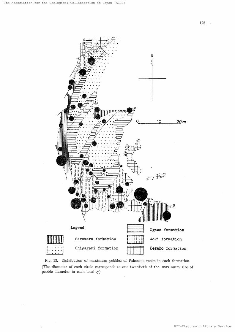
Fig, 13, Distribution of maximum pebbles of Paleozoic rocl<s in each formation
(The diameter of each circle cerresponcls to one twentieth of the maximu,m size
pebble diameter in each locality),of

The Association for the Geological Collaboration in Japan (AGCJ)
NII-Electronic Library Service
TheAssociationfor the Geological Collaboration in Japan{AGCJ)
124
zontal displacement of strata, as mentioned befere,Nevertheless, the state of the later deposits and
the crossbedding seem to support the assumption
that the course of transportation was somewhat
deviated northeastward and the strong' coastal
current was flgwing [rom south te north.
From the end of the Ogawa stagc to the Shi-
garami stage. intermixture of andcsitic pebbles
becomes・ conspicuous, When inferred from the
rock types and pebble sizes, these andesitic pebblesmust have been derived from the volcanic activity
that toQk place in the Fossa Magna at the time
of deposition,
Deposits of the Ogawa stage in the eastern
sedimentary basin are exposed only at Komaki-
yama of Ueda City. The deposits seem to havebeen supplied from the surrounding areas, such
as the area in the north of Ueda City, the Uchi-
mura area and the Saktt Mountains area. Rock
types are various. Andesitic pebbles are abundant,
increasing all the more in the Shigarami stage.
Since the end of the Ogawa stage of Late
Miocenc, andesitic volcanic activities took place in
the Northern Fossa Magna ; the activities becamemore violent in the Pliocene, and have continued
to the Recent. This is verified also by the cha-
racter of pebbles,
E, l7iocene
In the Pliocene period, transporting force grewstronger rapidly. The average diameter of pebblesof the Shigarami stage is 40,4mm, and in the
Sarumaru stage it reaches 51,3 mm. This tendencybecomes remarkable as the age becomes younger,
It may be ascribed to the increase in the abund-
ance Tatio of the 'l]ertiary
pebbles transported
from nearby sources, but the pebbles of Paleozoic
rocks aTe also found to become larger in youngerdeposits, as shown by their maximum diarneterwhich averages 63.7 mm in the Ogawa stage but,increases to le7.2mm in the Shigarami stage and
97.1 mm in the Sarumaru stage,
In the Sarumaru stage ef Late Pliocene, the
amount of upheaval of the Hida Mountains against
the Fossa Magna increased rapid!y, so that a pied-mont subsiding area was formed on the east side,
and molasse-type sand and gavel were depositedthere. During the sedimentation, the volcanic
activity represented by the Omine type dacite oc-
curred in the N-S direction, In the western sedimentary basin, the deposits
of the late Shigarami stage were transported north-
northeastward from the Hida Mountains, Thistendency is similar to the case of the Ogawa stage,
The deposits are distributed along the major syn-
clinal axes. Pebbles oi the Takase type granite
and the Nishina type quartz-porphyry are distri-buted in the Otari Mountains 30krn north-northeast
of the present exposures of these rocks, The close
resemblance of the conglo]nerate in the Nakatsuchlsyncline te the conglomerate in the Hikage syn-
cline may indicate that both conglomerates were
once in the same sedimentary environment, The
main movement of the Otari-Shiojiri line is a later
event.
In the Sarumaru stage, deltaic deposits were Iaid
down on the east side of the Hida Mountains.
The rock types of pebbles were markedly variable
with the rivers coming from the Hida Mountains
and fiowing eastward to enter the sea. The depositshave their source in the recks now exposed in the
IIida Mountains on the immediate west, Ne rocks
from the inner parts of the I'Iida Mountains are
found in the deposits, probably because the HidaMountains at that time was tilted to the west and
the rivers on the east side were small and short.
Almost on rocks from the Mt, Hakuba and its
vicinity were transported to the east, and the
Happo type serpentinite and the Hakuba type
metamorphic rocks are rare among the pebbles,This rnay be ascribed to the fact that the north-
eastern part of the Hida Mountains was not much
eroded, or that the east-fiowing rlver system was
not developed there. !t is true that these roc!{s
are undurable, but their occurrence as pebbles istoo small even among the recent river gravels
(Fig. 12).
The Pliocene depesits along the Susobana Riverinside Northern Fossa Magna are rnixed with
boulders of the Omine type dacite. These boulders
must have been transperted out oi the lava fiows
in the Omine formation (KoBAyAsm and HiRA-BAyi・xsHi, 1952) on the west side of the Otari-Shio-
jiri line at the time of the line's east-thTowing
movement aiter the sedimentation. Accordingly,
the horizon of the Sarumaru formation along the
Susobana River is higher than that in the Ominearea. The Pliocene series distributed in the drain-age area of the Susobana River consists chiefly of,
andesite of the Palaeo-Iizuna Volcano, but alse
contains exotie pebbles such as the Takase type
granite transported from the west-southwest, The
amount Df such pebbles, however, is very small in
comparison with their abundance in the recent
river gravels ef the River Sai-gawa in the neigh-
berhood,
As the time lapsed inte the Toyono stage, the
western sedimentary basin entered a fresh-waterenvironment for the mest part, and after the
tolding movement in the latest period oi the stage,
the block rnovement prevailed, causing the struc-

The Association for the Geological Collaboration in Japan (AGCJ)
NII-Electronic Library Service
The Associationfor the Geological Collaboration in Japan{AGCJ)
125
tural upheaval of the IIida Mountains, the west-
throwing movement of the Otari-Shiojiri line, and
forming a basin structure between this Iine and
the Otari-Hakuba line (IIiRABAyAsHi, 1968). Since the Sarumaru stage, a fresh-water environ-
ment rapidly prevailed also in the eastern basin.Then the Kornore group was deposited, and a
little later the Enrei formation was deposited widely
extending as far as the Matsumote City area. These
deposits are of terrestrial origin. consistin.a largelyo/f pyroclastic rnaterials,
VII Conclusions
The iollowing geohistorical developments in theNorthern Fossa Magna were revealed through the
study of conglomerates.
A. Ileriod of suXiply from the south
During the Early te Middle Miocene period, the
supply source of pebbles was in the south, namely,
the Akaishi Mountains and the Kiso district, as
verified by the presence of pebbles of the Nohitype quartz-porphyry, the Sanbagawa type meta-
morphic rocks and the Ryoke type granite. I{owever,the deposits contaning the pebbles mentioned above,
are not founcl in the eastern sedimentary basin.
Green tuff of submarine volcanic origin was ac-
cumulated in the eastern basin, but no conglomer-
ate was developed there, The western area since
Early Miocene Was in an environment where
ordinary sedimentary recks abounding in pebblescould be deposited, Nevertheless, no positiveevidence is available to show that pebbles were
supplied from the Hida Mountains in the west or
from the Kanto Mountains in the east, The strata
ef the Bessho and Aoki stages, the period when
the median belt oi upheaval began to form, are
distributed continuously over the eastern and
western sedimentary basins, and the characteristic
Nohi type quartz-porphyry observed in the western
sedimentary basin is seen to have moved into theeastern sedimentary basin,
B. Pleriod of suPPly from the Uthimura fbrmation The green tuff, dacite and andesite of the Uchi-mura formation began to supp!y pebbles alreadyat the end of the Bessho stage of Middle Miocene,These pebbles were supp!ied mostly into the eastern
sedimentary basin, and were not transported into
the western sedlrnentary basin. Therefore, so faras assumed from the pebbles, the sedimentary
environment during the Middle Miocene was
strongly infiuenced by the eastward fiow of a
coastal current or a river system.
The quartz-dioritic intruding the Uchimura for-mation did not supply pebbles yet in this period,
There is a report (KoBAyAsm, 1957) on the
presence of the quartz-diorite among the pebbles
of thc Aoki stage, but it was not confirmed lnthe investigatien by the present writer. Trans-
I}ortation ei the quartz-diorite pebbles becoinesrnost conspicuous in the Pleistocene period.
C. I]taried of suiiply from variozas sources
At abeut the middle of the Ogawa stage of Late
Miocene, the rnedian belt of upheaval was developedremarkably, causing the eastern and the western
b4sins to undergo different sedimentations,
In this period the supply of pebbles from the
south into the western sedimentary basin clecreased,whlle the supply from the Hida Mountains on the
west began. In ether words, this was a tlansitional
period, As a eonsequence, the average diameterof pebbles became smaller than that of the Aoki
stage. Taking place of the Ryoke type granite,the granitc pebbles irom the Hida Mountains side
began to be intermingled, and the pebble size tends
to decrease eastward, going away frorn the Hida
MoUntains, Andesite pebbles are not found, andthe rock composition is rather simplc.
In the eastern basin the distribution of con-
glomerate is limited to a small area of Komaki-
yama. The component rock types are quite vari-
able, comprising the quartz-diorite in addition to
the volcanic rocks of the Uchimura formation fromthe Uchiyama area and from the north of Ueda
City, Pebbles of granite and Paleozoic rocks,
probably transported from the Kanto Mountains,are also found. Since this peried, the sedimentary
environment becomes entirely different betweenthe eastern and the western basins separated by
the median belt of upheaval.
D, Peptiod of sevpt)ly from the Eida Mbuntains
In the area along the Hida Mountains, namely
the western marginal zone oi the Fossa Magna,
the Miocene strata are not distributed, The older
rocks of the Hida Meuntains are directly overlain
by the strata of the Pliocene Sarumaru stage with
an unconformable relation (HIRABAyAs}ii, 1953), Inthe area east of the Otari-Shiojiri line, strata older
than the Shigararni stage are also distributed.Accordingly, the pebbles supplied from the HidaMountains into the Northern Fossa Magna becemeabundant in the strata of the Shigarami, Toyonoand Sarumaru stages, The Nishina type quartz-
porphyry and the Takase type granite are the
characteristic rock types. With the Hida Moun-tains as the main source of supply, the abundance
ratio of granitic pebbles increases as the age of
deposition becomes younger, and pebbles of ?aleo-
zoic rocks decrease. This indicates that the
erosion advanced into the deeper parts of the Hida

The Association for the Geological Collaboration in Japan (AGCJ)
NII-Electronic Library Service
TheAssociationfor the Geological Collaboration in Japan{AGCJ)
126
Mountains. The deposits of this period vary with
the river that transported the pebbles, and the
compoment rock types reflect the .cr.eology
o'f the
hinterland on the immediate west. Rccks in the
inner parts of thc Hlda Mottntains were net trans-
ported eut, which sug- gests that the Hida Mourrtainswas undergoing a west-tilting movemeiit and thc
small and short strearns on the east slde were
accurnulating the deltaic deposits.
In many cases the pebbles supplied from the HidaMountains were deposited ih the north-northeast of
the supp!y source, In the Northern Fossa Magna
some geologists attach importance to the leftward
displacement of the strata on the east ef the Itoi-
gawa-Shizuoka line (KeMATsu, 1967; KoBAyAsHi,1969). The 12-km long displacement betweenthe median dislocation line and the Yokokawa-
gawa fault around Lake Suwa has often been
discussed. (GoRAi, 1951; KAwAcHi et al., 1966),The present writer previously pointed out the
existence of an area where block movement
was active, between the Otari-Shiejiri line and
the Hakuba-Shiojiri line, and regarded this area
as part of the Itoigawa-Shizuoka line. He also
stated that the structure on the east sidc oi the
Otari-Shiojiri line was affected by Iateral pressurefrom the southeast and was warped so as to
take a nearly N-S direction (Hii{ABAyAsm, 1967,1968).
According to the writer's study of pebbles, the
distribution o,E pebbles of the Saruinaru stage,
youngest of the Neogene, is deviated 15krn north-
ward from the supplying area, and that of the
preceding age, Shigararni stage, is cleviated 30km
northward. On the other hand, the distributionof the pebbles of the Ogawa stage and older ages
does not show any unnatural deviation from the
location of their supply source. Even though the
east side of the Otari-Shiojiri line might havemade a leftward displacement against the west
side, the writer does not think the movement is
structurally important, because it seems to havecaused on!y a partial warping oi" the structure
along the line, The idea that the median disloca-
tion line was deviated and became continuous
with the Yokokawagawa fault may be acceptable,
but the writer considers that such a movement
had occurred already in the period of the base-
ment, so that the displacement after the deposi-tion of the Cenozoic system rnust be very slight,
From the above-mentioned facts, the writer thinks
that the north-northeastward deviation of the dis-
tribution of pebbles from the Hida Mountains is
attributed mainly to a river system fiowing inthat direction or to a coastal current coming frem
the south. He is inclined to think that the struc-
tural eause of the horizontal displacement is un-
lnlportant.
[t is certain that tl]esupply o[' pebbles fron], the
Hida Mountaims increasedi in the Late Miocene
Sarumaru stage when the strnctural subsidence
occurred. This agrees well with the idca hithertornaintained (KoBAyAsHi, 1957).
Even durlng the period when the Hida Moun-tains served as the major source of supply, the
pebbles of the rocks from the south, such as the
Uchirnura formation, the Sanbagawa type meta-
morphics and the Ryoke type granite, are also
founcl, though in small amounts. This fact maybe explained by assuming they are re-worked peb-bles that were transported out to be commingled
with other pebbles.
E. Period of sulu>ly of volcanic rocle Pebbges
The pebbles oi volcanic rock from the greentuff iacies of the Uchimura formation were men-
tioned before. Other volcanic rocks than these
begin to appear as pebbles in conglomerates since
the Ogawa stage, in both eastern and western
sedimentary basins. The liparitic volcanic activi-
ties occurrecl during a period from the early
Ogawa stage to the Teyono stage. The Susobana]iparite of the Ogawa stage and the Omine type
dacite of the Sarumaru stage are especially notice-
able. Andesite activities took place in various
districts since the end of the Ogawa stage, Many
of these activities were submarine eruptions d"r-ing the sedimentation, whereas younger volcanoes
of the Quaternary are found on the land. The
Omine type dacite was transported as pebblesnortheastward from the site of its activity, pro-bably due to the east-throwing movement of the
Otari-Shiojiri line. Accordingly, the Sarumaru
formation at that time must have had a fairly
wide area of deposition in both basins. The drain-
age area of the Hime River, that of the SusobanaRiver, the Joshinetsu volcanic area, thc distribu-tion area ef the Enrei formation, and the supply-
ing area of the Komoro group were the center oi
the andesitic activities which supplied large
amounts of coarse pyroclastic materials into thedepressions of vo!canic origin. In many places,
lacustrine deposits are found at the base of the
pyroclastics.
During the Shigarami stage a fresh-water en-
vironment was prevalent in the eastern sedimen-
tary basin, whereas in the western sedimentary
basin the iresh-water deposits were accurnulated
only in a very sma!1 part and the remaining partwas still under the sea until the early period of
Pleistocene, as suggested by fossils. However,

The Association for the Geological Collaboration in Japan (AGCJ)
NII-Electronic Library Service
The Association for theGeological Collaboration in Japan{AGCJ)
discrimination of beach gravels from river gravelsby the shape oE pebbles cannot be made at present,because no useful clue is available.
It has been recognized by many geologists that
during the Neogene period coarse deposits rich in
pebbles werc intcrmittently accumulated in the
Northern Fossa Magna, andi along with them the
flysch-type deposits aud pyroclastic materials
formed thick beds. The writer, based on the re-
sults oi his investigation on the Neogene con-
glomerates, clarified the characters of the depositsand the geological history of the Northern FossaMagna. ALIsQ, referring to the obtained data of
geological structure, the writer was able to galnsome new facts.
E J;hrture ProbJems
As a result of this study, the following problemsremain for further confirrnation and for future in-
vestlgation,
1. Establishment of an appropriate method to
fulfi1! the requiremerits of the study en river
gravels and conglomerates. .
2. Finding an effecttve method to discriminatebeach gravels frorn river gravels, By cmploying
such rnethod, the sedirnentary environments can
be inferred from the character of gravels.
3. Similar study of fine pebbles smaller than
10rnm, and sand grains and mud, which were
excluded from the present study.
4. Study of andesite pebbles and Quaternarypebbles.
References
Hii{A[}AyAsT-aT, T. (1955) Geology of the Vicinity
of Mt, IIakuba,'Nagano Prefecture: Nagano
Prefecture Resources Investigation Association 249-262.
---
(1963) Geolegy of the San zaka Hill
along the n.orthern part of the Itoigawa-Shizu- oka tectonic line: four, GeoL S・oc. fopgn. Vol. 69, No. 813, 279-280.
-
-(1966) Provenance of the Tertiary con・
glomerates east of the Matsumoto basin, Naga-
Prefecture: four, GeoL Soc, fopan. Vol, 72, No.
4, 191-203.
(1967) Geologic structure of the northern
part of the Itoigawa-Shizuoka tectonic line:
Aid.o'ano thql17cture Edzfcation Center Reserch
Bull,, No, 1, 51-75,
---
(1968) Structaral characteristics of the
western margina] area oi the Northern Fossa
Magna : `t f;bssa J14ti.e'na," GeoJ. Soc. Jtipan, 31-35.
--- (1969) Ge61ogic structure of the Northern
Fossa Magna: IVtzfurno Proj13cture Etlzrcation
127
Cent'er Annual Roport, No. 3, 33-44.IuiMA, N, et al. (1958) Tectonic significance of
the Fossa "dagna : Earth Science (Ckileyza KZz-
gaku), g7. 29-33.KAMEi, T. (1955) Geo]ogy along the middle re-
aches of the Hime River, Nagano Prefecture: N[rg'ano thojbcture Resources lnvestigation As- sociaton, 231-236.KANEi<o, S, (1956) Asymmetric ridges in the northern part of the Ushiro-Tateyama Range :
Geogrmphical Review (Chirigufeu Hi,oron), Vol. 29, No. 8, 14-28.KAwAcHi, S. (1961) The Yatsugatake Volcanic
Chain, I, II: Earth Science (Chileyu tftJgaku),
55, 1-8, 56, 11-17.KAwAcHi, Y. et al. (1966) Crystalline schist of
Yokokawa district (Yokokawa metamorphic
rocks) north of Lake Suwa, Central Japan: lbur, R?tr. Miner, Econ. GeoL Assoc., Vol. 56, No, 1, 21-29.Ko]3.4y,xsHi, K. (1951) On the fault topography
of Mt. Jonen: Geagropical Review (Chigzifku Llyoron), Vol. 24, No. 11, 377-381.
and HIRABAyAsHI, T. (1952) The so-called
Omine Volcano and the Quaternary geologic
division in the western part of the Fossa
Magna: lbur. Geol. Soc. joPan, Vol. 58, No, 682, 293.
(1955) Nature of the Japan Alps: Tsukiji Shokan,
and HiRABAyAsHi, T. (1955) On the so-
called "mountain
boulder gravel" around
Matsumoto basin: Jbur. Geol. Soc, JlrijJan, Vol. 61, No. 712, 30-47,OMoE{i, Masae (1960) On the geological meaning
of the "Fossa
Magna": thrth Science (Chi- layu Kkxgzxleu), 50-51, 75-82.
Otari Research Group (1968) Problems in the
ncrthern part of the Itoigawa-Shizuoka tectonic
line : L`Fossa
Magna", Geol. Soc. Japan, 45-47.Saikawa Research Group (1966) Geological struc-
ture of the Sai-kawa fractured zone-Geolegy
of.'the Sai-kawa urea, Nagano Prefecture, Monograph 12, 95-102, The Association for the Geological Collaboration in Japan.SAsAKLu{A, }vl. (1932) Geelogy along the lower reaches of the Hime-kawa and structural
significance of the Hime-kawa area: flhe
IYarlh (Chikyu), Vol, 17, No. 6, 1-16.SmBA'rA, H. ancl HARA, K, (1954) Granitic rocks
from the North Alps o'f Japan (Preliminary Report) lour. (;eog Soc, .Jlipan, Vol. 60, Ne.
10, 436.4,t4,
Si-uBATA, H; and HARA, K. (1955) Nishina-type
sub-alkalic rocks from the North Alps of Japan:

The Association for the Geological Collaboration in Japan (AGCJ)
NII-Electronic Library Service
The Assooiation for the Geologioal Collaboration in Japan (AGCJ }
128
ro緲 o Univ. Educ. Res . RePt. Vol ・4,隻33−46・
TANAKA , K , et aL (1962) On the Tertiary system
around Mt. Moriya, Nagano Prefecture (1st
repQrt ); ノ∂%γ. Geol.50σ. fapα n, Vo1.68, No .
806,618−628.
and HIRABAYAs 田 , T .(1964) Geology of
Utsukushigahara and Sanjiro district, Matsu−
moto City: ∫ou γ. Fac. Educ ., Shinshu Univ・
No,13 ,63−79.
ToMlzAwA , T .(1962) Geological study of the
Neogene syste 皿 of northern Shinshu : Nagano
Prefecture Geological Association・
YABE , H ,(1918) Itoigawa −Shizuoka tectoniG line:
Science of Today (Gendai no Kagaku ),6,1−4.
YAMAGI $HI,1,(1958) “Green tuff
,, in the northern
district of Ueda City, Nagano Prefecture :
Treatises in Co 皿 rnemoration of Prof. Haru・
yoshi Fujii皿 oto’s Sixtieth Birthday,245−250.
YAMAsHITA , N .(1960) Alpine orogeny in Japan
and proble皿 s of green tuff age ;Eaγth Science
(()hileyu K αgaku ),50−51,9−21.
(Received March 27,1970)
(摘 要)
中部 日本,北部フ ォ ッ サ ・マ グナの新第三系
礫岩と新生代地史
平 林 照 雄
北部 フ ォ ッ サ マ グナ は , 中部日本北部 に お い て , 日本
列島の 地 質構造単位 と して , きわ め て 重要 な 意義 を も っ
て い る 地域で ある .海退期に 伴 う前 期 中新 世以降 の 新生
代 の 地層が広く分布して お り, 全層に わ た っ て礫岩層が
よ く発達して い る .しか し,こ の 地域 の 堆積物,特に 礫
岩 に つ い て 7 全域的に , か つ 長い 地質時代を 通 して ,系
統的lcVF究 さ れ た もの は な い .そ こ で ,筆者は 堆積物中
の 礫岩の 礫を用い て ,後背地 と堆積盆 地 と の 問 の 構造運
動 を考察し よ うと試 み た.
礫岩の 測定方法 に は 種 a あ る が ,こ の 研究の 目的か ら
考え て ,結果的 に は ,長径 10mm 以 上 の 礫を 対象とす
る 便宜 的な 方法を 設定 し た .調査地 点は 104個所 に お よ
び,礫 の 岩石 種 ・礫径 ・円暦度 ・風化の 程度・膠結物 ,
礫岩層中の 最大礫 ・被度 ・淘汰度 ・走向傾斜 ・堆積構造
に つ い て 調査 した .こ れらの 結果を検討 し, 礫岩 の 性質
か らみ た 北部 フ ォ ッ サ ・マ グ ナ の 地 史的発達 を 考察 し
た .す な わ ち ,後背地 か らの 礫 の 供給 と,堆積地 域 と の
関係は,古い 時代か ら新しい 方へ ,次の 各段階に 区分す
る こ とが で ぎ る,
1,南方 の 木曽西南部 や,赤石山脈・伊那山脈 か ら供
給 された 時代,
2.主 と し て ,北部 フ ォ ッ サ ・マ グナ 内部 の 南部 の 内
村累 層 か ら供給 された 時代.
3.1 と 2 の 地域 お よ び 西方な い し,西 南方か らの 供
給時代.
4.主と して , 西方ない し 西南方 の 飛騨山脈方面か ら
供給され た 時代,
なお , 3 と 4 で は ,堆積時 の 火山噴出物 が 混入 し,構
成礫種 に 特徴をつ けて い る.
こ の よ うな 後背地 の 隆起 ・侵食運動 と,堆積物 との 関
係の 究明か ら , 北部フ ォ ッ サ ・マ グナ堆積盆地 の構造発
達 に 関 し て , 従来 の 研究結果 の 裏づ けを した り,ま た,
新 しい 知見を加 え る こ とが で ぎた ,特 に 北部 フ ォ ッ サ ・
マ グナ 内部の 中央隆起帯 の 発達や,糸魚川一壌尻線地帯
の 構造発達過 程 と,礫 の 供給状況 との 関係を 明 らか に す
る こ とに 役立 っ た ,と りわ け,従 来 も一
般的 に は 考 え ら
れて い た 北部 フ ri・
ッ サ ・マ グ ナ 地域 と、そ の 西 側の 飛騨
山脈 との 顕著な構造的対立 の 時代 や 運動が,中新世 末か
ら鮮新世初期,お よび , 鮮新世 末か ら洪 積世前期 で あ
り, こ れ が 飛騨山脈 の 急激 な隆起現象に よ っ て 表現 され
た もの で あ る こ と を確 認 す る こ とが で きた .
N 工工一Eleotronio Library

The Association for the Geological Collaboration in Japan (AGCJ)
NII-Electronic Library Service
TheAssociationfortheGeologicalCollaboration mJapan {AGCJ)
t'l-lr/N/fit[al-..t.-.t.-...
-]
lgll:F"]lv:sgn:nFUv-r: 'tif
t,es!llt
ilij
ii
ii,I/I,,ilIi['i:i:$etvrzE
"lj:Nlvasi;sut-.::E..Nanm-ow-::asn'u:v::ia::it=g...tArpL.e..H-un.-.
fglf"f
lgYi/I'Sg1
iLJ
'
,iti111
ii'i//Sg.eilil'Flri"2'f'L'I//.i・ii?'igY':Eli;l-ll'i:`l.,Iiig.i'k}/
!/
''Tl-'iLll-i,i-Iil-:g.i-n/tl1'
:'q{,un/='zT/s,u2"ab'.'sr1 ]i.i.1! km'Hta/um1==,=//1ens=M.."diijkN-r,:T Ei+ /- /u-.s::i
iithititeI=i,tsmvM:N
--.L.!StuI'I o. '1lnd""//Mtn:I=/fi1-"f"rpbmts.pr,l 1tt =m'FLng,ie・ta,:'=glslwptLM
.....efi.v-i-F-"11,,,L -E.g-:gsei'gl'pm1=!=F=tolr:,'-ui
1' tv-imrm-Ml.:..t
ptgl?MgJIMff,v/n1o:tL"utsS es.'- lL.-aeL.I..-'
rtL7x1ris/-gti-:T:=zaastsi,1'T1ec-[.1-skl.Iagmth=-)M8-vt7Hl=l==f":b"mw/en lv.t= 11-/fit
ast,ItSl=1j=I=':s:-:Ga5:I' INtss /lp-E"Anth1/''M-ITffJ:Ntu.ptm:i"[=ift/ hi--,ffn-iJZ11Tes"Le.IA.p,1'1=E-ts1rrls
at'Nf/e=Z=Elglm:.:tseE-la r,Lth-l----. n'g."t..-evnv.-."lF/..:v:. t//:==!=12/ilM"NeNtu1tuan!u1uamk)
w'l'l`1=1='iF,'Z
ts/m,'n 1F-"kmta1rt''='=-le
--stil='':l: "-rmk.,,laaA'! 1plmeFtr'd/
me-s/,ilx=:=,a.. unHx.N+-]-11+ts3#t/slrlfie.ge"./: 1"Itt.'.- s1l:slI.1+tszaza1
Fht:,,s,:=,:1:"
E:egs-
tTr,:,ll:ltaL." IMt
za:.:buUg"r`F.carm.tLfY'lt-'.wr,15rnvv.'-''M'L-Tenfiget-Y m''Ets1
Eg.Ltlt.x,slslijZ-"-#gsn.s[/ml wme-tH/tsgl'/'::"tr!11= '
S...1 4/essi-1 Jmpt'wes/svli'sla'::F..- :1sdisi- -lp-i1 el-!-・
'ea'-.sE-/.,/1eltsSuilgxl/.t-,S-X,:/-ive.l-:--..=・va:Eva'-EaP 1lgiga',,Gi,i+mlHH' -=iFIl
F'1:!x/r=1:.]tSpt-itulmaM:t1 pt/.-/
,letltl=':-lum':zzH.1 lsl/1 iul"J",rptL.t
/tlml=li'ls
'"N,-.,' XXi/,1 X'4fi/
sESk-.:t=,!,s'e.g{.Fu/2'.sgffI'th-.N-[":'
=1r1mT';/=/mg/m/ unl/e'±
'Sk・I.r:-1-asl:
IFErc,HY-M
"iiitl.1. . 1:l-;vBvl
li1 ...F:.S m!,e,=1=,:a1:E..hig.:' -11 ,]
...w"L=.en.S'-.,--vlrmE.e::.ii2
'S'=I",glil:..ia1 1"1w
dith1iM'-
nt 4Elm,th't"[--"dvge
/t di,-]"ebjyqlxx=・t!- '[i"geeit'.!zlil:.lsl.re.."..E-[/
'S-1I':.e'/ leif
g.t:,:1r=,t,ig,wscuNN ±asM-ts1ori1ra ± g`il':M,.1as1si.,
gs-2Lxilslg・,-L・.. s:pN'gllunLEIE.rsTHxi' 1-uWlu-eL!.1
lm$ir:::te/./,.-'--MmaemAM1figlS!=.nt-.=u"m"-lglSlYtaj:z!s[vai.s';"nyvee.-pVza- 7-/pulx. 1 81/'
I,::,.,xilge: an:11 ..I..."+.e.lt,:,1',pe'1
z"M: e = r/ :-I= Hp H m zz Tti-e.-L/ -ml L11'gJM-=/sL.:-x lrliiliT
mntmlEl u Mv
. .Nt /."finE =i=.rl"Fs
-U -r .-li th:''i
.A 5Vs=L"1mti-"fi:
=1= = e wwH#/,. 1als a[fi
wm"--lpH rrinnmu-IF :
vmS:==tsikl.st:1z1 ,, ,X-i::;i-L
--.-rv]nyi : =1 teli
pm..=1=Ir[s,Mtg-.tie/ n,:
= xlel".'igrme -aE;i=tnmL.gi}-l-:-=Ir
ei ,. Sr.-LI-,- ,.I.[R-ystuun
S f.i:.,:I{+t-L:IL:+I i-HmaH .:."=lilll= Xl:1'lsLza
・ .LEI L=. ,.//,v z!slLl"
1.ttE=LEItLEI-gL- ts-NN-tath:pt"
s'di
ptg llr1e1:1 1m U1M-d mL di-ff]--7e1:iO.i--.:.n.H.:V:L.nLtrpmZ :l=,: l e'
s : 1 i p l "fi
,1 di ,= ras
-!!L.-L.-diIS-'1 - m
" m.L-.
e'
"--s11I- -1 ei.I-
"-
'"!I'th-i
'k
-ptSLZ-: : rrtsal.!.I -lpM
I vi !
=-t.!L .1 ...t" 1+
1 :=za /- --L--ta: . pi L- n -/ -Na.,
vl
L[
"-l -P/ma t=Ipt 1s ts/ 11-i- 1
F=1xva1
x -ulIth.-., -itxx=-I
k"1::
'. - . . -u
.mal.E.Il lw-.-.
'/"=Ell-E:-g± sll s
11/.i /. /1,l,i/rl.
:IEI=1=, ,ee
-:gsc'
Lrin.:1.1/LT.-tsl.t]$
wint--- " es-el--
pt it El
..:.Vta ]- r.n e.
t.q.
.ptta" l . .- l ....tiL. .tr.tml. 1- + .
1 bS,
" "
Fv' M.. ,i-ta-'.e]"-- thith.-sc.-th.1
. usilll
Nii
l. i il i l i/ l- I lii ljil'iEi mE!:";:mu'-W`G"
tu
sj "#': /a
ntel-----1.wt[:
pt 1ETHm.sg'ss! ' -as'-.nv,
--.wuu.ftn.--bl u+,.r:1=tils=.i./.fi..m.
ale----- 1-gm-.- ,i ' .. L.s
' :v'-dimE.L.9.-za th ' ..L.nmu-fimu i.ael
:, 7th rlT r tl1,H [11 x
s x
:1ff:-1
} l
:
/
e:/ "1{lr/v fft 1" o r -1 ・・・-z,
ll th1:E:]vlPl li , 1..ua J..- +. 11 l
[![1tuES.nsm:t stFvl: .
HSz. m- u
g!sc,=qv "Iz!.ls .stL i.. .・.1
rb
1rero Ilh
1an1{ i ,i ts1: :..± .-.Lts g
1{iv rle','ml:trls g,gim,,vl:ITIslel
1, '
i ll=FTLi-Y-:-ts. .di-ljr
i B1s tst:.1ml sc S-vepm-.M HE HStsu ut nl-1 .,.IH-IH-'FIl, .1/n.. .tnvge
Fll ua-....IQ.s/F :-r tt,I[/l I -!---al.
t s-
wilEti
':/1 lnp," 1 tpig 1- !-1
ZmX-itl rr ft Ig -.g-z n1clrlilzl
lg -M N#zavlia.L .geel E:'va' .s s,/ge"MLot-!fi/F1 H-#/1 '
an, 'm :!:7LNIt:"1v"E
th":!s sis 1ti-]tm1 :1 trr.
r-1
eeiM:.{,":Ti:'1"Is s asVI g/n
wt,s!vHr:Sl!izayffe:-.'.i.m.r olz z i
/ :I=l: !11 mFl
: H . .eN-R-ii E'-.'`-'.1-r,1
nv1" if p
# ] g,.N s z
' 'nyi ::F:- i
i
.i ::. WLNI[ma1
!tul t.-n
IP- w- eeRMgemumm.di .-rrt!.rgL.. -1-
ZH..m.s-Eee;1
w t.in=L-lrl,/liMtetsnyhve-Jlje.-Ir.rvwr
IlS'Ya.s-- sb'snL.L-t-SgL-i-lr
,:z: vl
Ea u1 zL.・an.l-za- ]" t lin e s/ fi L'l
f. i.epit u H1rLgLu..n
.d-rd. =rcH'
tuin," ±' LgLK ,.ilreI-U/kifigL
m ", senLP UI ts1 ---' z
1++ .1.
1 ..
:1
l ..y: v-1
lsl
I:rH,.L= .t-NltRL.
F-".li1vatt[ P"N S
za
tl".LJ.-L-
:[g.i.-T,Tr1:/ - rlll=
al T"-]., 't
, g
rx irr l g
1
#gts.s#rgr-:Nr.-: ----"t
-EFuleH.1F1 L =.,L
SLti.L ..u.rxTL'
':EP-1, EL-u ::.[
1.N+:l.:S.u ±!.L:=/c,r1sl:N!/ tlN r rllI rst o)--'sza
1 te +1"N.#.rristke
'S'nlgEzal
;RffI:g