Conceptual Development Plan For The Fort King Site · PDF file30/6/2009 · The...
11
Conceptual Development Plan For The Fort King Site Prepared For City of Ocala, Florida Henry A. Sheldon, P.E. 11611 SW 89 th Street Gainesville, Fl 32608 June 2009
Transcript of Conceptual Development Plan For The Fort King Site · PDF file30/6/2009 · The...

Conceptual Development Plan
For The
Fort King Site
Prepared For
City of Ocala, Florida
Henry A. Sheldon, P.E. 11611 SW 89th Street Gainesville, Fl 32608
June 2009

Engineering Report
2
Fort King
Conceptual Development Plan
Chapter 1
Purpose and Scope
Purpose The purpose of this report is to present an updated Conceptual Development Plan for the Fort King site based on archaeological work completed during 2008-09. This archaeological work was funded in part by a Historic Preservation Grant from the Florida Department of State (2008) and was intended to better delineate the artifact ‘rich and poor’ zones so as to direct the location of future access drives, parking, and visitor center facilities. This Engineering Report is a companion report to the archaeological report prepared by Gulf Archaeological Research Institute (GARI) and is based on findings and recommendations of that report. The report is prepared as part of the local share component of the Grant Application. All legal (boundary) and topographic survey and associated CAD digitized maps were completed by city staff. The maps were used in the preparation of this report. Scope of Work Consulting engineering services provided as part of the Historic Preservation Grant effort included the following:
1. Meetings with city staff and GARI to review progress of the archaeological findings and field work. Providing engineering input to surveying teams, project approach, and concepts being discussed.
2. Physical inspection of Fort King site and archaeological investigations. Review of densities and types of artifacts recovered.
3. Inspection of the topography and field ecology of the site. 4. Review of Archaeological Reports 5. Preparation of this Conceptual Development Plan

Engineering Report
3
Chapter 2
Background The Fort King Site The Fort King Site is located on Fort King Street 3.2 miles east of City Hall and 2.6 miles southwest of Silver Springs as shown in Figure 1. The fort was located and constructed on this site in 1827 by U.S. Army regulars as a defensive hilltop close to the Silver River in the interior wilderness of Florida. Its history is recounted in other reports. Many people helped save it.
City Hall
Fort King St
SR 40
US 301/441
Baseline Rd
Fort King Site
SilverSprings
1 Mile
Figure 1 – Fort King Site Location Map The site was awarded National Historic Landmark (NHL) status in January 2004. The present NHL site consists of approximately 37 acres as shown in Figure 2. Photo #1 shows the stone monument erected on the site by the city in 2008 to commemorate the NHL award.

Engineering Report
4
The site was acquired by the City of Ocala and Marion County with assistance from the County School Board over the decade 1991-2001. Also included in the NHL site is a one acre tract on Fort King Street owned by the Daughters of the American Revolution
Photo 1 – NHL Stone Monument
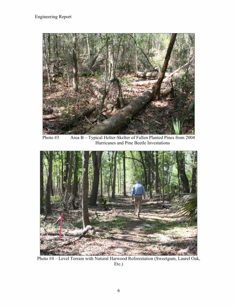
(DAR). They acquired this acre in 1927 as a historic graveyard (burial ground) associated with Fort King although presently there are no known graves on the site. Figure 2 shows the current (2009) development of the site. The palisade wall limits of the fort as shown in the figure were located in previous archaeological studies (1999-2002). Area A includes the fort and McCall’s house and yard and has been considered the most important historical area of the site based on previous studies. The McCall house presently functions as on-site living quarters for security personnel. Fort King Hill slopes steeply to the north, east, and south. Area B west of the hilltop is a moderately sloping plateau covered in planted pine. Areas C and D on the north slope are significantly eroded and in hardwood succession forest (laurel oak, hickory, sweetgum, magnolia, etc.). Areas E and F are bottom lands part of the intermittent drainage swale. Representative photographs of the site are shown in Photos #2, #3, and #4.

Engineering Report
5
McCallHouse
Fort King
PlantedSlashPine
DAR PrivateResidence
PrivateResidence
SE Fort King
MixedHardwoods(Laurel OakSweetgumMagnoliaHickory)
MixedHardwoods(Laurel OakSweetgumMagnoliaHickory)
A
B
CD
E
F
NE 4
1st A
venu
e
NE 3rd StreetNE
37t
h Te
rrace
NE 3
9th
Ave
S
EW
N
200'
PrivateResidences
NHL Boundary
NHL StoneMonument
Figure 2 –Existing Site Plan
Photo #2 – Archaeological Investigations Area A @ East Side of Fort Adjacent to McCall House, April 2009
Engineering Report
6
Photo #3 Area B – Typical Helter-Skelter of Fallen Planted Pines from 2004
Hurricanes and Pine Beetle Investations
Photo #4 – Level Terrain with Natural Harwood Reforestation (Sweetgum, Laurel Oak,
Etc.)

Engineering Report
7
The NPS Study As part of the National Historic Landmark classification, the National Park Service conducted a Special Resource Study (SRS) of the site to determine its best use in the National Park System including an upgrade to National Historic Park status which would be fully developed and maintained by Congress. The National Historic Landmark status carries no Federal funding obligation. The SRS was completed in October 2005 and summarized three possible development plans (Alternatives) for the site. The first two plans called for minimal improvements including hiking trails and continued use of the McCall house for a visitor center. The third site plan evaluated (Alternative D) is the only plan adequate for National Historic Park (Federally maintained) status. The Alternative D Site Plan is shown in Figure 3.
Figure 3 – NPS Alternative D Site Development Plan
Engineering Report
8
Chapter 3
Site Development Constraints
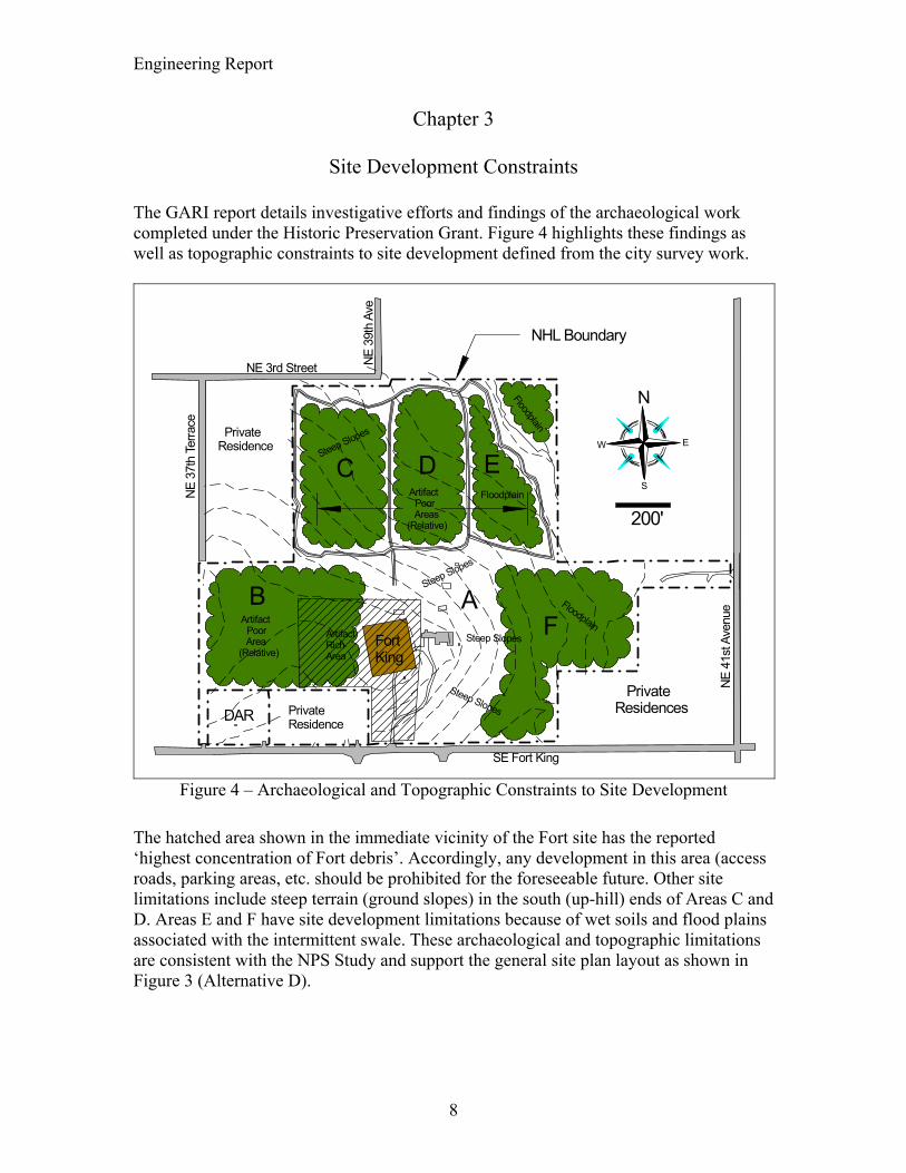
The GARI report details investigative efforts and findings of the archaeological work completed under the Historic Preservation Grant. Figure 4 highlights these findings as well as topographic constraints to site development defined from the city survey work.
Fort King
DAR PrivateResidence
PrivateResidence
SE Fort King
AB
C D E
F
NE 4
1st A
venu
e
NE 3rd Street
NE 3
7th
Terra
ce
NE 3
9th
Ave
S
EW
N
200'
PrivateResidences
NHL Boundary
ArtifactRichArea
Artifact Poor Areas(Relative)
Artifact Poor Area(Relative)
Floodplain
Floodplain
Floodplain
Steep Slopes
Steep Slopes
Steep Slopes
Steep Slopes
Figure 4 – Archaeological and Topographic Constraints to Site Development
The hatched area shown in the immediate vicinity of the Fort site has the reported ‘highest concentration of Fort debris’. Accordingly, any development in this area (access roads, parking areas, etc. should be prohibited for the foreseeable future. Other site limitations include steep terrain (ground slopes) in the south (up-hill) ends of Areas C and D. Areas E and F have site development limitations because of wet soils and flood plains associated with the intermittent swale. These archaeological and topographic limitations are consistent with the NPS Study and support the general site plan layout as shown in Figure 3 (Alternative D).
Engineering Report
9
Chapter 4
Conceptual Site Plan
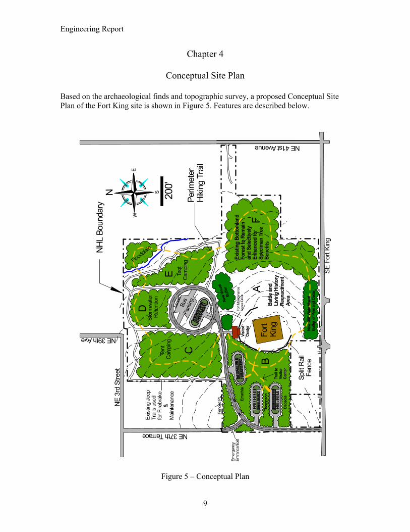
Based on the archaeological finds and topographic survey, a proposed Conceptual Site Plan of the Fort King site is shown in Figure 5. Features are described below.
Split
Rail
Fen
ce
Fort
King
SE F
ort K
ing
NE 41st Avenue
NE 3
rd S
treet
NE 37th Terrace
NE 39th Ave
S
EW
N 200'
NHL
Boun
dary
Emat
hla
Thom
pson
Osce
ola
Fenc
ed P
L
Emer
genc
yEn
tranc
e/Ex
itVi
sito
rCe
nter
Stor
mwa
ter
Ret
entio
n
Tent
Cam
ping
Te
ntCa
mpi
ngBu
s Par
king
B
us
Park
ing
Exist
ing
Jeep
Trai
ls us
edfo
r Fire
brak
e
&M
aint
enan
ce
Battl
e an
d Li
ving
His
tory
Reen
actm
ent
AreaNe
w Vi
sual
Bu
ffer
Floodpl
ain
Exis
ting
Botto
mla
ndFo
rest
to R
emai
nan
d Se
lect
ivel
yEn
hanc
ed fo
r Sp
ecim
an T
ree
Bene
fits
New
100'
Wid
e Vi
sual
Bu
ffer o
f Pin
e an
d Ce
dar
Fort
Mai
nten
ance
Acce
s Dr
ive
B
CPe
rimet
er
Hikin
g Tr
ail
Trai
l to
Visi
tor
Cent
er
D
E
FA
Jesu
p
Jum
per
Figure 5 – Conceptual Plan

Engineering Report
10
Site Plan Features – 1. Minimum new construction in artifact rich areas 2. Relocated entrance drive to west boundary (existing road easement) 3. Maximum use of existing contours (topography) to minimize cut and fill 4. Area A used for battle and living history reenactments 5. Area B used for Parking and trails 6. Area C used for tent camping 7. Area D used for Parking and Stormwater Retention 8. Area E used for Tent Camping next to wetland and creek bed 9. Area F used for natural buffer in wetland and creek bed 10. Possible phased construction (road length, parking lots, restrooms, etc.) 11. Use of existing forested areas minimizes mowing and maintenance costs. 12. Layout minimizes impact on neighbors (interior drives and parking). 13. Planted forest buffers isolates fort site from residential areas.

Engineering Report
11
Chapter 5
Implementation
Phase 1 Improvements The primary site improvement needed at present is a new access drive and parking lot which would allow for safe visitor use. Widening of Fort King Street is presently in final design and includes a turning lane at the proposed new site access drive as shown in Figure 5. Accordingly a proposed first phase improvement would consist of constructing the proposed new west entrance drive to the first proposed parking lot (Osceola Lot). If this is coordinated with the widening and resurfacing of Fort King Street there might be some cost economy as an addendum to the Fort King Street project. A preliminary cost estimate for this access drive and parking lot is as follows:
1. 350’ of 22’ wide (two lane) paved access drive w/roadway clearing, grubbing, and prep, stabilized subgrade, 8” of limerock base and 1 ½” of asphalt pavement @ $150/linear foot = $52,500.
2. 24 Space Parking lot w/circular access drive (same specs as above) including site clearing and prep = $50,000 each.
Total cost for this first phase improvement including engineering and swale retention ponds is estimate at $150,000. Access from the Osceola Parking Lot to the fort site would be by a 10-foot wide grassed and mowed walking trail. Phase 2 Improvements Phase 2 Improvements would include the further extension of the proposed access drive, additional parking lots and installation of restroom facilities. Estimated Phase 2 costs area as follows:
1. 2,100’ of 22’ wide (two lane) paved access drive w/roadway clearing as above @ $150/linear foot = $315,000
2. 4 – 24 Space Parking Lots as above @ $50,000 each = $200,000. 3. Associated Stormwater Management System (Culverts, Storm drains,
retention ponds) = $350,000. 4. Restoom Facilities = $150,000 w/offsite connection to central sewer system Total cost of Phase 2 Improvements is estimated at $1,000,000.
Phase 3 Improvements Phase 3 Improvements of the site is the construction of a visitor center in accordance with National Park standards. Estimated cost = $2 million.
End of Report