COMRISK meeting – March 2003 EUROSION Coastal Erosion - Assessing the needs for actions Project...
20
COMRISK meeting – March 2003 EUROSION Coastal Erosion - Assessing the needs for actions Project funded by the European Commission
-
Upload
augustus-williams -
Category
Documents
-
view
212 -
download
0
Transcript of COMRISK meeting – March 2003 EUROSION Coastal Erosion - Assessing the needs for actions Project...
COMRISK meeting – March 2003
EUROSIONCoastal Erosion - Assessing the
needs for actions
Project funded by the
European Commission
COMRISK meeting – March 2003
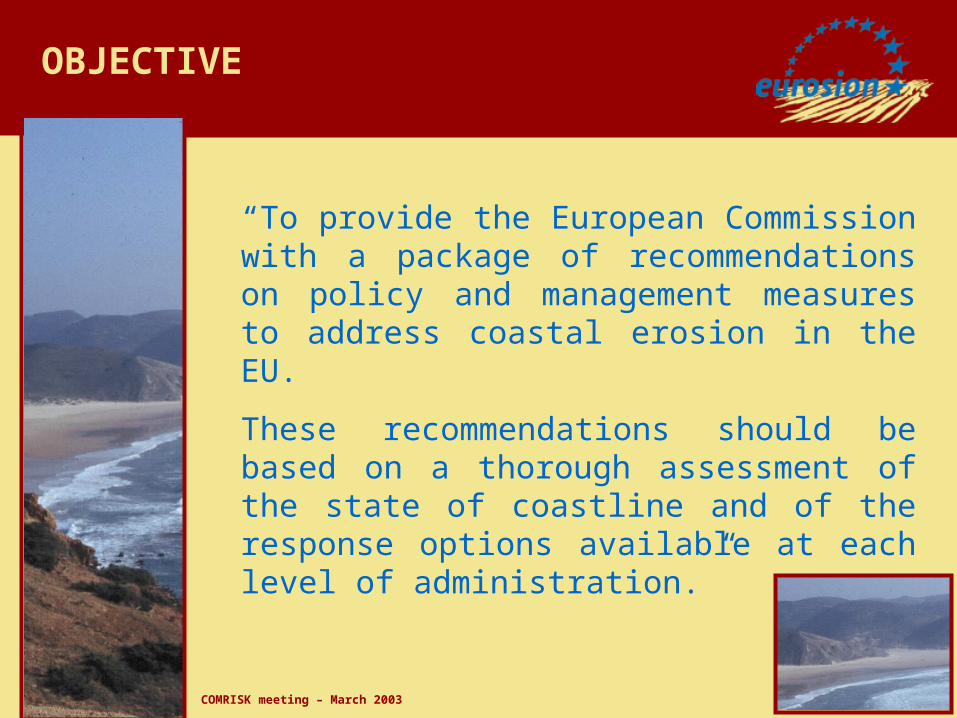
OBJECTIVE
“To provide the European Commission with a package of recommendations on policy and management measures to address coastal erosion in the EU.
These recommendations should be based on a thorough assessment of the state of coastline and of the response options available at each level of administration.”
COMRISK meeting – March 2003
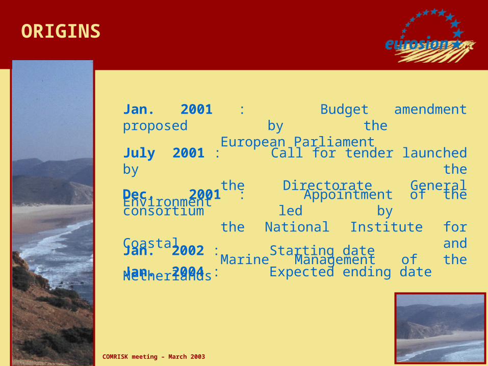
ORIGINS
Jan. 2001 : Budget amendment proposed by the European Parliament
July 2001 : Call for tender launched by thethe Directorate General Environment
Dec. 2001 : Appointment of the consortium led by the National Institute for Coastal andMarine Management of the Netherlands
Jan. 2002 : Starting date
Jan. 2004 : Expected ending date

COMRISK meeting – March 2003
Unit B.3 Territorial Dimension
European Commission
Directorate-General Environment
Directorate B - Environmental quality of Natural resources
THE CLIENT
COMRISK meeting – March 2003
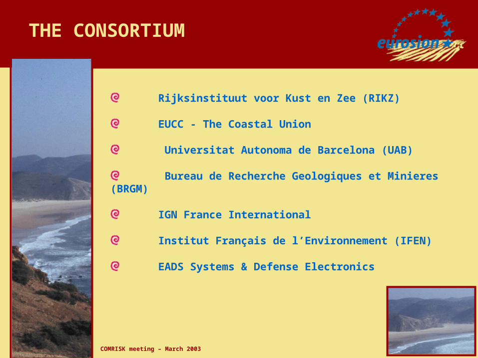
THE CONSORTIUM
Rijksinstituut voor Kust en Zee (RIKZ)
EUCC - The Coastal Union
Universitat Autonoma de Barcelona (UAB)
Bureau de Recherche Geologiques et Minieres (BRGM)
IGN France International
Institut Français de l’Environnement (IFEN)
EADS Systems & Defense Electronics

COMRISK meeting – March 2003
WORK PACKAGE 2
Production of a comprehensive multi-thematic database at scale 1:100,000, of European coasts and their vulnarability to coastal erosion
WORK PACKAGES 3&4
Review of lessons learned from local shoreline experiences and elaboration of a shoreline management guide
WORK PACKAGE 5
Formulation of policy recommendations for managing coastal erosion.
WORK PACKAGE
1
PROJECT
MANAGEMENT
WORK PACKAGES 6&7
Communication and dissemination of the project results towards the public
PROJECT ORGANISATION
COMRISK meeting – March 2003
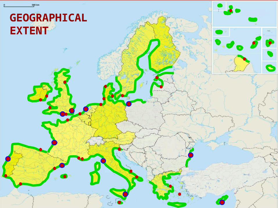
GEOGRAPHICAL EXTENT
COMRISK meeting – March 2003
FROM DATA TO INFORMATION
Occurence of storms
Sea level rise
Coastline sections featuring coastal erosion
Sediments discharged from rivers
Coastal urbanization
Change in coastal erosion patterns since 1985
Infrastructure disrupting sediment transports
Economical assets at risk
People at risk
Natural habitats at risk
INDICATORS OF DRIVING FORCES
INDICATORS OF PRESSURE
INDICATORS OF STATE
INDICATORS OF IMPACT
Areas potentially subject to floods
INDICATORS OF RESPONSE
Budget invested in shoreline management
Presence of coastal defence works
FROM INFORMATION TO ACTION
Administrative boundaries
Elevation and bathymetry
Land cover and Land cover changes
Hydrography
Infrastructure
Sediments discharged from rivers
Hydrodynamics and sea level rise
Geology, geomorphology and evolutionary trends
Nationally designated areas (NATURA2000)
Legal and regulatory patterns
Budget invested in shoreline management
Socio-economical profiles
EUROPE-WIDE DATABASE
Coastal erosion hotspots
Highly vulnerable areas
Moderately vulnerable areas
Lowly vulnerable areas
VULNERABILITY ASSESSMENT
WP 2 – EUROPE-WIDE VULNERABILITY ASSESSMENT

COMRISK meeting – March 2003
Review erosion management practices over 60 case studies
1. Geomorpho- and hydro-dynamical processes2. Policy framework3. Technical and engineering solution4. Social and economical profile
WP3&4 - LESSONS LEARNED FROM LOCAL EXPERIENCES
5. Communication between stakeholders
Decision-making processesPublic perception
6. Information management practices
Modelling and monitoring toolsData collection and storageData processing and representationData dissemination and exchange
11 pilot areas11 pilot areas
Guidelines for implementing Local Information Systems
Elaboration of a Shoreline Management Guide
COMRISK meeting – March 2003
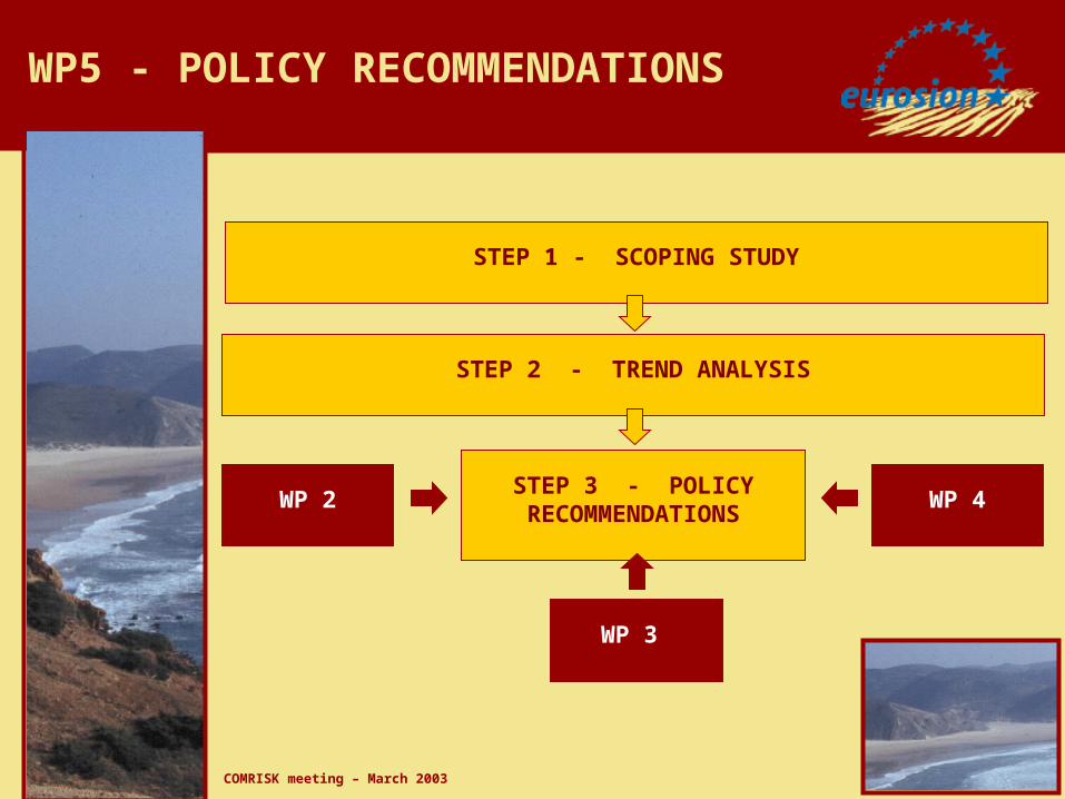
STEP 1 - SCOPING STUDY
STEP 2 - TREND ANALYSIS
STEP 3 - POLICY RECOMMENDATIONS
WP 2
WP 3
WP 4
WP5 - POLICY RECOMMENDATIONS
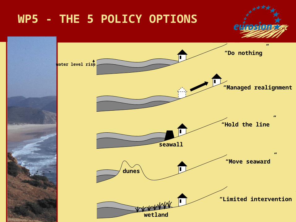
COMRISK meeting – March 2003
seawall
dunes
wetland
“Hold the line”
“Managed realignment”
“Do nothing”
“Move seaward”
“Limited intervention”
water level rise
WP5 - THE 5 POLICY OPTIONS
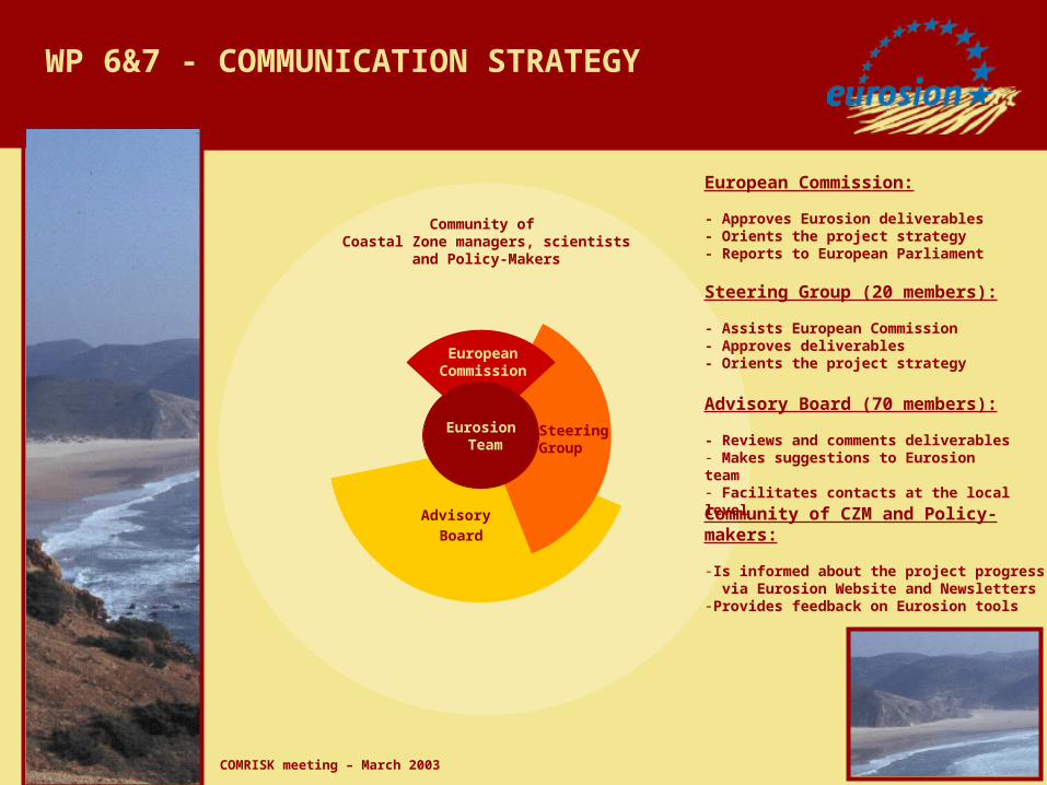
COMRISK meeting – March 2003
Community of Coastal Zone managers, scientists
and Policy-Makers
Advisory Board
Steering Group
EuropeanCommission
Eurosion Team
Steering Group (20 members):
- Assists European Commission- Approves deliverables- Orients the project strategy
Advisory Board (70 members):
- Reviews and comments deliverables- Makes suggestions to Eurosion team- Facilitates contacts at the local level
Community of CZM and Policy-makers:
-Is informed about the project progress via Eurosion Website and Newsletters-Provides feedback on Eurosion tools
European Commission:
- Approves Eurosion deliverables- Orients the project strategy- Reports to European Parliament
WP 6&7 - COMMUNICATION STRATEGY
COMRISK meeting – March 2003
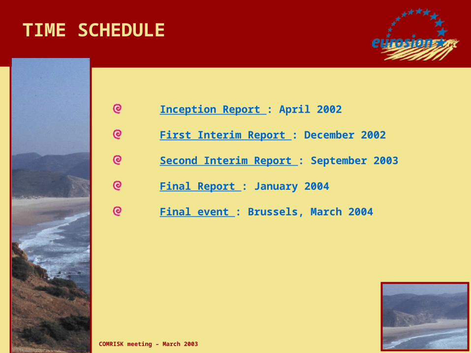
TIME SCHEDULE
Inception Report : April 2002
First Interim Report : December 2002
Second Interim Report : September 2003
Final Report : January 2004
Final event : Brussels, March 2004

COMRISK meeting – March 2003
http://www.eurosion.org
Thank you for your attention !
COMRISK meeting – March 2003

COMRISK meeting – March 2003
GEOMORPHOLOGY AND GEOLOGYExample of Aquitaine (France)
Source: EUROSION

COMRISK meeting – March 2003
ADMINISTRATIVE BOUNDARIESExample of Ajaccio Bay – Corsica (France)
Source: SABE
Mediterranean Sea

COMRISK meeting – March 2003
LAND COVER Example of Andalucia (Spain)
Source CORINE Land Cover

COMRISK meeting – March 2003
(0.7643 E, 49.2345 N) statistical values observed over a period of 18.6 yearsN NE E SE S SW W NW All
Mean wave height (m) 0.9 2.3 2.2 2.7 2.1 1.1 1.0 0.9 1.7Wave height that is exceeded 10% ot the time (m) 1.5 3.9 3.7 4.6 3.6 1.9 1.7 1.5 2.8Wave height that is exceeded 1% ot the time (m) 2.6 6.6 6.4 7.8 6.1 3.2 2.9 2.6 4.8Mean wave period (s) 3.6 4.2 4.1 4.2 4.4 4.3 4.1 3.8 4.1Mean wave period that is exceeded 10% of the time (s) 6.1 7.1 7.0 7.1 7.5 7.3 7.0 6.5 6.9Mean wave period that is exceeded 1% of the time (s) 10.4 12.1 11.8 12.1 12.7 12.4 11.8 11.0 11.8Average w ind speed at 10 meter height (m/s) 1.8 2.0 2.1 2.0 1.9 1.9 1.8 1.8 1.9Wind speed that is exceeded 10% of the time (m/s) 3.1 3.4 3.6 3.4 3.2 3.2 3.1 3.1 3.3Wind speed that is exceeded 1% of the time (m/s) 5.2 5.8 6.1 5.8 5.5 5.5 5.2 5.2 5.5Tidal range (m) - - - - - - - - 3.2Sea level rise (mm) - - - - - - - - 2.4
HYDRODYNAMICAL DATAExample of Fécamp (France)
Source: EUROSION

COMRISK meeting – March 2003
Quantity discharged in 2000
QUANTITY OF SEDIMENTS DISCHARGED BY RIVERS Source: adapted from NOPOLU / JRC