
Comprehensive Plan for Tysons Corner 1. 2 Land Use Categories 1.Transit Station Mixed Use: the...
15
Comprehensive Plan for Tysons Corner 1
Transcript of Comprehensive Plan for Tysons Corner 1. 2 Land Use Categories 1.Transit Station Mixed Use: the...

Comprehensive Plan for Tysons Corner
1

2

Land Use Categories
1. Transit Station Mixed Use: the overall percentage of office uses throughout all of the Transit Station Mixed Use areas should be approximately 65%. Individual developments may have flexibility to build more than 65% office if other developments in the category are built or rezoned with a use mix that contains proportionately less office. The residential component should be on the order of 20% or more of the total development
2. Retail Mixed Use: the residential component should be on the order of 20% or more
3. Office: planned almost exclusively for office uses
4. Residential Mixed Use: the residential component should be on the order of 75% or more of the total development
5. Residential: planned almost exclusively for residential uses
6. Civic Use or Public Facility: planned for public uses, such as a library, school, arts center, or community center
7. Parks/Open Space: planned for passive and active park land and urban open spaces such as plazas and pocket parks
http://www.fairfaxcounty.gov/dpz/comprehensiveplan/adoptedtext/2007-23.pdf
3

4
FARs
No maximum FAR for properties within ¼ mile of rail; however, office (and uses that generate more trips than hotels) above a 2.5 FAR will be approved through an SE Properties beyond ¼ mile of Metro Stations may redevelop up to a 2.0 FAR, plus bonuses for affordable and workforce housings and superlative contributions toward implementing public facilities Properties within 1/3 mile of Metro Stations that do not include any office space or other high trip generating uses may redevelop up to 2.5 FAR, plus bonuses (this increase was meant to encourage residential uses between the ¼ and ½ mile)
Redevelopment proposals for TOD District areas that are located more than 1/4 milefrom the stations may be allowed additional intensity if:
• They are planned for the residential mixed use category• They can demonstrate a convenient, safe, and pleasant walk to a Metro station• They can demonstrate that they are unable to achieve the proposed intensity through bonuses
for affordable housing or public facilities and • They are in close proximity to or redeveloping in coordination with an area that is located within
1/4 mile of a Metro station
Specific guidance for properties in the Non-TOD area is outlined in the District Regulations
5
The County has set an initial “maximum” office development level of 45 million square feet
Today, Tysons has:
• 27 million square feet of office development on the ground• 6 million square feet approved and in the pipeline and• 2 million square feet reserved for the superlative provision of public facilities leaving:
10 million square feet of office development remaining
and
At least 5 rezoning applications have been or are about to be filed.
Initial Development Level
6

7

8

Proffer Summary
1. Major transportation commitments, including the grid of streets and Tysons-wide transportation improvements2. Structured parking and parking design3. Workforce and Affordable Housing4. Urban parks and active recreation facilities5. Stormwater management and environmental requirements6. Green-building7. Public facilities (schools, fire and police stations, libraries, etc.)8. Urban design (shadow and wind studies, noise studies, landscaping, streetscape design amenities, etc.)8. Bicycle parking, racks and lockers9. Bus shelters10. Circulator system11. Lighting12. Information and Communications Technology13. Signage
9

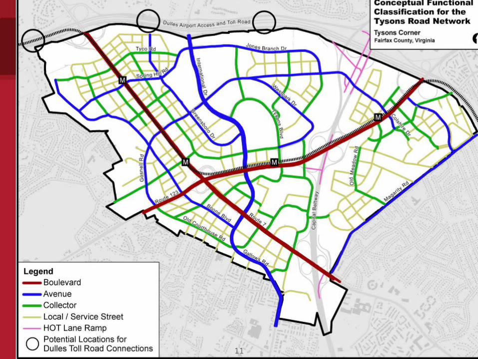
1. Grid of Streets
Creation of an official map with conceptual engineering sufficient to determine the centerline and width of right-of-way (with input and cooperation from local landowners and the Fairfax County and Virginia Departments of Transportation) a
Provision of the grid of streets, on and off-site, including sidewalks, on-street parallel parking and dedicated bicycle lanes where applicable
2. Tysons-Wide Transportation Improvements (approximately $210 million, to be funded through a Tysons-wide
Community Development Authority (“CDA”) and apportioned based on $.07 per $100 of assessed value, a smaller CDA that provides a significant component of the $210 million or other binding commitments to phase development to the funding or construction of one or more of the Tysons-wide improvements)
3. Tysons Transportation Fund: currently, $3.87 per square foot of non-residential development; $859 per unit for
residential development (however, in a recent presentation by the Fairfax County Office of Community Revitalization and Reinvestment to the Planning Commission, it was suggested that this figure could go up as high as $8.63 per square foot of non-residential development and $1,000 per unit)
4. Traffic Impact Analyses (evaluating 3 time periods: 1st phase, interim phase and Plan build-out) 5. Transportation Demand Management (“TDM”), including:
TDM implementation plansTDM coordinatorsTDM monitoring andTDM commitments, including parking management, phasing plans, remedy funds to improve TDM program delivery
and penalties to deter non-compliance
Major Transportation Commitments
10
11

Proffers: Stumbling Blocks
Workforce and affordable housing
• 20% of units in a residential development should be affordable to households with incomes ranging from 50-120% of Area Median Income (“AMI”)
• Non-residential development should contribute $3.00 per square foot (adjusted annually) to a housing trust fund
Urban parks and active recreation facilities
• Urban parks (between ½ acre and 5 acres): 1.5 acres per 1,000 residents and 1 acre per 10,000 employees
• Recreational facilities: 20 fields to serve Tysons, approximately 2 acres per field (addressed through on-site development of needed facilities and/or through equivalent money or in-kind contributions to the Park Authority)
12

Parking Spaces Per Unit or Spaces Per 1,000 sq. ft.
Previous 1/8 1/8 - 1/4 1/4 - 1/2 Non-TOD
Min. Min. Max. Min. Max. Min. Max. Min. Max.Townhouse 2.7 1.75 2.2 1.75 2.2 2.0 2.5 2.0 2.7
Multifamily0-1 bedroom 1.6 1.0 1.3 1.0 1.3 1.1 1.4 1.1 1.42 bedroom 1.6 1.0 1.6 1.0 1.6 1.35 1.7 1.35 1.73+ bedroom 1.6 1.0 1.9 1.0 1.9 1.6 2.0 1.6 2.0
Hotel/Motel 1.08 none 1.0 none 1.0 none 1.05 0.85 1.08
Office 2.6 none 1.6 none 2.0 none 2.2 2.0 2.4
Parking Ratios for Tysons Corner
13

In all cases, consolidations or coordinated development plans should meet the followingobjectives:
1.Commitment to a functioning grid of streets both on-site and off-site
2.Provision of parks and open space as set forth in the Environmental Stewardship section of the Areawide Recommendations, either on-site or within the subdistrict through a partnership
3.Provision of land and/or building space for public facilities as set forth in the Public Facilities section of the Areawide Recommendations
4.Conformance with the guidance in the Urban Design section and any urban design guidelines for the district or subdistrict
5.Demonstration of how adjacent parcels could be redeveloped in a manner that is compatible with the proposal and in conformance with the Plan.
Consolidation
14
Zoning Ordinance Amendment:Major Elements
Rezoning to the “Planned Tysons Corner Urban District” (“PTC”) required of all properties in Tysons Corner whose owners wish to take advantage of the redevelopment option in the Comprehensive Plan Amendment
Use of the PTC District limited to the 1,700 acres of Tysons Corner Cellar space counts toward FAR (it is not counted in the other districts) 10-acre minimum lot size required (but the minimum can be waived by the Board
of Supervisors) Maximum FAR:
Within ¼, mile, no maximum FAR (but a Special Exception above a 2.5 FAR is required for uses that generate more vehicle trips than hotel use )
Beyond ¼ mile and in the non-TOD districts, 2.5 FAR, exclusive of bonus FAR However, properties in the TOD district but beyond ¼ mile and proposed for residential mixed-use may
utilize the FARs listed in the 1st bullet subject to certain conditions (i.e. acceptable pedestrian access to the Metrorail station, adjacent to or redeveloping in coordination with property that is within ¼ mile)
No maximum building heights or minimum yard requirements (Plan would dictate) No percentage requirement for open space (Plan would dictate) Small, stand alone structures discouraged except where part of a long-term
phased development; and then, only as interim uses New parking methodology employed - both minimums and maximums are
specified and the requirements are premised on distance to rail15


