Comprehensive Land Use Plan For Henry County, Kentucky
44
Comprehensive Land Use Plan For Henry County, Kentucky Prepared For Henry County Planning Commission Henry County Courthouse Annex New Castle, Kentucky 40050 Henry County Planning Commission Sam Adams, Chairman Mike Ray, Vice-Chairman Rueben Yount Terry Rowlett Cindy Norton John Wheeler Carol Spreitzer Minice McAlister Danny Shain Ed Frederick Darlene Taylor, Secretary Josh Clubb, Attorney
Transcript of Comprehensive Land Use Plan For Henry County, Kentucky
Comprehensive Land Use Plan
For
Henry County, Kentucky
Prepared For
Henry County Planning Commission Henry County Courthouse Annex
New Castle, Kentucky 40050
Henry County Planning Commission
Sam Adams, Chairman
Mike Ray, Vice-Chairman
Rueben Yount
Terry Rowlett
Cindy Norton
John Wheeler
Carol Spreitzer
Minice McAlister
Danny Shain
Ed Frederick
Darlene Taylor, Secretary
Josh Clubb, Attorney

Henry County Board of Adjustments
Robert Reed Bush, Chairman
Richard Riedel, Vice-Chairman
Glenn Smith
Yvonne Moore
Frank Denton
Bill Henderson
Matt Jackson
Josh Clubb, Attorney
Henry County Fiscal Court
John Logan Brent, County Judge Executive
Scott Bates, District #1
Rickey Timberlake, District #2
Jason Stanley, District #3
M.Terri Cummings, District #4
Michael Fisher, District #5
Jerry Beasley, District #6

APPENDIX
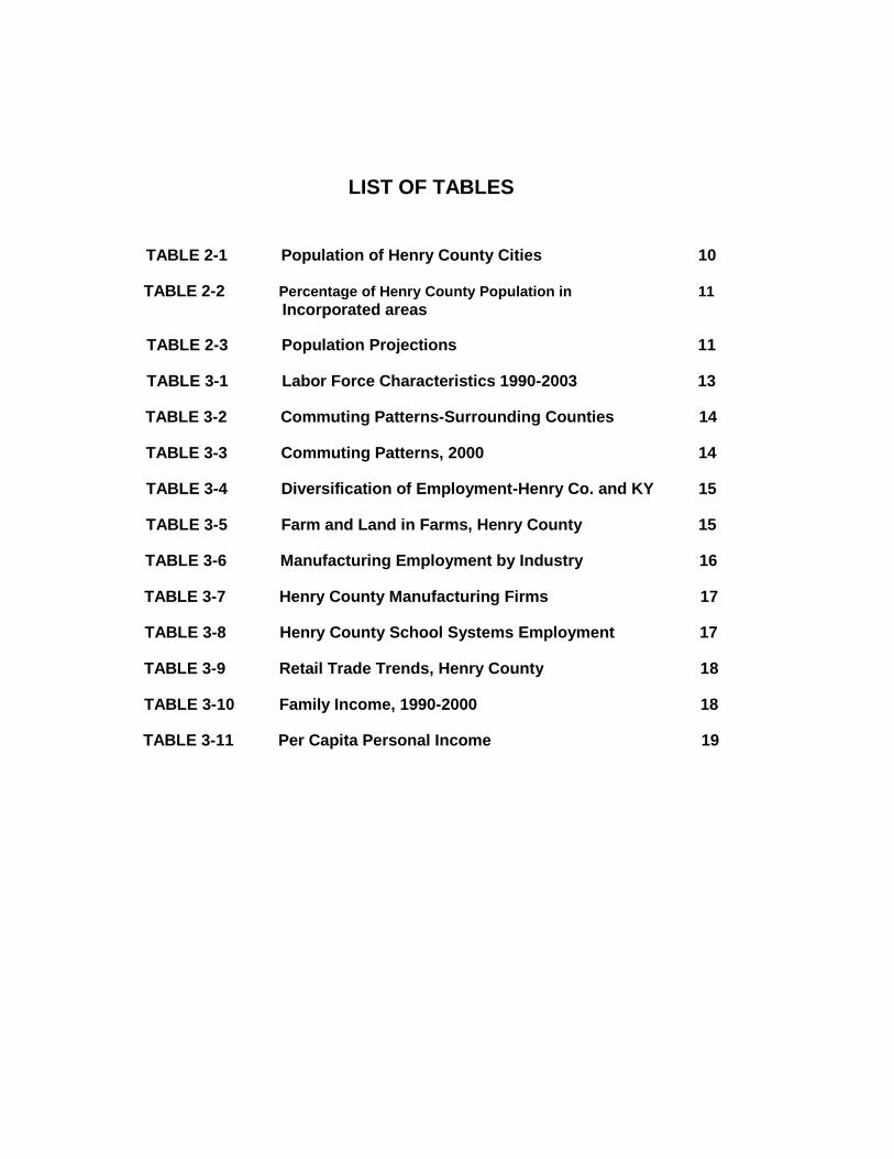
LIST OF TABLES
TABLE 2-1 Population of Henry County Cities 10
TABLE 2-2 Percentage of Henry County Population in 11
Incorporated areas
TABLE 2-3 Population Projections 11
TABLE 3-1 Labor Force Characteristics 1990-2003 13
TABLE 3-2 Commuting Patterns-Surrounding Counties 14
TABLE 3-3 Commuting Patterns, 2000 14
TABLE 3-4 Diversification of Employment-Henry Co. and KY 15
TABLE 3-5 Farm and Land in Farms, Henry County 15
TABLE 3-6 Manufacturing Employment by Industry 16
TABLE 3-7 Henry County Manufacturing Firms 17
TABLE 3-8 Henry County School Systems Employment 17
TABLE 3-9 Retail Trade Trends, Henry County 18
TABLE 3-10 Family Income, 1990-2000 18
TABLE 3-11 Per Capita Personal Income 19

LIST OF MAPS
MAP 1 New Castle Land Use
MAP 2 Eminence Land Use
MAP 3 Smithfield Land Use
MAP 4 Pleasureville Land Use
MAP 5 Campbellsburg Land Use
MAP 6 New Castle Future Land Use
MAP 7 Eminence Future Land Use
MAP 8 Smithfield Future Land Use
MAP 9 Pleasureville Future Land Use
MAP 10 Campbellsburg Future Land Use
MAP 11 Henry County Land Use and Land Cover
MAP 12 New Castle Traffic Areas
MAP 13 Eminence Traffic Areas
MAP 14 Smithfield Traffic Areas
MAP 15 Pleasureville Traffic Areas
MAP 16 Campbellsburg Traffic Areas
MAP 17 Henry County Fire Districts
MAP 18 Henry County Cities and Points of Interest
MAP 19 Henry County Water Districts
MAP 20 Henry County Soils
MAP 21 Henry County Agricultural Districts
MAP 22 Henry County Pace Easements
MAP 23 Henry County School Districts
MAP 24 Future Land Use Campbellsburg Interstate Interchange
MAP 25 Future Land Use Pendleton Interstate Interchange

HENRY COUNTY COMPREHENSIVE LAND USE PLAN UPDATE
TABLE OF CONTENTS
INTRODUCTION 1 CHAPTER I GOALS AND OBJECTIVES 3 Housing 3 Natural Resources 3 Land Use 4 Agriculture 4 Residential Land Use 5 Commercial Development 5 Industrial Development 6 Transportation 6 Community Facilities 7 Economic Development 8 Annexation/Growth 8 CHAPTER II POPULATION ANALYSIS 9 Introduction 9 Past Population Characteristics 10 Population Distribution 11 Future Population Forecasts CHAPTER III ECONOMIC ANALYSIS 12 Introduction 12 CHAPTER IV EXISTING LAND USE 20 Housing Background 20 Physiographic Features 20 Soils 21 Geology 22 Groundwater 22 Slopes 22 Floodplains 22 Incorporated Cities and Existing Land Use 23

CHAPTER V COMMUNITY FACILITIES PLAN 25 Introduction 25 Sewer 25 Water 26 Electricity and Gas 27 Solid Waste 27 Safety and Health 27 Education 28 Library 29 Media 29 Capital Improvements Plan 30 CHAPTER VI TRANSPORTATION PLAN 31 Introduction 31 Pleasureville 31 Smithfield 32 Campbellsburg 32 New Castle 33 Eminence 33 Rail 34 Trucking 34 Water 34 Air 34 CHAPTER VII FUTURE LAND USE PLAN 35 Introduction 35 Agricultural Protection 35 Future Land Use 35 Residential Use 38 Commercial Use 39 Industrial Use 40 Public/Semi-Public Use 40 Principles for Proposed Land Use 42 Application for Maps 44 CHAPTER VIII IMPLEMENTATION 46 Land Use Map vs. Zoning Map 46

LIST OF CHARTS CHART 1 Percent of Population−Agriculture Page 13 CHART 2 Tax Dollars Vs. Residential Services Cost Page 41-A

HENRY COUNTY COMPREHENSIVE LAND USE PLAN UPDATE
INTRODUCTION
A Comprehensive Plan is a document prepared to help guide the future growth and development of a community. Basically such a plan should be:
Comprehensive - A plan should cover all geographic parts of a community and all activities that affect physical development.
General - A plan is not supposed to be a straightjacket. It should summarize policies and proposals and is intended to provide flexibility.
Long range - This plan strives to present a vision of the future of the community. While addressing short-term issues and problems, its main function is to look beyond current conditions to those desired 20 years from now.
This plan is designed as a tool to be used by all decision makers, both public and private. In so doing, this Plan is an update and reflects the expressed desires of the community and serves as a guide to decision making (i.e. zone change and development plan).
In order to be effective a Comprehensive Plan must be evaluated at least every five years to insure that it still- guides the community in the most appropriate direction. Once adopted it will be imperative to continue to periodically review, revise, and update to ensure its relevance to the community.
Kentucky Revised Statutes, Chapter 100 provides the enabling legislation for planning and plan implementation (zoning ordinances, subdivision regulations, official maps and capital improvement programming) to local governments. Several parts of Chapter 100 are related to the preparation and use of the Comprehensive Plan. Following is a brief synopsis of those sections of Chapter 100.
100.183 Comprehensive Plan Required. This section requires each Planning Commission to prepare a plan "which shall serve as a guide for public and private actions and decisions to assure the development of public and private property in the most appropriate relationships."
100.187 Contents of Comprehensive Plan. This section outlines the basic components of the plan. They include: a statement of Goals and Objectives, a land use element, a transportation plan element, a community facilities element, and other elements that will further serve the purposes of the plan.
100.191 Research Requirements for Comprehensive Plan. Section 191 sets forth the basic research that must be done during the preparation of the plan. There are three categories of research needed: population (past and future trends); economic survey and analysis; and analysis to "the nature, extent, adequacy and the needs of the community for the existing land and- building use, transportation and community facilities in terms of their general location, character and extent."

100.193 Statement of Goals and Objectives. This section states that the Planning Commission must prepare and adopt the statement of objectives (the Goals and Objectives required in 100.187) to act as a guide for preparing the rest of the plan. In addition, this section directs the Commission to present this statement for consideration, amendment and adoption by the legislative body and/or fiscal court within its area of jurisdiction.
100.197 Adoption and Amendment; Comprehensive Plan. This section outlines the processes for adoption and amendment of the plan. It specifically states that the plan elements must be reviewed and amended, if necessary, at least once every five years.
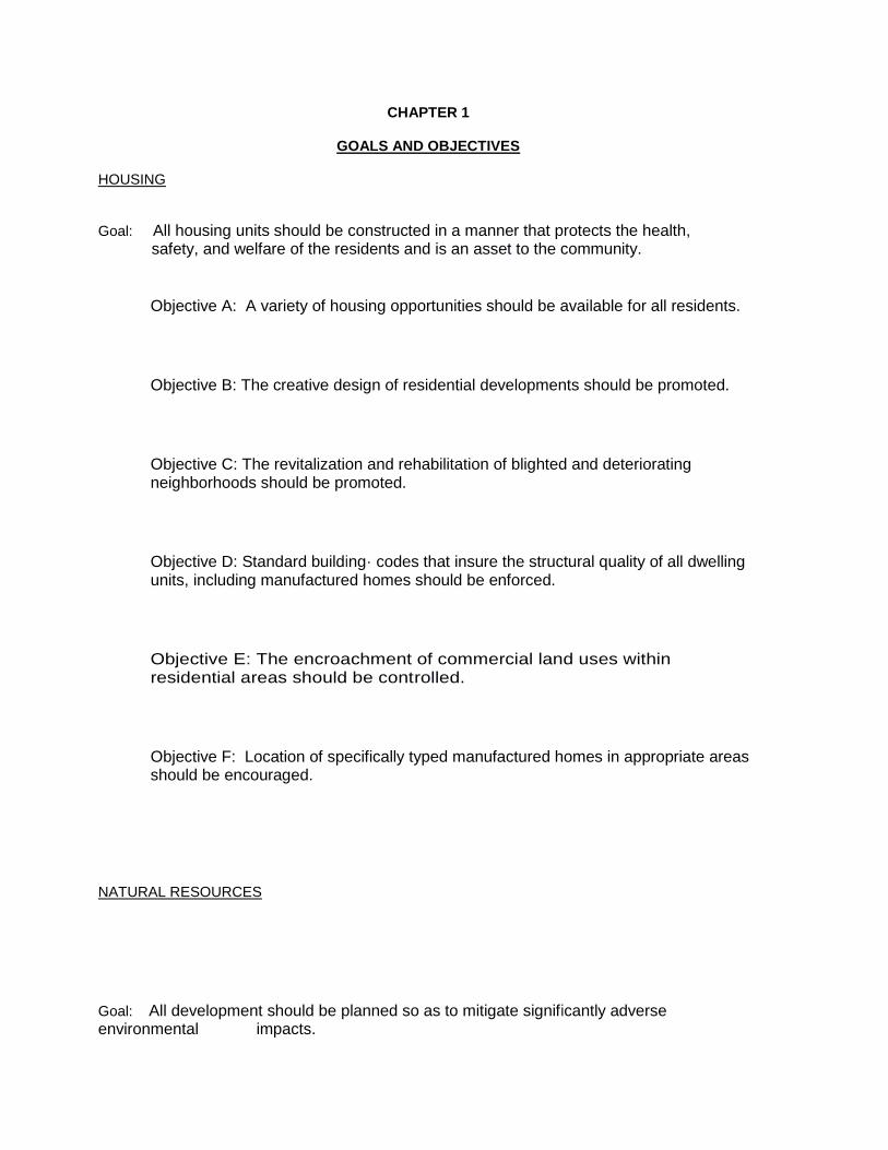
CHAPTER 1
GOALS AND OBJECTIVES HOUSING
Goal: All housing units should be constructed in a manner that protects the health, safety, and welfare of the residents and is an asset to the community.
Objective A: A variety of housing opportunities should be available for all residents.
Objective B: The creative design of residential developments should be promoted.
Objective C: The revitalization and rehabilitation of blighted and deteriorating neighborhoods should be promoted.
Objective D: Standard building· codes that insure the structural quality of all dwelling units, including manufactured homes should be enforced.
Objective E: The encroachment of commercial land uses within residential areas should be controlled.
Objective F: Location of specifically typed manufactured homes in appropriate areas should be encouraged.
NATURAL RESOURCES
Goal: All development should be planned so as to mitigate significantly adverse environmental impacts.

Objective A: Any development in floodplains should be sensitive to property loss, damage, or hazards associated with floods. Information is available on Floodplain Maps in the Planning & Zoning Office or on the Internet at www.fema.com .
Objective B: Development in Karst areas should be sensitive to environmental hazards created off or on-site.
Objective C: Proper construction techniques should be employed when building on unsuitable soils and steep slopes.
Objective D: New industrial development proposals should insure that pollution controls are adequate and meet the Environmental Protection Agency's current standards.
Objective E: Developments engaged in the handling or disposal of wastes, especially those hazardous to the health, safety and welfare of Henry County residents, should be regulated and controlled.
LAND USE
Goal: All land use should be developed in a manner that promotes the health, safety, and
general welfare of residents in Henry County.
Objective A: Land use transitions between land uses of varying density or intensity should be facilitated.
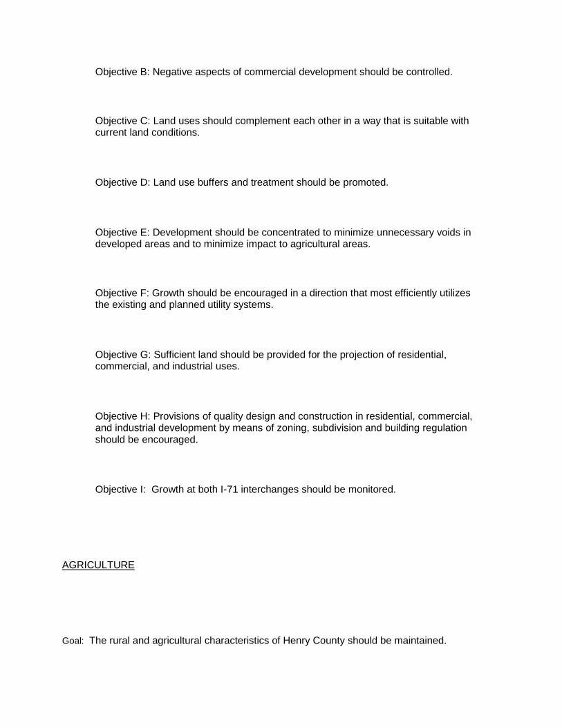
Objective B: Negative aspects of commercial development should be controlled.
Objective C: Land uses should complement each other in a way that is suitable with current land conditions.
Objective D: Land use buffers and treatment should be promoted.
Objective E: Development should be concentrated to minimize unnecessary voids in developed areas and to minimize impact to agricultural areas.
Objective F: Growth should be encouraged in a direction that most efficiently utilizes the existing and planned utility systems.
Objective G: Sufficient land should be provided for the projection of residential, commercial, and industrial uses.
Objective H: Provisions of quality design and construction in residential, commercial, and industrial development by means of zoning, subdivision and building regulation should be encouraged.
Objective I: Growth at both I-71 interchanges should be monitored.
AGRICULTURE
Goal: The rural and agricultural characteristics of Henry County should be maintained.

Objective A: The agricultural heritage and atmosphere of Henry County should be protected.
Objective B: A stable agricultural base for the County while, accomplishing orderly development and maximum land utilization should be maintained.
Objective C: Regulations related to agricultural lands, processes, dwellings and buildings should be minimized.
Objective D: Agricultural District Map and Pace Map should be looked at in relation to conservation, easements and Pace. See Map 21 and Map 22 in the Appendix.
RESIDENTIAL LAND USE
Goal: The creation and perpetuation of stable and attractive residential neighborhoods should be promoted.
Objective A: Appropriate regulations for sized lots and sound housing 'With adequate floor space should be established.
Objective B: Residential land-uses should be buffered from adverse impacts on non-residential uses.
Objective C: New residential land uses should be located in areas suitable for residential development and should be separated from high intensity uses.
Objective D: The location of non-agricultural scattered housing sites in undeveloped rural areas should be discouraged. Zones with A-2 and A-3 ratings should be discouraged in rural areas and encouraged closer to incorporated cities and those
seven unincorporated communities as shown on page 24 in bold typeset.
COMMERCIAL DEVELOPMENT
GOAL: Attractive and well designed commercial areas, which assure an adequate variety of goods and services for the convenience of the public and are easily and safely accessible from adjoining thoroughfares, and do not have an adverse impact upon adjacent land use should be provided.
Objective A: The cities' Central Business Districts should be strengthened as the major and most easily accessible shopping, business, professional, civic and entertainment centers in the County.
Objective B: The development of off-street parking, both public and private, within the Central Business District and other commercial developments should be encouraged.
Objective C: The development of poorly located and shallow commercial strips, the consolidation of commercial activities, and minimization of the encroachment of commercial establishments into residential areas should be discouraged through zoning.
Objective D: Encourage major commercial development near already populated centers.
INDUSTRIAL DEVELOPMENT

GOAL: Industrial areas or sites that will encourage the development of planned industrial parks and provide for diversification of the industrial base of the County should be provided.
Objective A: Industrial parks should be located in areas with adequate roads, water, sewer, police, emergency services and fire protection.
Objective B: The concentration of industrial activity should be promoted in limited areas most suitable for industrial use and discouraged at isolated sites. Objective C: Mitigation of the impact of industrial zones upon surrounding areas should be considered.
TRANSPORTATION
Objective A: New collector and arterial streets in urban areas should be created.
Objective B: Existing substandard right-of-ways and roads should be upgraded when new development presents opportunities.
Objective C: The construction of sidewalks should provide for the safe movement of pedestrians through new residential subdivisions.
Objective D: New construction along arterial corridors should be facilitated through the provision and encouragement of service roads, designated crossovers, and control of access points.
Objective E: Improved safety at location having high accident rates should occur through the channelization of intersections, signals, and other improvements.
Objective F: Adequate rail transportation systems and adequate support facilities should be ensured.
Objective G: Improvements of Gratz Bridge should be strongly encouraged.
Objective H: Improve Highway 146 between New Castle and Pendleton by widening
and straightening to provide better safety and encourage Economic Development.
Objective I: Improve both I-71 interchanges for safety reasons.
TRANSPORTATION

GOAL: Inter and intra-county access should be improved to Henry County.
Objective A: The promotion of improvements to KY 55, KY 146, KY 22, and KY 421, and improvements to traffic flow in the Eminence area and improve routes to Shawnee Park.
Objective B: Improve both 1-71 interchanges for better access and safety.
COMMUNITY FACILITIES
GOAL: Adequate and desirable community facilities and public service should be provided in an orderly and efficient manner.
Objective A: Vocational education should be expanded to residents in Henry County. Objective B: Strategies to improve public schools in Henry County should continue to be developed. Objective C: Sewer facilities should continue to be improved throughout the County and to get better sewer availability at the Interstate interchanges should be pursued. Objective D: Water pressure and supplies should be improved throughout the entire County. Objective E: Adequate police and fire protection should be provided to all areas of Henry County. (The district fire protection has been accomplished by the $35.00 deed assessment fee that is dispensed to the proper district.) Objective F: County recreation facilities should be encouraged and expanded. Recreational facilities should be encouraged in all communities. Objective G: Encourage and expand recycling programs, such as tires, metal, etc .... Objective H: Additional nursing home facilities for the elderly and others needing care should be provided. Encourage more retirement homes and assisted living facilities. Objective I: Emergency medical services should be upgraded and available 24 hours a day. Part time service has been established and full time service is being encouraged.
Objective J: A Regional Sewage Facility should be obtained.

ECONOMIC DEVELOPMENT
GOAL: A sound economic base within the county should be provided through an intelligent program of industrial development, commercial expansion, preservation, and enhancement of the existing assets in the county.
Objective A: The development of industrial parks in areas with adequate facilitates should be promoted.
Objective B: Development and growth of small businesses should be promoted.
Objective C: The development of commercial and industrial uses should be compatible with surrounding land uses.
Objective D: The expansion of existing businesses and clean industries should be promoted.
Objective E: In order to accommodate new industry the cities and the county must acquire physical, social, and community resources for development.
Objective F: Upgrade the condition of buildings and facilities and develop appropriate promotional strategies to attract and enhance new commercial, retail, and professional business in Eminence, New Castle, Pleasureville, and Campbellsburg.
Objective G: Small retail establishments in Smithfield and other small community districts should be encouraged throughout the County.
Objective H: A state park or recreational facility should be developed in the existing forest areas and land along Kentucky River.
Objective I: Encourage Economic Development Programs that promote the sale of locally grown and locally produced products. Encourage Economic Development Program, which includes full time Specialists and staff.
ANNEXATION/GROWTH
Goal: Annexation of adjacent areas near New Castle, Eminence, Pleasureville, Smithfield, and Campbellsburg should be facilitated.
Objective A: Annexation agreements with residents in return for the provision of city services should be secured.
CHAPTER II
POPULATION ANALYSIS Introduction The analysis of population trends serves as a fundamental basis for many planning decisions. The size of the population, its composition, and its spatial distribution impact future social, economic, and physical land use needs. An examination of the current population size and trends over recent years provides an estimate of current land use and spatial needs. The use of future population projections then allows the prediction of future land use and space needs. Population composition provides the breakdown by categories such as age groups, household sizes and income levels. This information assists in determining the division of space needs for schools, recreational areas, and other community facilities for each population characteristic category. The current and projected future population distribution determines where the various land uses transportation routes and community facilities should be located throughout the county or urban areas. Past Population Characteristics The population of Henry County grew by 12.5% between 1950 and 1990. During the twenty years from 1950 to 1970, the population steadily declined. It was not until the decade between 1970 and 1980 that Henry County again experienced population growth. Henry County’s growth of 17.5% between 1970 and 1990 is significant, especially when compared to the statewide increase in population of 13.6%. Oldham County, which borders Henry, experienced population increase of 201.7% since 1950. It is important to note that while Jefferson County’s population decreased between 1970 and 1990, the counties along and near its borders gained in population. This trend is indicative of the effects of suburbanization and out-migration from urban areas to suburban counties and may be responsible for a further population increase in Henry County between 1990 and 2010. Henry County has five incorporated cities, the largest of which is Eminence. Table 2-1 displays the growth pattern of each of these cities and the county as a whole from 1970 to 2000. Campbellsburg has shown the most growth from 1970 to 2000, with 22.6% increase.
TABLE 2-1
POPULATION OF HENRY COUNTY CITIES
1970-2000
1970 1980 1990 2000
EST 2003
Henry County 10,910 12,740 12,823 15,060 15,543
Campbellsburg 479 714 604 705 706
Eminence 2,225 2,260 2,055 2,231 2,242
New Castle 755 832 893 919 919
Pleasureville 747 758 761 869 873
Smithfield 185 137 115 102 102
Source: U.S. Census Bureau, Census of Population, 1970-2000.
Source: Kentucky State Data Center, April 1, 2000 Population Estimates
Population Distribution
Typically, urban areas begin to grow as they begin to be able to provide a wider variety of services such as water, sewer, schools, police and fire protection. They then also have the population base to begin to support economic activities, such as places of employment and variety and competition in goods and prices. Once these services are in place, urban areas are equipped to handle growth more readily and population concentrations therefore, tend to locate within or immediately adjacent to these urban areas. Table 2-2 shows that Henry County's urban population, located in five incorporated cities and in Lockport, has fluctuated considerable over the years, varying from between 32% and 43% of the county's total population. This indicates that while the county as a whole has shown significant growth in the last 30 years, the increased population is not settling in the incorporated cities. This is supported by the cities' population data in Table 2-1, which, with the exception of Campbellsburg and New Castle, shows limited urban growth with an 80% decrease in growth in Smithfield.
TABLE 2-2
PERCENTAGE OF HENRY COUNTY POPULATION IN INCORPORATED AREAS 1950-2000
.
Source: U.S. Census Bureau, Census of Population, 1950-2000 Source: Kentucky State Data Center, April 1, 2000 Population Estimates
Migration may be the most important variable affecting the population growth of an area because it is so intimately tied with the economic health of the area. Migration is often directly related to the employment opportunities of a city, county, or the surrounding counties. New employment opportunities in a county or in its neighboring counties will be reflected in a corresponding in-migration to the area.
Future Population Forecasts
The Kentucky State Data Center Research Unit provided the population forecasts for Henry County and the surrounding counties shown in Table 2-3.
Year
Total Population in Incorporated Areas
Henry County Population
% of Total Population in Incorporated
Areas
1950 4,922 11,394 43.2
1960 3,952 10,987 36.0
1970 4,391 10,910 40.2
1980 4,701 12,740 36.9
1990 4,428 12,823 34.5
2000 4,826 15,060 32.05
Est 2003 4,842 15,543 31.15

TABLE 2-3
POPULATION PROJECTIONS HENRY COUNTY AND SURROUNDING COUNTIES
County Census
2000 2010 2020 2030
HENRY COUNTY 15,060 17,828 20,810 23,949
Carroll County 10,155 11,485 12,736 13,845
Franklin County 47,687 51,447 54,377 56,602
Jefferson County 693,604 741,078 784,289 821,140
Oldham County 46,178 59,795 75,343 94,139
Owen County 10,547 12,355 14,381 16,497
Shelby County 33,337 42,356 53,046 65,605
Trimble County 8,125 10,480 13,423 17,085
Source: Kentucky State Data Center, April 1, 2000 Population Estimates
Population analysis is very important to the planning process in that knowledge of past and present population characteristics is essential to meaningful projections of future population levels and characteristics. Future population levels are most important since they determine both the amount of land to be developed in the future and, to a large extent, the type of development (residential or commercial, for example), which will soon occur. An understanding of the present population characteristics also helps the community (city or county) to determine the adequacy of existing land use patterns, economic arrangements, and community facilities in terms of meeting existing needs.

CHAPTER III
ECONOMIC ANALYSIS
Introduction
The following exhibits provide a quantitative look at Henry County's economy as whole, in comparison with the state and other counties in the region, and broken into component parts. The exhibits display data regarding the labor force and employment trends of Henry County residents, including local commuting patterns; data regarding the diversity of Henry County's economy, including' statistics about agriculture, manufacturing, retailing; and data regarding family and per capita income-trends.
Throughout the history of Henry County, agriculture has been a major part of its economic foundation. Although manufacturing has recently replaced agriculture as one of the largest industrial employers (table 3-4) and the greatest source of personal income, agriculture is still a critical part of the county's current economic structure. Compared with other counties in the region and with the state, agriculture is ranked as one of the top industries and employs a high percentage of Henry County's population.
In addition to agriculture and manufacturing, public administration and trade plays an important role in the employment economy of Henry County because of the proximity to Frankfort and Louisville.
Another significant factor of Henry County's economy is the commuter pattern of its residents (table 3-2 and 3-3). More citizens in Henry County commute out of the county for work as work and reside in the County. This reflects the industrial base of the adjoining counties as well as the public sector jobs in Frankfort and industrial jobs in Jefferson County.
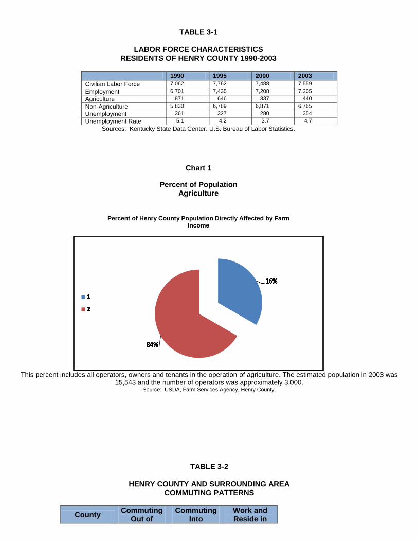
TABLE 3-1
LABOR FORCE CHARACTERISTICS RESIDENTS OF HENRY COUNTY 1990-2003
1990 1995 2000 2003
Civilian Labor Force 7,062 7,762 7,488 7,559
Employment 6,701 7,435 7,208 7,205
Agriculture 871 646 337 440
Non-Agriculture 5,830 6,789 6,871 6,765
Unemployment 361 327 280 354
Unemployment Rate 5.1 4.2 3.7 4.7
Sources: Kentucky State Data Center. U.S. Bureau of Labor Statistics.
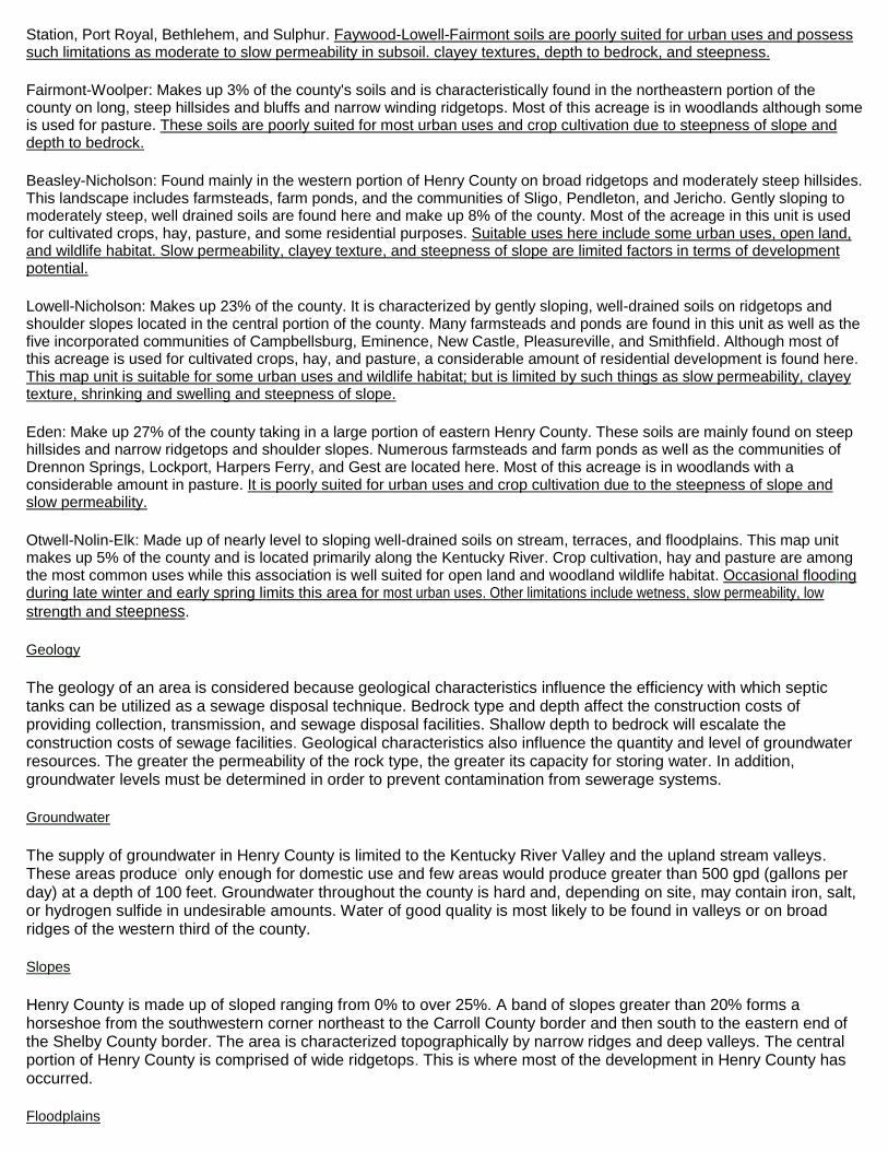
Chart 1
Percent of Population Agriculture
Percent of Henry County Population Directly Affected by Farm Income
This percent includes all operators, owners and tenants in the operation of agriculture. The estimated population in 2003 was
15,543 and the number of operators was approximately 3,000. Source: USDA, Farm Services Agency, Henry County.
TABLE 3-2
HENRY COUNTY AND SURROUNDING AREA COMMUTING PATTERNS
County Commuting
Out of Commuting
Into Work and Reside in

HENRY 4,154 1,131 2,839
Carroll 991 3,335 3,475
Franklin 4,495 13,585 18,793
Jefferson 25,467 100,930 303,624
Oldham 14,509 6,060 7,207
Owen 2,644 328 1,899
Shelby 7,428 5,467 9,298
Trimble 2,831 294 849 Source: Kentucky State Data Center, University of Louisville, Community Patterns, Census 2000.
TABLE 3-3
HENRY COUNTY COMMUTING PATTERNS, 2000
Source: Kentucky State Data Center, University of Louisville, Community Patterns, Census 2000.
TABLE 3-4
DIVERSIFICATION OF EMPLOYMENT HENRY COUNTY AND KENTUCKY
(% of total employment)
1980 1990 2000 Henry State Henry State Henry State
Agriculture* 16.7 8.5 13.0 6.2 4.7 3.3 Construction 7.8 6.1 7.2 6.3 9.1 7.2 Manufacturing 23.2 22.5 20.2 19.5 22.8 17.6 Transportation** 4.8 7.3 6.7 7.3 7.0 8.2 Trade*** 15.5 20.2 14.9 21.3 13.8 15.6 Finance**** 3.8 4.6 3.9 5.2 5.0 5.4 Services 16.9 25.7 24.6 29.9 29.4 38.4 Public Admin. 11.3 5.1 9.5 4.3 8.2 4.3
Number Commuting
Out of Henry
County into
Commuting Into
Henry County from
Carroll 261 114
Franklin 311 74
Jefferson 1,258 162
Oldham 1,148 153
Owen 37 41
Shelby 786 303
Trimble 44 174
Other Ky Counties 149 83
Indiana 115 16
Ohio 29 N/A
Florida 7 N/A
Tennessee 9 N/A
Michigan N/A 6
Minnesota N/A 2
Pennsylvania N/A 3

Total 100 100 100 100 100 100
Source: U.S. Bureau of the Census, Census of Population, 1980-1990, 1990-2000.
*Agriculture includes forestry, fisheries, hunting, and mining **Transportation includes communication, warehousing, information, and public utilities ***Trade includes both wholesale and retail ****Finance includes insurance, rental, leasing, and real estate
TABLE 3-5
FARMS AND LAND IN FARMS HENRY COUNTY
1987 1992 1997 2002 Number of Farms 1,093 1,071 1,022 883
Number of Acres 166,376 159,966 150,585 141,592
Average Size (Acres) 152 149 147 160
Value-Land and Buildings $149,268 $152,635 $239,361 $358,936 Source: 2002 Census of Agriculture, U S Department of Agriculture
TABLE 3-6
MANUFACTURING EMPLOYMENT BY INDUSTRY (% of total manufacturing employment)
1990-2001
1990 1994 1996 2001 Henry State Henry State Henry State Henry State Food and Kindred Products 0.0% 6.8% 0.0% 7.4% 0.0% 7.8% 0.0% 9.5%
Tobacco 0.0% 1.9% 0.0% 1.6% 0.0% 1.3% 0.0% 0.6%
Clothing,textiles and leather * 14.4% 0.0% 13.5% 0.0% 11.3% * 5.7%
Lumber and furniture * 5.7% * 6.1% * 6.1% * 7.3%
Printing,publishing & paper * 10.4% * 10.5% * 10.7% * 9.0%
Chemicals,petroleum,coal, and rubber
0.0% 12.4% 0.0% 12.3% 0.0% 12.1% 0.0% 11.5%
Stone, clay, & glass * 3.5% * 3.7% * 3.6% * 3.5%
Primary metals * 6.0% .* 5.4% * 5.6% * 5.7%
Machinery, metal products & equipment
* 35.8% 53.4% 36.6% 54.4% 38.3% 38.3% 44.5%
Other * 3.1% * 2.9% * 2.9% * 2.7%
Sources: Kentucky Cabinet for Economic Development, Kentucky Deskbook of Economic Statistics.

TABLE 3-7
HENRY COUNTY MANUFACTURING FIRMS 2004 EMPLOYMENT
Source: Kentucky Department of Economic Development, 2004 Kentucky Directory of Manufacturers.
TABLE 3-8
HENRY COUNTY SCHOOL SYSTEMS 2004 EMPLOYMENT
TABLE 3-9
RETAIL TRADE TRENDS HENRY COUNTY
Source: U.S. Census Bureau, Census of Retail Trade, 1982,1987,1998. U.S. Census Bureau, 1997 Economic Census.
TABLE 3-10
FIRM(ESTABLISHMENT DATE) PRODUCT 2004 EMPLOYMENT EMINENCE
Eminence Speaker Corp. (1966) Hussey Copper Ltd. (1966) Steel Technologies, Inc. (1971)
Electronic speakers Copper Products Cold rid steel, strip, & sheet
170 187 142
Lockport
Liters Quarry Mago Construction Co. (1966)
Limestone Bituminous concrete mixes
26 3
New Castle
The Henry County Local (1876) Safety Kleen Envirosystems (1970)
Newspaper Solvent recycling
6 115
Pendleton
Ernst Concrete KY LLC (1972)
Ready-mixed concrete 5
Smithfield
C.A. Garner Veneer, Inc. (1983) Quality Veneer, Inc. (1990)
Fine hardwood veneers White oak veneer
80 5
Campbellsburg
Arvin Sango Pearce Bros. Concrete
Automotive exhaust systems Concrete mix
85 15
TOTAL EMPLOYEES 839
SCHOOL 2004 EMPLOYMENT EMINENCE INDEPENDENT SCHOOL
Eminence, KY
92
HENRY COUNTY PUBLIC SCHOOL
New Castle, KY 300
Category 1982 1987 1992 1997 % change 1982-97
Establishments 100 61 61 53 -47%
Employees 334 438 537 470 +13.6%
Total Sales ($000’s) 28,024 48,449 60,728 90,541 +323%

FAMILY INCOME HENRY COUNTY
1990-2000 CENSUS
Source: U.S. Bureau of the Census, Census of Population, 1990-2000.
TABLE 3-11
PER CAPITA PERSONAL INCOME SELECTED COUNTIES
County 1971 1981 1991 2001 % Change 1991-2001
HENRY $ 3,538 $ 8,525 $ 15,153 $ 23,243 53%
Carroll $ 2,936 $ 8,852 $15,056 $ 22,740 51%
Franklin $ 4,136 $ 9,973 $18,501 $ 27,568 49%
Jefferson $ 4,335 $11,223 $ 20,772 $ 32,773 57%
Oldham $ 3,950 $10,785 $ 22,582 $ 32,451 44%
Owen $ 2,657 $ 6,902 $ 12,853 $ 17,835 39%
Shelby $ 3,602 $ 9,619 $ 18,539 $ 27,933 50%
Trimble $ 2,747 $ 7,668 $ 9,255 $ 17,055 84%
Kentucky $ 3,375 $ 9,072 $ 16,162 $ 24,954 54% Sources: U.S. Bureau of Economic Analysis.
Characteristic 1990 2000
All Families 3,691 4,331
< $2500
2500-4999
5000-7499
7500-9999 556 293
10000-14999 358 300
15000-24999 777 476
25000+ 1,976 3,262
Median Income $26,590 $45,009

CHAPTER IV
EXISTING LAND USE Historic Background
Henry County is located in northcentral Kentucky approximately 40 miles east of Louisville, Kentucky, and 75 miles southwest of Cincinnati, Ohio and 65 miles northwest of Lexington, Kentucky. It was created out of Shelby County in 1798 and was later divided to form Oldham and Trimble Counties. Henry County was named after the famous orator and statesman, Patrick Henry. Henry County contains 291 squares miles and 184,960 acres of land varying from rolling hills and cliffs to flat farmlands.
Henry County borders three northern Kentucky counties, which lie along the Ohio River, Oldham, Trimble, and Carroll Counties. The Kentucky River, which makes up Henry County's eastern edge, separates it from Owen County. Shelby and Franklin Counties border it on the south. Henry County also lies on the northwestern edge of the outer Bluegrass Region. Henry County is part of the Kentuckiana Regional Planning Development Area (KIPDA), which is made of six of the seven counties of the Louisville Metropolitan Statistical Area, plus Trimble, and Spencer. Five incorporated communities lie within the county, including Campbellsburg, Eminence, New Castle, Pleasureville, and Smithfield.
Henry County is primarily a rural/agricultural, county. According to the 1997 Census of Agriculture, 149,179 acres or 81% of the county is in farms. The areas topography and its proximity to urban centers, particularly Louisville, have affected the development of Henry County. In recent years, an areas proximity and accessibility to commercial and industrial center is a prime motivator of economic development efforts. Although Henry County is a rural county, it possesses an exceptional linkage to urban markets. Interstate 71, which passes through the northwest quadrant of the county, and has two interchanges in Henry County, provides access to Interstate 65 and 64 in Louisville and Interstate 75 and 74 in Cincinnati. Four additional interchanges along Interstate 71 in Oldham County, as well as two in Carroll County, allow a linkage to other state and county roadways within Henry County.
Physiographic Features
Henry County is characterized by rolling hills, with steep slopes found particularly in the northeast and northwest. Several of the soil types that make up the county are derived from limestone and have a shallow depth to bedrock. A significant portion of the county is best suited for pasture and woodlands. The Kentucky River, which runs along the eastern border of the county, is the largest waterway in the county. Other waterways include the Little Kentucky River, Six Mile Creek, and Drennon Creek. The Kentucky River provides the county with barge transportation for the shipment of commodities and durable goods.
Henry County's natural features including soil types, geology; slopes, and floodplains all have an effect on an area's development potential.
Soils
Henry County contains six of the eighteen soil associations found in Kentucky. These features can be seen on Map 20.
Faywood-Lowell-Fairmount: Makes up 25% of the county's soil. A large portion of this unit is underlain with limestone bedrock. Most of this acreage is used for pastureland and for hay. This type of soil occurs irregularly throughout the county on long, narrow ridgetops, short shoulder slopes, and upper hillsides. Communities located within this unit include Turners
Station, Port Royal, Bethlehem, and Sulphur. Faywood-Lowell-Fairmont soils are poorly suited for urban uses and possess such limitations as moderate to slow permeability in subsoil. clayey textures, depth to bedrock, and steepness.
Fairmont-Woolper: Makes up 3% of the county's soils and is characteristically found in the northeastern portion of the county on long, steep hillsides and bluffs and narrow winding ridgetops. Most of this acreage is in woodlands although some is used for pasture. These soils are poorly suited for most urban uses and crop cultivation due to steepness of slope and depth to bedrock.
Beasley-Nicholson: Found mainly in the western portion of Henry County on broad ridgetops and moderately steep hillsides. This landscape includes farmsteads, farm ponds, and the communities of Sligo, Pendleton, and Jericho. Gently sloping to moderately steep, well drained soils are found here and make up 8% of the county. Most of the acreage in this unit is used for cultivated crops, hay, pasture, and some residential purposes. Suitable uses here include some urban uses, open land, and wildlife habitat. Slow permeability, clayey texture, and steepness of slope are limited factors in terms of development potential.
Lowell-Nicholson: Makes up 23% of the county. It is characterized by gently sloping, well-drained soils on ridgetops and shoulder slopes located in the central portion of the county. Many farmsteads and ponds are found in this unit as well as the five incorporated communities of Campbellsburg, Eminence, New Castle, Pleasureville, and Smithfield. Although most of this acreage is used for cultivated crops, hay, and pasture, a considerable amount of residential development is found here. This map unit is suitable for some urban uses and wildlife habitat; but is limited by such things as slow permeability, clayey texture, shrinking and swelling and steepness of slope.
Eden: Make up 27% of the county taking in a large portion of eastern Henry County. These soils are mainly found on steep hillsides and narrow ridgetops and shoulder slopes. Numerous farmsteads and farm ponds as well as the communities of Drennon Springs, Lockport, Harpers Ferry, and Gest are located here. Most of this acreage is in woodlands with a considerable amount in pasture. It is poorly suited for urban uses and crop cultivation due to the steepness of slope and slow permeability.
Otwell-Nolin-Elk: Made up of nearly level to sloping well-drained soils on stream, terraces, and floodplains. This map unit makes up 5% of the county and is located primarily along the Kentucky River. Crop cultivation, hay and pasture are among the most common uses while this association is well suited for open land and woodland wildlife habitat. Occasional flooding during late winter and early spring limits this area for most urban uses. Other limitations include wetness, slow permeability, low
strength and steepness.
Geology
The geology of an area is considered because geological characteristics influence the efficiency with which septic tanks can be utilized as a sewage disposal technique. Bedrock type and depth affect the construction costs of providing collection, transmission, and sewage disposal facilities. Shallow depth to bedrock will escalate the construction costs of sewage facilities. Geological characteristics also influence the quantity and level of groundwater resources. The greater the permeability of the rock type, the greater its capacity for storing water. In addition, groundwater levels must be determined in order to prevent contamination from sewerage systems.
Groundwater
The supply of groundwater in Henry County is limited to the Kentucky River Valley and the upland stream valleys. These areas produce' only enough for domestic use and few areas would produce greater than 500 gpd (gallons per day) at a depth of 100 feet. Groundwater throughout the county is hard and, depending on site, may contain iron, salt, or hydrogen sulfide in undesirable amounts. Water of good quality is most likely to be found in valleys or on broad ridges of the western third of the county.
Slopes
Henry County is made up of sloped ranging from 0% to over 25%. A band of slopes greater than 20% forms a horseshoe from the southwestern corner northeast to the Carroll County border and then south to the eastern end of the Shelby County border. The area is characterized topographically by narrow ridges and deep valleys. The central portion of Henry County is comprised of wide ridgetops. This is where most of the development in Henry County has occurred.
Floodplains
Stormwater and flooding problems in Henry County are generally minor. Flooding occasionally occurs along the Kentucky River near the communities of Lockport and Drennon Springs. The community of Sulphur is subject to periodic flash flooding. Controlling of flood hazard areas and protection of existing land uses is provided through the Kentucky River Watershed Project and the Little Kentucky River Watershed Conservancy District.
Incorporated Areas and Communities of Henry County and Existing Land Use
Henry County presently has five incorporated cities with combined populations of 4,826 residents based on 2000
Census made by the Kentucky State Data Center.
A. Campbellsburg
Located in the northwest sector of the county, Campbellsburg was incorporated in 1840, originally known as Chiltonsville. The 2000 population was 705. Map 5 portrays the existing land use in Campbellsburg. Within the city limits there appears to be a good balance of low and high-density residential development and commercial areas to serve the needs of the local residents. The downtown is fairly modern having been rebuilt after tornado damage in 1974. Campbellsburg has extensive room for development within its city limits and has the potential for rapid residential expansion due to its proximity to 1-71 and Louisville. Adjacent to 1-71 on the north side of the city limits is an area for industrial, commercial, and residential development. This area has been targeted for future industrial and commercial growth as the public sewer system extends its lines to accommodate the demand. There are also areas on the south side of Campbellsburg that may be available for future growth with access to the railroad system. B. Eminence
Located in the southcentral sector of the county, adjacent to the Shelby County border, it was incorporated in 1857 and is the largest city in the County and supports its own Independent School System. Eminence is the hub for commercial and business ventures in Henry County. The 2000 population was 2,231. Land use pattern is displayed on Map 2. Eminence is the center for commercial and industrial development for Henry County. The western portion of the city developed in a basic circular pattern centered along the crossroads of KY 22 and KY 55. The downtown is an historic core of commercial and public uses and is primarily surrounded by single family residential development. The city has annexed land east and southeast of the city that is primarily an area of industrial development. This area is targeted for future industrial growth. Just outside Eminence's western city limits is also an area of industrial and commercial development. Extension of additional city services in this direction should by tied to annexation consideration. C. New Castle
Located in the center of the county, New Castle was incorporated in 1817 and is the County Seat of Government. The 2000 population was 919. The existing land use pattern of New Castle is shown in Map 1. Being the county seat for Henry County, New Castle has a high proportion of public type land use, particularly around the courthouse in the downtown area. Intermixed with the local governmental offices is downtown commercial development. The balance of city is low and high-density residential development. There is limited undeveloped land within the city limits available for future development. Infill development downtown can accommodate commercial development pressures and small areas of vacant land are available for additional single family and multi-family residential development D. Pleasureville
-Located in the south-central part of the county -Incorporated in 1842 -The 2000 population was 869. -Existing land use is shown on Map 4. E. Smithfield
-Located in the southwest part of the county, approximately 4 miles west of Eminence -Incorporated in 1842 -The 2000 population was 102. -Existing Land use is shown on Map 3. F. Unincorporated Communities
a) Lockport located on the Kentucky River. b) Drennon Springs c) Bethlehem d) Defoe located in the southeastern section of the county e) Franklinton located in the eastern section near Drennon Ridge

f) Gestville, located on the Kentucky River g) Jericho located in the southwestern part of the county h) Harpers Ferry located in the extreme southeastern area of the county i) Port Royal located in the northern end of the county j) Sulphur located in the western part of the county near the Trimble County line. k) Turners Station, located on the L & N Railroad, in the northern part of the county I) Pendleton m)Glenmary, Blackwell, Sligo, Lacie, Lecompte's Bottom, Dellville, Orville, Webbtown and Cemetery Hill.
CHAPTER V
COMMUNITY FACILITIES PLAN Introduction
The quality and vitality of the environment and lifestyle of the residents of Henry County is dependent upon the facilities and public services available to them. These facilities and services support the social fabric of the community and include schools, libraries, parks, municipal buildings, public safety facilities, and sanitation facilities such as water and sewer systems.
Community facilities are those areas, buildings, and services which are public in nature but which may be publicly or privately owned. Community facilities include: schools, police and fire protection, utilities and infrastructure, health care facilities, libraries, recreation and open space areas and other public buildings.
Public facilities, especially school systems, play an important role in attracting new residents and industries as well as retaining present residents and employers. The age and efficiency of the existing public facilities affect the revenue needs of the cities and county. The efficient layout and construction of new facilities determine the direction for future growth of residential, commercial, and industrial development. For all of the above reasons, it is important that the development of public facilities be coordinated according to the needs and desires of the residents of Henry County.
Residents and businesses in Campbellsburg, Eminence, Pleasureville, and New Castle are all served by local public wastewater treatment systems. The rest of the county is not served by public sewers and must use septic tanks and other private means of sewage disposal. Currently, this is one of the limiting factors to development in Henry County.
Sewer
Residents and businesses in Campbellsburg, Eminence, Pleasureville, and New Castle are all served by local public wastewater treatment systems. The rest of the county is not served by public sewers and must use septic tanks and other private means of sewage disposal. Currently, this is one of the limiting factors to development in Henry County.
The Campbellsburg Wastewater Treatment Plant provides sewer service in Campbellsburg. This facility has a capacity of 75,000 gallons per day (gpd) and has a 50,000-gallon holding tank. The plant is at capacity serving 966 of the population with 322 connections.
The New Castle Wastewater Treatment Plant provides sewer service in New Castle. This facility was completed in 1985 when the entire wastewater collection system was renovated as part of a $1 million dollar construction project. The sewer system is adequately serving the needs of this area of the county. The new plant has a capacity of 298,000 gpd and an average flow of 90,000 gpd. The treatment plant serves 1374 of the population with 458 connections.
The City of Eminence Wastewater Treatment Plant provides sewer service in Eminence. The treatment plant has 500,000-gpd capacity. The project included line extensions to unserved areas and construction of the effluent pipeline to the Kentucky River. Eminence serves 2751 and has 917 service connections.
The City of Campbellsburg also needs to carefully monitor any new development to ensure that they do not aggravate an already critical situation for their sewage treatment plant. The plant is currently operating at approximately 95% capacity on a daily basis, which enables it to adequately meet demand during dry weather. The plant also has a 50,000 galIon holding tank for peak demand days, however, particularly with storm water infiltration, the plant cannot meet the demand. Surface and roof water runoff, which flow into the sanitary sewer system as well as other types of storm sewer infiltration cause hydraulic overload of the treatment plant. They are presently under a line extension ban and there are l/l (inflow and infiltration) problems to be addressed. This treatment facility needs upgrading and collectors are in need of replacement. Any new development, which is a high water user, will continue to overload the Campbellsburg Sewage Treatment Plant's capacity. Because Campbellsburg is an area that is anticipated to grow the city should anticipate the increasing demand and plan carefully for it. They are currently dumping their sewage into a holding tank and then hauling it and pumping it into the city system. Funding for any extensions of the sewer lines should include consideration of a treatment plant upgrade. All extensions outside the city limits should be tied to annexation agreements.
The City of New Castle renovated its wastewater treatment plant in 1985 and the new plant has more than enough capacity to meet current and future sewage treatment needs. The system serves approximately·1400 people. The maximum hydraulic capacity is 1 MGD of which they are currently using only 30% of their normal capacity.
The City of Smithfield is limited in development potential because of their lack of public sewers. It is a priority for the communities to secure financing for new public sewer systems to serve its residents.
Water
There are two water suppliers currently serving the county. Henry County Water District Number 2, the most prominent, has six wells located in the Trimble County portion of the river aquifer. It sells on a retail basis to most of its customers in the county and sells other portions of its supply to the Cities of Campbellsburg, New Castle, Eminence and the West Carroll Water District. The other incorporated cities of Smithfield and Pleasureville are served directly by the district. The Oldham County Water District is a secondary supply source that is mainly available as a back-up source.
Electricity and Gas
Two companies provide electricity to Henry County. The Kentucky Utilities Company serves Campbellsburg, Eminence, New Castle and the surrounding areas. Shelby Energy Corporation, which buys its power from the East Kentucky Power Cooperative, serves most of rural Henry County.
The Louisville Gas and Electric Company provide natural gas service to portions of Henry County.
Solid Waste Management
The Henry County Solid Waste Management Plan was adopted in 1993, and revised, updated in 2003. The plan serves as the authority for solid waste issues for Henry County. The County has put in place a Mandatory Garbage Ordinance and also has a Dumpster Agreement for dumpster services. At time of this publication there was over 90% participation in this collection on the Mandatory Garbage. There is a 7-day a week recycling center for paper and plastic products. A part-time Solid Waste Coordinator is in place to enforce the County Solid Waste Ordinance.
Henry County has no permitted public or private landfills. The largest and most frequently utilized landfill facility is the Valley View Landfill in southern Trimble County. This large, privately owned facility is very close to Henry County, and is adequate for the disposal of much of the county's waste'. Rumpke Sanitation Landfill in Pendleton County is also used.
Safety and Health
Police protection in Henry County is provided to the five incorporated cities by their respective police departments. The largest is the Eminence Police Department, with six staff persons and three patrol cars. The County Sheriff's Department has a staff of five and three patrol cars. Standards that have been established by the Federal Bureau of Investigation recommend 1.4 police officers for every 1000 persons in the population. The county as a whole has very adequate police protection based on this standard.

Fire protection is provided to Henry County residents outside of the incorporated cities by six volunteer fire departments that cover different areas of the county. Approximately 150 volunteers work to bring excellent fire protection to the county. The cities of Campbellsburg and Pleasureville have received an ISO rating of class 7. Eminence and New Castle have recently received an upgraded ISO rating of class 6. The balance of the county is class 10. There is a $35.00 fire protection fee that is paid on every noncommercial tax bill per year and $100 on every commercial tax bill. This fee goes directly to the proper fire district.
Five emergency squads that serve different areas of the county provide emergency medical services. These squads have paid medical personnel from 5a.m. to 6p.m. 7 days a week. Approximately 50 volunteers that are fully trained to provide medical services operate the other hours.
No hospitals are located within Henry County; however, three hospitals are located within 20 miles of New Castle and these adequately serve the County's residents. The Baptist Hospital Northeast, a 120 bed facility, is located 14 miles from New Castle in LaGrange, KY. The Jewish Hospital, a 76 bed facility, is located 16 miles from New Castle in Shelbyville, KY. And the Carroll County Memorial Hospital, a 54 bed facility, is located 20 miles from New Castle in Carrollton, KY. Also, several health care facilities offering medical care of all types are located in Louisville, which is 36 miles from New Castle.
There are several health facilities in Henry County, which house doctors and dentists in private practice.
There is currently only one nursing home in operation in Henry County, the Homestead Nursing Home, in New Castle. It is a 60 bed, intermediate care facility and is currently operating at 100% capacity. There is also an Assisted Living Facility adjacent to the nursing home in New Castle with capacity of 28 residents.
Education
Henry County currently has two separate school systems: the Henry County School System and the Eminence Independent School System. The larger of the two systems, Henry County Schools, had a total enrollment of 2,117 for the 2004-2005 school year. This also includes the Headstart Program. The projected enrollment for the year 2007 is 2,149. It has three elementary schools that house kindergarten through fifth grade. These include: Campbellsburg Elementary; Eastern Elementary, and New Castle Elementary. See Map 23 in the appendix for School District Map.
Henry County High School offers vocational education classes in Business and Agriculture. Students interested in learning more technical skills may attend the Oldham County Area Vocational Education Center, located 15 miles from the high school or the Shelby County Area Vocational Education Center, also about 15 miles from the high school.
The Eminence Independent School System had a total enrollment in fall of 2004 in grade Headstart through 12 of 645 students, 315 in elementary grades (Headstart-4) and 330 in middle and high school grades (5-12). All of the students are located on one campus, with different grade levels occupying different wings of the campus. See Map 23 in the appendix for School District Map.
The Eminence Independent School System also offers vocational education classes in Business. Students interested in learning more technical skills may attend the Shelby County Area Vocational Education Center, located about 10 miles from the high school.
Higher education is readily available to the people of Henry County because of the great number of colleges and universities, which offer various types of degrees, that are located approximately 38 miles away in Jefferson County. There are also several schools in Lexington, approximately 53 miles away, and several others within driving distance. Jefferson Community College also has facilities located at Shelbyville and Carrollton. Students can get double credits at these facilities.
Library
Library services are available to the people of Henry County at the Henry County Public library located in Eminence. The county also has a bookmobile that provides services to different areas of the county. The library has a collection of approximately 35,000 volumes. The Kentuckiana Regional Library is also housed in the same building.
Media
Henry County is served by one local newspaper, the Henry County Local, which provides weekly news coverage. The paper has a circulation of approximately 4,600. Daily news coverage is also provided to the county by The Courier Journal, which

is delivered from Louisville, just 38 miles to the southeast.
Henry County has two radio stations, WKX-AM and WKX-FM in Eminence, and also picks up stations from surrounding counties. Television reception is accessible from stations in Louisville, KY, Lexington, KY, and Cincinnati, Ohio. Insight Cable TV provides cable television service, and telephone service is available from BellSouth with all available carriers.
CAPITAL IMPROVEMENTS PLAN
The development of a Capital Improvements Plan (CIP) is a higher level of strategic planning. The ideal capital budgeting process begins with a ranking by city and county officials of prospective capital projects based the future land use projections and on agreed upon guidelines. As with operating budgets, the County Judge Executive and the Mayors must approve the capital budget and submit it to the Fiscal Court and City Councils for final approval. To facilitate review of these submissions, capital budgets should include a priority ranking of these submissions, capital budgets should include a priority ranking of projects, explanations of ranking methodology, as well as information concerning long-term operating and maintenance costs. It is recommended that the county and cities consider adopting a five-year capital improvement plan, which is reviewed on a yearly basis. The plan should involve an evaluation of the current local infrastructure and the prioritization of various projects. Project costs should be estimated and construction time tables should be completed as a part of the CIP. Attachments could go here from cities that have a 5-yr plan.

CHAPTER VI
TRANSPORTATION PLAN
Introduction
The quality of a local transportation system can have a critical impact on the quality, type, and rate of development that occurs in a local community. This transportation plan will identify traffic problem locations in each of the incorporated areas and for Henry County as a whole and will provide some recommendations as to changes, improvements, or new construction needed to address the current limitations.
It is important to determine traffic problem locations in order to distinguish areas within the county's road and street circulation system, which have created problems in the past and will consequently need to be repaired in the future. Repair measures may take many forms. At one extreme, repair measures might involve construction of new highways, at another, installation of a single stop sign, traffic signal, or improvement of a turning radius might be all that is required to improve an existing or potential traffic hazard. Usually the solution to a problem will not be one single improvement. The highway network is a system, and this system can only operate well by the functional components of the system working together in harmony to produce the desired result of the movement of automobiles and trucks through Henry County in the most efficient manner possible. Also included in this analysis of efficient manner possible. Also included in this analysis of traffic problems are areas where pedestrian traffic is impeded. Areas needing sidewalks, sidewalk repair, crosswalks, and traffic signals for pedestrian crossings can affect the flow of all traffic in a community.
Specific problem area identified by the local citizens and the planning commissions are listed below:
Pleasureville
Map 15 shows the following traffic problem areas in the City of Pleasureville. Proposals for corrections are also noted.
A. There is a drainage problem along KY 241 near the intersection of US 421 and KY 22. A
drainage culvert needs to be installed in this area. B. A culvert is also needed on Bibb Street because poor drainage is resulting in yard
flooding. C. Sidewalks are needed along US 421 and KY 241. D. KY 241 needs to be widened. E. The public parking area between Fallis Street and Marcus Street, east of KY 241 needs to be blacktopped. F. Marcus Street needs to be widened. An area on Marcus Street, where the "G" is located, also needs a retaining wall and correction of the road grade, noting that there is a dangerous drop off in this area. G. The area along KY 241 south of downtown Pleasureville is a traffic problem because the light and telephone poles are located too close to the roadway. Any improvements to this area would need to include moving these poles away from the pavement.
Additional vehicular and pedestrian traffic hazards found in Pleasureville include the fact that 60-70% of the existing sidewalks throughout the city are in need of major repair work, and that the trees in the right-of-way along KY 241 obstruct vision and need to be cut back. All city streets have been blacktopped in connection with the sewer project.
Smithfield
Map 14 also depicts the locations of traffic problem areas in the City of Smithfield.
A. A Traffic light/stop light is needed at 1211 and 322.

Campbellsburg
Map 16 depicts the following locations of the City of Campbellsburg traffic problem areas.
A. Lake Road, which forms a portion of the western city limits of Campbellsburg, needs to be widened, where it forms the city limits and to have speed limit signs posted along it.
B. The intersection where Randell Drive and Main Street meet will need a stop light within the next five years. This area along Main Street is projected to be an area of commercial redevelopment and the area around the lake and along Randell Drive is projected to have extensive low and high-density residential development. The timing of this new development will impact how quickly this traffic signal is needed.
C. An area in need of immediate attention is the intersection of First Street and Main Street. This intersection has been called a "death trap" and is very much in need of a traffic signal/stop light. Additional residential development along First Street should be tied to this improvement.
D. Another area in need of immediate attention is the intersection of Cardinal Drive and Main Street. This intersection has a caution light, but is still a very dangerous intersection.
E. At the intersection of KY55 and Montfort Lane, the road needs to be looked at for visibility. Entering KY55 from Montfort Lane is very dangerous.
New Castle Map 12 depicts the location of the following traffic problems in the City of New Castle. A. The area of the downtown central business district B. Need off-street loading areas to accommodate the traffic C. Flow and parking needs in the commercial district D. The portion of Cedar Street west of Main Street needs to be widened. It is critical that this improvement be tied
to any substantial additional residential development on Adams Street.
Eminence The following identified problem traffic areas for the City of Eminence are depicted on Map 13. A. A traffic light/stop light is needed at the intersection of Elm Street and North Main Street. B. Mulberry Pike from South Main to the industrial area past Eminence Clear Creek Road needs to be widened. C. Main Street (KY 55) needs to be widened. D. Many of the internal traffic problems in Eminence could be solved through the construction of a by-pass from KY 22 east of town around the southern and western borders of Eminence to KY 55 north of town and eastward to U.S. 421. The depiction of this by-pass in Map 13 graphically depicts the need for a bypass and does not necessarily represent a precise preferred location of the bypass. The transportation analysis of this chapter will concentrate on a description of the existing facilities.
Henry County has an adequate inter-county, as well as intra-county highway network for the movement of its people and goods. However, it is imperative that normal upkeep and maintenance be continued, improvements be made when needed and new construction be initiated where necessary if this system is to remain workable and effective. Henry County is served by several major roads and highways which link together the small cities in the county, as well as linking the county with the surrounding areas Interstate 71, which connects Louisville and Cincinnati, runs along the northwestern part of the county and provides excellent access for shipping goods into and out of the county. Interchanges for 1-71 are located near Campbellsburg and Pendleton. Another major route paralleling 1-71 connecting Cincinnati and Louisville is U.S. 42. U.S. 42 runs through Sligo in the western part of Henry County. Interstate 64, which connects Louisville and Lexington, is accessible 15 miles south of Eminence in Shelby County. Other major roads in the County are U.S. 421 and Kentucky Route 55. New Castle and Campbellsburg are located along U.S. 421 and Eminence lies along Kentucky 55. Roads that serve as truck routes and to move traffic through the county include Kentucky Routes 193, 389, 146, and 22. The county will look into the possibility of an extra exit in the Providence area on KY 55. This would decrease truck traffic through Campbellsburg, give better access between 1-64 and 1-71 and also facilitate new commercial growth.

Rail
Railroad service is provided directly to Henry County in Campbellsburg by CSX Transportation. Services provided are main line; 3 northbound and 3 southbound through-freights daily; switching services; teamtrack space for 12 cars. Piggyback facilities, such as Norfolk Southern Corporation, Paducah and Louisville Railway, and Burlington Northern Railroad are located 39 miles southwest of Campbellsburg in Louisville.
Trucking
Several trucking companies provide services to Henry County for intrastate and interstate shipping of goods into and out of the county.
Water
The Ohio River is the closest major navigable waterway to Henry County. Its closest point to the county is 20 miles north of New Castle in Carrollton. Kentucky River is also used for commercial navigable waterway traffic from the mouth near Carrollton to Lock 4 in Frankfort.
Air
There are no airports located in Henry County. The nearest small craft airport, the Capital City Airport, is located in Frankfort, KY, which is 29 miles southwest of New Castle. Scheduled commercial airline and airfreight services are
available at Louisville International Airport, which is 39 miles southwest of New Castle, and the Cincinnati/Northern Kentucky International Airport, which is approximately 70 miles from New Castle. Also 39 miles away in Louisville is UPS, which has worldwide shipping.
CHAPTER VII
FUTURE LAND USE PLAN
Introduction
The purpose of this chapter is to determine the future land use needs of Henry County and its five incorporated cities. Examining the existing land use patterns, projections, and population trends for Henry County as a whole, projects the County's future land use needs. Economic trends also provide a good foundation for determining local future commercial and industrial needs. Certain areas within the cities should be considered for possible redevelopment for commercial and residential uses. It is anticipated that the five incorporated areas of Henry County will continue to grow. Availability of transportation and community services near these cities make these the prime locations for future commercial and industrial land use needs.
Agricultural Protection
When anticipating development that may occur in the rural portions of Henry County, this plan attempts to promote a balance between protection and regulation. There is a high priority in Henry County on the need to protect the right of the farmer to carry on agricultural activities with a minimum amount of regulation and a minimum amount of impact from urban-type development When considering more intense farming operations such as CAFO's (confined animal feeding operations), it is important to balance this with the right of others to live in a rural setting that is safe, quiet, and dust and odor-free. In order to protect the agricultural base of Henry County, it is important to recognize the need for a relationship between the farmer and the adjacent property owner to or near the agricultural operations. By providing notification to inhabitants of residential areas that adjoin agricultural areas that have the potential to create adverse noise, odor, chemicals, smoke, and hours of operation a positive relationship could be obtained. Balancing these two uses is a primary goal of establishing zones in which certain activities are allowed and others prohibited. Determining which land is the most productive agricultural land can be very important to a county dependent upon agriculture. The continued pattern of the conversion of the best agricultural land to other land uses is not in the best interest of Henry County. The practice not only eIiminates this land as a potential source of agricultural income for both the farmer and the county, but also forces agricultural use of less productive land, land that could be better engaged in another activity. This type of trade-off can also force agricultural uses of land, land that might have severe environmental limitations such as steep slope, high erosion hazards, and others. A growing urban population will need avenues to

buy from local farmers. Existing agricultural operations may look into areas of agricultural tourism. Planning should strongly consider pace and soil conservation.
Future Land Uses
It is understood that as areas immediately surrounding the city limits become developed, they are no longer considered rural in nature and eventually must be served by urban services. Text and maps must be looked at as a whole when considering land use decisions and not considered as isolated pieces. This is a plan for the County and each decision made must be looked at in the light of the whole County's Comprehensive Plan.
Smithfield is developed within its city limits. The city may want to anticipate expanding its limits to accommodate development. The location of small retail establishments within Smithfield should be encouraged. Residential growth around the city limits is expected.
Pleasureville, while similar in population to both Campbellsburg and New Castle, lacks the transportation and water facilities to allow for extensive development. Pleasureville, like Smithfield, is currently completely developed within its city limits. Map 9 projects that this area will continue to be developed. Development will most likely be residential growth. All development in this area should reflect careful consideration of the status of potential improvements to US 421. Pleasureville has the potential for expansion through annexation particularly in the area connecting the two old cities.
Campbellsburg is one of the fastest growing urban areas in Henry County. Its proximity to 1-71, and therefore to Louisville, has made it a prime area for development in recent years. Within the city limits, Campbellsburg has a good balance of low and high-density residential development and commercial growth to meet the local residents' needs. Continued residential and commercial development within the current city limits is possible. Campbellsburg also has the advantage of having an adequate water system to accommodate existing and limited amounts of new development. There are prime areas for future commercial development. The sewer system can accommodate existing development, but the treatment plant and collection system needs to be upgraded for future development. Extension of water and sewer lines outside the city limits with annexation agreements and a capital facilities plan should be highly encouraged. Map 10 shows substantial future land use proposals for Campbellsburg and its environs. Areas of future low-density residential development are depicted around the lake and throughout the city. All major development proposals must be carefully weighed with respect to access, traffic flow, and the impact to the sewer system. Campbellsburg is in a position to expect substantial development.
New Castle is the county seat of Henry County and the second largest city with a 2000 population of 919. Map 6 depicts the future land use proposal for New Castle. The city almost completely developed within its city limits but has areas available for new development. As the county seat, New Castle has a substantial amount of public land in the downtown area to accommodate city and county offices. Currently some residential buildings are being developed into offices and other commercial uses in the downtown area. Infill development and redevelopment in the downtown area should be encouraged. Commercial enterprises need to be encouraged to assist in the revitalization of the New Castle downtown. Limited areas of additional residential development are also indicated on Map 6. Low-density expansion can also take place on an infill basis in a variety of places throughout the city. High-density residential development is indicated. Any development in this area should be tied to provisions for an additional access to this area, preferably with access through to KY 157. Any major development of any type in New Castle which will rely on the New Castle Water Works for water should be coordinated with improvements to the water supply, storage, and pressure systems. The New Castle Wastewater Plant has sufficient capacity to handle substantial development in this area of the county. There is potential to encourage industry to locate in and around the city of New Castle as a result of the new sewage treatment plant's capacity. However, extension of sewer lines outside the city limits to serve residential, commercial, or industrial customers should only be permitted if annexation agreements have been made and a capital facilities plan is in place. New commercial and industrial areas, if annexed, could be a real boon to New Castle's economy.
Eminence is the largest incorporated area in Henry County. It is the center of commercial and industrial development for the county. The historic downtown core, consisting primarily of public and commercial uses surrounded by single-family residential development is fairly well developed. However, in the area surrounding this, but stilt within the old circular city limits, there is substantial area for additional residential development and areas for commercial development. Annexed lands to the east of the city, containing primarily industrial and residential development. West of the city on KY 22, particularly areas, which have, not yet been annexed, have potential for long-term future commercial and residential development Map 7 depicts the future land use proposal for the city of Eminence and its environs. Industry currently found in and surrounding Eminence provides the major industrial base for Henry County at

this time. Eminence is an area that would adjust to additional industrial growth. Future commercial development, in addition to any redevelopment and infill development in the downtown area is depicted at each major entrance to the city on Map 7. Any development in this area should be served by city services and within the city limits. Future residential development is also proposed throughout the city of Eminence. Future low-density residential development is depicted on Map 7. Numerous areas throughout the eastern half of the city, which are currently vacant lands, are also proposed for low-density residential development. Again all major development proposals must be carefully reviewed for access and traffic safety, impact on water, sewers, schools and other community facilities, and should be annexed into the city before city services are provided.
Interchange Areas are located in the area adjacent to the two interchanges on 1-71 in Henry County and should be the primary focus for commercial development in the unincorporated areas of the County. The County should closely monitor requests for commercial development in these areas and take steps to ensure wise development with careful consideration of access, traffic safety, stormwater management, surface water runoff provisions, and water and sewer service to these areas. Wise planning for commercial development at these interchanges could provide an economic boon to Henry County.
In light of the heavily concentrated trucking industry located at Exit 28, it is the goal of the county to have a greater diversity of businesses at Exit 34 and Exit 28 that do not focus on the trucking interest. It is also the goal to have consumer related industry, such as Hotels and Restaurants. Developers of business and residential ventures are expected to partner on roads, sewer, water and utilities cost in order to accommodate the increased burden on the infrastructure by the development.
As noted in the Goals and Objectives of this Comprehensive Plan, it is the intention of the county to maintain the rural and agricultural characteristics of Henry County, and to mitigate significantly adverse environmental impacts. These are the principal goals and objectives governing land use and development decisions in the rural portions of the County. These are supported by the additional goals and objectives that encourage growth only in directions that most efficiently utilize the existing and planned utility systems, encourage the location of future industrial development where it will be most compatible with surrounding land uses and will meet specific locational criteria, discourage poorly located and shallow commercial strips and provide an efficient transportation system.
Residential Use
While the majority of future development in the rural portions of Henry County will be agricultural in nature, single family residential development should be permitted throughout the County on five-acre lots used for agricultural purposes, which have adequate road frontage. One cut for twenty-five acres of land and two cuts should be permitted for over fifty acres of land. This use should be permitted in the Agricultural Zoning District (A-1) which has as its intent to preserve, promote, and protect the rural character of the land. Residential development in these areas will be required to tolerate agricultural noises, odors, and dust because this is the primary proposed land use for the majority of the County.
Recognizing that there is a demand for rural housing by nonfarm families, there will also be a Rural Residential Zoning District (A-2) which will allow single family residential development concentrated in rural areas relatively free from incompatible agricultural uses. Residential development will be allowed to occur in these zones on lots as small as 20,000 sq. ft. where no public sewers are available. It is important to remember that although this growth is permitted, adequate services, such as roads, water, sewer, and schools should be taken into consideration before scattered site development is encouraged. A substantially greater amount of land per house may actually be required in this zone due to the necessity of utilizing septic systems in these portions of the County. The exact amount of land required will be dependent on the density of development permitted. Subdivisions of land into three or more non-agricultural, less than five acre lots should be reviewed individually. Heavy consideration should be given to the relationship of the subdivision to existing and planned utility systems, transportation networks, and other services.
The Rural Residential District should have provisions allowing uses as permitted in urban residential zones if the lots are smaller than two acres, and allowing all uses allowed in an Agricultural District if the lots are greater than two acres. The agricultural exemptions permitted by the state enabling legislation (KRS 100) will still apply only to lots greater than five acres.

Throughout the rural areas of Henry County, there exist small settlements or communities that possess a strong historical, physical, and social identity. Public recognition of their existence, limited urban services, low density of development and a desire of the residents to continue the existence of their community characterize these settlements. To enable these settlements to continue to exist, provisions will be made for a Small Community Zoning District (A-3) which will allow for limited residential and commercial expansion of the existing communities to allow for young people in the community to form new households as families develop and to permit the replacement of housing which becomes physically unsound. Map 11, depicting the existing land use in the County and Map 18, identifies fifteen such small communities. Where such a settlement exists and contains fire protection, a public water supply, electrical service, and environmental conditions conducive to the safe and effective operation of septic systems, this plan encourages the Planning Commission to allow limited and controlled residential expansion in these areas, while allowing only large lot agricultural development throughout the Farm-Oriented Agricultural District of the County. Small lot development should not be encouraged in the small communities, which do not contain the public services mentioned. The Zoning Ordinance will address matters such as density of development, minimum lot size, location standards, and required public services for aIl the rural zoning districts.
Preference for A-2 and A-3 zones should be given to areas within 1/2 mile of higher density rural areas with similar zoning classifications including Bethlehem, Defoe, Franklinton, Jericho, Port Royal, Sulphur, Pendleton, and Sligo. A-2 and A-3 should be discouraged in flood zones and in close proximity to Agricultural Districts as well as on rural county roads.
Another logical place for residential development pressures is immediately adjacent to the city limits of the five incorporated areas of the County. While this is a good location for residential subdivision development, it is highly desirable that this type of development be permitted only if the land is rezoned and annexed into the appropriate city. Even if these developments are large lot subdivisions, which can handle septic system drainage, these are essentially "urban" land uses, which eventually require all city services. The best method for the prevention of future development problems is to address this plan and discourage the zoning of areas immediately adjacent to cities zoned as Rural Residential (A-2), which allows residential development on septic tanks. By zoning the areas surrounding the cities as Agricultural (A-1), any proposed smaller lot development would require a zone change and a development plan review. This enables the Planning Commission to ensure a high quality development and to protect the integrity of development adjacent to the cities. This also forces the cities to anticipate the impact of this type of development and plan for needed expansion improvements to their water and sewer systems and other public services.
Commercial Use
It is the contention upon which this plan is based that the five incorporated cities of Henry County will continue to meet most of the urban-type needs of the County. This includes most of the commercial services needed by the County. However, existing general-store-type commercial facilities in rural areas should be allowed to continue to meet the day-to-day needs of the rural population. New commercial development in the unincorporated areas of Henry County should be restricted to the existing small communities and development zoned A-2 or R-1 throughout the County or as further discussed in this paragraph. Allowing spot zoning and violations of land use principles will result in spotty commercial development. One such violation will hinder future attempts to prevent the spread of isolated commercial development. The proposed small community zone should be flexible enough to permit the existing small communities to expand commercially to serve local daily needs.
Industrial Use
As indicated in the chapter on Economic Analysis, the manufacturing sector of the economy is the largest segment of Henry County's economy in terms of employment and economic growth. While the importance of the agricultural sector of the economy relative to the other sectors is gradually decreasing, increases in the value of farm products sold and production potentials indicate agriculture will continue to be a substantial source of income in the local economy. It is important, therefore, to provide sufficient land for both the manufacturing and agricultural sectors of the local economy, in order to promote the economic well being of Henry County.
The Plan recognizes the significance of the agricultural sector of the Henry County economy and recognizes that in order for the area to continue to benefit from the agricultural economy, sufficient areas must be reserved for

agricultural use and be protected from the encroachment of high-density urban development. Some types of industrial land uses can be compatible with rural and agricultural land uses. Industries such as quarries and sawmills lumber yards which rely on the natural resources found in the rural portions of the County should be considered by the Planning Commission during the zone change or conditional use request.
Public/Semi-Public Uses
Because of the nature of the rural areas of the county, public and semi-public needs are minimal. There are a number of small local churches throughout the county serving local needs. Schools are part of the countywide system and future needs are anticipated and planned for by the Board of Education, as they are needed. Recreational open space needs are in many ways met by the large acreage on which the residences are situated.
Henry County encourages the adoption of a policy for future development. Such a policy should state which areas could be provided with basic services. The policy should be based on the Land Use Plans for the incorporated areas and should include areas where development might be expected within the planning period.
The policy should support the concepts of this plan and purpose that most new urban type development be located around the incorporated cities, thus leaving the remaining portion of the county in an undeveloped or agricultural character.
The major objectives should be as follows:
1. To provide sufficient area for the needs and growth of the population in such a manner that the supply of land more than meets the demand, recognizing that some land cannot or will not be developed or available for development. (ie Pace Programs, Farms in Agricultural Districts) See Map 21 and Map 22 in the Appendix.
2. To clearly establish a limit beyond which only single-family residential and agricultural uses are permitted, in order to separate major urban and agricultural activities.
3. To ensure orderly development through the containment of urban development within an area that can be most easily and efficiently served with new services and facilities by the incorporated cities.
4. To promote the public health by requiring use of sanitary sewers in new developments and generally permitting the use of septic tanks only in those areas outside incorporated cities.
The Comprehensive Plan should delineate the portions of Henry County that should house nearly all of the community's growth. Any new growth which requires urban services should locate inside this perimeter, thereby encouraging police and fire protection, street repairs, school service, postal service, park service, transit, water, gas, electricity, storm water, and sanitary sewage disposal, etc.
Without a policy for guiding the community's growth, the rural areas could be subject to enroachment by all types of residential, commercial, and industrial land uses. These uses would require provision of the same urban services and facilities that are provided for the remainder of the urban area but would necessarily involve a greater expense to the city and/or county governments. The cost of providing such services, when weighed against the tax contribution of these uses would be disproportionately high. National statistics show that on average of tax dollars collected on residential property versus dollars spent on services, more are spent on services than collected. (See Page 41-A for Chart 2) This cost would be borne by the entire community rather than by the benefited few. It should be emphasized that the urban service boundary would be the maximum extent to which urban services will be pr9vided. This does not imply, however, that all the area within the urban service boundary. Obviously, only a portion of the land area is needed to accommodate the projected population and only a portion of the land is intended to be approved for urban development. The provision of more land than is required is intended to provide the public with a choice of living environments while at the same time controlling urban sprawl.
In order to accommodate development within the area in an economical and efficient manner consistent with the public safety and welfare, the timing of development should be considered in the evaluation of proposed developments. Prior to approval of a proposed development the Planning Commission should determine through reference to the Comprehensive Plan and other relevant data that:
1. Whether the density and use of the proposed developed is appropriate to the location. 2. Whether the proposed development is located with safe and convenient access to streets, highways, and
other transportation facilities. 3. Whether adequate sewage treatment facilities and stormwater drainage facilities will be provided to the
development by the time of occupancy. 4. Whether adequate public services and utilities will be provided to development by the time of occupancy.
A short-range growth area boundary should be proposed to promote the concept of "infill" development with the incorporated cities. These boundaries should delineate the sections of the cities that are felt to be the most advantageous areas for urban development within a given time frame. Well-planned construction within these areas will promote the completion of new collector and local roads within the urban area new developments should also extend sewer and water lines into the sections of the urban area, which can easily be serviced. See Future Land Use Maps in the appendix.
Location Principles for Proposed Land Uses
General principles relating to the location of land uses provide a reference for the Planning Commission in the development of a land use plan and other devices to promote the orderly and systematic growth of all areas of Henry County. Principles for the major types of land uses are provided below as guidelines for consideration of zone change requests.
1. All New Development
a. No development should be allowed to be built in designated 100-year floodplain areas unless mitigation measures are taken.
b. Development should be discouraged from being constructed in sinkholes, or on steep slopes. Filling areas should be avoided unless they are properly compacted for the use.
c. Development should be contiguous to already built-up areas to minimize costs of public facilities such as water, sewer, police, and fire services.
d. Cluster development should be encouraged to allow environmentally sensitive areas to remain undeveloped.
2. All Residential Uses
a. Residential neighborhoods should be protected from adverse impacts of proposed developments, encroachments, and land use changes. b. Residential development fronting state highways within 1/4 mile of an Interstate Interchange are highly discouraged. See in Appendix, Map 24 and 25. c. New residential developments should be such that their densities are compatible with adjacent residential areas.
d. Residential development should be discouraged on lands with steep (greater than 15%) slopes unless proper construction techniques are employed. e. Residential areas should be located on well-drained land. f. Parks and playgrounds should be incorporated into subdivision plans. g. Residential areas should have a street system, which will discourage through traffic and non-residential
traffic and which will provide convenient access to neighborhood facilities as well as to adjoining major thoroughfares.
h. Residential areas should be provided with all necessary services, including fire and police protection, sanitary sewers, and storm sewers. The use of septic disposal systems should be under the jurisdiction of the County Health Department and in compliance with the Zoning Ordinance.