Complex Compliance Support with ArcGIS Online, Enterprise ... · • Perform bio surveys,...
24
www.jacobs.com | worldwide Complex Compliance Support with ArcGIS Online, Enterprise, ArcPy, and FME Using the Esri Platform to Track, Log, Survey, Schedule, and Report Environmental Compliance July 10, 2019 2019 Esri UC Gavin Jenkins Southern California Edison Jeff Friesen, P.E. Jacobs (Los Angeles) Chris Schaffer Jacobs (Irvine)
Transcript of Complex Compliance Support with ArcGIS Online, Enterprise ... · • Perform bio surveys,...

www.jacobs.com | worldwide
Complex Compliance Support with ArcGIS Online, Enterprise, ArcPy, and FMEUsing the Esri Platform to Track, Log, Survey, Schedule, and Report Environmental Compliance
July 10, 20192019 Esri UC
Gavin JenkinsSouthern California Edison
Jeff Friesen, P.E.Jacobs (Los Angeles)
Chris SchafferJacobs (Irvine)

BACKGROUNDPurpose• The West of Devers Transmission Line Upgrade Project is needed to facilitate the full
deliverability of new electric generation resources being developed in eastern Riverside County.
• As renewable energy generating facilities come on-line in eastern Riverside County, the WOD Project will allow the transfer of this electricity into the Los Angeles area. Currently, development of renewable energy generating facilities is limited due to transmission capacity.
• The Project will facilitate progress towards meeting California's Renewable Portfolio Standard goals requiring utilities to produce 33% of their electricity sales from renewable energy sources by 2020.
2
RenewableEnergyWest of Devers
Upgrade ProjectOur Communities

BACKGROUNDScope• Tear down and rebuild ~184 circuit miles of existing 220 kV T/L facilities (~ 48
corridor miles)• Upgrade substation equipment at 5 substations to accommodate increased
power transfer on 220 kV lines.• Removal and relocation of 2 miles of two existing 66 kV subtransmission
lines.• Removal and relocation of 4 miles of existing 12 kV distribution lines.• Installation of telecommunication lines and equipment for the protection,
monitoring, and control of transmission lines and substation equipment.
3
MAP OF PROJECT AREA
4

CONTEXTEngineer Procure Construct (EPC)
5
• Engineering• Environmental• Real Properties
ConstructionContractor
EnvironmentalContractor
Sub SubSub
Sub Sub BiologyEHS/SWPP
Cultural/PaleoRegulatory
GIS

CONTEXT: Environmental Contractor
6
• Engineering• Environmental• Real Properties
ConstructionContractor
EnvironmentalContractor
Regulator(CPUC)
• Ensure environmental compliance• Perform bio surveys, monitoring, inspections, photo documentation, restoration
support, reporting, GIS support for field teams• GIS: Support field workflows; provide impact analysis, reporting, mapping
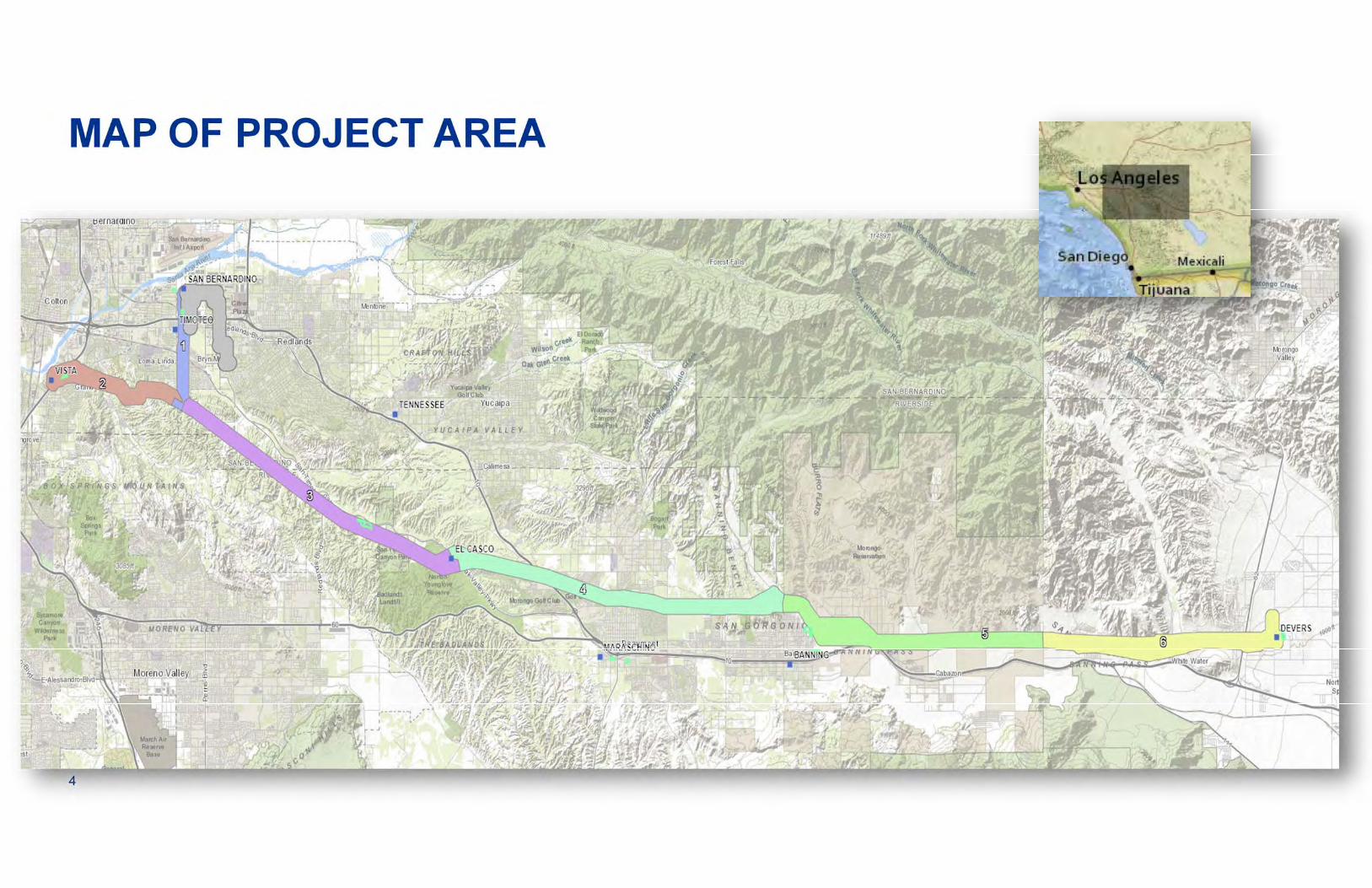
CHALLENGE: Environmental ComplianceComplex regulations, mitigation measures, and oversight
The West of Devers Upgrade Project is very complicated from a regulatory perspective. The alignment spans , Riverside and San Bernardino, including lands administered by the Bureau of Land Management, California Department of Parks and Recreation, Riverside Regional Park and Open Space District, and tribal lands. The project was subject to review under the National Environ‐mental Policy Act and California Environmental Quality Act, with the California Public Utilities Commission acting as the . . The resulting Environmental Impact Report and Environmental Impact Statement include
. For biological resources, the permitting was virtually unprecedented. The project traverses two Multiple Species Habitat Conservation Plans through which SCE obtained coverage for take of species listed under Section 10 of the Federal Endangered Species Act and California Endangered Species Act
. In parallel, the project was subject to permitting pursuant to Section 7 of the FESA and Section 2081 of the California Fish and
Game Code . The project was subject to permitting pursuant to the Clean Water Act and FGC Section 1602. In addition, the project required regulation to minimize impacts to
as well as other regulations governing. and other areas. The net result is a list of complicated, overlapping, and interconnected project requirements overseen by. with which SCE must comply.
two countiesprivate and public lands
NEPA/CEQA
CPUClead state agency
EIR EIScomprehensive mitigation measures
MSHCPs
FESACESA
CFGCCWA
cultural, paleontological, tribal resources
quality, public safety
and local agencies
air quality, water
multiple federal, state

CHALLENGE: Environmental ComplianceComplex regulations, mitigation measures, and oversight
two countiesprivate and public lands
NEPA/CEQA CPUC lead state agencyEIREIS
comprehensive mitigation measures
MSHCPs
FESA CESA
CFGCCWA
: with as
and
cultural, paleontological, tribal resources/
public
quality, public safetyand local agencies
air quality, watermultiple federal, state
/

CPUC
LocalGov’t
USACE
CDFW
Con-struction
SCE
TribesPublic
Account-ants
FAA
Keep everyone .
Private
AQMD
© Copyright PresentationGo.com
CHALLENGE

CPUC
LocalGov’t
USACECDFW
Con-struction
SCE
TribesPublic
Account-ants
FAAStarting Point:
Private
AQMD
© Copyright PresentationGo.com
APPROACHING SOLUTIONS
• Mitigation Measures• Previous experience & tools• ArcGIS Online/Enterprise• Mobile Apps• FME / Python
Broad Requirements:• Quick deployment & prototyping• Wide deployment at low cost• Easy to implement

SPECIFIC PROJECT NEEDS• Provide meaningful information to each project role
– Don’t overwhelm individuals with data: plan carefully
• Near-real-time data dissemination– 50 miles, 900 work sites, 90 users: maximize communication
• Keep project data current– Dynamic environment; violations risk safety, environment, costs and reputation
• Integrate data from external systems– System-of-Record resides with SCE
• Respond quickly and flexibly to change15

Jacobs
External
Environmental
Jacobs
External
Construction
ExternalAgencies
UsersMobile Apps
Browsers
Client Data
ArcGISOnline
Engineering
Impacts
Environmental
Interactive Dashboards
Cloud Data
AutomaticEmail
Reports
Maps & Apps
Enterprise Data
Status/Tracking
Helicopter Logistic Support
Site Status Updates
OUR UNIVERSE

Jacobs
External
Environmental
Jacobs
External
Construction
ExternalAgencies
UsersMobile Apps
Browsers
Client Data
ArcGISOnline
Engineering
Impacts
Environmental
Interactive Dashboards
Cloud Data
AutomaticEmail
Reports
Maps & Apps
Enterprise Data
Status/Tracking
Helicopter Logistic Support
Site Status Updates
1
23
4
OUR UNIVERSE

1Web-based Access – App Gallery
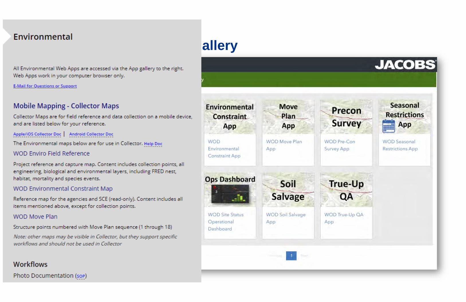
Web-based Access – App Gallery

2 Ingest Client Data – Update Layers
JSON
• Python used to retrieve updated nest and species from SCE FRED system-of-record.
• Load XY data into existing FC in Enterprise, generate buffers.
• Exception reporting if failure. VERY robust.
Nest/Habitat Buffers

3Helicopter Logistic Support - Overview
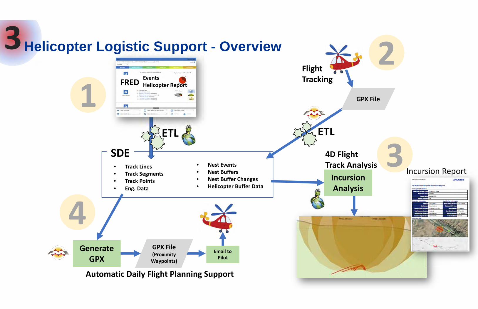
SDE
Generate GPX
• Track Lines• Track Segments• Track Points
• Nest Events• Nest Buffers• Nest Buffer Changes• Helicopter Buffer Data• Eng. Data
Email to Pilot
4D Flight Track Analysis
Automatic Daily Flight Planning Support
Flight Tracking
3Helicopter Logistic Support - Overview
ETL
FRED EventsHelicopter Report
GPX File(Proximity Waypoints)
ETL
12
4Incursion Analysis
Incursion Report
GPX File
3
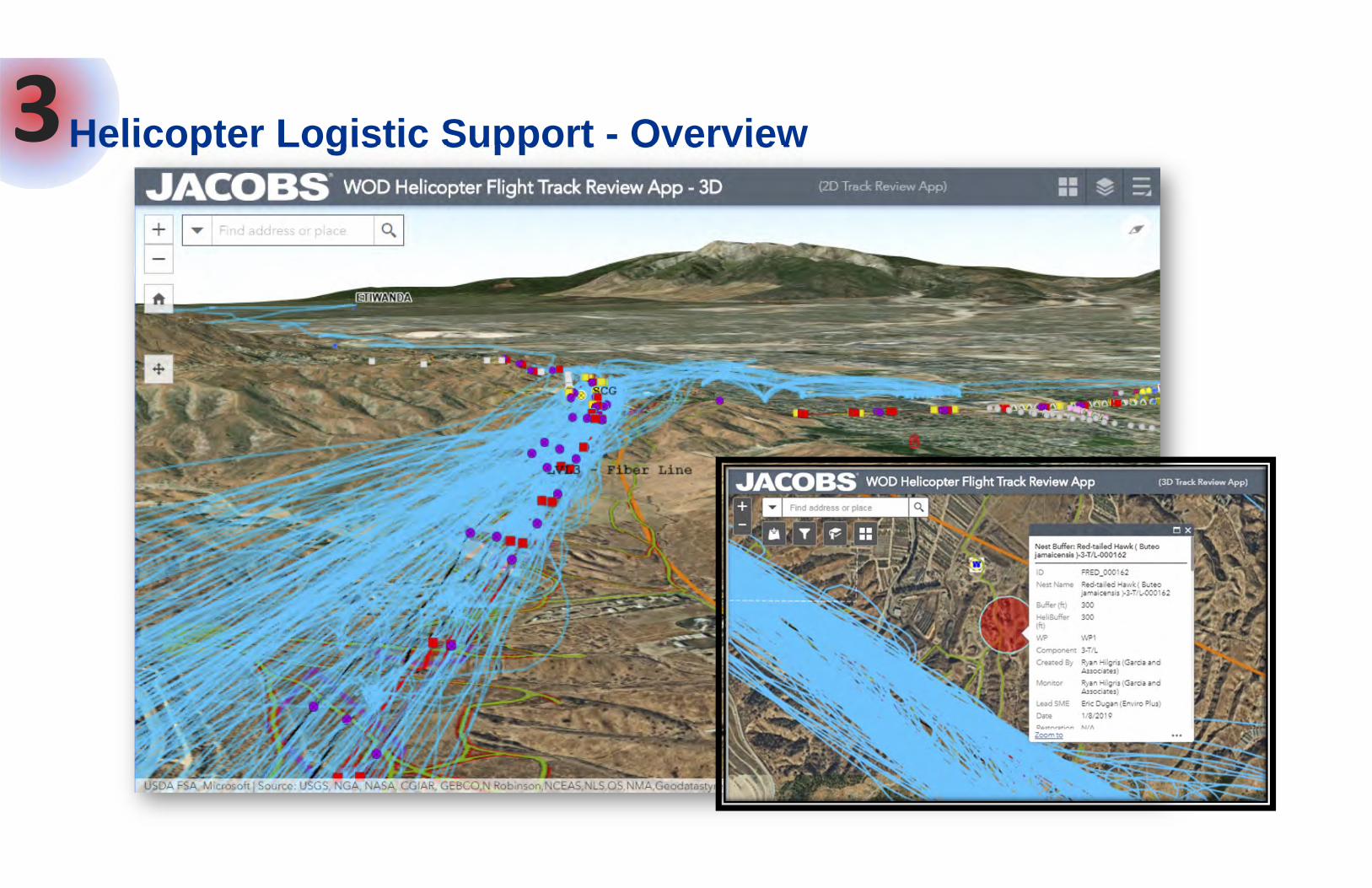
3Helicopter Logistic Support - Overview

4• Site Status determines when/where crews can work• Mitigation measures consider time of day, not just date• Status is controlled by actions and dates/times at each site• Site attributes are set in the field through Collector, or in the office• Status set by logic: outcome of multiple site attributes
Work Site Status

4• 7 possible status values for a supersite; 2 allow entry onto site
Construction may proceedConstruction may proceed – expiry is imminent
Supersite will be Active once Clearance Sweep is doneAs “Not Swept” but expiry is imminent
Awaiting CPUC field validationAs above but expiry is imminent
Site is not active
DO NOT EN
TER
Work Site Status

OutcomesWhat benefits have we realized?
• Elimination of intensive mapping production and manual QC through online platform
• Reduced scheduling effort through daily automated site status reporting
• Reduced field capture turnaround time with mobile data collection apps, and tools are in the hands of many more users
• Faster decision-making, resource allocation, and greater overall project safety through faster data dissemination
• Fewer mitigation measure violations because of near-real-time data
• Cost savings: 7 FTE GIS staff down to <3, plus reduced support staff

www.jacobs.com | worldwideJuly 22, 2019
© Copyright Jacobs
Thank you!
Gavin Jenkins, [email protected]
Jeff Friesen, [email protected]+1 (213) 228-8216
Chris Schaffer, [email protected]
Automated 4D Analysis of Helicopter Flight Tracks and Bird Nest No‐Fly ZonesSession Title: Innovation to Solve Real Utility ProblemsToday, 1:00 PM ‐ 2:00 PM Room 26 B
Avoiding Compliance Violations: ArcGIS Online, Python, Collector, and 90 UsersSession Title: How GIS can Improve Compliance and Integrated WorkflowsTomorrow, 1:00 PM ‐ 2:00 PM Room 26B
Important
The material in this presentation has been prepared by Jacobs®.
Copyright and other intellectual property rights in this presentation vest exclusively with Jacobs. Apart from any use permitted under applicable copyright legislation, no part of this work may in any form or by any means (electronic, graphic, mechanical, photocopying, recording or otherwise) be reproduced, copied, stored in a retrieval system or transmitted without prior written permission.
Jacobs is a trademark of Jacobs Engineering Group Inc.
Copyright July 22, 2019Jacobs Engineering Group Inc. All rights reserved.
Disclaimer
©
33
July 10, 2019