Complete Streets Prioritization Plan
55
Town of Marblehead Complete Streets Prioritization Plan
Transcript of Complete Streets Prioritization Plan

Town of Marblehead
Complete Streets Prioritization Plan

Agenda1. Introduction to Complete
Streets Process2. Benefits3. Progress toward MassDOT
Funding Program4. Evaluation5. Potential Project Prioritization6. Next Steps

SafetyMoment
When driving, walking, or biking be considerate and watchful of allpublic road users.
- Always expect the unexpected.
- Watch for movement all around you.
- When on the road stay alert, distracted driving, walking, or biking can be hazardous.

• Town adopted and MassDOT approved policy, received funding for consultant & formed ad hoc Complete Streets Committee
• Committee has met 3 times & worked on more than 20 project options (minimum 15 for a MassDOT priority chart)
• Committee assessing a DRAFT priority chart w/goal to submit to MassDOT by end of March 2019.
Progress

Marblehead Complete Streets Committee:
Stantec: Consultant
Name Title
Jason Silva Town Administrator
Rebecca Curran Cutting Town Planner
Judith R. Jacobi Selectman
James E. Nye Selectman
Arthur Graves DPW Director
Peter James Recreation & Parks Department Superintendent
Ed Lang Disabilities Commission Representative
Maryann Perry School Superintendent
Doug Jones Design Review Representative
Robert O. Picariello Chief of Police
Charles Quigley Town Engineer
Felix Twaalhoven Biking Community
David Kucharsky Sustainable Marblehead
Stantec Consultant: Alan CloutierGary Hebert
Project ManagerAdvisor

6
Tier 1Training & Complete Streets Policy
Development
Tier 2Complete Streets Prioritization Plan
Development
Tier 3 Construction Application
MassDOT Complete Streets Funding Eligibility – 3 Tier Process
Presenter
Presentation Notes
There are 3 Tiers of this program. Municipalities move through these at their own rate.

Tier 1 – PolicyProgress: Done, Marblehead completed and MassDOTapproved on February 20, 2018,
Tier 2 – Prioritization Plan due to MassDOT on or before April 1, 2019Progress: Underway
Tier 3 – Construction ApplicationsProgress: After Tier 2 priority plan is completed. Due on May 1and October 1, 2019. Marblehead intends to submit funding request for 1-2 pf its highest priority applications this year.Other Priority list projects to be submitted in subsequent years. Priorities on list may shift over time.
Tier FY19 Review Deadlines

• Marblehead identifies projects from its Prioritization Plan for funding
• MassDOT review
• Marblehead enters into a contract with MassDOT for reimbursement
• Reimbursement process through District Aid office similar to Chapter 90
Tier 3 – Project Application

Complete streets provide safe and accessible options not only for autos and truck drivers and their passengers, but for all users– pedestrians, bikers, bus riders, and – for people of all ages and physical abilities.
Complete Streets improvements may be large or small scale.
Complete Streets Defined:
What is a
Complete Street?
Mass Ave, Arlington

To accommodate ALL people
• Pedestrians • Transit• Bicyclists• Drivers• Goods movement
Purpose of Complete Streets
Making streets work for all!

• Safety• Equity• Fitness and health• Increase demand for environmentally-friendly modes• Improved mobility for:
- People with disabilities- Children and aging population
Benefits of Complete Streets

• Multi-modal Safety• Bicycle Enhancements• Pedestrian Enhancements• Transit Use Enhancements
Synergy is best – multiple user benefits
Wide Range of Eligible types
12

• Identify deficiencies• Recommend projects• Create prioritized list of projects• Discuss and review with Committee
and Community
Developing the Complete Streets Priority Plan

Sidewalks, Trails, & Transit Stops N

Walk Demand
N

Bike Demand N

Legend
Less Biking – More Biking
Bicycle Heat Map N

GeneralCrash Locations
2012-2016N
>1 crash/year 2002-2016
5+
4
2+
2+
2+
2+
2+
HighestCrash Locations
2002-2016

Crash LocationsPed/BikeCrash Locations
2012-2016 N

Town of Marblehead Key Roads – South Half Pedestrian and Bicycle Gap Assessment
Map 1 of 2
Missing sidewalk connectionMissing controlled school rail trail accessExisting bollards restrict bike/ADA accessMultiuse rail trailRail trail crossing deficiencySidewalk one sideSidewalk both sides ADA ramp missing or needs adjustmentExisting crosswalk Existing signal or RRFB-controlled crosswalk
Legend
Reported pedestrian or bike crash 2012-2016
Salem sidewalk
ends
No connecting sidewalk on north side of Vinnin
Street
2
2
N

Town of Marblehead Key Roads – North Half Pedestrian and Bicycle Gap Assessment
Map 2 of 2
Missing sidewalk connectionMissing controlled school rail trail accessExisting bollards restrict bike/ADA accessMultiuse rail trailRail trail crossing deficiencySidewalk one sideSidewalk both sides ADA ramp missing or needs adjustmentExisting crosswalk Existing signal or RRFB-controlled crosswalk
Legend
Reported pedestrian or bike crash 2012-2016
2N

Tentative MarbleheadComplete Streets
High Priority Projects

Project 1 - Path Upgrades toMarblehead Rail Trail
• Stabilize erosion
• Minimize trail hazards mud holes rock protrusions encroaching vegetation
• Rockaway Street crossing
• Town $50K grant application accepted
• Underway 2019

Project 2 – Enhance safety of MHRT public road crossings
• Town awarded $50K design grant
• Provide consistent crossing approaches and signs
• Rectangular Rapid Flashing Beacon (RRFB’s) at West Shore Drive, Pleasant Street, Smith Street and Clifton Avenue
• RRFBs:• Motorist yielding rates of 87.8% for 4
beacons (TRB)• Pedestrian activated (pushbutton or
passive)• Warning device• Can be solar powered or hard wired• Nearest in Salem at extension of
Marblehead Rail Trail Crossing

• Address priority unfundedADA pedestrian and bike access from public streets and Marblehead Rail Trail
• E.g., Smith St - Baldwin Rd intersection, missing Cornell Rd sidewalks, missing ADA ramps on Jane Rd and Mohawk Rd
Project 3 – Enhance Bell School Area Pedestrian and Bike Access

Add or repair curb cut ramps to comply with ADA/AAB; relocate cross walks with potential curb extensions at Chestnut, Central, Commercial, Barnard & Hawkes Streets
Project 4 – Atlantic Avenue curb ramps & possible extensions where feasible

Repair sidewalks due to tree root lifting at approximately 40 locations Town-wide (e.g., Pleasant St, Heritage Way, etc.)
Project 5 – Town-wide ‘tree root lifting’ sidewalk repairs

Install bike racks at various schools, parks, conservation area entrances, downtown, beaches, Near Town Hall, etc.
Project 6 – Town-wide community activity center bike racks (U-type)

Project 7 – Smith Street pedestrian & access accommodations
Provide ADA/AAB curb ramps at Devereux Street and inlaid missing sidewalk on south side behind head in parking spaces.

Add or modify curb cut ramps to comply with ADA/AAB and south side missing sidewalk
Project 8 – Install missing Lafayette Street sidewalk and ADA curb ramps

Project 9 – Provide missing sidewalks on Rockaway Avenue, Leggs Hill Road, and Commercial Street
Install missing sidewalks environmentally sensibly, without loss of trees & only with
strong abutter support...

Project 10 – Mugford, Green & Elm Streets Enhancements
Complete Streets Concept Only – Not to Scale
Green Street
N

Project 11 – Pilot bike route on Beach Street/Ocean Avenue – Atlantic Avenue to Harbor Avenue
Could be as simple as paint and signs only with, perhaps, some optional physical modifications as shown on the next few slides…
12 3 4

1
Ocean Avenue at Beach Street Complete Streets Concept Only – Not to Scale
N

Ocean Avenue at Devereux Beach EntranceComplete Streets Concept Only – Not to Scale
N
2

Ocean Avenue at Marblehead Causeway Optional Complete Streets Concept
3

Ocean Avenue at Harbor AvenueComplete Streets Concept Not to Scale
4
N

Project 12 – Install missing sidewalks on Brookhouse Drive & improve Tedesco Street crossing
Source: CTPS
N

Projects 13 to15 – Install missing ADA ramps on Tedesco, Humphrey, and Pleasant Streets
Install ADA ramps on Marblehead’s primary travel corridors to close gaps in ADA sidewalk travel.

Projects 16 to19 – Install reasonableon-street bike accommodations on Atlantic Avenue, Lafayette Street, West Shore Drive, and Pleasant Streets
• Must be applied creatively. Consider town-wide study prior to implementation
• Many Committee members expressed concern about the installation of on-road bike lanes.
• Bikes are permitted on all Marblehead roads. Separate bike facilities are preferred, but on road use should be addressed.
• Optional shared lane markings, or “sharrows” may be used for route guidance where insufficient width for shoulders or bike lanes.

Projects 16 &18 – Potential on- road Bicycling enhancements Atlantic Ave/Humphrey StAtlantic Avenue and Humphrey Streets generally have wide shoulders, occasional parking observed. Could be candidates for bikeable shoulders or bike lanes.

Lafayette Street at Maple Street Complete Streets Concept Only – Not to Scale
Project 17 Example 1:Lafayette /Maple Sts

Lafayette Street at West Shore DriveComplete Streets Concept Only – Not to Scale
Project 17 Example 2:Lafayette /W Shore N

Reduce Travel Lane Width• Slow Speeding• Creates room to separate
bikes
Project 17 Example 3: West Shore Drive

Pleasant Street at Baldwin Road/Smith Street EastComplete Streets Concept Only – Not to Scale
Project 19 Example 3: Pleasant/Smith Streets
N

Intermittent accommodations, but low traffic volumes and crash rates.
Projects 20 -21 - Harbor Avenue and Ocean Avenue Pedestrian/Bike Enhancements

Rail trail is grade separated, a connection is desired, as both Village Street and Veterans Middle Schools are served.
Projects 22- Village Street Pedestrian Enhancements and MRT Access

DRAFT Complete Streets Projects Overview – Marblehead Rail Trail Enhancements & Regional Context
LegendPossible school connectionRail TrailsPublic road crossing and approach enhancementsAdd rectangular rapid flashing beacons (RRFBs)Removal of rock outcrops and vegetation encroachmentsSurface restorations
Tentative Project Priority
500m1,000 ft
1
2A
2B
2C
2D
2E
2G
2H
2F
XX
N

DRAFT Complete Streets Projects Overview – Key Road Sidewalk and ADA Crossing Enhancement Areas
Legend
Potential to construct missing sidewalk or marking shoulderPotential corridor for adding new curb ramps for better ADA accessConsider bus stop enhancementsDraft Priority Project Number
500m1,000 ft
3
4
8
13
14
7
10
12
18
9
4
XX
9
9
20
21
N

DRAFT Complete Streets Projects Overview Potential Key Road On-street Bike Enhancements
Legend
Potential for bikeable shoulders or bike lanes Potential bikeable shoulders or shared lane markings
where width inadequate or on-street parking neededPotential for intersection bike boxesPotential for public bike storage (sample locations
shown; others possible)
Draft Matrix Project Number
500m
1,000 ft
17
17
21
11
19
18
16
XX
20
N

Questions?

Tentative Project Listing
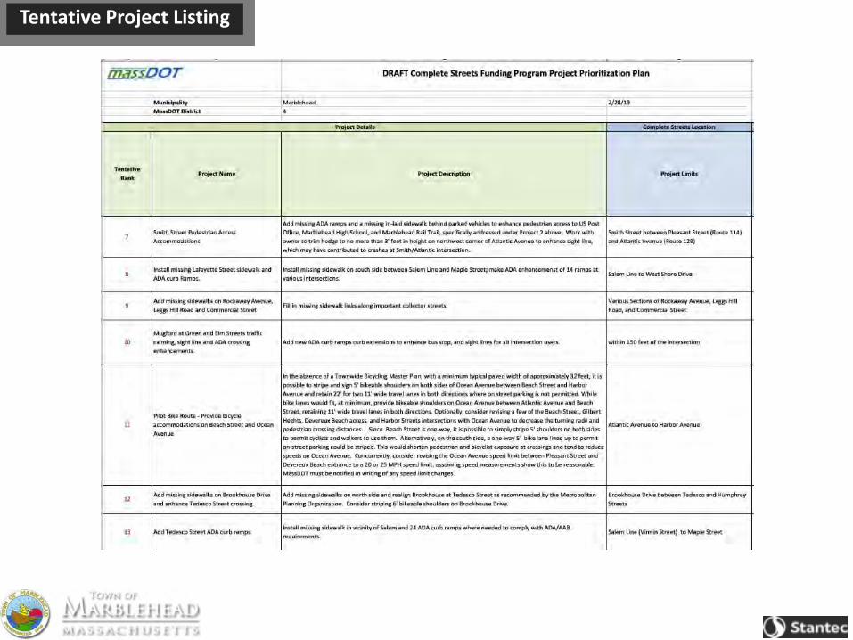
Tentative Project Listing

Tentative Project Listing

Tentative Project Listing